Embed Size (px)
Citation preview
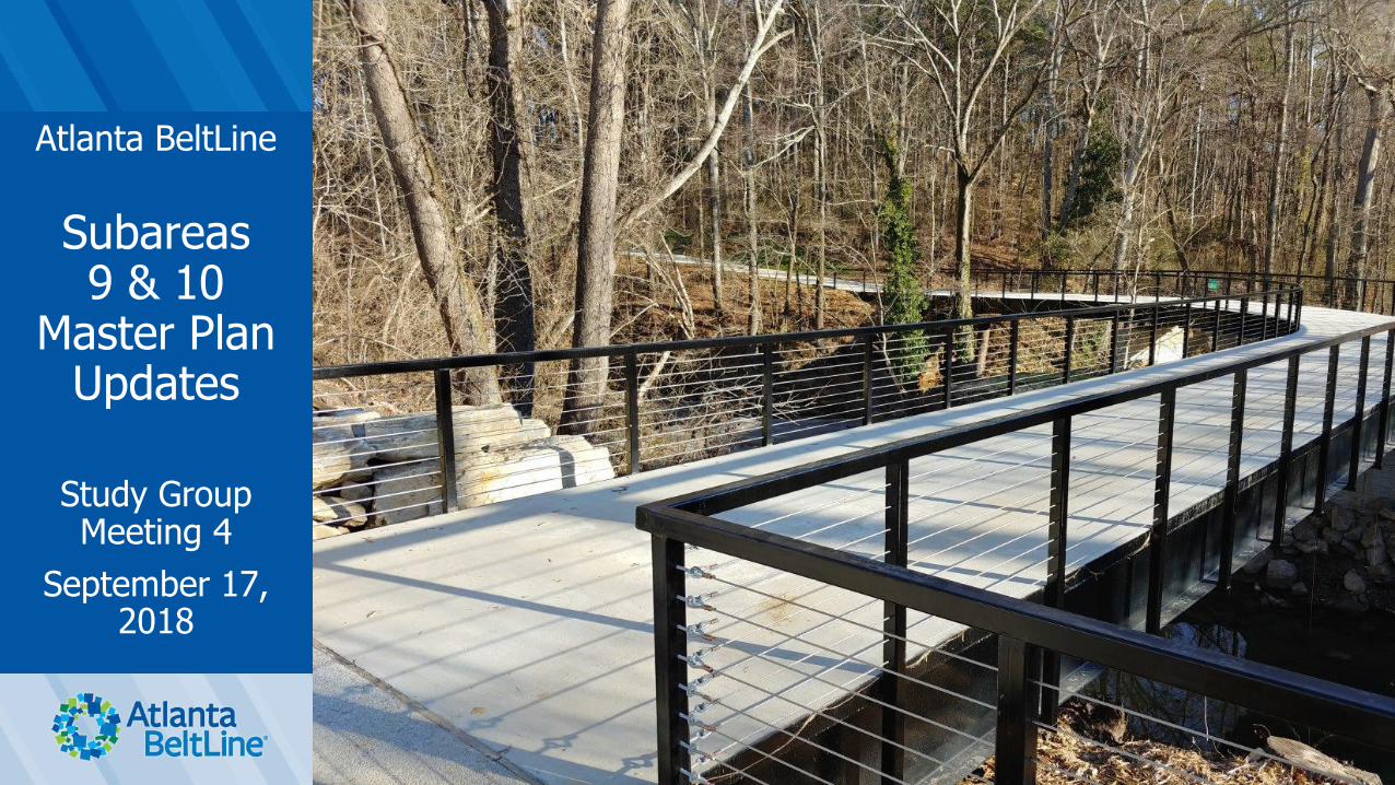
Atlanta BeltLine
Subareas 9 & 10
Master Plan Updates
Study Group Meeting 4
September 17, 2018
Washington Park Jamboree1
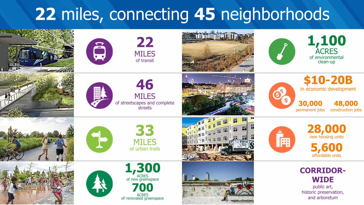
22 miles, connecting 45 neighborhoods
22MILESof transit
46MILES
of streetscapes and complete streets
33MILES
of urban trails
1,300ACRES
of new greenspace
700ACRES
of renovated greenspace
1,100ACRES
of environmentalclean-up
$10-20Bin economic development
28,000new housing units
5,600affordable units
48,000construction jobs
30,000permanent jobs
CORRIDOR-WIDEpublic art,
historic preservation,and arboretum
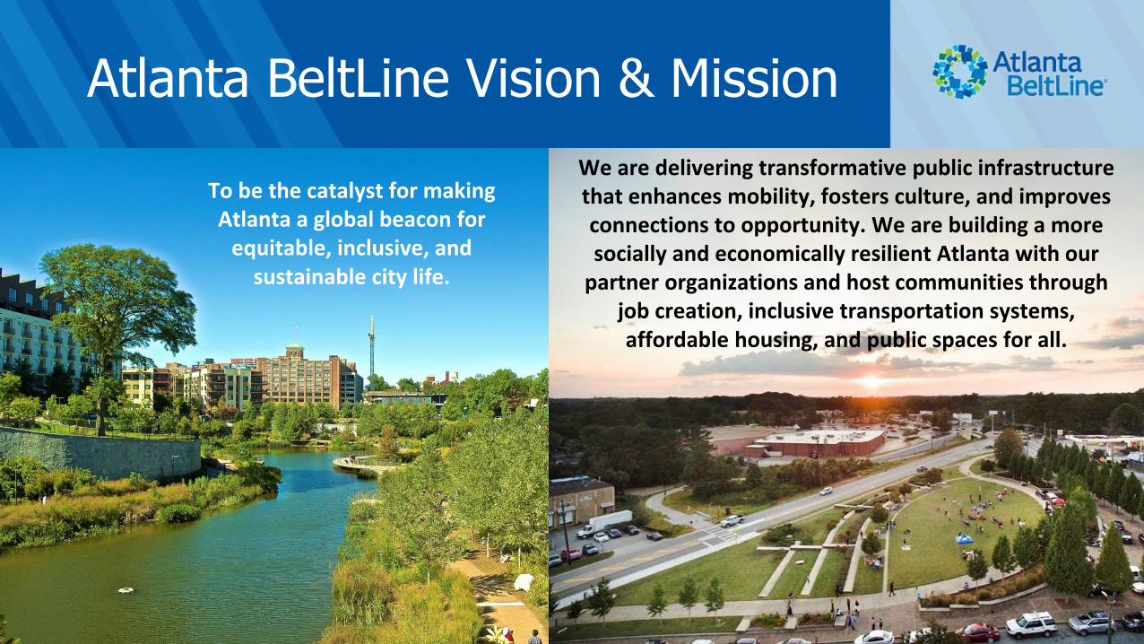
Atlanta BeltLine Vision & Mission
3
To be the catalyst for making Atlanta a global beacon for
equitable, inclusive, and sustainable city life.
We are delivering transformative public infrastructure that enhances mobility, fosters culture, and improves connections to opportunity. We are building a more socially and economically resilient Atlanta with our
partner organizations and host communities through job creation, inclusive transportation systems, affordable housing, and public spaces for all.

Meeting Agenda
❑ Subarea Master Plan Update Purpose and Schedule
❑ Master Plan Update Process
❑ What We’ve Heard
❑ Demographics and Market Overview
❑ Land Use and Mobility Recommendations
❑ Let Us Know What You Think
• Action Plan / Work Program
4
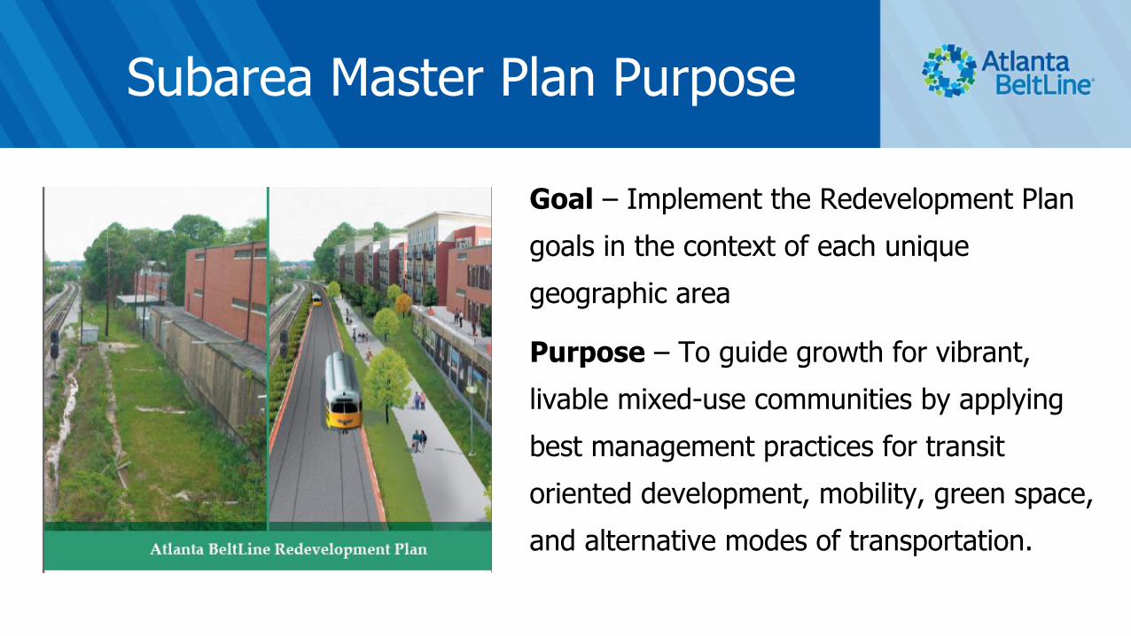
Subarea Master Plan Purpose
Goal – Implement the Redevelopment Plan
goals in the context of each unique
geographic area
Purpose – To guide growth for vibrant,
livable mixed-use communities by applying
best management practices for transit
oriented development, mobility, green space,
and alternative modes of transportation.
Subarea Master Plan Update Purpose
The original 10 Subarea Master Plans completed ~10 years ago
• Subarea 9 Master Plan adopted in 2009
• Subarea 10 Master Plan adopted in 2010
A lot has happened – it’s time to update the plans to reflect these changes and the potential for future success
These are updates, so they will not be as long or as detailed as the previous plans
We are not starting from scratch6

Subarea 9 & 10
ContextSubarea
9
Subarea10
NEIGHBORHOODS
SUBAREA 9
• Bankhead
• Grove Park
• Rockdale
• English Avenue
• Knight Park /
Howell Station
SUBAREA 10
• Ashview Heights
• Bankhead
• English Avenue
• Harris Chiles
• Just Us
• Vine City
• Atlanta University
Center
• Grove Park
• Hunter Hills
• Mozley Park
• West End

Subarea 9 & 10 Master Plan Team
8

Study Group Meeting 1: Kick-off Meeting, March 26th
Study Group Meeting 2: Workshop
• Saturday, April 28th, 10:00 A.M. – 12:00 P.M. (Subarea 9)
• Saturday, April 28th, 1:00 P.M. – 3:00 P.M. (Subarea 10)
Study Group Meeting 3: Draft Recommendations
• August 27th, 6:30 P.M. to 8:00 P.M.
Study Group Meeting 4: Draft Action Plan
(You are here)
Study Group Meeting 5: Final Work Plan/Recommendations• TBD
• Plan Adoption: 4th Quarter 20189
Subarea 9 & 10
Master Plan Update
Schedule
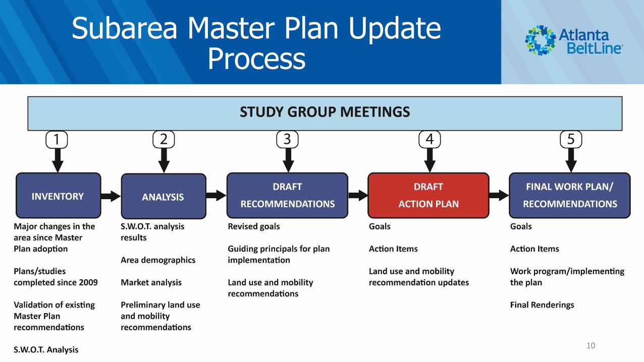
Subarea Master Plan Update Process
10

Implementing the Plan
• Goals and Guiding Principals
• Future Land Use Map
• Bike/Pedestrian Circulation Plan
• Vehicular Circulation Plan
• Street Framework Plan
• Action Plan / Work Program11
SUBAREA 9
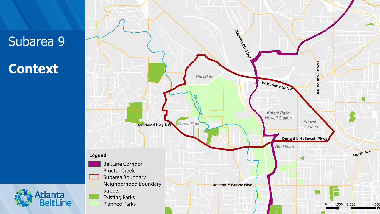
Subarea 9
Context
What We’ve Heard
Strengths and Opportunities
• Sense of community, lots of history and culture
• Lovely place to live close to the city
• Legacy residents
• Westside Reservoir Park
14

What We’ve Heard
Weaknesses and Threats
• Lack of retail and grocery store options
• Lack of entertainment options for younger couples and families
• Reduction in the number of owner-occupied homes–investors buying real estate
• Lack of access and connectivity to surrounding amenities and across railroad tracks
• Lack of good bike and sidewalk network with safe pedestrian crossings and lighting
15

What We’ve Heard
Consolidated Comments
• Enhance the bike/sidewalk network - Provide safe and direct bike and pedestrian access from surrounding neighborhoods to Westside Reservoir Park, Bankhead MARTA Station, Proctor Creek Greenway and existing and future activity nodes
• Advance streetscape improvements
• Advance improvements to area parks
• Provide opportunities for hiking/mountain biking in Westside Park
16
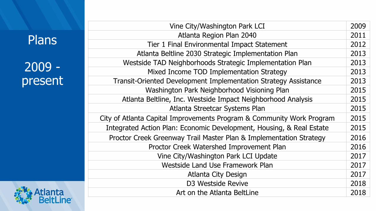
Plans
2009 -present
Vine City/Washington Park LCI 2009
Atlanta Region Plan 2040 2011
Tier 1 Final Environmental Impact Statement 2012
Atlanta Beltline 2030 Strategic Implementation Plan 2013
Westside TAD Neighborhoods Strategic Implementation Plan 2013
Mixed Income TOD Implementation Strategy 2013
Transit-Oriented Development Implementation Strategy Assistance 2013
Washington Park Neighborhood Visioning Plan 2015
Atlanta Beltline, Inc. Westside Impact Neighborhood Analysis 2015
Atlanta Streetcar Systems Plan 2015
City of Atlanta Capital Improvements Program & Community Work Program 2015
Integrated Action Plan: Economic Development, Housing, & Real Estate 2015
Proctor Creek Greenway Trail Master Plan & Implementation Strategy 2016
Proctor Creek Watershed Improvement Plan 2016
Vine City/Washington Park LCI Update 2017
Westside Land Use Framework Plan 2017
Atlanta City Design 2017
D3 Westside Revive 2018
Art on the Atlanta BeltLine 2018

Major Changes Since 2009
• Proctor Creek Greenway Phase I trail completed
• BeltLine trail construction to Washington Park completed
• Westside Reservoir Park Phase I underway
• Donald Lee Hollowell streetscape project underway
• Atlanta Streetcar System proposed line extension to Bankhead
• Significant redevelopment proposed in the immediate vicinity
18

Development Activity in Subarea 9
Subarea
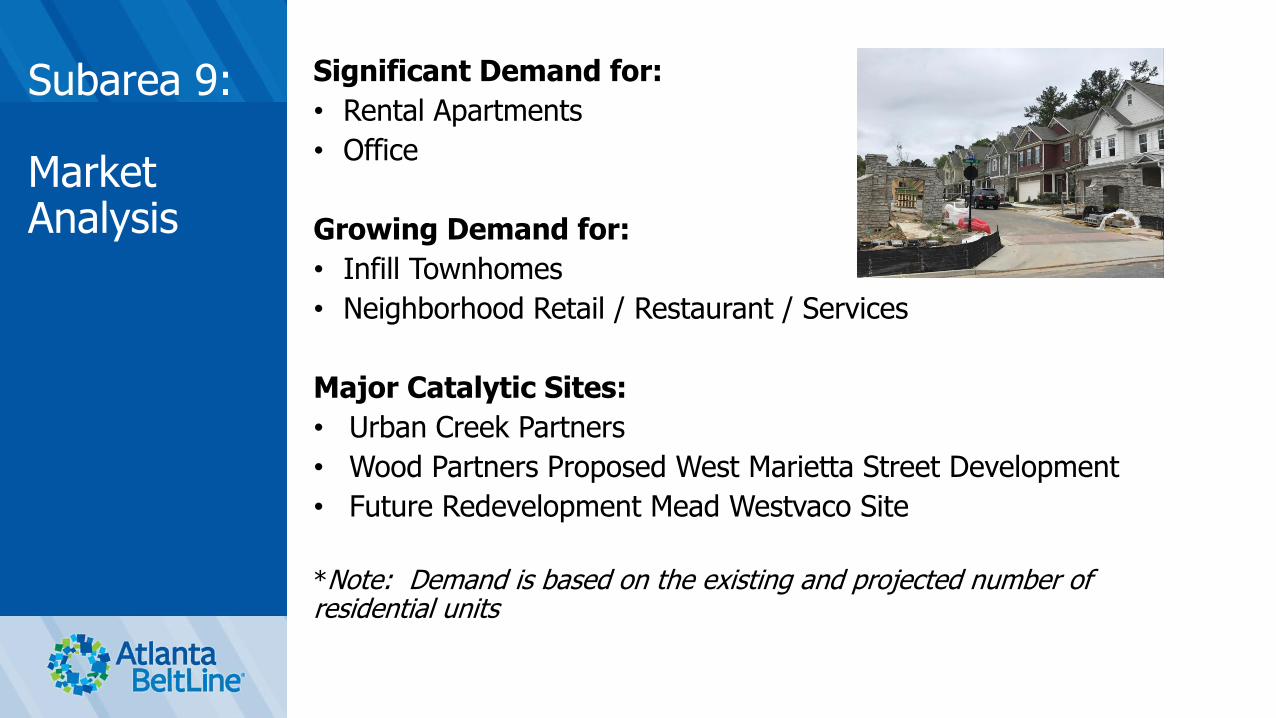
3
Significant Demand for:
• Rental Apartments
• Office
Growing Demand for:
• Infill Townhomes
• Neighborhood Retail / Restaurant / Services
Major Catalytic Sites:
• Urban Creek Partners
• Wood Partners Proposed West Marietta Street Development
• Future Redevelopment Mead Westvaco Site
*Note: Demand is based on the existing and projected number of residential units
Subarea 9:
Market Analysis

Subarea 9:
Draft FutureLand Use Plan
1. Increase existing park space to be consistent
with future Westside Reservoir Park boundary
2. Increase density (MU 10+ stories and MF 5-9
stories) around the Bankhead MARTA station
3. Convert a portion of industrial properties along
J.E. Lowery to mixed-industrial while retaining a
portion of existing industrial
4. Convert vacant land east of Lois St. to medium-
density mixed-use (MU 5-9 stories)
5. Convert a portion of Marietta Blvd. from
industrial to low density mixed-use (MU 1-4
stories)
6. Provide medium-density multi-family (MF 5-9
stories) south of W. Marietta St. (SE corner)
and south of Jefferson St.
7. Provide medium-density mixed-use (MU 5-9
stories) south of Jefferson St. and north of D.L.
Hollowell Parkway

Subarea 9:
Changes to Land Use Plan - Post Community Meeting #3
2. Increase density (MU 10+ stories and MF 5-9
stories) around the Bankhead MARTA station
Originally MU 10+ stories and MU 5-9 stories
3. Convert a portion of industrial properties along
J.E. Lowery to mixed-industrial while retaining a
portion of existing industrial Originally a greater
number of parcels were designated as mixed-
industrial
5. Convert a portion of Marietta Blvd. from
industrial to low density mixed-use (MU 1-4
stories) Originally low-density commercial

Subarea 9:
Draft Circulation (Bike/Ped) Plan
1. Add sidewalks on major corridors that do not
have sidewalks or have intermittent sidewalks
2. Add ADA ramps to non-compliant
intersections with sidewalks
3. Evaluate adding multi-use trail west from
Jefferson St./Marietta Blvd. over CSX tracks to
provide access to the Proctor Creek Trail
4. Continue bike lane on D.L. Hollowell Pkwy to
West Lake Ave.
5. Evaluate multi-use trail under D.L. Hollowell Pkwy.
through culvert along Proctor Creek to provide
access to Proctor Creek Trail and Bankhead
MARTA Station
6. Provide streetscape on W. Marietta St. from
Marietta Blvd. to Brady Ave./8th St.

Subarea 9:
Draft Circulation (Vehicular) Plan
1. Evaluate Street Retrofit: J.E. Lowery Blvd. –
Convert 3 lanes to 2 lanes with 5 ft. wide bike
lanes
2. Streetscape improvements: Lois Rd.,
Johnson Rd. and Perry Blvd.
3. Street Retrofit: Marietta Blvd. – Evaluate a road
diet and potential for near-term cycle
track/future BeltLine transit
4. BeltLine and D.L. Hollowell Pkwy to North
Ave. corridor – streetcar/LRT
5. Various intersection improvements consistent
with the original SA master plan

Subarea 9:
Draft StreetFramework Plan
1. Enhance the street network 2. Add connection to Westside Reservoir Park
from Knight Park/Howell Station at SW apex of
Niles Avenue
3. Provide multi-modal operational, access and safety improvements to accommodate future
development

Subarea 9:
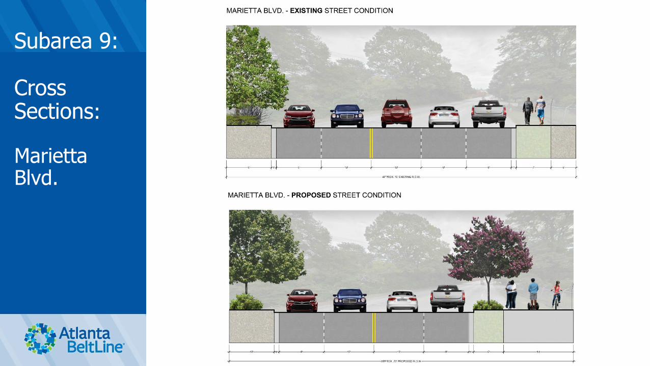
Cross Sections:
Option A -J.E. Lowery Boulevard
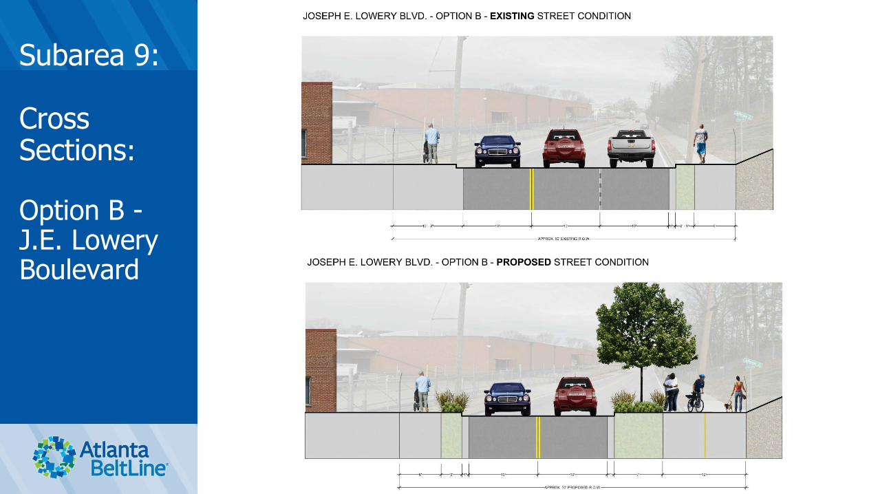
Subarea 9:
Cross Sections:
Option B -J.E. Lowery Boulevard
Subarea 9:
Cross Sections:
Marietta Blvd.

SUBAREA 10
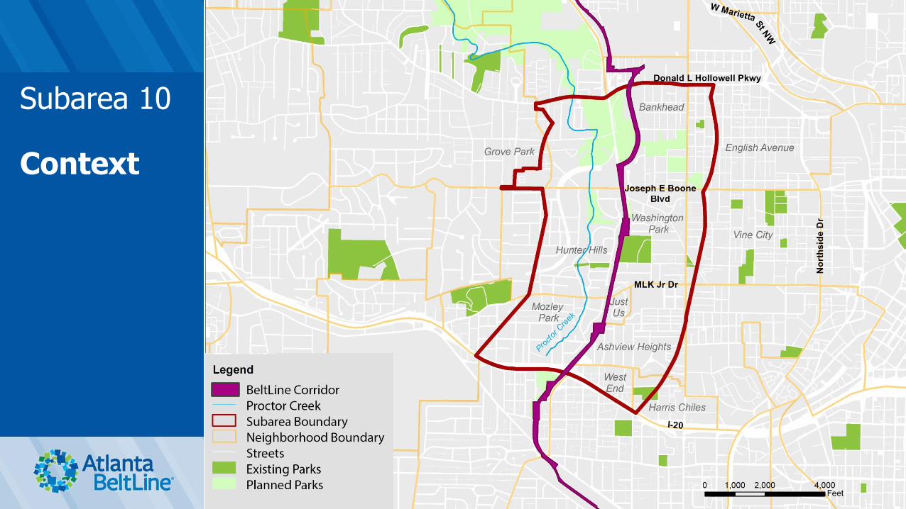
Subarea 10
Context

What We’ve Heard
Strengths and Opportunities
• Culturally rich history and proud residents
• Strong sense of community, lots of community gatherings
• Affordable housing
• Transit access
• Recently opened BeltLine Westside Trail
31
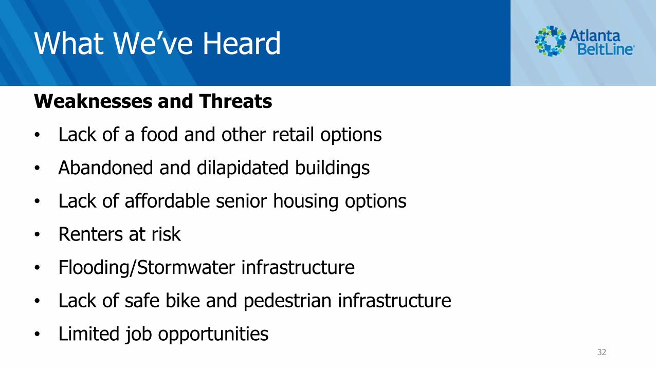
What We’ve Heard
Weaknesses and Threats
• Lack of a food and other retail options
• Abandoned and dilapidated buildings
• Lack of affordable senior housing options
• Renters at risk
• Flooding/Stormwater infrastructure
• Lack of safe bike and pedestrian infrastructure
• Limited job opportunities32

What We’ve Heard
Consolidated Comments
• Enhance retail and entertainment options
• Advance improvements to Maddox park
• Advance streetscape improvements
• Connect North Avenue south of Maddox Park
33

What We’ve Heard
Consolidated Comments
• Enhance the bike/sidewalk network - Provide safe bike and pedestrian access to Westside Reservoir Park, Bankhead MARTA Station, Proctor Creek Greenway and existing and future activity nodes
• Cycling is not a viable transportation option for everyone – do not reduce capacity to provide bike lanes that benefit just a few people
34

Plans
2009 -present
Vine City/Washington Park LCI 2009
Atlanta Region Plan 2040 2011
Tier 1 Final Environmental Impact Statement 2012
Atlanta Beltline 2030 Strategic Implementation Plan 2013
Westside TAD Neighborhoods Strategic Implementation Plan 2013
Mixed Income TOD Implementation Strategy 2013
Transit-Oriented Development Implementation Strategy Assistance 2013
Washington Park Neighborhood Visioning Plan 2015
Atlanta Beltline, Inc. Westside Impact Neighborhood Analysis 2015
Atlanta Streetcar Systems Plan 2015
City of Atlanta Capital Improvements Program & Community Work Program 2015
Integrated Action Plan: Economic Development, Housing, & Real Estate 2015
Proctor Creek Greenway Trail Master Plan & Implementation Strategy 2016
Proctor Creek Watershed Improvement Plan 2016
Vine City/Washington Park LCI Update 2017
Westside Land Use Framework Plan 2017
Atlanta City Design 2017
D3 Westside Revive 2018
Art on the Atlanta BeltLine 2018

Major Changes Since 2010
• Proctor Creek Greenway Phase I trail completed
• BeltLine trail construction to Washington Park completed
• Westside Reservoir Park Phase I underway
• Donald Lee Hollowell streetscape project underway
• Atlanta Streetcar System proposed line extension to Bankhead
36
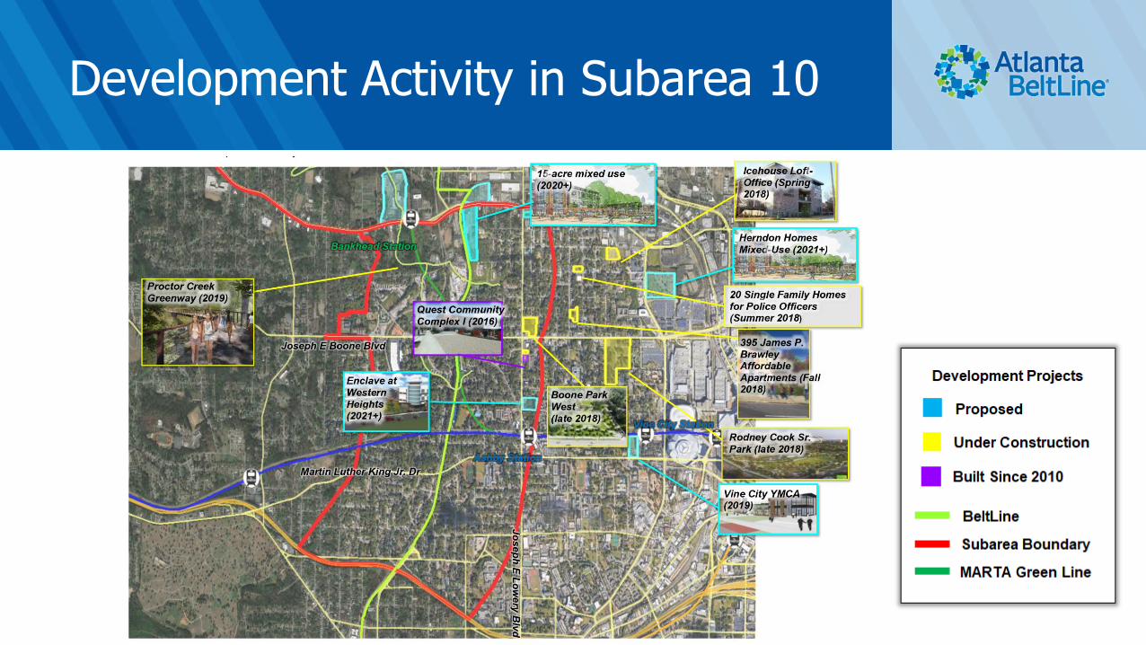
Development Activity in Subarea 10

Subarea
3
Limited Redevelopment Sites:
• Primarily existing single family communities
• Some potential along Boone and Maddox Park – but longer term
Moderate Demand for:
• Limited Rental Apartments and Office infill (adaptive reuse)
• Will see some new construction single family
Future Demand for:
• 5+ years will bring demand for infill townhomes and higher concentration of apartments and office
*Note: Demand is based on the existing and projected number of residential units
Subarea 10:
Market Analysis

Subarea 10:
Draft Future Land Use Plan
1. Increase park space west and south of
Maddox Park to be consistent with the
Proctor Creek Greenway
2. Convert industrial properties east of Maddox
Park to medium density mixed-use (MU 5-9)
with proper transitions to single-family)
3. Increase the number of low-density multi-
family and medium density mixed-use
properties to the southwest of Maddox Park
4. Incorporate medium-density and low-density
mixed-use development (MU 5-9 stories and
MU 1-4 stories) along Boone Blvd. between
Chappel Rd. and the future BeltLine corridor
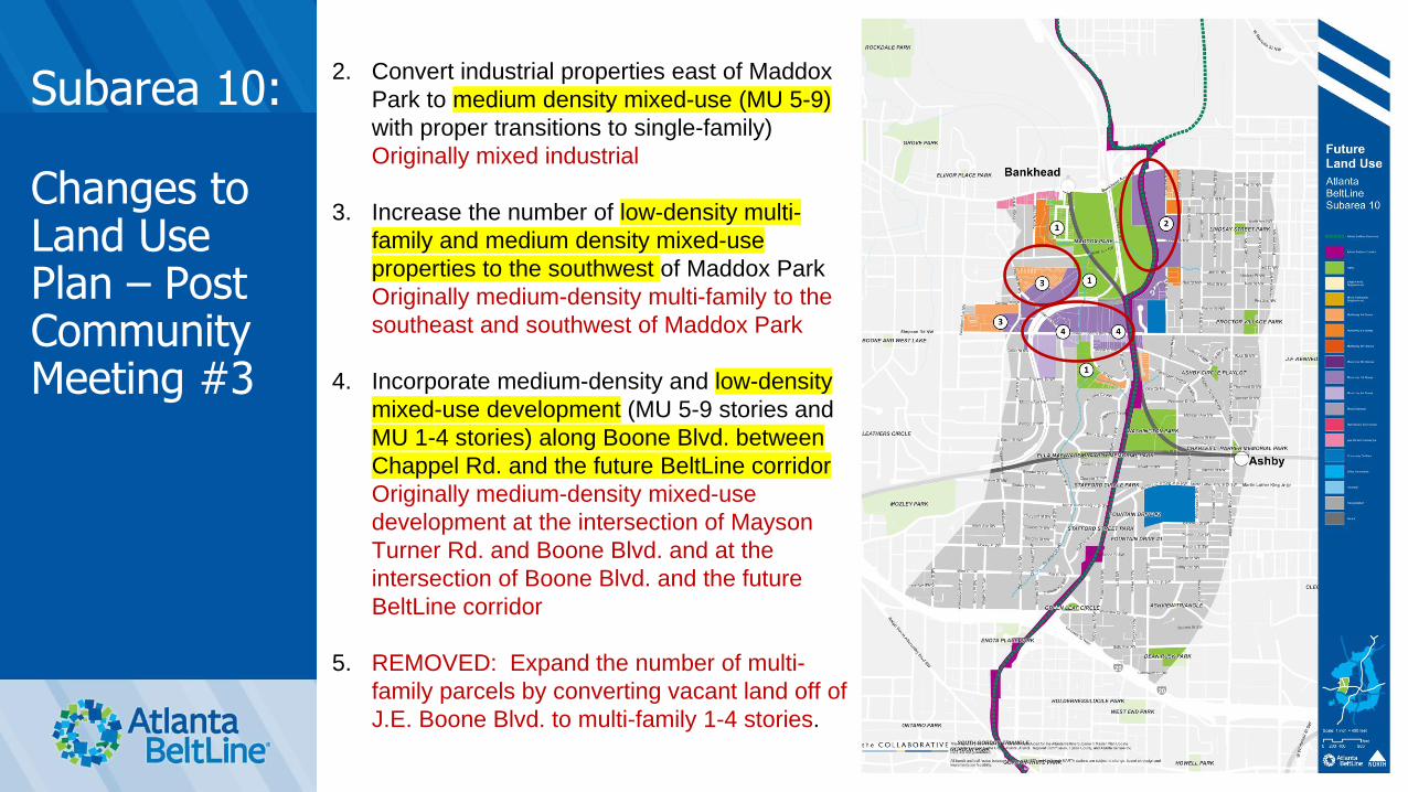
Subarea 10:
Changes to Land Use Plan – Post Community Meeting #3
2. Convert industrial properties east of Maddox
Park to medium density mixed-use (MU 5-9)
with proper transitions to single-family)
Originally mixed industrial
3. Increase the number of low-density multi-
family and medium density mixed-use
properties to the southwest of Maddox Park
Originally medium-density multi-family to the
southeast and southwest of Maddox Park
4. Incorporate medium-density and low-density
mixed-use development (MU 5-9 stories and
MU 1-4 stories) along Boone Blvd. between
Chappel Rd. and the future BeltLine corridor
Originally medium-density mixed-use
development at the intersection of Mayson
Turner Rd. and Boone Blvd. and at the
intersection of Boone Blvd. and the future
BeltLine corridor
5. REMOVED: Expand the number of multi-
family parcels by converting vacant land off of
J.E. Boone Blvd. to multi-family 1-4 stories.
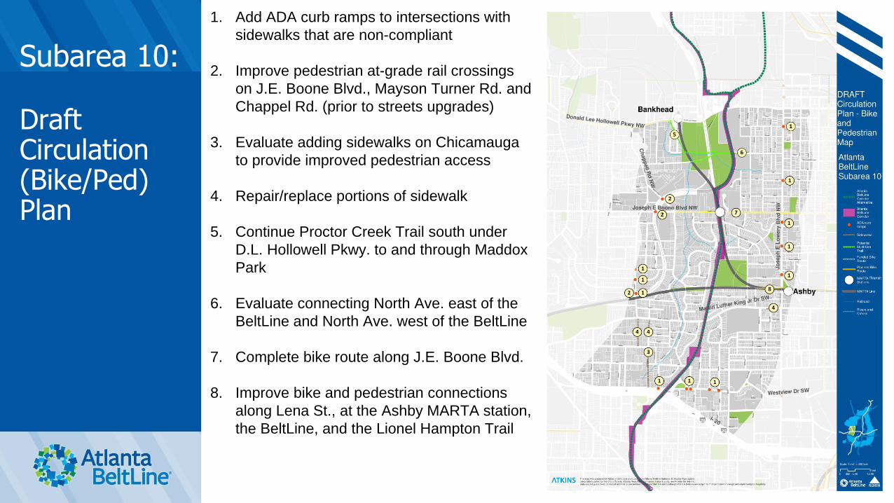
Subarea 10:
Draft Circulation (Bike/Ped) Plan
1. Add ADA curb ramps to intersections with
sidewalks that are non-compliant
2. Improve pedestrian at-grade rail crossings
on J.E. Boone Blvd., Mayson Turner Rd. and
Chappel Rd. (prior to streets upgrades)
3. Evaluate adding sidewalks on Chicamauga
to provide improved pedestrian access
4. Repair/replace portions of sidewalk
5. Continue Proctor Creek Trail south under
D.L. Hollowell Pkwy. to and through Maddox
Park
6. Evaluate connecting North Ave. east of the
BeltLine and North Ave. west of the BeltLine
7. Complete bike route along J.E. Boone Blvd.
8. Improve bike and pedestrian connections
along Lena St., at the Ashby MARTA station,
the BeltLine, and the Lionel Hampton Trail

Subarea 10:
Draft Circulation (Vehicular) Plan
1. Complete planned streetcar/LRT/BRT routes
along D.L. Hollowell Pkwy, J.E. Boone Blvd.,
J.E. Lowery Blvd., and Westview Dr.
2. Evaluate Street Retrofit: J.E. Lowery Blvd. from
D.L. Hollowell Pkwy to Mayson Turner Rd. –
convert from 3 lanes to 2 lanes with 5 ft. bike
lanes
3. Evaluate continuing Street Retrofit: J.E. Boone
Blvd. – convert from 3 lanes to 2 lanes with bike
lanes in ROW from J.E. Lowery Blvd. to railroad
crossing
4. Streetscape/Complete Streets Projects: D.L.
Hollowell Pkwy., J.E. Boone Blvd., Mayson
Turner Rd., J.E. Lowery Blvd., and North Ave.
5. Evaluate various intersection improvements
6. Add all-way pedestrian phase to signal at J.E.
Lowery Blvd. and MLK Jr. Dr.
7. Add pedestrian lead time to phasing of signal at
Boone Blvd. and J.E. Lowery Blvd.
8. Evaluate the need for traffic calming measures
on Westview Dr. in the vicinity of Lawton Drive
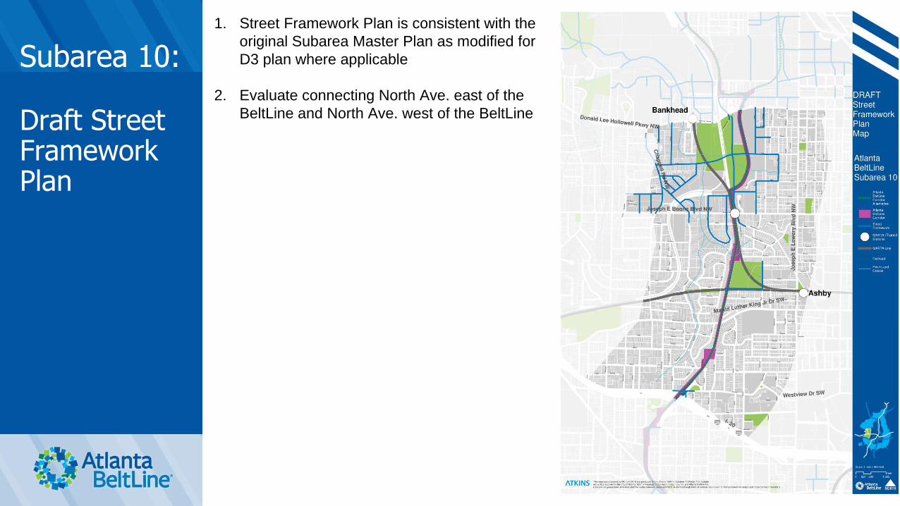
Subarea 10:
Draft Street Framework Plan
1. Street Framework Plan is consistent with the
original Subarea Master Plan as modified for
D3 plan where applicable
2. Evaluate connecting North Ave. east of the
BeltLine and North Ave. west of the BeltLine
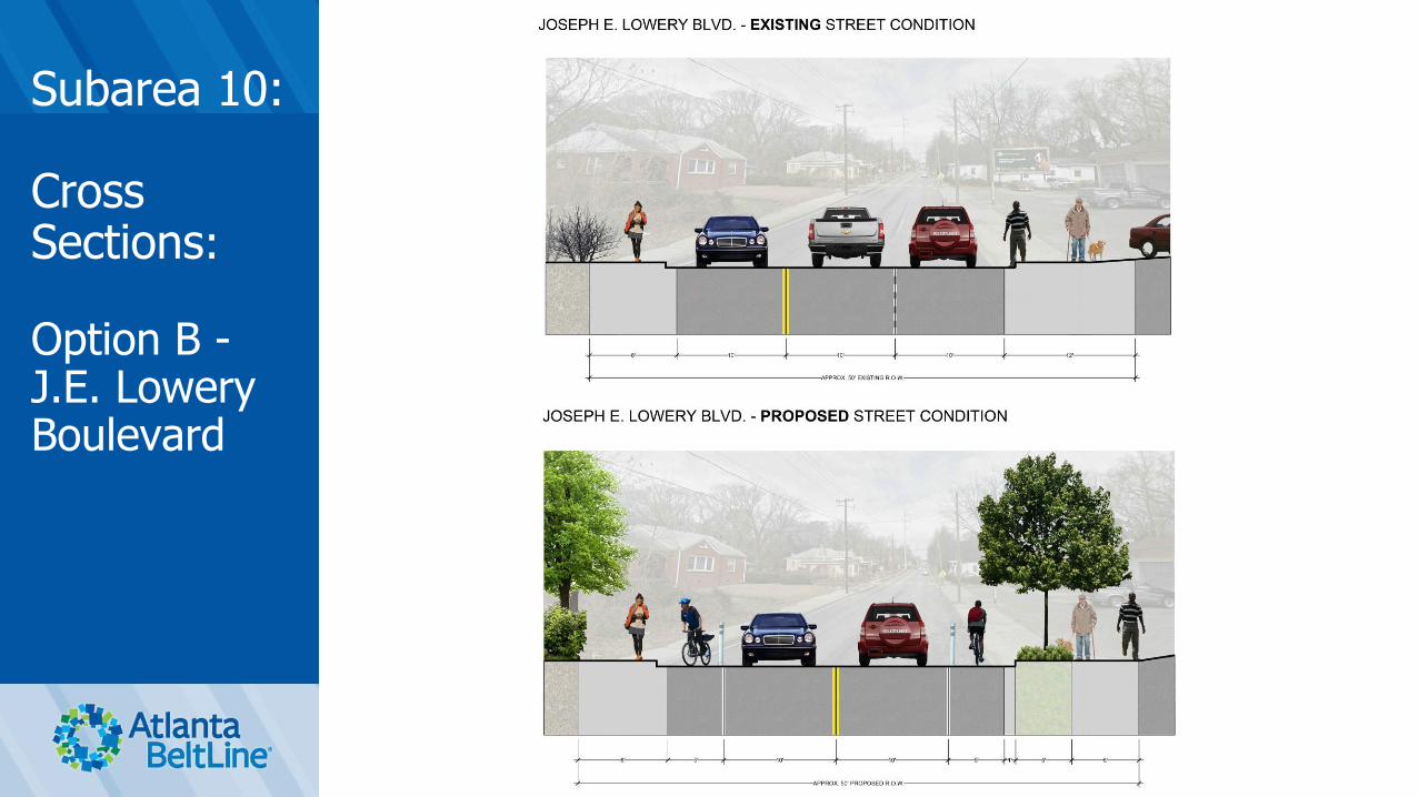
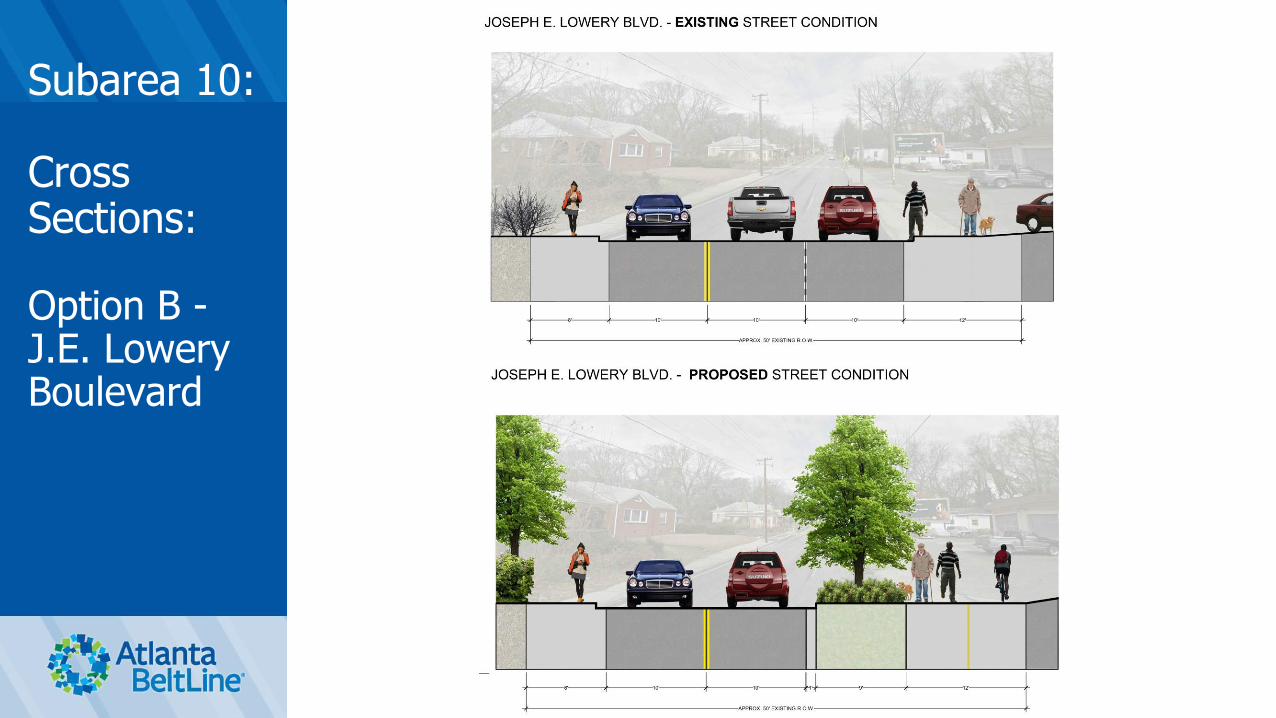
Subarea 10:
Cross Sections:
Option B -J.E. Lowery Boulevard
Subarea 10:
Cross Sections:
Option B -J.E. Lowery Boulevard

Subarea 10:
Cross Sections:
North Ave.
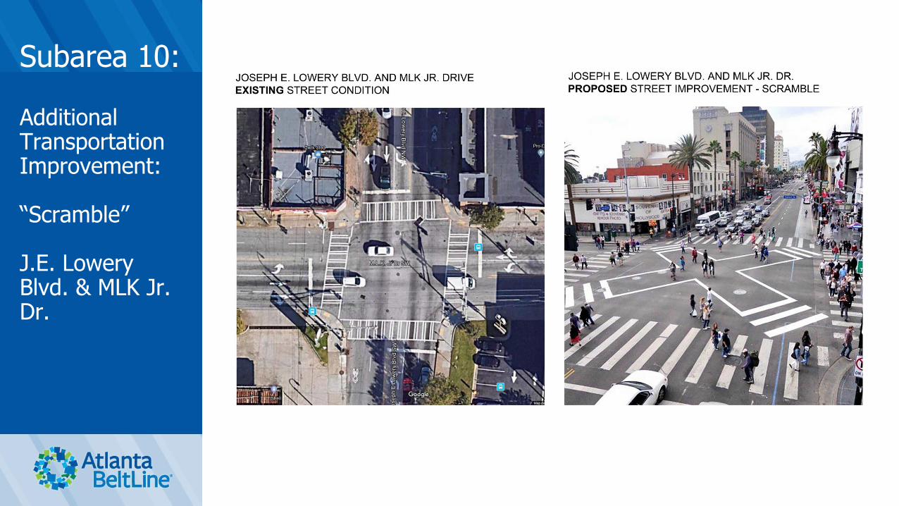
Subarea 10:
Additional Transportation Improvement:
“Scramble”
J.E. Lowery Blvd. & MLK Jr. Dr.

Subarea 10:
Additional Transportation Improvement:
Speed Table/Raised Intersection
Westview Dr. and Lawton St.

Implementing the Plan
• Goals and Guiding Principals
• Future Land Use Map
• Bike/Pedestrian Circulation Plan
• Vehicular Circulation Plan
• Street Framework Plan
• Action Plan / Work Program49

Let Us Know What You Think
Step 1. Review Action Plan Boards
Step 2. Prioritize Action Plan Items by placing a
green dot on the five items you would like to see
completed first
Questions/Discussion
Thank you!