Embed Size (px)
Citation preview

French MeadowsReservoir
Hell HoleReservoir
E L D O R A D O C O U N T Y
P L A C E R C O U N T Y
N E V A D A C O U N T Y
Union ValleyReservoir
Ice HouseReservoir
Slab CreekReservoir
FolsomLake
RalstonAfterbayNort
h Fork
Amer
ican
Rive
r
Middle For k A
merican Rive
r
Nor th Fork American River
Nor th For k o
f M
idd l
e Fo r k A
me r
ican River
Dun
can C
reek
Long Canyon
N.
Fk. Lon
g C
anyo
n
S. Fk.
Midd
le Fork American River
Fiv e Lak
es C
reek
Rubicon River
South Fork Rubicon River
Ba ssi F
ork
Si lv er Cr ee
k
Rubicon R
iver
South For
k S i
lver
C
reek
South Fork A m er ican River
Silver
CreekSouth Fork Ame r ican R ive r
Middle ForkInterbay
Stumpy MeadowsReservoir
Loon Lake
Canyon Creek
Otter Creek
Pilo t Creek
South Fork Long Canyon Diversion
North Fork Long Canyon Diversion
PCWA Power SystemHeadquarters
F O R E S T H I L L
A U B U R N
P L A C E R V I L L E
French MeadowsDam
Hell HoleDam
Long
Canyon
49
OxbowP.H.
RalstonP.H.
Middle ForkP.H.
Middle Fork - Ralston Tunnel
Ralston - Oxbow Tunnel
Hell Hole - Middle Fork Tunnel
Duncan Creek - Middle Fork Tunnel
French MeadowsP.H.
Hell HoleP.H.
French Meadows - Hell Hole Tunnel
LakeTahoe
Interbay Dam
Ralston AfterbayDam
Duncan Creek Diversion
49
193
174
20
89
193
80
50
Date: 11/7/07
Projection: CA State Plane, Zone 2Datum: NAD 83
0 1 2 3 4 5
Miles
Placer County Water AgencyMiddle Fork American River Pro jec t
Principal Project Facilitiesand Geographic Setting
Project Facilities
Dam
Powerhouse
Transportation
Major Road
Minor Road
Watercourse
Water Body
County Boundary
Hydrography
Designated Boundary
Tunnel
Penstock
C:\GIS\ENTRIX\3116501\map\GeneralMaps\PCWA_MFAR_17i11i_03.mxd
Map 1
Middle Fork American RiverWatershed*
*Modified from Calwater Ver. 2.2 to representdrainage above high-water mark of Folsom Lake
Wilderness Area
168
B
B
B
Date: 11/2/07Projection: Ca. Stateplane, Zone 2
Datum: NAD 83
Placer County Water AgencyMiddle Fork American River Pro jec t
C:\GIS\ENTRIX\3116501\map\BettermentsMaps\PCWA_ProjectBetterments_17i11i_01_SeasonalStorage_HH_HHArea.mxd
Map 2aHell Hole Reservoir
Seasonal Storage Increase
PCWA Facilities and Features
Project Recreation Facilities
Water Supply Line
Developed Campground
Scenic Viewpoint
Boat Ramp
Picnic Area
PG & E Transmission Lines:
Other Facilities
60 kV
230 kV
Transportation
Recreation Access Road
Project Trail
Project Road
Road
FERC Boundary
Access Point
Gate
Tunnel
Penstock
Gage
Powerhouse
Ancillary and Other Facilities
Public Safety Fence
Dam
Project Power andCommunication Lines:
Communication/Power (underground)
Power (underground)
Power
Communication
Communication/Power
Hell Hole Dam Parapet WallHell Hole Dam Parapet Wall
Hell Hole DamParapet Wall Construction Staging and Work Area
Hell Hole Dam Spillway Crest Gates Construction Work Area
Hell Hole Dam Spillway Crest Gates Construction Road
Hell Hole Dam Spillway Crest Gates Control Building Construction Staging Area
Hell Hole Dam Spillway Crest Gates
Hell Hole DamSpillway Crest Gates
Control Building Powerline
Hell Hole DamSpillway Crest Gates
Control Building
Hell Hole - Middle Fork Tunnel GatehouseParapet Wall
Hell Hole DamSpillway Crest Gates Control Building
Construction Work Area
Hell Hole - Middle Fork Tunnel GatehouseParapet Wall Construction Staging and Work Area
Hell Hole DamSpillway Crest Gates Control Building Powerline
Construction Work Area
Hell Hole DamSpillway Crest Gates Control Building Powerline
Construction Staging Area
HELL HOLE DAM AREA0 500250
Feet
NOTE: Boundary of the potential betterment-relatedchange in reservoir innundation area to be determined
168
B
B
B
Potential Project Betterments
Control Building
Intake Structure
Parapet
Penstock
Outlet Pipe
Powerline
Powerhouse
Crest Gates
Access Road
Construction Staging and/or Work Area
Non-Project Road
Date: 11/2/07Projection: Ca. Stateplane, Zone 2
Datum: NAD 83
Placer County Water AgencyMiddle Fork American River Pro jec t
C:\GIS\ENTRIX\3116501\map\BettermentsMaps\PCWA_ProjectBetterments_17i11i_01_SeasonalStorage_HH_SFLCArea.mxd
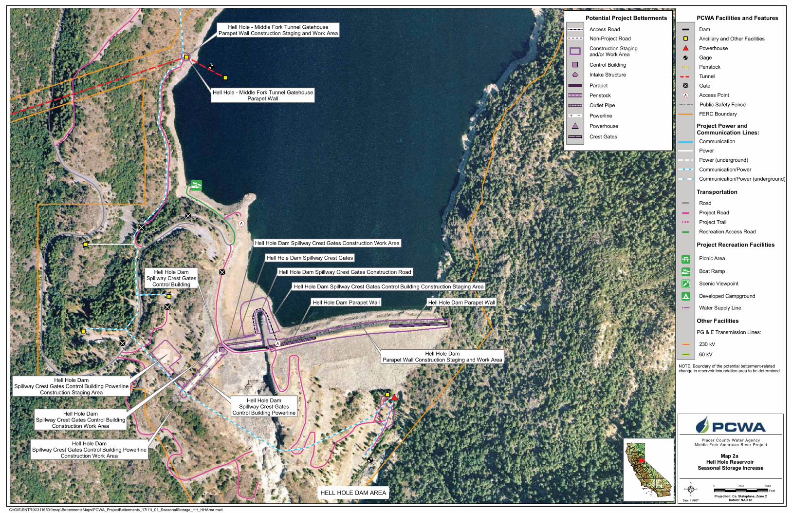
Map 2bHell Hole Reservoir
Seasonal Storage Increase
South Fork Diversion DamCrest Gates Generator Building
South Fork Diversion DamCrest Gates
South Fork Diversion DamCrest Gates and Generator Building
Construction Staging and Work Area
SOUTH FORK LONG CANYON AREA
PCWA Facilities and Features
Project Recreation Facilities
Water Supply Line
Developed Campground
Scenic Viewpoint
Boat Ramp
Picnic Area
PG & E Transmission Lines:
Other Facilities
60 kV
230 kV
Transportation
Recreation Access Road
Project Trail
Project Road
Road
FERC Boundary
Access Point
Gate
Tunnel
Penstock
Gage
Powerhouse
Ancillary and Other Facilities
Public Safety Fence
Dam
Project Power andCommunication Lines:
Communication/Power (underground)
Power (underground)
Power
Communication
Communication/Power
NOTE: Boundary of the potential betterment-relatedchange in reservoir innundation area to be determined
0 10050Feet
168
B
B
B
French Meadows PowerhouseParapet Wall
French MeadowsPowerhouse
French Meadows PowerhouseParapet Wall Construction Staging
and Work Area
FRENCH MEADOWS POWERHOUSE AREA
Potential Project Betterments
Control Building
Intake Structure
Parapet
Penstock
Outlet Pipe
Powerline
Powerhouse
Crest Gates
Access Road
Construction Staging and/or Work Area
Non-Project Road
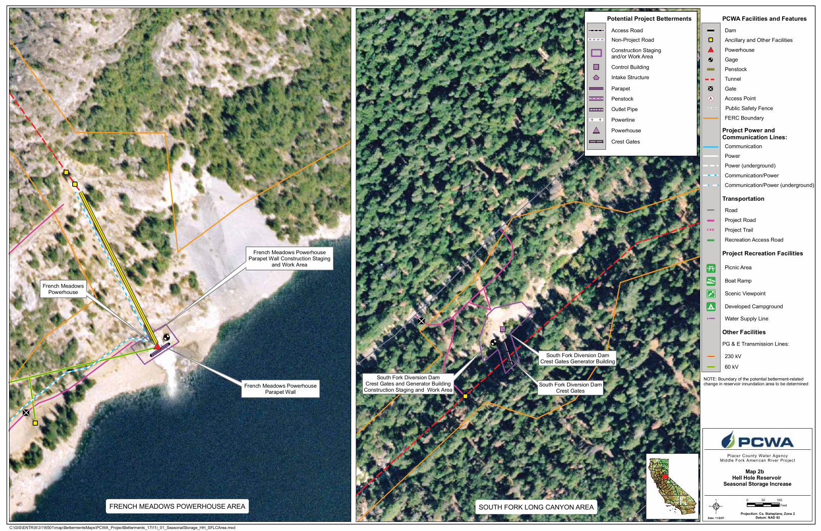
French Meadows - Hell Hole Tunnel
Hell HoleReservoir
French Meadows - Hell Hole TunnelIntake Trash Rack
French Meadows - Hell Hole TunnelIntake Trash Rack Construction Staging Area
French Meadows - Hell Hole TunnelIntake Trash Rack Construction Work Area
Forest Road 14N09AConstruction Staging and Work Area
French Meadows - Hell Hole TunnelIntake Trash Rack Construction Road
Date: 11/5/07Projection: Ca. Stateplane, Zone 2
Datum: NAD 83
Placer County Water AgencyMiddle Fork American River Pro jec t
0 0.50.25Miles
Z:\Entrix\3116501\map\BettermentsMaps\PCWA_ProjectBetterments_17i11i_01_PHupgrade_FM.mxd
Map 2cFrench Meadows
Powerhouse Capacity Upgrade
PCWA Facilities and Features
Project Recreation Facilities
Water Supply Line
Developed Campground
Scenic Viewpoint
Boat Ramp
Picnic Area
PG & E Transmission Lines:
Other Facilities
60 kV
230 kV
Transportation
Recreation Access Road
Project Trail
Project Road
Road
FERC Boundary
Access Point
Gate
Tunnel
Penstock
Gage
Powerhouse
Ancillary and Other Facilities
Public Safety Fence
Dam
Project Power andCommunication Lines:
Communication/Power (underground)
Power (underground)
Power
Communication
Communication/Power
French Meadows Powerhouse / SwitchyardConstruction Staging Area
French Meadows Powerhouse Penstock
French Meadows PowerhousePenstock Construction Work Area
French Meadows Powerhouse
French Meadows PowerhousePenstock Construction Staging Area
French Meadows Powerhouse / SwitchyardConstruction Staging Area
French Meadows Powerhouse / SwitchyardConstruction Work Area
Forest Road 14N09AConstruction Staging and Work Area
French Meadows Powerhouse Switchyard
French Meadows- Hell Hole Tunnel Surge PipelineConstruction Work Area
French Meadows- Hell Hole TunnelSurge Shaft or Pipeline Road Construction
Staging and Work Area
French Meadows- Hell Hole TunnelSurge Shaft or Pipeline Road
French Meadows - Hell Hole Tunnel Surge Pipeline
French Meadows - Hell Hole Tunnel Surge Shaft / Tank
French Meadows- Hell Hole TunnelSurge Shaft / Tank or Pipeline
Construction Staging Area
French Meadows PowerhousePenstock Construction Staging Area
French Meadows- Hell Hole TunnelSurge Shaft / Tank or Pipeline
Construction Staging Area
French Meadows - Hell Hole Tunnel Surge Shaft / TankConstruction Work Area
Forest Road 14N09A
168
B
B
B
Potential Project Betterments
Control Building
Intake Structure
Parapet
Penstock
Outlet Pipe
Surge Pipeline
Powerline
Powerhouse
Surge Shaft
Crest Gates
Access Road
Construction Stagingand/or Work Area
Non-Project Road
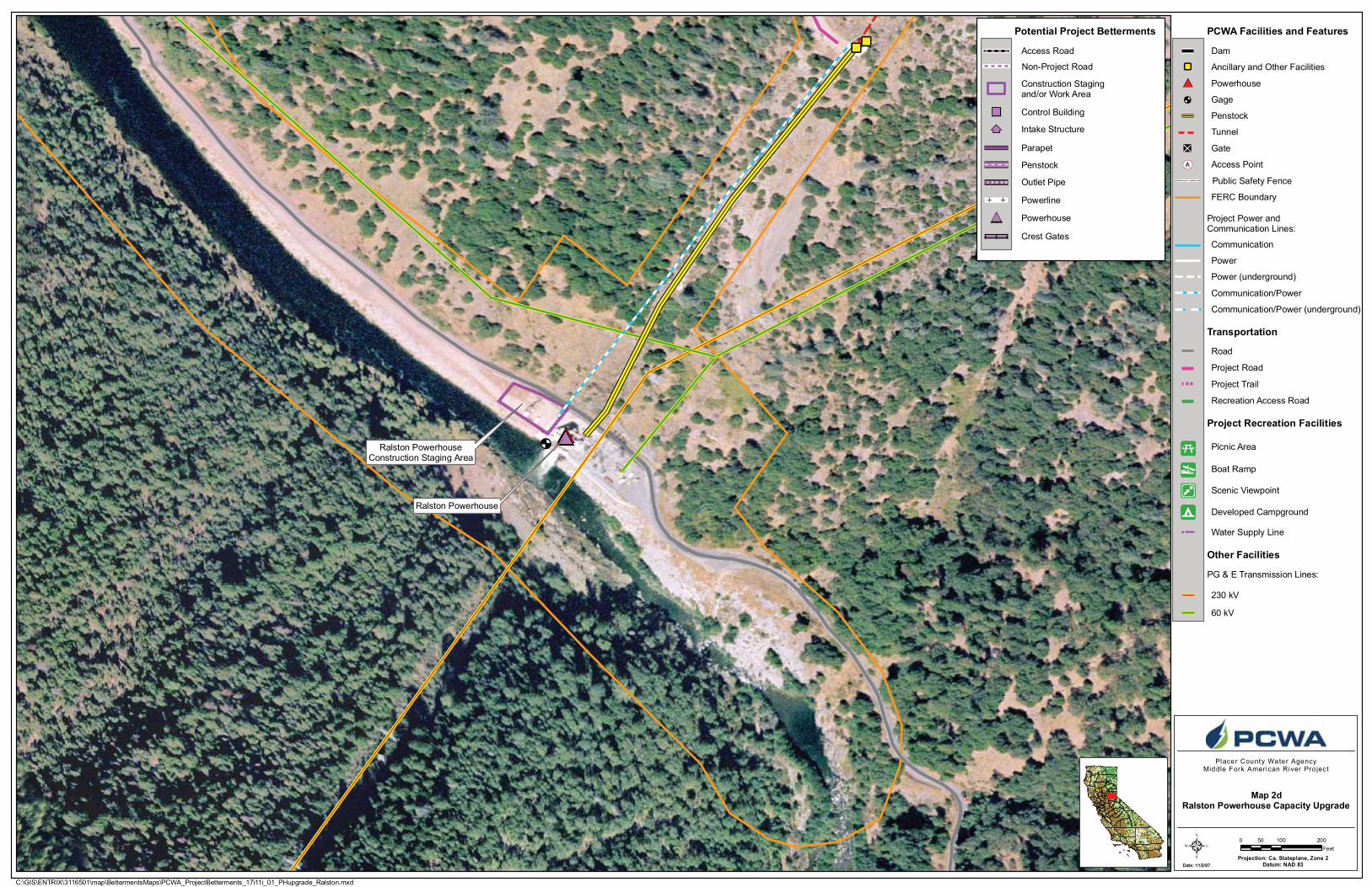
Ralston PowerhouseConstruction Staging Area
Ralston Powerhouse
Date: 11/2/07Projection: Ca. Stateplane, Zone 2
Datum: NAD 83
Placer County Water AgencyMiddle Fork American River Pro jec t
0 100 20050Feet
C:\GIS\ENTRIX\3116501\map\BettermentsMaps\PCWA_ProjectBetterments_17i11i_01_PHupgrade_Ralston.mxd
Map 2dRalston Powerhouse Capacity Upgrade
PCWA Facilities and Features
Project Recreation Facilities
Water Supply Line
Developed Campground
Scenic Viewpoint
Boat Ramp
Picnic Area
PG & E Transmission Lines:
Other Facilities
60 kV
230 kV
Transportation
Recreation Access Road
Project Trail
Project Road
Road
FERC Boundary
Access Point
Gate
Tunnel
Penstock
Gage
Powerhouse
Ancillary and Other Facilities
Public Safety Fence
Dam
Project Power andCommunication Lines:
Communication/Power (underground)
Power (underground)
Power
Communication
Communication/Power
168
B
B
B
Potential Project Betterments
Control Building
Intake Structure
Parapet
Penstock
Outlet Pipe
Powerline
Powerhouse
Crest Gates
Access Road
Construction Staging and/or Work Area
Non-Project Road
CONFIDENTIAL MAP 3
“Known Locations of CRLF in the Middle Fork American River Watershed” (from BA-BE Appendix D)
Map 3 has been removed from this document because it contains the location(s) of sensitive biological resources and is considered “confidential” information. Confidential biological resources information is located in Volume 4 which may not be made available to the public pursuant to the Federal Energy Regulatory Commission’s (FERC’s) regulations contained in 36 CFR 385.1112. This information is not maintained in FERC’s Public Reference Room or on the Commission’s electronic library except as an indexed item.
French MeadowsReservoir
Hell HoleReservoir
RalstonAfterbay
North F
ork A
merica
n Rive
r
Middle Fork American River
North Fork
of M
iddle For k A
meric
an R
iver
Dun
can
Creek
Long Canyon
N. F
k.
Long
Can
yon
S. Fk.
Mid
dle F
ork American River
Rubicon River
South Fork Rubicon R iver
Rubicon River
S
Middle ForkInterbay
Canyon Creek
Otter Creek
Pilot Creek
South Fork Long Canyon Diversion
North Fork Long Canyon Diversion
FORE S TH I L L
AU B U R N
French MeadowsDam
Hell HoleDam
Long
C
anyon
49
OxbowP.H.
RalstonP.H.
Middle ForkP.H.
French Meadows P.H.
Hell HoleP.H.
Stumpy MeadowsReservoir
Union ValleyReservoir
Map 4a
Map 4g
Map 4e
Map 4f
Map 4d
Map 4b
RalstonAfterbay
Dam
Map 4i
Five
Lak
es C
reek
North Fork American River
Map 4c
Map 4h
Interbay Dam
Duncan Creek Diversion
49
193
174
80
Date: 2/1/08
Projection: CA State Plane, Zone 2Datum: NAD 83
0 1 2 30.5Miles
Placer County Water AgencyMiddle Fork American River Pro jec t
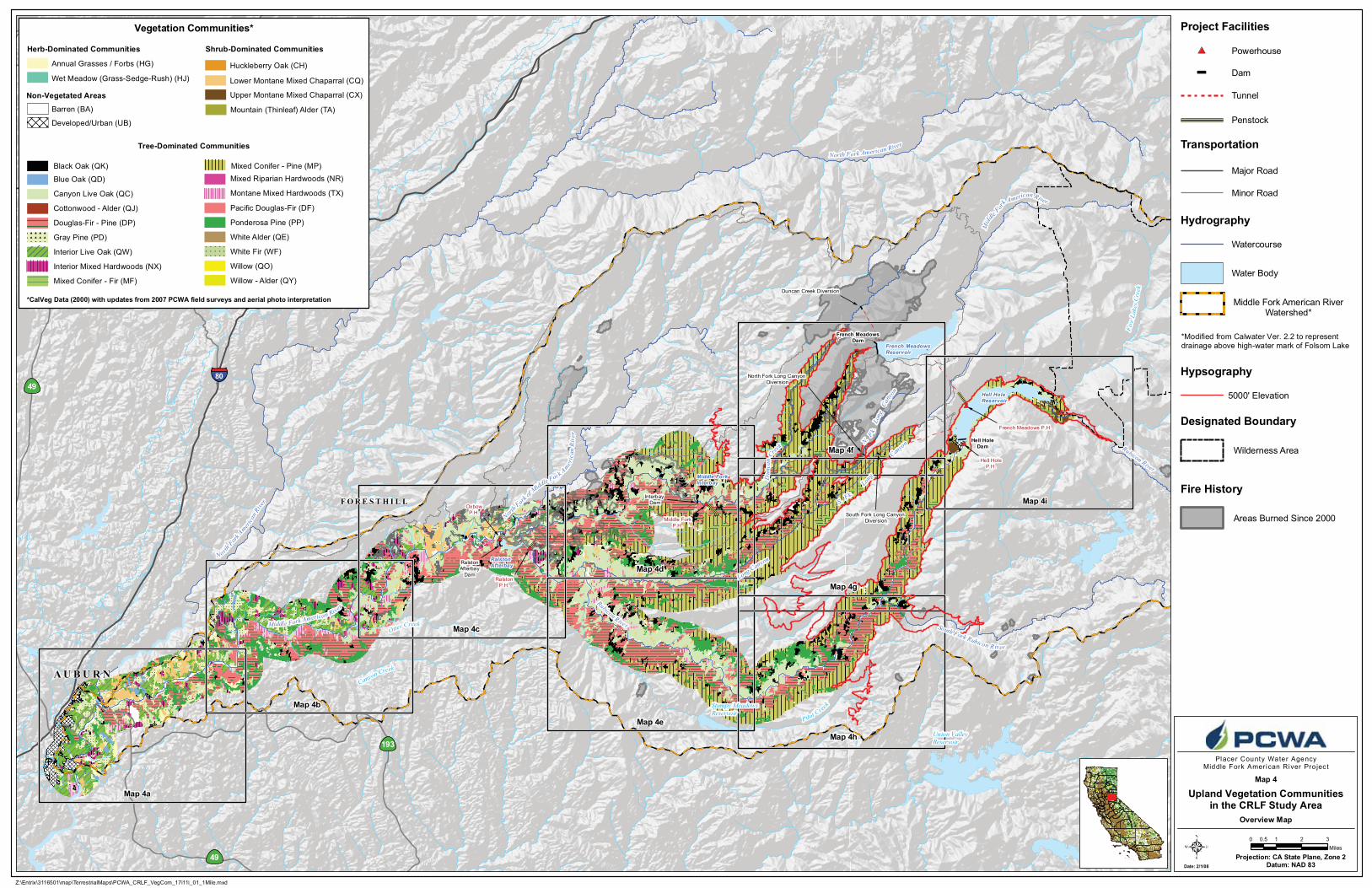
Upland Vegetation Communitiesin the CRLF Study Area
Map 4
Z:\Entrix\3116501\map\TerrestrialMaps\PCWA_CRLF_VegCom_17i11i_01_1Mile.mxd
Dam
Powerhouse
Transportation
Major Road
Minor Road
Watercourse
Water Body
Hydrography
Designated Boundary
Tunnel
Penstock
Wilderness Area
Middle Fork American RiverWatershed*
*Modified from Calwater Ver. 2.2 to representdrainage above high-water mark of Folsom Lake
Overview Map168
B
B
B
Fire History
Areas Burned Since 2000
Project Facilities
*CalVeg Data (2000) with updates from 2007 PCWA field surveys and aerial photo interpretation
Vegetation Communities*
Douglas-Fir - Pine (DP)
Willow (QO)
Willow - Alder (QY)
Mountain (Thinleaf) Alder (TA)
Pacific Douglas-Fir (DF)
White Fir (WF)
Mixed Conifer - Fir (MF)
Mixed Conifer - Pine (MP)
Ponderosa Pine (PP)
Gray Pine (PD)
Barren (BA)
Annual Grasses / Forbs (HG)
Wet Meadow (Grass-Sedge-Rush) (HJ) Lower Montane Mixed Chaparral (CQ)
Upper Montane Mixed Chaparral (CX)
Huckleberry Oak (CH)
Canyon Live Oak (QC)
Interior Live Oak (QW)
Black Oak (QK)
Interior Mixed Hardwoods (NX)
Mixed Riparian Hardwoods (NR)
Montane Mixed Hardwoods (TX)
Cottonwood - Alder (QJ)
White Alder (QE)
Developed/Urban (UB)
Herb-Dominated Communities Shrub-Dominated Communities
Tree-Dominated Communities
Non-Vegetated Areas
Blue Oak (QD)
5000' Elevation
Hypsography

North
For
k Am
erica
n Ri
ver
AU BURN
Middle Fork American River
49
Oregon Bar
Confluence Area
Murderer's Bar
Mammoth Bar
193
80
Date: 2/1/08
Projection: CA State Plane, Zone 2Datum: NAD 83
0 2,000 4,000
Feet
Placer County Water AgencyMiddle Fork American River Pro jec t
Project Facilities
Transportation
Hydrography
Z:\Entrix\3116501\map\TerrestrialMaps\PCWA_CRLF_VegCom_Tiles_17i11i_01_1Mile.mxd
Watercourse
Water Body
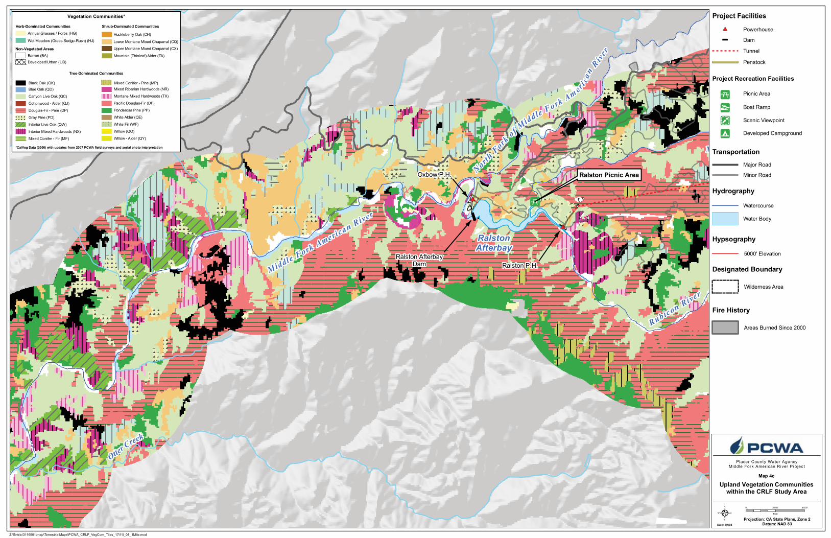
Upland Vegetation Communitieswithin the CRLF Study Area
Map 4a
*CalVeg Data (2000) with updates from 2007 PCWA field surveys and aerial photo interpretation
Vegetation Communities*
Douglas-Fir - Pine (DP)
Willow (QO)
Willow - Alder (QY)
Mountain (Thinleaf) Alder (TA)
Pacific Douglas-Fir (DF)
White Fir (WF)
Mixed Conifer - Fir (MF)
Mixed Conifer - Pine (MP)
Ponderosa Pine (PP)
Gray Pine (PD)
Barren (BA)
Annual Grasses / Forbs (HG)
Wet Meadow (Grass-Sedge-Rush) (HJ) Lower Montane Mixed Chaparral (CQ)
Upper Montane Mixed Chaparral (CX)
Huckleberry Oak (CH)
Canyon Live Oak (QC)
Interior Live Oak (QW)
Black Oak (QK)
Interior Mixed Hardwoods (NX)
Mixed Riparian Hardwoods (NR)
Montane Mixed Hardwoods (TX)
Cottonwood - Alder (QJ)
White Alder (QE)
Developed/Urban (UB)
Herb-Dominated Communities Shrub-Dominated Communities
Tree-Dominated Communities
Non-Vegetated Areas
Blue Oak (QD)
Designated Boundary
Wilderness Area
Fire History
Areas Burned Since 2000
5000' Elevation
Hypsography
Project Recreation Facilities
Picnic Area
Boat Ramp
Developed Campground
Scenic Viewpoint
Powerhouse
Dam
Tunnel
Penstock
Major Road
Minor Road

Middle Fork American River
Canyon Creek
Otter Creek
Drivers Flat
193
Date: 2/1/08
Projection: CA State Plane, Zone 2Datum: NAD 83
0 2,000 4,000
Feet
Placer County Water AgencyMiddle Fork American River Pro jec t
Project Facilities
Transportation
Hydrography
Z:\Entrix\3116501\map\TerrestrialMaps\PCWA_CRLF_VegCom_Tiles_17i11i_01_1Mile.mxd
Watercourse
Water Body
Upland Vegetation Communitieswithin the CRLF Study Area
Map 4b
*CalVeg Data (2000) with updates from 2007 PCWA field surveys and aerial photo interpretation
Vegetation Communities*
Douglas-Fir - Pine (DP)
Willow (QO)
Willow - Alder (QY)
Mountain (Thinleaf) Alder (TA)
Pacific Douglas-Fir (DF)
White Fir (WF)
Mixed Conifer - Fir (MF)
Mixed Conifer - Pine (MP)
Ponderosa Pine (PP)
Gray Pine (PD)
Barren (BA)
Annual Grasses / Forbs (HG)
Wet Meadow (Grass-Sedge-Rush) (HJ) Lower Montane Mixed Chaparral (CQ)
Upper Montane Mixed Chaparral (CX)
Huckleberry Oak (CH)
Canyon Live Oak (QC)
Interior Live Oak (QW)
Black Oak (QK)
Interior Mixed Hardwoods (NX)
Mixed Riparian Hardwoods (NR)
Montane Mixed Hardwoods (TX)
Cottonwood - Alder (QJ)
White Alder (QE)
Developed/Urban (UB)
Herb-Dominated Communities Shrub-Dominated Communities
Tree-Dominated Communities
Non-Vegetated Areas
Blue Oak (QD)
Designated Boundary
Wilderness Area
Fire History
Areas Burned Since 2000
5000' Elevation
Hypsography
Project Recreation Facilities
Picnic Area
Boat Ramp
Developed Campground
Scenic Viewpoint
Powerhouse
Dam
Tunnel
Penstock
Major Road
Minor Road
RalstonAfterbay
North F
ork o
f Middle Fork Am er
i can
Riv
er
Otter Creek
F O R E S T H I L L
Oxbow P.H.
Ralston P.H.
Rubicon River
Middle Fork American River
M
Ralston Picnic Area
Ralston AfterbayDam
Date: 2/1/08
Projection: CA State Plane, Zone 2Datum: NAD 83
0 2,000 4,000
Feet
Placer County Water AgencyMiddle Fork American River Pro jec t
Project Facilities
Transportation
Hydrography
Z:\Entrix\3116501\map\TerrestrialMaps\PCWA_CRLF_VegCom_Tiles_17i11i_01_1Mile.mxd
Watercourse
Water Body
Upland Vegetation Communitieswithin the CRLF Study Area
Map 4c
*CalVeg Data (2000) with updates from 2007 PCWA field surveys and aerial photo interpretation
Vegetation Communities*
Douglas-Fir - Pine (DP)
Willow (QO)
Willow - Alder (QY)
Mountain (Thinleaf) Alder (TA)
Pacific Douglas-Fir (DF)
White Fir (WF)
Mixed Conifer - Fir (MF)
Mixed Conifer - Pine (MP)
Ponderosa Pine (PP)
Gray Pine (PD)
Barren (BA)
Annual Grasses / Forbs (HG)
Wet Meadow (Grass-Sedge-Rush) (HJ) Lower Montane Mixed Chaparral (CQ)
Upper Montane Mixed Chaparral (CX)
Huckleberry Oak (CH)
Canyon Live Oak (QC)
Interior Live Oak (QW)
Black Oak (QK)
Interior Mixed Hardwoods (NX)
Mixed Riparian Hardwoods (NR)
Montane Mixed Hardwoods (TX)
Cottonwood - Alder (QJ)
White Alder (QE)
Developed/Urban (UB)
Herb-Dominated Communities Shrub-Dominated Communities
Tree-Dominated Communities
Non-Vegetated Areas
Blue Oak (QD)
Designated Boundary
Wilderness Area
Fire History
Areas Burned Since 2000
5000' Elevation
Hypsography
Project Recreation Facilities
Picnic Area
Boat Ramp
Developed Campground
Scenic Viewpoint
Powerhouse
Dam
Tunnel
Penstock
Major Road
Minor Road
rica
n
R iver
Middle ForkInterbay
Middle Fork P.H.
Middle Fork - Ralston Tunnel
H
Rubicon River
Middle Fork American River
Long Canyon
Interbay Dam
Date: 2/1/08
Projection: CA State Plane, Zone 2Datum: NAD 83
0 2,000 4,000
Feet
Placer County Water AgencyMiddle Fork American River Pro jec t
Project Facilities
Transportation
Hydrography
Z:\Entrix\3116501\map\TerrestrialMaps\PCWA_CRLF_VegCom_Tiles_17i11i_01_1Mile.mxd
Watercourse
Water Body
Upland Vegetation Communitieswithin the CRLF Study Area
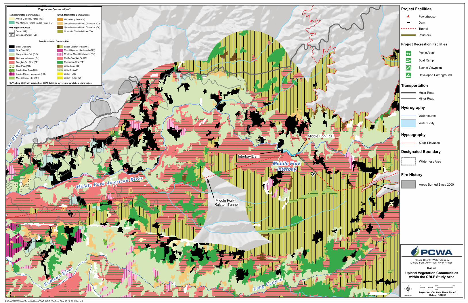
Map 4d
*CalVeg Data (2000) with updates from 2007 PCWA field surveys and aerial photo interpretation
Vegetation Communities*
Douglas-Fir - Pine (DP)
Willow (QO)
Willow - Alder (QY)
Mountain (Thinleaf) Alder (TA)
Pacific Douglas-Fir (DF)
White Fir (WF)
Mixed Conifer - Fir (MF)
Mixed Conifer - Pine (MP)
Ponderosa Pine (PP)
Gray Pine (PD)
Barren (BA)
Annual Grasses / Forbs (HG)
Wet Meadow (Grass-Sedge-Rush) (HJ) Lower Montane Mixed Chaparral (CQ)
Upper Montane Mixed Chaparral (CX)
Huckleberry Oak (CH)
Canyon Live Oak (QC)
Interior Live Oak (QW)
Black Oak (QK)
Interior Mixed Hardwoods (NX)
Mixed Riparian Hardwoods (NR)
Montane Mixed Hardwoods (TX)
Cottonwood - Alder (QJ)
White Alder (QE)
Developed/Urban (UB)
Herb-Dominated Communities Shrub-Dominated Communities
Tree-Dominated Communities
Non-Vegetated Areas
Blue Oak (QD)
Designated Boundary
Wilderness Area
Fire History
Areas Burned Since 2000
5000' Elevation
Hypsography
Project Recreation Facilities
Picnic Area
Boat Ramp
Developed Campground
Scenic Viewpoint
Powerhouse
Dam
Tunnel
Penstock
Major Road
Minor Road

Stumpy MeadowsReservoir
Pilot Creek
Rubicon River
Rubicon River
Long Canyon
Date: 2/1/08
Projection: CA State Plane, Zone 2Datum: NAD 83
0 2,000 4,000
Feet
Placer County Water AgencyMiddle Fork American River Pro jec t
Project Facilities
Transportation
Hydrography
Z:\Entrix\3116501\map\TerrestrialMaps\PCWA_CRLF_VegCom_Tiles_17i11i_01_1Mile.mxd
Watercourse
Water Body
Upland Vegetation Communitieswithin the CRLF Study Area
Map 4e
*CalVeg Data (2000) with updates from 2007 PCWA field surveys and aerial photo interpretation
Vegetation Communities*
Douglas-Fir - Pine (DP)
Willow (QO)
Willow - Alder (QY)
Mountain (Thinleaf) Alder (TA)
Pacific Douglas-Fir (DF)
White Fir (WF)
Mixed Conifer - Fir (MF)
Mixed Conifer - Pine (MP)
Ponderosa Pine (PP)
Gray Pine (PD)
Barren (BA)
Annual Grasses / Forbs (HG)
Wet Meadow (Grass-Sedge-Rush) (HJ) Lower Montane Mixed Chaparral (CQ)
Upper Montane Mixed Chaparral (CX)
Huckleberry Oak (CH)
Canyon Live Oak (QC)
Interior Live Oak (QW)
Black Oak (QK)
Interior Mixed Hardwoods (NX)
Mixed Riparian Hardwoods (NR)
Montane Mixed Hardwoods (TX)
Cottonwood - Alder (QJ)
White Alder (QE)
Developed/Urban (UB)
Herb-Dominated Communities Shrub-Dominated Communities
Tree-Dominated Communities
Non-Vegetated Areas
Blue Oak (QD)
Designated Boundary
Wilderness Area
Fire History
Areas Burned Since 2000
5000' Elevation
Hypsography
Project Recreation Facilities
Picnic Area
Boat Ramp
Developed Campground
Scenic Viewpoint
Powerhouse
Dam
Tunnel
Penstock
Major Road
Minor Road
French MeadowsReservoir
Duncan
Cree
k
N.
Fk. Long Canyon
South Fork Long Canyon Diversion Dam
North ForkLong Canyon Diversion Dam
FrenchMeadows
Dam
French Meadows - Hell Hole Tunnel
S.Fk.
Long
Canyo
n
Mid
dle F
ork
Amer
ican
Rive
r
Middle MeadowsGroup Campground
Date: 2/1/08
Projection: CA State Plane, Zone 2Datum: NAD 83
0 2,000 4,000
Feet
Placer County Water AgencyMiddle Fork American River Pro jec t
Project Facilities
Transportation
Hydrography
Z:\Entrix\3116501\map\TerrestrialMaps\PCWA_CRLF_VegCom_Tiles_17i11i_01_1Mile.mxd
Watercourse
Water Body
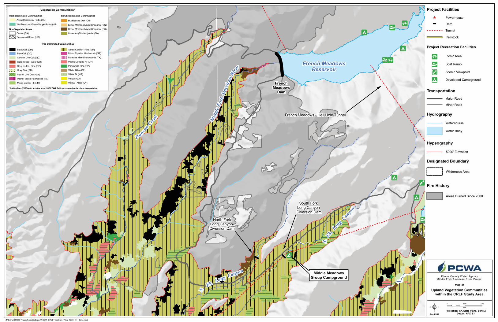
Upland Vegetation Communitieswithin the CRLF Study Area
Map 4f
*CalVeg Data (2000) with updates from 2007 PCWA field surveys and aerial photo interpretation
Vegetation Communities*
Douglas-Fir - Pine (DP)
Willow (QO)
Willow - Alder (QY)
Mountain (Thinleaf) Alder (TA)
Pacific Douglas-Fir (DF)
White Fir (WF)
Mixed Conifer - Fir (MF)
Mixed Conifer - Pine (MP)
Ponderosa Pine (PP)
Gray Pine (PD)
Barren (BA)
Annual Grasses / Forbs (HG)
Wet Meadow (Grass-Sedge-Rush) (HJ) Lower Montane Mixed Chaparral (CQ)
Upper Montane Mixed Chaparral (CX)
Huckleberry Oak (CH)
Canyon Live Oak (QC)
Interior Live Oak (QW)
Black Oak (QK)
Interior Mixed Hardwoods (NX)
Mixed Riparian Hardwoods (NR)
Montane Mixed Hardwoods (TX)
Cottonwood - Alder (QJ)
White Alder (QE)
Developed/Urban (UB)
Herb-Dominated Communities Shrub-Dominated Communities
Tree-Dominated Communities
Non-Vegetated Areas
Blue Oak (QD)
Designated Boundary
Wilderness Area
Fire History
Areas Burned Since 2000
5000' Elevation
Hypsography
Project Recreation Facilities
Picnic Area
Boat Ramp
Developed Campground
Scenic Viewpoint
Powerhouse
Dam
Tunnel
Penstock
Major Road
Minor Road
N.
Fk. Long Canyon
.H.
Hell Hole - Middle Fork Tunnel
Rubi
con
Rive
r
Long Canyon
S.
Fk. Long C
anyon
Middle MeadowsGroup Campground
Date: 2/1/08
Projection: CA State Plane, Zone 2Datum: NAD 83
0 2,000 4,000
Feet
Placer County Water AgencyMiddle Fork American River Pro jec t
Project Facilities
Transportation
Hydrography
Z:\Entrix\3116501\map\TerrestrialMaps\PCWA_CRLF_VegCom_Tiles_17i11i_01_1Mile.mxd
Watercourse
Water Body
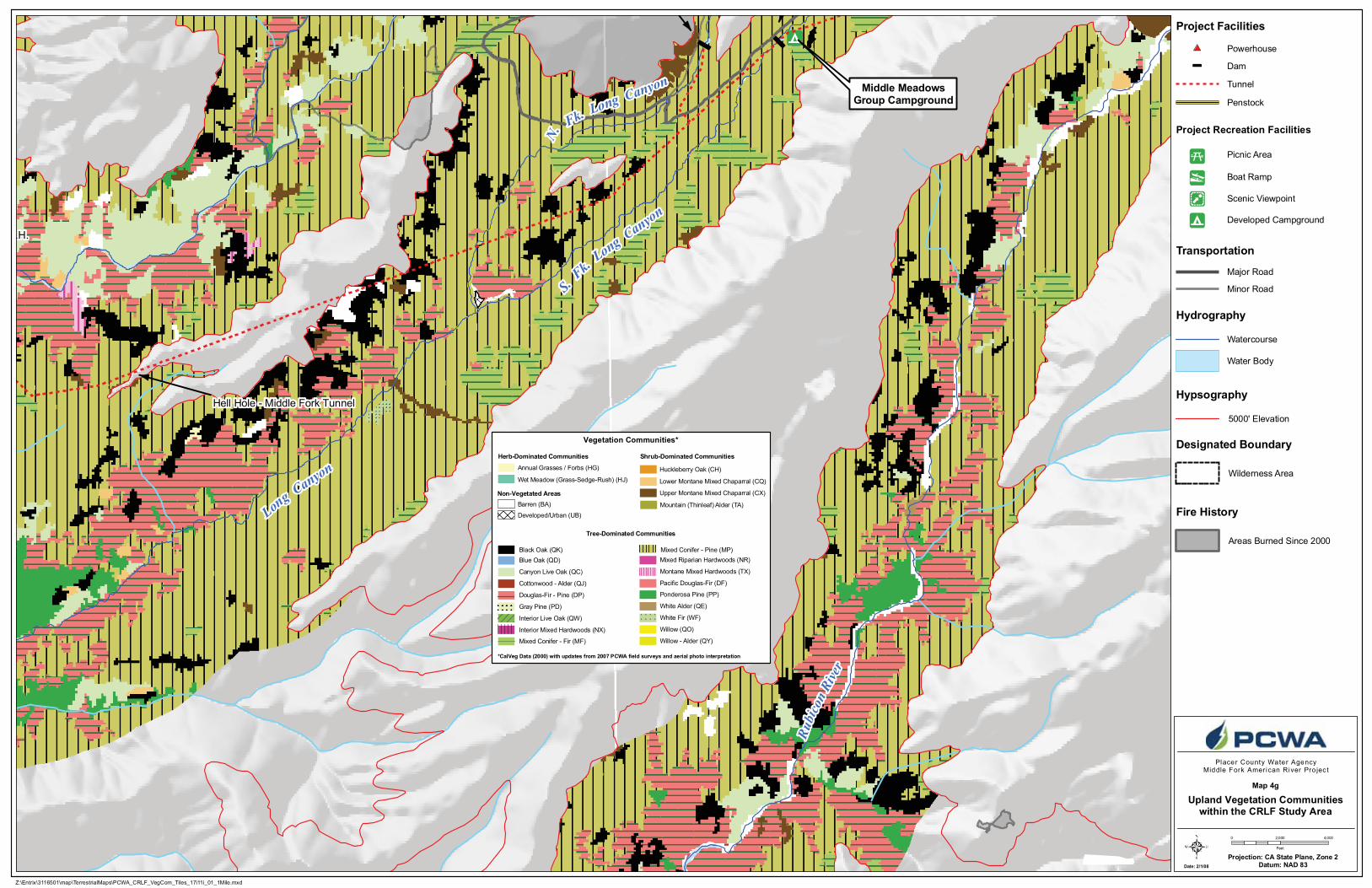
Upland Vegetation Communitieswithin the CRLF Study Area
Map 4g
*CalVeg Data (2000) with updates from 2007 PCWA field surveys and aerial photo interpretation
Vegetation Communities*
Douglas-Fir - Pine (DP)
Willow (QO)
Willow - Alder (QY)
Mountain (Thinleaf) Alder (TA)
Pacific Douglas-Fir (DF)
White Fir (WF)
Mixed Conifer - Fir (MF)
Mixed Conifer - Pine (MP)
Ponderosa Pine (PP)
Gray Pine (PD)
Barren (BA)
Annual Grasses / Forbs (HG)
Wet Meadow (Grass-Sedge-Rush) (HJ) Lower Montane Mixed Chaparral (CQ)
Upper Montane Mixed Chaparral (CX)
Huckleberry Oak (CH)
Canyon Live Oak (QC)
Interior Live Oak (QW)
Black Oak (QK)
Interior Mixed Hardwoods (NX)
Mixed Riparian Hardwoods (NR)
Montane Mixed Hardwoods (TX)
Cottonwood - Alder (QJ)
White Alder (QE)
Developed/Urban (UB)
Herb-Dominated Communities Shrub-Dominated Communities
Tree-Dominated Communities
Non-Vegetated Areas
Blue Oak (QD)
Designated Boundary
Wilderness Area
Fire History
Areas Burned Since 2000
5000' Elevation
Hypsography
Project Recreation Facilities
Picnic Area
Boat Ramp
Developed Campground
Scenic Viewpoint
Powerhouse
Dam
Tunnel
Penstock
Major Road
Minor Road

Rubicon River
Ellicott Bridge
Date: 2/1/08
Projection: CA State Plane, Zone 2Datum: NAD 83
0 2,000 4,000
Feet
Placer County Water AgencyMiddle Fork American River Pro jec t
Project Facilities
Transportation
Hydrography
Z:\Entrix\3116501\map\TerrestrialMaps\PCWA_CRLF_VegCom_Tiles_17i11i_01_1Mile.mxd
Watercourse
Water Body
Upland Vegetation Communitieswithin the CRLF Study Area
Map 4h
*CalVeg Data (2000) with updates from 2007 PCWA field surveys and aerial photo interpretation
Vegetation Communities*
Douglas-Fir - Pine (DP)
Willow (QO)
Willow - Alder (QY)
Mountain (Thinleaf) Alder (TA)
Pacific Douglas-Fir (DF)
White Fir (WF)
Mixed Conifer - Fir (MF)
Mixed Conifer - Pine (MP)
Ponderosa Pine (PP)
Gray Pine (PD)
Barren (BA)
Annual Grasses / Forbs (HG)
Wet Meadow (Grass-Sedge-Rush) (HJ) Lower Montane Mixed Chaparral (CQ)
Upper Montane Mixed Chaparral (CX)
Huckleberry Oak (CH)
Canyon Live Oak (QC)
Interior Live Oak (QW)
Black Oak (QK)
Interior Mixed Hardwoods (NX)
Mixed Riparian Hardwoods (NR)
Montane Mixed Hardwoods (TX)
Cottonwood - Alder (QJ)
White Alder (QE)
Developed/Urban (UB)
Herb-Dominated Communities Shrub-Dominated Communities
Tree-Dominated Communities
Non-Vegetated Areas
Blue Oak (QD)
Designated Boundary
Wilderness Area
Fire History
Areas Burned Since 2000
5000' Elevation
Hypsography
Project Recreation Facilities
Picnic Area
Boat Ramp
Developed Campground
Scenic Viewpoint
Powerhouse
Dam
Tunnel
Penstock
Major Road
Minor Road

Hell HoleReservoir
Rubicon RiverHell Hole Dam
French Meadows P.H.
Hell Hole P.H.
French Meadows - Hell Hole Tunnel
Upper Hell Hole Campground
Hell Hole Boat Ramp
Date: 2/1/08
Projection: CA State Plane, Zone 2Datum: NAD 83
0 2,000 4,000
Feet
Placer County Water AgencyMiddle Fork American River Pro jec t
Project Facilities
Transportation
Hydrography
Z:\Entrix\3116501\map\TerrestrialMaps\PCWA_CRLF_VegCom_Tiles_17i11i_01_1Mile.mxd
Watercourse
Water Body
Upland Vegetation Communitieswithin the CRLF Study Area
Map 4i
*CalVeg Data (2000) with updates from 2007 PCWA field surveys and aerial photo interpretation
Vegetation Communities*
Douglas-Fir - Pine (DP)
Willow (QO)
Willow - Alder (QY)
Mountain (Thinleaf) Alder (TA)
Pacific Douglas-Fir (DF)
White Fir (WF)
Mixed Conifer - Fir (MF)
Mixed Conifer - Pine (MP)
Ponderosa Pine (PP)
Gray Pine (PD)
Barren (BA)
Annual Grasses / Forbs (HG)
Wet Meadow (Grass-Sedge-Rush) (HJ) Lower Montane Mixed Chaparral (CQ)
Upper Montane Mixed Chaparral (CX)
Huckleberry Oak (CH)
Canyon Live Oak (QC)
Interior Live Oak (QW)
Black Oak (QK)
Interior Mixed Hardwoods (NX)
Mixed Riparian Hardwoods (NR)
Montane Mixed Hardwoods (TX)
Cottonwood - Alder (QJ)
White Alder (QE)
Developed/Urban (UB)
Herb-Dominated Communities Shrub-Dominated Communities
Tree-Dominated Communities
Non-Vegetated Areas
Blue Oak (QD)
Designated Boundary
Wilderness Area
Fire History
Areas Burned Since 2000
5000' Elevation
Hypsography
Project Recreation Facilities
Picnic Area
Boat Ramp
Developed Campground
Scenic Viewpoint
Powerhouse
Dam
Tunnel
Penstock
Major Road
Minor Road

French MeadowsReservoir
Hell HoleReservoir
E L D O R A D O C O U N T Y
P L A C E R C O U N T Y
RalstonAfterbay
Middle Fk. American
R.
North F
ork o f M
iddl
e Fo
rk A
mer
ican
R
iver
Dun
can C
reek
Long C anyon
N.
Fk. Lon
g C
anyo
n
S. Fk.
Midd
le Fork American River
Fiv
e Lak
es C
reek
South Fork Rubicon River
Ba s si F
ork
Rubicon River
Silver C
reekSouth Fork Ame r ican Rive r
Middle ForkInterbay
Canyon CreekOtter Creek
Pilo t C reek
South Fork Long Canyon Diversion
North Fork Long Canyon Diversion
AU B U R N
P L AC E RV I L L E
French MeadowsDam
Hell HoleDam
Long
Can
yon
49
OxbowP.H.
RalstonP.H.
Middle ForkP.H.
French Meadows P.H.
Hell HoleP.H.
Stumpy MeadowsReservoir Union Valley
Reservoir
Ice HouseReservoir
Loon LakeHorseshoeBar Ponds
MF A R REACH 3
MFAR RE A
CH
2
Gas
Can
yo
n
Todd
Creek
America
n C anyo
n Cr.
Wallace Canyon
Brush y Can yon
MFAR REA CH 1
North
For
k A
merican R
iver
FolsomLake
Jesse Canyon Cr.
Pond Cr.
Volc
an
o Canyon Cr.
F OR E S TH I L L
Interbay Dam
Ralston AfterbayDam
Duncan Creek Diversion
49
193
174
Pond "A"
Pond "B"
Tiechert MinePonds
Ralston RidgePond
80
50
Date: 2/13/08
Projection: CA State Plane, Zone 2Datum: NAD 83
0 1 2 3
Miles
Placer County Water AgencyMiddle Fork American River Pro jec t
Project Facilities
Dam
Powerhouse
Transportation
Major Road
Minor Road
Watercourse
Water Body
County Boundary
Hydrography
Designated Boundary
Tunnel
Penstock
Map 5
Wilderness Area
Middle Fork American RiverWatershed*
*Modified from Calwater Ver. 2.2 to representdrainage above high-water mark of Folsom Lake
Pond "C" Pond "G"
Pond "F"
Pond "E"
Pond "D"
South Lake
Pond Locations
168
B
B
B
Z:\Entrix\3116501\map\TerrestrialMaps\PCWA_CRLF_2007Survey_17i11i_02.mxd
2007 CRLF Survey Data
CRLF Study Area**
Rivers, Creeks, Reservoirs,Diversion Pools, and Off-Channel Ponds
in the CRLF Study Area
** Within one mile of MFP andunder 5000' elevation
5000' Elevation
Horseshoe Bar Ponds