Embed Size (px)
Citation preview
POTENTIALS OF GLOBAL POSITIONING SYSTEM FOR METEOROLOGY IN LOW-
LATITUDE REGIONS
AMIR SHARIFUDDIN BIN AB LATIP
UNIVERSITI TEKNOLOGI MALAYSIA
POTENTIALS OF GLOBAL POSITIONING SYSTEM FOR METEOROLOGY IN
LOW-LATITUDE REGIONS
AMIR SHARIFUDDIN B AB LATIP
A thesis submitted in fulfilment of the
requirements for the award of the degree of
Master of Science (Geomatic Engineering)
Faculty of Geoinformation and Real Estate
Universiti Teknologi Malaysia
SEPTEMBER 2012

iii
Dedicated to
My precious parents,Ab Latip B Buyong and Jamaaiah Bt Ismail
My loving wife,Sharifah Ainul Mardhiah Bt Syed Shahar
iv
ACKNOWLEDGEMENT
Praise and thanks must be given first to the Almighty Allah who has provided me
with health, opportunity and knowledge to complete this thesis.
I would like to express my sincere gratitude to my supervisor Dr Tajul Ariffin
Musa who guidance me during this study period. His encouragement, constructive
criticism, spirit and personal support have greatly contributed to complete this thesis. I
am also very thankful to my co-supervisor Professor Dr. Halim Setan for his valuable
discussions.
I am truly grateful to my parents, brothers (Amir, Boan, Faez) and young sister
(Nur) for their prayed for my health and brilliant future. I would like to give my special
appreciation to my wife for her patience, understanding and encouraging me to complete
this work. I would like to extent my special appreciation to my mother-in-law (Mak Ani)
and father-in-law (Abah Ar) for their constant support and prayer.
I would like to express my appreciation to all my G&G friends (Yong, Leong,
Faiz, Firdaus, Faiz Pa’suya, Amin, Khidir, Meng Chan, Anom and Su) for their helping
and suggestion to complete this thesis. I also want to thank Pak Uteh Madon, Ami,
Haizul, Fazrul, Yaakob, Tang and Azis for all their great help during the difficult times.
I would also like to express my sincere appreciation to all others who have played a part
in contribution of success of this research project. May Allah bless all of you.
v
ABSTRACT
Water vapor plays an important role in weather forecasting and climatemonitoring, particularly in low-latitude regions which contain large amount andinhomogeneous water vapor. The Global Positioning System (GPS) has the ability toprovide observations of water vapor continuously and more frequently for wide areaswith high accuracy in all weather conditions. The GPS continuously operatingreference station (CORS) data processing allows the estimation of zenith path delay(ZPD) from the GPS CORS network and will be further processed into integratedwater vapor (IWV) using surface meteorological data. This research aims to studythe potential of using the GPS for meteorology applications in low-latitude regions.In this study, the ZPD values from Australia and Peninsular Malaysia were derivedin order to investigate the variability of water vapor in these two regions. Besides,the continuous result of the GPS-derived IWV assessment with radiosonde-derivedIWV for one year data in Peninsular Malaysia are also discussed. Based on theanalysis of the ZPD from the two regions, the water vapor is high and its change israpid in Peninsular Malaysia. The quality of the ZPD obtained was compared to theInternational GNSS Service (IGS) troposphere products; the root mean square(RMS) errors of the GPS-derived ZPD are in the range of 4 to 12 mm. Meanwhile,the large amount of IWV and its variability in Peninsular Malaysia shows a closerelationship with the monsoon seasons in this area. Four GPS stations close toradiosonde stations were assessed; the RMS errors of the GPS-derived IWV are3.447 kg/m2, 3.786 kg/m2, 4.122 kg/m2 and 4.253kg/m2 and their linear correlationcoefficients are 0.877, 0.797, 0.851 and 0.849, respectively. This strong correlationshows that there is potential to develop a real-time GPS IWV system in PeninsularMalaysia. This study also reports on an initial development of real-time GPS IWVsystem known as UTM GPS-MET which was designed starting from data collection,data processing and results dissemination. Several tests on this initial system foundthat the total time delay in UTM GPS-MET from data collection until the resultdissemination is within one minute and 37 seconds, the time period which cansupport the real-time GPS IWV application.
vi
ABSTRAK
Wap air memainkan peranan sangat penting dalam peramalan cuaca danpemantauan iklim, terutama di kawasan latitud rendah yang mengandungi wap airyang tinggi dan tidak seragam. Sistem Penentududukan Global (GPS) mempunyaikeupayaan mencerap wap air secara berterusan dengan lebih kerap bagi kawasanyang luas dengan ketepatan yang tinggi dalam semua keadaan cuaca. Pemprosesandata GPS dari stesen rujukan yang beroperasi secara terus (CORS) membolehkanpenganggaran lewatan laluan zenith (ZPD) dari rangkaian GPS CORS seterusnyadiproses untuk mendapatkan integrasi kandungan wap air (IWV) menggunakan datameteorologi permukaan. Penyelidikan ini bertujuan mengkaji potensi penggunaanGPS untuk aplikasi meteorologi di kawasan latitud rendah. Dalam kajian ini, nilaiZPD dari Australia dan Semenanjung Malaysia telah diperoleh bagi mengkajiperubahan wap air di kedua-dua rantau ini. Selain itu, hasil penilaian GPS IWVdengan belon kaji cuaca IWV secara berterusan bagi tempoh setahun diSemenanjung Malaysia turut dibincangkan. Berdasarkan analisis ZPD dari kedua-duarantau ini, wap air adalah tinggi dan perubahannya adalah pantas di SemenanjungMalaysia. Kualiti ZPD yang diperoleh telah dibandingkan dengan ZPD daripadaInternational GNSS Service (IGS); ralat punca min kuasa dua (RMS) untuk GPSZPD yang diperoleh adalah dalam lingkungan 4 mm hingga 12 mm. Sementara itu,jumlah IWV yang tinggi serta perubahannya di Semenanjung Malaysia telahmenunjukkan hubungan yang rapat dengan musim monsun di kawasan ini. Empatstesen GPS yang berdekatan dengan stesen belon kaji cuaca telah dinilai; ralat RMSuntuk GPS IWV yang diperoleh adalah 3.447 kg/m2, 3.786 kg/m2, 4.122 kg/m2 dan4.253 kg/m2 dengan pekali korelasi linear masing-masing ialah 0.877, 0.797, 0.851dan 0.849. Korelasi yang tinggi ini menunjukkan terdapat potensi untukmembangunkan sistem GPS IWV dalam masa hakiki di SemenanjungMalaysia. Kajian ini juga melaporkan pembangunan awalan sistem GPS IWV dalammasa hakiki dikenali sebagai sistem UTM GPS-MET yang direkabentuk bermuladari pengumpulan data, pemprosesan data dan penyebaran hasil. Beberapa ujian keatas sistem awalan ini mendapati bahawa jumlah lewatan masa sistem UTM GPS-MET dari proses pengumpulan data sehingga penyebaran hasil adalah dalam jangkamasa 1 minit 37 saat, iaitu tempoh masa yang dapat menyokong aplikasi GPS IWVdalam masa hakiki.

vii
TABLE OF CONTENTS
CHAPTER TITLE PAGE
DECLARATION ii
DEDICATION iii
ACKNOWLEDGEMENT iv
ABSTRACT v
ABSTRAK vi
TABLE OF CONTENTS vii
LIST OF TABLES xi
LIST OF FIGURES xiii
LIST OF ABBREVIATIONS xviii
LIST OF SYMBOLS xxi
LIST OF APPENDICES xxiv
1 INTRODUCTION 1
1.1 Atmospheric Water Vapor: Distribution &
Measurement Techniques
1
1.2 Problem Statement 7
1.3 Research Objectives 9
1.4 Research Scopes 10
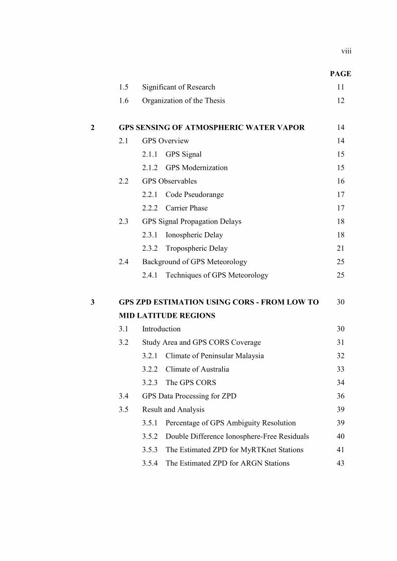
viii
PAGE
1.5 Significant of Research 11
1.6 Organization of the Thesis 12
2 GPS SENSING OF ATMOSPHERIC WATER VAPOR 14
2.1 GPS Overview 14
2.1.1 GPS Signal 15
2.1.2 GPS Modernization 15
2.2 GPS Observables 16
2.2.1 Code Pseudorange 17
2.2.2 Carrier Phase 17
2.3 GPS Signal Propagation Delays 18
2.3.1 Ionospheric Delay 18
2.3.2 Tropospheric Delay 21
2.4 Background of GPS Meteorology 25
2.4.1 Techniques of GPS Meteorology 25
3 GPS ZPD ESTIMATION USING CORS - FROM LOW TO
MID LATITUDE REGIONS
30
3.1 Introduction 30
3.2 Study Area and GPS CORS Coverage 31
3.2.1 Climate of Peninsular Malaysia 32
3.2.2 Climate of Australia 33
3.2.3 The GPS CORS 34
3.4 GPS Data Processing for ZPD 36
3.5 Result and Analysis 39
3.5.1 Percentage of GPS Ambiguity Resolution 39
3.5.2 Double Difference Ionosphere-Free Residuals 40
3.5.3 The Estimated ZPD for MyRTKnet Stations 41
3.5.4 The Estimated ZPD for ARGN Stations 43
ix
PAGE
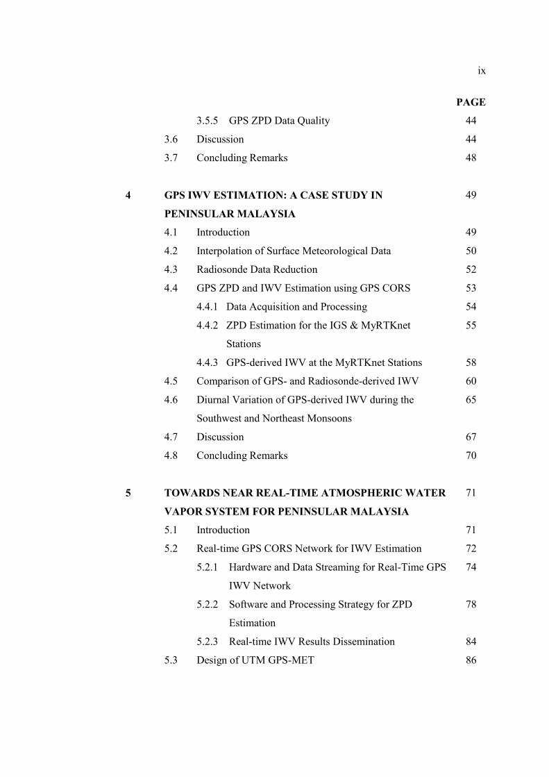
3.5.5 GPS ZPD Data Quality 44
3.6 Discussion 44
3.7 Concluding Remarks 48
4 GPS IWV ESTIMATION: A CASE STUDY IN
PENINSULAR MALAYSIA
49
4.1 Introduction 49
4.2 Interpolation of Surface Meteorological Data 50
4.3 Radiosonde Data Reduction 52
4.4 GPS ZPD and IWV Estimation using GPS CORS 53
4.4.1 Data Acquisition and Processing 54
4.4.2 ZPD Estimation for the IGS & MyRTKnet
Stations
55
4.4.3 GPS-derived IWV at the MyRTKnet Stations 58
4.5 Comparison of GPS- and Radiosonde-derived IWV 60
4.6 Diurnal Variation of GPS-derived IWV during the
Southwest and Northeast Monsoons
65
4.7 Discussion 67
4.8 Concluding Remarks 70
5 TOWARDS NEAR REAL-TIME ATMOSPHERIC WATER
VAPOR SYSTEM FOR PENINSULAR MALAYSIA
71
5.1 Introduction 71
5.2 Real-time GPS CORS Network for IWV Estimation 72
5.2.1 Hardware and Data Streaming for Real-Time GPS
IWV Network
74
5.2.2 Software and Processing Strategy for ZPD
Estimation
78
5.2.3 Real-time IWV Results Dissemination 84
5.3 Design of UTM GPS-MET 86
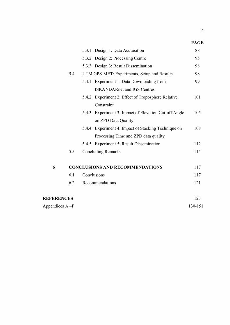
x
PAGE
5.3.1 Design 1: Data Acquisition 88
5.3.2 Design 2: Processing Centre 95
5.3.3 Design 3: Result Dissemination 98
5.4 UTM GPS-MET: Experiments, Setup and Results 98
5.4.1 Experiment 1: Data Downloading from
ISKANDARnet and IGS Centres
99
5.4.2 Experiment 2: Effect of Troposphere Relative
Constraint
101
5.4.3 Experiment 3: Impact of Elevation Cut-off Angle
on ZPD Data Quality
105
5.4.4 Experiment 4: Impact of Stacking Technique on
Processing Time and ZPD data quality
108
5.4.5 Experiment 5: Result Dissemination 112
5.5 Concluding Remarks 115
6 CONCLUSIONS AND RECOMMENDATIONS 117
6.1 Conclusions 117
6.2 Recommendations 121
REFERENCES 123
Appendices A –F 130-151
xi
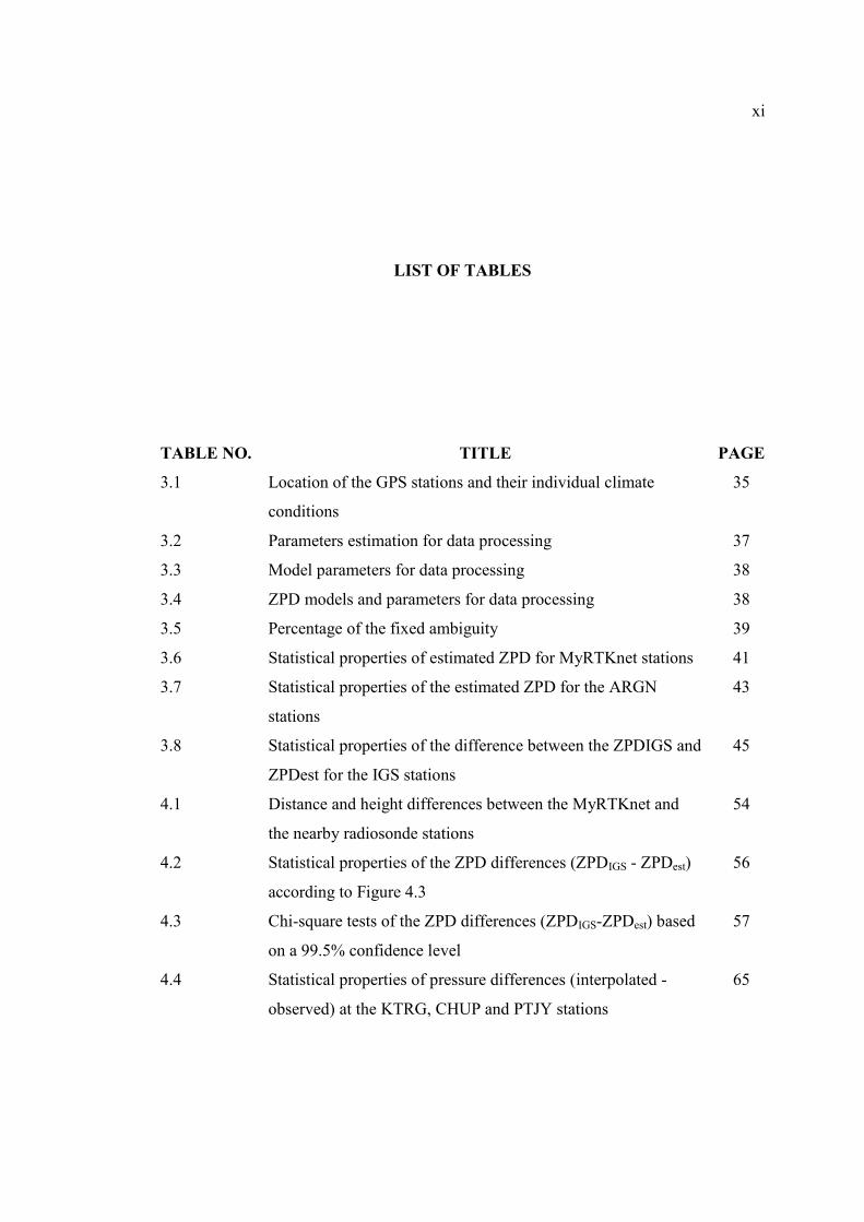
LIST OF TABLES
TABLE NO. TITLE PAGE
3.1 Location of the GPS stations and their individual climate
conditions
35
3.2 Parameters estimation for data processing 37
3.3 Model parameters for data processing 38
3.4 ZPD models and parameters for data processing 38
3.5 Percentage of the fixed ambiguity 39
3.6 Statistical properties of estimated ZPD for MyRTKnet stations 41
3.7 Statistical properties of the estimated ZPD for the ARGN
stations
43
3.8 Statistical properties of the difference between the ZPDIGS and
ZPDest for the IGS stations
45
4.1 Distance and height differences between the MyRTKnet and
the nearby radiosonde stations
54
4.2 Statistical properties of the ZPD differences (ZPDIGS - ZPDest)
according to Figure 4.3
56
4.3 Chi-square tests of the ZPD differences (ZPDIGS-ZPDest) based
on a 99.5% confidence level
57
4.4 Statistical properties of pressure differences (interpolated -
observed) at the KTRG, CHUP and PTJY stations
65
xii
PAGE
4.5 Statistical properties of pressure differences (interpolated -
observed) at the KTRG, CHUP and PTJY stations
68
5.1 Summary of analysis procedures for SuomiNET, GEONET and
GASP network
84
5.2 Receiver and antenna information 89
5.3 Hardware components for the UTM GPS-MET processing
centre
96
5.4 Software components for the UTM GPS-MET processing
centre
96
5.5 List of initial parameters and strategies used in the UTM GPS-
MET
97
5.6 Summary of download time delay in Experiment 1 100
5.7 Statistic of the ZPD differences according to Test 1, Test 2,
Test 3 and Test 4
104
5.8 Statistic of the ZPD differences according to Test 1, Test 2,
Test 3 and Test 4
108
5.9 Comparison of processing time versus quality of ZPD estimates 111
xiii
LIST OF FIGURES
FIGURE NO. TITLE PAGE
1.1 The global distribution of water vapor derived from the
NASA water vapor project
2
1.2 An example of major flood in Kelantan 3
1.3 Radiosondes instruments 4
1.4 Water vapor radiometer 5
1.5 Electro-L weather satellite 6
2.1 Space-based GPS meteorology 27
2.2 GPS antenna adjacent to the surface meteorological sensor 28
3.1 Global ZPD interpolation from the IGS CORS 31
3.2 Climate zones in Australia 34
3.3 Distribution of the MyRTKnet, ARGN and IGS stations
chosen in this study
35
3.4 Baselines DD IF residuals of 24 hours period 40
3.5 The time series of estimated ZPD for MyRTKnet stations 41
3.6 Three months rainfall amounts of four weather stations
operated by MMD
42
3.7 The time series of estimated ZPD for ARGN stations 43
3.8 The difference between the ZPDIGS and ZPDest for the IGS
stations
45
xiv
PAGE
3.9 Histogram representing the number of residual distributions
(ZPDIGS minus ZPDest) at all IGS stations
46
4.1 Deduction of temperature and pressure from a weather station
to a GPS station
51
4.2 The locations of the MyRTKnet, meteorological and IGS
stations utilized in this study
54
4.3 The differences between ZPDIGS and ZPDest for the IGS
stations
56
4.4 Histogram representing the number of residual distributions
of the ZPD differences (ZPDIGS minus ZPDest) at all IGS
stations
57
4.5 The time series of ZPDest for the a) PEKN, b) GETI, c) BANT
and d) USMP stations
58
4.6 The trends monthly means of the GPS-derived IWV (lines)
and the total amounts of rainfall (bars) for the year 2008
59
4.7 GPS- and radiosonde-derived IWV for the PEKN station 60
4.8 GPS- and radiosonde-derived IWV for the GETI station 61
4.9 GPS- and radiosonde-derived IWV for the BANT station 61
4.10 GPS- and radiosonde-derived IWV for the USMP station 62
4.11 Scatter-plot for the PEKN station comparing the GPS-derived
IWV against the radiosonde-derived IWV from the analysis of
223 data samples
63
4.12 Scatter-plot for the GETI station comparing the GPS-derived
IWV against the radiosonde-derived IWV from the analysis of
193 data samples
63
4.13 Scatter-plot for the BANT station comparing the GPS-derived
IWV against the radiosonde-derived IWV from the analysis of
252 data samples
64
xv
PAGE
4.14 Scatter-plot for the USMP station comparing the GPS-derived
IWV against the radiosonde-derived IWV from the analysis of
416 data samples
64
4.15 Monthly means of the diurnal GPS-derived IWV cycle during
the Southwest monsoon (Jun-September)
66
4.16 Monthly means of the diurnal GPS-derived IWV cycle during
the Northeast monsoon (November –December)
67
5.1 SuomiNet GPS CORS network in The US 73
5.2 GEONET station distribution map 73
5.3 GASP GPS CORS network 74
5.4 SuomiNet station configuration with a GPS receiver and
antenna, weather sensor, computer and UPS
75
5.5 An example of GEONET GPS station 76
5.6 GFZ GPS station at Thruxton Airport 77
5.7 Sliding window technique scheme of 12 hours solution
(constant width)
83
5.8 Stacking Technique scheme of 12 hours solution (constant
width)
83
5.9 Snapshot of the real-time GPS PWV maps of SuomiNET
stations
85
5.10 Model-based design for UTM GPS-MET system 87
5.11 The distribution of the ISKANDARnet and IGS CORS
stations for UTM GPS-MET
89
5.12 NTRIP data streaming system 91
5.13 Installation of weather station at ISK1 station, December
2011
92
5.14 A surface meteorological sensor located adjacent to the ISK1
GPS antenna
93
xvi
PAGE
5.15 Davis Vantage Pro2 Data logger console is connected to
Weatherlink software at ISKANDARnet/ISK1 data centre
94
5.16 Percentage of the GPS stations data availability in Experiment
1
100
5.17 The ZPD difference for Test 1. All ZPD values were
estimated on an hourly basis for both UTM GPS-MET and
IGS centres
102
5.18 The ZPD difference for Test 2. All ZPD values were
estimated on an hourly basis for both UTM GPS-MET and
IGS centres
102
5.19 The ZPD difference for Test 3. All ZPD values were
estimated on an hourly basis for both UTM GPS-MET and
IGS centres
103
5.20 The ZPD difference for Test 4. All ZPD values were
estimated on an hourly basis for both UTM GPS-MET and
IGS centres
103
5.21 The ZPD difference for Test 1. All ZPD values were
estimated on an hourly basis for both UTM GPS-MET and
IGS centres
106
5.22 The ZPD difference for Test 2. All ZPD values were
estimated on an hourly basis for both UTM GPS-MET and
IGS centres
106
5.23 The ZPD difference for Test 3. All ZPD values were
estimated on an hourly basis for both UTM GPS-MET and
IGS centres
107
5.24 The ZPD difference for Test 4. All ZPD values were
estimated on an hourly basis for both UTM GPS-MET and
IGS centres
107
5.25 Standard deviation of ZPD difference versus number of NEQ
stacking files
110

xvii
PAGE
5.26 ZPD differences for 24 hours NEQ stacking files 112
5.27 FileZilla ftp client software interface 113
5.28 Snapshots of Kriging IWV map with four hours interval 114
5.29 2D water vapour map on the website 115
xviii
LIST OF ABBREVIATIONS
ARGN - Australian Regional GNSS Network
BINEX - Binary Independent Exchange
BKG - Federal Agency for Cartography and Geodesy
C/A-code - Coarse acquisition code
CL - Civilian long
CM - Civilian moderate
CODE - Center for Orbit Determination in European
CORS - Continuously operating reference station
DD - Double difference
DoD - Department of Defense
DSMM - Department of Survey and Mapping Malaysia
DWD - German Weather Service
EMR - Electromagnetic radiation
EPOS - Earth parameter and orbit parameter software
FTP - File transfer protocol
GASP - GPS Atmosphere Sounding Project
GEONET - GPS Earth Observation NETwork
GFZ - GeoForschungsZentrum
GIMs - Global ionosphere maps
GIPSY - GNSS-inferred positioning system and orbit analysis simulation
xix
software
GPS - Global Positioning System
GSI - Geographical Survey Institute
HTML - Hypertext markup language
IDD - Internet data distribution
IF - Ionosphere-free
IGS - International GNSS Service
IP-VPN - Internet protocol virtual private network
IWV - Integrated water vapor
JMA - Japan Meteorological Agency
JPL - Jet Propulsion Laboratory
KKPG - Kolej Komuniti Pasir Gudang
LAMBDA - Least-squares AMBiguity Decorrelation Adjusment
LC - Linear combination
LEO - Low-Earth-orbit
LM - Local model
MET - Meteorology
MHZ - Megahertz
MMD - Malaysia Meteorological Department
MRI - Meteorological Research Institute
MSL - Mean sea level
MyRTKnet - Malaysia Real-Time Kinematic GNSS Network
NEQ
NMF
-
-
Normal Equation
Niell mapping function
NOAA - National Oceanic and Atmospheric Administration
NTRIP - Networked transport of RTCM via internet protocol
NWM - Numerical weather model
NWP - Numerical weather prediction
P-code - Precision code
PCV - Phase centre variations
PPP - Precise point positioning
xx
PRN - Pseudo-Random Noise
PTP - Port of Tanjung Pelepas
PWV - Precipitable water vapor
QIF - Quasi-ionosphere-free
R&D - Research and development
RAM - Random access memory
RF - Radio frequency
RINEX - Receiver INdependent EXchange
RMS - Root mean square
RO - Radio occultation
SAPOS - German Land Surveying Agencies
SPD - Slant path delay
STD - Standard deviation
TEC - Total electron content
UNAVCO - University NAVSTAR Consortium
UPS - Uninterruptible power supply
US - United State
UTM - Universiti Teknologi Malaysia
WVR - Water vapor radiometer
ZHD - Zenith hydrostatic delay
ZPD - Zenith path delay
ZTD - Zenith total delay
ZWD - Zenith wet delay
xxi
LIST OF SYMBOLS
P - Code range observationp - Geometric satellite-receiver range
c - Speed of electromagnetic radiationsdt - Satellite clock error
Rdt - Receiver clock error
iond - Ionospheric delay
tropd - Tropospheric delay
sdH - Satellite hardware delay
RdH - Receiver hardware delay
mpd - Multipath effect
e - Pseudorange measurement noise
L - Carrier phase observation
- Wavelength of corresponding carrier phase
N - Unknown ‘integer carrier phase ambiguity’
E - Carrier phase measurement noise
eN - Electron density
ds - Path length
f - Frequency
- Arbitrary numbers
xxii
- Arbitrary numbers
i - Integer numberj - Integer number
- Latitude
n - Refractive index of the tropospheretropN - Refractivity of the tropospheretrophd - Dry delay
tropwd - Wet delay
hM - Hydrostatic mapping function
wM - Wet mapping function
E - Satellite Elevation angle
h - Station height
hydrohydrohydro c,b,a - Hydrostatic coefficient
wetwetwet c,b,a - Wet coefficient
hththt c,b,a - Height correction constants
T - Temperature
rP - Pressure
we - Water vapor pressure
w - Density of atmospheric water vapor
sP - Surface pressure
- Latitudinal variation of the gravitational acceleration
3k - Constant value
2'k - Constant value
vR - Gas constant
mT - Weighted mean temperature
sT - Surface temperature
w - Density of liquid water
xxiii
w - Weight
z - Zenith angle
MSLP - Pressure at MSL
SMP - Pressure at a meteorological station
MH - Height above MSL at a meteorological station
MSLT - Temperature at MSL
SMP - Temperature at a meteorological station
GPSP - Pressure at a GPS station
GPST - Temperature at a GPS station
GH - Height above MSL in meters at a GPS station
TP - Pressure at the top of troposphere
q - Specific humidity
sg - Gravity of Earth
dT - Dew-point temperature
L1 - GPS frequency of 1575.42 MHz
L1C - GPS frequency of 1575.42 MHz
L2 - GPS frequency of 1227.60 MHz
L2C - GPS frequency of 1227.60 MHz
L3 - Ionosphere-free linear combination
L5 - GPS frequency of 1176.45 MHz
t - Time
ZPDest - Estimated ZPD
ZPDIGS - IGS ZPD
xxiv
LIST OF APPENDICES
APPENDIX TITLE PAGE
A Interpolation of the surface meteorological data 130
B Computation of the IWV from estimated ZPD 131
C The IWV reduction from radiosonde 133
D Download the RINEX files from the
ISKANDARnet and IGS data centre
135
E Download the IGS orbit, Earth rotation parameter
and ionosphere model
140
F Rename and unzip RINEX File 147
G Research Activities 149
1
CHAPTER 1
INTRODUCTION
1.1 Atmospheric Water Vapor: Distribution & Measurement Techniques
Water vapor plays an important role in meteorological processes that act over a
wide range of spatial and temporal scales of the Earth water cycle or hydrological cycle.
In the hydrological cycle, the movement of water vapor from the sea and land to the
atmosphere leads to the formation of clouds. From cloud, precipitation such as rain or
snow falls back to the Earth’s surface, thus supplying rivers which flow back to the sea
(Moran et al., 1997). The water vapor is a dominant greenhouse gases in the atmosphere.
Greenhouse gases absorb or trap more of the heat energy from sunlight that escapes
from the Earth. Hence, it creates more warming to the Earth’s surface. This is known as
the Greenhouse Effect.
The Earth’s weather and climate is heavily influenced by the amount of water
vapor in the lower part of the (neutral) atmosphere known as the troposphere. Nearly all
atmospheric water vapor is concentrated in the troposphere (Buchdahl and Hare, 2000).
Approximately, more than 90% of the water vapor is contained in the lower 5 km and
less than 6% of the water vapor is contained above 5 km of the troposphere, and only
2
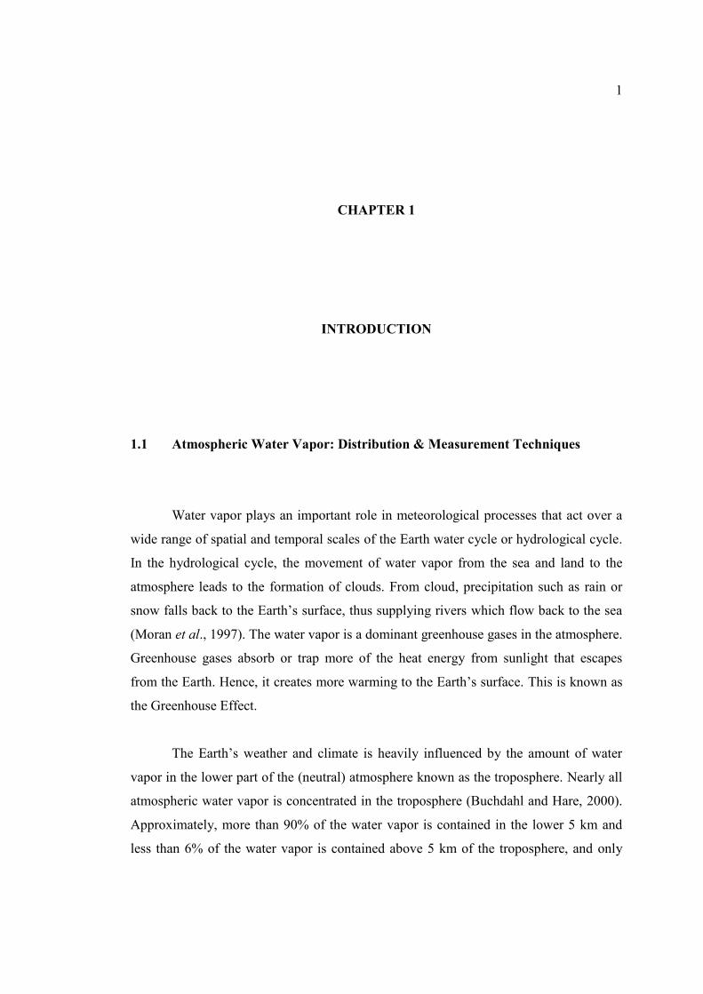
less than 1% is in the stratosphere (Tao, 2008). The global distribution of water vapor
has a significant latitudinal dependence (see Figure 1.1). Large amount of water vapor is
concentrated in low-latitude region (red areas) and it decreases towards high latitude
region (blue areas). This is due to low-latitude region that gains more solar radiation,
especially in the tropical area, which causes the temperature increases compared to the
high latitude region. Therefore, it often gets heavy rainfall. The minimum annual
precipitation is normally around 2,000 mm and the relative humidity frequently exceeds
70%.
Figure 1.1: The global distribution of water vapor derived from the NASA water vapor
project
(Source: CIRA’s, 2011).
Malaysia is located in the low-latitude region. As a tropical country, the area has
a large amount of water vapor in the atmosphere. Moreover, the high amount (and
variation) of atmospheric water vapor in Malaysia shows a close relationship with its
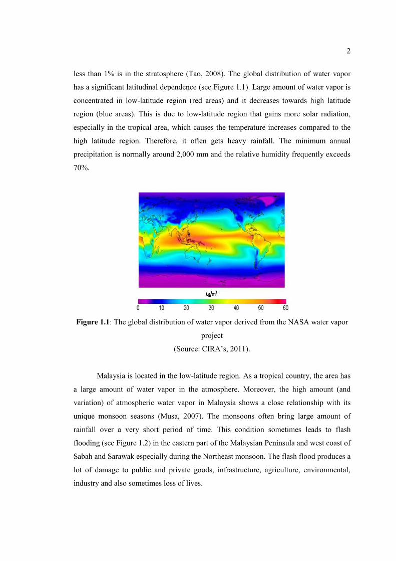
unique monsoon seasons (Musa, 2007). The monsoons often bring large amount of
rainfall over a very short period of time. This condition sometimes leads to flash
flooding (see Figure 1.2) in the eastern part of the Malaysian Peninsula and west coast of
Sabah and Sarawak especially during the Northeast monsoon. The flash flood produces a
lot of damage to public and private goods, infrastructure, agriculture, environmental,
industry and also sometimes loss of lives.
3
In contrast, abundant water and sunlight in Malaysia help the tropical ecosystem
to hold the largest biodiversity of all biomes which is an important basis for socio-
economic development, natural resource management and conservation. In fact, the
understanding of the dynamics of the tropical atmospheric water vapor directly benefits
to the study of global warming, tropical epidemiology, energy and water safety, tropical
medicine, tropical rainforest biodiversity and food production. Malaysian should take a
leading role in research and development (R&D), locally and internationally, to sustain
the biodiversity and its tropical properties with much of concern on the dynamics of the
atmospheric water vapor.
Figure 1.2: An example of major flood in Kelantan
(Source: BERNAMA, 2012)
Water Vapor Measurement Techniques
Conventional observing techniques for the measurement of the vertical and
horizontal distribution of water vapor can be categorized as: (i) in-situ measurements,
i.e., radiosondes, (ii) remote sensing from the ground, i.e., ground-based upward looking
radiometry, and (iii) remote sensing from space, i.e., satellite-based downward looking
radiometry (Bevis et al., 1992).
4
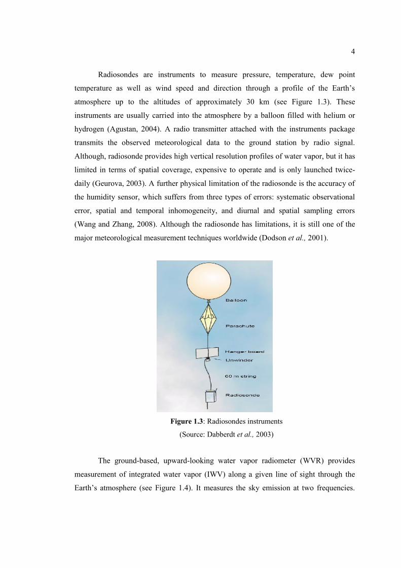
Radiosondes are instruments to measure pressure, temperature, dew point
temperature as well as wind speed and direction through a profile of the Earth’s
atmosphere up to the altitudes of approximately 30 km (see Figure 1.3). These
instruments are usually carried into the atmosphere by a balloon filled with helium or
hydrogen (Agustan, 2004). A radio transmitter attached with the instruments package
transmits the observed meteorological data to the ground station by radio signal.
Although, radiosonde provides high vertical resolution profiles of water vapor, but it has
limited in terms of spatial coverage, expensive to operate and is only launched twice-
daily (Geurova, 2003). A further physical limitation of the radiosonde is the accuracy of
the humidity sensor, which suffers from three types of errors: systematic observational
error, spatial and temporal inhomogeneity, and diurnal and spatial sampling errors
(Wang and Zhang, 2008). Although the radiosonde has limitations, it is still one of the
major meteorological measurement techniques worldwide (Dodson et al., 2001).
Figure 1.3: Radiosondes instruments
(Source: Dabberdt et al., 2003)
The ground-based, upward-looking water vapor radiometer (WVR) provides
measurement of integrated water vapor (IWV) along a given line of sight through the
Earth’s atmosphere (see Figure 1.4). It measures the sky emission at two frequencies.
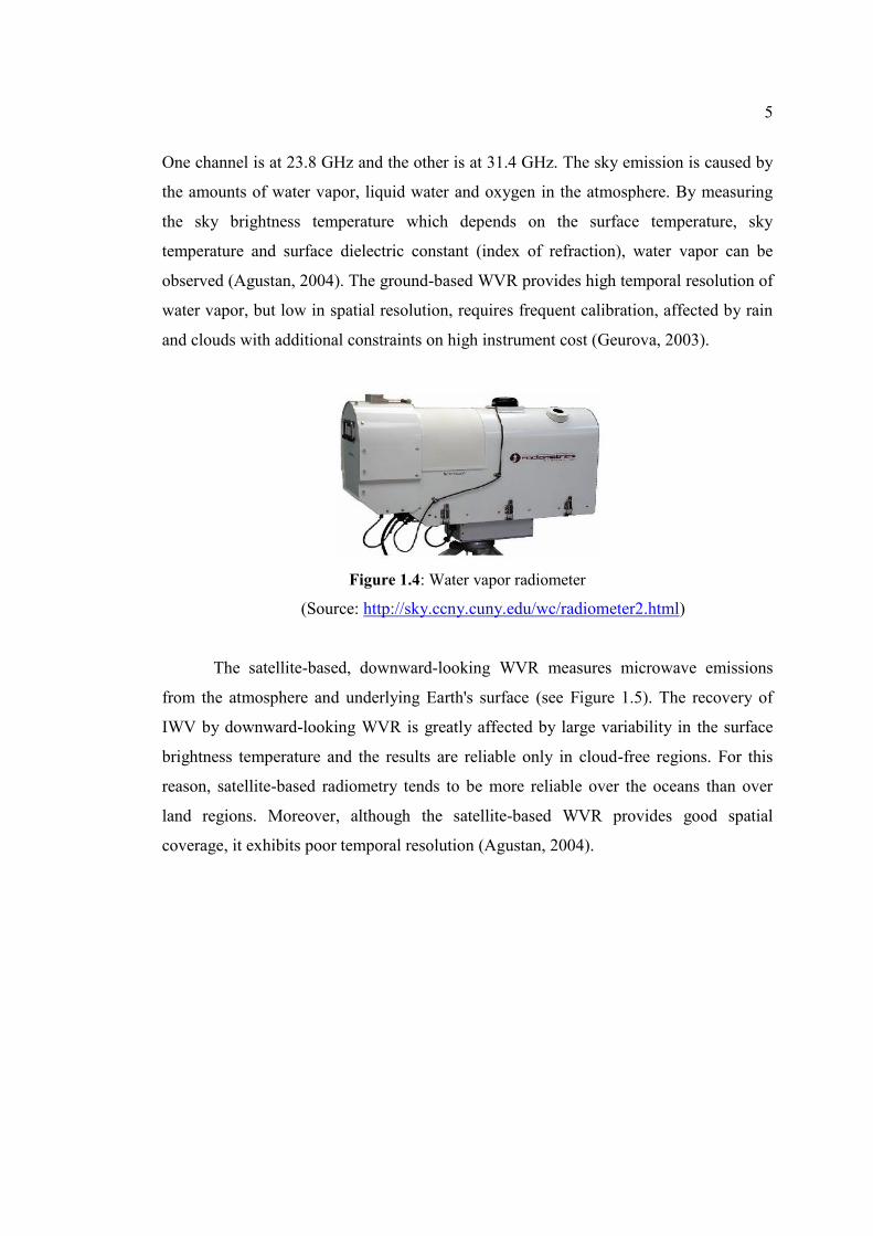
5
One channel is at 23.8 GHz and the other is at 31.4 GHz. The sky emission is caused by
the amounts of water vapor, liquid water and oxygen in the atmosphere. By measuring
the sky brightness temperature which depends on the surface temperature, sky
temperature and surface dielectric constant (index of refraction), water vapor can be
observed (Agustan, 2004). The ground-based WVR provides high temporal resolution of
water vapor, but low in spatial resolution, requires frequent calibration, affected by rain
and clouds with additional constraints on high instrument cost (Geurova, 2003).
Figure 1.4: Water vapor radiometer
(Source: http://sky.ccny.cuny.edu/wc/radiometer2.html)
The satellite-based, downward-looking WVR measures microwave emissions
from the atmosphere and underlying Earth's surface (see Figure 1.5). The recovery of
IWV by downward-looking WVR is greatly affected by large variability in the surface
brightness temperature and the results are reliable only in cloud-free regions. For this
reason, satellite-based radiometry tends to be more reliable over the oceans than over
land regions. Moreover, although the satellite-based WVR provides good spatial
coverage, it exhibits poor temporal resolution (Agustan, 2004).
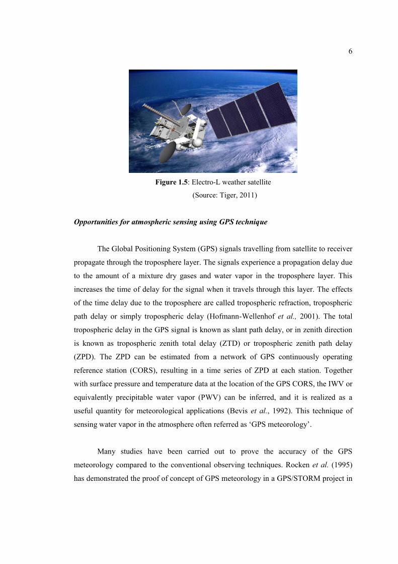
6
Figure 1.5: Electro-L weather satellite
(Source: Tiger, 2011)
Opportunities for atmospheric sensing using GPS technique
The Global Positioning System (GPS) signals travelling from satellite to receiver
propagate through the troposphere layer. The signals experience a propagation delay due
to the amount of a mixture dry gases and water vapor in the troposphere layer. This
increases the time of delay for the signal when it travels through this layer. The effects
of the time delay due to the troposphere are called tropospheric refraction, tropospheric
path delay or simply tropospheric delay (Hofmann-Wellenhof et al., 2001). The total
tropospheric delay in the GPS signal is known as slant path delay, or in zenith direction
is known as tropospheric zenith total delay (ZTD) or tropospheric zenith path delay
(ZPD). The ZPD can be estimated from a network of GPS continuously operating
reference station (CORS), resulting in a time series of ZPD at each station. Together
with surface pressure and temperature data at the location of the GPS CORS, the IWV or
equivalently precipitable water vapor (PWV) can be inferred, and it is realized as a
useful quantity for meteorological applications (Bevis et al., 1992). This technique of
sensing water vapor in the atmosphere often referred as ‘GPS meteorology’.
Many studies have been carried out to prove the accuracy of the GPS
meteorology compared to the conventional observing techniques. Rocken et al. (1995)
has demonstrated the proof of concept of GPS meteorology in a GPS/STORM project in
7
United States (US). They found that the GPS-derived IWV and WVR-derived IWV
exhibit the same level of accuracy with RMS of 1 to 2 kg/m2. Tregoning et al. (1998)
further demonstrated the IWV estimates using GPS, radiosonde and WVR in Australia.
Based on two months of data processing, they found that the RMS of GPS and
radiosonde, also the GPS and WVR estimates of IWV are 1.52 kg/m2 and 1.42 kg/m2,
respectively. Smith et al. (2000) showed that the potential use of real-time GPS IWV
estimates in numerical weather prediction (NWP) model in order to improve the
accuracy of short term precipitation forecasts. Jin and Luo (2009) looked at the long
term (13 years) GPS IWV estimates using globally distributed 155 IGS stations to
investigate water vapor for climate study. They found that GPS IWV changes with
seasonal cycles, annual and diurnal (24 hours) variations.
1.2 Problem Statement
Water vapor is very important in operational weather forecasting and climate
monitoring. They are severely limited to do so by the lacking of accurate, dense and
continuous observation of water vapor in the atmosphere (Wolfe and Gutman, 2000). As
being mentioned, conventional water vapor observing techniques are radiosondes, WVR
and weather satellites. The three techniques have several drawbacks as the following;
Radiosondes measurement are limited in terms of spatial coverage, expensive to
operate in terms of material and labour, and are only launched twice-daily.
WVR are affected by rain and clouds, and they present very low spatial
resolution of water vapor due to additional constraint of high instrument cost.
8
Weather satellites have limited over the land because of the variable surface
brightness temperature and also have limited temporal resolution because they
must rotate in their own orbit with a fixed time frame.
GPS can be utilized as a tool to complement the limitations of the three existing
techniques described above. The GPS provides a better spatial-temporal resolution, low
cost system, global coverage and all weather condition (not affected by rain and clouds).
Since 1990’s, many researches around the world especially in the mid-latitude and
near tropic areas have already utilized the applications of the GPS CORS to support
many meteorological activities for example in the US, Japan and Europe (Haan, 2006).
Aside from the above efforts, only little study was conducted in the low-latitude areas.
This could be explained by the lacking of GPS CORS infrastructures and non-existing of
surface meteorological sensors at the GPS stations in this area. This situation is rather
unfortunate due to the wide range of spatial and temporal conditions of the Earth
atmospheric water vapor happens in the low-latitude areas.
Many studies were reported that the variability of the estimated IWV between
GPS and WVR ranges from 1 to 2 kg/m2 (Rocken et al., 1995; Tregoning et al., 1998).
However, these studies were conducted at the mid- or high-latitude region where the
atmosphere has a water vapor burden smaller than 20 kg/m2 on the average. Currently,
only few studies have taken advantage to investigate the accuracy of GPS-derived IWV
in low-latitude region. Therefore, further study on the accuracy of the GPS-derived IWV
in low-latitude region needs to be conducted.
The establishment of a real-time GPS IWV system can be used to augment the
operational weather monitoring and forecasting. The scientific challenges of a real-time
GPS IWV system require GPS observation, orbit correction and surface meteorological
data to be available with a nominal latency of several minutes. Furthermore, the large
amount of GPS observation data needs to be processed as fast as possible but to maintain
high quality of the GPS IWV is difficult. These processes are difficult to balance in GPS
9
data processing as an increasing number of GPS stations or higher quality of IWV
solution inherently takes longer time to process. Therefore, a study is required to tackle
these challenges in the development of a real-time GPS IWV system.
1.3 Research Objectives
The main aim of this research is to investigate the potential use of GPS
meteorology in the low-latitude region.
In order to support the aim, there are three main objectives as follows:
1. To estimate the ZPD and IWV from the network of GPS stations
The ZPD is the direct product from the GPS data processing. The ZPD can be estimated
after resolve or model the orbital parameters of the satellites, the receiver positions,
ionospheric delays and phase cycle ambiguities. By using the additional surface
meteorological data, the estimated ZPD can be further processed into IWV.
2. To assess the estimated ZPD and IWV
Two aspects of the GPS meteorology technique can be assessed. Firstly is on the quality
of ZPD estimation and secondly is on the quality of IWV estimates. The quality of ZPD
estimation can be assessed in comparison with the IGS ZPD. Besides, in order to prove
the quality of GPS IWV estimation, its validity can be determined by using the nearest
radiosonde data.
10
3. To design a real-time GPS IWV system
The design gives end-to-end of the real-time GPS IWV system, including all of the steps
from the data acquisition up to the results dissemination. Several experiments and tests
can be performed in order to investigate the design of the real-time GPS IWV system.
1.4 Research Scopes
The scope of this research includes:
1. Primarily, the study area focuses on the water vapor distribution in Peninsular
Malaysia which is located in the low-latitude region. However, this study is extended to
Australia which is located in the mid-latitude region, in order to investigate the
horizontal distribution of atmospheric water vapor across the two regions.
2. There are currently two primary techniques for sensing atmospheric water vapor
by using GPS; space-based and ground-based techniques. This study concentrates on
water vapor estimation using a ground-based technique.
3. The Malaysia Real-Time Kinematic GNSS Network (MyRTKnet) currently
consists of 58 GPS stations in Peninsular Malaysia. However, only four of these stations
are selected for GPS IWV estimation. This limited selection of GPS stations is due to the
availability of meteorological stations adjacent to the GPS stations. In the case of GPS
ZPD estimation, the GPS network coverage is extended to include few existing stations
from International GNSS Service (IGS) in the low-latitude region.
4. The double difference (DD) ionosphere free linear combination or L3 is used to
eliminate the ionopsheric errors and as the fundamental measurements for the GPS ZPD
estimation process in this study. These L3 measurements may contain residual errors due
11
to the imperfect mapping function and multipath model that may be absorbed into the
ZPD estimation. However, these residuals errors are not further modelled in the final
results since it is beyond the scopes of this study.
5. The GPS network provides an important data source to study water vapor.
However, the amount of water vapor cannot be directly derived and evaluated from the
GPS network observations without collocated meteorological data. Therefore, it is
necessary to take advantages of meteorological data from the existing weather stations
closely located to the corresponding individual GPS stations.
6. This study also covers the design and initial development of real-time GPS IWV
estimation system. However, due to the lack of the real-time surface meteorological and
the real-time GPS data in Peninsular Malaysia (i.e., MyRTKnet), the system can only
simulate real-time ZPD computation. This simulation makes use of three GPS CORS
distributed over the metro-area of Iskandar Malaysia, known as ISKANDARnet GPS
network, as a test-bed for the system. In addition, few IGS stations in South-East Asia,
India and Australia were also included to the simulation process.
1.5 Significant of Research
The significant of this research can be summarized as follows:
1. It is a special interest of positioning communities and meteorologist to explore
the benefits of GPS meteorology. The ability of GPS of estimating the amount of water
vapor in the atmosphere will help to investigate a range of questions about the rainfall
and monsoon seasons in Peninsular Malaysia.
12
2. The initial goal of GPS CORS MyRTKnet and ISKANDARnet is for positioning
and geodetic applications. However, this research extends the applications of these
CORS infrastructures to be used as a water vapor observation system.
3. This study has developed procedures to allow the estimation of GPS IWV in
Peninsular Malaysia by using surface meteorological data collected adjacent to the GPS
stations. This study also demonstrates the feasibility of ground-based GPS network and
interpolated surface meteorological data for GPS IWV estimation process.
4. This study indicates that GPS has a potential to complement existing water vapor
observation techniques in Peninsular Malaysia. A knowledge and the existing
infrastructures of real-time GPS network can be utilized to augment water vapor
observation system and climate study in this area.
5. This study has put an initiative to design and conduct an initial development of
real-time GPS IWV in Peninsular Malaysia. The combination of the best strategy of
ZPD and IWV estimates obtained from this study could be useful for full
implementation of real-time GPS IWV for Peninsular Malaysia in the near future.
1.6 Organization of the Thesis
This thesis is organized into 6 chapters as follows:
Chapter 1 describes about the background, problem statements, objectives, scopes and
significances of the study.
13
Chapter 2 provides fundamental GPS theory and GPS signal propagation delay. The
chapter also puts an effort to explain on the concept of GPS meteorology.
Chapter 3 presents the results of the estimated ZPD from MyRTKnet and Australian
Regional GNSS Network (ARGN) CORS. This chapter also presents the quality of the
estimated ZPD by comparing the results with IGS final ZPD products.
Chapter 4 presents the results of the estimated IWV in Peninsular Malaysia. This
chapter also presents the quality of the GPS-derived IWV by comparing it with
radiosonde-derived IWV. The relation of GPS IWV with monsoon seasons, rainfall and
geographical location of the GPS CORS in Peninsular Malaysia is also discussed.
Chapter 5 starts with some reviews on existing real-time GPS IWV system. Next, the
initial design of real-time IWV system in Peninsular Malaysia based on simulation
works of ISKANDARnet GPS network as a test-bed is also presented. The simulation of
this real-time IWV system includes several tests and data processing strategies.
Chapter 6 summarizes the main findings of this study as well as recommendations for
future research works.
123
REFERENCES
Abdullah, M., Bahari, S. A., Zaharim, A., Zain, A. F. M., Habib, S. N. A. A. and
Cheak, B. Y. (2009). Forecasting of ionospheric delay using the Holt-Winters
method. European Journal of Scientific Research. 37(3), 471-480.
Agustan (2004). Strategies for Estimating Atmospheric Water Vapour Using Ground
Based GPS Receiver in Australia. Degree of Master of Science (Surveying
and Mapping), Curtin University of Technology.
Amir, S. A. L. (2008). Effect of Tropospheric Delay to Global Positioning System
Signal. Bachelor Degree, Universiti Teknologi Malaysia, Skudai.
Bai, Z. (2004). Near-real-time GPS sensing of atmospheric water vapor. PhD Thesis,
Cooperative Research Centre for Satellite Systems, Queensland University of
Technology.
Bai, Z. and Feng, Y. (2003). GPS Water Vapour Estimation Using Interpolated
Surface Meteorological Data from Australian Automatic Weather Stations.
Journal of Global Positioning Systems. 2(2), 83-89.
BERNAMA (2012). Bah di Pantai Timur. Berita Harian. Retrieved on Jun 18, 2007,
via http://www.bharian.com.my/bharian/Gallery/index_html?idg=Tragedi
Banjir.
Bevis, M., Businger, S., Herring, T., Rocken, C., Anthes, R. and Ware, R. (1992).
GPS Meteorology: Remote Sensing of Atmospheric Water Vapour Using the
Global Positioning System. Journal of Geophysical Research. 97(D14),
15787-15801.
Bruyninx, C. (2008). Present Status and Modernization Plans. Retrieved on April 5,
2009, via http://www.gps.oma.be/gb/modern_gb_ok_css.htm.
Buchdahl, J. and Hare, S. (2000). Troposphere. Retrieved on Mac 1, 2008, via
http://www.ace.mmu.ac.uk/ eae/ Atmosphere/ Older/ Troposphere.html.
CIRA's (2011). Welcome to CIRA's Climate Research Group. Retrieved December
20, 2011, via http://www.cira.colostate.edu/cira/Climate/overview.htm.
Collins, J. P. (1999). An overview of GPS inter-frequency carrier phase
combinations. Retrieved on Jun 18, 2007, via http://www.springerlink.com/
content/ 4whw73336673j786/ fulltext.pdf.
124
Dabberdt, W. F., Shellhorn, R., Cole, H., Paukkunen, A., Ho¨rhammer, J. and
Antikainen, V. (2003). Radiosondes. Retrieved January 10, 2012, via
http://www.eol.ucar.edu/homes/junhong/Ency-radiosonde.pdf.
Dach, R., Hugentobler, U., Fridez, P. and Meindl, M. (2007). Bernese GPS Software
Version 5.0. Astronomical Institute, University of Bern, Bern, Switzerland.
Davis, J. L., Herring, T. A., Sharipo, I. I., Rogers, A. E. E. and Elgered, G. (1985).
Geodesy by radio interferometry: effects of atmospheric modeling errors on
estimates of baseline length. Radio Science. 20 (6), 1593–1607.
Dick, G. (2006). GPS Network: GFZ contribution to COPS/GOP. Retrieved on
January 18, 2012, via https://www.uni-hohenheim.de/ cops/4th_COPS_WS/
presentations/02_07_GPS_GFZ.pdf.
Dodson, A. H., Chen, W., Penna, N. T. and Baker, H. C. (2001). GPS estimation of
atmospheric water vapour from a moving platform. Journal of Atmospheric
and Solar-Terrestrial Physics. 63, 1331-1341.
Drescher, R. (2007). RenameRNXfile.pl. Institute of Physical Geodesy, Technical
University of Darmstadt, D-64287 Darmstadt, Germany.
Duan, J., Bevis, M., Fang, P., Bock, Y., Chiswell, S., Businger, S., Rocken, C.,
Solheim, F., Van, H. T., Ware, R., McClusky, S., Herring, T.A. and King,
R.W. (1996). GPS meteorology: direct estimation of the absolute value of
precipitable water. Journal of Applied Meteorology. 35, 830–838.
Elegered, G., Davis, J. L., Herring, T. A., Shapiro, I. I. (1991). Geodesy by radio
interferometry: water vapor radiometry for estimation of the wet delay.
Journal of Geophysical Research. 96, 6541–6555.
Emardson, T.R., Elgered, G. and Johanson, J. (1998). Three months of continuous
monitoring of atmospheric water vapor with a network of global positioning
system receivers. Journal Geophysics Research. 103, 1807–1820.
Fu, E., Zhang, K., Marion, K., Xu, X., Marshall, J. L., Rea, A., Weymouth, G. and
Kuleshov, Y. (2009). Assessing COSMIC GPS radio occultation derived
atmospheric parameters using Australian 10 radiosonde network data.
Proceeding Earth Planet Sciences. 1 June 2009.
Gendt, G., Dick, G., Reigber, C., Tomassini, M., Liu, Y. Z. and Ramatschi, M.
(2004). Near Real Time GPS Water Vapor Monitoring for Numerical
Weather Prediction in Germany. Journal of the Meteorological Society of
Japan. 82(1B), 361-370.
125
Guerova, G. (2003). Derivation of Integrated Water Vapor (IWV) from the ground -
based GPS estimates of Zenith Total Delay (ZTD). Dept. of Microwave
Physics, Institute of Applied Physis, University of Bern, Bern, Switzerland.
Guoping, L., Dingfa, H., Biquan, L. and Jiaona, C. (2007). Experiment on Driving
Precipitable Water Vapour from Ground-Based GPS Network in Chengdu
Plain. Geo-spatial Information Science. 10(3), 181-185.
Haan, S. de. (2006). National/regional operational procedures of GPS water vapor
networks and agreed international procedures, Report No. 92, WMO/TD-No.
1340.
Hagemann S., Bengtsson, L. and Gendt, G. (2003). On the determination of
atmospheric water vapor from GPS measurements. Journal Geophysics
Research. 108(D21), 4678.
Hatanaka, Y., Iizuka, T., Sawada, M., Yamagiwa, A., Kikuta, Y., Johnson, J. M. and
Rocken, C. (2003). Improvement of the Analysis Strategy of GEONET.
Bulletin of the Geographical Survey Institute. 49, 11–37.
Hofmann-Wellenhof, B., Lichtenegger, H. and Collins, J. (2001). Global Positioning
System: Theory and Practice, (6th ed.) Australia: Springer-Verlag Wien New
York.
Jackson, M. E., Meertens, C., Estey, L., Feaux, K., Jeffries, S., Johns, B., Laffea, L.,
Rosewater, A., Ruud, O. and Ware, R. (2001). University Navstar
Consortium Support for Suominet, a GPS Network for Atmospheric Sensing.
Retrieved on April 5, 2009, via http://facility.unavco.org/kb/categories/
Facility-managed +Projects/SuomiNet/.
Jin, S.G. and Luo, O. (2009). Variability and climatology of PWV from global 13-
year GPS observations. IEEE Transactions Geosciences Remote Sensing.
47(7), 1918-1924.
Kirchner, M. and Drescher, R. (2007). autodl_obs1.pl. Institute of Physical Geodesy,
Technical University of Darmstadt, D-64287 Darmstadt, Germany.
Kirchner, M., Drescher, R. and Schoenemann, E. (2009). autodl_orb2.pl. Institute of
Physical Geodesy, Technical University of Darmstadt, D-64287 Darmstadt,
Germany.
126
Kirk, G. (2007). GPS Modernization, GLONASS Augmentation and the status of
GALILEO – Benefits for heavy and highway contractors. Retrieved on April
5, 2009, via http://www.trimbleproductivity.com/media/pdf/whitepaper_GPS
_GLONASS_Galileo_construction.pdf
Klein Baltink, H., H. J. P., Derks., A. C. A. P., Van Lammeren., B. A. C.,
Ambrosius., A. G. A., Van der Hoeven., H., Van der Marel., F., Kleijer., A. J.
M. and Kösters. (1999). GPS water vapor meteorology, Beleids Commissie
Remote Sensing (BCRS), Chapter 2: Water vapor from GPS troposheric delay
estimates.
Kuo, Y.-H., Sokolovskiy, S., Anthes, R. A. and Vandenberghe, F. (2000).
Assimilation of GPS radio occultation data for numerical weather prediction.
Terrestrial, Atmospheric and Oceanic Science. 11(1), 157-186,
Kursinski, E. R., Hajj, G. A., Schofield, J. T., Linfield, R. P. and Hardy, K. R.
(1997). Observing Earth’s atmosphere with radio occultation measurements
using the Global Positioning System. Journal Geophysics Research. 102,
23429-23465.
Liou, Y. A., Teng, Y. T., Van, H. T. and Liljegren, J. (2001). Comparison of
precipitable water observations in the near tropics by GPS, microwave
radiometer, and radiosondes. Journal Applied Meteorology. 40, 5–15.
Moran, J. M., Morgan, M. D. and Pauley, P. P. (1997). Meteorology: The
Atmosphere and the Science of Weather. (5th ed.) United State of America:
Prentice-Hall, Inc.
Mullenix, D., Fulton, J., Harbuck, T. and Winstead, A. (2009). Update on GPS: New
Civilian Accessible Signals – L1C, L2C, and L5. Retrieved on April 9, 2009,
via http://www.aces.edu/timelyinfo/BioSysEng/2009/January/BSEN-PA-09-
03.pdf.
Musa, T.A. (2007). Residual Analysis of Atmospheric Delay in Low Latitude Region
Using Network-Based GPS Positioning. PhD Thesis, School of Surveying
and Spatial Information Systems, the University of New South Wales,
Sydney NSW 2052, Australia.
Niell, A. E. (1996). Global mapping functions for the atmospheric delay at radio
wavelengths. Journal of Geophysical Research. 101(B2), 3227-3246.
127
Ohtani, R. and Naito, I. (2000). Comparisons of GPS-derived precipitable water
vapors with radiosonde observations in Japan. Journal Geophysics Research.
105(D22), 26917–26929.
Pacione, R. and Vespe. F. (2005). GPS ZTD and Reference Frame Correlations.
Retrieved on April 8, 2009 via http://web.dmi.dk/pub/tough/deliverables/d67-
ZTD-refframe-corr-asi.pdf.
Pagiatakis, S.D. (1990). The response of a realistic Earth to ocean tide loading.
Geophysics Journal Int. 103, 541-560.
Rizos, C., Lim, S., Musa, T. A., Ses, S., Sharifuddin, A. and Zhang, K. (2009).
Atmospheric remote sensing using GNSS in the Australasian region: From
temperate climates to the tropics. Proceedings of the 2009 IEEE International
Geoscience & Remote Sensing Symposium. 12 – 17 July. Cape Town, South
Africa.
Rocken, C., Van, H. T., Johnson, J., Solheim, F., Ware, R., Bevis, M., Chiswell, S.
and Businger, S. (1995). GPS/STORM – GPS Sensing of Atmospheric Water
Vapour for Meteorology. Journal of Atmospheric and Oceanographic
Technology. 12(3), 468-478.
Ross, R. J. and Rosenfeld, S. (1997). Estimating mean weighted temperature of the
atmosphere for Global Positioning System applications. Journal Geophysics
Research. 102(D18), 21719–21730.
Rothacher, M., Springer, T.A., Schaer, S. and Beutler, G. (1997). Processing
Strategies for Regional GPS Networks. Retrieved on April 9, 2009 via
ftp://ftp.unibe.ch/aiub /papers/riopap97.ps.
Scherneck, H.-G. (1991). A parameterised solid earth tide model and ocean tide
loading effects for global geodetic measurements. Geophysics Journal
International. 106, 677–694.
Schreiner, W. S., Hunt, D. C., Rocken, C. and Sokolovskiy, S. (1998). Precise GPS
data processing for the GPS/MET radio occultation mission at UCAR.
Proceedings of the 1998 National Technical Meeting of the Institute of
Navigation. 21 – 23 January. Long Beach, California, 103 - 112.
Schwiderski, E. W. (1981). NSWC Global Ocean Tide Data (GOTD) Tape, U. S.
Naval Surface Welfare Center, Dahlgren, Virginia.
128
Shariff, N.S.M. (2011). A Network-Based Real-Time Kinematic Positioning System
for Iskandar Malaysia. Master of Science (Satellite Navigation), Universiti
Teknologi Malaysia.
Shoji, Y. (2009). A Study of Near Real-time Water Vapor Analysis Using a
Nationwide Dense GPS Network of Japan. Journal Meteorology Society of
Japan. 87(1), 1-18.
Smith, E. K. and Weintraub, S. (1953). The constants in the equation for atmospheric
refractive index at radio frequencies. Proceeding IRE. 41, 1035-1037.
Smith, T. L., Benjamin, S.G., Schwartz, B. E. and Gutman, S. I. (2000). Using GPS-
IPW in a 4-D data assimilation system. Earth Planets Space. 52, 921-926.
Suresh Raju, C., Saha, Thampi. and Parameswaran, K. (2007). Empirical model for
mean temperature for Indian zone and estimation of precipitable water vapor
from ground based GPS measurements. Ann Geophysics Journal. 25, 1935–
1948.
Tao, W. (2008). Near Real-Time GPS PPP-inferred Water Vapour System
Development and Evaluation. Master Sciences Thesis, University of Calgary,
Alberta Canada.
Teunissen, P. J.G. and Kleusberg, A. (1998). GPS for Geodesy. (1st ed). Germany:
Springer Verlag Berlin Heidelberg.
Tiger (2011). Elektro-L atop Zenit-3F/Fregat-SB on January 20, 2011. Retrieved on
November 17, 2011, via http://www.orbiterforum.com/showthread.php?p
=234142.
Tregoning, P., Boers, R., O'Brien, D. and Hendy, M. (1998). Accuracy of absolute
precipitable water vapour estimates from GPS observations. Journal
Geophysics Research. 103(D22), 28701–28710.
Vömel, H. H., Selkirk, L., Miloshevich, J., Valverde, J., Valdés, E., Kyrö, R., Kivi,
W., Stolz, G., Peng., J. A. and Diaz. (2007). Radiation dry bias of the Vaisala
RS92 humidity sensor. Journal Atmospheric Oceanic Technology. 24, 953-
963.
Wang J., Zhang L. and Dai, A. (2005). Global estimates of water-vapor weighted
mean temperature of the atmosphere for GPS applications. Journal of
Geophysical Research. 110(D21101).
129
Wang, J. and Zhang, L. (2008). Systematic errors in global radiosonde precipitable
water data from comparisons with ground-based GPS measurements. Journal
of Climate. 21, 2218–2238.
Ware, R. H., Fulker D. W., Stein S. A., Anderson, D. N., Avery S.K., Clark, R. D.,
Droegemeier, K. K., Kuettner, J. P., Minster, J. and Sorooshian, S. (2000).
Real-time national GPS networks: Opportunities for atmospheric sensing.
Earth Planets Space. 52, 901-905.
Wikipedia (2012). Climate of Australia. Retrieved on November 17, 2019, via
http://en.wikipedia.org/wiki/Climate_of_Australia.
Wolfe, D. E. and Gutman, S. I. (2000). Developing an operational, surface based,
GPS, water vapor observing system for NOAA: Network design and results.
Journal of Atmospheric and Oceanic Technology. 17, 426-440.
Yamagiwa, A., Hatanaka, Y., Yutsudo, T. and Miyahara, B. (2006). Real time
capability of GEONET system and its application to crust monitoring.
Bulletin of the Geographical Survey Institute. 53, 27–33.
Zhang J. and Lachapelle, G. (2001). Precise estimation of residual tropospheric
delays using a regional GPS network for RTK applications. Journal of
Geodesy. 75(5-6), 255-266.