Embed Size (px)
Citation preview

September 2005
NASA/CR—2005-213924
Potential Interventions by Government and Industry to Minimize Violations of Temporary Flight Restrictions Michael Zuschlag John A. Volpe National Transportation Systems Center, Cambridge, Massachusetts
https://ntrs.nasa.gov/search.jsp?R=20050223561 2018-06-30T01:23:31+00:00Z

September 2005
The NASA STI Program Office ... in Profile
Since its founding, NASA has been dedicated to the advancement of aeronautics and space science. The NASA Scientific and Technical Information (STI) Program Office plays a key part in helping NASA maintain this important role. The NASA STI Program Office is operated by Langley Research Center, the lead center for NASA’s scientific and technical information. The NASA STI Program Office provides access to the NASA STI Database, the largest collection of aeronautical and space science STI in the world. The Program Office is also NASA’s institutional mechanism for disseminating the results of its research and development activities. These results are published by NASA in the NASA STI Report Series, which includes the following report types: • TECHNICAL PUBLICATION. Reports of
completed research or a major significant phase of research that present the results of NASA programs and include extensive data or theoretical analysis. Includes compilations of significant scientific and technical data and information deemed to be of continuing reference value. NASA counterpart of peer-reviewed formal professional papers, but having less stringent limitations on manuscript length and extent of graphic presentations.
• TECHNICAL MEMORANDUM.
Scientific and technical findings that are preliminary or of specialized interest, e.g., quick release reports, working papers, and bibliographies that contain minimal annotation. Does not contain extensive analysis.
• CONTRACTOR REPORT. Scientific and
technical findings by NASA-sponsored contractors and grantees.
• CONFERENCE PUBLICATION. Collected papers from scientific and technical conferences, symposia, seminars, or other meetings sponsored or co-sponsored by NASA.
• SPECIAL PUBLICATION. Scientific,
technical, or historical information from NASA programs, projects, and missions, often concerned with subjects having substantial public interest.
• TECHNICAL TRANSLATION. English-
language translations of foreign scientific and technical material pertinent to NASA’s mission.
Specialized services that complement the STI Program Office’s diverse offerings include creating custom thesauri, building customized databases, organizing and publishing research results ... even providing videos. For more information about the NASA STI Program Office, see the following: • Access the NASA STI Program Home
Page at http://www.sti.nasa.gov • E-mail your question via the Internet to
[email protected] • Fax your question to the NASA STI Help
Desk at (301) 621-0134 • Telephone the NASA STI Help Desk at
(301) 621-0390 • Write to:
NASA STI Help Desk NASA Center for AeroSpace Information 7121 Standard Drive Hanover, MD 21076-1320
September 2005
NASA/CR—2005-213924
Potential Interventions by Government and Industry to Minimize Violations of Temporary Flight Restrictions Michael Zuschlag John A. Volpe National Transportation Systems Center, Cambridge, Massachusetts
National Aeronautics and Space Administration Prepared for Langley Research Center Langley Research Center under Intragovernmental Transaction Hampton, VA 23681-2199 NNL04AA72I
4
Acknowledgments
The investigator wishes to thank Susan Wilz and Eddie Norris of the Aviation Safety and Security Program, Protected Asset Flight System at NASA Langley Research Center for supporting this work and providing feedback
on this report. Thanks also to Alan Yost and Drew Kendra of the Volpe Center, for assisting in developing the recommendations in this report, and to Mark Freeman, also of the Volpe Center, for his comments and suggestions.
Available from:
NASA Center for AeroSpace Information National Technical Information Service 7121 Standard Drive 5285 Port Royal Road Hanover, MD 21076-1320 Springfield, VA 22161 301-621-0390 703-605-6000 This report is also available in electronic form at http://ntrs.nasa.gov and http://www.volpe.dot.gov/opsad/pubs.html
iii
Executive Summary
In effort to oppose the use of aircraft by terrorists, the FAA has been establishing temporary flight restrictions (TFRs), air defense identification zones (ADIZs), and other restrictive airspace in effort to increase security around potential ground targets. Since this widespread application of these airspaces, which may be collectively called "security-supporting airspaces" (SSAs), the annual rate of violations of such airspace is over 30 times greater than in previous years (Government Accountability Office, 2004). This frequency of violations entails an economic cost, and potentially compromises safety and even security, the latter by inducing complacency and misallocation of resources. This paper enumerates interventions to reduce the frequency of violations by more effectively providing pilots with the information necessary to avoid such violations (Zuschlag, 2005). Short term interventions, some variants of which are already in progress, focus on improving the form and content of the Notices to Airmen (NOTAMs) currently used to inform pilots of SSAs. These interventions include:
Support of better sorting, filtering, or highlighting of such NOTAMs in the preflight briefing reports returned through electronic briefing services, so that the relevant SSA NOTAMs, which often are more important that other NOTAMs, are given higher priority.
Provide improved and standardized language and formatting of each NOTAMs in briefing reports, arranging and emphasizing information so that relevant SSA NOTAMs are easier to find, and key information within the NOTAM is easier to understand.
Provide detailed and readable maps with each NOTAM of a SSA in order to illustrate better the SSA's boundaries with respect to significant surface and navigation reference objects.
Government agencies can also reduce violations of SSAs chiefly through:
Representing relatively static or recurrent SSAs on aeronautical charts so that their presence and boundaries are obvious to pilots.
Using weather information products and other information channels to more widely distribute alerts of SSAs.
Standardizing and simplifying the procedures for entering SSAs that permit entry (e.g., ADIZs) in order to reduce confusion on these procedures.
Formalizing, standardizing, naming, and documenting the levels of control a SSA may have to simplify training on SSAs and allow faster understanding of NOTAMs on SSAs.
Proceeding with fielding new technology, such as the Operational and Supportability Implementation System (OASIS), designed to improve the capabilities and performance of flight service station briefers.
Distributing SSA information in standardized machine-readable format for vendors of GPS databases and other users.
A long-term technical intervention is for industry to develop an Integrated System for Airspace Requirements Compliance (ISARC), which would provide pilots with the following functions:
Ground and airborne presentation of information on any SSA, including display on an electronic moving map.
Fully mechanized execution from the cockpit of the procedures required for entry into SSAs that allow entry.
iv
Alerting of the potential for SSA violations both during flight planning and while the aircraft is moving.
Capitalizing on a future government-developed infrastructure for the Wide Area Augmentation System (WAAS), datalink, and intra-agency digital communication, ISARC could be implemented as a set of features integrated in a general-purpose GPS moving map device. For example, datalink can be used to upload the latest SSA information and to electronically get clearances from air traffic control into SSAs that allow entry. Knowing the position of the aircraft and the SSA, and the existence of a clearance (or lack thereof), ISARC can alert the pilot before a violation occurs. Within an acceptable development time horizon, ISARC is expected to substantially reduce violations while not compromising safety or security. The incorporating device is expected to be affordable to pilots and ISARC requires almost no additional effort to use, making for a desirable product.
v
Contents Executive Summary ....................................................................................................................... iii
Contents........................................................................................................................................... v
Figures ............................................................................................................................................ vi
Tables ............................................................................................................................................. vi
1. Problem and Purpose................................................................................................................ 1
2. Background .............................................................................................................................. 2 2.1. Characteristics of and Nomenclature for SSAs................................................................. 2
2.1.1. Stability of Activation............................................................................................................. 4 2.2. Root Causes of Accidental Violations .............................................................................. 6 2.3. Current Efforts to Improve SSA Awareness and Understanding...................................... 7
3. Goals and Principles for Interventions ................................................................................... 10
4. Short-term Interventions ........................................................................................................ 12 4.1. Improving Pilot Awareness of the Presence of SSAs ..................................................... 12
4.1.1. Sorting, Filtering, or Highlighting Briefing Reports............................................................. 12 4.1.2. Formatting of NOTAMs in Briefing Reports ....................................................................... 14 4.1.3. Other Possible Improvements for Briefing Reports.............................................................. 15 4.1.4. Charting Recurrent and Static SSAs..................................................................................... 15 4.1.5. Weather Products and Other Channels ................................................................................. 16 4.1.6. Specific Times and Places for All TFRs............................................................................... 17
4.2. Improving Pilot Awareness of SSA Boundaries............................................................. 17 4.2.1. Charting SSAs ...................................................................................................................... 18 4.2.2. Optimally Detailed Maps...................................................................................................... 18 4.2.3. Improved Map Readability and Understandability............................................................... 20 4.2.4. Standardize and Improve Text Descriptions......................................................................... 21 4.2.5. Additional Measures to Improve Boundary Understanding ................................................. 23
4.3. Improving Pilot Understanding of SSA Procedures ....................................................... 24 4.3.1. Standardize and Improve Descriptions of Restrictions......................................................... 24 4.3.2. Standardize and Simplify the SSA Procedures ..................................................................... 25 4.3.3. Standardize SSA Control Levels .......................................................................................... 27 4.3.4. Education and Training......................................................................................................... 28
5. The Long Term: ISARC......................................................................................................... 29 5.1. Functional Requirements ................................................................................................ 30
5.1.1. SSA Presentation .................................................................................................................. 30 5.1.2. Mechanized Filing and Activation of SSA Flight Plans ....................................................... 30 5.1.3. Alerting of Potential for SSA Violation ............................................................................... 31 5.1.4. Additional Functions ............................................................................................................ 32
5.2. Infrastructure Requirements............................................................................................ 33 5.3. Performance Requirements ............................................................................................. 34 5.4. Technological Elements and Development Needs.......................................................... 34
5.4.1. Current Technologies............................................................................................................ 35 5.4.2. Developing Technologies ..................................................................................................... 36 5.4.3. Future Developments............................................................................................................ 37
5.5. Notional System.............................................................................................................. 37 5.5.1. Components and Interfaces................................................................................................... 37 5.5.2. Function Implementation...................................................................................................... 39
5.6. Analysis .......................................................................................................................... 40

vi
5.6.1. Effectiveness and Timeliness ............................................................................................... 40 5.6.2. Compliance and Security Impacts ........................................................................................ 41 5.6.3. Safety Impacts ...................................................................................................................... 41 5.6.4. Certification.......................................................................................................................... 43 5.6.5. Cost and Acceptance ............................................................................................................ 43 5.6.6. Alternatives........................................................................................................................... 45 5.6.7. Realization............................................................................................................................ 45
6. Additional Issues and Research.............................................................................................. 45
7. Summary ................................................................................................................................ 47
8. Abbreviations and Acronyms................................................................................................. 47
9. References .............................................................................................................................. 50
Appendices .................................................................................................................................... 54 Consolidated Mockup of Formatted NOTAM 5/1953............................................................... 54 Interventions and Actions to Perform........................................................................................ 57
Figures Figure 1. NOTAM 5/1953, an example of Presidential TFR NOTAM. Note: While fairly typcial for a
Presidential TFR NOTAM, most non-TFR NOTAMs are considerably shorter. Use of all-capital letters is from the orginal NOTAM. User of Courier font as above is typical of DUATS. .................... 7
Figure 2. Default map of the SSAs described in NOTAM 5/1953 (see Figure 1) as provided on the FAA TFR web site (FAA, 2005e). Value contrast is intensified in this gray-scale reproduction. In the original image, water bodies (gray in above image) are light blue, and SSA boundaries (black in above image) are red. ........................................................................................................................................ 9
Figure 3. SSAs described in NOTAM 5/1953 (see Figure 1) when superimposed on a raster-scanned map. This DUATS-provided screen capture is similar to other maps provided by the FAA and IMAPS for computer screen presentation. The resolution is inferior to the original paper sectional, making most of the text and many symbols at this level of zoom illegible. Zooming in improves legibility, but eliminates the context. The original screen image for this figure was full color, with the SSAs rendered as bright red circles, but when printed on a black and white printer, it would appear much like above............................................................................................................................................................... 10
Figure 4. Mockup of heading for NOTAM 5/1953 (see Figure 1) using variable font weight and size to aid scanning. This would be followed by the content of the NOTAM in smaller font using mixed case (see Appendix, Page 54). ............................................................................................................................. 14
Figure 5. Mockup of a METAR with inclusion of a TFR alert, both in coded form and as it would appear in a DUATS plain-text “translation.” ....................................................................................................... 16
Figure 6. Mockup of a map for NOTAM 5/1953 (see Figure 1, Figure 2, and Figure 3) attempting to optimize the level of detail necessary to communicate key SSA information. Labels for each SSA (Areas 1, 2, and 3) cross-reference the pilot to additional information (see Appendix, Page 54). ....... 19
Figure 7. Mockup of SSA text boundary information in a tabular format for 5/1953 for better reference and readability (compare to Figure 1). ........................................................................................................ 23
Figure 8. Mockup of restrictions information for 5/1953, formatted for better reference and readability (compare to Figure 1). .......................................................................................................................... 25
Figure 9. Components and flows for GPS moving map device with ISARC. All components shown are within an on-board airborne device. ..................................................................................................... 38
Tables Table 1. Probable causes of violations of SSAs (Zuschlag, 2005). ................................................................ 2 Table 2. Summary of Levels of Control for SSAs.......................................................................................... 3
vii
Table 3. Examples of SSAs and SUAs typed by activation degree of stability and control level. SUAs are shown in italics. ...................................................................................................................................... 5
Table 4. Variations in Control Level 2 departure procedures for airports in the Washington DC ADIZ and FRZ (AOPA, 2004b). ........................................................................................................................... 26
Table 5. Variations in Control Level 2a procedures for airports within the DC ADIZ (AOPA 2004b, 2004c). Note that only two airports allow arrivals under standard transponder codes. For the others, arrivals follow Control Level 2 procedures. ......................................................................................... 28
Table 6. ISARC alert conditions and levels.................................................................................................. 32 Table 7. Existing and new technological elements that may be used to implement ISARC’s functional
requirements. ........................................................................................................................................ 35 Table 8. Extension of current GPS devices to ISARC functions.................................................................. 36
1
1. Problem and Purpose
In effort to oppose the use of aircraft by terrorists, the Federal Aviation Administration (FAA) has been attempting to increase the control of airspace around potential ground targets by establishing what may collectively referred to as "security-supporting airspace" (SSA) over potential targets. SSAs include security and VIP temporary flight restrictions (TFRs), Flight Restricted Zones (FRZ) or Special Flight Rules Areas (SFRAs), and Air Defense Identification Zones (ADIZs) (e.g., FAA 2003a, b, c, 2004a, b c). This array of different SSAs have emerged from the FAA rapidly adapting existing rules and technical capabilities to the sudden new challenges manifested by the 9/11/2001 attacks.
SSAs are on average larger, more numerous, and more enduring than before the attacks of 9/11/2001, affording a much greater probability of accidental violation by pilots. Indeed, since the emergence of these new SSAs, the annual rate of violations of such airspace is over 30 times greater than in previous years (Government Accountability Office, 2004). At its peak, the rate of violations has been several per day nationwide (Zuschlag, 2005).
This frequency of violations represents a risk to safety. Intervention by air traffic controllers is required to handle such violations, a task that may distract the controller from his or her chief task of ensuring safe separation of aircraft. About 15% of all violations result in an armed aircraft intercepting the violator (Zuschlag, 2005). For every scramble there is a chance that a sequence of errors may lead to an innocent aircraft being shot down.
This frequency of violations also compromises security. Apparently, all the thousands of violations since 9/11 have been false alarms rather than actual terrorist attacks. Such a high level of false alarms may yield complacency that delays an appropriate response during a real attack. Furthermore, given limited resources to respond to violators, there is a chance that resources may not be available for an actual attack due to their being already committed to a false alarm.
Finally, the current frequency of violations has an economic cost, as resources are spent to handle to false alarms. Each military scramble alone costs tens of thousands of dollars (Associated Press, 2005). Also, pilots who violate a SSA typically have their pilot’s licenses suspended, which may ultimately impact the local economy.
Clearly, there is a need to reduce the frequency of accidental violations of SSAs.1 Developing interventions to reduce the frequency requires understanding of the nature of such accidental violations. In a statistical analysis of two years worth of violations (Zuschlag, 2005), it was found that about three quarters of the violations are associated with long-duration or re-occurring SSAs, with the remainder being associated with relatively transitory SSAs. Further study of pilots’ descriptions of their violations of SSAs revealed that the violations appear to be primarily due to pilots not understanding the details about the SSA (see Table 1). Specifically, pilots often were mistaken about the relative position of the boundaries of the airspace. For some of these cases, this was due to the pilot not knowing his or her own exact geographic position, but more often the absolute position of the boundaries themselves was not clearly understood. Accidental violators also frequently misunderstood the procedures for allowed penetration of the airspace, especially for the DC ADIZ. A secondary, but non-trivial, cause of violations was the pilot not being aware 1 Many of the proposed interventions in this paper would also reduce the frequency of violations of non-security and non-VIP TFRs (e.g., TFRs for hazards and air shows). However, over 97% of all TFR and ADIZ violations in recent years were for SSAs (Zuschlag, 2005), so emphasis is placed on avoiding SSA violations.

2
of the existence of the SSA, especially for SSAs other than the DC ADIZ. Occasionally pilot errors in transponder use also played a role in some violations. However, in summary, over 85% of all violations are due to a pilot’s lack of knowledge or understanding about the SSA and the aircraft’s relation to it. Table 1. Probable causes of violations of SSAs (Zuschlag, 2005).
Probable Cause DC ADIZ2 Other SSAs Total
Relative distance to SSA not understood 40.0% 41.8% 40.9%
SSA not known about or recalled 12.0% 30.1% 21.2%
Procedures for allowed penetration of SSA not understood
31.0% 8.7% 19.7%
Time or date of activations not understood 0.0% 5.8% 3.0%
Other or unspecific lack of detailed knowledge about the SSA
3.0% 2.9% 3.0%
Control setting error 3.0% 1.0% 2.5%
Indeterminate / multiple / other 10.0% 9.7% 9.9%
If there is any chance of reducing the violation rate to something approaching pre-9/11 levels, substantial interventions may be in order. The purpose of this paper is to suggest possible interventions aimed specifically at the identified causes of the violations. The interventions include both short-term changes involving current processes, and long-term changes leveraging emerging technologies. The interventions represent both actions that may be carried out by government agencies like the FAA, and opportunities for businesses seeking to provide products and services to pilots. In the appendix, starting on Page 57, is a list of all interventions along with the actions necessary by researchers, government, and industry for each intervention's realization.
2. Background
2.1. Characteristics of and Nomenclature for SSAs
The large-scale application of TFRs, ADIZs, FRZs and other measures in effort to increase the security of the national airspace has been mostly ad hoc largely applying existing authority to the urgent new demands to thwart airborne terrorist threats. These measures have evolved since 9/11 and continue to evolve to more effectively maximize and balance security and other interests. As a result, however, a certain vagueness pervades terms like “temporary flight restrictions” (for example, they may or may not be particularly temporary), so, for the purpose of this paper, a nomenclature is established to describe and classify SSAs from the functional viewpoint of the pilot in order to aid discussion of the interventions.
A SSA (Security Supporting Area), to begin with, is any contiguous airspace of specified spatial boundaries established with the intention of improving the security of people or objects within. A SSA is active when the flight restrictions, requirements, or recommendations associated with the SSA are in force. An inactive SSA imposes no restrictions on flight, other than those associated with any other overlapping airspace that happens to be present (e.g., Class B).
2 About half of all SSA violations are for the DC ADIZ (Zuschlag, 2005).
3
For this paper, a TFR (Temporary Flight Restriction) refers to a particular instance of one or more SSAs becoming active. In this usage, a single TFR may concern the activation of multiple SSAs, and a single SSA may be activated multiple times through as many TFRs.3
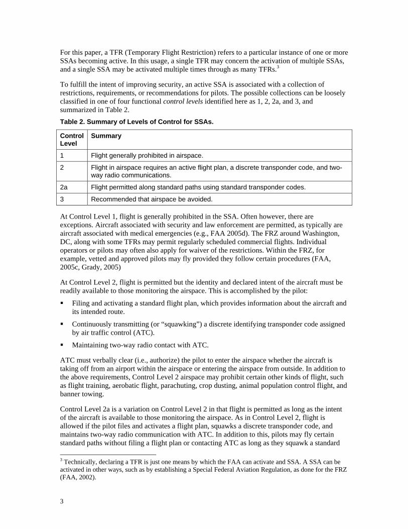
To fulfill the intent of improving security, an active SSA is associated with a collection of restrictions, requirements, or recommendations for pilots. The possible collections can be loosely classified in one of four functional control levels identified here as 1, 2, 2a, and 3, and summarized in Table 2. Table 2. Summary of Levels of Control for SSAs.
Control Level
Summary
1 Flight generally prohibited in airspace.
2 Flight in airspace requires an active flight plan, a discrete transponder code, and two-way radio communications.
2a Flight permitted along standard paths using standard transponder codes.
3 Recommended that airspace be avoided.
At Control Level 1, flight is generally prohibited in the SSA. Often however, there are exceptions. Aircraft associated with security and law enforcement are permitted, as typically are aircraft associated with medical emergencies (e.g., FAA 2005d). The FRZ around Washington, DC, along with some TFRs may permit regularly scheduled commercial flights. Individual operators or pilots may often also apply for waiver of the restrictions. Within the FRZ, for example, vetted and approved pilots may fly provided they follow certain procedures (FAA, 2005c, Grady, 2005)
At Control Level 2, flight is permitted but the identity and declared intent of the aircraft must be readily available to those monitoring the airspace. This is accomplished by the pilot:
Filing and activating a standard flight plan, which provides information about the aircraft and its intended route.
Continuously transmitting (or “squawking”) a discrete identifying transponder code assigned by air traffic control (ATC).
Maintaining two-way radio contact with ATC.
ATC must verbally clear (i.e., authorize) the pilot to enter the airspace whether the aircraft is taking off from an airport within the airspace or entering the airspace from outside. In addition to the above requirements, Control Level 2 airspace may prohibit certain other kinds of flight, such as flight training, aerobatic flight, parachuting, crop dusting, animal population control flight, and banner towing.
Control Level 2a is a variation on Control Level 2 in that flight is permitted as long as the intent of the aircraft is available to those monitoring the airspace. As in Control Level 2, flight is allowed if the pilot files and activates a flight plan, squawks a discrete transponder code, and maintains two-way radio communication with ATC. In addition to this, pilots may fly certain standard paths without filing a flight plan or contacting ATC as long as they squawk a standard 3 Technically, declaring a TFR is just one means by which the FAA can activate and SSA. A SSA can be activated in other ways, such as by establishing a Special Federal Aviation Regulation, as done for the FRZ (FAA, 2002).

4
transponder code that represents the intent to fly a particular path. Typically, Control Level 2a has been applied around airports on the fringe of the Washington DC ADIZ where the standard paths take the aircraft out of the ADIZ by the shortest route (FAA, 2005b). There are also a couple fringe airports that include approved standard paths to the airport from outside the ADIZ (FAA, 2005b).
At Control Level 3, pilots are advised to but not required to avoid the airspace. If pilots do enter the airspace, it is recommended they proceed directly through the airspace without circling or loitering.
The above four control levels comprise the SSAs currently imposed, although it should be noted there are variations within each control level. Other control levels are also possible. For example, during the Winter Olympics in 2002, all aircraft entering the airspace around Salt Lake City had to be physically inspected. Aircraft departing from airports within the airspace were inspected at their point of origin, while aircraft arriving from outside the airspace were required to land for inspection at a “gateway” airport on the fringe before being allowed to proceed (Aircraft Owners and Pilots Association (AOPA), 2002a; FAA, 2002a). This level of control has not been imposed since the Olympics.
For a given potential target, a number of SSAs may be combined, typically to provide layers of protection by having smaller SSAs with a relatively strict control level surrounded by a larger SSA with a more liberal control level. For example, Washington DC is protected by the FRZ, a Control Level 1 SSA about 15 nm in radius. It is surrounded by the much larger ADIZ, a Control Level 2 SSA extending over 40 nm from the Capitol in places (FAA, 2003a). A few airports on the fringe of the ADIZ are functionally in Control Level 2a airspace (FAA, 2005a, b). Similarly, VIP TFRs intended to protect the President during visits to locations outside the DC area typically include a large (up to 30 nm radius) Control Level 2 SSA surrounding one or more relatively small Control Level 1 SSAs that correspond to specific locations the President will be (AOPA, 2003a; e.g., FAA, 2005d). This layered architecture seeks to balance security for the potential target with freedom of access to the airspace.
The significance of control level to the causes of violations can be seen in Table 1. The DC ADIZ is a mostly Control Level 2 SSA, with parts at Control Level 2a, while most other SSAs are at Control Level 1. The result is a different distribution of cause for violations for the DC ADIZ than other SSAs, with the DC ADIZ being more likely that other SSAs to be violated due to misunderstandings of the procedures for allowed penetration. In contrast to Control Level 1 SSAs, in order to reduce violations of Control Level 2 SSAs, it is nearly as important to improve pilots' understandings of the SSAs' procedures as to improve pilots' understanding of the boundaries of the SSAs.
2.1.1. Stability of Activation
In addition to control level, SSAs vary on their stability of activation. The activation of a SSA can be categorized as having roughly the following degrees of stability:
Transitory. Airspace is active for hours or days, with no recurrence over the next year or so. In this case, a SSA is imposed to enhance security for a specific event at an arbitrary location.
Recurrent. Airspace is active for hours to weeks at a time interspersed with similar periods of inactivity. In this case, the security for a given area periodically needs to be enhanced under certain conditions such as due to the performance of vulnerable activities on the ground or due to an increase in apparent threat.
5
Static. Airspace remains active for months to years, with no set date of expiration. In this case, a potential target on the ground is considered to require long-term security from the air.
The significance of the degree of stability of activation can also be seen in the distribution of probable cause among the DC ADIZ and other SSAs as shown in Table 1. While the degree of stability of DC ADIZ is static, approximately half of the other SSAs are transitory. Compared to violations of the DC ADIZ, these violations of other SSAs are more likely to be due the pilot not knowing about or recalling the presence of the SSA. Thus, drastically reducing violations of transitory SSAs requires that one ensure that pilots are, first of all, aware that they exist.
Crossing activation stability with control level yields a typology that can be applied to many of the new SSAs as well as other established security-related special use airspace (SUA) (FAA, 2004d). This is shown in Table 3. Table 3. Examples of SSAs and SUAs typed by activation degree of stability and control level. SUAs are shown in italics.
Degree of Stability Control Level Transitory Recurrent Static
1 "Classic" TFR
Core of VIP TFR
Restricted Areas
Newport TFR
Stadium TFR
Prohibited Areas
FRZ
Disney TFR
2 Outer ring of VIP TFR Outer ring of Crawford TFR DC ADIZ
2a -- -- Fringe airports in DC ADIZ
3 -- -- National Security Area
Industrial/Military TFR
A transitory Control Level 1 SSA is much like the “classic” TFR, where effectively flight is briefly prohibited over an area where it would compromise with security or safety (e.g., during rescue operations or space flight) (FAA, 2004d). As discussed before, it also serves as the core of presidential VIP TFRs, which is surrounded by a transitory Control Level 2 SSA. Transitory Control Level 2 SSAs may also be imposed over major metropolitan areas in response to an acute threat. For example, an ADIZ was placed around New York City for four weeks in March and April 2003 while major hostilities transpired between US and Iraqi armed forces.
A recurrent Control Level 1 SSA is much like many Restricted Area SUAs that periodically “go hot.” Certain TFRs also functionally represent recurrent Control Level 1 SSAs. For example, TFRs come and go around the chemical weapons depots in Newport, IN, and Pueblo, CO, dependent on the agent disposal operations being carried out there. A “blanket” TFR effectively places over all large stadiums (seating 30,000 or more) a recurrent Control Level 1 SSA that activates whenever an event is held at the stadium. Recurrent Control Level 1 SSAs also comprised the TFRs periodically imposed for places the President regularly visits, such as Camp David in Maryland and Crawford, TX. The Crawford airspace also includes a recurrent Control Level 2 SSA ringing the Control Level 1 core, as is typical for presidential VIP TFRs.
A static Control Level 1 SSA is similar to a Prohibited Area SUA, where flight through that airspace is effectively banned indefinitely. Several “temporary” flight restrictions remained continuously in effect over a year, such as the TFRs for Disney World, Disneyland, and the ballistic missile submarine bases at St. Marys, GA, and Bangor, WA. The US Navy has sought to
6
convert the latter two of these into full-fledged Prohibited Areas. The FRZ at DC is also a static Control Level 1 SSA, surrounded by the static Control Level 2 DC ADIZ. The fringe airports of the DC ADIZ comprise the only Control Level 2a SSAs currently present.
A static Control Level 3 SSA is very similar to a National Security Area (NSA) SUA. A “blanket” TFR also effectively places static Control Level 3 SSAs over all military installations and various industrial facilities that are considered vulnerable or attractive terrorist targets (e.g., power plants, dams, and refineries). So far, there have been no examples of transitory or recurrent Control Level 3 SSAs.
The degrees of stability can characterize a particular control level of a SSA, as well as its pattern of activation. In particular, a SSA may be transitorily or recurrently moved to more strict level of control in response to an increase in threat or vulnerability. For example, in the hours around the 2005 State of the Union Address, the entire DC ADIZ was moved to Control Level 1. Static Control Level 3 SSAs likewise may become Level 1 with an increase in the level of threat.
2.2. Root Causes of Accidental Violations
The vast majority of violations of SSAs are due to lack of awareness and understanding of the SSAs. To correct this condition one must understand the reasons for this inadequate awareness and understanding. The reasons appear to be the traditional method used for disseminating information about SSAs. This information is primarily disseminated to pilots by Notices to Airmen (NOTAMs). NOTAMS are a means of distributing information of interest to pilots more quickly than through new editions of other publications such as aeronautical charts and directories. Typically these are free-text descriptions of such things as changes to procedures, outages of electronic aids to navigation or lights, runway and taxiway closures, and amendments to charts, along with declarations of TFRs (see Figure 1).
While adequate when SSAs were rare, short-lived, and small, the NOTAM systems possess features that make reception of SSA information by the pilot prone to human error (Zuschlag, 2005). As seen in Figure 1, it is difficult to picture and interpret from a free text description the geometric and temporal dimensions of a SSA. To see NOTAMs, a pilot preparing for flight typically downloads them from an electronic preflight briefing service such as the Direct User Access Terminal (DUAT) or the Direct User Access Terminal System (DUATS). These services provide very limited filtering and no pilot-selected sorting of the NOTAMs. Instead, the pilot scans the downloaded report of NOTAMs to find the ones specifically relevant to his or her flight. The NOTAMs for a single flight may fill 20 printed pages or more. Most NOTAMs are irrelevant for a given flight, involving airports the pilot will not stop at, routes she or he will not traverse, aircraft types she or he is not flying (e.g., jets), and procedures she or he will not follow (e.g., flying by instrument flight rules, or IFR). Within such a paper mass, a key SSA NOTAM is easy to miss. Alternatively, a pilot may get NOTAM information through a verbal preflight briefing from a Flight Service Station (FSS) controller. With such briefings typically done by phone, it is now the FSS controller who must peruse the NOTAMs to determine the ones relevant to the pilot, and verbally transmit them to the pilot, who, presumably, jots down the details on paper. The potential for error, from the FSS controller selecting and describing the SSA details to the pilot hearing and noting the SSA, are legion.

7
FDC 5/1953 ZJX PART 1 OF 4 FLIGHT RESTRICTIONS PENSACOLA, FLORIDA, MARCH 18, 2005 LOCAL.PURSUANT TO TITLE 14, SECTION 91.141, OF THE CODE OF FEDERAL REGULATIONS (CFR), AIRCRAFTFLIGHT OPERATIONS ARE PROHIBITED: WITHIN 30 NMR UP TO BUT NOT INCLUDING FL180 OF302824N/0871115W OR THE CEW228033.7 FROM 0503181350 (0750 LOCAL 03/18/05) UNTIL0503181805 (1205 LOCAL 03/18/05). WITHIN 10 NMR UP TO BUT NOT INCLUDING FL180 OF302110N/0871901W OR THE BFM108041.3 FROM 0503181350 (0750 LOCAL 03/18/05) UNTIL0503181455 (0855 LOCAL 03/18/05). WITHIN 10 NMR UP TO BUT NOT INCLUDING FL180 OF302824N/0871115W OR THE CEW228033.7 FROM 0503181415 (0815 LOCAL 03/18/05) UNTIL0503181640 (1040 LOCAL 03/18/05). WITHIN 10 NMR UP TO BUT NOT INCLUDING FL180 OF302110N/0871901W OR THE BFM108041.3 FROM 0503181600 (1000 LOCAL 03/18/05) UNTIL0503181805 (1205 LOCAL 03/18/05). END PART 1 OF 4
FDC 5/1953 ZJX PART 2 OF 4 FLIGHT RESTRICTIONS PENSACOLA, FLORIDA, MARCH 18, 2005 LOCAL.EXCEPT AS SPECIFIED BELOW AND/OR UNLESS AUTHORIZED BY ATC: A. ALL AIRCRAFT OPERATIONSWITHIN A 10 NMR AREA LISTED ABOVE ARE PROHIBITED EXCEPT FOR: 1. LAW ENFORCEMENT, MILITARYAIRCRAFT DIRECTLY SUPPORTING THE UNITED STATES SECRET SERVICE (USSS) AND THE OFFICE OFTHE PRESIDENT OF THE UNITED STATES, EMERGENCY MEDICAL FLIGHTS, AND REGULARLY SCHEDULEDCOMMERCIAL PASSENGER AND ALL-CARGO CARRIERS OPERATING UNDER ONE OF THE FOLLOWING TSA-APPROVED STANDARD SECURITY PROGRAMS/PROCEDURES: AIRCRAFT OPERATOR STANDARD SECURITYPROGRAM (AOSSP), DOMESTIC SECURITY INTEGRATION PROGRAM (DSIP), TWELVE FIVE STANDARDSECURITY PROGRAM (TFSSP), OR ALL-CARGO INTERNATIONAL SECURITY PROCEDURE (ACISP) AND AREARRIVING INTO AND/OR DEPARTING FROM 14 CFR PART 139 AIRPORTS. 2. FOR OPERATIONS WITHINTHE TFR, ALL MEDICAL FLIGHT OPERATION COMPANIES SHALL COORDINATE OPERATIONS IN ADVANCEWITH THE END PART 2 OF 4
FDC 5/1953 ZJX PART 3 OF 4 FLIGHT RESTRICTIONS PENSACOLA, FLORIDA, MARCH 18, 2005 LOCAL.USSS AT 850-444-5646 TO AVOID POTENTIAL DELAYS. B. WITHIN THE AIRSPACE BETWEEN 10 NMR AND30 NMR LISTED ABOVE: 1. ALL AIRCRAFT ENTERING OR EXITING THE 30 NMR TFR SHALL BE ON ANACTIVE IFR OR VFR FLIGHT PLAN WITH A DISCRETE CODE ASSIGNED BY AN ATC FACILITY. AIRCRAFTSHALL BE SQUAWKING THE DISCRETE CODE PRIOR TO DEPARTURE AND AT ALL TIMES WHILE IN THETFR. 2. ALL AIRCRAFT ENTERING OR EXITING THE 30 NMR TFR MUST REMAIN IN TWO-WAY RADIOCOMMUNICATIONS WITH ATC. 3. ALL AIRCRAFT OPERATING WITHIN THE 10 NMR TO 30 NMR TFR ANDOPERATING AT ALTITUDES OF UP TO BUT NOT INCLUDING FL180 ARE LIMITED TO AIRCRAFT ARRIVINGOR DEPARTING LOCAL AIRFIELDS AND ATC MAY AUTHORIZE TRANSIT OPERATIONS. AIRCRAFT MAY NOTLOITER. 4. FLIGHT TRAINING, PRACTICE INSTRUMENT APPROACHES, AEROBATIC END PART 3 OF 4
FDC 5/1953 ZJX PART 4 OF 4 FLIGHT RESTRICTIONS PENSACOLA, FLORIDA, MARCH 18, 2005 LOCAL.FLIGHT, GLIDER OPERATIONS, PARACHUTE OPERATIONS, ULTRALIGHT, HANG GLIDING, BALLOON,AGRICULTURE/CROP DUSTING, ANIMAL POPULATION CONTROL FLIGHT OPERATIONS, AND BANNER TOWINGOPERATIONS ARE NOT AUTHORIZED. 5. ALL USSS CLEARED AIRCRAFT OPERATORS BASED IN THE AREASHOULD NOTIFY THE USSS PRIOR TO THEIR DEPARTURE. 6. FOR OPERATIONS WITHIN THE TFR, ALLMEDICAL FLIGHT OPERATION COMPANIES SHALL COORDINATE OPERATIONS IN ADVANCE WITH THE USSSAT 850-444-5646 TO AVOID POTENTIAL DELAYS. C. IT IS RECOMMENDED THAT ALL AIRCRAFTOPERATORS CHECK NOTAMS FREQUENTLY FOR POSSIBLE REQUIRED CHANGES TO THIS TFR PRIOR TOOPERATIONS WITHIN THIS REGION. END PART 4 OF 4
Figure 1. NOTAM 5/1953, an example of Presidential TFR NOTAM. Note: While fairly typcial for a Presidential TFR NOTAM, most non-TFR NOTAMs are considerably shorter. Use of all-capital letters is from the orginal NOTAM. User of Courier font as above is typical of DUATS.
2.3. Current Efforts to Improve SSA Awareness and Understanding
Recognizing that improved knowledge and understanding of SSAs is key to reducing accidental violations of them, the FAA has taken significant steps to improve the dissemination of SSA information, relying less on NOTAMs. Developed and maintained through NAS Aeronautical Information Management Enterprise System (NAIMES) program, the FAA now has a web site that lists all active and upcoming SSA activations (and non-SSA TFRs as well), providing links to the associated NOTAM, and, more significantly, a map illustrating the SSA (AOPA, 2003b; FAA, 2005e). The NOTAM gives the times of effect in both universal coordinate time and more convenient local time. Some information within the NOTAM is broken out into a column of fields for easier reading. This web site undergoes periodic improvements to provide better and easier to access information on SSAs (e.g., AOPA, 2003c). Meanwhile NAIMES has

8
supplemented this web site with another with more detailed maps and more powerful map manipulation tools for pilots (currently at https://www.tfrfaa.naimes.faa.gov/TfrFAA2/start.do).
The FAA has also updated its paper publications. Some recurrent and static SSAs, such as the DC ADIZ and FRZ and the SSA for the presidential residence in Kennebunkport, ME, now appear on charts. In the official Airport/Facility Directory (AFD) (FAA, 2004d) the entries for airports in the FRZ now warn that "compliance with SFAR 94 is required," SFAR 94 being the regulations governing flight in the FRZ.
Other efforts to keep pilots informed of SSAs have been attempted. A review of Aviation Safety Reporting System reports on SSA violations4 indicates that sometimes (but not always) SSAs are announced over the local airport's Automatic Terminal Information Service (ATIS), which otherwise provides key weather information for airborne pilots. Local FAA officials held for pilots in the DC area informative seminars on the DC ADIZ, a large static Control Level 2 SSA that alone has been responsible for half of all violations (AOPA, 2004a). As a long term intervention, the FAA continues to develop and deploy the Operational and Supportability Implementation System (OASIS), a sophisticated tool for FSS briefers that supports easier sorting, reviewing, and alerting of SSAs relevant to a particular flight.
Other organizations, including private companies, have also attempted to make relevant SSA information more accessible and understandable to pilots. Internet Marine and Aviation Planning Services (IMAPS), DUATS, and the Aircraft Owners and Pilots Association (AOPA) each maintain a web site with maps of SSAs that supplement those provided by the FAA5. DUATS and DUAT provide NOTAM "highlights" in easier-to-read tabular format. The AOPA’s web site provides extensive SSA information and training materials, along with a formatted plain-language "translation" of complex NOTAMs (AOPA, 2005a). AOPA also provides a service that emails pilots if a SSA is activated in their region and IMAPS provides a similar service. In addition to web sites, dedicated personal computer clients are available for purchase, including DUATS Golden Eagle, Jeppesen FliteStar, and IMAPS AeroPlanner, that each graphically show SSAs on flight planning maps.
The combined efforts appear to be having an effect. After peaking at 231 violations of SSAs per month in the third quarter of 2003, the frequency of violations has progressively declined to 87 violations per month in the second quarter of 2004. However the current rate of violations is still over 30 times higher than in the years prior to 9/11/01 (Government Accountability Office, 2004).
While the above interventions were crucial, they also had limitations, although with updates and improvements being continuously applied, some limitations are perhaps being addressed. Airport/Facility Directory entries for airports within the DC ADIZ do not mention that special procedures are necessary to fly to them. There has been substantial delay in updating charts. The DC ADIZ did not appear on charts until 12 months after it was imposed (charts are normally re-issued about every 6 months), resulting in charts showing the FRZ but not the ADIZ. In some cases during that period, a pilot, who knew the ADIZ existed, confused the smaller FRZ shown on the charts with the much larger ADIZ, resulting in a violation. The current sectional charts depict a 5 nm radius SSA around Camp David, apparently based on a canceled NOTAM from 2002 (AOPA, 2002b; FAA, 2004e). More recently, the SSA for Camp David has been 10 nm radius. Reports indicate that some pilots accidentally violated this SSA because they assumed the chart depiction was for 10 nm, not 5 nm (Zuschlag, 2005).
4 This is the same corpus of reports used in Zuschlag (2005). 5 The federal National Interagency Fire Center uses IMAPS's products to also provide SSA maps in addition to maps for forest fire TFRs and other concerns
9
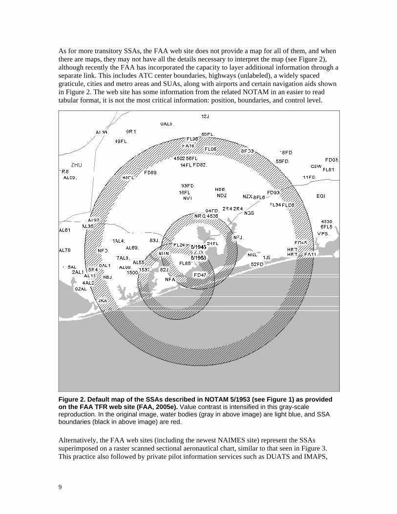
As for more transitory SSAs, the FAA web site does not provide a map for all of them, and when there are maps, they may not have all the details necessary to interpret the map (see Figure 2), although recently the FAA has incorporated the capacity to layer additional information through a separate link. This includes ATC center boundaries, highways (unlabeled), a widely spaced graticule, cities and metro areas and SUAs, along with airports and certain navigation aids shown in Figure 2. The web site has some information from the related NOTAM in an easier to read tabular format, it is not the most critical information: position, boundaries, and control level.
Figure 2. Default map of the SSAs described in NOTAM 5/1953 (see Figure 1) as provided on the FAA TFR web site (FAA, 2005e). Value contrast is intensified in this gray-scale reproduction. In the original image, water bodies (gray in above image) are light blue, and SSA boundaries (black in above image) are red.
Alternatively, the FAA web sites (including the newest NAIMES site) represent the SSAs superimposed on a raster scanned sectional aeronautical chart, similar to that seen in Figure 3. This practice also followed by private pilot information services such as DUATS and IMAPS,

10
and appears superior to the sparse map format shown in Figure 2. Such maps provide nearly all the necessary details using standard symbology and ease cross-referencing to standard aeronautical charts. Such maps also have limitations, largely due sectionals being designed for high-resolution color printing on a large sheet of paper. When scanned into a computer, the result is too much information: a cluttered map that is difficult to read, especially when viewed on a computer screen or printed on a standard-sized paper in black-and-white.
Figure 3. SSAs described in NOTAM 5/1953 (see Figure 1) when superimposed on a raster-scanned map. This DUATS-provided screen capture is similar to other maps provided by the FAA and IMAPS for computer screen presentation. The resolution is inferior to the original paper sectional, making most of the text and many symbols at this level of zoom illegible. Zooming in improves legibility, but eliminates the context. The original screen image for this figure was full color, with the SSAs rendered as three bright red circles, but when printed on a black and white printer, it would appear much like above.
3. Goals and Principles for Interventions
This paper aims to propose the most realistic, feasible, and effective interventions to reducing accidental violations of SSAs. Reducing the frequency of violations by an order of magnitude is an ambitious goal. Violations need to be vastly reduced for static and recurrent SSAs to decrease the frequency by 75% of the current rate. Decreasing it down to about 10% requires that interventions substantially reduce the violations of presidential TFRs (e.g., Figure 1), which account for nearly a quarter of all violations. These TFRs represent a particular challenge:
They usually cover a large populated area, typically being 30 nm in radius with altitudes extending to 18,000 feet, and thus confront a large population of pilots when activated.
They have complex structures, typically including two or more nested SSAs each with different control levels or activation periods.
11
They have complex procedures, usually including a variation of Control Level 2, which, as observed with the DC and NY ADIZ, can be difficult to understand when first imposed.
They can occur anywhere and anytime on short notice, making it more likely that pilots will not be expecting or preparing for them, and will be unfamiliar with the requirements.
Achieving an order of magnitude reduction in the frequency of violations is only likely by adopting the pragmatic approach of acknowledging that accidental violations are a problem with the system and seeking the solutions that will work best in the real world wherever SSAs may be implemented. It is not productive to attempt to assign blame for this problem and to shift responsibility for solving it on one party or another. The ultimate solutions will require efforts by government service and regulatory agencies, the research community, industry, and pilots themselves.
The interventions proposed here are derived from a working knowledge of the aviation domain and an understanding of the probable causes for SSA violations as found by Zuschlag (2005). No attempt has been made to evaluate the present or alternative approaches to securing potential terrorist targets from attacks from the air. It is conceivable that equal security can be effected through alternatives to applying the current types of SSAs –alternatives that may be associated with a substantially lower cost to the aviation community and the nation as a whole. However, the search for such alternatives, if they exist, is beyond the scope of this report. The interventions for this report assume that the national interest is best served by applying SSAs of the current type, size, frequency, and duration.
The vast majority of violations of SSAs are made in small aircraft, usually a piston-powered single (Zuschlag, 2005). This implies that the most effective interventions are those that target the low-end general aviation private pilot, presumably flying under Visual Flying Rules (VFR). Such pilots do not have the resources to support his or her flying that a commercial or military pilot has. This implies that for an intervention to be most effective, it should, from the pilot's point of view, have the following attributes:
Low cost.
Low training requirements.
Not reliant on instrument flying skills.
Low workload.
Low workload is especially important while airborne as typically such aircraft are operated by a single pilot. As an additional consideration of available resources, while advanced graphics-capable multi-function displays are making their way into the general aviation cockpit, such technology cannot be assumed to be available to all pilots in the next decade or so. Indeed, it should be assumed that there will always be a population of aircraft that do not have in-panel digital cockpit systems, or even electrical systems. Interventions should not depend on such systems.
There are also human factors considerations to any intervention. The intervention should be consistent with current flight concepts and practices so that existing knowledge and ingrained habits result in fewer violations rather than more. The intervention should be readily integrated into normal procedures and routines. The easier it is for pilots to include actions to avoid violations, the more likely they will take those actions. The more such actions disrupt flight tasks or conflict with flight goals, the less likely pilots will take them. Relatedly, the intervention should avoid requiring pilot actions that must be done specifically to avoid SSAs (e.g., checking an information source dedicated to SSAs before each flight). While pilots who are flying near
12
static or frequently recurrent SSAs may be motivated to perform such actions, other pilots may not because a SSA is not expected. The intervention should be designed such that pilots naturally develop awareness and understanding of a SSA through their pursuit of the normal goals and tasks associated with flight (e.g., preflight preparation, navigating, avoiding weather, communicating). This is not to imply that pilots should not be responsible for being fully aware of the airspace they transit. It does, however, recognize that realistically many pilots are going to be less motivated to regularly carry out any extra work necessary for checking for SSAs given the low probability of a transitory SSA for a particular region at a particular time. Finally, the information provided through the intervention should be functionally trustworthy and useful. If the information source is found to be inaccurate (e.g., frequently causing false alarms) or not useful for avoiding SSAs, pilots will soon ignore it.
4. Short-term Interventions
Short-term interventions are those that can be accomplished without the development and deployment of new hardware, either to cockpits or to ground facilities such as air traffic control centers. In other words, these interventions are limited to procedure and policy changes, changes to information content, format, or medium, or, at most, software changes. Some of these interventions could be carried out by private industry using materials as it is currently distributed by the FAA, while other interventions may be better carried out by the FAA itself, perhaps as part of current programs to improve information dissemination, such as NAIMES.
As shown in Table 1, most violations of SSAs can be attributed to lack of information about SSAs, the chief information being (1) the relative distance to SSA, (2) the simple presence of the SSA, and (3) the procedures for allowed penetration of SSA. Short-term solutions are broken down by the primary information deficiency they address, beginning with knowing the presence of the SSA.
4.1. Improving Pilot Awareness of the Presence of SSAs
Failure to recognize the existence of a SSA is not the single most important cause of SSA violations, but maximizing the number of pilots in an area that recognize the presence of a SSA is still the first step to reducing violations of it, thus interventions to maximize awareness are discussed first.
Currently, the activation of a transitory and recurrent SSA is announced through a NOTAM. Thus, knowledge of the presence of such a SSA activation can be improved by increasing the likelihood of the pilot seeing the associated NOTAM. A typical preflight task includes using electronic preflight briefing services such as DUATS to receive a report on the weather and NOTAMs in the vicinity of the flight path as indicated by the flight plan provided by the pilot. An intervention to improve awareness of the SSA's NOTAM would best focus on improving this briefing report, rather than, say, developing other SSA-specific sources of the NOTAM, which would require pilot action specific to avoiding SSAs.
4.1.1. Sorting, Filtering, or Highlighting Briefing Reports
The briefing report can be improved to increase SSA awareness without sacrificing awareness of other important information through better sorting, filtering, or highlighting of its contents. Currently, NOTAMs appear at the end of the report, sorted broadly by source; SSA NOTAMs are at the end intermixed with numerous other NOTAMs from the National Flight Data Center. The FAA can support better sorting, filtering, and highlighting by including in each NOTAM standard
13
keywords that allow software to identify the type and relevance of the NOTAM. Keywords can be used to encode:
Class and identity of object NOTAM relates to (e.g., runway, navaid, airspace).
Class of action related to object (e.g., name change, frequency change, restriction).
Type of flight or aircraft that the NOTAM is most relevant to.
Further research by a government agency is necessary to determine the information to encode and the keywords to be used. Ultimately or alternatively to the keyword approach, the FAA could encode and transmit NOTAM information as named database fields, although this would require addition government research and development to convert the system to support formatting or markup.
By using such keywords, or by using its own methods for categorizing NOTAMs, services such as DUATS can then provide more sophisticated filtering, sorting, or highlighting of NOTAMs within briefing reports for the given flight path or region to reflect the priority and proximity of the NOTAM. For many pilots, NOTAMs of proximal SSAs are the single most important type of NOTAM, so these should be listed first or highlighted (e.g., with additional delimiters such as a border of asterisks). The lowest priority is NOTAMs that simply announce the cancellation of other NOTAMs. These can be filtered out and presented separately, perhaps only with explicit pilot request. Apparently, it is technically feasible for a computer program to successfully extract the SSA shape and location from most NOTAMs. With this done, the briefing report can display a prominent alert at the top of briefing if the pilot-entered flight plan directly conflicts with a SSA.
With sufficient information encoded in the NOTAMs, perhaps all NOTAMs may be sorted by likelihood that the pilot will encounter the element related to the NOTAM given the flight plan submitted by the pilot. Top priority for the pilot to view would be applied to NOTAMs for airports the aircraft lands at or takes off from, airways on the path, and airspace the given path passes through, the latter including any relevant SSA NOTAMs. Possibly the entire briefing report can be sorted by such criteria, with weather conditions, forecasts, and NOTAMs likely to be encountered all intermixed and sorted in the geographic order of the flight. Other weather and NOTAMs (the bulk of the report) would be presented separately. Currently the briefing report is sorted by the source of the information –first all Meteorological Reports (surface observations) presented together, then all airborne pilot reports, then radar summaries, then terminal forecasts, (etc.).
NOTAMs could also be categorized and subsequently filtered by characteristics of the flight. For example, NOTAMs primarily relevant to IFR flight can be separated from those primarily relevant to VFR flight. Additional study of NOTAMs and how they affect flight may identify other dimensions for categorization that discriminate the NOTAMs' relevance for different pilots, aircraft, or types of flights. NOTAMS for Control Level 1 SSAs would be relevant to all aircraft and always have high priority, but with other irrelevant NOTAMs separated, they will be easier to spot.
While most recommendations here focused on printed or electronic briefings, many pilots are briefed through FSS. FSS controllers as a rule are highly professional and competent, but there are nonetheless cases of pilots failing to be aware of active SSAs after being briefed by FSS (Zuschlag, 2005). Such failures to communicate may be due to the antiquated technology used by FSSs. At the very least, all FSS stations should have technology to detect a potential SSA conflict based on the flight plan supplied by the pilot. Better sorting and filtering of NOTAMs for the FSS controller will have similar benefits as it can have for pilots. Ideally, to assist cases when FSS is
14
contacted by an airborne pilot, FSS workstations could display the current position of the aircraft on maps depicting the SSA, perhaps based on a feed from ATC, allowing the briefer to give more precise advice for avoiding the SSA. The FAA has most of these capabilities in the form of OASIS and the Special Use Airspace/Inflight Service Enhancement (SUA/ISE) system, but their availability has been limited (Reauthorization of the Federal Aviation Administration and the Aviation Programs, 2003), suggesting that funding and the application of policy is the primary obstacle. Considering the high frequency of SSA violations, the availability of these technologies, if anything, should be accelerated.
4.1.2. Formatting of NOTAMs in Briefing Reports
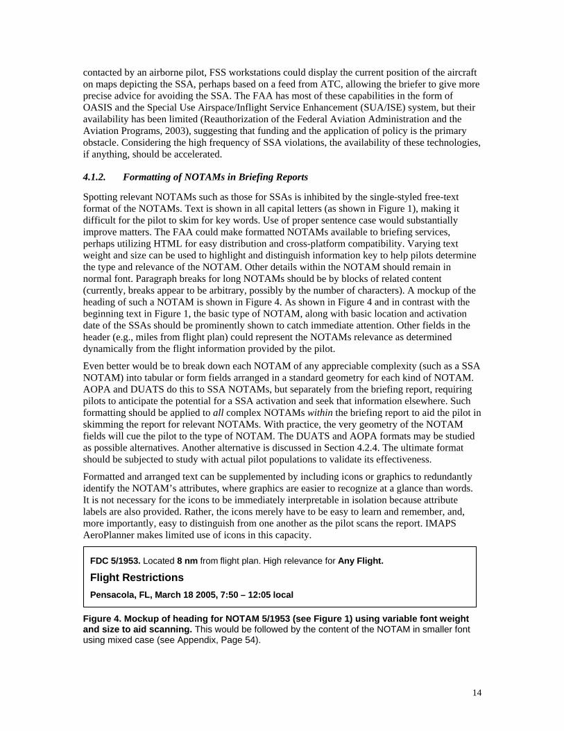
Spotting relevant NOTAMs such as those for SSAs is inhibited by the single-styled free-text format of the NOTAMs. Text is shown in all capital letters (as shown in Figure 1), making it difficult for the pilot to skim for key words. Use of proper sentence case would substantially improve matters. The FAA could make formatted NOTAMs available to briefing services, perhaps utilizing HTML for easy distribution and cross-platform compatibility. Varying text weight and size can be used to highlight and distinguish information key to help pilots determine the type and relevance of the NOTAM. Other details within the NOTAM should remain in normal font. Paragraph breaks for long NOTAMs should be by blocks of related content (currently, breaks appear to be arbitrary, possibly by the number of characters). A mockup of the heading of such a NOTAM is shown in Figure 4. As shown in Figure 4 and in contrast with the beginning text in Figure 1, the basic type of NOTAM, along with basic location and activation date of the SSAs should be prominently shown to catch immediate attention. Other fields in the header (e.g., miles from flight plan) could represent the NOTAMs relevance as determined dynamically from the flight information provided by the pilot.
Even better would be to break down each NOTAM of any appreciable complexity (such as a SSA NOTAM) into tabular or form fields arranged in a standard geometry for each kind of NOTAM. AOPA and DUATS do this to SSA NOTAMs, but separately from the briefing report, requiring pilots to anticipate the potential for a SSA activation and seek that information elsewhere. Such formatting should be applied to all complex NOTAMs within the briefing report to aid the pilot in skimming the report for relevant NOTAMs. With practice, the very geometry of the NOTAM fields will cue the pilot to the type of NOTAM. The DUATS and AOPA formats may be studied as possible alternatives. Another alternative is discussed in Section 4.2.4. The ultimate format should be subjected to study with actual pilot populations to validate its effectiveness.
Formatted and arranged text can be supplemented by including icons or graphics to redundantly identify the NOTAM’s attributes, where graphics are easier to recognize at a glance than words. It is not necessary for the icons to be immediately interpretable in isolation because attribute labels are also provided. Rather, the icons merely have to be easy to learn and remember, and, more importantly, easy to distinguish from one another as the pilot scans the report. IMAPS AeroPlanner makes limited use of icons in this capacity.
FDC 5/1953. Located 8 nm from flight plan. High relevance for Any Flight.
Flight Restrictions Pensacola, FL, March 18 2005, 7:50 – 12:05 local
Figure 4. Mockup of heading for NOTAM 5/1953 (see Figure 1) using variable font weight and size to aid scanning. This would be followed by the content of the NOTAM in smaller font using mixed case (see Appendix, Page 54).
15
4.1.3. Other Possible Improvements for Briefing Reports
There are a number of other possible improvements one could make to briefing reports. The exact format and effectiveness of each may be subjects of future research.
In addition to improving sorting and formatting of NOTAMs within an electronic preflight briefing report, the electronic briefing service could include at the beginning a flight plan specific summary of the most critical information. This may be a dynamically generated map of the flight plan prominently displaying active SSAs as well as threatening weather, laser activity, moored balloons, smoke, and other hazards. Less critical information (e.g., frequency changes) may be more discretely represented. Links or cross references from the map access additional details (e.g., the associated NOTAM). As pilots get into the habit of first quickly checking the summary for any hazards, those who may not be expecting the activation of a SSA will nonetheless become informed.
The briefing or the NOTAM itself can also indicate when a NOTAM for an object such as a SSA has been updated or corrected, including the date and time of the updating and highlighting the changes. This will cover cases of pilots erroneously dismissing certain NOTAMs as being functionally the same as prior familiar NOTAMs.
For Restricted Area SUA that do not have a regular schedule that can be documented on charts (as is done now), the FAA could begin supplying NOTAMs to announce their activation. The same can be done for when the control level of a NSA is raised. This will help get pilots in the habit of referring to the NOTAMs in a briefing report for all recurrent or transitory airspace restrictions. Regularly checking for a SUA activation, the pilot is more likely to see a transitory SSA activation.
Electronic briefing services or the FAA can develop a feature to support personalized update briefings. When delivering a standard briefing to a pilot, the username, timestamp, and flight plan is stored until some time after the pilot-provided end time of the flight. Pilots calling up the same flight plan (and possibly editing it) are then supplied with only new weather and NOTAMs given the current time and any flight plan changes. This will encourage pilots to check back with briefing services, perhaps while airborne, to see if anything significant has changed (e.g., a change in SSA activation) 6. The system may even automatically phone the pilot if there are significant changes from original standard briefing.
4.1.4. Charting Recurrent and Static SSAs
Along with various weather information products, navigation charts are a key source of aeronautical information that is frequently used by pilots. It is natural to map static and recurrent SSAs on charts such as sectionals, terminal area charts, and IFR en route charts, which already show SUAs, the cousins to SSAs. By placing SSAs on such regularly referenced charts, pilots are much more likely to be aware of the presence. For a recurrent SSA, this awareness will encourage pilots to regularly scan for a NOTAM indicating the SSA’s activation. To maximize the chance of this behavior, static SSAs need to be distinct from recurrent SSAs (parallel to what is done for Prohibited and Restricted SUAs), and the SSA needs to be clearly and consistently identified on both the chart and the header of the NOTAM.
As mentioned earlier, some efforts have already been made to chart such SSAs. However, up-to-date representations of these SSAs have been delayed, leading to confusion. If charts are to be
6 Presidential TFRs typically warn pilots to “check NOTAMs frequently for possible required changes” (see Figure 1)

16
effectively used to raise pilots’ awareness of SSAs, then the process for adding and changing SSAs on charts needs to be streamlined. Otherwise, pilots may soon fail to trust and to use such information. Possibly, an agency can assist the FAA in studying the current process and proposing affordable improvements. Among the first steps to address this is to formalize the definition of “recurrent” or “static” SSA (e.g., by anticipated number of activations per year or activation duration) in order to identify the sort of SSAs that are candidates for charting and set the requirements for a revised system for charting SSAs.
4.1.5. Weather Products and Other Channels
While much can be done to increase awareness of SSAs by improving the current primary means of disseminating SSA information, awareness can also be improved by opening new channels to communicate the presence of SSAs. The task of determining the actual implementation (e.g., how to feed the data) requires further study.
For the VFR pilot, perhaps the most important and frequently needed information from outside sources is weather. If a pilot does any preflight preparation at all, chances are it involves a check of the weather. The preflight briefing provides extensive weather information along with NOTAMs. However, a less than fully conscientious pilot may forgo a full standard briefing for short or simple flights (e.g., pattern work around the airport), and instead gather only key weather information. Accidental violations by such pilots can be reduced by including recurrent and transitory SSA activation alerts with local weather information products. As an alerting mechanism, it is not necessary to include any details about the SSA. It can merely serve to get the pilot’s attention and direct him or her to an appropriate source of the details.
Automated Flight Service Station (AFSS) weather summaries can include SSA activation alerts, as can the pre-recorded weather summaries accessible through the Telephone Information Briefing Service (TIBS). Meteorological Reports (METARs) and Terminal Aerodrome Forecasts (TAFs) in particular make good products to include SSA activation alerts. METARs include a Remarks portion that may be suited for this. In keeping with the terse system of abbreviations found in such products, the key text “TFR” followed by the associated NOTAM number may be sufficient (see Figure 5). Consistent with the functions of METARs and TAFs, a METAR may be used if the SSA is currently active at that location, while a TAF may be used if a SSA encompassing that location will activate in the next 24 hours.
METAR KPNS 181353Z VRB05KT 10SM FEW011 SCT043 09/06 A3004 RMK AO2 SLP177 T00890056 TFR5/1953
Pensacola FL [KPNS] hourly observation on the 18th at 8:53am EST (1353Z) Wind variable at 5 knots, visibility 10 miles, 1,100 feet few, 4,300 feet scattered, temperature 9°C (48°F), dewpoint 6°C (43°F), altimeter 30.04, automated station with precipitation discriminator, sea level pressure 30.05" Hg (1017.7 hPa), temperature 8.9°C (48.0°F), dewpoint 5.6°C (42.1°F), TFR in effect see NOTAM 5/1953.
Figure 5. Mockup of a METAR with inclusion of a TFR alert, both in coded form and as it would appear in a DUATS plain-text “translation.”
Some airports are already putting SSA activation alerts on their ATIS broadcasts, which are frequently checked by pilots before takeoff and as they approach their destination. Including such alerts make it possible for even airborne pilots to learn of the presence of an active SSA, including a SSA that changed after takeoff. This practice should be extended and standardized to
17
all airports providing ATIS broadcasts. The Automated Weather Observing System (AWOS) may also be reprogrammed to allow the inclusion of such alerts. Alerts may also be included in other airborne weather information services such as Transcribed Weather Broadcasts (TWEB) and the Hazardous In-flight Weather Advisory Service (HIWAS). The frequency of local FSS can be included in the alert to allow the airborne pilot to get the details of the SSA activation.
The FAA could provide fixed-based operators (FBOs) at airports and even individual pilots with alerts of the activation of SSAs through automatic faxes or email, similar to the services provided by private organizations. FBOs may be allowed to sign up for receiving standard-formatted large-print notice that may be posted for pilots to see before flight.
4.1.6. Specific Times and Places for All TFRs
Historically, the FAA has imposed multiple SSAs through a single “blanket” NOTAM, which declare SSAs over all instances of a particular class of potential targets, rather than over an individual location. One such NOTAM currently in effect (FAA, 2003d), declares Control Level 1 SSAs over any major populated stadium and sporting event. It is left to the pilot to determine where these events occur and when they are scheduled. Another NOTAM (FAA, 2004f) essentially declares Control Level 3 SSAs over all "military facilities" and "industrial complexes," among other structures, without defining these terms or the size or shape of the respective SSAs. While these are "only" at Control Level 3, it is nonetheless important for pilots to avoid these areas. This is especially so for nuclear power stations given a plane deemed threatening might be shot down (AOPA, 2005b). Few violations are associated with the SSAs covered by blanket NOTAMs. However, it remains a questionable expectation for pilots to keep clear of such SSAs while not providing sufficient information to do so.
At a minimum, all such SSAs should be charted so the locations are known to pilots. There are then two alternatives to handle the time element, where different stadiums or sports events may use one or the other alternative dependent on the threat and vulnerability. Firstly, if it affords an acceptable level of security, a static Control Level 3 SSA could be placed over the stadium. Text (perhaps on the chart itself) should tell pilots that it is especially important to remain clear of the stadium when they are populated. Pilots may still stray over stadium events, but at least they will usually see that the stadium is populated (by the cars in the parking lot, if nothing else), and can promptly leave the area.
Secondly, the FAA can establish recurrent Control Level 1 SSAs over certain high-risk stadiums, and announce each SSA activation through the usual channels. Given that events are scheduled well in advanced, a single NOTAM can cover a month or even a season's worth of activations for a particular stadium. The goal is to be able to provide in a briefing all the information necessary for the pilot to definitively determine if the airspace may or may not be flown. This alternative implies that event organizers should be required by law to inform federal authorities of their schedules. This would seem to be an appropriate obligation if such a level of control is truly necessary. In addition to providing the FAA with the information necessary to distribute an appropriate NOTAM, other federal agencies need the schedule in order to provided adequate security (e.g., having interceptors ready to stop an actual terrorist attack).
4.2. Improving Pilot Awareness of SSA Boundaries
The single most important cause of violations of SSAs is the pilot not being aware of the SSA’s position relative to the pilot’s aircraft. All interventions to this cause of violations focus on better communicating the boundaries of the SSA to the pilot.
18
4.2.1. Charting SSAs
Through NOTAMs and FSS briefings, SSA boundary information is currently represented in words, usually as a radius from geographic coordinates or a radial and distance from a navigation aid (see Figure 1). However, a pilot cannot take these words alone and form an accurate mental representation of the airspace. Only by taking the words and plotting the SSA on a map can any reliable sense of the boundaries by understood. Forcing pilots to manually plot a SSA from a text description provides an opportunity for errors in transcription and interpretation of the NOTAM. Furthermore, a pilot may elect to not do the extra labor to plot a certain SSA, believing it is not relevant, only for it to become relevant due to changes in plans after airborne (e.g., due to unpredicted weather).
It thus makes sense to plot the SSA for the pilot, and it has already been recommended that static and recurrent SSAs be on all appropriate charts. This process appears to be already underway, but the efficiency of the process needs to be improved to ensure the SSA representations are timely and accurate. The goal should be to have the capacity to add or remove a SSA within a single update cycle of the chart. Ideally, unless there is an especially urgent security consideration, a recurrent or static SSA should not be imposed until it can appear on charts.
The charting of the boundaries of static and recurrent SSAs should include SSAs associated with military facilities, industrial infrastructure, stadiums and other areas currently covered by “blanket” NOTAMs (the former two currently being Control Level 3 SSAs). Even transitory SSAs could be mapped if they are known with sufficient lead time and will be active for a substantial portion of the chart edition’s lifetime (e.g., that associated with a major event such as the Olympics). When possible, the FAA should use existing SUA types and associated symbology (e.g., Prohibited Areas, Restricted Areas, and NSAs) since these are already relatively familiar to pilots and well documented. However, it may be necessary to define new types of airspace corresponding to certain control levels and degrees of stability, and develop associated symbology. This is a topic for additional research. It is probably a good practice to state the SSA identity and boundaries on the chart (i.e., providing its name, diameter, and ceiling) so the pilot can cross-check it against notices concerning other SSAs. This will reduce the chance of a pilot confusing a NOTAM instantiating a new SSA with an existing SSA depicted on the chart, as has occurred in the past (Zuschlag, 2005).
4.2.2. Optimally Detailed Maps
For maps of transitory SSAs, the best solution is to provide them through electronic distribution, as is done by the FAA on their TFR web site, but, as discussed earlier, not all SSAs are mapped, and, if they are, often the maps lack the optimal level of detail (see Figure 2). Private organizations such as DUATS, AOPA, and IMAPS likewise use maps that are not optimized for the purpose of communicating the position and boundaries of a SSA. The map should be sufficiently detailed to allow a pilot unfamiliar with the area to precisely identify each SSA and draw each on a sectional or other chart, but not so detailed that text or symbols are difficult to read when printed in black and white or viewed at the level of zoom necessary to show the entire SSA. A proposed map design should be experimentally tested on pilots to verify that the design meets this criterion.
In general, this means the details should be at a level comparable to that found on a sectional, using symbology consistent with a sectional chart. At the same time a simple unmodified scan of a sectional or other chart is not necessarily desirable. The details of such a scan may not be readable in a computer image at certain levels of scale and may produce difficult to read printouts
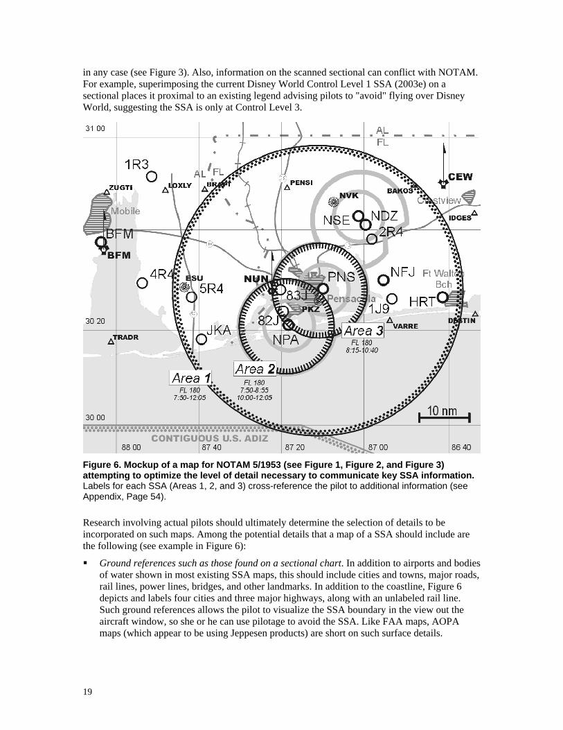
19
in any case (see Figure 3). Also, information on the scanned sectional can conflict with NOTAM. For example, superimposing the current Disney World Control Level 1 SSA (2003e) on a sectional places it proximal to an existing legend advising pilots to "avoid" flying over Disney World, suggesting the SSA is only at Control Level 3.
Figure 6. Mockup of a map for NOTAM 5/1953 (see Figure 1, Figure 2, and Figure 3) attempting to optimize the level of detail necessary to communicate key SSA information. Labels for each SSA (Areas 1, 2, and 3) cross-reference the pilot to additional information (see Appendix, Page 54).
Research involving actual pilots should ultimately determine the selection of details to be incorporated on such maps. Among the potential details that a map of a SSA should include are the following (see example in Figure 6):
Ground references such as those found on a sectional chart. In addition to airports and bodies of water shown in most existing SSA maps, this should include cities and towns, major roads, rail lines, power lines, bridges, and other landmarks. In addition to the coastline, Figure 6 depicts and labels four cities and three major highways, along with an unlabeled rail line. Such ground references allows the pilot to visualize the SSA boundary in the view out the aircraft window, so she or he can use pilotage to avoid the SSA. Like FAA maps, AOPA maps (which appear to be using Jeppesen products) are short on such surface details.
20
All fixes useful for locating the SSA boundaries. This includes, but is generally not limited to, the navigation aid referenced in the NOTAM to locate the center of the SSA. Including multiple fixes helps the pilot plan the use of electronic navigation to avoid the SSA (e.g., by flying a particular radial, or heading to a fix stored in the aircraft’s GPS database). Figure 6 depicts VHF omnidirectional ranges (VORs) and non-directional beacons (NDBs), along with reporting points using nearly standard symbols. Most DUATS and some AeroPlanner maps at least show navigation aids, but only AOPA shows additional fixes that may be useful to pilots.
Other airspace, especially Class B and C, and certain SUAs, along with any Mode C veil. Figure 6, for example, shows the Class C airspace around the three major airports in the center of the map, along with the US ADIZ along the south edge (numerous SUAs are not shown). Pilots are already used to avoiding such airspace. Being able to reference the SSA to such airspace allows the pilot to better understand its boundaries and may guide a strategy to avoid the airspace (e.g., stay out of the Mode C veil, which encompasses the entire SSA). Many GPS moving map displays display this airspace, allowing the pilot to monitor his or her position to the SSA while in flight. Showing Class E airspace boundaries, in contrast, will not provide this function and should be suppressed to minimize clutter.
Latitude and longitude graticule. Figure 6, for example, shows latitude and longitude in 20-minute increments. In addition to providing general cartographic orientation and sense of scale, a graticule allows pilots with GPS hardware to create waypoints to navigate around the SSA.
State and national borders. Figure 6, for example, depicts the Florida-Alabama border. Like coastlines, this provides a general orientation and a sense of scale.
It is probably better to not show terrain, as can happen when raster scanned maps are used, especially if the terrain altitude is color-coded as done on sectionals. This will tend to add excessive clutter and reduce the contrast of other map elements (especially when printed on a black and white printer), while providing little benefit. Stylized representations of significant terrain features (e.g., significant mountains and ridges as done on some approach charts) may be considered as these may help the pilot understand the boundaries of the SSA.
In addition to surface references, the map should display the ceiling of each SSA shown, perhaps in the same manner as used for Class D airspace on sectionals. Figure 6 provides an alternative means to show this information that avoids the clutter that is often found at the center of a SSA (which are typically over urban and airport areas). Effective times of the SSA’s activation should also be indicated (as shown in Figure 6) so that the map provides the temporal as well as geographic boundaries of the SSA activation. Text or symbology should be used to distinguish the general level of control of the SSA. In Figure 6, for example, symbology based on that for charting Restricted Areas is used for the two smaller Control Level 1 SSAs in 5/1953, while symbology based on that for the ADIZ is used for the larger Control Level 2 SSA. In other words, all the key information from the NOTAM should be represented in the map. The map may even include a text caption summarizing the airspace with sufficient detail to allow it to be precisely drawn (i.e., radius and center position). A reference or hypertext link should exist between the map and the associated NOTAM or other SSA text representation, perhaps between map and the correct location in the preflight briefing.
4.2.3. Improved Map Readability and Understandability
Related to optimizing the map details is maximizing map readability and understandability. As discussed above, excessive information can clutter a map. However, even with a fixed amount of

21
information to place on a map, the choice of scale and symbology impacts the capacity of the pilot to read and correctly understand the information on the map. SSA maps from AOPA ’s web site, for example, eschew the use of raster scanned sectionals to provide a less cluttered map. However, the map size and scale selected nonetheless tends to make the map difficult to read.
A map scale of miles (bottom right of Figure 6) is often lacking on current SSA maps but is important for judging the size of the SSA and choosing references for navigating around the SSA (i.e., ones that are not too close to the boundary). Dynamically scaled maps, such as those shown on the computer screen should always show a scale of miles. Map orientation should always be with true north at the top to allow easier cross-referencing with charts. The FAA maps sometimes have direction of north at less than perfectly vertical (true north is approximately 6 degrees counterclockwise from vertical in Figure 2).
It may be necessary to adjust map characteristics for the medium of display. For display on a computer monitor display, map images must be created with the consideration that computer monitors have substantially smaller sizes and lower resolutions (dots per inch) than a printed sectional. Very large scaling is necessary to read a scanned aeronautical chart, making it difficult to appraise the overall boundaries of the SSA. Electronic maps can be more effective through application of different font size, symbol representation, and color usage from printed maps, while still remaining generally consistent aeronautical charting conventions (e.g., Society of Automotive Engineers, 1997; International Civil Aviation Organization, 2001; Radio Technical Commission for Aeronautics (RTCA), 2003). Private organizations currently display electronic SSA maps only at a small “lowest common denominator” size, generally less than 640x380 pixels, but most users have larger monitors than can ease the resolution problem. Thus, in addition to allowing the user to select the scale of such dynamic maps, the user should be able to set the map size to make best use of his or her display’s capability.
The same map image used for display on the monitor may not be adequate for a printout. Most printers can print at resolution approaching a sectional, and printing a low-resolution map for monitors will fail to capitalize on this. With their higher resolution, printed maps can be made easier to read and more faithful to charting conventions for symbol shape. However, unlike for monitors, it cannot be assumed that the user has access to a color printer. Printed maps should work well in black and white, and color should not be the sole source of coding information. Printouts of the map are best printed at one of the standard scales used by aeronautical charts (e.g.,1:500,000, 1:250,000), making it easy for pilots to cross reference the map to official charts. Ultimately, it may be advantageous to supply two sources of maps, as done by AeroPlanner, dynamic maps for screen display and fixed-scale documents (e.g., as PDF (Portable Document Format) files) for printing.
4.2.4. Standardize and Improve Text Descriptions
While a map of the SSA is the best way to communicate the location and boundaries of the SSA, benefits can also be had by improving the text descriptions of the boundaries as provided in the NOTAM for the SSA. As discussed in Section 4.1.2, breaking up the SSA NOTAM and reformatting it will make it easier for pilots to recognize the relevance of a NOTAM when scanning through a preflight briefing report. Such restructuring can also make the NOTAM easier to understand once it is identified as relevant by representing the configuration of the SSA in the use of emphasis and the geometric arrangement of the information. This also makes it easier to pick out the boundary information at a glance when the pilot references the NOTAM. The arrangement of information should be such that the pilot can quickly draw the SSA on a chart, or enter it into a GPS moving map system. It should be recognized that the reading conditions may
22
be substantially suboptimal (e.g., done while in flight with poor lighting, turbulence, and other tasks competing for attention).
The FAA could help this process by considering standardizing and simplifying the shapes of transitory SSAs, so that a standard format of boundary information can be adhered to. Because recurrent and static SSAs should be charted as recommended in Sections 4.1.4 and 4.2.1 (preferably before the SSA becomes active), these SSAs may have a more irregular shape that better balances airspace access and security concerns. Transitory SSAs, being by definition short-lived can afford less optimized boundaries for the sake of easier understanding by pilots, although exceptions from a standard shape must also be allowed for. For example, the US cannot legally impose a SSA over foreign airspace. A SSA centered on a point near the Mexican or Canadian border will need a “cutout.” The most convenient shape for pilots may be a circle of a given radius centered on a specified point, which describes most transitory SSAs currently imposed, but not necessarily all (Burnside, 2004). If a circular SSA happens to be centered on a distance measure equipment (DME) facility, a pilot can use the DME to keep clear of the SSA. For a more arbitrary point, many GPS systems will provide pilots with a continuous in-flight readout of the distance to a pilot-entered point.
As stated earlier, the ultimate format of a NOTAM should be determined through systematic study with actual pilot populations. However, one approach to structuring SSA text information for pilots is illustrated in Figure 7. This can be compared with the approaches taken by private organizations such as DUATS and AOPA.
As shown in Figure 7, each SSA activation within the NOTAM is presented tabularly as a separate column, arranged chronologically from left to right. Reference numbers for each SSA are provided in the top row to match the text to a mapped depiction of the SSAs (as in Figure 6; see Page 54 in the appendix for a consolidated mockup), which, for a hypertext medium, may be linked (represented by underlining in Figure 7). A Restrictions field includes a number that would refer the pilot (possibly by linking) to the basic rules for operating within the SSA. As is done in current NOTAMs, the position of each SSA is given both as latitude and longitude and as a position relative to a proximal navigation fix in order to maximize the ease and accuracy of manual entry of the position into various vendors’ GPS units.
Additional characteristics of the NOTAM text can also improve a pilot’s ability to avoid accidentally crossing the boundaries of a SSA. The position of a SSA should always be given relative to a major navigation fix identifiable on nearly all charts, (e.g., using a radial and distance to indicate the center of a circular SSA). It should never be a location that cannot be relied on to be on charts or in a GPS database (e.g., the actual building or place the SSA is intended to protect).
The SSA’s ceiling should always be provided as altitude above mean sea level (MSL), since even aircraft with minimal instrumentation will feature a barometric altimeter. Currently some SSA ceilings are specified in MSL, while others in height above ground, the latter which may lead to confusion as well as difficulty translating it into usable dimension (most single-engine piston aircraft do not have a radar altimeter).
“Legalese” language and other text that is not relevant to understanding the functional impact of the NOTAM should be eliminated or de-emphasized. Referencing the federal regulation that justifies the imposition of the SSA (as in Figure 1) does not help a pilot understand it.
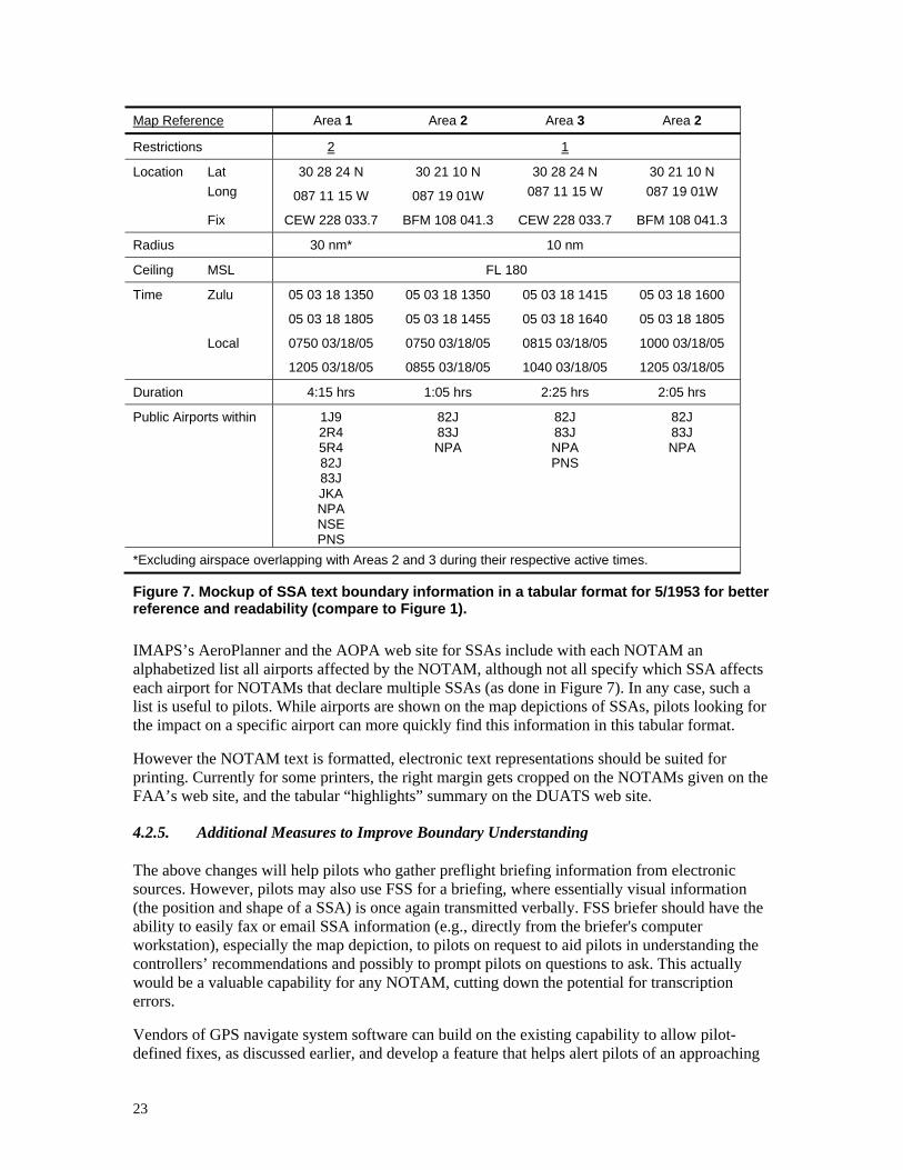
23
Map Reference Area 1 Area 2 Area 3 Area 2
Restrictions 2 1
Location Lat Long
30 28 24 N
087 11 15 W
30 21 10 N
087 19 01W
30 28 24 N 087 11 15 W
30 21 10 N 087 19 01W
Fix CEW 228 033.7 BFM 108 041.3 CEW 228 033.7 BFM 108 041.3
Radius 30 nm* 10 nm
Ceiling MSL FL 180
Time Zulu 05 03 18 1350
05 03 18 1805
05 03 18 1350
05 03 18 1455
05 03 18 1415
05 03 18 1640
05 03 18 1600
05 03 18 1805
Local 0750 03/18/05
1205 03/18/05
0750 03/18/05
0855 03/18/05
0815 03/18/05
1040 03/18/05
1000 03/18/05
1205 03/18/05
Duration 4:15 hrs 1:05 hrs 2:25 hrs 2:05 hrs
Public Airports within 1J9 2R4 5R4 82J 83J JKA NPA NSE PNS
82J 83J NPA
82J 83J NPA PNS
82J 83J NPA
*Excluding airspace overlapping with Areas 2 and 3 during their respective active times.
Figure 7. Mockup of SSA text boundary information in a tabular format for 5/1953 for better reference and readability (compare to Figure 1).
IMAPS’s AeroPlanner and the AOPA web site for SSAs include with each NOTAM an alphabetized list all airports affected by the NOTAM, although not all specify which SSA affects each airport for NOTAMs that declare multiple SSAs (as done in Figure 7). In any case, such a list is useful to pilots. While airports are shown on the map depictions of SSAs, pilots looking for the impact on a specific airport can more quickly find this information in this tabular format.
However the NOTAM text is formatted, electronic text representations should be suited for printing. Currently for some printers, the right margin gets cropped on the NOTAMs given on the FAA’s web site, and the tabular “highlights” summary on the DUATS web site.
4.2.5. Additional Measures to Improve Boundary Understanding
The above changes will help pilots who gather preflight briefing information from electronic sources. However, pilots may also use FSS for a briefing, where essentially visual information (the position and shape of a SSA) is once again transmitted verbally. FSS briefer should have the ability to easily fax or email SSA information (e.g., directly from the briefer's computer workstation), especially the map depiction, to pilots on request to aid pilots in understanding the controllers’ recommendations and possibly to prompt pilots on questions to ask. This actually would be a valuable capability for any NOTAM, cutting down the potential for transcription errors.
Vendors of GPS navigate system software can build on the existing capability to allow pilot-defined fixes, as discussed earlier, and develop a feature that helps alert pilots of an approaching

24
transitory SSA. After the pilot enters a fix and distance (and possibly a time interval as well), the GPS will alert the pilot with visual and/or auditory singal if the aircraft comes close to the given distance from the fix. It can even cue the pilot on which turn would best avoid the airspace. A more advanced variation of this feature is discussed in Section 5. It may be desirable for a government research agency to prototype such a feature in order to spur industry to develop and market it.
The recommendations given in 4.2.4 focused on maximizing the readability of SSA information by humans. The FAA can ultimately reduce the number of violations of SSAs by also providing a version of SSA information that is easily readable by machines. This is a separate source of electronically distributed SSA activation information from NOTAMs, and is far beyond including keywords, as detailed as a stopgap measure in Section 4.1.1. Rather, this is a source of information intended solely for mechanized digital processing by electronic briefing services and vendors of GPS databases (although the direct use by properly equipped private individuals is also a definite possibility). Developing such a standardized format requires research by government, perhaps aided by industry standards organizations, to ensure the resulting format is usable by current and future vendors of such services and products.
In distributing SSA information in an appropriate standardized machine-readable file format, requesting agencies can automatically plot any SSA on electronic and dynamically generated maps. GPS database vendors can alert their customers of updates that include new SSAs, allowing them to download the update to their cockpit GPS systems. With this feature, even transitory SSAs can be displayed on a moving map display, and an automated alert system can notify pilots if they are approaching a SSA. Ideally, the transfer of SSA information should be fast and compatible with automated downloading and processing in order to maximize the chance of information reaching pilots in a timely matter.
4.3. Improving Pilot Understanding of SSA Procedures
For the DC ADIZ, a Control Level 2 SSA, failure to understand the procedures for allowed penetration of the SSA is the second most common cause of violations, accounting for a substantial number of all SSA violations (see Table 1). Over the course of a year and half after the DC ADIZ was imposed, pilots continued to misunderstand these procedures, accounting for about 15% of all SSA violations in the entire country (Zuschlag, 2005). With time, such errors should diminish as the local pilots become fully educated on the ADIZ. However, Control Level 2 SSAs of similar size as the DC ADIZ are being imposed throughout the country, usually as part of a presidential TFR. One can also imagine transitory or recurrent Control Level 2 SSAs being imposed in various places in response to changes in the terrorism threat level, as happened for New York City during the invasion of Iraq in March, 2003. In either case, pilots in these regions, often near major metropolitan areas, are unacquainted with the procedures, and, barring intervention, can be expected to make the same errors observed in the early months after the DC ADIZ was imposed. For the four weeks that the New York Control Level 2 SSA was active, the frequency of violations was comparable to that for the DC ADIZ during the same period (the DC ADIZ had been imposed a mere two months earlier), suggesting the experience of the DC ADIZ is typical for any new Control Level 2 SSA (Zuschlag, 2005).
4.3.1. Standardize and Improve Descriptions of Restrictions
Just as with the descriptions of the boundaries of SSAs, the descriptions of the entry requirements can also benefit from replacing the current stream of text with a standard formatting, arranging the information in fields, and using varying emphasis to communicate the structure of the
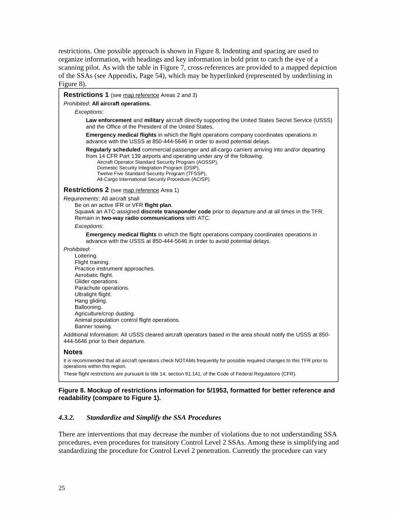
25
restrictions. One possible approach is shown in Figure 8. Indenting and spacing are used to organize information, with headings and key information in bold print to catch the eye of a scanning pilot. As with the table in Figure 7, cross-references are provided to a mapped depiction of the SSAs (see Appendix, Page 54), which may be hyperlinked (represented by underlining in Figure 8). Restrictions 1 (see map reference Areas 2 and 3)
Prohibited: All aircraft operations. Exceptions:
Law enforcement and military aircraft directly supporting the United States Secret Service (USSS) and the Office of the President of the United States, Emergency medical flights in which the flight operations company coordinates operations in advance with the USSS at 850-444-5646 in order to avoid potential delays. Regularly scheduled commercial passenger and all-cargo carriers arriving into and/or departing from 14 CFR Part 139 airports and operating under any of the following:
Aircraft Operator Standard Security Program (AOSSP), Domestic Security Integration Program (DSIP), Twelve Five Standard Security Program (TFSSP), All-Cargo International Security Procedure (ACISP)
Restrictions 2 (see map reference Area 1) Requirements: All aircraft shall
Be on an active IFR or VFR flight plan. Squawk an ATC-assigned discrete transponder code prior to departure and at all times in the TFR. Remain in two-way radio communications with ATC. Exceptions:
Emergency medical flights in which the flight operations company coordinates operations in advance with the USSS at 850-444-5646 in order to avoid potential delays.
Prohibited: Loitering. Flight training. Practice instrument approaches. Aerobatic flight. Glider operations. Parachute operations. Ultralight flight. Hang gliding. Ballooning. Agriculture/crop dusting. Animal population control flight operations. Banner towing.
Additional Information: All USSS cleared aircraft operators based in the area should notify the USSS at 850-444-5646 prior to their departure.
Notes It is recommended that all aircraft operators check NOTAMs frequently for possible required changes to this TFR prior to operations within this region. These flight restrictions are pursuant to title 14, section 91.141, of the Code of Federal Regulations (CFR).
Figure 8. Mockup of restrictions information for 5/1953, formatted for better reference and readability (compare to Figure 1).
4.3.2. Standardize and Simplify the SSA Procedures
There are interventions that may decrease the number of violations due to not understanding SSA procedures, even procedures for transitory Control Level 2 SSAs. Among these is simplifying and standardizing the procedure for Control Level 2 penetration. Currently the procedure can vary
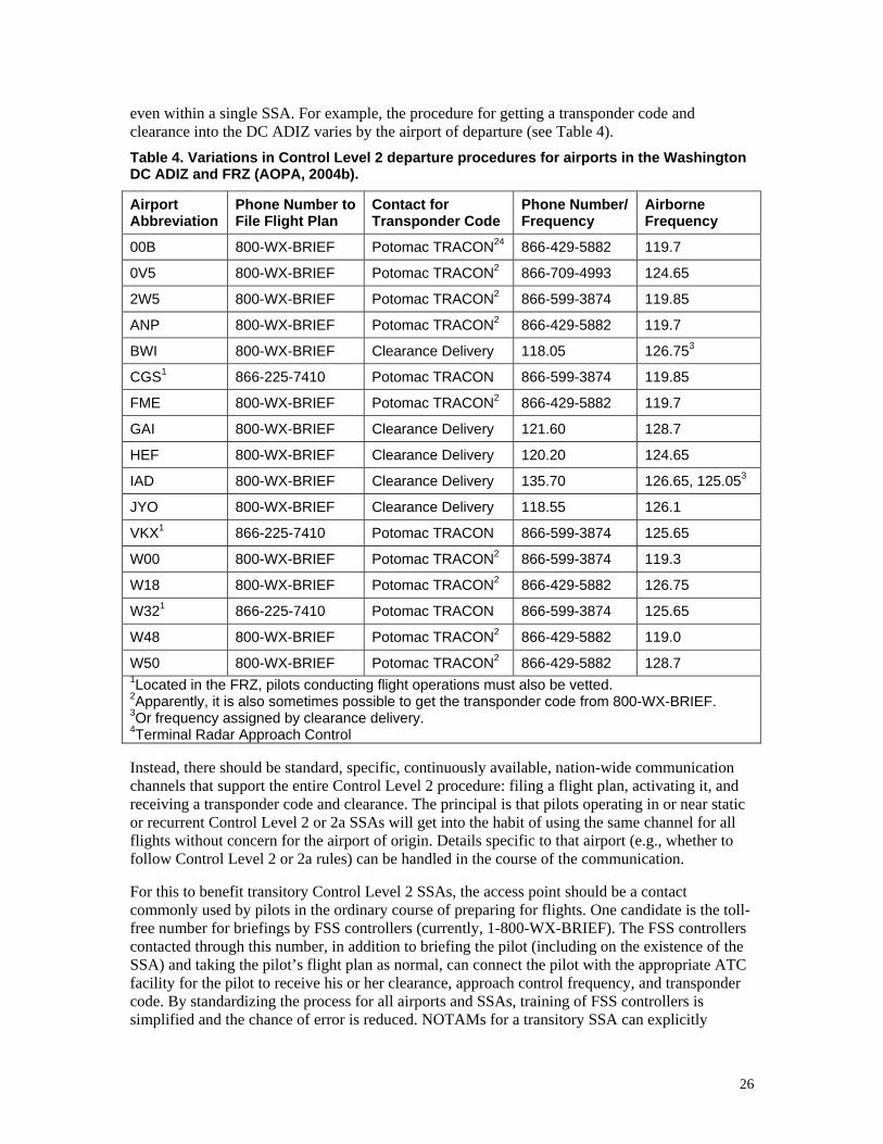
26
even within a single SSA. For example, the procedure for getting a transponder code and clearance into the DC ADIZ varies by the airport of departure (see Table 4). Table 4. Variations in Control Level 2 departure procedures for airports in the Washington DC ADIZ and FRZ (AOPA, 2004b).
Airport Abbreviation
Phone Number to File Flight Plan
Contact for Transponder Code
Phone Number/ Frequency
Airborne Frequency
00B 800-WX-BRIEF Potomac TRACON24 866-429-5882 119.7
0V5 800-WX-BRIEF Potomac TRACON2 866-709-4993 124.65
2W5 800-WX-BRIEF Potomac TRACON2 866-599-3874 119.85
ANP 800-WX-BRIEF Potomac TRACON2 866-429-5882 119.7
BWI 800-WX-BRIEF Clearance Delivery 118.05 126.753
CGS1 866-225-7410 Potomac TRACON 866-599-3874 119.85
FME 800-WX-BRIEF Potomac TRACON2 866-429-5882 119.7
GAI 800-WX-BRIEF Clearance Delivery 121.60 128.7
HEF 800-WX-BRIEF Clearance Delivery 120.20 124.65
IAD 800-WX-BRIEF Clearance Delivery 135.70 126.65, 125.053
JYO 800-WX-BRIEF Clearance Delivery 118.55 126.1
VKX1 866-225-7410 Potomac TRACON 866-599-3874 125.65
W00 800-WX-BRIEF Potomac TRACON2 866-599-3874 119.3
W18 800-WX-BRIEF Potomac TRACON2 866-429-5882 126.75
W321 866-225-7410 Potomac TRACON 866-599-3874 125.65
W48 800-WX-BRIEF Potomac TRACON2 866-429-5882 119.0
W50 800-WX-BRIEF Potomac TRACON2 866-429-5882 128.7 1Located in the FRZ, pilots conducting flight operations must also be vetted. 2Apparently, it is also sometimes possible to get the transponder code from 800-WX-BRIEF. 3Or frequency assigned by clearance delivery. 4Terminal Radar Approach Control
Instead, there should be standard, specific, continuously available, nation-wide communication channels that support the entire Control Level 2 procedure: filing a flight plan, activating it, and receiving a transponder code and clearance. The principal is that pilots operating in or near static or recurrent Control Level 2 or 2a SSAs will get into the habit of using the same channel for all flights without concern for the airport of origin. Details specific to that airport (e.g., whether to follow Control Level 2 or 2a rules) can be handled in the course of the communication.
For this to benefit transitory Control Level 2 SSAs, the access point should be a contact commonly used by pilots in the ordinary course of preparing for flights. One candidate is the toll-free number for briefings by FSS controllers (currently, 1-800-WX-BRIEF). The FSS controllers contacted through this number, in addition to briefing the pilot (including on the existence of the SSA) and taking the pilot’s flight plan as normal, can connect the pilot with the appropriate ATC facility for the pilot to receive his or her clearance, approach control frequency, and transponder code. By standardizing the process for all airports and SSAs, training of FSS controllers is simplified and the chance of error is reduced. NOTAMs for a transitory SSA can explicitly
27
instruct pilots to call FSS before takeoff in order to comply with the Control Level 2 requirements. Working through FSS can work for towered airports too, provided that standard language is used to emphasize that a clearance into a SSA does not constitute clearance to depart the airport or to enter other controlled airspace (e.g., Class D).
In a more technically advanced system, the FSS controller can deliver the clearance and code directly to the pilot by communicating electronically with the ATC facility. Electronic flight plan activation with clearance delivery is discussed in greater detail in Section 5.4.3, but the capacity for it within the FAA and with selected other agencies opens additional candidates for single-contact compliance with Control Level 2 requirements. The radio frequencies for FSSs can be used, so a single radio call from an airborne pilot approaching a SSA could yield a filed and activated flight plan, and the code and clearance for entry into the SSA.
Another contact point that would benefit from electronic flight plan activation with clearance delivery would be electronic briefing services such as DUATS and DUAT. Having entered a flight plan previously or in the same session, a pilot can activate it and receive clearance and code. Electronic flight plan filing can already be done through DUATS and DUAT, but only for flights that do not enter Control Level 2 SSAs..
Barring electronic flight plan activation, the FSS controller contacted from the air should at least be able to hand off the pilot to ATC for clearance and code. NOTAMs for transitory SSA should include the ATC frequencies that may be used.
4.3.3. Standardize SSA Control Levels
SSA control levels have been gravitating to the levels given in Table 2. Confusion about the procedures for these control levels can be reduced by formalizing, standardizing, naming, and documenting the control levels. To minimize the training, memory burden, and confusion, the number of standard control levels should be kept to a bare minimum. Four is likely to be an acceptable number of levels.
Once standardized, pilots can be taught about the required procedures as part of normal flight training. Reference manuals such as the Aeronautical Information Manual (AIM) (FAA, 2004d) can provide details in the event the exact procedures are forgotten. When a transitory SSA is imposed, pilots will at most need only a quick brush up. Standardization also simplifies training and minimizes the chance of error for ATC and FSS personnel.
Procedures for each control level should be sufficiently standard and clear such that if a NOTAM states that a “Control Level 2 TFR” has been imposed, or that a static SSA is being temporarily upgraded from “Control Level 3” to “Control Level 1,” pilots can know or easily find out what is required without further reference to the NOTAM. With such standardization, the full formatted description of the requirements, as shown in Figure 8, will not need to be included with every NOTAM, reducing the information clutter a pilot must sift through when reviewing a preflight briefing report. The NOTAM can be limited to just information specific to a particular SSA, such as its boundaries in the case of a transitory SSA. With such terminology defined, the Airport/Facility Directory can note the control level for each airport in a static or recurrent SSA. For charts and maps associated with SSAs, each standard control level should have distinguishable symbology so that pilots looking at the chart or map can immediately recognize the required procedures.
While standardization should be maximized as much as feasible, allowance should be provided for additional requirements or licenses for a given transitory SSA activation for very exceptional circumstances in response to a specific threat or vulnerability. Such exceptions should be

28
prominently indicated in the associated NOTAMs, using formatting techniques discussed in Sections 4.1.2 and 4.2.4, and shown in Figure 8.
Standardization and formalization of the control levels will be of particular benefit to Control Level 2 and 2a SSAs. Control Level 2 SSAs vary in their requirements, with transitory SSAs, such as those for presidential TFRs, tending to restrict more operations than static SSAs, such as the DC ADIZ (e.g., compare FAA 2003a with 2005b). The Control Level 2a SSAs within the DC ADIZ, meanwhile, are relatively vaguely and inconsistently defined. Sometimes both airport arrival and departure is allowed under standard codes, and sometimes only departure (see Table 5). The allowed regions or paths are ill-defined for many airports, and there have been violations due to misunderstandings of the text descriptions provided in the NOTAMs (Zuschlag, 2005).
As feasible for each SSA’s degree of stability, these regions should be specifically defined and placed on the maps provided with the associated NOTAMs, and on sectionals and other navigation maps, as well as in GPS displays. For static and recurrent SSAs, the standard transponder codes should be printed in the chart margins and be available in the AFD notes for the airport. Table 5. Variations in Control Level 2a procedures for airports within the DC ADIZ (AOPA 2004b, 2004c). Note that only two airports allow arrivals under standard transponder codes. For the others, arrivals follow Control Level 2 procedures.
Airport Abbreviation
Departure Code
Arrival Code
Airborne Frequency1
1W5 1205 None Potomac TRACON 128.7
2VG2 1205 None Potomac TRACON 124.65
3VA1 1205 None Potomac TRACON 124.65
3W3 1233 1233 Common Traffic Advisory Frequency 122.7
4MD9 1205 None Potomac TRACON 126.75
7MD9 1205 None Potomac TRACON 119.7
AVA9 1205 None Potomac TRACON 124.65
MD48 1205 None Potomac TRACON 119.0
MD64 1205 None Potomac TRACON 119.7
MD90 1205 None Potomac TRACON 119.7
MD92 1205 None Potomac TRACON 119.0
MTN 1205 None Potomac TRACON 119.0
VA97 1205 None Potomac TRACON 124.65
W29 1227 1227 Common Traffic Advisory Frequency 123.0 1Pilots are required to monitor the respective frequency, but do not have to contact with ATC.
4.3.4. Education and Training
Standardization of procedures and control levels will eventually reduce the frequency of SSA violations due to procedure misunderstanding, but until then pilots still must climb a learning curve regarding these new kinds of airspace. In the mean time, errors can be somewhat reduced by introducing new standard language for FSS and ATC controllers to emphasize the peculiar
29
aspects about SSAs. For example, FSS briefers can remind pilots to “squawk discrete code before takeoff,” since a common error is for pilots to attempt to get a clearance and transponder code immediately after takeoff into a Control Level 2 SSA, this being a common practice in other analogous situations (Zuschlag, 2005).
Another common error is setting the transponder to the standard VFR code (1200) when ATC services, such as IFR flight, are terminated within a Control Level 2 SSA. Again, this standard practice for flight outside a SSA, and pilots may find themselves doing this unthinkingly once ATC announces its services have ended. By changing the standard language for ending services in a SSA (e.g., “Maintain squawk <code>. Radar services now terminated.”), ATC can cue the pilot to follow the proper procedure, and prevent pilots from thinking or assuming they heard instructions to “squawk VFR.”
The FAA can also continue its educational outreach to pilots in the interim before training on the standardized control levels becomes a normal part of ground school. The widespread application of SSAs over the past three years represent a substantial change in the airspace and warrants an aggressive educational campaign, probably on a scale similar to what has been done for runway incursions (FAA, 2002d) or the conversion of Terminal Control Areas (TCAs) to Class B airspace in 1992. Such an outreach may also be necessary for any future SSA that does not follow “standard” levels of control (e.g., a SSA that uses the gateway airport model of control described in Section 2.1). Possible avenues of outreach include:
Safety seminars normally held by the local Flight Standards District Office.
Biannual recurrent VFR ground instruction.
Incorporation in the educational materials shipped to flight instructors.
The FAASafety.gov electronic newsletter.
Perhaps an annual educational push can be conducted each February, since there is some reason to believe that the frequency of SSA violations is especially high in March and April, as flying activity increases with the coming of spring (Zuschlag, 2005).
5. The Long Term: ISARC
With a long-term view, new technologies can be developed to attain a more dramatic reduction in the frequency of accidental violations of SSAs than can be achieved by just changing the content and form of SSA information. Such short-term changes to content and form are expected to reduce violations, but the present technical system would still require pilots to search effectively for the information prior to flight and to accurately recall and use the information once approaching an SSA. This will have an inherently limited impact. In pursuing long term technological interventions, it becomes possible to conceive of a system that "pushes" SSA information to the pilot with nominal initiation on his or her part. Furthermore, this information can be presented to the pilot not just during flight planning, but while airborne, including shortly before a potential violation. With the information presented temporally proximal to the potential violation, recall failures and errors are minimized. The system can select when, where, and how to present such information based on selected contextual information (e.g., aircraft location) from sources that are likely to be more accurate than those provided by the pilot. Finally, the system can automate various processes, or at least offer recommended actions for the pilot to approve, reducing the probability of pilot error in manually carrying out the procedures required by an SSA.

30
Specifically, one can envision the future implementation of an Integrated System for Airspace Requirements Compliance (ISARC), a set of digital device features that supports the following root functions to be available to the pilot both while on the ground and while airborne:
Presentation of up-to-date information on any SSA of any degree of stability, including the display of the SSA on an electronic moving map.
Fully mechanized filing and activation of SSA flight plans and reception of SSA clearances and transponder codes.
Alerting of the potential for a SSA violation.
For system to provide such functions in the air, it will almost certainly require that new devices be aboard aircraft. Given that an effective intervention requires that these devices be aboard the vast majority of all low-end general aviation aircraft (as well as other aircraft), such devices must be compatible with all principles given in Section 3, including low cost. For a more long term intervention, the need to follow these principles is likely to be even more important since future airspace is expected to include large numbers of light sport aircraft (AvWeb 2004; FAA, 2004g), pilots of which should have and use devices that include ISARC. Details for conforming to these principles are discussed further in Section 5.6.
5.1. Functional Requirements
The following sections detail the requirements for each root function of ISARC. Unless otherwise stated, all requirements apply both when the aircraft is airborne and when on the ground.
5.1.1. SSA Presentation
ISARC is capable of providing up-to-date information on any SSA. The information available to the pilot includes the SSA’s activation time, control level or compliance procedure, ceiling, special (e.g., SSA-specific) requirements, and other information relevant to complying with the SSA. Changes in a SSA's attributes, including its activation, are provided in real time from when the changes come into effect or earlier. This includes the establishment and activation of transitory SSAs.
ISARC is capable of displaying the SSA information in several formats to best support the pilot's task of complying with the SSA. This includes a strategic map display of the SSA, showing its position and boundaries for a pilot-selected map view, and a tactical map display, showing the SSA relative to the aircraft's current position with an appropriate frequency of position updates (e.g., RTCA, 2003). Both map display types are capable of showing the SSA relative to other aeronautical objects as described in Section 4.2.2. The control level of the SSA is symbolically differentiated on the map displays.
ISARC is also capable of displaying the SSA information as text, with the format and layout designed to maximize understandability and compliance (see Sections 4.2.4 and 4.3.1).
5.1.2. Mechanized Filing and Activation of SSA Flight Plans
ISARC is capable of receiving or retrieving a pilot-entered flight plan. The flight plan may be retrieved from a separate device or component, or a flight planning capability may incorporated with ISARC into a single device to allow the creating, updating, and deleting flight plans. ISARC is then capable of formally filing the retrieved flight plan by electronically sending it to a ground-
31
based FSS or ATC authority as appropriate. ISARC is capable of both initiating and updating a flight plan in this manner. Included with the flight plan is the following information:
Flight plan type: IFR, VFR, or VFR for SSA penetration (i.e., defense-VFR).
Aircraft identity and description.
Pilot identity and contact information.
Aircraft capabilities, as appropriate (e.g., if aircraft is equipped with digital radio).
Other information necessary to file a flight plan (e.g., occupant information).
ISARC is capable of sending a request for clearance into a SSA and receiving clearance authorization in return. As the aircraft approaches entry into a SSA, this request may be transmitted automatically, or ISARC can prompt the pilot to transmit the request.
Having received a SSA clearance, ISARC is capable of processing the information included with the clearance for use by the pilot and the ISARC alerting function. This information includes the transponder code and the necessary communication radio frequency for SSA penetration. As a minimum, ISARC is capable of displaying the code and radio frequency to the pilot (e.g., as a notice or as an item on an electronic checklist). Optionally, ISARC interfaces with the transponder and/or radios, setting the transponder code automatically, and tuning the standby radio to the appropriate frequency. ISARC is capable of verifying that the code transmitted by the transponder corresponds to the code received with the clearance.
ISARC is capable of displaying the status of the clearance for a SSA, indicating if the pilot is cleared to enter the SSA or not. The pilot is able to determine from the device the reason for a lack of clearance (e.g., no filed flight plan, no activated flight plan, or ATC-rejected flight plan). ISARC is also capable of indicating if the flight plan has been closed or canceled and if the transponder code is no longer valid or required (e.g., due to the aircraft exiting the corresponding SSA under VFR).
ISARC supports the electronic closing and canceling of flight plans. The pilot is able to manually close and cancel a flight plan filed with ATC with real time effect. ISARC is capable of automatically closing a flight plan on determination that the flight has been completed (e.g., aircraft arrives on the ground at the destination or alternative airport as entered in the flight plan). ISARC does not close the flight plan if there are indications of a mishap (e.g., sharp drop in ground speed to zero). ISARC notifies the pilot if it does not close a flight plan for this reason. Optionally, ISARC can take measures to alert the authorities in the event of such a mishap.
The ISARC capacity to process flight plans includes conveniently supporting flight plans involving pattern work at an airport, being able to file, activate, monitor, and possibly close such plans. ISARC is designed such that it is not necessary to file and activate a new flight plan with every takeoff when using a flight plan involving pattern work.
5.1.3. Alerting of Potential for SSA Violation
ISARC is capable of alerting the pilot if there are indications of the potential for a violation of a SSA. An ISARC alert is presented at a level of attention-getting that corresponds to the urgency of pilot action to avoid a violation. At the lowest level of alert, potential for violation is on the order of hours away. At the highest level, pilots must respond in less than a minute to avoid a violation. The alert level may vary from the display of a small symbol or annunciator to a prominent alert message and aural, possibly speech, alarm.

32
ISARC is capable of providing the appropriate level of alert for all the conditions given in Table 6. High level alerts include an indication of the imminence of the violation and perhaps offer a course of action to avoid a violation (Stock, 2004). For example, as the aircraft is approaching a SSA, an alerting message on the display may give a countdown of tenths of nautical miles until anticipated penetration. If the SSA is at Control Level 2, and a valid unfiled flight plan is available to the device, ISARC can offer to file and activate it. If the SSA is at Control Level 1, ISARC may offer an alternative course that will best avoid penetration, possibly allowing for other considerations (e.g., terrain).
ISARC is capable of determining if the aircraft is on the ground and not positioned for departure and thereby suppresses alerts. Alerts are triggered under the conditions in Table 6 on indication that the aircraft is preparing for takeoff at an airport in a SSA (e.g., positioned between ends of a runway and oriented on the runway's heading). Table 6. ISARC alert conditions and levels.
Condition Alert Level
An entered flight plan conflicts or is especially close to a SSA.
Medium for Control Level 1. Low for Control Level 2, 2a, or 3.
A new active SSA relevant to the flight plan or current general location has been imposed since the pilot filed the flight plan.
Medium for Control Level 1 2, or 2a. Low for Control Level 3
Current track and altitude or vertical speed will imminently bring the aircraft into a SSA.
High for Control Level 1. High for 2 if no flight plan is activated. Low for Control Level 3.
Current speed, flight plan and/or track will cause the aircraft to become trapped in a SSA that is about to activate.
High for Control Level 1. High for 2 if no flight plan is activated. Low for Control Level 3.
Transponder is not squawking the appropriate code while approaching a Control Level 2 or 2a SSA.
High
Pilot attempts to change the transponder from the appropriate code while in a Control Level 2 or 2a SSA.
High. If ISARC can control the transponder, it requests pilot confirmation before the transponder code is actually changed.
Pilot attempts to cancel the flight plan while in a Control Level 2 SSA.7
High. ISARC requests pilot confirmation before actually canceling the flight plan.
The aircraft is deviating from an activated flight plan.
High when in a Control Level 2 SSA. Medium otherwise.
The aircraft is deviating from an acceptable path while in a Control Level 2a SSA.
High
5.1.4. Additional Functions
The following functions are not related to ISARC's three root functions, nor are they intended to reduce the frequency of violations of SSAs. They are additional optional features whose value is to mitigate the possible repercussions of a violation. Depending on the implementation of the on-board device that incorporates ISARC and its relation to other devices, such functions can be supported by leveraging the ISARC components necessary for the root functions.
7 There is no alert if the pilot attempts to amend the flight plan.
33
Among these additional functions is an ability for an authorized air traffic controller, law enforcement officer, or interceptor pilot to unilaterally extract flight plan information from the device incorporating ISARC (whether filed and activated or not), along with the aircraft identity and type. Another is a dedicated radio emergency communication channel that allows authorized personnel to contact the pilot irrespective of what the aircraft's communications radio is tuned to or even if the radio is on. ATC or interceptors may use this channel to contact a pilot who is violating a SSA when all normal channels fail. With the ability to extract information and establish communication with a violating aircraft, authorities can make a more accurate assessment of the risk presented by the aircraft, minimizing the chance of a misunderstanding resulting in targeting the aircraft as a high-level threat.
5.2. Infrastructure Requirements
ISARC will rely on various routine processes to exchange information between the on board device and ground agencies. Ground-to-ground versions of many of these processes already exist, but need to be revised to best suit ISARC. Chief among these is a means to transfer the latest SSA information to each instance of ISARC. This may involve various organizations in the FAA coordinating to distribute the information to the device's vendor for subsequent reformatting and distribution to the pilot (much as is now done for the databases for GPS moving map devices). Alternatively, the FAA can make the information directly available to the pilot for downloading into the device incorporating ISARC. In order to include information on transitory SSAs and recurrent SSA activation, this distribution will need to include information that is usually covered by NOTAMs. In order to meet the requirement for up-to-date information, the capability must exist to transmit such information to a moving aircraft.
To be maximally effective at meeting its functional requirements and thereby reducing violations of SSAs, ISARC (as proposed) depends on an infrastructure that includes the implementation of many of the short-term interventions discussed in Section 4. ISARC, in this way, builds on more immediate interventions, and such short term intervention retain their value after ISARC has reached widespread deployment. Among the key short-term interventions that ISARC needs is the replacement of blanket NOTAMs with individual SSAs (Section 4.1.6). ISARC can no better than a pilot reliably keep track of all locations and events that may qualify under these NOTAMs. Instead, ISARC needs information on specific locations with specific boundaries and time for displaying them and alerting the pilot.
Improving and standardizing the format and language of NOTAMs is equally important for deploying ISARC as it is for achieving short term impacts (Sections 4.1.2 and 4.2.4). A pilot using ISARC to display information about a SSA would benefit as much from better formatting as a pilot retrieving such information from the web. For ISARC, it is especially important for the FAA to offer a standardized machine-readable format for SSA information (Section 4.2.5), so that ISARC can correctly interpret the requirements of a SSA and alert the pilot accordingly. If ISARC has to extract requirements from free-form text NOTAMs, it may make errors in determining the requirements, and such errors will lead to pilots distrusting and ultimately not using ISARC. In line with this intervention is the standardization of SSAs into a few levels of control, each with standard names and symbology (Section 4.3.3). This will allow ISARC to present precise and accurate representations of the SSAs, using symbols consistent with paper charts. With standardized control levels, ISARC can minimize the number of alert false alarms.
Electronic flight plan activation with clearance delivery requires a new capability on the ground to accept such electronic flight plans, pass them to appropriate personnel in the FAA, and transmit back a clearance and transponder code. This represents the most significant new
34
infrastructure change needed for ISARC to realize its full potential, especially for minimizing violations of Control Level 2 SSAs. Electronic flight plan activation is defined as a fully automated process for filing and activating a flight plan via electronic links to an FSS/ATC system. For flights into a Control Level 2 SSA, the FSS/ATC system automatically reviews it, and, on approval, passes the information to the appropriate controller. The system then sends back to the pilot an approved clearance, transponder code, and radio frequency to contact ATC for when the aircraft enters the SSA. Approval of the flight plan would be based on an algorithmic review of the flight plan against any special security requirements of the SSA. In general, any reasonable flight plan would be routinely approved.
Because the air traffic controller is not responsible for ensuring separation for an aircraft operating under VFR, such a clearance can be automated because the controller does not have to coordinate the aircraft’s entry into the airspace with other traffic. As such, this form of automated clearance delivery is limited to flights into SSAs. If the pilot intends to fly IFR or enter Class B (major terminal) airspace, an air traffic controller may likely have to become involved, although in the future the controller may deliver the clearance through the same electronic channel (Morse, 2004). This is similar to the current process where clearance into a SSA does not necessarily constitute clearance into other airspace imbedded within.
While electronic flight plan activation and clearance delivery represents a new capability, as discussed in Section 4.3.1, it may be valuable for reducing SSA violations even before ISARC is deployed. Once electronic flight plan activation is implemented for ground-based electronic briefing services, extending it to ISARC becomes a relatively small extension.
5.3. Performance Requirements
The requirements for ISARC regarding accuracy, reliability, and integrity are much the same as for any avionics (e.g., RTCA, 2003). In particular, it is necessary for ISARC to be sufficiently accurate and reliable to meet the FAA's criteria for a sole source of SSA information. In addition, like any avionics, a detectable failure of ISARC must not endanger the aircraft before the pilot can respond and an undetectable failure of ISARC must not endanger the aircraft in any case. For example, an implementation of ISARC must not fail in a manner that it displays hazardously misleading information. Furthermore, the operation of ISARC must not compromise the safe operation of the aircraft as a whole. For example, an ISARC-generated alert must not be so intense that it distracts pilots from more important information in the cockpit. Likewise, the workload associated with the correct use of ISARC must not interfere with safety-critical tasks of flight. Beyond these requirements, a certain level reliability, accuracy, effectiveness, and ease of use are necessary to maximize the probability of pilot acquisition and use of ISARC (see Section 3).
5.4. Technological Elements and Development Needs
There are numerous ways to implement ISARC as defined above. However, a fast and affordable implementation can be expected to capitalize on existing and emerging technological elements. The fewer elements that need to be developed from scratch, the more rapidly ISARC can become available to a large proportion of pilots, and the larger impact it will have on reducing violations of SSAs. The elements, their relation to ISARC, and their current development status are summarized in Table 7.

35
Table 7. Existing and new technological elements that may be used to implement ISARC’s functional requirements.
Element Related Features Related Requirements Status
GPS Moving Map Devices
Platform for ISARC. See Table 8. Deployed
Electronic Flight Bags (EFBs)
Additional platform for ISARC.
Same as GPS moving map devices.
Prototyped
Universal Access Transceiver (UAT)
Aircraft-ground datalink protocol developed for general aviation.
En route updating of SSA information.
Electronic flight plan activation and automated reception of SSA clearances.
Field testing
Flight Information Service – Broadcast (FIS-B)
General information service for datalink.
En route updating of SSA information.
Field testing
Digital Radio Always-available emergency channels.
Communication with violating aircraft.
Under development
Wide Area Augmentation System (WAAS)
Aircraft altitude and precise position.
Suppression of false alerts when taxiing.
Currently being deployed
System Wide Information Management (SWIM)
Infrastructure for inter-agency information transfer.
SSA information transmission.
Electronic flight plan activation and automated clearance delivery.
Under development
FAA Telecommunications Infrastructure (FTI)
Infrastructure for information transfer within the FAA.
SSA information transmission.
Electronic flight plan activation and automated clearance delivery.
Under development
Electronic flight plan activation and SSA clearance.
Infrastructure for automated flight plan processing.
Electronic flight plan activation and automated clearance delivery.
To be proposed
5.4.1. Current Technologies
A root requirement of ISARC is the on-board map display if SSAs relative to the aircraft. As such, it is functionally closest to existing cockpit GPS navigation and situation awareness moving map devices. Marketed at general aviation pilots, these moving map devices generally feature a GPS receiver, a database of aeronautical objects, a map generator to create an image of these objects in relation to the current position of the aircraft, and a graphic display to show the image. Typically, the vendor provides periodic updates for the database that the pilot manually uploads through a physical port or data storage device reader.
Moving map devices provide basic functions related to ISARC. Many of these devices will show airspace (e.g., Class B, C, D, etc.) on their moving map displays (Aircraft Electronics Association (AEA), 2004). Other products, such as those provided by Weather Services International, already provide graphic depiction of TFRs on cockpit displays (AEA, 2004; see also Higdon, 2002). Built-in databases of moving map devices allow the pilot to access text information about various
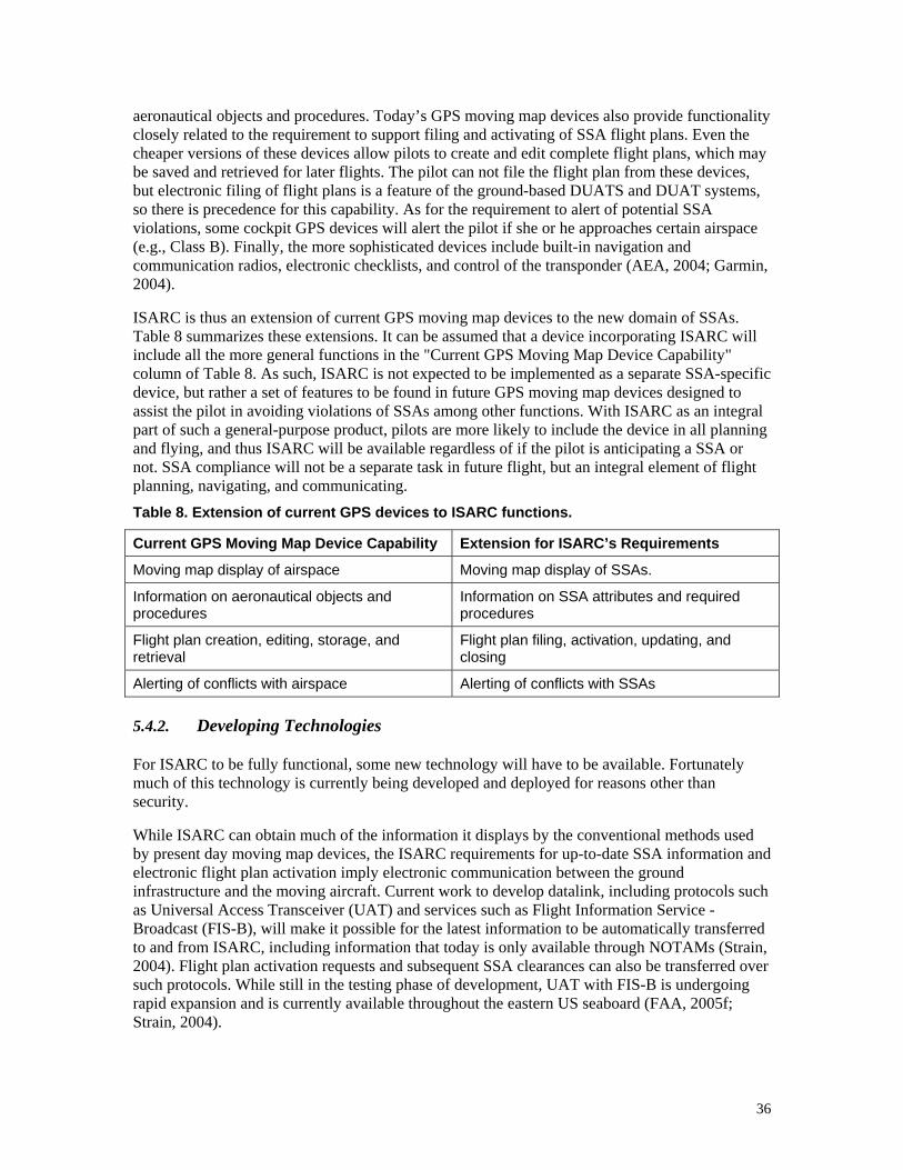
36
aeronautical objects and procedures. Today’s GPS moving map devices also provide functionality closely related to the requirement to support filing and activating of SSA flight plans. Even the cheaper versions of these devices allow pilots to create and edit complete flight plans, which may be saved and retrieved for later flights. The pilot can not file the flight plan from these devices, but electronic filing of flight plans is a feature of the ground-based DUATS and DUAT systems, so there is precedence for this capability. As for the requirement to alert of potential SSA violations, some cockpit GPS devices will alert the pilot if she or he approaches certain airspace (e.g., Class B). Finally, the more sophisticated devices include built-in navigation and communication radios, electronic checklists, and control of the transponder (AEA, 2004; Garmin, 2004).
ISARC is thus an extension of current GPS moving map devices to the new domain of SSAs. Table 8 summarizes these extensions. It can be assumed that a device incorporating ISARC will include all the more general functions in the "Current GPS Moving Map Device Capability" column of Table 8. As such, ISARC is not expected to be implemented as a separate SSA-specific device, but rather a set of features to be found in future GPS moving map devices designed to assist the pilot in avoiding violations of SSAs among other functions. With ISARC as an integral part of such a general-purpose product, pilots are more likely to include the device in all planning and flying, and thus ISARC will be available regardless of if the pilot is anticipating a SSA or not. SSA compliance will not be a separate task in future flight, but an integral element of flight planning, navigating, and communicating. Table 8. Extension of current GPS devices to ISARC functions.
Current GPS Moving Map Device Capability Extension for ISARC’s Requirements
Moving map display of airspace Moving map display of SSAs.
Information on aeronautical objects and procedures
Information on SSA attributes and required procedures
Flight plan creation, editing, storage, and retrieval
Flight plan filing, activation, updating, and closing
Alerting of conflicts with airspace Alerting of conflicts with SSAs
5.4.2. Developing Technologies
For ISARC to be fully functional, some new technology will have to be available. Fortunately much of this technology is currently being developed and deployed for reasons other than security.
While ISARC can obtain much of the information it displays by the conventional methods used by present day moving map devices, the ISARC requirements for up-to-date SSA information and electronic flight plan activation imply electronic communication between the ground infrastructure and the moving aircraft. Current work to develop datalink, including protocols such as Universal Access Transceiver (UAT) and services such as Flight Information Service - Broadcast (FIS-B), will make it possible for the latest information to be automatically transferred to and from ISARC, including information that today is only available through NOTAMs (Strain, 2004). Flight plan activation requests and subsequent SSA clearances can also be transferred over such protocols. While still in the testing phase of development, UAT with FIS-B is undergoing rapid expansion and is currently available throughout the eastern US seaboard (FAA, 2005f; Strain, 2004).
37
Digital radio will also offer new options for communication between the aircraft and the ground, including the possibility of an always-on emergency voice communication channel. The channel can even be design to be heard by the pilot even if the radio's microphone key is stuck (Morse, 2004). While currently available GPS moving map devices is perhaps the most logical product to include ISARC, the new and more general purpose electronic flight bags (EFBs), with their own GPS modules and databases, is an additional possibility (Chandra, et, al., 2003) that may make ISARC available to an even wider range of pilots.
Meanwhile, on the ground, deployment of the Wide Area Augmentation System (WAAS) is proceeding, which, in addition to allowing navigation with greater precision and integrity, can also be used to determine altitude in lieu of the traditional barometric altimeter. This will allow a self-contained device to determine if an aircraft is flying over an airport or merely taxiing on its surface, thus making it possible for ISARC to suppress false alerts of SSA penetration. National network interconnection initiatives, such as System Wide Information Management and the FAA Telecommunications Infrastructure wide-area network, will provide the infrastructure for faster, more widespread, and more automatic transfer of digital information among government agencies, including SSA declarations and activations.
5.4.3. Future Developments
The most significant all-new development needed to fulfill ISARC’s requirements is the infrastructure to support electronic flight plan activation and automated clearance delivery. While this may leverage the new FAA information infrastructure current under development (see 5.4.2 above), certain dedicated automated processes will have to be implemented in order to actually receive an electronic flight plan (perhaps via datalink), review it for security requirements, route it to the appropriate ATC personnel, and select the proper transponder code and radio frequency to transmit back to the pilot. As a significant new process, electronic flight plan activation requires research and development largely by the government. Likely, a functioning proof-of-concept demonstration may be the necessary first step in order to establish the feasibility to the FAA and to the aviation community.
5.5. Notional System
5.5.1. Components and Interfaces
Figure 9 presents an example implementation of ISARC using the technological elements reviewed above in 5.4. Actual implementation may differ from this depending on research findings, the capabilities of future technology, and the details of the targeted operational environment and market. The notional device shown here integrates ISARC with many of the components found in current GPS moving map devices (shown black outline in Figure 9). Any of these components may be implemented as an integrated hardware, software, and network architecture. A database component includes flight plans that were entered through the user interface or uploaded through a port (if the flight plan was prepared on another device such as a personal computer). The database also includes all aeronautical information including information on all SSAs of all degrees of stability. Much of this information, including information on static and recurrent SSAs, may be updated through a port (e.g., from a storage unit shipped by the vendor). Pilots also have limited ability to create and edit information (e.g., pilot-defined waypoints). Clearance records are kept indicating if each entry into a SSA in the flight plan is approved. Aircraft and pilot identity and characteristics are entered by the pilot when the device was acquired. A WAAS-capable GPS receiver component determines the aircraft position and altitude. A moving map generation component takes all this information to create a map
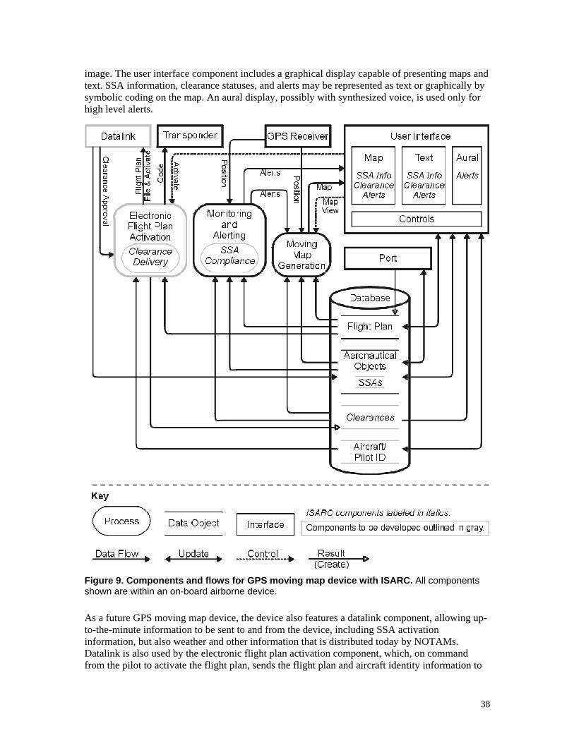
38
image. The user interface component includes a graphical display capable of presenting maps and text. SSA information, clearance statuses, and alerts may be represented as text or graphically by symbolic coding on the map. An aural display, possibly with synthesized voice, is used only for high level alerts.
Figure 9. Components and flows for GPS moving map device with ISARC. All components shown are within an on-board airborne device.
As a future GPS moving map device, the device also features a datalink component, allowing up-to-the-minute information to be sent to and from the device, including SSA activation information, but also weather and other information that is distributed today by NOTAMs. Datalink is also used by the electronic flight plan activation component, which, on command from the pilot to activate the flight plan, sends the flight plan and aircraft identity information to
39
ATC, receiving in return clearance approval and transponder codes, the latter which may be sent to the transponder. The SSA compliance monitor, part of a more general monitoring and alerting component, takes the aircraft and SSA positions, the clearance records, and other information and compares these to requirements for the SSAs as stored in the database.
The device may interface with the transponder, as shown in Figure 9, to allow ISARC to automatically set the transponder to the code necessary for SSA penetration once clearance is received. Alternatively, perhaps to avoid the additional certification issues associated with interfacing with panel electronics, the device may instead include a 1190 MHz transponder receiver so that it can detect the aircraft's current transponder setting and provide alerts if the transponder code does not match the code received with the clearance. Ideally, such an implementation of ISARC would include a 1030 MHz receiver and low-powered transmitter so that if no ATC interrogations are detected, ISARC can interrogate the aircraft's transponder. This will provide an alerting functionality even when the aircraft is not in range of ATC radar (e.g., when on the ground at certain airports).
In another variation, a totally self-contained handheld unit may be implemented with an integrated the transponder that encodes the WAAS altitude with its response signal. The use of WAAS altitude rather than barometric altitude for this purpose would need to be approved by the FAA, but it would make it allowable for aircraft without an electrical system to fly through Control Level 2 and 2a SSAs. If WAAS altitude is to be used for high altitude flight (above Flight Level 180), surface pressure readings would have to be datalinked to the device so it can correct the altitude to simulate the standard barometric altimeter setting of 29.92 inches.
Not shown in Figure 9, but also possibly included are incorporated or interfaced communication radios (possibly with the future digital channels) and perhaps even navigation radios.
5.5.2. Function Implementation
To display information about SSAs to the pilot, SSA information is stored in the database with other geographic and aeronautical information. Information on the boundaries of static and recurrent SSAs is loaded into the database through routine updates. Information on recurrent SSA activations and transitory SSAs is loaded automatically by datalink when the device is on and new information is available. The SSAs are shown graphically on the map display, along with other geographic information, both when the pilot is graphically editing and reviewing a flight plan and when the pilot has selected the moving map display. Different symbology, consistent with that found on official paper charts, distinguishes different levels of control. The pilot can also call up as text additional information from the database on any SSA, just as she or he can for weather, hazards, and other information useful in flight planning.
Using the datalink, the pilot can choose to electronically file a created or amended flight plan with the FAA, including for flight through a Control Level 2 SSA. An annunciation on the display acknowledges acceptance of the plan. For a simple VFR flight, this may mean little more than entering the identifier of the destination airport and selecting “Send Plan.” The current airport, as determined from the GPS position, is the default starting point, and a single course path is assumed and likely flight time is calculated; pilot and aircraft information are pulled from the database.
The datalink is also used to activate the flight plan for VFR flight, which includes clearance delivery to the cockpit for entry into Control Level 2 SSAs. Ideally, a single pilot action activates (or amends) the flight plan with ATC and FSS or possibly, activation is automatically triggered by the aircraft arriving at the start point of the flight plan (e.g., the GPS receiver indicates that the
40
aircraft is moving onto a runaway of an airport identified as the flight plan's origin). If this involves Control Level 2 SSA, the clearance and appropriate transponder code is received in real time. A status annunciator on the ISARC display informs the pilot if she or he is cleared or not, and the received transponder code and radio frequency is set or displayed to the pilot. The flight plan is automatically closed via the datalink when the aircraft arrives at its destination as indicated by the GPS receiver. The status annunciator also indicates if the aircraft has departed the SSA, although the transponder code may best be left unchanged (e.g., in case the aircraft is flying under IFR).
The implementation supports ISARC’s SSA alerting functionality by continuously monitoring transponder setting or transmissions, along with aircraft altitude, position, and trend as determined from the GPS receiver, and combining this with information stored in the database on the SSA boundaries, aircraft flight plan, and clearances and codes in order to determine if an alert is warranted. For example, in general no alert is given if the WAAS altitude, current position, and ground speed indicate the aircraft is on the ground at an airport (where airport altitude is stored in the database). However if the aircraft moves towards the ends of any runway at the airport or otherwise enters a runway and aligns itself on the runway’s heading (where runaway end positions are also stored in the database), then a synthesized voice warns the pilot if a Control Level 1 SSA is in effect over the airport.
In the event of certain alerts, the device displays recommended courses of action based on information in the database and capabilities provided by other components. For example, in recommending an alternative course to avoid a Control Level 1 SSA, The device may consider the current WAAS altitude and terrain information, the latter which may be stored in the database. If the incorporating GPS navigation device is currently coupled to the autopilot, the pilot may simply approve the course recommendation, and the device will execute it.
5.6. Analysis
5.6.1. Effectiveness and Timeliness
Over eighty-five percent of violations of SSAs are due a pilot’s lack of correct knowledge or understanding of a SSA, specifically, the presence of the SSA, the boundaries of the SSA, and the procedures necessary for SSA penetration. By providing SSA presence, boundary, and procedure information in a most compelling representation (e.g., on a moving map), it is very improbable that a pilot who uses ISARC would violate a SSA due to lack of knowledge. For those that do, the alerting feature offers a backup to make violations even more remote. The main limit on the effectiveness of ISARC is the proportion of pilots that are equipped with ISARC. If nearly all pilots operating around static and recurrent SSAs were equipped with ISARC (these being the pilots most motivated to acquire ISARC), and ISARC were nearly 100% effective at preventing violations due lack of knowledge and understanding, then, given 75% of all violations occur in static and recurrent SSAs, the frequency of SSA violation can be expected to drop by 64%. If, in addition, half of all remaining pilots acquire ISARC (these being less motivated pilots), the frequency of SSA violation can be expected to drop by 75%. Given that ISARC is an integrated set of features of a GPS moving map device, many pilots will acquire ISARC not because they specifically sought it, but because it was part of a generally useful device. Indeed, in the future, as advanced digital electronics increase their penetration the general aviation cockpit, perhaps nearly all pilots will have a GPS moving map device, all which may include ISARC. In such a future, violations may be reduced by 85% or more. If this is achieved, the frequency of SSA violations will be returned to the same order of magnitude as observed before 9/11/2001.

41
By building on technology that currently exists or is already under development, the development time for ISARC is probably on the order of 10 years. The primary limit on faster development is not the incorporating device itself. GPS moving map devices already exist, and moving map displays using datalink have already been demonstrated. Rather, the primary limit is the time necessary to implement the ground infrastructure. This includes providing nation-wide datalink coverage, improving information transmission within federal agencies, and developing and supporting electronic flight plan activation. While ISARC may be about 10 years away, it is likely the problem it addresses will still remain. The future of the current sources of terrorism is unpredictable, but, while it is conceivable that it will be greatly attenuated within the next 10 years, it seems more likely that it will remain for a number of decades (United States, 2004). Even if the current source is attenuated, one can anticipate new organizations with new political agendas attempting to emulate the same tactics as seen on 9/11/2001. In other words, SSAs may remain part of the aviation landscape for many years come. There is a definite need for a long-term intervention to reduce accidental violations of SSAs.
5.6.2. Compliance and Security Impacts
ISARC is primarily intended to reduce accidental violations of SSAs. Given that its purpose is to increase compliance with flight regulations, one should consider the possibility that it could also unintentionally decrease compliance with regulations. With regard to automated clearance delivery via electronic flight plan activation, the possibility exists for pilots to confuse a SSA clearance for other traditional clearances (e.g., for takeoff or entry into Class B). Mitigating this issue is that non-SSA clearances will continue to be given through two-way radio communication for the near future, just as pilots are used to today. Only SSA clearances, that is, only the new airspace types will support automated clearance delivery. This is an improvement over the current system where clearance to nearly all airspace, including SSAs, is done by radio. The potential for a pilot to confuse clearance into a SSA to also include clearance into overlapping airspace of another type is higher now than it would be with ISARC, yet this does not appear to be a serious problem (Zuschlag, 2005). Pilots have long been acquainted with handling overlapping layers of airspace (e.g., Class D under Class B, or a restricted SUA in Class B).
ISARC is not specifically designed to address a security threat, at least not directly. One may ask if, in seeking to reduce accidental SSA violations, ISARC will compromise security. Specifically, cannot a terrorist take an ISARC equipped aircraft and use the electronic flight plan activation component to gain access to a Control Level 2 SSA? The answer is yes, this will be possible, but it represents nothing different than what may be done today. There is nothing stopping a terrorist from using a phone or radio to file and activate a legitimate flight plan into a Control Level 2 SSA. ISARC may offer a slightly greater security by its feature to automatically send pilot and aircraft identification information with the flight plan. For example, if the plane has been reported as stolen, the terrorist has declared its location by filing and activating a flight plan (although a savvy terrorist may have the knowledge and time to re-write the identifying information in the incorporating device’s database). It should also be remembered that reducing violations itself improves security by making more resources available for handling each violation. Adding improved communication as part of ISARC also allows any remaining accidental violations to be handled quickly and safely so that attention can be refocused on any other potential threats.
5.6.3. Safety Impacts
ISARC is also not specifically designed to directly improve safety, at least outside of minimizing accidents associated with interception. However, as when anything is introduced into the cockpit, the impact on safety must be considered for both normal and failure modes. Because ISARC is
42
primarily an information presentation system and because the information is not safety related, the impact of an ISARC failure is minimal. That is, there is simply no information about a SSA that ISARC could incorrectly display that would be hazardously misleading. If ISARC displays the wrong information about a SSA, the likely impact is either (a) the pilot avoiding airspace when it is not necessary, or (b) the pilot violating a SSA. The former may cost the pilot time and money (e.g., additional fuel) and the latter results in an enforcement action against the pilot, but neither are themselves safety concerns. A failure to correctly depict a SSA or alert the pilot of a SSA is very unlikely to result in catastrophic consequences (e.g., aircraft destruction), at least not without other improbable errors also occurring (e.g., by an interceptor). Providing features to mitigate the impact of violations, such as including an always-available emergency radio channel, reduces the chance of catastrophe even further. In general, a sufficient level of reliability, integrity, and accuracy of the SSA depictions are primarily an issue for certification (Section 5.6.4) and pilot acceptance (Section 5.6.5), not safety.
Regarding normal functioning, concern may also be raised that ISARC represents greater workload and distraction for the pilot as discussed in Section 5.3 (e.g., from alerts and display of SSAs, which may mask more pressing information the pilot needs). GPS moving map devices, for example, are already complex, offering a myriad of features and information layers. Accessing these features with limited controls and viewing this information on a small screen is already pushing the limits of acceptability in some cases. Adding ISARC increases the demands of the user interface. It is necessary that ISARC not interfere with other features, especially those related to safety of flight. The more ISARC can be integrated as part of the user interface of a multi-function on-board device (e.g., a general-purpose moving map display), the less impact it will have. On the other hand, the more ISARC is implemented as a separate device or a poorly integrated set of features within a multi-function device, the more workload it will likely represent.
The incorporation of ISARC in large-screen state-of-the-art glass cockpits for general aviation aircraft is almost certainly feasible. It is believed to be also possible for a handheld unit to meet these requirements. For example, a decluttering feature to remove the display of SSAs from the moving map is likely to be a common characteristic of such devices, possibly integrated with a general “airspace” display mode. Only by evaluating actual implementations can it be demonstrated that a small device provides ISARC at acceptable levels of ease of use. Not all possible implementations are likely to be successful. With adequate research and attention to this issue, impacts can be minimized. Overall, ISARC should reduce pilot workload. Displaying the SSA on a moving map allows the pilot to monitor the SSA's relative position better than requiring the pilot to cross-reference a paper chart. Electronic flight plan activation with clearance delivery reduces the attention and actions necessary to obtain clearance into a Control Level 2 SSA, freeing pilot resources for safety concerns.
There is also a safety issue related to displaying recommended pilot actions in the event of an alert of an approaching SSA. Research is need to study the possibility of the pilot blindly following a recommendation and possibly compromising safety for the sake of avoiding a violation (e.g., turning away from a SSA and into terrain or traffic). To some degree, this is mitigated by ISARC’s capacity to graphically display SSAs well before an alert condition is triggered (indeed, before the flight even begins). Thus, alerts prompting an immediate response by the pilot should be relatively rare. Nonetheless, the manufacturer needs to address in the design of this feature such a possibility. At a minimum, it needs to be made clear to the pilot what conditions are considered in providing the recommended action. Otherwise, this may be a feature that is best left out.
43
A moving map device that incorporates ISARC may also have more direct safety benefits. With the capacity for convenient electronic flight plan filing and activation, VFR pilots may be more likely fly under flight plans even when no SSA is nearby. With more pilots flying with filed flight plans, search and rescue can respond more quickly to an overdue aircraft. One may also ask if more filed flight plan means more false alarms for search and rescue due to failure to close a flight plan or notify FSS of a change in plans. However, the former is minimized by ISARC automatically closing the flight plan on arrival. The latter is minimized by ISARC alerting the pilot of flight plan deviations (to which the pilot may respond by amending the flight plan, or, if outside a SSA, easily canceling the plan). It seems more likely that if electronic flight plan activation and closing is widely used in lieu of manual activation and closing, the frequency of such false alarms would decrease.
Finally, it should be noted that the presence of ISARC in a GPS moving map device may encourage pilots (e.g., those flying around static SSAs) to use such a device when otherwise they would not. While their main reason for using the device may be to avoid SSA violations, the other features will likely provide them with greater overall situation awareness, increasing overall safety.
5.6.4. Certification
To be effective, an ISARC implementation must meet the FAA's criteria for a sole source of SSA information. Furthermore, being on board the aircraft and possibly interfacing with panel-mounted avionics, it may also have to be certified as a cockpit device. Certification can add considerably to the development time and costs of such a system. However, given that ISARC does not provide information related to safety of flight (see Section 5.6.3), such implementations may be certified at a relatively low level, comparable to devices intended for situation awareness. At the lowest level, ISARC may be incorporated into a handheld moving map device with no other connection to the aircraft other than possibly a power supply and cradle. In such an implementation, no interface is provided to the transponder or communication radios, although ISARC should be able to monitor the aircraft's transponder signal for alerting purposes. This does not rule out a manufacturer from choosing a higher level of certification, consistent with the intended market and selling price (Chandra, Yeh, Riley, and Mangold, 2003), in which the incorporating device is panel mounted with interfaces with cockpit systems such as the altimeter, radios, transponder, and autopilot. This range of potential implementation is desirable because it makes ISARC more widely available for more pilots and more aircraft, allowing it to have a larger impact on reducing violations.
Thus, the impact of certification is that the time and cost to develop and a device with ISARC is comparable to the time and costs of a general-purpose GPS moving map device. ISARC does not add much additional certification burden. Manufacturers intending to implement ISARC can reduce the cost and development time by organizing with the FAA to write minimum operational performance standards for ISARC, which the FAA can cite in a technical standard order (TSO).
5.6.5. Cost and Acceptance
Cost is another consideration when evaluating the viability of ISARC. By leveraging infrastructure technology that will be deployed anyway, additional costs to federal agencies is minimized. The electronic flight plan activation component, specifically automated clearance delivery capability is the only element that is specific to reducing SSA violations. While electronic flight plan activation with clearance delivery is key for the most effective implementation of ISARC and important for reducing SSA violations even in the absence of
44
ISARC, it has other benefits as well. As discussed in Section 5.6.3, by making filing and activating a flight plan more convenient, pilots flying VFR are more likely to file flight plans in order to capitalize on the safety of having search and rescue promptly initiated in the event of a failure to complete the flight plan. While the automated clearance delivery feature is only initially suitable for SSAs, it may have a more general application in the future national airspace that implements the Next Generation Air Transportation System (NGATS) (Joint Planning and Development Office, 2004). In such an environment where the responsibility for traffic separation is shared between aircraft and ground, automated clearance delivery may have application for access to dense traffic areas. The application of automated clearance delivery to SSAs may thus serve as test bed for such concepts. The FAA may be motivated to pursue its implementation for these reasons of safety improvement and future airspace development, in addition to the reducing SSA violations.
Pilots are expected to bear some of the cost by purchasing and maintaining the GPS moving map devices that incorporated ISARC. Many if not most pilots that habitually operate near static or recurrent SSAs (e.g., the Washington D.C. area) are likely to accept the cost of a moving map device with ISARC given the penalties for violating an SSA, commonly being a two month suspension of one's pilot's license (Zuschlag, 2005). However, for ISARC to reduce SSA violations by an order of magnitude, the majority of pilots throughout much of the US should be equipped with such devices. With a range of moving map products marketed, from situation awareness devices to those certified for navigation, nearly every pilot should be able to find a unit that is within budget. Furthermore, with ISARC being a set of features within a more general product, some of the cost may be absorbed into the larger system, providing the pilot with more value than would be achieved with a separate dedicated device. Pilots may purchase the incorporating device primary for its other features, believing ISARC itself will not be necessary. Nonetheless, ISARC will be available for them when it is needed.
After purchase of a device with ISARC for whatever reason, the subsequent use of ISARC is a voluntary action for pilots. Success of ISARC thus depends on the wide acceptance and use of ISARC in the pilot community. Acceptance and use probably depends mostly on the degree ISARC provides tangible benefit with minimal additional effort. Thus, as discussed previously, a certain level of accuracy and reliability, along with ease of use of the user interface is key to the acceptance of an ISARC implementation. With the proper infrastructure in place (e.g., the FAA providing machine-readable SSA information available to aircraft by datalink to compare to the WAAS-determined aircraft position), accuracy and reliability should be very high. A certain level of integrity monitoring can also be built into the system in that it flags the pilot if, for example, a SSA declaration is received that for some reason ISARC cannot interpret. An easy-to-use user interface represents a greater challenge that warrants further research. If the device is difficult to use, pilots may respond by not using the device during periods of high workload, which is typically when operating at low altitude such as on approach, precisely where a SSA violation is most likely.
Currently, pilots are deeply concerned about SSA violations and appear willing to take some responsibility to reduce the chances of a violation on their own (Charles, 2002, 2004), and thus ISARC is likely to be accepted, and even welcomed. Furthermore, ISARC represents few inconveniences for the pilot, integrating well with normal tasks. Indeed, electronic flight plan activation is likely to be seen as a significant benefit: a flight need only be entered once, not twice as is necessary for today (once for ATC or FSS, and once for the GPS map device). Pilots may recognize the safety benefits of this feature even when no known SSA is present. Finally, when ISARC is not needed, it remains unobtrusive. Assuming the user interface requirements are met,
45
using a device with ISARC when no SSAs are present entails no more work than using a device that lacks ISARC.
5.6.6. Alternatives
ISARC nonetheless presents a nontrivial investment, and it is worth comparing its value to alternatives to reducing SSA violations. It may be argued that the short-term interventions listed in this paper are sufficient. However, the short-term interventions as a group have one major limitation that ISARC addresses: only ISARC helps the pilot avoid a SSA violation when it is about to occur. The short-term interventions provide help primarily during preflight. Violations do not occur until after the pilot is airborne, allowing time for the pilot to forget SSA information or become distracted while attempting to deal with SSAs. Furthermore, only ISARC addresses the scenario of a pilot who is simply lost (Zuschlag, 2005). Avoiding a SSA requires that pilots know the SSA boundaries relative to the aircraft. If the pilot is lost, knowing the absolute location of the boundaries by referring to a chart will not help. ISARC will display and alert the pilot to an approaching SSA even if the pilot does not know where she or he is.
Within the context of long-term solutions, one should consider other technological interventions for reducing SSA violations. For example, one could develop portable radio beacons to mark the boundaries of SSAs. A system could monitor ATC radar data and detect an aircraft straying too close to a SSA and automatically send the pilot a warning such as by laser light (Associated Press, 2005; Avweb, 2005). Navigation aids could be modified to transmit a special signal when they are in a SSA. Any solution that relies on widespread ground-based and cockpit hardware specifically related to SSA will likely cost substantially more overall than ISARC, which uses only ground infrastructure and cockpit systems that are being developed anyway. Furthermore, only ISARC, being onboard the aircraft with access to its navigation and communication systems, is in the best position to evaluate the aircraft’s compliance with the SSA’s requirements –not only whether the aircraft is in or out of the SSA, but whether it has a clearance and is squawking the right code. Such other technological interventions can certainly be developed to reinforce the effectiveness of ISARC, but ISARC will likely provide the greatest impact on SSA violations for the amount of effort expended.
5.6.7. Realization
While it is expected that there is a market for ISARC, it may be necessary to encourage the private implementation of it through development and demonstrations by government aviation research agencies. Specifically, such an organization can work with the FAA to specify and even develop the infrastructure as described in Section 5.4.3. Work is necessary to determine the best means to implement the infrastructure, establishing ground communication links and new processes among FAA organizations. A research organization can also contribute by prototyping an ISARC-incorporating device. By studying ISARC use under realistic flight conditions, such an organization can provide a proof of the concept, flesh out the requirements beyond those given in 5.1, and investigate promising avenues of implementation, as discussed in 5.5. Such preliminary work will do much to encourage ISARC development by industry.
6. Additional Issues and Research
This paper has focused on interventions to reduce violations of SSAs by focusing on providing pilots with better information on SSAs. There are other issues related to reducing violations or minimizing the impacts of violations, but further study is necessary before interventions can be formulated (Zuschlag, 2005). These issues include:

46
Effectiveness of SSA communication between pilots and FSS briefers.
Impact of the current frequency of SSAs on ATC workload and techniques to mitigate it.
Effectiveness of communication between violating pilot and interceptor pilot.
Interceptor requirements, current suitability, and alternatives.
Further study, including trend analysis, of SSA violation frequencies.
Most of the proposed interventions in this paper seek to provide better SSA information to pilots by changing NOTAMs, maps, cockpit displays, and other artifacts used directly by pilots. However, pilots also received SSA information from through FSS personnel, and there are some indications of communication breakdown concerning SSAs between pilots and FSS briefers. Zuschlag (2005) provided only the pilot’s perspective on this problem. Specific study of FSS briefers is called for to better understand the characteristics and seriousness of this problem. The deployment of new systems such as OASIS is aimed at improving FSS quality of service, but it is not clear if these systems will specifically address the reasons for the apparent problems with SSA communication.
There have also been some indications that SSAs represent a substantial increase in workload for ATC, and higher workload itself may be contributing to violations and other problems (Landsberg, 2003; Zuschlag, 2005). Further study is needed to specifically understand the impact of SSAs on ATC. If the workload has increased to the point that performance is compromised, interventions may be called for. For example, it may be necessary to break up the airspace around static SSAs. When a recurrent or transitory SSA is in effect, it may be helpful to subdivide tasks among more controllers (e.g., one controller may be charged with just giving SSA clearances).
After a violation has occurred, there have been cases of difficulties of communication between the interceptor and violator (Zuschlag, 2005), even though procedures supposedly allow effective communication even when no radio contact is achieved. There may be a need for an educational outreach for general aviation and interceptor pilots, emphasizing the importance of knowing and following standard intercept procedures and monitoring the emergency radio channel, especially when a TFR is nearby.
The interceptor aircraft itself also warrants more careful study. The current interceptors include full-capability supersonic fighters such as the F-16 and passenger-type aircraft such as Blackhawk helicopters and Citation business jets. These represent a poor compromise of the requirements and can even present dangers (Zuschlag, 2005). An interceptor for SSA violations should have low operating costs and be able to fly at low speed. It also should be able to dash across an SSA to the location of the violator, communicate with a violator, possibly without relying on radios, maneuver and target weapons on an adversary (which may be an acrobatics-capable airplane), and deliver ordinance capable of downing a large aircraft.
Government study is needed to flesh out these requirements, and find an aircraft that best fits them. One option is to develop an all-new aircraft, but possibly there are currently active or mothballed aircraft (e.g., the A-4 or AT-38) that may serve, perhaps after some minor modifications. Alternatively, the fully detailed requirements and performance characteristics may imply that a system of multiple aircraft types is best. For example, possibly multiple uninhabited aerial vehicles (UAVs) can patrol the same airspace cheaper than a single manned aircraft. With several UAVs each responsible for a smaller portion of the SSA, they would not need especially high dash speed. A loitering unarmed UAV may be used to initially intercept, observe, communicate with, and direct a violating aircraft. A high-speed armed and manned tactical

47
aircraft is scrambled only if the aircraft refuses to comply or attempts evasion. A third passenger-type aircraft may also be available to promptly bring law enforcement personnel to the violator's aircraft after it has landed.
Finally, it is important to continue to monitor the frequency of violations of SSAs. As stated earlier, the frequency appears to be decreasing but it may level off at an unacceptable rate if additional interventions are not implemented. As interventions to reduce accidental violations are implemented, it will be important to monitor their ultimate impact. It would be particularly interesting to monitor violations associated with presidential TFRs to evaluate the effectiveness of communication about them. Presidential TFRs include large Control Level 2 SSAs, which, based on the early experience of the DC and New York ADIZs, can be hypothesized to be associated with substantial numbers of violations. This hypothesis has yet to be tested, however.
7. Summary
This paper suggests interventions to reduce the violations of SSAs. As a rule, a pilot does not deliberately violate a SSA. Pilots in general feel strongly motivated to avoid such violations and take such violations and the general need for SSAs very seriously (Zuschlag, 2005). Violations are pilot errors mostly due to the pilot’s lack of knowledge or understanding of a SSA. The interventions in this paper seek to improve this knowledge and understanding. In the short-term, interventions are focused on improving the form and format of the information on SSAs contained in NOTAMs, along with providing additional channels for SSA information, such as on aeronautical charts. In many ways the past three years have been an experiment, with various kinds of SSAs tried to seek a good balance between security and free access to the skies. Now there should be enough experience to standardize SSAs, which itself should reduce violations. A proposed long-term intervention dovetails well with existing and emerging technologies to provide pilots with SSA situation awareness and alerts in the cockpit, where it is needed most.
The philosophy behind these interventions is to acknowledge the problem SSAs present for pilots and to find feasible solutions that best address the problem, whether the cost of solution is initially borne by pilots, the government, or industry. The shear frequency of violations indicates that current means of addressing violations through sanctioning pilots is ineffective. The nation is not one ounce more secure by intercepting and punishing accidental violators. In fact, it is less secure.
8. Abbreviations and Acronyms
ADIZ ............ Air Defense Identification Zone
ADS-B.......... Automatic Dependent Surveillance – Broadcast
AEA.............. Aircraft Electronics Association
AFD.............. Airport/Facility Directory
AFSS ............ Automated Flight Service Station
AIM .............. Aeronautical Information Manual
AOPA........... Aircraft Owners and Pilots Association
ARP .............. Aerospace Recommended Practice

48
ATC.............. Air Traffic Control
ATIS ............. Automatic Terminal Information Service
AWOS .......... Automated Weather Observing System
BGAN........... Broadband Global Area Network
CFR .............. Code of Federal Regulations
CTAF............ Common Traffic Advisory Frequency
DC ................ District of Columbia
DME............. Distance Measuring Equipment
DUAT........... Direct User Access Terminal
DUATS......... Direct User Access Terminal System
EFB............... Electronic Flight Bag
FAA.............. Federal Aviation Administration
FANS............ Future Air Navigation System
FBO .............. Fixed Base Operator
FDC .............. Flight Data Center
FIS-B ............ Flight Information Service - Broadcast
FRZ............... Flight Restricted Zone
FSS ............... Flight Service Station
FTI................ FAA Telecommunications Infrastructure
GPS............... Global Positioning System
HIWAS......... Hazardous In-flight Weather Advisory Service
HTML........... Hypertext Mark-up Language
ICNS............. Integrated Communications, Navigation and Surveillance
IFR................ Instrument Flight Rules
IMAPS.......... Internet Marine and Aviation Planning Services
ISARC .......... Integrated System for Airspace Requirements Compliance
METAR........ Meteorological Report
MHz.............. MegaHertz
MSL.............. Mean Sea Level
NAIMES....... NAS Aeronautical Information Management Enterprise System

49
NAS.............. National Airspace System
NASA........... National Aeronautics and Space Administration
NDB ............. Nondirectional Beacon
NGATS......... Next Generation Air Transportation System
nm................. Nautical Mile
NORAD........ North American Aerospace Defense Command
NOTAM ....... Notice to Airmen
NSA.............. National Security Area
NTSC............ National Transportation Systems Center
OASIS .......... Operational and Supportability Implementation System
PDF............... Portable Document Format
RTCA ........... Radio Technical Commission for Aeronautics
SFRA............ Special Flight Rules Area
SSA............... Security-Supporting Airspaces
STI................ Scientific and Technical Information
SUA.............. Special Use Airspace
SUA/ISE....... Special Use Airspace/Inflight Service Enhancement
SWIM........... System Wide Information Management
TAF .............. Terminal Aerodrome Forecast
TCA.............. Terminal Control Area
TFR............... Temporary Flight Restriction
TIBS ............. Telephone Information Briefing Service
TRACON ..... Terminal Radar Approach Control
TSA .............. Transportation Security Administration
TSO .............. Technical Standard Order
TWEB........... Transcribed Weather Broadcast
UAT.............. Universal Access Transceiver
UAV ............. Uninhabited Aerial Vehicles
US................. United States
USSS ............ United States Secret Service
50
VFR .............. Visual Flight Rules
VHF.............. Very High Frequency
VIP ............... Very Important Person
VOR ............. VHF Omnidirectional Range
WAAS .......... Wide Area Augmentation System
9. References Aircraft Electronics Association (2004). Pilot's Guide to Avionics. Available from the author at
http://www.aea.net/.
Aircraft Owners and Pilots Association (2002a). FAA releases 45-nm Special Flight Rules Area for 2002 Winter Olympics. News Items, January 16, 2002. http://www.aopa.org/whatsnew/newsitems/2002/02-1-021x.html.
Aircraft Owners and Pilots Association (2002b). Reduction of P-40 TFR good news for Maryland pilots. News Items, April 25, 2002. http://www.aopa.org/whatsnew/newsitems/2002/02-2-074x.html.
Aircraft Owners and Pilots Association (2003a). President Bush gets 30-nm TFR for Chicago visit Wednesday. News Items, June 10, 2003. http://www.aopa.org/whatsnew/newsitems/2003/03-2-187x.html.
Aircraft Owners and Pilots Association (2003b). AOPA Expo 2003 to kick off with visit from FAA administrator. News Items, June 27, 2003. http://www.aopa.org/whatsnew/newsitems/2003/03-2-198.html.
Aircraft Owners and Pilots Association (2003c). AOPA, member input leads to improved FAA TFR Web site. News Items, November 6, 2003. http://www.aopa.org/whatsnew/newsitems/2003/03-4-083x.html.
Aircraft Owners and Pilots Association (2004a). FAA joins AOPA's efforts to educate D.C.-area pilots on flight restrictions. News Items, June 9, 2004. http://www.aopa.org/whatsnew/newsitems/2004/040609adiz.html.
Aircraft Owners and Pilots Association (2004b). Departure and Pattern Operations at Airports within the Washington Air Defense Identification Zone Including Clearance Delivery Frequencies and Potomac Landline Numbers. http://www.aopa.org .
Aircraft Owners and Pilots Association (2004c). Checklists for Operations within the Washington D.C. ADIZ Area. http://www.aopa.org .
Aircraft Owners and Pilots Association (2005a). AOPA Online - Notices to airmen (NOTAMs, TFRs). http://www.aopa.org/whatsnew/notams.html.
Aircraft Owners and Pilots Association (2005b). NORAD can shoot down aircraft threatening nuke plants. News Items, March 17, 2005.
Associated Press (2005). Pentagon to use lasers to warn pilots. Washington, DC, April 12, 2005. At Cable News Network, http://www.cnn.com/2005/TRAVEL/04/12/lasers.planes.ap/index.html.
AvWeb (2004). Predicting the Short-Term Future. Newswire, March 28, 2004. http://www.avweb.com/eletter/archives/avflash/216-full.html.
AvWeb (2005). Laser Tag, NORAD Style, Is No Game. Newswire. April 17, 2005. http://www.avweb.com/eletter/archives/avflash/388-full.html.
Burnside , J. (2004). TSA Watch: AOPA And The "Dumbbell" TFR. AvWeb BizAv, July 21, 2004. http://www.avweb.com/bizav/10_30/news/187740-1.html.
51
Chandra, Divya C., Yeh, M., Riley, V., & Mangold, S.J. (2003). Human factors considerations in the design and evaluation of Electronic Flight Bags (EFBs), Version 2. DOT-VNTSC-FAA-03-07. USDOT Volpe Center: Cambridge, MA. http://www.volpe.dot.gov/opsad/efb/pdf/efb_version2.pdf.
Charles, M. M. (2002). As the Beacon Turns #53: Skipping Through the Mine Field. Avweb, July 24, 2002. http://www.avweb.com/news/columns/182359-1.html.
Charles, M. M. (2004). As the Beacon Turns #83: TFRs Again & Again. Avweb, Nov. 14, 2004. http://www.avweb.com/news/columns/188505-1.html.
Federal Aviation Administration (2002a). Enhanced Security Procedures for Operations at Certain Airports in the Washington, DC Metropolitan Area Special Flight Rules Area. Docket No. FAA-2002-11580, SFAR 94, RIN 2120-AH62, February 13, 2002. Washington, DC: Federal Aviation Administration.
Federal Aviation Administration (2002b). Airspace and Flight Operations Requirements for the 2002 Winter Olympic Games, Salt Lake City, UT (14 CFR Part 91, RIN No. 2120-AH61, Docket No. FAA-2002-11332; SFAR No. 95).
Federal Aviation Administration (2002c). Runway Incursions Nationwide Decreased in 2001. Press release posted January 23, http://www.faa.gov/apa/pr/pr.cfm?id=1490.
Federal Aviation Administration (2002d). Runway Safety Blueprint 2002-2004. FAA Office of Runway Safety, July 2002, http://www.faa.gov/runwaysafety/publications.cfm.
Federal Aviation Administration (2003a). Washington DC Metropolitan Area Air Defense Identification Zone (DC ADIZ) (FDC 3/2126). FAA Air Traffic Control Systems Command Center.
Federal Aviation Administration (2003b). Washington DC (FDC 3/0853). FAA Air Traffic Control Systems Command Center.
Federal Aviation Administration (2003c). VFR Traffic Pattern Operations (FDC 3/2943). FAA Air Traffic Control Systems Command Center.
Federal Aviation Administration (2003d). Proximity to Stadiums and Other Sporting Events (FDC 3/1862). FAA Air Traffic Control Systems Command Center.
Federal Aviation Administration (2003e). Orlando, FL (FDC 3/2122). FAA Air Traffic Control Systems Command Center.
Federal Aviation Administration (2004b). Egress Procedures for Certain Airports within the Washington, DC Metropolitan Area Air Defense Identification Zone (DC ADIZ) (FDC 4/0540). FAA Air Traffic Control Systems Command Center.
Federal Aviation Administration (2004c). Washington, DC Metropolitan Area Air Defense Identification Zone (DC ADIZ) (FDC 4/5555). FAA Air Traffic Control Systems Command Center.
Federal Aviation Administration (2004d). Aeronautical Information Manual. http://www.faa.gov/ATpubs/AIM/.
Federal Aviation Administration (2004e). Washington Sectional Aeronautical Chart (75th Edition). National Aeronautical Charting Office (FAA Product ID SWAS).
Federal Aviation Administration (2004f). Proximity to Power Plants, Dams, Refineries, Industrial Complexes, Military Facilities (FDC 4/0811). FAA Air Traffic Control Systems Command Center.
Federal Aviation Administration (2004g). Certification of Aircraft and Airmen for the Operation of Light-Sport Aircraft. Docket No. FAA–2001–11133, SFAR 94, RIN 2120–AH19, September 1, 2004. Washington, DC: Federal Aviation Administration.
Federal Aviation Administration (2005a). Special Notice, Ingress/Egress Procedures for Bay Bridge (W29) and Kentmorr (3W3) Airports in Maryland (FDC 5/0345). FAA Air Traffic Control Systems Command Center.
52
Federal Aviation Administration (2005b). Special Notice. ADIZ Egress Procedures for Certain Airports within the Washington, DC Metropolitan Area Air Defense Identification Zone. (FDC 5/0847). FAA Air Traffic Control Systems Command Center.
Federal Aviation Administration (2005c). Washington DC. (FDC 5/1254). FAA Air Traffic Control Systems Command Center.
Federal Aviation Administration (2005d). Pensacola, Florida, March 18 2005 Local (FDC 5/1953). FAA Air Traffic Control Systems Command Center.
Federal Aviation Administration (2005e). Federal Aviation Administration - Graphic TFR's. Federal Aviation Administration. http://tfr.faa.gov/tfr/list.jsp.
Federal Aviation Administration (2005f). Automatic Dependent Surveillance - Broadcast (ADS-B) and other Broadcast Services--Initial Capabilities in the National Airspace System (NAS). Graphic Notices, General Information, GEN05002, 3/10/2005. http://www.faa.gov/ntap/NTAP05APR14/gen05002.htm.
Garmin (2004). GNS 480 Color GPS/WAAS/NAV/COM Pilot’s Guide. Olathe, KS: Garmin International, Inc.
Grady, M. (2005). New Rule Spells Out Procedures. AvWeb Newswire, February 14, 2005, http://www.avweb.com/newswire/11_07a/leadnews/189160-1.html.
Government Accountability Office (2004). General Aviation Security: Increased Federal Oversight Is Needed, but Continued Partnership with the Private Sector Is Critical to Long-Term Success. GAO-05-144, November, 2004.Higdon, D. (2002). AEA 2002: Avionics Advances Continue Unabated. AvWeb (April 2002), http://www.avweb.com/news/aea2002/181592-1.html.
International Civil Aviation Organization (2001). Aeronautical Charts, Annex 4 to the Convention on International Civil Aviation (10th edition), July 2001. Montreal: International Civil Aviation Organization.
Joint Planning and Development Office (2004). Next Generation Air Transportation System Integrated Plan http://www.jpdo.aero.
Landsberg, B. (2003). Delayed and distracted. AOPA Pilot, September 2003. Also available at http://www.aopa.org/asf/asfarticles/2003/sp0309.html.
Morse, D. (2004). Next Generation FANS over BGAN. Integrated Communications, Navigation, and Surveillance (ICNS) Conference and Workshop, April 2004.
Radio Technical Commission for Aeronautics (2003). Minimum Operational Performance Standards for the Depiction of Navigation Information on Electronic Maps (DO-257A). Washington, DC: Radio Technical Commission for Aeronautics.
Reauthorization Of The Federal Aviation Administration And The Aviation Programs (2003).108th Congress, 1st Session (testimony of Walter W. Pike).
Society of Automotive Engineers (1997). Electronic Aeronautical Symbols (ARP 5289). Warrendale, PA: Society of Automotive Engineers.
Stock, T. (2004). Data Link- Supported Low-Cost Airspace Alerting and Avoiding System. MITRE Eleventh Annual Technology Symposium. McLean, VA: MITRE Corporation, (April, 2004) http://www.mitre.org/news/events/tech04/5.html#1496.
Strain, R. (2004). Safe Flight 21East Coast Implementation of Broadcast Services. Proceedings of the Fourth Integrated Communications, Navigation, and Surveillance (ICNS) Conference and Workshop. (August) (NASA/CP-2004-213308). Cleveland, OH: NASA Glenn Research Center.
United States of America (2004). The 9-11 Commission Report: Final Report of the National Commission on Terrorist Attacks Upon the United States (9-11 Commission). Washington, DC: Government Printing Office.

53
Zuschlag, M. K. (2005). Violations of Temporary Flight Restrictions and Air Defense Identification Zones: An Analysis of Airspace Violations and Pilot Report Data. NASA/CR—2005–213923, Hampton, VA: NASA Langley Research Center.

54
Appendices
Consolidated Mockup of Formatted NOTAM 5/1953
The following consolidation of Figure 4, Figure 6, Figure 7, and Figure 8 is a mockup of a complete NOTAM using formatting and graphic techniques discussed in Sections 4.1.2, 4.2.2, 4.2.4, and 4.3.1 for improving pilot awareness of the presence, boundaries, and requirements for a SSA. This may be compared to that currently available from the FAA as shown in Figure 1 and Figure 2. Such a consolidated NOTAM may be included in or linked from a preflight briefing report. The last portion of text (labeled Restrictions 1 and Restrictions 2) are not necessary if SSA requirements are standardized, as described in 4.3.3.
FDC 5/1953. Located 8 nm from flight plan. High relevance for Any Flight.
Flight RestrictionsPensacola, FL, March 18 2005, 7:50 – 12:05 local
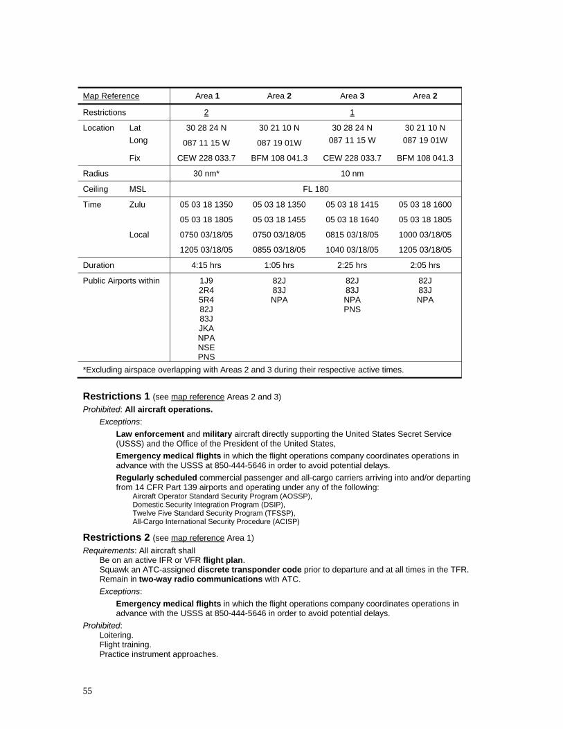
55
Map Reference Area 1 Area 2 Area 3 Area 2
Restrictions 2 1
Location Lat Long
30 28 24 N
087 11 15 W
30 21 10 N
087 19 01W
30 28 24 N 087 11 15 W
30 21 10 N 087 19 01W
Fix CEW 228 033.7 BFM 108 041.3 CEW 228 033.7 BFM 108 041.3
Radius 30 nm* 10 nm
Ceiling MSL FL 180
Time Zulu 05 03 18 1350
05 03 18 1805
05 03 18 1350
05 03 18 1455
05 03 18 1415
05 03 18 1640
05 03 18 1600
05 03 18 1805
Local 0750 03/18/05
1205 03/18/05
0750 03/18/05
0855 03/18/05
0815 03/18/05
1040 03/18/05
1000 03/18/05
1205 03/18/05
Duration 4:15 hrs 1:05 hrs 2:25 hrs 2:05 hrs
Public Airports within 1J9 2R4 5R4 82J 83J JKA NPA NSE PNS
82J 83J NPA
82J 83J NPA PNS
82J 83J NPA
*Excluding airspace overlapping with Areas 2 and 3 during their respective active times.
Restrictions 1 (see map reference Areas 2 and 3) Prohibited: All aircraft operations.
Exceptions: Law enforcement and military aircraft directly supporting the United States Secret Service (USSS) and the Office of the President of the United States, Emergency medical flights in which the flight operations company coordinates operations in advance with the USSS at 850-444-5646 in order to avoid potential delays. Regularly scheduled commercial passenger and all-cargo carriers arriving into and/or departing from 14 CFR Part 139 airports and operating under any of the following:
Aircraft Operator Standard Security Program (AOSSP), Domestic Security Integration Program (DSIP), Twelve Five Standard Security Program (TFSSP), All-Cargo International Security Procedure (ACISP)
Restrictions 2 (see map reference Area 1) Requirements: All aircraft shall
Be on an active IFR or VFR flight plan. Squawk an ATC-assigned discrete transponder code prior to departure and at all times in the TFR. Remain in two-way radio communications with ATC. Exceptions:
Emergency medical flights in which the flight operations company coordinates operations in advance with the USSS at 850-444-5646 in order to avoid potential delays.
Prohibited: Loitering. Flight training. Practice instrument approaches.

56
Aerobatic flight. Glider operations. Parachute operations. Ultralight flight. Hang gliding. Ballooning. Agriculture/crop dusting. Animal population control flight operations. Banner towing.
Additional Information: All USSS cleared aircraft operators based in the area should notify the USSS at 850-444-5646 prior to their departure.
Notes It is recommended that all aircraft operators check NOTAMs frequently for possible required changes to this TFR prior to operations within this region.
These flight restrictions are pursuant to title 14, section 91.141, of the Code of Federal Regulations (CFR).
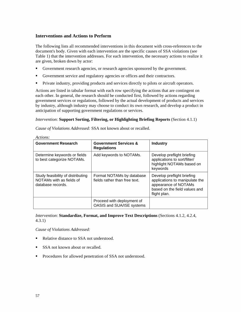
57
Interventions and Actions to Perform
The following lists all recommended interventions in this document with cross-references to the document's body. Given with each intervention are the specific causes of SSA violations (see Table 1) that the intervention addresses. For each intervention, the necessary actions to realize it are given, broken down by actor:
Government research agencies, or research agencies sponsored by the government.
Government service and regulatory agencies or offices and their contractors.
Private industry, providing products and services directly to pilots or aircraft operators.
Actions are listed in tabular format with each row specifying the actions that are contingent on each other. In general, the research should be conducted first, followed by actions regarding government services or regulations, followed by the actual development of products and services by industry, although industry may choose to conduct its own research, and develop a product in anticipation of supporting government regulations or services.
Intervention: Support Sorting, Filtering, or Highlighting Briefing Reports (Section 4.1.1)
Cause of Violations Addressed: SSA not known about or recalled.
Actions: Government Research Government Services &
Regulations Industry
Determine keywords or fields to best categorize NOTAMs.
Add keywords to NOTAMs. Develop preflight briefing applications to sort/filter/ highlight NOTAMs based on keywords
Study feasibility of distributing NOTAMs with as fields of database records.
Format NOTAMs by database fields rather than free text.
Develop preflight briefing applications to manipulate the appearance of NOTAMs based on the field values and flight plan.
Proceed with deployment of OASIS and SUA/ISE systems
Intervention: Standardize, Format, and Improve Text Descriptions (Sections 4.1.2, 4.2.4, 4.3.1)
Cause of Violations Addressed:
Relative distance to SSA not understood.
SSA not known about or recalled.
Procedures for allowed penetration of SSA not understood.

58
Actions: Government Research Government Services &
Regulations Industry
Determine format for improved readability, scanability, and understandability of NOTAMs.
Format or markup NOTAMs for easier scanning or reading.
Display NOTAMs in marked-up form in preflight briefing reports.
Standardize shapes of transitory SSAs.
Standardize boundary descriptions to always reference a navigation aid and always use MSL altitude.
List public airports affected by SSA
Intervention: Provide interactive graphic summary in preflight briefing reports (Section 0).
Cause of Violations Addressed: SSA not known about or recalled.
Actions: Government Research Industry
Study usefulness of an interactive graphic summary in preflight briefing reports.
Implement summary, contingent on research findings.
Intervention: Include SUA activations in NOTAMs (Section 0).
Cause of Violations Addressed: SSA not known about or recalled.
Actions: Government Services & Regulations
Develop means to route SUA information into NOTAM system.
Intervention: Support personalized updates in briefings (Section 0).
Cause of Violations Addressed: SSA not known about or recalled.
Actions: Government Services & Regulations Industry
Support personalized updates in FSS briefings. Support personalized updates in electronic briefing services.
Intervention: Chart Recurrent and Static SSAs (Sections 4.1.4, 4.2.1).
Cause of Violations Addressed:
Relative distance to SSA not understood.
SSA not known about or recalled.
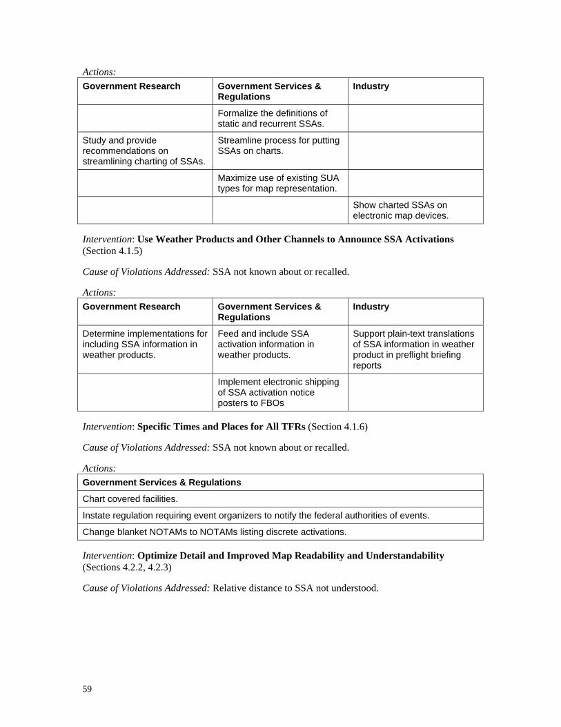
59
Actions: Government Research Government Services &
Regulations Industry
Formalize the definitions of static and recurrent SSAs.
Study and provide recommendations on streamlining charting of SSAs.
Streamline process for putting SSAs on charts.
Maximize use of existing SUA types for map representation.
Show charted SSAs on electronic map devices.
Intervention: Use Weather Products and Other Channels to Announce SSA Activations (Section 4.1.5)
Cause of Violations Addressed: SSA not known about or recalled.
Actions: Government Research Government Services &
Regulations Industry
Determine implementations for including SSA information in weather products.
Feed and include SSA activation information in weather products.
Support plain-text translations of SSA information in weather product in preflight briefing reports
Implement electronic shipping of SSA activation notice posters to FBOs
Intervention: Specific Times and Places for All TFRs (Section 4.1.6)
Cause of Violations Addressed: SSA not known about or recalled.
Actions: Government Services & Regulations
Chart covered facilities.
Instate regulation requiring event organizers to notify the federal authorities of events.
Change blanket NOTAMs to NOTAMs listing discrete activations.
Intervention: Optimize Detail and Improved Map Readability and Understandability (Sections 4.2.2, 4.2.3)
Cause of Violations Addressed: Relative distance to SSA not understood.

60
Actions: Government Research Industry and Government Services & Regulations
Determine critical information and details to include on maps of SSAs.
Update map web sites to use new maps.
Indicate map scale on maps.
Adjust map format for electronic displays and black-and-white printing.
Support user-selected map size for electronic displays
Intervention: Support easy electronic transmission of maps from FSS briefers (Section 4.2.5).
Cause of Violations Addressed: Relative distance to SSA not understood.
Actions: Government Services & Regulations
Supply FSS briefers with applications to transmit maps and other graphics by email and fax.
Intervention: Develop pilot-defined airspace alerting feature in GPS map devices (Section 4.2.5).
Cause of Violations Addressed: Relative distance to SSA not understood.
Actions: Government Research Industry
Study means to implement pilot-defined airspace alerting feature in GPS map devices.
Implement pilot-defined airspace alerting feature in GPS map devices.
Intervention: Provide machine-readable format for SSA information (Section 4.2.5).
Cause of Violations Addressed: Relative distance to SSA not understood.
Actions: Government Research Government Services &
Regulations Industry
Study best means of formatting SSA information for machine reading.
Develop standards for formatting SSA information for machine reading.
Develop and distribute machine-readable SSA information.
Develop standards for formatting SSA information for machine reading.
Develop applications to automatically read and map such distributed information.
Intervention: Standardize and Simplify the SSA Procedures (Section 0)
Cause of Violations Addressed: Procedures for allowed penetration of SSA not understood.
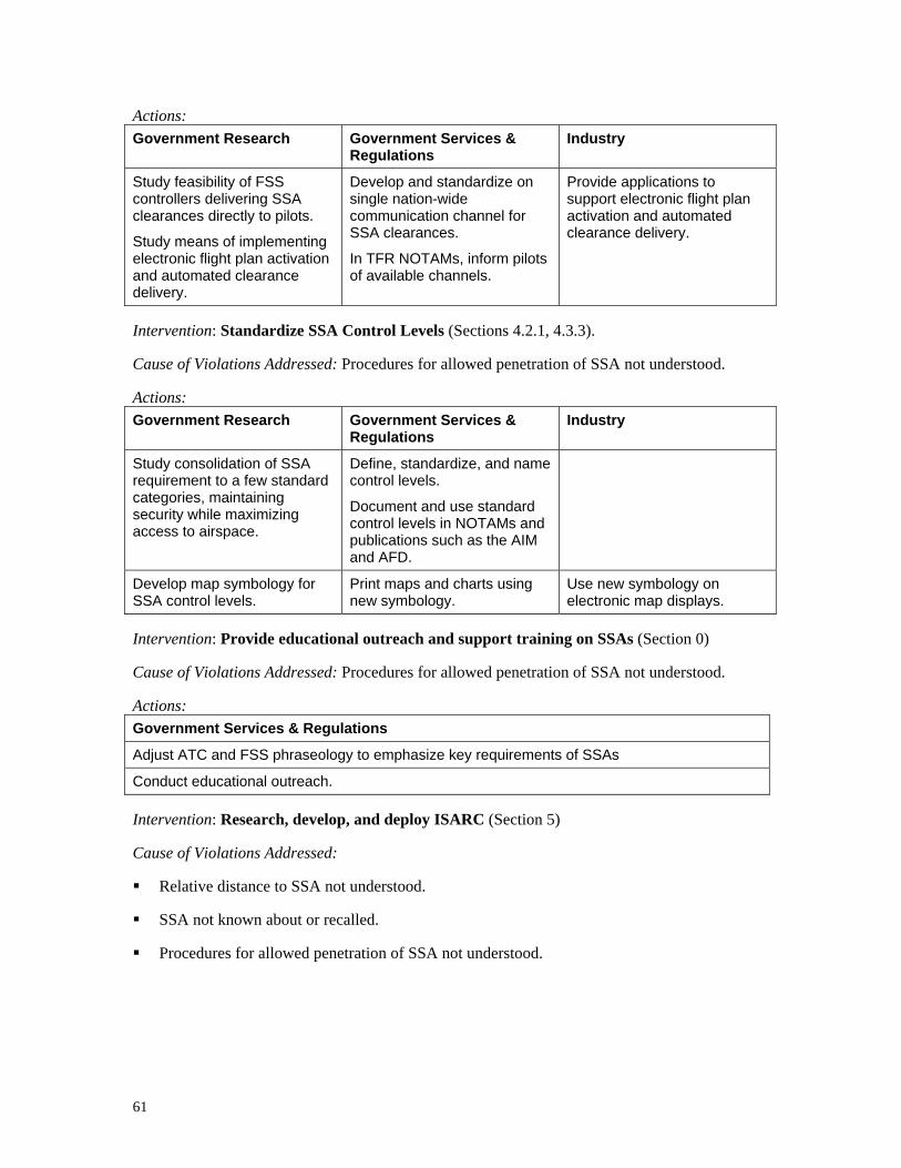
61
Actions: Government Research Government Services &
Regulations Industry
Study feasibility of FSS controllers delivering SSA clearances directly to pilots.
Study means of implementing electronic flight plan activation and automated clearance delivery.
Develop and standardize on single nation-wide communication channel for SSA clearances.
In TFR NOTAMs, inform pilots of available channels.
Provide applications to support electronic flight plan activation and automated clearance delivery.
Intervention: Standardize SSA Control Levels (Sections 4.2.1, 4.3.3).
Cause of Violations Addressed: Procedures for allowed penetration of SSA not understood.
Actions: Government Research Government Services &
Regulations Industry
Study consolidation of SSA requirement to a few standard categories, maintaining security while maximizing access to airspace.
Define, standardize, and name control levels.
Document and use standard control levels in NOTAMs and publications such as the AIM and AFD.
Develop map symbology for SSA control levels.
Print maps and charts using new symbology.
Use new symbology on electronic map displays.
Intervention: Provide educational outreach and support training on SSAs (Section 0)
Cause of Violations Addressed: Procedures for allowed penetration of SSA not understood.
Actions: Government Services & Regulations
Adjust ATC and FSS phraseology to emphasize key requirements of SSAs
Conduct educational outreach.
Intervention: Research, develop, and deploy ISARC (Section 5)
Cause of Violations Addressed:
Relative distance to SSA not understood.
SSA not known about or recalled.
Procedures for allowed penetration of SSA not understood.
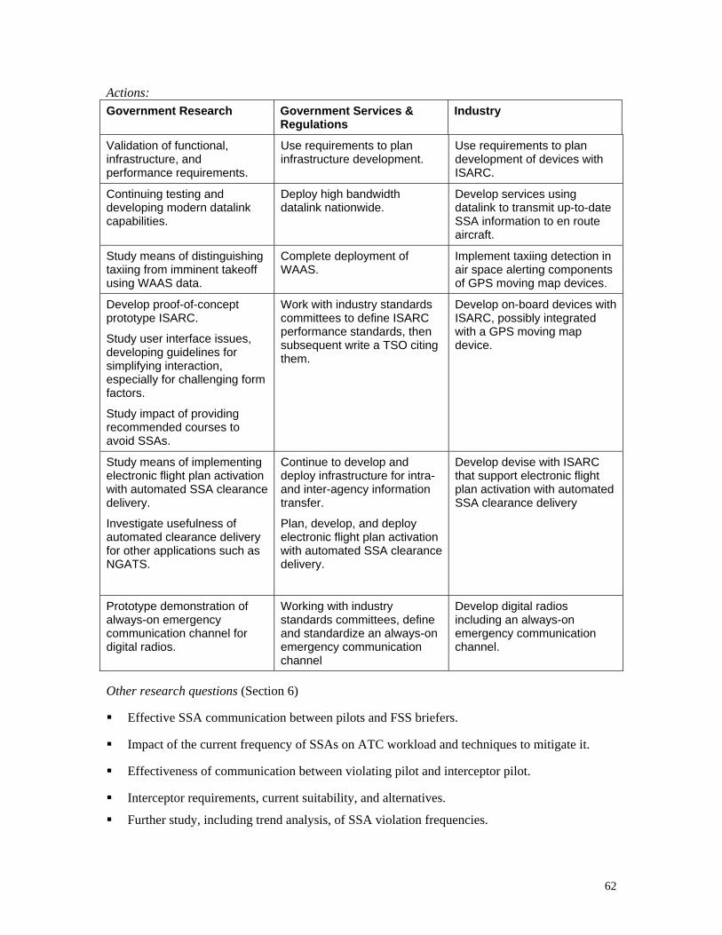
62
Actions: Government Research Government Services &
Regulations Industry
Validation of functional, infrastructure, and performance requirements.
Use requirements to plan infrastructure development.
Use requirements to plan development of devices with ISARC.
Continuing testing and developing modern datalink capabilities.
Deploy high bandwidth datalink nationwide.
Develop services using datalink to transmit up-to-date SSA information to en route aircraft.
Study means of distinguishing taxiing from imminent takeoff using WAAS data.
Complete deployment of WAAS.
Implement taxiing detection in air space alerting components of GPS moving map devices.
Develop proof-of-concept prototype ISARC.
Study user interface issues, developing guidelines for simplifying interaction, especially for challenging form factors.
Study impact of providing recommended courses to avoid SSAs.
Work with industry standards committees to define ISARC performance standards, then subsequent write a TSO citing them.
Develop on-board devices with ISARC, possibly integrated with a GPS moving map device.
Study means of implementing electronic flight plan activation with automated SSA clearance delivery.
Investigate usefulness of automated clearance delivery for other applications such as NGATS.
Continue to develop and deploy infrastructure for intra- and inter-agency information transfer.
Plan, develop, and deploy electronic flight plan activation with automated SSA clearance delivery.
Develop devise with ISARC that support electronic flight plan activation with automated SSA clearance delivery
Prototype demonstration of always-on emergency communication channel for digital radios.
Working with industry standards committees, define and standardize an always-on emergency communication channel
Develop digital radios including an always-on emergency communication channel.
Other research questions (Section 6)
Effective SSA communication between pilots and FSS briefers.
Impact of the current frequency of SSAs on ATC workload and techniques to mitigate it.
Effectiveness of communication between violating pilot and interceptor pilot.
Interceptor requirements, current suitability, and alternatives.
Further study, including trend analysis, of SSA violation frequencies.
REPORT DOCUMENTATION PAGE Form ApprovedOMB No. 0704-0188
2. REPORT TYPE Contractor Report
4. TITLE AND SUBTITLE
Potential Interventions by Government and Industry to MinimizeViolations of Temporary Flight Restrictions
5a. CONTRACT NUMBER
6. AUTHOR(S)
Zuschlag, Michael
7. PERFORMING ORGANIZATION NAME(S) AND ADDRESS(ES)
NASA Langley Research Center John A. Volpe National TransportationHampton, VA 23681-2199 Systems Center Cambridge, MA 02142
9. SPONSORING/MONITORING AGENCY NAME(S) AND ADDRESS(ES)
National Aeronautics and Space AdministrationWashington, DC 20546-0001
8. PERFORMING ORGANIZATION REPORT NUMBER
10. SPONSOR/MONITOR'S ACRONYM(S)
NASA
13. SUPPLEMENTARY NOTESLangley Technical Monitor: Eddie NorrisAn electronic version can be found at http://ntrs.nasa.gov and http://volpe.dot.gov/opsad/pubs.html
12. DISTRIBUTION/AVAILABILITY STATEMENTUnclassified - UnlimitedSubject Category 03Availability: NASA CASI (301) 621-0390
19a. NAME OF RESPONSIBLE PERSON
STI Help Desk (email: [email protected])
14. ABSTRACT
This document enumerates interventions to reduce the frequency of restricted airspace violations, particularly those associatedwith temporary flight restrictions (TFRs) and air defense identification zones (ADIZs), by more effectively providing pilotswith the information necessary to avoid such violations. Interventions are divided into both near term and far term groupings.Short term interventions, some variants of which are already in progress focus on improving the form and content of thetextual Notices to Airmen (NOTAMs) as well as the graphical depiction of TFRs. A long-term technical intervention isproposed which would provide pilots the following functionality: ground and airborne presentation of information on anyrestricted airspace, including display on an electronic moving map, fully mechanized execution from the cockpit of theprocedures required for entry into restricted airspaces that allow for entry, and alerting of the potential for TFR violations bothduring flight planning and while the aircraft is moving.15. SUBJECT TERMSAirpsace; Aviation safety; Security-Supporting Airspaces; ADIZ; TFR; SSA
18. NUMBER OF PAGES
7219b. TELEPHONE NUMBER (Include area code)
(301) 621-0390
a. REPORT
U
c. THIS PAGE
U
b. ABSTRACT
U
17. LIMITATION OF ABSTRACT
UU
Prescribed by ANSI Std. Z39.18Standard Form 298 (Rev. 8-98)
3. DATES COVERED (From - To)
5b. GRANT NUMBER
5c. PROGRAM ELEMENT NUMBER
5d. PROJECT NUMBER
NNL04AA72I5e. TASK NUMBER
5f. WORK UNIT NUMBER
23-723-51-A5
11. SPONSOR/MONITOR'S REPORT NUMBER(S)
NASA/CR-2005-213924
16. SECURITY CLASSIFICATION OF:
The public reporting burden for this collection of information is estimated to average 1 hour per response, including the time for reviewing instructions, searching existing data sources, gathering and maintaining the data needed, and completing and reviewing the collection of information. Send comments regarding this burden estimate or any other aspect of this collection of information, including suggestions for reducing this burden, to Department of Defense, Washington Headquarters Services, Directorate for Information Operations and Reports (0704-0188), 1215 Jefferson Davis Highway, Suite 1204, Arlington, VA 22202-4302. Respondents should be aware that notwithstanding any other provision of law, no person shall be subject to any penalty for failing to comply with a collection of information if it does not display a currently valid OMB control number.PLEASE DO NOT RETURN YOUR FORM TO THE ABOVE ADDRESS.
1. REPORT DATE (DD-MM-YYYY)
09 - 200501-