ggim.un.org “Positioning geospatial information to address global challenges” Positioning geospatial information to address global challenges Potential Areas for Collaboration 2030 Agenda for Sustainable Development International Forum on Geospatial Information and Services for Disasters Bridgetown, Barbados --- 4-5 September 2016 Session 3 Sendai Framework for Disaster Risk Reduction 2015-2030 Strategic Framework for GISD 2016-2030
Potential Areas for Collaboration - UN-GGIMggim.un.org/meetings/2016-Barbados/documents/PN_Tiangco...Potential Areas for Collaboration 2030 Agenda for Sustainable Development International
“Positioning geospatial information to address global challenges” Positioning geospatial information to address global challenges
Potential Areas for Collaboration 2030 Agenda for Sustainable Development
International Forum on Geospatial Information and Services for Disasters
Bridgetown, Barbados
---
4-5 September 2016
Session 3
Sendai Framework for Disaster Risk Reduction 2015-2030 Strategic Framework for GISD 2016-2030
Presenter
Presentation Notes
Good afternoon everyone! I will be presenting to you the Potential Areas for Collaboration between the 2030 Agenda for Sustainable Development, Sendai Framework for Disaster Risk Reduction 2015-2030 and the Strategic Framework on Geospatial Information and Services for Disasters 2016-2030.
ggim.un.org
Positioning geospatial information to address global challenges
…common but differentiated goals and outcomes
Presenter
Presentation Notes
The 2030 Agenda, Sendai Framework and the Strategic Framework have common but differentiated goals and outcomes. Subscribing to the principles of the Strategic Framework is seen to contribute to the success of both the 2030 Agenda and the Sendai Framework – paving a platform for collaboration towards achieving global resiliency. These linkages will be further explained in the succeeding slides.
ggim.un.org
Positioning geospatial information to address global challenges
• ‘a plan of action for people, planet and prosperity’
• adopted in the UN Sustainable Development Summit (New York, September 2015)
• main goal is to eradicate poverty in all its forms and dimensions
2030 Agenda for Sustainable Development
EXTREME POVERTY
SUSTAINABLE DEVELOPMENT
Presenter
Presentation Notes
We begin with the 2030 Agenda for Sustainable Development, which is defined as ‘a plan of action for people, planet and prosperity’. Adopted in the UN Sustainable Development Summit held in New York on September 2015, its main goal is to eradicate poverty in all its forms and dimensions, including extreme poverty as an indispensable requirement for sustainable development.
ggim.un.org
Positioning geospatial information to address global challenges
25 targets directly and indirectly to disaster risk reduction and management (DRRM) in 10 of the 17 SDGs, firmly establishing the role of
DRRM as a core development strategy
Presenter
Presentation Notes
The Agenda has launched the 17 Sustainable Development Goals (SDGs) to realize these aspirations, most of which cut across disaster risk reduction and management (DRRM). As presented on the slide, there are 25 targets directly and indirectly related to disaster risk reduction in 10 of the 17 SDGs, firmly establishing the role of DRRM as a core development strategy. As it focuses on poverty reduction, the SDGs identified major activities for the economic, social and environmental sectors.
ggim.un.org
Positioning geospatial information to address global challenges
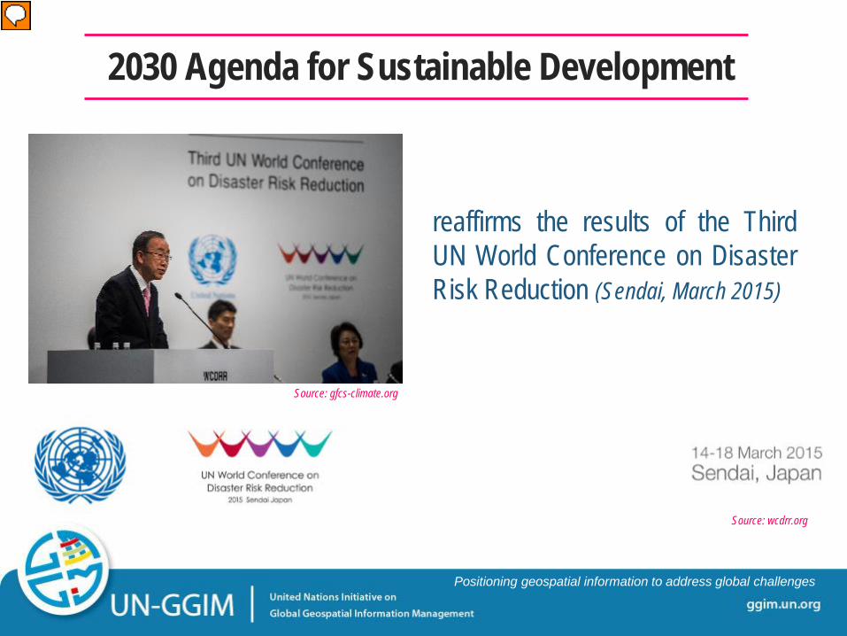
reaffirms the results of the Third UN World Conference on Disaster Risk Reduction (Sendai, March 2015)
2030 Agenda for Sustainable Development
Source: gfcs-climate.org
Source: wcdrr.org
Presenter
Presentation Notes
Aside from building on the Millennium Development Goals (MDGs), the 2030 Agenda also reaffirms the results of the Third UN World Conference on Disaster Risk Reduction held in Sendai, Japan on March 2015, where the Sendai Framework for Disaster Risk Reduction 2015-2030 was adopted. Sustainable development will only be achieved once disaster resiliency, particularly among vulnerable communities are upheld.
ggim.un.org
Positioning geospatial information to address global challenges
• successor instrument of the Hyogo Framework for Action (HFA) 2005-2015
• provides concrete implementation plan for all SDGs related to DRRM
• Four priorities for action: • Priority 1: Understanding Disaster Risk • Priority 2: Strengthening Disaster Risk Governance
to Manage Disaster Risk • Priority 3: Investing in Disaster Risk Reduction for
Resilience • Priority 4: Enhancing Disaster Preparedness and to
‘Build Back Better’
Sendai Framework for Disaster Risk Reduction
Presenter
Presentation Notes
As the successor instrument of the Hyogo Framework for Action (HFA) 2015-2030, the Sendai Framework provides a concrete implementation plan for all SDGs related to disaster risk reduction and management (DRRM). It revolves around four priorities for action, as presented on the slide.
ggim.un.org
Positioning geospatial information to address global challenges
tasked to implement strategies to make available and accessible all quality geospatial information and services before, during and after disasters.
Sendai Framework for Disaster Risk Reduction
Priority 1: Understanding Disaster Risk
UN-GGIM Working Group on Disasters
Presenter
Presentation Notes
Of the four priorities for action, the first priority pertaining to understanding disaster risk is most relevant with the mandates of the UN Committee of Experts on Global Geospatial Information Management (UN-GGIM), particularly the Working Group on Geospatial Information and Services for Disasters. As cited in its Terms of Reference (TOR), the Working Group on Disasters is tasked to implement strategies to make available and accessible all quality geospatial information and services before, during and after disasters.
ggim.un.org
Positioning geospatial information to address global challenges
“Policies and practices for disaster risk reduction and management should be based on an understanding of disaster risk in all its dimensions of vulnerability, capacity, exposure of persons and assets, hazard characteristics and the environment.”
Sendai Framework for Disaster Risk Reduction
[par. 23]
…need to harness the potential of geospatial information and services in managing disaster risks
Presenter
Presentation Notes
As stated in paragraph 23 of the Sendai Framework, ‘policies and practices for disaster risk reduction and management should be based on an understanding of disaster risk in all its dimensions of vulnerability, capacity, exposure of persons and assets, hazard characteristics and the environment’. Such will be achieved by harnessing the potential of geospatial information and services in managing disaster risks.
ggim.un.org
Positioning geospatial information to address global challenges
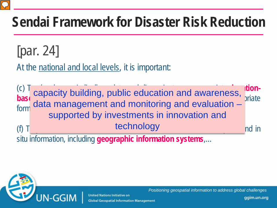
At the national and local levels, it is important: (c) To develop, periodically update and disseminate, as appropriate, location-based disaster risk information, including risk maps…in an appropriate format by using, as applicable, geospatial information technology; (f) To promote real time access to reliable data, make use of space and in situ information, including geographic information systems,…
Sendai Framework for Disaster Risk Reduction
[par. 24]
capacity building, public education and awareness, data management and monitoring and evaluation –
supported by investments in innovation and technology
Presenter
Presentation Notes
At the national and local levels, it is important to: To develop, periodically update and disseminate location-based risk information, including risk maps by using geospatial information technology. To promote real time access to reliable data, make use of space and in situ information, including geographic information system (GIS). Capacity building, public education and awareness, data management and monitoring and evaluation - which are all supported by investments in innovation and technology were also identified as priority focus areas.
ggim.un.org
Positioning geospatial information to address global challenges
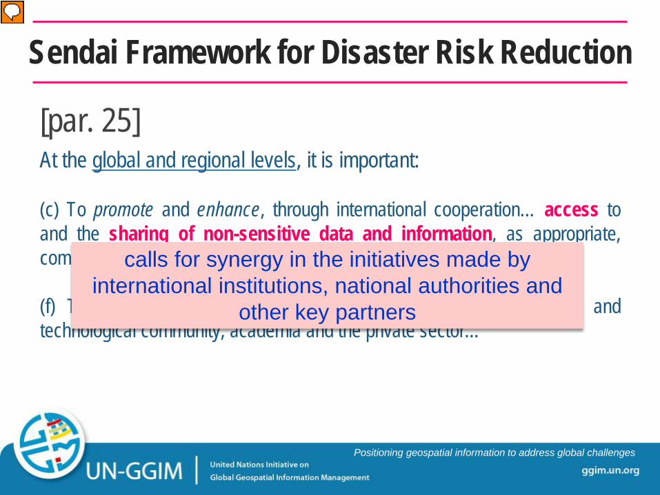
At the global and regional levels, it is important: (c) To promote and enhance, through international cooperation… access to and the sharing of non-sensitive data and information, as appropriate, communications and geospatial and space-based technologies… (f) To promote common efforts in partnership with the scientific and technological community, academia and the private sector…
Sendai Framework for Disaster Risk Reduction
[par. 25]
calls for synergy in the initiatives made by international institutions, national authorities and
other key partners
Presenter
Presentation Notes
At the global and regional levels, it is important to: To promote and enhance access to and the sharing and use of non-sensitive data and information, including communications and geospatial and space-based technologies and related services. To promote common efforts in partnership with the scientific and technological community, academia and the private sector. These, among other major activities calls for synergy in the initiatives made by international institutions, national authorities and other key partners.
ggim.un.org
Positioning geospatial information to address global challenges
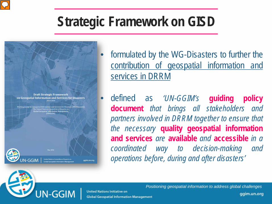
• formulated by the WG-Disasters to further the contribution of geospatial information and services in DRRM
• defined as ‘UN-GGIM’s guiding policy document that brings all stakeholders and partners involved in DRRM together to ensure that the necessary quality geospatial information and services are available and accessible in a coordinated way to decision-making and operations before, during and after disasters’
Strategic Framework on GISD
Presenter
Presentation Notes
To further the contribution of geospatial information and services in DRRM, the Working Group on Disasters of the UN-GGIM formulated the Strategic Framework on Geospatial Information and Services for Disasters 2016-2030. As defined, the strategic framework is a guiding policy document that brings all stakeholders and partners involved in DRRM together to ensure that the necessary quality geospatial information and services are available and accessible in a coordinated way to decision-making and operations before, during and after disasters’
ggim.un.org
Positioning geospatial information to address global challenges
implementing the framework will result in the achievement of all GIM-related initiatives cited
in the Sendai Framework
all these interventions contribute to the SDGs of the 2030 Agenda.
potential areas for collaboration between and
among the three instruments.
Strategic Framework on GISD
Governance and Policies
Awareness Raising and Capacity Building
Data Management Common Infrastructure and Services
Resource Mobilization
Presenter
Presentation Notes
Using the Sendai Framework as its template, the Strategic Framework has enlisted major activities for each of the five priorities for action, namely: Governance and Policies Awareness Raising and Capacity Building Data Management Common Infrastructure and Services Resource Mobilization Implementing the framework will result in the achievement of all GIM-related initiatives cited in the Sendai Framework. Further, all these interventions contribute to the Sustainable Development Goals of the 2030 Agenda. These define the potential areas for collaboration between and among the three instruments.
ggim.un.org
Positioning geospatial information to address global challenges
Potential Areas for Collaboration
2030 Agenda for Sustainable
Development
Strategic Framework for
GISD
Sendai Framework for
DRR
Preventing and/or mitigating disaster impacts to lessen
economic loss
GIM for managing disaster risks and
impacts
fully recover from economic loss to achieve sustainable
development
INTERVENTIONS
Presenter
Presentation Notes
As presented in the slide, the flowchart shows direct linkages in each of the three documents. Implementing specific activities from the strategic framework will reap direct and indirect benefits to achieving the goals of the Sendai Framework and the 2030 Agenda. For instance, emergency simulation exercises conducted in local communities will not only heighten their awareness of multihazards, but also capacitate them to respond during emergency scenarios. This would result in substantial decrease in economic loss, as exemplified in several SDGs. Another instance would include mobilizing resources across all phases of the emergency cycle. Investments in innovations and technologies will vastly improve inter- and intraregional information exchange which will lead to improved data and system infrastructures.
ggim.un.org
Positioning geospatial information to address global challenges
Member States, international organizations and other key stakeholders shall consider using the strategic framework as a guide in managing disaster risks and subsequently, put forward sustainable development
It is thus incumbent upon Member States, international organizations and other key stakeholders to consider using the strategic framework as a guide in managing disaster risks, achieving resiliency and subsequently, putting forward sustainable development in their respective agenda. The guidance provided by these instruments should not only leverage internal resources, but also foster lasting partnerships among Member States. The Working Group on Disasters, and the UN-GGIM will respond to these challenges.
ggim.un.org
Positioning geospatial information to address global challenges