Embed Size (px)
Citation preview
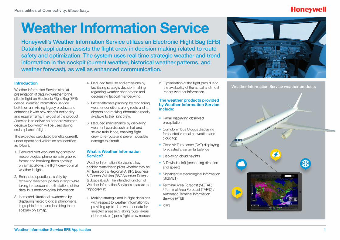
Weather Information Service Honeywell’s Weather Information Service utilizes an Electronic Flight Bag (EFB) Datalink application assists the flight crew in decision making related to route safety and optimization. The system uses real time strategic weather and trend information in the cockpit (current weather, historical weather patterns, and weather forecast), as well as enhanced communication.
Weather Information Service EFB Application
Possibilities of Connectivity. Made Easy.
1
Introduction
Weather Information Service aims at presentation of datalink weather to the pilot in flight on Electronic Flight Bag (EFB) device. Weather Information Service builds on an existing legacy product and enhances it with new set of functionality and requirements. The goal of the product / service is to deliver an onboard weather decision tool which will be used during cruise phase of flight.
The expected calculated benefits currently under operational validation are identified as follows:
1. Reduced pilot workload by displaying meteorological phenomena in graphic format and localizing them spatially
on a map allows the flight crew optimal weather insight.
2. Enhanced operational safety by receiving weather updates in-flight while taking into account the limitations of the data links meteorological information.
3. Increased situational awareness by displaying meteorological phenomena in graphic format and localizing them spatially on a map.
4. Reduced fuel use and emissions by facilitating strategic decision making regarding weather phenomena and decreasing tactical manoeuvring.
5. Better alternate planning by monitoring weather conditions along route and at airports and making information readily available to the flight crew.
6. Reduced maintenance by displaying weather hazards such as hail and severe turbulence, enabling flight crew to re-route and prevent possible damage to aircraft.
What is Weather Information Service?
Weather Information Service is a key enabler relate this to pilots whether they be Air Transport & Regional (AT&R), Business & General Aviation (B&GA) and/or Defense & Space (D&S). The intended function of Weather Information Service is to assist the flight crew in:
1. Making strategic and in-flight decisions with respect to weather information by providing up-to-date weather data for selected areas (e.g. along route, areas of interest, etc) per a flight crew request.
2. Optimization of the flight path due to the availability of the actual and most recent weather information.
The weather products provided by Weather Information Service include:
• Radar displaying observed precipitation
• Cumulonimbus Clouds displaying forecasted vertical convection and cloud top
• Clear Air Turbulence (CAT) displaying forecasted clear air turbulence
• Displaying cloud heights
• 3-D winds aloft (presenting direction and speed)
• Significant Meteorological Information (SIGMET)
• Terminal Area Forecast (METAR) / Terminal Area Forecast (TAF/D) / Automatic Terminal Information Service (ATIS)
• Icing
Weather Information Service weather products

Flight Operation Center (FOC)/ Airline Operation Center (AOC)
In case of unexpected WX phenomena push mode allows FOC team to extend Flight Watch abilities.
• Strategic evaluation ahead of tactical weather avoidance
• Same view as pilots
• Graphical WX data push, Flight Planpush
• Messaging
Active FOC watch can alert the crew by uplink push of updated relevant WX graphical information and attached text message.
• Clear and shared picture of situation
• Enables strategic evaluation of optimum route/flight level changes ahead of tactical weather avoidance
Pilot
• Weather Information Service highly improves quality of regular weather checks
• Weather Information Service provides advanced features for crew assessment of weather trends
• More precise idea about weather en-route ahead providing better strategic planning for avoidance of unwanted phenomena like CBs or CAT
• Weather Information Service allows fuel and time optimization of flight plan changes
• Weather Information Service allows crew to adhere optimum trajectory (no avoidance required)
• More accurate and up-to-date winds enable optimum flight level selection
• Better mental model of en-route alternate airports provides faster and better decision making in case of diversion
• Early crew awareness of situation gives time for FOC involvement in decision making about preferred alternate
• Weather Information Service supports optimum diversion when destination airport becomes unsuitable
• Weather Information Service provides a Collaborative Decision-Making tool for strategic weather avoidance
Passenger
• Weather Information Service helps to increase safety for cabin crew and passengers
• Weather Information Service improves cabin service
• Reduced delay at destination
Who benefits from Weather Information Service?
Weather Information Service EFB Application2
Benefits
Possibilities of Connectivity. Made Easy.
AOC/FOC Pilot
Passenger
• Weather Information Service helps to increase safety for cabin crew and passengers
• Weather Information Service improves cabin service
• Reduced delay at destination
Weather Information Service EFB Application 3
What is Weather Information Service?
The flight crew’s strategic decision making regarding weather is frequently performed on the basis of information retrieved from the onboard weather radar, VOLMET/D-VOLMET broadcasts, pilot reports (PIREPs), or by listening to party line information. Except for the weather radar image usually displayed in the navigation display, or a dedicated weather radar display, the weather information is provided verbally via radio or textually via data link.
Weather Information Service increases the flight crew weather phenomena awareness by providing map referenced meteorological information along the flight route.
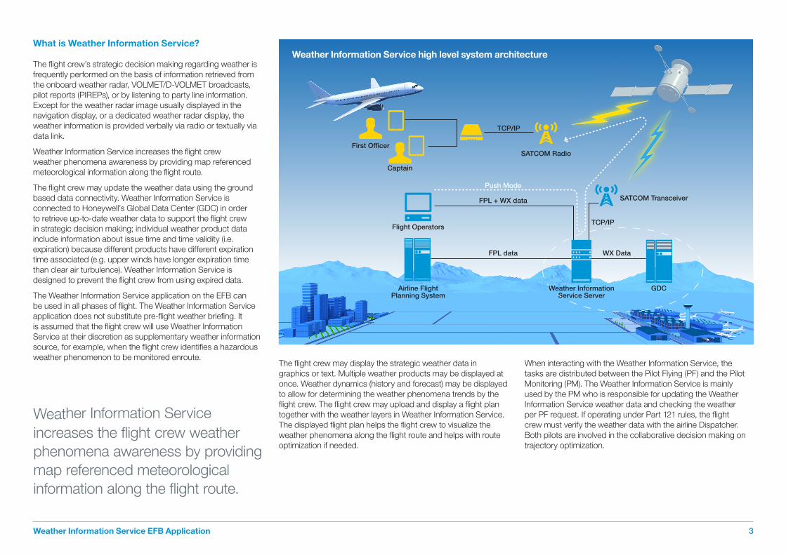
The flight crew may update the weather data using the ground based data connectivity. Weather Information Service is connected to Honeywell’s Global Data Center (GDC) in order to retrieve up-to-date weather data to support the flight crew in strategic decision making; individual weather product data include information about issue time and time validity (i.e. expiration) because different products have different expiration time associated (e.g. upper winds have longer expiration time than clear air turbulence). Weather Information Service is designed to prevent the flight crew from using expired data.
The Weather Information Service application on the EFB can be used in all phases of flight. The Weather Information Service application does not substitute pre-flight weather briefing. It is assumed that the flight crew will use Weather Information Service at their discretion as supplementary weather information source, for example, when the flight crew identifies a hazardous weather phenomenon to be monitored enroute.
The flight crew may display the strategic weather data in graphics or text. Multiple weather products may be displayed at once. Weather dynamics (history and forecast) may be displayed to allow for determining the weather phenomena trends by the flight crew. The flight crew may upload and display a flight plan together with the weather layers in Weather Information Service.The displayed flight plan helps the flight crew to visualize the weather phenomena along the flight route and helps with route optimization if needed.
When interacting with the Weather Information Service, the tasks are distributed between the Pilot Flying (PF) and the Pilot Monitoring (PM). The Weather Information Service is mainly used by the PM who is responsible for updating the Weather Information Service weather data and checking the weather per PF request. If operating under Part 121 rules, the flight crew must verify the weather data with the airline Dispatcher. Both pilots are involved in the collaborative decision making on trajectory optimization.
First Officer
TCP/IP
TCP/IP
GDC
FPL + WX data
Push Mode
Flight Operators
Airline FlightPlanning System
FPL data WX Data
SATCOM Radio
SATCOM Transceiver
Captain
Weather InformationService Server
Weather Information Service high level system architecture
Weather Information Service increases the flight crew weather phenomena awareness by providing map referenced meteorological information along the flight route.
Q Is it possible to use the Weather Information Service app in-flight to review up-to-date weather information?
A Yes, Weather Information Service is designed to be used and updated in-flight to avoid hazardous weather in an effective and efficient way.
Q Is it possible to display multiple weather layers at the same time in Weather Information Service?
A Yes, each weather layer can be switched on and off independently on the others without adding unnecessary display clutter.
Q Why is it worth it to purchase Weather Information Service instead of other weather products available on the market?
A Weather Information Service is designed to (1) be used in-flight (2) support collaborative decision making between a Dispatcher and a pilot, (3) save costs associated with adverse weather avoidance, (4) designed to cater for pilot needs.
Q Who are the intended users of Weather Information Service on EFB?
A Airline pilots who want a strategic weather application which is super easy to use, easy to interpret, and which makes right information available at the right time.
Q Is it possible to use Weather Information Service for tactical in-flight decisions?
A No, Weather Information Service is a datalink weather application which cannot be used tactically. Pilots should use other information for tactical decision making (e.g. weather radar).
Q Can you uplink relative weather?
A In case of unexpected weather phenomena active Flight watch can alert the crew by updating relevant weather graphical information and attached text message. This allows the crew to download up-to-date weather data on request or periodically.
Q What the Dispatchers can see?
A Ground module has the same functionalities like airborne module. However, it is adapted to the work and task of Dispatcher workflows. Generally it is similar to the same view of the pilot of the aircraft, so it serves as a collaborative decision making tool.
Q&A’sQuestions & Answers
Weather Information Service utilizes an EFB application assisting the flight crew in decision making relative to route safety and optimization using real time strategic weather and trend information in the cockpit and enhanced communication with the Dispatcher.
Weather Information Service EFB Application 4
Weather Information Service towards future role of EFB in the cockpit Honeywell is uniquely positioned to offer a set of in-flight functions which require connectivity to the avionics and to the ground systems. Weather Information Service represents the baseline for further functions which will be developed. After addressing weather, Honeywell offer a seemless suite of applications for in-flight use. Honeywell’s strong emphasis is on safety – therefore our design philosophy will not compromise safety. Intuitive Human Machine Interface (HMI) is reflecting current state of the art of mobile devices and tablets and in the same time will ensure consistency in the cockpit to make pilot comfortable to use this device during flight phase.
In next step, Weather Information Service will address very important area of In-flight optimization. The main driver is to help an airline to reduce operational costs and to enable fuel savings by in-flight optimization features which will complement Flight Management System (FMS) functions. The offering which leverages further avionics functions is also planned to provide unique bridge between the certified avionics and non certified EFB device. Great example of such a future use of weather radar data from other aircrafts to improve weather observations and overall provide decision support tool for the pilot.
Honeywell will develop Weather Information Service towards the vision of an advisory tool to address fuel efficiency and to improve strategic decision making based on the aircraft state and the situation. Weather is an important part of the situation – future developments will include additional layers such as D-NOTAMs, traffic and other information – all important components to enable pilots decision making.

Weather dataprovider
Weather dataprovider
Weather Information Network servers
Business Aviation EFB
Data Processing
Weather Information Service Viewer
Legend
Honeywell
Other Vendor
OEM/EFBintegrator/airline
specific Airline Current SW Solution
Flight PlanningSystem
BriefingSolution
Secured internetconnection
OCC Data Center
Communicationmanager
Dispatcher View(same source of
information as for the cockpit)
Weather Information Service SERVERs
Data Outbox
A633 flightplan
WX briefing generated on customer sidefrom customer weather data
PUSH mode with confirmationA633 flight plans available
Weather Information Serviceapplications running on
various platforms
Air Transport EFB
The Weather Information Service system architecture by Honeywell
For more information on Honeywell’s Weather Information Service technology, please contact your Honeywell sales representative or call +1 (800) 601 3099 or +1 (602) 365 3099.
Honeywell Aerospace 1944 East Sky Harbor Circle Phoenix, Arizona 85034 North America: +1 (800) 601 3099 Outside North America: +1 (602) 365 3099 aerospace.honeywell.com
C61-1353-000-000March 2015© 2015 Honeywell International Inc.
Abbreviations ADS-C Automatic Dependent Surveillance-Contract
AOC Airline Operations Center
CAT Clear Air Turbulence
CB Type of cloud Cumulonimbus associated with thunderstorm
EFB Electronic Flight Briefcase
FL Flight Level
FOC Flight Operations Center
FPL Flight Plan
WX Weather Wind Ice Cloud
Lightning
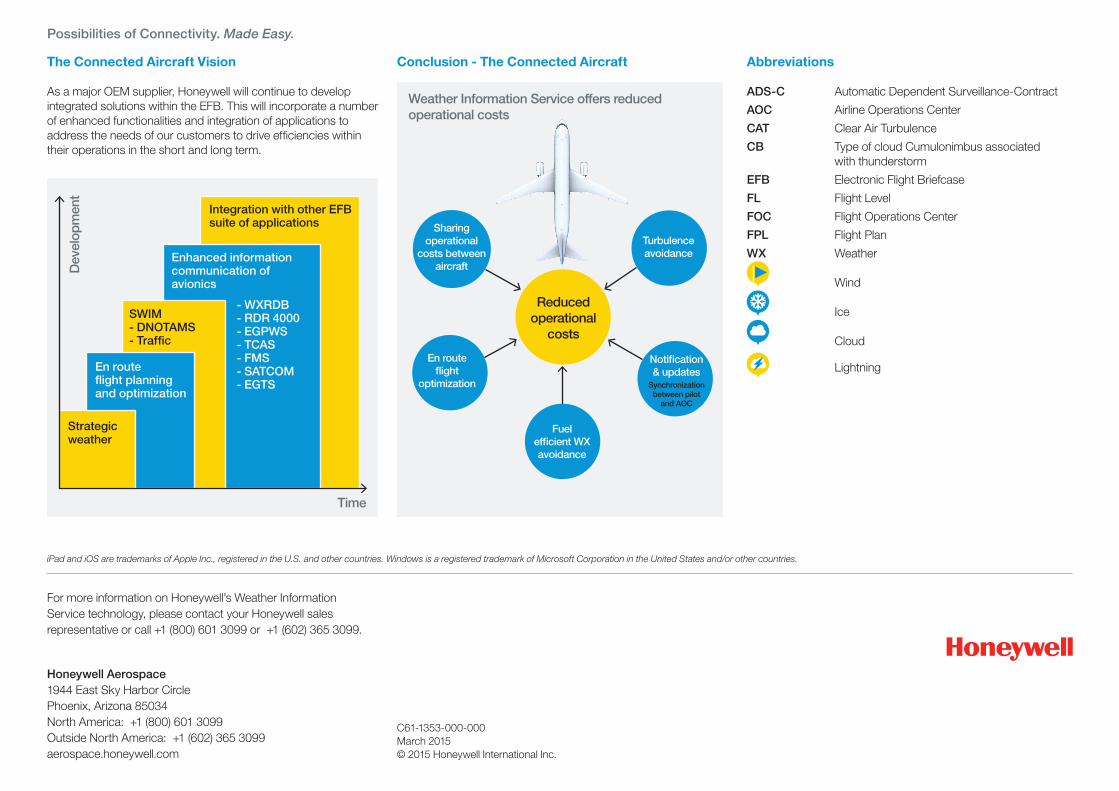
The Connected Aircraft Vision As a major OEM supplier, Honeywell will continue to develop integrated solutions within the EFB. This will incorporate a number of enhanced functionalities and integration of applications to address the needs of our customers to drive efficiencies within their operations in the short and long term.
Weather Information Service offers reduced operational costs
Time
Possibilities of Connectivity. Made Easy.
iPad and iOS are trademarks of Apple Inc., registered in the U.S. and other countries. Windows is a registered trademark of Microsoft Corporation in the United States and/or other countries.
Turbulenceavoidance
En routeflight
optimization
Sharing operational
costs between aircraft
Notification & updates
Synchronization between pilot
and AOC
Reducedoperational
costs
Fuel efficient WX avoidance
Dev
elop
men
t
Strategic weather
En route flight planning and optimization
SWIM - DNOTAMS - Traffic
Integration with other EFB suite of applications
Enhanced information communication of avionics
- WXRDB - RDR 4000 - EGPWS - TCAS - FMS - SATCOM - EGTS
Conclusion - The Connected Aircraft