Embed Size (px)
Citation preview
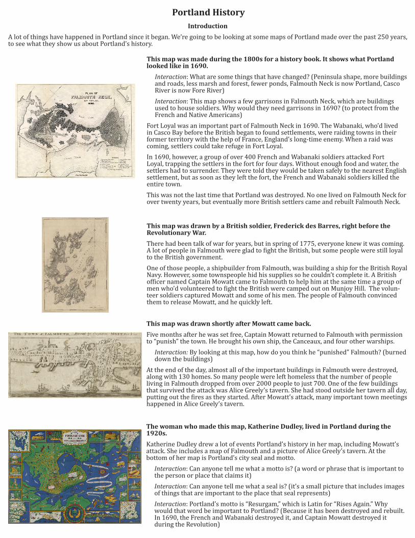
This map was made during the 1800s for a history book. It shows what Portland looked like in 1690.
Interaction: What are some things that have changed? (Peninsula shape, more buildings and roads, less marsh and forest, fewer ponds, Falmouth Neck is now Portland, Casco River is now Fore River)Interaction: This map shows a few garrisons in Falmouth Neck, which are buildings used to house soldiers. Why would they need garrisons in 1690? (to protect from the French and Native Americans)
Fort Loyal was an important part of Falmouth Neck in 1690. The Wabanaki, who’d lived in Casco Bay before the British began to found settlements, were raiding towns in their former territory with the help of France, England’s long-time enemy. When a raid was coming, settlers could take refuge in Fort Loyal. In 1690, however, a group of over 400 French and Wabanaki soldiers attacked Fort Loyal, trapping the settlers in the fort for four days. Without enough food and water, the settlers had to surrender. They were told they would be taken safely to the nearest English settlement, but as soon as they left the fort, the French and Wabanaki soldiers killed the entire town. This was not the last time that Portland was destroyed. No one lived on Falmouth Neck for over twenty years, but eventually more British settlers came and rebuilt Falmouth Neck.
This map was drawn shortly after Mowatt came back.
Five months after he was set free, Captain Mowatt returned to Falmouth with permission to “punish” the town. He brought his own ship, the Canceaux, and four other warships.
Interaction: By looking at this map, how do you think he “punished” Falmouth? (burned down the buildings)
At the end of the day, almost all of the important buildings in Falmouth were destroyed, along with 130 homes. So many people were left homeless that the number of people living in Falmouth dropped from over 2000 people to just 700. One of the few buildings that survived the attack was Alice Greely’s tavern. She had stood outside her tavern all day, putting out the fires as they started. After Mowatt’s attack, many important town meetings happened in Alice Greely’s tavern.
This map was drawn by a British soldier, Frederick des Barres, right before the Revolutionary War.
There had been talk of war for years, but in spring of 1775, everyone knew it was coming. A lot of people in Falmouth were glad to fight the British, but some people were still loyal to the British government. One of those people, a shipbuilder from Falmouth, was building a ship for the British Royal Navy. However, some townspeople hid his supplies so he couldn’t complete it. A British officer named Captain Mowatt came to Falmouth to help him at the same time a group of men who’d volunteered to fight the British were camped out on Munjoy Hill. The volun-teer soldiers captured Mowatt and some of his men. The people of Falmouth convinced them to release Mowatt, and he quickly left.
The woman who made this map, Katherine Dudley, lived in Portland during the 1920s.
Katherine Dudley drew a lot of events Portland’s history in her map, including Mowatt’s attack. She includes a map of Falmouth and a picture of Alice Greely’s tavern. At the bottom of her map is Portland’s city seal and motto.
Interaction: Can anyone tell me what a motto is? (a word or phrase that is important to the person or place that claims it)Interaction: Can anyone tell me what a seal is? (it’s a small picture that includes images of things that are important to the place that seal represents)Interaction: Portland’s motto is “Resurgam,” which is Latin for “Rises Again.” Why would that word be important to Portland? (Because it has been destroyed and rebuilt. In 1690, the French and Wabanaki destroyed it, and Captain Mowatt destroyed it during the Revolution)
Portland HistoryIntroduction
A lot of things have happened in Portland since it began. We’re going to be looking at some maps of Portland made over the past 250 years, to see what they show us about Portland’s history.
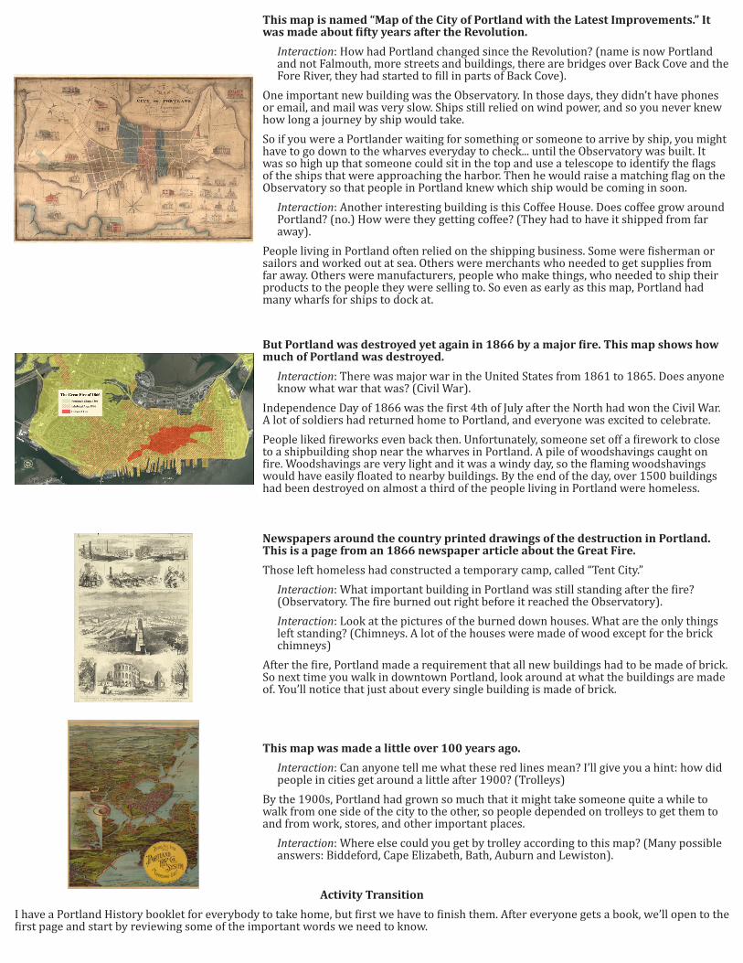
This map is named “Map of the City of Portland with the Latest Improvements.” It was made about fifty years after the Revolution.
Interaction: How had Portland changed since the Revolution? (name is now Portland and not Falmouth, more streets and buildings, there are bridges over Back Cove and the Fore River, they had started to fill in parts of Back Cove).
One important new building was the Observatory. In those days, they didn’t have phones or email, and mail was very slow. Ships still relied on wind power, and so you never knew how long a journey by ship would take. So if you were a Portlander waiting for something or someone to arrive by ship, you might have to go down to the wharves everyday to check... until the Observatory was built. It was so high up that someone could sit in the top and use a telescope to identify the flags of the ships that were approaching the harbor. Then he would raise a matching flag on the Observatory so that people in Portland knew which ship would be coming in soon.
Interaction: Another interesting building is this Coffee House. Does coffee grow around Portland? (no.) How were they getting coffee? (They had to have it shipped from far away).
People living in Portland often relied on the shipping business. Some were fisherman or sailors and worked out at sea. Others were merchants who needed to get supplies from far away. Others were manufacturers, people who make things, who needed to ship their products to the people they were selling to. So even as early as this map, Portland had many wharfs for ships to dock at.
Newspapers around the country printed drawings of the destruction in Portland. This is a page from an 1866 newspaper article about the Great Fire.
Those left homeless had constructed a temporary camp, called “Tent City.” Interaction: What important building in Portland was still standing after the fire? (Observatory. The fire burned out right before it reached the Observatory).Interaction: Look at the pictures of the burned down houses. What are the only things left standing? (Chimneys. A lot of the houses were made of wood except for the brick chimneys)
After the fire, Portland made a requirement that all new buildings had to be made of brick. So next time you walk in downtown Portland, look around at what the buildings are made of. You’ll notice that just about every single building is made of brick.
But Portland was destroyed yet again in 1866 by a major fire. This map shows how much of Portland was destroyed.
Interaction: There was major war in the United States from 1861 to 1865. Does anyone know what war that was? (Civil War).
Independence Day of 1866 was the first 4th of July after the North had won the Civil War. A lot of soldiers had returned home to Portland, and everyone was excited to celebrate. People liked fireworks even back then. Unfortunately, someone set off a firework to close to a shipbuilding shop near the wharves in Portland. A pile of woodshavings caught on fire. Woodshavings are very light and it was a windy day, so the flaming woodshavings would have easily floated to nearby buildings. By the end of the day, over 1500 buildings had been destroyed on almost a third of the people living in Portland were homeless.
This map was made a little over 100 years ago.
Interaction: Can anyone tell me what these red lines mean? I’ll give you a hint: how did people in cities get around a little after 1900? (Trolleys)
By the 1900s, Portland had grown so much that it might take someone quite a while to walk from one side of the city to the other, so people depended on trolleys to get them to and from work, stores, and other important places.
Interaction: Where else could you get by trolley according to this map? (Many possible answers: Biddeford, Cape Elizabeth, Bath, Auburn and Lewiston).
Activity Transition
I have a Portland History booklet for everybody to take home, but first we have to finish them. After everyone gets a book, we’ll open to the first page and start by reviewing some of the important words we need to know.