Embed Size (px)
Citation preview

WORK SAMPLES IN
RISD
TILLINGHAST FARMDesign Principles | 2 Months Project
BOLD POINT PARKConstructed Ground | 1 Month Project
REPRESENTATION
DESIGN FOUNDATION
BOOKBINDING
JING LIRoom 301, 1 Regency Plaza Apt, Providence, RI
[email protected] | 401 3409522EDUCATION
08.2009 - 06.2014Hunan University | Changsha ChinaBachelor of engineering in Landscape Architecture | GPA 3.5Core Courses: History of Modern Landscape | Landscape Planning and Design | Principle of Landscape Planning | Planting Design | Landscape Engineering and Technology
08.2014 - presentRhode Island School of Design | Providence Rhode IslandMaster of Landscape Architecture (Program 2) | GPA 3.42Core Courses: Design Principle | Theory 1 | Topic of Representation | Research Method | Constructed Ground; Elective Course: Bookbinding | Painting | Pottery
WORK EXPERIENCE
07.2013 - 10.2013China Academy of Urban Planning and Design | Beijing China
-Landscape Design, Section and Elevation Drawing, Ecology Analyze,Traffic Planning, Vegetation Planning, Visualization, Documents Writing and Making | Wetland Park Planning and Protection, Tongling,China-Existing Situation Investigation, Master Plan Drawing, Concept Diagram Drawing, Land Use Planning, CAD Drawing | 2013-2030 Mater Planning, Rizhao,China-CAD Drawing, Concept Design, Visualization | Changsha,Zhuzhou,Xiangtan City Group Planning, Hunan,China-Master Plan Drawing, GIS Analysis, CAD Drawing, Section and Elevation Drawing | Qionghai Wetland Park Planning, Xichang,China-CAD Drawing, Site Analysis,Traffic Design | Urban Planning, Zhoukou,China
Intern Landscape ArchitectRealize integrated process of planning and design project | Participate in each step | Gain basic knwoledge of ecological sensitivity analysis | Increase understanding of ecological protection | Improve writing ability.
RESEARCH01.2015 - 02.2015 Historical Research In Jewelry District, Post-Industrial Providence
Investigate history of Jewelry District | Come up with a research question | Focus on the relationship between street form and historical industrial building in a specific area
04.2012 - 08.2013 Investigation of Social Places in Modern Universities
Investigate social and behavioral patterns of college students | Analyze the structure of HNU | Conceive new space pattern in university to provide students with suitable social placesStudent Innovation Training Project
Mentor: Suzanne Mathew
09.2012 - 11.2012 Different Activity Space for Kids in Old & New Community
HONORS10.2010 & 10.2011
10.2011
10.2012
Single Course Scholarship
The Second Scholarship
Outstanding Student Cadres-Top 30%, 2009-2011 | HNU
-Top 20%, 2011-2012 | HNU
-Only 1 in Faculty, 2010-2011 | HNU
SKILLSsoftware
language
Auto CAD, Sketch UP, Adobe Creative Suite( Photoshop,Illustrator,InDesign,Lightroom), ArcGIS, DiaLUX, Vray, Microsoft Office, 3D MAXEnglish | Full professional proficiency
Mandarin | Native or bilingual proficiencyCantonese | Limited working proficiency
Investigate space patterns in different kinds of communities | Survey behavioral patterns of children and their parents | Analyze differences between old and new communities | Provide new plans for specific activity places
Mentor: Yanyang Xiao
10.2012 - 12.2012 Ecological Pattern of Western Changsha
Analyze transformation of greenland areas, water areas and field spaces in the past decade | Give suggestions of city development from the perspective of ecological protectionMentor: Prof.Sheng Jiao
TRANSCRIPT
TILLINGHAST FARMDESIGNPRINCIPLES +
SITE UNDERSTANDING
FORM
DESIGN DESIGN
SPACE
FORM
PHENOMENA
FUNCTION
JING LIRoom 301, 1 Regency Plaza Apt, Providence, RI
[email protected] | 401 3409522
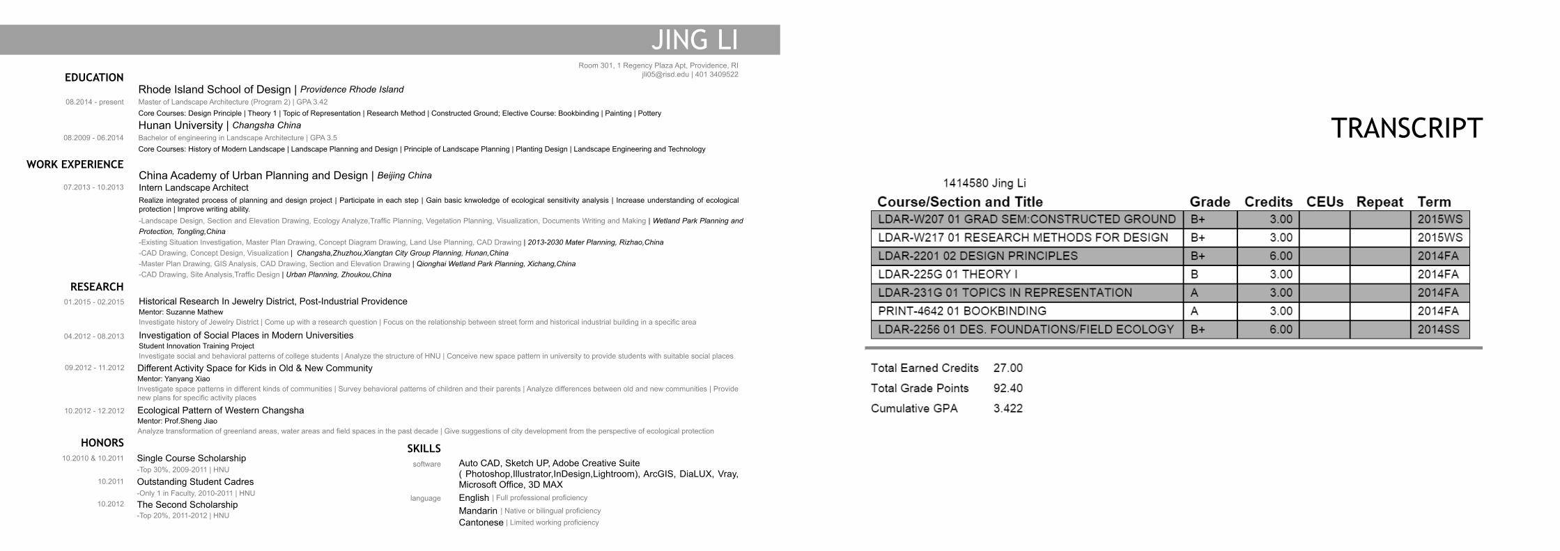
To whom it may concern,
I am Jing Li, a first year student in RISD MLA 2 program. I am eager for practicing and developing my skills in landscape design. For me, landscape projects are like smaller gears to
deliver power and make the city run better. Grew up in China, I witnessed lots of examples of the changes brought by good landscape designs. Charm of diverse landscape become my
motivation to go further in this way, and to work in a great firm like EDSA is one of my dream.
As far as I know, EDSA has lots of projects in a wild range of scale, I went to the Downtown Disneyland last year and I found it was very attractive and well arranged. EDSA designed so
many sustainable places during the last 50 years and made great achievements in lots of areas such as working and living space design and planning.
Leading by my understanding of landscape, I treated every project in college as gear, which truly connected to development and optimization of our environment. The Programs I did
in RISD are new gears with deeper knowledge of nature. I learned how to think about underground condition, to analyze the phenomena, to design with threshold and to deal with the
details in construction here as well as how to make process models quickly to help thinking. As for my undergraduate programs, I practiced in different scales, from a series of structures
to plan and design for an urban district. Varieties of designing methods as well as the understanding of my gear theory were gained from all these projects. My internship in China
Academy of Urban Planning and Design (CAUPD) updated my understanding of gearing city in several ways such as how to directly optimize the city gear itself in sustainable ways, how
to protect and develop wetland parks, and how to respect existing creatures and environment while developing a scenic. These projects revealed the promotion made by city gears and
gave a bright future of landscape design and planning to me.
As a well-prepared student and a landscape architect, I am sincerely expecting to participate in and contribute my knowledge and skills to your program in EDSA. Thank you for your
time in reading this and hope to join you in this summer.
Best,
Jing Li
PAPER MODELFOLD/ CURVE/ ROTATE/ CUT/ BEND/ COMBINE/ UNIT
fold
combine
units sOIL MODELSILT
pressure water
horizon a organIc
horizon b1 S & g
horizon c1 S & g
horizon b2 S & g
horizon c2 S & g
horizon c3 FInE SanD
bEDrocK
sandpeat
sand sandsand
sand sandcobble
silt
silt sandorganic organic organic organica:gravely sand
b:gravely sandgravely sand
gravely sandc1:gravely sandc2:gravely sandc3:fine sand
organic
silt sand
1
1
2 3 45 6
65
432
TILLINGHAsTFARM
DESIGNPRINCIPLES +SITE UNDERSTANDING
FORM
DESIGN DESIGN
SPACE
FORM
PHENOMENA
FUNCTION
TILLINGHAST FARM
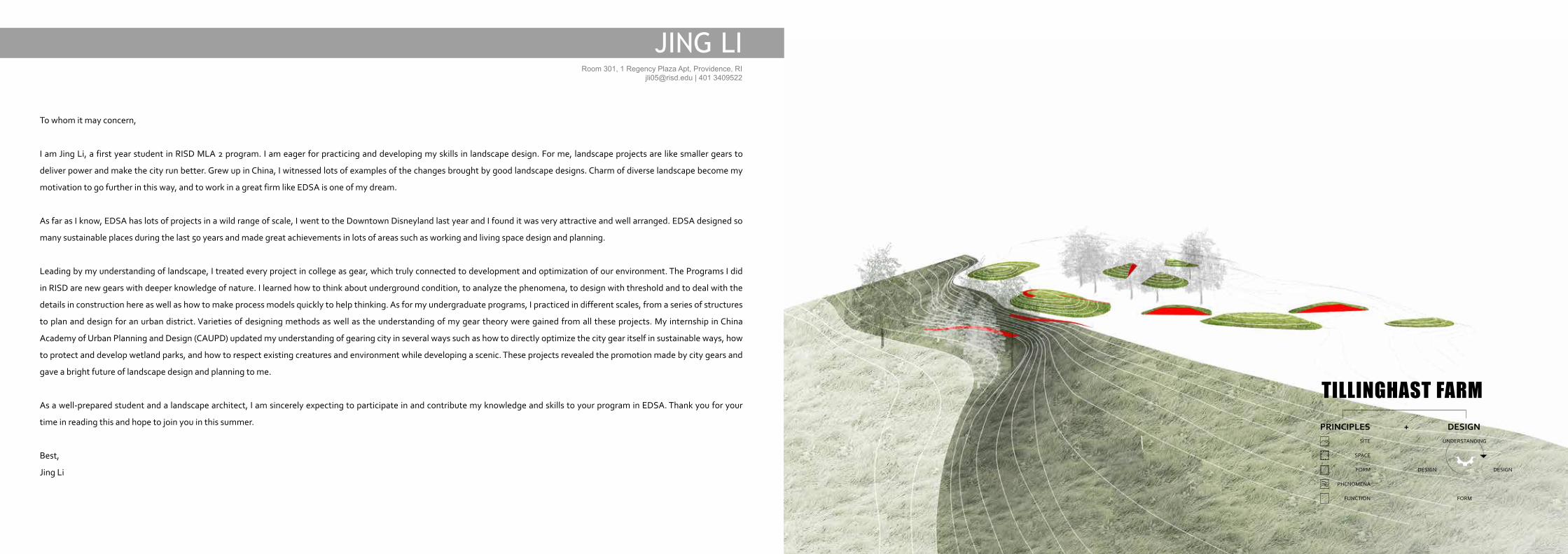
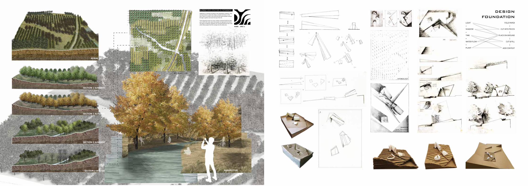
To design landscape is to begin with understanding what is beneath the ground.Started from folding paper, I began to develop a system with an unit, than apply it in analyzing the soil profile.
To introduce this paper study into the site - Tillinghast Farm, a coastal site that moves from an upland, pastoral open space, down through a woodland, marshers and finally arrives at a beach, we broke the site exploration into three investigations: of ground, of phenomena, and finally, of site spatial transitions.
We digged into ground to see the composition of soil at different locations on site. Based on the specific section I was focusing, the soil horizon models represent the layers of ground as they change from the surface to a depth of 8 feet below this surface.
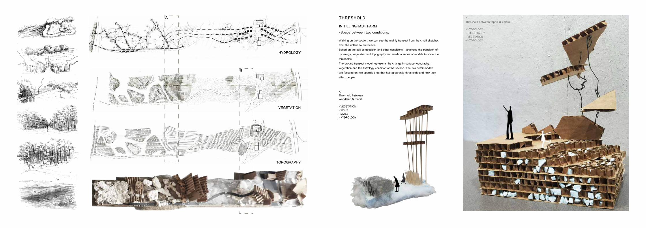
THREsHOLD
IN TILLINGHAST FARM-Space between two conditions.
a: Threshold between woodland & marsh
- VEgETaTIon- SIgHT- SPacE- HYDroLogY
b: Threshold between tophill & upland
- HYDroLogY- ToPograPHY- VEgETaTIon- HYDroLogYWalking on the section, we can see the mainly transect from the small sketches
from the upland to the beach. Based on the soil composition and other conditions, I analyzed the transition of hydrology, vegetation and topography and made a series of models to show the thresholds.The ground transect model represents the change in surface topography, vegetation and the hyfrology condition of the section. The two detail models are focused on two specific area that has apparently thresholds and how they affect people.
A
B
HYDROLOGY
VEGETATION
TOPOGRAPHY
PHENOMENA
INSTALLATION
SITE
one week projectscale & topography study
working on 1'=1'' scale
create new th
reshold
same edition with
installatio
n
choose a new place
SITE
iteration
use the same concept
design with light & temperature
THRESHOLD
PHENOMENA
PHENOMENA MODEL OF NEW THRESHOLD
Inteangible and dynamic elements are integral components to landscape space. After documented changes in light and moisture from the farm down to the beach, I translated the transition into visual, spatial, and 3-dimentional representations to understandhow these phenomena respond to the site, then I began to focus on a specific area where has intersting transition in topography, hydrology, light, and vegetation.
From all these study, I finally chose an area to insert the new pogram
- CLAssROOM
To better understand scale and threshold, we made a 1=1 installation in the site to see how the new threshold in topography and vegetation influence the Tillinghast Farm.
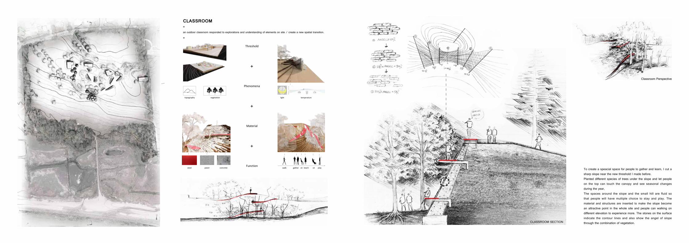
CLAssROOM
steel paver concrete walk gather sit teach sit play
Threshold
=
=
Phenomena
Material
Function
light temperature
CLASSROOM SECTION
topography vegetation
an outdoor classroom responded to explorations and understanding of elements on site / create a new spatial transition.
+
+
+
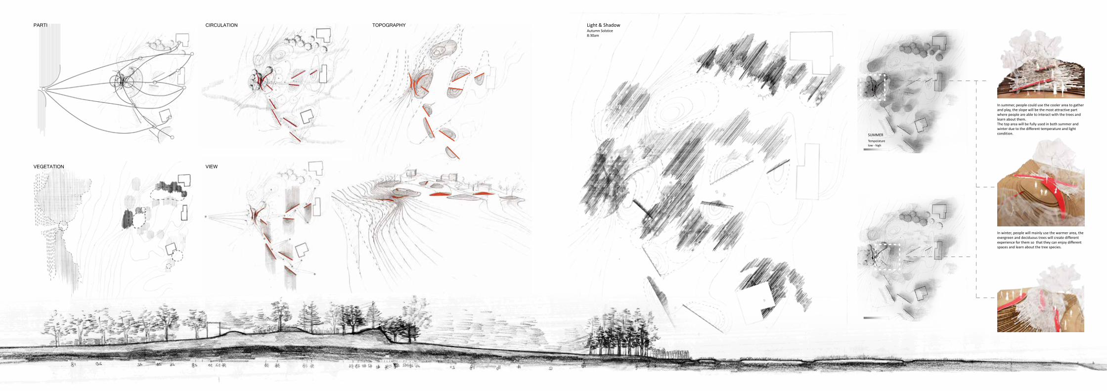
To create a speacial space for people to gather and learn, I cut a sharp slope near the new threshold I made before.Planted different species of trees under the slope and let people on the top can touch the canopy and see seasonal changes during the year,The spaces around the slope and the small hill are fluid so that people will have multiple choice to stay and play. The material and structures are inserted to make the slope become an attractive point in the whole site and people can walking on different elevation to experience more. The stones on the surface indicate the contour lines and also show the angel of slope through the combination of vegetation.
Classroom Perspective
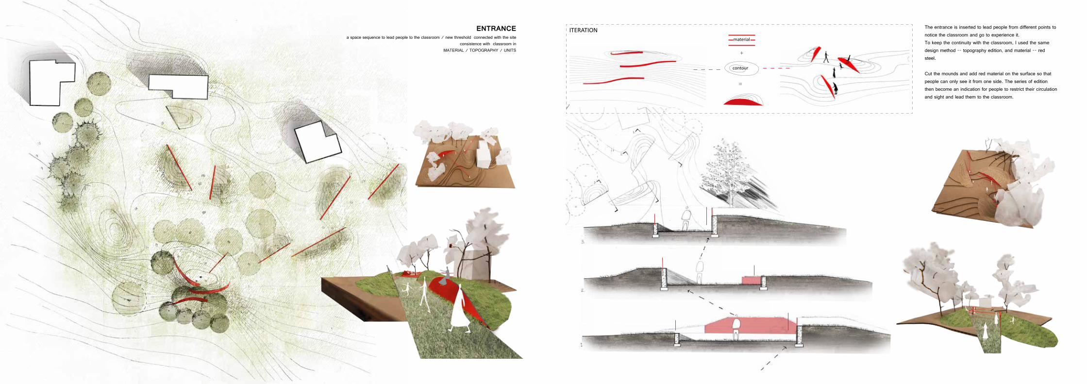
ENTRANCE
+
=
contour
material
ITEraTIona space sequence to lead people to the classroom / new threshold connected with the site
consistence with classroom inMATERIAL / TOPOGRAPHY / UNITS
The entrance is inserted to lead people from different points to notice the classroom and go to experience it.To keep the continuity with the classroom, I used the same design method -- topography edition, and material -- red steel.
Cut the mounds and add red material on the surface so that people can only see it from one side. The series of edition then become an indication for people to restrict their circulation and sight and lead them to the classroom.
Temperaturelow - high
SUMMEr
Temperaturelow - high
WInTEr
Light & Shadowautumn Solstice8:30am
In summer, people could use the cooler area to gather and play, the slope will be the most attractive part where people are able to interact with the trees and learn about them.The top area will be fully used in both summer and winter due to the different temperature and light condition.
In winter, people will mainly use the warmer area, the evergreen and deciduous trees will create different experience for them so that they can enjoy different spaces and learn about the tree species.
PARTI
VEGETATION VIEW
CIRCULATION TOPOGRAPHY
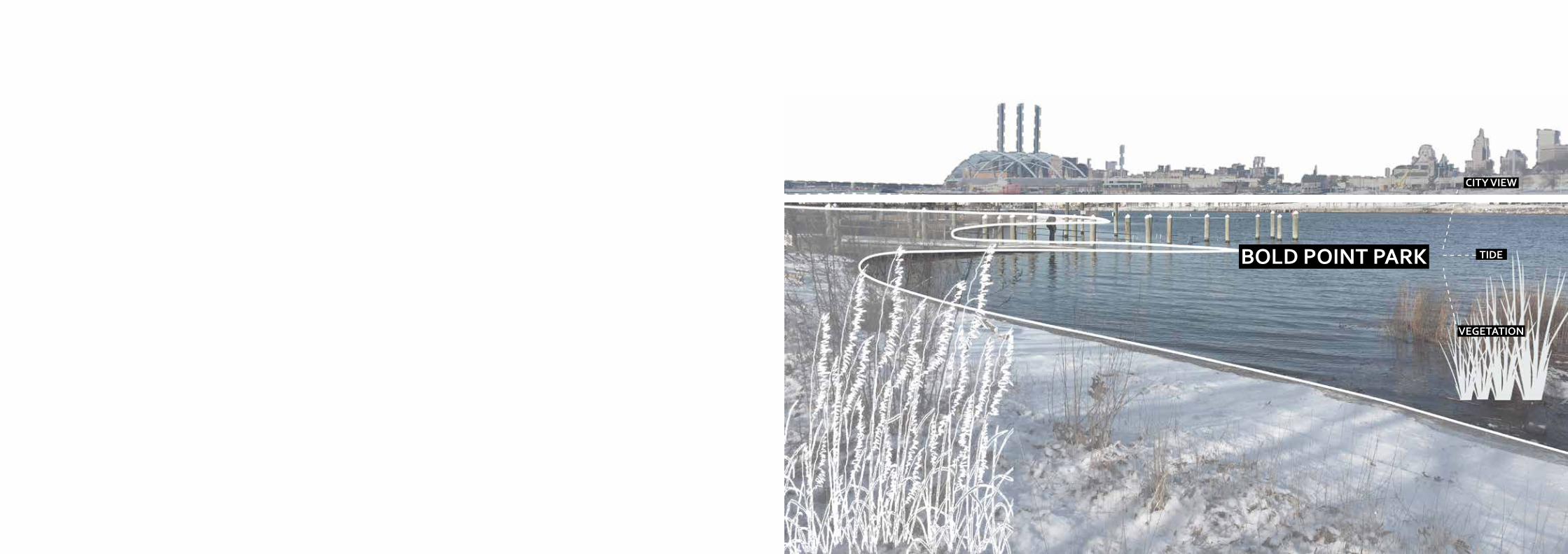
BOLD POINT PARK
CITy vIEw
TIDE
vEGETATION
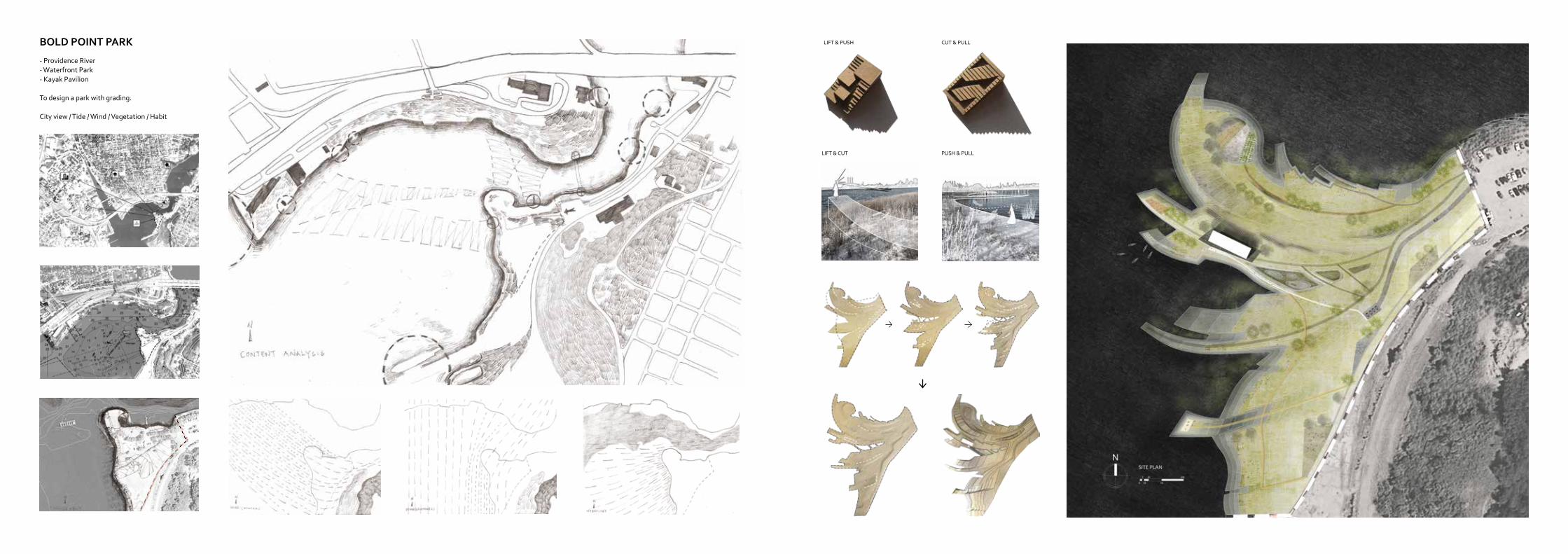
BOLD POINT PARK
- Providence River- Waterfront Park- Kayak Pavilion
To design a park with grading.
City view / Tide / Wind / Vegetation / Habit
LIFT & PUSH CUT & PULL
LIFT & CUT PUSH & PULL
1
1
2
2
TIDE
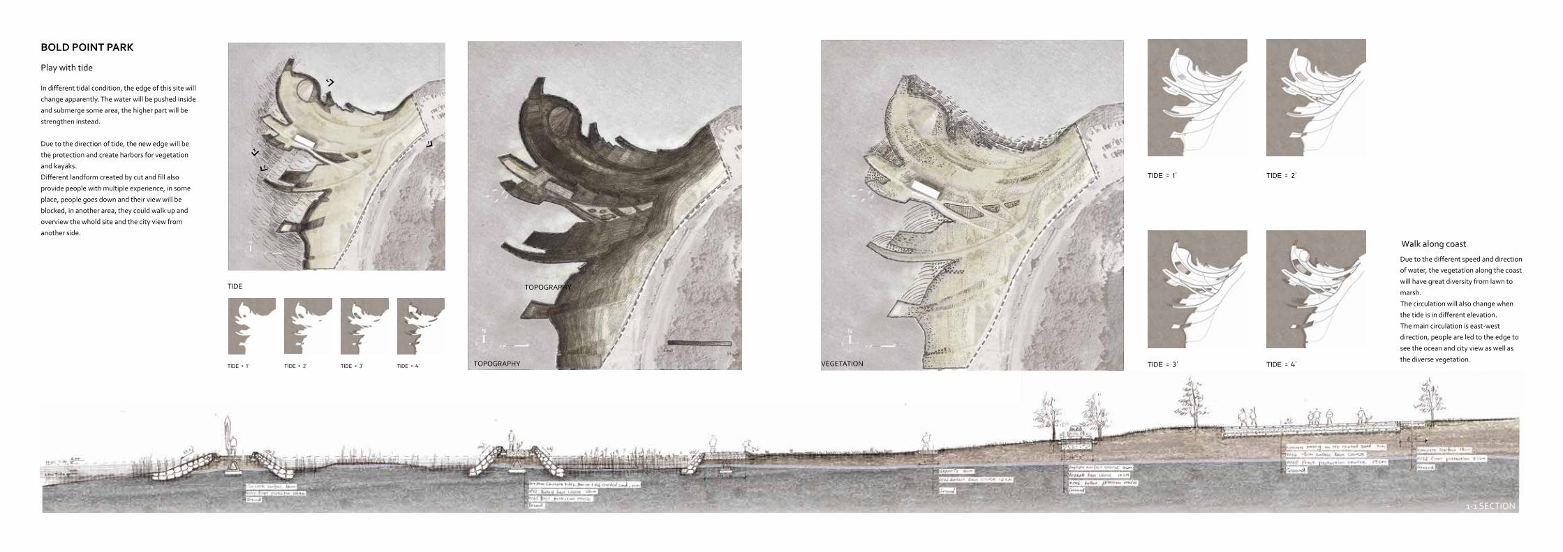
TIDE = 1' TIDE = 2' TIDE = 3' TIDE = 4'
TOPOGRAPHy
TIDE = 1' TIDE = 2'
TIDE = 3' TIDE = 4'VEGETATIONTOPOGRAPHy
In different tidal condition, the edge of this site will
change apparently. The water will be pushed inside
and submerge some area, the higher part will be
strengthen instead.
Due to the direction of tide, the new edge will be
the protection and create harbors for vegetation
and kayaks.
Different landform created by cut and fill also
provide people with multiple experience, in some
place, people goes down and their view will be
blocked, in another area, they could walk up and
overview the whold site and the city view from
another side.
Due to the different speed and direction
of water, the vegetation along the coast
will have great diversity from lawn to
marsh.
The circulation will also change when
the tide is in different elevation.
The main circulation is east-west
direction, people are led to the edge to
see the ocean and city view as well as
the diverse vegetation.
BOLD POINT PARK
Play with tide
Walk along coast
1-1 SECTION
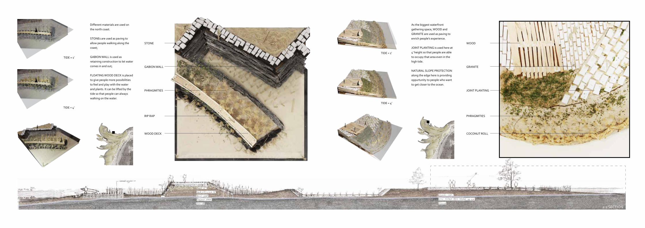
STONE
TIDE = 1'TIDE = 1'
TIDE = 4'TIDE = 4'
WOOD
GABION WALL GRANITE
PHRAGMITIES JOINT PLANTING
RIP RAP PHRAGMITIES
WOOD DECK COCONUT ROLL
Different materials are used on
the north coast.
STONEs are used as paving to
allow people walking along the
coast;
GABION WALL is used as
retaining construction to let water
comes in and out;
FLOATING WOOD DECK is placed
to give people more possibilities
to feel and play with the water
and plants. It can be lifted by the
tide so that people can always
walking on the water.
As the biggest waterfront
gathering space, WOOD and
GRANITE are used as paving to
enrich people's experience.
JOINT PLANTING is used here at
4' height so that people are able
to occupy that area even in the
high tide.
NATURAL SLOPE PROTECTION
along the edge here is providing
oppurtunity to people who want
to get closer to the ocean.
2-2 SECTION
SITE PLAN 1” = 40’
CONCEPT DRAWING
AERIAL VIEW
SECTION 1 SUMMER
SECTION 1 AUTUMN
SECTION 2 SUMMER
SECTION 2 WINTER PERSPECTIVE
Vegetation is inserted according to the topography condition, trees are more dense in where the slope is sharper and looser in flat area. There is no trees in the most flat area where people could go through or gather and reach the top of the hill.
Trees along the stream are more random compared with the other area, which will create space that people can approach the stream. The space divided by vegetation are connected with the main road, which allow people from the road go into the whole site.
NAME:JING LI
ALONG|FOREST STRUCTURE ON TOPOGRAPHY DESIGN FOUNDATION
FOLD PAPER
|
CUT INTO PIECES
|
PLACE ON GROUND
|
CUT & FILL
|
ADD CONTEXT
LIGHT
+
SHADOW
+
TIME
+
WATER FLOW
+
PLANT
HyDROLOGy
SHADOW22nd, December
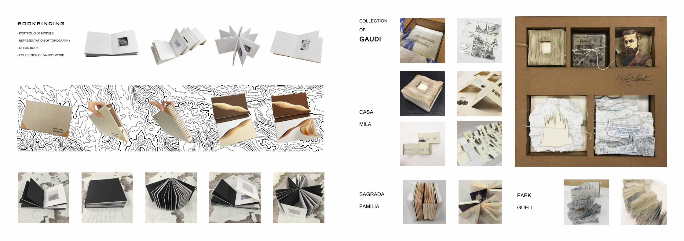
bOOkbINDING
- PORTFOLIO OF MODELS
- REPRESENTATION OF TOPOGRAPHy
- OCEAN BOOK
- COLLECTION OF GAUDI'S WORK
PARK
GUELL
SAGRADA
FAMILIA
CASA
MILA
COLLECTION
OF
GAUDI