Embed Size (px)
DESCRIPTION
a portfolio of all the explain
Citation preview
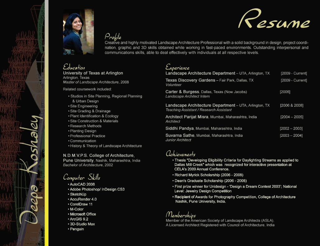
• AutoCAD 2008 • Adobe Photoshop/ InDesign CS3 • SketchUp • AccuRender 4.0 • CorelDraw 11 • M-Color • Microsoft O • Microsoft Office • ArcGIS 9.2 • 3D-Studio Max • Penguin
• Thesis "Developing Eligibility Criteria for Daylighting Streams as applied to Dallas Mill Creek" which was recognized for interactive presentation at CELA's 2009 Annual Conference. • Richard Myrick Scholarship (2006 - 2008)• Dean's Graduate Scholarship (2006 - 2008)• First prize winner for Unidesign - 'Design a Dream Contest 2003’; National Level: Jewelry Design Competition• Recipient of• Recipient of Awards for Photography Competition, College of Architecture Nashik, Pune University, India.
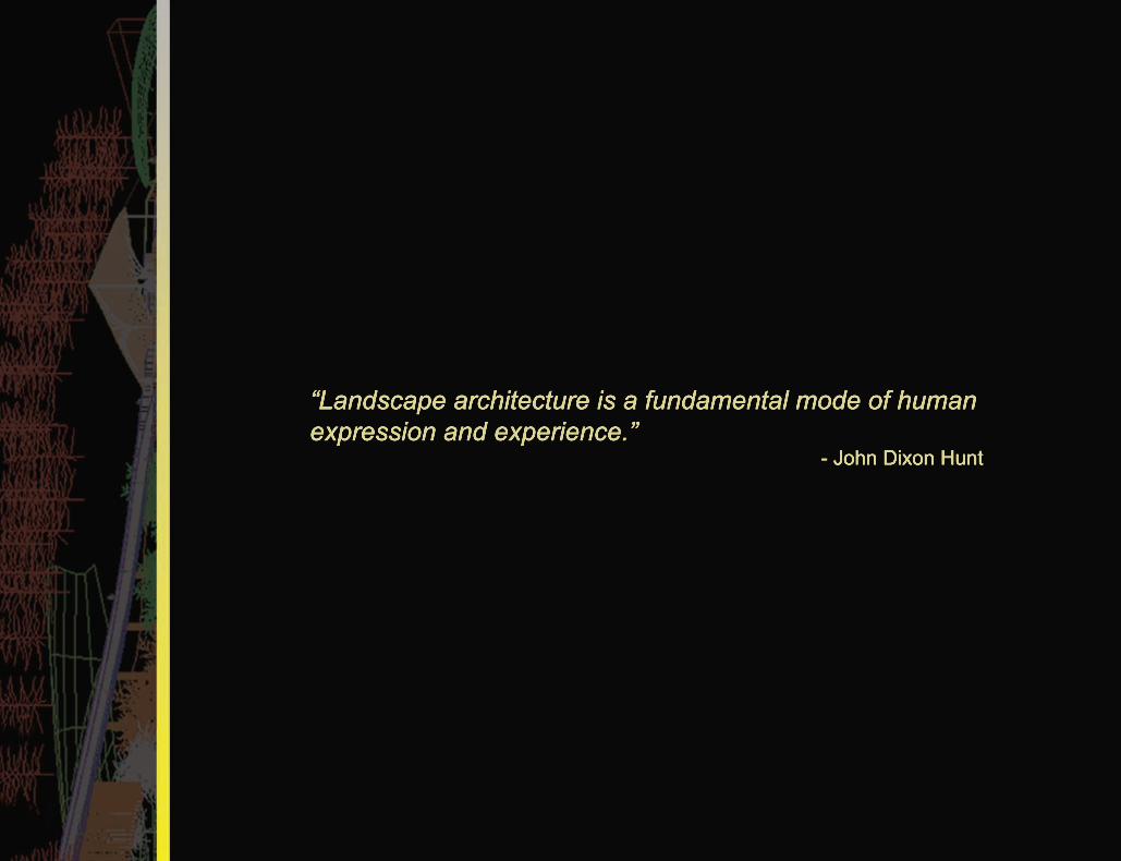
“Landscape architecture is a fundamental mode of human expression and experience.” - John Dixon Hunt

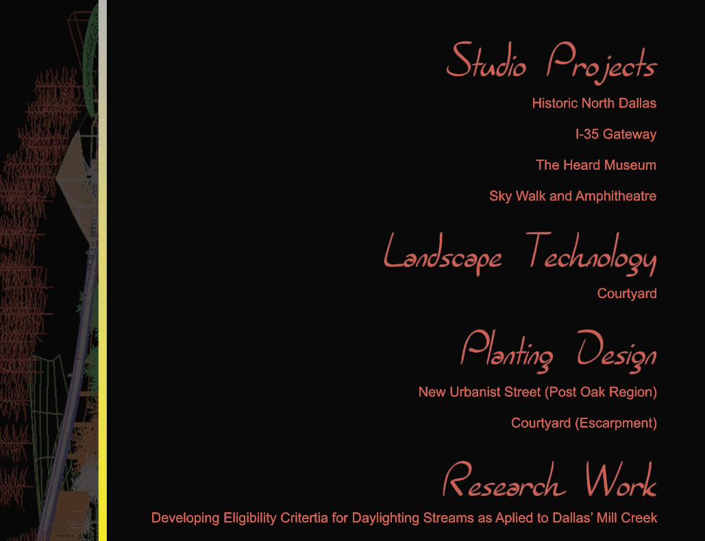
Historic North Dallas
I-35 Gateway
The Heard Museum
Sky Walk and Amphitheatre
New Urbanist Street (Post Oak Region)
Courtyard (Escarpment)
Courtyard
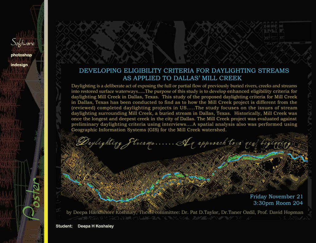
Developing Eligibility Critertia for Daylighting Streams as Aplied to Dallas’ Mill Creek
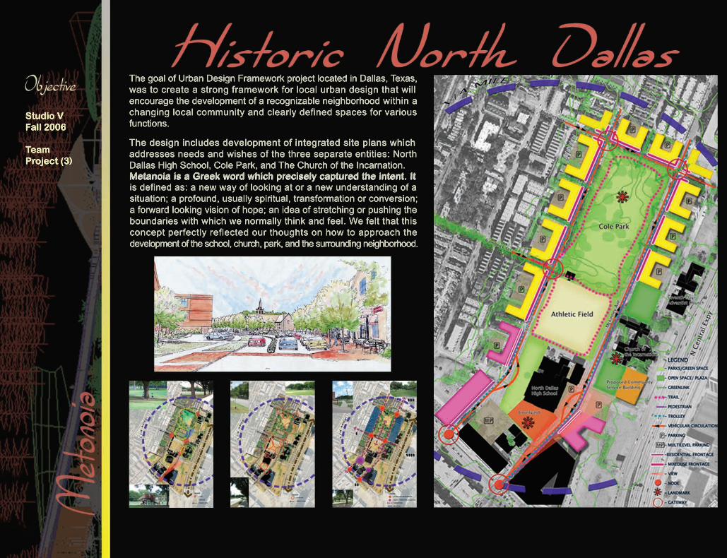
The goal of Urban Design Framework project located in Dallas, Texas, was to create a strong framework for local urban design that will encourage the development of a recognizable neighborhood within a changing local community and clearly defined spaces for various functions.
The design includes development of integrated site plans whichThe design includes development of integrated site plans which addresses needs and wishes of the three separate entities: North Dallas High School, Cole Park, and The Church of the Incarnation.Metanoia is a Greek word which precisely captured the intent. It Metanoia is a Greek word which precisely captured the intent. It is defined as: a new way of looking at or a new understanding of a situation; a profound, usually spiritual, transformation or conversion; a forward looking vision of hope; an idea of stretching or pushing the boundaries with which we normally think and feel. We felt that this concept perfectly reflected our thoughts on how to approach the development of the school, church, park, and the surrounding neighborhood.
Studio VFall 2006
Team Project (3)
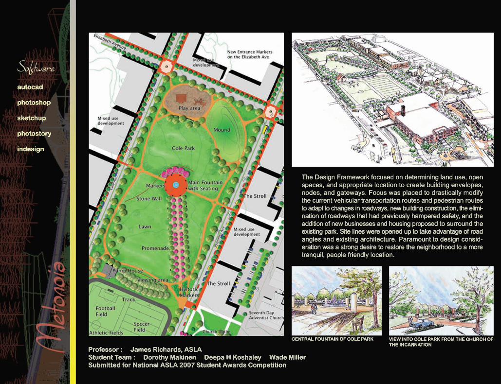
The Design Framework focused on determining land use, open spaces, and appropriate location to create building envelopes, nodes, and gateways. Focus was placed to drastically modify the current vehicular transportation routes and pedestrian routes to adapt to changes in roadways, new building construction, the elimi-nation of roadways that had previously hampered safety, and the addition of new businesses and housing proposed to surround the existing park. Site lines were opened up to take advantage of roadexisting park. Site lines were opened up to take advantage of road angles and existing architecture. Paramount to design consid-eration was a strong desire to restore the neighborhood to a more tranquil, people friendly location.
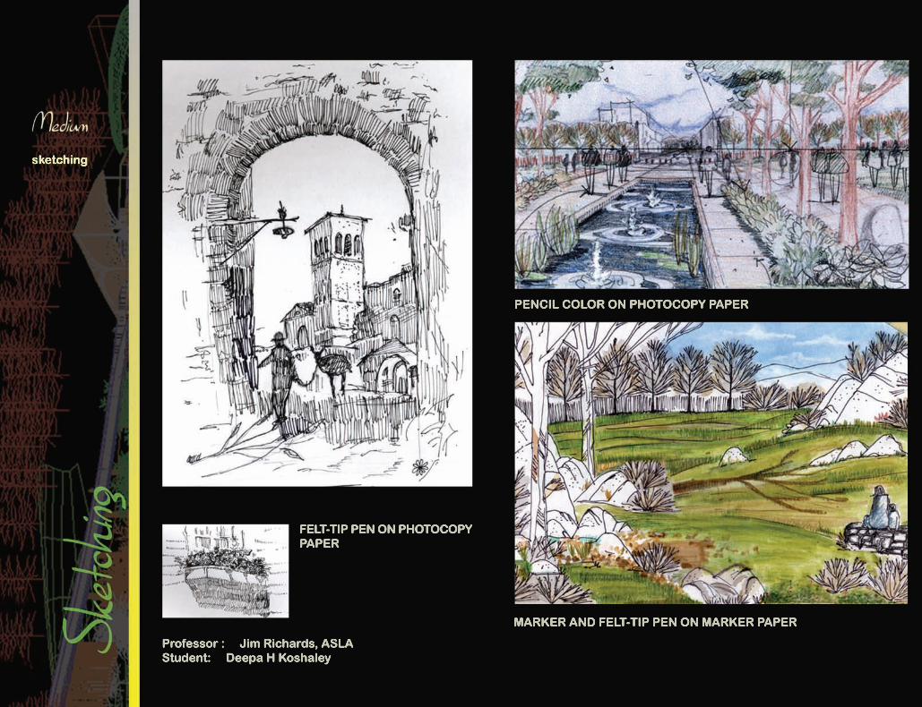
Professor : James Richards, ASLAStudent Team : Dorothy Makinen Deepa H Koshaley Wade Miller Submitted for National ASLA 2007 Student Awards Competition
CENTRAL FOUNTAIN OF COLE PARK VIEW INTO COLE PARK FROM THE CHURCH OF THE INCARNATION
autocad
photoshop
sketchup
photostory
indesign
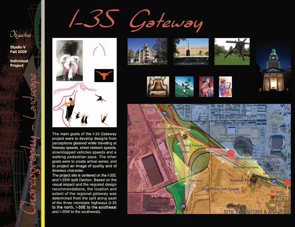
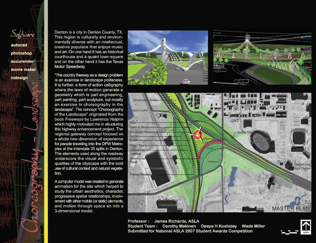
The main goals of the I-35 Gateway project were to develop designs from perceptions gleaned while traveling at freeway speeds, street network speeds, slow/stopped vehicles speeds and a walking pedestrian pace. The other goals were to create arrival sense, and to project an image of quality and ofto project an image of quality and of timeless character.The project site is centered on the I-35E and I-35W split Denton. Based on the visual impact and the required design recommendations, the location and extent of the regional gateway was determined from the split along each of the three interstate highways (I-35 to the north, I-35E to the southeast to the north, I-35E to the southeast and I-35W to the southwest).
Studio VFall 2006
Individual Project
Professor : James Richards, ASLAStudent Team : Dorothy Makinen Deepa H Koshaley Wade Miller Submitted for National ASLA 2007 Student Awards Competition 0’ 50’ 100’
Denton is a city in Denton County, TX. This region is culturally and environ-mentally diverse with an intellectual, creative populace that enjoys music and art. On one hand it has an historical courthouse and a quaint town-square and on the other hand it has the Texas Motor SpeedwaMotor Speedway.
“The country freeway as a design problem is an exercise in landscape politeness. It is further, a form of action calligraphy where the laws of motion generate a geometry which is part engineering, part painting, part sculpture, but mostly an exercise in choreography in the landscape”.landscape”. The concept ”Choreography of the Landscape” originated from the book Freeways by Lawrence Halprin which highly motivated me in structuring this highway enhancement project. The regional gateway concept focused on a whole new dimension of experience for people traveling into the DFW Metrofor people traveling into the DFW Metro-plex at the Interstate 35 splits in Denton. The elements used along the roadway underscore the visual and symbolic qualities of the cityscape with the bold use of cultural context and natural vegeta-tion.
A computer model was created to generate animation for the site which helped to study the urban aesthetics, character, progressive spatial relationships, involv-ement with other mobile (or static) elements, and motion through space an into a 3-dimensional model.
autocad
photoshop
accurender
movie maker
indesign
Studio IIIFall 2005
TeamProject (4)
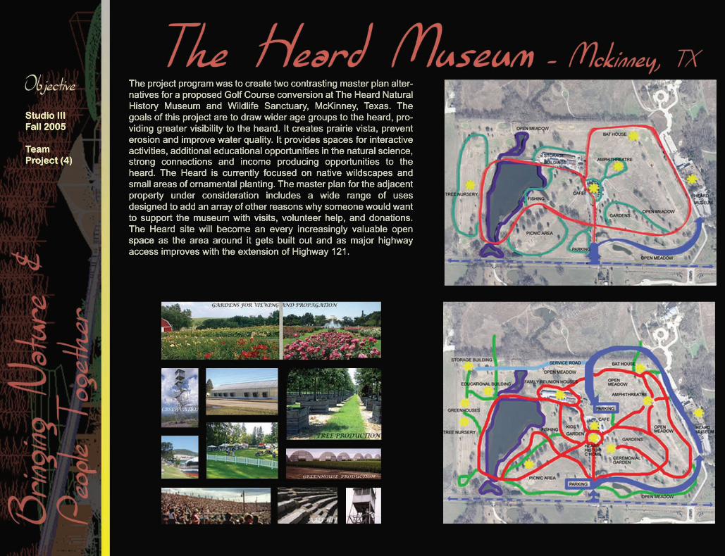
The project program was to create two contrasting master plan alter-natives for a proposed Golf Course conversion at The Heard Natural History Museum and Wildlife Sanctuary, McKinney, Texas. The goals of this project are to draw wider age groups to the heard, pro-viding greater visibility to the heard. It creates prairie vista, prevent erosion and improve water quality. It provides spaces for interactive activities, additional educational opportunities in the natural science, strong connections and income producing opportunities to the heard. The Heard is currently focused on native wildscapes and small areas of ornamental planting. The master plan for the adjacent property under consideration includes a wide range of uses designed to add an array of other reasons why someone would want to support the museum with visits, volunteer help, and donations. The Heard site will become an every increasingly valuable open spacespace as the area around it gets built out and as major highway access improves with the extension of Highway 121.
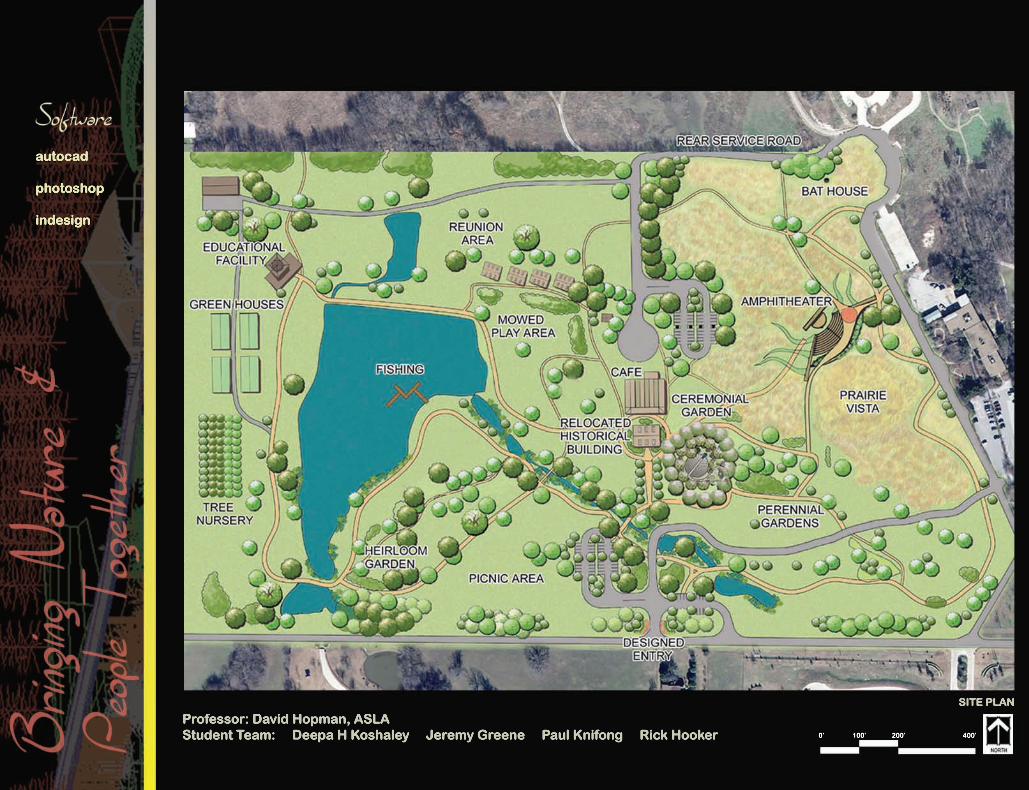
Professor: David Hopman, ASLAStudent Team: Deepa H Koshaley Jeremy Greene Paul Knifong Rick Hooker
SITE PLAN
0’ 100’ 200’ 400’
autocad
photoshop
indesign
Studio IIIFall 2005
Individual Project
0’ 20’ 40’ 80’ 120’
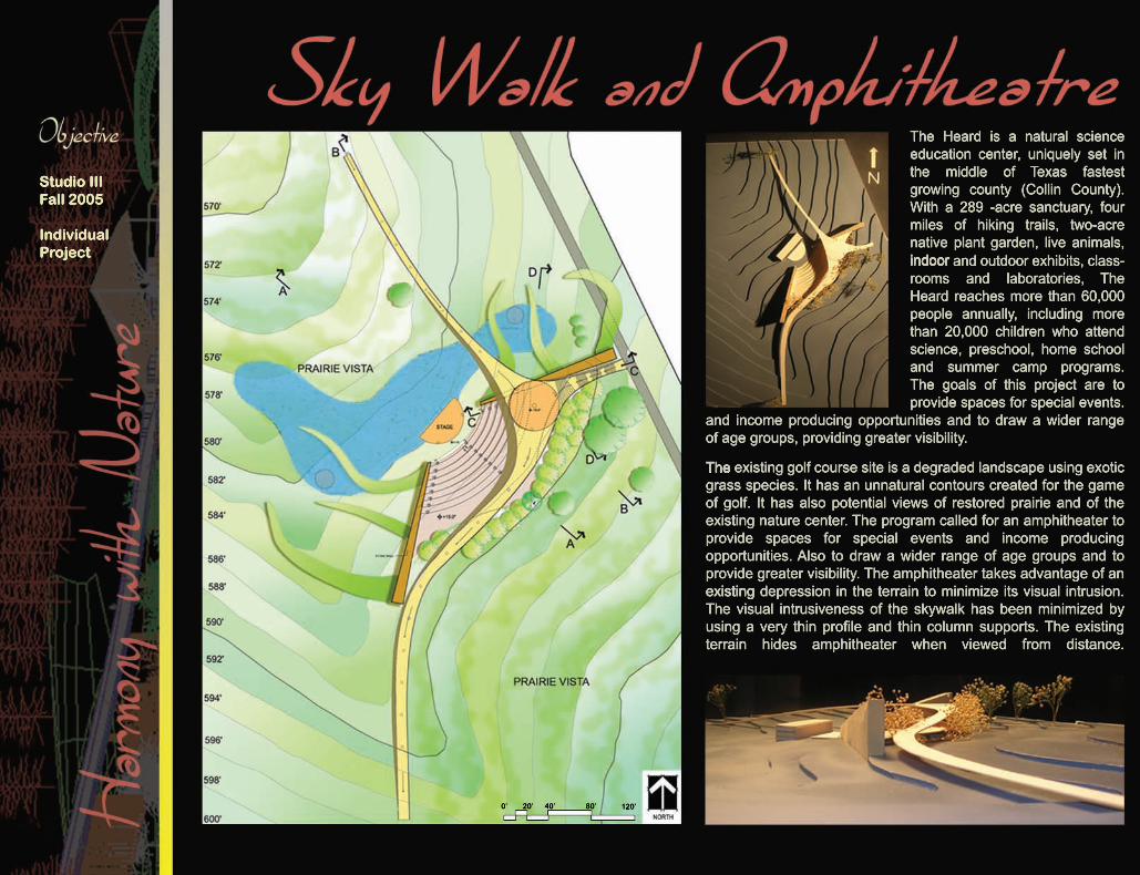
The Heard is a natural science education center, uniquely set in the middle of Texas fastest growing county (Collin County). With a 289 -acre sanctuary, four miles of hiking trails, two-acre native plant garden, live animals, indoorindoor and outdoor exhibits, class-rooms and laboratories, The Heard reaches more than 60,000 people annually, including more than 20,000 children who attend science, preschool, home school and summer camp programs. The goals of this project are to provide spaces for special events.
and income producing opportunities and to draw a wider range of age groups, providing greater visibility.
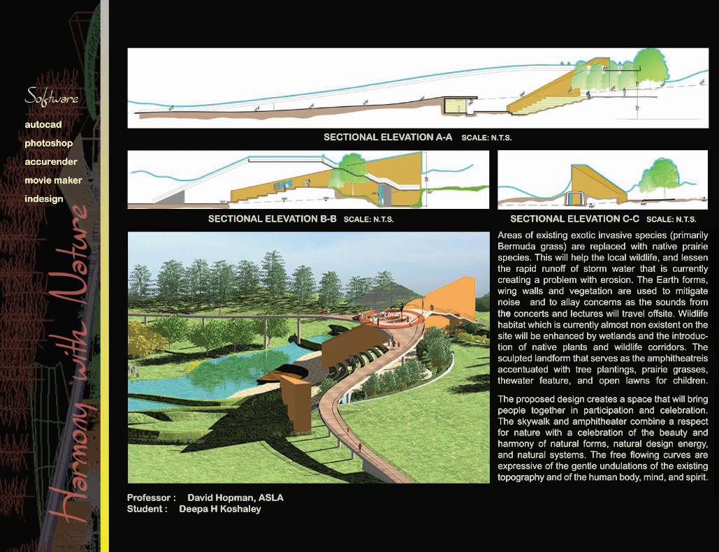
TheThe existing golf course site is a degraded landscape using exotic grass species. It has an unnatural contours created for the game of golf. It has also potential views of restored prairie and of the existing nature center. The program called for an amphitheater to provide spaces for special events and income producing opportunities. Also to draw a wider range of age groups and to provide greater visibility. The amphitheater takes advantage of an existingexisting depression in the terrain to minimize its visual intrusion. The visual intrusiveness of the skywalk has been minimized by using a very thin profile and thin column supports. The existing terrain hides amphitheater when viewed from distance.
Professor : David Hopman, ASLAStudent : Deepa H Koshaley
SECTIONAL ELEVATION B-B SCALE: N.T.S. SECTIONAL ELEVATION C-C SCALE: N.T.S.
Areas of existing exotic invasive species (primarily Bermuda grass) are replaced with native prairie species. This will help the local wildlife, and lessen the rapid runoff of storm water that is currently creating a problem with erosion. The Earth forms, wing walls and vegetation are used to mitigate noise and to allay concerns as the sounds from thethe concerts and lectures will travel offsite. Wildlife habitat which is currently almost non existent on the site will be enhanced by wetlands and the introduc-tion of native plants and wildlife corridors. The sculpted landform that serves as the amphitheatreis accentuated with tree plantings, prairie grasses, thewater feature, and open lawns for children.
The proposed design creates a space that will bring people together in participation and celebration. The skywalk and amphitheater combine a respect for nature with a celebration of the beauty and harmony of natural forms, natural design energy, and natural systems. The free flowing curves are expressive of the gentle undulations of the existing topographytopography and of the human body, mind, and spirit.
SECTIONAL ELEVATION A-A SCALE: N.T.S.autocad
photoshop
accurender
movie maker
indesign
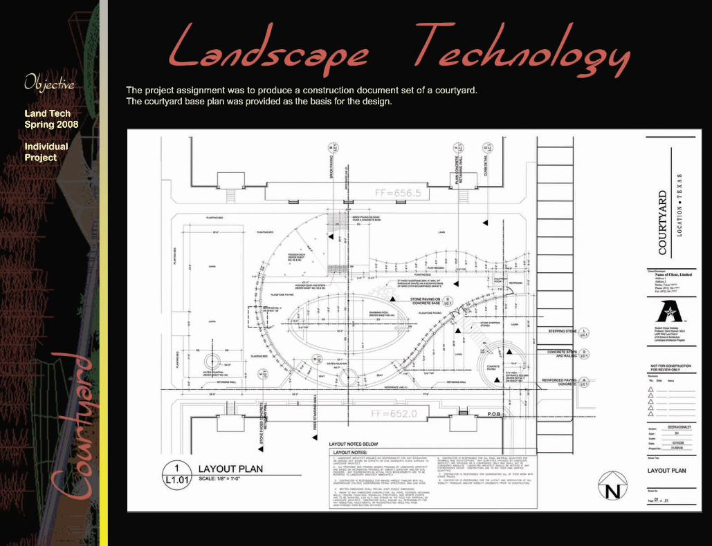
The project assignment was to produce a construction document set of a courtyard. The courtyard base plan was provided as the basis for the design.
Land TechSpring 2008
Individual Project
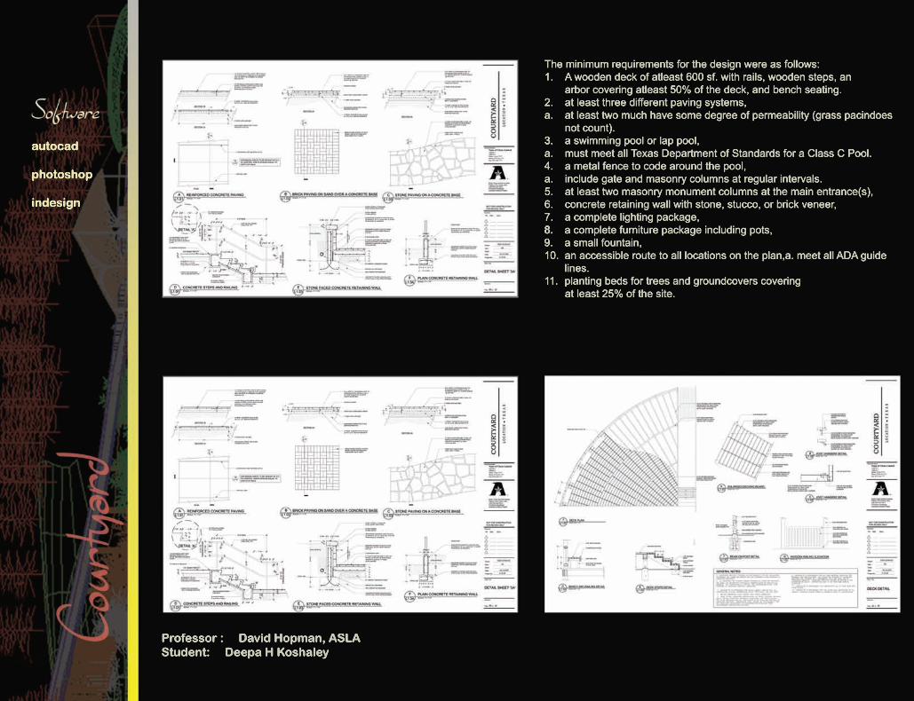
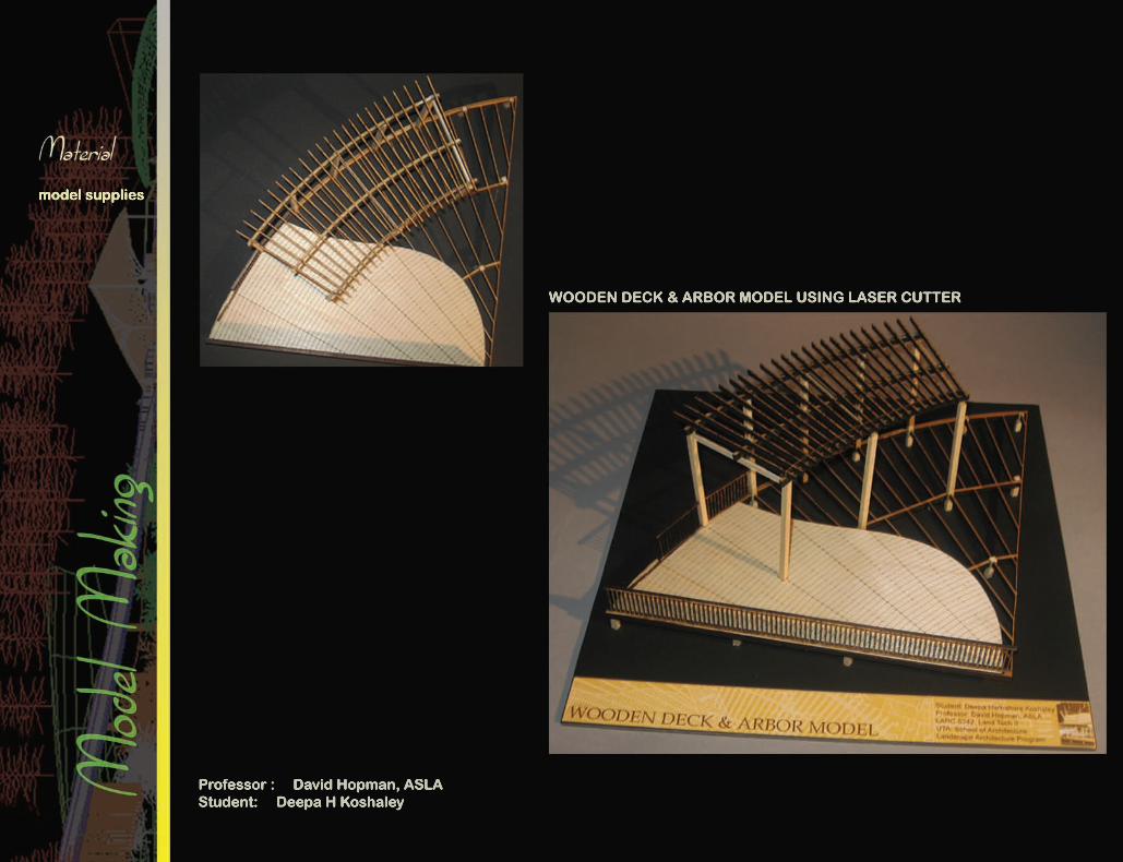
The minimum requirements for the design were as follows:1. A wooden deck of atleast 600 sf. with rails, wooden steps, an arbor covering atleast 50% of the deck, and bench seating.2. at least three different paving systems,a. at least two much have some degree of permeability (grass pacindoes not count).3.3. a swimming pool or lap pool,a. must meet all Texas Department of Standards for a Class C Pool.4. a metal fence to code around the pool,a. include gate and masonry columns at regular intervals.5. at least two masonry monument columns at the main entrance(s),6. concrete retaining wall with stone, stucco, or brick veneer,7. a complete lighting package,8.8. a complete furniture package including pots,9. a small fountain,10. an accessible route to all locations on the plan,a. meet all ADA guide lines.11. planting beds for trees and groundcovers covering at least 25% of the site.
Professor : David Hopman, ASLAStudent: Deepa H Koshaley
autocad
photoshop
indesign
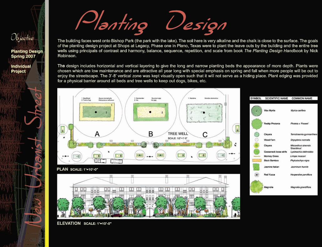
The building faces west onto Bishop Park (the park with the lake). The soil here is very alkaline and the chalk is close to the surface. The goals of the planting design project at Shops at Legacy, Phase one in Plano, Texas were to plant the leave outs by the building and the entire tree wells using principals of contrast and harmony, balance, sequence, repetition, and scale from book The Planting Design Handbook by Nick Robinson. TheThe design includes horizontal and vertical layering to give the long and narrow planting beds the appearance of more depth. Plants were chosen which are low maintenance and are attractive all year long with special emphasis on spring and fall when more people will be out to enjoy the streetscape. The 3’-8’ vertical zone was kept visually open such that it will not serve as a hiding place. Plant edging was provided for a physical barrier around all beds and tree wells to keep out dogs, bikes, etc.
PLAN SCALE: 1’=10’-0”
ELEVATION SCALE: 1’=10’-0”
Planting DesignSpring 2007
Individual Project
Professor : David Hopman, ASLAStudent : Deepa H Koshaley
PERSPECTIVE VIEW
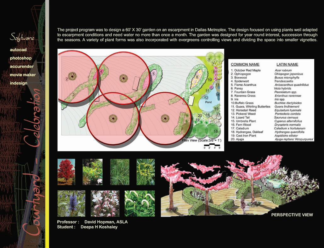
The project program was to design a 60’ X 30’ garden on an escarpment in Dallas Metroplex. The design focused on using plants well adapted to escarpment conditions and need water no more than once a month. The garden was designed for year round interest, succession through the seasons. A variety of plant forms was also incorporated with evergreens controlling views and dividing the space into smaller vignettes.
autocad
photoshop
accurender
movie maker
indesign
ThesisFall 2008
Individual Work
Professor : Dr. Pat D Taylor, ASLAStudent: Deepa H Koshaley
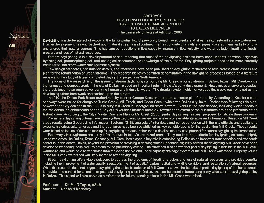
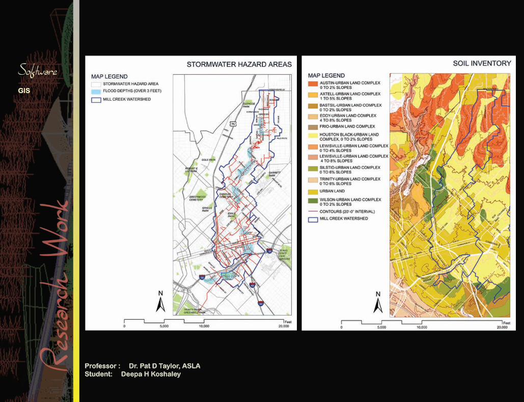
ABSTRACTDEVELOPING ELIGIBILITY CRITERIA FORDAYLIGHTING STREAMS AS APPLIED
TO DALLAS MILL CREEKThe University of Texas at Arlington, 2008
DaylightingDaylighting is a deliberate act of exposing the full or partial flow of previously buried rivers, creeks and streams into restored surface waterways. Human development has encroached upon natural streams and confined them in concrete channels and pipes, covered them partially or fully, and altered their natural courses. This has caused reductions in flow capacity, increase in flow velocity, and water pollution, leading to floods, erosion, and loss of natural resources. Stream daylighting is in a developmental phase, meaning that most of the daylighting projects have been undertaken without rigorous hydrological, geomorphological, and ecological assessment or knowledge of the outcome. Daylighting projects need to be more carefully engineered into storm-water management systems. Few design standards, construction details, and references have been published on daylighting of streams to help professionals assess and plan for the rehabilitation of urban streams. This research identifies common denominators in the daylighting processes based on a literature review and the study of fifteen completed daylighting projects in North America. The focus of the research is on the issues of stream daylighting surrounding Mill Creek, a buried stream in Dallas, Texas. Mill Creek—once the longest and deepest creek in the city of Dallas—played an important role in the city’s early development. However, over several decades, the creek became an open sewer carrying human and industrial waste. The riparian system which enveloped the creek was removed as the developing urban framework encroached upon the stream. In 1910, the Dallas Park Board authorized city planner George Kessler to prepare a master plan for the city. According to Kessler’s plan, parkways were called for alongside Turtle Creek, Mill Creek, and Cedar Creek, within the Dallas city limits. Rather than following this plan, however, the City decided in the 1930s to bury Mill Creek in underground storm sewers. Events in the past decade, including violent floods in the residential neighborhoods and the Baylor University’s medical complex, revealed the extent of the subsurface drainage problems of the historichistoric creek. According to the City’s Master Drainage Plan for Mill Creek (2005), partial daylighting has been proposed to mitigate these problems. Preliminary daylighting criteria have been synthesized based on review and analysis of available literature and information. Based on Mill Creek study results using Geographic Information Systems (GIS), analysis of interviews and correspondence with the city officials and daylighting experts, historical/cultural values and thoroughfares have been established as key considerations for the daylighting Mill Creek. These results were based on issues of decision making for daylighting streams, rather than a detailed step-by-step protocol for stream daylighting implementation. Roadways/thoroughfares are a key infrastructure in today’s urbanized areas. They are important criteria for daylighting streams in highly urbanized areas like Dallas, Texas. Secondly, Mill Creek has played a key role in establishing Dallas as an important transportation and economic center in north-central Texas, beyond the provision of providing a drinking water. Enhanced eligibility criteria for daylighting Mill Creek have been developed by adding these two key criteria to the preliminary criteria. The study has also shown that partial daylighting is feasible in the Mill Creek watershedwatershed and would be a better choice than replacing the old and under-capacity drainage system of the Mill Creek watershed. Property values in the Mill Creek watershed will likely increase after daylighting. Stream daylighting offers viable solutions to address the problems of flooding, erosion, and loss of natural resources and provides benefits including the improvement of water quality, reestablishment of aquatic/riparian habitat and wildlife corridors, and restoration of natural resources. While this research does not suggest daylighting the entire historic run of Mill Creek, it shows the benefits of partial daylighting of the buried creek. It provides the context for selection of potential daylighting sites in Dallas, and can be useful in formulating a city-wide stream-daylighting policy in Dallas. in Dallas. This report will also serve as a reference for future planning efforts in the Mill Creek watershed.
GIS
ThesisFall 2008
Individual Work
Professor : Dr. Pat D Taylor, ASLAStudent: Deepa H Koshaley
GIS


Kala Academy
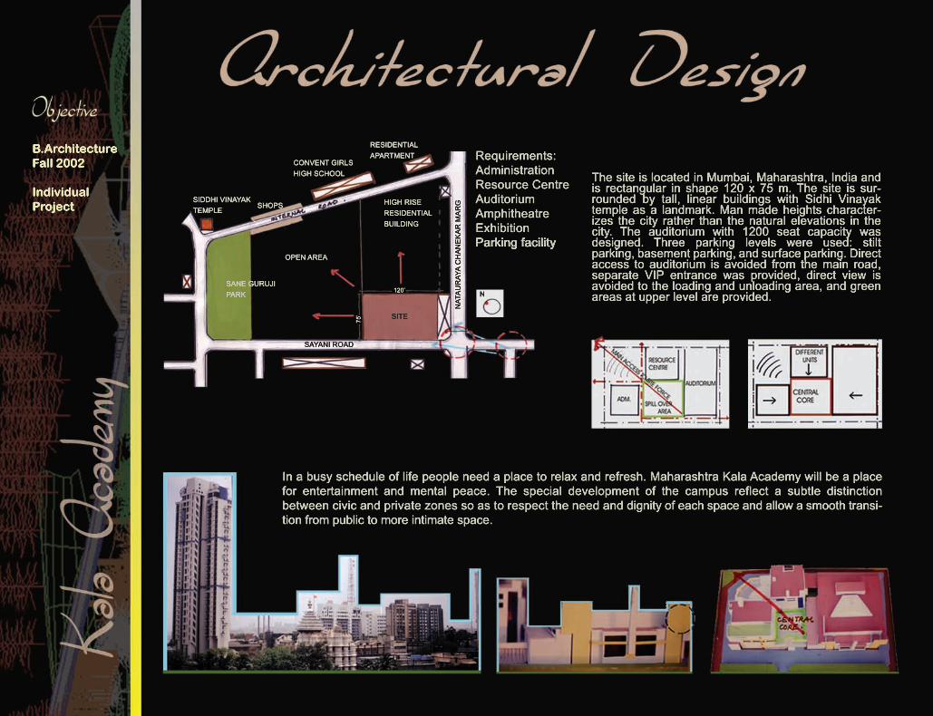
The site is located in Mumbai, Maharashtra, India and is rectangular in shape 120 x 75 m. The site is sur-rounded by tall, linear buildings with Sidhi Vinayak temple as a landmark. Man made heights character-izes the city rather than the natural elevations in the city. The auditorium with 1200 seat capacity was designed. Three parking levels were used: stilt parking, basement parking, and surface parking. Direct access to auditorium is avoided from the main road, separate VIP entrance was provided, direct view is avoided to the loading and unloading area, and green areas at upper level are provided.
In a busy schedule of life people need a place to relax and refresh. Maharashtra Kala Academy will be a place for entertainment and mental peace. The special development of the campus reflect a subtle distinction between civic and private zones so as to respect the need and dignity of each space and allow a smooth transi-tion from public to more intimate space.
B.ArchitectureFall 2002
Individual Project
Requirements:AdministrationResource CentreAuditorium AmphitheatreExhibitionParking facilityParking facility
SIDDHI VINAYAK TEMPLE
SHOPS
CONVENT GIRLS HIGH SCHOOL
RESIDENTIAL APARTMENT
HIGH RISE RESIDENTIALBUILDING
OPEN AREA
120’
75’
SAYANI ROAD
NATAURAYA CHANEKAR MARG
SITE
NSANE GURUJIPARK
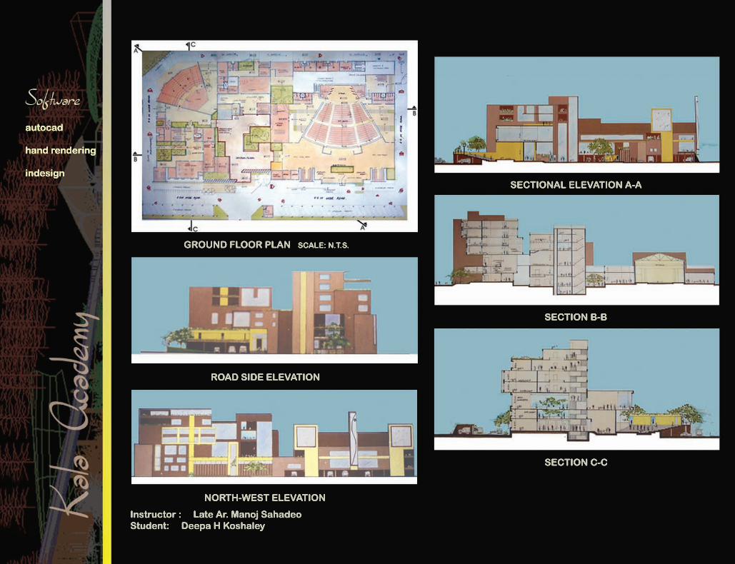
Instructor : Late Ar. Manoj SahadeoStudent: Deepa H Koshaley
GROUND FLOOR PLAN SCALE: N.T.S.
ROAD SIDE ELEVATION
NORTH-WEST ELEVATION
SECTIONAL ELEVATION A-A
SECTION B-B
SECTION C-C
autocad
hand rendering
indesign

Tradigital Imaging
AutoCAD, Accurender, Penguin
Model Making
Board Layout
Photoshop
Photography, Sketching
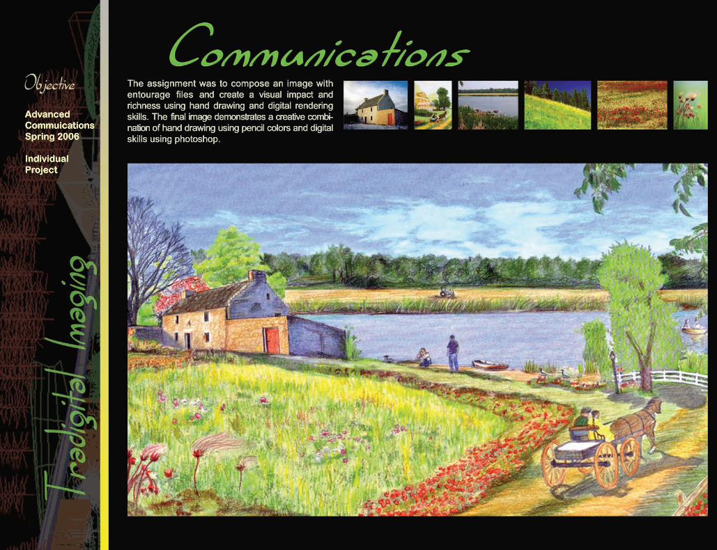
The assignment was to compose an image with entourage files and create a visual impact and richness using hand drawing and digital rendering skills. The final image demonstrates a creative combi-nation of hand drawing using pencil colors and digital skills using photoshop.
Advanced CommuicationsSpring 2006
Individual Project
Professor : Jim Richards, ASLAStudent: Deepa H Koshaley
autocad
indesign
markers
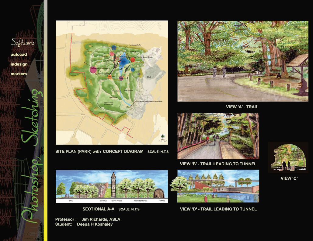
SITE PLAN (PARK) with CONCEPT DIAGRAM SCALE: N.T.S.
VIEW ‘A’ - TRAIL
VIEW ‘B’ - TRAIL LEADING TO TUNNEL
VIEW ‘C’
VIEW ‘D’ - TRAIL LEADING TO TUNNELSECTIONAL A-A SCALE: N.T.S.
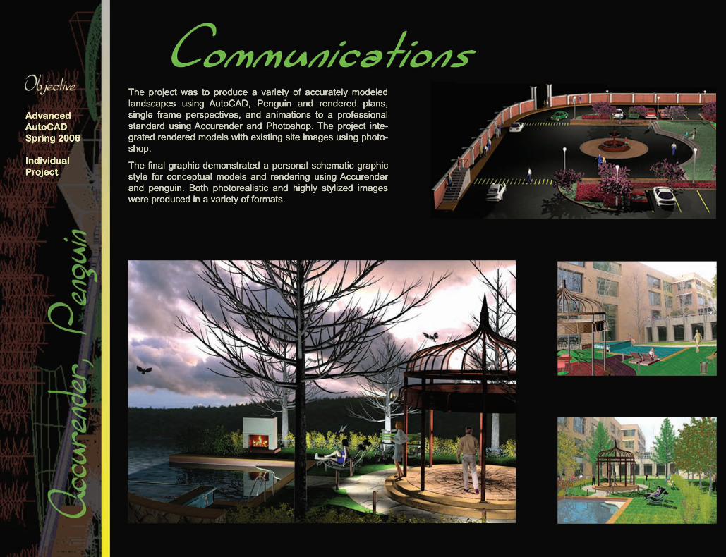
The project was to produce a variety of accurately modeled landscapes using AutoCAD, Penguin and rendered plans, single frame perspectives, and animations to a professional standard using Accurender and Photoshop. The project inte-grated rendered models with existing site images using photo-shop.
The final graphic demonstrated a personal schematic graphic style for conceptual models and rendering using Accurender and penguin. Both photorealistic and highly stylized images were produced in a variety of formats.
Advanced AutoCADSpring 2006
Individual Project
Professor : David Hopman, ASLAStudent: Deepa H Koshaley
autocad
accurender
penguin
photoshop
indesign
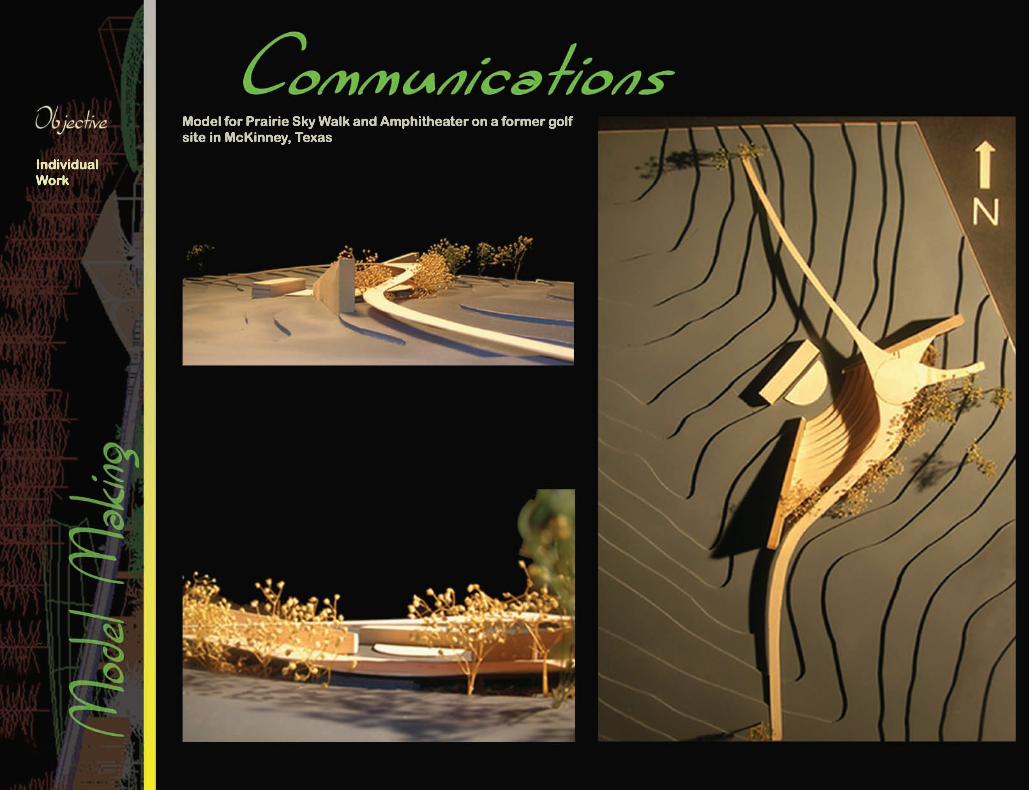
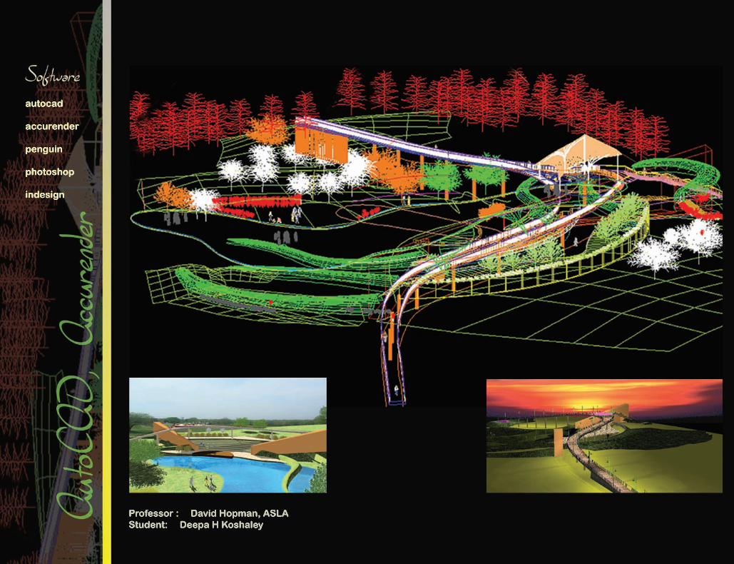
Model for Prairie Sky Walk and Amphitheater on a former golf site in McKinney, Texas
Individual Work
Professor : David Hopman, ASLAStudent: Deepa H Koshaley
model supplies
WOODEN DECK & ARBOR MODEL USING LASER CUTTER
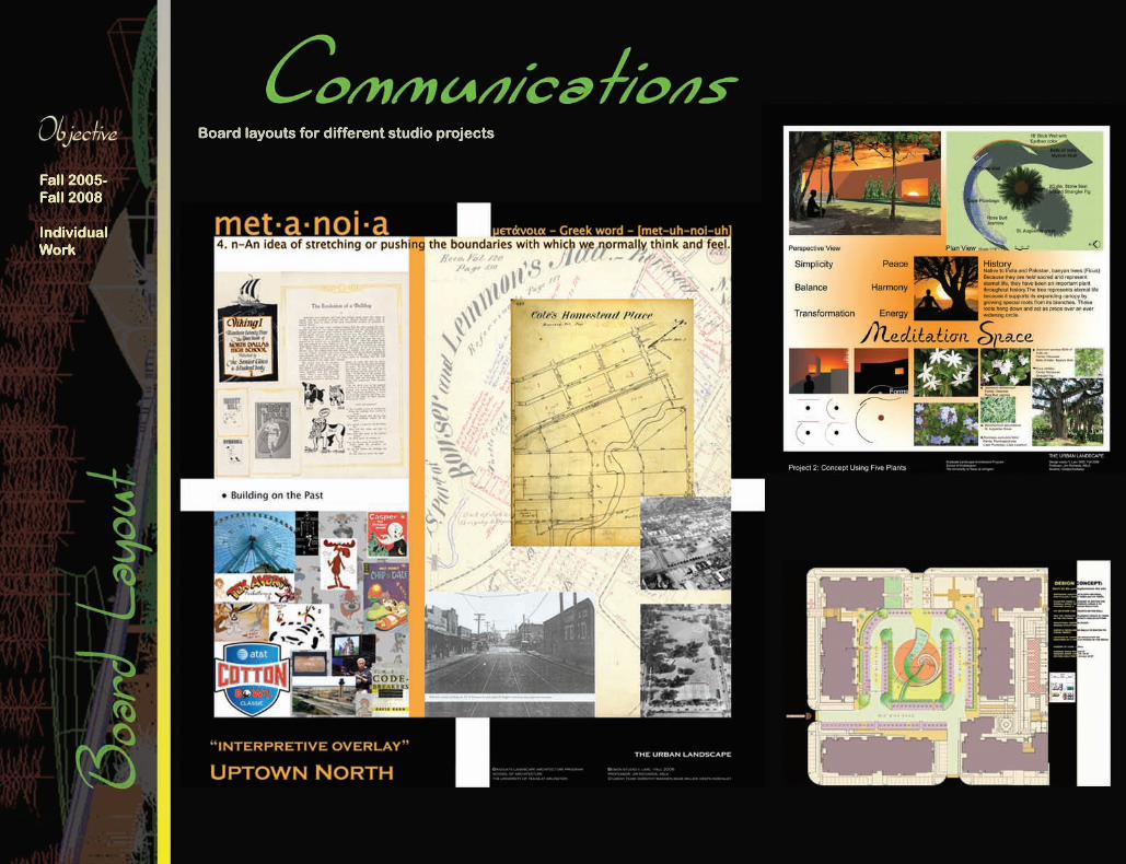
Board layouts for different studio projects
Fall 2005-Fall 2008
Individual Work
Student: Deepa H Koshaley
photoshop
indesign
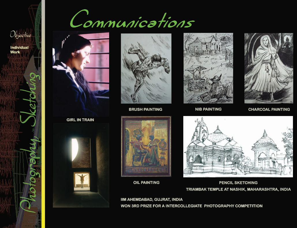
BRUSH PAINTING
GIRL IN TRAIN
OIL PAINTING
WON 3RD PRIZE FOR A INTERCOLLEGIATE PHOTOGRAPHY COMPETITION
IIM AHEMDABAD, GUJRAT, INDIA
TRIAMBAK TEMPLE AT NASHIK, MAHARASHTRA, INDIA
PENCIL SKETCHING
NIB PAINTING CHARCOAL PAINTING
Individual Work
Professor : Jim Richards, ASLAStudent: Deepa H Koshaley
sketching
FELT-TIP PEN ON PHOTOCOPY PAPER
PENCIL COLOR ON PHOTOCOPY PAPER
MARKER AND FELT-TIP PEN ON MARKER PAPER

IFCA - Independent Financial Centre for Americas
Le Meridian - Landscaping for Plaza Beach Resort at Mauritius
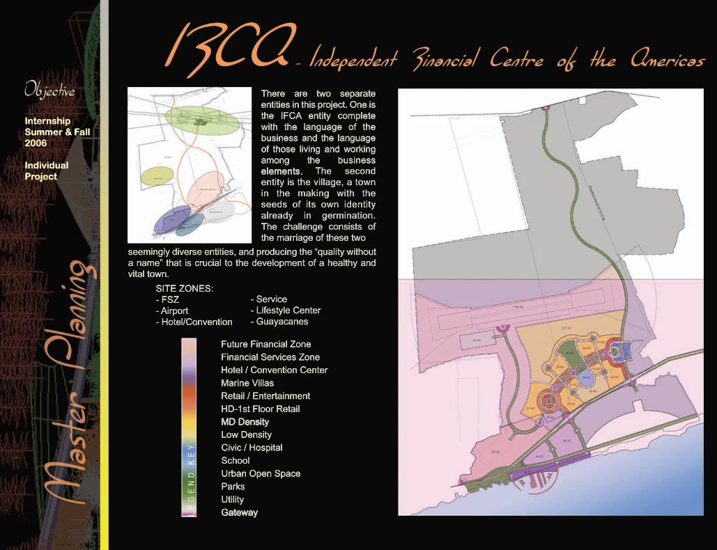
There are two separate entities in this project. One is the IFCA entity complete with the language of the business and the language of those living and working among the business elements.elements. The second entity is the village, a town in the making with the seeds of its own identity already in germination. The challenge consists of the marriage of these two
seemingly diverse entities, and producing the “quality without a name” that is crucial to the development of a healthy and vital town.
SITE ZONES:- FSZ- Airport- Hotel/Convention
- Service- Lifestyle Center- Guayacanes
Future Financial ZoneFinancial Services ZoneHotel / Convention CenterMarine VillasRetail / EntertainmentHD-1st Floor RetailMD DensityMD DensityLow DensityCivic / HospitalSchoolUrban Open SpaceParksUtilityGatewayGateway
InternshipSummer & Fall2006
Individual Project

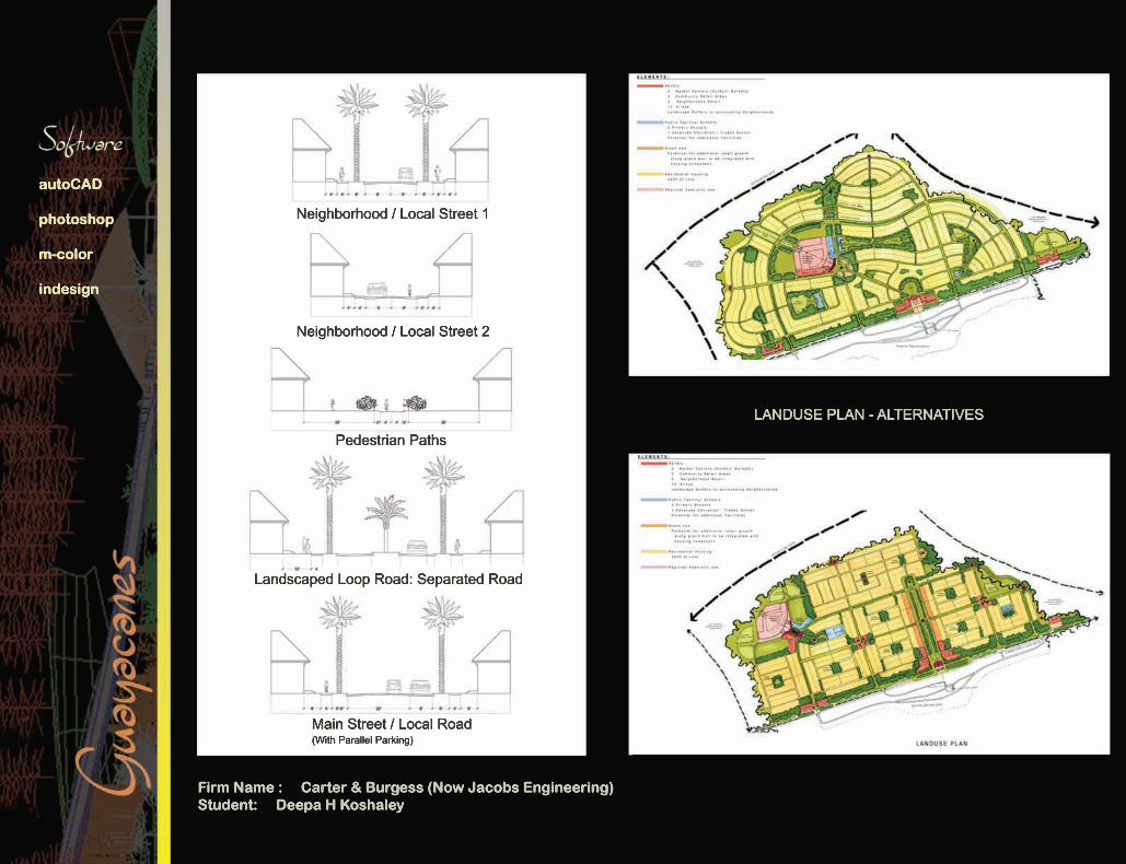
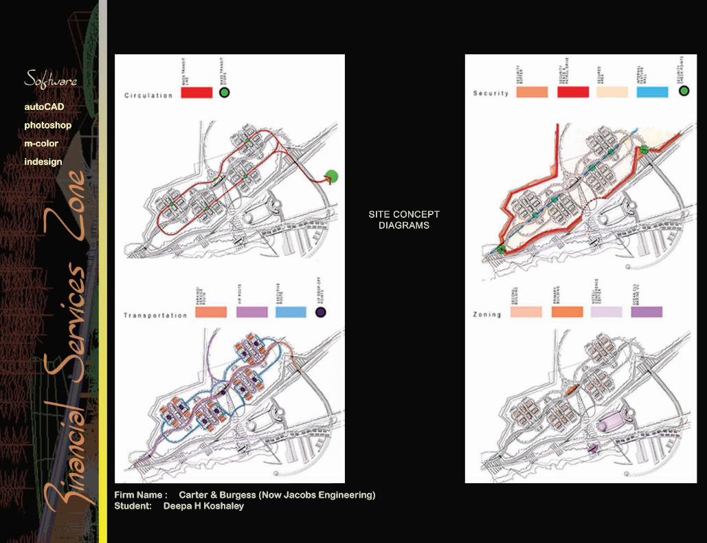
Firm Name : Carter & Burgess (Now Jacobs Engineering)Student: Deepa H Koshaley
autoCAD
photoshop
m-color
indesign
Single Family/Low Density - 324 acresTownhomes/Moderate Density - 96 acresMulti Family Moderately High Desnity - 90 acresMulti Family Mixed Use/High Density - 46 acresSchool - 69 acresCivic - 118 acresHospital - 21 acresHospital - 21 acresRetail/Entertainment - 263 acresMarine Villas - 46 acresFinancial Services Zone - 278 acresFuture Financial Services Zone - 1500 acresUtilities - 46 acresSecurity Perimeter - 230 acresParks and Urban Open Space - 134 acresParks and Urban Open Space - 134 acresGateway
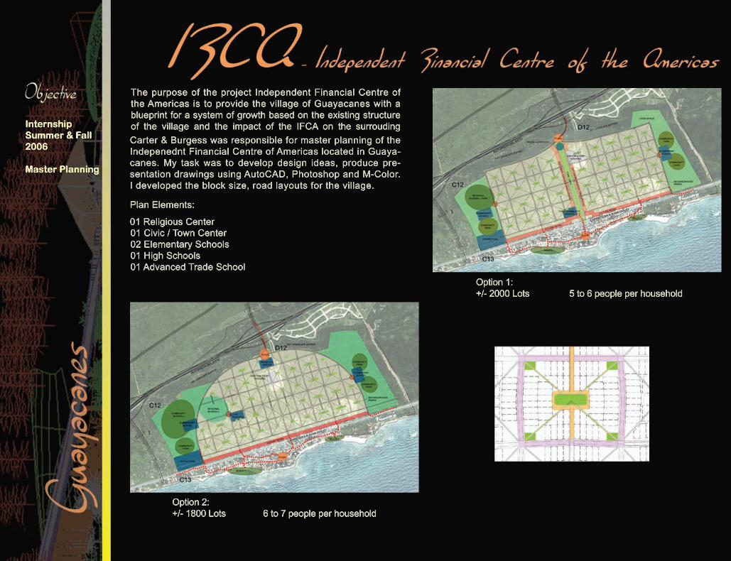
The purpose of the project Independent Financial Centre of the Americas is to provide the village of Guayacanes with a blueprint for a system of growth based on the existing structure of the village and the impact of the IFCA on the surrouding Carter & Burgess was responsible for master planning of the Indepenednt Financial Centre of Americas located in Guaya-canes. My task was to develop design ideas, produce pre-sentation drawings using AutoCAD, Photoshop and M-Color. I developed the block size, road layouts for the village.
Plan Elements:
01 Religious Center01 Civic / Town Center02 Elementary Schools01 High Schools01 Advanced Trade School
Option 1:+/- 2000 Lots 5 to 6 people per household
Option 2:+/- 1800 Lots 6 to 7 people per household
InternshipSummer & Fall2006
Master Planning
Firm Name : Carter & Burgess (Now Jacobs Engineering)Student: Deepa H Koshaley
autoCAD
photoshop
m-color
indesign
LANDUSE PLAN - ALTERNATIVES
Neighborhood / Local Street 1
Neighborhood / Local Street 2
Pedestrian Paths
Landscaped Loop Road: Separated Road
Main Street / Local Road(With Parallel Parking)
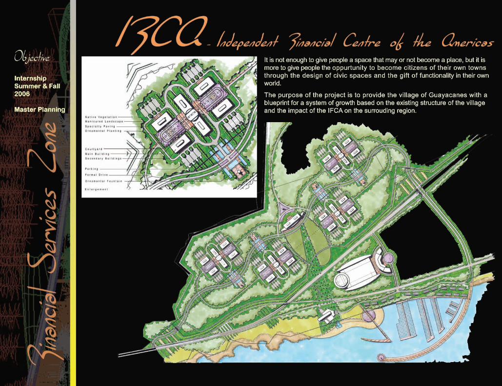
It is not enough to give people a space that may or not become a place, but it is more to give people the oppurtunity to become citizens of their own towns through the design of civic spaces and the gift of functionality in their own world.
The purpose of the project is to provide the village of Guayacanes with a blueprint for a system of growth based on the existing structure of the village and the impact of the IFCA on the surrouding region.
InternshipSummer & Fall2006
Master Planning
Firm Name : Carter & Burgess (Now Jacobs Engineering)Student: Deepa H Koshaley
autoCAD
photoshop
m-color
indesign
SITE CONCEPT DIAGRAMS
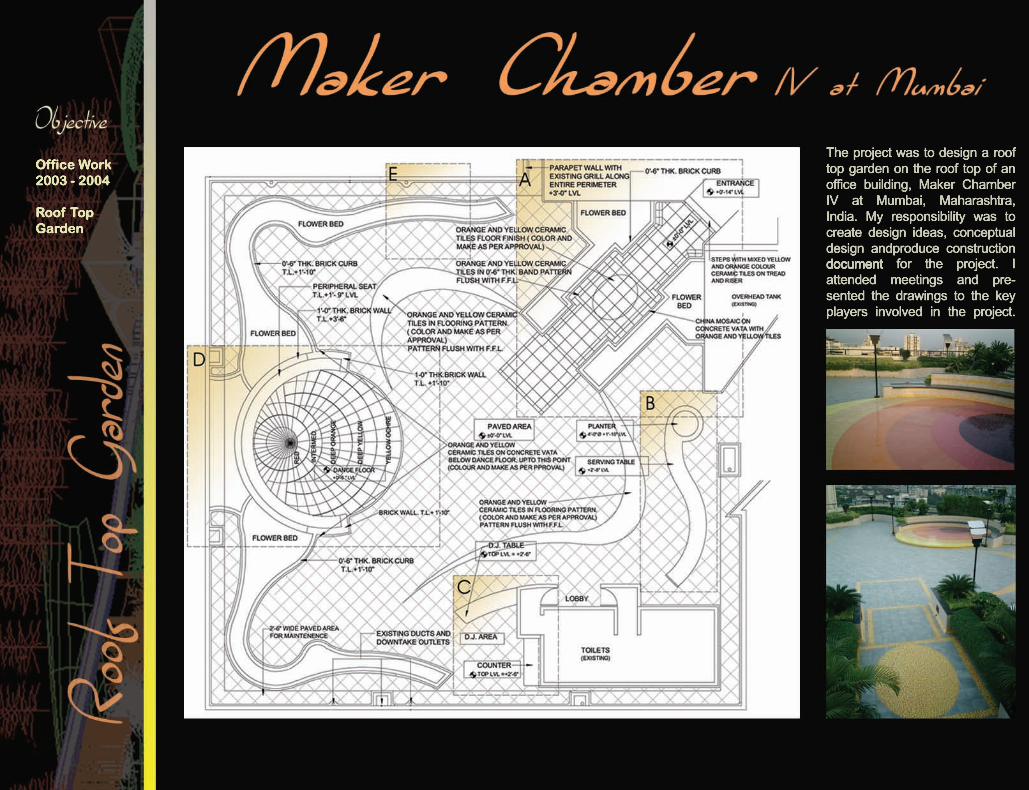
The project was to design a roof top garden on the roof top of an office building, Maker Chamber IV at Mumbai, Maharashtra, India. My responsibility was to create design ideas, conceptual design andproduce construction documentdocument for the project. I attended meetings and pre-sented the drawings to the key players involved in the project.
Office Work2003 - 2004
Roof Top Garden
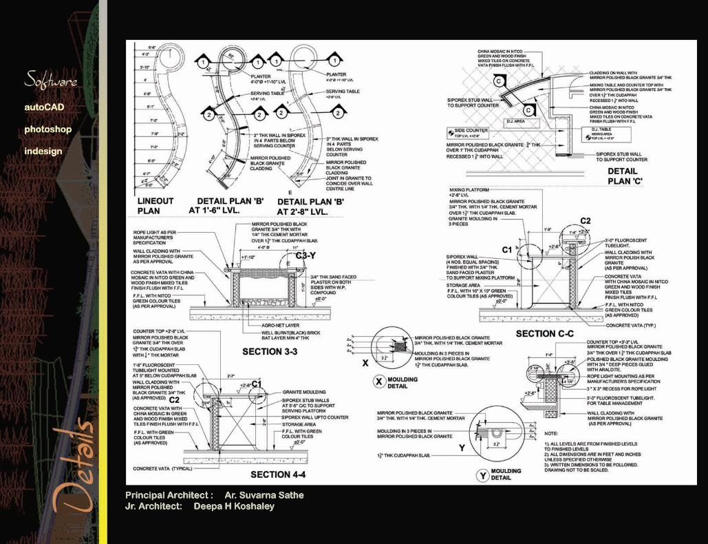
Principal Architect : Ar. Suvarna SatheJr. Architect: Deepa H Koshaley
autoCAD
photoshop
indesign

Office Work2003 - 2004
Resort Landscaping
The site located in north Mauritius was long and narrow, ideal for a beach resort with the longer side of the plot facing the ocean. With the side facing the ocean admeasuring around 1Km. (1000.00 meters), it was difficult integrating the landscape visually. Hence distinct zones were created such that each could be felt and used to its fullest.their own world. The plant material is composed to extenuate the casual look of the various spaces. A tropical garden was envisaged more so as the site fell in the southern tropics. A lot of fully grown palm trees were transplanted inin no particular geometry to create a natural look. Also Perennial coloured flowering plants were grouped at the various locations designed to break the monotony of hard surfaces, The site work went on for five months and was completed in December 2003 at a cost of Indian Rupees - 3.5 Crores. create screens or focal points etc.
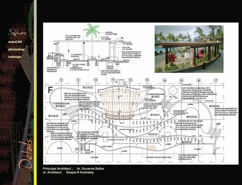
Principal Architect : Ar. Suvarna SatheJr. Architect: Deepa H Koshaley
autoCAD
photoshop
indesign
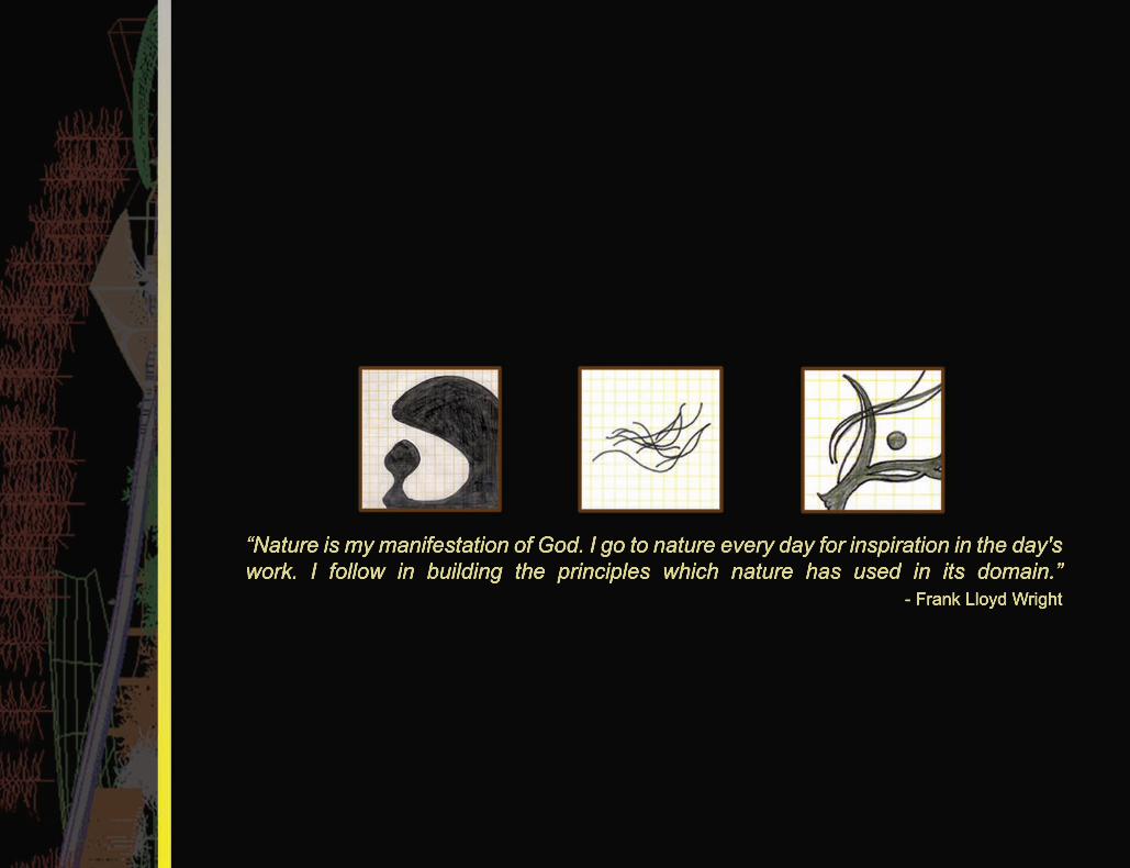
“Nature is my manifestation of God. I go to nature every day for inspiration in the day's work. I follow in building the principles which nature has used in its domain.”
- Frank Lloyd Wright