Embed Size (px)
Citation preview
Port of Grays Harbor
Recreation Lands and Facilities Plan 2016-2022
Prepared By:
Port of Grays Harbor 111 S. Wooding
Aberdeen, Washington 98520
In association with the
Grays Harbor Council of Governments 115 S. Wooding Street
Aberdeen, Washington 98520
Port of Grays Harbor Recreational Lands and Facilities Plan: 2016-2022
Port of Grays Harbor Commissioners
Chuck Caldwell
Stan Pinnick Jack Thompson
Gary Nelson, Executive Director
Recreation Lands and Facilities Committee:
Alissa Shay, Satsop Business Park Manager of Business Development Kayla Dunlap, Port of Grays Harbor Public Affairs Manager Leonard Barnes, Port of Grays Harbor Deputy Executive Director Robin Leraas, Westport Marina Manager Randy Lewis, Port of Grays Harbor Director of Environmental and Engineering Services
Port of Grays Harbor Contributing Staff
Kenneth Rausch, Westport Marina Operations Manager Marissa Yauch, Executive Assistant
Grays Harbor Council of Governments Contributing Staff:
Vicki Cummings, Executive Director Theressa Julius, Planner/GIS Coordinator Zana Dennis, Office Coordinator
i
PORT OF GRAYS HARBOR RECREATIONAL LANDS AND FACILITIES PLAN
TABLE OF CONTENTS Page Chapter 1 – INTRODUCTION
Purpose ................................................................................................................... 1 Background ............................................................................................................. 2 Plan Organization .................................................................................................... 4
Chapter 2 – GOALS AND OBJECTIVES
Access ...................................................................................................................... 5 Sense of Place ......................................................................................................... 6 Comfort and Safety ................................................................................................. 7 Fiscal Responsibility ................................................................................................ 8
Chapter 3 – EXISTING RECREATION LANDS AND FACILITIES INVENTORY
Westport Marina ..................................................................................................... 9 28th Street Landing ................................................................................................ 16 Aberdeen Landing ................................................................................................. 17 Friends Landing ..................................................................................................... 18 Sterling Landing..................................................................................................... 20 Service Area .......................................................................................................... 21 Launch Facilities and Waterfront Access .............................................................. 21
Chapter 4 – PUBLIC INVOLVEMENT Recreation Lands and Facilities Committee .......................................................... 27 Public Process ....................................................................................................... 28 Final Draft Public Notification and Solicitation for Comments ............................. 30 Plan Adoption........................................................................................................ 30
Chapter 5 – DEMAND AND NEED ANALYSIS Population Trends ................................................................................................. 31 Income Trends ...................................................................................................... 31 Statewide Recreation Trends ................................................................................ 32 Factors Influencing Recreational Boating ............................................................. 32 Survey Responses.................................................................................................. 34 Final Observations ................................................................................................ 35 Recommendations ................................................................................................ 35
Chapter 6 – CAPITAL IMPROVEMENT PROGRAM
Capital Improvement Program ............................................................................ 37 Westport Marina .................................................................................................. 38 Friends Landing .................................................................................................... 40
ii
TABLE OF CONTENTS Continued
Sterling Landing .................................................................................................... 41 28th Street Landing ............................................................................................... 41 Public Funding Opportunities ............................................................................... 42 Private Funding Opportunities .............................................................................. 43
MAPS Page Figure 1-1 Port of Grays Harbor Recreational Properties Vicinity Map ............................................... 3 3-1 Westport Marina District Map .......................................................................................... 15 3-2 Port of Grays Harbor Recreational Properties Service Area ............................................. 22 3-3 Facilities Inventory: Waterfront Access Sites ................................................................... 25 TABLES Page 3-1 Waterfront Access Facilities Inventory ............................................................................. 26 5-1 Vessel Registration Counts................................................................................................ 33 6-1 Port of Grays Harbor Recreation Lands and Facilities Capital Improvement Plan 2016 - 2022 ............................................................................. 38 APPENDICES
Appendix A: Calendar of Events ............................................................................................. A-1 Appendix B: Related Planning Efforts .................................................................................... B-1 Appendix C: User Surveys....................................................................................................... C-1 Appendix D: Request of Public Input ..................................................................................... D-1 Appendix E: Final Draft Public Review ................................................................................. E-1 Appendix F: Adoption Resolution and Public Meeting Minutes ........................................... F-1 Appendix G: RCO Self Certification Form ............................................................................... G-1
iii
RESOURCES • 28th Street Landing Recreational Lands and Facilities Plan: 2009-2014, Port of Grays
Harbor, 2009. • 2013 Economic Impact of the Port of Grays Harbor, Martin Associates, October 2014. • 2013 Special Report on Fishing and Boating, Recreational Boating & Fishing Foundation
and the Outdoor Foundation, 2013. • 2015 Special Report on Fishing and Boating, Recreational Boating & Fishing Foundation
and the Outdoor Foundation, 2015. • Boat Launches of Grays Harbor. www.ghonline.com/boatlaunches • City of Aberdeen 2011 – 2016 Comprehensive Parks & Recreation Plan, City of
Aberdeen, January 2011. • City of Hoquiam Park and Recreation Comprehensive Plan 2005 – 2007, City of
Hoquiam 2005. • City of Westport Comprehensive Park & Recreation Plan 2006 – 2011, City of Westport
2006. • City of Westport, Port of Grays Harbor Marina District Parking Study, MAKERS, March
2007. • Grays Harbor Estuary Management Plan, Grays Harbor Regional Planning Commission,
1986. • Harpers Playground, www.harpersplayground.org. • Outdoor Recreation in Washington, The 2013 State Comprehensive Outdoor Recreation
Plan, Washington State Recreation and Conservation Office, May 2013. • Port of Camas/Washougal Comprehensive Plan of Harbor Improvements and Industrial
Development: Recreational Lands & Facilities Element, Port of Camas/Washougal, 2004. • Port of Everett Waterfront Place Implementation Strategy Marina Demand Assessment,
Reid Middleton, BST Assoc. September 2014. • Port of Grays Harbor web page. http://www.portofgraysharbor.com/ • Port Industrial Area Master Plan Update, HDR Inc., 2005. • Port of Grays Harbor Industrial Properties Master Plan, Reid Middleton, 1996. • U.S. Census Bureau, American Community Survey • Vessel Registrations 2015, Washington State Department of Licensing. • Washington Boater Needs Assessment, Responsive Management, 2007. • Westport Marina use Statistics, Port of Grays Harbor Westport Marina Office. • Westport Marina Boat Basin Master Plan, Reid Middleton, December 2009.
1
CHAPTER 1
INTRODUCTION
Purpose The purpose of the Port of Grays Harbor Recreation Plan is to establish a framework to guide the operation, development and improvement of public recreation lands and facilities under the ownership of the Port of Grays Harbor. This is the Port’s first comprehensive plan for its recreational facilities; it is consistent with the Washington State Recreation and Conservation Office (RCO) Comprehensive Plan Guidelines. This plan also provides the basis of eligibility for federal and state financial assistance. All elements necessary to qualify for recreation funding are included in this plan:
• Goals and objectives • Inventory • Public involvement • Demand and need analysis • Capital Improvement Program • Local adoption
Washington State statutes enable ports to operate certain recreational facilities. RCW 53.08.260 enables port districts to construct, improve, maintain and operate public park and recreation facilities when such facilities are necessary to fully utilize boat landings, harbors, wharves and piers; air, land and water passenger and transfer terminals and waterways, and other port facilities authorized by law pursuant to a port’s comprehensive scheme of harbor improvements and industrial development. Through the provision of increased public access the Port of Grays Harbor is upholding the Public Trust Doctrine. The essence of the Doctrine is that the waters of the state are a public resource available to all citizens for navigation, commerce, fishing, recreation and similar uses and that this trust is not invalidated by private ownership of the underlying land. The Doctrine limits public and private use of tidelands and other shore lands to protect the public's right to
Port of Grays Harbor Mission
To best utilize our resources to facilitate, enhance and stimulate international trade, economic development and tourism
for the betterment of the region.
2
use the waters of the state.1 While the Doctrine does not allow public trespass on privately owned lands, it does protect public use of navigable water bodies below the ordinary high water mark. The Shoreline Management Act is one of the primary means by which the Public Trust Doctrine is enabled. All Shoreline Master Programs must include a public access element to make provisions for public access to publicly owned areas, and a recreational element for the preservation and enlargement of recreational opportunities. While Port district boundaries cover the entire county, only recreation lands and facilities owned and operated by the Port of Grays Harbor will be discussed in this plan. Please refer to Figure 1-1, Port of Grays Harbor Recreational Properties Vicinity Map. The cities within Grays Harbor County maintain their own individual Comprehensive Park and Recreation plans. For the context of this plan it is important to note that Grays Harbor County does not plan under the Growth Management Act. Background The Port of Grays Harbor, a Special Purpose Municipal Government, was incorporated in 1911 to serve the citizens of Grays Harbor County. Located on the Pacific Coast of Washington State, Port boundaries include all of Grays Harbor County in entirety. An elected, three-member Board of Commissioners governs the Port. The Board appoints an Executive Director and a Director of Finance and Administration to oversee daily operations and employees. The Port fosters job and recreational opportunities to the area. It operates four deep-water Marine Terminals for receiving and shipping international cargoes, a regional airport for general aviation, a marina for recreational, charter, and commercial boating, three public boat launches, two viewing towers, 1,600 acres of industrial properties including the Satsop Business Park, along with its surrounding 1,300 acres of managed forest land. A recent study identified the Port of Grays Harbor as one of the fastest growing export ports on the West Coast. The Port has experienced a surge in cargo volumes while at the same time commercial and recreational fishing at the port-owned Westport Marina have also been growing. Activities of the Port of Grays Harbor’s marine terminals, marina, airport and industrial properties generated over 5,700 jobs and $564 million in business revenues according to a study conducted by Martin Associates based on 2013 data. Over $32.1 million in state and local taxes resulted from these activities in 2013.2 1 Caminiti v. Boyle, 107 Wn. 2d 662, 732 P.2d 989 2 The 2013 Economic Impact of the Port of Grays Harbor, Martin Associates, October 2014
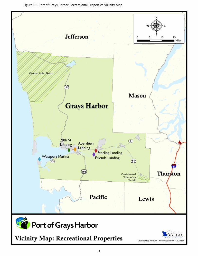
)
XX
X
X
XWestport Marina Friends Landing
Sterling Landing
28th StLanding Aberdeen
Landing
£¤101
£¤101
£¤12UV105
UV8
§̈¦5
Lewis
Jefferson
Pacific
Grays HarborGrays HarborMason
Thurston
Quinault Indian Nation
Confederated Tribes of the
Chehalis
VicinityMap PortGH_Recreation.mxd 12/2015tjVicinity Map: Recreational Properties
:0 5 10 15
Miles
Figure 1-1 Port of Grays Harbor Recreational Properties Vicinity Map
3
4
In October of 2014 the Port added Friend’s Landing and Sterling Landing recreational facilities to their portfolio. The 501(c)(3) that owned and operated the facilities requested the Port take ownership of the properties to ensure long term governance, maintenance, and public access. Friend’s Landing offers 152 acres of ADA accessible recreation opportunities on the Chehalis River including hiking, fishing, camping and bird watching, a 32 acre man-made lake, 1.7 miles of paved trail, a handicap accessible boat launch, and RV and tent camping facilities with full hook-up sites. Sterling Landing is an undeveloped 30-acre site with two lakes, gravel trails, and a gravel take-out on the Wynoochee River. This planning effort is being undertaken to ensure the long-term public enjoyment of these sites along with the Port’s other recreation lands and facilities. Plan Organization The Port of Grays Harbor Recreation Lands and Facilities Plan is organized as follows:
Chapter 1, Introduction – Provides an introduction of the plan including the purpose, background information, and organization of chapters. Chapter 2, Goals and Objectives – Presents a vision and strategy for the Port’s recreation properties. Sites, facilities, maintenance, and capital plans are addressed by the goals and objectives set forth in this plan.
Chapter 3, Inventory – Lists service area, location, type, and condition of Port recreation lands and facilities, along with individual amenities.
Chapter 4, Public Involvement – Describes the important public outreach process in developing this plan.
Chapter 5, Demand and Need Analysis – Reviews and identifies the State, regional and local trends and other pertinent information to provide guidance in developing priorities and channeling investment in Port recreation lands and facilities.
Chapter 6, Capital Improvement Plan – Lists recreation facilities capital assets, future needs for improvements and/or maintenance, costs, and likely fund sources over a 6 year period.
Chapter 7, Adoption and Update – Describes how the Port reviewed and approved the recreation facilities plan, and how it can be updated as the years proceed.
5
CHAPTER 2 GOALS AND OBJECTIVES
The following goals are broad statements of intent with respect to the recreation lands and facilities of the Port of Grays Harbor. They describe the Port’s desired outcomes and lay the framework for good planning, maintenance and development.
Objectives associated with each goal are measurable and specific and provide a benchmark for obtaining the goal. Importantly, they reflect the interests of those who use the sites as set forth in the chapters on demand and need and public participation.
The following goals and objectives were developed through recommendations of the Port of Grays Harbor Recreation Lands and Facilities Committee, Port of Grays Harbor officials and staff, and members of the Grays Harbor community.
Information identified in the collection of goals and objectives will create guidelines that can help direct future site use and infrastructure decisions. Goals and objectives defined herein are sound, realistic and can be supported by reasonably available resources.
ACCESS To the extent possible ensure that Port of Grays Harbor recreation sites, facilities and their shoreline environments are accessible to all members of the community, where practical and safe, by maintaining and expanding opportunities for recreational fishing and pedestrian shoreline access: Goal 1 – Maintain, improve, and expand (where appropriate) boat ramp access points for
recreational boaters.
Objective 1a – Investigate the feasibility of installing a new loading float on the Chehalis River at Friends Landing to increase launch capacity.
Objective 1b – Explore opportunities to permit and upgrade the existing informal boat launch ramp on the Wynoochee River at Sterling Landing and create both river and lake canoe and kayak launch access.
Goal 2 – Maintain and expand trails and pedestrian points of access to shoreline areas.
Objective 2a – Improve existing trails at Sterling Landing and Friends Landing to ensure
accessibility to waterfront areas. Clean and de-brush trails at both locations.
6
Objective 2b – Complete a master planning process for Sterling Landing to identify the appropriate use or uses and improvements to ensure access to land and water pathways is accommodated where practical.
Goal 3 - Continue to incorporate Americans with Disabilities Act (ADA) requirements in the
development and/or re-development of recreation properties.
Objective 3a – Perform a full ADA site assessment study at Friends Landing to ensure ADA accessibility requirements have been met and to retain the unique ADA compliant status.
Objective 3b – Improve the walkability of the wooden trail system at Friends Landing by creating a non-skid surface on the wood face that is consistent with the trail surface.
Objective 3c – Perform an engineering analysis of bank line at the base of the pedestrian bridge at Friends Landing to ensure long term stability of the bank line and the bridge.
Objective 3d – Better identify ADA access points to moorage and fishing floats at the Westport Marina.
Objective 3e – Provide barrier-free picnic tables and play apparatus at the Westport Marina viewing tower, and Friends Landing.
Objective 3f – If a new boarding float is constructed at Friends Landing include features to make it fully accessible.
SENSE OF PLACE Enrich the unique natural, waterfront, and shoreline areas of Grays Harbor; draw residents and visitors into the experience: Goal 1 – Ensure recreation facilities are identifiable and easy to locate by implementing a
system of easily visible signage for all Port recreation sites. Objective 1a – Develop signage at the Westport Marina to identify day parking, overnight
parking and trailer parking locations. Objective 1b – Develop easily identifiable directional signage (main road and park entrance)
at Friends Landing and Sterling Landing. Include boat launch signage. Objective 1c – Develop kiosks with directional, safety and amenities information at
Westport Marina and Friend’s Landing. Include trail distances in Friends Landing kiosk.
7
Goal 2 – Ensure that the natural aspects of recreation facilities are self-sustaining to the greatest extent possible and not overbuilt.
Objective 2a – Seek to develop sites such as Sterling Landing in a manner that compliments
the natural attributes of the area. Objective 2b – Develop and maintain water and pedestrian access in a manner that is
context sensitive to each individual site. Objective 2c – Use approved methods to control the growth and spread of knotweed and
other invasive species that could potentially harm existing natural areas. Goal 3 – Support, advocate and facilitate the development of paddle trails.
Objective 3a – Work with community partners to identify a paddle trail system on interconnecting waterways.
Objective 3b – Develop a ‘route map’ of launch sites, take outs, possible trails segments and their length for locations adjoining Port recreation sites. Incorporate this information onto recreation site kiosks as appropriate.
COMFORT AND SAFETY Maintain recreation properties and facilities in a manner that ensures the highest level of user comfort and provides the safest possible environment for users: Goal 1 – Maintain recreation sites and facilities in a manner that creates a safe, attractive and
positive experience, incorporating user amenities as site appropriate.
Objective 1a – Invest in improvements at the Westport Marina to improve the experience of day users, recreational fishers and moorage clients. Improvements should include the rehabilitation of existing showers and restrooms, the development of new additional facilities, laundry facilities, fish cleaning station and a wash down facility.
Objective 1b - Invest in improvements at Friends Landing to include additional covered picnic tables and bbq stations to accommodate increased usage.
Objective 1c - Invest in improvements at Sterling Landing consistent with the master plan once approved.
Goal 2 - Remove and replace outdated equipment and facilities to maintain functionality.
Objective 2a – Improve general maintenance along promenade, hand railings, docks & fencing at the Westport Marina.
Objective 2b – Replace playground equipment beyond its useful life span at Friends Landing and upgrade to ADA compatibility standards.
8
Goal 3 - Ensure facilities, parking lots and pathways are well maintained and free of debris and obstacles.
Objective 3a – Work with the City of Westport to identify opportunities for additional
parking throughout Westport Marina, pave boat launch parking facilities and improve parking for boat trailers.
Objective 3b - Clean up port owned areas, vacant properties and water surrounding the Westport Marina. Research and implement improvements in facilities and practices to prevent trash from accumulating in and around the waters of the marina.
Objective 3c – Establish an access agreement with the Washington Department of Fish & Wildlife for use of the entry road at Sterling Landing
Objective 3d – Re-grade parking lot and entry road at Friends Landing and Sterling Landing. Objective 3e – Develop and maintain easily accessible, well-lit restroom facilities at the
Westport Marina and add new restrooms and/or sani-cans that meet ADA accessibility standards. Add additional restrooms at Friends Landing near the boat ramp parking lot and install restroom facilities at Sterling Landing.
Objective 3f – Improve or install lighting at high-use recreation areas, in parking lot and restrooms such as the Westport Marina and Friends Landing.
FISCAL RESPONSIBILITY Maintain recreation sites and facilities in a manner that is responsive to the site and balances the needs of its users while maintaining fiscal responsibility: Goal 1 - Utilize financial resources efficiently and equitably. Develop, approve, implement
and monitor annual recreation sites and facilities budget with focus on balancing needs and investments.
Objective 1a – Continually seek operational efficiencies to ensure that recreation sites and
facilities are provided in a cost effective manner. Objective 1b – Actively seek out alternative funding sources for the development and
maintenance of recreation sites and facilities.
9
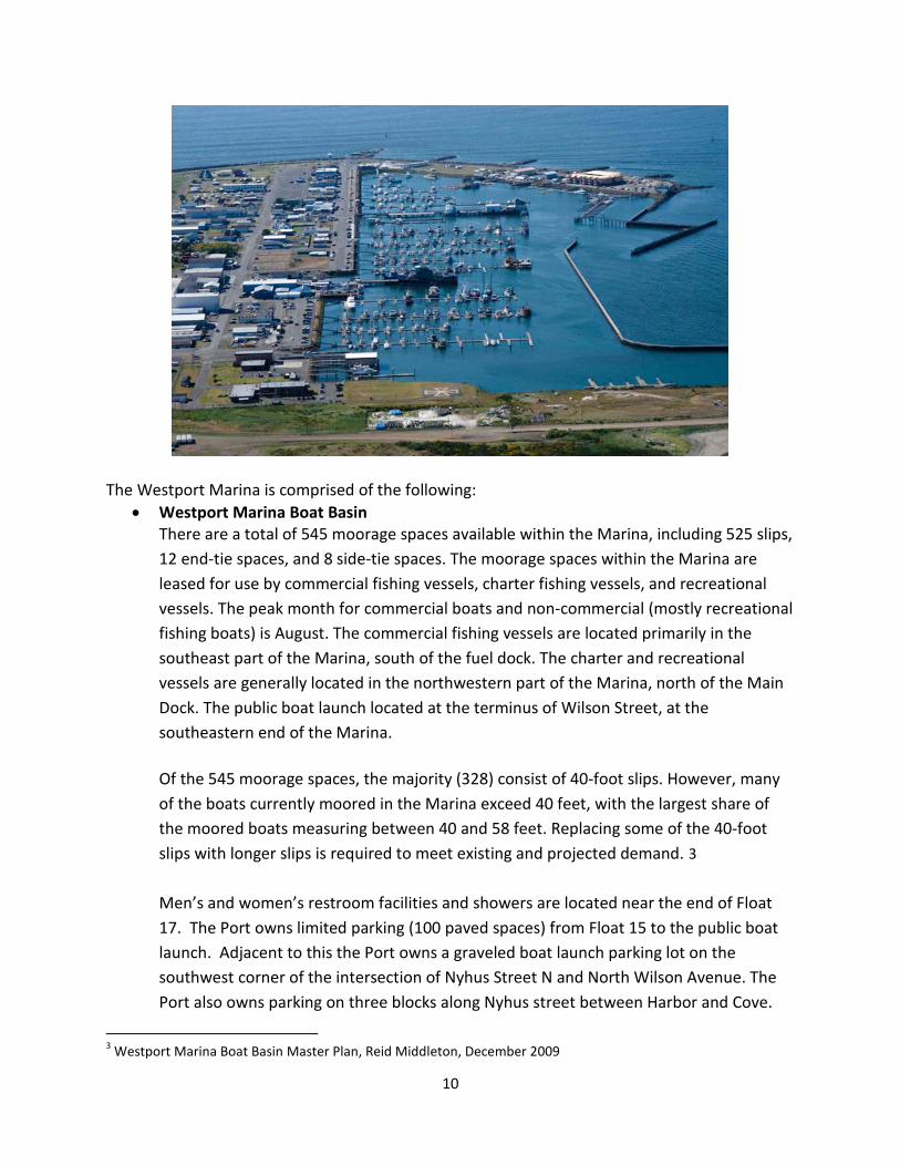
CHAPTER 3 EXISTING RECREATION LANDS AND FACILITIES INVENTORY
Existing recreation facility inventory provides the basis upon which the Recreation Lands and Facilities Plan for the Port will be built. This inventory of sites and facilities assesses their location, amenities, condition and service area. The inventory also facilitates comparison with recreation facility goals and strategies enabling judgments to be made on the adequacy of the present Inventory. Existing Inventory As part of their commitment to utilize resources to enhance the betterment of the region, the Port of Grays Harbor owns and operates several sites and facilities which provide recreational opportunities. Port leadership has a strong commitment to the provision of waterfront access and recreational opportunities among its properties. Westport Marina Located in the City of Westport, the Westport Marina is owned and operated by the Port of Grays Harbor. The Westport Marina basin is bounded by the Point Chehalis peninsula to the west and south, a rock revetment and system of groins to the north, and several timber pile breakwaters to the east. A riprap bulkhead separates the upland from the water along most of Westhaven Drive. The Marina houses commercial, charter and sport fishing vessels and provides a public boat launch. The Marina itself consists of floating docks and several fixed piers, including the Main Dock and the Fuel Dock. The docks are provided with electrical and water services. All docks are open and accessible 24 hours a day. The Westport Marina is the premier coastal marina in the Pacific Northwest and home to Washington State's largest charter fishing fleet. It is the largest commercial fish landing port in Washington State in terms of fish landed and product value. It is 13th in the nation in volume of fish landed. Salmon, Tuna, Pacific Whiting and Halibut, shrimp and crab are industry staples. Salmon season is announced the second week of April each year. Tuna season starts in early July and runs into mid-October. Halibut season begins the first Sunday in May. Rock Fish/Ling Cod season runs mid-March through late October.
“Future properties for industrial development will consider
complimentary public access development. This may occur off-
site or in the enhancement of existing sites”.
Executive Director Gary Nelson
10
The Westport Marina is comprised of the following: • Westport Marina Boat Basin
There are a total of 545 moorage spaces available within the Marina, including 525 slips, 12 end-tie spaces, and 8 side-tie spaces. The moorage spaces within the Marina are leased for use by commercial fishing vessels, charter fishing vessels, and recreational vessels. The peak month for commercial boats and non-commercial (mostly recreational fishing boats) is August. The commercial fishing vessels are located primarily in the southeast part of the Marina, south of the fuel dock. The charter and recreational vessels are generally located in the northwestern part of the Marina, north of the Main Dock. The public boat launch located at the terminus of Wilson Street, at the southeastern end of the Marina. Of the 545 moorage spaces, the majority (328) consist of 40-foot slips. However, many of the boats currently moored in the Marina exceed 40 feet, with the largest share of the moored boats measuring between 40 and 58 feet. Replacing some of the 40-foot slips with longer slips is required to meet existing and projected demand. 3 Men’s and women’s restroom facilities and showers are located near the end of Float 17. The Port owns limited parking (100 paved spaces) from Float 15 to the public boat launch. Adjacent to this the Port owns a graveled boat launch parking lot on the southwest corner of the intersection of Nyhus Street N and North Wilson Avenue. The Port also owns parking on three blocks along Nyhus street between Harbor and Cove.
3 Westport Marina Boat Basin Master Plan, Reid Middleton, December 2009
11
These lots are operated by the City of Westport. Unhitched trailer parking is available in a gravel lot on the northeast corner of Bay and Harms streets. Activities in the boat basin include sight-seeing, fishing, and crabbing along the jetty and docks. Please refer to Figure 3-1 Westport Marina District Map.
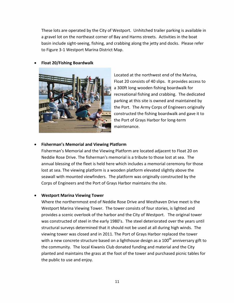
• Float 20/Fishing Boardwalk Located at the northwest end of the Marina, Float 20 consists of 40 slips. It provides access to a 300ft long wooden fishing boardwalk for recreational fishing and crabbing. The dedicated parking at this site is owned and maintained by the Port. The Army Corps of Engineers originally constructed the fishing boardwalk and gave it to the Port of Grays Harbor for long-term maintenance.
• Fisherman’s Memorial and Viewing Platform
Fisherman’s Memorial and the Viewing Platform are located adjacent to Float 20 on Neddie Rose Drive. The fisherman's memorial is a tribute to those lost at sea. The annual blessing of the fleet is held here which includes a memorial ceremony for those lost at sea. The viewing platform is a wooden platform elevated slightly above the seawall with mounted viewfinders. The platform was originally constructed by the Corps of Engineers and the Port of Grays Harbor maintains the site.
• Westport Marina Viewing Tower
Where the northernmost end of Neddie Rose Drive and Westhaven Drive meet is the Westport Marina Viewing Tower. The tower consists of four stories, is lighted and provides a scenic overlook of the harbor and the City of Westport. The original tower was constructed of steel in the early 1980’s. The steel deteriorated over the years until structural surveys determined that it should not be used at all during high winds. The viewing tower was closed and in 2011. The Port of Grays Harbor replaced the tower with a new concrete structure based on a lighthouse design as a 100th anniversary gift to the community. The local Kiwanis Club donated funding and material and the City planted and maintains the grass at the foot of the tower and purchased picnic tables for the public to use and enjoy.
12
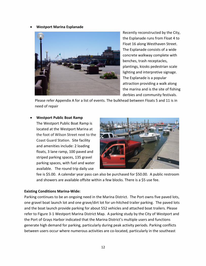
• Westport Marina Esplanade Recently reconstructed by the City, the Esplanade runs from Float 4 to Float 16 along Westhaven Street. The Esplanade consists of a wide concrete walkway complete with benches, trash receptacles, plantings, kiosks pedestrian scale lighting and interpretive signage. The Esplanade is a popular attraction providing a walk along the marina and is the site of fishing derbies and community festivals.
Please refer Appendix A for a list of events. The bulkhead between Floats 5 and 11 is in need of repair
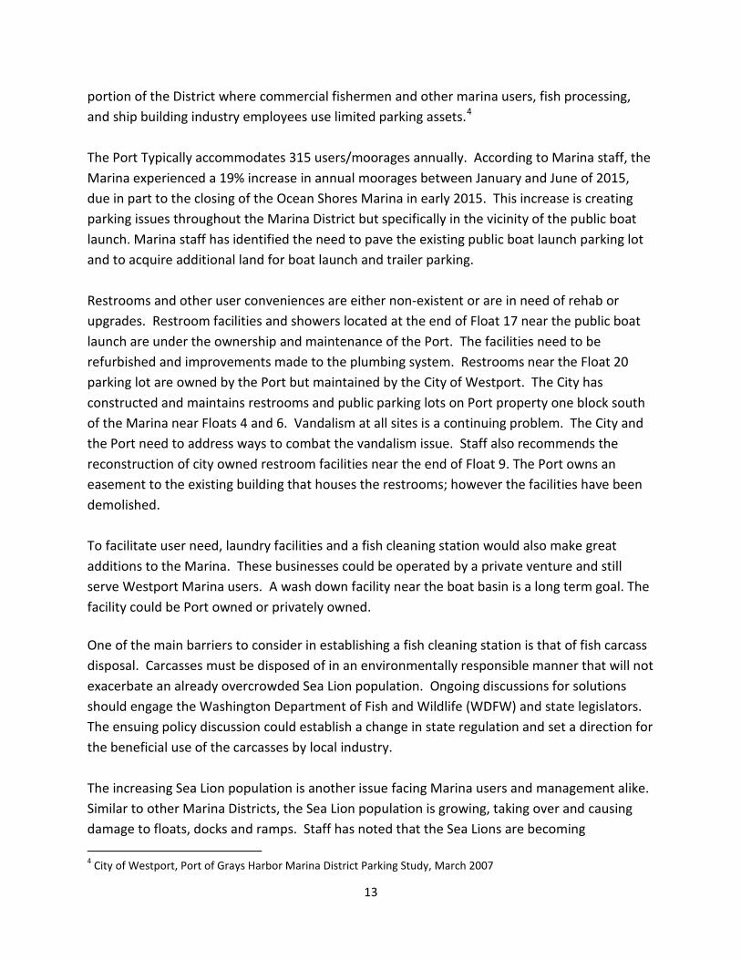
• Westport Public Boat Ramp The Westport Public Boat Ramp is located at the Westport Marina at the foot of Wilson Street next to the Coast Guard Station. Site facility and amenities include: 2 loading floats, 3 lane ramp, 100 paved and striped parking spaces, 135 gravel parking spaces, with fuel and water available. The round trip daily use fee is $5.00. A calendar year pass can also be purchased for $50.00. A public restroom and showers are available offsite within a few blocks. There is a $5 use fee.
Existing Conditions Marina-Wide: Parking continues to be an ongoing need in the Marina District. The Port owns five paved lots, one gravel boat launch lot and one grave/dirt lot for un-hitched trailer parking. The paved lots and the boat launch provide parking for about 552 vehicles and attached boat trailers. Please refer to Figure 3-1 Westport Marina District Map. A parking study by the City of Westport and the Port of Grays Harbor indicated that the Marina District’s multiple users and functions generate high demand for parking, particularly during peak activity periods. Parking conflicts between users occur where numerous activities are co-located, particularly in the southeast
13
portion of the District where commercial fishermen and other marina users, fish processing, and ship building industry employees use limited parking assets.4 The Port Typically accommodates 315 users/moorages annually. According to Marina staff, the Marina experienced a 19% increase in annual moorages between January and June of 2015, due in part to the closing of the Ocean Shores Marina in early 2015. This increase is creating parking issues throughout the Marina District but specifically in the vicinity of the public boat launch. Marina staff has identified the need to pave the existing public boat launch parking lot and to acquire additional land for boat launch and trailer parking. Restrooms and other user conveniences are either non-existent or are in need of rehab or upgrades. Restroom facilities and showers located at the end of Float 17 near the public boat launch are under the ownership and maintenance of the Port. The facilities need to be refurbished and improvements made to the plumbing system. Restrooms near the Float 20 parking lot are owned by the Port but maintained by the City of Westport. The City has constructed and maintains restrooms and public parking lots on Port property one block south of the Marina near Floats 4 and 6. Vandalism at all sites is a continuing problem. The City and the Port need to address ways to combat the vandalism issue. Staff also recommends the reconstruction of city owned restroom facilities near the end of Float 9. The Port owns an easement to the existing building that houses the restrooms; however the facilities have been demolished. To facilitate user need, laundry facilities and a fish cleaning station would also make great additions to the Marina. These businesses could be operated by a private venture and still serve Westport Marina users. A wash down facility near the boat basin is a long term goal. The facility could be Port owned or privately owned. One of the main barriers to consider in establishing a fish cleaning station is that of fish carcass disposal. Carcasses must be disposed of in an environmentally responsible manner that will not exacerbate an already overcrowded Sea Lion population. Ongoing discussions for solutions should engage the Washington Department of Fish and Wildlife (WDFW) and state legislators. The ensuing policy discussion could establish a change in state regulation and set a direction for the beneficial use of the carcasses by local industry. The increasing Sea Lion population is another issue facing Marina users and management alike. Similar to other Marina Districts, the Sea Lion population is growing, taking over and causing damage to floats, docks and ramps. Staff has noted that the Sea Lions are becoming 4 City of Westport, Port of Grays Harbor Marina District Parking Study, March 2007

14
increasingly aggressive and they are concerned for the safety of Marina users. Marina management would like to explore options to manage the population in order to remove human/Sea Lion conflict.
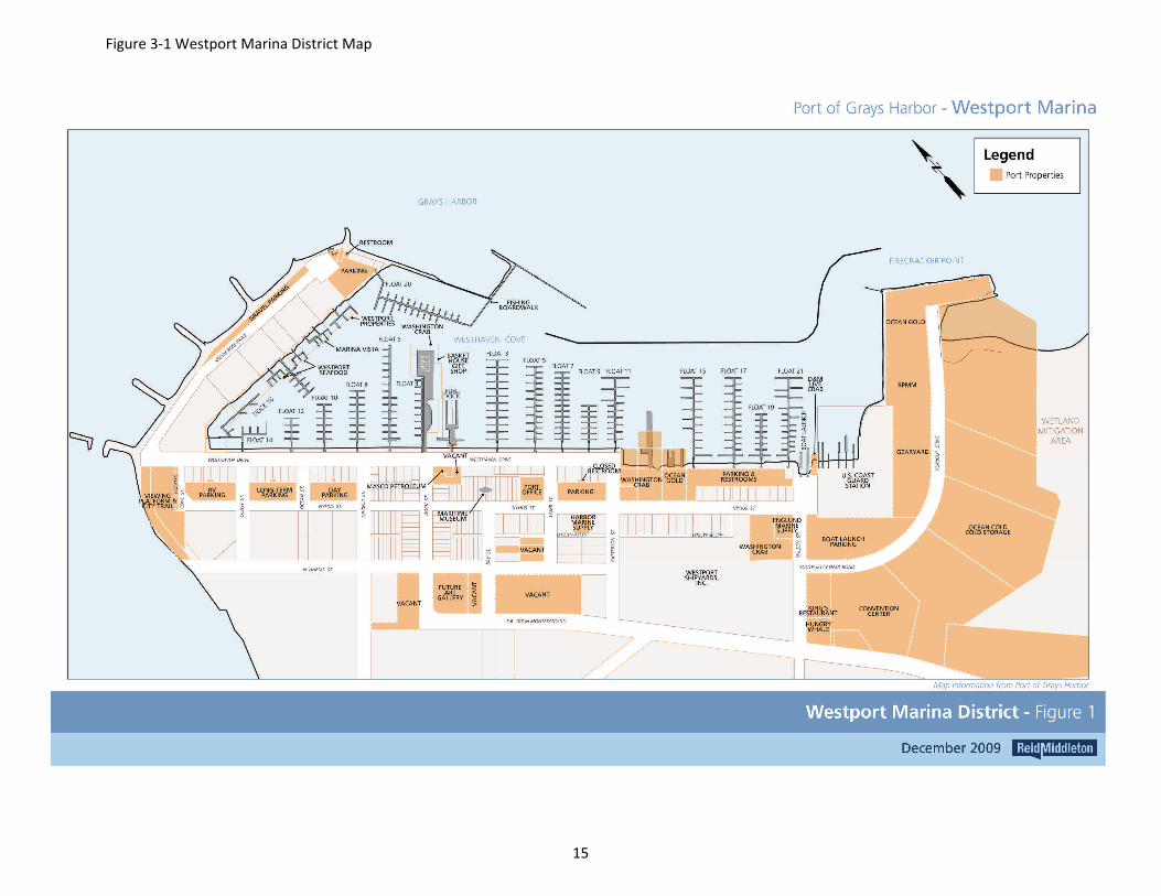
Figure 3-1 Westport Marina District Map
15
16
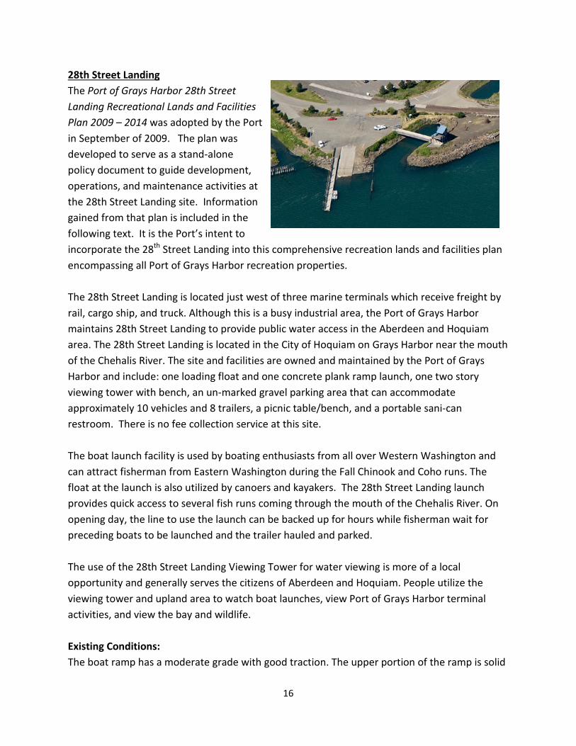
28th Street Landing The Port of Grays Harbor 28th Street Landing Recreational Lands and Facilities Plan 2009 – 2014 was adopted by the Port in September of 2009. The plan was developed to serve as a stand-alone policy document to guide development, operations, and maintenance activities at the 28th Street Landing site. Information gained from that plan is included in the following text. It is the Port’s intent to incorporate the 28th Street Landing into this comprehensive recreation lands and facilities plan encompassing all Port of Grays Harbor recreation properties. The 28th Street Landing is located just west of three marine terminals which receive freight by rail, cargo ship, and truck. Although this is a busy industrial area, the Port of Grays Harbor maintains 28th Street Landing to provide public water access in the Aberdeen and Hoquiam area. The 28th Street Landing is located in the City of Hoquiam on Grays Harbor near the mouth of the Chehalis River. The site and facilities are owned and maintained by the Port of Grays Harbor and include: one loading float and one concrete plank ramp launch, one two story viewing tower with bench, an un-marked gravel parking area that can accommodate approximately 10 vehicles and 8 trailers, a picnic table/bench, and a portable sani-can restroom. There is no fee collection service at this site. The boat launch facility is used by boating enthusiasts from all over Western Washington and can attract fisherman from Eastern Washington during the Fall Chinook and Coho runs. The float at the launch is also utilized by canoers and kayakers. The 28th Street Landing launch provides quick access to several fish runs coming through the mouth of the Chehalis River. On opening day, the line to use the launch can be backed up for hours while fisherman wait for preceding boats to be launched and the trailer hauled and parked. The use of the 28th Street Landing Viewing Tower for water viewing is more of a local opportunity and generally serves the citizens of Aberdeen and Hoquiam. People utilize the viewing tower and upland area to watch boat launches, view Port of Grays Harbor terminal activities, and view the bay and wildlife. Existing Conditions: The boat ramp has a moderate grade with good traction. The upper portion of the ramp is solid
17
V-groove concrete and the lower portion is made of concrete planks. The boat ramp is prone to accumulate debris from the harbor. The float can accommodate up to ten boats to tie in at the highest tide and none at extreme low tides. The second side of the float has a handrail for ADA access, preventing the use of the side for boat tie in. There is no overnight moorage. The parking area is gravel, riddled with pot holes, and does not have lighting. Additional vehicle and trailer parking is available on 28th Street. Due to the popularity of this site during fishing season, accommodations for additional parking are recommended. The Port may wish to consider the purchase of additional nearby land for parking overflow if suitable parking can be identified and becomes available. The observation tower and picnic are adjacent to the boat ramp. The observation tower is in need of general maintenance and painting. The previous planning process identified the following facility improvements needed at the 28th Street Landing:
• Debris barrier replacement • Launch float replacement and expansion • Launch pad replacement and expansion • Parking improvements and expansion • Permanent restroom • Signage
Phase I improvements were completed in August of 2015 at 28th Street boat launch and landing. Phase I improvements included removal and replacement of precast floats and guide piles, reconstruction of a portion of the boat launch ramp, removal and replacement of the debris deflector in the water, and removal and installation of stone revetments along the shore in the boat launch area. The Port applied for and received $811,942 in RCO Boating Facilities Program funds (2013 – 2015 biennium) and contributed $275,000 in cash and donations. The funds will allow the Port to complete Phase II of the project which will replace and widen the boat ramp, add an additional boarding float, pave and stripe the main parking area, add a permanent ADA accessible restroom facility, and lighting in the parking area. Phase II improvements are expected to get underway in Spring 2016. Aberdeen Landing Located along the Chehalis River in the City of Aberdeen, WA. This site consists of a previously developed primitive boat launch and a fenced dock on pilings with a sprinkler system and room for tie ups. There are six parking spaces dedicated for this site for Port use. The site is situated behind the East Aberdeen Waterfront Walkway trail system that runs behind Wal-Mart. The
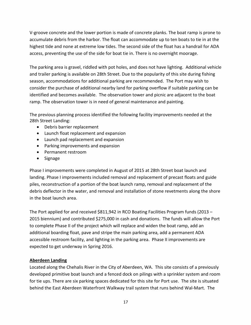
18
boat launch is not accessible for use as it is blocked by curbing, street lights, and landscaping. Access to the site is via a shoreline trail easement granted to the City of Aberdeen by the Port of Grays Harbor. The purpose of the easement is to allow access to the East Aberdeen Waterfront Walkway. An identical easement was given to the City of Aberdeen by Wal-Mart to allow for public access.
Although the logistics of this site are complicated, the Port may consider appropriate development in near future. Future plans for the site would require the negotiating of additional easements and parking space from Wal-Mart. Aberdeen Landing could potentially accommodate light mixed use recreation such as seasonal attractions, vendors, and appropriate amenities. The City of Aberdeen has approached the Port with a well-developed design concept to use
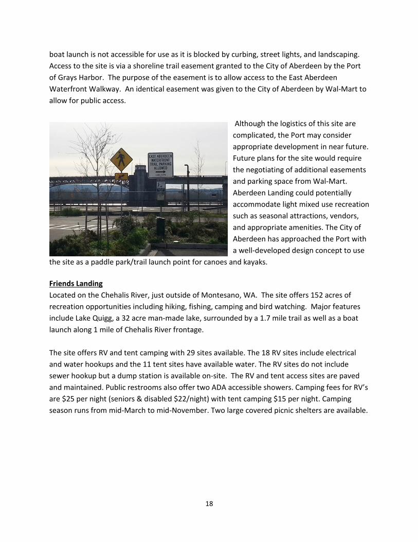
the site as a paddle park/trail launch point for canoes and kayaks. Friends Landing Located on the Chehalis River, just outside of Montesano, WA. The site offers 152 acres of recreation opportunities including hiking, fishing, camping and bird watching. Major features include Lake Quigg, a 32 acre man-made lake, surrounded by a 1.7 mile trail as well as a boat launch along 1 mile of Chehalis River frontage. The site offers RV and tent camping with 29 sites available. The 18 RV sites include electrical and water hookups and the 11 tent sites have available water. The RV sites do not include sewer hookup but a dump station is available on-site. The RV and tent access sites are paved and maintained. Public restrooms also offer two ADA accessible showers. Camping fees for RV’s are $25 per night (seniors & disabled $22/night) with tent camping $15 per night. Camping season runs from mid-March to mid-November. Two large covered picnic shelters are available.
19
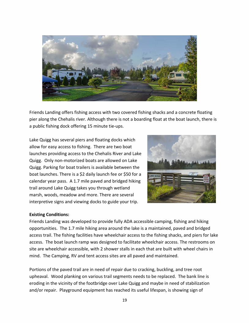
Friends Landing offers fishing access with two covered fishing shacks and a concrete floating pier along the Chehalis river. Although there is not a boarding float at the boat launch, there is a public fishing dock offering 15 minute tie-ups. Lake Quigg has several piers and floating docks which allow for easy access to fishing. There are two boat launches providing access to the Chehalis River and Lake Quigg. Only non-motorized boats are allowed on Lake Quigg. Parking for boat trailers is available between the boat launches. There is a $2 daily launch fee or $50 for a calendar year pass. A 1.7 mile paved and bridged hiking trail around Lake Quigg takes you through wetland marsh, woods, meadow and more. There are several interpretive signs and viewing docks to guide your trip. Existing Conditions: Friends Landing was developed to provide fully ADA accessible camping, fishing and hiking opportunities. The 1.7 mile hiking area around the lake is a maintained, paved and bridged access trail. The fishing facilities have wheelchair access to the fishing shacks, and piers for lake access. The boat launch ramp was designed to facilitate wheelchair access. The restrooms on site are wheelchair accessible, with 2 shower stalls in each that are built with wheel chairs in mind. The Camping, RV and tent access sites are all paved and maintained. Portions of the paved trail are in need of repair due to cracking, buckling, and tree root upheaval. Wood planking on various trail segments needs to be replaced. The bank line is eroding in the vicinity of the footbridge over Lake Quigg and maybe in need of stabilization and/or repair. Playground equipment has reached its useful lifespan, is showing sign of
20
extreme wear and should be replaced. The gravel parking lot and road into the site need to be re-graded. The Port should also keep an eye on the development of any knot weed patches. The Port is in the process of replacing the on-site care taker residence.
The Port of Grays Harbor should engage in a full assessment of the ADA accessibility of the Friends Landing site. This will provide a roadmap of needed improvements, recommended enhancements and associated costs. The Port acquired Friend’s Landing In October of 2014 after the 501(c)(3) that owned and operated the facilities requested the Port take ownership. The Port has no historic data on the site such as user-ship records, financial history, and fee structures. Those items are valuable as information gained from examining past usage can be helpful in determining current and future needs. Since the Port formally took ownership they have begun managing data and records for the site. Shortly after acquisition the Port performed a rate analysis to determine a competitive fee structure. Numbers were based on an analysis of 13 sites in western Washington with similar amenities. Sterling Landing
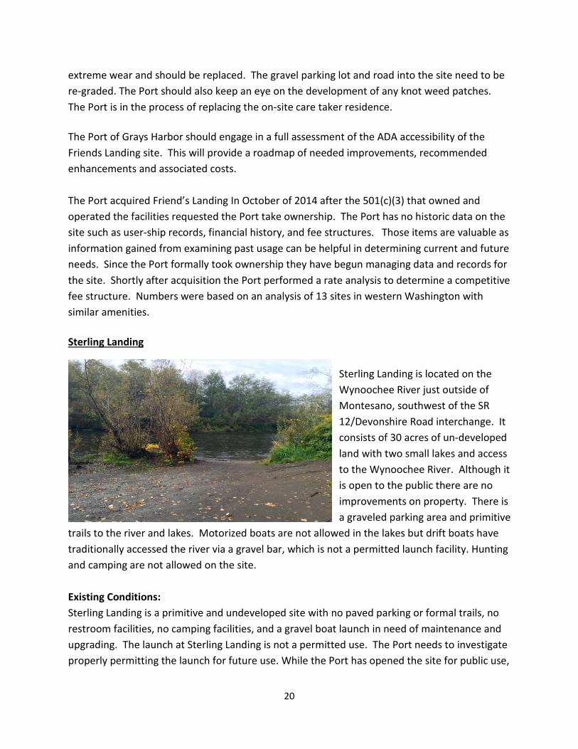
Sterling Landing is located on the Wynoochee River just outside of Montesano, southwest of the SR 12/Devonshire Road interchange. It consists of 30 acres of un-developed land with two small lakes and access to the Wynoochee River. Although it is open to the public there are no improvements on property. There is a graveled parking area and primitive
trails to the river and lakes. Motorized boats are not allowed in the lakes but drift boats have traditionally accessed the river via a gravel bar, which is not a permitted launch facility. Hunting and camping are not allowed on the site. Existing Conditions: Sterling Landing is a primitive and undeveloped site with no paved parking or formal trails, no restroom facilities, no camping facilities, and a gravel boat launch in need of maintenance and upgrading. The launch at Sterling Landing is not a permitted use. The Port needs to investigate properly permitting the launch for future use. While the Port has opened the site for public use,
21
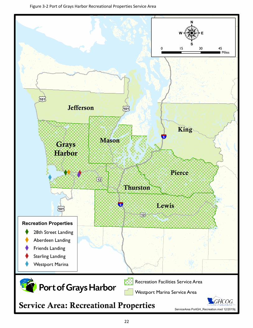
they are aware of the need for site planning. The Sterling Landing site has limited development capabilities as it functions as a natural drainage basin. To meet public need, maintain site sensitivity and direct investment it is recommended that the Port of Grays Harbor develop a plan specifically for the Sterling Landing property. Any development of the site should keep in mind the close proximity of neighboring homes, farmlands and pasturelands and incorporate safety buffers or barriers to protect those properties. Service Area The localized service area for Port owned sites is county-wide. The Westport Marina is the premier marina on the Washington Coast with a service area that encompasses most counties in western Washington and also draws users from California, Montana and Nevada.5 Sites such as 28th Street Landing and Friends Landing draw users from surrounding counties such as Mason, Peirce, Thurston and Lewis Counties.6 Within the context of this plan a discussion of inventories outside of Grays Harbor County is not practicable. Please refer to Figure 3-2 Port of Grays Harbor Recreational Properties Service Area. Launch Facilities and Waterfront Access There are 31 launch sites providing access to the rivers, tributaries and the harbor within Grays Harbor County. These sites have varied issues affecting access and ease of use including: Seasonal limitations, tidal limitations, lack of amenities, lack of vehicle and or trailer parking, lack of a tie up float, primitive nature and/or remote location. Of these sites 10 have seasonal and/or tidal limitations, 7 provide gravel launches, and 15 have no amenities. Some sites are simply not desirable fishing locations. Recreation lands and facilities owned by the Port of Grays Harbor are unique in character and not comparable to city park sites such as pocket parks, neighborhood or community parks. Yet Port owned sites are more than just stand alone launch sites. Below is a discussion of existing waterfront access sites surrounding Port owned sites that are closest in amenities. Please refer to Figure 3-3 Facilities Inventory: Waterfront Access Sites and Table 3-1 Waterfront Access Facilities Inventory. Note - The lettering system on the Waterfront Access Site Map and the Waterfront Facilities Inventory table are corresponding.
5 Westport Marina use statistics, Westport Marina survey September 2015 6 28th Street Landing and Friends Landing surveys September 2015
XXXX
X
£¤101
King
Lewis
Pierce
Jefferson
GraysHarbor
Mason
Thurston
§̈¦5
§̈¦5
£¤12£¤101
£¤12
£¤101
ServiceArea PortGH_Recreation.mxd 12/2015tjService Area: Recreational Properties
:0 15 30 45
Miles
Recreation Facilities Service AreaWestport Marina Service Area
Recreation PropertiesX 28th Street LandingX Aberdeen LandingX Friends LandingX Sterling LandingX Westport Marina
Figure 3-2 Port of Grays Harbor Recreational Properties Service Area
22
23
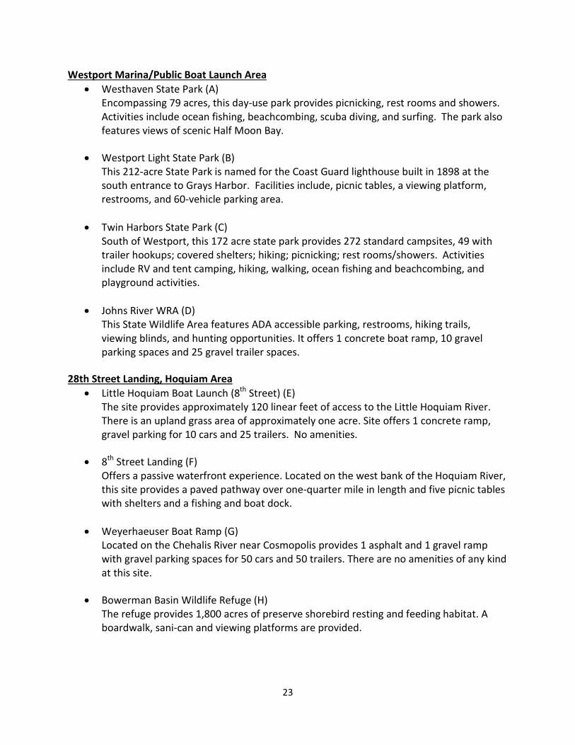
Westport Marina/Public Boat Launch Area • Westhaven State Park (A)
Encompassing 79 acres, this day-use park provides picnicking, rest rooms and showers. Activities include ocean fishing, beachcombing, scuba diving, and surfing. The park also features views of scenic Half Moon Bay.
• Westport Light State Park (B)
This 212-acre State Park is named for the Coast Guard lighthouse built in 1898 at the south entrance to Grays Harbor. Facilities include, picnic tables, a viewing platform, restrooms, and 60-vehicle parking area.
• Twin Harbors State Park (C) South of Westport, this 172 acre state park provides 272 standard campsites, 49 with trailer hookups; covered shelters; hiking; picnicking; rest rooms/showers. Activities include RV and tent camping, hiking, walking, ocean fishing and beachcombing, and playground activities.
• Johns River WRA (D) This State Wildlife Area features ADA accessible parking, restrooms, hiking trails, viewing blinds, and hunting opportunities. It offers 1 concrete boat ramp, 10 gravel parking spaces and 25 gravel trailer spaces.
28th Street Landing, Hoquiam Area
• Little Hoquiam Boat Launch (8th Street) (E) The site provides approximately 120 linear feet of access to the Little Hoquiam River. There is an upland grass area of approximately one acre. Site offers 1 concrete ramp, gravel parking for 10 cars and 25 trailers. No amenities.
• 8th Street Landing (F)
Offers a passive waterfront experience. Located on the west bank of the Hoquiam River, this site provides a paved pathway over one-quarter mile in length and five picnic tables with shelters and a fishing and boat dock.
• Weyerhaeuser Boat Ramp (G) Located on the Chehalis River near Cosmopolis provides 1 asphalt and 1 gravel ramp with gravel parking spaces for 50 cars and 50 trailers. There are no amenities of any kind at this site.
• Bowerman Basin Wildlife Refuge (H)
The refuge provides 1,800 acres of preserve shorebird resting and feeding habitat. A boardwalk, sani-can and viewing platforms are provided.
24
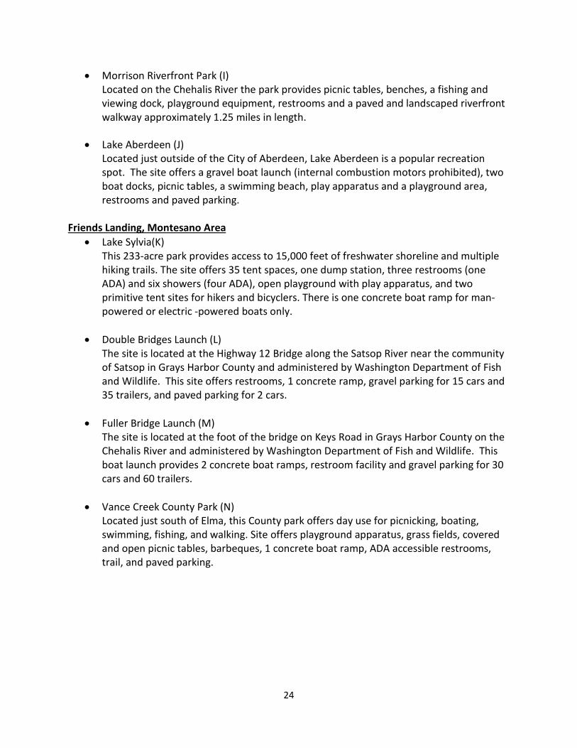
• Morrison Riverfront Park (I) Located on the Chehalis River the park provides picnic tables, benches, a fishing and viewing dock, playground equipment, restrooms and a paved and landscaped riverfront walkway approximately 1.25 miles in length.
• Lake Aberdeen (J)
Located just outside of the City of Aberdeen, Lake Aberdeen is a popular recreation spot. The site offers a gravel boat launch (internal combustion motors prohibited), two boat docks, picnic tables, a swimming beach, play apparatus and a playground area, restrooms and paved parking.
Friends Landing, Montesano Area
• Lake Sylvia(K) This 233-acre park provides access to 15,000 feet of freshwater shoreline and multiple hiking trails. The site offers 35 tent spaces, one dump station, three restrooms (one ADA) and six showers (four ADA), open playground with play apparatus, and two primitive tent sites for hikers and bicyclers. There is one concrete boat ramp for man-powered or electric -powered boats only.
• Double Bridges Launch (L) The site is located at the Highway 12 Bridge along the Satsop River near the community of Satsop in Grays Harbor County and administered by Washington Department of Fish and Wildlife. This site offers restrooms, 1 concrete ramp, gravel parking for 15 cars and 35 trailers, and paved parking for 2 cars.
• Fuller Bridge Launch (M)
The site is located at the foot of the bridge on Keys Road in Grays Harbor County on the Chehalis River and administered by Washington Department of Fish and Wildlife. This boat launch provides 2 concrete boat ramps, restroom facility and gravel parking for 30 cars and 60 trailers.
• Vance Creek County Park (N) Located just south of Elma, this County park offers day use for picnicking, boating, swimming, fishing, and walking. Site offers playground apparatus, grass fields, covered and open picnic tables, barbeques, 1 concrete boat ramp, ADA accessible restrooms, trail, and paved parking.
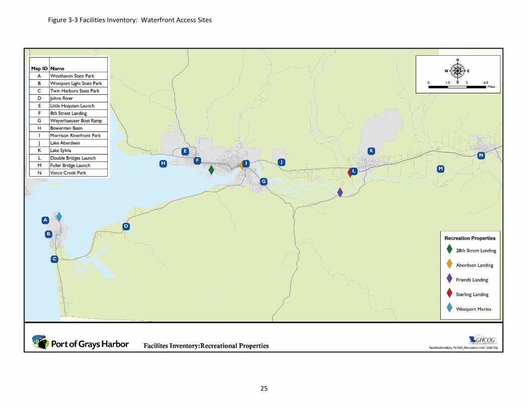
Figure 3-3 Facilities Inventory: Waterfront Access Sites
25
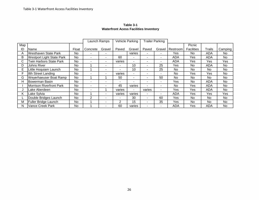
Map ID Name Float Concrete Gravel Paved Gravel Paved Gravel Restroom
Picnic Facilities Trails Camping
A Westhaven State Park No - - varies - - Yes No ADA NoB Westport Light State Park No - - 60 - - - ADA Yes ADA NoC Twin Harbors State Park No - - varies - - - ADA Yes Yes YesD Johns River No 1 - - 10 - 25 Yes No ADA NoE Little Hoquiam Launch No 1 - - 10 - 25 No No No NoF 8th Street Landing No - - varies - - - No Yes Yes NoG Weyerhaeuser Boat Ramp No 1 1 50 - - 50 No No No NoH Bowerman Basin No - - - - - - Yes No ADA NoI Morrison Riverfront Park No - - 45 varies - - No Yes ADA NoJ Lake Aberdeen No - 1 varies - varies - Yes Yes ADA NoK Lake Sylvia No 1 - varies varies - - ADA Yes Yes YesL Double Bridges Launch No 2 - - 30 - 60 Yes No No NoM Fuller Bridge Launch No 1 - 2 15 - 35 Yes No No NoN Vance Creek Park No 1 - 60 varies - - ADA Yes ADA No
Vehicle Parking Trailer Parking Launch Ramps
Waterfront Acess Facilities InventoryTable 3-1
Table 3-1 Waterfront Access Facilities Inventory
26
27
CHAPTER 4 PUBLIC INVOLVEMENT
Public outreach and input was an integral part of the planning process and served as the foundation for identifying the Goals and Objectives and determining the Capital Improvement Program projects and implementation recommendations. The planning process for creating the Port of Grays Harbor Recreation Lands and Facilities Plan included a series of processes, each of which provided the opportunity for public comment and involvement. Public involvement included an iterative process involving comment review and resulting in revision to plan contents. This is an important element in being sensitive to comments of the public as well as building trust during the planning process. The current update began in early 2015, with Port of Grays Harbor and the Grays Harbor Council of Governments (GHCOG) strategizing on plan formation. Public comment was welcomed and incorporated at every point: Recreation Lands and Facilities Committee The Committee directed and reviewed the bulk of work undertaken by GHCOG in creation of the current plan, covering the years 2016-2022. Additional staff was called upon to assist in various technical elements of the plan as needed. Committee membership consisted of the following:
Alissa Shay, Satsop Business Park Manager of Business Development Kayla Dunlap, Port of Grays Harbor Public Affairs Manager Leonard Barnes, Port of Grays Harbor Deputy Executive Director Randy Lewis, Port of Grays Harbor Director of Environmental and Engineering Services Robin Leraas, Westport Marina Manager Vicki Cummings, Executive Director Grays Harbor Council of Governments
Since the structure of the Port of Grays Harbor is very different than that of a city or county the Recreation Lands and Facilities Committee fulfilled a role similar to that of a planning commission through the duration of the planning process. Committee members were assigned their role by Port leadership. Actions of the Committee were reviewed monthly by Executive Director Gary Nelson and the Port of Grays Harbor Commissioners. 2015 Commissioners included:
28
Commissioner Jack Thomson - Serving on the Commission since 1994 Commissioner Chuck Caldwell – Serving on the Commission since 2002 Commissioner Stan Pinnick – Serving on the Commission since 2003
During the early months of 2015 GHCOG began compiling information and laying out the planning infrastructure. The Committee began meeting mid-summer and met approximately every two weeks for the duration of the process. Public Process Committee activities were reported on at regular Port staff meetings. GHCOG provided monthly presentations to the Port of Grays Harbor Commission at regularly scheduled Commission meetings. All Commission meetings are open to the public with opportunities to comment during two public comment periods. Port Commission meetings are well-attended and covered by local media. PLAN REVIEW - A comprehensive review of existing plans documents was completed. Please refer to Appendix B Related Planning Efforts. Information within those documents was incorporated into the Port of Grays Harbor Recreation Lands and Facilities Plan as appropriate. Multiple documents were reviewed and referenced throughout this plan. PERSONAL INTERVIEWS - A series of personal interviews was ongoing during the planning process which resulted in direct input into the Demand and Need and Goals and Objectives Chapters. SURVEYS - During the month of September the Port provided an open opportunity to participate in surveys involving Friends Landing, Sterling Landing and the Westport Marina. 28th Landing was not included in the survey as upgrades to the site were in progress. Aberdeen Landing was not included in the survey as the site has considerable development restrictions. The Port needs to engage in internal discussions addressing site development. Please refer to Appendix C User Surveys. Notification signs were posted at each of three locations to inform site users of the opportunity to participate. The survey was available on the Port of Grays Harbor website as well as in hard copy at the Port of Grays Harbor main office in Aberdeen, the Westport Marina office in Westport and the Friends Landing office. Hard copy surveys were not available at Sterling Landing as it is an undeveloped site. The Daily World published a news article on September 5, 2015 stating “the Port is seeking input from the public on how to improve its recreational waterfront facilities” and informing the public as to how they may access the surveys. In all 260
29
total responses were received; Westport Marina received 142 responses, Friends Landing received 75 responses, Sterling Landing received 43 responses. Notifications for the survey process included the August 2015 Port of Grays Harbor Around the Docks newsletter and radio and newspaper PSA announcements. Please refer to Appendix D Request of Public Input. The survey process was open for 30 days between September 1 and September 30, 2015. Following the close of the survey, the Recreation Lands and Facilities Committee met to review and discuss the submittals. The committee then made site visits to both Friends Lading and Sterling Landing to field verify the comments received. OPEN HOUSE - A Public Open House was held on November 23, 2015 in the Port of Grays Harbor Commission Chambers to receive public comment and discuss the draft plan materials. The open house contained stations which were staffed by Recreation Lands and Facilities Committee members and GHCOG staff. Each station focused on a different aspect of the plan. For example, one station discussed the plan timeline and RCO plan requirements. Another station highlighted the public process to-date, while yet another station focused on draft goals and objectives. A planning area map and various recreation sites and facilities photographs were also displayed. Public comment cards were made available at the open house, so that individuals could write their comments and have them considered by the Committee in developing the final plan text. Notifications of the Public Open House included the September 2015 Port of Grays Harbor Around the Docks newsletter and radio and newspaper PSA announcements. Please visit Appendix D Request of Public Input. CITY COUNCILS – Due to the proximity of Friends Landing and Sterling Landing to the City of Montesano a presentation was made to the Montesano City Council on November 24, 2015. Due to the location of the Westport Marina a presentation was made to the Westport City Council on November 30, 2015. The purpose of the City Council presentations was to inform elected officials as well as the public about plan development efforts and provide yet another opportunity for public input.
30
Final Draft Public Notification and Solicitation for Comments The public was informed that a final draft of the Port of Grays Harbor Recreation Lands and Facilities Plan was available for review, by several methods listed below. See Appendix E Final Draft Public Review for more information. NOTE-To be completed upon return of Affidavit of Publication.
• Posting the final draft plan for review on the Port of Grays Harbor web site. • Notifications were sent to all cities, Grays Harbor County, and to the Quinault and
Chehalis Tribes to inform them that a final draft plan is available for review on the Port of Grays Harbor web site.
• Hard copies of the plan were delivered to Public Libraries within Grays Harbor. • Public Service Announcements were issued to Grays Harbor Media on January 6, 2016. • A follow-up display advertisement to be placed in The Daily World during the second
week of January 2016. The public was also made aware of the planning process and progress through several Port of Grays Harbor Commission meetings. Planning progress was relayed to the Port Commissioners at open public meetings that are generally well attended by the public and covered by the local media. Plan Adoption NOTE – To be completed after close of the public review and comment period. It is anticipated that the Port of Grays Harbor Recreation Lands and Facilities Plan will be formally adopted via resolution at the February 9, 2016 Port of Grays Harbor Commission meeting. Appendix F Adoption Resolution and Public Meeting Minutes
31
CHAPTER 5 DEMAND AND NEED ANALYSIS
The demand and need analysis was developed using national, state and local trends, population characteristics, information from ongoing Port activities and the public involvement process. The purpose of the analysis is to provide useful information to Port of Grays Harbor leadership and staff to assist in developing priorities and directing investments. As addressed earlier in this plan, the lands and facilities offered for public recreation by the Port of Grays Harbor are unique in character. As a port district there is no requirement to provide public recreational facilities. However, Port of Grays Harbor leadership appreciates the support of the Grays Harbor community and feels strongly about enabling the interaction of the community with the pristine natural environments found in Grays Harbor. Since these lands and facilities are not city, state or federal parks, applying standardized measurement criteria forces an awkward fit. However, there is great benefit in examining local and regional trends and addressing their impacts (if any) to existing recreation opportunities offered by the Port of Grays Harbor. Population Trends The national population is aging, and with several places in Grays Harbor being favorite retirement locations, the county follows this trend. Since 2000 the percent of residents in Grays Harbor age 62 and older has steadily risen; from 18.2% in 2000 to 20.4% in 2014. While the state population of 62 years of age or older was 13.3% in 2000 and 15.6% in 2014. The median age of Grays Harbor County is 42.5 years; the median age of Washington State is 37.3.7
The aging population in Washington is having an impact on recreation in the state as many older Washington residents remain very active and involved in outdoor recreation throughout the state. According to The State Comprehensive Outdoor Recreation Plan (SCORP), older residents are participating in nature-based activities at a higher rate than are younger residents, which is an important finding given that trends in participation among all residents show a dramatic increase in participation in many nature-based activities. 8 Income Trends Median household income in Grays Harbor is not only lower than the state average but has a slower growth rate as well. 2014 median household income in Grays Harbor was $41,409 while
7 U.S. Census Bureau - American Community Survey and OFM 8 Outdoor Recreation in Washington, the 2013 State Comprehensive Outdoor Recreation Plan (SCORP), Washington State Recreation and Conservation Office, May 2013.
32
the Washington State median household income was $58,686. Between 2000 and 2014 the State’s median household income grew at a rate of 8% while that of Grays Harbor had only a 6% growth rate.9 One of the outcomes of reduced income is people recreating closer to home. The economic downturn of 2008 saw less families traveling away for recreation and those who did shortened the length of their time away. The buzzword in the hospitality and tourism industries became “staycations”, vacationing in your own back yard. It is also notable that Americans average 14 vacation days per year compared to the European average of 40 days per year. This places a greater demand on the need for local and regional recreational facilities. Statewide Recreation Trends The 2013 statewide participation survey conducted for the Recreation and Conservation Office and Funding Board, State Comprehensive Outdoor Recreation Plan (SCORP), identified over 60 different recreation activities. The top ten favored activities included a desire to recreate closer to home. The percentage of responses is also listed:
1. Picnicking, bbqing or grilling out - 80.9% 2. Walking (without a pet) - 71.3% 3. Wildlife viewing/photographing – 59% 4. Sightseeing - 56.8% 5. Gardening - 56.7% 6. Hiking - 53.1% 7. Walking (with pet) – 51.6% 8. Camping – 42.4% 9. Swimming or wading at beach - 38.8% 10. Swimming in a pool – 38.2%
Fishing was 16th on the list with 34.1% of respondents and boating was 22nd on the list with 24.8% of respondents. Factors Influencing Recreational Boating Recreational boating is a discretionary activity and fluctuates in relation to income trends and economic conditions. But all around statistics show a distinct interest in boating activities in the US and in Washington State. 9 U.S. Census Bureau - American Community Survey, OFM
33
A 2013 Special Report on Fishing and Boating indicates that 2.4% of the US population was considering boating for the first time and 13.6% of previous boat owners were considering buying again.10 Forty-six million Americans, or 15.8% of the U.S. population ages six and older, participated in fishing in 2014. Compared to the year before, the fishing participation rate remained steady. The demographics of continuing fishing participants in 2013 identified 66.6% as male and 33.4% as female. Yet, the demographics of those beginning fishing for the first time in 2013 showed 47.4% as female and 52.5 % as male.11 These figures demonstrate a shift in the demographics of fishing participants. This trend may have an impact on the types of facilities/amenities needed in the near future. In Washington State, approximately 36% of all residents participate in boating with12:
• 25% of participants participating in motor boating • 11% of participants participating in canoeing, kayaking, rowing, manual craft • 5% of participants participating with personal watercraft • 4% of participants participating with sailboats
The 2007 Washington Boater Needs Assessment by Responsive Management for the Recreation and Conservation Funding Board identified the following:
• 62% of boaters boat most days in the county in which they reside • 23% boated more than 30 days per year • 43% boaters indicated there are boating facilities or services in the county in which they
boat most often that they would like to see improved • Boat launch ramp improvements were sited more often as a facility need by Coastal
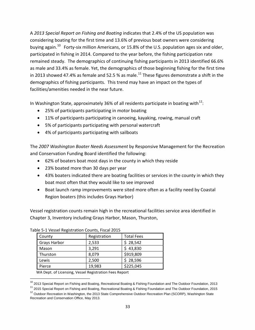
Region boaters (this includes Grays Harbor) Vessel registration counts remain high in the recreational facilities service area identified in Chapter 3, Inventory including Grays Harbor, Mason, Thurston, Table 5-1 Vessel Registration Counts, Fiscal 2015
County Registration Total Fees Grays Harbor 2,533 $ 28,542 Mason 3,291 $ 43,830 Thurston 8,079 $919,809 Lewis 2,500 $ 28,596 Pierce 19,983 $225,045
WA Dept. of Licensing, Vessel Registration Fees Report 10 2013 Special Report on Fishing and Boating, Recreational Boating & Fishing Foundation and The Outdoor Foundation, 2013 11 2015 Special Report on Fishing and Boating, Recreational Boating & Fishing Foundation and The Outdoor Foundation, 2015 12 Outdoor Recreation in Washington, the 2013 State Comprehensive Outdoor Recreation Plan (SCORP), Washington State Recreation and Conservation Office, May 2013.
34
Survey Responses The common thread throughout all three surveys, Friends Landing, Sterling Landing and the Westport Marina is to maintain and improve existing properties. When asked what improvements participants would most like to see at these sites, the top responses included the improvement or addition of restrooms, parking facilities, trails and boat launches; closely followed by improved signage, lighting and picnic and bbq facilities.
The majority of the site and facilities improvements identified in the surveys are achievable and the Port has incorporated them into current and future financial plans. However it must be noted that not every improvement requested can be implemented. For example, specific requests to steepen the ramp at Friends Landing cannot be met since the ramp was constructed at a specific angle to accommodate ADA needs for wheelchair accessibility. Requests to create a swimming beach at Lake Quigg in Friends Landing cannot be met as the lake is not suitable for swimming due to steep drop offs and unsafe depths. Similarly, requests to over develop Sterling Landing cannot be met as the site functions as a drainage basin and any improvements to site must take this function into account. It is also important to understand that none of the recreational properties generates a significant portion of the Port’s revenues and the Port’s ability to fund the planned improvements are tied to market trends that could impact its ability to provide funding as planned.
When asked to “Best describe where you live” the vast majority of responses for both Friends Landing and Sterling Landing mirror the state trend of recreating close to home. 64% of Friends Landing respondents and 67% of Sterling Landing respondents live in central Grays Harbor; placing them within minutes (half an hour or under) to the sites. Due to the unique nature of the Westport Marina 51% of respondents are from another county or state. Yet in-county respondents accounted for almost 20% from the south beach area and 20% from central Grays Harbor.
When asked why participants visited each of the three sites the responses were as follows (note - respondents were allowed to check all that apply):
• Friends Landing Walking the trails – 77.14% Using covered picnic shelters – 44.9% Camping – 30%
• Sterling Landing Fishing in river & walking/hiking tied at 42.42% Swimming & kayaking/canoeing tied at 24.24%
35
• Westport Marina Fishing/boating from public boat ramp – 51.09% Non-commercial vessel moorage – 45.26% Walking /sightseeing along Esplanade & use of fuel dock tied at 32.85%
Additionally, Sterling Landing survey participants were asked, “If you don’t visit the site would you if it were developed?” 91% of all respondents answered yes. The tally of responses from these surveys closely reflects the state-wide recreation trends identified in the State Comprehensive Outdoor Recreation Plan.
Final Observations Current and past planning efforts for the Westport Marina have identified the need to pave the public boat launch and trailer parking lots. There are also existing recommendations for the Port to consider the conversion of existing properties or the purchase of new properties to provide added parking.
There are existing recommendations to consider the purchase of additional parking at the 28th Street Landing to accommodate parking overflow. Recommendations to improve the existing parking lot and float and add restrooms and lighting are being fulfilled via an RCO grant and Port of Grays Harbor funds.
The most recent park and recreation planning efforts for the City of Hoquiam and the City of Aberdeen identify the need for an additional boat launches in each community. Please refer to Appendix B, Related Planning Efforts.
In consideration of the information identified in this plan, especially the information gained through public participation, the Port of Grays Harbor shall channel its available investments, to the extent possible, while meeting its statutory mission and obligations, into maintaining and upgrading its existing recreation lands and facilities. Port of Grays Harbor leadership believes recreation lands and facilities under Port ownership will continue to enhance other existing recreation opportunities and ease the need for city investment. 28th Street Landing is physically located in the City of Hoquiam and in close proximity to the City of Aberdeen. The completion of improvements at this site will provide additional capacity serving both communities.
Recommendations 1. Budget to provide capital improvements for existing park sites. Focus on
improvements of existing recreation lands and facilities such as: Signage, lighting, parking, playground equipment, picnic and bbq facilities, boat launch improvements, restroom facilities and trails.
36
2. Budget to maintain existing park facilities with minimum but adequate levels of maintenance. This includes general maintenance such as: Trash and debris removal, re-painting and repair of facilities, maintaining trail surfaces, re-grading of gravel parking areas as needed; keeping signage in good repair.
3. Seek capital improvement grant funding for the following: • Friends Landing – Full ADA Site Assessment, bank stabilization (for pedestrian
bridge), water trails development. • Sterling Landing – Master Plan development and implementation. • Westport Marina – Development of new restroom facilities.
37
CHAPTER 6 CAPITAL IMPROVEMENT PLAN
A Capital Improvement Plan (CIP), sometimes termed a Capital Facilities Plan (CFP), is an operational tool that includes:
• an existing inventory of all capital facilities • a forecast of future needs • the proposed location and capacities of new facilities, and • at least a six year financing plan showing fund sources for future facilities.
One element of the overall CIP is the Parks and Recreation Element. Once completed and adopted, the CIP can be easily updated by staff. Importantly, it can be integrated into the existing annual or semi-annual budget adoption process and updated along with each budget. The CIP organizes and prioritizes all capital needs and costs for at least the next 6 years. This helps keep scarce capital budget expenditures focused on true system-wide, established priorities. CIPs are increasingly required to support state and federal loan and grant funding requests. Even though Grays Harbor County is not a mandatory Growth Management Act jurisdiction, and therefore its municipalities are not required to adopt Capital Improvement Plans, the awarding of grants and loans are increasingly competitive and local governments who can demonstrate careful planning for their capital needs will score higher on evaluations of their applications for grants and loans. The open house comments, surveys, Recreation Lands and Facilities Committee insights, and staff recommendations that were described in the Demand and Need Analysis provided the information to establish the project array outlined in the Capital Improvement Plan (CIP). It is important to note that the six-year CIP is a living planning document and as such is open to changes as needed. For example, if an unforeseen funding opportunity becomes available the Port may opt to move a project from one year to another to take advantage of the opportunity. Alternately if repair to a site or a facility becomes critical, the Port may opt to rebalance funds and scheduling between projects to facilitate need.
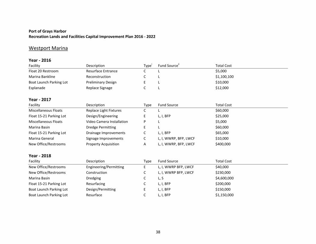
Port of Grays Harbor Recreation Lands and Facilities Capital Improvement Plan 2016 - 2022 Westport Marina Year - 2016 Facility Description Typei Fund Sourceii Total Cost Float 20 Restroom Resurface Entrance C L $5,000 Marina Bankline Reconstruction C L $1,100,100 Boat Launch Parking Lot Preliminary Design E L $10,000 Esplanade Replace Signage C L $12,000
Year - 2017 Facility Description Type Fund Source Total Cost Miscellaneous Floats Replace Light Fixtures C L $60,000 Float 15-21 Parking Lot Design/Engineering E L, I, BFP $25,000 Miscellaneous Floats Video Camera Installation P L $5,000 Marina Basin Dredge Permitting E L $60,000 Float 15-21 Parking Lot Drainage Improvements C L, I, BFP $65,000 Marina General Signage Improvements C L, I, WWRP, BFP, LWCF $10,000 New Office/Restrooms Property Acquisition A L, I, WWRP, BFP, LWCF $400,000
Year - 2018 Facility Description Type Fund Source Total Cost New Office/Restrooms Engineering/Permitting E L, I, WWRP BFP, LWCF $40,000 New Office/Restrooms Construction C L, I, WWRP BFP, LWCF $230,000 Marina Basin Dredging C L, S $4,600,000 Float 15-21 Parking Lot Resurfacing C L, I, BFP $200,000 Boat Launch Parking Lot Design/Permitting E L, I, BFP $150,000 Boat Launch Parking Lot Resurface C L, I, BFP $1,150,000
38
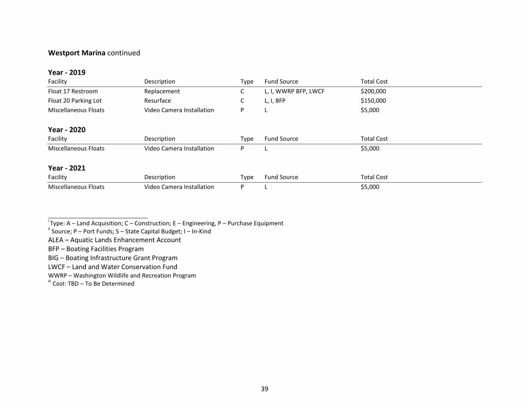
Westport Marina continued Year - 2019 Facility Description Type Fund Source Total Cost Float 17 Restroom Replacement C L, I, WWRP BFP, LWCF $200,000 Float 20 Parking Lot Resurface C L, I, BFP $150,000 Miscellaneous Floats Video Camera Installation P L $5,000
Year - 2020 Facility Description Type Fund Source Total Cost Miscellaneous Floats Video Camera Installation P L $5,000
Year - 2021 Facility Description Type Fund Source Total Cost Miscellaneous Floats Video Camera Installation P L $5,000 ______________________________ i Type: A – Land Acquisition; C – Construction; E – Engineering, P – Purchase Equipment ii Source; P – Port Funds; S – State Capital Budget; I – In-Kind ALEA – Aquatic Lands Enhancement Account BFP – Boating Facilities Program BIG – Boating Infrastructure Grant Program LWCF – Land and Water Conservation Fund WWRP – Washington Wildlife and Recreation Program iii Cost: TBD – To Be Determined
39
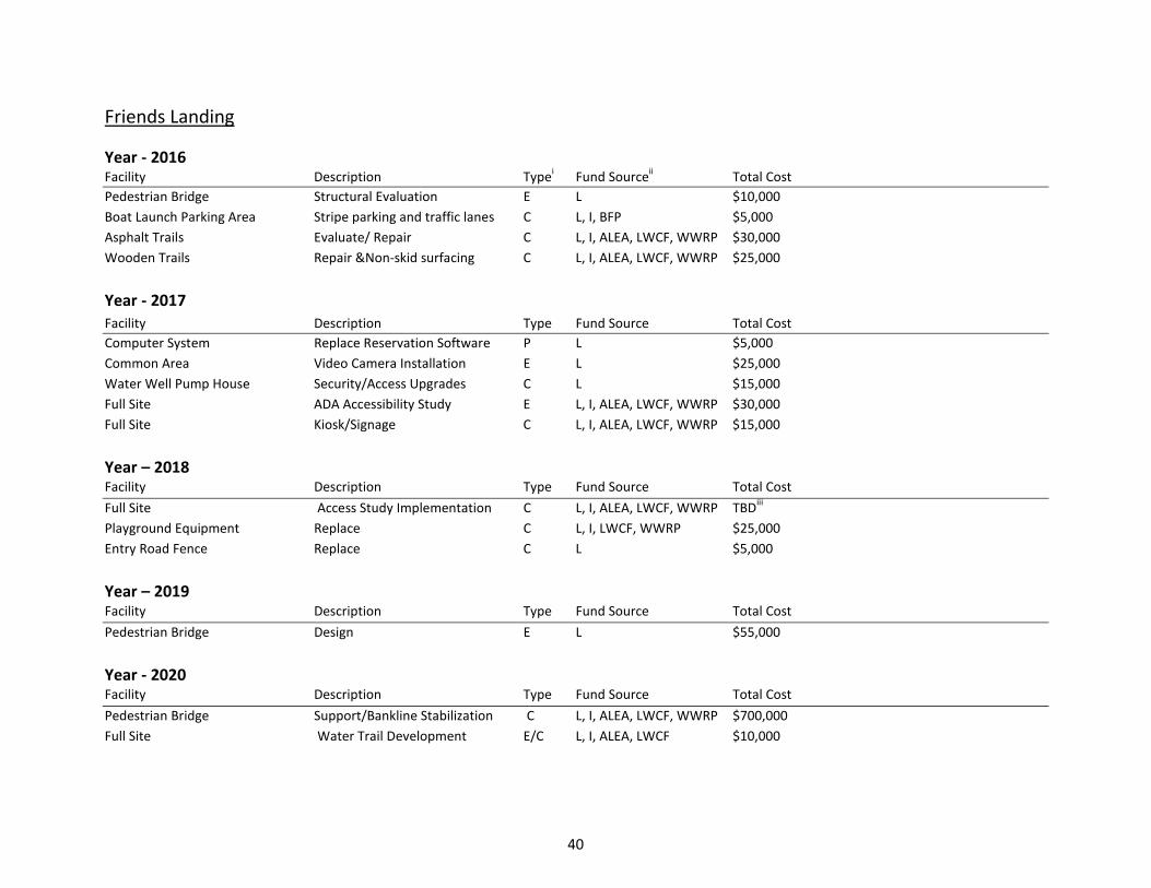
Friends Landing Year - 2016 Facility Description Typei Fund Sourceii Total Cost Pedestrian Bridge Structural Evaluation E L $10,000 Boat Launch Parking Area Stripe parking and traffic lanes C L, I, BFP $5,000 Asphalt Trails Evaluate/ Repair C L, I, ALEA, LWCF, WWRP $30,000 Wooden Trails Repair &Non-skid surfacing C L, I, ALEA, LWCF, WWRP $25,000
Year - 2017 Facility Description Type Fund Source Total Cost Computer System Replace Reservation Software P L $5,000 Common Area Video Camera Installation E L $25,000 Water Well Pump House Security/Access Upgrades C L $15,000 Full Site ADA Accessibility Study E L, I, ALEA, LWCF, WWRP $30,000 Full Site Kiosk/Signage C L, I, ALEA, LWCF, WWRP $15,000
Year – 2018 Facility Description Type Fund Source Total Cost Full Site Access Study Implementation C L, I, ALEA, LWCF, WWRP TBDiii Playground Equipment Replace C L, I, LWCF, WWRP $25,000 Entry Road Fence Replace C L $5,000
Year – 2019 Facility Description Type Fund Source Total Cost Pedestrian Bridge Design E L $55,000
Year - 2020 Facility Description Type Fund Source Total Cost Pedestrian Bridge Support/Bankline Stabilization C L, I, ALEA, LWCF, WWRP $700,000 Full Site Water Trail Development E/C L, I, ALEA, LWCF $10,000
40
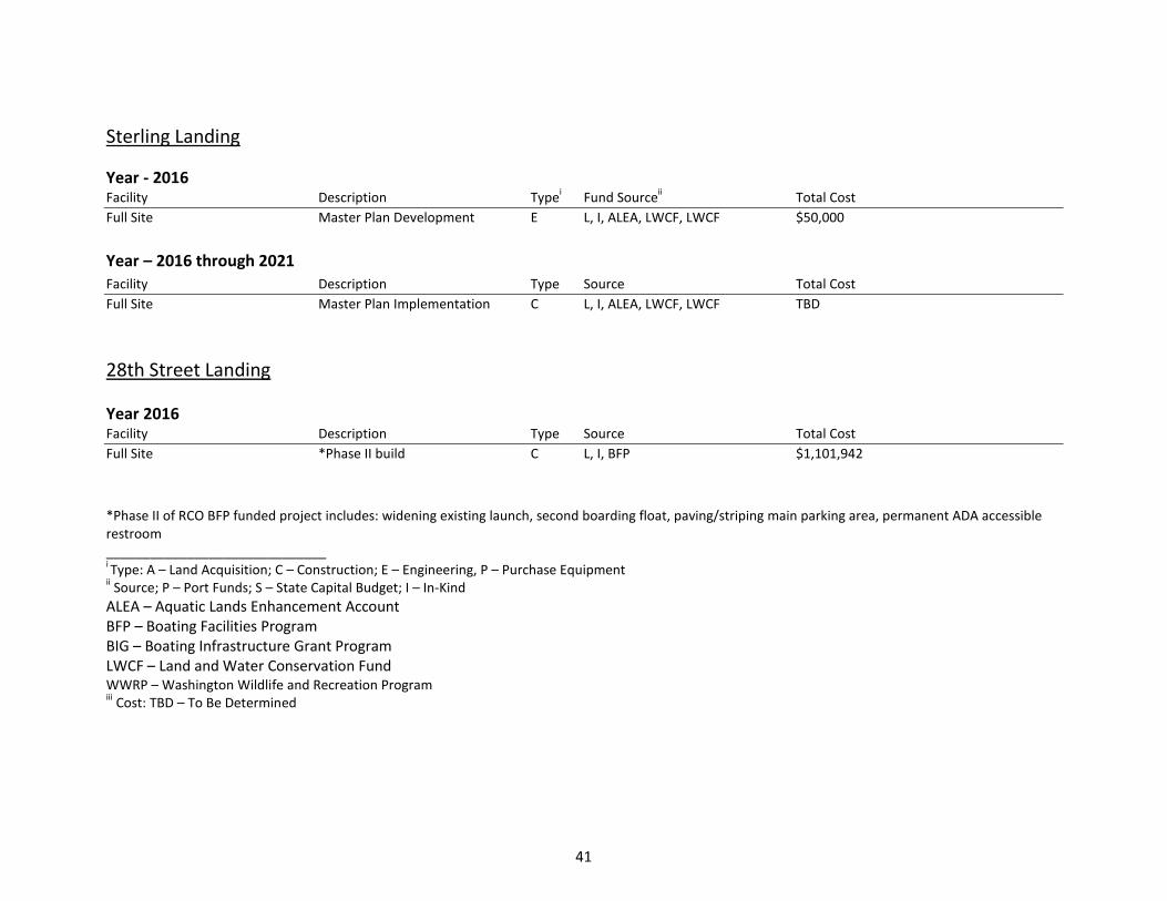
Sterling Landing Year - 2016 Facility Description Typei Fund Sourceii Total Cost Full Site Master Plan Development E L, I, ALEA, LWCF, LWCF $50,000
Year – 2016 through 2021 Facility Description Type Source Total Cost Full Site Master Plan Implementation C L, I, ALEA, LWCF, LWCF TBD
28th Street Landing
Year 2016 Facility Description Type Source Total Cost Full Site *Phase II build C L, I, BFP $1,101,942 *Phase II of RCO BFP funded project includes: widening existing launch, second boarding float, paving/striping main parking area, permanent ADA accessible restroom ______________________________ i Type: A – Land Acquisition; C – Construction; E – Engineering, P – Purchase Equipment ii Source; P – Port Funds; S – State Capital Budget; I – In-Kind ALEA – Aquatic Lands Enhancement Account BFP – Boating Facilities Program BIG – Boating Infrastructure Grant Program LWCF – Land and Water Conservation Fund WWRP – Washington Wildlife and Recreation Program iii Cost: TBD – To Be Determined
41
Public Funding Opportunties The funding of recommended improvements within the Port of Grays Harbor Recreation Lands and Facilities Plan is an important consideration. With limited, budgeted recreation funds outside sources such as grants and loans should be considered. There are a number of programs that Port properties are eligible for, they have been outlined below. This recreation plan complies with the planning eligibility requirement for Recreation and Conservation Funding Board (RCFB) programs. Boating Facilities Program (BFP) This program is administered by the RCFB with the purpose to: acquire, develop, plan for and renovate boating facilities, including launching ramps, transient moorage, and support facilities. The BFP is highly desirable to provide funding assistance for Westport Marina facilities. Grant applications are usually due July 1st each year. A minimum of 25% of the project cost (matching share) must be covered by the applicant. Matching share may include: cash; bonds; donations of cash, land, labor, equipment, and material; federal, state, local and private grants; and force account labor, equipment and materials. All projects will be barrier-free and the project must remain open to public use in perpetuity. Please see Manual 9: Boating Facilities Program for more specific details and restrictions. Land and Water Conservation Fund (LWCF) This program is also administered by the RCFB with the purpose to: provide funding to assist in acquiring, preserving, developing, and assuring accessibility to outdoor recreation resources such as parks, trails, water access and wildlife lands. The LWCF is a potential funding program for facility improvements at both Friends Landing and Sterling Landing such as: picnic facilities, interpretive signage, restrooms, parking, trails, boardwalks, bridges and waterfront access. Grant applications are usually due May 1st each year. A minimum of 50% of the projects cost (matching share) must be covered by the applicant. Please see Manual15: LWCF Program Policies for more specific details and restrictions. Washington Wildlife Recreation Program (WWRP) This program is also administered by the RCFB and provides funding for a broad range of land protection and outdoor recreation, including park acquisition and development, habitat conservation, farmland preservation, and construction of outdoor recreation facilities. The LWCF is a potential funding program for facility improvements at both Friends Landing and Sterling Landing such as: buildings, campgrounds, cabins, fishing floats, interpretive kiosks, signs, picnic shelters, play areas, restrooms, roads, paths, and parking, viewing areas.
42
The program is open in even number years and the awarded projects are subject to funding appropriation and approval by the Legislature in the next yearly session. Applications are generally due in the spring. A minimum of 50% of the project cost (matching share) must be covered by the applicant. Please see Manua110a: WWRP Outdoor Recreation Account (ORA) for more specific details and restrictions. Aquatic Lands Enhancement Account (ALEA) This RCFB program offers grants to provide and improve access to aquatic lands by funding land purchase and improvement or aquatic land protection projects. ALEA grants may be used for the acquisition, improvement, or protection of aquatic lands for public purposes. They also may be used to provide or improve public access to the waterfront. The ALEA program is targeted at re-establishing the natural, self-sustaining ecological functions of the waterfront, providing or restoring public access to the water, and increasing public awareness of aquatic lands as a finite natural resource and irreplaceable public heritage. ALEA is funded almost entirely by revenue generated by the Washington State Department of Natural Resources' management of state-owned aquatic lands. ALEA grant process opens in even number years for funding in the following state fiscal year (2 years out). A minimum of 50% of the project cost (matching share) must be covered by the applicant. Please see Manual 21: ALEA Program Policies and Project Selection for more specific details and restrictions. Private Funding Opportunties Private charitable organizations may provide a funding source for public recreation projects. Before pursuing private funding it is important to make sure your project will fit the criteria for funding consideration. Private organizations have leeway to select or refuse projects; therefore much time needs to be spent in communication with the organization before submitting a grant application. The Sierra Pacific Foundation The Foundation makes grants to communities with company facilities, primarily in Northern California and Washington. Grants range from $100 to $50,000, with total annual giving of approximately $900,000. Funding is provided for academic and community programs, particularly those that benefit children, including civic affairs, parks and recreation, youth sports and public safety. General operating and project support are provided.
43

Emerson Charitable Trust National scope, primarily in communities with company operations. Grants range from $100 to $1,000,000. Focus areas include civic and economic health in building and maintaining public assets such as parks and zoos. Project and general support, as well as equipment, building funds and matching grants are provided.
44

APPENDICES

APPENDIX A Westport Marina Events
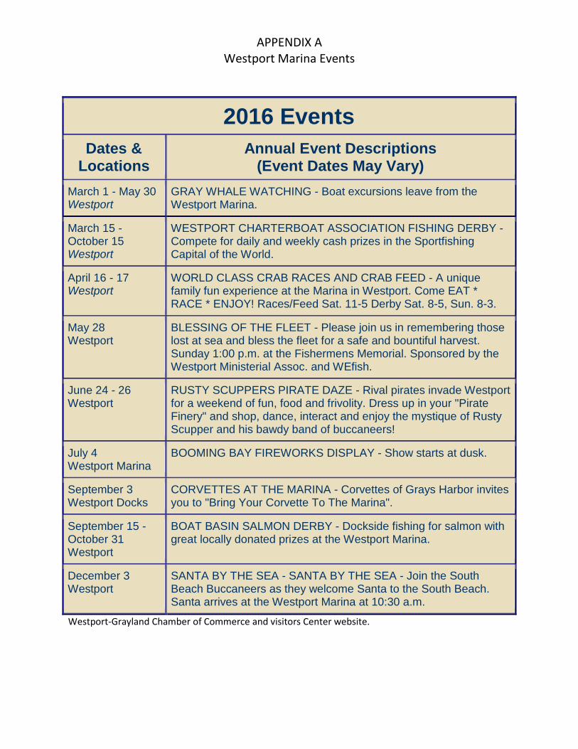
APPENDIX A Westport Marina Events
Westport-Grayland Chamber of Commerce and visitors Center website.
2016 Events
Dates & Locations
Annual Event Descriptions (Event Dates May Vary)
March 1 - May 30 Westport
GRAY WHALE WATCHING - Boat excursions leave from the Westport Marina.
March 15 - October 15 Westport
WESTPORT CHARTERBOAT ASSOCIATION FISHING DERBY - Compete for daily and weekly cash prizes in the Sportfishing Capital of the World.
April 16 - 17 Westport
WORLD CLASS CRAB RACES AND CRAB FEED - A unique family fun experience at the Marina in Westport. Come EAT * RACE * ENJOY! Races/Feed Sat. 11-5 Derby Sat. 8-5, Sun. 8-3.
May 28 Westport
BLESSING OF THE FLEET - Please join us in remembering those lost at sea and bless the fleet for a safe and bountiful harvest. Sunday 1:00 p.m. at the Fishermens Memorial. Sponsored by the Westport Ministerial Assoc. and WEfish.
June 24 - 26 Westport
RUSTY SCUPPERS PIRATE DAZE - Rival pirates invade Westport for a weekend of fun, food and frivolity. Dress up in your "Pirate Finery" and shop, dance, interact and enjoy the mystique of Rusty Scupper and his bawdy band of buccaneers!
July 4 Westport Marina
BOOMING BAY FIREWORKS DISPLAY - Show starts at dusk.
September 3 Westport Docks
CORVETTES AT THE MARINA - Corvettes of Grays Harbor invites you to "Bring Your Corvette To The Marina".
September 15 - October 31 Westport
BOAT BASIN SALMON DERBY - Dockside fishing for salmon with great locally donated prizes at the Westport Marina.
December 3 Westport
SANTA BY THE SEA - SANTA BY THE SEA - Join the South Beach Buccaneers as they welcome Santa to the South Beach. Santa arrives at the Westport Marina at 10:30 a.m.

APPENDIX B Related Planning Efforts
APPENDIX B Related Planning Efforts
LOCAL RELATED PLANNING EFFORTS 28th Street Landing Recreational Lands and Facilities Plan: 2009-2014, Port of Grays Harbor, 2009. In 2009 the Port of Grays Harbor completed a planning effort to specifically address 28th Street Landing property. The plan provided funding eligibility for the Recreation and Conservation Funding Board. Goals included:
1. IMPROVE BOATING FACILITIES - Improve and expand boating opportunities and access at the 28th Street Landing boat launch to accommodate additional recreational vessels both motorized and non-motorized.
2. IMPROVE CHEHALIS RIVER ACCESS - Improve and expand opportunities for water viewing and access. Increase the Chehalis River historic information at the 28th Street Landing. 3. IMPROVE SUPPORT FACILITIES - Improve, expand, and upgrade support facilities for the 28th Street Landing boat launch and viewing tower.
Port Industrial Area Master Plan Update December 2005 In 2005 HDR Inc. prepared an update for the Port of Grays Harbor 1996 Industrial Properties Master Plan specifically covering properties around the Port Industrial Road Area. The plan addresses the 28th Street boat launch outlining the following goals:
• Consider a boat launch user fee program to offset maintenance costs. • Develop a plan to address security issues and concerns (for example, lighting, restroom
availability, pedestrian accessibility, vandalism, littering, etc). • Investigate the possibility of sharing parking facilities with boaters during off-work hours
in addition to providing formal boat/trailer parking. • Pursue grant funding targeted for public recreation and amenity improvements.
The envisioned results of plan implementation for the 28th Street boat launch include:
• Boat launch and viewing tower upgraded and improved public amenities • A permanent public restroom • Attractive lighting, picnic tables, and interpretive kiosk • Formal parking area and designated trailer spaces.
Port of Grays Harbor Industrial Properties Master Plan - 1996 Developed by Reid Middleton in 1996, the purpose of this master plan was to determine the highest and best use for the following seven properties:
1) Main Port Terminal 5) IDD No. 2 (Wal-Mart Site) 2) ITT Rayonier 6) South Shore 3) A&M Site 7) Westport Properties 4) Bowerman Hill
The Master Plan identifies strategic recommendations for each site. The goal of the plan was to ensure the Port’s ability to continue its core missions of economic development, trade, and tourism. Plans identified for the IDD 2 site identified a balance of public features and amenities, private retail and commercial uses in support of a vibrant and active waterfront area. Westport properties were slated for a mix of marine industry expansion, private sector development and the establishment of a ferry service between Westport and Ocean Shores. City of Hoquiam Park and Recreation Comprehensive Plan 2005 - 2007 The 28th Street Landing is included in the City of Hoquiam’s recreation inventory. One of the tools used in the needs analysis to identify the city’s current and future recreational needs is the application of per capita standards. Table 5.5 “Application of per capita acreage standard to the 2000 and year 2010 resident population of the City of Hoquiam” states the required number of boat launch lanes for the city is nine (1 lane/1,000 persons). The city has two existing boat launch lanes, leaving a deficit of seven launch lanes. Due to the lack of launch lanes within the City of Hoquiam, it is important to keep the 28th Street Landing boat launch open and maintained for use as it serves an under fulfilled facility need. Future expansion of the launch facility, such as adding another launch lane, will help reduce the number of needed launch lanes in the city. City of Aberdeen 2011 – 2016 Comprehensive Parks & Recreation Plan The City of Aberdeen park and recreation plan identifies the need for linear and point access to the water for its citizens, outlined in Chapter 5 Shoreline Public Access. It also notes that access to boat launches is limited. Table 6-1 “Existing and planned per capita acreage need for park site and facilities in the City of Aberdeen” state the required number of boat launch facilities (1/7,500 persons) in 2004 was three and only two are provided, leaving a deficit of one launch. Planned for year 2009 the facility need for boat launches increase to two.
The 28th Street Landing boat launch provides a needed access to water and helps alleviate the deficit of launch lanes for the City. Grays Harbor Estuary Management Plan The Grays Harbor Estuary Management Plan (GHEMP) was prepared to improve the interpretation and implementation of the variety of local, county, state, and federal development regulations which affect the Grays Harbor estuary. The GHEMP serves to guide both the cities of Aberdeen and Hoquiam in the development of lands within the estuary. Under the GHEMP, the estuary is divided into eight planning areas, each representing a common set of natural and man-related features. Planning areas provide a basis for describing how different areas of the estuary presently function and how they should function in the future. The 28th Street Landing is located in the management unit 15 and the urban development management category.
Urban Development category purpose: The urban development management category designates areas where the predominant uses are or will be industrial and commercial development. The intent of the designation is to provide for efficient utilization of such areas primarily for water-dependent/water-related commerce and industry that are directly related to the region’s primary economy.
Piers, docks, wharves, piling and mooring dolphins, bank line straightening, erosion control, and boat ramps are allowable or appropriate activities. STATE AND FEDERAL RELATED PLANNING EFFORTS Growth Management Act In 1990, Washington State engaged in state-mandated planning to manage growth. Grays Harbor County does not fully plan under the Growth Management Act, but is required to develop ordinances that protect critical areas and natural resource lands. Planning for park and recreation facilities will be required to meet local critical area ordinances. Shoreline Management Act The Shoreline Management Act was passed into law June 1, 1971 (RCW 90.58). The Act’s objectives are to protect and restore the valuable natural resources that shorelines represent and to plan for all “reasonable and appropriate uses” that are dependant upon waterfront location or which will offer the opportunities for the public to enjoy the state’s shorelines. The
Act, administered by the Washington State Department of Ecology, requires that all counties and cities prepare and adopt local shoreline master programs. Coastal Zone Management Program In addition to the Shoreline Management Act, Washington became the first state to have a federally approved Coastal Zone Management Program. The state’s Coastal Zone Management Program, approved in 1976, supports technical assistance, education, and project grants to improve public access. Endangered Species Act The US Fish and Wildlife Service and the National Marine Fisheries Service administer the Endangered Species Act, passed in 1973, for the conservation and recovery of endanger or threatened species. Through these efforts, critical habitat that endangered or threatened species depend upon may also be protected, which may have possible effects on recreational planning efforts.

APPENDIX C Surveys
Friends Landing Sterling Landing
Westport Marina
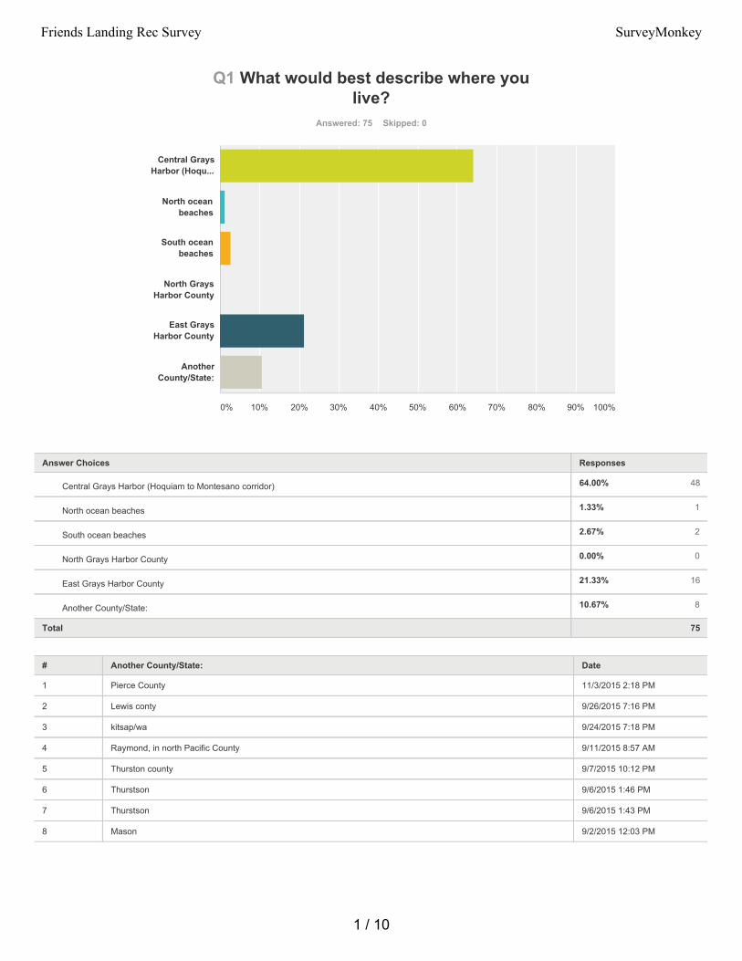
64.00% 48
1.33% 1
2.67% 2
0.00% 0
21.33% 16
10.67% 8
Q1 What would best describe where youlive?
Answered: 75 Skipped: 0
Total 75
# Another County/State: Date
1 Pierce County 11/3/2015 2:18 PM
2 Lewis conty 9/26/2015 7:16 PM
3 kitsap/wa 9/24/2015 7:18 PM
4 Raymond, in north Pacific County 9/11/2015 8:57 AM
5 Thurston county 9/7/2015 10:12 PM
6 Thurstson 9/6/2015 1:46 PM
7 Thurstson 9/6/2015 1:43 PM
8 Mason 9/2/2015 12:03 PM
Central GraysHarbor (Hoqu...
North oceanbeaches
South oceanbeaches
North GraysHarbor County
East GraysHarbor County
AnotherCounty/State:
0% 10% 20% 30% 40% 50% 60% 70% 80% 90% 100%
Answer Choices Responses
Central Grays Harbor (Hoquiam to Montesano corridor)
North ocean beaches
South ocean beaches
North Grays Harbor County
East Grays Harbor County
Another County/State:
1 / 10
Friends Landing Rec Survey SurveyMonkey
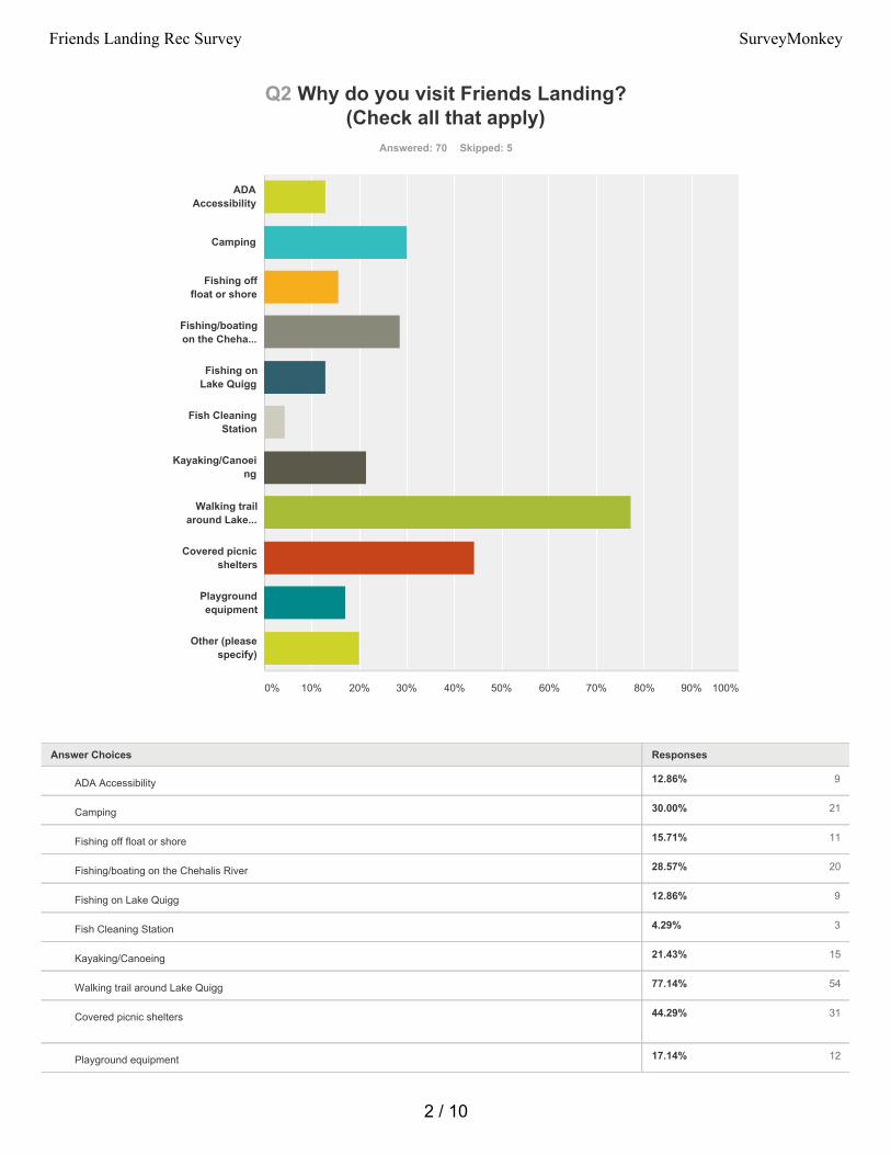
12.86% 9
30.00% 21
15.71% 11
28.57% 20
12.86% 9
4.29% 3
21.43% 15
77.14% 54
44.29% 31
17.14% 12
Q2 Why do you visit Friends Landing?(Check all that apply)
Answered: 70 Skipped: 5
ADAAccessibility
Camping
Fishing offfloat or shore
Fishing/boatingon the Cheha...
Fishing onLake Quigg
Fish CleaningStation
Kayaking/Canoeing
Walking trailaround Lake...
Covered picnicshelters
Playgroundequipment
Other (pleasespecify)
0% 10% 20% 30% 40% 50% 60% 70% 80% 90% 100%
Answer Choices Responses
ADA Accessibility
Camping
Fishing off float or shore
Fishing/boating on the Chehalis River
Fishing on Lake Quigg
Fish Cleaning Station
Kayaking/Canoeing
Walking trail around Lake Quigg
Covered picnic shelters
Playground equipment
2 / 10
Friends Landing Rec Survey SurveyMonkey
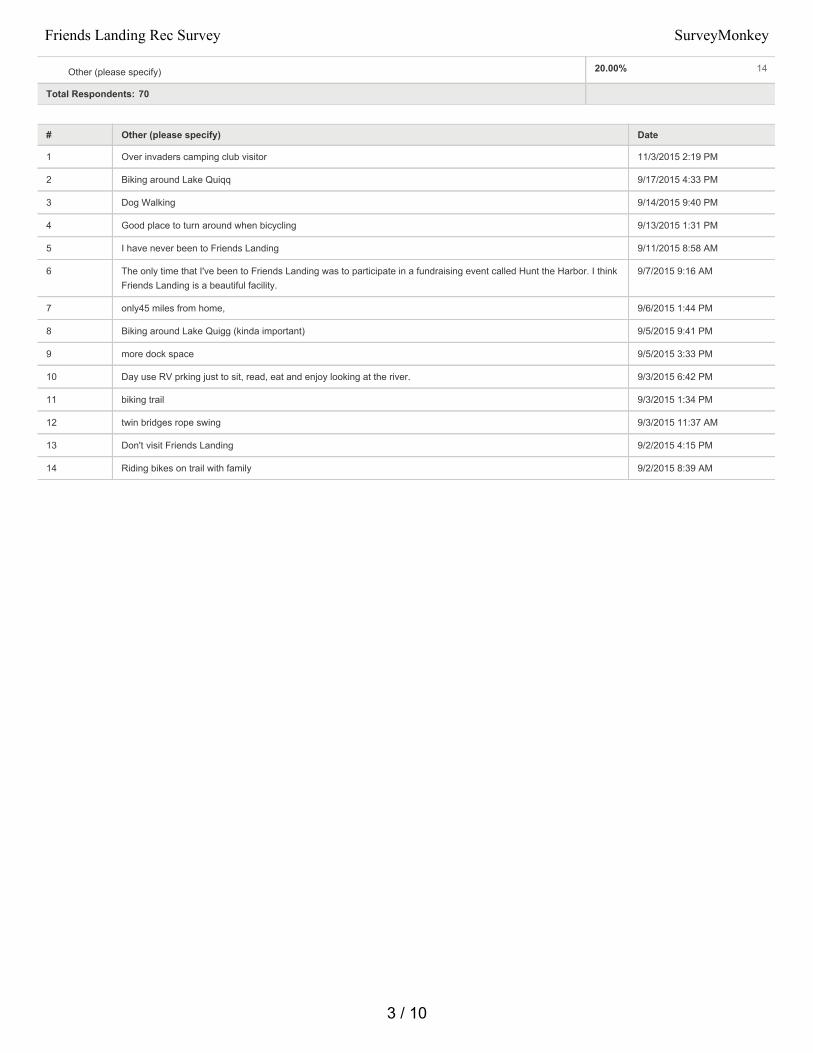
20.00% 14
Total Respondents: 70
# Other (please specify) Date
1 Over invaders camping club visitor 11/3/2015 2:19 PM
2 Biking around Lake Quiqq 9/17/2015 4:33 PM
3 Dog Walking 9/14/2015 9:40 PM
4 Good place to turn around when bicycling 9/13/2015 1:31 PM
5 I have never been to Friends Landing 9/11/2015 8:58 AM
6 The only time that I've been to Friends Landing was to participate in a fundraising event called Hunt the Harbor. I thinkFriends Landing is a beautiful facility.
9/7/2015 9:16 AM
7 only45 miles from home, 9/6/2015 1:44 PM
8 Biking around Lake Quigg (kinda important) 9/5/2015 9:41 PM
9 more dock space 9/5/2015 3:33 PM
10 Day use RV prking just to sit, read, eat and enjoy looking at the river. 9/3/2015 6:42 PM
11 biking trail 9/3/2015 1:34 PM
12 twin bridges rope swing 9/3/2015 11:37 AM
13 Don't visit Friends Landing 9/2/2015 4:15 PM
14 Riding bikes on trail with family 9/2/2015 8:39 AM
Other (please specify)
3 / 10
Friends Landing Rec Survey SurveyMonkey
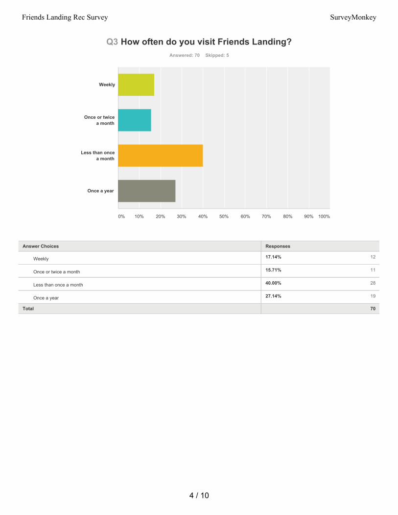
17.14% 12
15.71% 11
40.00% 28
27.14% 19
Q3 How often do you visit Friends Landing?Answered: 70 Skipped: 5
Total 70
Weekly
Once or twicea month
Less than oncea month
Once a year
0% 10% 20% 30% 40% 50% 60% 70% 80% 90% 100%
Answer Choices Responses
Weekly
Once or twice a month
Less than once a month
Once a year
4 / 10
Friends Landing Rec Survey SurveyMonkey
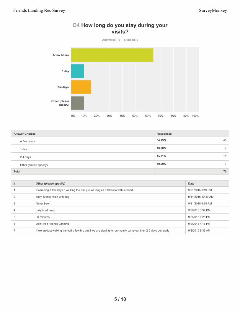
64.29% 45
10.00% 7
15.71% 11
10.00% 7
Q4 How long do you stay during yourvisits?
Answered: 70 Skipped: 5
Total 70
# Other (please specify) Date
1 If camping a few days if walking the trail just as long as it takes to walk around. 9/21/2015 3:19 PM
2 daily 40 min. walk with dog 9/14/2015 10:49 AM
3 Never been 9/11/2015 8:58 AM
4 daily boat ramp 9/5/2015 3:34 PM
5 30 minutes 9/2/2015 8:25 PM
6 Dpn't visit Friends Landing 9/2/2015 4:16 PM
7 If we are just walking the trail a few hrs but if we are staying for our yearly camp out then 2-5 days generally 9/2/2015 9:33 AM
A few hours
1 day
2-4 days
Other (pleasespecify)
0% 10% 20% 30% 40% 50% 60% 70% 80% 90% 100%
Answer Choices Responses
A few hours
1 day
2-4 days
Other (please specify)
5 / 10
Friends Landing Rec Survey SurveyMonkey
50.75% 34
17.91% 12
14.93% 10
23.88% 16
32.84% 22
28.36% 19
31.34% 21
Q5 What are the two most importantimprovements you would like to see at
Friends Landing?Answered: 67 Skipped: 8
Total Respondents: 67
# Other (please specify) Date
1 Didn't have a 2nd 11/3/2015 2:19 PM
2 Repair the trail by installing sand paper on the wood parts. It takes almost two days of dry weather before the woodparts aren't too slippery to walk on.
9/30/2015 8:07 PM
3 Maintain trail areas and benches more frequently. Replace broken concrete bench along trail and clear view in thatarea
9/26/2015 7:19 PM
4 Swimming Beach access to Lake Quigg for floating and sand for kids to play in. 9/14/2015 9:41 PM
Repair trailsurfaces
Replaceplayground...
Parking areaimprovements...
Boat launchimprovements
Additionalaccess to La...
Signage andlighting...
Other (pleasespecify)
0% 10% 20% 30% 40% 50% 60% 70% 80% 90% 100%
Answer Choices Responses
Repair trail surfaces
Replace playground equipment
Parking area improvements/expansion
Boat launch improvements
Additional access to Lake Quigg
Signage and lighting improvements
Other (please specify)
6 / 10
Friends Landing Rec Survey SurveyMonkey
5 Sand slippery wet wooden walkways in winter. Have leaves cleared off trail/wood walkways couple times a week-could drive mower around trail to blow them off.
9/14/2015 10:54 AM
6 Manager and host. Manager house full of cigarette smoke, horrible and stale and camp host is full time live in. Thepark could be a top 100 if more maintained
9/7/2015 10:16 PM
7 I haven't been to Friends Landing enough to have an opinion on improving it but I am interested in kayak access toLake Quigg.
9/7/2015 9:20 AM
8 restroom 9/6/2015 4:42 PM
9 There's a lake there? Had no idea. I couldn't find my way out of the picnic area. Had never been there before and hadno idea. You should go there like you've never been before and just look.
9/6/2015 12:05 PM
10 Paved trail development and connectivity so that people living in Central Park and Montesano can walk/bike to andfrom the park safely (i.e. not worrying about getting hit by a car driving too fast on the rural roads ((cause we all knowthey do drive too fast))). Also, driving is boring simply put, and more parking takes up land... but being able to safelywalk and bike to the park, provide that and many in the community will take advantage of it.
9/5/2015 9:46 PM
11 more dock space 9/5/2015 3:34 PM
12 Replace Caretakers residence. Also advertise the campground and offer Wi-Fi as a way to attract more campers. 9/4/2015 12:35 PM
13 The trails are too slippery I know it's a challenge in the Pacific Northwest but just hard packed gravel and blowing theleaves away everyday would make the trail usable for several months longer each year
9/4/2015 6:22 AM
14 At least one more public restroom , eventually a dry camping area, interpretive signage. 9/3/2015 6:43 PM
15 50.00 for a annual launch is way to much. you need to set it at 30.00 not many people launch 25 times a year. and thatmeans they wont buy the annual permit.
9/3/2015 8:14 AM
16 new house for caretaker 9/2/2015 8:26 PM
17 Not sure it can be done but need steeper ramp so we don't need to put tow vehicle in water to launch boat. 9/2/2015 6:49 PM
18 Boat rentals 9/2/2015 4:39 PM
19 more bank fishing docks on river 9/2/2015 11:42 AM
20 Seating areas on the trail for those of us who are getting up there in age. 9/2/2015 8:41 AM
21 Small cabins for rent such as those in KOA campgrounds 9/2/2015 8:38 AM
7 / 10
Friends Landing Rec Survey SurveyMonkey
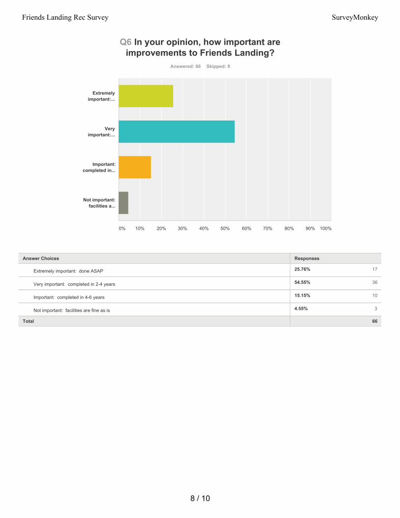
25.76% 17
54.55% 36
15.15% 10
4.55% 3
Q6 In your opinion, how important areimprovements to Friends Landing?
Answered: 66 Skipped: 9
Total 66
Extremelyimportant:...
Veryimportant:...
Important:completed in...
Not important:facilities a...
0% 10% 20% 30% 40% 50% 60% 70% 80% 90% 100%
Answer Choices Responses
Extremely important: done ASAP
Very important: completed in 2-4 years
Important: completed in 4-6 years
Not important: facilities are fine as is
8 / 10
Friends Landing Rec Survey SurveyMonkey
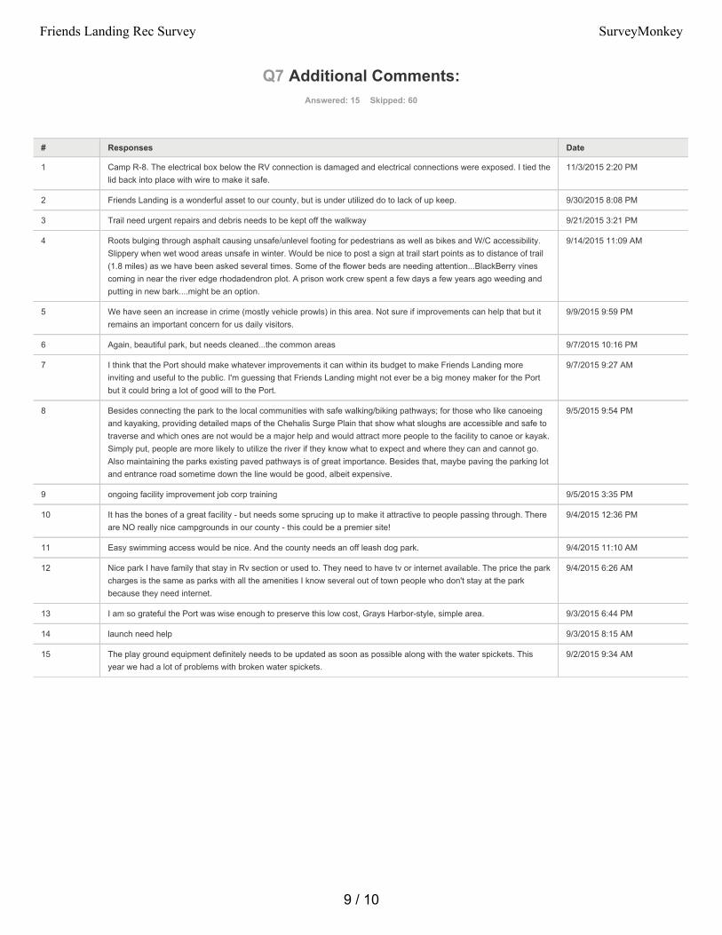
Q7 Additional Comments:Answered: 15 Skipped: 60
# Responses Date
1 Camp R-8. The electrical box below the RV connection is damaged and electrical connections were exposed. I tied thelid back into place with wire to make it safe.
11/3/2015 2:20 PM
2 Friends Landing is a wonderful asset to our county, but is under utilized do to lack of up keep. 9/30/2015 8:08 PM
3 Trail need urgent repairs and debris needs to be kept off the walkway 9/21/2015 3:21 PM
4 Roots bulging through asphalt causing unsafe/unlevel footing for pedestrians as well as bikes and W/C accessibility.Slippery when wet wood areas unsafe in winter. Would be nice to post a sign at trail start points as to distance of trail(1.8 miles) as we have been asked several times. Some of the flower beds are needing attention...BlackBerry vinescoming in near the river edge rhodadendron plot. A prison work crew spent a few days a few years ago weeding andputting in new bark....might be an option.
9/14/2015 11:09 AM
5 We have seen an increase in crime (mostly vehicle prowls) in this area. Not sure if improvements can help that but itremains an important concern for us daily visitors.
9/9/2015 9:59 PM
6 Again, beautiful park, but needs cleaned...the common areas 9/7/2015 10:16 PM
7 I think that the Port should make whatever improvements it can within its budget to make Friends Landing moreinviting and useful to the public. I'm guessing that Friends Landing might not ever be a big money maker for the Portbut it could bring a lot of good will to the Port.
9/7/2015 9:27 AM
8 Besides connecting the park to the local communities with safe walking/biking pathways; for those who like canoeingand kayaking, providing detailed maps of the Chehalis Surge Plain that show what sloughs are accessible and safe totraverse and which ones are not would be a major help and would attract more people to the facility to canoe or kayak.Simply put, people are more likely to utilize the river if they know what to expect and where they can and cannot go.Also maintaining the parks existing paved pathways is of great importance. Besides that, maybe paving the parking lotand entrance road sometime down the line would be good, albeit expensive.
9/5/2015 9:54 PM
9 ongoing facility improvement job corp training 9/5/2015 3:35 PM
10 It has the bones of a great facility - but needs some sprucing up to make it attractive to people passing through. Thereare NO really nice campgrounds in our county - this could be a premier site!
9/4/2015 12:36 PM
11 Easy swimming access would be nice. And the county needs an off leash dog park. 9/4/2015 11:10 AM
12 Nice park I have family that stay in Rv section or used to. They need to have tv or internet available. The price the parkcharges is the same as parks with all the amenities I know several out of town people who don't stay at the parkbecause they need internet.
9/4/2015 6:26 AM
13 I am so grateful the Port was wise enough to preserve this low cost, Grays Harbor-style, simple area. 9/3/2015 6:44 PM
14 launch need help 9/3/2015 8:15 AM
15 The play ground equipment definitely needs to be updated as soon as possible along with the water spickets. Thisyear we had a lot of problems with broken water spickets.
9/2/2015 9:34 AM
9 / 10
Friends Landing Rec Survey SurveyMonkey
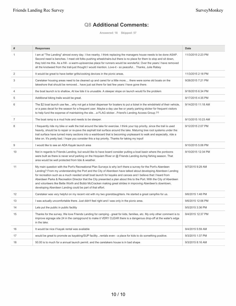
Q8 Additional Comments: Answered: 18 Skipped: 57
# Responses Date
1 I am at "The Landing" almost every day. I live nearby. I think replacing the managers house needs to be done ASAP.Second need is benches. I meet old folks pushing wheelchairs-but there is no place for them to stop and sit down,they told me this. As a frill - a warm-up/exercise place for runners would be wonderful. Over the years I have removedall the knotweed from the trail-just thought I would mention. Love-it - so peaceful... Thanks, Julie Rabey
11/3/2015 2:23 PM
2 It would be great to have better grills/cooking devices in the picnic areas. 11/3/2015 2:18 PM
3 Caretaker housing areas need to be cleaned up and cared for a little more.... there were some old boats on thelakeshore that should be removed... have just sat there for last few years I have gone there.
9/26/2015 7:21 PM
4 the boat launch is to shallow, At low tide it is unusable. A steeper slope on launch would fix the problem 9/18/2015 6:34 PM
5 Additional biking trails would be great. 9/17/2015 4:35 PM
6 The $2 boat launch use fee....why not get a ticket dispenser for boaters to put a ticket in the windshield of their vehicle,or a pass decal for the season for a frequent user. Maybe a day use fee or yearly parking sticker for frequent visitorsto help fund the expense of maintaining the site....a FLAG sticker...Friend's Landing Access Group.??
9/14/2015 11:18 AM
7 The boat ramp is a mud hole and needs to be steeper. 9/13/2015 10:23 AM
8 I frequently ride my bike or walk the trail around the lake for exercise. I think your top priority, since the trail is usedheavily, should be to repair or re-pave the asphalt trail surface around the lake. Maturing tree root systems under thetrail surface have turned many sections into a washboard that is becoming unpleasant to walk and especially, ride abike on. It's pretty bad. I hope you consider this a top priority. Thanks for taking my input!
9/12/2015 2:07 PM
9 I would like to see an ADA Kayak launch area 9/10/2015 5:06 PM
10 Not in regards to Friends Landing, but would like to have board consider putting a boat basin where the pontoonswere built as there is never enuf parking on the Hoquiam River or @ Friends Landing during fishing season. Thatarea would be well protected from tide & weather.
9/10/2015 12:34 PM
11 My main question with the Port's Recreational Plan Surveys is why isn't there a survey for the Port's AberdeenLanding? From my understanding the Port and the City of Aberdeen have talked about developing Aberdeen Landingfor recreation such as a much needed small boat launch for kayaks and canoes and I believe that I heard fromAberdeen Parks & Recreation Director that the City presented a plan about this to the Port. With the City of Aberdeenand volunteers like Bette Worth and Bobbi McCracken making great strides in improving Aberdeen's downtown,developing Aberdeen Landing could be part of that effort.
9/7/2015 9:29 AM
12 Caretaker was very helpful on my recent vist with my two granddaughters. He started a great campfire for us. 9/6/2015 1:48 PM
13 I was actually uncomfortable there. Just didn't feel right and I was only in the picnic area. 9/6/2015 12:06 PM
14 Lets put the public in public facility 9/5/2015 3:36 PM
15 Thanks for the survey. We love Friends Landing for camping - great for kids, families, etc. My only other comment is toimprove signage site 24 in the campground to make it VERY CLEAR there is a dangerous drop-off at the water's edgein the lake.
9/4/2015 12:37 PM
16 It would be nice if kayak rental was available 9/4/2015 5:59 AM
17 would be great to promote as kayaking/SUP facility...rentals even - a place for kids to do something positive. 9/3/2015 1:37 PM
18 50.00 is to much for a annual launch permit. and the caretakers house is in bad shape 9/3/2015 8:16 AM
10 / 10
Friends Landing Rec Survey SurveyMonkey
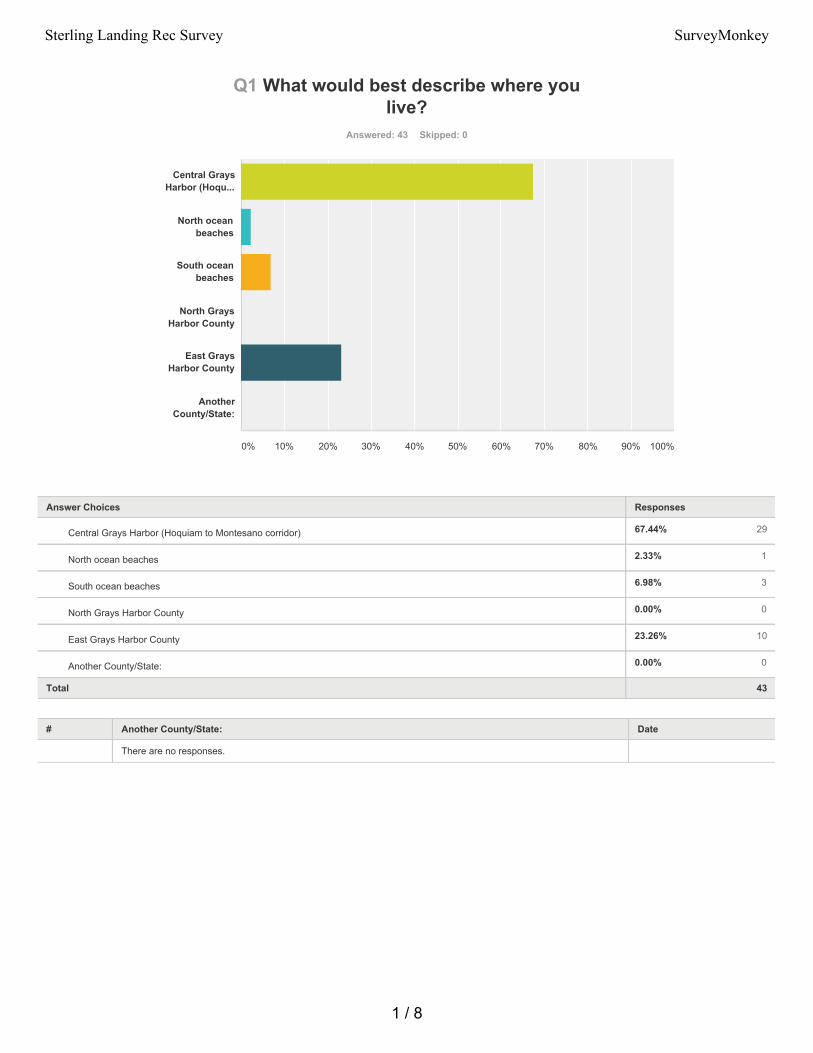
67.44% 29
2.33% 1
6.98% 3
0.00% 0
23.26% 10
0.00% 0
Q1 What would best describe where youlive?
Answered: 43 Skipped: 0
Total 43
# Another County/State: Date
There are no responses.
Central GraysHarbor (Hoqu...
North oceanbeaches
South oceanbeaches
North GraysHarbor County
East GraysHarbor County
AnotherCounty/State:
0% 10% 20% 30% 40% 50% 60% 70% 80% 90% 100%
Answer Choices Responses
Central Grays Harbor (Hoquiam to Montesano corridor)
North ocean beaches
South ocean beaches
North Grays Harbor County
East Grays Harbor County
Another County/State:
1 / 8
Sterling Landing Rec Survey SurveyMonkey
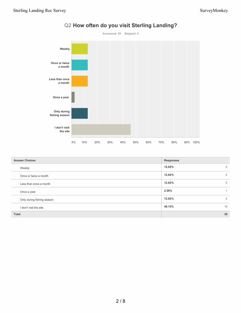
12.82% 5
12.82% 5
12.82% 5
2.56% 1
12.82% 5
46.15% 18
Q2 How often do you visit Sterling Landing?Answered: 39 Skipped: 4
Total 39
Weekly
Once or twicea month
Less than oncea month
Once a year
Only duringfishing season
I don't visitthe site
0% 10% 20% 30% 40% 50% 60% 70% 80% 90% 100%
Answer Choices Responses
Weekly
Once or twice a month
Less than once a month
Once a year
Only during fishing season
I don't visit the site
2 / 8
Sterling Landing Rec Survey SurveyMonkey
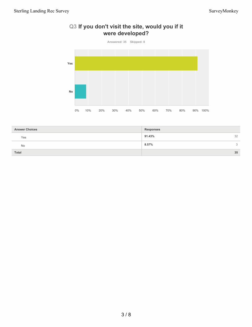
91.43% 32
8.57% 3
Q3 If you don't visit the site, would you if itwere developed?
Answered: 35 Skipped: 8
Total 35
Yes
No
0% 10% 20% 30% 40% 50% 60% 70% 80% 90% 100%
Answer Choices Responses
Yes
No
3 / 8
Sterling Landing Rec Survey SurveyMonkey
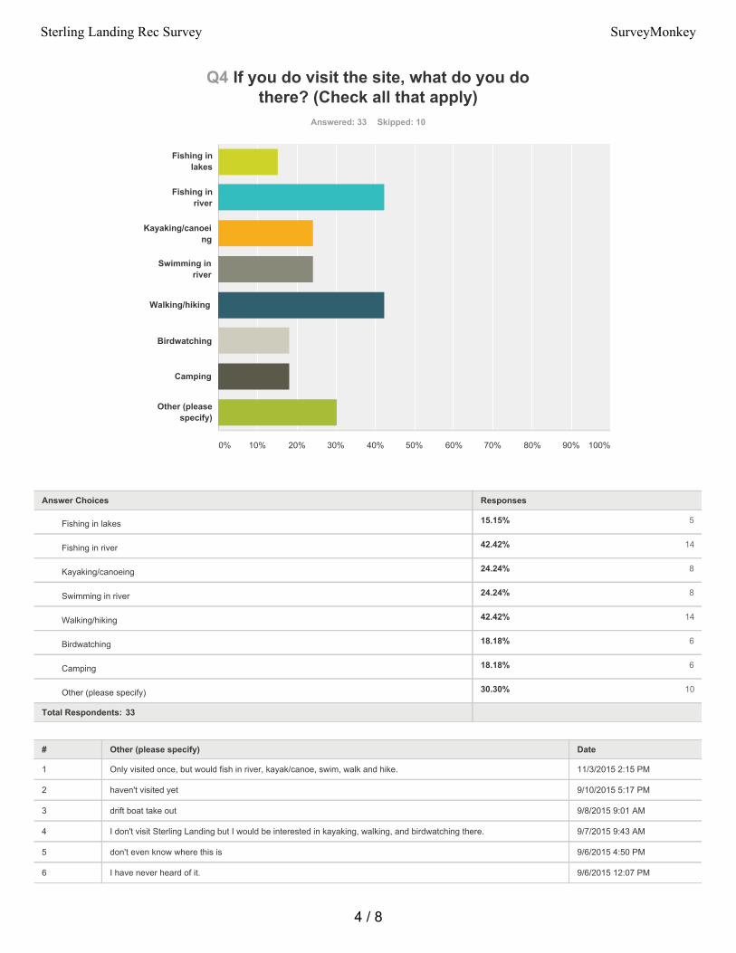
15.15% 5
42.42% 14
24.24% 8
24.24% 8
42.42% 14
18.18% 6
18.18% 6
30.30% 10
Q4 If you do visit the site, what do you dothere? (Check all that apply)
Answered: 33 Skipped: 10
Total Respondents: 33
# Other (please specify) Date
1 Only visited once, but would fish in river, kayak/canoe, swim, walk and hike. 11/3/2015 2:15 PM
2 haven't visited yet 9/10/2015 5:17 PM
3 drift boat take out 9/8/2015 9:01 AM
4 I don't visit Sterling Landing but I would be interested in kayaking, walking, and birdwatching there. 9/7/2015 9:43 AM
5 don't even know where this is 9/6/2015 4:50 PM
6 I have never heard of it. 9/6/2015 12:07 PM
Fishing inlakes
Fishing inriver
Kayaking/canoeing
Swimming inriver
Walking/hiking
Birdwatching
Camping
Other (pleasespecify)
0% 10% 20% 30% 40% 50% 60% 70% 80% 90% 100%
Answer Choices Responses
Fishing in lakes
Fishing in river
Kayaking/canoeing
Swimming in river
Walking/hiking
Birdwatching
Camping
Other (please specify)
4 / 8
Sterling Landing Rec Survey SurveyMonkey

7 Just enjoying being away from people and looking at trees and water. 9/3/2015 6:46 PM
8 Was in there today again just to see if it had changed. 9/2/2015 7:19 PM
9 Swimming, relaxing by lakes 9/2/2015 1:59 PM
10 Bbq 9/2/2015 8:28 AM
5 / 8
Sterling Landing Rec Survey SurveyMonkey
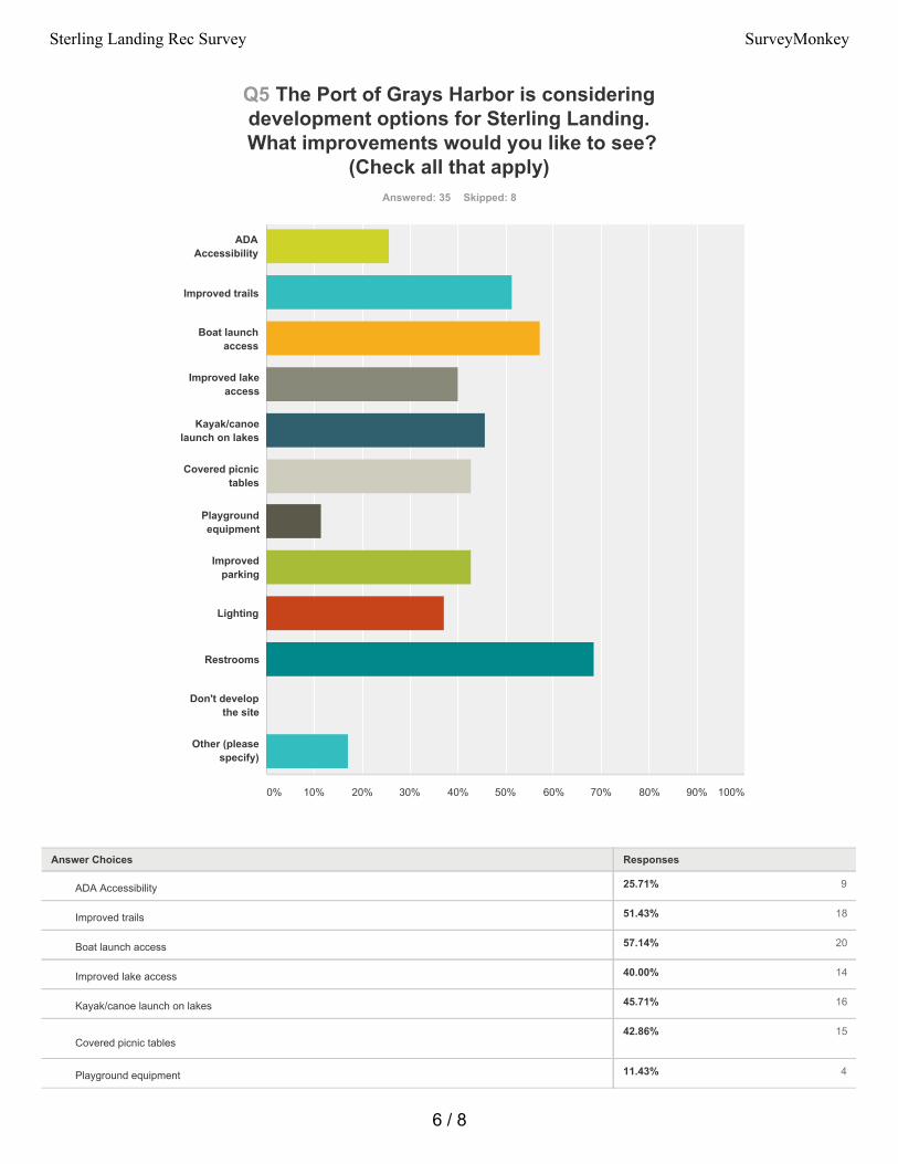
25.71% 9
51.43% 18
57.14% 20
40.00% 14
45.71% 16
42.86% 15
11.43% 4
Q5 The Port of Grays Harbor is consideringdevelopment options for Sterling Landing.
What improvements would you like to see?(Check all that apply)
Answered: 35 Skipped: 8
ADAAccessibility
Improved trails
Boat launchaccess
Improved lakeaccess
Kayak/canoelaunch on lakes
Covered picnictables
Playgroundequipment
Improvedparking
Lighting
Restrooms
Don't developthe site
Other (pleasespecify)
0% 10% 20% 30% 40% 50% 60% 70% 80% 90% 100%
Answer Choices Responses
ADA Accessibility
Improved trails
Boat launch access
Improved lake access
Kayak/canoe launch on lakes
Covered picnic tables
Playground equipment
6 / 8
Sterling Landing Rec Survey SurveyMonkey
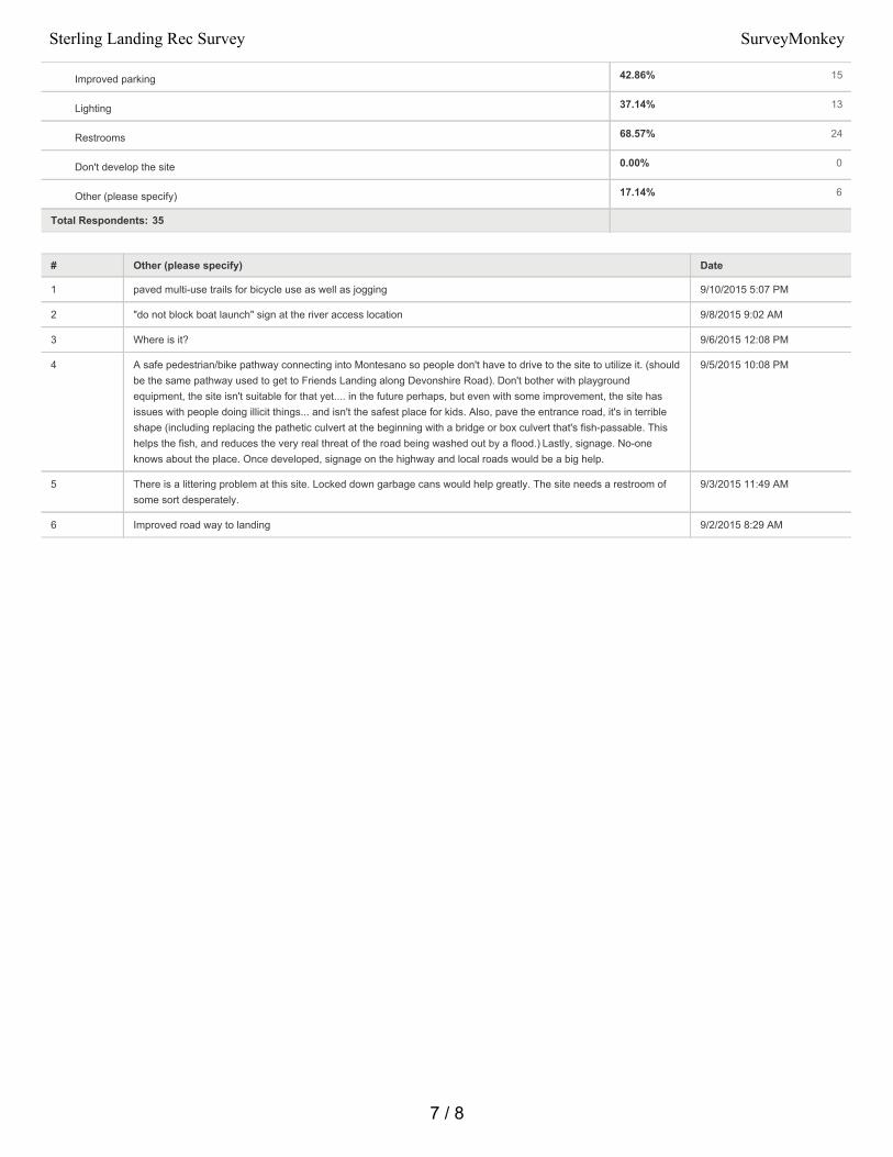
42.86% 15
37.14% 13
68.57% 24
0.00% 0
17.14% 6
Total Respondents: 35
# Other (please specify) Date
1 paved multi-use trails for bicycle use as well as jogging 9/10/2015 5:07 PM
2 "do not block boat launch" sign at the river access location 9/8/2015 9:02 AM
3 Where is it? 9/6/2015 12:08 PM
4 A safe pedestrian/bike pathway connecting into Montesano so people don't have to drive to the site to utilize it. (shouldbe the same pathway used to get to Friends Landing along Devonshire Road). Don't bother with playgroundequipment, the site isn't suitable for that yet.... in the future perhaps, but even with some improvement, the site hasissues with people doing illicit things... and isn't the safest place for kids. Also, pave the entrance road, it's in terribleshape (including replacing the pathetic culvert at the beginning with a bridge or box culvert that's fish-passable. Thishelps the fish, and reduces the very real threat of the road being washed out by a flood.) Lastly, signage. No-oneknows about the place. Once developed, signage on the highway and local roads would be a big help.
9/5/2015 10:08 PM
5 There is a littering problem at this site. Locked down garbage cans would help greatly. The site needs a restroom ofsome sort desperately.
9/3/2015 11:49 AM
6 Improved road way to landing 9/2/2015 8:29 AM
Improved parking
Lighting
Restrooms
Don't develop the site
Other (please specify)
7 / 8
Sterling Landing Rec Survey SurveyMonkey
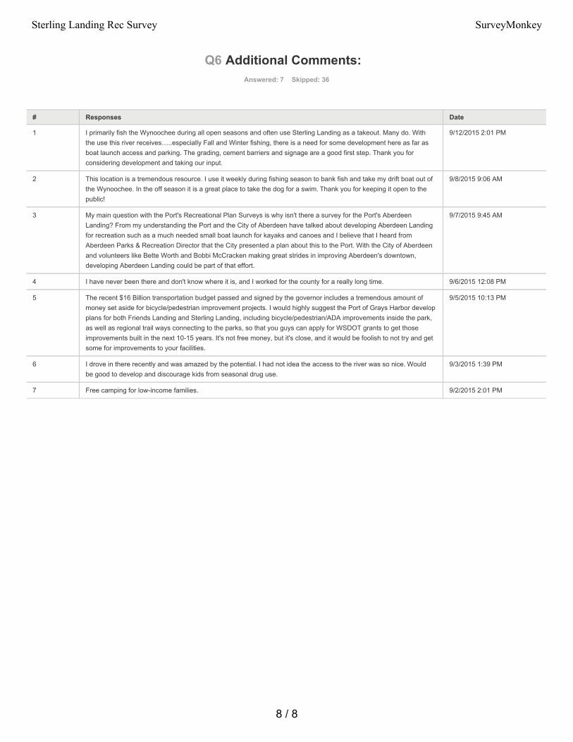
Q6 Additional Comments: Answered: 7 Skipped: 36
# Responses Date
1 I primarily fish the Wynoochee during all open seasons and often use Sterling Landing as a takeout. Many do. Withthe use this river receives…..especially Fall and Winter fishing, there is a need for some development here as far asboat launch access and parking. The grading, cement barriers and signage are a good first step. Thank you forconsidering development and taking our input.
9/12/2015 2:01 PM
2 This location is a tremendous resource. I use it weekly during fishing season to bank fish and take my drift boat out ofthe Wynoochee. In the off season it is a great place to take the dog for a swim. Thank you for keeping it open to thepublic!
9/8/2015 9:06 AM
3 My main question with the Port's Recreational Plan Surveys is why isn't there a survey for the Port's AberdeenLanding? From my understanding the Port and the City of Aberdeen have talked about developing Aberdeen Landingfor recreation such as a much needed small boat launch for kayaks and canoes and I believe that I heard fromAberdeen Parks & Recreation Director that the City presented a plan about this to the Port. With the City of Aberdeenand volunteers like Bette Worth and Bobbi McCracken making great strides in improving Aberdeen's downtown,developing Aberdeen Landing could be part of that effort.
9/7/2015 9:45 AM
4 I have never been there and don't know where it is, and I worked for the county for a really long time. 9/6/2015 12:08 PM
5 The recent $16 Billion transportation budget passed and signed by the governor includes a tremendous amount ofmoney set aside for bicycle/pedestrian improvement projects. I would highly suggest the Port of Grays Harbor developplans for both Friends Landing and Sterling Landing, including bicycle/pedestrian/ADA improvements inside the park,as well as regional trail ways connecting to the parks, so that you guys can apply for WSDOT grants to get thoseimprovements built in the next 10-15 years. It's not free money, but it's close, and it would be foolish to not try and getsome for improvements to your facilities.
9/5/2015 10:13 PM
6 I drove in there recently and was amazed by the potential. I had not idea the access to the river was so nice. Wouldbe good to develop and discourage kids from seasonal drug use.
9/3/2015 1:39 PM
7 Free camping for low-income families. 9/2/2015 2:01 PM
8 / 8
Sterling Landing Rec Survey SurveyMonkey
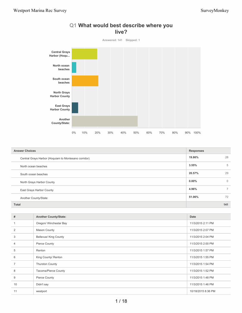
19.86% 28
3.55% 5
20.57% 29
0.00% 0
4.96% 7
51.06% 72
Q1 What would best describe where youlive?
Answered: 141 Skipped: 1
Total 141
# Another County/State: Date
1 Oregon/ Winchestar Bay 11/3/2015 2:11 PM
2 Mason County 11/3/2015 2:07 PM
3 Bellevue/ King County 11/3/2015 2:04 PM
4 Pierce County 11/3/2015 2:00 PM
5 Renton 11/3/2015 1:57 PM
6 King County/ Renton 11/3/2015 1:55 PM
7 Thurston County 11/3/2015 1:54 PM
8 Tacoma/Pierce County 11/3/2015 1:52 PM
9 Pierce County 11/3/2015 1:48 PM
10 Didn't say 11/3/2015 1:46 PM
11 westport 10/18/2015 8:36 PM
Central GraysHarbor (Hoqu...
North oceanbeaches
South oceanbeaches
North GraysHarbor County
East GraysHarbor County
AnotherCounty/State:
0% 10% 20% 30% 40% 50% 60% 70% 80% 90% 100%
Answer Choices Responses
Central Grays Harbor (Hoquiam to Montesano corridor)
North ocean beaches
South ocean beaches
North Grays Harbor County
East Grays Harbor County
Another County/State:
1 / 18
Westport Marina Rec Survey SurveyMonkey
12 snohomish county 9/30/2015 8:26 PM
13 Thurston, wa 9/24/2015 9:47 AM
14 Olympia 9/17/2015 8:07 AM
15 pierce co. 9/16/2015 8:34 AM
16 Pierce county 9/14/2015 8:38 AM
17 Pierce county 9/14/2015 8:25 AM
18 King 9/13/2015 8:13 PM
19 Snohomish 9/13/2015 5:24 PM
20 King 9/8/2015 1:11 PM
21 none 9/8/2015 11:05 AM
22 kirkland,Wa 9/7/2015 3:08 PM
23 Pierce County 9/7/2015 9:57 AM
24 wa 9/3/2015 6:51 PM
25 overton nevada 9/3/2015 8:05 AM
26 Montana 9/3/2015 7:44 AM
27 edmonds 9/3/2015 6:33 AM
28 pierce 9/3/2015 2:39 AM
29 King/WA 9/2/2015 7:56 PM
30 Gig harbor 9/2/2015 7:44 PM
31 Pierce 9/2/2015 7:27 PM
32 king 9/2/2015 6:30 PM
33 Puyallup 9/2/2015 6:14 PM
34 Pierce county 9/2/2015 4:34 PM
35 kitsap 9/2/2015 4:20 PM
36 King County 9/2/2015 4:12 PM
37 King County 9/2/2015 3:54 PM
38 Pierce county 9/2/2015 2:55 PM
39 pierce 9/2/2015 2:52 PM
40 Tacoma 9/2/2015 2:43 PM
41 King county 9/2/2015 1:43 PM
42 Thurston co 9/2/2015 1:30 PM
43 sumner wa 9/2/2015 1:18 PM
44 Marysville, WA 9/2/2015 12:55 PM
45 Tacoma 9/2/2015 12:32 PM
46 pierce 9/2/2015 12:20 PM
47 Kitsap 9/2/2015 11:36 AM
48 Sacramento, CA 9/2/2015 11:28 AM
49 Pierce county Washington 9/2/2015 10:21 AM
50 King 9/2/2015 10:20 AM
51 Pacific County 9/2/2015 10:15 AM
52 Snohomish county 9/2/2015 10:06 AM
2 / 18
Westport Marina Rec Survey SurveyMonkey
53 pierce 9/2/2015 10:03 AM
54 King County 9/2/2015 10:01 AM
55 Vancouver 9/2/2015 9:51 AM
56 Kitsap 9/2/2015 9:44 AM
57 Westport... 9/2/2015 9:32 AM
58 Pierce 9/2/2015 9:27 AM
59 Pierce county 9/2/2015 9:17 AM
60 Kitsap county 9/2/2015 9:14 AM
61 Snohomish 9/2/2015 9:06 AM
62 Thurston County 9/2/2015 8:51 AM
63 Gig Harbor 9/2/2015 8:45 AM
64 Pierce county 9/2/2015 8:44 AM
65 mason county 9/2/2015 8:31 AM
66 University Place WA 9/2/2015 8:29 AM
67 Port townsend 9/1/2015 10:19 PM
68 Tacoma 9/1/2015 7:23 PM
69 Chelan County 9/1/2015 6:05 PM
70 Snohomish county 9/1/2015 4:56 PM
71 pierce 9/1/2015 3:40 PM
72 King County 9/1/2015 3:34 PM
3 / 18
Westport Marina Rec Survey SurveyMonkey
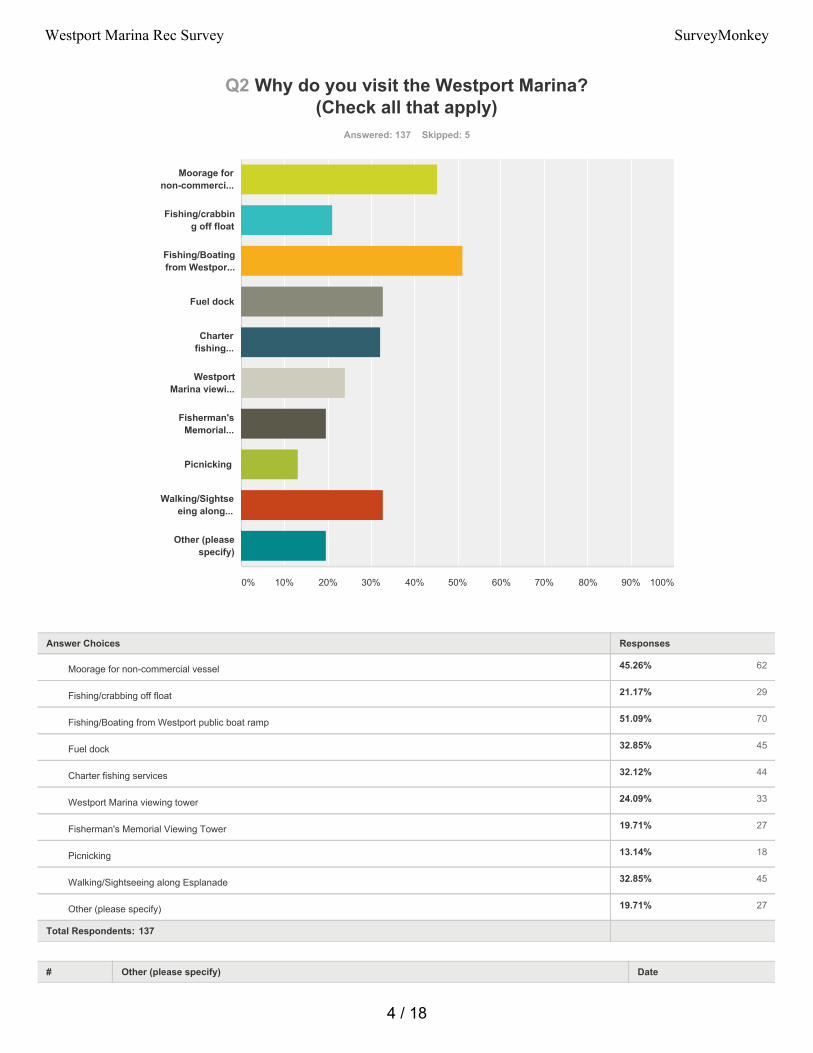
45.26% 62
21.17% 29
51.09% 70
32.85% 45
32.12% 44
24.09% 33
19.71% 27
13.14% 18
32.85% 45
19.71% 27
Q2 Why do you visit the Westport Marina?(Check all that apply)
Answered: 137 Skipped: 5
Total Respondents: 137
# Other (please specify) Date
Moorage fornon-commerci...
Fishing/crabbing off float
Fishing/Boatingfrom Westpor...
Fuel dock
Charterfishing...
WestportMarina viewi...
Fisherman'sMemorial...
Picnicking
Walking/Sightseeing along...
Other (pleasespecify)
0% 10% 20% 30% 40% 50% 60% 70% 80% 90% 100%
Answer Choices Responses
Moorage for non-commercial vessel
Fishing/crabbing off float
Fishing/Boating from Westport public boat ramp
Fuel dock
Charter fishing services
Westport Marina viewing tower
Fisherman's Memorial Viewing Tower
Picnicking
Walking/Sightseeing along Esplanade
Other (please specify)
4 / 18
Westport Marina Rec Survey SurveyMonkey
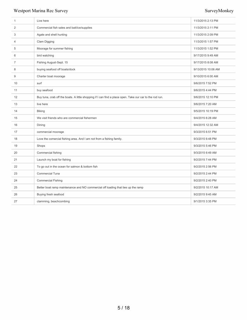
1 Live here 11/3/2015 2:13 PM
2 Commercial fish sales and bait/ice/supplies 11/3/2015 2:11 PM
3 Agate and shell hunting 11/3/2015 2:09 PM
4 Clam Digging 11/3/2015 1:57 PM
5 Moorage for summer fishing 11/3/2015 1:52 PM
6 bird watching 9/17/2015 9:49 AM
7 Fishing August-Sept. 15 9/17/2015 8:08 AM
8 buying seafood off boats/dock 9/13/2015 10:06 AM
9 Charter boat moorage 9/10/2015 6:00 AM
10 surf 9/6/2015 7:52 PM
11 buy seafood 9/6/2015 4:44 PM
12 Buy tuna, crab off the boats. A little shopping if I can find a place open. Take our car to the rod run. 9/6/2015 12:10 PM
13 live here 9/6/2015 7:20 AM
14 Biking 9/5/2015 10:19 PM
15 We visit friends who are commercial fishermen 9/4/2015 6:28 AM
16 Dining 9/4/2015 12:32 AM
17 commercial moorage 9/3/2015 6:51 PM
18 Love the comercial fishing area. And I am not from a fishing family. 9/3/2015 6:48 PM
19 Shops 9/3/2015 5:46 PM
20 Commercial fishing 9/3/2015 6:49 AM
21 Launch my boat for fishing 9/2/2015 7:44 PM
22 To go out in the ocean for salmon & bottom fish 9/2/2015 2:56 PM
23 Commercial Tuna 9/2/2015 2:44 PM
24 Commercial Fishing 9/2/2015 2:40 PM
25 Better boat ramp maintenance and NO commercial off loading that ties up the ramp 9/2/2015 10:17 AM
26 Buying fresh seafood 9/2/2015 9:45 AM
27 clamming, beachcombing 9/1/2015 3:35 PM
5 / 18
Westport Marina Rec Survey SurveyMonkey
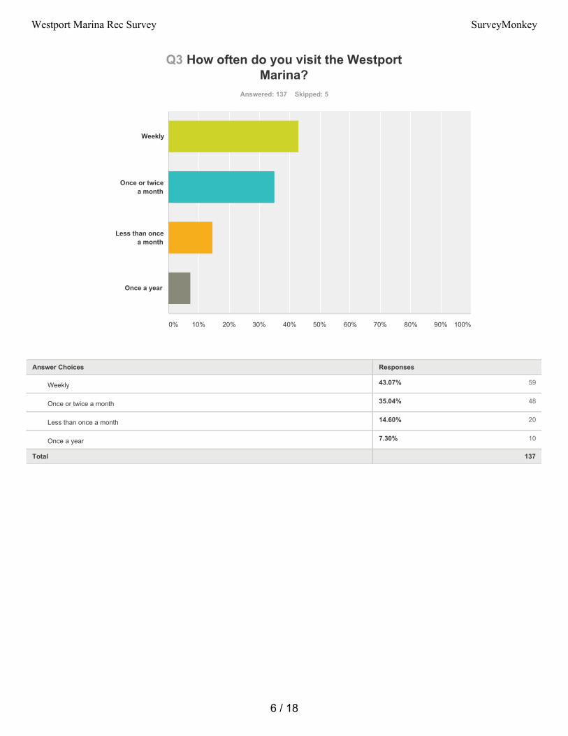
43.07% 59
35.04% 48
14.60% 20
7.30% 10
Q3 How often do you visit the WestportMarina?
Answered: 137 Skipped: 5
Total 137
Weekly
Once or twicea month
Less than oncea month
Once a year
0% 10% 20% 30% 40% 50% 60% 70% 80% 90% 100%
Answer Choices Responses
Weekly
Once or twice a month
Less than once a month
Once a year
6 / 18
Westport Marina Rec Survey SurveyMonkey
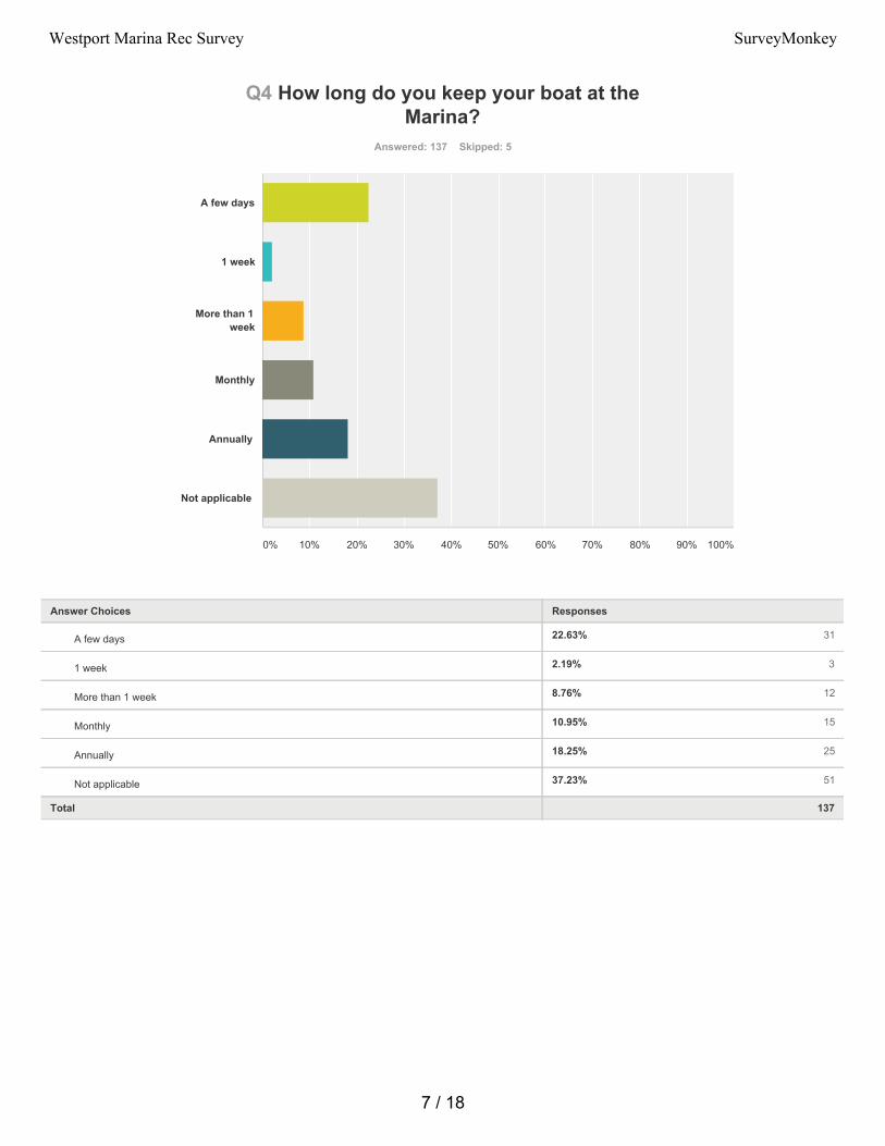
22.63% 31
2.19% 3
8.76% 12
10.95% 15
18.25% 25
37.23% 51
Q4 How long do you keep your boat at theMarina?
Answered: 137 Skipped: 5
Total 137
A few days
1 week
More than 1week
Monthly
Annually
Not applicable
0% 10% 20% 30% 40% 50% 60% 70% 80% 90% 100%
Answer Choices Responses
A few days
1 week
More than 1 week
Monthly
Annually
Not applicable
7 / 18
Westport Marina Rec Survey SurveyMonkey
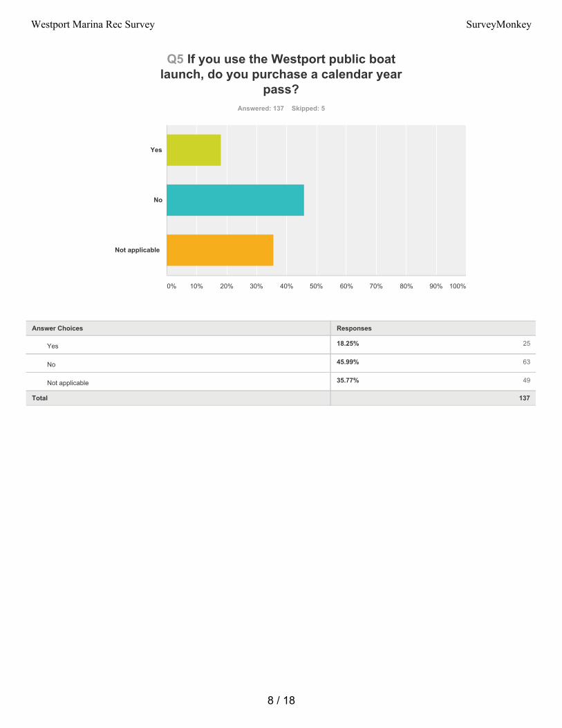
18.25% 25
45.99% 63
35.77% 49
Q5 If you use the Westport public boatlaunch, do you purchase a calendar year
pass?Answered: 137 Skipped: 5
Total 137
Yes
No
Not applicable
0% 10% 20% 30% 40% 50% 60% 70% 80% 90% 100%
Answer Choices Responses
Yes
No
Not applicable
8 / 18
Westport Marina Rec Survey SurveyMonkey
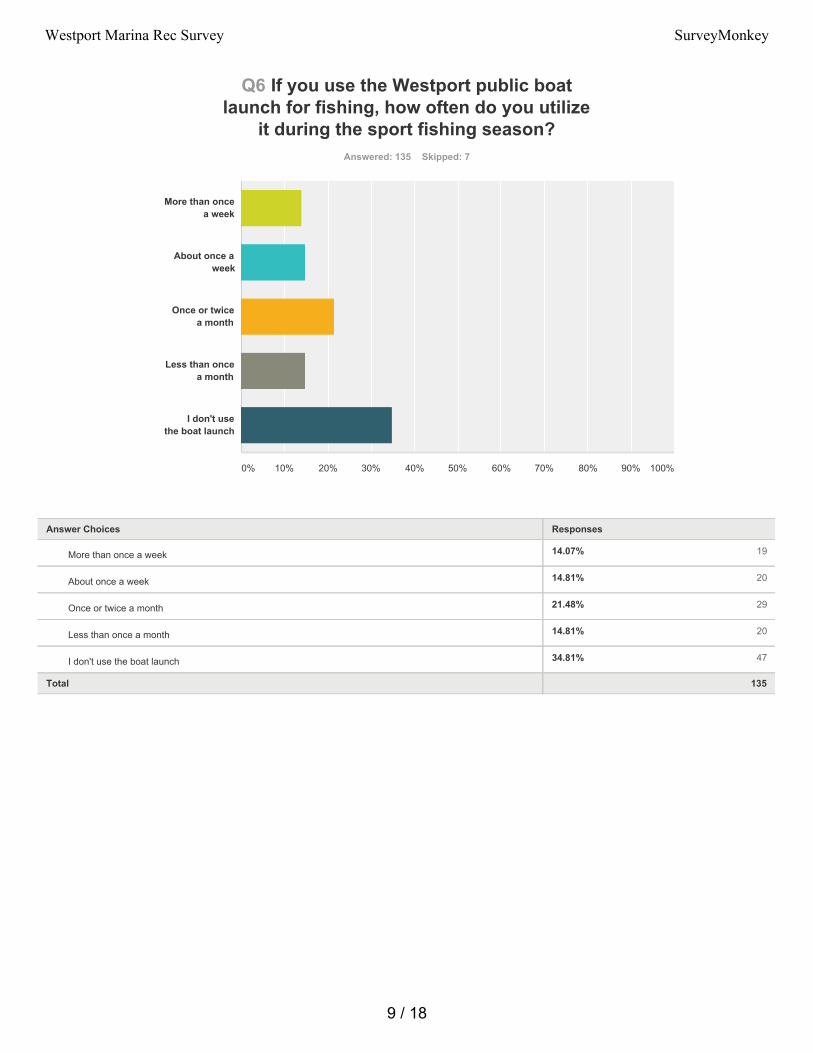
14.07% 19
14.81% 20
21.48% 29
14.81% 20
34.81% 47
Q6 If you use the Westport public boatlaunch for fishing, how often do you utilize
it during the sport fishing season?Answered: 135 Skipped: 7
Total 135
More than oncea week
About once aweek
Once or twicea month
Less than oncea month
I don't usethe boat launch
0% 10% 20% 30% 40% 50% 60% 70% 80% 90% 100%
Answer Choices Responses
More than once a week
About once a week
Once or twice a month
Less than once a month
I don't use the boat launch
9 / 18
Westport Marina Rec Survey SurveyMonkey
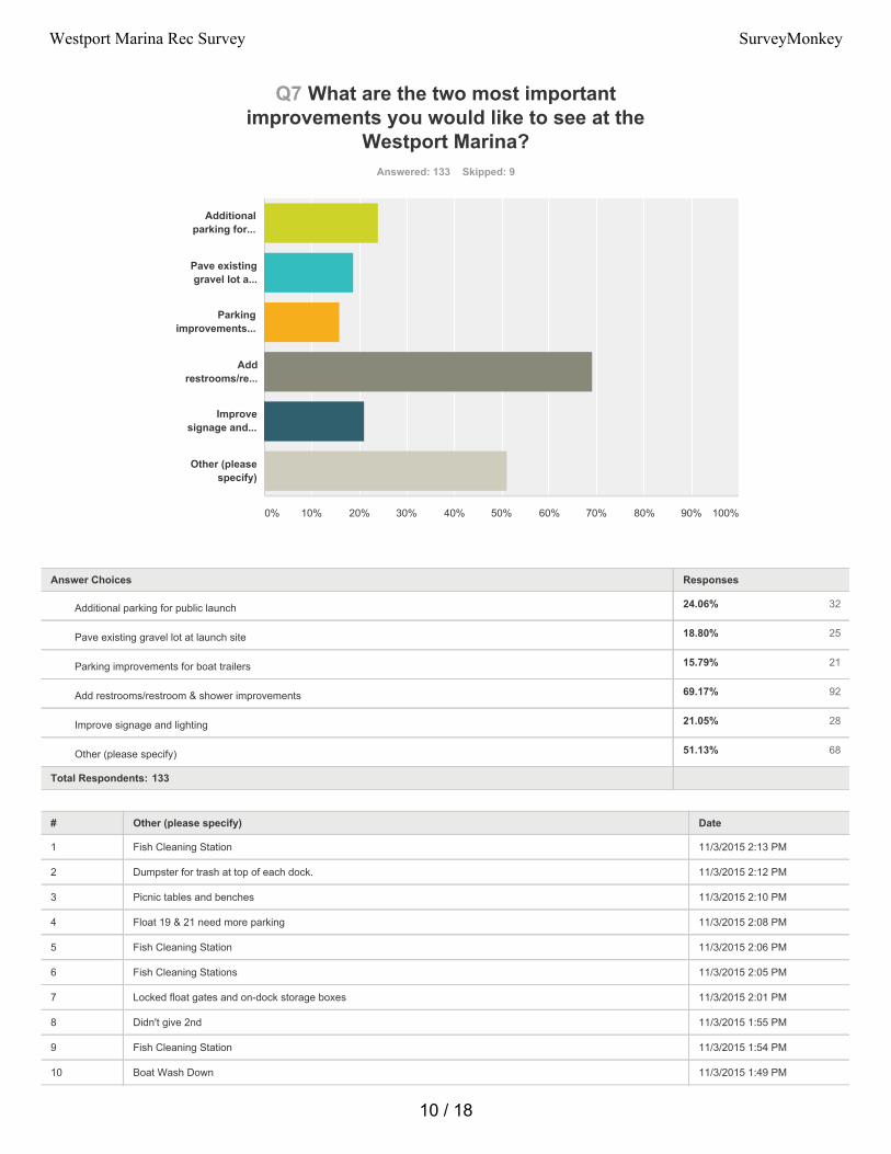
24.06% 32
18.80% 25
15.79% 21
69.17% 92
21.05% 28
51.13% 68
Q7 What are the two most importantimprovements you would like to see at the
Westport Marina?Answered: 133 Skipped: 9
Total Respondents: 133
# Other (please specify) Date
1 Fish Cleaning Station 11/3/2015 2:13 PM
2 Dumpster for trash at top of each dock. 11/3/2015 2:12 PM
3 Picnic tables and benches 11/3/2015 2:10 PM
4 Float 19 & 21 need more parking 11/3/2015 2:08 PM
5 Fish Cleaning Station 11/3/2015 2:06 PM
6 Fish Cleaning Stations 11/3/2015 2:05 PM
7 Locked float gates and on-dock storage boxes 11/3/2015 2:01 PM
8 Didn't give 2nd 11/3/2015 1:55 PM
9 Fish Cleaning Station 11/3/2015 1:54 PM
10 Boat Wash Down 11/3/2015 1:49 PM
Additionalparking for...
Pave existinggravel lot a...
Parkingimprovements...
Addrestrooms/re...
Improvesignage and...
Other (pleasespecify)
0% 10% 20% 30% 40% 50% 60% 70% 80% 90% 100%
Answer Choices Responses
Additional parking for public launch
Pave existing gravel lot at launch site
Parking improvements for boat trailers
Add restrooms/restroom & shower improvements
Improve signage and lighting
Other (please specify)
10 / 18
Westport Marina Rec Survey SurveyMonkey
11 Washdown station added 9/30/2015 8:29 PM
12 Maintenance on docks and rails. 9/23/2015 7:22 AM
13 Have handicapped access to public fishing dock. 9/17/2015 4:39 PM
14 improvements in the inner harbor and additional boat launches around Aberdeen/Hoquiam - the boat launch inHoquiam has dismal parking & needs to be improved - we do not have adequate facilities for recreation or tourism!
9/17/2015 9:54 AM
15 Easier moorage reservation process. 9/17/2015 8:14 AM
16 Nothing is a bigger tune-off to visiting the area than rundown, trash filled properties across from the Port facilities. Yes,this should not be the Port's problem. The truth is that these rundown properties reflect badly on all interests, bothpublic and private in the area. Here is a start: 1. Work with the City Of Westport, Chamber-of-Commerce andvolunteers to at least minimally maintain currently unused properties along Westhaven Drive. 2. Abandoned or longunused properties should be cleaned up and turned into pedestrian rest areas with painted benches with local themes.The windows of these buildings that face the street.should be filled with tourist information and long historic posters.These items are actually on the inside and face outward.
9/15/2015 7:38 PM
17 Fish cleaning stations with ability to remove the fish remains out of the harbor. 9/15/2015 9:06 AM
18 More handy capped parking while on charter boat fishing 9/14/2015 8:41 AM
19 Boat wash down area 9/13/2015 5:26 PM
20 Boatyard/Haul out Clean/improve/maintain current floats and ramps....they are all in very bad shape, weeds growing,wood rotten, cement lifting or broken, some are not safe
9/13/2015 10:09 AM
21 A haul out facility and a public hoist. 9/9/2015 7:14 PM
22 annual float wifi 9/8/2015 11:07 AM
23 Gas dock open 7 days a week & open earlier and later Locked access to morage docks 9/8/2015 4:04 AM
24 Fuel dock open on Sundays and longer hrs 9/7/2015 3:12 PM
25 I think that the Port should make whatever improvements it can within its budget to make Westport Marina moreinviting and useful to the public. I think that the good will that Westport Marina brings to the Port is important.
9/7/2015 9:52 AM
26 Boat haul out facilities 9/7/2015 9:05 AM
27 A real fish dinner restaurant 9/6/2015 7:55 PM
28 repair docks do something about sea lions - maybe make a place just for them so they don't get on the docks 9/6/2015 4:48 PM
29 Back to the restrooms.......... They're horrible! Dirty, nasty, dark. 9/6/2015 12:12 PM
30 maybe installing float lane mirrors (fish eye's) to help backing down at low tides. 9/6/2015 11:58 AM
31 Improved and safer access to the Fisherman's Boardwalk. ADA accessible sidewalks along Neddie Rose Drive wouldbe a fantastic start. The boardwalk itself is looking pretty sketchy, showing its age, and is unfortunately not compliant tocurrent ADA codes which require a 1:12 ratio for ramps no longer than 30 ft. At least not compliant for all tidalvariations.
9/5/2015 10:32 PM
32 your restroom facilities are terriable at the boat launch, two sani-cans, are u kidding me. port of willapa just built apermanent restroom at the boatlaunch, plus they have 4 sanicans, you guys need to get on the ball. you need apermanent restroom where the fisherman get there parking pass or at least 4-5 sanicans. I know theres a permanentrestroom about 100 yards from boat launch, but nobody knows about it. when your in line to launch u can't go that faraway or u hold up other boats.
9/5/2015 7:40 PM
33 Off leash dog park 9/4/2015 11:13 AM
34 I would first thing clean the restrooms that are there. They are gross! Also just a general cleaning of the area. Getsomeone in a small skiff and pick garbage up out of the water. You can evwn use nets to clean water around thedocks. I realize it would be almost a full time job but people will not return if its gross and it is gross!
9/4/2015 6:32 AM
35 Fix up the excisting bathrooms at the Fishermans Memorial...Definately needs improvements. There also needs to begood RESTROOM/SHOWER HOUSE at the boat launch area as well. Boaters and fishermen need clean showersafter they been on boats. COIN OPERATED Laundry area too....
9/3/2015 10:11 PM
36 New office staff/manager 9/3/2015 6:53 PM
37 While it does not apply to me I too often see folks in need of a dog area. They really don't want to have their dogs usepublic places as a potty area but don't know what to do.
9/3/2015 6:50 PM
11 / 18
Westport Marina Rec Survey SurveyMonkey
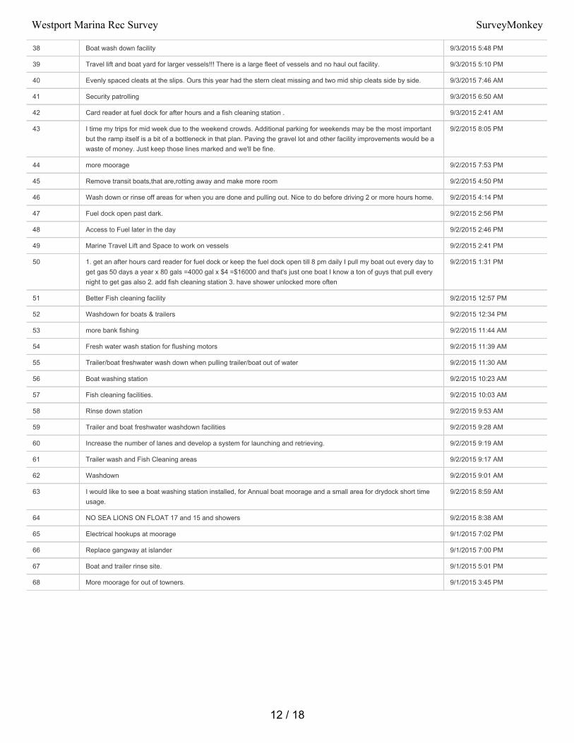
38 Boat wash down facility 9/3/2015 5:48 PM
39 Travel lift and boat yard for larger vessels!!! There is a large fleet of vessels and no haul out facility. 9/3/2015 5:10 PM
40 Evenly spaced cleats at the slips. Ours this year had the stern cleat missing and two mid ship cleats side by side. 9/3/2015 7:46 AM
41 Security patrolling 9/3/2015 6:50 AM
42 Card reader at fuel dock for after hours and a fish cleaning station . 9/3/2015 2:41 AM
43 I time my trips for mid week due to the weekend crowds. Additional parking for weekends may be the most importantbut the ramp itself is a bit of a bottleneck in that plan. Paving the gravel lot and other facility improvements would be awaste of money. Just keep those lines marked and we'll be fine.
9/2/2015 8:05 PM
44 more moorage 9/2/2015 7:53 PM
45 Remove transit boats,that are,rotting away and make more room 9/2/2015 4:50 PM
46 Wash down or rinse off areas for when you are done and pulling out. Nice to do before driving 2 or more hours home. 9/2/2015 4:14 PM
47 Fuel dock open past dark. 9/2/2015 2:56 PM
48 Access to Fuel later in the day 9/2/2015 2:46 PM
49 Marine Travel Lift and Space to work on vessels 9/2/2015 2:41 PM
50 1. get an after hours card reader for fuel dock or keep the fuel dock open till 8 pm daily I pull my boat out every day toget gas 50 days a year x 80 gals =4000 gal x $4 =$16000 and that's just one boat I know a ton of guys that pull everynight to get gas also 2. add fish cleaning station 3. have shower unlocked more often
9/2/2015 1:31 PM
51 Better Fish cleaning facility 9/2/2015 12:57 PM
52 Washdown for boats & trailers 9/2/2015 12:34 PM
53 more bank fishing 9/2/2015 11:44 AM
54 Fresh water wash station for flushing motors 9/2/2015 11:39 AM
55 Trailer/boat freshwater wash down when pulling trailer/boat out of water 9/2/2015 11:30 AM
56 Boat washing station 9/2/2015 10:23 AM
57 Fish cleaning facilities. 9/2/2015 10:03 AM
58 Rinse down station 9/2/2015 9:53 AM
59 Trailer and boat freshwater washdown facilities 9/2/2015 9:28 AM
60 Increase the number of lanes and develop a system for launching and retrieving. 9/2/2015 9:19 AM
61 Trailer wash and Fish Cleaning areas 9/2/2015 9:17 AM
62 Washdown 9/2/2015 9:01 AM
63 I would like to see a boat washing station installed, for Annual boat moorage and a small area for drydock short timeusage.
9/2/2015 8:59 AM
64 NO SEA LIONS ON FLOAT 17 and 15 and showers 9/2/2015 8:38 AM
65 Electrical hookups at moorage 9/1/2015 7:02 PM
66 Replace gangway at islander 9/1/2015 7:00 PM
67 Boat and trailer rinse site. 9/1/2015 5:01 PM
68 More moorage for out of towners. 9/1/2015 3:45 PM
12 / 18
Westport Marina Rec Survey SurveyMonkey
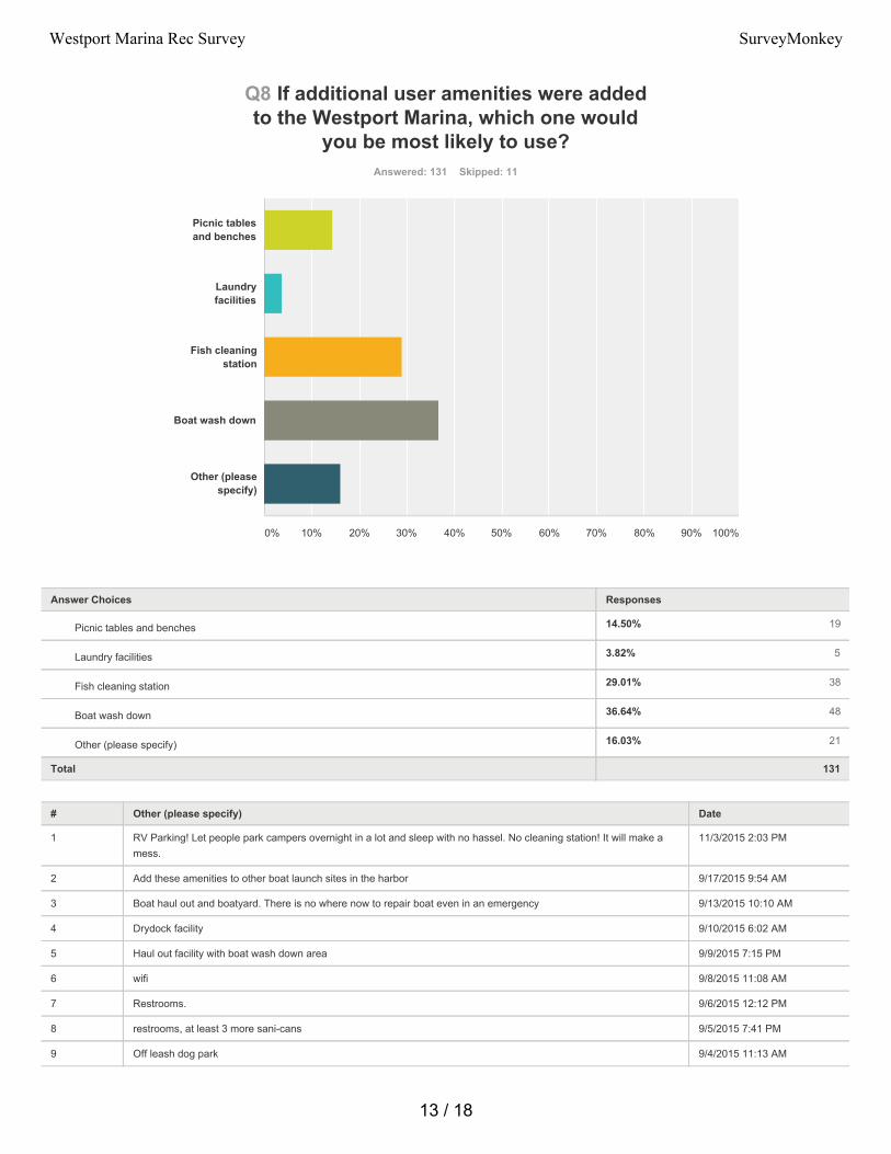
14.50% 19
3.82% 5
29.01% 38
36.64% 48
16.03% 21
Q8 If additional user amenities were addedto the Westport Marina, which one would
you be most likely to use?Answered: 131 Skipped: 11
Total 131
# Other (please specify) Date
1 RV Parking! Let people park campers overnight in a lot and sleep with no hassel. No cleaning station! It will make amess.
11/3/2015 2:03 PM
2 Add these amenities to other boat launch sites in the harbor 9/17/2015 9:54 AM
3 Boat haul out and boatyard. There is no where now to repair boat even in an emergency 9/13/2015 10:10 AM
4 Drydock facility 9/10/2015 6:02 AM
5 Haul out facility with boat wash down area 9/9/2015 7:15 PM
6 wifi 9/8/2015 11:08 AM
7 Restrooms. 9/6/2015 12:12 PM
8 restrooms, at least 3 more sani-cans 9/5/2015 7:41 PM
9 Off leash dog park 9/4/2015 11:13 AM
Picnic tablesand benches
Laundryfacilities
Fish cleaningstation
Boat wash down
Other (pleasespecify)
0% 10% 20% 30% 40% 50% 60% 70% 80% 90% 100%
Answer Choices Responses
Picnic tables and benches
Laundry facilities
Fish cleaning station
Boat wash down
Other (please specify)
13 / 18
Westport Marina Rec Survey SurveyMonkey
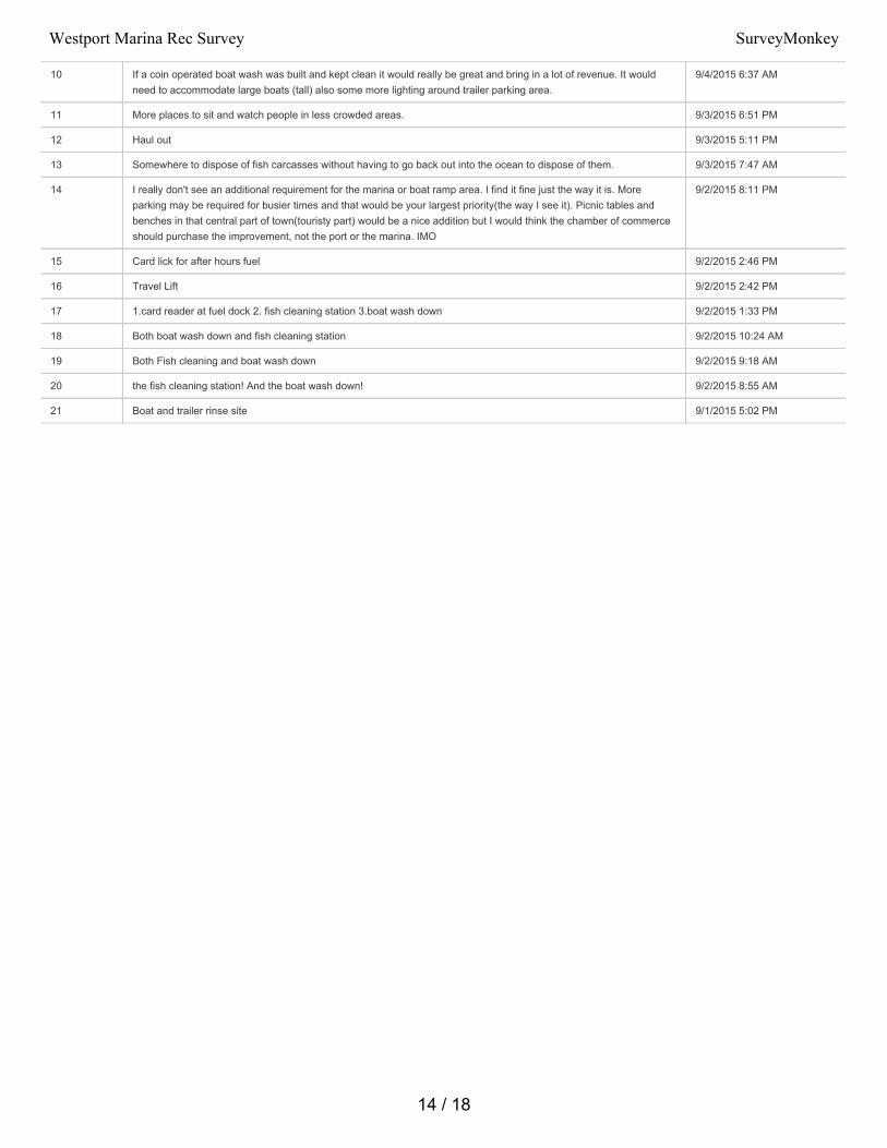
10 If a coin operated boat wash was built and kept clean it would really be great and bring in a lot of revenue. It wouldneed to accommodate large boats (tall) also some more lighting around trailer parking area.
9/4/2015 6:37 AM
11 More places to sit and watch people in less crowded areas. 9/3/2015 6:51 PM
12 Haul out 9/3/2015 5:11 PM
13 Somewhere to dispose of fish carcasses without having to go back out into the ocean to dispose of them. 9/3/2015 7:47 AM
14 I really don't see an additional requirement for the marina or boat ramp area. I find it fine just the way it is. Moreparking may be required for busier times and that would be your largest priority(the way I see it). Picnic tables andbenches in that central part of town(touristy part) would be a nice addition but I would think the chamber of commerceshould purchase the improvement, not the port or the marina. IMO
9/2/2015 8:11 PM
15 Card lick for after hours fuel 9/2/2015 2:46 PM
16 Travel Lift 9/2/2015 2:42 PM
17 1.card reader at fuel dock 2. fish cleaning station 3.boat wash down 9/2/2015 1:33 PM
18 Both boat wash down and fish cleaning station 9/2/2015 10:24 AM
19 Both Fish cleaning and boat wash down 9/2/2015 9:18 AM
20 the fish cleaning station! And the boat wash down! 9/2/2015 8:55 AM
21 Boat and trailer rinse site 9/1/2015 5:02 PM
14 / 18
Westport Marina Rec Survey SurveyMonkey
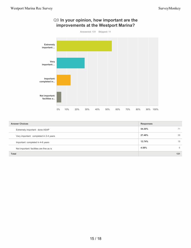
54.20% 71
27.48% 36
13.74% 18
4.58% 6
Q9 In your opinion, how important are theimprovements at the Westport Marina?
Answered: 131 Skipped: 11
Total 131
Extremelyimportant:...
Veryimportant:...
Important:completed in...
Not important:facilities a...
0% 10% 20% 30% 40% 50% 60% 70% 80% 90% 100%
Answer Choices Responses
Extremely important: done ASAP
Very important: completed in 2-4 years
Important: completed in 4-6 years
Not important: facilities are fine as is
15 / 18
Westport Marina Rec Survey SurveyMonkey
Q10 Additional Comments:Answered: 55 Skipped: 87
# Responses Date
1 Would also like laundry facilities and a haul out. Marina staff is extremely helpful and professional. 11/3/2015 2:14 PM
2 Great facility, would also like picnic tables and benches. 11/3/2015 2:12 PM
3 More shops! 11/3/2015 2:10 PM
4 Control of sea lions 11/3/2015 2:09 PM
5 Some parking spaces fro slip renters down where the ramp area is because we get a lot of boat company parking inour slip area.
11/3/2015 2:06 PM
6 Sell a parking pass so people can sleep in a truck or RV overnight before/after fishing. We don't need hookups, just aspot to be left alone with no "check out" time so there is no rush to get back to the dock.
11/3/2015 2:04 PM
7 Also would like parking improvements for boat trailers and a longer dock for launching. As a sport fisherman weappreciate your interest in knowing our needs to make our fishing experience better and safer. All fo the questionsasked are so important to us. The better the marina is the more revenue will come into the community. Thank you.
11/3/2015 2:00 PM
8 More public moorage. Please!!! 11/3/2015 1:56 PM
9 Electronic launch fee machine that takes credit cards. Thank you for your consideration. Westport is a world classfishing destination and the boat launch should reflect that.
11/3/2015 1:50 PM
10 Need fresh water hose to rinse salt water off trailer breaks. 11/3/2015 1:47 PM
11 When towing the boat home, its best to wash the saltwater out of the trailer brakes to make them last longer. 9/30/2015 8:32 PM
12 Stricter enforcement of anglers snagging fish. And charters dumping fish bodies into water. 9/23/2015 7:24 AM
13 why did the port abandon boat launches for the public, for example, where Tall Ships used to be located? 9/17/2015 9:55 AM
14 I enjoy the facilities as provided, yet I'm only using the facilities during peak season Aug.-Sept. 15. Also, the marinastaff are excellent public servants.
9/17/2015 8:18 AM
15 important to verbally let people who rent slips for either the summer or annually know they are required to give 24hrnotice before allowing friends to tie in there slips we had a problem this summer because my elderly friend rented aslip for the year and I brought my boat down and took him fishing and received a bill for moorage, he had noknowledge of the 24 hr rule
9/16/2015 8:41 AM
16 This is not just about the Port, bringing people to Port facilities, and keeping them coming back is a team effort about amutual interest. Nurture that understanding with the City of Westport, The Chamber and even individual localbusinesses.
9/15/2015 7:43 PM
17 We love wesport charter services.Updates on fishing are sometimes not current & while posting messages somecharter services never ever answer our comments but westport is the place to be..
9/14/2015 8:54 AM
18 Please do not let another 10 years go by with yet another survey and plan without actually building the boat haul outand boat yard. Keep in mind this is a working port and provides a lot of jobs. Support the jobs, boats and workingmarina with a boat haul out and boat yard before spending money on recreational upgrades.
9/13/2015 10:13 AM
19 The marina is packed all summer long, and it is also quite busy with commercial fishing all year long. The Port needsto invest in improving the infrastructure for its users. A haul out facility is greatly needed and would bring jobs to thearea. Marina users should not have to leave the area to work on their vessels, especially when the parts that areneeded are available in Westport. Shower and bathroom facilities need to be improved. The facilities in Westport arehorrible compared with other ports. Also, the railings along the promenade are in need of repair. There should also bepower to end of Float 21, and there are many pilings that need to be replaced.
9/9/2015 7:26 PM
20 wifi 9/8/2015 11:08 AM
21 It would be great to have the gas docks open earlier and later 7 days a week during the busy season. As well asnotices in each docking area for bar closure/restrictions, fishing rule changes and emergency notices
9/8/2015 4:08 AM
22 the women's restroom by the public launch is very unclean and has no locks on the stall doors or soap to wash yourhands. It is unsanitary and icky.
9/7/2015 10:03 AM
16 / 18
Westport Marina Rec Survey SurveyMonkey
23 My main question with the Port's Recreational Plan Surveys is why isn't there a survey for the Port's AberdeenLanding? From my understanding the Port and the City of Aberdeen have talked about developing Aberdeen Landingfor recreation such as a much needed small boat launch for kayaks and canoes and I believe that I heard fromAberdeen Parks & Recreation Director that the City presented a plan about this to the Port. With the City of Aberdeenand volunteers like Bette Worth and Bobbi McCracken making great strides in improving Aberdeen's downtown,developing Aberdeen Landing could be part of that effort.
9/7/2015 9:52 AM
24 Being the Mother of a commercial fisherman I know that a haul out facility would be most welcomed, and as a localresident who appreciates our Harbor...more tourist ammenities...picnic tables, restrooms, and general dock clean upwould be appreciated.
9/7/2015 9:07 AM
25 Westport is a destination fishery bringing people from all over the state and beyond. An upgrade to the facilities -paved parking lot, fish cleaning station, washdown area would be appreciated. I would be willing to pay more to usethe facility.
9/6/2015 12:28 PM
26 I do believe that the rate for locals is too high. We already pay taxes to the port and there for should get some kind ofbrake on day and monthly rates.
9/6/2015 12:01 PM
27 Mooring for people that launch their boats to load and off load. 9/6/2015 11:53 AM
28 Parking is a big problem near the museum. The commercial fishermen need to have a designated parking area forthem. They leave their vehicles for several days and that prevents others from using the spaces. They also need apick up and drop off area to get things to their boats but they should have it limited for parking. There is a field near atthe end of the road near the museum which I believe the port owns. Can that be used for fisherman parking?
9/6/2015 7:28 AM
29 We really enjoy going to Westport but it is hard to enjoy when there is so much garbage around the water. I couldn'tsay for sure but I don't believe the bathrooms down by the boat launch have changed for at least 20 years andgenerally are out of toilet paper I have never seen soap either.
9/4/2015 6:42 AM
30 Public Toilets need fixing ASAP...Then boatlaunch facilities for fisherman and public. 9/3/2015 10:15 PM
31 needs to be better security, 9/3/2015 6:53 PM
32 I wish I didn't have to use a whole day to visit the Port facility. wish some consideration would be given to a few simplesites on the North Beach area.
9/3/2015 6:52 PM
33 Great marina, great services. No complaints. Just the fish carcass disposal request - somewhere to put them insteadof having to go back out to dispose of them.
9/3/2015 7:49 AM
34 I feel like in there is a lot of theft every year in the marina, I understand the Westport pd is aware and I know the porthas added lighting and such as a boat owner this is one thing I want at the top of the lost. Also I think the sea lions area serious threat to the recreation at Westport marina. Each year they kill a dog or two, it's only a matter of time beforesomebody's child is attacked while viewing them on vacation. An accident like that could devastate our tourismindustry
9/3/2015 6:56 AM
35 Thanks Robin for all of your hard work! Safety Nap Mark in the ramp parking lot. :) 9/2/2015 8:12 PM
36 something needs to be done about the grass at the launch. It floats and gets all over the trailers. WDFW cut spartinaand it ends up in the launch. Very big pain in the butt getting it of the trailer
9/2/2015 7:55 PM
37 I am considering doing most of my summer fishing out of Westport, where I predominantly use Chinook/Illwaco now.Would like to be able to clean fish and rinse trailer down at launch
9/2/2015 7:47 PM
38 Thank you for taking the time to listen to your customers 9/2/2015 4:37 PM
39 Westport is a great family tradition and one of the best places in the country to travel to. 9/2/2015 4:16 PM
40 Will continue to use facilities regardless of improvements. I appreciate the opportunity to give my opinion. 9/2/2015 3:56 PM
41 Public dock w/hoist and a marine travel lift are needed. There is not one public access dock for the fishers here.Leaving folks to tote catch in garbage cans and it also limits the ability to market.
9/2/2015 2:44 PM
42 1.card reader a fuel dock would make you a ton of money, and make my life a lot nicer 2. a cleaning station would be agreat improvement. 3. a boat wash down area would be nice
9/2/2015 1:37 PM
43 A boat wash down area would be nice also 9/2/2015 1:33 PM
44 We enjoy Westport and it would be more enjoyable with better restrooms, trailer parking, season pass. Thanks 9/2/2015 10:23 AM
45 You have a world class fishery out front! Westport should be a world class recreational fishery facility!!! 9/2/2015 10:09 AM
46 The staff is fantastic and appreciate the help every year. 9/2/2015 9:54 AM
17 / 18
Westport Marina Rec Survey SurveyMonkey
47 When everyone takes their boat out in the afternoon the retrieval order turns into a cluster. Some people go by theorder of boats on the dock while others go by the order of the trucks in line. It becomes a mess.
9/2/2015 9:20 AM
48 Keep up with your fine service, just wish the Seattle Tocoma traffic wasn't on the route down. 9/2/2015 9:12 AM
49 Thank You for listening to your guest we do appreciate the marina and all Westport has to offer! 9/2/2015 9:01 AM
50 More pull in docks at launch, move the bigger boats west. 9/2/2015 8:57 AM
51 Fish cleaning station is paramount. Other services would be a bonus. 9/2/2015 8:46 AM
52 It is an excellent managed seaport, you guys do an excellent job, but improvements to the lack of showers in a bigboat basin would be nice but to have a facility and boat launch of that size and not even a fresh water wash downshould be addressed
9/2/2015 8:40 AM
53 Always good to remember that salmon fishing $$$ built the town/marina and if anglers don't come nothing will getfunded. Keep the anglers happy and $$$ will keep flowing into town and the marina
9/1/2015 7:30 PM
54 Boat and trailer rinse site. I would provide my own hose. There is a need to rinse both my trailer brakes pror to puttingit into the storage yard and to rinse my engines after I pull the boat out.
9/1/2015 5:05 PM
55 Westport marina staff is awesome to deal with 9/1/2015 3:36 PM
18 / 18
Westport Marina Rec Survey SurveyMonkey

APPENDIX D Request for Public Input
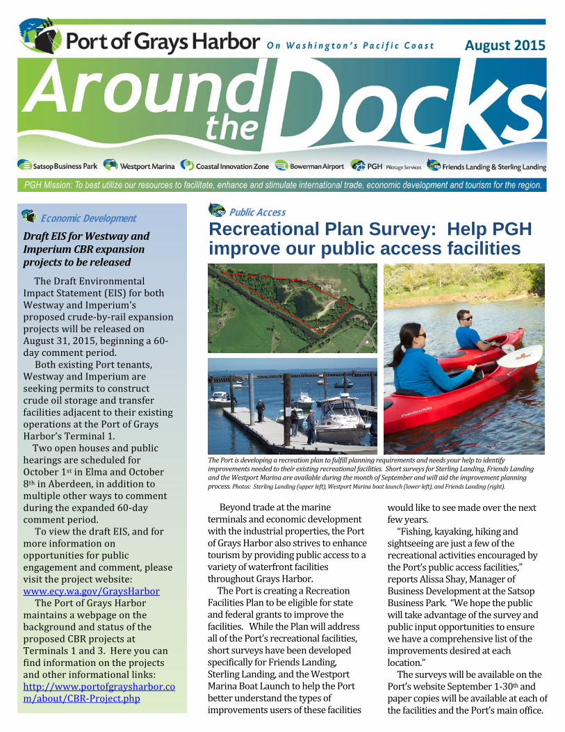
Public Access
would like to see made over the next few years. “Fishing, kayaking, hiking and sightseeing are just a few of the recreational activities encouraged by the Port’s public access facilities,” reports Alissa Shay, Manager of Business Development at the Satsop Business Park. “We hope the public will take advantage of the survey and public input opportunities to ensure we have a comprehensive list of the improvements desired at each location.” The surveys will be available on the Port’s website September 1-30th and paper copies will be available at each of the facilities and the Port’s main office.
August 2015
Recreational Plan Survey: Help PGH improve our public access facilities
Beyond trade at the marine terminals and economic development with the industrial properties, the Port of Grays Harbor also strives to enhance tourism by providing public access to a variety of waterfront facilities throughout Grays Harbor. The Port is creating a Recreation Facilities Plan to be eligible for state and federal grants to improve the facilities. While the Plan will address all of the Port’s recreational facilities, short surveys have been developed specifically for Friends Landing, Sterling Landing, and the Westport Marina Boat Launch to help the Port better understand the types of improvements users of these facilities
Economic Development
Draft EIS for Westway and Imperium CBR expansion projects to be released
The Draft Environmental Impact Statement (EIS) for both Westway and Imperium’s proposed crude-by-rail expansion projects will be released on August 31, 2015, beginning a 60-day comment period. Both existing Port tenants, Westway and Imperium are seeking permits to construct crude oil storage and transfer facilities adjacent to their existing operations at the Port of Grays Harbor’s Terminal 1. Two open houses and public hearings are scheduled for October 1st in Elma and October 8th in Aberdeen, in addition to multiple other ways to comment during the expanded 60-day comment period. To view the draft EIS, and for more information on opportunities for public engagement and comment, please visit the project website: www.ecy.wa.gov/GraysHarbor The Port of Grays Harbor maintains a webpage on the background and status of the proposed CBR projects at Terminals 1 and 3. Here you can find information on the projects and other informational links: http://www.portofgraysharbor.com/about/CBR-Project.php
The Port is developing a recreation plan to fulfill planning requirements and needs your help to identify improvements needed to their existing recreational facilities. Short surveys for Sterling Landing, Friends Landing and the Westport Marina are available during the month of September and will aid the improvement planning process. Photos: Sterling Landing (upper left), Westport Marina boat launch (lower left), and Friends Landing (right).
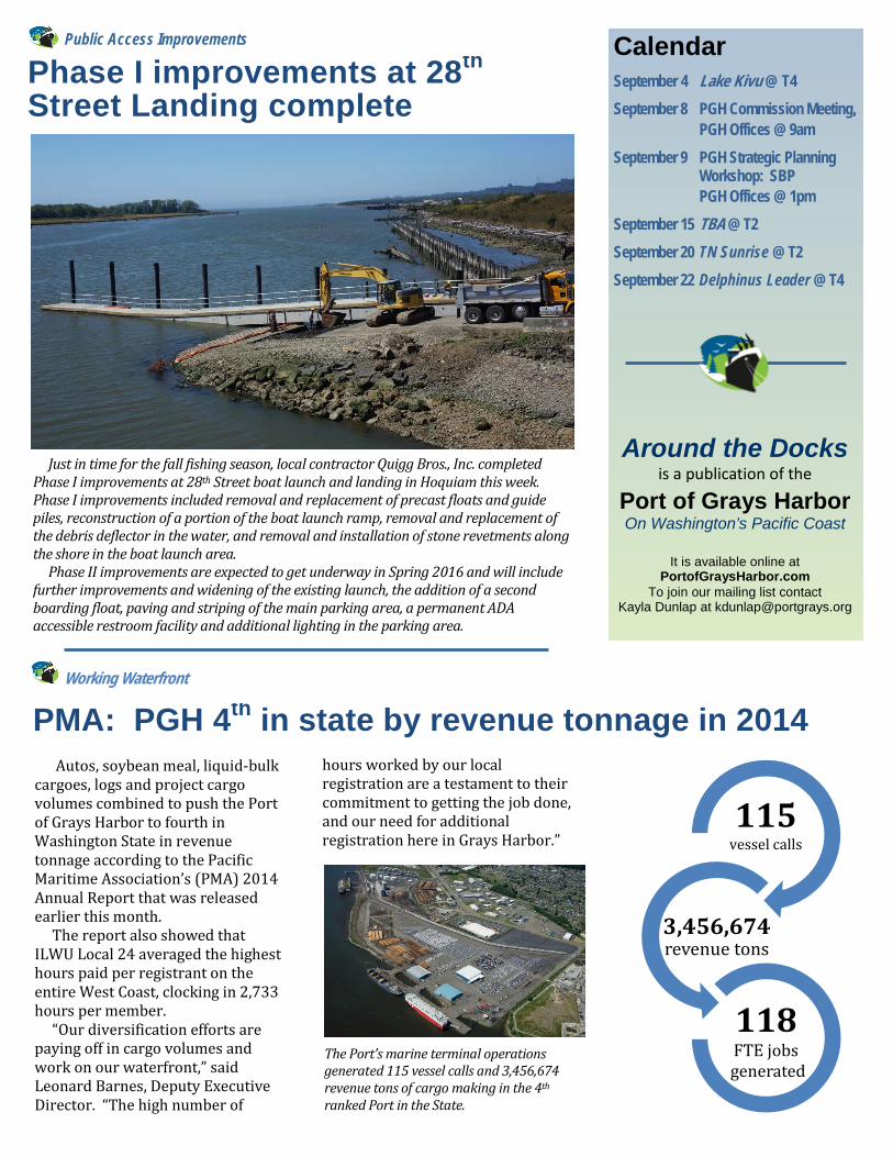
Calendar
September 4 Lake Kivu @ T4
September 8 PGH Commission Meeting, PGH Offices @ 9am
September 9 PGH Strategic Planning Workshop: SBP
PGH Offices @ 1pm
September 15 TBA @ T2
September 20 TN Sunrise @ T2
September 22 Delphinus Leader @ T4
Around the Docks
is a publication of the
Port of Grays Harbor On Washington’s Pacific Coast
It is available online at PortofGraysHarbor.com
To join our mailing list contact Kayla Dunlap at [email protected]
Public Access Improvements
PMA: PGH 4th in state by revenue tonnage in 2014 Working Waterfront
Phase I improvements at 28th Street Landing complete
Autos, soybean meal, liquid-bulk cargoes, logs and project cargo volumes combined to push the Port of Grays Harbor to fourth in Washington State in revenue tonnage according to the Pacific Maritime Association’s (PMA) 2014 Annual Report that was released earlier this month. The report also showed that ILWU Local 24 averaged the highest hours paid per registrant on the entire West Coast, clocking in 2,733 hours per member. “Our diversification efforts are paying off in cargo volumes and work on our waterfront,” said Leonard Barnes, Deputy Executive Director. “The high number of
hours worked by our local registration are a testament to their commitment to getting the job done, and our need for additional registration here in Grays Harbor.”
115 vessel calls
3,456,674 revenue tons
118 FTE jobs
generated
Just in time for the fall fishing season, local contractor Quigg Bros., Inc. completed Phase I improvements at 28th Street boat launch and landing in Hoquiam this week. Phase I improvements included removal and replacement of precast floats and guide piles, reconstruction of a portion of the boat launch ramp, removal and replacement of the debris deflector in the water, and removal and installation of stone revetments along the shore in the boat launch area. Phase II improvements are expected to get underway in Spring 2016 and will include further improvements and widening of the existing launch, the addition of a second boarding float, paving and striping of the main parking area, a permanent ADA accessible restroom facility and additional lighting in the parking area.
The Port’s marine terminal operations generated 115 vessel calls and 3,456,674 revenue tons of cargo making in the 4th ranked Port in the State.
Press Release: September 2, 2015
Contact: Kayla Dunlap, Public Affairs Manager [email protected] or 360-533-9590
For Immediate Release
Port of Grays Harbor seeking input regarding improvements at its waterfront access facilities
Aberdeen, Wash. – The Port of Grays Harbor invites users of its waterfront access facilities to
provide input regarding improvements they would like to see made in the future. Short surveys
for Friends Landing, Sterling Landing and the Westport Marina are available during the month of
September on the Port’s website, www.portofgraysharbor.com. Paper copies of surveys are also
available at Friends Landing, the Westport Marina office, and the Port’s main office.
The Port is developing a Recreation Plan so that it may be eligible for state and federal funding in
the future. The surveys are the first of several opportunities for the public to weigh in on the Plan.
Additional opportunities will be announced as the planning process continues over the next
several months before being adopted by the Port Commission in early 2016.
“We hope the public will take advantage of the survey and additional public input opportunities
throughout the rest of the year to ensure we have a comprehensive list of the improvements
desired at each location,” explained Alissa Shay, Manager of Business Development at the Satsop
Business Park. “We look forward to seeing the results of the surveys so we can better understand
what the users of these facilities envision for future improvements.”
Founded in 1911, the Port of Grays Harbor is one of Washington State’s oldest port districts and
Washington’s only deep-water port located directly on the Pacific Ocean. The Port of Grays
Harbor operates 4 deep-water marine terminals, the Westport Marina, Bowerman Airport and
numerous industrial and business parks throughout the region. The addition of Satsop Business
Park increases the Port’s properties to more than 1,000 acres of industrial properties and an

additional 1,200 acres of sustainably managed forestland. Strategically located midway between
Seattle and Portland and less than 1 ½ hours from open sea, the Port of Grays Harbor provides
businesses a diverse portfolio of facilities. More information on the Port of Grays Harbor’s
facilities and operations is available at portofgraysharbor.com or satsop.com.
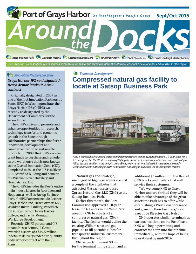
Economic Development
additional $2 million into the fleet of CNG trucks and trailers that will service their customers. “We welcome XNG to Grays Harbor and are thrilled they will be able to take advantage of the great assets the Park has to offer while establishing a West Coast presence and growing their business,” said Executive Director Gary Nelson. XNG operates similar terminals at various locations on the East Coast. XNG will begin permitting and contract for a tap into the pipeline immediately, with the hope of being operational by mid-2016.
Sept/Oct 2015
Compressed natural gas facility to locate at Satsop Business Park
Natural gas and strategic, uncongested highway access are just a couple of the attributes that attracted Massachusetts-based Xpress Natural Gas, LLC (XNG) to the Satsop Business Park. Earlier this month, the Port Commission approved a 10-year lease for 4.3 acres in the West Park area for XNG to construct a compressed natural gas (CNG) facility. The facility would utilize the existing William’s natural gas pipeline to fill portable tubes for transport to industrial customers throughout the region. XNG expects to invest $3 million for the terminal filling station and an
Innovation Partnership Zone
Grays Harbor IPZ re-designated; Hesco Armor lands US Army contract
Originally designated in 2007 as one of the first Innovation Partnership Zones (IPZ) in Washington State, the Grays Harbor IPZ (GHIPZ) was recently re-designated by the Department of Commerce for the second time. The GHIPZ strives to promote and enhance opportunities for research, technology transfer, and economic growth in the Zone through collaborative partnerships that foster innovation, development and commercialization of sustainable products. In 2009, the GHIPZ received grant funds to purchase and remodel an old warehouse that is now known as the Coastal Innovation Zone (CIZ). Completed in 2010, the CIZ is a Silver LEED certified building and home to the Wishkah River Distillery and Hesco Armor, LLC. The GHIPZ includes the Port’s entire main industrial area in Aberdeen and Hoquiam, as well as Satsop Business Park. GHIPZ Partners include Greater Grays Harbor, Inc., Hesco Armor, LLC, Wishkah River Distillery, Paneltech, REG Grays Harbor, Grays Harbor College, and Pacific Mountain Workforce Development. Recently, GHIPZ partner and CIZ tenant, Hesco Armor, LLC, was awarded a share of a $49.5 million indefinite delivery/indefinite quantity body armor contract with the US Army.
XNG, a Massachusetts-based logistics and transportation company, was granted a 10-year lease for a 4.3 acre parcel in the West Park area of Satsop Business Park where they will construct a natural gas filling station, similar to the one pictured above, to serve various industrial customers, currently without access to natural gas, with compressed natural gas delivered via all-composite trailers.
Calendar
October 21 Sunrise Sky @ T2 October 25 Cano Leader @ T4 November 3 Royal Fairness @ T2 November 6 Lake Kivu @ T4 November 7 Desert Hope @T2
November 10 PGH Commission Meeting, PGH Offices @ 9am
November 11 PGH Offices Closed November 15 Indigo Lake @ T4
November 20 TBA @ T2
Around the Docks
is a publication of the
Port of Grays Harbor On Washington’s Pacific Coast
It is available online at PortofGraysHarbor.com
To join our mailing list contact Kayla Dunlap at [email protected]
Partners for a Stronger Economy
PGH audit team earns 21st straight clean audit
Fiscal Responsibility
REG celebrates ownership of Grays Harbor facility with ribbon cutting
For the 21st year in a row, the Port of Grays Harbor has earned a clean audit report from Washington State Auditor’s Office. The audit team, led by Director of Finance and Administration Mary Nelson and Accounting Manager Lisa Benn, includes staff from the Westport Marina, Satsop Business Park, the Finance Department, the Environmental and Engineering Department, and the Industrial Properties division. The 2014 accountability and financial statement audits looked at various areas including accounts receivable, insurance/risk management, significant accounting systems, payroll, lease agreements, open public meeting minutes, donations and procurement of both purchases and on-call contracts. “We are once again thrilled with
and extremely proud of the Port team and their ability to responsibly manage public funds,” shared Port Commission President Stan Pinnick. The Port’s audit report is available on the Washington State Auditor’s website: www.sao.wa.gov
Open house for Recreational Facilities Plan scheduled
Recreational Facilities
With the results of the recreational plan surveys in hand, the Port of Grays Harbor and Grays Harbor Council of Governments have announced they will hold an open house on Monday, November 23, 2015 from 6-8pm at the Port of Grays Harbor Commission Chambers. The Recreational Facilities Plan will address all of the Port’s recreational facilities and the public is cordially invited to attend the open house to learn more about the Recreational Plan and review and comment on the Plan’s objectives and goals.
Port Commissioners Jack Thompson and Stan Pinnick joined Renewable Energy Group, Inc. (REG) board members and staff and other Grays Harbor leaders for the REG Grays Harbor facility’s ribbon cutting ceremony in September. Located at Terminal 1, the Grays Harbor facility is a 100 million gallon per year biorefinery and is REG’s 11th and largest facility.
Port of Grays Harbor Audit Team members (first row, left to right) Trish Ulmer, Shannon Anderson, Janet Blackmun-Johnson, Robin Leraas; (second row) Randy Lewis, Lisa Benn, Mike Johnson and Mary Nelson. Team members Tracy Ewing, Aric Cleverly and Terri Norris were absent for the photo.
Recreational Facilities Plan Open House
When: Monday, November 23rd 6pm-8pm
Where: Port of Grays Harbor Commission Chambers, 111 S. Wooding Street, Aberdeen

APPENDIX E Final Draft Public Review
(To be completed upon receipt of Affidavit of Publication)

APPENDIX F Adoption Resolution and Meeting Minutes
(To be completed after formal adoption)

APPENDIX G RCO Self Certification Form #222
(To be completed after formal adoption)