Embed Size (px)
Citation preview

PORT ACCESS ROUTE STUDY
TO
ANALYZE IPOTENTIAL VESSEL ROUTING MEASURES
FOR REDUCING VESSEL (SHIP) STRIKES
OF
NORTH ATLANTIC RIGHT WHALES
PREPARED BY THE
OFFICE OF NAVIGATION SYSTEMS
WATERWAYS MANAGEMENT DIRECTORATE
UNITED STATES COAST GUARD
I. REQUIREMENT
This study is required by Section 626 of the Coast Guard and Maritime Transportation Act of 2004 (the 2004 Act), which states that “the Secretary of the department in which the Coast Guard is operating-- (1) shall cooperate with the Administrator of the National Oceanic and Atmospheric Administration in analyzing potential vessel routing measures for reducing vessel strikes of North Atlantic Right Whales, as described in the notice published at pages 30857 through 30861 of volume 69 of the Federal Register; and (2) within 18 months after the date of enactment of this Act, shall provide a final report of its analysis to the Committee on Commerce, Science, and Transportation of the Senate and the Committee on Transportation and Infrastructure of the House of Representatives.”
11. GENERAL
The North Atlantic right whale, Eubalaena glacialis, is considered one of the most endangered large whale species in the world. Right whales have been listed as endangered under the Endangered Species A.ct (ESA) since its passage in 1973 (35 FR 8495, June 2, 1970). Although precise estimates of abundance are not available, it appears that the eastern North Atlantic population is nearly extinct and the western North Atlantic population numbers approximately 300 whales. (See Ward-Geiger, Silber, and Baumstark, and Pulfer, 2005.) The status of North Atlantic right whales is a very serious issue, especially for the National Marine Fisheries Service (NMFS) and the United States Coast Guard, While calf production has increased somewhat in recent years, reproduction has been erratic over the last few decades, and recovery is seriously affected by fatalities and serious injury resulting from human activities, primarily from collisions with vessels (ship strikes) and entanglement in fishing gear.
In order to protect right whales, NMFS published an advance notice of proposed rulemaking (69 FR 30857, June 1,2004) in the Federal Register (NMFS ANPRM), which announced that NMFS was considering regulations and non-regulatory measures to implement a strategy to reduce ship strikes of right whales (Strategy). The goal of the Strategy is to help the right whale population recover by reducing the likelihood and threat of ship strikes. This PARS analyzes potential vessel routing measures identified in the NMFS ANPRM. Other elements of the Strategy described in the NMFS ANPRM, such as potential establishment of speed restrictions, are being addressed separately by NMFS and are not analyzed in this PARS.
The Coast Guard is ch,arged with enforcing the Marine Mammal Protection Act (MMPA), ESA, and the regulations issued under those statutes. One of the Coast Guard‘s core missions and strategic goals is the protection of the marine environment, including the conservation of living marine resources and enforcement of living marine resource laws. The Coast Guard works in collaboration with NMFS to prevent ship strikes. The Coast Guard issues local and written periodic notices to mariners concerning ship strikes, issues NAVTEX messages alerting mariners to the locatioin of right whales, and actively participates in the Mandatory Ship Reporting (MSR) Systiems that provide information to mariners entering two specific areas, one in the northeastern United States and one in the southeastern United States. ln addition, the Coast Guard provides ]patrols dedicated to enforcement of the ESA and the MMPA; limited
2

vessel and aircraft support to facilitate right whale research and population monitoring; funding to support the Sighting Advisory (SAS)/Early Warning System (EWS); vessels and aircraft to assist in right whale disentanglements and strandings; and disseminates NMFS information packets to vessels boarded in or near right whale waters. As part of its Strategy development, and consistent with section 626 of the 2004 Act, NMFS asked the Coast Guard for assistance in its ship-strike rulemak.ing by conducting a Port Access Route Study (PARS).
Under the Ports and Waterways Safety Act (PWSA) (33 U.S.C. 1223(c)), the Commandant of the Coast Guard may designate necessary fairways and traffic separation schemes (TSSs) to provide safe access routes for vessels proceeding to and from U. S. ports. The PWSA provides that such designation of fairways and TSSs must recognize, within the designated areas, the paramount right of navigation over all other uses. The PWSA requires the Coast Guard to conduct a study (the Coast Guard calls these studies PARS) of potential traffic density and the need for safe access routes for vessels before establishing or adjusting fairways or TSSs. Through the study process, the Coast Guard must consult with Federal, State, and foreign state agencies (as appropriaie) and consider the views of maritime community representatives, environmental groups., and other interested stakeholders received through the public comment process. The Coast Guard must also take into account all other uses of the area under consideration including as appropriate:
the exploration for, or exploitation of, oil, gas, or other mineral resources; the construction or operation of deepwater ports or other structures on or above the seabed or subsoil of the submerged lands or the Outer Continental Shelf (OCS) of the u . s.; the establishment or operation of marine or estuarine sanctuaries; and activities involving recreational or commercial fishing.
Designation shall, to tlhe extent practicable, reconcile the need for safe access routes with the needs of all other reasonable uses of the area involved. Additionally, for this particular PARS, Section 626 of the 2004 Act specifically requires that routing measures be considered to reduce ship strikes of North Atlantic right whales.
Most commercial vessels calling at U.S. ports are foreign flag vessels. The United States, after Executive Branch review and clearance, may submit proposed routing measures recommended by a PARS--in particular traffic separation schemes (TSSs)--to the International Maritime Organization (IMO) for approval, adoption, and implementation. However, not all routing measures must be submitted to IMO. For instance, as set forth below, the routing measures being analyzed by the PARS for the southeastern United States and for Cape Cod Bay are not being proposed for submission to IMO, while the amendment to the Boston TSS (a previously IMO adopted measure) and the area to be avoided are being proposed for IMO submission. The International Convention for the Safety of Life at Sea (SOLAS) recognizes IMO as the competent international body for developing guidelines, criteria and regulations at the international level for ships’ routing systems. Upon adoption of a routing measure, IMO issues a circular to its approximately 166 Member States to provide geographic coordinates of the adopted routing measure. The routing measure is then added to navigational charts issued by various entities worldwide, including National Oceanic and Atmospheric Administration
3

(NOAA) navigational charts. As to the proposed amendment of the Boston TSS, the Coast Guard will begin the process of updating the list of offshore traffic separation schemes and precautionary areas at 33 C.F.R. Part 167 during or after IMO action on the proposal by the United States, including issuing a Federal Register notice and providing opportunity for public comment. The traffic separation schemes and other routing measures that have been adopted worldwide by IMO can be found at www.imo.org.
On February 18,2005, the Coast Guard published a notice of study in the Federal Register (70 FR 83 12) which provided the reason for the study, procedures by which the public could comment on the study, descriptions of the geographic areas to be studied, and a timetable and process that the Coast Guard was going to use in conducting its PARS.
111. BACKGROUND
DEFINITIONS
The following definitions are from the IMO’s publication “Ships’ Routeing” (except those marked by an asterisk which are terms derived from Coast Guard regulations) and should help the reader to understand terms used throughout this document:
Area to be avoided or ATBA means a routing measure comprising an area within defined limits in which either navigation is particularly hazardous or it is exceptionally important to avoid casualties and which should be avoided by all vessels, or certain classes of vessels.
Deep-water roil.& means a route within defined limits, which has been accurately surveyed for clearance of sea bottom and submerged obstacles as indicated on nautical charts.
Fairway* means a lane or corridor in which no artificial island or structure, whether temporary or permanent, will be permitted so that vessels using U.S. ports will have unobstructed approaches.
Inshore traffic landward boundary of a traffic separation scheme and the adjacent coast, to be used in accordance with the provisions of Rule 1 O(d), as amended, of the International Regulations for Preventing Collisions at Sea, 1972 (COLREGS).
means a routing measure comprising a designated area between the
No anchoring 2 s means a routing measure comprising an area within defined limits where anchoring is hazardous or could result in unacceptable damage to the marine environment. ’4nchoring in a no anchoring area should be avoided by all vessels or certain classes of vessels, except in case of immediate danger to the vessel or the persons on board.
4

Precautionary area means a routing measure comprising an area within defined limits where vessels must navigate with particular caution and within which the direction of traffic flow may be recommended.
Recommended route means a route of undefined width, for the convenience of vessels in transit, which is often marked by centerline buoys.
Recommended track means a route which has been specially examined to ensure so far as possible that it is free of dangers and along which vessels are advised to navigate.
Regulated Navigation Area or RNA* means a water area within a defined boundary for which regulatilons for vessels navigating within the area have been established under 33 CFR part 165.
Roundabout means a routing measure comprising a separation point or circular separation zone and a circular traffic lane within defined limits. Traffic within the roundabout is :separated by moving in a counterclockwise direction around the separation point or zone.
Separation Zoig or separation line means a zone or line separating the traffic lanes in which vessels are proceeding in opposite or nearly opposite directions; or from the adjacent sea area; or separating traffic lanes designated for particular classes of vessels proceeding in ithe same direction.
Traffic lane means an area within defined limits in which one-way traffic is established. Natural obstacles, including those forming separation zones, may constitute a boundary.
Traffic Separation Scheme or J’SJ means a routing measure aimed at the separation of opposing streams of traffic by appropriate means and by the establishment of traffic lanes.
Two-way rout(; means a route within defined limits inside which two-way traffic is established, aimed at providing safe passage of ships through waters where navigation is difficult or d.angerous.
Vessel routing system means any system of one or more routes or routing measures aimed at reducing the risk of casualties; it includes traffic separation schemes, two-way routes, recommended tracks, areas to be avoided, no anchoring areas, inshore traffic zones, roundabouts, precautionary areas, and deep-water routes.
A. STUDY AREAS
NMFS’ Advance Notice of Proposed Rulemaking proposed to implement various operational measures in its Strategy within three broad geographic regions off the U.S. east coast:
the southeastern Atlantic coast ; the Mid-Atlantic region ; and
5
the northeastern Atlantic coast.
NMFS has considered establishing routing measures that could potentially reduce the risk of ship strikes. NMFS has concluded that establishing certain routing measures in locations where right whales are known to aggregate (particularly feeding areas in the north and calving areas in the south) could potentially reduce the risk of ship strikes. At this time NMFS is not considering routing measures as defined for the Mid-Atlantic region. Therefore, the Coast Guard and NMFS agreed to conduct the PARS in the two remaining areas and further refined the description as follows:
1. Southern r e a : The area bounded to the north by a line drawn at latitude 3 1 O 27'N (which coincidles with the northernmost boundary of the Mandatory Ship Reporting System) and to the south by a line drawn at latitude line 29" 45'N. The eastern offshore boundary is formed by a line drawn at longitude 8 1 O OO'W and the western boundary is formed by the shoreline. The ports of Jacksonville and Fernandina, FL, and Brunswick, GA, are included in this area.
2. Northern r e a : Cape Cod Bay; the area off Race Point at the northern end of Cape Cod (Race Point) and the Great South Channel.
B. PORT DESCRIPX7ONS
1. Southern Regic,n:
a. Jacksonville, FL: Is located on Florida's north Atlantic coast and serves as a southeastern focal point for the intermodal movement of commodities on the world market. Port activities are divided between those under the control of the Port Authority and those owned by private interests. Leading cargoes include containerized and roll-on/roll-off general cargo, automobiles, breakbulk cargoes, and dry and liquid bulk products, including petroleum and phosphate. The governing body of the port is the Jacksonville Port Authority (JAXPORT).
JAXPORT owns and operates three public marine terminals and one passenger cruise terminal. JAXPORT develops, manages and markets those publicly-owned facilities to promote the growth of maritime and related industries in Jacksonville, Florida and beyond. In addition, year-round cruise ship service is offered in the Port of Jacksonville.
Tonnage for the entire Jacksonville harbor exceeds 16 million tons each year. Of this total, JAXPOR.T's three public marine terminals handled 8,448,654 tons in fiscal year 2005 (ending September 30,2005), including more than 544,000 vehicles - making JAXPORT one of the largest vehicle handling ports in the country. In terms of total tonnage, the Port of Jacksonville ranks about 40* in the nation.
Jacksonville's main shipping channel is a 23-mile stretch of the St. Johns River extending from the mouth of the Atlantic Ocean to the JAXPORT's Talleyrand Marine
6
Terminal just north of downtown Jacksonville. As the owner and manager of Jacksonville's public ship terminals, J AXPOR'T considers maintaining a deep harbor essential to keeping Jacksonville's port viable. A competitive harbor depth allows Jacksonville to accommodate the water depth (draft) requirements of fully-loaded cargo vessels which currently call on Jacksonville's port, and to meet the needs of new, even larger cargo ships which may call on Jacksonville in the future. The St. Johns River harbor deepening project, begun in 2002 by the U.S. Army Corps of Engineers, has so far deepened about 14 miles of Jacksonville's main shipping channel from the mouth of the river to Drummond Point to a maintained depth of 40 feet (1 3.3 m). A proposed extension to deepen the harbor from Drummond Point to JAXPORT's Talleyrand Marine Terminal is currently under consideration. A proposal to extend the harbor deepening frorn Drummond Point to JAXPORT's Talleyrand Marine Terminal was authorized by ithe U.S. Congress in December 2005. The project will be conducted in 2006 and deepen the final stretch of Jacksonville's main shipping channel from 38 feet (12.7 m) to a maintained depth of 40 feet (13.3 m). (See generally wtzi~zi.iaxport.co1-n.)
b. Fernandina, FL: Is Florida's northernmost seaport which serves the southeastern U. S., including major metropolitan areas in Florida and Georgia. It handles breakbulk, predominantly forest product exports, and containerized cargo. The Port has access to a road network and railroad system that provides a link into the interior U. S. The Port Authority is the governing body of the Port of Fernandina. It has policy-making, budgeting, and general oversight responsibilities for all Port activities. It serves the principal public purpose to encourage economic development in Nassau County. The Port Authority employs Nassau Terminals Inc., a private port operating company, to manage and administer the port under the terms of an operating agreement.
c. Brunswick, CA: The Port of Brunswick is comprised of three Georgia Port Authority-owned (GPA) deepwater terminals, two of which are directly operated by the GPA. The port is one of the fastest growing auto and heavy machinery ports in North America. Today, more than 12 major auto manufacturers, supported by three auto processors, use the Colonel's Island Terminal. The terminal also has fast growing bulk exporthmport (operation. Agri-products from Georgia and the rich U. S. grain belt, as well as import products, move through the Colonel's Island Terminal. Brunswick's Mayor's Point Terminal facilitates the export of Georgia's forest products, while Marine Port Terminals;, operated by Logistec U.S.A., specializes in the handling of breakbulk and bulk commodities.
The Savannah District, U.S. Army Corps of Engineers was awarded the initial contract for the Brunswick Harbor Deepening Project in July 2002. Work continues on the project, which includes deepening the entrance channel from 32 feet (9.8 m) to 38 feet (12.7 m) deep and the inner channels from 30 feet (9.1 m) to 36 feet (1 1 m) deep. Other improvements include the construction of a new turning basin in the Upper East River, widening of certain channels/reaches, construction of a bird nesting island, restoration of 59 acres (24 ha) of marshland, and the raising of the Andrews Island Disposal area dike to regain llost capacity. The recent completion of the new Sidney Lanier Bridge in conjunction with the completion of the harbor deepening will allow additional growth
7

and associated economic development. The project is scheduled for completion in 2006. These projects are expected to give the Port of Brunswick the ability to accommodate the water depth (draft) requirements of fully-loaded cargo vessels which call at the port, and to meet the needs of new, even larger cargo ships which may call on Brunswick in the future.
2. Northern repiori:
No specific, major ports similar to the ports listed for the southern region were listed in NMFS’ ANPRM for the northern region. The areas mentioned within the northern region are off of the ports of Boston and Provincetown, MA.
C. ANALYSIS
During the course of a routine PARS, the Coast Guard reviews port data, which would include vessel types, vessel tralffic density, types of cargo, economic impacts, port improvements, vessel safety, and overall environmental impacts. In addition, the Coast Guard reviews comments received on the PARS notice. Further, if meetings of any type are held, comments received at those meetings are also considered.
In analyzing potential vessel routing measures for reducing vessel strikes of North Atlantic right whales, the Coast Guard and NOAA agreed this PARS would be narrower in scope than a routine PARS because the Coast Guard did not consider economic impacts, These impacts would be considered bly NMFS as part of an economic analysis it is doing as part of the implementation of its Strategy. The Coast Guard also reviewed research papers published and/or provided by NEAFS which, in addition to advising on right whale habitat and migration patterns, also analyzedl ship transit data, especially those studies that cite Mandatory Ship Reporting System data. Comments received on its PARS announcement in the Federal Register as well as cornments NMFS received on its ANPRM were also reviewed by the Coast Guard.
NMFS advises that right whales tend to migrate seasonally in a corridor along the eastern seaboard of the U. S. and Canada between winter calving/nursing areas in the southern region (near the border between Georgia and Florida) and summer feeding grounds in the northern region ( e.g. Cape Cod, Great South Channel, Bay of Fundy). In waters off the southeast U. S. and mid-Atlantic right whales are often found within 30 nautical miles of the coast. Their fall southward migration primarily occurs in November and December, and their spring northward migration primarily occurs in March and April. Accordingly, depending upon the time of the year, right whale sightings may occur within 30 nautical miles of the shore along much of the U. S. east coast, whereas in New England and Canadian waters this distance is greater. (See Ward-Geiger, et al., 2005.)
The following charts provided by NMFS (figures 1 through 4) provide summaries of right whale sighting information in the southeast and northeast regions during the months indicated and provide background on the migration time period and distribution of right whales.
8

RIGHT WHALE DISTRIBUTION OFF FLORIDA AND GEORGIA IN DECEMBER (1992 - 2002 Sighting Data)
Figure 1. (See Garrison, 2005.)
9

RIGHT WHALE DISTRIBUTION OFF FLORIDA AND GEORGIA IN MARCH (1992 - 2002 Sighting Data)
Figure 2. (See Garrison, 2005.)
10

North Atlantic Right Whales Observed in Ship Strike Management Zones - April
I00 Miles
Figure 3 . (See Merrick, 2005).
us Canada Hague Line 100 fathom contour 50 fathom contour Traffic Separation Lane Traffic Lane ORF Management Zone 0 CCB Management Zone 0 GSC Managementi%ne Right Whale Sightings
0 April
N
E
S
11

North Atlantic Right Whales Observed in Ship Strike Management Zones - May
Jo 0 100 M t h
Figure 4. (See Merriclk, 2005).
TV. ROUTING MEhrSURES REVIEWED
us Canada
,- HagueLine 100 fathom contour 50 fathom contour Traffic Separation Lane Traffic Lane ORF Management Zone 0 CCB Management Zone
k?tt ig Whale Sightings
w
GSCManagementzOne
May
N
E
S
NMFS considers the use of routing measures an essential component of its Ship Strike Reduction Strategy, because use of such measures by vessels could reduce exposure of right whales to ships and thus reduce the likelihood of a ship strike to the extent practicable, while minimizing adverse impacts on the shipping industry. During the consultation process between the Coast Guard and NMFS, potential routing measures were discussed to determine applicability and usefulness in protecting right whales from ship strikes. NMFS and the Coast Guard determined that five measures merited further review and consideration. These measures were defined previously and a discussion of their uses and applicability to prevent ship strikes are provided below:
A. Fairways - are created to provide mariners with unobstructed approaches to ports or another area of a large body of water. The Coast Guard has been using this measure for many years,, especially in the Gulf of Mexico where it has been used to aid mariners in avoiding oil rigs and platforms. In addition, charted fairways preclude the oil industry from locating structures in the areas delineated as fairways. Fairways allow for two-way vessel traffic and provide predictability as to that traffic. To help reduce the risk of ship strikes, fairways could potentially be located in areas where data indicate relatively fewer concentrations of right whales exist. Further, if a fairway must go through or near areas where right whales sightings occur, it could potentially be located
12
where studies indicate that the risk of right whale exposure to vessels is relatively lower, thereby potentially reducing the risk of ship strikes.
B.. Two-way r@ - is a routing measure which provides mariners a route within defined limits for safe passage through bodies of water where transiting may be difficult or dangerous. A two-way route provides predictability as to vessel traffic. Its designation and nomenclature on a chart allows mariners to know its limits as well as provide arrows of direction within the route which also aids predictability and helps reduce the risk of collision. Similar to fairways, a two-way route could potentially provide mariners a way or “path” through areas where right whales occur and could potentially be located where studies indicate that the exposure of right whales to vessels is relatively lower, thereby potentially reducing the risk of ship strikes.
C. Traffic separation scheme (TSS) - is a measure that separates traffic by having vessels travel in a lane in a particular direction. In addition, the lanes are separated by a separation zone or line. A vessel in a TSS must comply with Rule 10 of the International R.egulations for Preventing Collisions at Sea, 1972, as amended (COLREGS). Rule 10 requires that a vessel using a TSS stay within its lane and avoids crossing traffic: lanes as far as practicable. TSSs are usually placed at the entrance of a harbor, especially if there is a large volume of vessel traffic that transits to and from the harbor. This measure provides a high level of predictability to ship movements and locations and, if used properly by all vessels in relative proximity to each other, can reduce the risk of collision. As in the cases of fairways and two-way routes, TSSs can potentially be located where studies indicate that the exposure of right whales to vessels is lower, thereby potentially reducing the risk of ship strikes.
D. Recommended route - is a measure that has a centerline but no defined width. Because of having no defined width vessels using the route may travel far from the centerline where there is adequate water to do so. If this routing measure were to be used, its centerline could be placed where vessel and right whale interaction may be statistically low. However, since a recommended route has no defined width, there would be no outer parameter to help guide vessels and vessels may inadvertently transit nearby areas where studies indicate the risk of interaction between right whales and vessels is relatively higher. Also in cases of poor visibility mariners have a tendency to “follow” or “hug” the line. In such a case the risk of collision could increase.
E. Recommended track - is a measure that provides a track for the mariner where the mariner can assume that along the track line is good and safe water. This measure is depicted as a dashed line on a chart with direction arrows. Mariners are advised to actually follow the track. Similar to recommended routes, if mariners follow or hug the track line then the risk of collision could be greater when there is opposing vessel traffic. This measure may have merit when compared to a recommended route or two- way route. A short, recommended track through critical habitat may reduce potential interaction time between whales and vessels.
13

V. REC0MMENDE:D RATHER THAN MANDATORY MEASURES
During the consultations between the Coast Guard and NMFS, the issue of whether the routing measures should be recommended or mandatory was discussed.
One of the Coast Guard’s primary missions is to promote safety at sea. The Coast Guard has found that a key factor in vessel safety is to maintain the ability and responsibility of the ship’s master to operate (navigate) a vessel based on surrounding circumstances. Vessel operators must account for a multitude of variables and risks posed by continuously changing elements such as sea state, weather, visibility, vessel condition, and other vessel traffic. Constraining a vessel operator’s discretion to act appropriate to circumstances can pose serious risks of collision, grounding, or other casualties with implications for both safety and the greater marine environment. Accordingly, the Coast Guard generally supports the establishment of recommended rather tlhan mandatory routing measures.
NMFS agreed that recommended measures should be pursued, unless compliance with such measures is low. NMFS and the Coast Guard will develop proper monitoring methods and techniques to determine compliance with the measures. If there is non- or low compliance with the recommended measures, steps may be taken to pursue making them mandatory. The agreement by NMFS to proceed with recommended measures is based on an understanding that recommended measures are easier to implement, may be implemented more quickly, and that mariners generally accept and follow such measures.
VI. ROUTING MEASURES FOR THE SOUTHERN REGION
No designated routing measures have been adopted by IMO or established by the Coast Guard for vessels proceeding, to or from the southern region ports of Jacksonville, FL; Fernandina, FL; or Brunswick. GA.
A. JacksonviZZe, FL: At the present time, vessels transiting to and from Jacksonville generally use three different uncharted routes (for purposes of this study they will be referred to as “de facto” routes). These de facto routes consist of a southeasterly/riorthwesterly (SE/NW) route on a center axis of 132 degrees outbound and 3 12 degrees inbound (1 32/3 12); an easterly/westerly (E/W) route on a center axis of 098/278 degrees; and a northeasterly/southwesterly (NE/SW) route on a center axis of 050/230 degrees. These axes are measured to and from the Jacksonville channel entrance buoy. Studies done by the Southeast Fisheries Science Center indicate that the SE/NW and E/W routes present the lowest risk of interactions between right whales and vessels based on right whale sighting data. (See Garrison, 2005.)
After evaluatirig the proposals presented by NMFS, and accounting for navigation safety and overall environmental protection (including right whale protection), the Coast Guard prefers two-way routes. The Coast Guard recommends the establishment of two, two-way routes to approach and depart Jacksonville. These two-way routes would be located very close to where the SE/NW and the E/W de facto routes currently exist. These routes would connect with a circular precautionary area centered round the
14

entrance buoy. See the draft chart (figure 5) following this paragraph for their contemplated locations. NMFS reports right whale sighting-associated indications of a relatively highler risk of vessel and whale interaction along the NE/SW de facto route. Because of these right whale sighting-associated indications and associated relatively higher risk of vessel and whale interaction along the NE/S W de facto route, the Coast Guard recommends that no routing measure be created in the area of the NE/SW de facto route. Further, a NE/SW route would cross the SE/NW route into the port of Fernandina. To support vessels transiting to and from the northeast, the Coast Guard recommends two entranceldeparture routes from the E/W route. Utilizing the most northern of the entrance/departure routes would increase a voyage by up to approximately five miles when compared to using the NE/SW de facto route. NMFS estimates that, if vessels follow these routes, the risk of interactions between vessels and whales in the vicinity could potentially be reduced by up to 26%. (See Garrison, 2005.)
JACKSONVILLE. FL
Figure 5.
B. Fernandina, FL: Vessels transiting to and from Fernandina tend to use three different routes. These de facto routes consist of a southeasterly/northwesterly (SE/NW) route on a center axis of 135/315 degrees; an easterly/westerly (E/W) route on a center axis of 103/283 degrees; and a northeasterly/southwesterly (NE/SW) route on a center axis of O66/246 degrees. These axes are measured to and Erom the St. Mary’s Entrance buoy. Studies done by the Southeast Fisheries Science Center indicate that the
15

SE/NW and E/W routes present the lowest risk of interactions between right whales and vessels based on right whale sighting data. (See Garrison, 2005.)
After evaluating the proposed routes presented by NMFS, and accounting for navigation safety and overall environmental protection (including right whale protection), the Coast Guard recommends the establishment of two, two-way routes to approach and depart Fernandina. Similar to Jacksonville, these two-way routes would be located very close to where the SENW and the E/W defacto routes currently exist. These routes would connect with a circular precautionary area centered round the entrance buoy. See the draft chart (figure 6) following this paragraph for their locations. Because of these right whale sighting-associated indications and associated relatively higher risk of vessel and whale interaction along the NE/SW de facto route, the Coast Guard recommends that no routing measure be created in the area of the NE/SW de facto route. (See Garrison, 2005.) To support vessels transiting to and from the northeast, the Coast Guard would place the entrance of the E/W route at the 8 1 O longitude line. NMFS estimates that, if vessels follow these routes, the risk of interactions between vessels and whales in the vicinity could potentially be reduced by up to 32%.
FERNANDINA. FL
Figure 6.
C. Brunswick, GA: The route most vessels take to and from Brunswick is on a southeasterly/northwesterly (SE/NW) axis of 122/302 degrees, which then lines up with the Brunswick Harbor - Bar Channel. Based on NMFS data and analysis, the Coast
16
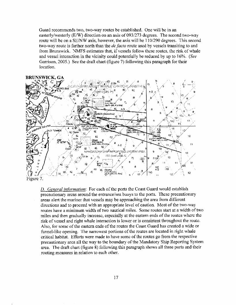
Guard recommends two, two-way routes be established. One will be in an easterly/westerly (E/W) direction on an axis of 093/273 degrees. The second two-way route will be on a SE/NW axis, however, the axis will be 110/290 degrees. This second two-way route is farther north than the de facto route used by vessels transiting to and from Brunswick. NMFS estimates that, if vessels follow these routes, the risk of whale and vessel interaction in the vicinity could potentially be reduced by up to 16%. (See Garrison, 2005.) See the draft chart (figure 7) following this paragraph for their location.
BRUNSWICK. GA
D. General information: For each of the ports the Coast Guard would establish precautionary areas around the entrancehea buoys to the ports. These precautionary areas alert the mariner that vessels may be approaching the area from different directions and to proceed with an appropriate level of caution. Most of the two-way routes have a minimum width of two nautical miles. Some routes start at a width of two miles and then gradually increase, especially at the eastern ends of the routes where the risk of vessel and right whale interaction is lower or is consistent throughout the route. Also, for some of the eastern ends of the routes the Coast Guard has created a wide or funnel-like opening. The narrowest portions of the routes are located in right whale critical habitat. Efforts were made to have some of the routes go from the respective precautionary area all the way to the boundary of the Mandatory Ship Reporting System area. The draft chart (figure 8) following this paragraph shows all three ports and their routing measures in relation to each other.
17

SOUTHERN REGION
18
VII. ROUTING MEASURES FOR THE NORTHERN REGION
A. Cape Cod Bay: Vessels transiting between the Gulf of Maine and the Cape Cod Canal generally tend to travel on a trackline of 025/205 degree orientation, which goes through right whale critical habitat in Cape Cod Bay. NMFS has advised that there is a relatively high risk of vessel and right whale interaction at points along the current trackline. (See Kite-Powell and Nichols, 2005). Accordingly, the Coast Guard recommends the creation of the following routing measures in Cape Cod Bay:
0 two precautionary areas three, two-way routes
0 one, two-way recommended track
One circular precautionary area would be established with a radius of approximately 2.8 nautical miles. Its center would be at the geographic position for red and white (RW) buoy “H” located due east of New Inlet, MA. Emanating from this precautionary area would be three, two-way routes. One route would go towards Boston, MA, on a heading of 3 17 degrees and connect with the existing precautionary area outside the entrance to Boston Harbor. A second route would go towards Provincetown, MA, on a 130 degree heading. The third, two-way route would go in a southerly direction (1 73 degrees) towards the entrance of Cape Cod Canal and would connect with the precautionary area located at the canal entrance. Each two-way route would have a width of 2 nautical miles. Vessels transiting the northbound and southbound routes would travel on the western side of the critical habitat. One study estimates that if vessels followed these proposed routes the risk of right whale and vessel interaction could potentially be reduced by up to 37% to 45% because right whale sighting information indicates relatively lower concentrations of right whales in this part of the critical habitat. (See Kite-Powell and Nichols, 2005).
The two-way recommended track would be between the precautionary area at the canal entrance and Provincetown, MA, on a heading of 045 degrees. Although this two-way track would go directly through right whale critical habitat, the number of vessels currently using this route is minimal; their size is usually small; and their operating speed is normally at or very near the speed limit that NOAA is considering implementing in the critical habitat. (See Kite-Powell and Nichols, 2005 and Russell, 2001). If vessels transiting from the canal and Provincetown instead went north and then headed east, they would actually spend more time in critical habitat which could potentially increase the chances of interaction with right whales.
An additional two-way route was considered but not included. This route would have been connected to the precautionary area at buoy “H” and would have been oriented in a northhortheast direction. Vessel traffic heading north through Cape Cod Bay would use the proposed north two-way route from the canal to the precautionary area and then use the additional route to transit further north to the Gulf of Maine. The Coast Guard is not recommending the creation of this two-way route at this time because it would cause all northbound vessel traffic to be concentrated and cross the TSS at
19
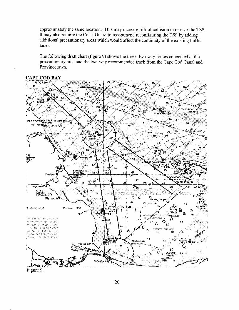
approximately the same location. This may increase risk of collision in or near the TSS. It may also require the Coast Guard to recommend reconfiguring the TSS by adding additional precautionary areas which would affect the continuity of the existing traffic lanes.
The following draft chart (figure 9) shows the three, two-way routes connected at the precautionary area and the two-way recommended track from the Cape Cod Canal and Provincetown.
CAPE COD BAY
20
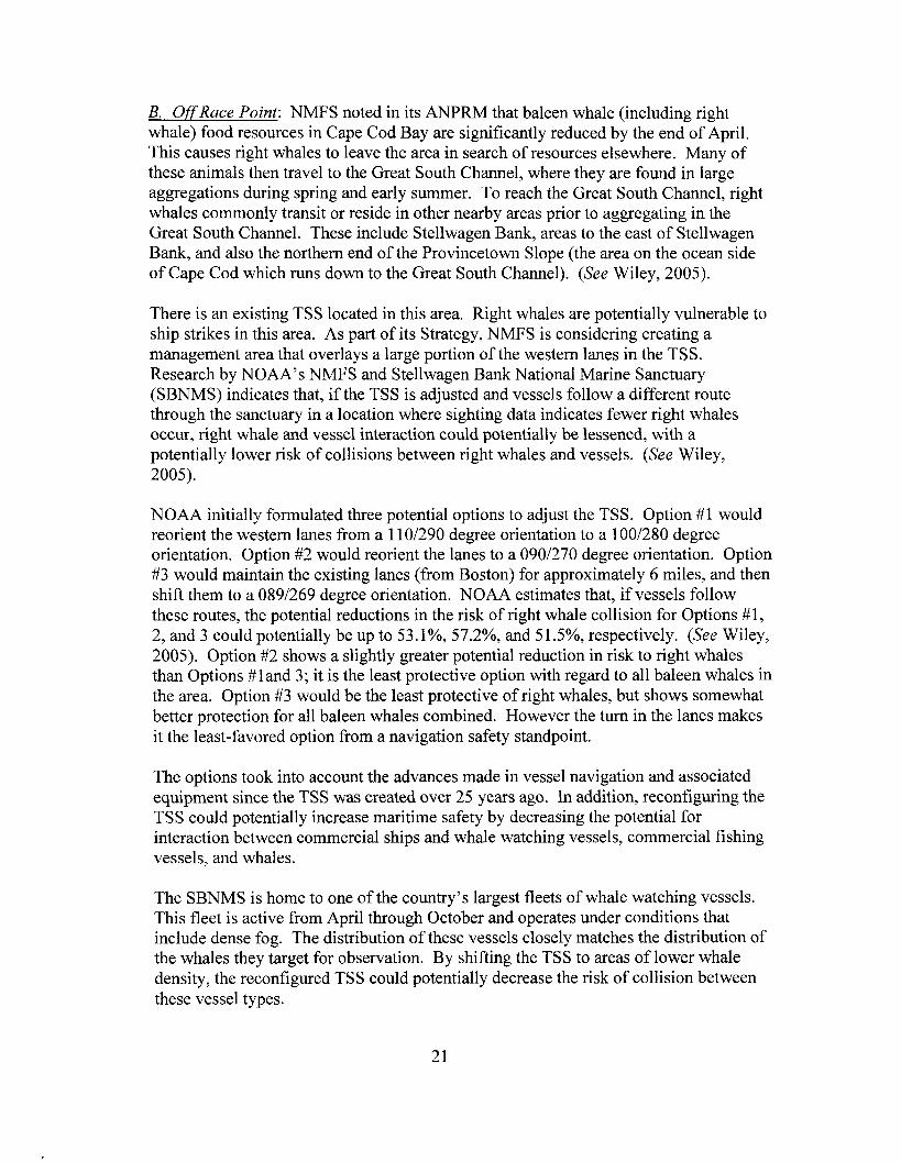
B. Off Race Point: NMFS noted in its ANPRM that baleen whale (including right whale) food resources in Cape Cod Bay are significantly reduced by the end of April. This causes right whales to leave the area in search of resources elsewhere. Many of these animals then travel to the Great South Channel, where they are found in large aggregations during spring and early summer. To reach the Great South Channel, right whales commonly transit or reside in other nearby areas prior to aggregating in the Great South Channel. These include Stellwagen Bank, areas to the east of Stellwagen Bank, and also the northern end of the Provincetown Slope (the area on the ocean side of Cape Cod which runs down to the Great South Channel). (See Wiley, 2005).
There is an existing TSS located in this area. Right whales are potentially vulnerable to ship strikes in this area. As part of its Strategy, NMFS is considering creating a management area that overlays a large portion of the western lanes in the TSS. Research by NOAA’s NMFS and Stellwagen Bank National Marine Sanctuary (SBNMS) indicates that, if the TSS is adjusted and vessels follow a different route through the sanctuary in a location where sighting data indicates fewer right whales occur, right whale and vessel interaction could potentially be lessened, with a potentially lower risk of collisions between right whales and vessels. (See Wiley, 2005).
N O M initially formulated three potential options to adjust the TSS. Option #1 would reorient the western lanes from a 1 10/290 degree orientation to a 100/280 degree orientation. Option #2 would reorient the lanes to a 090/270 degree orientation. Option #3 would maintain the existing lanes (from Boston) for approximately 6 miles, and then shift them to a 0891269 degree orientation. NOAA estimates that, if vessels follow these routes, the potential reductions in the risk of right whale collision for Options #I, 2, and 3 could potentially be up to 53.1%, 57.2%, and 5 1 WO, respectively. (See Wiley, 2005). Option #2 shows a slightly greater potential reduction in risk to right whales than Options #land 3; it is the least protective option with regard to all baleen whales in the area. Option #3 would be the least protective of right whales, but shows somewhat better protection for all baleen whales combined. However the turn in the lanes makes it the least-favored option from a navigation safety standpoint.
The options took into account the advances made in vessel navigation and associated equipment since the TSS was created over 25 years ago. In addition, reconfiguring the TSS could potentially increase maritime safety by decreasing the potential for interaction between commercial ships and whale watching vessels, commercial fishing vessels, and whales.
The SBNMS is home to one of the country’s largest fleets of whale watching vessels. This fleet is active from April through October and operates under conditions that include dense fog. The distribution of these vessels closely matches the distribution of the whales they target for observation. By shifting the TSS to areas of lower whale density, the reconfigured TSS could potentially decrease the risk of collision between these vessel types.
21

The SBNMS also provides opportunities to a large commercial fishing industry. This fleet is active year round and operates at night and under conditions of dense fog. Survey data collected by the sanctuary indicates that reconfiguring the TSS could move vessel traffic away from areas historically used by fishers. Additional safety benefits would occur because the reconfigured TSS passes through the Western Gulf of Maine Closed Area (WGMCA). The WGMCA was established by the New England Fishery Management Council and prohibits ground fish vessels from using the area. Potentially a smaller number of ground fish vessels would be active within the reconfigured TSS, thereby potentially reducing the risk of collision with commercial shipping.
While in consultation on these options, NOAA initially advised the Coast Guard that it preferred Option # 1. In addition to adding a relatively high potential reduction of risk of right whale-ship interaction, Option #1 also presents the smallest extent of change to the existing TSS. NOAA indicates that representatives of the maritime industry have been briefed on all three options and tend to favor Option #1, as well. As discussed above, industry acceptance is a key aspect of the success of a routing measure. (See Wiley, 2005).
The PWSA (33 U.S.C. 1223(c)(3)(B) and (C)) requires the Coast Guard to take into account all other uses of the area under consideration and to the extent practicable, reconcile the need for safe access routes with the needs of all other reasonable uses of the area. The Coast Guard has received two applications for deepwater ports in the vicinity of the existing TSS. One application proposes deepwater port locations in very close proximity to the existing TSS. (The proposed locations are depicted as shaded circles in figures 10 through 12 below.) These locations will likely not be feasible should either Option #1 or #2 be implemented. It appears that Option #3 would be able to accommodate the deepwater ports. However, the Coast Guard avoids use of turns in TSS lanes because there are increased safety risks associated with more frequent turns in confined areas. The Coast Guard’s preference is to create lanes in a TSS that run as long as possible in the same direction without turns. Options #1,2, and 3 are depicted on the charts following this paragraph, with the existing TSS shaded.
After development of the three initial options described previously, the Coast Guard and NOAA continued to consult and jointly developed another option to adjust the TSS (Option #4) (figure 13).
If Option #4 is implemented it would consist of traffic lanes 1.5 nautical miles wide vice their current 2 mile width. Based on advances in vessel navigation referenced above, the Coast Guard believes that 1.5 mile lanes would provide a sufficient margin of safety. The separation zone dimensions would remain the same. This option would reorient the lanes to a 095/275 axis which places it between Options #1 and #2. NOAA has analyzed this proposed location against right whale data and has concluded that if vessels used the proposed TSS the potential reduction in the risk of right whale collisions could be up to 57.9%. An additional benefit of this option is that it could potentially reduce the risk of collision to all baleen whales in this area by up to 80.7%. In addition to the potential reduction in risk to right whales it appears this option would
22

be able to accommodate currently proposed deepwater ports in their proposed locations. NOAA has briefed the representatives of the maritime industry on Option #4 and received a generally favorable response. The Coast Guard will seek the first available opportunity to present this option to the maritime industry for additional input.
Figure 10
23

TSS OPTION #2
TSS OPTION #3
24

Figure 13.
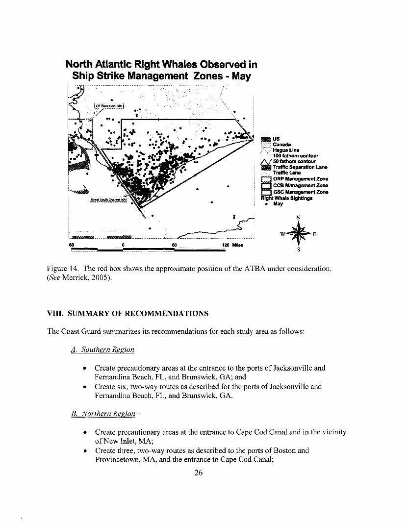
C. Great South Channel: The Coast Guard notes that NMFS mentioned in its ANPRM that it is considering recommending the establishment of an Area to be Avoided (ATBA) off of Great South Channel. The potential impact of the ATBA is that vessels transiting north and south which previously avoided using the TSS may begin to use the TSS because they would be prohibited or advised to avoid passing through the ATBA and could potentially have a shorter voyage through the TSS than by going around the ATBA and George’s Bank to the east (fig. 14). These vessels would leave the lanes once past the boundaries of the ATBA. Right whales occupy the area north of the ATBA. (See Merrick, 2005). Therefore, it may be necessary to create additional routing measures such as another TSS or two-way route that would break off to the north from the existing TSS where the risk of right whale and vessel interaction may potentially be lower. Both NMFS and the Coast Guard will continue to investigate this possible shift in vessel traffic patterns and determine the validity and necessity of creating additional routing measures.
25
North Atlantic Right Whales Obsewed in Ship Strike Management Zones - May
* I I
us Canada Hague Line 100 fathom contour 50 fathom contour Traffic Separation Lane Traffic Lane ORP mnagementzone
nCCccBMaMgementZone r""""J Gsc Management zone Right Whale Sighting8
a May
N
E
S
Figure 14. The red box shows the approximate position of the ATBA under consideration. (See Merrick, 2005).
VIII. SUMMARY OF RECOMMENDATIONS
The Coast Guard summarizes its recommendations for each study area as follows:
A. Southern Region -
0
0
Create precautionary areas at the entrance to the ports of Jacksonville and Fernandina Beach, FL, and Brunswick, GA; and Create six, two-way routes as described for the ports of Jacksonville and Fernandina Beach, FL, and Brunswick, GA.
B. Northern Region -
0
0
Create precautionary areas at the entrance to Cape Cod Canal and in the vicinity of New Inlet, MA; Create three, two-way routes as described to the ports of Boston and Provincetown, MA, and the entrance to Cape Cod Canal;
26

Create a two-way recommended track from the Cape Cod Canal entrance to Provincetown, MA; and Realign the TSS: Option #4 is the current preference.
IX. FUTURE ACTION ITEMS
The following are action items that may be required as a result of this PARS:
Surveys of areas where routing measures are to be created to ensure there are no hazards or bathymetric reasons to indicate the routes are not suitable; Surveys of fish havens (especially in the southeastern U. S.) to determine their status and possibility of removal to ensure navigational safety; IMO documents to be developed and submitted for amending the Boston TSS and the establishing of the Great South Channel ATBA; USCG will publish a final notice of the PARS study with a 10 day public comment period; USCG to notify NMFS if no major changes are necessitated after the comment period within 10 days after the closing date for receipt of comments; If changes to the report are necessitated by the comments received, within 10 days the USCG will initiate coordination with NOAA on any comments received to the final notice of the PARS study; If no major changes are necessitated after the comment period, NMFS will request NOS Charting to mark the recommended routes on charts, with an implementation date no earlier than 3 months after NMFS and the USCG agree on the proposed changes (this will enable adequate notice to mariners of the proposed changes); Maritime community and other stakeholders to be advised of routing measures; Aids to navigation to be added, moved or removed to accommodate or mark new routing measures; and If any regulations are necessary, such regulations will be promulgated by the appropriate agency.
27

X. REFERENCES
Garrison, L. P. 2005. Applying a spatial model to evaluate the risk of interactions between vessels and right whales in the southeast United States critical habitat. Southeast Fisheries Science Center.
Georgia Port Authority website (www.tr;aporls.eonr).
Jacksonville Port Authority website (www.i axport.com).
Kite-Powell, H. L., 0. C. Nichols. 2005. Analysis of risk to North Atlantic right whales (Eubalaena glacialis) from shipping traffic in Cape Cod Bay. Center for Coastal Studies and Woods Hole Oceanographic Institution.
Merrick, R. 2005. Seasonal management areas to reduce ship strikes of Northern right whales in the Gulf of Maine. Northeast Fisheries Science Center.
National Marine Fisheries Service. 2005. Recovery Plan for the North Atlantic Right Whale (Eubalaena glacialis). National Marine Fisheries Service, Silver Spring, MD.
NDC. 2004. Publications and U. S. waterway data CD. U. S. Army Corps of Engineers.
Russell, B. A. 2001. Recommended measures to reduce ship strikes of North Atlantic right whales.
Russell, B., A.R. Knowlton, J. B. Ring. 2003. Vessel traffic management scenarios based on recommended measures to reduce ship strikes of Northern right whales.
Ward-Geiger, L.I., G. K. Silber, R. D. Baumstark, T. L. Pulfer. 2005. Characterization of Ship Traffic in Right Whale Critical Habitat. Coastal Management, 33:263-278.
Wiley, D. N., M. Thompson and R. Merrick. 2005. Reducing the risk of ship strike to whales within the Stellwagen Bank NMS. PowerPoint presentation. Stellwagen Bank National Marine Sanctuary.
28