Embed Size (px)
Citation preview
www.devexresources.com.au
T: +61 (0) 8 9322 3990 F: +61 (0) 8 9322 5800 E: [email protected]
DevEx Resources Limited Level 2, 1292 Hay Street, West Perth WA 6005, Australia GPO Box 2980, Perth WA 6001
Porphyry Copper-Gold Targets Identified at Junee Project,
Lachlan Fold Belt, NSW
Project-scale exploration programs planned this quarter targeting potential for buried porphyry copper-gold
mineralisation similar to Cadia-Ridgeway and Northparkes deposits
Highlights
Re-interpretation of geophysical and geological data within the Junee Project has identified the
potential for buried porphyry-style copper-gold style mineralisation, of similar style to other major
deposits in this region, including the world-class Cadia-Ridgeway and Northparkes copper-gold
mines.
Field reconnaissance completed last month recognised extensive alteration (silicification of
sediments) and quartz veining, associated with prominent elevated topography overlying coincident
magnetic and gravity lows.
Project-scale mapping, rock chip and soil sampling planned for the current quarter, subject to
securing land access agreements, with targeting to follow.
DevEx Resources (ASX: DEV) is pleased to advise that it has substantially upgraded the exploration potential of its
recently granted Junee Copper-Gold Project, located within the highly-endowed Lachlan Fold Belt of New South
Wales, after identifying a number of promising targets with the potential to host large-scale porphyry copper-gold
mineralisation.
The Company plans to progress the evaluation of these targets this quarter, with exploration of this promising early-
stage project to be pursued alongside its emerging lithium project in Western Australia and its copper-gold exploration
project in the Northern Territory.
DevEx secured the Junee Copper-Gold Project last year because of its location and geological address. The project
area covers a sequence of Ordovician and Silurian volcanics, the Junawarra Volcanics, adjacent to a major crustal
structure, the Gilmore Suture Zone, within a province with a high copper-gold endowment, the Macquarie Arc.
The rocks of the Macquarie Arc host many large porphyry copper-gold deposits, including the world-class Cadia-
Ridgeway and Northparkes deposits (Figure 1). This is the style of mineralisation targeted on the Company’s tenure.
Page | 2
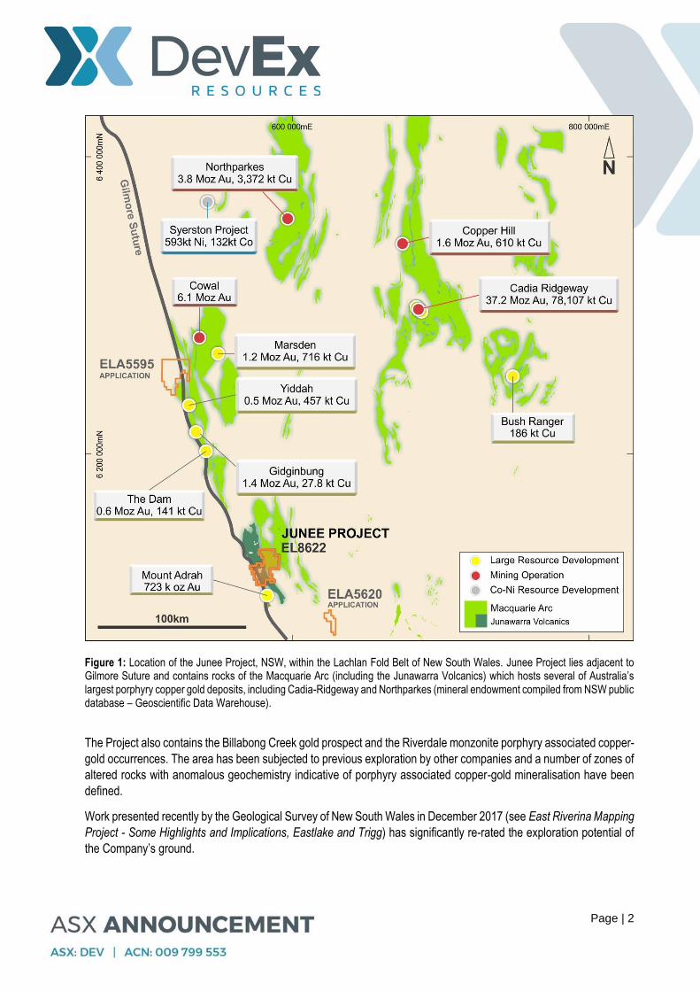
Figure 1: Location of the Junee Project, NSW, within the Lachlan Fold Belt of New South Wales. Junee Project lies adjacent to Gilmore Suture and contains rocks of the Macquarie Arc (including the Junawarra Volcanics) which hosts several of Australia’s largest porphyry copper gold deposits, including Cadia-Ridgeway and Northparkes (mineral endowment compiled from NSW public database – Geoscientific Data Warehouse).
The Project also contains the Billabong Creek gold prospect and the Riverdale monzonite porphyry associated copper-
gold occurrences. The area has been subjected to previous exploration by other companies and a number of zones of
altered rocks with anomalous geochemistry indicative of porphyry associated copper-gold mineralisation have been
defined.
Work presented recently by the Geological Survey of New South Wales in December 2017 (see East Riverina Mapping
Project - Some Highlights and Implications, Eastlake and Trigg) has significantly re-rated the exploration potential of
the Company’s ground.
Page | 3
This work found that the Junawarra Volcanics contain monzonitic intrusions that are high-potassium in nature, with
trace element signatures typical of subduction-zone magmatism. The chemical affinity of these intrusions is favourable
for copper-gold ore-metal associations and is similar to those of mineralised calc-alkaline intrusions of the Macquarie
Arc.
The Junawarra Volcanics are not exclusively tholeiitic or MORB-like as previously reported. New U–Pb zircon dating
indicates these magmas were emplaced during phase 4 of the Macquarie Arc, contemporaneous with mineralised
intrusions at Cadia and Goonumbla.
On these grounds the Junawarra Volcanics are now interpreted by the GSNSW as a southern extension of the Junee–
Narromine Volcanic Belt, consequently affirming them as prospective for porphyry copper-gold mineralisation.
This new information has allowed a re-rating of the exploration opportunities associated with the alteration and
mineralisation defined by historical exploration on Devex’s Junee exploration licence. There is clear potential for
discovery of a major porphyry-related copper-gold system.
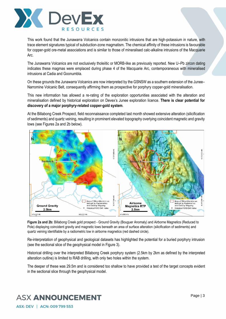
At the Billabong Creek Prospect, field reconnaissance completed last month showed extensive alteration (silicification
of sediments) and quartz veining, resulting in prominent elevated topography overlying coincident magnetic and gravity
lows (see Figures 2a and 2b below).
Figure 2a and 2b: Billabong Creek gold prospect - Ground Gravity (Bouguer Anomaly) and Airborne Magnetics (Reduced to
Pole) displaying coincident gravity and magnetic lows beneath an area of surface alteration (silicification of sediments) and
quartz veining identifiable by a radiometric low in airborne magnetics (red dashed circle).
Re-interpretation of geophysical and geological datasets has highlighted the potential for a buried porphyry intrusion
(see the sectional slice of the geophysical model in Figure 3).
Historical drilling over the interpreted Billabong Creek porphyry system (2.5km by 2km as defined by the interpreted
alteration outline) is limited to RAB drilling, with only two holes within the system.
The deeper of these was 29.5m and is considered too shallow to have provided a test of the target concepts evident
in the sectional slice through the geophysical model.

Page | 4
Figure 3: Section A – A’, 3-D Inversion Model of Magnetics sections showing magnetic low image (blue) with bounding magnetic highs (red) interpreted to be a potential porphyry intrusion. Units measured as magnetic susceptibility si units.
Project-scale mapping and rock chip and soil sampling is planned for the current quarter, subject to securing land
access agreements, with targeting to follow.
With the majority of the project area lying within an active farming community, similar to other active exploration projects
in the region, the Company has commenced the process of landowner engagement with the purpose of entering into
formal land access agreements which will allow it to carry out exploration.
As part of the Junee technical review, and compilation of regional and open file data related to copper-gold potential
within the Lachlan Fold Felt, two areas were identified where historical exploration activity and geophysics suggested
the potential for significant copper-gold mineralisation. New Exploration Licence Applications were submitted, and
both areas are currently under review to determine their mineral potential.
DevEx Resources Managing Director, Mr Brendan Bradley, said: “Thanks to the invaluable geophysical and geological datasets obtained from the Geological Survey of NSW, we have been able to undertake an initial review which has significantly upgraded the potential of our recently granted Junee Exploration Licence in NSW.” “The licence is located in a Tier-1 address from an exploration perspective, within the highly endowed Macquarie Arc – the same province that hosts world-scale deposits such as Cadia-Ridgeway. This potential is now supported by specific data provided by the GSNSW and by the results of initial field exploration activities undertaken by the Company towards the end of last year.” “The presence of extensive alteration and quartz veining associated with prominent geological and geophysical features is an exciting development which was confirmed by our field team. We believe there is clear potential for the discovery of large-scale porphyry mineralisation on our tenements, and we are looking forward to getting back into the field to begin more focused exploration.”
Brendan Bradley Managing Director
Page | 5
For further information, please contact: Brendan Bradley, Managing Director DevEx Resources Limited Telephone +61 8 9322 3990
For media inquiries, please contact: Nicholas Read Read Corporate Telephone: +61 8 9388 1474
COMPETENT PERSON STATEMENT
The information in this report that relates to Exploration results is based on information compiled by DevEx Resources Limited and reviewed by Mr Brendan Bradley who is the Managing Director of the Company and a member of the Australian Institute of Geoscientists. Mr Bradley has sufficient experience that is relevant to the styles of mineralisation, the types of deposits under consideration and to the activities undertaken to qualify as a Competent person as defined in the 2012 edition of the “Australasian Code for Reporting of Exploration Results, Mineral Resources and Ore Reserves”. Mr Bradley consents to the inclusion in this report of the matters based on this information in the form and context in which it appears. FORWARD LOOKING STATEMENT This announcement contains forward-looking statements which involve a number of risks and uncertainties. These forward looking statements are expressed in good faith and believed to have a reasonable basis. These statements reflect current expectations, intentions or strategies regarding the future and assumptions based on currently available information. Should one or more of the risks or uncertainties materialise, or should underlying assumptions prove incorrect, actual results may vary from the expectations, intentions and strategies described in this announcement. No obligation is assumed to update forward looking statements if these beliefs, opinions and estimates should change or to reflect other future developments.
Page | 6
Appendix 1. Junee Project - JORC 2012 Table 1
Section 1 Sampling Techniques and Data
Criteria JORC Code explanation Commentary
Sampling techniques
Nature and quality of sampling (eg cut channels, random chips, or specific specialised industry standard measurement tools appropriate to the minerals under investigation, such as down hole gamma sondes, or handheld XRF instruments, etc). These examples should not be taken as limiting the broad meaning of sampling.
Include reference to measures taken to ensure sample representivity and the appropriate calibration of any measurement tools or systems used.
Aspects of the determination of mineralisation that are Material to the Public Report.
In cases where ‘industry standard’ work has been done this would be relatively simple (eg ‘reverse circulation drilling was used to obtain 1 m samples from which 3 kg was pulverised to produce a 30 g charge for fire assay’). In other cases more explanation may be required, such as where there is coarse gold that has inherent sampling problems. Unusual commodities or mineralisation types (eg submarine nodules) may warrant disclosure of detailed information.
This report does not contain any new drill related results.
Drilling techniques Drill type (eg core, reverse circulation, open-hole hammer, rotary air blast, auger, Bangka, sonic, etc) and details (eg core diameter, triple or standard tube, depth of diamond tails, face-sampling bit or other type, whether core is oriented and if so, by what method, etc).
This report refers to open-file RAB drilling within the Junee Project, carried out by GeoPeko and Lachlan Resources. Within the area of interest drilling typically drilled to depth of between 3 and 30 metres. This drilling is presented for completeness, but is not considered an effective test of the underlying target discussed within this report.
Drill sample recovery
Method of recording and assessing core and chip sample recoveries and results assessed.
Measures taken to maximise sample recovery and ensure representative nature of the samples.
Whether a relationship exists between sample recovery and grade and whether sample bias may have occurred due to preferential loss/gain of fine/coarse material.
This report refers to open-file RAB drilling within the Junee Project, carried out by GeoPeko and Lachlan Resources. Sample recovery is not recorded in the historical dataset. This drilling is presented for completeness, but is not considered an effective test of the underlying target.
Logging Whether core and chip samples have been geologically and geotechnically logged to a level of detail to support appropriate Mineral Resource estimation, mining studies and metallurgical studies.
Whether logging is qualitative or quantitative in nature. Core (or costean, channel, etc) photography.
The total length and percentage of the relevant intersections logged.
This report refers to open-file RAB drilling within the Junee Project, carried out by GeoPeko and Lachlan Resources. General geology of bottom of hole chips is recorded. This drilling is presented for completeness, but is not considered an effective test of the underlying target discussed within this report.
Sub-sampling techniques and sample preparation
If core, whether cut or sawn and whether quarter, half or all core taken.
If non-core, whether riffled, tube sampled, rotary split, etc and whether sampled wet or dry.
For all sample types, the nature, quality and appropriateness of the sample preparation technique.
Quality control procedures adopted for all sub-sampling stages to maximise representivity of samples.
Measures taken to ensure that the sampling is representative of the in situ material collected, including for instance results for field duplicate/second-half sampling.
Whether sample sizes are appropriate to the grain size of the material being sampled.
This report refers to open-file RAB drilling within the Junee Project, carried out by GeoPeko and Lachlan Resources. Sub-Sampling and sampling techniques are not recorded in the historical information. This drilling is presented for completeness, but is not considered an effective test of the underlying target discussed within this report.
Quality of assay data and laboratory tests
The nature, quality and appropriateness of the assaying and laboratory procedures used and whether the technique is considered partial or total.
For geophysical tools, spectrometers, handheld XRF instruments, etc, the parameters used in determining the analysis including instrument make and model, reading times, calibrations factors applied and their derivation, etc.
Geophysical data presented is publically available data sourced from the Geological Survey of NSW (GSNSW): Planning and Environment Resources and Energy Department’s Geoscientific Data Warehouse:
Gravity Survey: A detailed ground gravity survey was carried out by Haines Surveys in 2009 for Clancy
Page | 7
Criteria JORC Code explanation Commentary
Nature of quality control procedures adopted (eg standards, blanks, duplicates, external laboratory checks) and whether acceptable levels of accuracy (ie lack of bias) and precision have been established.
Exploration Limited. There were 27 observations repeated for quality control purposes, giving a repeat percentage of 2.5%. All gravity stations were not completed due to terrain. Note; some of the stations may have been slightly offset from their planned position due to vegetation and terrain. Gravity measurements were made using the Scintrex CG5 Autograv instrument numbered 40352. Readings of 120 seconds were taken at base stations. Readings of 40 seconds were taken at all other gravity survey points. Base station readings were taken at the beginning of the day and at the end of the day’s fieldwork. Magnetic and Radiometric Surveys – Aeroquest Airborne conducted a low level airborne geophysical survey for Clancy Exploration Limited in 2011. The list of geophysical and navigation equipment used for the survey is as follows: General Survey Equipment • Cessna 206-H fixed wing survey aircraft. • UTS proprietory flight planning and survey navigation system. • UTS proprietory high speed digital data acquisition system. • Novatel, 12 channel precision navigation GPS. • OMNISTAR real time differential GPS system. • UTS LCD pilot navigation display and external track guidance display. • UTS post mission data verification and processing system. • Bendix/King KRA-405 radar altimeter. Magnetic Data Acquisition Equipment • UTS tail stinger magnetometer installation. • Cesium Vapour total field magnetometer. • Fluxgate three component vector magnetometer. • RMS Aeromagnetic Automatic Digital Compensator (AADC II). • Diurnal monitoring magnetometer (Scintrex Envimag or Geometrics GR-856). Radiometric Data Acquisition Equipment • RS-500 advanced digital gamma-ray spectrometer consisting of 8 x 4L Nal(TI) gamma ray detectors. • Barometric altimeter (height and pressure measurements). • Temperature and humidity sensor.
Verification of sampling and assaying
The verification of significant intersections by either independent or alternative company personnel.
The use of twinned holes.
Documentation of primary data, data entry procedures, data verification, data storage (physical and electronic) protocols.
Discuss any adjustment to assay data.
Airborne Magnetic and Radiometric Surveys : Detailed magnetics broadly correlate with separate regional government magnetics previously completed.
Airborne Magnetic data is adjusted by carrying our industry standard processing to produce a Reduce to the Pole image with sun angle shading.
Gravity: Gravity data is sourced from the NSW Department. In presenting Gravity Data, images are presented as a Bouguer Anomaly Map, which is a gravity anomaly corrected for the height at which it is measured. This methodology is considered a standard way of presenting Gravity Data
Page | 8
Criteria JORC Code explanation Commentary
Location of data points
Accuracy and quality of surveys used to locate drill holes (collar and down-hole surveys), trenches, mine workings and other locations used in Mineral Resource estimation.
Specification of the grid system used.
Quality and adequacy of topographic control.
For the gravity survey, carrier phase GPS data has been collected using Trimble 4000 series Geodetic receivers. Measurements for detail gravity observations have been made using Real Time Kinematic (RTK) techniques including Post Processed Infill giving horizontal and vertical precisions of at least 5 cm. RTK processing has been has been completed using Trimble TSC1 firmware and Trimble Geomatics Office version 1.50 software.
For the magnetics and radiometrics surveys, survey data positioning and flight line navigation was derived using realtime differential GPS (Global Positioning System). Navigation was performed using a UTS designed and built electronic pilot navigation system providing computer controlled digital navigation instrumentation mounted in the cockpit as well as an externally mounted track guidance system. GPS derived positions were used to provide both aircraft navigation and survey data location information. The GPS systems used for the survey were: Aircraft GPS Model Novatel, Sample rate 0.5 Seconds (2 Hz), GPS satellite tracking channels 12 parallel, Typical differentially corrected accuracy 1-2 metres (horizontal), 3-5 metres (vertical). Accurate survey heights above the terrain were measured using a King radar altimeter installed in the aircraft. The height of each survey data point was measured by the radar altimeter and stored by the UTS data acquisition system. Radar altimeter models Bendix/King KRA-405, Accuracy 0.3 metres, Resolution 0.1 metres, Range 0 - 762 metres, Sample rate 0.1 Seconds (10Hz).
The grid system used is Map Grid of Australia (MGA) GDA94 Zone 55.
Data spacing and distribution
Data spacing for reporting of Exploration Results.
Whether the data spacing and distribution is sufficient to establish the degree of geological and grade continuity appropriate for the Mineral Resource and Ore Reserve estimation procedure(s) and classifications applied.
Whether sample compositing has been applied.
Magnetic and Radiometric Surveys: It comprised a 1178 line km, 50m line spaced airborne magnetic and radioelement survey at a nominal height of 40m. The flight lines were oriented in a NE-SW orientation perpendicular to regional geological strike.
Gravity Survey: The survey comprised 1085 detail gravity stations on 51 W-E lines. The lines are coincident with GDA94 Zone 55 with line intervals of 200m and station intervals of 200m.
The expected accuracy is +/- 5cm.
The grid system used is Map Grid of Australia (MGA) GDA94 Zone 55.
Orientation of data in relation to geological structure
Whether the orientation of sampling achieves unbiased sampling of possible structures and the extent to which this is known, considering the deposit type.
If the relationship between the drilling orientation and the orientation of key mineralised structures is considered to have introduced a sampling bias, this should be assessed and reported if material.
Orientation of the Gravity Survey, Airborne Magnetic and Radiometric Surveys are detailed above.
This report does not discuss new drill related results.
This report refers to open-file RAB drilling within the Junee Project, carried out by GeoPeko and Lachlan Resources. This RAB drilling is shallow and no considered an effective test of the underlying modelled geophysical targets.
Orientations of primary mineralisation is currently unknown.
Sample security The measures taken to ensure sample security. This report does not discuss new data collected by the company.
Audits or reviews The results of any audits or reviews of sampling techniques and data.
The company has employed independent geophysical consultant Graham Elliot to process and review the open file
Page | 9
Criteria JORC Code explanation Commentary
geophysical datasets referred within. Graham has reviewed the quality of the data sets and find them suitable for the purposes presented within.
Section 2 Reporting of Exploration Results
Criteria JORC Code explanation Commentary
Mineral tenement and land tenure status
Type, reference name/number, location and ownership including agreements or material issues with third parties such as joint ventures, partnerships, overriding royalties, native title interests, historical sites, wilderness or national park and environmental settings.
The security of the tenure held at the time of reporting along with any known impediments to obtaining a licence to operate in the area.
The Junee Project represents exploration licence EL8622 granted in 2017 by the New South Wales Planning and Environment, Resources and Energy Department.
DevEx Resources Limited holds 100% of EL8622 through its wholly owned subsidiary TRK Resources Pty Ltd.
The majority of EL8622 lies within free-hold land requiring TRK Resource Pty Ltd to enter in a land access agreement with individual land owners as prescribed by New South Wales State Law.
EL8622 is in its first year of grant and is considered to be in good standing.
Exploration done by other parties
Acknowledgment and appraisal of exploration by other parties.
The company has completed a comprehensive open file review of historical exploration within EL8622. This review identified the potential for porphyry copper mineralisation through works carried out by Jododex Australia Pty Ltd 1980 - 81, Getty Oil Development Co Ltd 1982 - 83, Lachlan Resources NL 1984 - 1988, Peko Wallsend Operations Ltd and North Limited 1987 - 96, Gateway Mining Nl 1998, Golden Cross Operations Pty Ltd 2002 - 05, Clancy Exploration Limited 2008 – 12 and Mount Adrah Gold Limited 2014 - 16
Geology Deposit type, geological setting and style of mineralisation. Discussed in the text of this announcement, the Junee Copper-Gold Project, located within the Lachlan Fold Belt of New South Wales, is focused on a sequence of Ordovician and Silurian volcanics, the Junawarra Volcanics, adjacent to a major crustal structure, the Gilmore Suture Zone, within a province with a high copper-gold endowment, the Macquarie Arc. The rocks of the Macquarie Arc host many large porphyry copper-gold deposits, including the Cadia-Ridgeway and Northparkes deposits. This is the style of mineralisation targeted on the Company’s tenement.
The Geological Survey of New South Wales in December 2017 (see East Riverina Mapping Project - Some highlights and implications – Eastlake and Trigg) significantly re-rated the exploration potential of the Company’s ground. This work found that the Junawarra Volcanics contain monzonitic intrusions that are high-potassium in nature, with trace element signatures typical of subduction-zone magmatism. The chemical affinity of these intrusions is favourable for Cu-Au ore-metal associations and is similar to those of mineralised calc-alkaline intrusions of the Macquarie Arc.
Drill hole Information
A summary of all information material to the understanding of the exploration results including a tabulation of the following information for all Material drill holes: o easting and northing of the drill hole collar o elevation or RL (Reduced Level – elevation above sea
level in metres) of the drill hole collar o dip and azimuth of the hole o down hole length and interception depth o hole length.
If the exclusion of this information is justified on the basis that the information is not Material and this exclusion does not detract from the understanding of the report, the Competent
This report does not contain any new drill related results.
This report refers to historical open-file RAB drilling carried out by Peko Wallsend Operations Ltd and North Limited Peko, and Lachlan Resources NL in the vicinity of the Billabong Prospect. This RAB drilling is shallow and not considered an effective test of the underlying modelled geophysical targets. RAB drilling depth ranges between 3 to 30m within the area of interest. It is provided for completeness and context to the potential to the Billabong Prospect.
Page | 10
Criteria JORC Code explanation Commentary
Person should clearly explain why this is the case.
Data aggregation methods
In reporting Exploration Results, weighting averaging techniques, maximum and/or minimum grade truncations (eg cutting of high grades) and cut-off grades are usually Material and should be stated.
Where aggregate intercepts incorporate short lengths of high grade results and longer lengths of low grade results, the procedure used for such aggregation should be stated and some typical examples of such aggregations should be shown in detail.
The assumptions used for any reporting of metal equivalent values should be clearly stated.
This report does not contain any new or historical drill related results.
Relationship between mineralisation widths and intercept lengths
These relationships are particularly important in the reporting of Exploration Results.
If the geometry of the mineralisation with respect to the drill hole angle is known, its nature should be reported.
If it is not known and only the down hole lengths are reported, there should be a clear statement to this effect (eg ‘down hole length, true width not known’).
This report does not contain any new or historical drill related results.
Diagrams Appropriate maps and sections (with scales) and tabulations of intercepts should be included for any significant discovery being reported These should include, but not be limited to a plan view of drill hole collar locations and appropriate sectional views.
Refer to figures in the body of text.
Balanced reporting Where comprehensive reporting of all Exploration Results is not practicable, representative reporting of both low and high grades and/or widths should be practiced to avoid misleading reporting of Exploration Results.
This report does not contain any new drill related results.
Other substantive exploration data
Other exploration data, if meaningful and material, should be reported including (but not limited to): geological observations; geophysical survey results; geochemical survey results; bulk samples – size and method of treatment; metallurgical test results; bulk density, groundwater, geotechnical and rock characteristics; potential deleterious or contaminating substances.
The information presented in the Junee Project section of this report relates to previous geophysical exploration including ground gravity, airborne magnetics and radiometrics. Modelling of these datasets identifies an area of coincidence where gravity, magnetics lows correspond with a region of silicified sediments. Where access could be achieved (roadsides), field observations confirm that quartz veining and hydrothermal alteration of the overlying sediments can be observed at several areas surrounding this anomaly.
Geophysical modelling of the magnetic low suggests that possible buried porphyry copper-gold target buried beneath these rocks.
Other information such as metallurgy, geotechnical and densities is currently immaterial as the information related to an early stage exploration project.
Further work The nature and scale of planned further work (eg tests for lateral extensions or depth extensions or large-scale step-out drilling).
Diagrams clearly highlighting the areas of possible extensions, including the main geological interpretations and future drilling areas, provided this information is not commercially sensitive.
The Company is in the process of contacting land owners in the areas of interest with the intent of entering into Land Access Agreements in the coming quarter.
Project scale mapping and rock chip and soil sampling is planned for the coming quarter, subject to securing land access agreements, with targeting to follow.