Embed Size (px)
Citation preview
Polson Development Code
1993
Polson City Council
James W. Jones, Mayor; John W. Gluckert; Fred C. Funke, Tom Jones, Kyle K. Karstens, Michael F. Lies, Dan Morrison, Roland H. Pedersen, Thomas R. Vergeront, Clinton J. White
Lake County Board of Commissioners
Mike W. Hutchin, Gerald Newgard, David S. Stipe
Polson City:County Planning Board
Joe Browning, Valeria Broyles, Greg Garrison, John M. Heinrich, Calvin P. Hubbard, Thomas C. Lindell, Wayne C. Mahugh, Lee Manicke, Robert T. Sloan,
Thomas R. Vergeront
Rev 1/05
i
CONTENTS CHAPTER I - PURPOSE, AUTHORITY, AND GENERAL PROVISIONS ………………………………………………… 5 A. What This Chapter Does 5 Division 1 - Purpose and Authority 5 B. Purpose 5 C. Authority 5 Division 2 - Transition from Previous Regulations 5 D. Conflicting Ordinances 5 E. Vested Rights 5 F. Nonconforming Uses and Buildings 5-6 G. Private Agreements 6 Division 3 - Interpretation 6 H. Most Restrictive Standards 6 I. Burden of Proof 6 J. Requirements Minimum 6 K. Severability 6 L. Effective Date 6 CHAPTER II - ADMINISTRATIVE PROCEDURES …………………………………………………………………………... 7 A. What This Chapter Does 7 Division 1 - Permits Required 7 B. Permit Required 7 C. Exemptions for Land Divisions 7 D. Exemptions for Development Activity 7 E. Natural Resource Development 8 F. Application Forms and Fees 8 G. Site Inspection 8 Division 2 - Permit Procedures 8 H. Who Reviews Permits 8 I. Minor Subdivision Permit Procedure 8-9 J. Subdivision Permit Procedure 9-10 K. Development Permit Procedure 10 L. Special Use Permit Procedure 10-11 M. Conditions 11 N. Hearing Notices 11 O. Approvals Valid for Two Years 12 Division 3 - Appeals and Variances 12 P. Appeals 12 Q. Variances 12-13 Division 4 - Hearing Procedures 13 R. Hearing Procedure 13 S. Additional Hearing Procedures 13-14 T. Hearings To Be Taped 14 U. Decision Record 14 Division 4 - Enforcement 14 V. Failure to Obtain a Permit 14 W. Certificate of Compliance 14 X. Enforcement 14-15 Y. Violations 15 Z. Penalties 15 AA. Utilities Service 15 Division 5 - Amendments 15 BB. Amendments. 15-16 CHAPTER III - ZONING DISTRICTS …………………………………………………………………………………………. 17 A. What This Chapter Does 17 B. Zoning Districts 17 C. Overlay Districts 17 D. Zoning Map 17
ii
E. District Boundaries 17 CHAPTER IV - PRODUCTIVE LANDS ZONING DISTRICT ……………………………………………………………... 18 A. What This Chapter Does 18 B. Land Use 18 C. Specification Standards 18 D. Performance Standards 18 E. Overlay Districts 18 CHAPTER V - RURAL RESIDENTIAL ZONING DISTRICT ………………………………………………………………... 19 A. What This Chapter Does 19 B. Land Use 19 C. Specification Standards 19 D. Performance Standards 19-20 E. Overlay Districts 20 CHAPTER VI - LOW DENSITY RESIDENTIAL ZONING DISTRICT ……………………………………………………… 21 A. What This Chapter Does 21 B. Land Use 21 C. Specification Standards 21 D. Performance Standards 21-22 E. Overlay Districts 22 F. Livestock Land Use/Performance Standards (County Res. #, 4/4/02) 22 CHAPTER VII - MEDIUM DENSITY RESIDENTIAL DISTRICT …………………………………………………………… 24 A. What This Chapter Does 24 B. Land Use 24 C. Specification Standards 24 D. Performance Standards 24-25 E. Overlay Districts 26 CHAPTER VII -SUPPLEMENT-MIXED USE RESIDENTIAL DISTRICT (City Ord. #603, 1/05)……………………… 27 A. What This Chapter Does 27 B. Land Use 27 C. Specification Standards 27 D. Performance Standards 27 E. Overlay Districts 27 F. Density 27 CHAPTER VIII - TRANSITIONAL ZONING DISTRICT ……………………………………………………………………... 29 A. What This Chapter Does 29 B. Land Use 29 C. Specification Standards 29 D. Performance Standards 29-30 E. Overlay Districts 30 CHAPTER IX - RESORT ZONING DISTRICT ……………………………………………………………………………….. 31 A. What This Chapter Does 31 B. Land Use 31 C. Specification Standards 31 D. Performance Standards 31-32 E. Overlay Districts 32 CHAPTER X - HIGHWAY COMMERCIAL ZONING DISTRICT…………………………………………………………… 33 A. What This Chapter Does 33 B. Land Use 33 C. Specification Standards 33 D. Performance Standards 33-34 E. Overlay Districts 34 CHAPTER XI - CENTRAL BUSINESS ZONING DISTRICT ……………………………………………………………….. 35 A. What This Chapter Does 35 B. Land Use 35 C. Specification Standards 35 D. Performance Standards 35 E. Overlay Districts 35 CHAPTER XII - GENERAL COMMERCIAL - INDUSTRIAL ZONING DISTRICT……………………………………….. 36
iii
A. What This Chapter Does 36 B. Land Use 36 C. Specification Standards 36 D. Performance Standards 36 E. Overlay Districts 36 CHAPTER XIII - AIRPORT SAFETY OVERLAY DISTRICT……………………………………………………………….. 37 A. What This Chapter Does 37 Division 1 - Procedural Requirements 37 B. Additional Requirements for Nonconforming Uses 37 C. Additional Requirements for Permits 37 D. Additional Requirements for Variances 37 E. Obstruction Marking and Lighting 37 Division 2 - Height and Use Limitations 37 F. Height Limitation Zones 37-38 G. Use Restrictions 38 H. RESERVED 38 CHAPTER XIV - WELLHEAD PROTECTION OVERLAY DISTRICT ……………………………………………………... 40 A. What This Chapter Does 40 B. Wellhead Protection Zones 40 C. Land Use in Wellhead Protection Zones 40 D. Additional Performance Standards 40-41 CHAPTER XV - RESORT RESIDENTIAL OVERLAY DISTRICT …………………………………………………………. 43 A. What This Chapter Does 43 B. Additional Land Uses Permitted 43 C. Site Plan 43 D. Standards 43 CHAPTER XVI - SALISH POINT OVERLAY DISTRICT …………………………………………………………………… 44 A. What This Chapter Does 44 B. Interim Procedure 44 C. Interim Additional Performance Standard 44 CHAPTER XVII - RAILYARD OVERLAY DISTRICT ……………………………………………………………………….. 44 A. What This Chapter Does 44 B. Interim Procedure 44 C. Interim Additional Performance Standard 44 CHAPTER XVIII - PERFORMANCE STANDARDS ………………………………………………………………………… 45 A. What This Chapter Does 45 Division 1 - Protecting Flathead Lake and Other Natural Assets - Avoiding Natural Hazards 45 B. Runoff Management 45 C. Shoreline Buffers 45-46 D. Hillside Development 46 E. Water Quality 46 F. Air Quality 46 G. Hazardous Materials 46 H. Floodplain 46 I. RESERVED 46 Division 2 - Providing Adequate Infrastructure 47 J. Municipal Utilities 47 K. Private Utilities 47 L. Easements 47 M. Runoff Management 47 N. Vehicular Access 47 O. Access Driveways 47 P. Off-Street Parking 47 Q. Pedestrian Access 47 R. Bicycle Access 47 S. Circulation 47 T. Parks 48 U. RESERVED 48
iv
V. Large-Scale Development 48-49 Division 3 - Ensuring Land Use Compatibility - Enhancing the Community's Image 49 W. Potential Nuisances 49 X. Landscaped Buffers 50 Y. Signs 50 Z. Views to Flathead Lake 50 AA. RESERVED 51 Division 4 - Land Divisions 51 BB. Master Planning Required 51 CC. Environmental Assessments 51 DD. Plats 51 CHAPTER XIX - REQUIRED IMPROVEMENTS ……………………………………………………………………………. 52 A. What This Chapter Does 52 B. Installation at Developer’s Expense 52 C. Standards for Required Improvements 52 D. Time of Installation/Development Agreements 52 E. Effect of Development Agreement. 53 F. Guarantees 53 G. Inspection and Acceptance of Improvements 53 H. Warranty of Improvements 53 I. Continuing Maintenance Required. 53-54 CHAPTER XX - EXISTING NUISANCES …………………………………………………………………………………….. 55 A. What This Chapter Does 55 B. Existing Nuisances 55 D. Dangerous Buildings 55 E. Abandoned Signs 55 CHAPTER XXI - DEFINITIONS ………………………………………………………………………………………………... 56 A. What This Chapter Does 56 B. Rules of Interpretation 56 C. through III. Definitions 56-60 APPENDICES A separate table of contents is provided for the appendices, following page 60.
Polson Development Code 5
CHAPTER I - PURPOSE, AUTHORITY, AND GENERAL PROVISIONS A. What This Chapter Does. This chapter states the purpose of these regulations, identifies the statutes pursuant to which they are adopted, repeals conflicting regulations, establishes vested rights for developments approved prior to adoption of these regulations, establishes rules for the continuation of existing uses and buildings that do not conform to the requirements of these regulations, and establishes rules for the interpretation of these regulations.
Division 1 - Purpose and Authority B. Purpose. The purpose of these regulations is to promote the health, safety, and general welfare of the people of the City of Polson and the surrounding jurisdictional area by implementing the regulatory strategies of the Polson Master Plan. Specific statements of purpose accompany certain provisions of these regulations, but their policy basis is found in the master plan. C. Authority. These regulations are adopted under the authority granted by 76-2-201, MCA, et seq., which authorizes county zoning; 76-2-301, MCA, et seq., which authorizes city zoning; and 76-3-501, MCA, which requires cities and counties to adopt subdivision regulations.
Division 2 - Transition from Previous Regulations D. Conflicting Ordinances. All prior ordinances are repealed to the full extent of their inconsistency with these regulations, including the 1986 Development Plan Zoning Ordinance and Subdivision Regulations. E. Vested Rights. A vested right is the right to proceed with development in compliance with the city’s previous regulations (which are repealed by I.D.), or the right to proceed in compliance with these regulations, pursuant to a development agreement, as provided in XIX.D., et seq.
1. A vested right to proceed with development initiated prior to the effective date of these regulations shall be established only by:
a. having obtained a permit in compliance with the previous regulations (such vested rights expire with the permit or, where construction has not been diligently pursued, two years after the effective date of these regulations); or b. having recorded a final plat or obtained final approval of a preliminary plat in compliance with the previous regulations. Recording a final plat establishes a vested right to develop and sell lots precisely as they are described on that plat. Development or subsequent division of the lots shown on a final plat must comply with these regulations. Prior approval of a preliminary plat establishes a vested right to proceed with final platting and development of the subdivision precisely as approved. Such vested rights expire with the preliminary plat approval or, if a final plat is not recorded, two years after the effective date of these regulations. Development or subsequent division of lots shown on a preliminary plat must comply with these regulations.
2. Vested rights to proceed with development in compliance with these regulations (which may, of course, be amended) shall be established only by obtaining a permit. Such vested rights expire with the permit or, where one is approved, the development agreement. Vested rights are established for a development precisely as it was approved. Any change must be in compliance with the then current regulations.
F. Nonconforming Uses and Buildings. A nonconforming use or building complied with the regulations that were in effect at the time of its development, but would not comply with these regulations, if submitted for approval after their effective date. Nonconforming uses and buildings may continue as provided here.
1. Any nonconforming use abandoned for more than 18 months shall be terminated. Abandonment shall not be measured by the owner's intent, but solely by the fact that use ceases for a period of 18 or more months.
Polson Development Code 6
2. There shall be no limit on the maintenance and repair of nonconforming uses or buildings, provided that: a. no such activity increases the degree of nonconformity; b. no permit for such activity shall be issued until existing on-site sewage disposal systems are either: i. abandoned by connection to the municipal sewerage system, or ii. inspected and brought into compliance with current design standards, if necessary; and c. all such activity complies with the city’s fire and building codes. 3. Requests for minor changes of occupancy in nonconforming buildings or sites shall be processed as applications for special use permits, with compliance with this sub-paragraph added to the determinations made on the special use permit checklist. The use of nonconforming buildings or sites may be changed only where: a. the new use is no more intense (with intensity measured by anticipated traffic and noise generation, the number of parking spaces required, the number and size of signs proposed, and similar factors) than the existing; b. the degree of nonconformity is not increased, c. existing on-site sewage disposal systems are either: i. abandoned by connection to the municipal sewerage system, or ii. inspected and brought into compliance with current design standards, if necessary; and d. the proposed use complies with the city’s fire and building codes. 4. Nonconforming buildings that have been destroyed by fire or other catastrophe may be replaced upon approval of a development permit, with compliance with this sub-paragraph added to the determinations made by the administrator in deciding whether or not to approve the application. Other requests for replacement of nonconforming buildings shall be processed as applications for special use permits, with compliance with this sub-paragraph added to the determinations made on the special use permit checklist. Nonconforming buildings may be replaced only where: a. the degree of nonconformity is not increased; b. existing on-site sewage disposal systems are either: i. abandoned by connection to the municipal sewerage system, or ii. inspected and brought into compliance with current design standards, if necessary; and c. all construction complies with the city’s fire and building codes.
G. Private Agreements. Adoption of these regulations does not nullify easements, covenants, and similar private agreements, but where any such agreement imposes requirements less restrictive than those adopted here, the requirements of these regulations apply.
Division 3 - Interpretation H. Most Restrictive Standards. If future regulations adopted by the county or city, or state or federal law, impose additional requirements on activities governed by these regulations, the most restrictive apply. I. Burden of Proof. The responsibility for demonstrating compliance with these regulations is the developer’s. No incomplete application for a permit shall be accepted, and “insufficient information to determine compliance” shall be proper grounds for the rejection of an application by the administrator or board. J. Requirements Minimum. All requirements of these regulations shall be interpreted as the minimum necessary to protect the public health, safety, and general welfare, and implement the plan. This ordinance is designed for consistency with the plan and should be interpreted to achieve its goals and strategies. K. Severability. If any requirement of these regulations, or their application to particular circumstances, is held to be invalid, the remaining requirements and application of these regulations to other circumstances shall be unaffected. L. Effective Date. These regulations shall become effective immediately upon their adoption.
Polson Development Code 7
CHAPTER II - ADMINISTRATIVE PROCEDURES A. What This Chapter Does. This chapter requires a permit for all land development and building activity in the city and the surrounding jurisdictional area, and establishes procedures for the administration of these regulations.
Division 1 - Permits Required B. Permit Required. A permit shall be required for any division of land, clearing, grading, excavation, construction, reconstruction, or any land development, re-development, or building activity, except as specifically exempted by II.C., II.D., or II.E. These regulations establish four kinds of permits.
1. A minor subdivision permit shall be required for any minor subdivision. The minor subdivision permit procedure is found at II.I. 2. A subdivision permit shall be required for any subdivision. The subdivision permit procedure is found at II.J. 3. A development permit shall be required for any land use or building activity listed as “permitted” in these regulations. The development permit procedure is found at II.K. Development permits may be combined and processed simultaneously with permits required by the city’s fire and building codes. 4. A special use permit shall be required for any land use or building activity listed as a “special permit use” in these regulations. The special use permit procedure is found at II.L.
C. Exemptions for Land Divisions. Except where an exempted method of land division is used in an attempt to evade these regulations, land divisions and the other activities specifically exempted from regulation as subdivisions by 76-3-201, 76-3-202, 76-3-203, 76-3-204, 76-3-205, 76-3-206, 76-3-207, or 76-3-209, MCA, are exempt from those requirements of these regulations adopted under the authority of the Montana Subdivision and Platting Act. Such land divisions are not exempt from the requirements of these regulations adopted under the zoning enabling authority cited in I.C. The text of the exemptions appears in Appendix A. Note that:
1. exemption of a land division does not exempt development of that parcel from compliance with these regulations, and 2. any attempt to create a subdivision through the exemptions provided by the Montana Subdivision and Platting Act is a violation of these regulations, subject to the penalties provided in this chapter. No permit shall be issued for any land use or building activity on a lot or parcel created in violation of these regulations.
D. Exemptions for Development Activity. The activities listed here are not exempt from any applicable requirement of these regulations, except the requirement for a permit. No permit shall be required for:
1. clearing, grading, or excavation for the installation or maintenance of residential grounds and gardens; 2. repair or remodeling that does not alter the exterior dimensions of the building by more than six inches (note that the city’s fire and building codes may require a permit for such activities);
3. certain signs, as provided in Appendix B; 4. construction or installation of accessory buildings that are exempt from review for compliance with the city’s fire and building codes (generally, single story accessory buildings with a projected roof area of less than 120 square feet), except where such buildings are within an airport safety zone or shoreline buffer established by these regulations; and 5. minor utility installations, except where such installations are within an airport safety zone or shoreline buffer established by these regulations.
Polson Development Code 8
E. Natural Resource Development. As provided by 76-1-113(1), MCA, these regulations do not prevent “the complete use, development, or recovery of any mineral, forest, or agricultural resources by the owner thereof”, except as provided by 76-1-113(2), MCA which authorizes exclusion of sand and gravel mining and associated processing (including concrete mixing and asphalt plants) from residential zoning districts. In order to establish reasonable conditions upon their operation, these regulations do require a permit for new mines. Note also that the processing of mineral, forest, or agricultural commodities is an industrial land use, subject to all applicable requirements of these regulations. F. Application Forms and Fees.
1. Applications for permits shall be submitted on forms provided by the city and, as required by I.I., no incomplete application shall be accepted for review. All applications shall include a site plan or preliminary plat, and all other maps, plans, drawings, tabulations, calculations, and text needed to demonstrate compliance with these regulations. The administrator may require submission of multiple copies of application forms and supporting materials. 2. Application fees for each type of permit and the other procedures (appeals, variances, etc.) established by these regulations shall be set by resolution of the council.
G. Site Inspection. The filing of an application for a permit constitutes permission for the administrator, board, BOA, council, and BOCC to conduct inspections of the proposed development site during their consideration of the application.
Division 2 - Permit Procedures
H. Who Reviews Permits. All permit applications shall be filed with the administrator. Where board review and action is required, the application shall be reviewed by the Polson City-County Planning Board (also referred to as ‘the board’). Where action by elected officials, either upon recommendation of the board, or independently, is required, applications within the city shall be reviewed by the City Council (also referred to as ‘the council’) and applications within the jurisdictional area by the Board of County Commissioners (also referred to as the BOCC). The Polson City-County Planning Board is the “designated agency” for the review of preliminary subdivision plats, as provided by 76-3-604, MCA. I. Minor Subdivision Permit Procedure. Division into 5 or fewer lots is considered a minor subdivision. The minor subdivision permit procedure provides for summary review of minor subdivisions, as required by 76-3-505, MCA, while ensuring that such subdivisions comply with the plan and these regulations.
1. The developer shall file a properly completed application form, a preliminary plat, any supporting materials necessary to demonstrate compliance with these regulations, and the required application fee with the administrator. 2. The administrator shall place consideration of the proposed minor subdivision on the agenda of the next regular meeting of the council/BOCC at which time will allow its proper consideration, but within the deadline imposed by state law: see 6., below. 3. The administrator shall prepare, or contract for preparation of, a report that describes the proposed minor subdivision, its site, its context, and its compliance, or failure to comply, with these regulations. 4. The council/BOCC shall review the application and administrator’s report, then determine whether the proposed minor subdivision complies with the plan and these regulations. If the council/BOCC finds that it complies, the application for a permit shall be approved. If the council/BOCC finds that the proposed minor subdivision fails to comply, the application for a permit shall be rejected. Conditions may be attached to approval of any minor subdivision permit, as provided in II.M.
Polson Development Code 9
5. The administrator shall formally notify the developer of the decision within 10 days. 6. As required by 76-3-609, MCA, all action on an application for a minor subdivision permit shall be completed within 35 days of the submission of a properly completed application to the board. 7. Approval of a minor subdivision does not constitute or imply approval of any prospective use of any lot created.
J. Subdivision Permit Procedure. The subdivision permit procedure is designed to implement 76-3-501, MCA, et seq. and ensure that subdivisions comply with the plan and these regulations, which require that subdivision development be accompanied by the installation of necessary on and off site public facilities, and be compatible with neighboring land uses and the landscape setting.
1. Pre-Application. The purpose of this procedure is to ensure that a properly completed application is filed.
a. The developer shall file a request for pre-application review and a sketch plan of the proposed subdivision with the administrator. b. The administrator shall, within 15 days, conduct a pre-application review. Pre-application review is not a regulatory proceeding, but an opportunity for the applicant to be made aware of the requirements of these regulations. The need for a community impact report or environmental assessment shall also be determined at the pre-application review.
2. Application.
a. The developer shall file a properly completed application form, a preliminary plat, any supporting materials necessary to demonstrate compliance with these regulations, and the required application fee with the administrator. b. The administrator shall place a hearing on the proposed subdivision on the agenda of the next regular board meeting for which these notice requirements can be met, and at which time will allow for its proper consideration, but within the deadline imposed by state law: see g., below. Notice of that hearing shall be provided as follows: i. by certified mail, at least 15 days before the hearing: to the developer and all adjoining property owners (including purchasers under contract for deed); ii. by newspaper publication, at least 15 days before the hearing: one legal notice in the official newspaper; and iii. by first class mail, at least 15 days before the hearing: to all potentially affected public agencies and public utilities, and any person who has requested mail notice of such hearings and paid the annual fee for that service specified in the fee resolution (see II.F.2.). Hearing notices shall comply with II.N. c. The administrator shall prepare, or contract for preparation of, a report that describes the proposed subdivision, its site, its context, and its compliance, or failure to comply, with these regulations. d. The board shall conduct a hearing on the proposed subdivision following the procedure established in II.R. At that hearing, the board shall determine whether the proposed subdivision is in compliance with the plan and these regulations. If the board finds that it complies, it shall recommend approval of the application by the council/BOCC. If the board finds that the proposed subdivision fails to comply, it shall recommend rejection of the application by the council/BOCC. Conditions may be attached to a recommended approval, as provided in II.M. e. The administrator shall notify the council/BOCC, the developer, and interested parties who have specifically requested such notice of the board’s recommendation within 10 days. The administrator shall also place consideration of the board’s recommendation on the agenda of the next regular council/BOCC meeting at which time will allow its proper consideration, but within the deadline imposed by state law: see g., below.
Polson Development Code 10
f. The council/BOCC shall review the board’s recommendation and determine whether the proposed subdivision is in compliance with the plan and these regulations. If the council/BOCC finds that it complies, it shall approve the application. If the council/BOCC finds that the proposed subdivision fails to comply, it shall reject the application. Conditions may be attached to the approval of any subdivision permit, as provided in II.M. g. As required by 76-3-604, MCA, all action on subdivision permits shall be completed within 60 days of the submission of a complete application.
3. Final Plat. The developer may present a proposed final plat at any time after the subdivision permit is approved and all requirements of these regulations for the installation of required improvements are fulfilled. Note that subdivision permits expire after two years, as provided in II.O., except where a development agreement has been approved, as provided in XIX.D., et seq.
a. Upon submission of a proposed final plat, the administrator shall schedule a final plat review at the next regular council/BOCC meeting at which time will permit proper consideration of the final plat. b. The council/BOCC shall review the proposed final plat for compliance with the plan, these regulations, and any conditions attached to approval of the subdivision permit. If the council/BOCC finds that it complies, it shall be approved. If the council/BOCC finds that the proposed final plat fails to comply, it shall be rejected. c. As provided by 76-3-611, MCA, no final plat shall be approved for any parcel on which real property taxes are delinquent. d. Approval of a final plat does not constitute or imply approval of any prospective use of any lot created.
K. Development Permit Procedure. The purpose of the development permit procedure is to ensure that routine building activity complies with the plan and these regulations. As provided by II.B.3., development permits may be combined and processed simultaneously with permits required by the city’s fire and building codes.
1. The developer shall file a properly completed application form, a site plan, any supporting materials necessary to demonstrate compliance with these regulations, and the required application fee with the administrator. 2. The administrator shall determine whether the proposed development is in compliance with the plan and these regulations. If it complies, the application for a permit shall be approved. If the proposed development fails to comply, the application for a permit shall be rejected. No development that is not in compliance with previously approved subdivision or special use permits shall be approved. 3. The administrator shall notify the developer of the decision within 10 days after a properly completed application is filed. 4. The administrator's decision may be appealed to the Board of Adjustments (also referred to as the BOA) using the appeals procedure of II.P. A notice of appeal must be filed with the administrator within 10 days after notice of the decision is issued, as required by 3., above.
L. Special Use Permit Procedure. The special use permit procedure implements the plan and these regulations by requiring intensive public review of developments that may have a significant impact on the landscape setting, public facilities and services, or neighboring land uses, and requiring that such developments comply with performance standards designed to ensure their compatibility with the landscape setting, the capacity of public facilities and services, and neighboring land uses.
1. Pre-Application. The purpose of this procedure is to ensure that a properly completed application is filed.
Polson Development Code 11
a. The developer shall file a request for pre-application review and a sketch plan of the proposed special permit use with the administrator. b. The administrator shall, within 15 days, conduct a pre-application review. Pre-application review is not a regulatory proceeding, but an opportunity for the applicant to be made aware of the requirements of these regulations. The need for a community impact report or environmental assessment shall also be determined at the pre-application review.
2. Application.
a. The developer shall file a properly completed application form, a preliminary plat, any supporting materials necessary to demonstrate compliance with these regulations, and the required application fee with the administrator. b. The administrator shall place a hearing on the proposed special permit use on the agenda of the next regular board meeting for which these notice requirements can be met, and at which time will allow for its proper consideration. Notice of that hearing shall be provided as follows: i. by certified mail, at least 15 days before the hearing: to the developer and all adjoining property owners (including purchasers under contract for deed); ii. by newspaper publication, at least 15 days before the hearing: one legal notice in the official newspaper; and iii. by first class mail, at least 15 days before the hearing: to all potentially affected public agencies and public utilities, and any person who has requested mail notice of such hearings and paid the annual fee for that service specified in the fee resolution (see II.F.2.) All notices shall comply with II.N. c. The administrator shall prepare, or contract for preparation of a report that describes the proposed special permit use, its site, its context, and its compliance, or failure to comply, with the applicable requirements of these regulations. d. The board shall conduct a hearing on the proposed special permit use following the procedure established in II.R. At that hearing, the board shall determine whether the proposed special permit use is in compliance with the plan and these regulations. If the board finds that it complies, it shall approve the application. If the board finds that the proposed special permit use fails to comply, it shall reject the application. Conditions may be attached to the approval of any special use permit, as provided in II.M. e. Consideration of a special use permit application may be tabled for no more than 35 days. f. The administrator shall notify the council/BOCC, BOA, developer, and interested parties who have specifically requested such notice of the board’s recommendation within 10 days after it is made. g. The board’s decision may be appealed to the BOA using the appeals procedure of II.P. A notice of appeal must be filed with the administrator within 10 days after notice of the decision is issued, as required by e., above.
M. Conditions. Conditions may be imposed upon the approval of any permit or variance, if: 1. they are clearly designed to ensure compliance with one or more specific requirements of these regulations; and 2. a list of all conditions imposed is provided to the developer with notice of the decision. That list shall specifically identify the provision/s of these regulations each condition is designed to implement. N. Hearing Notices. All required notices shall provide the following information: 1. name and mailing address of the developer; 2. legal description of the site and its address or another general description by which the public can locate it; 3. present land use at the site; 4. proposed use and, for subdivisions, proposed number of lots & average lot size; 5. the body (board, BOA, council or BOCC) that will conduct the hearing; 6. the date, time and place; and 7. where applications are available for review. Applications for amendments to the plan or these regulations shall be available for review in the office of the county clerk, as well as the office of the administrator. For model hearing notices see Appendix C.
Polson Development Code 12
O. Approvals Valid for Two Years. Permits shall be valid for two years from the date of approval, unless extended by a development agreement, as provided in XIX.D., et seq.
Division 3 - Appeals and Variances P. Appeals. Any decision of the administrator or board may be appealed to the BOA. Recommendations of the board (on subdivision permits) go to the council/BOCC, and may not be appealed to the BOA.
1. The appellant shall file a properly completed notice of appeal and the required appeal fee with the administrator, within 10 days after notice of the decision was issued. Supporting materials may be filed later, but not less than 10 days before the hearing. 2. The administrator shall place a hearing on the appeal on the agenda of the next regular BOA meeting for which the notice requirements can be met, and at which time will permit its proper consideration. Notice requirements for an appeal shall be the same as for the original permit application. 3. The BOA shall conduct a hearing on the appeal following the procedure established in II.R. At that hearing, the BOA shall determine whether the decision being appealed is in compliance with the plan and these regulations, and affirm, modify, or overturn that decision accordingly. 4. Consideration of an appeal may be tabled for no more than 10 days. 5. The administrator shall notify the appellant and interested parties who have specifically requested such notice of the BOA’s decision within 10 days after it is made.
Q. Variances. Variances provide relief for landowners who, due to some unique physical characteristic of their property, would have no beneficial use if these regulations are strictly enforced. Land use may not be varied. Variances from the specification and performance standards of these regulations may be granted, but only as provided here.
1. The developer shall file a properly completed application form, the required supporting materials, and the required application fee with the administrator. 2. The administrator shall place a hearing on the appeal on the agenda of the next regular BOA meeting for which the notice requirements can be met and at which time will permit its proper consideration. Notice requirements for a variance shall be the same as for a special use permit: see II.L.2.b. 3. The BOA shall conduct a hearing on the proposed variance following the procedure established in III.R. 4. The BOA shall approve a variance only upon finding that:
a. the need for a variance results from physical limitations unique to the lot or parcel on which the variance is requested; b. failure to approve the variance will result in undue hardship because no reasonable conforming use of the lot or parcel is possible without a variance; c. the alleged hardship has not been created by action of the owner or occupants; d. approval of the variance will not create a nuisance or have an adverse affect on implementation of the plan, and e. the variance is the minimum relief from the requirements of these regulations necessary to permit a reasonable conforming use.
Polson Development Code 13
f. Additional findings may be required for variances in airport safety zones and shoreline buffers. g. Conditions may be attached to the approval of any variance, as provided in II.M.
5. Consideration of a variance may be tabled for no more than 10 days. 6. The administrator shall notify the developer and interested parties who have specifically requested such notice of the BOA’s decision within 10 days. 7. Approvals valid for two years. Variance approvals shall be valid for two years from the date of approval, unless extended in writing by the Board of Adjustment. Substantiating evidence must be submitted along with a written extension request to the Board of Adjustment and good cause must be shown to justify any extension hereunder. Upon receiving a written request and attached evidence the Board of Adjustment shall determine whether the requested extension shall be granted, and its decision shall be appealable in like manner as elsewhere provided herein. (City Ord. # 580, 2/19/02; County Res. # 02-27, 4/4/02)
Division 4 - Hearing Procedures R. Hearing Procedure. This procedure shall be followed in all hearings before the board, BOA, council, or BOCC.
1. The presiding officer shall announce the purpose and subject of the hearing. 2. The presiding officer shall determine whether proper notice of the hearing has been provided. If proper notice has not been provided, the hearing shall be re-scheduled. 3. The presiding officer shall ask if any member wishes to declare a conflict of interest in the matter to be heard, and excuse anyone who declares such a conflict from participation in the hearing. 4. The presiding officer shall ask the administrator to present a report on the proposal being considered. 5. The presiding officer shall direct questions from members to the administrator. Questions asked at this time shall be solely for the purpose of clarifying the location and nature of the proposed development. 6. The presiding officer shall remind those present that all statements given must address the merits of the proposed development as measured by its compliance or lack of compliance with the plan and these regulations. 7. The presiding officer shall request a statement from the developer or a representative, or in appeals hearings, the appellant or a representative. Members may ask questions following this statement, with all questions and replies directed through the presiding officer. 8. Following the statement of the developer or appellant, the presiding officer shall ask for statements from the public. Anyone giving a statement shall begin by stating his or her name and mailing address. Members may ask questions following this statement, with all questions and replies being through the presiding officer. 9. When all statements have been given, the presiding officer shall ask if anyone who gave a statement wishes to speak in rebuttal to other statements or clarify his or her statement. Questions from members may follow each rebuttal or clarification. 10. The presiding officer shall close the public hearing and call for discussion, resulting in action, as provided by these regulations. 11. Written statements, plans, photographs, and other materials offered in support of statements at a hearing are part of the hearing record and shall be retained by the city.
Polson Development Code 14
S. Additional Hearing Procedures. These procedures may be used, without prior notice, to facilitate conduct of large or controversial hearings.
1. In order to allow everyone an opportunity to speak and ensure completion of the agenda, time limits may be imposed on the statements given. 2. Any person who wishes to make a statement may be required to register his/her intention to do so with the administrator before the hearing. The presiding officer shall then use the register to call upon persons to present their statements.
T. Hearings To Be Taped. The administrator shall keep a tape record of all hearings on file for at least six months after the final hearing, including appeals hearings, on the development. U. Decision Record. All board, BOA, council, and BOCC decisions shall be reported in the form of findings of fact and conclusions of law. Findings of fact may be established by reference to application materials, the administrator’s report, and testimony at the hearing. Conclusions of law shall be reported in the form of checklists showing that all requirements of the plan and these regulations have been considered.
Division 4 - Enforcement V. Failure to Obtain a Permit. Whenever the administrator becomes aware of an activity for which a permit is required by these regulations, but for which a permit has not been approved, he/she shall order the occupant (and owner, if they are not the same) of the site to immediately cease all unpermitted activity. Notice shall be given by posting on the site and/or mail. If the activity does not cease, the administrator shall ask the city/county attorney to take prompt action, as authorized by 76-2-308 and 76-3-105, MCA, to end the unpermitted activity and, if a permit is not subsequently issued, require restoration of the site to its original condition. Restoration shall include re-establishment of vegetative cover where sites have been graded in violation of these regulations. W. Certificate of Compliance. A certificate of compliance indicates that an on-site inspection has shown that the development complies with these regulations, including any conditions imposed upon its approval. Occupancy of a development without a certificate of compliance is a violation of these regulations. Certificates of compliance may be combined with certificates of occupancy required by the city’s fire and building codes.
1. A certificate of compliance shall be issued before any lot or parcel is offered for sale, lease, or development, or before any land or building is occupied. A certificate of compliance is not required for the sale or lease of an existing parcel, or for any development activity that is exempt from these regulations, as provided in II.C. or II.D. 2. A temporary certificate of compliance may be issued to permit temporary use of a building in cases where weather prevents the prompt completion of required site improvements. No such certificate shall be valid for more than 120 days. 3. Issuance of a certificate of compliance shall not be construed as approval of any violation of these regulations that may have been undiscovered during the inspection.
X. Enforcement. The process for enforcement of these regulations shall be as described here.
1. The administrator shall notify the occupant (and owner, if they are not the same) of the violation by mail and/or posting on the site. The notice shall describe the violation, cite the sections of these regulations being violated, and order the occupant to attain compliance within 30 days. 2. Any person who receives a notice of violation may: a. request inspection by the administrator to show that compliance has been attained within the 30 days allowed, or b. file an appeal of the administrator's notice,
Polson Development Code 15
following the procedure of II.P. 3. The administrator shall ask the city/county attorney to begin legal action, as authorized by 76-2-308 or 76-2-315, MCA, against any occupant or owner who fails to attain compliance within the specified time, or show, on appeal, that a violation has not occurred. 4. This enforcement procedure may be accelerated where the administrator finds that public health and safety are endangered by a violation. In such cases, the administrator shall ask the city/county attorney to take immediate action to end the danger to public health and safety.
Y. Violations. A person violates these regulations whenever he or she: 1. proceeds with an activity for which a permit is required by II.B. without having obtained a permit, 2. makes any misrepresentation in any application for a permit required by these regulations; 3. offers any land for sale, lease, or development, or occupies a development without obtaining a certificate of compliance, as required by II.W.; 4. fails to fulfill any condition imposed on the approval of an application for a permit; or 5. fails to maintain any improvement required for compliance with these regulations. Z. Penalties. Penalties for violations of these regulations shall be: 1. for zoning violations, as provided in 76-2-315, MCA: a fine not exceeding $500, or imprisonment in the county jail not exceeding six months, or both; and 2. for violations of subdivision regulations, as provided in 76-3-105, MCA: a fine of not less than $100 or more than $500, or imprisonment in the county jail for not more than three months, or both. AA. Utilities Service. No municipal utilities service shall be provided to any development that is not in full compliance with these regulations.
Division 5 - Amendments BB. Amendments. Any person may petition for amendment of the plan or these regulations. The amendment procedure shall be as provided here and in 76-1-604, MCA (for plan amendments) or 76-2-303, MCA (for development code amendments). Amendments may also be initiated by the board, in which case steps 1. and 4., below will not be required.
1. The petitioner shall file a properly completed application form, the required supporting materials, and the required application fee with the administrator. 2. The administrator shall place a hearing on the application for a zoning amendment on the agenda of the next regular board meeting for which the notice requirements can be met, and at which time allows for its proper consideration. 3. The administrator shall publish notice of the hearing in the official newspaper at least 15 days before the hearing. The notice shall be as required by II.N. 4. The administrator shall prepare, or contract for preparation of a report that describes the proposed amendment and how its complies, or fails to comply, with the plan. 5. The board shall conduct a hearing on the proposed amendment following the procedure established in II.R. At the hearing, the board shall determine whether the proposed amendment is consistent with the plan, and recommend that the council/BOCC approve or disapprove it accordingly. 6. Action on a proposed amendment may be tabled, but for no more than 35 days. 7. The administrator shall convey the board’s recommendation to the council/BOCC and, unless the application is withdrawn, place a hearing on the application on the agenda of the next regular council/BOCC meeting for which the notice requirements can be met, and at which time allows for its proper consideration. The notice shall be as required by II.N.
Polson Development Code 16
8. The council/BOCC shall conduct a hearing on the proposed amendment following the procedure established in II.R. At the hearing, the council/BOCC shall consider the recommendation of the board and all testimony received, then approve or reject the amendment. 9. Action on a proposed amendment may be tabled, but for no more than 35 days. 10. The administrator shall notify the petitioner and interested parties who have specifically requested such notice of the council/BOCC decision within 10 days.
Polson Development Code 17
CHAPTER III - ZONING DISTRICTS A. What This Chapter Does. This chapter establishes zoning districts in the city and the surrounding jurisdictional area, adopts an official zoning map, and provides a procedure for the interpretation of zoning district boundaries. B. Zoning Districts. A zoning district is a geographic area within which development of certain land uses and buildings is permitted upon approval of a development permit (see II.K.) and certain other uses and buildings may be developed upon approval of a special use permit, as provided in II.L. All uses not explicitly permitted, upon approval of a development or special use permit, shall be prohibited. The following zoning districts and their boundaries, as shown on the Polson City-County Planning Area Zoning Map, are established: 1. Productive Lands, 2. Rural Residential, 3. Low Density Residential, 4. Medium Density Residential, 4A. Mixed Use Residential, 5. Transitional, 6. Resort, 7. Highway Commercial, 8. Central Business, and 9. General Commercial-Industrial. C. Overlay Districts. An overlay district modifies the regulations applicable in the zoning districts “over” which it is mapped. The following overlay districts and their boundaries, as shown on the Polson City-County Planning Area Zoning Map, are established: 1. Airport Safety, 2. Railyard, 3. Resort Residential, 4. Salish Point, and 5. Wellhead Protection. D. Zoning Map. The Zoning Districts Map is adopted, by reference, as part of these regulations. A copy of that map shall be maintained for public inspection at the office of the administrator. E. District Boundaries. Any person who disputes the location of a zoning district boundary, as interpreted by the administrator, may appeal the administrator's decision to the BOA using the procedure of II.P.
Polson Development Code 18
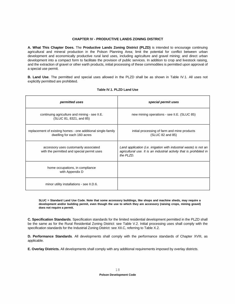
CHAPTER IV - PRODUCTIVE LANDS ZONING DISTRICT A. What This Chapter Does. The Productive Lands Zoning District (PLZD) is intended to encourage continuing agricultural and mineral production in the Polson Planning Area; limit the potential for conflict between urban development and economically productive rural land uses, including agriculture and gravel mining; and direct urban development into a compact form to facilitate the provision of public services. In addition to crop and livestock raising, and the extraction of gravel or other earth products, initial processing of these commodities is permitted upon approval of a special use permit. B. Land Use. The permitted and special uses allowed in the PLZD shall be as shown in Table IV.1. All uses not explicitly permitted are prohibited.
Table IV.1. PLZD Land Use
permitted uses
special permit uses
continuing agriculture and mining - see II.E. (SLUC 81, 8321, and 85)
new mining operations - see II.E. (SLUC 85)
replacement of existing homes - one additional single-family
dwelling for each 160 acres
initial processing of farm and mine products
(SLUC 82 and 85)
accessory uses customarily associated
with the permitted and special permit uses
Land application (i.e. irrigation with industrial waste) is not an agricultural use. It is an industrial activity that is prohibited in the PLZD.
home occupations, in compliance
with Appendix D
minor utility installations - see II.D.6.
SLUC = Standard Land Use Code. Note that some accessory buildings, like shops and machine sheds, may require a development and/or building permit, even though the use to which they are accessory (raising crops, mining gravel) does not require a permit.
C. Specification Standards. Specification standards for the limited residential development permitted in the PLZD shall be the same as for the Rural Residential Zoning District: see Table V.2. Initial processing uses shall comply with the specification standards for the Industrial Zoning District: see XII.C, referring to Table X.2. D. Performance Standards. All developments shall comply with the performance standards of Chapter XVIII, as applicable. E. Overlay Districts. All developments shall comply with any additional requirements imposed by overlay districts.
Polson Development Code 19
CHAPTER V - RURAL RESIDENTIAL ZONING DISTRICT A. What This Chapter Does. The Rural Residential Zoning District (RRZD) permits exurban residential development on suitable sites within the jurisdictional area, but not where such development will impede the city’s expansion. B. Land Use. The permitted and special uses allowed in the RRZD shall be as shown in Table V.1. All uses not explicitly permitted are prohibited.
Table V.1. RRZD Land Use
permitted uses
special permit uses
single-family dwellings
see Ordinance #545 or Chapt. XXI, YY
two-family dwellings
accessory uses customarily associated with permitted and special permit uses, including
the keeping of livestock, as provided in V.D.1.
parks and other public recreation areas
home occupations, in
compliance with Appendix D
minor utility installations - see II.D.6.
C. Specification Standards. The specification standards for the RRZD appear in Table V.2. Where previous development has resulted in setbacks less than those specified by Table V.2., the administrator may permit building in conformance with the existing pattern, if:
1. covenants recorded prior to the effective date of these regulations dictate setbacks less than those specified by these regulations, and a. the subdivision was not vacant on the effective date of these regulations, and b. the developer submits drawings or similar evidence to demonstrate that existing dwellings have been built in compliance with the setbacks provided by the covenants; or 2. covenants do not dictate setbacks, or such covenants have not been enforced, but the developer submits drawings demonstrating that the proposed setbacks are consistent with, or greater than, those on at least 50% of the adjoining lots. 3. Setbacks along arterial roads shall not be reduced by the administrator, nor shall conformance with covenants or the setbacks on adjoining properties be used to permit development that does not comply with the city’s fire and building codes.
D. Performance Standards. All developments shall comply with the performance standards of Chapter XVIII, as applicable, and the following additional performance standards.
1. Livestock. The RRZD is the only zoning district in which the keeping of livestock on residential lots or parcels is a permitted accessory use.
a. No livestock shall be kept on a lot of less than one acre in size, or within 50 feet of a property line.
Polson Development Code 20
b. Livestock shall be fenced out of shoreline buffers established by these regulations (see XVIII.C.) and Wellhead Protection Zone I, as established by XIV.B. Surface runoff from corrals and other areas in which livestock are kept shall be directed to a densely vegetated filter strip. c. Manure shall be removed from corrals and other areas in which livestock are confined at least twice each year, and more frequently where the administrator determines that its accumulation constitutes a nuisance because odor, flies, etc. are adversely affecting neighboring properties.
2. Outdoor Storage. See also XVIII.W.6. Outdoor storage shall be permitted anywhere it is fully screened from public view and adjoining properties. Outdoor storage that is not fully screened shall be permitted in rear yards, but not in front or required side yards (this permits storage to the side of a dwelling that has a larger than required side yard), except that:
a. Construction equipment and materials may be stored in front and required side yards during the course of work for which a permit has been approved in compliance with these regulations. This exception expires with the permit or upon issuance of a certificate of compliance. b. Vehicles and watercraft with current registrations may be parked in front and required side yards. Parked vehicles or watercraft shall not block vision at intersections or where driveways enter public streets.
3. Accessory Buildings. Accessory buildings shall be permitted in rear yards, but not in front or required side yards (this permits accessory buildings in side yards that are larger than required), (Ord. # 567, 8/16/99).
E. Overlay Districts. All developments shall comply with any additional requirements imposed by overlay districts.
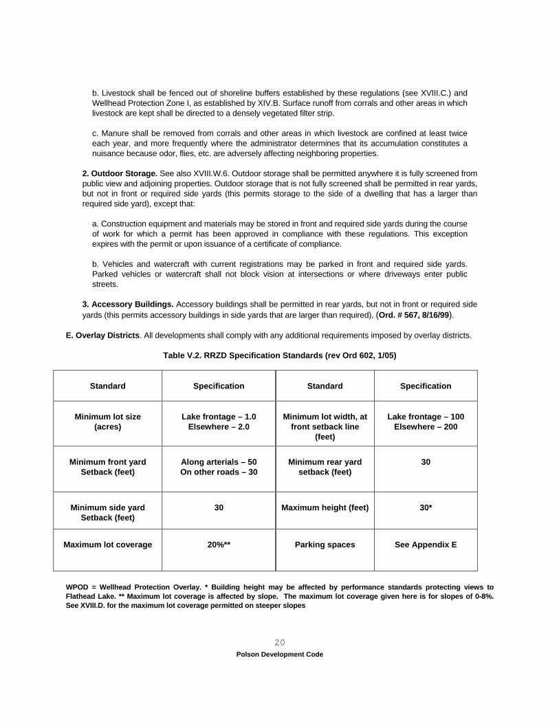
Table V.2. RRZD Specification Standards (rev Ord 602, 1/05)
Standard
Specification
Standard
Specification
Minimum lot size
(acres)
Lake frontage – 1.0
Elsewhere – 2.0
Minimum lot width, at
front setback line (feet)
Lake frontage – 100
Elsewhere – 200
Minimum front yard
Setback (feet)
Along arterials – 50 On other roads – 30
Minimum rear yard
setback (feet)
30
Minimum side yard
Setback (feet)
30
Maximum height (feet)
30*
Maximum lot coverage
20%**
Parking spaces
See Appendix E
WPOD = Wellhead Protection Overlay. * Building height may be affected by performance standards protecting views to Flathead Lake. ** Maximum lot coverage is affected by slope. The maximum lot coverage given here is for slopes of 0-8%. See XVIII.D. for the maximum lot coverage permitted on steeper slopes
Polson Development Code 21
CHAPTER VI - LOW DENSITY RESIDENTIAL ZONING DISTRICT
A. What This Chapter Does. This chapter creates a Low Density Residential Zoning District (LRZD) for neighborhoods of single-family dwellings that are connected to municipal utilities. Areas in the LRZD will generally be buffered from commercial or industrial uses, or arterial roads by areas of the Medium Density Residential or Transitional zoning districts. B. Land Use. The permitted and special uses allowed in the LRZD shall be as shown in Table VI.1. All uses not explicitly permitted are prohibited.
Table VI.1. LRZD Land Use (Ord. #546, 9/2/97)
permitted uses
special permit uses
single-family dwellings excluding all manufactured homes –
manufactured homes of any type are prohibited; system built housing is allowed (Ord #589, 9/15/03)
churches
accessory uses customarily associated with
the permitted and special permit uses
day care centers and elementary schools
home occupations in compliance with Appendix D
parks and other public recreation areas
minor utility installations - see II.D.6.
limited livestock outside City limits
(see VI.F for criteria, and XXI.V and XXI.CC for definitions)
C. Specification Standards. The specification standards for the LRZD appear in Table VI.2. Where previous development has resulted in setbacks less than those specified by Table VI.2., the administrator may permit building in conformance with the existing pattern, if:
1. covenants recorded prior to the effective date of these regulations dictate setbacks less than those specified by these regulations, and a. the subdivision was not vacant on the effective date of these regulations, and b. the developer submits drawings or similar evidence to demonstrate that existing dwellings have been built in compliance with the setbacks provided by the covenants; or 2. covenants do not dictate setbacks, or such covenants have not been enforced, but the developer submits drawings demonstrating that the proposed setbacks are consistent with, or greater than, those on at least 50% of the adjoining lots. 3. Conformance with covenants or the setbacks on adjoining properties shall not be used to permit development that fails to comply with the city’s fire and building codes.
D. Performance Standards. All developments shall comply with the performance standards of Chapter XVIII, as applicable, and the following additional performance standards.
1. Outdoor Storage. See also XVIII.W.6. Outdoor storage shall be permitted anywhere it is fully screened from
Polson Development Code
22
public view and adjoining properties. Outdoor storage that is not fully screened shall be permitted in rear yards, but not in front or required side yards (this permits storage to the side of a dwelling that has a larger than required side yard), except that:
a. construction equipment and materials may be stored in front and required side yards during the course of work for which a permit has been approved in compliance with these regulations. This exception expires with the permit or upon issuance of a certificate of compliance. b. Vehicles and watercraft with current registrations may be parked in front and required side yards. Parked vehicles or watercraft shall not block vision at intersections or where driveways enter public streets. c. Notwithstanding any other provision of these codes, system built homes built and installed in conformance with Uniform Building Codes and International Building Codes and any applicable building code provisions of the City of Polson or the State of Montana, and otherwise in conformance with the mandates of this code, shall be permitted in this zoning district. (Ord. # 589, 9/15/03)
2. Accessory Buildings. Accessory buildings shall be permitted in rear yards, but not in front or required side yards (this permits accessory buildings in side yards that are larger than required), (Ord. # 567, 8/16/99). 3. Day Care Centers. Day care centers shall:
a. be registered with the Montana Department of Family Services; b. provide off-street parking and loading areas in compliance with Appendix E; c. retain a residential appearance, or the appearance of special permit use (like a church); and d. provide a minimum six foot high opaque wood or masonry fence or a 20 foot basic landscaped buffer (as provided in Appendix F) between all outdoor play areas and adjoining dwellings. e. Day care centers may display a single non-illuminated wall sign of no more than six square feet.
E. Overlay Districts. All developments shall comply with the additional requirements imposed by overlay districts. F. Livestock. (applies to County Planning Area, outside City limits) LRZD, Permitted Uses (County Res #02-26, 4/4/02) Livestock as permitted within LRZD outside the Polson City limits. The keeping or raising of domestic livestock for show, breeding or other purposes incidental to the principle use of the premises is permitted, subject to the following:
1. Livestock or fowl shall not be permitted on a lot less than five acres in area. 2. Domestic animals and livestock, except pigs, buffalo, llama, alpacas, emu, rheas geese, and ostrich, may be
kept on a lot provided they are not bred or maintained for any commercial purpose. 3. Not more than two head of cattle, or one horse, or one mule, or four goats, or four sheep, or four lambs or
20 fowl, or a reasonable combination shall be permitted per five acres of lot area unless a qualified person (extension agent or similar person) can substantiate that the land and management practices can support more livestock.
4. No permanent structure or fixed facility for housing livestock shall be kept within 50 feet of a property line. 5. Livestock areas shall be adequately fenced. 6. Manure shall be removed from corrals and other areas in which livestock are confined at least twice each
Polson Development Code
23
year, and more frequently where the administrator determines that its accumulation constitutes a nuisance because odor, flies, etc. are adversely effecting neighboring properties.
7. The property owners shall create and maintain a process to direct and filter surface runoff from corrals and
other areas in which livestock are kept. The diverted surface water shall be retained on the property. 8. Common area within a subdivision, that meets the minimum acreage for the keeping of livestock, may be
utilized as defined in the zoning, if livestock use is addressed in the covenants so residents are aware of such potential use.
9. See XXI.C and XXI.VV for definitions of livestock and fowl, per County Res #02-26, 4/4/02.
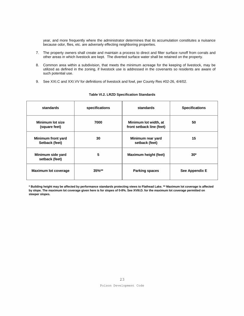
Table VI.2. LRZD Specification Standards
standards
specifications
standards
Specifications
Minimum lot size
(square feet)
7000
Minimum lot width, at
front setback line (feet)
50
Minimum front yard
Setback (feet)
30
Minimum rear yard
setback (feet)
15
Minimum side yard
setback (feet)
5
Maximum height (feet)
30*
Maximum lot coverage
35%**
Parking spaces
See Appendix E
* Building height may be affected by performance standards protecting views to Flathead Lake. ** Maximum lot coverage is affected by slope. The maximum lot coverage given here is for slopes of 0-8%. See XVIII.D. for the maximum lot coverage permitted on steeper slopes.
Polson Development Code
24
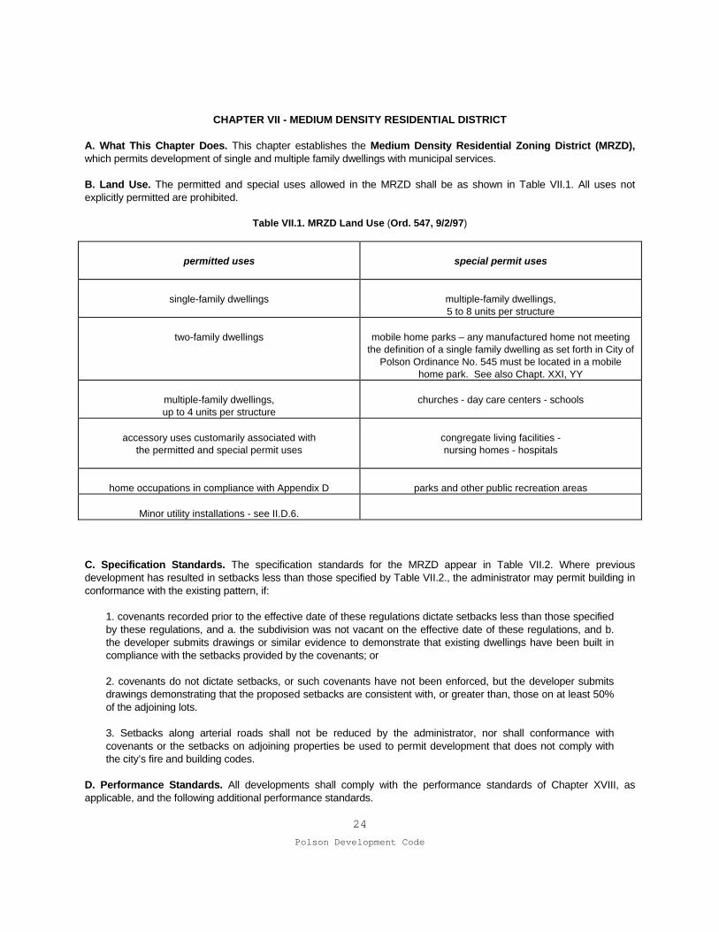
CHAPTER VII - MEDIUM DENSITY RESIDENTIAL DISTRICT A. What This Chapter Does. This chapter establishes the Medium Density Residential Zoning District (MRZD), which permits development of single and multiple family dwellings with municipal services. B. Land Use. The permitted and special uses allowed in the MRZD shall be as shown in Table VII.1. All uses not explicitly permitted are prohibited.
Table VII.1. MRZD Land Use (Ord. 547, 9/2/97)
permitted uses
special permit uses
single-family dwellings
multiple-family dwellings, 5 to 8 units per structure
two-family dwellings
mobile home parks – any manufactured home not meeting
the definition of a single family dwelling as set forth in City of Polson Ordinance No. 545 must be located in a mobile
home park. See also Chapt. XXI, YY
multiple-family dwellings, up to 4 units per structure
churches - day care centers - schools
accessory uses customarily associated with
the permitted and special permit uses
congregate living facilities - nursing homes - hospitals
home occupations in compliance with Appendix D
parks and other public recreation areas
Minor utility installations - see II.D.6.
C. Specification Standards. The specification standards for the MRZD appear in Table VII.2. Where previous development has resulted in setbacks less than those specified by Table VII.2., the administrator may permit building in conformance with the existing pattern, if:
1. covenants recorded prior to the effective date of these regulations dictate setbacks less than those specified by these regulations, and a. the subdivision was not vacant on the effective date of these regulations, and b. the developer submits drawings or similar evidence to demonstrate that existing dwellings have been built in compliance with the setbacks provided by the covenants; or 2. covenants do not dictate setbacks, or such covenants have not been enforced, but the developer submits drawings demonstrating that the proposed setbacks are consistent with, or greater than, those on at least 50% of the adjoining lots. 3. Setbacks along arterial roads shall not be reduced by the administrator, nor shall conformance with covenants or the setbacks on adjoining properties be used to permit development that does not comply with the city’s fire and building codes.
D. Performance Standards. All developments shall comply with the performance standards of Chapter XVIII, as applicable, and the following additional performance standards.
Polson Development Code
25
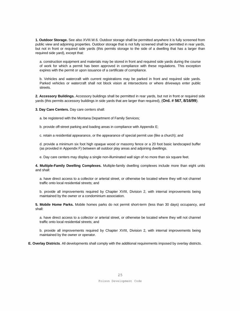
1. Outdoor Storage. See also XVIII.W.6. Outdoor storage shall be permitted anywhere it is fully screened from public view and adjoining properties. Outdoor storage that is not fully screened shall be permitted in rear yards, but not in front or required side yards (this permits storage to the side of a dwelling that has a larger than required side yard), except that:
a. construction equipment and materials may be stored in front and required side yards during the course of work for which a permit has been approved in compliance with these regulations. This exception expires with the permit or upon issuance of a certificate of compliance. b. Vehicles and watercraft with current registrations may be parked in front and required side yards. Parked vehicles or watercraft shall not block vision at intersections or where driveways enter public streets.
2. Accessory Buildings. Accessory buildings shall be permitted in rear yards, but not in front or required side yards (this permits accessory buildings in side yards that are larger than required), (Ord. # 567, 8/16/99). 3. Day Care Centers. Day care centers shall:
a. be registered with the Montana Department of Family Services; b. provide off-street parking and loading areas in compliance with Appendix E; c. retain a residential appearance, or the appearance of special permit use (like a church); and d. provide a minimum six foot high opaque wood or masonry fence or a 20 foot basic landscaped buffer (as provided in Appendix F) between all outdoor play areas and adjoining dwellings. e. Day care centers may display a single non-illuminated wall sign of no more than six square feet.
4. Multiple-Family Dwelling Complexes. Multiple-family dwelling complexes include more than eight units and shall:
a. have direct access to a collector or arterial street, or otherwise be located where they will not channel traffic onto local residential streets; and b. provide all improvements required by Chapter XVIII, Division 2, with internal improvements being maintained by the owner or a condominium association.
5. Mobile Home Parks. Mobile homes parks do not permit short-term (less than 30 days) occupancy, and shall:
a. have direct access to a collector or arterial street, or otherwise be located where they will not channel traffic onto local residential streets; and b. provide all improvements required by Chapter XVIII, Division 2, with internal improvements being maintained by the owner or operator.
E. Overlay Districts. All developments shall comply with the additional requirements imposed by overlay districts.
Polson Development Code
26
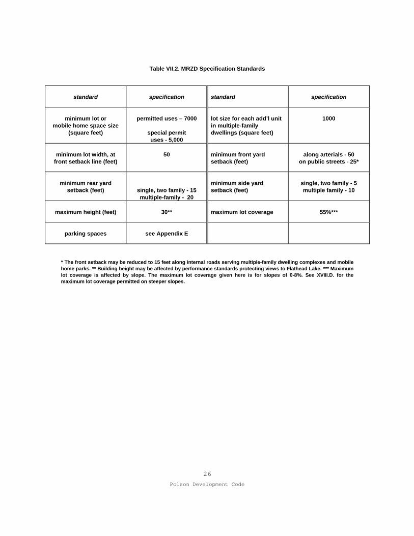
Table VII.2. MRZD Specification Standards
standard
specification
standard
specification
minimum lot or mobile home space size
(square feet)
permitted uses – 7000
special permit uses - 5,000
lot size for each add’l unit in multiple-family dwellings (square feet)
1000
minimum lot width, at
front setback line (feet)
50
minimum front yard setback (feet)
along arterials - 50
on public streets - 25*
minimum rear yard
setback (feet)
single, two family - 15 multiple-family - 20
minimum side yard setback (feet)
single, two family - 5 multiple family - 10
maximum height (feet)
30**
maximum lot coverage
55%***
parking spaces
see Appendix E
* The front setback may be reduced to 15 feet along internal roads serving multiple-family dwelling complexes and mobile home parks. ** Building height may be affected by performance standards protecting views to Flathead Lake. *** Maximum lot coverage is affected by slope. The maximum lot coverage given here is for slopes of 0-8%. See XVIII.D. for the maximum lot coverage permitted on steeper slopes.
27
Polson Development Code—rev 04
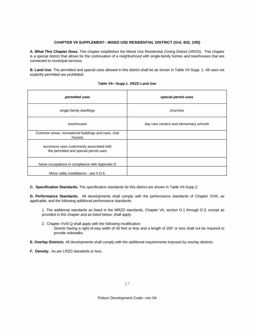
CHAPTER VII SUPPLEMENT– MIXED USE RESIDENTIAL DISTRICT (Ord. 603, 1/05) A. What This Chapter Does. This chapter establishes the Mixed Use Residential Zoning District (XRZD). This chapter is a special district that allows for the continuation of a neighborhood with single-family homes and townhouses that are connected to municipal services. B. Land Use. The permitted and special uses allowed in this district shall be as shown in Table VII-Supp. 1. All uses not explicitly permitted are prohibited.
Table VII—Supp.1. XRZD Land Use
permitted uses
special permit uses
single-family dwellings
churches
townhouses
day care centers and elementary schools
Common areas, recreational buildings and uses, club houses
accessory uses customarily associated with
the permitted and special permit uses
home occupations in compliance with Appendix D
Minor utility installations - see II.D.6.
C. Specification Standards. The specification standards for this district are shown in Table VII-Supp.2. D. Performance Standards. All developments shall comply with the performance standards of Chapter XVIII, as applicable, and the following additional performance standards:
1. The additional standards as listed in the MRZD standards, Chapter VII, section D.1 through D.3, except as provided in this chapter and as listed below, shall apply.
2. Chapter XVIII.Q shall apply with the following modification:
Streets having a right-of-way width of 40 feet or less and a length of 200’ or less shall not be required to provide sidewalks.
E. Overlay Districts. All developments shall comply with the additional requirements imposed by overlay districts. F. Density. As per LRZD standards or less.
28
Polson Development Code—rev 04
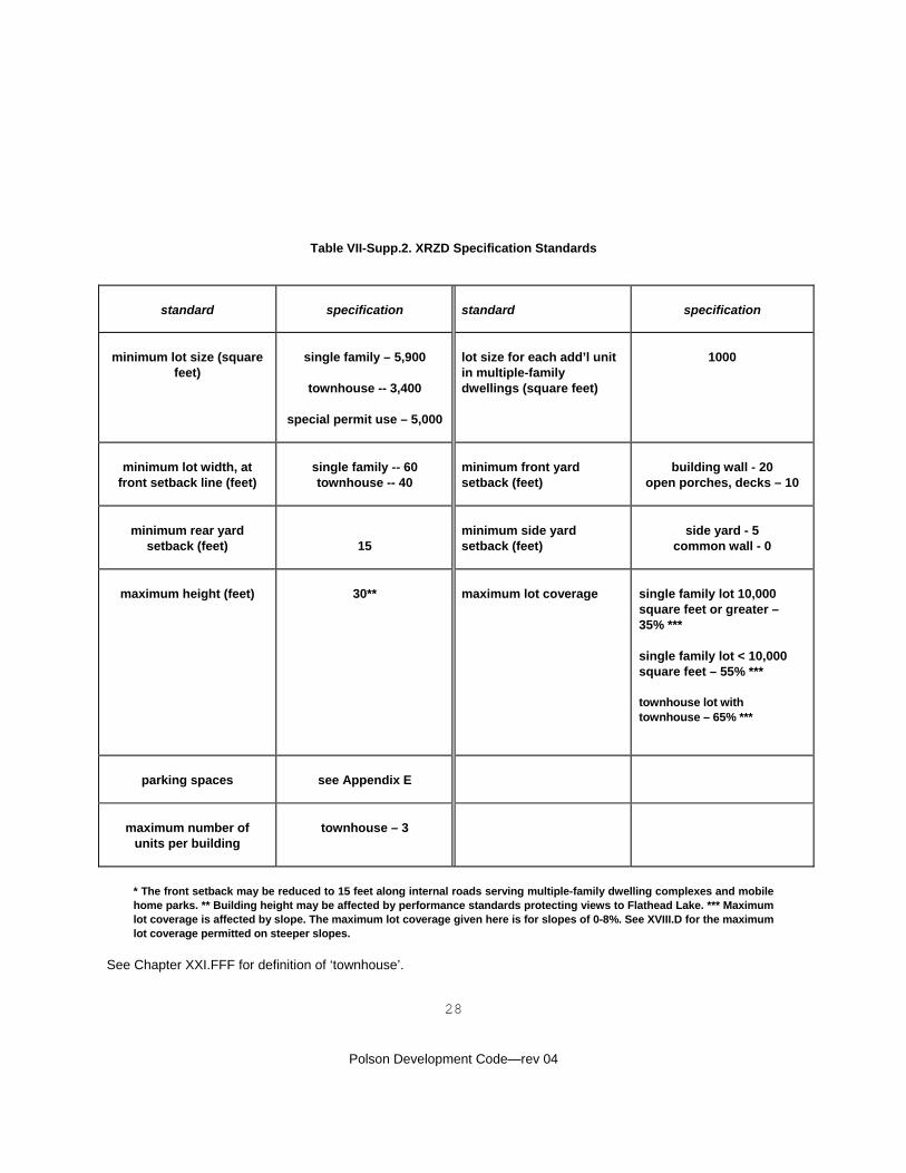
Table VII-Supp.2. XRZD Specification Standards
standard
specification
standard
specification
minimum lot size (square feet)
single family – 5,900
townhouse -- 3,400
special permit use – 5,000
lot size for each add’l unit in multiple-family dwellings (square feet)
1000
minimum lot width, at
front setback line (feet)
single family -- 60 townhouse -- 40
minimum front yard setback (feet)
building wall - 20
open porches, decks – 10
minimum rear yard
setback (feet)
15
minimum side yard setback (feet)
side yard - 5
common wall - 0
maximum height (feet)
30**
maximum lot coverage
single family lot 10,000 square feet or greater – 35% *** single family lot < 10,000 square feet – 55% *** townhouse lot with townhouse – 65% ***
parking spaces
see Appendix E
maximum number of
units per building
townhouse – 3
* The front setback may be reduced to 15 feet along internal roads serving multiple-family dwelling complexes and mobile home parks. ** Building height may be affected by performance standards protecting views to Flathead Lake. *** Maximum lot coverage is affected by slope. The maximum lot coverage given here is for slopes of 0-8%. See XVIII.D for the maximum lot coverage permitted on steeper slopes.
See Chapter XXI.FFF for definition of ‘townhouse’.
29
Polson Development Code—rev 04
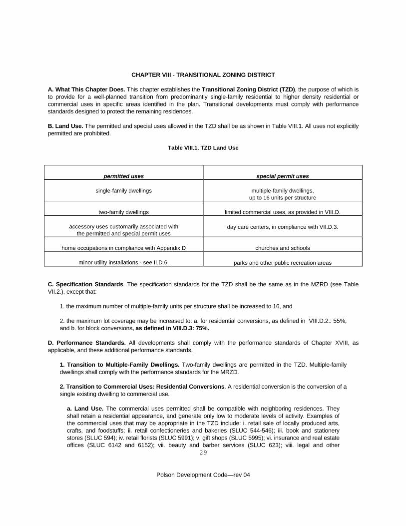
CHAPTER VIII - TRANSITIONAL ZONING DISTRICT
A. What This Chapter Does. This chapter establishes the Transitional Zoning District (TZD), the purpose of which is to provide for a well-planned transition from predominantly single-family residential to higher density residential or commercial uses in specific areas identified in the plan. Transitional developments must comply with performance standards designed to protect the remaining residences. B. Land Use. The permitted and special uses allowed in the TZD shall be as shown in Table VIII.1. All uses not explicitly permitted are prohibited.
Table VIII.1. TZD Land Use
permitted uses
special permit uses
single-family dwellings
multiple-family dwellings,
up to 16 units per structure
two-family dwellings
limited commercial uses, as provided in VIII.D.
accessory uses customarily associated with the permitted and special permit uses
day care centers, in compliance with VII.D.3.
home occupations in compliance with Appendix D
churches and schools
minor utility installations - see II.D.6.
parks and other public recreation areas
C. Specification Standards. The specification standards for the TZD shall be the same as in the MZRD (see Table VII.2.), except that:
1. the maximum number of multiple-family units per structure shall be increased to 16, and 2. the maximum lot coverage may be increased to: a. for residential conversions, as defined in VIII.D.2.: 55%, and b. for block conversions, as defined in VIII.D.3: 75%.
D. Performance Standards. All developments shall comply with the performance standards of Chapter XVIII, as applicable, and these additional performance standards.
1. Transition to Multiple-Family Dwellings. Two-family dwellings are permitted in the TZD. Multiple-family dwellings shall comply with the performance standards for the MRZD. 2. Transition to Commercial Uses: Residential Conversions. A residential conversion is the conversion of a single existing dwelling to commercial use.
a. Land Use. The commercial uses permitted shall be compatible with neighboring residences. They shall retain a residential appearance, and generate only low to moderate levels of activity. Examples of the commercial uses that may be appropriate in the TZD include: i. retail sale of locally produced arts, crafts, and foodstuffs; ii. retail confectioneries and bakeries (SLUC 544-546); iii. book and stationery stores (SLUC 594); iv. retail florists (SLUC 5991); v. gift shops (SLUC 5995); vi. insurance and real estate offices (SLUC 6142 and 6152); vii. beauty and barber services (SLUC 623); viii. legal and other
30
Polson Development Code—rev 04
professional services (SLUC 652 and 659); ix. the offices of civic organizations (SLUC 699); and x. travel agencies (SLUC 4923). b. Operating Hours. Operating hours shall begin no earlier than 8:00 A.M. and end no later than 8:00 P.M. c. Residential Landscaping. Landscaping similar to that of neighboring homes (yards with turf or ground cover, trees, including street trees, shrubs, flowers, etc.) shall be retained on the 45% or more of the lot left open to comply with VIII.C. Where such landscaping is absent or in poor condition, it shall be restored. d. Side and Rear Yards. A minimum six foot high opaque wood fence or masonry wall shall be installed and maintained along the side and rear property lines that adjoin dwellings. The city may also require supplemental plantings to protect the privacy and enjoyment of residential neighbors. Rear yards may be used as outdoor dining or display areas, but all storage shall be within the converted dwelling or an accessory building (like an existing garage). e. Front Yard. The front yard shall be left unfenced, or if one is existing, or in conformance with neighboring properties, with a low, open fence (like a picket fence) or hedge. No commercial use shall be made of the front yard, except that existing front driveways may be used for employee parking. f. Architecture. The residence being converted to commercial use may be remodeled or expanded, in compliance with these regulations and the city’s building and fire codes, but all such activity shall retain a residential appearance. The developer shall submit elevations and other drawings to demonstrate compliance with this performance standard.
3. Block Conversions. A block conversion is the development of commercial or mixed commercial and multiple-family dwellings on at least one-half of a platted block.
a. Land Use. Block conversions involve a higher intensity of commercial use, but must still respect neighboring residences. Examples of additional uses that may be appropriate in a block conversion in the TZD include: i. retail apparel and accessories (SLUC 56); ii. retail electronics (SLUC 573 - but not including installation of automotive sound systems); iii. eating and drinking places (SLUC 58 - but not including drive-in restaurants); iv. other retail uses that do not require large outdoor sales areas, outdoor storage, or drive-in service; v. finance, insurance, and real estate services (SLUC 61); vi. personal services (SLUC 62); vii. professional services (SLUC 65); and viii. miscellaneous services (SLUC 65). b. Landscape. There shall be a coherent planting plan for the entire development. Landscaping will not retain its residential character with a maximum 75% lot coverage, but should retain functional existing vegetation to the extent possible, and utilize landscape design themes from the surrounding residential neighborhood. See XVIII.X. for landscaped buffer requirements. c. Architecture. The buildings in the block conversion shall present a coherent appearance and utilize themes from the surrounding residential neighborhood. d. Outdoor Sales and Storage. Limited outdoor sales, including outdoor dining areas shall be permitted. All storage, except temporary storage of construction materials and equipment being used for work in progress, shall be within buildings.
E. Overlay Districts. All developments shall comply with any additional requirements imposed by overlay districts.
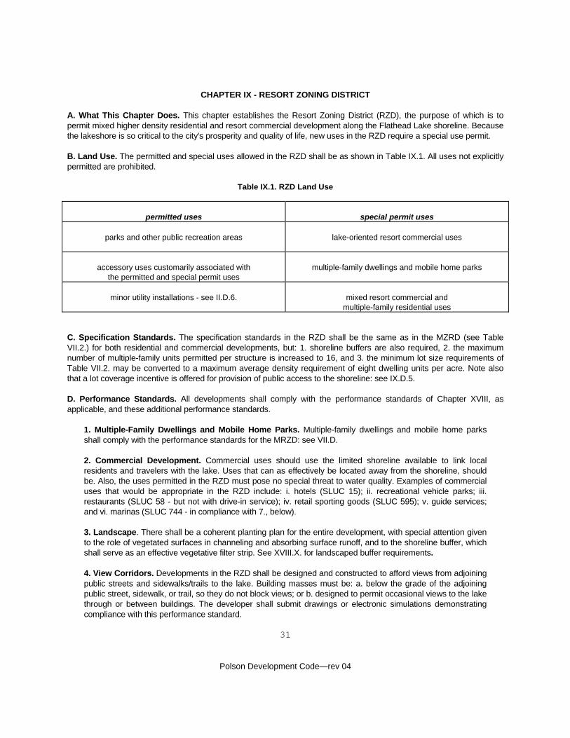
31
Polson Development Code—rev 04
CHAPTER IX - RESORT ZONING DISTRICT
A. What This Chapter Does. This chapter establishes the Resort Zoning District (RZD), the purpose of which is to permit mixed higher density residential and resort commercial development along the Flathead Lake shoreline. Because the lakeshore is so critical to the city's prosperity and quality of life, new uses in the RZD require a special use permit. B. Land Use. The permitted and special uses allowed in the RZD shall be as shown in Table IX.1. All uses not explicitly permitted are prohibited.
Table IX.1. RZD Land Use
permitted uses
special permit uses
parks and other public recreation areas
lake-oriented resort commercial uses
accessory uses customarily associated with
the permitted and special permit uses
multiple-family dwellings and mobile home parks
minor utility installations - see II.D.6.
mixed resort commercial and
multiple-family residential uses
C. Specification Standards. The specification standards in the RZD shall be the same as in the MZRD (see Table VII.2.) for both residential and commercial developments, but: 1. shoreline buffers are also required, 2. the maximum number of multiple-family units permitted per structure is increased to 16, and 3. the minimum lot size requirements of Table VII.2. may be converted to a maximum average density requirement of eight dwelling units per acre. Note also that a lot coverage incentive is offered for provision of public access to the shoreline: see IX.D.5. D. Performance Standards. All developments shall comply with the performance standards of Chapter XVIII, as applicable, and these additional performance standards.
1. Multiple-Family Dwellings and Mobile Home Parks. Multiple-family dwellings and mobile home parks shall comply with the performance standards for the MRZD: see VII.D. 2. Commercial Development. Commercial uses should use the limited shoreline available to link local residents and travelers with the lake. Uses that can as effectively be located away from the shoreline, should be. Also, the uses permitted in the RZD must pose no special threat to water quality. Examples of commercial uses that would be appropriate in the RZD include: i. hotels (SLUC 15); ii. recreational vehicle parks; iii. restaurants (SLUC 58 - but not with drive-in service); iv. retail sporting goods (SLUC 595); v. guide services; and vi. marinas (SLUC 744 - in compliance with 7., below). 3. Landscape. There shall be a coherent planting plan for the entire development, with special attention given to the role of vegetated surfaces in channeling and absorbing surface runoff, and to the shoreline buffer, which shall serve as an effective vegetative filter strip. See XVIII.X. for landscaped buffer requirements. 4. View Corridors. Developments in the RZD shall be designed and constructed to afford views from adjoining public streets and sidewalks/trails to the lake. Building masses must be: a. below the grade of the adjoining public street, sidewalk, or trail, so they do not block views; or b. designed to permit occasional views to the lake through or between buildings. The developer shall submit drawings or electronic simulations demonstrating compliance with this performance standard.
32
Polson Development Code—rev 04
5. Access to the Lakeshore. Any development that provides safe, continuous public pedestrian/bicycle access to the shoreline shall be permitted to increase its maximum lot coverage from 55% to 75%. Award of such a bonus does not eliminate the requirements of XVIII.C. for shoreline buffers. 6. Outdoor Sales and Storage. Limited outdoor sales, including outdoor dining areas shall be permitted. All storage, except temporary storage of construction materials and equipment being used for work in progress, shall be within buildings. 7. Marinas. A marina may be an appropriate use in the RZD, but because marinas involve extensive lakeshore disturbance and the handling of fuel and other potential contaminants, the developer shall be required to:
a. provide for a professionally-prepared environmental assessment, including recommended mitigation measures, and b. provide plans sufficient to demonstrate compliance with National Fire Protection Association (NFPA) 303 Marinas and Boatyards, and other fire and building codes specifically applicable to marinas.
The need for an environmental assessment shall be established at the pre-application review and the production of the assessment will follow the procedure provided for community impact reports in Chapter XVIII.
E. Overlay Districts. All developments shall comply with any additional requirements imposed by overlay districts.
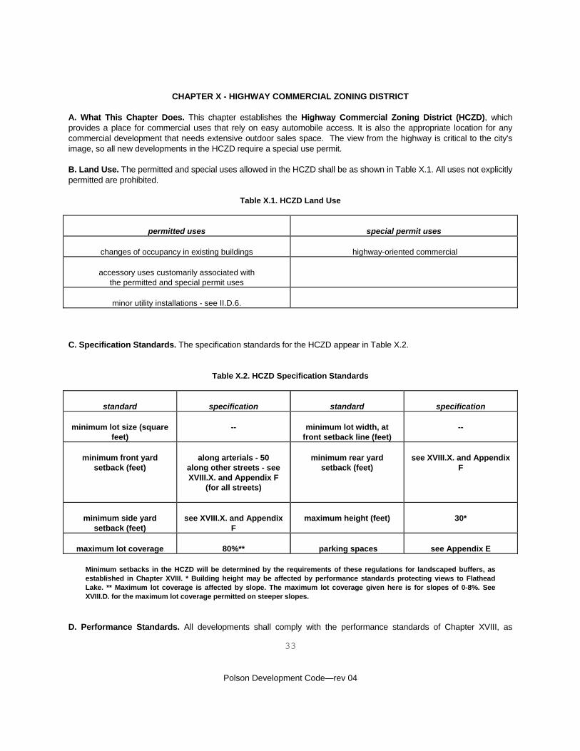
33
Polson Development Code—rev 04
CHAPTER X - HIGHWAY COMMERCIAL ZONING DISTRICT A. What This Chapter Does. This chapter establishes the Highway Commercial Zoning District (HCZD), which provides a place for commercial uses that rely on easy automobile access. It is also the appropriate location for any commercial development that needs extensive outdoor sales space. The view from the highway is critical to the city's image, so all new developments in the HCZD require a special use permit. B. Land Use. The permitted and special uses allowed in the HCZD shall be as shown in Table X.1. All uses not explicitly permitted are prohibited.
Table X.1. HCZD Land Use
permitted uses
special permit uses
changes of occupancy in existing buildings
highway-oriented commercial
accessory uses customarily associated with
the permitted and special permit uses
minor utility installations - see II.D.6.
C. Specification Standards. The specification standards for the HCZD appear in Table X.2.
Table X.2. HCZD Specification Standards
standard
specification
standard
specification
minimum lot size (square
feet)
--
minimum lot width, at
front setback line (feet)
--
minimum front yard
setback (feet)
along arterials - 50
along other streets - see XVIII.X. and Appendix F
(for all streets)
minimum rear yard
setback (feet)
see XVIII.X. and Appendix
F
minimum side yard
setback (feet)
see XVIII.X. and Appendix
F
maximum height (feet)
30*
maximum lot coverage
80%**
parking spaces
see Appendix E
Minimum setbacks in the HCZD will be determined by the requirements of these regulations for landscaped buffers, as established in Chapter XVIII. * Building height may be affected by performance standards protecting views to Flathead Lake. ** Maximum lot coverage is affected by slope. The maximum lot coverage given here is for slopes of 0-8%. See XVIII.D. for the maximum lot coverage permitted on steeper slopes.
D. Performance Standards. All developments shall comply with the performance standards of Chapter XVIII, as
34
Polson Development Code—rev 04
applicable, and the following additional performance standards. 1. No Strip. Development in the HCZD shall be designed and constructed to minimize the functional and appearance problems associated with the strip development pattern. Conditions to be minimized, to the extent feasible given the location, size, and context of the lot or parcel, include:
a. commercial development that is only one lot in depth, has numerous points of access to public streets, and makes no provision for safe pedestrian circulation; and b. a view from the road that is dominated by vehicles, asphalt, and signs.
2. Access to Commercial and Industrial Uses. No commercial development shall have its principal access through the RRZD, LRZD, or MRZD. 3. Outdoor Sales and Storage. Outdoor sales shall be permitted in the HCZD. Outdoor storage is also permitted, but shall be screened from public view by any effective combination of the placement of buildings, landscaped buffers, and screening fences or walls. Temporary storage of construction materials and equipment being used for work in progress is exempted from this screening requirement.
E. Overlay Districts. All developments shall comply with any additional requirements imposed by overlay districts.
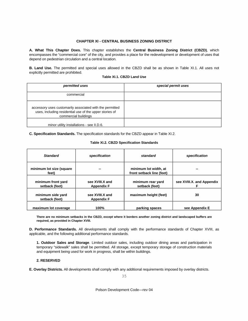
35
Polson Development Code—rev 04
CHAPTER XI - CENTRAL BUSINESS ZONING DISTRICT A. What This Chapter Does. This chapter establishes the Central Business Zoning District (CBZD), which encompasses the “commercial core” of the city, and provides a place for the redevelopment or development of uses that depend on pedestrian circulation and a central location. B. Land Use. The permitted and special uses allowed in the CBZD shall be as shown in Table XI.1. All uses not explicitly permitted are prohibited.
Table XI.1. CBZD Land Use
permitted uses
special permit uses
commercial
accessory uses customarily associated with the permitted
uses, including residential use of the upper stories of commercial buildings
minor utility installations - see II.D.6.
C. Specification Standards. The specification standards for the CBZD appear in Table XI.2.
Table XI.2. CBZD Specification Standards
Standard
specification
standard
specification
minimum lot size (square
feet)
--
minimum lot width, at
front setback line (feet)
--
minimum front yard
setback (feet)
see XVIII.X and
Appendix F
minimum rear yard
setback (feet)
see XVIII.X. and Appendix
F
minimum side yard setback (feet)
see XVIII.X and
Appendix F
maximum height (feet)
30
maximum lot coverage
100%
parking spaces
see Appendix E
There are no minimum setbacks in the CBZD, except where it borders another zoning district and landscaped buffers are required, as provided in Chapter XVIII.
D. Performance Standards. All developments shall comply with the performance standards of Chapter XVIII, as applicable, and the following additional performance standards.
1. Outdoor Sales and Storage. Limited outdoor sales, including outdoor dining areas and participation in temporary “sidewalk” sales shall be permitted. All storage, except temporary storage of construction materials and equipment being used for work in progress, shall be within buildings. 2. RESERVED
E. Overlay Districts. All developments shall comply with any additional requirements imposed by overlay districts.
36
Polson Development Code—rev 04
CHAPTER XII - GENERAL COMMERCIAL - INDUSTRIAL ZONING DISTRICT A. What This Chapter Does. This chapter establishes the General Commercial - Industrial Zoning District (CIZD), which provides a place for a wide range of commercial uses that do not rely on direct highway access or a CBD location, and industrial development in the city and jurisdictional area. B. Land Use. The permitted and special uses allowed in the CIZD shall be as shown in Table XII.1. All uses not explicitly permitted are prohibited.
Table XII.1. CIZD Land Use
permitted uses
special permit uses
commercial
certain uses may require a special use permit if located within
the WPOD: see Chapter XIV.
industrial
accessory uses customarily associated with
the permitted and special permit uses
minor utility installations - see II.D.6.
Note that “industrial” includes wholesale trade, warehousing, contract construction, and certain other trade and service uses.
C. Specification Standards. The specification standards for the CIZD shall be the same as in the HCZD: see Table X.2. D. Performance Standards. All developments shall comply with the performance standards of Chapter XVIII, as applicable, and the following additional performance standards.
1. Access to Commercial and Industrial Uses. No commercial or industrial development shall have its principal access through the RRZD, LRZD, or MRZD. 2. RESERVED
E. Overlay Districts. All developments shall comply with any additional requirements imposed by overlay districts.
37
Polson Development Code—rev 04
CHAPTER XIII - AIRPORT SAFETY OVERLAY DISTRICT A. What This Chapter Does. This chapter establishes airport safety zones around the Polson Airport, as called for by the Federal Aviation Administration (FAA) in the Federal Aviation Regulations, Part 77 - Objects Affecting Navigable Airspace. The purpose of the Airport Safety Overlay District (ASOD) is to protect the lives of aircraft pilots and passengers, and the public investment in the Polson Airport.
Division 1 - Procedural Requirements B. Additional Requirements for Nonconforming Uses. Nonconforming buildings and uses are regulated by the provisions of I.F and, within the ASOD, these additional requirements.
1. Nonconforming uses shall permit installation, operation, and maintenance of any markers or light needed to indicate their presence to aircraft pilots. 2. No nonconforming building or tree shall be permitted to become a greater hazard to air navigation than it was on the effective date of these regulations.
C. Additional Requirements for Permits. Within the ASOD, the permit requirements established by II.B. shall be expanded to include the planting of any tree with a growth habit of more than 30 feet and the construction of any building that is more than 30 feet in height, but is exempted from the requirement for a permit by II.D. D. Additional Requirements for Variances. The variance procedure is described at II.Q. Any application for a variance of the height limitations established by this chapter shall be accompanied by a determination from the FAA as to the effect of the proposal on the operation of air navigation facilities and the safe use of navigable airspace. E. Obstruction Marking and Lighting. Approval of any application for a permit or variance may be conditioned upon the installation, operation, and maintenance, at the owner's expense, of the markings or lights necessary to indicate the presence of an obstruction to aircraft pilots.
Division 2 - Height and Use Limitations F. Height Limitation Zones. The ASOD is composed of several height limitation zones, which include all land lying beneath the approach, transitional, horizontal, and conical surfaces appurtenant to the Polson Airport. Except as provided in XIII.G. no building, structure, or tree may extend above any of these surfaces. The height limitation zones are shown on a supplement to the zoning map adopted in III.D. Any area located in more than one of these zones is considered to be only in the zone with the more restrictive height limitation.
1. Approach Zones. These approach zones are for utility visual approach runways.
a. The inner edges of these zones coincide with the width of the primary surface and are 250 feet wide. The approach zones expand outward uniformly to a width of 1,250 feet at a horizontal distance of 5,000 feet from the ends of the primary surface and their centerlines are continuations of the centerline of the runway. b. The utility runway visual approach surfaces slope twenty feet outward for each foot upward beginning at the end of, and same elevation as, the primary surface, and extending a horizontal distance of 5,000 feet along the extended runway centerline.
2. Transitional Zones. The transitional zones are the areas beneath the transitional surfaces, which slope seven feet outward for each foot upward beginning at the sides of and same elevation as the primary and approach surfaces, and extending to the horizontal surface. Transitional surfaces also slope seven feet
38
Polson Development Code—rev 04
outward for each foot upward beginning at the sides of and same elevation as the approach surface, and extending to the conical surface. 3. Horizontal Zone. This zone is described by swinging arcs of 5,000 feet from the center of each end of the primary surface and connecting the adjacent arcs by drawing lines tangent to them. The horizontal zone does not include the utility runway visual approach or transitional zones. The horizontal surface is 150 feet above the airport elevation. 4. Conical Zone. This zone is the area that commences at the perimeter of the horizontal zone and extends outward from it a horizontal distance of 4,000 feet. The conical surface slopes 20 feet outward for each foot upward beginning at the edge of the horizontal surface, and extending to a height of 350 feet above the airport elevation. 5. Nothing in this chapter shall prevent construction or maintenance of any structure of 30 feet or less in height, or growth of any tree to a height of 30 feet, above the surface of the land within the horizontal and conical zones.
G. Use Restrictions. No use shall interfere with navigational signals or radio communication between the airport and aircraft, make it difficult for pilots to distinguish between airport lights and other lights, result in glare in the eyes of pilots using the airport, impair visibility in the vicinity of the airport, create bird strike hazards, or in any way endanger or interfere with the operation of aircraft. H. RESERVED

39
Polson Development Code—rev 04
wellhead supplement map appears here
40
Polson Development Code—rev 04
CHAPTER XIV - WELLHEAD PROTECTION OVERLAY DISTRICT (Ord. 602, 1/05)
A. What This Chapter Does. This chapter is intended to protect the City's groundwater supply from contamination. B. Wellhead Protection Zones. The Wellhead Protection Overlay District (WPOD) consists of two wellhead protection zones, which are shown on a supplement to the zoning map adopted in III.D.
1. Wellhead Protection Zone I includes the area within a 100-foot radius of a municipal well or the current control region identified in accordance with guidelines in the Source Water Protection Program (MDEQ, 1999) and approved by the Montana Department of Environmental Quality. 2. Wellhead Protection Zone II includes the area within which groundwater has an approximately three year time-of-travel to a municipal well or the current inventory region identified in accordance with guidelines in the Source Water Protection Program (MDEQ, 1999) and approved by the Montana Department of Environmental Quality.
All development on existing parcels of land and the creation of new parcels within the WPOD shall be consistent with the protection of groundwater resources, including existing underground storage tanks. Land uses and developments or improvements may not result in exposure of the source water used by the public water supply to moderate or high susceptibility to contaminant sources as determined by a susceptibility assessment completed pursuant to Section 5 of the Montana Source Water Protection Program (see Appendix J). In cases where development is proposed within a WPOD that has the potential to impact a public water supply, the zoning administrator may require the developer to conduct a susceptibility assessment as described in Appendix J. C. Land Use in Wellhead Protection Zones. Table XIV.1. shows the additional land use regulations applicable in the wellhead protection zones. D. Additional Performance Standards.
1. Gravel Mines, Other Excavations. Gravel mines and similar excavations are prohibited in Wellhead Protection Zone I (see Table XIV.1.), but shall be permitted in Wellhead Protection Zone II, upon approval of a special use permit and compliance with the following additional performance standards.
a. A 50 foot minimum vertical buffer shall be maintained between the bottom of the excavation and the water table. The developer shall drill one or more observation wells, or use any existing well(s) on the site to collect data and prepare a mining plan demonstrating that this buffer will be maintained. The mining plan must be submitted with the application for a special use permit. b. Surface runoff is channeled away from the excavation by vegetated berms and/or swales. c. No fuel or other hazardous material shall be stored in the excavated area or on the inward slope of the surrounding berms. d. An effective security fence shall be erected on the perimeter and the site shall be kept inaccessible when not in operation. The developer/operator is liable for the costs of clean-up if hazardous materials, septage, or other wastes are dumped on the site. e. The site shall be reclaimed in compliance with state law, with reclamation phased to minimize the extent of excavation open at any one time.
2. Underground Storage Tanks, not including individual propane tanks for household use. Table XIV.1.
41
Polson Development Code—rev 04
and these performance standards apply to all underground storage tanks (USTs) in which fuel or other hazardous materials are or may be stored, including tanks that are not regulated by state or federal law. USTs are prohibited in Wellhead Protection Zone I, but may be permitted in Wellhead Protection Zone II, upon approval of a development or special use (where the UST is part of a proposed development that requires one) permit and compliance with applicable state and federal laws, and the following performance additional standards.
a. All USTs installed in Wellhead Protection Zone II shall have a complete secondary containment system. b. All UST's installed in the Wellhead Protection Zone II shall be subject to monitoring by Lake County or the City, and to the payment of an annual fee, set by resolution of the Council/BOCC, to cover the costs of such monitoring.
3. On-site Sewage Disposal. On-site sewage disposal systems are prohibited within Zone 1. On-site
sewage disposal systems are permitted within Zone II as described below.
a. For lots less than one acre in size that were in existence as of the time of adoption of this Chapter, on-site sewage disposal systems are permitted if three engineered barriers (described below) are installed.
b. No new lots less than one acre in size are permitted to have individual on-site sewage
disposal systems.
c. For all lots between one and two acres in size, two engineered barriers are required.
d. For all lots between two and four acres in size, one additional engineered barrier is required.
e. For all lots over four acres in size, no additional engineered barriers are required unless specified in the Lake County On-Site Sewage Disposal regulations or other documents adopted by the City, Lake County and/or the Montana Department of Environmental Quality.
f. Engineered barriers for on-site sewage disposal systems include:
i. Level II (nutrient reduction) or advanced treatment technology.
ii. Established operation and maintenance plan with required pumping schedule including annual inspection by an independent qualified party. Reports shall be submitted to Lake County Environmental Health Dept.
iii. Pressure-dosed distribution systems.
iv. Soil investigation with soil boring(s) demonstrating presence of confining unit greater
than 20 feet in thickness. (Confining unit is defined as a thick continuous layer of clay.
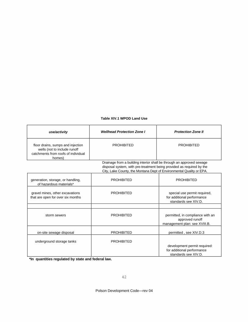
42
Polson Development Code—rev 04
Table XIV.1 WPOD Land Use
use/activity
Wellhead Protection Zone I
Protection Zone II
floor drains, sumps and injection wells (not to include runoff
catchments from roofs of individual homes)
PROHIBITED
PROHIBITED
Drainage from a building interior shall be through an approved sewage disposal system, with pre-treatment being provided as required by the City, Lake County, the Montana Dept of Environmental Quality or EPA.
generation, storage, or handling,
of hazardous materials*
PROHIBITED
PROHIBITED
gravel mines, other excavations that are open for over six months
PROHIBITED
special use permit required,
for additional performance standards see XIV.D.
storm sewers
PROHIBITED
permitted, in compliance with an approved runoff
management plan: see XVIII.B.
on-site sewage disposal
PROHIBITED
permitted , see XIV.D.3
underground storage tanks
PROHIBITED
development permit required:
for additional performance standards see XIV.D.
*In quantities regulated by state and federal law.
43
Polson Development Code—rev 04
CHAPTER XV - RESORT RESIDENTIAL OVERLAY DISTRICT A. What This Chapter Does. This chapter establishes an overlay district (the RROD) that allows golf courses, tennis clubs, fitness centers, and similar commercial uses to be integrated into residential developments on the basis of a master plan for the entire property. Where it overlays the LRZD, this overlay district also permits attached housing, at the same density permitted for single family dwellings in the LRZD. B. Additional Land Uses Permitted. The additional land uses permitted by the RROD shall include:
1. golf courses, tennis courts, health clubs, riding stables, and similar commercial recreational uses (SLUC 74), and incidental retail sales and restaurants associated with these uses; and 2. where it overlays the LRZD (see Chapter VI.), attached housing, at a maximum density of six units per acre.
C. Site Plan. The RROD may be applied to undeveloped areas zoned LRZD or MRZD by amendment of the future land use map adopted in the plan, where necessary, and amendment of the zoning map adopted in III.D. No such amendment shall be considered except upon submission of a site plan showing how the proposed commercial use will be made compatible with the neighboring residential development. Approval of the plan and/or zoning map amendment shall constitute approval of the site plan, and development permits on the property shall be issued only in compliance with that site plan. D. Standards. Commercial uses permitted in the RROD shall comply with the specification standards of the zoning district in which they are sited; the performance standards of Chapter XVIII, as applicable; and the following additional performance standards.
1. Operating Hours. Limited operating hours may be required. 2. Traffic. Commercial uses permitted in the RROD shall have direct access to a collector or arterial street, or otherwise be located where they will not channel traffic onto local residential streets. 3. Outdoor Sales and Storage. The RROD permits certain commercial outdoor recreational activities, but outdoor sales, with the exception of outdoor dining areas, shall not be permitted. All storage shall be enclosed in a building or fully screened from public view or the view of neighboring residences.
44
Polson Development Code—rev 04
CHAPTER XVI - SALISH POINT OVERLAY DISTRICT A. What This Chapter Does. This chapter establishes the Salish Point Overlay District (SPOD), which will ultimately be used to implement the Salish Point urban renewal plan. B. Interim Procedure. A special use permit shall be required for all new uses and principal buildings in the SPOD, but not for changes of occupancy in existing buildings. C. Interim Additional Performance Standard. Compliance with the Salish Point policy statement of the plan shall be added to the determinations required for approval of a special use permit in the SPOD.
CHAPTER XVII - RAILYARD OVERLAY DISTRICT A. What This Chapter Does. This chapter establishes the Railyard Overlay District (RYOD), which will ultimately be used to implement the Railyard urban renewal plan. B. Interim Procedure. A special use permit shall be required for all new uses and principal buildings in the RYOD, but not for changes of occupancy in existing buildings. C. Interim Additional Performance Standard. Compliance with the Railyard policy statement of the plan shall be added to the determinations required for approval of a special use permit in the RYOD.
45
Polson Development Code—rev 04
CHAPTER XVIII - PERFORMANCE STANDARDS A. What This Chapter Does. This chapter establishes performance standards, with which all development must comply, as applicable.
Division 1 - Protecting Flathead Lake and Other Natural Assets - Avoiding Natural Hazards B. Runoff Management. A runoff management plan shall be implemented by all developments that are adjacent to the lakeshore or that: disturb, or may reasonably be expected to result in disturbance of, a cumulative total of more than one acre of land with a slope of 8% or more, or a high erosion hazard; include 1,000 or more lineal feet of road crossing a slope of more than 8% or more, or an area of high erosion hazard; or create 20,000 square feet or more of contiguous impervious coverage. Such plans shall be prepared by a qualified professional and:
1. identify runoff and erosion hazard areas on the site; 2. show how the retention of existing vegetation will be maximized (including the protection of existing vegetation during construction) and land disturbance minimized; 3. show how the area disturbed by construction at any one time will be minimized and how disturbed areas will be stabilized during the construction period; 4. show how disturbed areas will be promptly, permanently stabilized by revegetation or structural techniques; 5. show how runoff velocities will be minimized and drainageways will be prepared to handle any acceleration or increase of runoff; 6. show how the additional volume of runoff generated will be retained on-site and absorbed, evaporated, or released at the pre-development rate of release; 7. show how sediment resulting from accelerated soil erosion will be retained on site; 8. show how water quality in adjoining or nearby streams and wetlands will be protected by retention of existing vegetation, installation of vegetative filter strips, and similar means; 9. show how groundwater quality will be protected, particularly in the WPOD; and 10. show how the future maintenance of runoff management measures (including earthwork, plantings, and structures) will be provided.
C. Shoreline Buffers. The shoreline buffer includes the 100 year floodplain or special flood hazard area, all wetlands adjacent to the shoreline, and the land area within 50 feet of the high water line of the lake or river.
1. Shoreline buffers shall be left in, or restored to, wetlands, riparian, hay meadow, or other vegetation capable of serving as an effective vegetative filter strip. Shoreline buffers may, however, be disturbed as follows: a. clearing and grading to prepare for plantings and other activities required to restore or enhance wetlands and riparian areas; b. repair or replacement of existing irrigation works, roads, bridges, utility lines, and similar structures; c. construction of new roads, bridges, and utility lines, provided that the area disturbed by such work is minimized; d. construction of pedestrian and bicycle trails of a maximum ten feet in width, including associated benches and picnic tables; e. installation of boat ramps, piers, docks, and observation decks provided that such structures disturb no more than 10% or 24 feet, whichever is less, of the lake frontage on any lot or parcel; and f. development of marinas, as provided in IX.D.7.
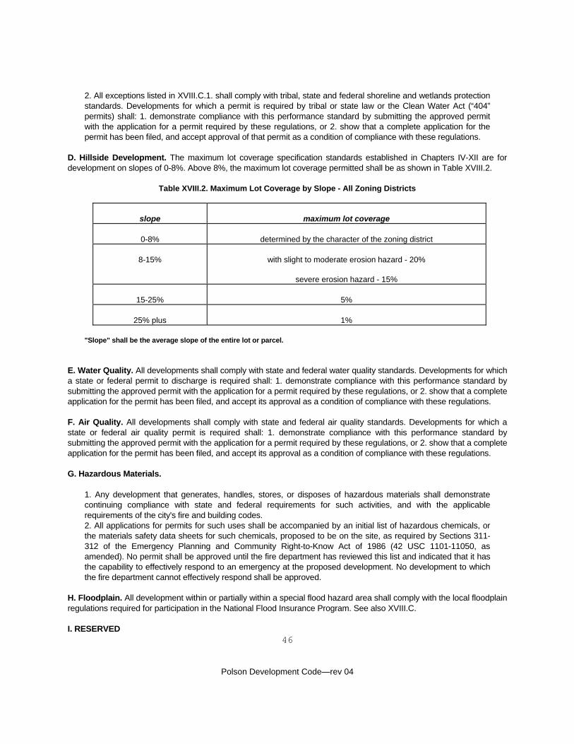
46
Polson Development Code—rev 04
2. All exceptions listed in XVIII.C.1. shall comply with tribal, state and federal shoreline and wetlands protection standards. Developments for which a permit is required by tribal or state law or the Clean Water Act (“404” permits) shall: 1. demonstrate compliance with this performance standard by submitting the approved permit with the application for a permit required by these regulations, or 2. show that a complete application for the permit has been filed, and accept approval of that permit as a condition of compliance with these regulations.
D. Hillside Development. The maximum lot coverage specification standards established in Chapters IV-XII are for development on slopes of 0-8%. Above 8%, the maximum lot coverage permitted shall be as shown in Table XVIII.2.
Table XVIII.2. Maximum Lot Coverage by Slope - All Zoning Districts
slope
maximum lot coverage
0-8%
determined by the character of the zoning district
8-15%
with slight to moderate erosion hazard - 20%
severe erosion hazard - 15%
15-25%
5%
25% plus
1%
"Slope" shall be the average slope of the entire lot or parcel.
E. Water Quality. All developments shall comply with state and federal water quality standards. Developments for which a state or federal permit to discharge is required shall: 1. demonstrate compliance with this performance standard by submitting the approved permit with the application for a permit required by these regulations, or 2. show that a complete application for the permit has been filed, and accept its approval as a condition of compliance with these regulations. F. Air Quality. All developments shall comply with state and federal air quality standards. Developments for which a state or federal air quality permit is required shall: 1. demonstrate compliance with this performance standard by submitting the approved permit with the application for a permit required by these regulations, or 2. show that a complete application for the permit has been filed, and accept its approval as a condition of compliance with these regulations. G. Hazardous Materials.
1. Any development that generates, handles, stores, or disposes of hazardous materials shall demonstrate continuing compliance with state and federal requirements for such activities, and with the applicable requirements of the city's fire and building codes. 2. All applications for permits for such uses shall be accompanied by an initial list of hazardous chemicals, or the materials safety data sheets for such chemicals, proposed to be on the site, as required by Sections 311-312 of the Emergency Planning and Community Right-to-Know Act of 1986 (42 USC 1101-11050, as amended). No permit shall be approved until the fire department has reviewed this list and indicated that it has the capability to effectively respond to an emergency at the proposed development. No development to which the fire department cannot effectively respond shall be approved.
H. Floodplain. All development within or partially within a special flood hazard area shall comply with the local floodplain regulations required for participation in the National Flood Insurance Program. See also XVIII.C. I. RESERVED
47
Polson Development Code—rev 04
Division 2 - Providing Adequate Infrastructure J. Municipal Utilities. Except in the PLZD and RRZD, all developments, and all lots or parcels within a development, shall have direct access to municipal water and sewer utilities. Provision of utilities, including any extension of mains, lift stations, etc. shall be the responsibility of the developer, although the city may choose to bear the costs of providing larger facilities to provide for future development. Developments in the PLZD and RRZD shall have on-site water and sewerage system approved by the county. K. Private Utilities.
1. All developments, and all lots or parcels within a development, shall have direct access to electric power, telephone, and, where available, cable television and natural gas. Private utilities shall be provided by the developer, as required by the individual utilities. 2. Wherever such service is available, utilities shall be placed underground, with the connections to each lot made before street surfaces are constructed.
L. Easements. No building shall be placed in any utility easement, public or private. If approved by the Water and Sewer Superintendent, fences with a gate or separable section may be constructed across municipal utility easements. Fences across other easements must have approval of the affected utility. Note that irrigation companies and districts are considered to be utilities for the purposes of this performance standard. M. Runoff Management. RESERVED N. Vehicular Access. All developments, and all lots or parcels within a development, shall have safe direct access to a dedicated public street that complies with the detailed performance standards of Appendix G. Exception: Multiple-family dwelling complexes and mobile home parks shall provide private internal streets. Provision of access, including street extensions, shall be the responsibility of the developer, although the city may choose to participate in the costs of extending collector streets to serve future development. O. Access Driveways. All points of access to public streets, including residential driveways, shall comply with the detailed performance standards of Appendices E and G. P. Off-Street Parking. All developments shall provide off-street parking and loading areas in compliance with the detailed performance standards of Appendix E, except in the CBZD zoning district, where reliance on shared parking areas and on-street parking is permitted. Snow storage shall not be allowed to reduce the size of required off-street parking or loading areas. Q. Pedestrian Access. Developments shall provide sidewalks along all street frontages and/or an effective system of off-street pedestrian circulation. Sidewalks and pedestrian (not intended for use by bicycles) trails shall be a minimum of five feet in width in residential developments, and ten feet in width in commercial areas. Wider walks or pedestrian trails may be required in active areas, including the CBZD and SPOD, or where trails will be shared with bicycles, in which case the minimum width shall be 10 feet. R. Bicycle Access. RESERVED S. Circulation. All circulation systems, vehicular, pedestrian, and bicycle, shall be designed and constructed to connect with both existing and anticipated future development.
48
Polson Development Code—rev 04
T. Parks. As required by 76-3-606, MCA, residential subdivisions shall dedicate land or provide a cash donation in lieu of dedication for parks.
1. 11.1% of the total area of lots of five acres or less in size and 8.33% of the total area of lots of five to 10 acres in size, exclusive of all other dedications, shall be dedicated for parks, except 2. where the small size of the parcel to be dedicated, topography, location, or other circumstances (see 4., below) make dedication infeasible, the council/BOCC may accept a cash donation. Cash donations shall be for the fair market value of the undivided, unimproved land. Cash donations shall be paid into a separate fund and used only for the acquisition of park land or the initial development of parks. 3. In subdivisions developed pursuant to a development agreement (see Chapter XIX), the parks dedication for the entire subdivision shall accompany the first final plat filed. 4. The location of land dedicated as a park shall be approved by the council/BOCC in compliance with the following guidelines. Where these guidelines cannot be met, a cash donation shall be required.
a. Slopes, wetlands, and other areas that cannot be developed for active recreation shall not be accepted, although the developer may include such areas as part of a larger park. b. The proposed park must be large enough for development as a useful neighborhood park: at least six acres. c. The proposed park space should within one-half mile of the majority of lots to be served. d. The proposed park must be safely accessible by pedestrians coming from the lots to be served, but have direct access to a collector street, or otherwise be located where it will not channel traffic onto local residential streets. e. Where possible, the proposed park should be connected to existing or proposed pedestrian/bicycle trails.
5. Exception. No dedication or donation is required where: a. only one lot is created; b. all lots are five or more acres in size and the developer records a covenant, which may be revoked only with city/county consent, that: i. no lot shall be used for any purpose other than a single-family dwelling, and ii. no lot shall be further subdivided; and c. developed park facilities are provided by the developer and maintained by a community association created in compliance with these regulations.
U. RESERVED V. Large-Scale Development. A large-scale development includes 100 or more residential lots or units or commercial or industrial uses that will potentially generate 1000 or more trips on the average working day (ADT).
1. Large-scale developments shall provide, or contribute to provision of, additional public facilities necessitated, entirely or in part, by their development. Such facilities shall be provided in compliance with all requirements of these regulations and may include: water system capacity, including larger mains, wells, and reservoirs; sewerage system capacity, including larger mains, lift stations, and treatment facilities; runoff management measures; street improvements, including deceleration, acceleration, or turn lanes, traffic signals, and bridges; solid waste transfer stations; and emergency services buildings and apparatus. 2. The public facilities needs of a large-scale development shall be determined through a fact-finding process conducted by the board, at the expense of the developer. The administrator may retain professional planners
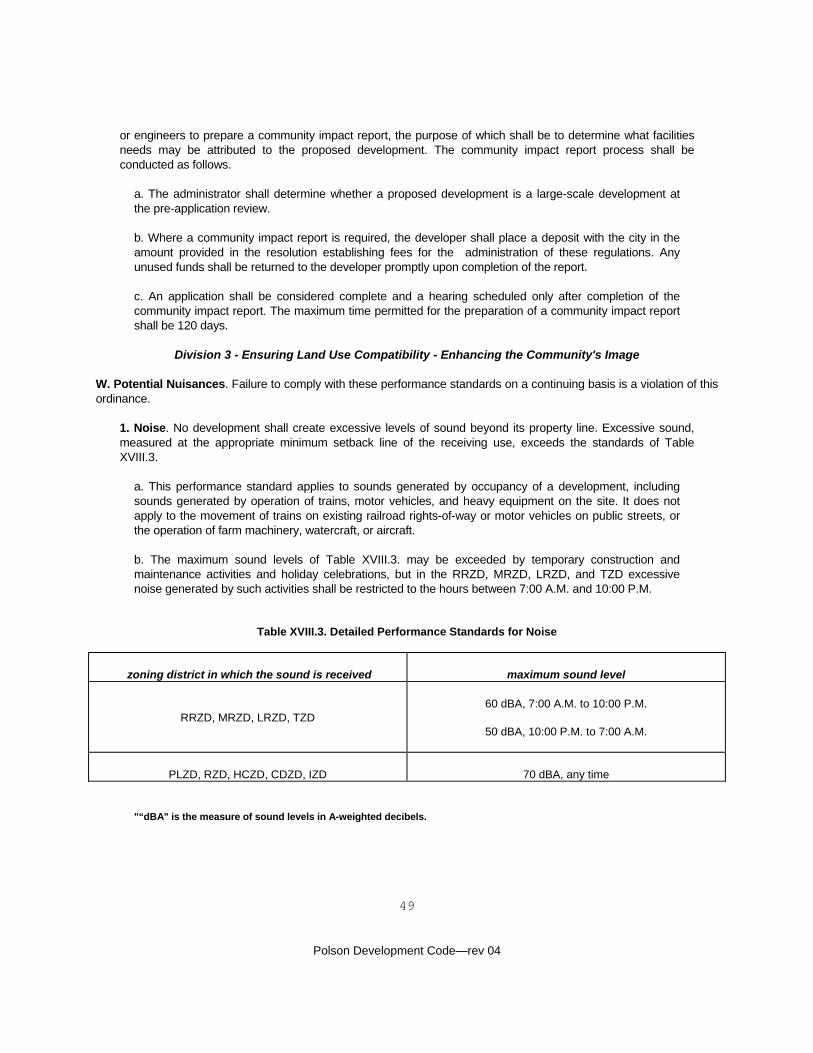
49
Polson Development Code—rev 04
or engineers to prepare a community impact report, the purpose of which shall be to determine what facilities needs may be attributed to the proposed development. The community impact report process shall be conducted as follows.
a. The administrator shall determine whether a proposed development is a large-scale development at the pre-application review. b. Where a community impact report is required, the developer shall place a deposit with the city in the amount provided in the resolution establishing fees for the administration of these regulations. Any unused funds shall be returned to the developer promptly upon completion of the report. c. An application shall be considered complete and a hearing scheduled only after completion of the community impact report. The maximum time permitted for the preparation of a community impact report shall be 120 days.
Division 3 - Ensuring Land Use Compatibility - Enhancing the Community's Image W. Potential Nuisances. Failure to comply with these performance standards on a continuing basis is a violation of this ordinance.
1. Noise. No development shall create excessive levels of sound beyond its property line. Excessive sound, measured at the appropriate minimum setback line of the receiving use, exceeds the standards of Table XVIII.3.
a. This performance standard applies to sounds generated by occupancy of a development, including sounds generated by operation of trains, motor vehicles, and heavy equipment on the site. It does not apply to the movement of trains on existing railroad rights-of-way or motor vehicles on public streets, or the operation of farm machinery, watercraft, or aircraft. b. The maximum sound levels of Table XVIII.3. may be exceeded by temporary construction and maintenance activities and holiday celebrations, but in the RRZD, MRZD, LRZD, and TZD excessive noise generated by such activities shall be restricted to the hours between 7:00 A.M. and 10:00 P.M.
Table XVIII.3. Detailed Performance Standards for Noise
zoning district in which the sound is received
maximum sound level
RRZD, MRZD, LRZD, TZD
60 dBA, 7:00 A.M. to 10:00 P.M.
50 dBA, 10:00 P.M. to 7:00 A.M.
PLZD, RZD, HCZD, CDZD, IZD
70 dBA, any time
"“dBA" is the measure of sound levels in A-weighted decibels.
50
Polson Development Code—rev 04
2. Light, Glare, Heat. No development shall direct excessive or dangerous light, glare, or heat beyond its property line, or create light or glare that constitutes a traffic hazard.
a. Welding equipment and similar sources of intense light or heat shall be shielded from neighboring properties and public ways by enclosure in a building, location on the property, or a fence or wall. b. No commercial or industrial development shall generate a level of illumination greater than 0.5 foot-candle in any neighboring residential zoning district.
3. Electrical Interference. No development shall create electrical interference on other properties. See also XIII.H. 4. Solid Waste. Solid waste shall be stored in approved containers, and handled in a manner that does not: a. attract bears, rodents, flies, or other animals; b. generate odors perceptible beyond the property line or liquid runoff; or c. permit the blowing of paper and other lightweight waste. 5. Commercial and Industrial Waste: All commercial and industrial solid waste handling and storage areas shall be screened from public view by enclosure in a building, location on the property, a fence or wall, or a densely planted landscaped buffer. 6. Outdoor Storage. Outdoor storage of commercial and industrial solid waste is covered in 5., above. Other outdoor storage shall be permitted as established in each zoning district, but shall not, regardless of its location on the property, or screening or buffering, create a fire, health, or safety hazard, or constitute an attractive nuisance. 7. Surface Runoff. No development shall channel surface or irrigation water onto another property without the express permission of its owner. See also XVIII.B. 8. Irrigation. No development shall adversely impact the operation of an existing irrigation system. 9. Dust, Smoke, Odors. No development shall generate dust, smoke, odors, or other air-borne pollutants that have an adverse impact on neighboring properties or the enjoyment of public spaces. See also XVIII.F.
X. Landscaped Buffers. Installation of landscaped buffers is among the most effective techniques for ensuring land use compatibility and enhancing the community's image. Landscaped buffers shall be provided as required by Appendix F. Y. Signs. All signs shall comply with the detailed performance standards of Appendix B. Z. Views to Flathead Lake. See also IX.D.4., which requires that view corridors be provided in the RZD. Views to Flathead Lake from dwellings and lake-oriented commercial uses are a valuable resource, and should generally not be blocked, even by development that otherwise complies with these regulations.
1. Proposed subdivisions shall provide drawings or electronic simulations showing how their design minimizes the possibility that their development will block existing lake views. 2. Proposed special permit uses shall provide drawings or electronic simulations demonstrating that they do not block existing lake views, or that partial blocking of existing lake views is necessary to permit any reasonable use of the lot or parcel on which 3. Permitted uses will generally be assumed to comply with this performance standard, if they meet the specification standards of their zoning district. The administrator may, however, condition the approval of a development permit on alterations that help retain views from adjoining properties.
51
Polson Development Code—rev 04
AA. RESERVED BB. Recreational Vehicles. (Applies to County Planning Area, outside City limits, only—not approved or allowed by City) (County Res #02-28, 4/4/02)
1) In all residential zoning districts located within the Polson Master Plan area, the temporary use of a recreational vehicle for landowners’ guests shall be permitted for a time period not to exceed 14 days without obtaining a zoning conformance permit.
2) Permitted Uses—Temporary Recreational Accommodations: A recreational vehicle may be used as a
temporary recreational structure on waterfront properties outside of the Polson city limits on a seasonal basis with a zoning conformance permit. The number of recreational vehicles shall not exceed one per lot, without a special use permit. The recreational vehicles may not be rented. These structures must meet all specification standards of the zoning district in which the property is located including setback distances, shoreline buffers and other applicable performance standards detailed in Chapter XVIII of the Polson Development Code. The recreational vehicle may be stored on the property in compliance with the outdoor storage specification defined for each zoning district while not is use. All RVs shall have sewage disposal facilities that meet local and state sanitation requirements.
No RV structures shall be used as permanent (year round) dwellings. No recreational vehicle shall be parked or permitted to stand on any public street, highway, road, alley or other such right-of-way for more than a 24-hour period. If so parked for less than a 24-hour period, it shall be parallel to the edge of the right-of-way, safely out of the flow of moving traffic.
Division 4 - Land Divisions BB. Master Planning Required. An application for a minor subdivision or subdivision permit shall be considered incomplete if it fails to show an overall plan for the development of the entire contiguous holdings of the developer and/or owner. CC. Environmental Assessments. As provided by 76-3-210(2), MCA, subdivisions that are in compliance with these regulations and the plan are not required to submit an environmental assessment. Note that community impact reports are required of large-scale developments, including subdivisions, by XVIII.V. DD. Plats. All final plats shall be as required by the Uniform Standards for Monumentation, Certificates of Survey, and Final Subdivision Plats promulgated by the Montana Department of Commerce (ARM 8.94.3001 through 8.94.3003, as amended). Preliminary plats shall be as required by Appendix H.
52
Polson Development Code—rev 04
CHAPTER XIX - REQUIRED IMPROVEMENTS
A. What This Chapter Does. The provisions of this chapter ensure that required improvements will be installed and maintained. A required improvement is any on or off-site improvement required for compliance with these regulations. Required improvements include, but are not limited to: the vegetative and structural measures needed to implement an approved runoff management plan; utilities; streets; off-street parking and loading areas; improvements required by a community impact report; improvements that mitigate potential nuisances, including screening fences and walls; landscaped buffers; and any other improvement required for compliance with the requirements of these regulations. B. Installation at Developer’s Expense. The installation of required improvements shall be at the developer's expense, although the city may choose to participate in the costs of certain improvements, as provided in XVIII.J. and N. C. Standards for Required Improvements. All required improvements shall be installed in compliance with these regulations and any design and engineering standards separately adopted by the city or other agencies responsible for providing services to the development. D. Time of Installation/Development Agreements.
1. All required improvements may be installed before a final plat is recorded or the development is offered for lease or sale, leased, sold, or occupied.
or 2. Developers may elect to record final plats of the development in phases or to offer phases of the development for lease, sale, or occupancy before all required improvements are installed. Phasing shall be permitted pursuant to a development agreement that:
a. incorporates the preliminary plat or site plan used as a basis for permit approval and a detailed site plan and construction drawings of the initial phase; b. identifies all required improvements in the initial phase/s and establishes their estimated cost; c. sets a schedule for the completion of the required improvements in the initial phase and an anticipated schedule for future phases; d. guarantees completion and 365 days’ maintenance of all required improvements in the initial phase/s using one of the methods listed in this chapter, and provides a process for submission of detailed plans and cost estimates, and the guarantee of improvements in future phases; e. provides a process by which the city may, if necessary, complete required improvements using the guarantee provided; f. provides a process by which either party may request re-negotiation of the development agreement, g. provides a process by which the development agreement may be transferred, with city approval, to the developer's successors; and h. provides that the development agreement and any vested rights it confers shall be void if the city is required to “call” a guarantee to complete required improvements, or if the anticipated schedule is not met or re-negotiated. The developer may re-negotiate the anticipated schedule without losing vested rights, provided that such negotiations are initiated within 90 days after failure to initiate or complete a phase as scheduled.
53
Polson Development Code—rev 04
E. Effect of Development Agreement. The effect of a development agreement shall be to create vested rights in the preliminary plat or site plan, as it was approved. Such rights expire with the development agreement. Development agreements do not insulate developments from changes in state or federal regulations, or changes in the city's fire and building codes. F. Guarantees. Completion of the improvements identified in a development agreement shall be guaranteed by one of the following methods:
1. The developer may place an amount equal to 150% of the estimated cost of the required improvements in escrow, with that amount and accumulated interest being released only after the city has inspected and accepted the required improvements. A development agreement may provide for the phased release of a portion of the escrowed funds as work proceeds, but at least 25% of the amount in escrow shall be retained until all required improvements are installed, inspected, and accepted. If required improvements are not completed as provided in the development agreement, the city shall use as much as necessary of the escrow account to complete those improvements, then return any remaining balance to the developer. 2. The developer may provide an irrevocable or standing letter of credit for an amount equal to 150% of the estimated cost of the required improvements. The letter of credit shall be released only after the city has inspected and accepted the required improvements. If any required improvements are not completed as provided in the development agreement, the city shall use as much as necessary of the credit available to complete those improvements, then release any remaining balance to the developer.
G. Inspection and Acceptance of Improvements.
1. Fees for the inspection of required improvements shall be set by resolution of the council. Inspection fees must be paid before a certificate of compliance is issued. 2. Required improvements shall be inspected by the administrator before acceptance. Acceptance of required improvements shall be by action of the council, following submission of the developer's written request for acceptance and receipt of the administrator's report that all improvements have been inspected and are in compliance with these regulations. 3. Reproducible as-built drawings of all subdivision improvements shall be provided to the city, at the developer's expense, before a certificate of compliance is issued.
H. Warranty of Improvements. Required improvements shall be warranted by the developer for both materials and workmanship for one year following their acceptance. Such a warranty provision shall be included in all development agreements. Where all required improvements will be completed before a final plat is approved and the development is offered for lease, sale, or occupancy, a separate warranty agreement shall be submitted for approval. Enforcement of the warranty shall be assured by:
1. retention of 10% of an escrow account established to comply with XIX.F.1.; 2. a continuing letter of credit, as provided in XIX.F.2., but for 10% of the cost of the required improvements; or 3. opening a new escrow account or providing a new letter of credit in an amount equal to 10% of the cost of all required improvements.
These warranty funds shall be released upon expiration of the warranty period or, if necessary, used to remedy defects that have not been remedied by the developer. I. Continuing Maintenance Required. The continuing maintenance of any improvement required for compliance with
54
Polson Development Code—rev 04
these regulations shall be required, and failure to maintain a required improvement shall be a violation, subject to the penalties provided by II.Z.
1. Any development subject to the continuing maintenance requirement established here that results, or may reasonably be expected to result, in multiple ownerships shall create a community association to ensure continuing maintenance. The developer shall submit the proposed declaration of covenants, articles of incorporation, and by-laws for that association with the application for a permit. These documents shall be reviewed and approved by the city attorney, and shall have been recorded before a certificate of compliance is issued. 2. Maintenance of landscaped areas required by this ordinance includes installation and maintenance of an irrigation system and timely irrigation, where necessary; weed and pest control; and all other activities required to maintain the function of the landscaped area.
55
Polson Development Code—rev 04
CHAPTER XX - EXISTING NUISANCES
A. What This Chapter Does. Unlike the other chapters of these regulations, which apply to existing uses or buildings only when they are changed, this chapter applies to all existing uses and buildings. Its purpose is to provide a basis for the elimination of existing nuisances. B. Existing Nuisances. Existing conditions that violate the performance standards of XVIII.W. are declared to be public nuisances and, as such, violations of these regulations subject to the enforcement procedures of II.X. C. Outdoor Storage.
1. In Residential Zoning Districts. Outdoor storage in the RRZD, LRZD, MRZD, and TZD that does not comply with these regulations is declared to be a public nuisance and, as such, a violation of these regulations subject to the enforcement procedures of II.X. 2. In Commercial and Industrial Zoning Districts. No commercial or industrial outdoor storage area may be expanded, except in compliance with these regulations.
D. Dangerous Buildings. Dangerous buildings may be addressed using the Uniform Code for the Abatement of Dangerous Buildings. E. Abandoned Signs. Abandoned signs, as defined in Appendix B, are declared to be public nuisances, subject to removal as provided in Appendix B.
56
Polson Development Code—rev 04
CHAPTER XXI - DEFINITIONS A. What This Chapter Does. This chapter provides definitions for terms used in these regulations. Any dispute about the meaning of a term shall be resolved using the appeals procedure of II.P. B. Rules of Interpretation. Terms include both singular and plural forms; i.e. building includes buildings, and their derivatives; i.e. adjacent includes adjoining. C. Accessory. Accessory uses and buildings are those customarily associated with and clearly subordinate to a permitted or special permit building or use. Common accessory uses (a parking lot associated with a business, for example) and buildings (a detached garage in a residential area, for example) raise few questions, but this definition specifically addresses two problematic accessory uses.
1. A single dwelling unit occupied by the owner, a manager, or a guard is a customary accessory use on all commercial and industrial premises. 2. An accessory apartment (a single, functionally separate dwelling unit) is a customary accessory use in all single-family dwellings. 3. Family and group day-care homes registered by the Montana Department of Family Services shall be customary accessory uses in all single-family dwellings, as provided by 76-2-412, MCA. Day care shall also be considered customarily accessory to any commercial or industrial use that provides on-site day care for its employees. Day care centers in commercial or industrial zoning districts are commercial or industrial uses, subject to all applicable performance standards. 4. Certain other accessory uses and buildings are addressed in specific zoning districts (like the keeping of livestock in the RRZD). Home occupations are separately addressed: see Appendix D.
D. Adjacent. Adjacent includes all lots or parcels that directly border the lot or parcel on which a development is proposed, and all lots or parcels separated from that lot or parcel by only a public or private easement or right-of-way, including streets, railroads, and irrigation canals. E. Administrator. The city employee or contractor responsible for the administration of these regulations. F. Arterial Street. For the purpose of these regulations, the following roads within the City-County Master Planning and Zoning Area shall be considered to be Arterial Streets: Highway 93, Highway 35, 1st Street E., 7th Ave., Main St., 7th Street E., Kerr Dam Road and Rocky Point Road. G. BOA. The Board of Adjustment, as required by 76-2-222, MCA. The BOA is an appointed body that hears variances, and appeals from decisions of the administrator and board. H. Board. The Polson City-County Board, appointed as authorized by 76-1-101, MCA, et seq. I. BOCC. The Lake County Board of Commissioners, the county's chief elected officials. J. Buffer. Two different kinds of buffers are required by these regulations. XVIII.C. requires a shoreline buffer, which is a minimally disturbed areas along the lakeshore. XVIII.X. requires landscaped buffers, which are required between adjoining properties that are in different zoning districts or, in certain cases, in the same zoning district, but have different uses. Landscaped buffers are not required between structures on the same lot or parcel, except where the lot or parcel is platted or otherwise intended for future partition.
57
Polson Development Code—rev 04
K. Building. As used in these regulations, refers to any structure. L. Building Height. The vertical distance from mean natural grade to the highest point on a building. Building height excludes chimneys, vents, and antennae. M. Certificate of Compliance. A certificate of compliance is issued upon the completion of a use or building and any accompanying improvements required by these regulations: see II.W. N. Clear Vision Triangle. A triangular area on a lot or parcel in which objects that would block the vision of drivers at an intersection or driveway are prohibited: see Appendices E and F. O. Collector Street. A street that will serve more than 15 dwelling units. P. Commercial. Includes all land uses in SLUC 4731, 4741, and 492; 52-59, except 598; 61-65, except 637; 67-69; and 71-79; except any use in SLUC 63-64 that includes an outdoor work and/or materials handling and/or storage yard. Such uses are industrial. (SLUC = Standard Land Use Code) Q. Council. The elected governing body of the City of Polson. R. Day Care. As defined by 52-2-703(5), MCA, day care means less than 24 hour out of home care for children, whether that care is for daytime or nighttime hours. Montana law defines three kinds of day care facilities.
1. A family day care home is a private residence in which day care is provided to three to six children from separate families on a regular basis. Montana law (76-2-412(4), MCA, requires that family day care homes be permitted as accessory uses in all residential zoning districts. 2. A group day care home is a private residence in which day care is provided to seven to 12 children on a regular basis. 3. A day care center is a place in which day care is provided to 13 or more children on a regular basis. 4. Family and group day care homes are not home occupations, but customary accessory uses to dwellings, as provided in XXI.C.3.
S. Development. Development is used as a generic term covering any and all activities for which a permit is required by these regulations. The developer is, by definition, the owner of the parcel on which a development is proposed, but owners may appoint a representative for all proceedings by these regulations. T. Facade. That portion of a building below the roofline fronting on and visible from a public street. U. Floodplain. For the purposes of these regulations, synonymous with "special flood hazard area", as defined and mapped by the Federal Insurance Administration. V. Fowl. Chickens, turkeys, ducks, guinea fowl, pigeons, and pheasants. (County Res #02-26, 4/4/02) W. Frontage. The frontage of a lot or parcel is the distance, measured in lineal feet, along any property line/s that directly abut a public street. X. (definition pending) Y. Hazardous Materials. Includes all substances subject to regulation by the Emergency Planning and Community Right-To-Know Act.
58
Polson Development Code—rev 04
Z. Home Occupation. A commercial or light industrial activity conducted in a dwelling or a building accessory to a dwelling. Home occupations, by definition, comply with the detailed performance standards of Appendix D. AA. Industrial. Includes all land uses in SLUC 21-52, except SLUC 4731, 4741, and 492; 55; 598; 637; 66; and 82-89; plus any use defined as industrial by XXI.P. BB. Large-Scale Development. A large-scale development is a project that will contain 100 or more residential lots or units, or is projected to generate 1,000 or more ADT: see XVIII.V. CC. Livestock. Cattle, calves, horses, mules, sheep, lambs, and goats. (County Res #02-26, 4/4/02) DD. Lot. Lot is used as both as a generic term for a development site, and to refer to any parcel of land created and described by a record of survey or plat. EE. Lot Coverage. Lot coverage is the percent of a lot or parcel that is covered by rooftops, paved roads, and other surfaces that prevent direct infiltration of precipitation or runoff into the soil. FF. Manufactured Home. See XXI.YY. GG. MCA. Acronym for Montana Code, Annotated. The state laws of Montana. HH. Minor Utility Installation. Includes cable television, electric power, and telephone cables and transmission lines, and natural gas pipelines that serve the area through which they are routed. Also includes transformer boxes and other minor appurtenances to those transmission lines or pipelines. Other utility installations are industrial uses. II. Minimize. For the purposes of this ordinance, "to minimize" means to demonstrate that no alternative plan for the proposed development will result in a smaller impact. JJ. Mobile Home. Any structure manufactured in compliance with the National Manufactured Home Construction and Safety Standards Act (42 U.S.C. 5401, et seq., as amended) that is transportable in one or more sections, and which in the traveling mode is eight body feet or more in width or 40 body feet or more in length or, when erected on site, is 320 or more square feet, and which is built on a permanent chassis and designed to be used as a dwelling with or without a permanent foundation. Mobile homes are not single-family dwellings: see XXI.YY. KK. Mobile Home Park. Any lot or parcel used for occupancy by mobile homes that are not placed on permanent foundations. Mobile home parks are subdivisions. LL. Montana Subdivision and Platting Act. 76-3-101, MCA, et seq. MM. Motor Home. “Motor home means a motor vehicle: (County Res #02-28, 4/4/02)
1) Designed to provide temporary living quarters, built as an integral part of or permanently attached to a self-propelled motor vehicle chassis or van.
2) Containing permanently installed independent life support systems that meet the ANSI/A119.2 standard; and
provides at least four of the following types of facilities:
a. Cooking, refrigeration or icebox b. Self-contained toilet c. Heating or air-conditioning or both d. Potable water supply, including a faucet and sink; or e. Separate 110-volt or 125-volt electrical pwer supply or a liquefied petroleum gas supply or both.
59
Polson Development Code—rev 04
NN. Nonconforming. A nonconforming use or building complied with the regulations that existed at the time of its development, but would not comply with these regulations, if submitted for approval after their effective date. The degree of nonconformity is the measured extent to which an existing building or use fails to comply with the specification standards of this ordinance. For example, the degree of nonconformity of a parking lot that has four spaces, but serves a use requiring nine, is five parking spaces. No change in the nonconforming building could be permitted that would reduce the number of parking spaces, because that would increase the degree of nonconformity. OO. Occupancy. The use of a building or lot. Occupancies are classified using the Standard Land Use Code (SLUC). A minor change in occupancy is a change within the two-digit SLUC code or a change to any occupancy that has identical parking requirements, similar traffic generation potential, creates no additional signage, and, has, as determined by the administrator, similar or lesser impacts on neighboring land uses. PP. Outdoor Storage. Keeping, stockpiling, or storing materials for any reason (it need not be for commercial use), including the long term storage of construction materials and inoperative machinery or vehicles, that is not enclosed in a building and is visible from a public street. QQ. Plan. The Polson Master Plan, as amended. RR. Plat. The legal map describing a subdivision. SS. Recreational Vehicle. A recreational vehicle is a motor home, travel trailer, truck camper or camping trailer, with or without motive power, designed for recreational or emergency occupancy. Recreational vehicles are not mobile homes. TT. Recreational Vehicle Park. Any lot or parcel used for temporary occupancy by recreational vehicles. Recreational vehicle parks are subdivisions. UU. Setback. The setback is the shortest distance between the property line and the outer wall, at grade, or any above grade extension that projects more than three feet from the outer wall at grade, of the principal building on the same lot. The space within that distance is called a yard.
1. The front setback is measured from the lot line paralleling the public street on which the building is addressed to the principal building. Except where one of the bordering streets is an arterial or collector, corner lots shall treat the yard on the street on which the structure is addressed as "front". The yard on an arterial or collector shall, however, be the front yard, regardless of whether the structure is addressed on that street. 2. The rear setback is measured from the rear lot line to the principal or accessory building. The rear lot line is parallel, or more or less parallel, to the street. Corner lots have two rear yards, but may treat either as a side yard for the purposes of these regulations. (Ord. #567, 8/16/99) 3. The side setback is measured from the side lot line to the principal or accessory building. (Ord. #567, 8/16/99)
VV. Sewerage. Refers to the entire system (mains, treatment plant, etc.) used to treat sewage wastes. WW. Short Court. A private road serving 3 to 8 dwelling units, with the following characteristics: road right-of-ways of 40’ width or less and with road lengths of 200’ or less; concrete curbs and gutters; no sidewalks; and plans for snow removal. (Ord. #594, 6/7/04) XX. Sign. Any object or structure used to identify, advertise, or in any way attract or direct attention to any use, building, person, or product by any means, including, but not limited to, the use of lettering, words, pictures, and other graphic depictions or symbols. Specific types of signs are defined in Appendix B.
60
Polson Development Code—rev 04
YY. Single-Family Dwelling. A detached building designed for occupancy by one family. Also includes foster and youth homes, and community residential facilities, as required by 76-2-401, MCA, et seq. Includes both conventional dwellings and, as required by 76-2-202(6), MCA and 76-3-302(4), MCA, manufactured homes that: 1. comply with the National Manufactured Home Construction and Safety Standards Act (40 USC 5401, as amended) or the Uniform Building Code; 2. are at least 1,000 square feet in size; 3. are attached to a permanent foundation and, where available, permanently connected to municipal utilities; 4. have a pitched roof and siding and roofing materials that are customarily used on site-built homes in the Polson Planning Area; and 5. have a minimum width of 24 feet exclusive of porches, decks, sidewalks, eaves and after factory additions. Recreational vehicle and travel trailers are not single family dwellings, and shall not be used as such. (Ord. #545, 9/2/97) ZZ. Site Plan. See Appendix H. AAA. Sketch Plan. A sketch plan is a general or conceptual site plan of a development. It must be to scale, and include the approximate site boundaries, approximate location of prominent natural features on and adjacent to the site; existing and proposed lot lines and streets; the approximate location and exterior dimensions of existing and proposed structures; the approximate location, size, and circulation pattern of proposed parking areas; and the approximate location and dimensions of proposed buffers. BBB. Standard Land Use Code. Abbreviated SLUC. The standard land use code is a method of classifying land uses adapted from the Standard Land Use Coding Manual, U.S. Department of Transportation, Federal Highway Administration, as reprinted in March 1977. A summary is given on the inside front cover of these regulations. CCC. Structure. Any object constructed or installed by man, including, but not limited to, buildings, towers,smokestacks, earth formations, liquid storage tanks, fences, and overhead transmission lines. For the purposes of Chapter XIII, includes mobile structures, like cranes. DDD. Subdivision. As provided by 76-3-103(14), MCA, "a division of land or land so divided that creates one or more parcels containing less than 160 acres that cannot be described as a one-quarter aliquot part of a U.S. government section, exclusive of public roadways, in order that the title to or possession of the parcels may be sold, rented, leased, or otherwise conveyed and includes any resubdivision and further includes a condominium or area, regardless of its size, that provides or will provide multiple space for recreational camping vehicles or mobile homes." EEE. (definition pending) FFF. Townhouse or Townhome. Arrangement under which individuals own their own residential unit and hold title to the land beneath said unit. A townhouse shares a common wall with one or more adjoining residential units. (Ord. #594, 6/7/04) GGG. Travel Trailer. A vehicular unit, mounted on wheels, designed to provide temporary living quarters for recreational, camping or travel use and not used as a principal residence. The size or weight of the unit is such that it can be licensed for standard highway travel and as not to require special highway movement permit(s). The unit is designed to be towed by a motorized vehicle that contains a towing mechanism that is mounted about or forward of the tow vehicle’s rear axle. (County Res #02-28, 4/4/02) HHH. Use. Synonymous with "occupancy": see XXI.OO. III. Variance. A variance is a modification of the specification or performance standards of these regulations that provide a reasonable use of lot or parcel that cannot otherwise be developed in compliance with these regulations. Specific findings are required for the approval of a variance: see II.Q.