Embed Size (px)
Citation preview

F I N A L R E P O R T
Pollution Prevention and Control Plan Phase Two Summary Report
Prepared for
City of London
March 2018
CH2M HILL Canada Limited 72 Victoria Street South, Suite 300 Kitchener, Ontario N2G 4B3


BI0328181550KWO CH2M HILL CANADA LIMITED • COMPANY PROPRIETARY ES-1
Executive Summary Introduction The City of London (City) initiated a Pollution Prevention and Control Plan (PPCP) in 2012 as part of its ongoing efforts to improve the performance of the City’s sanitary and storm sewer infrastructure. The PPCP is aimed at reducing sewer system overflows (SSOs) and wastewater treatment plant (WWTP) and pumping station (PS) bypasses that are discharged into receiving streams during extreme rainfall events.
A PPCP is a master planning level tool that provides the City with project implementation and capital planning guidance for the next 20 years and beyond. The PPCP is based on a defined set of goals and objectives that are aligned with the objectives of the City, the Ministry of the Environment and Climate Change (MOECC), the Upper Thames River Conservation Authority (UTRCA), First Nations, and local stakeholders to maximize the benefits of the PPCP implementation strategy within the opportunities and constraints of the City’s fiscal planning process.
This PPCP is being undertaken in accordance with the Environmental Assessment guidelines outlined in the Municipal Engineers Association (MEA) Municipal Class Environmental Assessment (EA) document (as amended in 2015), for Master Plans (MPs). MPs are long-range plans that examine the current and future requirements of a given infrastructure system using EA planning principles. The master planning process allows a municipality to identify the need for specific projects under a broad planning framework.
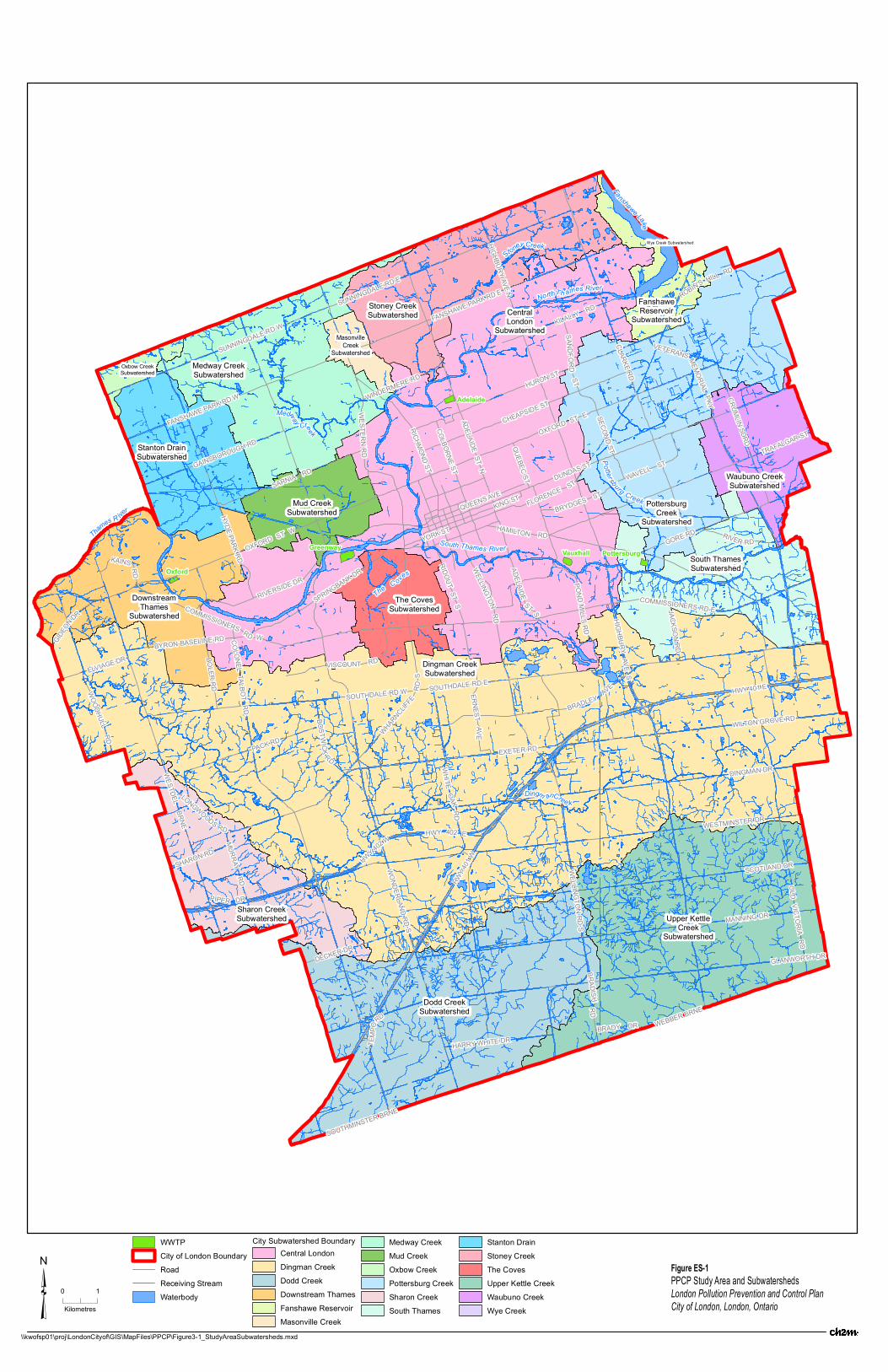
The PPCP is being implemented in three phases. The general study area for the PPCP is shown in Figure ES-1. This report summarizes the efforts completed in Phase Two which provides information on the characterization of the receiving stream environment, the potential impacts from SSO and bypasses to the receiving streams using the results of the hydrologic and hydraulic modelling and the identification of priority SSOs and PSs for mitigation.
Background The City’s first sewer collection systems were built in the 1850s and some are still in service today. Over the years, the City has grown through annexations of former municipalities and has assumed responsibility for approximately 2,750 kilometres (km) of sanitary, storm, and combined sewers. The City’s sanitary sewer system is comprised of five main sewersheds (Pottersburg, Vauxhall, Greenway, Adelaide, and Oxford).
Originally, SSOs and other bypasses that exist in the system were built to protect homes from basement flooding caused by the inflow and infiltration of excessive amounts of stormwater. At the time, discharge from these SSOs and bypasses was directed to receiving water bodies to alleviate flooding impacts.
The primary objective of this PPCP is therefore to develop and implement a plan to achieve a long-term solution that will limit the volume and frequency of occurrence of untreated wastewater discharges to the receiving streams from various SSOs and bypasses throughout the City, while maintaining an acceptable level of service and protection against basement flooding. This plan follows the principles outlined in the MOECC’s Procedure F-5-5.
Procedure F-5-5 outlines the minimum treatment requirements for municipal and private combined and partially separated sewer systems. The primary goals of the Procedure are to eliminate the occurrence of dry weather SSOs and to minimize the potential for impacts on human health and aquatic life.

EXECUTIVE SUMMARY
ES-2 CH2M HILL CANADA LIMITED • COMPANY PROPRIETARY BI0328181550KWO
Study Implementation SSO Characterization A program to identify and document SSOs and identify their discharge points has been completed by the City. In all, a total of 149 SSO locations within the conveyance system and 45 corresponding discharge points to receiving streams were identified during Phase One of the PPCP. There are also five wastewater treatment plants (WWTPs) and 38 wastewater pumping stations of which 29 have bypasses that may discharge directly to receiving streams during extreme wet weather events.
Phase Two included twelve modelling assignments, which were conducted in two rounds in 2015 and 2016. The modelling assignments were completed to determine the discharge frequency and overflow volume of each SSO during various rainfall events. The modelling assignments were carried out using InfoWorks CS and InfoWorks ICM.
The primary receiving stream for the City SSOs and bypasses is the Thames River. Other receiving streams include Dingman Creek, Medway Creek, Pottersburg Creek, and the Coves. The areas modelled in Phase Two are shown in Figure ES-2. The eleven SSOs that have been removed since the beginning of the PPCP have not been shown.
Receiving Water Characterization Two primary types of water quality monitoring programs were carried out for Phase Two of the PPCP. These include water chemistry studies and benthic macro invertebrate studies. Water chemistry constituents are generally selected for sampling and analysis using a list of conventional parameters. Benthic macro invertebrate sampling and analysis using BioMAP indices indicates the long-term water quality at the sampling location because the health of the macro invertebrate population is impacted as the macro invertebrates mature in the stream environment. The characteristics of the Thames River, Pottersburg Creek, and the Coves receiving environments, based on the BioMAP sampling results, are shown in Figure ES-3. The characteristics of the Dingman Creek receiving environment based on the BioMAP sampling results are shown in Figure ES-4.
Priority SSOs and PSs for Mitigation Using the BioMAP water quality characterization of the reach that each SSO discharges into, a list of priority SSOs was created. SSOs which discharged into an impaired reach were included in the list of priority SSOs. The overflow volume at each SSO for the typical year (2010) was also considered to generate an additional priority list of SSOs. The modelling assignments were reviewed to identify SSOs which overflow 1,000 m3 or more during the typical year, and these SSOs formed the basis for this additional priority list. The two priority SSO lists were combined and certain priority SSOs were grouped, based on whether a change made at one SSO could impact the overflow volume at another.
The SSO’s level of compliance with Procedure F-5-5 was also considered and the majority of the SSOs that did not conform with Procedure F-5-5 were included in the priority list. Of the SSOs that were not on the priority list, there were three that did not conform to Procedure F-5-5 and two in which compliance could not be calculated. However, these five SSOs have a relatively low overflow volume (below 280 m3) during the typical year and were not considered priority SSOs.
PSs and WWTPs were prioritized based on the water quality of the overflow receiving stream and monitored annual bypass volumes during the typical year from April 1 to October 31, 2010. Since 2010 is the City’s typical year used in the typical year simulations for determining SSO overflow volumes for all of the modelling assignments, it is appropriate to prioritize the PSs and WWTPs using the 2010
Dingm anCree k
Thames R iver
Medway Cre ek
Stoney Creek
Fanshawe Lake
The C oves
NorthTh ames RiverPottersburg Creek
South Thames RiverGreenway
Oxford
Adelaide
PottersburgVauxhall
CRUMLIN SDRD
WESTERN RD
CLARKE RD
RICHMOND ST
FANSHAWE PARK RD E
OXFORD ST E
COLONELTALBOT
RD
RIDOUT ST S
COLBORNE STADELAIDE ST N
HIGHBURY AVENWHARNCLIF
FERD
SCHEAPSIDE ST
HAMILTON RD
DUNDAS ST
KING ST
HWY 4
01 W
WINDERMERE RD
BRYDGES ST
BRADLEY AVE
LONGWOODS RD
WELLINGTONRD
GORE RD
HURON ST
RIVERSIDE DR
COMMISSIONERS RD W
ERNESTAVE
SECOND ST
OXFORD ST W
GAINSBOROUGH RD
YORK ST
SARNIA RD
HWY 401 E
COMMISSIONERS RD E
WESTDEL BRNE
BYRON BASELINE RD
QUEENS AVE
SOUTHDALE RD E
RIVER RD
SANDFORDST
EXETER RD
SPRINGBANK DR
HYDE PARK RD
QUEBEC ST
HIGHBURYAVE
S
BRADY DR
ADELAIDE
ST S
SOUTHDALE RD W
DINGMAN DR
SHARON RD
FANSHAWE PARK RD W
KILALLY RD
WESTMINSTER DR
KAINS RD
GLANWORTH DR
WOODHULLRD
SUNNINGDALE RD E
JACKSON RD
SCOTLAND DR
PACK RD
WHITEOAK
RD
SUNNINGDALE RD W
OLDVICTORIA
RD
MANNING DR
HWY 402 W
ELVIAGE DR
BOSTWICK
RD
HWY 402 E
DECKER DR
TEMP
ORD
PIPER DR
HARRY WHITE DR
ROBIN'S HILL RD
TRAFALGAR ST
WEBBER BRNE
SOUTHMINSTER BRNE
WONDERLAND RD S
VETERANS MEMORIALPKY
BOLER RD
WAVELL ST
GIDEON DR
POND MILLS RD
VISCOUNT RD
FLORENCE ST
BRADISHRD
WELL INGTONRD
S
WILTON GROVE RD
MURRAY RD
PottersburgCreek
Subwatershed
Waubuno CreekSubwatershed
Wye Creek Subwatershed
FanshaweReservoir
Subwatershed
Upper KettleCreek
Subwatershed
Dodd CreekSubwatershed
Sharon CreekSubwatershed
MasonvilleCreek
SubwatershedOxbow CreekSubwatershed
Medway CreekSubwatershed
Mud CreekSubwatershed
Stanton DrainSubwatershed
DownstreamThames
Subwatershed
South ThamesSubwatershed
CentralLondon
Subwatershed
The CovesSubwatershed
Dingman CreekSubwatershed
Stoney CreekSubwatershed
Figu re E S-1P P C P S tud y A re a a nd S u bw ate rsh ed sLo nd on P o llu tio n P re ven tio n an d C on tro l P la nC ity o f Lo nd o n , Lo n do n , O nta rio
WWTPCity of London BoundaryRoadReceiving StreamWaterbody
City Subwatershed BoundaryCentral LondonDingman CreekDodd CreekDownstream ThamesFanshawe ReservoirMasonville Creek
Medway CreekMud CreekOxbow CreekPottersburg CreekSharon CreekSouth Thames
Stanton DrainStoney CreekThe CovesUpper Kettle CreekWaubuno CreekWye Creek
\\kwofsp01\proj\LondonCityof\GIS\MapFiles\PPCP\Figure3-1_StudyAreaSubwatersheds.mxd
0 1
Kilometres³


po
po
po
po
po")P
")P
")P
")P
")P ")P
")P
")P
")P
")P
")P
")P
")P
")P
")P
")P
")P
")P
")P
")P
")P
")P
")P
")P
")P
")P
")P")P
")P
")P
")P
")P
")P
")P
")P
")P
")P
")P
ChelseaHeights PS
Pitcarnie PS
Broughdale PSHuron PS
Sunninghill PSBerkshire PS
ChelseaGreen PS
Westmount PS
Pond Mills PS
Dingman PS
HazeldonPark PS
Byron PS
Paardeberg PS
Medway PS
Brookdale PSTrafalgar PS
ClarkeRoad PS
NorthRidge PS
Sandford PS
Southland PS
South WindsVillage PS
East Park PS
VictoriaStreet PS
Summercrest PS
Hunt Club PS
Gore Road PS
Manor Park PS
StorybookWest PS
StorybookEast PS
AdelaidePCP PS
GreenwayPCC PS
Hyde Park PSRiverbend PS
Crestwood PS
TalbotVillage PS
Wonderland PS
Bostwick PS
Westfield PS
StanleyStreet PS
Waterloo PS
Greenway
Oxford
Adelaide
Pottersburg
Vauxhall
City of London BoundarySanitary PS")P Sanitary PSpo WWTP
SSOs
Assignment 8Assignment 6Assignment 5CavendishPall MallAssignment 1
Assignment 3Assignment 7Assignment 9Assignment 12Pall Mall NAssignment 4
Sanitary Sewer PipesDiameter
< 450 mm>= 450 mm
\\KWOFSP01\PROJ\LONDONCITYOF\492947PPCPPHASE2\500DESIGNWORKFILES\530REPORTS\PHASE2_FINALREPORT\FIGURES\PPCP2_ASSIGNMENT_LOCATIONS_10.3.MXD KM028746 4/2/2018 12:54:12 PM
³ 0 1
Kilometers
Figu re E S-2M od e llin g A ss ign m e nt L oca tion s w ith a ll S S O L oca tio nsLo nd on P o llu tio n P re ven tio n an d C on tro l P la nC ity o f Lo nd o n


!(
!(
!(
!(!(
!(!(!(
!(
!(
!( !(
!(
!(
!(
!(!(
!(
!(
!(
!(
!(
!(
!(
!(
!( !(
!(
!(!(
!(
#*
#*
#*
#*
#*
#*
#*
#*
#*#*
#*
#*
#*
#*
#*
#*
#*
CRUM
LIN SD
RD
RICH
MOND
ST
RIDO
UT ST
S
REGENTST
CARF
RAE
CRES
QUEB
EC S
T
OXFORD ST E
TRAFALGAR ST
ADEL
AIDE
ST S
NIXO
NAV
E
WELL
INGT
ON R
D
HORTON ST E
OXFORD ST W
GAINSBOROUGH RD
WHAR
NCLIF
FE R
D S
WOND
ERLA
ND R
D N
WHAR
NCLIF
FERD
N CLAR
KE R
D
HAMILTON RD
EGER
TON
ST
KING ST
HURONST
VISCOUNT RD
FLORENCE ST
SOUTHDALERD E
SASKATOONST
BOLE
R RD
THOMPSONRD
BRYDGES ST
SECO
ND S
T
SARNIA RD
BASELINERD E
CENTRALAVE
PONDMILLS RD
WINDERMERE RD
SPRINGBANK DRBYRONBASELINE RD
COMMISSIONERS RD WTH
AMES
ST
FANSHAWE
COLLEGE
BLVD
KAINS RD
WEST
ERN
RD
GORE RD
FANSHAWE PARK RD E
WOND
ERLA
ND R
D S
DUNDAS ST
DUFFERINAVE
SOUTHDALE RD WRIVER RD
HURON ST
FANSHAWE PARK RD W
KILALLY RD
PLAT
T'SLA
NE
RIVERSIDE DR
COLO
NEL T
ALBO
T RD
COLB
ORNE
ST
YORK STWAVELL ST
TRAFALGAR ST
WHITE
OAK
RD
HYDE
PARK
RD
QUEENS AVE
SAND
FORD
ST
NORT
HST
SUNNINGDALE RD E
CHEAPSIDE ST
HIGH
BURY
AVE S
PACK RD
SUNNINGDALE RD W
HIGH
BURY
AVE N
ADEL
AIDE
ST N
UPPE
RQU
EEN
ST
VETERANS MEMORIAL PKY
BOST
WICK
RD
COMMISSIONERS RD E
ROBIN'S HILL RD
TRAFALGAR ST
Reach8
Pottersburg Cr.
Reach 9
Reach 2
Dingm
an C
r
The C
oves
Reach 6
Reach 5
Reach 7
Reach 3
Reach 1
Medway
Pottersburg Cr.
Reach 4
D14 T1
T2T3 T4
T5T6
T7
T8
T9
T10
T14
NS1
NS2
NS3
NS4 NS5
NS6
NS7NS8
NS9
Figu re E S-3T ha m e s R ive r R e ach es a nd W a te r Q u a li ty R a tin g -N or thLo nd on P o llu tio n P re ven tio n an d C on tro l P la nC ity o f Lo nd o n
#*Major SSO Outlet
#*Major Pumping Station Outlet
#*WWTP Outlet
Benthic Water Quality (BioMAP)
( Insufficient Data
!(Unimpaired
!(Transitional
!( Impaired
ReachesBioMAP WQ
Impaired
Transitional
Unimpaired-Transitional
Unimpaired
WaterbodyMajor RoadsCity of London Boundary
\\KWOFSP01\PROJ\LONDONCITYOF\492947PPCPPHASE2\500DESIGNWORKFILES\530REPORTS\TM_REVISEDWQI\FLOWMONITORING_REACHES_BIOMAP_10.3.MXD KM028746 11/17/2017 9:00:33 AM
³ 0 1
Kilometers


!(
!(
!(
!(!(
!(
!(
!(!(
!(!(
!(
!(
!(
!(
!( !(
!(
!(
!(
!(!(
!(
!(
!(
!(
!(
!(
!(
!(
!(!(
!(
#*
#*
#*
#*
#*
#*
#*
#*#*
#*
#*
#*
#*
#*
#*
#*
RIDO
UT ST
S
TRAFALGAR ST
ERNE
ST AV
E
ADEL
AIDE
ST S
NIXO
NAV
E
WHARNCLIFFE
RD S
HORTON ST E
TRAFALGAR ST
BRADLEY AVE
EGER
TON
ST
VISCOUNT RD
FLORENCE ST
HIGH
BURY
AVE N
BOLE
R RD
EXETER RD
THOMPSONRD
BRYDGES ST
WELL
INGT
ON R
D
SOUTHDALERD E
COOK RD OL
D VIC
TORI
A RD
BASELINERD E
POND
MILL
S RD
POND
MILL
S RD
SPRINGBANK DR
HWY 401 W
RICH
MOND STBYRON BASELINE RD
COMMISSIONERS RD W
HAMILTON RD
WOND
ERLA
NDRD
S
CLAR
KE R
D
WOND
ERLA
ND R
D S
ADELAIDEST S
WILTON GROVE RD
GORE RDSOUTHDALE RD W
MURR
AY R
D
MAINST
WEST
DEL B
RNE
BESS
EMER
RD
COLO
NEL T
ALBO
T RD
YORK STWAVELL ST
JALNABLVD
HWY 401 E
NORT
H ST
JACK
SON
RD
HIGH
BURY
AVE S
WOOD
HULL
RD
PACK RD
WHITE
OAK
RD
LONGWOODS RD
WESTMINSTER DR
HIGHBURY AVE S
VETE
RANS
MEMO
RIAL
PKY
UPPE
RQU
EEN
STWE
LLIN
GTON
RD
S
HWY 402 W
WHITE
OAK
RD
RIVER RD
WESTMINSTER DR
DINGMAN DR
OLD
VICTO
RIA
RD
SHARON RD
BOST
WIC
K RD
HWY 401 W
HWY 402 E
HOME
WOOD
LANE
DECKER DR
PIPER DR
MORRISON
RD
ELVIAGE DR
OLD
VICTO
RIA R
D
SCOTLAND DRMANNING DR
COMMISSIONERS RD E
Reach 2
The C
ovesReach 7
Pottersburg Cr.
Reach 1
Reach 3
Dingman Cr
D1
D2
D3
D4D4A
D5
D6
D7D8
D9D9A
D10
D11
D12
D13
D14
T2T3 T4
T5T6 NS1
NS3
NS7NS8
NS9
Figu re E S-4T ha m e s R ive r R e ach es a nd W a te r Q u a li ty R a tin g -S o u thLo nd on P o llu tio n P re ven tio n an d C on tro l P la nC ity o f Lo nd o n
#*Major SSO Outlet
#*Major Pumping Station Outlet
#*WWTP Outlet
Benthic Water Quality (BioMAP)
( Insufficient Data
!(Unimpaired
!(Transitional
!( Impaired
ReachesBioMAP WQ
Impaired
Transitional
Unimpaired-Transitional
Unimpaired
WaterbodyMajor RoadsCity of London Boundary
\\KWOFSP01\PROJ\LONDONCITYOF\492947PPCPPHASE2\500DESIGNWORKFILES\530REPORTS\TM_REVISEDWQI\FLOWMONITORING_REACHES_BIOMAP_FIGURE4_10.3.MXD KM028746 11/17/2017 9:02:56 AM
³ 0 1
Kilometers


EXECUTIVE SUMMARY
BI0328181550KWO CH2M HILL CANADA LIMITED • COMPANY PROPRIETARY ES-11
monitored data. PSs and WWTPs that recorded a bypass during 2010 to a receiving stream with a water quality of impaired or transitional using BioMAP results, or had a bypass volume of 1,000 m3 or greater were identified as priority PSs and WWTPs. The exception to this is the Dingman PS, which although it did not overflow during 2010 it discharges to the BioMAP impaired Dingman Creek. Due to the large number of BioMAP impaired sampling results in Dingman Creek, the Dingman PS was classified as a priority PS.
As each WWTP undergoes a plant upgrade or expansion in the City, specific consideration is given to meet the intent of Procedure F-5-5 through these upgrades and through wet weather operating strategies. The WWTPs are not being further considered as part of the PPCP due to the uniqueness of these facilities. The priority SSOs that are further considered as part of the PPCP include SSOs in the sanitary sewer conveyance system and at PSs only. The remaining SSOs will continue to be monitored by the City and addressed in the future through capital infrastructure projects, and as the PPCP is reviewed and updated.
The priority PSs were grouped and combined with the list of priority SSOs. This combined list is shown in Table ES-1 and illustrated in Figure ES-5.
Table ES-1. Priority SSOs and PSs
Group ID. SSO ID Group
Description
Typical Year Overflow
Volume (m3) BioMAP WQ
Rating Complies with F-5-5 90%
Capture Rate (Y/N)
A SW-01 King/River, York/Ridout
40,251 Unimpaired N
A CW-04 2,709 Unimpaired Y
B SP-45 Cathcart/ Devonshire
146 Impaired Y
B SW-03 5 Impaired Y
C PM-02
Pall Mall Relief System
10,332 Unimpaired N
C PM-09 7,752 Unimpaired N
C SD-05 2,531 Unimpaired Y
C PM-03 1,397 Unimpaired Y
D SD-01 Cavendish 10,070 Unimpaired Y
E CP-09 Edward/Tecumseh 325 Impaired Y
F SN-05 Evergreen/ Riverview 3,337 Unimpaired N
G N/A Berkshire PS 4,667 Unimpaired -Transitional N/A
H N/A Medway PS 1,198 Unimpaired N/A
I N/A Sunninghill PS 863 Unimpaired-Transitional N/A
J N/A Hunt Club PS 343 Transitional N/A
K N/A Dingman PS 0 Impaired N/A
l N/A Southland PSa N/A Impaired N/A
a PS commissioned in early 2018.

EXECUTIVE SUMMARY
ES-12 CH2M HILL CANADA LIMITED • COMPANY PROPRIETARY BI0328181550KWO
Alternative Mitigation Strategies One of the objectives of Phase Two of the PPCP is to identify feasible alternatives to mitigate or eliminate SSOs and PS by-passes. The ultimate objective is to improve the water quality of the receiving streams. SSO best management practices and alternatives were grouped into three main categories:
• Source Controls – Water use methods such as water conservation or lot level method that remove, capture or reduce the flow of stormwater and groundwater that may be directed to the sanitary of combined sewers by means of municipal programs and policies.
• Conveyance Controls – Methods of storing, slowing and/or staggering the flow of excessive amounts of stormwater that has been directed to the sewer system during wet weather events. Conveyance controls can address site specific issues or can be included in system wide maintenance programs.
• End-of-Pipe Controls – These controls occur at the end of a flow conveyance system or outfall. The often include some form of water treatment or physical separation.
The priority SSOs and PSs would be mitigated through one or more of the categories outlined above. A long list of SSO and PS bypass mitigation alternatives was created using these categories to identify feasible alternatives to mitigate or eliminate the overflow volumes at priority SSOs and PSs to ultimately improve the receiver water quality. The long list of alternatives was screened to a short list of alternatives based on the characteristics of both the sanitary sewer system.
The short list of alternatives for priority SSOs and PSs will be evaluated further, in Phase Three of the PPCP, to identify the preferred solution for mitigating or eliminating discharges.
Recommendations It is recommended that a long-term mitigation plan for priority SSOs and PSs is developed in Phase Three of the PPCP, including the conceptual drawings, an implementation schedule and costs. It is also recommended that updates to the system hydraulic models are made as infrastructure projects are completed so that the overflow and bypass volumes can be reassessed through subsequent updates to the PPCP.

")P
")P
")P")P
")P ")P
")P
")P
")P
")P
")P
")P
")P
")P
")P
")P
")P
")P
")P
")P
")P
")P
")P
")P
")P
")P
")P")P
")P
")P")P
")P
")P
")P
")P
")P
")P
")P
po
po
po
po
po
Greenway
Oxford
Adelaide
Pottersburg
Vauxhall
Sunninghill PSBerkshire PS
Dingman PS
Medway PS
SouthlandPCP PS
Hunt Club PS
\\KWOFSP01\PROJ\LONDONCITYOF\492947PPCPPHASE2\500DESIGNWORKFILES\530REPORTS\PHASE2_FINALREPORT\FIGURES\PPCP2_FIGURE5-1_NEW_V10-3.MXD KM028746 1/12/2018 4:12:22 PM
po WWTP City of London Boundary
Sanitary Sewer PipesDiameter
< 450 mm>= 450 mm
Priority SSO GroupingsOther SSOPrioritized SSO
Priority PS")P Non-Priority PS")P Priority PS
Group AGroup BGroup C
Group DGroup EGroup F³ 0 1
Kilometers
Figu re E S-5P r io r it ize d S S O an d P S Lo ca tio n sLo nd on P o llu tio n P re ven tio n an d C on tro l P la nC ity o f Lo nd o n
SD-01
SN-05
SW-03SP-45
CP-09
SW-01CW-04
SD-05PM-02 PM-03
PM-09