Embed Size (px)
Citation preview
Policy, Legal and Institutional Development
for Groundwater Management in the SADC
Member States (GMI-PLI)
Guidance Document: Building Groundwater Resilience
September 2019
Report Number 3.3
Guidance Document: Building Groundwater Resilience Final i
This report emanates from the project Policy, Legal and Institutional Development for Groundwater
Management in the SADC Member States (GMI-PLI) commissioned by the Southern African
Development Community Groundwater Management Institute (SADC-GMI), and executed by
Pegasys.
SADC GROUNDWATER MANAGEMENT INSTITUTE (SADC-GMI)
Dean Street, University of the Free State
205 Nelson Mandela Drive,
Bloemfontein, 9300
South Africa
E-mail [email protected] Website www.sadc-gmi.org
Project team:
Derek Weston (Project Lead), Pegasys Traci Reddy (Project Manager), Pegasys Kevin Pietersen (Groundwater Management Expert), Pegasys Deepti Maharaj (Project Coordinator), Pegasys © SADC-GMI, 2019
Boxes, Tables, Figures, Maps, Photos and Illustrations as specified
This report is accessible online through SADC-GMI website: www.sadc-gmi.org
Citation: SADC-GMI, (2019). Guidance Document: Building Groundwater Resilience. SADC GMI report:
Bloemfontein, South Africa.
The designation of geographical entities, use of any name in this publication, and the presentation of
the material do not imply the expression of any opinion whatsoever on the part of SADC-GMI or
Pegasys concerning the legal status of any country or territory, or area of its authority, or concerning
the delimitation of its frontiers or boundaries.
Guidance Document: Building Groundwater Resilience Final ii
FOREWORD
The Southern African Development Community (SADC) Member States, through the support of
International Cooperating Partners have gone through a series of Water Sector Reforms which varied
in terms of policy, legal and institutional development. The focus of the water sector reforms has been
on Integrated Water Resources Management and aimed at achieving sustainable and equitable
distribution of water resources in the respective Member States. To a large extent, the water sector
reforms did not comprehensively address the sustainable management of groundwater resources, yet
70% of the population in the SADC region depend on it. Climate change continues to negatively affect
the availability of surface water, placing significance reliance on the use of groundwater for both urban
and rural supply throughout the region. Human wellbeing, livelihoods, food security, ecosystems,
natural habitats, industries and urban centres growth throughout the SADC Region are increasingly
becoming more reliant on groundwater. The SADC region in general has an abundance of groundwater
resources. However, due to several factors which include the lack of an enabling policy, legal and
institutional environment, only an estimated 1.5% of the available renewable groundwater resources
are currently being utilised.
It is estimated that there are about 30 Transboundary Aquifers (TBAs) and 15 transboundary river
systems and that these systems are central to the water security of the region. There is therefore a
need for Members States to establish and strengthen existing policy, legal and institutional frameworks
to achieve equitable and sustainable access to water resources through joint management of the
transboundary resources. It is in view of the above and in response to the need to strengthen the
sustainable use of groundwater resources conjunctively with surface water at both the national and
regional level, that the Southern African Development Community – Groundwater Management
Institute (SADC-GMI) was established by the SADC Secretariat, on behalf of the Member States.
The vision of the SADC-GMI is, “to be a Centre of Excellence in promoting equitable and sustainable
groundwater management in the SADC region”. The key focus areas of SADC-GMI are to 1)advocate,
raise awareness and provide technical support in SADC around sustainable management through the
dissemination of information and knowledge; 2) create an enabling environment for groundwater
management through policy, legal and regulatory frameworks; 3) promote action-oriented research;
4) promote impact-oriented capacity building and training for groundwater management in the region;
5) lead and promote regional coordination for groundwater management; and 6) support
infrastructure development for groundwater management.

Guidance Document: Building Groundwater Resilience Final iii
In pursuance of the focus area of creating an enabling environment, SADC-GMI implemented the
project entitled “Policy, Legal and Institutional Development for Groundwater Management in the
SADC Member States, (GMI-PLI)”. The methodology for said project included the development of the
Desired Future State, conducting a baseline study of best practices, and description of policy, legal and
institutional frameworks which promote sustainable groundwater management. Using an in-Country
Experts model, a systematic analysis of the existing policy, legal and Institutional frameworks in
comparison with the Desired Future State was conducted to identify gaps that required to be
addressed in order to fulfil the SADC-GMI mandate – to achieve sustainable groundwater management
in all 16 SADC Member States. The analytical assessment of the gaps identified at national level
culminated in the production of 16 National Gap Analysis & Action Plan Reports and the higher-level
Regional Gap Analysis Report. The latter summarises the findings across the SADC region.
This Guidance Document provides guidance to groundwater managers to understand and implement
measures related to the role of groundwater in water resilience as the SADC region is prone to
environmental, political, economic and social shocks and stresses. It is hoped that this Guidance
Document will aid the SADC Member States to understand the importance of groundwater in water
resilience and ultimately advance the groundwater narrative and bring it at par with surface water in
terms of policy, legal and institutional frameworks which will no doubt enhance sustainable
groundwater management at a national and regional level in the SADC Region.
James Sauramba Executive Director

Guidance Document: Building Groundwater Resilience Final iv
ACKNOWLEDGEMENTS
The following individuals and organisations are thanked for their contributions to the project:
SADC – Ground Water Management Institute
Project Team
Mr James Sauramba Executive Director Ms Nyakallo Khoabane Administration and Finance Assistance Mr Brighton Munyai Technical Advisor Mr Micah Majiwa Governance and Institutional Consultant Ms Mampho Ntshekhe Grant Officer Mr Thokozani Dlamini Communications and Knowledge Management Specialist
Mr Derek Weston Project Lead and Institutional Expert Ms Traci Reddy Project Manager Ms Deepti Maharaj Project Coordinator Ms Barbara Schreiner Policy Expert Dr Amy Sullivan Knowledge Management Expert Ms Jessica Troell Legal Expert Dr Kevin Pietersen Groundwater Management Expert Dr Pinnie Sithole Cluster Lead Ms Susan Byakika Cluster Lead Ms Pretty Ntuli Project Administrator Stakeholders Engaged
The project team would like to thank all those stakeholders that contributed to the project from
Government, Private Sector, Civil Society and Academia and Research.
The authors also like to express sincere appreciation to members of the SADC Sub-Committee on Hydrogeology for identifying the need for this project, following on the numerous challenges that they experience in their respective countries. Without the dedicated facilitation and support from the members of the SADC Sub-Committee on Hydrogeology, who also serve as focal points for groundwater development in their respective countries, this exercise would not have been accomplished.
In this regard, special thanks are given to:
Mr Manuel Quintino, Angola; Mr Kedumetse Keetile, Botswana; Mr Cyrille Masamba, Democratic Republic of Congo; Mr Trevor Shongwe, Kingdom of eSwatini, Ms Christinah Makoae, Lesotho; Mr. Luciano Andriavelojaona, Madagascar; Ms Zione Uka, Malawi; Mr Pokhun Rajeshwar, Mauritius; Ms Ana Isabel Fotine, Mozambique; Ms Maria Amakali, Namibia; Mr Frankie Jose Dupres, Seychelles; Mr Zacharia Maswuma, South Africa; Ms Mwanamkuu Mwanyika, United Republic of Tanzania; Mr Frank Ngoma, Zambia; and Mr Robert Mutepfa, Zimbabwe.
Additionally, the authors thank all other professionals from the Member States who contributed to the project by providing ideas and feedback, in particular, professionals from various organisations who contributed to the over-all project, and senior officials from the Member States. The contribution of all institutions and individuals who supported the project through ideas and comments and may not have been credited by name, is greatly appreciated.
Guidance Document: Building Groundwater Resilience Final v
DOCUMENT INDEX
Presented in the table below is a list of products developed during the GMI-PLI Project:
Phase Document Report No.
Country
Reports
Gap Analysis and Action Plan – Scoping Report: Angola 1.1
Gap Analysis and Action Plan – Scoping Report: Botswana 1.2
Gap Analysis and Action Plan – Scoping Report: Democratic Republic of
Congo
1.3
Gap Analysis and Action Plan – Scoping Report: Kingdom of Eswatini 1.4
Gap Analysis and Action Plan – Scoping Report: Lesotho 1.5
Gap Analysis and Action Plan – Scoping Report: Madagascar 1.6
Gap Analysis and Action Plan – Scoping Report: Malawi 1.7
Gap Analysis and Action Plan – Scoping Report: Mauritius 1.8
Gap Analysis and Action Plan – Scoping Report: Mozambique 1.9
Gap Analysis and Action Plan – Scoping Report: Namibia 1.10
Gap Analysis and Action Plan – Scoping Report: Seychelles 1.11
Gap Analysis and Action Plan – Scoping Report: South Africa 1.12
Gap Analysis and Action Plan – Scoping Report: Tanzania 1.13
Gap Analysis and Action Plan – Scoping Report: Zambia 1.14
Gap Analysis and Action Plan – Scoping Report: Zimbabwe 1.15
Gap Analysis and Action Plan – Scoping Report: Comoros 1.16
Tanzania GW-PLI Roadmap 1.17
Kingdom of Eswatini GW-PLI Roadmap 1.18
Regional
Reports
Regional Gap Analysis and Action Plan 2
Groundwater
Management
Guidance
Documents
Development of a Groundwater Policy, Legal and Institutional Roadmap 3.1
Operation and Maintenance of Groundwater Schemes 3.2
Building Groundwater Resilience 3.3.
Institutionalisation of Groundwater Management 3.4
Strategic Approach to Financing Groundwater Management 3.5
Guidance Document: Building Groundwater Resilience Final vi
EXECUTIVE SUMMARY
Groundwater resources - The road to water resilience
The South African Development Community (SADC) faces several risks to water security from extreme
weather events, natural disasters and state collapse or crisis. Building resilience in groundwater
resources provides an opportunity to improve water security by diversifying the water supply-mix.
The region has undergone severe droughts during the 2015/2016 and 2016/2017 rainy seasons and
floods (2019) through tropical storms Idai and Kenneth which caused deaths and extensive damage in
Mozambique, Malawi and Zimbabwe resulting in water crises and food shortages. Unplanned urban
population growth in cities and informal settlements presents another major challenge for water
security. Resilience system analysis is increasingly applied to water governance to understand socio-
ecological systems ability to recover from imposed shocks such as extreme weather events. Guidelines
are needed to support groundwater resource managers to implement measures in support of
groundwater resilience in SADC.
What is groundwater resilience?
A risk is the likelihood of a negative event and its consequences. A shock occurs when a risk becomes
reality (OECD 2014). A fundamental principle of resilience is being able to respond and adapt to shocks
and stresses and to transform when conditions require it (Brown and Boltz 2016). Drivers that have a
major bearing on groundwater, unfolding role and governance [in SADC], include widespread poverty
and food insecurity in the region, the continuing need for a basic domestic water supply in both rural
and informal urban areas, rapid urbanisation, and the need for drought security as part of all water
provision (Braune and Adams 2013). Groundwater resilience refers to the ability of groundwater
resources to recover from disturbances to its natural state or establish a new equilibrium in response
to imposed shocks.
The natural absorptive capacity of groundwater resources
Absorptive capacity is the ability of a system to prepare for, mitigate or prevent negative impacts, using
predetermined coping responses in order to preserve and restore essential basic structures and
functions (OECD 2014). This includes coping mechanisms used during periods of shock. Examples of
absorptive capacity for groundwater resources include groundwater storage availability, natural
attenuation to pollution and is clearly related to the duration and magnitude of a perturbation.
Groundwater storage serves as a key buffer for achieving groundwater resilience under extreme
climate events e.g. extended drought conditions. Using the groundwater resource strategically and
sustainably means that it can be a crucial factor to bridge gaps between water resource availability and
water demand. This requires careful consideration and includes: (i) setting a limit on how much water
can be safely pumped to avoid irreversible subsidence caused when too much water is removed from
the aquifer; (ii) defining a safety reserve to ensure an adequate water supply in a worst-case scenario,
Guidance Document: Building Groundwater Resilience Final vii
such as a multi-year-interruption in surface water supplies; and (iii) defining a management level – a
target groundwater level that allows use of the aquifer as a working reserve that can be used during
dry times and refilled when adequate surface water supplies are available while protecting the safety
reserve and while preventing exceedance of the irreversible subsidence limit.
The capacity of a groundwater system to recover from pollution is critical to the concept of resilience
as natural disasters and extreme weather events undermine the effectiveness of remediation
measures. Determining the natural attenuation capacity of groundwater systems at a local scale is
complex as it requires detailed knowledge of: (i) the type and quantity of pollutants involved; (ii) the
chemical and hydraulic characteristics of both unsaturated and saturated zones; and (iii) other factors
controlling the spatial extent and persistence of pollutants. Because of the overall complexity (often
unsuccessful) and costs of groundwater remediation the focus should be on prevention of pollution.
Interventions to support groundwater resilience
There are several measures to support groundwater resilience such as conjunctive management of
water resources; managed aquifer recharge (MAR); and groundwater reuse and recycling.
Conjunctive management
Conjunctive management in support of long-term groundwater (and surface water) resilience refers
to management of the combined use of groundwater, surface water and other sources of water in a
manner that prevents irreversible impacts (quantity and quality) on either of the resources. The
benefits of coordinated management of the water sources should exceed the benefits obtained
through their separate management. Benefits of conjunctive (planned) management are: (i)
diversification of water supply mix; (ii) improved water supply security and security of water sources
(prevention of over-exploitation, preparedness for extreme weather events); (iii) larger net water
supply yield (efficient use of both water resources); and (iv) reduced environmental impact
(prevents/limits over-exploitation of groundwater and surface water, water logging and salinisation).
In rapidly expanding cities, conjunctive use of groundwater and surface water is often unplanned and
includes ‘traditional’ groundwater sources (springheads or water wells) at the urban nucleus e.g.
Lusaka, Zambia and immediate neighbouring surface watercourses either one of which subsequently
become insufficient with urban growth.
Managed aquifer recharge
MAR is the replenishment of groundwater by planned subsurface infiltration which is recovered at a
later stage. The main objective of MAR is to create additional storage in a controlled manner to meet
future water needs, hence lessen the risk of over-exploitation. MAR usually forms part of a broader
water management plan to ensure sustainable utilisation of the groundwater resource. Benefits of
MAR other than storage enhancement includes flood and drought risk reduction, salinity improvement
and ecosystem enhancement. In the case of Windhoek, the capital of Namibia, groundwater
Guidance Document: Building Groundwater Resilience Final viii
contributes about 10% to the water supply (Christelis and Struckmeier 2011). A system of artificially
recharging groundwater resources has been put in place (Murray et al. 2018). The aim is to make
available up to 8 million cubic metre per annum (Mm3/annum) of groundwater for abstraction
(Tredoux et al. 2009). The present Windhoek water demand is about 20 Mm3/annum (Christelis and
Struckmeier 2011). MAR has contributed to water security in the Windhoek area.
Groundwater reuse and recycling
Groundwater recharge with recycled water maximizes the reuse and should be an important
component of water resource planning in major cities and towns of SADC. Indirect recycling of water
at Atlantis near Cape Town, South Africa, started shortly after development of the town in the mid-
1970s. The artificial groundwater recharge scheme of Atlantis stores and further purifies treated
domestic wastewater and urban stormwater. The groundwater is abstracted at wellfields and re-used
to augment the municipal water supplies for the town. It has alleviated the pressure on surface water
resources in the region (Bugan et al. 2016).
The road to water resilience requires broadening the water supply mix to include urban stormwater,
water harvesting, water reuse, recycled wastewater, desalinated water and groundwater.
Guidance Document: Building Groundwater Resilience Final ix
CONTENTS
FOREWORD .................................................................................................................................. II
ACKNOWLEDGEMENTS ................................................................................................................. iv
DOCUMENT INDEX ....................................................................................................................... v
EXECUTIVE SUMMARY .................................................................................................................. vi
CONTENTS ................................................................................................................................... ix
LIST OF FIGURES ........................................................................................................................... xi
LIST OF TABLES ............................................................................................................................. xi
LIST OF BOXES ............................................................................................................................. xii
LIST OF ACRONYMS .................................................................................................................... xiii
1. INTRODUCTION .............................................................................................................. 1
2. GROUNDWATER RESILIENCE ........................................................................................... 4
Defining resilience ........................................................................................... 4
Type of risks .................................................................................................... 7
3. ABSORPTIVE CAPACITY FOR GROUNDWATER RESILIENCE .............................................. 14
3.1. Groundwater storage availability ................................................................... 14
3.2. Natural attenuation to pollution .................................................................... 18
3.3. Perturbations and threshold metrics .............................................................. 21
4. CONJUNCTIVE MANAGEMENT ...................................................................................... 28
The benefits of conjunctive management ....................................................... 28
The need and opportunities for conjunctive management .............................. 30
Irrigated agriculture ....................................................................................... 32
Urban water supply ....................................................................................... 36
Requirements for conjunctive management ................................................... 41
5. MANAGED AQUIFER RECHARGE ................................................................................... 42
Storage enhancement .................................................................................... 42
Flood mitigation (Green infrastructure) .......................................................... 48
Drought mitigation ........................................................................................ 50
Guidance Document: Building Groundwater Resilience Final x
6. GROUNDWATER REUSE AND RECYCLING ...................................................................... 52
Recovery of reclaimed water through ASR ...................................................... 52
Aquifer reclamation ....................................................................................... 53
7. CONCLUSION AND RECOMMENDATIONS ...................................................................... 56
8. REFERENCES ................................................................................................................. 58
Guidance Document: Building Groundwater Resilience Final xi
LIST OF FIGURES
Figure 1: The evolving risk landscape, 2009–2019 ................................................................................. 6
Figure 2: (a) Regional groundwater drought risk; and (b) future climate ............................................... 8
Figure 3: Flooding of informal settlements due to high (rising) water table ........................................ 10
Figure 4: Key potential sources, pathways and receptors of faecal contamination in urban settings in
Sub-Saharan Africa ................................................................................................................................ 12
Figure 5: The groundwater reserve and its components ...................................................................... 14
Figure 6: Groundwater levels of 1967 in the Nyamandlovu area ......................................................... 16
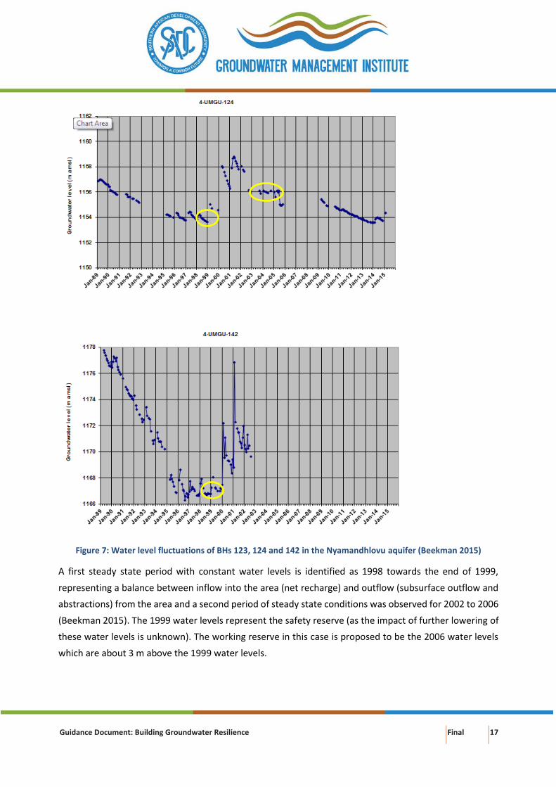
Figure 7: Water level fluctuations of BHs 123, 124 and 142 in the Nyamandhlovu aquifer ................ 17
Figure 8: Conceptual framework of the spatial dimension of saturated zone vulnerability ................ 19
Figure 9: Conceptual framework of the factors influencing residence time of a contaminant in an
aquifer ................................................................................................................................................... 20
Figure 10: Groundwater level minimum threshold .............................................................................. 23
Figure 11: Groundwater storage minimum threshold .......................................................................... 24
Figure 12: Seawater intrusion minimum threshold .............................................................................. 25
Figure 13: Degraded water quality minimum threshold ....................................................................... 26
Figure 14: Land subsidence minimum thresholds ................................................................................ 27
Figure 15: Surface water minimum depletion threshold ...................................................................... 27
Figure 16: Benefits of conjunctive use of groundwater and surface water for irrigated agriculture ... 36
Figure 17: Conjunctive use of groundwater and surface water for urban water supply ...................... 37
Figure 18: Typical hydrological modifications caused by successful conjunctive use of groundwater and
surface-water resources for urban water-supply ................................................................................. 37
Figure 19: Schematic illustration of the water supply system linked to the NSC ................................. 40
Figure 20: Management interventions for sustainable groundwater use ............................................ 42
Figure 21: Schematic of types of managed aquifer recharge ............................................................... 43
Figure 22: Aquifer Storage and Recovery (a) and Soil Aquifer Treatment (b) ...................................... 44
Figure 23: Sources of water, methods of capture and treatment for MAR .......................................... 45
Figure 24: Quality change of water in water/wastewater systems ...................................................... 53
Figure 25: Water well prone to (a) salinisation and (b) Freshkeeper solution ..................................... 55
LIST OF TABLES
Table 1: Structure of the Building Groundwater Resilience guidance document .................................. 3
Table 2: Distinct features of surface water and groundwater .............................................................. 28
Table 3: Key questions to be addressed for MAR projects ................................................................... 47
Guidance Document: Building Groundwater Resilience Final xii
LIST OF BOXES
Box 1: Resilience systems different type of shocks and stresses ............................................................ 1
Box 2: Tropical storms Idai and Kenneth ................................................................................................ 1
Box 3: Representative monitoring sites and required minimum thresholds for each sustainability
indicator ................................................................................................................................................ 22
Box 4: Conjunctive management: surface water-groundwater interaction ......................................... 30
Box 5: Variation of the dynamics and constraints of conjunctive use with hydrogeological setting ... 31
Box 6: Conjunctive use of groundwater and surface water in a canal command ................................ 33
Box 7: Up-coning of saline water – critical abstraction rate ................................................................. 34
Box 8: Atlantis planned urban water supply ......................................................................................... 38
Box 9: MAR in Southern Africa .............................................................................................................. 46
Box 10: Examples of GBNI solutions ..................................................................................................... 49
Box 11: MAR with check dams – Gaborone, Botswana ........................................................................ 51
Guidance Document: Building Groundwater Resilience Final xiii
LIST OF ACRONYMS
Acronym Definition
AWSS Atlantis Water Supply Scheme
MAR Managed Aquifer Recharge
NSC North-South Carrier
SADC Southern African Development Community
SADC-GMI Southern African Development Community
Groundwater Management Institute
mbgl Metres Below Ground Level
mg/ ℓ Milligram Per Litre
mm Millimetres
Mm3/a Million Cubic Metre Per Annum
t/ha Tons Per Hectare
Guidance Document: Building Groundwater Resilience Final 1
1. INTRODUCTION
The purpose of the document is to provide guidance to groundwater managers to understand and
implement measures related to the role of groundwater in water resilience (referred to hereafter as
groundwater resilience) as the Southern African Development Community (SADC) region is prone to
environmental, political, economic and social shocks and stresses (Box 1).
Box 1: Resilience systems different type of shocks and stresses (OECD 2014)
Resilience systems analysis considers different types of risks, shocks and stresses:
• Infrequent events with an impact on almost everyone in the target group, such as violent conflict,
volcanic eruptions or currency devaluations - covariate shocks
• Significant events that specifically affect individuals and families, such as the death of the main
breadwinner or the loss of income-generating activity - idiosyncratic shocks
• Seasonal shocks, such as annual flooding linked to the rainy season, food market price changes, or
recurring shocks such as frequent displacement or endemic cholera communities
• Long term trends, weakening the potential of a system and deepening the vulnerability of its actors,
like increased pollution, deforestation, exchange rate fluctuations and electoral cycles - stresses
Examples of recent shocks and stresses in the region include:
• Drought: The SADC-region has undergone severe droughts during the 2015/2016 and 2016/2017
summer rainfall seasons (Blamey et al. 2018; Siderius et al. 2018; Archer 2019; Nhamo and
Mabhaudhi 2019). In the past, droughts were driven by natural climate variability but with
anthropogenic influences the characteristics of droughts are changing to include a type of
drought that has a rapid onset and short duration (Yuan et al. 2018).
• Flooding: Widespread flooding over parts of Malawi, Mozambique, and Madagascar occurred in
January 2015 resulting in huge damage to property, infrastructure, and agriculture over several
regions in south-eastern Africa as well as significant loss of life (Rapolaki and Reason 2018). The
flooding was associated with tropical storm Chedza which developed in the Mozambique
Channel on 11 January 2015 (Rapolaki and Reason 2018), similar to tropical storm Idai and
Kenneth (Box 2).
• Disease: Rieckmann et al. (2018) compared cholera outbreaks during droughts and floods with
drought- and flood-free periods in 40 sub-Saharan African countries and found an increased
incidence rate of cholera outbreaks during droughts and floods. In Zimbabwe, the most recent
cholera outbreak began on 1 September 2018, in Harare. The Ministry of Health and Child Care
reported approximately 2,000 suspected cholera cases, of which 58 (2.9%) were confirmed cases,
and 24 (1.2%) resulted in death (WHO Regional Office for Africa 2018 in Ahmad et al. 2019).
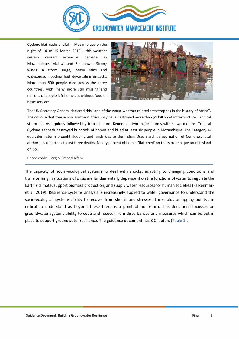
Box 2: Tropical storms Idai and Kenneth (Brackett and Wright 2019; Oxfam Education 2019).
Guidance Document: Building Groundwater Resilience Final 2
Cyclone Idai made landfall in Mozambique on the
night of 14 to 15 March 2019 - this weather
system caused extensive damage in
Mozambique, Malawi and Zimbabwe. Strong
winds, a storm surge, heavy rains and
widespread flooding had devastating impacts.
More than 800 people died across the three
countries, with many more still missing and
millions of people left homeless without food or
basic services.
The UN Secretary General declared this “one of the worst-weather related catastrophes in the history of Africa”.
The cyclone that tore across southern Africa may have destroyed more than $1 billion of infrastructure. Tropical
storm Idai was quickly followed by tropical storm Kenneth – two major storms within two months. Tropical
Cyclone Kenneth destroyed hundreds of homes and killed at least six people in Mozambique. The Category 4-
equivalent storm brought flooding and landslides to the Indian Ocean archipelago nation of Comoros; local
authorities reported at least three deaths. Ninety percent of homes 'flattened' on the Mozambique tourist island
of Ibo.
Photo credit: Sergio Zimba/Oxfam
The capacity of social-ecological systems to deal with shocks, adapting to changing conditions and
transforming in situations of crisis are fundamentally dependent on the functions of water to regulate the
Earth’s climate, support biomass production, and supply water resources for human societies (Falkenmark
et al. 2019). Resilience systems analysis is increasingly applied to water governance to understand the
socio-ecological systems ability to recover from shocks and stresses. Thresholds or tipping points are
critical to understand as beyond these there is a point of no return. This document focusses on
groundwater systems ability to cope and recover from disturbances and measures which can be put in
place to support groundwater resilience. The guidance document has 8 Chapters (Table 1).
Guidance Document: Building Groundwater Resilience Final 3
Table 1: Structure of the Building Groundwater Resilience guidance document
Chapter Contents
1. Introduction This chapter presents the introduction to the guidance document.
2. Groundwater resilience In this chapter groundwater resilience is defined and the global environmental
and societal risks discussed. Further information is provided about the
groundwater risks related to droughts, floods, excessive groundwater pumping,
pollution and sea-level rise.
3. Absorptive capacity for
groundwater resilience
The natural absorptive capacity of groundwater resources is discussed in Chapter
3. Examples of absorptive capacity of groundwater resources include
groundwater storage availability and natural attenuation to pollution. Absorptive
capacity is clearly related to the duration and magnitude of any perturbation as
discussed in Chapter 3.
4. Conjunctive
management
Chapter 4 deals with conjunctive management of the combined use of
groundwater, surface water and other sources of water in a manner that
prevents irreversible impacts (quantity and quality) on either of the resources.
5. Management aquifer
recharge
Managed aquifer recharge (MAR) which is the replenishment of groundwater by
planned subsurface infiltration recovered at a later stage is discussed in Chapter
5.
6. Groundwater reuse and
recycling
Groundwater recharge with recycled water maximizes water reuse and should
form an integral part of water resource planning in major cities and towns of
SADC is discussed in Chapter 6.
7. Conclusions and
recommendations
The conclusions and recommendations are presented in Chapter 7.
8. References The references cited in the guidance document is presented in Chapter 8.
Guidance Document: Building Groundwater Resilience Final 4
2. GROUNDWATER RESILIENCE
Defining resilience
A risk is the likelihood of a negative event and its consequences. A shock occurs when a risk becomes
reality (OECD 2014). A fundamental principle of resilience is being able to respond and adapt to shocks
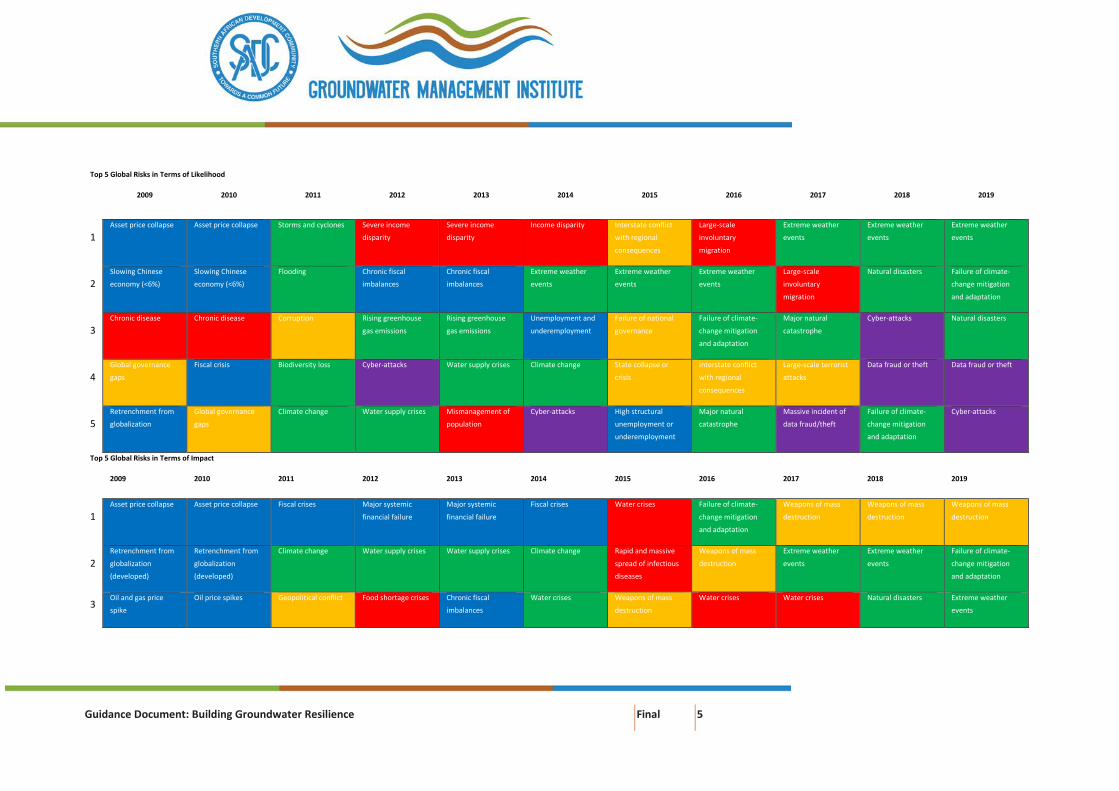
and stresses and to transform when conditions require it (Brown and Boltz 2016). In the World Economic
Forum (WEF) 2019 Global Risks Perception Survey, environmental risks have grown in prominence in
recent years with the five most prominent types of risks in the environmental category (extreme weather
events, natural disasters, failure of climate change mitigation and adaptation, man-made environmental
disasters and biodiversity loss and ecosystem collapse) being ranked higher than average for both
likelihood and impact over a 10-year horizon (WEF 2018; WEF 2019; Figure 1) compared to other risks.
Water crises1 have also been consistently ranked over the same time-period and defined as a societal
global risk in terms of likelihood and impact (Figure 1).
In the SADC-region, the global environmental and societal risks are predicted to put further pressure on
groundwater resources. The socio-economic drivers include (after Pegasys 2019):
• Water crises: SADC has about 280 million people of which 40% has no access to an adequate safe
drinking water supply, whilst 60% has no access to adequate sanitation service (SADC 2016). Like
the rest of Africa, urban population growth in SADC is outpacing economic, social and
institutional development (Bello-Schünemann and Aucoin 2016). Unplanned urban population
growth remains a serious threat to water security, especially in cities and informal settlements
of sub-Saharan Africa (Dos Santos et al. 2017). Kinshasa (Democratic Republic of Congo – DRC) is
already classed as a megacity with a population exceeding the 10 million mark with Johannesburg
(South Africa), Dar es Salaam (Tanzania), and Luanda (Angola) emerging as megacities by 2030
(United Nations 2016; Van Niekerk and Le Roux 2017). The high rate of urbanisation is already
putting strain on water infrastructure; poses problems for human and environmental health; and
disparate socioeconomic development and access to water; all resulting from governance failure
of water management institutions.
1 A significant decline in the available quality and quantity of fresh water, resulting in harmful effects on human health and/or economic activity (WEF 2018).
Guidance Document: Building Groundwater Resilience Final 5
Top 5 Global Risks in Terms of Likelihood
2009 2010 2011 2012 2013 2014 2015 2016 2017 2018 2019
1 Asset price collapse Asset price collapse Storms and cyclones Severe income
disparity
Severe income
disparity
Income disparity Interstate conflict
with regional
consequences
Large-scale
involuntary
migration
Extreme weather
events
Extreme weather
events
Extreme weather
events
2 Slowing Chinese
economy (<6%)
Slowing Chinese
economy (<6%)
Flooding Chronic fiscal
imbalances
Chronic fiscal
imbalances
Extreme weather
events
Extreme weather
events
Extreme weather
events
Large-scale
involuntary
migration
Natural disasters Failure of climate-
change mitigation
and adaptation
3 Chronic disease Chronic disease Corruption Rising greenhouse
gas emissions
Rising greenhouse
gas emissions
Unemployment and
underemployment
Failure of national
governance
Failure of climate-
change mitigation
and adaptation
Major natural
catastrophe
Cyber-attacks Natural disasters
4 Global governance
gaps
Fiscal crisis Biodiversity loss Cyber-attacks Water supply crises Climate change State collapse or
crisis
Interstate conflict
with regional
consequences
Large-scale terrorist
attacks
Data fraud or theft Data fraud or theft
5 Retrenchment from
globalization
Global governance
gaps
Climate change Water supply crises Mismanagement of
population
Cyber-attacks High structural
unemployment or
underemployment
Major natural
catastrophe
Massive incident of
data fraud/theft
Failure of climate-
change mitigation
and adaptation
Cyber-attacks
Top 5 Global Risks in Terms of Impact
2009 2010 2011 2012 2013 2014 2015 2016 2017 2018 2019
1 Asset price collapse Asset price collapse Fiscal crises Major systemic
financial failure
Major systemic
financial failure
Fiscal crises Water crises Failure of climate-
change mitigation
and adaptation
Weapons of mass
destruction
Weapons of mass
destruction
Weapons of mass
destruction
2 Retrenchment from
globalization
(developed)
Retrenchment from
globalization
(developed)
Climate change Water supply crises Water supply crises Climate change Rapid and massive
spread of infectious
diseases
Weapons of mass
destruction
Extreme weather
events
Extreme weather
events
Failure of climate-
change mitigation
and adaptation
3 Oil and gas price
spike
Oil price spikes Geopolitical conflict Food shortage crises Chronic fiscal
imbalances
Water crises Weapons of mass
destruction
Water crises Water crises Natural disasters Extreme weather
events
Guidance Document: Building Groundwater Resilience Final 6
4 Chronic disease Chronic disease Asset price collapse Chronic fiscal
imbalances
Diffusion of weapons
of mass destruction
Unemployment and
underemployment
Interstate conflict
with regional
consequences
Large-scale
involuntary
migration
Major natural
disasters
Failure of climate-
change mitigation
and adaptation
Water crises
5 Fiscal crises Fiscal crises Extreme energy price
volatility
Extreme in energy
and agriculture price
volatility
Failure of climate-
change mitigation
and adaptation
Critical infratructure
breakdown
Failure of climate-
change mitigation
and adaptation
Severe energy price
shock
Failure of climate-
change mitigation
and adaptation
Water crises Natural disasters
Economic Environmental Geopolitical Societal Technological
Figure 1: The evolving risk landscape, 2009–2019 (WEF 2019)
Guidance Document: Building Groundwater Resilience Final 7
• Food shortage crises: Despite the urbanisation trends, a significant percentage of the SADC
population is still rural. Most of the extreme poor in Southern Africa live in the rural areas and
85% of all poor people in the sub-region depend on agriculture for their livelihood (UNECA-SA
2012). Agriculture constitutes the primary source of subsistence, employment and income for
156 million people (55%) and accounts for close to 8% of its gross domestic product (UNECA-SA
2012).
• State collapse or crises: In countries that have undergone civil unrest (wars), investment in water
infrastructure fell short which was further aggravated by the destruction of infrastructure and
consequently regress of water supply. Significant investments are required to rebuild the
infrastructure in these countries; in the case of the DRC an estimated $2 billion is required for
infrastructure projects (Partow 2011).
• Failure of climate change mitigation and adaptation: Water resources in the SADC Region will
be impacted negatively by climate change. Therefore, issues related to climate change, climate
variability and climate proofing need to be continuously addressed in the SADC water sector
regional plans and programmes (SADC 2016). Namibia, for example, is expected to experience
reduced rainfall of 10 to 30% relative to the present situation by 2050 and 2080 (Reid et al. 2007).
Across the region there is an expectation of increased occurrence of extreme hydrological events,
requiring the region to develop improved adaptive capacity to flood and drought events.
Increasing aridity and dwindling surface water supplies result in new opportunities for groundwater
(Pegasys 2019). Drivers that have a major bearing on its unfolding role and governance [in SADC] include
the widespread poverty and food insecurity in the region, the continuing need for a basic domestic water
supply in both rural and informal urban areas, rapid urbanisation, and the need for drought security as
part of all water provision (Braune and Adams 2013). Groundwater resilience refers to the ability of
groundwater resources to recover from disturbances (shocks and stresses) to its natural state or new
equilibrium.
Type of risks
Droughts
Groundwater drought is the sustained and extensive occurrence of periods below normal groundwater
levels (Van Loon 2015). Groundwater drought is normally not incorporated in resilience planning as
responses during drought conditions are reactive rather than proactive or strategic. Regulation of
groundwater withdrawals during this time is generally absent and less applied than supply-side
groundwater management strategies (Langridge et al. 2018). During such times groundwater is normally
over-pumped. In California, the trend of increasing groundwater use amid cycles of drought has
exacerbated groundwater depletion, water quality degradation, land subsidence, and depletion of
interconnected surface water across the state (Babbitt et al. 2018).
Guidance Document: Building Groundwater Resilience Final 8
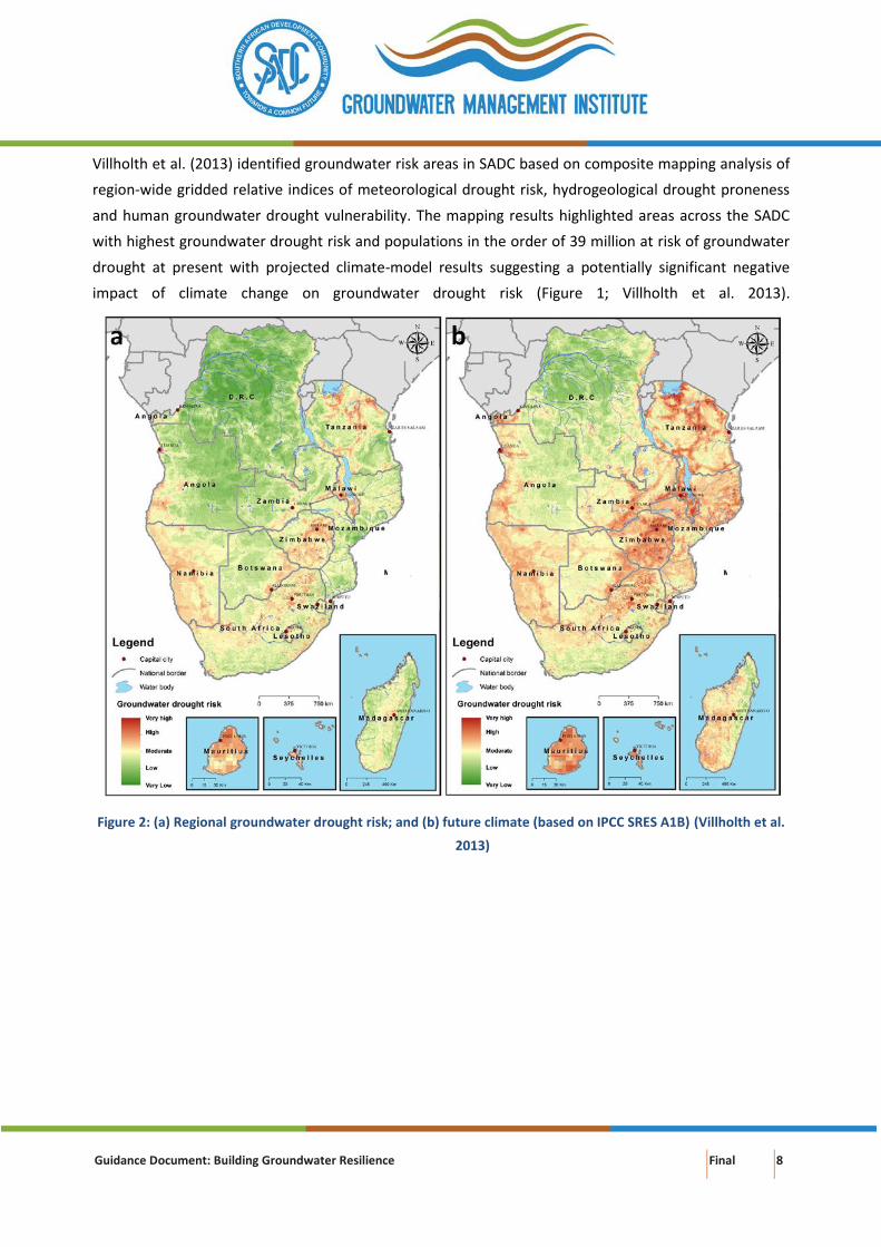
Villholth et al. (2013) identified groundwater risk areas in SADC based on composite mapping analysis of
region-wide gridded relative indices of meteorological drought risk, hydrogeological drought proneness
and human groundwater drought vulnerability. The mapping results highlighted areas across the SADC
with highest groundwater drought risk and populations in the order of 39 million at risk of groundwater
drought at present with projected climate-model results suggesting a potentially significant negative
impact of climate change on groundwater drought risk (Figure 1; Villholth et al. 2013).
Figure 2: (a) Regional groundwater drought risk; and (b) future climate (based on IPCC SRES A1B) (Villholth et al.
2013)
Guidance Document: Building Groundwater Resilience Final 9
Several problems are noted with drought planning (modified from Langridge et al. 2018):
• Consumer resistance: Resistance to (further) imposed water demand management by
consumers can occur as a result of long-term conservation measures (outdoor use restrictions,
rebate programs, and price structure changes) that make it difficult for utilities [or local
authorities] to induce further reductions in water use during drought
• Decreased revenue: Most water utilities [or local authorities] receive their revenues from water
consumption, so there can be a negative incentive to require conservation during non-drought
periods
• Inadequate drought planning: Existing drought planning does not sufficiently include private
borehole owners or small water systems serving disadvantaged communities
• No pro-active planning: Many drought projects focus on increasing storage for supply reliability,
but projects do not necessarily specify whether and how water will be available for future
droughts
Floods
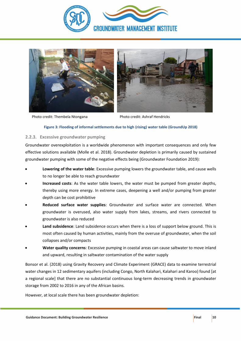
High intensity and long-duration rainfall often result in rising groundwater levels and ultimately flooding
at the surface. Three scenarios described for this type of flooding are (after Macdonald et al. 2008):
a. Long-lasting, often regionally extensive, flooding caused by the water table in an unconfined
aquifer rising above the land surface as a response to extreme rainfall (Figure 3), e.g. winter
flooding on top of the Cape Flats aquifer
b. Rising groundwater levels also occur in shallow unconsolidated sedimentary aquifers which
overly aquitards (less permeable) when the storage capacity is limited, direct rainfall recharge is
relatively high, and when there is a good hydraulic connection with adjacent rivers. Groundwater
levels are often close to the ground surface during much of the year. Intense rainfall can cause a
rapid response in groundwater levels due to rising river levels which creates increased heads that
drive water into the aquifer
c. Flooding occurs where there has been a reduction in abstraction from large aquifers underlying
major urban centres due to a reduction in industrial or mining activities. This has allowed
depressed groundwater levels to recover, thereby causing the risk of flooding to subsurface
infrastructure, such as tunnels and basements of buildings, as well as changes in geotechnical
and geochemical properties of the aquifer that could result in settlement and corrosion of deeply
founded structures
Guidance Document: Building Groundwater Resilience Final 10
Figure 3: Flooding of informal settlements due to high (rising) water table (GroundUp 2018)
Excessive groundwater pumping
Groundwater overexploitation is a worldwide phenomenon with important consequences and only few
effective solutions available (Molle et al. 2018). Groundwater depletion is primarily caused by sustained
groundwater pumping with some of the negative effects being (Groundwater Foundation 2019):
• Lowering of the water table: Excessive pumping lowers the groundwater table, and cause wells
to no longer be able to reach groundwater
• Increased costs: As the water table lowers, the water must be pumped from greater depths,
thereby using more energy. In extreme cases, deepening a well and/or pumping from greater
depth can be cost prohibitive
• Reduced surface water supplies: Groundwater and surface water are connected. When
groundwater is overused, also water supply from lakes, streams, and rivers connected to
groundwater is also reduced
• Land subsidence: Land subsidence occurs when there is a loss of support below ground. This is
most often caused by human activities, mainly from the overuse of groundwater, when the soil
collapses and/or compacts
• Water quality concerns: Excessive pumping in coastal areas can cause saltwater to move inland
and upward, resulting in saltwater contamination of the water supply
Bonsor et al. (2018) using Gravity Recovery and Climate Experiment (GRACE) data to examine terrestrial
water changes in 12 sedimentary aquifers (including Congo, North Kalahari, Kalahari and Karoo) found [at
a regional scale] that there are no substantial continuous long-term decreasing trends in groundwater
storage from 2002 to 2016 in any of the African basins.
However, at local scale there has been groundwater depletion:
Photo credit: Thembela Ntongana Photo credit: Ashraf Hendricks
Guidance Document: Building Groundwater Resilience Final 11
• The City of Windhoek, Namibia has been abstracting from the Windhoek aquifer since the 1950s
with water levels dropping by about 40m in the micaceous quartzites which constitute the main
wellfield areas; water levels were steadily declining in the pure quartzite areas (Murray et al.
2018)
• The Grootfontein groundwater aquifer is important for the water supply of the town Mahikeng
in the North West Province of South Africa and for commercial agriculture in the Province. The
water table, however, has fallen by up to 28m as a consequence of over-abstraction since the
1980s (Cobbing and de Wit 2018).
• Robins et al. (2013) postulated that the demand from weathered and fractured crystalline
basement aquifers in Malawi in some places may exceed long-term resource potential and that
this is also a cause of water point failure. The implications of long-term groundwater mining in
parts of Malawi urgently require further investigation in order to develop and implement a
sustainable remedial strategy to safeguard rural community livelihoods (Robins et al. 2013).
Pollution
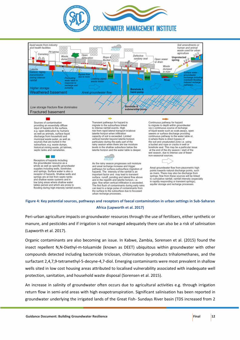
Pit latrines are the main form of sanitation in unplanned areas in many rapidly growing developing cities
(Jenkins et al. 2015; Kayembe et al. 2018). In Maputo, the capital of Mozambique, nitrate concentrations
above 250 milligram per litre (mg/ℓ) in groundwater have been reported due to the widespread use of
latrines and septic tanks that allow for constant infiltration of its content into the soil and eventually to
groundwater resources (Arsénio et al. 2018). Figure 4 summarises key pathways, shown by orange arrows,
in high-risk settings such as fractured basement terrains with lateritic soil, including surface and subsurface
pathways for migration of pollutants from sources to receptor areas (Lapworth et al. 2017).
Guidance Document: Building Groundwater Resilience Final 12
Figure 4: Key potential sources, pathways and receptors of faecal contamination in urban settings in Sub-Saharan
Africa (Lapworth et al. 2017)
Peri-urban agriculture impacts on groundwater resources through the use of fertilisers, either synthetic or
manure, and pesticides and if irrigation is not managed adequately there can also be a risk of salinisation
(Lapworth et al. 2017).
Organic contaminants are also becoming an issue. In Kabwe, Zambia, Sorensen et al. (2015) found the
insect repellent N,N-Diethyl-m-toluamide (known as DEET) ubiquitous within groundwater with other
compounds detected including bactericide triclosan, chlorination by-products trihalomethanes, and the
surfactant 2,4,7,9-tetramethyl-5-decyne-4,7-diol. Emerging contaminants were most prevalent in shallow
wells sited in low cost housing areas attributed to localised vulnerability associated with inadequate well
protection, sanitation, and household waste disposal (Sorensen et al. 2015).
An increase in salinity of groundwater often occurs due to agricultural activities e.g. through irrigation
return flow in semi-arid areas with high evapotranspiration. Significant salinisation has been reported in
groundwater underlying the irrigated lands of the Great Fish- Sundays River basin (TDS increased from 2
Guidance Document: Building Groundwater Resilience Final 13
000 to 3 400mg/ℓ) (Conrad et al. 1999). Studies of the influence of irrigation on groundwater at the
Vaalharts Irrigation Scheme were conducted by Verwey et al. (2011). In 1971, salinisation became a
problem as the water table had risen from 24 metres below ground level (mbgl) to 1.2 mbgl. Leakages
from dams and soil furrows of the system were about 45 million m3 per annum (Mm3/a). Salt deposited
through irrigation water amounted to 4.65 tons per hectare (t/ha) per annum. The TDS averaged
1,005mg/ℓ in 1976 and 1,350mg/ℓ in 2004, an average increase per annum of 13mg/ℓ (Verwey and
Vermeulen 2011). Irrigated salt deposits not drained build up in the soil at a rate of 0.8 t/ha per annum
(Verwey and Vermeulen 2011).
Sea-level rise
Coastal aquifers are influenced by various potential sources of salinity that determine the composition of
water extracted from boreholes. Sappa et al. (2015) assessed the seasonal variations of water supply
boreholes in the coastal areas of Dar Es Salaam City, Tanzania, and found that during the dry season the
water quality was highly saline resulting mainly from seawater intrusion and agricultural activities. Salt
water was found mostly in the area within 2 km of the Dar Es Salaam coastline, and the depth to the
interface was ranging from 1.3 to 20m (Mtoni et al. 2015).
Guidance Document: Building Groundwater Resilience Final 14
3. ABSORPTIVE CAPACITY FOR GROUNDWATER RESILIENCE
Absorptive capacity is the ability of a system to prepare for, mitigate or prevent negative impacts, using
predetermined coping responses in order to preserve and restore essential basic structures and functions
(OECD 2014). This includes coping mechanisms used during periods of shock. Examples of absorptive
capacity of groundwater resources include groundwater storage availability and natural attenuation to
pollution. Absorptive capacity is clearly related to the duration and magnitude of any perturbation.
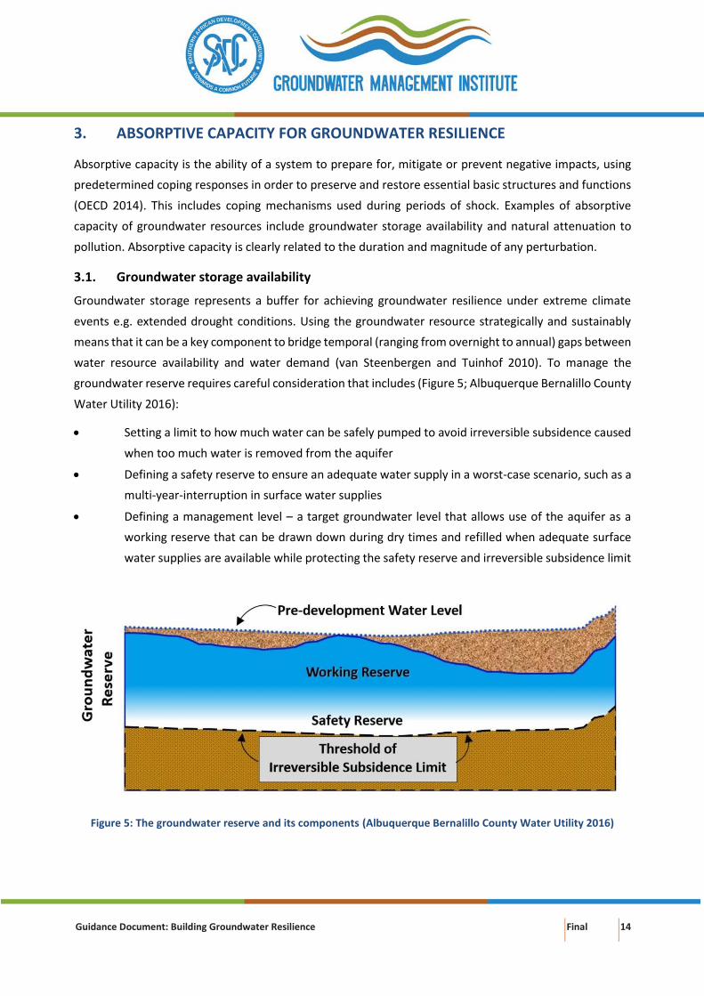
3.1. Groundwater storage availability
Groundwater storage represents a buffer for achieving groundwater resilience under extreme climate
events e.g. extended drought conditions. Using the groundwater resource strategically and sustainably
means that it can be a key component to bridge temporal (ranging from overnight to annual) gaps between
water resource availability and water demand (van Steenbergen and Tuinhof 2010). To manage the
groundwater reserve requires careful consideration that includes (Figure 5; Albuquerque Bernalillo County
Water Utility 2016):
• Setting a limit to how much water can be safely pumped to avoid irreversible subsidence caused
when too much water is removed from the aquifer
• Defining a safety reserve to ensure an adequate water supply in a worst-case scenario, such as a
multi-year-interruption in surface water supplies
• Defining a management level – a target groundwater level that allows use of the aquifer as a
working reserve that can be drawn down during dry times and refilled when adequate surface
water supplies are available while protecting the safety reserve and irreversible subsidence limit
Figure 5: The groundwater reserve and its components (Albuquerque Bernalillo County Water Utility 2016)
Guidance Document: Building Groundwater Resilience Final 15
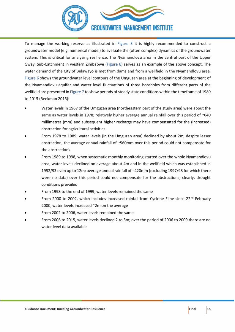
To manage the working reserve as illustrated in Figure 5 it is highly recommended to construct a
groundwater model (e.g. numerical model) to evaluate the (often complex) dynamics of the groundwater
system. This is critical for analysing resilience. The Nyamandlovu area in the central part of the Upper
Gwayi Sub-Catchment in western Zimbabwe (Figure 6) serves as an example of the above concept. The
water demand of the City of Bulawayo is met from dams and from a wellfield in the Nyamandlovu area.
Figure 6 shows the groundwater level contours of the Umguzan area at the beginning of development of
the Nyamandlovu aquifer and water level fluctuations of three boreholes from different parts of the
wellfield are presented in Figure 7 to show periods of steady state conditions within the timeframe of 1989
to 2015 (Beekman 2015):
• Water levels in 1967 of the Umguzan area (northeastern part of the study area) were about the
same as water levels in 1978; relatively higher average annual rainfall over this period of ~640
millimetres (mm) and subsequent higher recharge may have compensated for the (increased)
abstraction for agricultural activities
• From 1978 to 1989, water levels (in the Umguzan area) declined by about 2m; despite lesser
abstraction, the average annual rainfall of ~560mm over this period could not compensate for
the abstractions
• From 1989 to 1998, when systematic monthly monitoring started over the whole Nyamandlovu
area, water levels declined on average about 4m and in the wellfield which was established in
1992/93 even up to 12m; average annual rainfall of ~420mm (excluding 1997/98 for which there
were no data) over this period could not compensate for the abstractions; clearly, drought
conditions prevailed
• From 1998 to the end of 1999, water levels remained the same
• From 2000 to 2002, which includes increased rainfall from Cyclone Eline since 22nd February
2000, water levels increased ~2m on the average
• From 2002 to 2006, water levels remained the same
• From 2006 to 2015, water levels declined 2 to 3m; over the period of 2006 to 2009 there are no
water level data available
Guidance Document: Building Groundwater Resilience Final 16
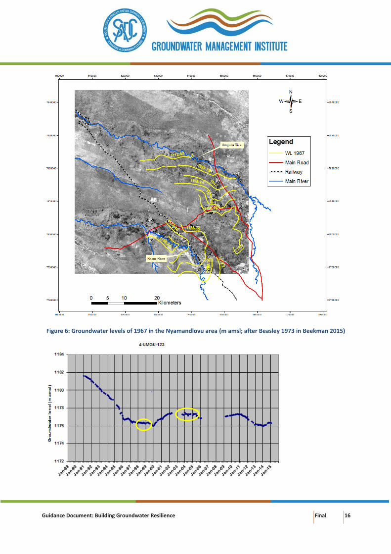
Figure 6: Groundwater levels of 1967 in the Nyamandlovu area (m amsl; after Beasley 1973 in Beekman 2015)
Guidance Document: Building Groundwater Resilience Final 17
Figure 7: Water level fluctuations of BHs 123, 124 and 142 in the Nyamandhlovu aquifer (Beekman 2015)
A first steady state period with constant water levels is identified as 1998 towards the end of 1999,
representing a balance between inflow into the area (net recharge) and outflow (subsurface outflow and
abstractions) from the area and a second period of steady state conditions was observed for 2002 to 2006
(Beekman 2015). The 1999 water levels represent the safety reserve (as the impact of further lowering of
these water levels is unknown). The working reserve in this case is proposed to be the 2006 water levels
which are about 3 m above the 1999 water levels.
Guidance Document: Building Groundwater Resilience Final 18
Beekman (2015) recommended that predictions with regards to the change in water levels with changing
abstraction and weather conditions should only be carried out once a transient state model is constructed
and following calibration and validation of the model. Construction of a transient state model is therefore
highly recommended by Beekman (2015) to:
a. Validate the steady-state model results, especially with regards to determine the sustainable
yield of the aquifer;
b. Design optimum pumping scenarios for the wellfield;
c. Act as an instrument for regulating drilling of boreholes and abstractions; and
d. Provide a tool that contributes to the development of an early warning system, inter alia, in
preventing or mitigating pollution and over-abstraction.
The above example also clearly demonstrates the critical need and value of long-term monitoring of
rainfall, surface water, groundwater levels, abstraction rates and water chemistry.
3.2. Natural attenuation to pollution
The capacity of a groundwater system to recover from pollution is critical to the concept of resilience as
natural disasters and extreme weather events can undermine the effectiveness of site remediation, and
can also affect contaminant toxicity, exposure, organism sensitivity, fate and transport, long-term
operations, management, and stewardship of remediation sites (Maco et al. 2018). The natural
attenuation processes include a variety of processes that reduce the mass, toxicity, mobility, volume or
concentration of contaminants in soil and groundwater (City Chlor 2013). The in-situ processes can refer
to physical, chemical or biological processes and include biodegradation, dispersion, dilution, sorption,
volatilization, radioactive decay, chemical or biological stabilization, transformation and destruction of
contaminants (City Chlor 2013).
There are three stages in evaluating natural attenuation capacity for decision-making (Saayman et al.
2007):
• Stage I: Screening and Scoping – to determine whether an assessment of groundwater
contamination risk is required for decision making
• Stage II: Assessment – to determine the risk of groundwater contamination, which depends on
the characteristics of the contaminant and the vulnerability of the aquifer to pollution
• Stage III: Decision-making – which integrates the outputs of the risk assessment into a cost
benefit analysis, which the decision maker evaluates with consideration of relevant laws,
regulations and guidelines and the principles and values of society.
Factors controlling the spatial extent of pollution are (Saayman et al. 2007):
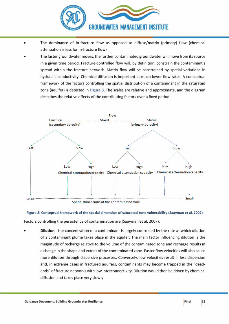
Guidance Document: Building Groundwater Resilience Final 19
• The dominance of in-fracture flow as opposed to diffuse/matrix (primary) flow (chemical
attenuation is less for in-fracture flow)
• The faster groundwater moves, the further contaminated groundwater will move from its source
in a given time period. Fracture-controlled flow will, by definition, constrain the contaminant’s
spread within the fracture network. Matrix flow will be constrained by spatial variations in
hydraulic conductivity. Chemical diffusion is important at much lower flow rates. A conceptual
framework of the factors controlling the spatial distribution of a contaminant in the saturated
zone (aquifer) is depicted in Figure 8. The scales are relative and approximate, and the diagram
describes the relative effects of the contributing factors over a fixed period
Figure 8: Conceptual framework of the spatial dimension of saturated zone vulnerability (Saayman et al. 2007)
Factors controlling the persistence of contamination are (Saayman et al. 2007):
• Dilution - the concentration of a contaminant is largely controlled by the rate at which dilution
of a contaminant plume takes place in the aquifer. The main factor influencing dilution is the
magnitude of recharge relative to the volume of the contaminated zone and recharge results in
a change in the shape and extent of the contaminated zone. Faster flow velocities will also cause
more dilution through dispersive processes. Conversely, low velocities result in less dispersion
and, in extreme cases in fractured aquifers, contaminants may become trapped in the “dead-
ends” of fracture networks with low interconnectivity. Dilution would then be driven by chemical
diffusion and takes place very slowly
Guidance Document: Building Groundwater Resilience Final 20
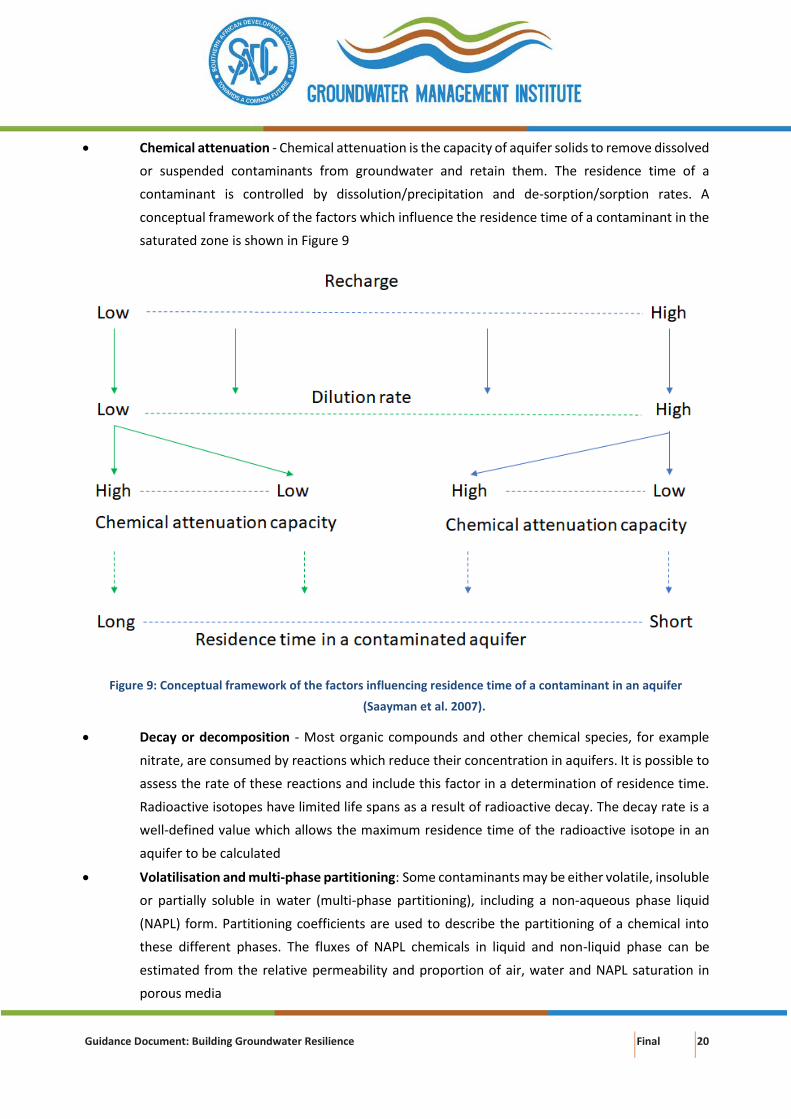
• Chemical attenuation - Chemical attenuation is the capacity of aquifer solids to remove dissolved
or suspended contaminants from groundwater and retain them. The residence time of a
contaminant is controlled by dissolution/precipitation and de-sorption/sorption rates. A
conceptual framework of the factors which influence the residence time of a contaminant in the
saturated zone is shown in Figure 9
Figure 9: Conceptual framework of the factors influencing residence time of a contaminant in an aquifer
(Saayman et al. 2007).
• Decay or decomposition - Most organic compounds and other chemical species, for example
nitrate, are consumed by reactions which reduce their concentration in aquifers. It is possible to
assess the rate of these reactions and include this factor in a determination of residence time.
Radioactive isotopes have limited life spans as a result of radioactive decay. The decay rate is a
well-defined value which allows the maximum residence time of the radioactive isotope in an
aquifer to be calculated
• Volatilisation and multi-phase partitioning: Some contaminants may be either volatile, insoluble
or partially soluble in water (multi-phase partitioning), including a non-aqueous phase liquid
(NAPL) form. Partitioning coefficients are used to describe the partitioning of a chemical into
these different phases. The fluxes of NAPL chemicals in liquid and non-liquid phase can be
estimated from the relative permeability and proportion of air, water and NAPL saturation in
porous media
Guidance Document: Building Groundwater Resilience Final 21
Determining the natural attenuation capacity of groundwater systems at a local scale is complex and
requires detailed knowledge of:
• The type and quantity of pollutants involved
• The chemical and hydraulic characteristics of both unsaturated and saturated zones
• The factors controlling the spatial extent and persistence of pollution as discussed above
Because of the overall complexity and costs of groundwater remediation (often unsuccessful) the focus
should be on prevention of pollution.
3.3. Perturbations and threshold metrics
The concepts of stability and resilience with reference to ecological systems state that a natural system
undergoes perturbations from an equilibrium state. The system is resilient when it can undergo a certain
amount of disturbance without changing the equilibrium state. When damage is irreversible the following
undesirable results occur in groundwater (DWR 2017):
• Chronic lowering of groundwater levels indicating a significant and unreasonable depletion of
supply
• Significant and unreasonable reduction of groundwater storage
• Significant and unreasonable seawater intrusion
• Significant and unreasonable degraded water quality, including the migration of contaminant
plumes that impair water supplies
• Significant and unreasonable land subsidence that substantially interferes with surface land uses
• Depletions of interconnected surface water that have significant and unreasonable adverse
impacts on beneficial uses of the surface water
Minimum thresholds are the quantitative values that represent the groundwater conditions at a
representative monitoring site that, when exceeded individually or in combination with minimum
thresholds at other monitoring sites, may cause an undesirable result(s) in an aquifer system (CDWR 2017;
Box 3):

Guidance Document: Building Groundwater Resilience Final 22
Box 3: Representative monitoring sites and required minimum thresholds for each sustainability indicator (DWR
2017)
Representative monitoring sites are a subset of a basin’s complete monitoring network, where minimum
thresholds, measurable objectives, and interim milestones are set. Representative monitoring sites can be used
for one sustainability indicator or multiple sustainability indicators. The figure below shows how different
combinations of representative monitoring sites can be used to assess seawater intrusion and lowering of
groundwater levels in a hypothetical groundwater basin.
• The minimum threshold metric for the chronic lowering of the groundwater levels sustainability
indicator shall be a groundwater elevation measured at the representative monitoring site (Box
3). Figure 10 illustrates a hypothetical groundwater level hydrograph and associated minimum
threshold at a representative monitoring site. Considerations when establishing minimum
thresholds for groundwater levels at a given representative monitoring site may include but are
not limited to the historical groundwater conditions in the basin, the average, minimum, and
maximum depths of municipal, agricultural, and domestic boreholes, and the potential impacts
of changing groundwater levels on groundwater dependent ecosystems
Guidance Document: Building Groundwater Resilience Final 23
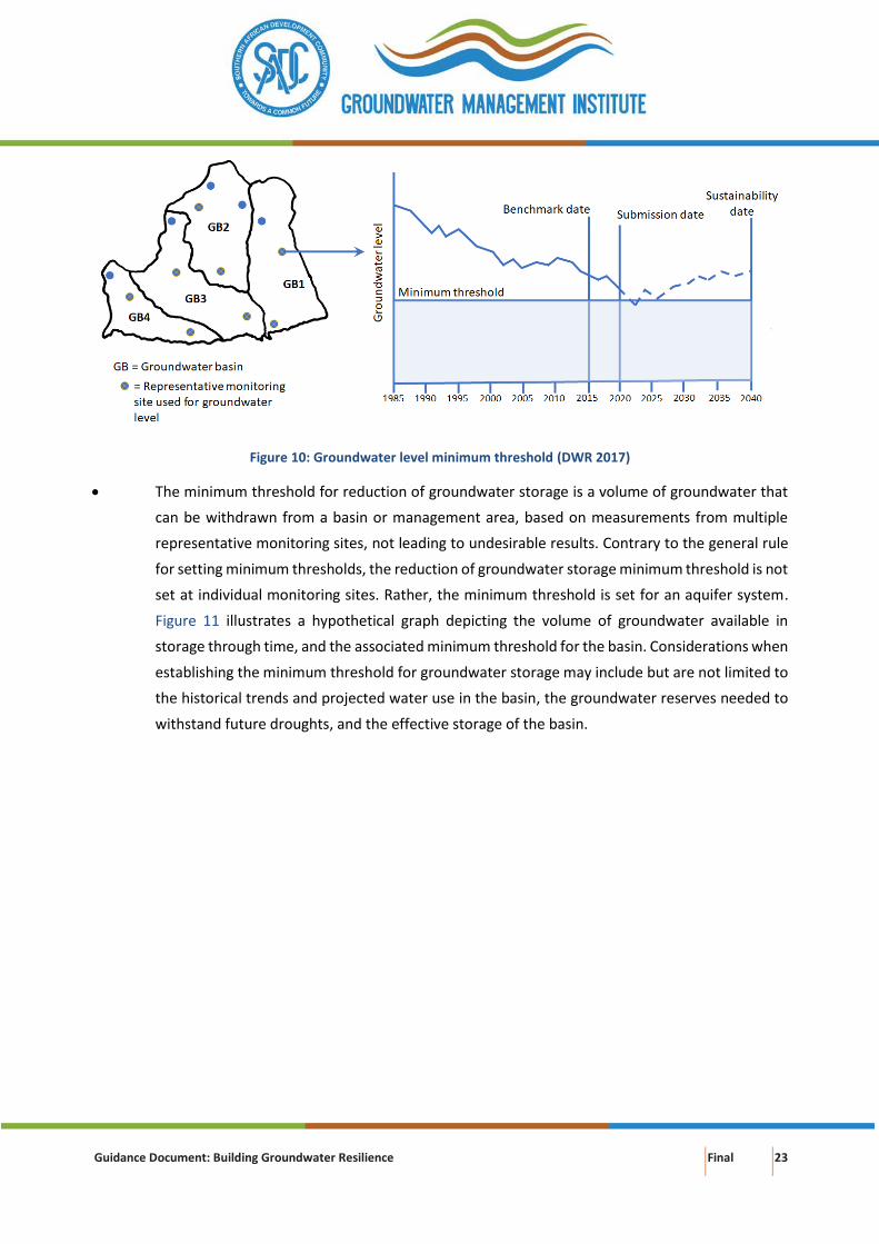
Figure 10: Groundwater level minimum threshold (DWR 2017)
• The minimum threshold for reduction of groundwater storage is a volume of groundwater that
can be withdrawn from a basin or management area, based on measurements from multiple
representative monitoring sites, not leading to undesirable results. Contrary to the general rule
for setting minimum thresholds, the reduction of groundwater storage minimum threshold is not
set at individual monitoring sites. Rather, the minimum threshold is set for an aquifer system.
Figure 11 illustrates a hypothetical graph depicting the volume of groundwater available in
storage through time, and the associated minimum threshold for the basin. Considerations when
establishing the minimum threshold for groundwater storage may include but are not limited to
the historical trends and projected water use in the basin, the groundwater reserves needed to
withstand future droughts, and the effective storage of the basin.
Guidance Document: Building Groundwater Resilience Final 24
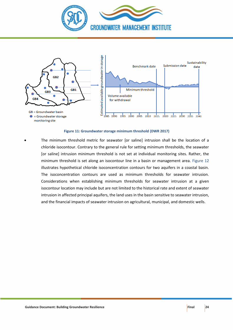
Figure 11: Groundwater storage minimum threshold (DWR 2017)
• The minimum threshold metric for seawater [or saline] intrusion shall be the location of a
chloride isocontour. Contrary to the general rule for setting minimum thresholds, the seawater
[or saline] intrusion minimum threshold is not set at individual monitoring sites. Rather, the
minimum threshold is set along an isocontour line in a basin or management area. Figure 12
illustrates hypothetical chloride isoconcentration contours for two aquifers in a coastal basin.
The isoconcentration contours are used as minimum thresholds for seawater intrusion.
Considerations when establishing minimum thresholds for seawater intrusion at a given
isocontour location may include but are not limited to the historical rate and extent of seawater
intrusion in affected principal aquifers, the land uses in the basin sensitive to seawater intrusion,
and the financial impacts of seawater intrusion on agricultural, municipal, and domestic wells.
Guidance Document: Building Groundwater Resilience Final 25
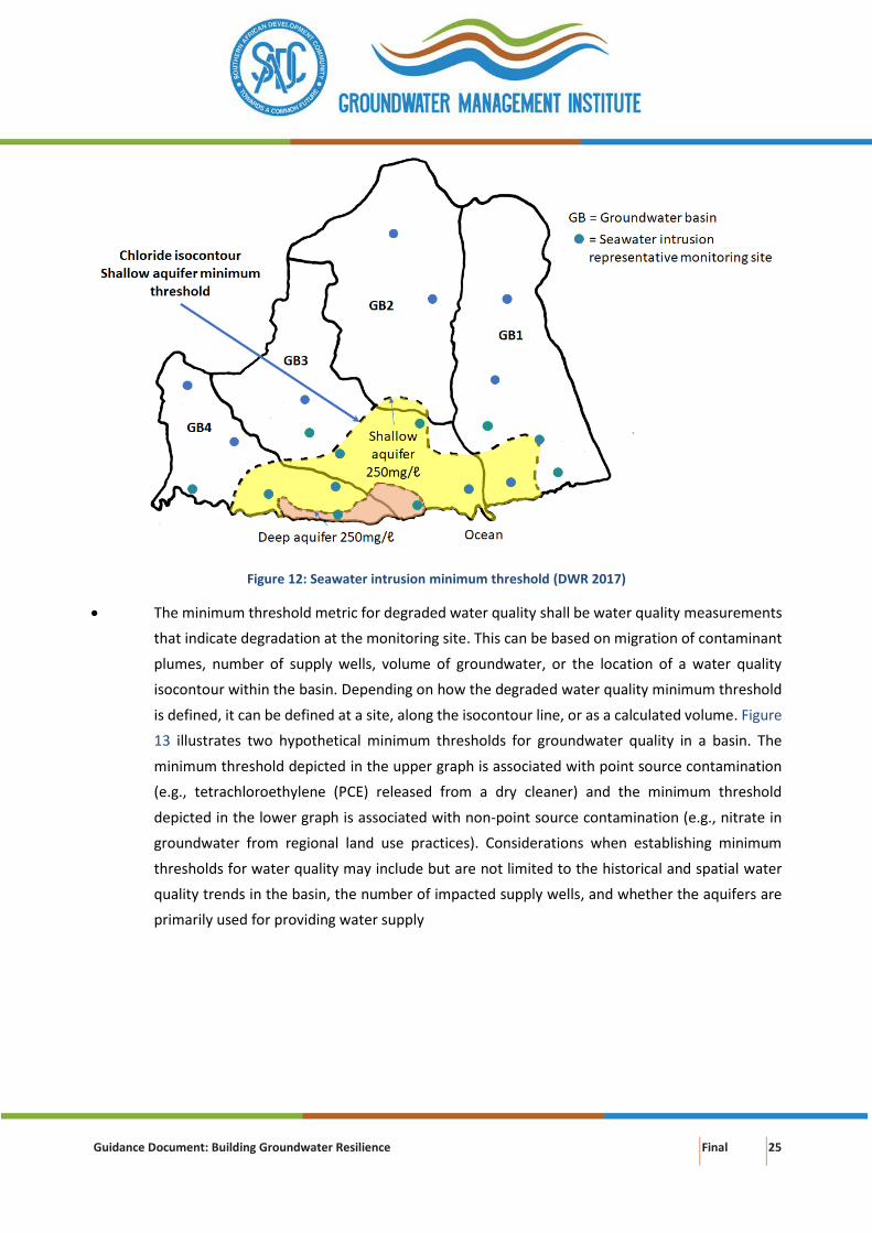
Figure 12: Seawater intrusion minimum threshold (DWR 2017)
• The minimum threshold metric for degraded water quality shall be water quality measurements
that indicate degradation at the monitoring site. This can be based on migration of contaminant
plumes, number of supply wells, volume of groundwater, or the location of a water quality
isocontour within the basin. Depending on how the degraded water quality minimum threshold
is defined, it can be defined at a site, along the isocontour line, or as a calculated volume. Figure
13 illustrates two hypothetical minimum thresholds for groundwater quality in a basin. The
minimum threshold depicted in the upper graph is associated with point source contamination
(e.g., tetrachloroethylene (PCE) released from a dry cleaner) and the minimum threshold
depicted in the lower graph is associated with non-point source contamination (e.g., nitrate in
groundwater from regional land use practices). Considerations when establishing minimum
thresholds for water quality may include but are not limited to the historical and spatial water
quality trends in the basin, the number of impacted supply wells, and whether the aquifers are
primarily used for providing water supply
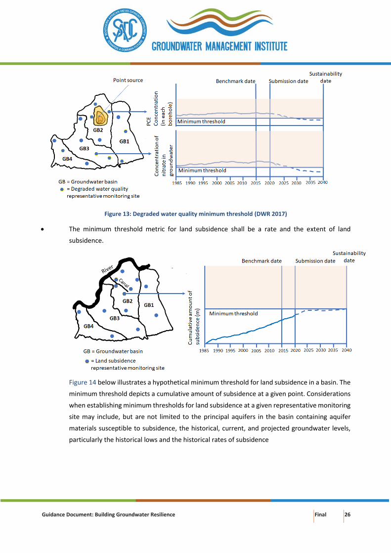
Guidance Document: Building Groundwater Resilience Final 26
Figure 13: Degraded water quality minimum threshold (DWR 2017)
• The minimum threshold metric for land subsidence shall be a rate and the extent of land
subsidence.
Figure 14 below illustrates a hypothetical minimum threshold for land subsidence in a basin. The
minimum threshold depicts a cumulative amount of subsidence at a given point. Considerations
when establishing minimum thresholds for land subsidence at a given representative monitoring
site may include, but are not limited to the principal aquifers in the basin containing aquifer
materials susceptible to subsidence, the historical, current, and projected groundwater levels,
particularly the historical lows and the historical rates of subsidence
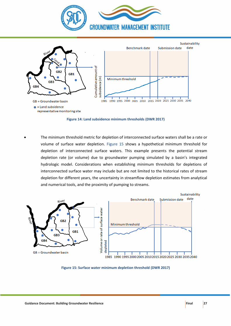
Guidance Document: Building Groundwater Resilience Final 27
Figure 14: Land subsidence minimum thresholds (DWR 2017)
• The minimum threshold metric for depletion of interconnected surface waters shall be a rate or
volume of surface water depletion. Figure 15 shows a hypothetical minimum threshold for
depletion of interconnected surface waters. This example presents the potential stream
depletion rate (or volume) due to groundwater pumping simulated by a basin’s integrated
hydrologic model. Considerations when establishing minimum thresholds for depletions of
interconnected surface water may include but are not limited to the historical rates of stream
depletion for different years, the uncertainty in streamflow depletion estimates from analytical
and numerical tools, and the proximity of pumping to streams.
Figure 15: Surface water minimum depletion threshold (DWR 2017)
Guidance Document: Building Groundwater Resilience Final 28
4. CONJUNCTIVE MANAGEMENT
Conjunctive management in support of long-term groundwater (and surface water) resilience refers to
management of the combined use of groundwater, surface water and other sources of water in a manner
that prevents irreversible impacts (quantity and quality) on either of the resources. The benefits of
coordinated management of the water sources should exceed the benefits obtained through their
separate management. Conjunctive water use is mostly done in large scale irrigation schemes with surface
water shortage and in rapidly expanding cities where either one of the water sources become insufficient.
The benefits of conjunctive management
In order to achieve an optimal level of conjunctive management of surface water and groundwater, the
distinct features of both resources must be accounted for (Table 2). For optimal conjunctive use, from a
groundwater perspective, recovery and recharge of groundwater needs to be balanced (Dudley and Fulton
2005).
Table 2: Distinct features of surface water and groundwater (modified after AGW-Net et al. 2015)
Feature Groundwater resources and aquifers
Surface water resources and reservoirs
Hydrological characteristics
Storage Very large Small to moderate
Resource areas Relatively unrestricted Restricted to water bodies
Recharge Restricted to unconfined aquifers Takes place everywhere with rainfall
Response to changes Very slow Rapid
Flow velocities Low Moderate to high
Residence time Generally decades / centuries Mainly weeks / months
Drought vulnerability Generally low Generally high
Evaporation losses Low and localised High for reservoirs
Resource evaluation High costs and significant uncertainty
Lower costs and often less uncertainty
Abstraction impacts Delayed and dispersed Immediate
Natural quality Generally high Variable
Pollution vulnerability Variable natural protection Largely unprotected
Pollution persistent Often extreme Mainly transitory
Socio-economic factors
Public perception of the resource Not visible, unreliable Visible, reliable
Development cost Modest - high High
Development risk Less than often perceived More often than assumed
Guidance Document: Building Groundwater Resilience Final 29
Feature Groundwater resources and aquifers
Surface water resources and reservoirs
Style of development Mixed public and private, often by individuals
Largely public
Guidance Document: Building Groundwater Resilience Final 30
The benefits of conjunctive management are:
• Diversification of the water supply mix
• Improved water supply security and security of water sources (prevention of over-exploitation,
preparedness for extreme weather events)
• Larger net water supply yield (efficient use of both water resources)
• Reduced environmental impact (prevents/limits over-exploitation of groundwater and surface
water, water logging and salinisation)
The need and opportunities for conjunctive management
Conjunctive management of surface water and groundwater is needed to secure water supply in times of
water shortages of either resource, and when ecosystems are compromised, e.g. by reduced baseflow and
salinization. There is also need for conjunctive management when there is (physical) interaction between
surface water and groundwater (Box 4).
Box 4: Conjunctive management: surface water-groundwater interaction (AGW-Net et al. 2015)
• Groundwater recharge impacted by surface water use: damming rivers and abstracting water reduces
downstream flow for indirect groundwater recharge through riverbed infiltration (e.g. in arid and semi-
arid environments); irrigation excess and wastewater discharge are also sources of groundwater
recharge.
• Groundwater use, particularly from shallow unconfined aquifers, delays the timing and reduces the
amount of surface run-off in the rainy season and decreases baseflow in the dry season. Such baseflow
may be of critical importance especially during periods of low flow and in semi-arid climates.
• Groundwater may provide perennial water to groundwater dependent ecosystems and the
communities that survive from these resources.
• Interaction between surface and groundwater can cause pollution to be transferred from one to the
other. Groundwater pollution can persist for centuries thereby reducing water resources availability for
generations to come.
Opportunities for conjunctive management arise when (CapNet et al. 2010):
• Groundwater holds large volumes of water in storage, while surface water storage is moderate
or small. Surface water could be allocated during the rainy season and groundwater use could
be increased in the dry season. Groundwater volumes in storage can provide a buffer in times of
drought and water scarcity.
• Managed aquifer recharge (MAR) of sandy aquifers may be done with surplus surface water
during the wet season if there is excess flow (Chapter 0). Recharging aquifers in this way will not
only provide additional dry season water resources but will also allow for natural purification of
any bacterial contamination in the surface water.
Guidance Document: Building Groundwater Resilience Final 31
• Groundwater may be developed where demand is dispersed and moderate, while development
of surface water focuses on large-scale demand and irrigation development.
• Upstream and downstream interests: by considering the entire suite of water resources, both
surface and groundwater, along the length of a catchment, managers are better able to provide
for equitable upstream and downstream demands.
The potential for conjunctive use, e.g. in irrigated agriculture, varies with differing hydrogeological setting
(Box 5). The implementation choice therefore needs to be adapted to the prevalent conditions. It is best
implemented on the local level, as it is easier to identify the special needs and circumstances of the
community and monitoring at local level is more easily carried out (Waelti and Spuhler 2019).
Box 5: Variation of the dynamics and constraints of conjunctive use with hydrogeological setting (Foster et al.
2010)
Hydrogeological typology Examples Dynamics of conjunctive
use
Constraints on
conjunctive use
Upstream humid or arid
outwash Peneplain
Indian Punjab-Indus
Peneplain,
Upper Oases Mendoza-
Argentina,
Yaqui Valley,
Sonora-Mexico
deep groundwater table
with major groundwater
recharge from rivers and
unlined canals, where
river flow reduces
seasonally groundwater
use predominates
in more arid areas
widespread natural soil
salinity which can be
mobilised to groundwater
during irrigation
development and
requires careful
management
Humid but drought-prone
middle alluvial plain
Middle Gangetic Plain–
India,
Middle Chao Phyra Basin-
Thailand
shallow groundwater
table and surface water
and groundwater
resources generally freely
available
excessive recharge in
canal head-water sections
can lead to serious soil
waterlogging/salinity and
poor canal-water service
levels in tail-end sections
causing excessive
groundwater pumping
Hyper-arid middle alluvial
plain
Middle Indus Plain-
Pakistan,
Lower Ica Valley-Peru,
Tadla – Morocco,
Tihama - Yemen
major rivers and primary
irrigation canals generate
locally important fresh
groundwater recharge/
lenses, in some cases
further augmented by
spate irrigation
conjunctive use of
groundwater important
to counter rising water-
table problems, and
concomitantly reach
higher cropping intensity,
but extreme care needed
Guidance Document: Building Groundwater Resilience Final 32
Hydrogeological typology Examples Dynamics of conjunctive
use
Constraints on
conjunctive use
to avoid saline-water
encroachment
Downstream alluvial plain
or delta with confined
groundwater
Ganges Delta-Bangladesh,
Lower Oasis Mendoza-
Argentina,
Nile Delta-Egypt
irrigation predominantly
from major rivers and
associated canals but,
where seasonal river flow
reduction marked,
supplementary
groundwater irrigation
can be important
alluvial aquifers often
semiconfined by surficial
clayey silts (also
sometimes with saline
phreatic groundwater) –
thus water well use
constrained by recharge
limitation and sometimes
by saline-water
mobilisation
Irrigated agriculture
Conjunctive water management in shared water resources of the SADC region is steadily gaining ground,
as the understanding of the benefits of coordinated use and management of surface and groundwater
increases (Mukuyu 2018; SADC-GMI 2018). Changing climatic conditions and concerns around water
scarcity in the region has made conjunctive management a viable option to mitigate water variability and
food insecurity. From a groundwater perspective, groundwater storage of aquifers will act as a buffer to
water supply variability (from surface water), groundwater salinisation and waterlogging for sustained
agricultural production. Conjunctive management in SADC is not yet as advanced as in other parts of the
world but lessons can be drawn from experiences elsewhere (Box 6).
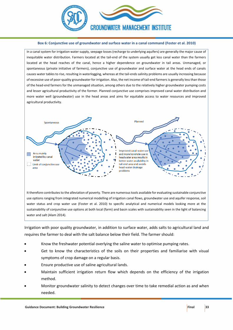
Guidance Document: Building Groundwater Resilience Final 33
Box 6: Conjunctive use of groundwater and surface water in a canal command (Foster et al. 2010)
In a canal system for irrigation water supply, seepage losses (recharge to underlying aquifers) are generally the major cause of
inequitable water distribution. Farmers located at the tail-end of the system usually get less canal water than the farmers
located at the head reaches of the canal, hence a higher dependence on groundwater in tail areas. Unmanaged, or
spontaneous (private initiative of farmers), conjunctive use of groundwater and surface water at the head ends of canals
causes water tables to rise, resulting in waterlogging, whereas at the tail-ends salinity problems are usually increasing because
of excessive use of poor-quality groundwater for irrigation. Also, the net income of tail-end farmers is generally less than those
of the head-end farmers for the unmanaged situation, among others due to the relatively higher groundwater pumping costs
and lesser agricultural productivity of the former. Planned conjunctive use comprises improved canal water distribution and
more water well (groundwater) use in the head areas and aims for equitable access to water resources and improved
agricultural productivity.
It therefore contributes to the alleviation of poverty. There are numerous tools available for evaluating sustainable conjunctive
use options ranging from integrated numerical modelling of irrigation canal flows, groundwater use and aquifer response, soil
water status and crop water use (Foster et al. 2010) to specific analytical and numerical models looking more at the
sustainability of conjunctive use options at both local (farm) and basin scales with sustainability seen in the light of balancing
water and salt (Alam 2014).
Irrigation with poor quality groundwater, in addition to surface water, adds salts to agricultural land and
requires the farmer to deal with the salt balance below their field. The farmer should:
• Know the freshwater potential overlying the saline water to optimise pumping rates.
• Get to know the characteristics of the soils on their properties and familiarise with visual
symptoms of crop damage on a regular basis.
• Ensure productive use of saline agricultural lands.
• Maintain sufficient irrigation return flow which depends on the efficiency of the irrigation
method.
• Monitor groundwater salinity to detect changes over time to take remedial action as and when
needed.
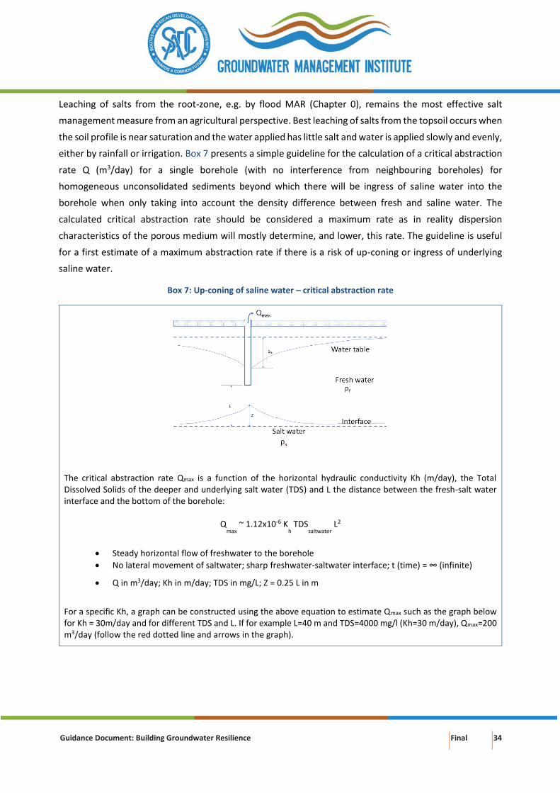
Guidance Document: Building Groundwater Resilience Final 34
Leaching of salts from the root-zone, e.g. by flood MAR (Chapter 0), remains the most effective salt
management measure from an agricultural perspective. Best leaching of salts from the topsoil occurs when
the soil profile is near saturation and the water applied has little salt and water is applied slowly and evenly,
either by rainfall or irrigation. Box 7 presents a simple guideline for the calculation of a critical abstraction
rate Q (m3/day) for a single borehole (with no interference from neighbouring boreholes) for
homogeneous unconsolidated sediments beyond which there will be ingress of saline water into the
borehole when only taking into account the density difference between fresh and saline water. The
calculated critical abstraction rate should be considered a maximum rate as in reality dispersion
characteristics of the porous medium will mostly determine, and lower, this rate. The guideline is useful
for a first estimate of a maximum abstraction rate if there is a risk of up-coning or ingress of underlying
saline water.
Box 7: Up-coning of saline water – critical abstraction rate
The critical abstraction rate Qmax is a function of the horizontal hydraulic conductivity Kh (m/day), the Total Dissolved Solids of the deeper and underlying salt water (TDS) and L the distance between the fresh-salt water interface and the bottom of the borehole:
Q
max ~ 1.12x10⁻⁶ K
h TDS
saltwater L2
• Steady horizontal flow of freshwater to the borehole
• No lateral movement of saltwater; sharp freshwater-saltwater interface; t (time) = ∞ (infinite)
• Q in m3/day; Kh in m/day; TDS in mg/L; Z = 0.25 L in m
For a specific Kh, a graph can be constructed using the above equation to estimate Qmax such as the graph below for Kh = 30m/day and for different TDS and L. If for example L=40 m and TDS=4000 mg/l (Kh=30 m/day), Qmax=200 m3/day (follow the red dotted line and arrows in the graph).
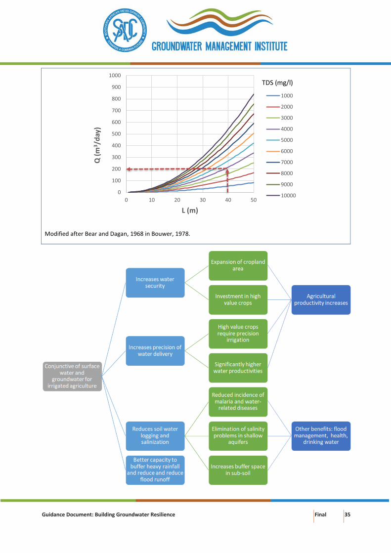
Guidance Document: Building Groundwater Resilience Final 35
Modified after Bear and Dagan, 1968 in Bouwer, 1978.
0
100
200
300
400
500
600
700
800
900
1000
0 10 20 30 40 50
Q (
m3/d
ay)
L (m)
1000
2000
3000
4000
5000
6000
7000
8000
9000
10000
TDS (mg/l)
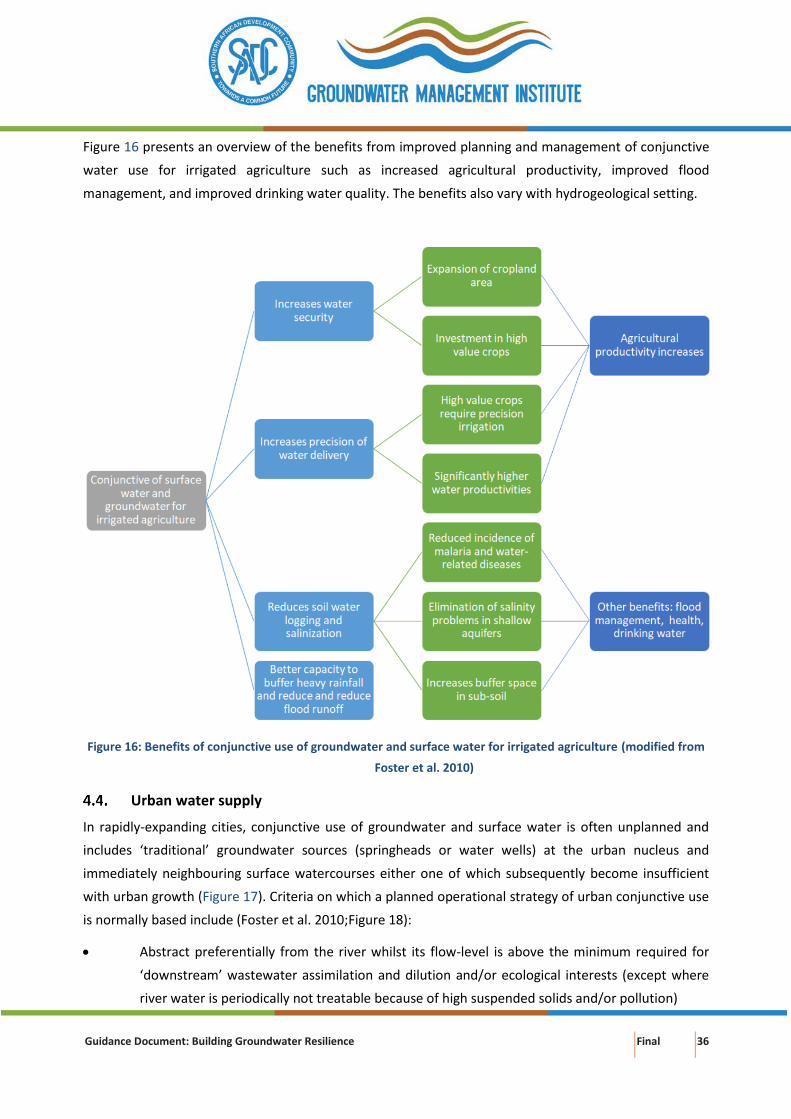
Guidance Document: Building Groundwater Resilience Final 36
Figure 16 presents an overview of the benefits from improved planning and management of conjunctive
water use for irrigated agriculture such as increased agricultural productivity, improved flood
management, and improved drinking water quality. The benefits also vary with hydrogeological setting.
Figure 16: Benefits of conjunctive use of groundwater and surface water for irrigated agriculture (modified from
Foster et al. 2010)
Urban water supply
In rapidly-expanding cities, conjunctive use of groundwater and surface water is often unplanned and
includes ‘traditional’ groundwater sources (springheads or water wells) at the urban nucleus and
immediately neighbouring surface watercourses either one of which subsequently become insufficient
with urban growth (Figure 17). Criteria on which a planned operational strategy of urban conjunctive use
is normally based include (Foster et al. 2010;Figure 18):
• Abstract preferentially from the river whilst its flow-level is above the minimum required for
‘downstream’ wastewater assimilation and dilution and/or ecological interests (except where
river water is periodically not treatable because of high suspended solids and/or pollution)
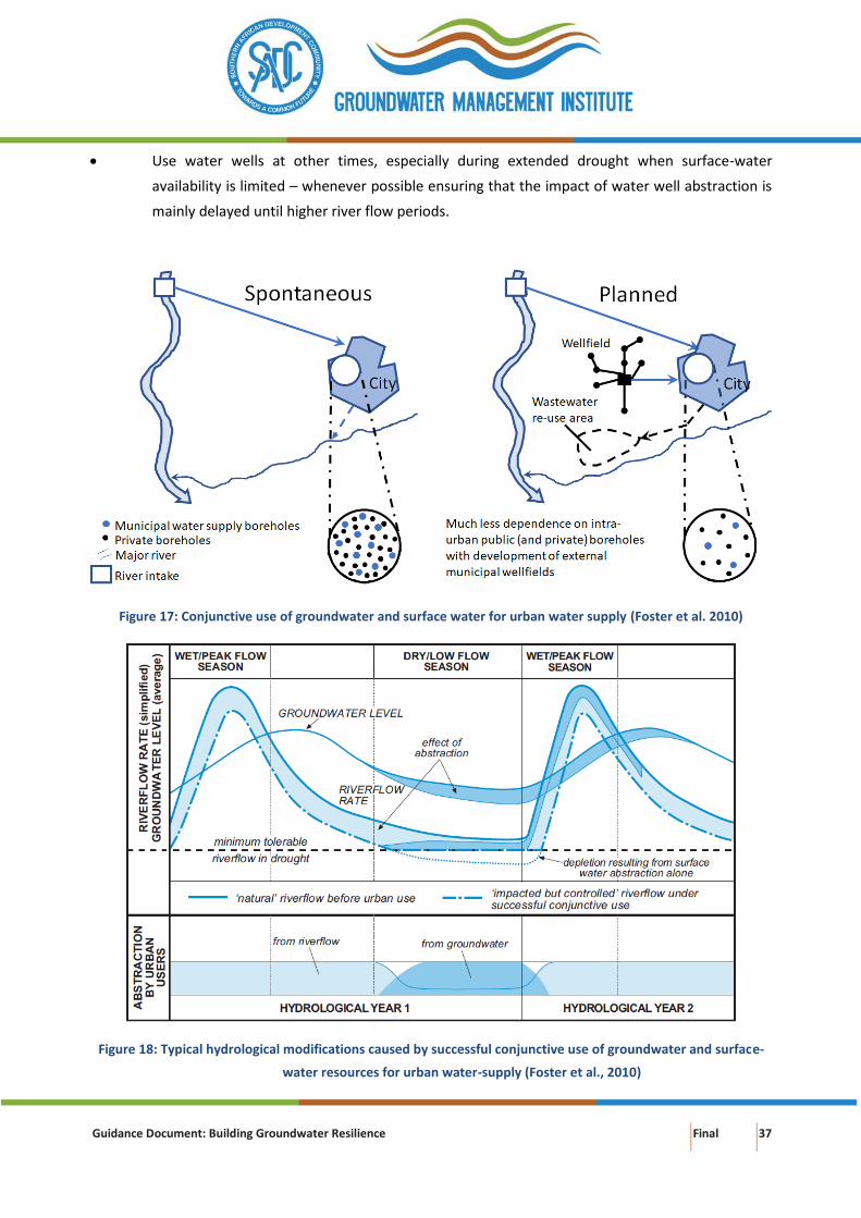
Guidance Document: Building Groundwater Resilience Final 37
• Use water wells at other times, especially during extended drought when surface-water
availability is limited – whenever possible ensuring that the impact of water well abstraction is
mainly delayed until higher river flow periods.
Figure 17: Conjunctive use of groundwater and surface water for urban water supply (Foster et al. 2010)
Figure 18: Typical hydrological modifications caused by successful conjunctive use of groundwater and surface-
water resources for urban water-supply (Foster et al., 2010)
Guidance Document: Building Groundwater Resilience Final 38
Only in a few cases, the use of groundwater has evolved as part of planned urban water-supply
development (e.g. Atlantis – South Africa, Box 8), but more often it has occurred in response to water
shortage or service deficiency, and often through private initiative (e.g. Lusaka, Dar-es-Salaam, Cape Town,
Windhoek and Gaborone and probably elsewhere). An example of conjunctive use is the North-South
Carrier (NSC), which is a bulk water supply system running from north to south in eastern Botswana,
connecting a number of surface water dams, groundwater aquifers and water treatment facilities (Lindhe
et al. 2014). The NSC system includes:
• 6 surface water dams
• 8 wellfields
• 7 water works
• 18 demand centres
Box 8: Atlantis planned urban water supply (Buchan et al., 2016)
The primary aquifer at Atlantis (Western Cape, South Africa) is ideally suited for water supply and the indirect
recycling of urban stormwater runoff and treated domestic wastewater for potable purposes. The relatively thin,
sloping aquifer requires careful management of artificial recharge and abstraction for balancing water levels.
Water quality management is a further key issue at Atlantis for ensuring the highest quality potable water.
Groundwater quality varies from point to point in the aquifer, while urban runoff and wastewater qualities vary
greatly. The layout of the town allows for the separation of stormwater from the residential and industrial areas
as well as separate treatment of domestic and industrial wastewater. This permits safe artificial recharge of the
various water quality portions at different points in the aquifer, either for recycling or for preventing seawater
intrusion. Lessons learnt from the Atlantis experience can be transferred to other potential sites for establishment
of similar systems in arid and semi-arid areas of Southern Africa.
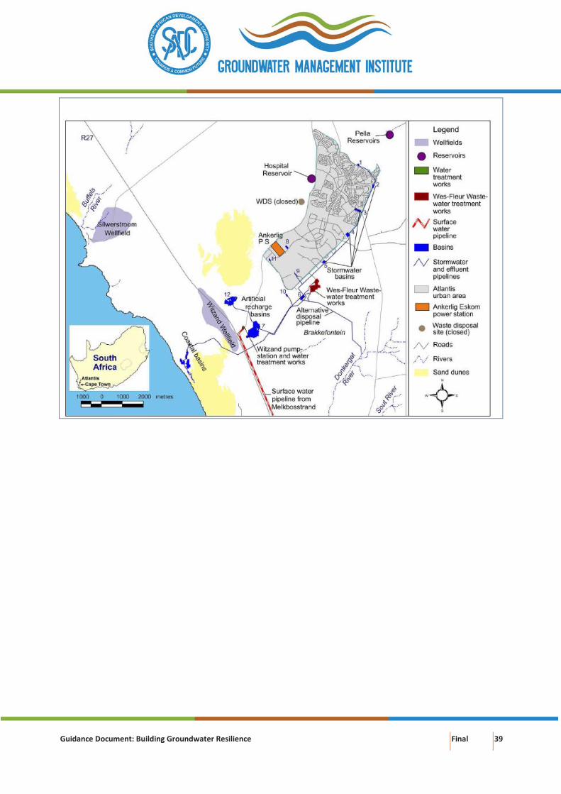
Guidance Document: Building Groundwater Resilience Final 39
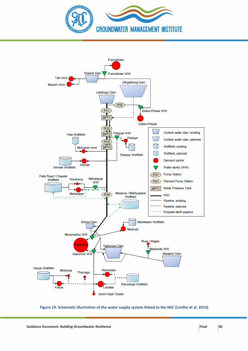
Guidance Document: Building Groundwater Resilience Final 40
Figure 19: Schematic illustration of the water supply system linked to the NSC (Lindhe et al. 2014)
Guidance Document: Building Groundwater Resilience Final 41
Requirements for conjunctive management
Conjunctive water management requires:
• A proper institutional framework comprising a regulatory body to control water distribution,
groundwater use and groundwater abstraction. The institutional framework should focus on
water agencies at local and provincial levels capable of implementing Integrated Water
Resources Management, and water user associations representing the stakeholders
• Minimum standards for sustainable conjunctive use of groundwater and surface water.
• Public awareness raising on the beneficial concept of conjunctive water use
• Capacity building of stakeholders to manage groundwater resources
• Implementation of solutions for sustainable groundwater use and groundwater abstraction
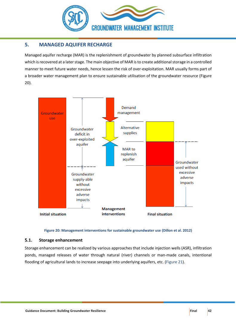
Guidance Document: Building Groundwater Resilience Final 42
5. MANAGED AQUIFER RECHARGE
Managed aquifer recharge (MAR) is the replenishment of groundwater by planned subsurface infiltration
which is recovered at a later stage. The main objective of MAR is to create additional storage in a controlled
manner to meet future water needs, hence lessen the risk of over-exploitation. MAR usually forms part of
a broader water management plan to ensure sustainable utilisation of the groundwater resource (Figure
20).
Figure 20: Management interventions for sustainable groundwater use (Dillon et al. 2012)
Storage enhancement
Storage enhancement can be realized by various approaches that include injection wells (ASR), infiltration
ponds, managed releases of water through natural (river) channels or man-made canals, intentional
flooding of agricultural lands to increase seepage into underlying aquifers, etc. (Figure 21).
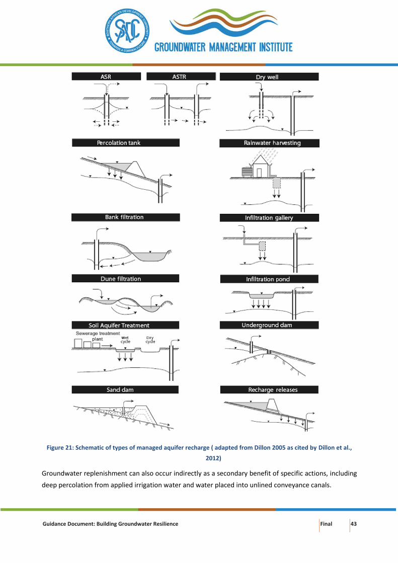
Guidance Document: Building Groundwater Resilience Final 43
Figure 21: Schematic of types of managed aquifer recharge ( adapted from Dillon 2005 as cited by Dillon et al.,
2012)
Groundwater replenishment can also occur indirectly as a secondary benefit of specific actions, including
deep percolation from applied irrigation water and water placed into unlined conveyance canals.
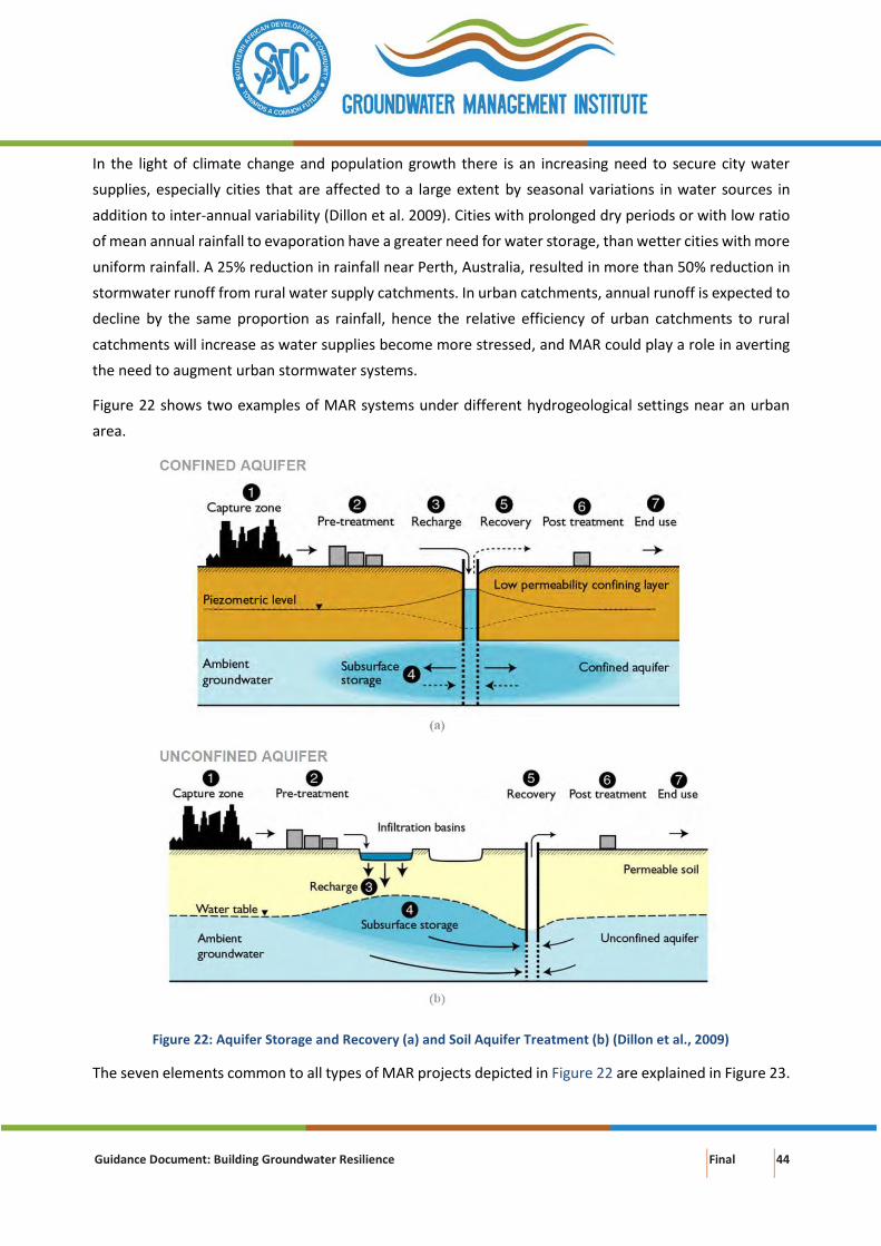
Guidance Document: Building Groundwater Resilience Final 44
In the light of climate change and population growth there is an increasing need to secure city water
supplies, especially cities that are affected to a large extent by seasonal variations in water sources in
addition to inter-annual variability (Dillon et al. 2009). Cities with prolonged dry periods or with low ratio
of mean annual rainfall to evaporation have a greater need for water storage, than wetter cities with more
uniform rainfall. A 25% reduction in rainfall near Perth, Australia, resulted in more than 50% reduction in
stormwater runoff from rural water supply catchments. In urban catchments, annual runoff is expected to
decline by the same proportion as rainfall, hence the relative efficiency of urban catchments to rural
catchments will increase as water supplies become more stressed, and MAR could play a role in averting
the need to augment urban stormwater systems.
Figure 22 shows two examples of MAR systems under different hydrogeological settings near an urban
area.
Figure 22: Aquifer Storage and Recovery (a) and Soil Aquifer Treatment (b) (Dillon et al., 2009)
The seven elements common to all types of MAR projects depicted in Figure 22 are explained in Figure 23.
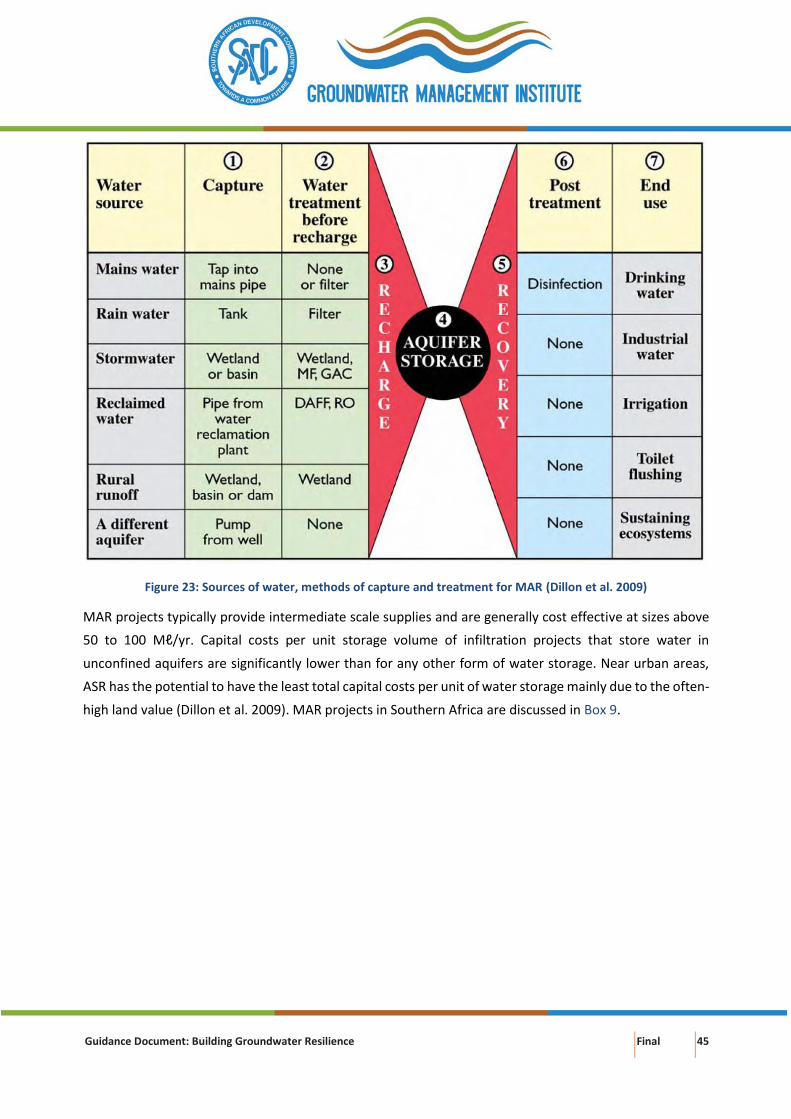
Guidance Document: Building Groundwater Resilience Final 45
Figure 23: Sources of water, methods of capture and treatment for MAR (Dillon et al. 2009)
MAR projects typically provide intermediate scale supplies and are generally cost effective at sizes above
50 to 100 Mℓ/yr. Capital costs per unit storage volume of infiltration projects that store water in
unconfined aquifers are significantly lower than for any other form of water storage. Near urban areas,
ASR has the potential to have the least total capital costs per unit of water storage mainly due to the often-
high land value (Dillon et al. 2009). MAR projects in Southern Africa are discussed in Box 9.
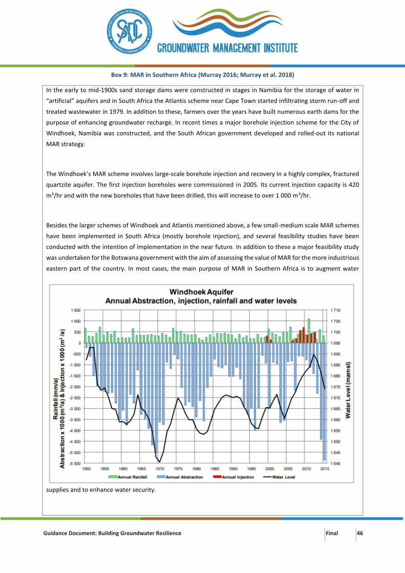
Guidance Document: Building Groundwater Resilience Final 46
Box 9: MAR in Southern Africa (Murray 2016; Murray et al. 2018)
In the early to mid-1900s sand storage dams were constructed in stages in Namibia for the storage of water in
“artificial” aquifers and in South Africa the Atlantis scheme near Cape Town started infiltrating storm run-off and
treated wastewater in 1979. In addition to these, farmers over the years have built numerous earth dams for the
purpose of enhancing groundwater recharge. In recent times a major borehole injection scheme for the City of
Windhoek, Namibia was constructed, and the South African government developed and rolled-out its national
MAR strategy.
The Windhoek’s MAR scheme involves large-scale borehole injection and recovery in a highly complex, fractured
quartzite aquifer. The first injection boreholes were commissioned in 2005. Its current injection capacity is 420
m3/hr and with the new boreholes that have been drilled, this will increase to over 1 000 m3/hr.
Besides the larger schemes of Windhoek and Atlantis mentioned above, a few small-medium scale MAR schemes
have been implemented in South Africa (mostly borehole injection), and several feasibility studies have been
conducted with the intention of implementation in the near future. In addition to these a major feasibility study
was undertaken for the Botswana government with the aim of assessing the value of MAR for the more industrious
eastern part of the country. In most cases, the main purpose of MAR in Southern Africa is to augment water
supplies and to enhance water security.
Guidance Document: Building Groundwater Resilience Final 47
Basin infiltration is a more cost-effective MAR approach for irrigated agriculture in rural areas. The farmer
must first consider access to recharge water and conveyance to the recharge area. Farms that are adjacent
to rivers and irrigation canals2 are more fortunate than areas lacking surface water conveyance facilities
which may constrain MAR implementation. There are several factors that determine the feasibility of MAR
on agricultural land (Geen et al. 2015):
• Deep percolation: Soils must be readily able to transmit water beyond the root zone.
• Root zone residence time: The duration of saturated/near saturated conditions after water
application must be acceptable for the crops grown on lands under consideration for MAR for
the entire crop root zone.
• Topography: Slopes that negatively influence the even distribution of water will be more difficult
to manage.
• Chemical limitations: High soil salinity and sodicity may result in saline leachate (poor water
quality) that must be avoided to protect and sustain good groundwater quality.
• Soil surface condition: Certain soils may be susceptible to compaction and erosion if large
volumes of water are applied. Surface horizons with high sodium are prone to crusting that may
contribute to decreased surface infiltration rates.
The following actions are proposed that farmers can take to enhance fresh groundwater storage:
• Review suitability of crops and farming practices for on-farm groundwater recharge by
flood/streamflow retention and aquifer storage and recovery techniques.
• Consider differentiated use of groundwater and surface water to optimise water quantity and
quality
Murray (2017) furthermore formulated key questions related to a wide range of topics from
engineering/environmental to legal/institutional/socio-economic perspectives that need to be addressed
prior to embarking on a MAR project (Table 3).
Table 3: Key questions to be addressed for MAR projects (Murray 2017)
Topic Some key questions
1. The need for the scheme • Is artificial recharge really necessary?
• Could you not increase your groundwater yield by
expanding the wellfield or by managing existing
wellfields better?
2 There may be a governance issue at play – as surface water is a public good but groundwater considered private water.
Guidance Document: Building Groundwater Resilience Final 48
Topic Some key questions
2. The source water • What volume of water is available for recharge,
and when is it available?
3. Aquifer hydraulics • Will the aquifer receive and store the water?
4. Water quality • Is the quality of the source water suitable for
artificial recharge?
5. Engineering issues • How will the water be transferred into the
aquifer?
6. Environmental issues • What are the potential environmental benefits,
risks and constraints?
7. Legal and regulatory issues • What type of authorisation is required?
8. Economics • How much will the scheme cost, how much will it
cost to operate it, and what will the cost of
supplied water per m3 be?
9. Management and technical capacity • What skills are required to operate the scheme,
and are they available?
10. Institutional arrangements • Who will be responsible for supplying the source
water and ensuring its quality is suitable for
recharge?
• Are there other users of the aquifer?
• Who will regulate the use of the scheme?
Flood mitigation (Green infrastructure)
Urban stormwater, rainwater that runs off urban surfaces such as roofs, pavements, car parks, and roads,
flows into storm water drains, creeks and rivers and forms part of the fresh water that ultimately flows to
estuaries and the ocean.
Stormwater in urban areas is usually abundant but may require treatment and storage before reuse (Page
et al. 2018). The primary limitation to storm water harvesting and reuse in urban areas is the ability to
store the water from runoff events in the wet season for subsequent use when water is in demand,
typically during the dry season. MAR can provide an economical method of storing and treating
stormwater in urban areas. Common uses of stormwater recycled via an aquifer include the irrigation of
parks and gardens, ovals and golf courses, other municipal and commercial purposes, and drinking water.
Guidance Document: Building Groundwater Resilience Final 49
With increasing adoption of MAR, green infrastructure3 and water-sensitive urban design practices, the
quality of urban stormwater and the quantity of harvestable should improve, and with tightening
requirements on urban (coastal) water quality, investments in wastewater, will make more water available
for use and for storage. These practices also contribute to mitigating floods and flood damage.
In the context of irrigated agriculture, flood MAR (including spate irrigation; see Latif 2015) purposefully
captures water from flood events and spread over land using diversion structures. Kocis and Dahlke (2017)
studied the magnitude, frequency, duration, and timing of high-magnitude flow (i.e. flow above the 90th
percentile) in the Central Valley, California, in order to assess the physical availability of surface water for
groundwater banking and found that these flows could provide enough water to balance more than two
times the annual groundwater overdraft. Similarly, wet years can provide over four times the average
annual groundwater overdraft.
In Box 10 groundwater based natural infrastructure (GBNI) solutions are presented to increase water
storage, water retention, water quality and environmental functions or services.
Box 10: Examples of GBNI solutions
3 Green infrastructure uses vegetation, soils, and other elements and practices to restore some of the natural processes required to manage water and create healthier urban environments. At the city scale, green infrastructure is a patchwork of natural areas that provides habitat, flood protection, cleaner air, and cleaner water.
https://www.epa.gov/green-infrastructure/what-green-infrastructure
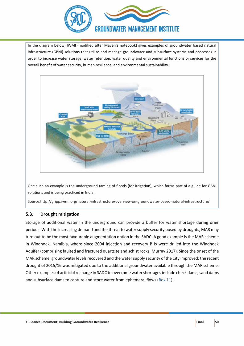
Guidance Document: Building Groundwater Resilience Final 50
In the diagram below, IWMI (modified after Maven’s notebook) gives examples of groundwater based natural
infrastructure (GBNI) solutions that utilize and manage groundwater and subsurface systems and processes in
order to increase water storage, water retention, water quality and environmental functions or services for the
overall benefit of water security, human resilience, and environmental sustainability.
One such an example is the underground taming of floods (for irrigation), which forms part of a guide for GBNI
solutions and is being practiced in India.
Source:http://gripp.iwmi.org/natural-infrastructure/overview-on-groundwater-based-natural-infrastructure/
Drought mitigation
Storage of additional water in the underground can provide a buffer for water shortage during drier
periods. With the increasing demand and the threat to water supply security posed by droughts, MAR may
turn out to be the most favourable augmentation option in the SADC. A good example is the MAR scheme
in Windhoek, Namibia, where since 2004 injection and recovery BHs were drilled into the Windhoek
Aquifer (comprising faulted and fractured quartzite and schist rocks; Murray 2017). Since the onset of the
MAR scheme, groundwater levels recovered and the water supply security of the City improved; the recent
drought of 2015/16 was mitigated due to the additional groundwater available through the MAR scheme.
Other examples of artificial recharge in SADC to overcome water shortages include check dams, sand dams
and subsurface dams to capture and store water from ephemeral flows (Box 11).
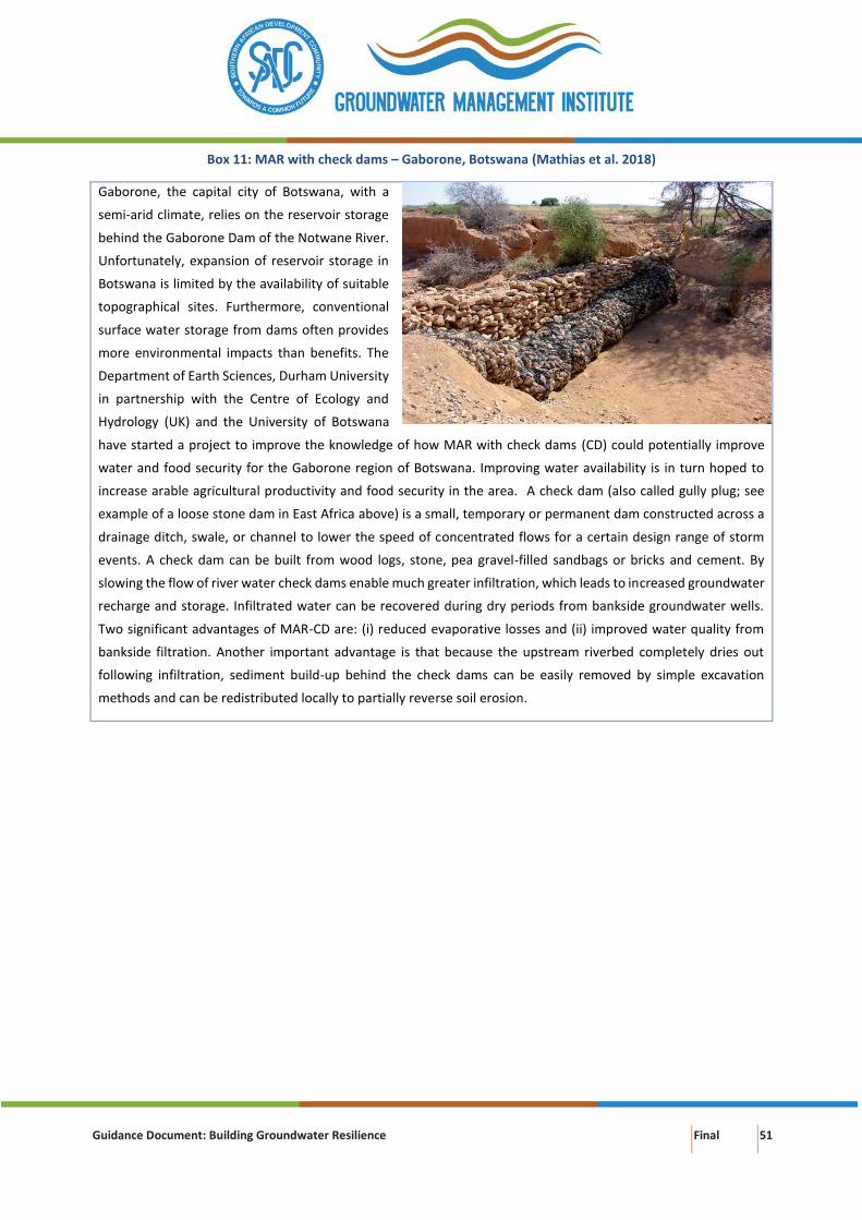
Guidance Document: Building Groundwater Resilience Final 51
Box 11: MAR with check dams – Gaborone, Botswana (Mathias et al. 2018)
Gaborone, the capital city of Botswana, with a
semi-arid climate, relies on the reservoir storage
behind the Gaborone Dam of the Notwane River.
Unfortunately, expansion of reservoir storage in
Botswana is limited by the availability of suitable
topographical sites. Furthermore, conventional
surface water storage from dams often provides
more environmental impacts than benefits. The
Department of Earth Sciences, Durham University
in partnership with the Centre of Ecology and
Hydrology (UK) and the University of Botswana
have started a project to improve the knowledge of how MAR with check dams (CD) could potentially improve
water and food security for the Gaborone region of Botswana. Improving water availability is in turn hoped to
increase arable agricultural productivity and food security in the area. A check dam (also called gully plug; see
example of a loose stone dam in East Africa above) is a small, temporary or permanent dam constructed across a
drainage ditch, swale, or channel to lower the speed of concentrated flows for a certain design range of storm
events. A check dam can be built from wood logs, stone, pea gravel-filled sandbags or bricks and cement. By
slowing the flow of river water check dams enable much greater infiltration, which leads to increased groundwater
recharge and storage. Infiltrated water can be recovered during dry periods from bankside groundwater wells.
Two significant advantages of MAR-CD are: (i) reduced evaporative losses and (ii) improved water quality from
bankside filtration. Another important advantage is that because the upstream riverbed completely dries out
following infiltration, sediment build-up behind the check dams can be easily removed by simple excavation
methods and can be redistributed locally to partially reverse soil erosion.
Guidance Document: Building Groundwater Resilience Final 52
6. GROUNDWATER REUSE AND RECYCLING
Groundwater recharge with recycled water maximizes water reuse and should form an integral part of
water resource planning in major cities and towns of SADC. Indirect recycling of water at Atlantis near
Cape Town, South Africa, started shortly after the town was established in the mid-1970s. The artificial
groundwater recharge scheme of Atlantis stores and purifies treated domestic wastewater and urban
stormwater. The groundwater is abstracted by wellfields and re-used to augment the municipal water
supplies to the town (Atlantis Water Supply Scheme – AWSS). It has alleviated the pressure on surface
water resources in the region (Bugan et al. 2016).
Recovery of reclaimed water through ASR
ASR can be used to recover reclaimed (Figure 24) water that has been injected into a subsurface formation
for storage (Chapter 0). ASR can be an effective management tool to minimize seasonal fluctuations in
supply and demand, by storage during the wet season when demand is low and recovery of water during
dry periods when demand is high (EPA 2012; Bloetscher et al. 2014). There are, however, a number of
concerns (EPA 2018):
• Pathogens may enter the aquifer if water is not disinfected prior to injection. In the case of
injection of raw water and treated effluent, the fate of microbes and viruses in an aquifer is a
critical factor to consider.
• Disinfection by-products can form in the aquifer if water is disinfected prior to injection. Soluble
organic carbon should be removed from the injectate before disinfection. If not, chlorinated
disinfectants may react with the carbon to form contaminating compounds. Contaminants
include trihalomethanes and haloacetic acids.
• Metals and radionuclides may be mobilized from the rock depending on the chemistry of the
injected water and the aquifer. Differences in pH and reduction-oxidation processes between the
injected water and aquifer may cause arsenic, iron, manganese, or radionuclides that are present
in the rock to dissolve.
• Carbonate precipitation in carbonate aquifers can clog wells when the injectate is not sufficiently
acidic.
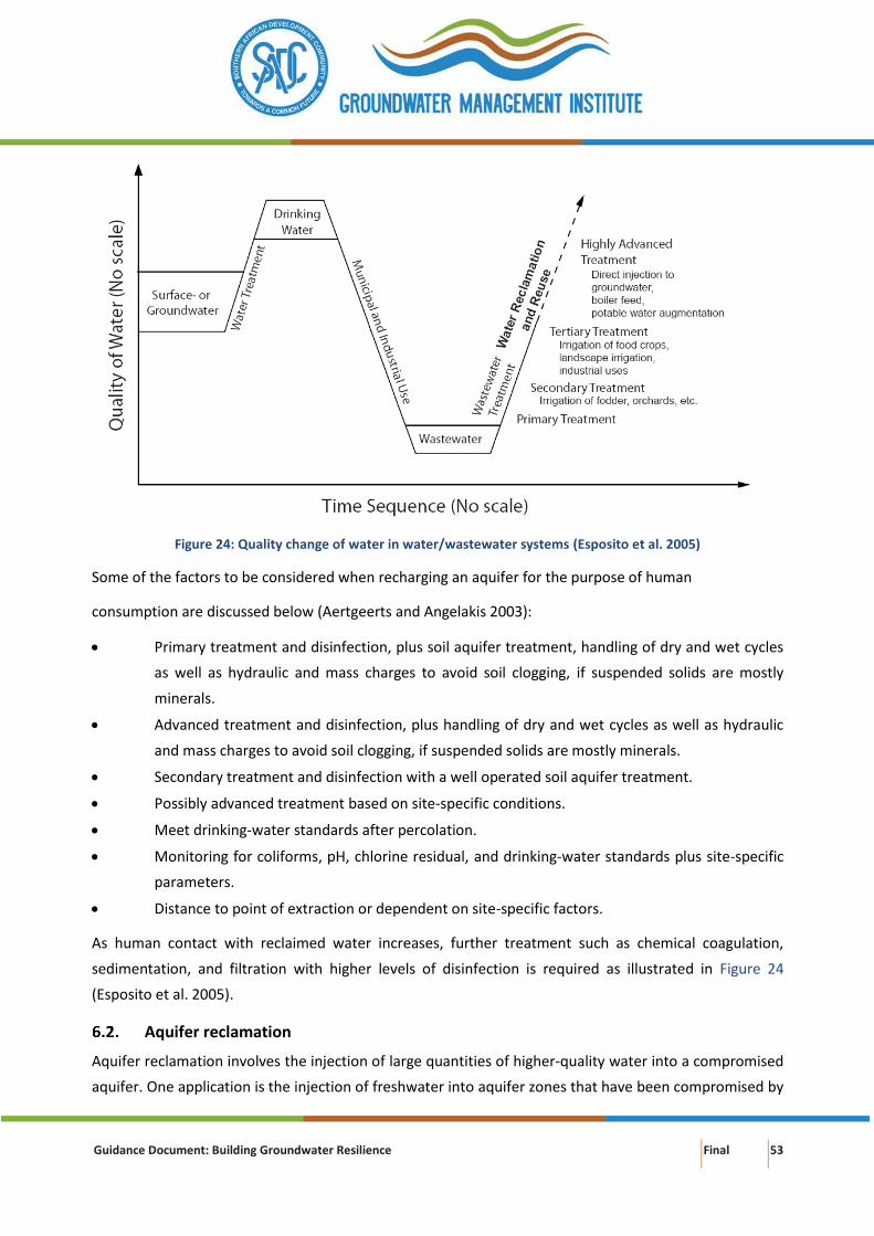
Guidance Document: Building Groundwater Resilience Final 53
Figure 24: Quality change of water in water/wastewater systems (Esposito et al. 2005)
Some of the factors to be considered when recharging an aquifer for the purpose of human
consumption are discussed below (Aertgeerts and Angelakis 2003):
• Primary treatment and disinfection, plus soil aquifer treatment, handling of dry and wet cycles
as well as hydraulic and mass charges to avoid soil clogging, if suspended solids are mostly
minerals.
• Advanced treatment and disinfection, plus handling of dry and wet cycles as well as hydraulic
and mass charges to avoid soil clogging, if suspended solids are mostly minerals.
• Secondary treatment and disinfection with a well operated soil aquifer treatment.
• Possibly advanced treatment based on site-specific conditions.
• Meet drinking-water standards after percolation.
• Monitoring for coliforms, pH, chlorine residual, and drinking-water standards plus site-specific
parameters.
• Distance to point of extraction or dependent on site-specific factors.
As human contact with reclaimed water increases, further treatment such as chemical coagulation,
sedimentation, and filtration with higher levels of disinfection is required as illustrated in Figure 24
(Esposito et al. 2005).
Aquifer reclamation
Aquifer reclamation involves the injection of large quantities of higher-quality water into a compromised
aquifer. One application is the injection of freshwater into aquifer zones that have been compromised by

Guidance Document: Building Groundwater Resilience Final 54
brackish water (water containing 1,000 to 10,000 ppm of total dissolved solids) intruding into the
formation (USEPA 2002). The freshwater serves to stabilize the water quality at a given chloride
concentration or forces the brackish water to retreat toward the source—typically the ocean, but also
lower formations where up-coning is a problem (AWWA 2015).
There are several techniques available for the sustainable abstraction of fresh groundwater whilst
preventing up-coning and/or intrusion of saline water in fresh aquifers, however each of the techniques
coming at a high cost.
A ‘balanced scavenger well system’ consisting of a production well and a so-called scavenging well some
20-30 meters deeper was proposed as a solution to solve long-term salinization problems in the Punjab in
Pakistan (Alam 2014). The dual pump system taps both the shallow fresh water and the deeper saline
water zones. The wells pump fresh and saline waters from the same site simultaneously without mixing,
through two separate discharge systems. The brackish water is disposed of, while the fresh water is used
for irrigation.
Zuurbier et al. (2017) proposed new technologies to counteract salinisation of well fields by interception
and desalination of up-coning brackish groundwater. The so-called ‘Freshkeeper’ aims to safeguard the
water supply from abstraction wells at risk of salinisation. The concept follows a three-step approach
(Figure 25):
a. Intercept up-coning brackish groundwater by abstracting fresh water from the top of the aquifer,
while pumping intruding brackish water from the lower part of the aquifer;
b. Use the intercepted brackish water as an additional water source by desalination through reverse
osmosis (RO); and
c. Dispose of the RO membrane concentrates by deep-well injection into a confined, more saline
aquifer.
At a pilot field site, Zuurbier et al. (2017) observed that the abstracted fresh water as well as the brackish
abstraction water freshened upon dual zone Freshkeeper abstraction. Chloride concentrations of the
abstracted fresh and brackish water decreased in the first months of the pilot, from 45 to 35 and 1000 to
600 mg/l, respectively. Freshening not only occurred in the near surrounding of the abstracting well
screens, but also in observation wells at greater distance (Zuurbier et al. 2017).
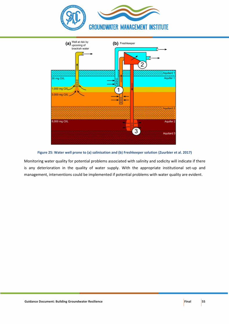
Guidance Document: Building Groundwater Resilience Final 55
Figure 25: Water well prone to (a) salinisation and (b) Freshkeeper solution (Zuurbier et al. 2017)
Monitoring water quality for potential problems associated with salinity and sodicity will indicate if there
is any deterioration in the quality of water supply. With the appropriate institutional set-up and
management, interventions could be implemented if potential problems with water quality are evident.
Guidance Document: Building Groundwater Resilience Final 56
7. CONCLUSION AND RECOMMENDATIONS
The road to water resilience requires broadening the water supply mix to include urban stormwater, water
harvesting, water reuse, recycled wastewater, desalinated water and groundwater.
Groundwater storage serves as a key buffer for achieving groundwater resilience under extreme climate
events e.g. extended drought conditions. Using the groundwater resource strategically and sustainably
means that it can be a crucial factor to bridge gaps between water resource availability and water demand.
This requires careful consideration and includes: (i) setting a limit on how much water can be safely
pumped to avoid irreversible subsidence caused when too much water is removed from the aquifer; (ii)
defining a safety reserve to ensure an adequate water supply in a worst-case scenario, such as a multi-
year-interruption in surface water supplies; and (iii) defining a management level – a target groundwater
level that allows use of the aquifer as a working reserve that can be used during dry times and refilled
when adequate surface water supplies are available while protecting the safety reserve and while
preventing exceedance of the irreversible subsidence limit.
The capacity of a groundwater system to recover from pollution is critical to the concept of resilience as
natural disasters and extreme weather events undermine the effectiveness of remediation measures.
Determining the natural attenuation capacity of groundwater systems at a local scale is complex as it
requires detailed knowledge of: (i) the type and quantity of pollutants involved; (ii) the chemical and
hydraulic characteristics of both unsaturated and saturated zones; and (iii) other factors controlling the
spatial extent and persistence of pollutants. Because of the overall complexity and costs of groundwater
remediation (often unsuccessful), the focus should be on prevention of pollution.
There are several measures to support groundwater resilience such as conjunctive management of water
resources; managed aquifer recharge; and groundwater reuse and recycling.
Conjunctive management in support of long-term groundwater (and surface water) resilience refers to
management of the combined use of groundwater, surface water and other sources of water in a manner
that prevents irreversible impacts (quantity and quality) on either of the resources. The benefits of
coordinated management of the water sources should exceed the benefits obtained through their
separate management. Benefits of conjunctive (planned) management are: (i) diversification of the water
supply mix; (ii) improved water supply security and security of water sources (prevention of over-
exploitation, preparedness for extreme weather events); (iii) larger net water supply yield (efficient use of
both water resources); and (iv) reduced environmental impact (prevents/limits over-exploitation of
groundwater and surface water, water logging and salinisation). In rapidly expanding cities, conjunctive
use of groundwater and surface water is often unplanned and includes ‘traditional’ groundwater sources
(springheads or water wells) at the urban nucleus e.g. Lusaka, Zambia, and immediate neighbouring
surface watercourses either one of which subsequently become insufficient with urban growth.
Guidance Document: Building Groundwater Resilience Final 57
Managed aquifer recharge (MAR) is the replenishment of groundwater by planned subsurface infiltration
which is recovered at a later stage. The main objective of MAR is to create additional storage in a controlled
manner to meet future water needs, hence lessen the risk of over-exploitation. MAR usually forms part of
a broader water management plan to ensure sustainable utilisation of the groundwater resource. Benefits
of MAR other than storage enhancement includes flood and drought risk reduction, salinity improvement
and ecosystem enhancement. In the case of Windhoek, the capital of Namibia, groundwater contributes
about 10% to the water supply (Christelis and Struckmeier 2011). A system of artificially recharging
groundwater resources has been put in place (Murray et al. 2018). The aim is to make available up to 8
million cubic metre per annum (Mm3/annum) of groundwater for abstraction (Tredoux et al. 2009). The
present Windhoek water demand is about 20 Mm3/annum (Christelis and Struckmeier 2011). MAR has
significantly contributed to water security in the Windhoek area and has a great potential for the SADC.
Groundwater recharge with recycled water maximizes the reuse and should be an important component
of water resource planning in major cities and towns of SADC. Indirect recycling of water at Atlantis near
Cape Town, South Africa, started shortly after development of the town in the mid-1970s. The artificial
groundwater recharge scheme of Atlantis stores and further purifies treated domestic wastewater and
urban stormwater. The groundwater is abstracted at wellfields and re-used to augment the municipal
water supplies for the town. It has alleviated the pressure on surface water resources in the region (Bugan
et al. 2016).
Guidance Document: Building Groundwater Resilience Final 58
8. REFERENCES
Aertgeerts R, Angelakis A (2003) State of the Art Report Health Risks in Aquifer Recharge Using Reclaimed
Water.
AGW-Net, BGR, IWMI, et al (2015) Integration of Groundwater Management Into Transboundary Basin
Organizations in Africa.
Ahmad T, Musa TH, Wei P, Jin H (2019) Cholera outbreak in Zimbabwe 2018. South Afr J Pub Heal 3:2019.
doi: 10.7196/SHS.2019.v3.i2.81
Alam N (2014) Sustainable conjunctive use of groundwater for additional irrigation. Delft University of
Technology
Albuquerque Bernalillo County Water Utility (2016) Water 2120: Securing our water future. City of
Albuquerque, New Mexico
Archer ERM (2019) Learning from South Africa ’ s recent summer rainfall droughts : How might we think
differently about response ? Area 1–6. doi: 10.1111/area.12547
Arsénio AM, Salim IC, Hu M, et al (2018) Mitigation Potential of Sanitation Infrastructure on Groundwater
Contamination by Nitrate in Maputo. Sustainability 10:1–18. doi: 10.3390/su10030858
AWWA (2015) Aquifer Storage and Recovery.
Babbitt C, Gibson K, Sellers S, et al (2018) The future of groundwater in California: Lessons in sustainable
management from across the West.
Beekman HE (2015) Nyamandlovu Groundwater Model – Steady State.
Bello-Schünemann J, Aucoin C (2016) African urban futures. Institute for Security Studies, Pretoria
Blamey RC, Kolusu SR, Mahlalela P, et al (2018) The role of regional circulation features in regulating El
Niño climate impacts over southern Africa : A comparison of the 2015 / 2016 drought with previous events.
Int J Clim 38:4276–4295. doi: 10.1002/joc.5668
Bloetscher F, Sham CH, Danko III JJ, Ratick S (2014) Lessons Learned from Aquifer Storage and Recovery (
ASR ) Systems in the United States. J Water Resour Prot 6:1603–1629.
Bonsor HC, Shamsudduha M, Marchant BP, et al (2018) Seasonal and Decadal Groundwater Changes in
African Sedimentary Aquifers Estimated Using. Remote Sens 10:1–20. doi: 10.3390/rs10060904
Brackett R, Wright P (2019) In Mozambique, Torrential Rain Keeps Food, Other Aid from Reaching Cyclone
Kenneth Victims. In: Weather Channel. https://weather.com/news/news/2019-04-25-tropical-cyclone-
kenneth-mozambique. Accessed 6 May 2019
Braune E, Adams S (2013) Regional Diagnostic Report Sub-Saharan Africa Region. Water Research Commi
Guidance Document: Building Groundwater Resilience Final 59
Brown A, Boltz F (2016) The Promise Of Freshwater Resilience. In: Forbes Opin.
https://www.forbes.com/sites/realspin/2016/08/26/the-promise-of-freshwater-
resilience/#6a3d52eb43a5. Accessed 23 Apr 2019
Bugan RDH, Jovanovic N, Israel S, et al (2016) Four decades of water recycling in Atlantis ( Western Cape ,
South Africa ): Past , present and future. Water SA 42:577–594.
CapNet, AWG-Net, GW-Mate (2010) Groundwater Management in IWRM: Training Manual.
Christelis G, Struckmeier WF (2011) Groundwater in Namibia. Department of Water Affairs, Windhoek,
Namibia
City Chlor (2013) Monitored Natural Attenuation - Option for plume management.
Cobbing JE, de Wit M (2018) The Grootfontein aquifer: Governance of a hydro social system at Nash
equilibrium. S Afr J Sci 114:1–7. doi: 10.17159/sajs.2018/20170230
Conrad J, Colvin C, Sililo O, et al (1999) Assessment of the impact of agricultural practices on the quality of
groundwater resources. Water Research Commission, Pretoria
Dillon P, Escalante EF, Tuinhof A (2012) Management of aquifer recharge and discharge processes and
aquifer storage equilibrium.
Dillon P, Pavelic P, Page D, et al (2009) Managed aquifer recharge : An Introduction.
Dos Santos S, Adams EA, Neville G, et al (2017) Urban growth and water access in sub-Saharan Africa:
Progress, challenges, and emerging research directions. Sci Total Environ 607–608:497–508. doi:
10.1016/j.scitotenv.2017.06.157
Dudley T, Fulton A (2005) Conjunctive Water Management. What is it? Why consider it? What are the
Challenges?
DWR (2017) DRAFT Sustainable Management Criteria.
EPA (2012) Guidelines for Water Reuse. Washington D.C
EPA (2018) Aquifer Recharge and Aquifer Storage and Recovery. In: Undergr. Inject. Control.
https://www.epa.gov/uic/aquifer-recharge-and-aquifer-storage-and-recovery. Accessed 16 May 2019
Esposito K, Tsuchihashi R, Anderson J, Selstrom J (2005) The Role of Water Reclamation in Water Resources
Management in the 21st Century. In: WEFTEC 2005. pp 8621–8633
Falkenmark M, Wang-erlandsson L, Rockström J (2019) Understanding of water resilience in the
Anthropocene. J Hydrol X 2:100009. doi: 10.1016/j.hydroa.2018.100009
Foster S, van Steenbergen F, Zuleta J, Garduño H (2010) Conjunctive Use of Groundwater and Surface
Water from spontaneous coping strategy to adaptive resource management. Sustain. Groundw. Manag.
Contrib. to Policy Promot. 1–26.
Guidance Document: Building Groundwater Resilience Final 60
Geen T, Saal M, Dahlke H, et al (2015) Soil suitability index identifies potential areas for groundwater
banking on agricultural lands. Calif Agric 69:75–84. doi: 10.3733/ca.v069n02p75
GroundUp (2018) Informal settlements flooded by heavy rains.
Groundwater Foundation (2019) Overuse and depletion. https://www.groundwater.org/get-
informed/groundwater/overuse.html. Accessed 26 Apr 2019
J. LD, W. NDC, J. O-O, et al Urban groundwater quality in Sub-Saharan Africa: current status and
implications for water security and public health. Hydrogeol J 25:1093–1116.
Jenkins MW, Cumming O, Cairncross S (2015) Pit Latrine Emptying Behavior and Demand for Sanitation
Services in Dar Es Salaam , Tanzania. Int J Environ Res Public Heal 12:2588–2611. doi:
10.3390/ijerph120302588
Kayembe JM, Thevenon F, La A, Sivalingam P (2018) International Journal of Hygiene and High levels of
faecal contamination in drinking groundwater and recreational water due to poor sanitation , in the sub-
rural neighbourhoods of Kinshasa , Democratic Republic of the Congo. Int J Hyg Environ Health 221:400–
408. doi: 10.1016/j.ijheh.2018.01.003
Kocis TN, Dahlke HE (2017) Availability of high-magnitude streamflow for groundwater banking in the
Central Valley, California.
Langridge R, Sepaniak S, Fencl A, Méndez L-E (2018) Adapting to Climate Change and Drought in Selected
California Groundwater Basins: Local Achievements and Challenges.
Lapworth DJ, Stuart ME, Pedley S, et al (2017) A review of urban groundwater use and water quality
challenges in Sub-Saharan Africa. Keyworth, United Kingdom
Latif N (2015) Design Guidelines For Lowland Spate Irrigation Systems.
Lindhe A, Rosén L, Per-Olof J, et al (2014) Increase of Water Supply Safety by Managed Aquifer Recharge
along the North-South Carrier – A pre-feasibility study. Göteborg, Sweden
Macdonald DMJ, Bloomfield JP, Hughes AG, et al (2008) Improving the understanding of the risk from
groundwater flooding in the UK. In: FLOODrisk 2008, European Conference on Flood Risk Management.
Oxford, United Kingdom,
Maco B, Hansen LJ, Bardos P, et al (2018) Resilient remediation: Addressing extreme weather and climate
change , creating community value. Remediation 29:7–18. doi: 10.1002/rem.21585
Mathias S, Marthews T, Worral F, Kenabatho P (2018) Increasing water availability in Botswana – a role for
managed aquifer recharge?
Molle F, López-Gunn E, Van Steenbergen F (2018) The local and national politics of groundwater
overexploitation. Water Altern 11:445–457.
Guidance Document: Building Groundwater Resilience Final 61
Mtoni Y, Chikira I, Martens K, Bakundukize C (2015) Estimation of depth to fresh – salt water interface and
its implications for sustainable groundwater resource management : a case study of the Coastal strip of
Dar es Salaam , Tanzania. Environ Earth Sci 6639–6662. doi: 10.1007/s12665-014-3887-0
Mukuyu P (2018) Conjunctive management of shared surface and groundwater systems in the SADC
Region, Africa. http://gripp.iwmi.org/2018/12/06/conjunctive-management-of-shared-surface-and-
groundwater-systems-in-the-sadc-region-africa/. Accessed 6 May 2019
Murray E (2016) An overview of Managed Aquifer Recharge in Southern Africa.
Murray E (2017) Managed Aquifer Recharge. An introductory guide for the SADC Groundwater
Management Institute including the Windhoek Case Study.
Murray R, Louw D, Merwe B Van Der, et al (2018) Windhoek , Namibia : from conceptualising to operating
and expanding a MAR scheme in a fractured quartzite aquifer for the city ’ s water security. Sustain Water
Resour Manag 4:217–223. doi: 10.1007/s40899-018-0213-0
Nhamo L, Mabhaudhi T (2019) Preparedness or repeated short-term relief aid ? Building drought resilience
through early warning in southern Africa. Water SA 45:75–85.
OECD (2014) Guidelines for Resilience Systems Analysis. OECD Publishing
Oxfam Education (2019) Cyclone Idai: Find out what has happened and think critically about what makes
some people more vulnerable to disasters than others. In: Oxfam Educ. Resour.
https://oxfamilibrary.openrepository.com/handle/10546/620714. Accessed 6 May 2019
Page D, Bekele E, Vanderzalm J, Sidhu J (2018) Managed Aquifer Recharge (MAR) in Sustainable Urban
Water Management. Water 10:239. doi: 10.3390/w10030239
Partow H (2011) Water Issues in the Democratic Republic of the Congo. Challenges and Opportunities.
United Nations Environment Programme, Nairobi, Kenya
Pegasys (2019) Policy, Legal and Institutional Development for Groundwater Management in the SADC
Member States: Regional Gap Analysis and Action Plan Report. Pretoria, South Africa
Rapolaki RS, Reason CJC (2018) Tropical storm Chedza and associated floods over. Nat Hazards 93:189–
217. doi: 10.1007/s11069-018-3295-y
Reid H, Sahlén L, MacGregor J, Stage J (2007) The economic impact of climate change in Namibia.
International Institute for Environment and Development, London, United Kingdom
Rieckmann A, Tamason CC, Gurley ES, et al (2018) Exploring Droughts and Floods and Their Association
with Cholera Outbreaks in Sub-Saharan Africa : A Register-Based Ecological Study from 1990 to 2010. Am
J Trop Med Hyg 98:1269–1274. doi: 10.4269/ajtmh.17-0778
Robins N, Davies J, Farr J (2013) Groundwater supply and demand from southern Africa’s crystalline
Guidance Document: Building Groundwater Resilience Final 62
basement aquifer: evidence from Malawi. Hydrogeol J 21:905–917. doi:
http://dx.doi.org/10.1007/s10040-013-0956-5
Saayman I, Beekman H, Adams S, et al (2007) Assessment of aquifer vulnerability in South Africa. Pretoria,
South Africa
SADC-GMI (2018) Southern African Development Community Groundwater Management Institute. 5.
SADC (2016) Regional Strategic Action Plan on Integrated Water Resources Development and
Management – Phase IV (2016-2020). South African Development Community, Gaborone, Botswana
Sappa G, Ergul S, Ferranti F, et al (2015) Journal of African Earth Sciences Effects of seasonal change and
seawater intrusion on water quality for drinking and irrigation purposes , in coastal aquifers of Dar es
Salaam , Tanzania. J African Earth Sci 105:64–84. doi: 10.1016/j.jafrearsci.2015.02.007
Siderius C, Gannon KE, Ndiyoi M, et al (2018) Hydrological Response and Complex Impact Pathways of the
2015 / 2016 El Niño in Eastern and Southern Africa. Earth’s Futur 6:2–22. doi: 10.1002/eft2.268
Sorensen JPR, Lapworth DJ, Nkhuwa DCW, et al (2015) Emerging contaminants in urban groundwater
sources in Africa. Water Res 72:51–63. doi: 10.1016/j.watres.2014.08.002
Tredoux G, Van Der Merwe B, Peters I (2009) Artificial recharge of the windhoek aquifer, namibia: water
quality considerations. Bol Geol y Min 120:269–278.
UNECA-SA (2012) Climate Change and the Rural Economy in Southern Africa: Issues, Challenges and
Opportunities. United Nations Economic Commission for Africa Subregional Office for Southern Africa
United Nations (2016) The World ’ s Cities in 2016. : United Nations, Department of Economic and Social
Affairs, Population Division (2014).
Van Loon AF (2015) Hydrological drought explained. Wiley Interdiscip Rev Water 2:359–392. doi:
10.1002/wat2.1085
Van Niekerk W, Le Roux A (2017) Human Settlements. In: Davis-Reddy C, Vincent K (eds) Climate Risk and
Vulnerability, Second. Pretoria, South Africa, pp 100–110
van Steenbergen F, Tuinhof A (2010) Managing the Water Buffer for Development and Climate Change
Adaptation.
Verwey P, Vermeulen P (2011) Influence of irrigation on the level , salinity and flow of groundwater at
Vaalharts Irrigation Scheme. Water SA 37:155–164.
Verwey P, Vermeulen P, van Tonder G (2011) The influence of Irrigation on Groundwater at the Vaalharts
Irrigation Scheme – Preliminary Assessment. Water Research Commission, Pretoria, South Africa
Villholth KG, Tøttrup C, Stendel M, Maherry A (2013) Integrated mapping of groundwater drought risk in
the Southern African Development Community (SADC) region. Hydrogeol J 21:863–885. doi:
Guidance Document: Building Groundwater Resilience Final 63
10.1007/s10040-013-0968-1
Waelti C, Spuhler D (2019) Conjunctive Use. https://sswm.info/sswm-university-course/module-4-
sustainable-water-supply/further-resources-water-sources-hardware/conjunctive-use. Accessed 6 May
2019
WEF (2018) The Global Risks Report 2018. Geneva, Switzerland
WEF (2019) The Global Risks Report 2019. Geneva, Switzerland
WHO Regional Office for Africa (2018) WHO is scaling up response to a fast-moving cholera outbreak in
Zimbabwe’s capital. https://afro.who.int/news/who-scaling-response-fast-moving-cholera-outbreak-
zimbabwes-capital. Accessed 7 May 2019
Yuan X, Wang L, Wood EF (2018) Anthropogenic Intensification of Southern African Flash Droughts as
Exemplified by the 2015/16 Season. In: [in “Explaining Extreme Events of 2016 from a Climate
Perspective”]. Bull. Amer. Meteor. Soc. pp 86–90
Zuurbier KG, Raat KJ, Paalman M, et al (2017) How Subsurface Water Technologies (SWT) can Provide
Robust, Effective, and Cost-Efficient Solutions for Freshwater Management in Coastal Zones. Water Resour
Manag 31:671–687. doi: 10.1007/s11269-016-1294-x
Guidance Document: Building Groundwater Resilience Final 64