Embed Size (px)
Citation preview

Glob
al e
nvi
ron
men
ts
Polar lands
Polar lands are located at the northern- most and southern-most points of the Earth. The northern polar lands, or Arctic, have been inhabited by people for thousands of years, while in the southern polar lands, or Antarctica, humans are newcomers to the environment. In the north the Sami of the Arctic are an indigenous group working towards self-determination, while in the south the scientific community works in accordance with a treaty that aims to protect the continent.
3
OutcomesA student:
4.1 identifies and gathers geographical information
4.2 organises and interprets geographical information
4.3 uses a range of written, oral and graphic forms to communicate geographical information
4.4 uses a range of geographical tools
4.6 describes the geographical processes that form and transform environments
4.8 describes the interrelationships between people and environments
4.10 explains how geographical knowledge, understanding and skills combine with knowledge of civics to contribute to informed citizenship.
Geographical toolsmaps• usevarioustypesofmaps
• locatefeaturesusinglatitudeandlongitude,area and grid references
• identifyphysicalandculturalfeaturesonamap
• measuredistancesonamapusinglinearscale
• identifyscaleaswritten,linearorrepresentative fraction
• usethepointsofacompasstodeterminedirection
• identifyandinterpretrelief
• constructasketchmap
Graphs and statistics• identifyandcalculatemaximumand
minimum, total, range, rank and average
• constructandinterpretbar,column,line,climatic and proportional graphs
Photographs• drawalinedrawing
• collectandinterpretphotographicimages
• distinguishbetweenoblique,aerial,ground-level photographs and satellite imagery
iCt• collectandinterpretelectronicinformation
• designandcreateamultimediapresentation
Sample
page
s

Definitionsbiomes—the world’s major environment types made up of plantandanimalcommunitiesthatareuniquelyadaptedtotheparticular environment
ice cap—a dome-shaped covering of ice and snow that covers the mountain ranges of a large area of land
indigenous people—the people who originally inhabited an area before outside settlement from other nations
katabatic winds—strong winds caused when air cooled by the ice caps flows rapidly along valleys towards the coast
nomadic—a lifestyle where people move around an environment to a range of locations, usually related to the seasons and the availability of food
pack ice—floating blocks of ice that have been driven together to form a large sheet of ice
permafrost—permanently frozen subsoil
self-determination—the right of indigenous people to govern themselves and make decisions about the future of their culture
taiga—the most common land-based biome on the planet, made up of trees adapted to the cold conditions
treaty—a formal agreement between two or more nations (signing a treaty indicates a commitment to the treaty and its contents, ratifying a treaty means bringing it into law in a particular country)
tundra—a biome of large, boggy, barren areas without trees
wilderness—areas on Earth where the natural environment remains largely unchanged or uninfluenced by human developments or actions
Sample
page
s
58 Geography Focus 1
Polar lands are the harshest and coldest environments on Earth. Their location at the northern and southern tips of the globe limits the amount of the Sun’s energy that reaches the areas. The Arctic Ocean at the northern end of the globe is the world’s smallest ocean. Antarctica, at the southern end, is the world’s fifth largest continent.
Indigenous groups like the Sami and the Inuit have lived in the lands surrounding the Arctic Ocean for thousands of years. Antarctica has only recently been visited by people, firstly by explorers, sealers and whalers and more recently by scientists and tourists.
Where are polar lands?The regions surrounding the North Pole and the South Pole remain frozen all year round. A thick ice cap blankets the continent of Antarctica while frozen pack ice forms a continuous sheet of ice that covers the Arctic Ocean.
Two different environmentsThere are two distinct polar land environments because near the North Pole there is ocean surrounded by land, while near the South Pole there is land surrounded by ocean. The availability of land and milder climate around the North Pole has meant that people could settle the area, while the expanse of cold oceans has made Antarctica the most isolated and coldest continent on earth.
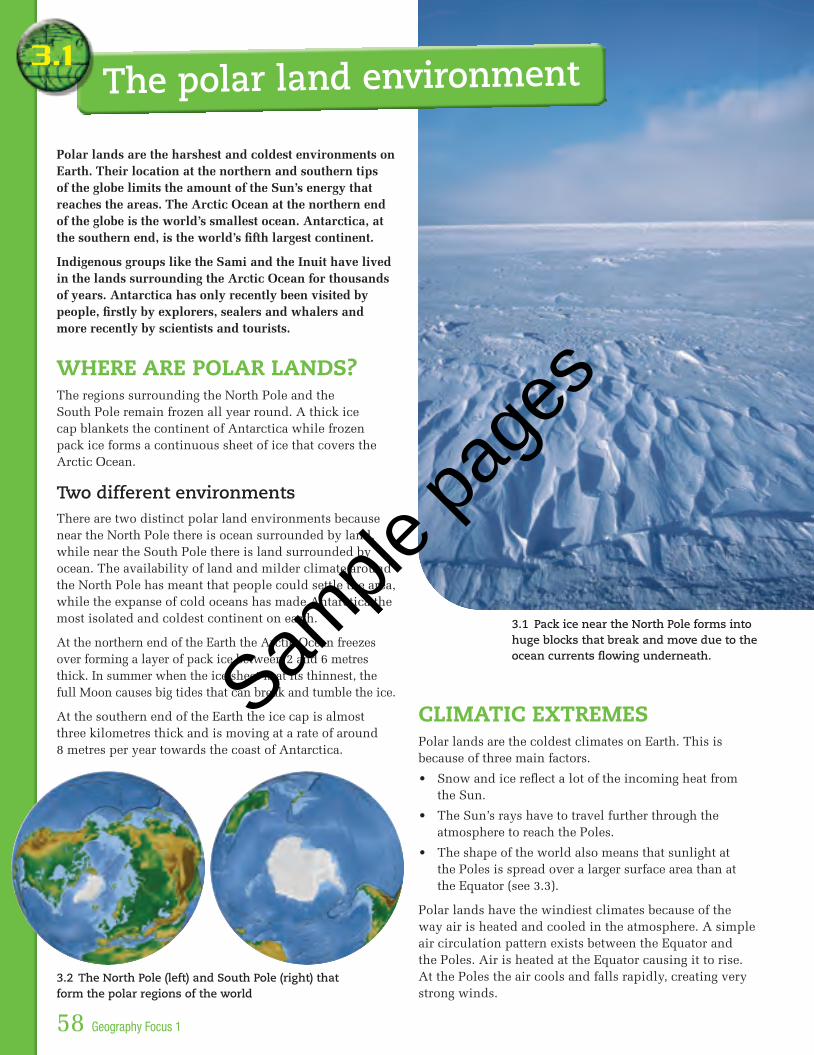
At the northern end of the Earth the Arctic Ocean freezes over forming a layer of pack ice between 2 and 6 metres thick. In summer when the ice sheet is at its thinnest, the full Moon causes big tides that can break and tumble the ice.
At the southern end of the Earth the ice cap is almost three kilometres thick and is moving at a rate of around 8 metres per year towards the coast of Antarctica.
ClimatiC extremesPolar lands are the coldest climates on Earth. This is because of three main factors.
• Snowandicereflectalotoftheincomingheatfromthe Sun.
• TheSun’srayshavetotravelfurtherthroughtheatmosphere to reach the Poles.
• Theshapeoftheworldalsomeansthatsunlightatthe Poles is spread over a larger surface area than at the Equator (see 3.3).
Polar lands have the windiest climates because of the way air is heated and cooled in the atmosphere. A simple air circulation pattern exists between the Equator and the Poles. Air is heated at the Equator causing it to rise. At the Poles the air cools and falls rapidly, creating very strong winds.
3.1
3.2 The North Pole (left) and South Pole (right) that form the polar regions of the world
The polar land environment
3.1 Pack ice near the North Pole forms into huge blocks that break and move due to the ocean currents flowing underneath.
Sample
page
s

0°
30°N
30°S
60°N
60°S
Equator
South Pole
North Pole
Sunlight directly overhead
Low angle of incoming sunlight
Low angle of incoming sunlight
June 21
Equator
March equinox Sun directly over the Equator
September equinox Sun directly over the Equator
December solstice
June solstice
March 21
September 22
December 21
Polar lands 59
lands of the midnight sunAnother feature of polar lands is that the lengths of night and day vary according to the seasons, or the rotation of planet Earth around the Sun. At the Poles this causes the ‘landofthemidnightSun’(see3.4).Forsixmonthsofthe year the Sun does not set at the Poles, and for the other six months it does not rise above the horizon,meaning24hoursofdarkness. The period of the total light or dark lessens the further away from the Poles a place is,suchasinnorthernFinlandwhere the Sun does not set for a period of 73 days during summer.
ActivitiesKnowledge
1 Where are polar lands located?
2 Explain the difference between pack ice and an ice cap.
3 Identify three differences between the North and South Pole.
4 List three factors that cause polar lands to be the coldest climates on Earth.
5 Explain why the Poles are called ‘land of the midnight sun’.
skills
6 Refer to 3.4 and complete the table below. Name the month of the year that the North Pole is furthest from the sun. Which season does the South Pole experience during this month? Explain any differences you notice.
time of year north Pole south Pole
December Solstice
June Solstice
7 With the aid of a diagram, explain why it is hotter at the Equator than it is at the Poles.
application
8 Use an annotated diagram to explain how the heating of the atmosphere causes polar lands to be the windiest places on Earth.
9 How many hours of daylight would the Poles experience on the September and March equinox?
surf
3.3 The Sun’s rays affect global temperatures. Polar lands are colder and windier than lands at the Equator.
3.4 The Earth’s tilt and rotation around the Sun causes 24 hours of daylight in summer and 24 hours of darkness in winter at the North and South Poles.
GeoGraphy focus
The Arctic ice sheet is thin enough for ships called ice breakers to travel through—especially in summer.
Sample
page
s

NORTH AMERICA
Bering Sea
Arctic Circle
PACIFIC OCEAN
ATLANTIC OCEAN
North Pole
Greenland
A S I A
E U R O P E
TaigaTundraPermanent ice cap
International boundaryMaximum sea ice boundary
Key
0 500 1000 km
NN
N
N
60 Geography Focus 1
The area around the North Pole is a frozen and barren wilderness area. As well as the polar biome created by the ice sheet that forms over the Arctic Ocean, there are other complex biomes that make up the northern polar lands—the tundra and the taiga (see 3.6). The plants and animals that are able to live in these environments are well adapted to the harsh conditions.
the iCe sheetThe central area of the Arctic Ocean is covered in ice all year round. This is where polar pack ice forms an icesheetofbetweenthreeandsixmetres.Furtherfromthe North Pole the pack ice gives way to drift ice. This is an area that is one solid ice sheet in winter, but in the summer months it breaks up into large sections where the iceformsfloatingsheetsthatconstantlycrashandbumpinto each other.
3.2
3.5 Polar bears are well adapted to the polar environment.
lands—the Arctic
The northern polar
3.6 The Arctic biomes the arCtiC tundraMoving away from the ice sheet at the North Pole, the first change in the environment is the tundra. This is an environment where the average winter temperatures are aslowas–34°C,andthesummertemperaturesrangebetween3°Cand12°C.Inthisbiomethegrowingseasonfor plants is very short, lasting for between 50 and 60 days.
In the tundra the soils are formed very slowly and are saturated with water. Due to the extremely cold temperatures the subsoil remains permanently frozen. This is known as permafrost. In summer the thin layer of topsoil thaws while the subsoil remains frozen meaning water is not able to infiltrate the soil; instead it forms boggy, marshy areas.
Animal life has adapted to the environment. Polar bears, for example, are able to live on ice as well as land and can swim very long distances in icy waters. The hairs in their fur are hollow to help insulate their skin. Their white fur offers the perfectcamouflageandtheyhave black skin underneath to absorbtheSun’swarmth.
GeoGraphy focus
Alpine tundra exists in areas around the world where mountain ranges cause similar cold climates to the Arctic. The main difference is that Alpine tundra is not as boggy as Arctic tundra.
Sample
page
s

Plants that grow in this environment are also highly adapted. Due to the permafrost they need to have shallow roots and be able to tolerate moist, boggy conditions. They are low-growing—usually less than 30 centimetres high—and dark in colour to absorb sunlight. Some have hairs on their leaves to keep them warm. The plants often grow in clumpsforaddedwarmth,andflowerstendto‘followtheSun’asitpassesovertotrapasmuchsunlightaspossible.
Thereareabout1700plantsthatareabletosurviveinthe Arctic tundra area. Examples of these plants include sedges,mossesandgrasses,floweringplantsandlichens.
the taigaThe taiga biome covers the largest land area of any of the world’sbiomes,makingitthemostcommonvegetationtypeonEarth.Itismainlylocatedbetween50°Nand60°N,althoughitdoesextendinsomeareasto70°N.Theseasons in the taiga consist of short, moist, mild summers and long, cold, dry winters. The length of the growing seasonis130days.
Thefloraofthetaigaconsistsmainlyofcold-tolerantevergreen conifers that are well adapted to the environment. These conifer forests (also known as boreal forests) are the most striking feature of the taiga biome. Conifershavelongneedle-shapedleavestohelpreducewater loss and prevent snow deposits from accumulating on branches, thick bark to protect them against the snow, shallow roots suited to thin soils and pine cones to protect seeds until warm weather arrives in the short summer.
Animals living in the taiga also need to be highly adapted to the environment and include bears, wolves, foxes and birds such as woodpeckers.
ActivitiesKnowledge1 Read the definition of a biome on the opening page of this
chapter. In your own words, describe what it means.
2 Name the three biomes that make up the Arctic region.
3 How does the ice sheet covering the Arctic Ocean change between summer and winter?
4 What is permafrost and what impact does it have on the soils of the Tundra?
5 Describe the features of the polar bear that enable it to live in the Arctic tundra biome.
6 Identify and explain four adaptations of plants to the tundra environment.
7 Where is the taiga biome located?
8 How do the growing seasons of the tundra and the taiga differ? Explain the factors that cause this difference.
9 What is another name for the coniferous forests of the arctic taiga?
10 Describe the adaptations of conifers that make them well suited to the taiga environment.
application11 Library research activity: Prepare a report on an animal
other than the polar bear that lives in the tundra and one that lives in the taiga. For each animal include a picture, a description including its main features and diet as well as any special adaptations it has to live in the environment. Be sure to include a bibliography at the end of your report.
surf
3.7 The highly specialised plants of the tundra biome
Polar lands61
Sample
page
s

HammerfestSami Territory
PechengaInari
KautokeinoTromso
Kiruna
Alta
NORWAY
SWEDEN
FINLAND
RUSSIA
Barents Sea
Baltic Sea
Norwegian Sea
Arctic Circle
Kola Peninsula
Arvidsjaur
Roros
JokkmokkGällivare
Rovaniemi
N
0 300 600 km
62 Geography Focus 1
The Sami are an indigenous people from the Arctic area of Europe. They have lived in the northern part of the Scandinavian peninsula for over 4000 years in a territory known as Sápmi. This territory covers parts of Norway, Sweden, Finland and Russia.
3.3
the Climate of sápmiThemajorityofSápmilieswithintheArcticCircleandtherefore has a very cold climate. The average winter temperatureis–12°C,althoughthetemperaturehasbeenknowntogoaslowas–50°Cinpartsoftheterritory.Winds blow from the Arctic Ocean and bring rain and snow. Snow generally falls from October to May. Summers are short and have generally mild temperatures upto14°C.(SeeclimaticdataforTromsØin3.15.)
3.9 Arctic berries
Living in polar lands—the Sami
3.8 Sápmi—the territory of the indigenous Sami. It is estimated that 40 000 Sami live in Norway, 20 000 in Sweden, 6500 in Finland and 2000 in Russia.
Today my father and mother took me on my first fishing expedition into the Barents Sea. We were after cod, which is an important part of our diet. Both my father and mother believe that it’s very important that I learn about the environment that I live in and the ways I can use the natural resources.I’ve come to understand that the Sami are a proud people with a long tradition of surviving in a harsh environment. At the moment my family lives on the coast, but we move around depending on the seasons. Soon we will be moving up the river and then into the mountains as the weather gets cooler.My parents have been trying to get me to understand everything about our way of life, but some parts
of it are changing. Recently there have been some other Sami groups coming to the coast from the mountains. They are different to our group because they have very large herds of reindeer that they farm. These large herds are eating the grasses that we normally use to feed our reindeer through the winter months.We only have four reindeer and they provide us with milk, fur and meat. We are starting to trade with the visiting Mountain Sami each year. My father believes that there will come a time when we will trade instead of travelling up into the mountains during winter each year.
Diary entry for a Sami child
3.10 Diary entry by a Sami child
Sample
page
s

Logs joined togetherand weighed down with rocks.
Removableladder
Supportingpole
Bear trap
Storage hut
Bait placed in here.
Front part of trap baited with a dead animal.
Bear enters trap to eat bait.Logs and rocks fall on the bear, killing it.
Polar lands 63
the nomadiC samiThe Sami were a nomadic people who settled in different parts of their territory according to the changes in the land due to the seasons. It was not uncommon for Sami people to have three to four seasonal dwelling places within their own territory.
There were several groups of Sami people who adapted their lifestyles to use the resources in the particular environment in which they lived.
The Sami groups that lived on the coast caught fish, small whales, seals and walruses in summer and hunted birds, squirrels, foxes and other animals for fur. In autumn they collected wild berries that grow in the tundra (see 3.9).
The Sami groups that lived further inland hunted and trapped reindeer, moose, bears and beavers. The reindeer herders are one of the most famous groups of Sami people.
The Sami shared ownership of the land and all the resources in it. Sami people did not pass down ownership of the land to their children—instead parents provided their children with the knowledge they would need to use the resources in the environment around them. Their nomadic lifestyle had a minimal impact on the natural environment as they moved often.
3.12 The nomadic lifestyle of the Sami meant that they had to be able to move their homes and possessions with them.
3.11 Bear traps were constructed by the Sami using materials from the environment they lived in.
3.13 Storage huts were built to protect meat and other foods from wildlife. The supporting pole was often smooth and the access ladder was easily removable for hiding in nearby bushes or a hut.
GeoGraphy
focus
Sami people were once
referred to as Lapps. In the
Norwegian language this
means ‘patch of cloth’
and was used to describe
Sami clothing. This name is
insulting to the Sami today.
Sample
page
s

250
200
150
100
50
0
20
15
10
5
0
Precipitation (mm)Temperature (°C)
J F M A M J J A S O N D
BERGENNorway
60° 24' N 5° 19' E
64Geography Focus 1
skills master
Climate graphs
3.14 Climatic graph for Bergen
Temperature is shown by a line graph drawn in red.
The scale for the precipitation graph is shown on this side of a climate graph.
Temperature for each month is plotted by placing a dot in the centre of each column.
The temperature line joins the dots for each month (without using a ruler)—a smooth, flowing line is preferable.
Precipitation is shown by a column graph drawn in blue.
The scale for the temperature graph is shown on this side of a climate graph.
Precipitation for each month is plotted by ruling a line across each column.
The area underneath the graph is shaded to show total precipitation.
interpreting the graphs
Temperature
The most useful part of a climatic graph in determining location is the temperature line. From this line it is possible to determine the hemisphere the place is located in.
• ApeakoftemperatureinJune,July,AugustandatroughinDecember,JanuaryandFebruaryindicates a Northern Hemisphere location.
• ApeakoftemperatureinDecember,January,FebruaryandatroughinJune,JulyandAugustindicates a Southern Hemisphere location.
• Arelativelyflattemperaturelineindicates an equatorial climate when temperatures are high.
Precipitation
• Aclusteringofhighprecipitationmonths indicates a wet season while a clustering of low precipitation months indicates a dryseason.
• Verylittleprecipitationindicatesadesertenvironment.
important climatic statistics
• Maximum temperature is thehottestaveragemonthlytemperature. It is the highest temperature for the table or graph.
• Minimum temperature is thecoldestaveragemonthlytemperature. It is the lowest temperature for the table or graph.
• Temperature range is calculated bysubtractingthecoldestmonthlytemperaturefromthehottestmonthlytemperature.
• Average annual rainfall is calculatedbyaddingtogethertheaveragemonthlyrainfallforeachmonthoftheyeartogetthetotalyearlyaveragerainfall.
Climatic statistics for Bergen, Norway Latitude 60º24' N Longitude 5º19'E
J F m a m J J a s o n D total
Temperature ºC 2 2 3 6 11 13 16 16 13 9 6 3 –
Precipitation mm 143 142 109 139 83 126 142 168 228 235 211 204 1930
Climatic data for temperature and precipitation at a particular location can be combined into a climatic graphbyplottingthedataforthemonthlyaveragesoftemperature and precipitation.
Sample
page
s

Polar lands 65
using the environmentSami people used the resources around them to make their clothes, kitchen utensils, sleds and skis. One of the most important materials to the Sami was wood, especially from the birch tree. Other important raw materials were animal horns, bones and leather from reindeer, elk, sheep, cattle and whales. The weapons they used were made from materials such as animal horns, slate and wood.
3.16 The Sami relied on reindeer and other animals to make their protective clothing, such as leather boots. Straw was used in boots, hats and other garments to increase their warmth.
ActivitiesKnowledge1 Who are the Sami people?
2 What is the name of the Sami territory? What countries does it cover?
3 How long have the Sami lived in their territory?
4 Describe what is meant by a ‘nomadic lifestyle’?
5 Why did the Sami have to lead a nomadic lifestyle?
6 Describe how the Sami diet varied according to their location and the seasons.
7 Describe one way that the Sami used the resources of the environment.
8 Explain how the mountain Sami changed the way of life of the coastal Sami.
9 Write a diary entry for a Sami child who lives with one of the mountain reindeer herding groups as they travel to the coast.
skills10 Using the information from 3.8, draw a column graph showing
the number of Sami people living in Sweden, Norway, Finland and Russia.
latitude (ºn) Tromsø 69
midnight sun 20 May – 22 July
Sunrise to sunset, Tromsø 2005
Date length of time
1 Jan -
1 Feb 5h 10m
1 Mar 9h 35m
1 Apr 14h 02m
1 May 18h 47m
1 Jun 24h 00m
1 Jul 24h 00m
1 Aug 20h 53m
1 Sep 15h 23m
1 Oct 11h 08m
1 Nov 6h 32m
1 Dec -
Source: Almanac for Norway 2005
3.15 Climatic data for Tromsø, Norway, 69ºN, 19ºE
temperature Cº
Precipitation mm
January –4 95
February –4 87
March –3 72
April 0 64
May 5 48
June 9 59
July 12 77
August 11 82
September 7 102
October 3 131
November –1 108
December –3 106
Period of darkness
start 25 Nov
end 16 Jan
Source: Almanac for Norway 2005
Midnight sun and darkness period, Tromsø 2005
11 Draw a climatic graph for Tromsø.
12 Use the statistics in 3.15 to calculate the following:a Name the hottest month.b What is the coldest average temperature for Tromsø?c Rank the months of the year from the hottest to the
coldest temperature.d What is the temperature range of Tromsø?e Name the months when the Sun does not set.f What is the average annual precipitation of Tromsø?
application13 Refer to 3.15. Name the three coldest and the three hottest
months for Tromsø. Use evidence from the climate graph to identify the hemisphere in which Tromsø is located.
14 A travel agent has approached you to plan a trip for some clients to Tromsø. Which month would you recommend the people visit? Use information in this unit to support your answer.
15 Sami people passed down information about the land and its resources to their children rather than ownership of land. List the most important information you think that parents would have passed down to their children.
surf
Sample
page
s

Drums
Objects for beating the drums
3.18 The runebomme—the ritual drum
66 Geography Focus 1
In the modern world it has been difficult for traditional cultures like the Sami’s to remain unchanged. Change can come from within the culture itself as a response to the environment. However, over time there will be other influences such as contact with groups of people who will impact on and change the culture. For the Sami, these changes have occurred over a long time period and have involved many groups.
early impaCts on traditional sami lifeContactwiththeSamifromtheoutsideworldisfirstdocumented around the year 98 ad. Trade was the main reason.Fromtheyear600ad, people began to spread northwards from Europe and settle on traditional Sami land. These settlers wanted the best land for farming and the best pastures for the herds of animals they brought with them. As a result the Sami started to lose their traditional lands and were forced to move to harsher lands further north.
3.4
3.17 Viking contact with the Sami began around 890 ad.
TheVikingswerethenextpeopletohaveaninfluenceonthe Sami, around the year 890 ad. The Vikings demanded taxes from the Sami. These taxes were paid in furs, duck feathers and other products that the Sami could gather. The Vikings and the Sami also swapped ideas and there is some evidence that the Sami even helped the Vikings build their boats because the designs from the two different cultures were similar. Even parts of the two languageswereinfluencedbyeachother.
The next major impact on the Sami in terms of contact withpeoplefromoutsideculturesoccuredinthe1600s.MissionariescameandconvertedtheSamitoChristianity.The Sami religion had been based on the environment that surrounded them. They believed that the natural environment contained many gods who needed to be worshipped with sacrifices.
Theritualdrumorrunebomme(see3.18)wasdecoratedatthe top with pictures of the ruling gods, while the bottom figures showed the life of the Sami—their dwellings, reindeer, neighbours, and the birds and game of the forest. It was made of reindeer calfskin stretched over an oval ring or wooden bowl, with holes for handles.
Sami culture
The changing
Sample
page
s

Development of reindeer herdingThe traditional lifestyle of the Sami was also changed through an adaptation to the environment.
Around 1500 years ago the Sami stopped hunting reindeer and started to herd them. The early reindeer herders continued to be nomadic. They would move to find good grazing lands for the herds and to escape predators when the reindeer were calving. In summer they would often move to escape the stinging insects that breed in the marshy environment of the tundra.
Their completely nomadic lifestyle started to change because herding allowed the Sami to have a constant supply of meat, milk, animal skins and antlers. To gather their herds they chased wild reindeer into large enclosures that they had made. These herds then attracted more wild reindeer, increasing the number of reindeer in captivity.
3.19 The domesticated reindeer could be harnessed to sleds to make it easier for the Sami to move their possessions around.
SnapShot
reCent impaCts on the sami CultureThe Sami have had to deal with the governments of four nations. This, combined with advances in technology, changing lifestyle expectations of the people themselves and the growth in tourism, has impacted on the traditional nomadic lifestyle Sami people once led.
Unfair taxes from governmentsThegovernmentsofSweden,Finland,NorwayandRussia impose taxes on their residents. As the Sami were nomadic across the Sápmi territory, some of the Sami groups actually spent time in each of the four countries. This meant they would pay taxes to each of the four governments. The Sami struggled to earn enough income to pay these taxes. The nomadic lifestyle was threatened. By staying in one place the Sami could actually save money.
Forced ‘Norwegianisation’Norway implemented a program that set out to destroy theSamicultureandmakethemNorwegian.Inthe1950sand1960stheSamilanguagewasbannedinschoolsandpressurewasputontheSamipeopleto‘fitin’withbothNorway and Sweden.
As the Sami were nomadic, children did not regularly attend the one school so the program initially failed. To solve the problem the Norwegian government built boarding schools and attendance by Sami children increased dramatically as the children stayed in school rather than following their traditional ways.
TechnologyThe convenience offered by a modern lifestyle placed great pressure on the Sami who followed a traditional lifestyle. The hunting equipment and animal traps that were made from materials like bone, stone and wood have nowbeenreplacedbyrifles.Thetraditionalsleighpulledby reindeer has been replaced by modern snowmobiles. The Sami of today have similar lifestyle expectations to people in most of the rich countries of the world.
3.20 Sami people are more likely to use motorised transport today than the traditional skis and reindeer sleds.
Polar lands 67
Sample
page
s

68 Geography Focus 1
TourismTourismhasbecometheworld’slargestindustry.Tobea part of this growth the countries covering the Sápmi territory have developed a tourist industry based around the Sami. Tourists can visit Sápmi and experience traditional Sami houses, reindeer herding and events such as weddings and festivals. However, marketing to western tourists has many impacts on traditional Sami culture. Forexample,somepeoplebelievethatthesouvenirsthatare now mass produced have altered the traditional Sami handcrafts and cheapened important cultural symbols.
There are both positive and negative aspects of tourism, as summarised in 3.23.
3.22 Mass-produced souvenirs are sold to tourists at roadside stores.
3.23 Impacts of tourism on Sami culture
economic impacts
environmental impacts
social impacts
Positive Work opportunities
Protection of wildlife and nature
More contacts
Higher incomes More attention to and protection of cultural heritage
Increased knowledge
Greater variety of jobs
Improved self-confidence
Improved conditions for women and children
Better social service benefits
negative Jobs are only seasonal
Erosion Loss of traditional culture
Higher prices Litter ‘Disneyfication’ to suit tourism
Increased dependence
Pollution Divides people into those ‘for’ and ‘against’
Costs of development
Noise
3.21 Modern technology has been used to build these traditional Sami dwellings, which provide an authentic stay for tourists.
Sample
page
s

Polar lands 69
3.24 Today Sami students are allowed to wear traditional dress as a uniform in city schools.
ActivitiesKnowledge1 What change occurred in Sami culture around 1500 years
ago? What did this change mean for Sami people?
2 What impact did the taxes imposed on Sami people by the governments of Norway, Sweden, Finland and Russia have on them? Were these taxes fair? Explain your answer.
3 Why was taxation a force that acted against the nomadic lifestyle of Sami people?
4 What is meant by the term ‘Norwegianisation’? In what way were the Sami put through this process?
5 Describe two ways that technology has changed Sami culture.
6 Outline the advantages and disadvantages of tourism for the Sami culture.
7 Give one reason why tourists might like to stay in the accommodation shown in 3.21.
8 How has the Norwegian government approach to Sami people changed?
9 Identify two ways the Sami culture is being recognised today. What impact might this have on the Sami and their culture in the future?
application10 Prepare a timeline to show the groups or influences that have
shaped Sami culture over the years. Your timeline should include detail of the impacts these contacts had on traditional Sami culture.
11 Prepare a tourist brochure advertising an overnight stay in a traditional Sami village.
12 Why do you think the Sami of northern Finland created Santa Claus Park? What advantages and disadvantages do you think it would have for the Sami?
13 Look at 3.17 and 3.20. Write two paragraphs that explain three of the forces that have changed Sami culture. First identify the change to the culture, then identify the factors that have caused the change and describe the impacts of the change on Sami culture.
14 Organise a class debate. ‘Traditional cultures need to change with the times in order to function in the present.’
surf
has traditional sami Culture Changed forever?Whereas once the Sami were nomads, today they tend to live in small settlements and towns, and take advantage of the convenience that items from modern life offers. Many have moved to large cities in Norway, SwedenandFinland.
Despite moving to the large cities and adopting modern technology, the Sami largely try to maintain and preserve much of their traditions and culture. The identity of the Sami is being recognised by the governments of the countriestheirterritorycovers.Forexample,inthepastSami culture was banned from schools but today all students learn about Sami life. There is even a course of study in Sami language and culture at the University of TromsØ in Norway.
GeoGraphy focus
Most people think Santa Claus lives
at the North Pole. In fact, Santa
has his office in Korvatunturi, a
mountain on the Arctic Circle in
northern Finland. A tourist attraction
in Sámpi territory involves a visit to
Santa Claus Park, meeting Santa and
the elves, feeding the reindeer and
discussing Christmas wishes.
Sample
page
s

70 Geography Focus 1
Sami culture has faced many influences. As the Sami gain rights in the countries they live in, they are seeking control over their future in terms of the land, the resources and their culture. It is an issue that started around 100 years ago and will continue into the future.
This is called self-determination and is an important issue to indigenous people in all countries of the world today.
steps toWards self‑determinationSami people have a strong identity today, despite their homeland covering four different countries. The road to self-determination has gone through a number of steps and involved Sami people, the governments of the countries they live in, and even the United Nations— all working together to ensure a future where the Sami culture can continue.
The Sami began to fight for self-determinationintheearly1900s.They believed that they had a basic right to their traditional lands due to their continued occupation and use of the land for thousands of years. They claimed their ownership predated the territorial claims of the governments ofNorway,Sweden,Finlandand Russia.
3.5
3.26 Sápmi fact file
3.27 The Sami flag uses a Sun–Moon symbol.
3.25 Sami reindeer herder protesting about the loss of feeding grounds
The Sami and
FACT FILEarea: Sápmi consists of the Kola Peninsula in
Russia,thenorthernmostpartofFinland,thecoastalandinlandareasofnorthernNorwayand the inland part of northern Sweden.
sami population: 70 000 (estimated)
area: 388350squarekilometres
language: Sami
sami centres: Giron(Kiruna,Sweden),Guovdageaidnu(Kautokeino,Norway)andAnár(Inari,Finland)
Currency: SwedishandNorwegiankrona,euroandrouble
self‑government bodies: Sami Parliaments (Sámediggi)inSweden,NorwayandFinland
flag: The common flag was adopted in 1986. The circle design represents a Sun and Moonsymbol.ThecolourfortheSunisred and blue for the Moon. These and the other colours in the flag are traditional Sami colours.
the sami national day: 6February
sami national song: Sámi soga lávlla (the Song of the Sami Family).Thetuneandthelyricswereofficiallyadoptedin1986and1992respectively.
religion: Christianity
main occupations: Reindeerhusbandry,handicrafts,hunting,fishingandtourism
exports: Reindeerproducts,handicraftsandmusic
national dress: Thegákti,atraditionaloutergarment
self-determination
GeoGraphy focus
The first national Sami meeting in 1917 was regarded as the beginning of the process of uniting the groups of four different nations so 6 February was chosen as the Sami national day.
Sample
page
s

Polar lands71
some Current sami strugglesThe struggle for self-determination faces many obstacles.
• InSweden,theSamihavebeendeniedaccesstolandfor reindeer grazing because they have to cross private farms to get to their traditional grazing lands. Swedish farmers complained that the reindeer damaged their properties when they moved through.
• InnorthernFinland,loggingisstoppingreindeerfromcompleting their annual migration between seasonal feeding grounds. As logging continues, reindeer are losing a lichen that is an important food source during winter months. Organisations such as Greenpeace and theFinnishAssociationforNatureConservationhaveworked with the Sami to map grazing areas that are essential for reindeer survival. Public protests against unfair treatment and limited access to traditional pastoral lands have been organised. Such protests can be broadcast across the globe to create international awareness of the problem.
self‑determination in aCtionSamiself-determinationhasmadegainsinits100-yearstruggle. Representation at government level is a significant positive step.
ActivitiesKnowledge1 What is meant by the term ‘self-determination’?
2 Name the groups that the Sami have had to negotiate with in their struggle for self-determination.
3 When did the struggle for self-determination begin and why did the Sami believe it was their right?
4 Describe two issues the Sami are currently experiencing in their struggle for self-determination.
5 Why was the year 1989 significant for the Sami of Norway?
6 Why do you think it was important for the Sami to have a say in the Norwegian Parliament?
7 Why was 2005 an important year for all Sami people in their struggle for self-determination?
8 Why is the establishment of a Sami parliament an important step towards self-determination?
skills9 Refer to the fact file:
a When is Sami national day?
b Describe the symbols used on the Sami flag.
c Norway was the first country to develop a Sami parliament. Using the statistics from 3.8 on page 62, explain why it has been easier for the Sami of Norway to be recognised as a group of people than it has for the Sami of Russia.
application10 Imagine you are a Sami herder seeking access to winter
pastures for your reindeer. A logging company is refusing access for you and your herd to the areas that you have used for thousands of years. Describe two steps you could lawfully take to resolve the situation.
11 As a class make a list of reasons why self-determination is so important to Sami people. Record this list in your notes.
12 Write a newspaper article for an Australian newspaper that accompanies the photograph in 3.25.
surf
Sami Parliament in NorwayThe Norwegian government enabled the establishment ofaSamiParliamentin1989.Theaimofthisparliamentwas to assist the Sami of Norway to safeguard and develop their language, culture and way of life. The Sami vote representatives to this parliament and these representatives can then raise issues in the Norwegian parliament.
Sami Parliament of Sápmi, 2005ThefirstSamiParliamentarianConferenceunitingallSamipeoplefromFinland,Norway,SwedenandRussia, gathered in Jokkmokk, northern Sweden on 24February2005.
The parliament recognised that the Sami are one people, united through a common history, culture, language and land area. The parliament set about proclaiming the Sami as a people entitled to their own future and is working towardsthegovernmentsofNorway,Sweden,Finlandand Russia recognising this.
GeoGraphy focus
The Sami are one of only a few
indigenous people who actually live in a
World Heritage listed area. Laponia, in
Northern Sweden, was listed because
of its rich biological diversity, its
historical value for Sami culture and its
value as a Sami cultural landscape.
Sample
page
s

3.29 A cross-section of Antarctica shows the land as if it has been sliced in half along 90°E and 90°W.
A B0
4750 km–2000
–1000
1000
2000
3000Metres
TRANSANTARCTIC MOUNTAINS
Ice sheet
SOUTH POLE
Davis Sea Bellingshausen Sea
Vertical scale exaggerated Cross-section along the 90º East and West line of longitude
90º
A B
Location of cross-sectionline
72 Geography Focus 1
The South Pole is located on the continent of Antarctica. This continent remained a land of mystery due to its isolation from the rest of the world and fascinates people as the last remaining wilderness on Earth. While classed as a polar land, Antarctica is very different to the northern polar lands and is known as a land of extremes.
3.6
3.28 At 5140 metres, the Vinson Massif is the highest point on the continent of Antarctica. It is one of the few peaks that break through the Antarctic ice cap.
SnapShot
Continent or ice cap?Antarctica is covered with 30 million cubic kilometres of ice. If it were all to melt, the global sea level would rise by 65 metres. The average ice thickness is almost 2500 metres. It is the ice that gives Antarctica its altitude.
However, much of Antarctica actually lies below sea level (see 3.29). Take away the ice and Antarctica would be considered to be one of the lowest continents on Earth.
Continental antarCtiCaAntarctica is the fifth largest continent on Earth, covering around10percentofthegloballandsurface.Inwinter,when the Southern Ocean around Antarctica freezes over, it doubles its size.
Ice covers 98 per cent of the continent of Antarctica. The thick ice cap covers entire mountain ranges, rising at its thickestpointto4775metres.Antarcticahasthehighestaverage elevation of all the continents at 2300 metres.
Antarcticaholds90percentoftheworld’sice—eighttimes more ice than the Arctic region. It also contains 70percentoftheworld’sfreshwaterlockedupinitshuge ice cap. Despite all this water, Antarctica also holds another title—it is the driest continent on the planet in the terms of precipitation.
polar land—Antarctica
The southern
Sample
page
s

Polar lands 73
ClimateAntarctica is the driest, coldest continent on Earth. The lowest temperature ever recorded was at Vostok, a Russian scientificbaseinAntarctica.Thetemperaturewas–89.2°C.Antarctica’sisolationcontributestothecoldclimate.
• SouthAmericais1000kilometresaway.
• Australiais2500kilometresaway.
• Africais4000kilometresaway.
The Southern Ocean completely surrounds Antarctica, allowing a current of cold water to encircle it. The smallest gap that this current has to pass through is the Drake Passage between South America and the Antarctic peninsula. This is a dangerousstretchofwaterbecausearound140milliontonnesof water per second travel through the passage—the equivalent of 5000 Amazon rivers. This cold ocean current cools the air above and helps to make Antarctica the coldest continent on Earth.
This current contributes to the air in Antarctica being very cold and dense causing it to fall rapidly. This forms a permanent high-pressure system over Antarctica and means there is little chance of precipitation on the continent.
Winds and the southern latitudesAntarctica is the windiest continent on Earth. The ice cap cools the air above it causing the air to sink. This dense air then moves quickly towards the coast due to gravity, converging in valleys and causing very strong katabatic winds.
ActivitiesKnowledge1 Prepare a summary of the features of Antarctica that cause
it to be classed as a ‘land of extremes’.
2 Describe what happens to the size of Antarctica during winter.
3 The Antarctic continent has the highest average elevation of all the continents. Explain why this claim can be made.
4 Antarctica is a desert that holds most of the world’s fresh water. Explain this statement.
5 What would happen to the sea level if the ice in Antarctica were to melt?
6 What is the Drake Passage and why is it very dangerous for shipping?
7 Give two factors that contribute to Antarctica being the driest continent on Earth.
8 Explain why Antarctica is classed as the windiest continent on Earth.
skills9 Refer to 3.29:
a What is the highest point on the cross section?
b What is the lowest point on the Antarctic continent?
c What is the difference between the highest point on the ice cap, and the highest point on the land mass that the ice cap covers?
d What is the total distance from east to west that the cross section covers?
10 Use the statistics from the tables in 3.31 to complete the following:
a Construct climatic graphs for Davis and Casey stations.
b Copy and fill in the table below:
station temperature range
total average monthly rainfall
strongest wind gust
Davis
Casey
3.31 Climatic data for two Antarctic stations
3.30 Antarctica is the windiest continent.
Davis, 68.6ºs 78ºe, altitude 18 metresJan Feb mar apr may Jun Jul aug sep oct nov Dec annual
Mean temperature, ºC 1 -2 -8 -13 -16 -15 -17 -17 -17 -12 -5 0 –
Mean monthly precipitation, mm 1 4 9 10 11 9 8 7 5 4 2 2 72
Highest recorded wind gust, km/h 163 189 163 205 187 185 195 198 176 178 169 169 –
Casey, 66.3ºs 110.5ºe, altitude 40 metresJan Feb mar apr may Jun Jul aug sep oct nov Dec annual
Mean temperature, ºC 0 -3 -7 -12 -15 -14 -14 -14 -14 -12 -6 -1 –
Mean monthly precipitation, mm 10 16 19 21 24 27 28 22 17 16 13 13 226
Highest recorded wind gust, km/h 163 176 241 223 215 217 241 221 241 213 184 181 –
Sample
page
s