Embed Size (px)
Citation preview

Point Grey Cliffs Need Your Help
An opportunity for feedback on options toward a cliff erosion management plan

UBC/Pacific Spirit Park Cliff Erosion Management Planning
Consultation Discussion Document
PLEASE NOTE
1. This planning process is being carried out without prejudice to the Musqueamaboriginal interests in this area (see page 14).
2. Consultation Discussion Document Values, Objectives and Principles remainunchanged. Changes have occurred in the remainder of the document. Changeswere proposed and supported by the Stakeholder Focus Group or CoordinatingPlanning Committee post UBC and GVRD Board adoption.
July 31, 2000

UBC/Pacific Spirit Park - Cliff Erosion Management Planning
July 31, 2000
Table of ContentsIntroduction 5
Consultation Process 5
Consultation Discussion Document Availability 6
Review and Comment Opportunity 6
Cliff and Beach Tours 7
Public Meetings 7
Consultation Input Report 7
Consultation Feedback Report 7
Consultation Schedule 8
Background 8
The Cliffs of Point Grey 8
Planning Area 9
Management Framework 11
Recent History 12
Causes of Cliff Erosion 13
Shoreline Erosion 15
Uprooting of Trees 15
Hydrological and Stormwater 15
Hydrogeological 16
Winter Freeze and Thaw 16
Wind and Rain 16
Human Activities 16
Planning Considerations 16
Musqueam Aboriginal Rights and Title 16
Official Community Plan 17
Other Agencies’ Land Use Plans 17
Acadia Beach Boundary Interface Spanish Banks West (City of Vancouver) 17
Vegetation 17
Habitat and Wildlife 18
Viewscapes 18
Greenway 18
Museum of Anthropology 18

UBC/Pacific Spirit Park Cliff Erosion Management Page ivConsultation Discussion Document
July 31, 2000
Infrastructure (North Side of Marine Drive) 19
Provincial Highways 19
Earthquake Preparation 19
Safety 19
Public Access 20
Wreck Beach Use 20
Fisheries 20
Log Storage 20
Development Proposals 20
Options for Consideration in the Management Plan 21A. Drainage22
B. Ground Water (Hydrogeology) 23
C. Vegetation 24
D. Berm and Drift Sill Maintenance 25
E. Mackenzie House 26
F. Museum of Anthropology 26
G. Coach House Area 26
H. Cecil Green 27
I. General Cliff Protection in the Cecil Green, MOA area 27
J. North West Marine Drive at Wesbrook Crescent 28
K. Booming Ground Creek, Botanical Garden Creek and Trail 7 Creek 29
L. Point Grey 30
M. Overall Management Plan Considerations 31
Consultation Feedback Form

UBC/Pacific Spirit Park Cliff Erosion Management Page 5Consultation Discussion Document
July31, 2000
UBC/Pacific Spirit Park - Cliff Erosion Management PlanningConsultation Discussion Document
PLEASE NOTE - This planning process is being carried out without prejudice to theMusqueam aboriginal interests in this area (see page 14).
This Consultation Discussion Document provides relevant background information andpossible options to minimize the causes of erosion of the cliffs of Point Grey along theUBC/Pacific Spirit Regional Park border. A form for your feedback has been included – welook forward to hearing from you!
IntroductionThe Point Grey peninsula juts out from the mainland and the Fraser River delta into the waters of the Straitsof Georgia. The perimeter is surrounded by steep slopes and cliffs descending down to the foreshore area.These slopes and cliffs occur from Booming Ground Creek at the mouth of the Fraser River and wraparound the peninsula to Acadia Beach on Burrard Inlet (the northeast boundary of Pacific Spirit RegionalPark). In places, the boundary between UBC and the park is close to the cliff edges. Due to a variety ofreasons, these cliffs are eroding and this erosion impacts the use of the adjacent lands, threatens some UBCfacilities and has impacts on the use of the beach.
UBC and GVRD Parks wish to examine the options for action on the erosion of these cliffs and are includingpublic consultation as a vital part of the planning process. This document describes the area in question,outlines a management framework, provides a historical perspective, lists causes of the erosion, notesconsiderations that need to be included and finally outlines the consultation and decision making process (flowcharts of the activities and the decision process are depicted in the appendices).
Consultation ProcessA Coordinating Committee representing the Musqueam First Nation, UBC and GVRD Regional Parks hasbeen working with representatives of a variety of community groups to clarify and define the issues andconsiderations in developing a cliff erosion management plan for the Point Grey cliffs. Thispre-consultation process has been underway since mid 1998 and has resulted in a Consultation DiscussionDocument and an agreed upon public consultation process.
Consultation activities include:
• Provision of information through the Consultation Discussion Document
• An opportunity to review and comment on proposed cliff erosion management actions
• Cliff and beach tours to view causes and effects of cliff erosion
• Public meetings to provide an opportunity for verbal feedback
• A Consultation Input Report summarizing all comments received
• A Consultation Feedback Report advising consultation participants of the decisions made andhow public feedback has been used in these decisions
For more information on this project or the consultation process, please contact the Project Secretariat,Lorraine Beckett at 822-4178. She will either be able to answer your question or may ask someone withmore information to call you back.
UBC/Pacific Spirit Park Cliff Erosion Management Page 6Consultation Discussion Document
July 31, 2000
Consultation Discussion Document AvailabilityAdditional printed copies of this document are available through the following locations:
• UBC Campus Planning 2210 West Mall (UBC Campus)
• Museum of Anthropology 6393 North West Marine Drive, Vancouver
• GVRD Park West Area Office 4915 West 16th Avenue, Vancouver
• Musqueam Band Office 6735 Salish Drive, Vancouver
• Westside libraries and Community Centres
The document may also be viewed and/or retrieved electronically on the following Web sites:
• UBC www.lbs.ubc.ca click on What’s New? (see Cliff Erosion Management Plan)
• GVRD www.gvrd.bc.ca/consult/PointGrey.html
Review and Comment OpportunityWe are interested in receiving your feedback on the possible actions that are being considered for inclusionin the action plan. Written comments submitted up to September 22, 2000 regarding the proposed actionsto address cliff erosion concerns will be included in the Consultation Input Report. These proposed actionsare included in the Consultation Discussion Document. A feedback sheet has been included with thisdocument (or can be obtained by calling the Project Secretariat, Lorraine Beckett at 822-4178) to facilitategathering your comments.
You can submit your written feedback in one of the following ways:
By mail:UBC/Pacific Spirit Regional Park Cliff ConsultationC/O UBC Campus Planning2210 West MallVancouver, B.C. V6T 1Z4
By fax:UBC/Pacific Spirit Regional Park Cliff Consultation822-6119
By e-mail:[email protected]
UBC/Pacific Spirit Park Cliff Erosion Management Page 7Consultation Discussion Document
July 31, 2000
Cliff and Beach ToursCliff and beach tours to view conditions first hand with GVRD and UBC staff. If you are interested intaking part on one of these tours, please contact GVRD Parks West Area Office (telephone 224-5841) toregister and receive further details. There will be 1 tour per day for each of the following days:
1. August 18, 2000 – 9:30 a.m.2. August 19, 2000 – 9:30 a.m.3. September 8, 2000 – 9:00 a.m4. September 9, 2000 – 9:00 a.m.
5. August 18, 2000 – 9:30 a.m.6. August 19, 2000 – 9:30 a.m.7. September 8, 2000 – 9:00 a.m8. September 9, 2000 – 9:00 a.m.
Public MeetingsFour public meetings have been scheduled as the opportunity for those who wish to provide verbalfeedback as well as listen to the comments of other members of the public. These meetings are scheduled asfollows:
• 7:00 – 9:30 p.m. Thursday, August 17, 2000• 7:00 – 9:30 p.m. Thursday, August 24, 2000• 2:30 – 5:00 p.m. Saturday, September 16, 2000• 7:00 – 9:30 p.m. Tuesday, September 19, 2000
All meetings will take place at:
Lecture HallSt. John's College2111 Lower Mall - UBC
Consultation Input ReportThe decision making process for the Cliff Erosion Management Plan is outlined in Appendix 1 (Phase 2) ofthis document. In order to ensure that decision makers are aware of public opinion, all comments receivedwill be organized by topic area and summarized. A draft of this report will be reviewed by representativesof various community groups that have participated in the pre-consultation report and additional commentsmay be added at this time. The final report will be submitted to decision makers and also be publiclyavailable through the same sources as the Consultation Discussion Document (see earlier section fordetails).
Consultation Feedback ReportFollowing the decision process, a final Consultation Feedback Report will be issued noting how thedecision makers have utilized the feedback provided. This report will be distributed to all those who haveindicated they wish to receive a copy during the consultation process as well as available through the samesources as the Consultation Discussion Document (see earlier section for details).
Tours will start from the front of the Museum ofAnthropology. Please have appropriate footwearfor a trail and beach walk. Time for each tour willbe about 3 hours.

UBC/Pacific Spirit Park Cliff Erosion Management Page 8Consultation Discussion Document
July 31, 2000
Consultation ScheduleThe projected completion dates* for key consultation activities are as follows (to be announced):
Consultation process advertised and Consultation Discussion Document available August 3
Cliff and beach tours August 18 & 19September 8 & 9
Public meetings August 17 & 24September 16 & 19
Preparation of draft Management Plan & Consultation Input Report September 29
Option Development group meeting to review the draft plan & public input October 5 & 12
Finalization of Management Plan & Consultation Input Report for submission to UBCBOG, Musqueam Band Council
October 16
Management Plan & Reports submitted to GVRD October 20
Final Management Plan & Consultation Feedback Report published December 8
* The actual dates for plan finalization may vary depending on a variety of circumstances that mayarise during the course of this consultation..
Background
The Cliffs of Point GreyDuring the last ice age, glaciers from the north covered the sedimentary deposits in the area that is now themouth of the Fraser River. The glaciers were typically hundreds of feet thick and compressed theunderlying sand and sedimentary deposits. Following a warming trend 10 to 15 thousand years ago the landtook on the form now known as Point Grey. In technical terms, the land in this area is what geologistsdescribe as a perched aquifer topology consisting of layers of glaciofluvial sand interspersed withimpermeable layers. This topography extends the length of Wreck Beach.
Over the millennia the uplands became forested and the two main streams of the area developed –Cutthroat Creek and Booming Ground Creek. The forests were populated with a variety of wildlife and thestreams were a year-round home for fresh water fish and a spawning ground for salmon. The only erosiveforces on the cliffs were those due to creek washout and tidal action at the toe of the cliffs.
This area is part of the traditional territory of the Musqueam First Nation. The Musqueam have lived in thisarea for several thousand years and utilized the whole of the Point Grey area. Musqueam sentries used thecliffs as lookout points for the protection of the Musqueam community from intruders. The forests weretheir hunting grounds and the beach area was utilized to harvest shellfish and access marine resources.
Logging started in these forests towards the end of the last century. Denudation of the land was exacerbatedby construction of the new university and by wartime construction of defense works. The cliffs were, fromthat time on, subjected to erosion from people scaling and sliding down the cliffs. Seepage from the cliffface at the different levels of sand beds has also contributed to erosion by promoting undercutting andshearing off of overhangs – very similar in process to that of the wave action at the base of the cliffs.Another cause of erosion, sappage, is caused by this same water on the cliff face freezing – the expansionof the freezing water causes pieces of the cliff face to be dislodged. Graham’s Gully and more recently thecliffs adjacent to the Coach House at Cecil Green House were significantly effected where large portions ofthe cliff have eroded due to heavy storms causing water to flow over the cliff top.

UBC/Pacific Spirit Park Cliff Erosion Management Page 9Consultation Discussion Document
July 31, 2000
At one time or another, human efforts have attempted to manage each of the erosive forces in variouslocations. Storm run-off was partially addressed by construction of the north (spiral) drain adjacent to themuseum. The cliff base was protected by construction of a cobble berm and rock drift sills to deflect waveenergy. Paths were constructed to manage beach visitors. The cliffs were extensively planted during the70’s to counter seepage erosion. The most severely exposed cliff faces were terraced and seeded with smalltrees. Each of these efforts to manage erosion have had some effects, some positive and some less so. Theseactions were reactive, responding to events, rather than planned to minimize the erosion. A successful planto minimize erosion cannot be seen as a one-time event; minimizing the causes of cliff erosion will requirean ongoing process of action and attention.
Planning AreaThe areas of Point Grey included in this planning process are the cliffs and slopes from Booming GroundCreek at the mouth of the Fraser at the south-eastern extreme, wrapping around Point Grey and extendingto Acadia Beach at the north-eastern extreme. The high ground to the interior of this strip and theimmediate foreshore at the base of these slopes and cliffs will also be included. This area can be seen in themap on the following page.
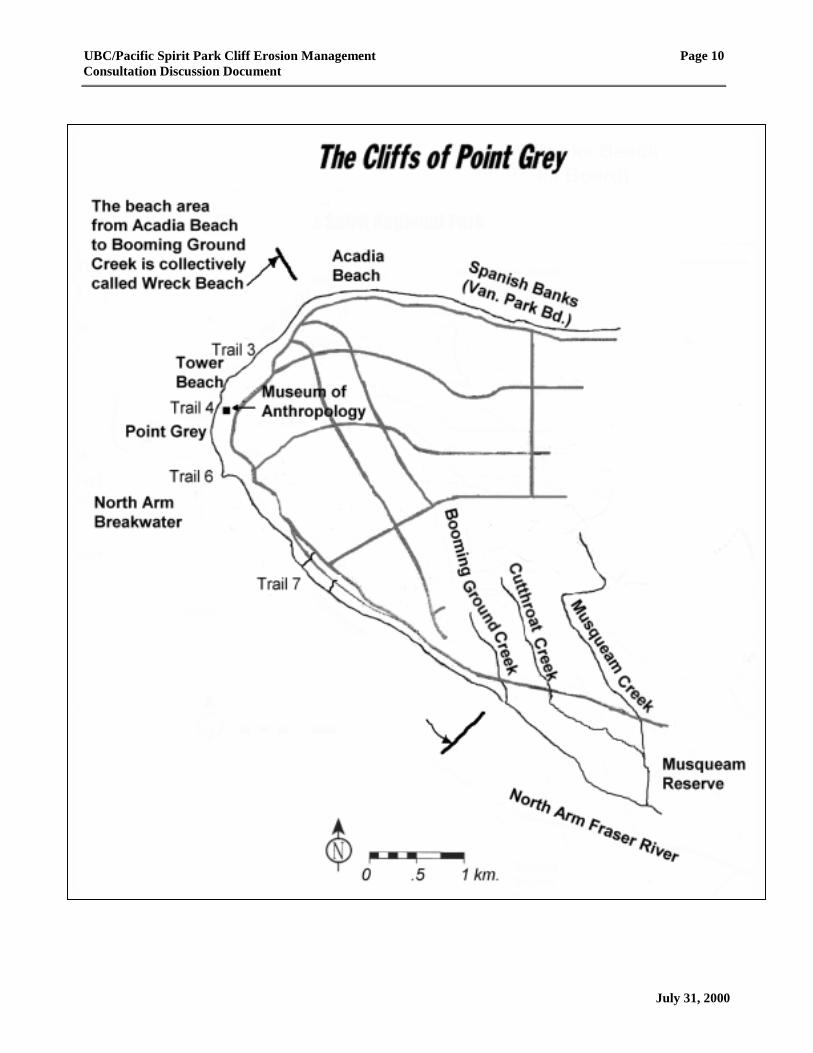
UBC/Pacific Spirit Park Cliff Erosion Management Page 10Consultation Discussion Document
July 31, 2000
UBC/Pacific Spirit Park Cliff Erosion Management Page 11Consultation Discussion Document
July 31, 2000
Management Framework
The plan that is adopted for managing cliff erosion will unfold over a lengthy time frame. It is likely thatsome issues will need to be addressed before others. In recognition of the varying time frames and parts ofthe escarpment, it is important that there be a clear management framework to guide any actions that mightbe taken and decisions into the future. The final management framework for the cliff area will becomprised of an overall objective, principles (governing policies) and values (important aspects forconsideration in decision making) to be agreed to by the Musqueam and UBC and approved by the GVRDBoard of Directors. The following is presented as an initial framework for consideration during theconsultation and management plan development phases.
ObjectiveThe main objective of this process is to find acceptable and affordable ways to manage the causes ofcliff erosion.
The cliff erosion management plan is intended to accomplish the following:
• Protect the cultural and archaeological resources of the area from damage due to cliff erosion(i.e. manage erosion threat and development of the cliffs in a manner that protects the culturaland archaeological resources);
• Preserve the wilderness-like setting of the foreshore;
• Mitigate the threat of damage from cliff erosion to UBC assets and property;
• Reduce embankment spills and fallen trees across the beach and access paths to increase safetyfor people near the cliff tops and those using the beaches; and
• Mitigate erosion threat to Marine Drive.
Principles1. All other UBC and GVRD planning activities which may have an impact on Point Grey cliff
erosion will be integrated with the cliff erosion management plan.
2. Once the cliff erosion management plan is completed, the UBC Official Community Plan(Electoral Area A) will be reviewed and, where necessary, recommendations forwarded to theGVRD Board to adjust the OCP to minimize the causes of cliff erosion.
3. Any actions taken will be in accordance with UBC’s policies and regulations and will ensurepreservation of UBC assets and lands to the extent possible given the current state of the cliffs.
4. Any actions taken will be in accordance with GVRD Regional Park policy and regulations, GVRDParks Department philosophy and management style and, where appropriate, fall within thestaffing and funding capability of GVRD Parks Department.
5. Any actions taken will be done in accordance with the government’s duties of consultation withaboriginal people. This consultation will include and not be limited to matters dealing withidentified and unidentified cultural resources of the area.
6. Any actions to manage cliff erosion will be done considering advisory input from stakeholdergroups, members of the public and other relevant agencies. An ongoing advisory committee willbe established to facilitate gathering this input.
7. Any action taken will not interfere with the recreational values of Wreck Beach regarding clothing–optional sunbathing and swimming.
8. Any actions taken will maintain the current condition of not being able to view buildings from thebeach or vice versa.

UBC/Pacific Spirit Park Cliff Erosion Management Page 12Consultation Discussion Document
July 31, 2000
9. Any actions taken must take into account the preservation of the beach as a whole in nearly anatural state as possible.
Values1. The cliffs have important cultural and archaeological value to the Musqueam First Nation that
must be respected and preserved.
2. While minimizing cliff erosion will likely call for ecological management, the flora and fauna ofthe escarpment should be preserved to the greatest extent possible.
3. Any actions taken must integrate with the campus community design.
Recent HistoryPre 1858 The area is part of the Musqueam territory.
1858 The colony of B.C. was created in response to the rapid influx of miners and settlers during theFraser River gold rush
1865 -1923
The initial principal uses of this area during early days of settlement were military defense andlogging.
1928 Land clearing for UBC was started; brick, tile, sand, gravel, stone, cement and other buildingmaterials were brought to Wreck Beach by barge and hauled up the cliff embankments.
1930 A dairy farm was established on the lands above Acadia Beach. Around this time, initialrecreational use was made of this area.
1935 A major storm water overflow from the north end of campus eroded a new deep gully adjacent toGraham house (Green College) requiring massive in-filling.
1936 The spiral drain at the rear of the Coach House was constructed to handle storm water run-off thatcould be expected from a storm event with a return period of once every ten years.
1939 Searchlight towers were placed on the beach, gun towers were put on the cliff tops and barrackswere erected above Point Grey as part of World War II defences; pathways were constructed toconnect these installations.
1953 The North Fraser Harbour Commission installed a breakwater on the North Arm of the FraserRiver across from Wreck Beach to protect river moorage and log booms.
1974 A short section of experimental beach berm was constructed to reduce the erosion of WreckBeach and toe erosion of the cliffs.
1977 Bulldozing and dredging deposition on the foreshore permanently altered the shoreline.
1979 A UBC Cliff Erosion Task Force identified the following priorities for action.Priority 1 included: removal of damaged trees; barriers to unwanted access, better signing andimproved access (particularly Trail 4); planting and fertilizing to stabilize the slopes; andrestructuring the storm drain. An advisory group was struck to help with the implementation ofthese actions.Priority 2 included: reclaiming washouts as per Graham’s Ravine; beach “defenses”; sandreplenishment; a North Arm Breakwater; surface water control; and subsurface (i.e. old drainagesystems) control.An informational program was also suggested to accompany any actions taken.
1981 A second phase of beach berm and drift sill work was started in accordance with principlesestablished in the 1979 public process.

UBC/Pacific Spirit Park Cliff Erosion Management Page 13Consultation Discussion Document
July 31, 2000
1987 Extensions to the Public Works Canada’s breakwater on the North Arm of the Fraser River weremade to further protect log booms and small craft in the Fisherman’s Mooring Basin. This has hadthe unintended consequence of a faster in-fill rate in the Point Grey booming grounds anddeposition of river silt on Wreck Beach.
1989 The province transferred part of the University Endowment Lands to the GVRD for designationas Pacific Spirit Regional Park. The Musqueam had previously commenced legal action claimingan existing aboriginal title to the area and objected to the transfer. The transfer was made withoutprejudice to Musqueam aboriginal rights and title.
1991 A management plan was adopted for Pacific Spirit Regional Park in which the cliff area was ratedas an Environmental Protection Zone with access prohibited except by designated trails. The planupheld the status of Wreck Beach as a clothing-optional area from Acadia Beach (Mile Marker,wood bridge just west of Acadia parking lot) to Booming Ground Creek. No consultation processwith the Musqueam had been developed or implemented.
1997 The GVRD Board approved the Official Community Plan (OCP) for Part of Electoral Area “A”(UBC and part of Pacific Spirit Regional Park).
1998 UBC has commissioned a small hydrological study re pipe installation on NW Marine Drive.
The Musqueam, UBC and GVRD have agreed to embark on a planning process (as described inthis Discussion Document) as the basis for the development of a long term approach tominimizing cliff erosion.
Causes of Cliff ErosionErosion of the cliffs is both a natural and anthropogenic (humanly affected) phenomena. The slopes havebeen eroding since the last Ice Age left these formations. However, since the area has grown in population,human activities and development have had a greater impact. At the same time, the desirability of this areafor human use and enjoyment has also grown.
The erosion in the following pictures has a variety of causes. Primarily these are shoreline erosion fromtides and storms, vegetative uprooting and the forces of gravity, hydrological or groundwater forces,stormwater runoff and human activities.
1968 – Low tide showing logs which hit the cliff4 feet higher at high tide
1968 – Trees and roots on beach as a result oftoe erosion
UBC/Pacific Spirit Park Cliff Erosion Management Page 14Consultation Discussion Document
1998 – Cliffs belowMuseum andMackenzie House
1974 Cliffs below Museum be
1976 Cliffs below Cecil Green Drive and Museum gr
July 31, 2000fore and after re-vegetation 1992
ounds before and after re-vegetation 1992
UBC/Pacific Spirit Park Cliff Erosion Management Page 15Consultation Discussion Document
July 31, 2000
1998 – View ofcliffs at CecilGreen House –note deep gully atright
There are many causes of erosion of the cliffs. These include shoreline erosion, uprooting of trees,stormwater, groundwater, weather and human activities. Each of these causes is briefly described below.
Shoreline Erosion⇒ The berm and drift sill protection works erected in 1981 were evaluated in 1992 for effectiveness. The
consultant’s review indicated that most of the work had held up well and had been effective inreducing or eliminating shoreline erosion. Some maintenance work was required, particularly at thenorthern end. Presently, the berm is almost gone in areas of Tower Beach. Much of the cliff baseremains exposed to this day and it was also noted that the areas left unprotected had suffered continualdamaging erosion. Much of this erosion is due to littoral drift (wave scour aided by logs pounding thecliff toe) at high tide and during storms.
Uprooting of Trees⇒ Fast growing but short lived deciduous trees such as alder (40-60 years) can accelerate erosion of the
cliffs by uprooting. Older large alder trees with wide crowns often lean outward from the cliff andthese trees are susceptible to wind throw. This happens when the upper weight of the tree causes thetree to topple. When this occurs the trees root system pulls away a significant amount of soil creating acavity and exposing the cliff’s sub soils. These sub soils that are then exposed to the rain and otherweather elements can become accelerated pockets of cliff erosion. (Note, the relationship betweenvegetation and erosion needs further study – see proposed actions for vegetation on page 22 of thisdocument).
Hydrological and Stormwater⇒ A study of the existing stormwater collection and discharge systems has recently concluded that the
maximum storm water run-off that can be handled for the development projected in the OfficialCommunity Plan approximates to a storm event whose return period is once every ten to twenty years.A study is under way to more precisely determine the system capacity. Once this study is completed,considerations will need to be made regarding the level of protection required for avoiding erosionfrom storm water flowing over the cliff edge.

UBC/Pacific Spirit Park Cliff Erosion Management Page 16Consultation Discussion Document
July 31, 2000
Hydrogeological⇒ The mixed layers of permeable sand and slowly permeable clays concentrate weeping from the cliff
face. This cliff face seepage is a source of erosion.
Winter Freeze and Thaw⇒ Winter conditions that bring heavy freezes lasting for a period of a week or more can accelerate cliff
erosion. When the exposed sand surfaces freeze, erosion occurs in two ways. Freezing can expand thesurface and force slabs of frozen cliff material to fall. Also, after a heavy freeze is over and thawingoccurs, surface materials loosen and fall.
Wind and Rain⇒ Off shore winds and rain cause an ongoing, low level erosion of exposed cliffs. When conditions are
dry, winds erode areas of exposed sand and during wet weather, rain beating on exposed areas of thecliff cause further erosion. The extent of these effects are not well understood.
Human Activities⇒ Early logging activities, initial construction of UBC, war time construction of towers and tunnels all
have been significant early human causes of erosion. In more recent times, the Point Grey cliffs havebeen and remain an attraction both to residents of the region and tourists. Construction on the UBCcampus has been ongoing. Prior to beach trail construction, access to the beach over the cliffs was asignificant cause of cliff erosion. Construction of Trails #7, #6, #4, and #3 has helped to protect thecliffs from this activity. Human activities such as cliff climbing, development of scatter trails,tunneling, sculpting, vegetation removal, camping and ineffective vegetation irrigation practicesremain a threat to the cliffs.
Planning ConsiderationsIn addition to determining the effectiveness of the various options addressing cliff erosion, there are severalother key considerations that must be taken into account in deciding whether the cliff stabilization /management option is desirable. These other planning considerations are noted below.
Musqueam Aboriginal Rights and Title⇒ The area is part of the traditional territory of the Musqueam First Nation who have lived, hunted and
fished here for several thousand years. As with other B.C. First Nations, the Musqueam have neversurrendered their aboriginal rights and title to the Crown. They are currently engaged in treatydiscussions as part of the B.C. Treaty Process. The area is of spiritual, cultural and archaeologicalimportance. There are important sites of ethnographic significance to the Musqueam along the cliffsand beach.
⇒ Musqueam’s aboriginal interests in the area mean that consultation with the Musqueam will berequired with respect to any action that might prejudicially impact on their interests. All work musttake into account the importance of Musqueam interests prior to undertaking any mitigationprocedures. Systematic archaeological investigation in partnership with the Musqueam will be requiredto ensure that mitigation works will not damage or destroy identified or as yet unidentifiedarchaeological sites or interfere with Musqueam use of and access to this area.

UBC/Pacific Spirit Park Cliff Erosion Management Page 17Consultation Discussion Document
July 31, 2000
⇒ In 1989, the GVRD received title to the lands from the province. GVRD swore an affidavit in theSupreme Court of B.C. that stated they accepted the transfer without prejudice to the aboriginal rightsand title claimed by the Musqueam in its lawsuit.
Official Community Plan⇒ The Official Community Plan (OCP) for Electoral Area “A” includes specific policies for the “North
Campus”. These policies include requirements for an area planning process prior to further institutionaland non-institutional development and hydrological studies prior to further development that sets theprotection of Pacific Spirit Regional Park as a priority objective.
Other Agencies’ Land Use Plans⇒ The North Fraser Port Authority is developing a land use plan which will take into account the
environmental, economic and social implications of all land use planning and development decisionswhich occur in the NFPA’s jurisdiction. Since this jurisdiction includes foreshore areas of the clifferosion management planning area, it will be important to ensure that these two plans are compatibleand coordinated.
⇒ Fraser River Estuary Management Program (FREMP) is a partnership of federal, provincial andregional government bodies established to foster coordinated management activities in the LowerFraser River. FREMP has an estuary management plan which addresses the Fraser River estuary andincludes a vision, goals and action plan for improving the environmental, economic and social healthof the estuary.
⇒ Burrard Inlet Environmental Action Program (BIEAP) is a partnership of federal, provincial andregional government bodies established to foster coordinated management activities in Burrard Inlet.Their focus includes the foreshore areas within the cliff erosion management Planning Area C.
⇒ Any work that has the potential to affect the intertidal or subtidal areas of the estuary or the inlet mustbe reviewed by those members of FREMP’s Environmental Review Committee (ERC) or by theBurrard Inlet Environmental Review Committee (BERC) who have jurisdictional authority. Thesecommittees have been established to provide proponents with a coordinated environmental reviewprocess of applications to be handled in a timely manner.
Acadia Beach Boundary Interface Spanish Banks West (City ofVancouver)⇒ The property immediately to the east of the planning area and adjoining Acadia Beach is within the
boundaries of the City of Vancouver. This beach area is called "Spanish Banks West" and is operatedby the Vancouver Parks Board. Spanish Banks West is operated as a clothed only swim beach.Vancouver Parks Board has adopted a different style of beach management than that of GVRD Parksfor Pacific Spirit Regional Park. Contact with Vancouver Parks Board on planning to minimize clifferosion is necessary to ensure appropriate treatment along property boundaries.
Vegetation⇒ A 1985 vegetation survey indicated that the principal vegetation in the cliff areas consisted of big leaf
maple, spring wood fern, bitter cherry, willow and trailing blackberry.
⇒ In 1992 a further survey of cliff vegetation was carried out by a former UBC academic who wasresponsible for the extensive planting programs during the seventies. The survey focused on the area inwhich planting had taken place and revealed considerable improvement to the cliff face stability, ormore precisely, to the ability to withstand erosive forces. Species such as black locust and birchflourished in areas crowding out the short-lived alder.

UBC/Pacific Spirit Park Cliff Erosion Management Page 18Consultation Discussion Document
July 31, 2000
⇒ In 1994, a park volunteer developed a vegetation survey of the area noting 129 separate plant species.The Pacific Spirit Park Society Vegetation Committee makes suggestions regarding maintenance orchanges to vegetation management.
Habitat and Wildlife⇒ The extensive forest edge and diversity of the Park’s flora contributes to fauna species diversity. The
upland streams, marshes and Camosun Bog also contribute to the food chain of the Park's wildlife bysupporting large, year-round insect populations. The different forest types also provide fruit, seeds andbulbs. Decaying logs, dead trees and a variety of vegetative cover types provide a wide diversity inwildlife habitat. The largest heronry in the Lower Mainland is situated in the park uplands aboveWreck Beach.
⇒ The Fraser River estuary (where salt and fresh water meet) and its associated tidal flats are productivefeeding areas for many of the birds of the area. The Fraser River is the largest salmon-bearing river onthe west coast of North America. The estuary is crucial as a transition zone, allowing juvenile salmonto acclimate to sea water on their way from upstream hatching areas and adult salmon to acclimate tofresh water on their return from the ocean. The marshes provide valuable habitat for salmonids whichmust be protected from damage.
⇒ The intertidal areas of Point Grey and Spanish Banks are very productive and provide valuable fish andwater bird habitat.
Viewscapes⇒ Demolition of the student residence (Fort Camp) and subsequent construction of the Museum of
Anthropology over a quarter of a century ago afforded the University the opportunity to raise theaesthetic level of landscaping. This also improved public access to the Howe Sound viewscape to thenorth that is comprised of water, trees, beaches and the Tantalus Mountain Range. It has becomeevident that many visitors enjoy not only the tranquility of the setting but the fine views. Many peoplebelieve that it is highly desirable to preserve view corridors that highlight the maritime environmentwhile protecting the natural seclusion afforded park visitors below the cliff tops and protecting cliffintegrity. The preservation of current views is a planning consideration for Planning Area B.
Greenway⇒ Greenways have become an important element integrating natural and urban spaces. The natural spaces
including Wreck Beach, Pacific Spirit Regional Park and UEL lands hold the possibility of extendingVancouver greenways to the north and the south of the university and the park. The need for and theform of such a use is a planning consideration.
Museum of Anthropology⇒ The architectural vision for the Museum of Anthropology grounds was to integrate the interior exhibits
and the exterior landscape as a whole experience. First Nations cultural materials displayed within theGreat Hall were to relate harmoniously to the surrounding landscaped Haida village and view of thesea. The original concept included a large, shallow reflecting pool. The pool was constructed but itspresence was considered a potential danger to the stability of the cliffs and so it has only containedwater on a few ceremonial occasions and normally remains unfilled. Currently the Museum isundergoing an assessment of its needs for the next generation. The Museum has requested that aschedule of activities for the second phase of the cliff erosion management planning process beprovided to facilitate their own planning activities.
UBC/Pacific Spirit Park Cliff Erosion Management Page 19Consultation Discussion Document
July 31, 2000
Infrastructure (North Side of Marine Drive)⇒ Cecil Green House and Coach House are both effected by erosion. A storm in 1994 caused significant
erosion directly adjacent to the Coach House and another storm in 1997 furthered the erosion. Thesebuildings have considerable historical value and their location above the cliffs is a cause for concern.
⇒ The University has a number of other assets in this area including Green College, Norman McKenzieHouse (which serves as the residence for UBC’s President) and the Parking and Security Offices. Clifferosion threatens each of these to some degree.
⇒ The Greater Vancouver Sewerage and Drainage District owns and operates the spiral drain which isdesigned to handle minor drainage for the 10 year return period storm. This drain is located near to themuseum.
⇒ A major trunk sewer was recently constructed on the cliff side of Marine Drive, skirting the UEL andUBC.
⇒ BC Tel has a building near the top of Trail 5.
Provincial Highways⇒ Marine Drive skirts the cliffs in two locations within the planning area under consideration. Marine
Drive adjacent to the west side of the University between gates 4 and 6, is only separated from the cliffedge by a concrete barrier curb and footpath. The cliff in this location is currently not actively beingeroded. NW Marine Drive adjacent to the University Endowment Lands between ChancellorBoulevard and Spanish Banks is currently subjected to direct erosion. The closeness of the cliff face atthe intersection of Wesbrook Mall and NW Marine to the cliff is a potential threat to the medium tolong term use of the road. The erosion situation further down the road where the cliff face abutsVancouver Parks Board property is relatively more stable. However, the path adjacent to the concretebarrier curb is narrow and in one place almost lost to the cliff slope.
⇒ Marine Drive in this area serves mainly as a collector for the University Endowment lands and as arecreational cycle and sightseeing route, it is not a regional connector or a strategic arterial. The pathadjacent to the road on the cliff side is highly valued as a walking and jogging route. Many cyclistsalso prefer to use the path rather than Marine Drive.
Earthquake Preparation⇒ Since this area has earthquake potential, any possible erosion control actions must include
consideration of the effects of earthquakes. UBC has undertaken earthquake studies of buildingslocated in the planning area. Also, buildings constructed in the last two decades have includedconsideration of earthquake potential when determining where these buildings should be situated.
Safety⇒ As one of the few remaining natural shorelines in the Region, the Pacific Spirit Regional Park
shoreline attracts many visitors. Estimated annual visitation for Wreck Beach is 150,000 while annualvisitation to Pacific Spirit Park is estimated at 650,000 (1998 projection). Beach use occurs daily,irrespective of the season. While no formal shoreline trail exists, public passage along the shoreline ispopular. There are inherent dangers when visiting parks with natural landscapes and vegetation,GVRD is responsible for the park and has a responsibility to provide safe parks. UBC is alsoconcerned with the safety of visitors on its property. Safety measures include area patrols (jointRCMP/GVRD), trimming of undergrowth along paths, repairs to the cliff face and posting of warningnotices of the danger related to the cliffs. A reasonable balance has to be reached between excessivesafety measures and visual harmony - for example, the cliff-top fence impedes the viewscape.

UBC/Pacific Spirit Park Cliff Erosion Management Page 20Consultation Discussion Document
July 31, 2000
⇒ At this time, lighting on the grounds is avoided to discourage nighttime activity on the cliff and beachbelow while allowing viewing from the University Flagpole Plaza of a nighttime sky to the northunpolluted by artificial light. Artificial light also has a negative impact on nocturnal birds that utilizethe darkness for hunting activities.
Public Access⇒ The north campus contains some of the great public spaces at UBC. Pacific Spirit Park's beach area
below the cliffs is clearly a unique regional resource. The University and the GVRD endorse bothcampus users and park visitors having access to park beaches.
⇒ The environmentally and archaeologically sensitive nature of the cliffs require some control of publicaccess. One particular concern is the avoidance of erosion caused by people climbing the cliffs. Thedemand for natural and scenic filming locations in Greater Vancouver has led to proposals for such ause in the Wreck Beach area.
⇒ It is important to include accessibility to viewscapes for non-ambulatory persons.
Wreck Beach Use⇒ Wreck Beach is a clothing optional beach from Acadia Beach to Booming Ground Creek. Some areas
of the beach have been used in this way since the 1920’s.
Fisheries⇒ Recreational fishing occurs at various times through the year along the shoreline immediately at the
base of the cliffs. The smelt fishery is the most practiced fishery in this area but is closed between June15 and August 15, to coincide with the peak smelt spawning period. Smelt fishers may move rock onthe beach to weigh down nets and use driftwood to light fires. Dungeness crabs are also harvested inthis area. Anything that adds to silting negatively effects this species. Activities that negatively affectthe smelt spawning or crab harvesting must be avoided.
Log Storage⇒ The log booming grounds in the brackish waters of the North Arm of the Fraser River adjacent to the
Musqueam lands provide protection to logs from damage from saltwater organisms. These booms alsoact as natural barriers to dampen boat wakes and storm surges which in turn protect the shoreline areabehind the booms.
Development Proposals⇒ With the planning area being discussed including large tracts of undeveloped lands and being
positioned next to a major urban setting, it is understandable that development proposals for this areawill be made. In the past, proposals have included restaurants, barge facilities, roads (including atrucking route) and bridges. It is critical that any future consideration of such proposals takes place inthe context of the overall cliff erosion management plan that will be developed as a result of theprocess described in this document.

UBC/Pacific Spirit Park Cliff Erosion Management Page 21Consultation Discussion Document
July31, 2000
Options for Consideration in the Management PlanThe potential actions for consideration to include in a Cliff Erosion Management Plan that are presentedin this section were developed through a series of public workshops and meetings held betweenNovember 1999 and January 2000. In some parts of this section, there are a number of possible optionsthat indicate choices for moving forward on a potential action while in other cases, only one course ofaction is presented as no viable options were identified.
This document is inclusive of all ideas put forward. These include some that are relevant for the entireplanning area and others that are site specific. You are asked to review these potential actions andprovide your comments by September 22, 2000. Following this, decision makers will be supplied withall the input received during the public consultation prior to their decisions on what plan to support.
Potential actions that have a general application for the planning area have been noted using thefollowing headings:
A. Drainage
B. Ground Water (hydrogeology)
C. Vegetation
D. Berm and Drift Sill Maintenance
Other potential actions have been noted for priority sites. These include:
E. Mackenzie House
F. Museum of Anthropology
G. Coach House Area
H. Cecil Green
I. General Cliff Protection in the Museum of Anthropology, Cecil Green Area
J. North West Marine Drive at Wesbrook Crescent
K. Booming Ground Creek, Botanical Garden Creek and Trail 7 Creek
L. Point Grey
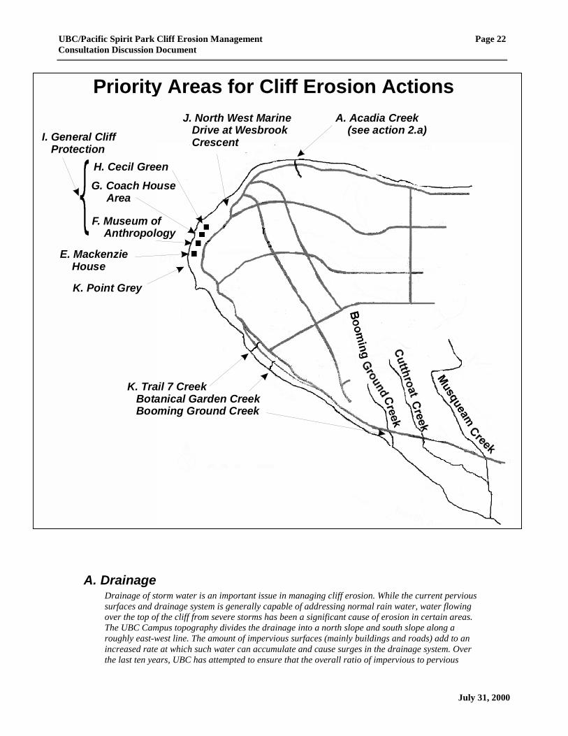
Each of these priority sites has been highlighted in a map on the following page.
A final section notes overall planning considerations that need to be taken into account to ensure thatthis plan can be managed (i.e. sustainable and integrated with other planning initiatives).
M. Overall Management Plan Considerations
UBC/Pacific Spirit Park Cliff Erosion Management Page 22Consultation Discussion Document
Priority Areas for Cliff Erosion Actions
July 31, 2000
A. DrainageDrainage of storm water is an important issue in managing cliff erosion. While the current pervioussurfaces and drainage system is generally capable of addressing normal rain water, water flowingover the top of the cliff from severe storms has been a significant cause of erosion in certain areas.The UBC Campus topography divides the drainage into a north slope and south slope along aroughly east-west line. The amount of impervious surfaces (mainly buildings and roads) add to anincreased rate at which such water can accumulate and cause surges in the drainage system. Overthe last ten years, UBC has attempted to ensure that the overall ratio of impervious to pervious
E. Mackenzie House
F. Museum of Anthropology
G. Coach House Area
H. Cecil Green
J. North West Marine Drive at Wesbrook Crescent
K. Trail 7 Creek
Booming Ground Creek
Botanical Garden Creek
K. Point Grey
I. General Cliff Protection
A. Acadia Creek (see action 2.a)

UBC/Pacific Spirit Park Cliff Erosion Management Page 23Consultation Discussion Document
July 31, 2000
surfaces in the North Campus stays about the same. At this time, while the South Campus remainslargely undeveloped, planned development may alter this ratio and the pattern of drainage. Throughdevelopment, many of the creeks in the South Campus have been altered during the last 30 years,causing changes to the previous natural drainage. Creeks in this area that have been affected includeBooming Ground Creek, Botanical Garden Creek and Trail 7 Creek.
The drainage system in the North Campus was designed for a ten year return storm. While upgradesto the collection and delivery system have improved the overall performance of the drainage system,the capacity of the spiral drain that routes this water through a vertical pipe behind the cliff face(behind the Coach House and Museum of Anthropology) and out into the ocean is for the ten yearreturn storm.
Possible actions to address general drainage issues include:
1. Conduct drainage study of the South Campus including consideration of:
a) Retention ponds in South Campus to reduce peak storm discharge
b) Sustainable development principles using recycled rain water
c) Possible diversion of storm waters into creeks and bogs
d) Erosion protection in the creeks where they emerge after flowing under Marine Drive(See Booming Ground Creek and Trail 7 Section later in the document)
e) Adoption of a policy requiring a comprehensive storm water mitigation plan for anypossible further development of the South Campus
2. Continue studying and/or improving the drainage system on the North Campus including:
a) Diversion of exceptional storm water flows to the bottom of the Marine Drive hill atSpanish Banks via Acadia Creek
b) Improve the drainage at the rear of the Coach House to increase the system capacity togreater than the ten year return storm using one of the following options:
OPTION 1 - Install an erosion resistant but natural, aesthetically pleasing creek fordrainage through Graham’s Gully
OPTION 2 - Investigate the possibility of reactivating the previous (and now unused)inclined drain behind Cecil Green House; this has a relatively low drainage capacityapproximately one foot in diameter
OPTION 3 - Bore a new additional drain with more drainage capacity (than the currentlyunused and low capacity drain in Option 2) at back of Cecil Green House
c) Determine existing facilities that might be used for storm water retention (e.g. parkadesand surface car parks, low lying playing fields)
d) Adopt design criteria for new buildings to include added capacity for storm waterretention (e.g. moats, dry ponds, flat roofs, car parks, etc.)
B. Ground Water (Hydrogeology)Water exists in the ground due to surface seepage to the underground water table. The geologicalcomposition of Point Grey consists largely of a top layer of slowly permeable glacial till underlain bya porous but very stable layer of Quadra sand. Through this thick layer are thin layers of clay thatare also slowly pervious. It is these layers of clay that block accumulated ground water and causedrainage to the cliff face. One of these clay layers can be seen at the north end of the cliffs at anelevation of about 20 meters. This layer slopes roughly in a southwest direction. The significance ofthis layer is that accumulated ground water seeps out of the cliff face leading to cliff face erosion.Over the years, various bore holes and wells have been dug on the campus that have led to a general
UBC/Pacific Spirit Park Cliff Erosion Management Page 24Consultation Discussion Document
July 31, 2000
understanding of the hydrogeology of this area but there is still not a clear understanding of theamounts or paths of ground water.
Possible actions to address ground water include:
1. Conduct a hydrogeological survey with a number of new locations to gather information (e.g.water flow characteristics) on ground water (in addition to information available from existingdrill holes) to provide a more complete picture together with previous data – could use drillholes or geophysics (e.g. can test electrical resistance of the ground or use ground penetratingradar)
2. Conduct specific studies at key problem areas including:
a) Cecil Green Coach House
b) North West Marine Drive
3. Survey seepage of water at the cliff face and streams emerging from the toe of the cliff
4. Study technical solutions from other areas to see what has been successful
5. Review buildings and services north of Marine Drive constructed prior to the UBCrequirement to control storm water seepage next to the foundation to determine if additionalcontrols might be required that are technically feasible, sustainable and financially reasonable
C. VegetationOriginally, the cliff slopes were largely treed but some logging and other historical uses have alteredthis vegetation. Now, on many slopes, vegetation remains an important element helping to stabilizecliff slopes. In many places, alders and other fast growing species aid stabilization in their earlyyears. Previous slope stabilization efforts have included re-vegetation initiatives and these havecurrently stabilized portions of the cliff face although precise records of effectiveness have not beenkept.
NOTE 1 – different areas of the cliff have different stabilization needs – vegetation may not beappropriate in all areas
NOTE 2 – On July 28, 2000, the GVRD Board approved recommendations for priority work (thedesign was evaluated through a stakeholder consultation) and the following actions are currentlyunder way:
⇒ In the area immediately to the west of the Coach House, a berm is being created to help retainexcess surface water runoff from up to a 1 in 70 year return period storm from reaching thecliff edge
⇒ Below the Coach House, the top part of the cliff is being filled in using materials withinterlocking properties to increase adhesion to the current slope and re-vegetation to help bindthe soil
Possible actions to address vegetation issues include:
1. Conduct a more detailed survey of previously re-vegetated areas to determine success levels
2. Research other similar cliff situations to determine what vegetation approaches were mostsuccessful
3. Identify the range of plants most suitable for re-vegetation efforts on the cliffs in site specificareas with a preference for indigenous plants
4. Specify areas where the exposed cliffs are relatively stable and/or where natural erosionprocesses will not threaten safety, UBC buildings or other important infrastructure forallowing natural processes to prevail
UBC/Pacific Spirit Park Cliff Erosion Management Page 25Consultation Discussion Document
July 31, 2000
5. Establish test area(s) to determine optimal conditions for successful re-vegetation (includingdifferent slope conditions and cliff elevations)
6. Ensure that effects on current vegetation are taken into account in any plans that will alterground water or drainage
7. Initiate a tree management program in sensitive areas to control those large trees that mayuproot and cause further slope erosion
a) Conduct a long term study to determine the impact of various tree species on slopestability
b) Develop an appropriate tree management program designed to maximize slope stability
D. Berm and Drift Sill MaintenanceMaintaining the integrity of the toe of the cliff is one of the keys to ensuring that the base does notcontinue to erode. In 1981/82, actions were taken to protect the shoreline north of Point Grey. Thisaction consisted of the construction of rock drift sills (rock “fingers” that extend perpendicular fromthe shore line) with the addition of rocks and gravel between these to form a berm at the base of thecliff. Survey work in 1991 indicated that the drift sills have been quite stable and the berm materialhas behaved as expected, migrating slowly down the beach between the sills due to prevailing winds,tidal currents and Fraser River outflow. The engineering specifications for this work called formaintenance on a ten year cycle but to date, no maintenance has taken place. Visual inspection of thebeach works indicate that the sills and berms are still providing essential protection but are no longeroptimal in providing some of the recreational values on the beach. While beaches generally areformed from natural deposition of materials to replenish the beach, Wreck Beach deposition has beenaltered due to the construction of jetties for the protection of log booms and marine transportation inthe North Arm of the Fraser River. Dredging of marine transportation channels in the North Arm ofthe Fraser River has also contributed to changes in natural sand deposition.
Possible actions to address berm and drift sills include:
1. Consult Musqueam, Department of Fisheries and Oceans, Ministry of Environment, NorthFraser Port Authority, GVRD Regional Parks, Wreck Beach Preservation Society and otherpark and beach groups to:
a) Identify areas in addition to those currently protected for which toe protection might berequired (additional berm or sill works)
b) Determine criteria for beach design in areas requiring protection but not currentlyprotected as well as for those areas in which berm and sill works currently exist
2. Design desired beach characteristics (include toe protection, recreation values and fish/aquatichabitat concerns at the initial planning stages)
3. Update the survey to the 1981/82 sills and berm to determine where further erosion hasoccurred (including cobble lost, current sill elevation, habitat and vegetation and fast ferryeffects on beach).
4. Re-design profile of the sills to:
a) Reduce elevation where possible
b) Improve access on side slopes
c) Reduce bypassing of sand and cobble down the beach
d) Provide fish habitat (tidal pools)
e) Achieve recreational values

UBC/Pacific Spirit Park Cliff Erosion Management Page 26Consultation Discussion Document
July 31, 2000
5. Explore feasibility and possible effectiveness of creating a spit and lagoon to protect the clifftoe (e.g. possibly a calm water area near Trail 4 to enhance swimming area)
6. Install stub sills or increase existing sill length to:
a) Optimize with respect to additional sill lengths and new cobble material
b) Re-align outer ends to improve efficiency
7. Add beach materials as required:
a) Coarse gravel between Towers 1 and 2 (2” minus)
b) Finer gravel south of Tower 2 (minimum size 1 mm sand)
c) Additional sand/fine materials above the berm crest to enhance the recreational area ofthe beach
E. Mackenzie HouseMackenzie House, residence of the President of UBC, is located above the cliff top near Trail 4. Inthe past, lawn and garden maintenance work on the cliff side of this facility contributed to watergoing over the cliff top edge which contributed to erosion. These irrigation practices have beenmodified, reducing this cause of erosion.
Possible actions to take at Mackenzie House include:
1. Investigate the need to further reduce any effects caused by the need for watering and, ifappropriate, consider the benefits of redeveloping the cliff side garden landscape based onwater conservation principles
F. Museum of AnthropologyThe Museum of Anthropology (MOA) is located above the cliff top adjacent to Cecil Green House andthe Coach House. The spiral drain which is a primary means of ensuring North Campus drain waterdoes not go over the cliff top, is located adjacent to MOA. Geotechnical engineers have given theirprofessional assurances that MOA is not threatened by cliff erosion. They have also determined thatthe Museum does not contribute directly to cliff erosion. However, with discussions taking placeregarding possible expansion of this facility, members of the public have raised concerns that anychanges to this structure may have an adverse impact on the cliffs.
Possible actions to take with regards to MOA include:
1. Obtain further professional input regarding any potential cliff related problems (e.g. stabilityof the soils related to construction activity and possible development) should UBC decide toproceed with development plans at this site.
G. Coach House AreaThe Coach House is a heritage structure that was part of the original Cecil Green House. This area islocated adjacent to the spiral drain and is one of the low points for drainage from parts of the NorthCampus. Severe storm events that the drainage system was unable to handle over the last number ofyears have resulted in storm waters overflowing the top of the cliff and washing out a gully. Theerosion is close enough to the Coach House that the facility cannot be used at this time.Improvements to the intake of the spiral drain and storm water collection system have added to theprotection of the area. However, the cliffs, the Coach House and spiral drain remain potentiallythreatened by an overwhelming storm event.
NOTE –Through the process leading up to this consultation, this site was identified as an area thatcould possibly require priority action. UBC applied to the GVRD Park Committee for approval to
UBC/Pacific Spirit Park Cliff Erosion Management Page 27Consultation Discussion Document
July 31, 2000
proceed with such action prior to the development of a comprehensive cliff erosion management plan.After working together with a stakeholder committee (Project Design and Implementation Committee)and consultants, a final design for work was submitted by UBC to the GVRD. On July 28, 2000, theGVRD Board approved recommendations to conduct the actions for priority work in this area; thefollowing work is now under way:
⇒ In the area immediately to the west of the Coach House, a berm is being created to help retainexcess surface water runoff from up to a 1 in 70 year return period storm from reaching thecliff edge
⇒ Below the Coach House, the top part of the cliff is being filled in using materials withinterlocking properties to increase adhesion to the current slope and re-vegetation to help bindthe soil
Possible actions to take to protect the Coach House itself include:
1. Take action to protect the Coach House considering one of the following options:
OPTION 1 - Investigate engineering solutions designed specifically to protect the CoachHouse in its current location
OPTION 2 - Move the Coach House further from the cliff edge to protect against furtherdamage to the structure from erosion-based causes
OPTION 3 - Do nothing to specifically protect the Coach House while whatever actionsmay be required to protect the spiral drain
H. Cecil GreenPossible actions to protect Cecil Green House include:
1. Investigate the need for protection for Cecil Green and possible engineering or other solutions(e.g. soil anchors, supports, vegetation, etc.)
I. General Cliff Protection in the Cecil Green, MOA areaThe cliffs immediately below the Museum of Anthropology and Cecil Green House are very steep andare sites of ongoing erosion. While all of the main buildings are well back of the cliff, long termerosion concerns have been voiced. The areas below the museum and Cecil Green House have beenfenced off to prevent unauthorized access. Even with the fences, use of unauthorized trails continues,adding to the erosion. These areas also offer significant viewscapes but the views are impaired inplaces by cliff top vegetation. In spots, the ground under the roots of the trees at the top of the cliffhave been eroded and these trees will eventually fall down, taking materials on the cliff along withthem as they fail. While re-vegetation efforts have been carried out on parts of these cliffs in the past,some of this work has been lost while other vegetation has succeeded and is helping minimizeerosion. Seepage of ground water in this area comes out of the cliff face at about the 20 meter leveland this leads to failure of the slope. In 1982, berm work was carried out at the toe of the cliffproviding protection from waves. When installed, engineering specifications called for maintenanceapproximately every 10 years but this work has not been done.
Possible actions to take for protecting the cliff face behind MOA and Cecil Green include:
1. Sink bore holes or wells to control seepage at cliff face
2. Provide new signage in the area to reinforce the necessity to not use this area for illegal access
3. Initiate a program to repair the fence as soon as there is any sign of damage or trespass
4. Use vegetation barriers to dissuade ongoing trespassing at the cliff top and at lower elevations
5. Remove trees at the top edge that are in danger of falling over
UBC/Pacific Spirit Park Cliff Erosion Management Page 28Consultation Discussion Document
July 31, 2000
6. Re-vegetate the slopes where possible
Possible action to take to protect the cliff toe below MOA and Cecil Green House include:
7. Improve berms at the toe of cliff (only where needed to protect the cliffs)
Possible action to take to restore the viewscape behind MOA include:
8. Investigate whether installing a permanent viewing spot will be an effective way to preventpeople from going past the fence barriers to enjoy the cliff top views (in conjunction withimproved signage to designated trails, vegetation barriers and more rigorous fencemaintenance activities)
9. Determine appropriate permanent site(s) where vegetation management and site maintenancewill provide viewscapes for visitors (including non-ambulatory)
J. North West Marine Drive at Wesbrook CrescentThe cliffs immediately to the north of North West Marine Drive at Wesbrook Crescent have eroded towithin 6 meters of the road in this area. A sanitary sewer line (installed 1993-94) runs parallel to theroad on the cliff side at this point; a storm sewer line is situated on the opposite side of the road. Boththe road and the sewer lines face threats if there is ongoing erosion of the cliffs in this area. The mainactual and potential causes of the erosion appear to be seepage of ground water emerging from theface of the cliff, trees on the face of the cliff and insufficient protection to the toe of the cliff fromwaves. It is also possible that storm water could accumulate in the fill material of the sanitary sewerline, contributing to the ground water seepage on the cliff face however tests done to date indicatethat this is not likely a serious threat.
Possible actions to reduce groundwater erosion threats to North West Marine Drive at WesbrookCrescent include:
1. Conduct hydrogeological survey of this area to determine the actual extent of groundwaterand the underground location(s) where this water accumulates
2. Take action to divert ground water currently seeping out of the cliff face using one of thefollowing options:
OPTION 1 - Drill 1-3 wells to intercept ground water that is currently draining on thecliff face and drain this to a lower level that emerges below the cliff toe
OPTION 2 - Drill an inclined bore hole from the beach level to the mid cliff clay strata todrain ground water before it reaches the cliff face
3. Capture and divert storm water which accumulates in the bedding material of the sanitarysewer trenches into the storm water system on the far side of road to eliminate potential buildup of water in trench (contribution to groundwater and possible overflowing over the cliffedge)
Possible actions to take to protect the cliff face at North West Marine Drive and Wesbrook Crescentinclude:
4. Initiate a tree management program to protect from uprooting; perhaps use “stumps” asnatural mechanical anchors for new cribbing system
5. Where appropriate for slope stability, re-vegetate the slope
UBC/Pacific Spirit Park Cliff Erosion Management Page 29Consultation Discussion Document
July 31, 2000
Possible actions to take to protect the cliff toe at North West Marine Drive and Wesbrook Crescentinclude:
6. Carry out berm and/or sill work on the beach to protect the toe of the cliff
Possible actions to take to reduce human causes of erosion at North West Marine Drive andWesbrook Crescent include:
7. Address issue of shortcut trails with fencing and/or vegetation barriers such as blackberry
Other possible actions to take to address erosion threats to North West Marine Drive and WesbrookCrescent include:
8. IF the above measures to protect this area are not feasible or sustainable, relocate MarineDrive and the sanitary sewer lines from this area
K. Booming Ground Creek, Botanical Garden Creek and Trail 7CreekThis area near the south end of the planning area has three creeks (Booming Ground Creek,Botanical Garden Creek and Trail 7 Creek) that provide drainage from the South Campus. The waterfrom each creek is channeled into drainage pipes that go under the roads and emerge on the cliffside. The pipes were installed as part of earlier road construction. The areas adjacent to the ends ofthe drainage pipes and further downstream toward the shoreline have eroded from this water flow. Atthis time, the ends of the pipes in all locations are several meters in the air due to erosion caused bythe water coming out at this height and hitting the ground. The amount of water flowing through thepipe at Booming Ground Creek in particular appears to be higher than other streams in the area –when these others dry up in the summer, a considerable amount of water continues to be present inthis channel. In addition to the volume at Booming Ground Creek, reports of skin irritations frompeople who have waded in the stream indicate that there may be a problem with the water quality.This has raised questions regarding what may have been introduced to drainage water that couldcause such problems. The water quality is of particular concern in this area as it is an importantrearing grounds for Great Blue Herons and the estuary is a significant habitat area for the migrationof salmonids.
Possible actions to take to improve drainage for the South Campus include:
1. Develop an overall drainage plan for the South Campus that places cliff and shorelineprotection as a key planning criteria (See A. Drainage earlier in this section)
2. Study the amount and velocity of water in each creek at different times of the year todetermine the relationship to ecology and erosion.
3. If ecologically sound and helpful to avoid erosion, divert water using one of the followingoptions:
OPTION 1 - Divert water from both Botanical Garden Creek and Trail 7 Creek through adrainage ditch to Booming Ground Creek
OPTION 2 - Divert water from Trail 7 Creek and Botanical Garden Creek to analternative water course for high flow situations
OPTION 3 - Protect Trail 7 Creek and Botanical Garden Creek from Marine Drive to theFraser River against excessive scouring or erosion
4. Based on the study results of water flows and the ability to manage the pipe end erosion,undertake one of the following possible actions:
OPTION 1 - Re-establish (day-light) Booming Ground Creek where it flows underMarine Drive and adjust the profile to the natural grade, ensuring a minimal level ofdisturbance to the creek banks; undertake remediation work to repair damage and
UBC/Pacific Spirit Park Cliff Erosion Management Page 30Consultation Discussion Document
July 31, 2000
mitigation to prevent ongoing erosion (e.g. rip rap on sides of creek below pipe end) forthe other creeks.
OPTION 2 - Construct an inclined drain in the vicinity of Booming Ground Creek to thebeach from where the pipe emerges on the cliff side of Marine Drive; undertakeremediation work to repair damage and mitigation to prevent ongoing erosion (e.g. riprap on sides of creek below pipe end) for the other creeks.
OPTION 3 - Construct an inclined drain or restore a natural watercourse for BoomingGround Creek to the beach from where the pipe emerges on the cliff side of MarineDrive; deactivate the current pipe ends under Marine Drive for Botanical Garden Creekand Trail 7 Creek and divert water from these creeks to a new inclined drain at BoomingGround Creek; carry out any necessary work to repair damage that may lead to furthercliff side erosion at the current pipe ends for Botanical Garden Creek and Trail 7 Creek
OPTION 4 - Do nothing and let the pipe end erosion continue
Possible actions to take to ensure water quality is not deleterious in the South Campus creeksinclude:
5. Construct a public washroom at the estuary (in consultation with the Wreck Beach LiaisonCommittee)
6. Test the quality of the drainage water at various locations in the catchment area (includingwhere there are specific discharge locations of possible concern)
a) Conduct tests during different seasons and weather conditions
b) Make the information on where drainage locations sites are located and where the testsfor water quality are done available to interested members of the public
c) If necessary, take steps to identify and rectify the introduction of any deleterioussubstances
L. Point GreyThe cliffs in this area are one of the key landmarks from a marine perspective. Toe erosion is themain threat. Elsewhere (between Towers 1 and 2), this toe erosion has been largely controlledthrough the construction of drift sills and berms (see Berm and Drift Sill Maintenance Section earlierin the document). A trail that was used for beach access in this area (Trail 5) was closed due to theterrain and erosion from human use. Water draining through this area continues to cause someerosion next to the old trail and some people continue to use this trail. While not readily accessible,the cliff top in this area offers a magnificent viewscape.
Possible actions to take at Point Grey include:
1. Extend the current beach works to continue to protect the cliff toe (See D. Berm and Drift SillMaintenance in an earlier section)
2. Review the impacts of the Trail 5 closure to determine:
a) What benefits have been realized as a result of this closure
b) Any learnings that may be applicable to other parts of the cliffs
c) If additional protection or mitigation work may be required along the closed off trail
d) If other means of preventing continued trail use may be required
3. Protect the cliff top from storm water run-off
4. Repair trail side erosion damage (consider vegetation approaches)

UBC/Pacific Spirit Park Cliff Erosion Management Page 31Consultation Discussion Document
July 31, 2000
5. Review a “do-nothing” policy for the cliff face combined with ensuring toe protection toconsider the possible benefits (e.g. protect the marine landmark aspect) and/or adverse effectsof such an approach
6. Adopt policies to ensure this site remains as natural as possible
M. Overall Management Plan ConsiderationsOverall plan considerations include:
1. Make specific linkages of the cliff erosion management plan to other relevant planningprocesses (including Musqueam planning processes, Pacific Spirit Regional ParkManagement Plan, UBC Comprehensive Community Plan, other UBC plans and planningprocesses, North Fraser Port Authority plans) to ensure that potential negative effects on clifferosion are avoided and cliff protection efforts are supported. Areas to pursue for suchlinkages include:
a) Adoption of the Cliff Erosion Management Plan at a policy level by both UBC andGVRD Regional Parks to ensure support of the principles, considerations andmanagement actions both for internal planning processes and in dealing with otheragencies for any actions that will affect the cliffs
b) Establishment of formal linkages (i.e. formal agreements to include cliff erosionconsiderations in their planning and management control processes) with other agencieswhose activities have affected or in the future might affect the cliffs (e.g. North FraserPort Authority)
2. Development of a cliff data base integrating the currently available and to be developedinformation; this could include:
a) Photo mapping of sensitive sites to provide a way of measuring the effects of actionstaken (GIS based)
b) Ecological inventory including the marine environment
c) Consideration for remote sensing of conditions for erosion prone areas
3. Establishment of an agreed upon setback line
a) Identification of areas of the cliff where such a setback line are required
b) Establishment of the appropriate angle of repose (including consideration of toeprotection to retain sloughed materials from the cliffs) plus a safety consideration foreach of the identified areas
UBC/Pacific Spirit Park Cliff Erosion Management Page 32Consultation Discussion Document
July31, 2000
Consultation Activities to DateThe activities in this process have included the following:
1. June/98 Initial meetings with UBC and GVRD Ad Hoc committee representatives to develop thesteps for Phase 1 of this process
2. June/98 Development of an initial Draft Discussion Document
3. July/98 Tour of the beach and cliffs followed by a first meeting with representatives of publicstakeholder groups (Consultation Focus Group) to explain process and to get a response tothe initial document
4. Aug/98 Additional meetings with UBC and GVRD Ad Hoc committee representatives; gatheringof additional information and revision of the Draft Discussion Document as per the inputfrom Consultation Focus Group
5. Sept/98 Meeting with the Musqueam; additional meetings with UBC and GVRD Ad Hoccommittee representatives to form the Coordinating Committee; second meeting withConsultation Focus Group; further revisions to the Draft Discussion Document andconsultation process
6. Oct/98 Additional meetings with Coordinating Committee and further revisions to the DraftDiscussion Document and consultation process
7. Nov/98 Fourth meeting with the Consultation Focus Group; additional meetings with theCoordinating Committee; circulation of the Draft Discussion Document to relevantagencies for their comments
8. Jan/99 Agency comments gathered and amalgamated into Draft Discussion Document
9. Feb/99 Agencies advised how their comments have been used; final review of the Draft DiscussionDocument by the Coordinating Committee and Consultation Focus Group; documentprepared for submission to Musqueam, UBC and the GVRD
10. May-Nov/99
Meetings of the Coordinating Committee to prepare for the Open Houses and the optionsdevelopment process.
11. Oct &Nov/99
Two Open Houses to provide information on the issues to interested members of the public
12. Nov/99 Education and Options Development weekend workshop with interested members of thepublic.
13. Dec/99 Second meeting of the Options Development group.
14. Jan/00 Third meeting of the Options Development group.
15. Jan/00 Additional meetings of the Coordinating Committee to finalize the Consultation DiscussionDocument and prepare for the public consultation.
16. Feb-June/00
Additional consultation process to provide input on design and implementation of prioritywork on the cliff face behind the Coach House to protect the spiral drain; this also resultedin a short delay on consultation for the overall management plan.

UBC/Pacific Spirit Park Cliff Erosion Management Page 33Consultation Discussion Document
July 31, 2000
The Coordinating Committee members include representatives from UBC, GVRD Parks and theMusqueam Band. Representation on the Consultation Focus Group has included:
• Musqueam Band • University Endowment Land Ratepayers
• Pacific Spirit Park Society • Wreck Beach Preservation Society
• Fraser River Coalition • Vancouver Natural History Society
• UBC Alma Mater Society

ConsultationFocus Group input
UBC/Pacific Spirit Regional ParkCliff Erosion Management PlanningDecision Making/Committee Structure
Phase 1 - Consultation Design
CoordinatingCommittee
Agency input
MusqueamAdministration
UBC StrategicPlanning &
PropertyCommittee
GVRD ParkCommittee
MusqueamBand Council
GVRD Board ofDirectors
UBC Board ofGovernors
Approval to proceed to Phase 2
DELIVER
AB
LED
raft Discussion D
ocument
& Consultation Plan
LEGENDsubmission to decision processback & forth dialogue
responsible for
decisions on Park
land
Appendix 1 - Overview of Decision Process
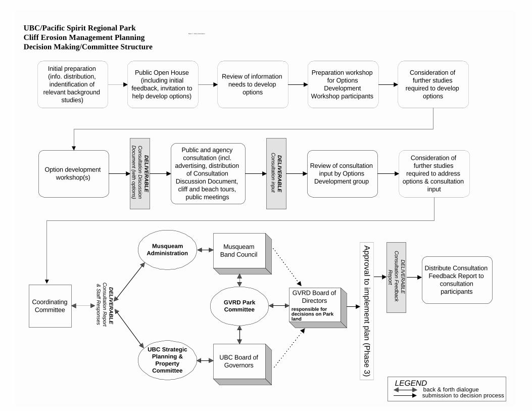
Public and agencyconsultation (incl.
advertising, distributionof Consultation
Discussion Document,cliff and beach tours,
public meetings
CoordinatingCommittee
Approval to implem
ent plan (Phase 3)Option development
workshop(s)
DELIVER
AB
LEC
onsultation Report
& Staff Responses
Initial preparation(info. distribution,indentification of
relevant backgroundstudies)
Public Open House(including initial
feedback, invitation tohelp develop options)
Review of informationneeds to develop
options
Preparation workshopfor Options
DevelopmentWorkshop participants
Consideration offurther studies
required to developoptions
DELIVER
AB
LEC
onsultation Discussion
Docum
ent (with options)
DELIVER
AB
LEC
onsultation input
Consideration offurther studies
required to addressoptions & consultation
input
Review of consultationinput by Options
Development group
UBC/Pacific Spirit Regional ParkCliff Erosion Management PlanningDecision Making/Committee Structure
Phase 2 - Public Consultation
LEGENDsubmission to decision processback & forth dialogue
DELIVER
ABLEC
onsultation FeedbackR
eport
Distribute ConsultationFeedback Report to
consultationparticipants
MusqueamAdministration
UBC StrategicPlanning &
PropertyCommittee
GVRD ParkCommittee
MusqueamBand Council
GVRD Board ofDirectors
UBC Board ofGovernors
responsible fordecisions on Parkland

TO BE DEVELOPEDSpecific actions, schedule and committee structure for implementation will be considered as
part of the consultation in Phase 2 and will reflect the decisions of the UBC Board ofGovernors, GVRD Board of Directors and Musqueam Band Council
UBC/Pacific Spirit Regional ParkCliff Erosion Management PlanningDecision Making/Committee Structure
Phase 3 - Plan Implementation

UBC/Pacific Spirit Regional ParkCliff Erosion Management Planning
Consultation FeedbackPLEASE NOTE - This planning process is being carried out without prejudice to theMusqueam aboriginal interests in this area (see page 14 of the “UBC/Pacific SpiritRegional Park Cliff Erosion Management Planning Consultation DiscussionDocument”).
Background information regarding the problems, overall management framework and considerations is supplied in theUBC/Pacific Spirit Regional Park Cliff Erosion Management Planning Consultation Discussion Document (call 822-4178 if youwant to obtain a copy).
Management Plan ObjectivesPlease indicate your level of support for the following objectives for the UBC/Pacific SpiritRegional Park Cliff Erosion Management Plan. If you wish, use the space which has beenprovided for additional point form comments. St
rong
lySu
ppor
t
Stro
ngly
Opp
ose
1. Protect the cultural and archaeological resources of the area from damage due to clifferosion (i.e. manage erosion of the cliffs in a manner that protects the cultural andarchaeological resources)
2. Preserve the wilderness-like setting of the foreshore.3. Mitigate the threat of damage from cliff erosion to UBC assets and property.4. Reduce embankment spills and fallen trees across the beach and access paths to increase
safety for people near the cliff tops and those using the beaches.5. Mitigate erosion threat to Marine Drive.
1 2 3 4 5
1 2 3 4 5 1 2 3 4 5 1 2 3 4 5
1 2 3 4 5Additional comments or suggestions re Management Plan Objectives.
Management Plan PrinciplesPlease indicate your level of support for the following principles for the UBC/Pacific SpiritRegional Park Cliff Erosion Management Plan. If you wish, use the space which has beenprovided for additional point form comments. St
rong
lySu
ppor
t
Stro
ngly
Opp
ose
1. All other UBC and GVRD planning activities which may have an impact on Point Grey clifferosion will be integrated with the cliff erosion management plan.
2. Once the cliff erosion management plan is completed, the UBC Official Community Plan(Electoral Area A) will be reviewed and, where necessary, recommendations forwarded tothe GVRD Board to adjust the OCP to minimize the causes of cliff erosion.
1 2 3 4 5
1 2 3 4 5

UBC/Pacific Spirit Regional Park - Cliff Erosion Management Planning Page 2Consultation Feedback
Management Plan Principles (continued)
Stro
ngly
Supp
ort
Stro
ngly
Opp
ose
3. Any actions taken will be in accordance with UBC’s policies and regulations and will ensurepreservation of UBC assets and lands to the extent possible given the current state of thecliffs.
4. Any actions taken will be in accordance with GVRD Regional Park policy and regulations,GVRD Parks Department philosophy and management style and, where appropriate, fallwithin the staffing and funding capability of GVRD Parks Department.
5. Any actions taken will be done in accordance with the government’s duties of consultationwith aboriginal people. This consultation will include and not be limited to matters dealingwith identified and unidentified cultural resources of the area.
6. Any actions to manage cliff erosion will be done considering advisory input fromstakeholder groups, members of the public and other relevant agencies. An ongoing advisorycommittee will be established to facilitate gathering this input.
7. Any action taken will not interfere with the recreational values of Wreck Beach regardingclothing –optional sunbathing and swimming.
8. Any actions taken will maintain the current condition of not being able to view buildingsfrom the beach or vice versa.
9. Any actions taken must take into account the preservation of the beach as a whole in nearly anatural state as possible.
1 2 3 4 5
1 2 3 4 5
1 2 3 4 5
1 2 3 4 5
1 2 3 4 5
1 2 3 4 5
1 2 3 4 5
Additional comments or suggestions re Management Plan Principles.
Management Plan ValuesPlease indicate your level of support for the following values for the UBC/Pacific Spirit RegionalPark Cliff Erosion Management Plan. If you wish, use the space which has been provided foradditional point form comments. St
rong
lySu
ppor
t
Stro
ngly
Opp
ose
1. The cliffs have important cultural and archaeological value to the Musqueam First Nationthat must be respected and preserved.
2. While minimizing cliff erosion will likely call for ecological management, the flora andfauna of the escarpment should be preserved to the greatest extent possible.
3. Any actions taken must integrate with the campus community design.
1 2 3 4 5
1 2 3 4 5
1 2 3 4 5
Additional comments or suggestions re Management Plan Values.

UBC/Pacific Spirit Regional Park - Cliff Erosion Management Planning Page 3Consultation Feedback
Please indicate your level of support for the potential actions for inclusion in a UBC/Pacific Spirit Regional Park Cliff ErosionManagement Plan. If you wish, use the space which has been provided in each section for additional point form comments.
A. Drainage
Stro
ngly
Supp
ort
Stro
ngly
Opp
ose
1. Conduct drainage study of the South Campus including consideration of:a) Retention ponds in South Campus to reduce peak storm dischargeb) Sustainable development principles using recycled rain waterc) Possible diversion of storm waters into creeks and bogsd) Erosion protection in the creeks where they emerge after flowing under Marine
Drivee) Adoption of a policy requiring a comprehensive storm water mitigation plan for any
possible further development of the South Campus2. Continue studying and/or improving the drainage system on the North Campus including:
a) Diversion of exceptional storm water flows to the bottom of the Marine Drive hillat Spanish Banks via Acadia Creek
b) Improve the drainage at the rear of the Coach House to increase the system capacityto greater than the ten year return storm using one of the following options:
OPTION 1 – Install an erosion resistant but natural, aesthetically pleasingcreek for drainage through Graham’s GullyOPTION 2 – Investigate the possibility of reactivating the previous (and nowunused) inclined drain behind Cecil Green House; this has a relatively lowdrainage capacity approximately one foot in diameterOPTION 3 – Bore a new additional drain with more drainage capacity (than thecurrently unused and low capacity drain in Option 2) at back of Cecil GreenHouse
c) Determine existing facilities that might be used for storm water retention (e.g.parkades and surface car parks, low lying playing fields)
d) Adopt design criteria for new buildings to include added capacity for storm waterretention (e.g. moats, dry ponds, flat roofs, car parks, etc.)
1 2 3 4 5 1 2 3 4 5 1 2 3 4 5 1 2 3 4 5
1 2 3 4 5
1 2 3 4 5
1 2 3 4 5
1 2 3 4 5
1 2 3 4 5
1 2 3 4 5
1 2 3 4 5
Additional comments or suggestions re “Drainage”
B. Ground Water - Hydrogeology
Stro
ngly
Supp
ort
Stro
ngly
Opp
ose
1. Conduct a hydrogeological survey with a number of new locations to gather information(e.g. water flow characteristics) on ground water (in addition to information available fromexisting drill holes) to provide a more complete picture together with previous data – e.g. usedrill holes or geophysics to test ground electrical resistance or use ground penetrating radar
1 2 3 4 5
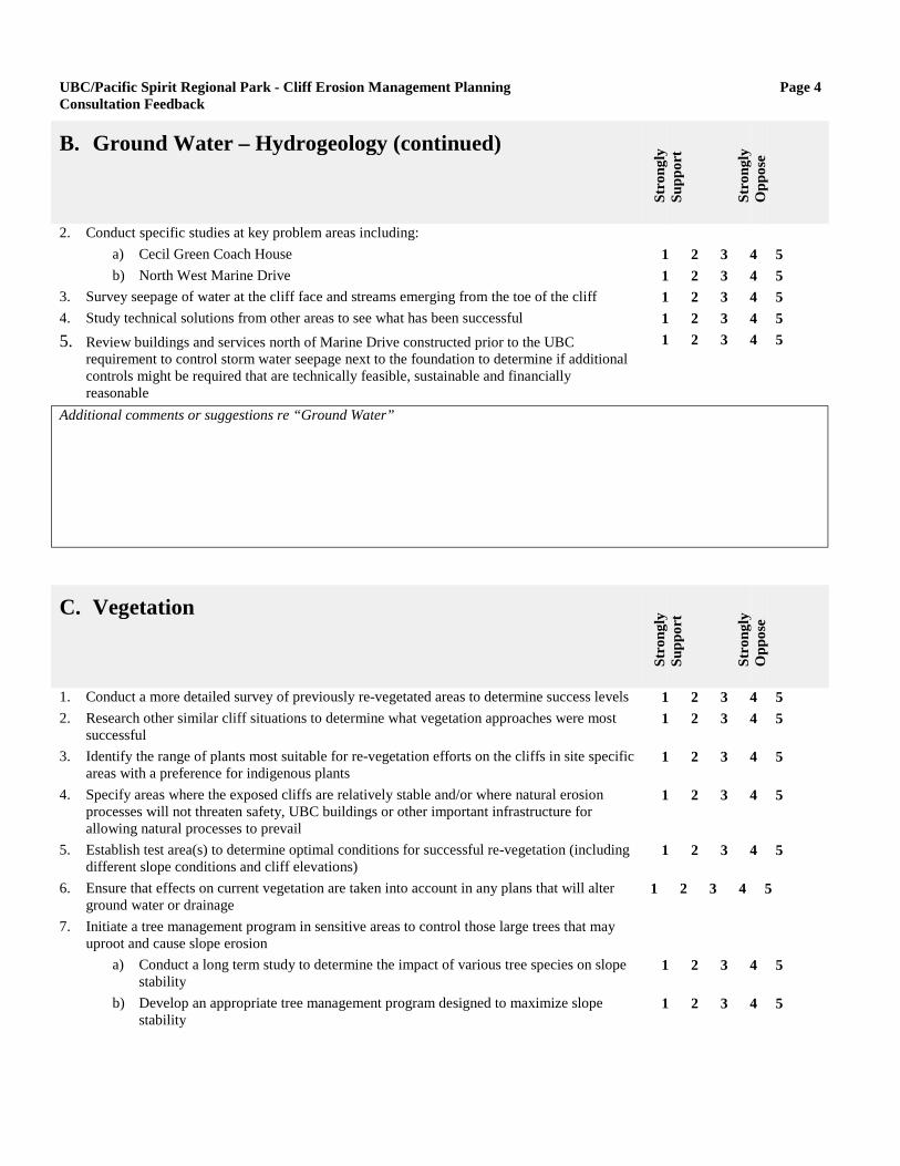
UBC/Pacific Spirit Regional Park - Cliff Erosion Management Planning Page 4Consultation Feedback
B. Ground Water – Hydrogeology (continued)
Stro
ngly
Supp
ort
Stro
ngly
Opp
ose
2. Conduct specific studies at key problem areas including:a) Cecil Green Coach Houseb) North West Marine Drive
3. Survey seepage of water at the cliff face and streams emerging from the toe of the cliff4. Study technical solutions from other areas to see what has been successful5. Review buildings and services north of Marine Drive constructed prior to the UBC
requirement to control storm water seepage next to the foundation to determine if additionalcontrols might be required that are technically feasible, sustainable and financiallyreasonable
1 2 3 4 5 1 2 3 4 5 1 2 3 4 5 1 2 3 4 5 1 2 3 4 5
Additional comments or suggestions re “Ground Water”
C. Vegetation
Stro
ngly
Supp
ort
Stro
ngly
Opp
ose
1. Conduct a more detailed survey of previously re-vegetated areas to determine success levels2. Research other similar cliff situations to determine what vegetation approaches were most
successful3. Identify the range of plants most suitable for re-vegetation efforts on the cliffs in site specific
areas with a preference for indigenous plants4. Specify areas where the exposed cliffs are relatively stable and/or where natural erosion
processes will not threaten safety, UBC buildings or other important infrastructure forallowing natural processes to prevail
5. Establish test area(s) to determine optimal conditions for successful re-vegetation (includingdifferent slope conditions and cliff elevations)
6. Ensure that effects on current vegetation are taken into account in any plans that will alterground water or drainage
7. Initiate a tree management program in sensitive areas to control those large trees that mayuproot and cause slope erosion
a) Conduct a long term study to determine the impact of various tree species on slopestability
b) Develop an appropriate tree management program designed to maximize slopestability
1 2 3 4 5 1 2 3 4 5
1 2 3 4 5
1 2 3 4 5
1 2 3 4 5
1 2 3 4 5
1 2 3 4 5
1 2 3 4 5

UBC/Pacific Spirit Regional Park - Cliff Erosion Management Planning Page 5Consultation Feedback
Additional comments or suggestions re “Vegetation”
D. Berm and Drift Sill Maintenance
Stro
ngly
Supp
ort
Stro
ngly
Opp
ose
1. Consult Musqueam, Department of Fisheries and Oceans, Ministry of Environment, NorthFraser Port Authority, GVRD Regional Parks, Wreck Beach Preservation Society and otherpark and beach groups to:
a) Identify areas in addition to those currently protected for which toe protectionmight be required (additional berm or sill works)
b) Determine criteria for beach design in areas requiring protection but not currentlyprotected as well as for those areas in which berm and sill works currently exist
2. Design desired beach characteristics (include toe protection, recreation values andfish/aquatic habitat concerns at the initial planning stages)
3. Update the survey to the 1981/82 sills and berm to determine where further erosion hasoccurred (including cobble lost, current sill elevation, habitat and vegetation and fast ferryeffects on beach).
1 2 3 4 5
1 2 3 4 5
1 2 3 4 5
1 2 3 4 5
4. Re-design profile of the sills to:a) Reduce elevation where possibleb) Improve access on side slopesc) Reduce bypassing of sand and cobble down the beachd) Provide fish habitat (tidal pools)e) Achieve recreational values
5. Explore feasibility and possible effectiveness of creating a spit and lagoon to protect the clifftoe (e.g. possibly a calm water area near Trail 4 to enhance swimming area)
6. Install stub sills or increase existing sill length to:a) Optimize with respect to additional sill lengths and new cobble materialb) Re-align outer ends to improve efficiency
7. Add beach materials as required:a) Coarse gravel between Towers 1 and 2 (2” minus)b) Finer gravel south of Tower 2 (minimum size 1 mm sand)c) Additional sand/fine materials above the berm crest to enhance the recreational area
of the beach
1 2 3 4 5 1 2 3 4 5 1 2 3 4 5 1 2 3 4 5 1 2 3 4 5 1 2 3 4 5
1 2 3 4 5 1 2 3 4 5
1 2 3 4 5 1 2 3 4 5 1 2 3 4 5
Additional comments or suggestions re “Berm and Drift Sill Maintenance”

UBC/Pacific Spirit Regional Park - Cliff Erosion Management Planning Page 6Consultation Feedback
E. Mackenzie House
Stro
ngly
Supp
ort
Stro
ngly
Opp
ose
1. Investigate the need to further reduce any effects caused by the need for watering and, ifappropriate, consider the benefits of redeveloping the cliff side garden landscape based onwater conservation principles
1 2 3 4 5
Additional comments or suggestions re “Mackenzie House”
F. Museum of Anthropology
Stro
ngly
Supp
ort
Stro
ngly
Opp
ose
1. Obtain further professional input regarding any potential cliff related problems (e.g. stabilityof the soils related to construction activity and possible development) should UBC decide toproceed with development plans at this site.
1 2 3 4 5
Additional comments or suggestions re “Museum of Anthropology”
G. Coach House Area
Stro
ngly
Supp
ort
Stro
ngly
Opp
ose
1. Take action to protect the Coach House considering one of the following options:OPTION 1 - Cut back the top edge of the cliff and fill in the top part of theexisting gully; vegetate the filled-in gully above the 20 meter level of the cliff;where possible, indigenous plants will be used; keep the Coach House in place;and investigate other possible engineering solutions to protect the Coach HouseOPTION 2 - Conduct actions as per Option 1 (above) but move the CoachHouse further from the cliff edge to further protect against possible impactsOPTION 3 - Do nothing to protect the Coach House while taking the actionsnoted in Option 1 above to protect the spiral drain
1 2 3 4 5
1 2 3 4 5
1 2 3 4 5

UBC/Pacific Spirit Regional Park - Cliff Erosion Management Planning Page 7Consultation Feedback
Additional comments or suggestions re “Coach House Area”
H. Cecil Green
Stro
ngly
Supp
ort
Stro
ngly
Opp
ose
1. Investigate the need for protection for Cecil Green and possible engineering or othersolutions (e.g. soil anchors, supports, vegetation, etc.)
1 2 3 4 5
Additional comments or suggestions re “Cecil Green”
I. General Cliff Protection in the Cecil Green, MOA areaSt
rong
lySu
ppor
t
Stro
ngly
Opp
ose
1. Sink bore holes or wells to control seepage at cliff face2. Provide new signage in the area to reinforce the necessity to not use this area for illegal
access3. Initiate a program to repair the fence as soon as there is any sign of damage or trespass4. Use vegetation barriers to dissuade ongoing trespassing at the cliff top and at lower
elevations5. Remove trees at the top edge that are in danger of falling over6. Re-vegetate the slopes where possible7. Improve berms at the toe of cliff (only where needed to protect the cliffs)8. Investigate whether installing a permanent viewing spot will be an effective way to prevent
people from going past the fence barriers to enjoy the cliff top views (in conjunction withimproved signage to designated trails, vegetation barriers and more rigorous fencemaintenance activities)
9. Determine appropriate permanent site(s) where vegetation management and sitemaintenance will provide viewscapes for visitors (including non-ambulatory)
1 2 3 4 5 1 2 3 4 5
1 2 3 4 5 1 2 3 4 5
1 2 3 4 5 1 2 3 4 5 1 2 3 4 5 1 2 3 4 5
1 2 3 4 5
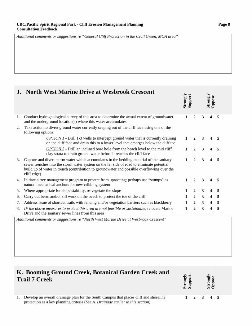
UBC/Pacific Spirit Regional Park - Cliff Erosion Management Planning Page 8Consultation Feedback
Additional comments or suggestions re “General Cliff Protection in the Cecil Green, MOA area”
J. North West Marine Drive at Wesbrook Crescent
Stro
ngly
Supp
ort
Stro
ngly
Opp
ose
1. Conduct hydrogeological survey of this area to determine the actual extent of groundwaterand the underground location(s) where this water accumulates
2. Take action to divert ground water currently seeping out of the cliff face using one of thefollowing options:
OPTION 1 - Drill 1-3 wells to intercept ground water that is currently drainingon the cliff face and drain this to a lower level that emerges below the cliff toeOPTION 2 - Drill an inclined bore hole from the beach level to the mid cliffclay strata to drain ground water before it reaches the cliff face
3. Capture and divert storm water which accumulates in the bedding material of the sanitarysewer trenches into the storm water system on the far side of road to eliminate potentialbuild up of water in trench (contribution to groundwater and possible overflowing over thecliff edge)
4. Initiate a tree management program to protect from uprooting; perhaps use “stumps” asnatural mechanical anchors for new cribbing system
5. Where appropriate for slope stability, re-vegetate the slope6. Carry out berm and/or sill work on the beach to protect the toe of the cliff7. Address issue of shortcut trails with fencing and/or vegetation barriers such as blackberry8. IF the above measures to protect this area are not feasible or sustainable, relocate Marine
Drive and the sanitary sewer lines from this area
1 2 3 4 5
1 2 3 4 5
1 2 3 4 5
1 2 3 4 5
1 2 3 4 5
1 2 3 4 5 1 2 3 4 5 1 2 3 4 5 1 2 3 4 5
Additional comments or suggestions re “North West Marine Drive at Wesbrook Crescent”
K. Booming Ground Creek, Botanical Garden Creek andTrail 7 Creek
Stro
ngly
Supp
ort
Stro
ngly
Opp
ose
1. Develop an overall drainage plan for the South Campus that places cliff and shorelineprotection as a key planning criteria (See A. Drainage earlier in this section)
1 2 3 4 5

UBC/Pacific Spirit Regional Park - Cliff Erosion Management Planning Page 9Consultation Feedback
K. Booming Ground Creek, Botanical Garden Creek andTrail 7 Creek (continued)
Stro
ngly
Supp
ort
Stro
ngly
Opp
ose
2. Study the amount and velocity of water in each creek at different times of the year todetermine the relationship to ecology and erosion.
3. If ecologically sound and helpful to avoid erosion, divert water using one of the followingoptions:
OPTION 1 - Divert water from both Botanical Garden Creek and Trail 7 Creekthrough a drainage ditch to Booming Ground CreekOPTION 2 - Divert water from Trail 7 Creek and Botanical Garden Creek to analternative water course for high flow situationsOPTION 3 - Protect Trail 7 Creek and Botanical Garden Creek from MarineDrive to the Fraser River against excessive scouring or erosion
4. Based on the study results of water flows and the ability to manage the pipe end erosion,undertake one of the following possible actions:
OPTION 1 - Re-establish (day-light) Booming Ground Creek where it flowsunder Marine Drive and adjust the profile to the natural grade, ensuring aminimal level of disturbance to the creek banks; undertake remediation work torepair damage and mitigation to prevent ongoing erosion (e.g. rip rap on sidesof creek below pipe end) for the other creeks.OPTION 2 - Construct an inclined drain for Booming Ground Creek to thebeach from where the pipe emerges on the cliff side of Marine Drive;undertake remediation work to repair damage and mitigation to preventongoing erosion (e.g. rip rap on sides of creek below pipe end) for the othercreeks.OPTION 3 - Construct an inclined drain or restore a natural watercourse forBooming Ground Creek to the beach from where the pipe emerges on the cliffside of Marine Drive; deactivate the current pipe ends under Marine Drive forBotanical Garden Creek and Trail 7 Creek and divert water from these creeksto a new inclined drain at Booming Ground Creek; carry out any necessarywork to repair damage that may lead to further cliff side erosion at the currentpipe ends for Botanical Garden Creek and Trail 7 CreekOPTION 4 - Do nothing and let the pipe end erosion continue
5. Construct a public washroom at the estuary to ensure water quality is not compromised (inconsultation with the Wreck Beach Liaison Committee)
6. Test the quality of the drainage water at various locations in the catchment area (includingwhere there are specific discharge locations of possible concern)
a) Conduct tests during different seasons and weather conditionsb) Make the information on where drainage locations sites are located and where the
tests for water quality are done available to interested members of the publicc) If necessary, take steps to identify and rectify the introduction of any deleterious
substances
1 2 3 4 5
1 2 3 4 5
1 2 3 4 5
1 2 3 4 5
1 2 3 4 5
1 2 3 4 5
1 2 3 4 5
1 2 3 4 5 1 2 3 4 5
1 2 3 4 5 1 2 3 4 5
1 2 3 4 5
Additional comments or suggestions re “Booming Ground Creek, Botanical Garden Creek and Trail 7 Creek”

UBC/Pacific Spirit Regional Park - Cliff Erosion Management Planning Page 10Consultation Feedback
L. Point Grey
Stro
ngly
Supp
ort
Stro
ngly
Opp
ose
1. Extend the current beach works to continue to protect the cliff toe2. Review the impacts of the Trail 5 closure to determine:
a) What benefits have been realized as a result of this closureb) Any learnings that may be applicable to other parts of the cliffsc) If additional protection or mitigation work may be required along the closed off
traild) If other means of preventing continued trail use may be required
3. Protect the cliff top from storm water run-off4. Repair trail side erosion damage (consider vegetation approaches)5. Review a “do-nothing” policy for the cliff face combined with ensuring toe protection to
consider the possible benefits (e.g. protect the marine landmark aspect) and/or adverseeffects of such an approach
6. Adopt policies to ensure this site remains as natural as possible
1 2 3 4 5
1 2 3 4 5 1 2 3 4 5 1 2 3 4 5
1 2 3 4 5 1 2 3 4 5 1 2 3 4 5 1 2 3 4 5
1 2 3 4 5Additional comments or suggestions re “Point Grey”
M. Overall Management Plan Considerations
Stro
ngly
Supp
ort
Stro
ngly
Opp
ose
1. Make specific linkages of the cliff erosion management plan to other relevant planningprocesses (including Musqueam planning processes, Pacific Spirit Regional ParkManagement Plan, UBC Comprehensive Community Plan, other UBC plans and planningprocesses, North Fraser Port Authority plans) to ensure that potential negative effects oncliff erosion are avoided and cliff protection efforts are supported. Areas to pursue for suchlinkages include:
a) Adoption of the Cliff Erosion Management Plan at a policy level by both UBC andGVRD Regional Parks to ensure support of the principles, considerations andmanagement actions both for internal planning processes and in dealing with otheragencies for any actions that will affect the cliffs
b) Establishment of formal linkages (i.e. formal agreements to include cliff erosionconsiderations in their planning and management control processes) with otheragencies whose activities have affected or in the future might affect the cliffs (e.g.North Fraser Port Authority)
1 2 3 4 5
1 2 3 4 5
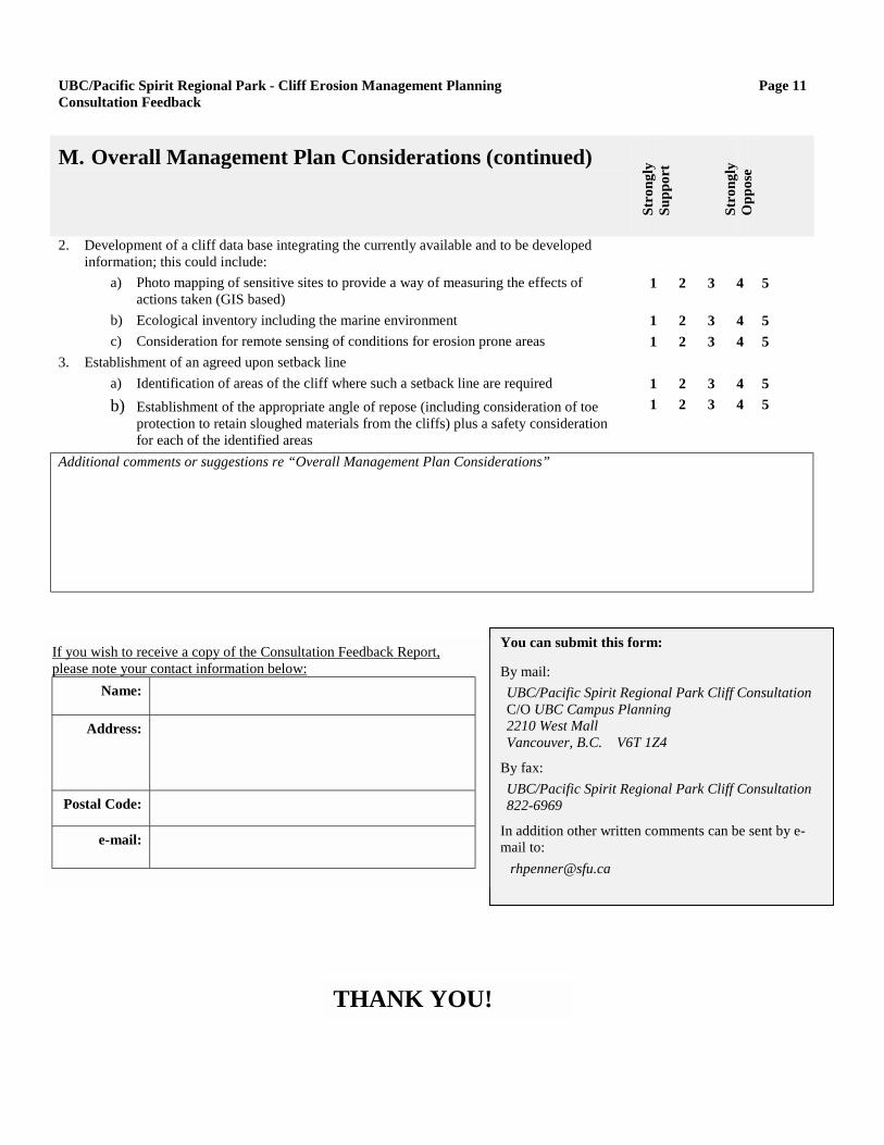
UBC/Pacific Spirit Regional Park - Cliff Erosion Management Planning Page 11Consultation Feedback
You can submit this form:
By mail:UBC/Pacific Spirit Regional Park Cliff ConsultationC/O UBC Campus Planning2210 West MallVancouver, B.C. V6T 1Z4
By fax:UBC/Pacific Spirit Regional Park Cliff Consultation822-6969
In addition other written comments can be sent by e-
M. Overall Management Plan Considerations (continued)
Stro
ngly
Supp
ort
Stro
ngly
Opp
ose
2. Development of a cliff data base integrating the currently available and to be developedinformation; this could include:
a) Photo mapping of sensitive sites to provide a way of measuring the effects ofactions taken (GIS based)
b) Ecological inventory including the marine environmentc) Consideration for remote sensing of conditions for erosion prone areas
3. Establishment of an agreed upon setback linea) Identification of areas of the cliff where such a setback line are requiredb) Establishment of the appropriate angle of repose (including consideration of toe
protection to retain sloughed materials from the cliffs) plus a safety considerationfor each of the identified areas
1 2 3 4 5
1 2 3 4 5 1 2 3 4 5
1 2 3 4 5 1 2 3 4 5
Additional comments or suggestions re “Overall Management Plan Considerations”
If you wish to receive a copy of the Consultation Feedback Report,please note your contact information below:
Name:
Address:
Postal Code:
e-mail:
mail to: [email protected]THANK YOU!