Embed Size (px)
Citation preview
Hastings Section 94 Major Roads
Contributions Plan Version 2.2
Port Macquarie-Hastings Council
April 2006
Major Roads Contributions Plan
1
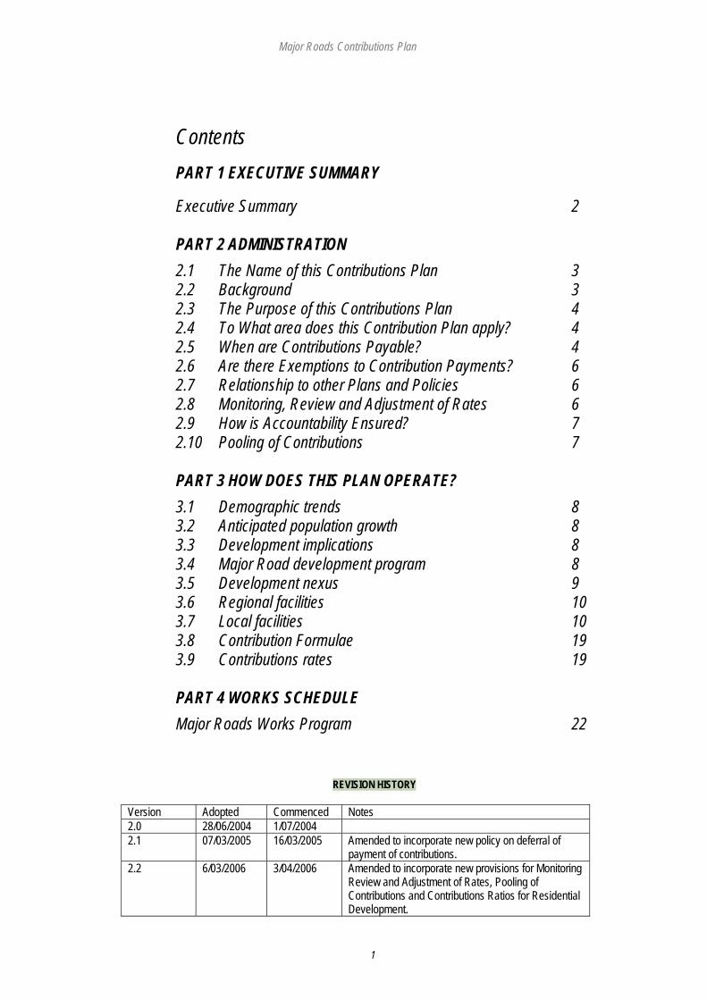
Contents PART 1 EXECUTIVE SUMMARY
Executive Summary 2 PART 2 ADMINISTRATION 2.1 The Name of this Contributions Plan 3 2.2 Background 3 2.3 The Purpose of this Contributions Plan 4 2.4 To What area does this Contribution Plan apply? 4 2.5 When are Contributions Payable? 4 2.6 Are there Exemptions to Contribution Payments? 6 2.7 Relationship to other Plans and Policies 6 2.8 Monitoring, Review and Adjustment of Rates 6 2.9 How is Accountability Ensured? 7 2.10 Pooling of Contributions 7 PART 3 HOW DOES THIS PLAN OPERATE? 3.1 Demographic trends 8 3.2 Anticipated population growth 8 3.3 Development implications 8 3.4 Major Road development program 8 3.5 Development nexus 9 3.6 Regional facilities 10 3.7 Local facilities 10 3.8 Contribution Formulae 19 3.9 Contributions rates 19 PART 4 WORKS SCHEDULE Major Roads Works Program 22
REVISION HISTORY
Version Adopted Commenced Notes 2.0 28/06/2004 1/07/2004 2.1 07/03/2005 16/03/2005 Amended to incorporate new policy on deferral of
payment of contributions. 2.2 6/03/2006 3/04/2006 Amended to incorporate new provisions for Monitoring
Review and Adjustment of Rates, Pooling of Contributions and Contributions Ratios for Residential Development.
Major Roads Contributions Plan
2
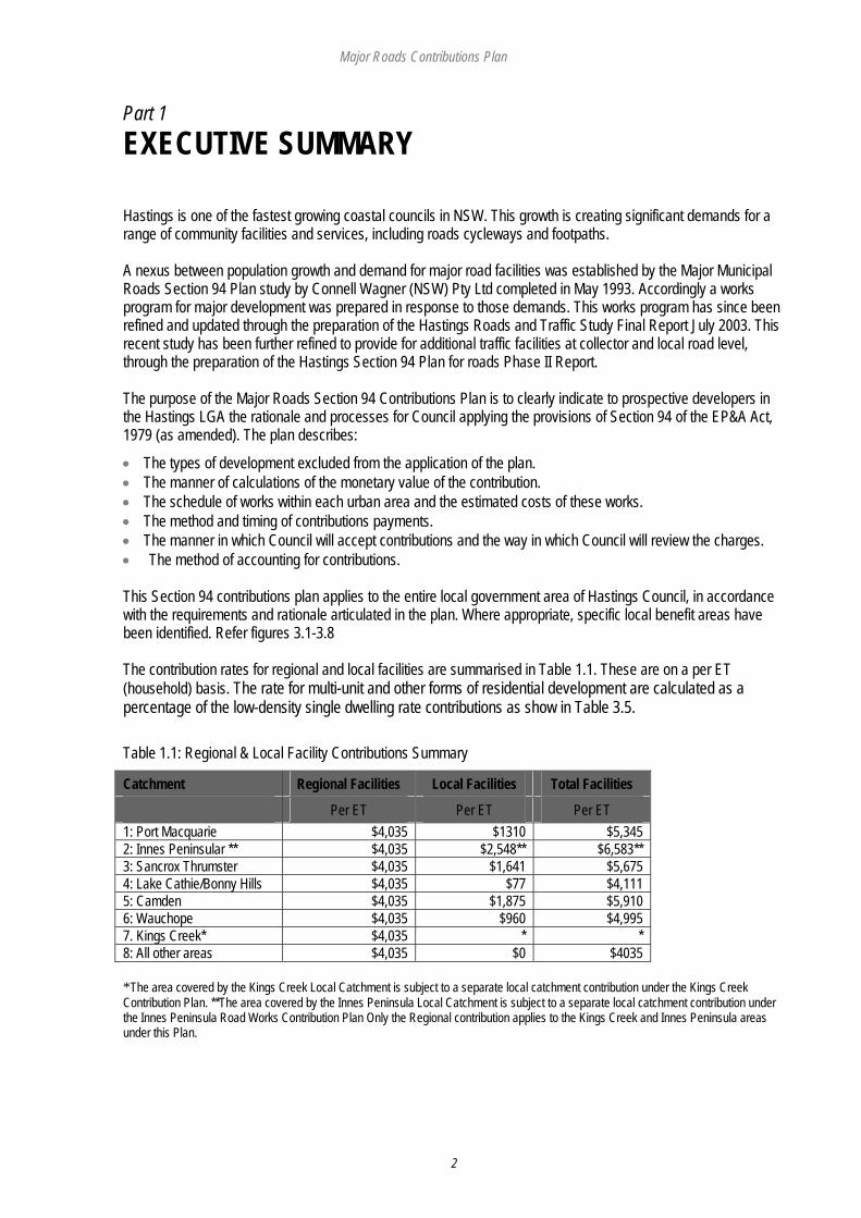
Part 1 EXECUTIVE SUMMARY Hastings is one of the fastest growing coastal councils in NSW. This growth is creating significant demands for a range of community facilities and services, including roads cycleways and footpaths. A nexus between population growth and demand for major road facilities was established by the Major Municipal Roads Section 94 Plan study by Connell Wagner (NSW) Pty Ltd completed in May 1993. Accordingly a works program for major development was prepared in response to those demands. This works program has since been refined and updated through the preparation of the Hastings Roads and Traffic Study Final Report July 2003. This recent study has been further refined to provide for additional traffic facilities at collector and local road level, through the preparation of the Hastings Section 94 Plan for roads Phase II Report. The purpose of the Major Roads Section 94 Contributions Plan is to clearly indicate to prospective developers in the Hastings LGA the rationale and processes for Council applying the provisions of Section 94 of the EP&A Act, 1979 (as amended). The plan describes:
• The types of development excluded from the application of the plan. • The manner of calculations of the monetary value of the contribution. • The schedule of works within each urban area and the estimated costs of these works. • The method and timing of contributions payments. • The manner in which Council will accept contributions and the way in which Council will review the charges. • The method of accounting for contributions. This Section 94 contributions plan applies to the entire local government area of Hastings Council, in accordance with the requirements and rationale articulated in the plan. Where appropriate, specific local benefit areas have been identified. Refer figures 3.1-3.8 The contribution rates for regional and local facilities are summarised in Table 1.1. These are on a per ET (household) basis. The rate for multi-unit and other forms of residential development are calculated as a percentage of the low-density single dwelling rate contributions as show in Table 3.5. Table 1.1: Regional & Local Facility Contributions Summary
Catchment Regional Facilities Local Facilities Total Facilities
Per ET Per ET Per ET 1: Port Macquarie $4,035 $1310 $5,345 2: Innes Peninsular ** $4,035 $2,548** $6,583** 3: Sancrox Thrumster $4,035 $1,641 $5,675 4: Lake Cathie/Bonny Hills $4,035 $77 $4,111 5: Camden $4,035 $1,875 $5,910 6: Wauchope $4,035 $960 $4,995 7. Kings Creek* $4,035 * * 8: All other areas $4,035 $0 $4035 *The area covered by the Kings Creek Local Catchment is subject to a separate local catchment contribution under the Kings Creek Contribution Plan. **The area covered by the Innes Peninsula Local Catchment is subject to a separate local catchment contribution under the Innes Peninsula Road Works Contribution Plan Only the Regional contribution applies to the Kings Creek and Innes Peninsula areas under this Plan.
Major Roads Contributions Plan
3
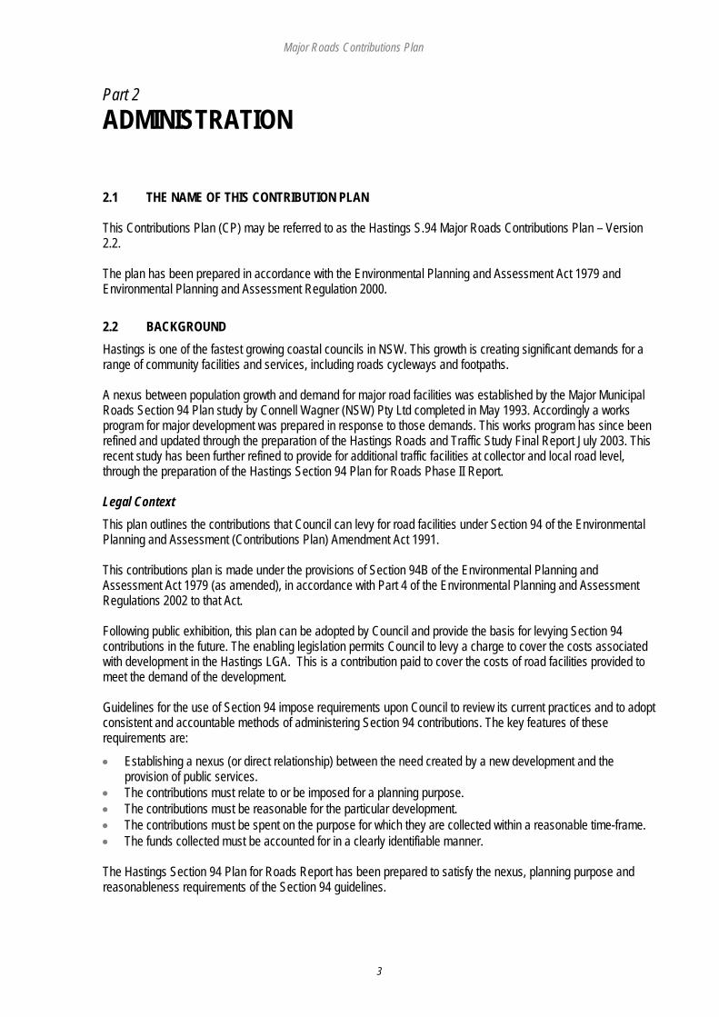
Part 2 ADMINISTRATION 2.1 THE NAME OF THIS CONTRIBUTION PLAN This Contributions Plan (CP) may be referred to as the Hastings S.94 Major Roads Contributions Plan – Version 2.2. The plan has been prepared in accordance with the Environmental Planning and Assessment Act 1979 and Environmental Planning and Assessment Regulation 2000. 2.2 BACKGROUND Hastings is one of the fastest growing coastal councils in NSW. This growth is creating significant demands for a range of community facilities and services, including roads cycleways and footpaths. A nexus between population growth and demand for major road facilities was established by the Major Municipal Roads Section 94 Plan study by Connell Wagner (NSW) Pty Ltd completed in May 1993. Accordingly a works program for major development was prepared in response to those demands. This works program has since been refined and updated through the preparation of the Hastings Roads and Traffic Study Final Report July 2003. This recent study has been further refined to provide for additional traffic facilities at collector and local road level, through the preparation of the Hastings Section 94 Plan for Roads Phase II Report. Legal Context This plan outlines the contributions that Council can levy for road facilities under Section 94 of the Environmental Planning and Assessment (Contributions Plan) Amendment Act 1991. This contributions plan is made under the provisions of Section 94B of the Environmental Planning and Assessment Act 1979 (as amended), in accordance with Part 4 of the Environmental Planning and Assessment Regulations 2002 to that Act. Following public exhibition, this plan can be adopted by Council and provide the basis for levying Section 94 contributions in the future. The enabling legislation permits Council to levy a charge to cover the costs associated with development in the Hastings LGA. This is a contribution paid to cover the costs of road facilities provided to meet the demand of the development. Guidelines for the use of Section 94 impose requirements upon Council to review its current practices and to adopt consistent and accountable methods of administering Section 94 contributions. The key features of these requirements are:
• Establishing a nexus (or direct relationship) between the need created by a new development and the provision of public services.
• The contributions must relate to or be imposed for a planning purpose. • The contributions must be reasonable for the particular development. • The contributions must be spent on the purpose for which they are collected within a reasonable time-frame. • The funds collected must be accounted for in a clearly identifiable manner. The Hastings Section 94 Plan for Roads Report has been prepared to satisfy the nexus, planning purpose and reasonableness requirements of the Section 94 guidelines.

Major Roads Contributions Plan
4
2.3 THE PURPOSE OF THIS CONTRIBUTIONS PLAN The purpose of the Major Roads Section 94 Contributions Plan is to clearly indicate to prospective developers in the Hastings LGA the rationale and processes for Council applying the provisions of Section 94 of the EP&A Act, 1979 (as amended). The plan describes:
• The types of development excluded from the application of the plan. • The manner of calculations of the monetary value of the contribution. • The schedule of works within each urban area and the estimated costs of these works. • The method and timing of contributions payments. • The manner in which Council will accept contributions and the way in which Council will review the charges. • The method of accounting for contributions. This plan has the following objectives:
• To clearly articulate the need for road and traffic facilities within the Hastings Council LGA.
• To clearly outline the statutory context of Section 94 so that the community and developers are aware of the legal obligations and limitations which govern the levying of contributions on new development.
• To identify the growth characteristics of Hastings LGA so that the general and unique development pressures experienced by the municipality can be recognised and accounted for in the Section 94 contributions plan for road, traffic, cycleway and footpath facilities.
• To adopt and articulate a set of standards which can be used to develop appropriate formulae for the levying of road, traffic, cycleway and footpath facilities. Section 94 contributions for new development.
• To create a clear and straight forward framework for the Section 94 Major Roads Contributions Plan to facilitate updating in response to changing circumstances.
2.4 TO WHAT AREA DOES THIS CONTRIBUTION PLAN APPLY? This Section 94 contributions plan applies to the entire local government area of Hastings Council, in accordance with the requirements and rationale articulated in the plan. Refer figure 3.1. Where appropriate, specific local benefit areas have been identified. Refer figures 3.2-3.8. 2.5 WHEN ARE CONTRIBUTIONS PAYABLE? Council will only accept S.94 contributions in the following manner:
Where a DA is required including integrated housing
Prior to the release of the construction certificate, or as specified in the development consent
Subdivision Prior to the subdivision certificate being issued, or as specified in the development consent
Strata Development Prior to the release of the construction certificate where required. If no construction certificate is required, prior to the subdivision certificate being issued or as otherwise specified in the development consent
Contributions shall be determined at the time of payment of the contribution. Payment is to be made prior to release of the construction certificate or the linen plan in the case of subdivision. Where no building approval is required, payment is to be made within three (3) months of the granting of development consent or prior to occupation, whichever is the sooner.
Major Roads Contributions Plan
5
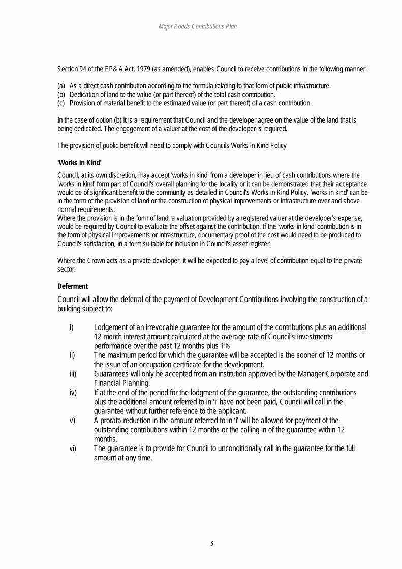
Section 94 of the EP& A Act, 1979 (as amended), enables Council to receive contributions in the following manner: (a) As a direct cash contribution according to the formula relating to that form of public infrastructure. (b) Dedication of land to the value (or part thereof) of the total cash contribution. (c) Provision of material benefit to the estimated value (or part thereof) of a cash contribution. In the case of option (b) it is a requirement that Council and the developer agree on the value of the land that is being dedicated. The engagement of a valuer at the cost of the developer is required. The provision of public benefit will need to comply with Councils Works in Kind Policy 'Works in Kind' Council, at its own discretion, may accept 'works in kind' from a developer in lieu of cash contributions where the 'works in kind' form part of Council's overall planning for the locality or it can be demonstrated that their acceptance would be of significant benefit to the community as detailed in Council’s Works in Kind Policy. 'works in kind' can be in the form of the provision of land or the construction of physical improvements or infrastructure over and above normal requirements. Where the provision is in the form of land, a valuation provided by a registered valuer at the developer's expense, would be required by Council to evaluate the offset against the contribution. If the 'works in kind' contribution is in the form of physical improvements or infrastructure, documentary proof of the cost would need to be produced to Council's satisfaction, in a form suitable for inclusion in Council's asset register. Where the Crown acts as a private developer, it will be expected to pay a level of contribution equal to the private sector. Deferment
Council will allow the deferral of the payment of Development Contributions involving the construction of a building subject to:
i) Lodgement of an irrevocable guarantee for the amount of the contributions plus an additional 12 month interest amount calculated at the average rate of Council’s investments performance over the past 12 months plus 1%.
ii) The maximum period for which the guarantee will be accepted is the sooner of 12 months or the issue of an occupation certificate for the development.
iii) Guarantees will only be accepted from an institution approved by the Manager Corporate and Financial Planning.
iv) If at the end of the period for the lodgment of the guarantee, the outstanding contributions plus the additional amount referred to in ‘i’ have not been paid, Council will call in the guarantee without further reference to the applicant.
v) A prorata reduction in the amount referred to in ‘i’ will be allowed for payment of the outstanding contributions within 12 months or the calling in of the guarantee within 12 months.
vi) The guarantee is to provide for Council to unconditionally call in the guarantee for the full amount at any time.

Major Roads Contributions Plan
6
2.6 ARE THERE ANY EXEMPTIONS FROM CONTRIBUTION PAYMENTS? Exemptions The types of development exempted from the application of this plan include:
• Non residential land uses and other uses that are not specified in table 3.5. • Existing vacant residential lots currently rated for water and sewer (except where subdivision or an increase in
population density is involved). • A change of land use not involving the creation of additional lots, dwellings or increased population. • Development exempted by direction of the Minister pursuant to SEPP Seniors Living • Rural or farming enterprises, which do not result in an increase in the demand for road and traffic facilities. • Development exempted by Council’s Development Contribution Assessment Policy.
2.7 RELATIONSHIP TO OTHER PLANS AND POLICIES
This plan relates to the following relevant Council plans and policies: • Hastings LEP (2001) • Hastings Urban Growth Strategy (2001) • Hastings Council Development Contribution Assessment Policy • Hastings Council Works in Kind Policy 2.8 MONITORING, REVIEW AND ADJUSTMENT OF RATES Council will adjust the contributions levy in this plan on a quarterly basis. To ensure that the value of the contributions is not eroded by inflation, Council will increase the levy in accordance with the Consumer Price Index All Group Index Number for Sydney (CPI), as published by the ABS. Where contributions have been levied under an existing consent, granted in accordance with this Plan, but not yet paid, the contribution will continue to be indexed on a quarterly basis in accordance with the above until such time as they are paid. Contributions rates will be adjusted in accordance with the following formula
CRA =
Where CRA is the adjusted contributions rate at the time of adjustment in the Contributions Plan, or at the time of payment of the contributions, as applicable. CRO is the original contribution rate in the contributions plan, or at the time of the development consent, as applicable. CPIO is the original CPI rate at the time of adoption of the contributions plan, or at the time of the development consent, as applicable.
( ) CROCPIO
CPIOCPIC ×−
+1
Major Roads Contributions Plan
7
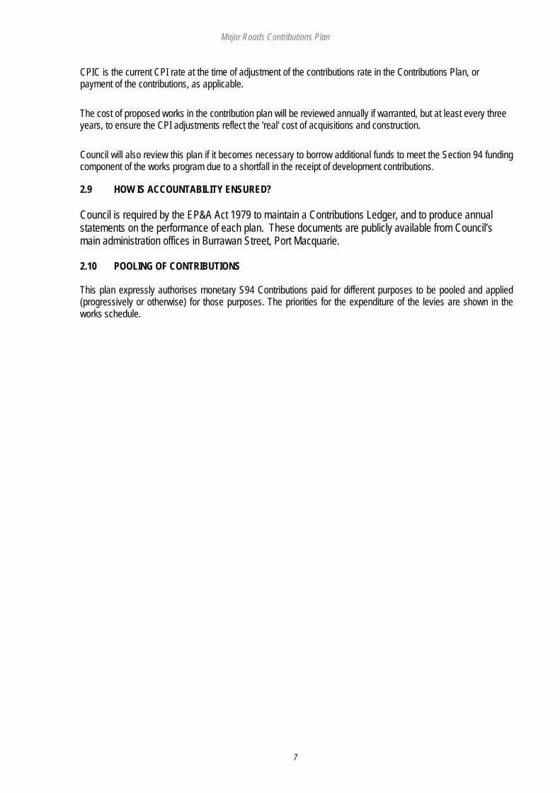
CPIC is the current CPI rate at the time of adjustment of the contributions rate in the Contributions Plan, or payment of the contributions, as applicable. The cost of proposed works in the contribution plan will be reviewed annually if warranted, but at least every three years, to ensure the CPI adjustments reflect the 'real' cost of acquisitions and construction. Council will also review this plan if it becomes necessary to borrow additional funds to meet the Section 94 funding component of the works program due to a shortfall in the receipt of development contributions. 2.9 HOW IS ACCOUNTABILITY ENSURED? Council is required by the EP&A Act 1979 to maintain a Contributions Ledger, and to produce annual statements on the performance of each plan. These documents are publicly available from Council’s main administration offices in Burrawan Street, Port Macquarie. 2.10 POOLING OF CONTRIBUTIONS This plan expressly authorises monetary S94 Contributions paid for different purposes to be pooled and applied (progressively or otherwise) for those purposes. The priorities for the expenditure of the levies are shown in the works schedule.

Major Roads Contributions Plan
8
PART 3 HOW DOES THIS PLAN OPERATE? 3.1 DEMOGRAPHIC TRENDS The Hastings Urban Growth Strategy has forecast that the population of the Hastings area will increase to 88,300 people by 2016 and 97,800 by 2021. This growth is expected to occur primarily in the coastal areas, with the inland rural areas forecast to sustain modest growth levels. To maintain a level of road and traffic facilities amenity enjoyed by the current residents and to enable the continuing satisfaction of road needs throughout the Hastings LGA, it is reasonable that the incoming population contribute towards the construction of new or upgraded facilities so that the current residents do not experience a reduction in the standard of provision.
3.2 ANTICIPATED POPULATION GROWTH The time span of this contribution plan is 20 years. The population growth figures contained in the Hastings Urban Growth Study have therefore been extrapolated to 2024 to provide for a 20 year horizon. The anticipate growth in Hasting’s population is summarised in Table 2.1. Whilst Port Macquarie is anticipated to sustain the highest levels of growth in absolute terms, catchments such as Sancrox Thrumster and Innes Peninsular are anticipated to experience the highest relative growth, starting as they do from a low base line. NB population figures in table 3.1 include some adjacent Rural population has shown in figures 3.1 – 3.8 Table 3.1: Anticipated Population Growth 2004
(Estimate) 2024
(Forecast) Increase
No. Increase
%
1. Port Macquarie 38998 47896 8898 18.6 2. Innes Peninsular 1805 7174 5369 74.8 3. Sancrox Thrumster 1450 7966 6516 81.8 4. Lake Cathie/Bonny Hills 4670 10444 5774 55.3 5. Camden Haven 9481 12778 3297 25.8 6. Wauchope 5435 7279 1844 28.6 8. Rural Western: 7405 7952 547 6.9 Total Hastings Council Area: 70200 103177 32977 32.0 3.3 DEVELOPMENT IMPLICATIONS There is a strong correlation between population growth higher traffic volumes and the need to upgrade traffic facilities as a result of the increased growth. The anticipated level of urban development will put significant additional demands on the Hastings road system. In response to this anticipated demand, priorities for road, cycleway and footpath facilities have been developed, the works costed, scheduled and an allowance made for existing demands and potential community benefit. 3.4 MAJOR ROADS DEVELOPMENT PROGRAM
To meet the needs of both the existing and anticipated populations, Council has identified a major roads development program with an estimated price tag of $ 212.3 million. These costs are phased as shown in Works Program. Costs have been determined on the basis of demand assessment and take into account:
• Government grants for road facilities; and • Community benefits arising from general improvements to the roads system.
Major Roads Contributions Plan
9
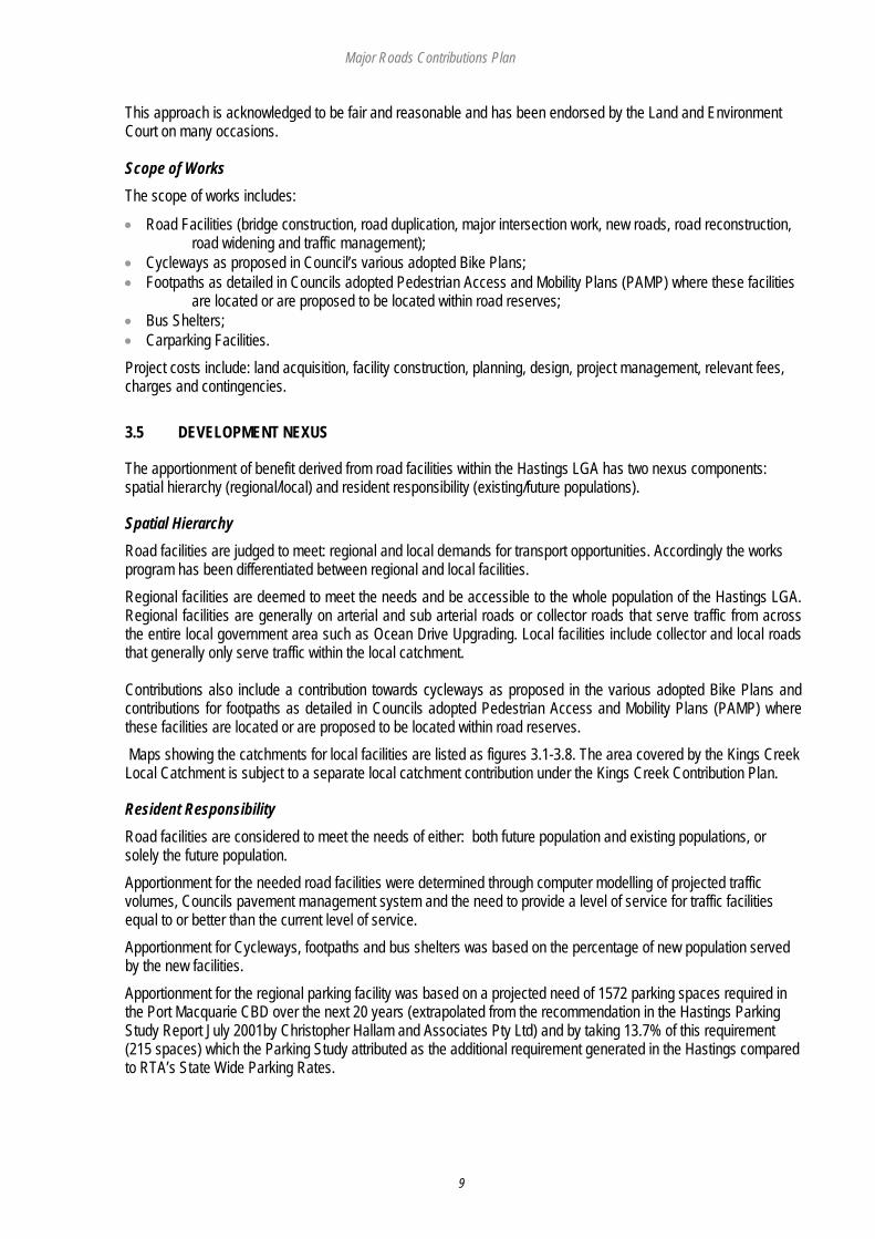
This approach is acknowledged to be fair and reasonable and has been endorsed by the Land and Environment Court on many occasions. Scope of Works The scope of works includes:
• Road Facilities (bridge construction, road duplication, major intersection work, new roads, road reconstruction, road widening and traffic management);
• Cycleways as proposed in Council’s various adopted Bike Plans; • Footpaths as detailed in Councils adopted Pedestrian Access and Mobility Plans (PAMP) where these facilities
are located or are proposed to be located within road reserves; • Bus Shelters; • Carparking Facilities. Project costs include: land acquisition, facility construction, planning, design, project management, relevant fees, charges and contingencies. 3.5 DEVELOPMENT NEXUS
The apportionment of benefit derived from road facilities within the Hastings LGA has two nexus components: spatial hierarchy (regional/local) and resident responsibility (existing/future populations).
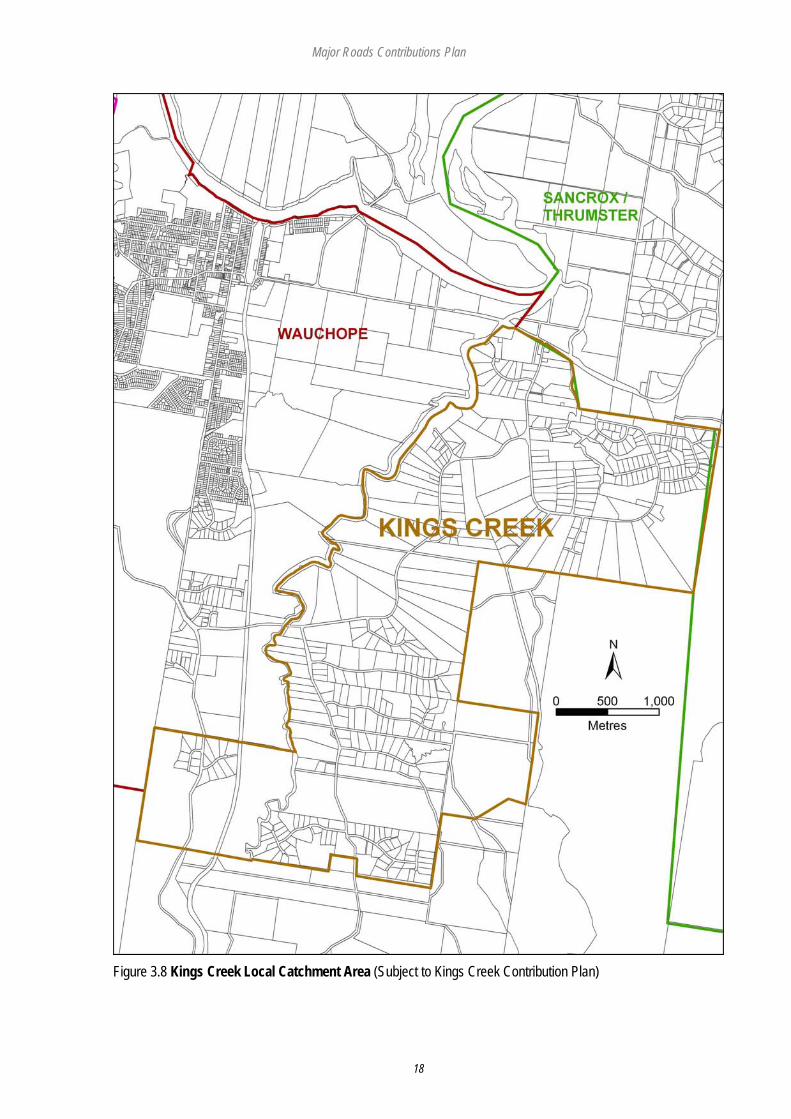
Spatial Hierarchy Road facilities are judged to meet: regional and local demands for transport opportunities. Accordingly the works program has been differentiated between regional and local facilities. Regional facilities are deemed to meet the needs and be accessible to the whole population of the Hastings LGA. Regional facilities are generally on arterial and sub arterial roads or collector roads that serve traffic from across the entire local government area such as Ocean Drive Upgrading. Local facilities include collector and local roads that generally only serve traffic within the local catchment. Contributions also include a contribution towards cycleways as proposed in the various adopted Bike Plans and contributions for footpaths as detailed in Councils adopted Pedestrian Access and Mobility Plans (PAMP) where these facilities are located or are proposed to be located within road reserves. Maps showing the catchments for local facilities are listed as figures 3.1-3.8. The area covered by the Kings Creek Local Catchment is subject to a separate local catchment contribution under the Kings Creek Contribution Plan.
Resident Responsibility Road facilities are considered to meet the needs of either: both future population and existing populations, or solely the future population. Apportionment for the needed road facilities were determined through computer modelling of projected traffic volumes, Councils pavement management system and the need to provide a level of service for traffic facilities equal to or better than the current level of service. Apportionment for Cycleways, footpaths and bus shelters was based on the percentage of new population served by the new facilities. Apportionment for the regional parking facility was based on a projected need of 1572 parking spaces required in the Port Macquarie CBD over the next 20 years (extrapolated from the recommendation in the Hastings Parking Study Report July 2001by Christopher Hallam and Associates Pty Ltd) and by taking 13.7% of this requirement (215 spaces) which the Parking Study attributed as the additional requirement generated in the Hastings compared to RTA’s State Wide Parking Rates.
Major Roads Contributions Plan
10
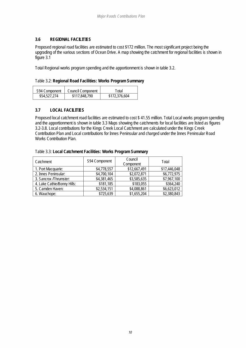
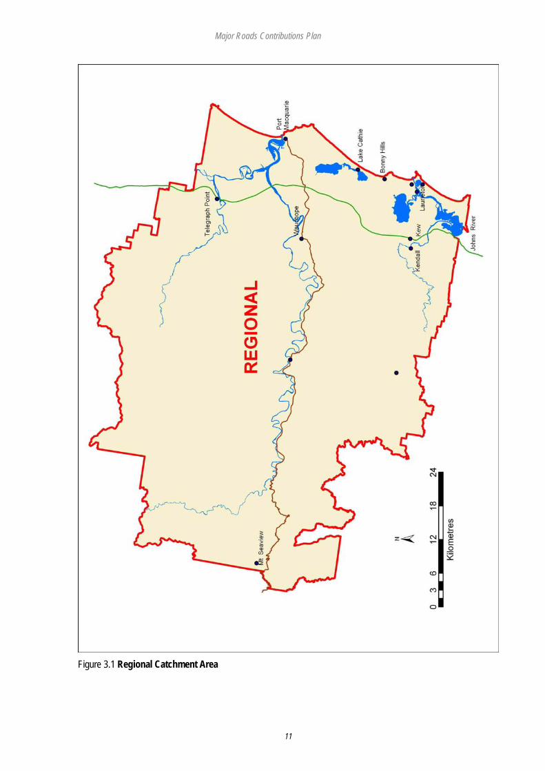
3.6 REGIONAL FACILITIES Proposed regional road facilities are estimated to cost $172 million. The most significant project being the upgrading of the various sections of Ocean Drive. A map showing the catchment for regional facilities is shown in figure 3.1 Total Regional works program spending and the apportionment is shown in table 3.2. Table 3.2: Regional Road Facilities: Works Program Summary
S94 Component Council Component Total $54,527,274 $117,848,790 $172,376,604
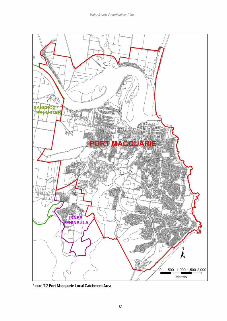
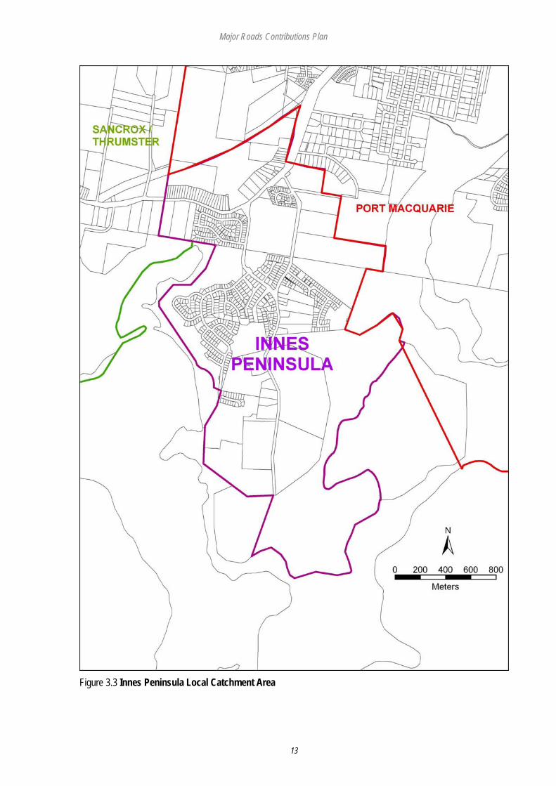
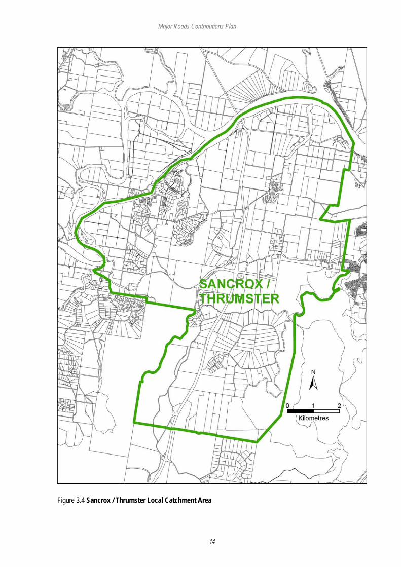
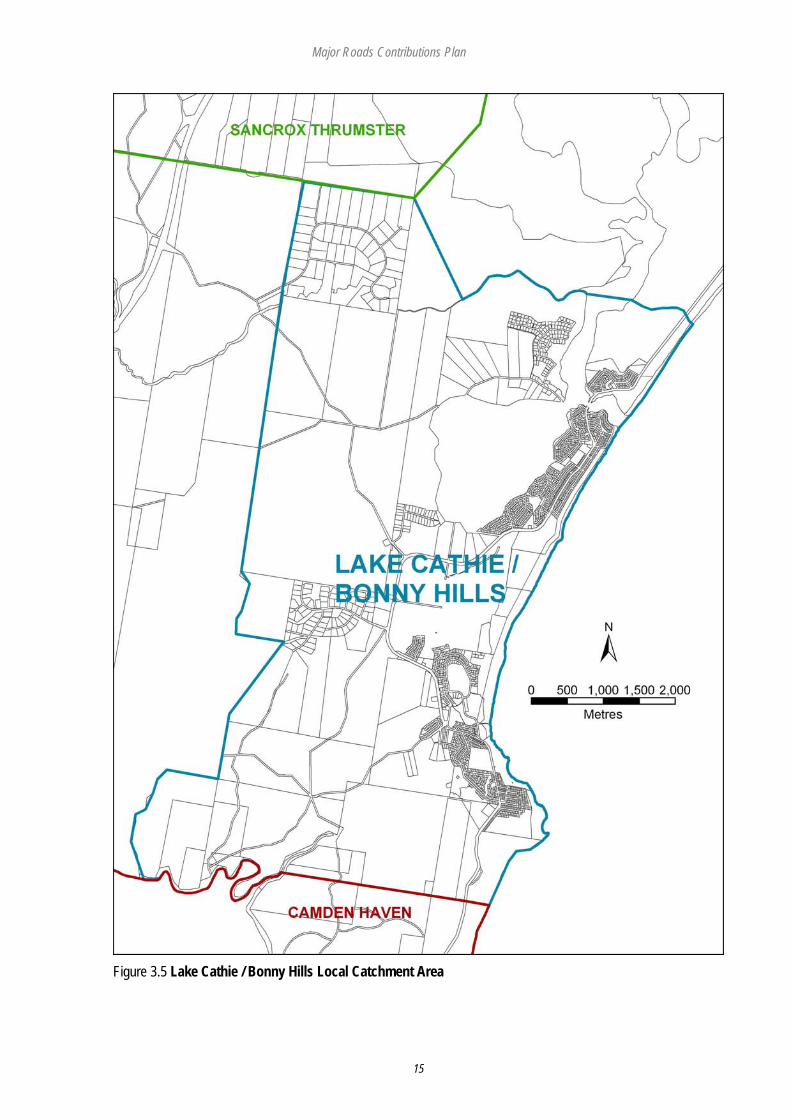
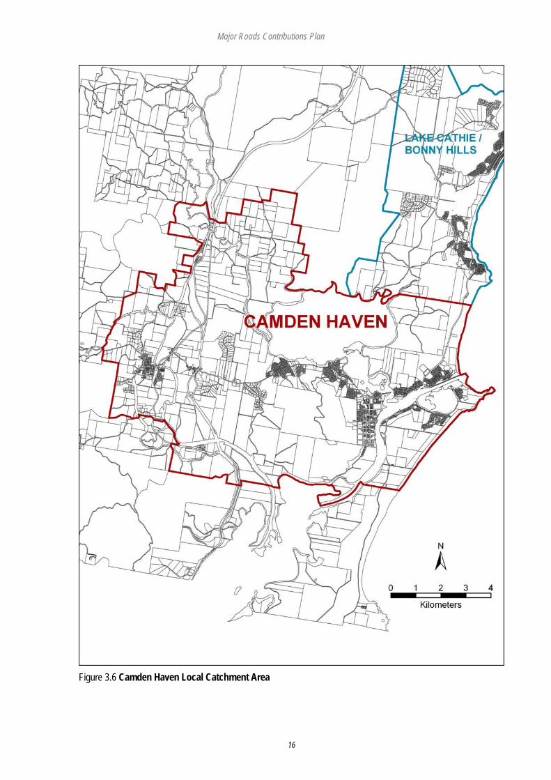
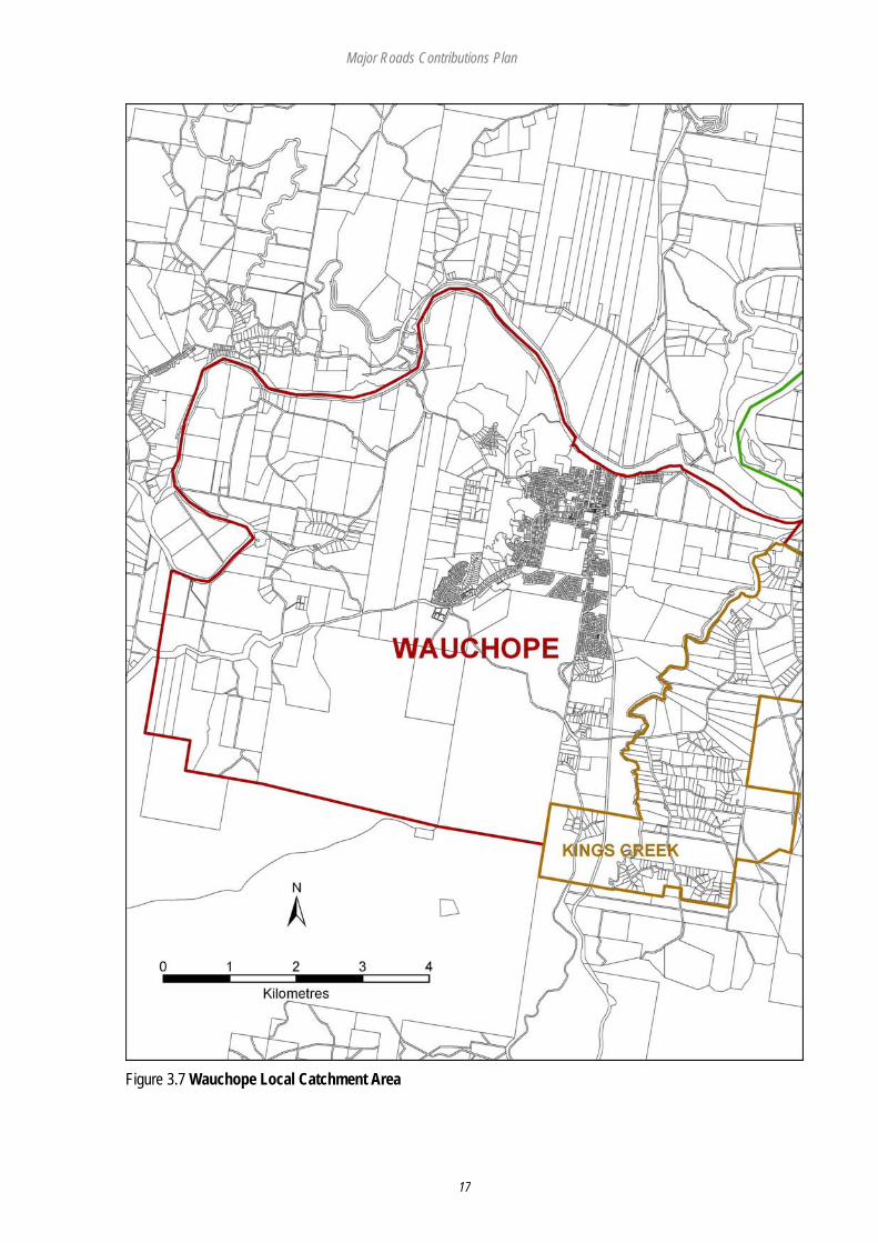
3.7 LOCAL FACILITIES Proposed local catchment road facilities are estimated to cost $ 41.55 million. Total Local works program spending and the apportionment is shown in table 3.3 Maps showing the catchments for local facilities are listed as figures 3.2-3.8. Local contributions for the Kings Creek Local Catchment are calculated under the Kings Creek Contribution Plan and Local contributions for Innes Peninsular and charged under the Innes Peninsular Road Works Contribution Plan. Table 3.3: Local Catchment Facilities: Works Program Summary
Catchment S94 Component Council Component Total
1. Port Macquarie: $4,778,557 $12,667,491 $17,446,048 2. Innes Peninsular: $4,700,104 $2,072,871 $6,772,975 3. Sancrox /Thrumster: $4,381,465 $3,585,635 $7,967,100 4. Lake Cathie/Bonny Hills: $181,185 $183,055 $364,240 5. Camden Haven: $2,534,151 $4,088,861 $6,623,012 6. Wauchope: $725,639 $1,655,204 $2,380,843
Major Roads Contributions Plan
11
Figure 3.1 Regional Catchment Area
Major Roads Contributions Plan
12
Figure 3.2 Port Macquarie Local Catchment Area
Major Roads Contributions Plan
13
Figure 3.3 Innes Peninsula Local Catchment Area
Major Roads Contributions Plan
14
Figure 3.4 Sancrox / Thrumster Local Catchment Area
Major Roads Contributions Plan
15
Figure 3.5 Lake Cathie / Bonny Hills Local Catchment Area
Major Roads Contributions Plan
16
Figure 3.6 Camden Haven Local Catchment Area
Major Roads Contributions Plan
17
Figure 3.7 Wauchope Local Catchment Area
Major Roads Contributions Plan
18
Figure 3.8 Kings Creek Local Catchment Area (Subject to Kings Creek Contribution Plan)

Major Roads Contributions Plan
19
3.8 CONTRIBUTION FORMULAE The major roads contributions are based on the analysis and findings contained in the Hastings Roads and Traffic Study Phase II Report. They are supported by the open space works program summarised in Tables 3.2 and 3.3 and detailed in PART 4. Contributions for major roads have a district and a local component.
Major Roads Contribution = Regional Contribution
+ Local Contribution
Regional and local contributions are calculated using the following formulae: Contribution = ((TC – S) x P) + I
Rate (-------------------------) x r (Per Lot or ET) n
TC = Total Cost of Facilities - sum of capital costs of the infrastructure, which is to be provided S = Direct Subsidies and Grants P = Proportion attributable to new development n = Population Increase r = Average Occupancy rate for detached single house taken from 2001 Census (2.44 persons) ET = Equivalent Tenement eg A house – single density, one lot with one dwelling entitlement) 3.9 CONTRIBUTION RATES The contribution rates for regional and local facilities are summarised in Table 3.4. These are on a per ET (household) basis. The rate for multi-unit and other forms of residential development are calculated as a percentage of the low-density single dwelling rate contributions as show in Table 3.5. Table 3.4: Regional & Local Facility Contributions Summary Catchment Regional Facilities Local Facilities Total Facilities
Per ET Per ET Per ET 1: Port Macquarie $4,035 $1310 $5,345 2: Innes Peninsular ** $4,035 $2,548** $6,583** 3: Sancrox Thrumster $4,035 $1,641 $5,675 4: Lake Cathie/Bonny Hills $4,035 $77 $4,111 5: Camden $4,035 $1,875 $5,910 6: Wauchope $4,035 $960 $4,995 7. Kings Creek* $4,035 * * 8: All other areas $4,035 $0 $4035 *The area covered by the Kings Creek Local Catchment is subject to a separate local catchment contribution under the Kings Creek Contribution Plan. **The area covered by the Innes Peninsula Local Catchment is subject to a separate local catchment contribution under the Innes Peninsula Road Works Contribution Plan Only the Regional contribution applies to the Kings Creek and Innes Peninsula areas under this Plan.
Major Roads Contributions Plan
20
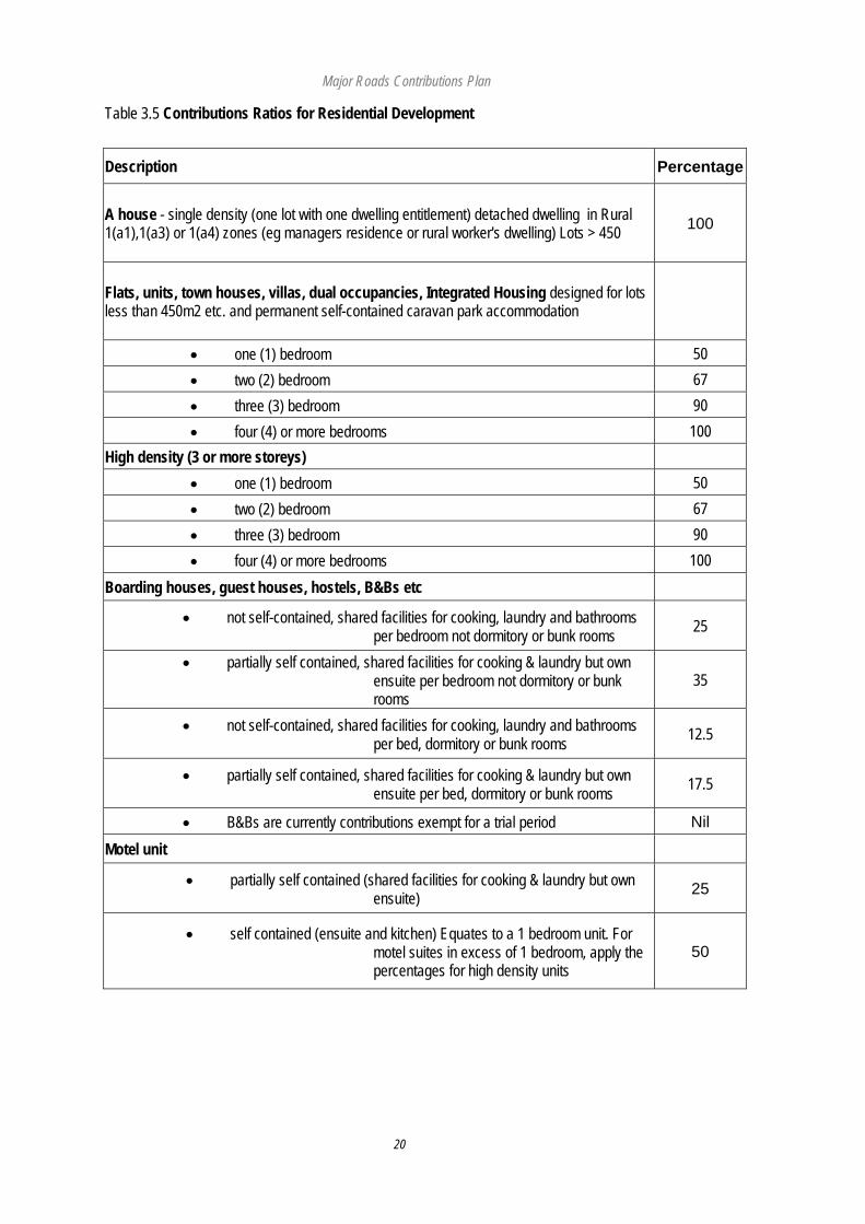
Table 3.5 Contributions Ratios for Residential Development
Description Percentage
A house - single density (one lot with one dwelling entitlement) detached dwelling in Rural 1(a1),1(a3) or 1(a4) zones (eg managers residence or rural worker's dwelling) Lots > 450 100
Flats, units, town houses, villas, dual occupancies, Integrated Housing designed for lots less than 450m2 etc. and permanent self-contained caravan park accommodation
• one (1) bedroom 50 • two (2) bedroom 67 • three (3) bedroom 90 • four (4) or more bedrooms 100
High density (3 or more storeys) • one (1) bedroom 50 • two (2) bedroom 67 • three (3) bedroom 90 • four (4) or more bedrooms 100
Boarding houses, guest houses, hostels, B&Bs etc
• not self-contained, shared facilities for cooking, laundry and bathrooms per bedroom not dormitory or bunk rooms 25
• partially self contained, shared facilities for cooking & laundry but own ensuite per bedroom not dormitory or bunk rooms
35
• not self-contained, shared facilities for cooking, laundry and bathrooms per bed, dormitory or bunk rooms 12.5
• partially self contained, shared facilities for cooking & laundry but own ensuite per bed, dormitory or bunk rooms 17.5
• B&Bs are currently contributions exempt for a trial period Nil
Motel unit
• partially self contained (shared facilities for cooking & laundry but own ensuite) 25
• self contained (ensuite and kitchen) Equates to a 1 bedroom unit. For motel suites in excess of 1 bedroom, apply the percentages for high density units
50
Major Roads Contributions Plan
21
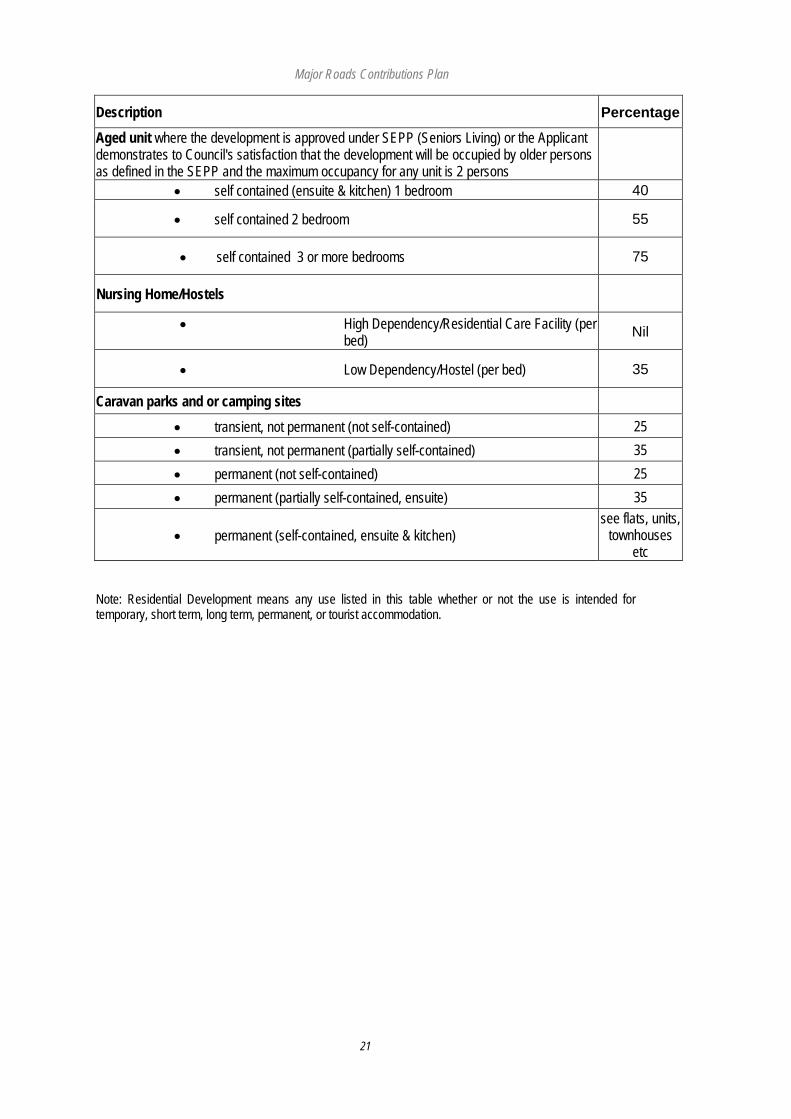
Description Percentage
Aged unit where the development is approved under SEPP (Seniors Living) or the Applicant demonstrates to Council's satisfaction that the development will be occupied by older persons as defined in the SEPP and the maximum occupancy for any unit is 2 persons
• self contained (ensuite & kitchen) 1 bedroom 40
• self contained 2 bedroom 55
• self contained 3 or more bedrooms 75
Nursing Home/Hostels
• High Dependency/Residential Care Facility (per bed) Nil
• Low Dependency/Hostel (per bed) 35
Caravan parks and or camping sites
• transient, not permanent (not self-contained) 25 • transient, not permanent (partially self-contained) 35 • permanent (not self-contained) 25 • permanent (partially self-contained, ensuite) 35
• permanent (self-contained, ensuite & kitchen) see flats, units,
townhouses etc
Note: Residential Development means any use listed in this table whether or not the use is intended for temporary, short term, long term, permanent, or tourist accommodation.
Major Roads Contributions Plan
22
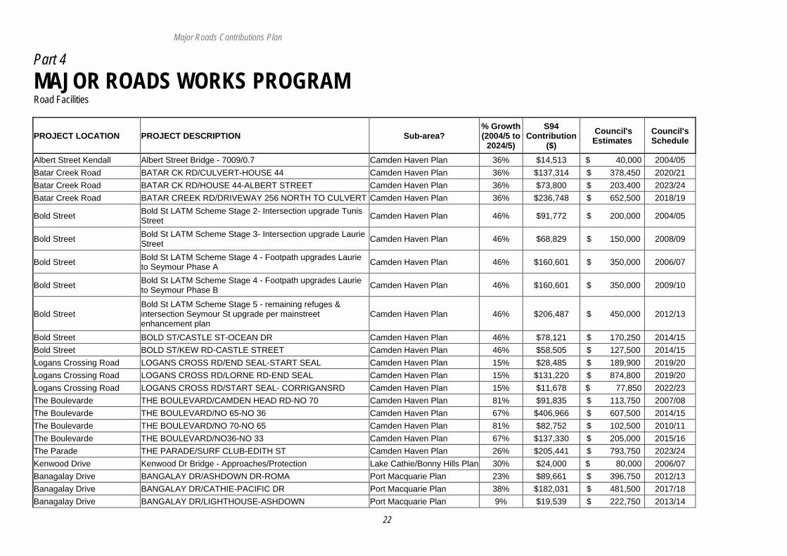
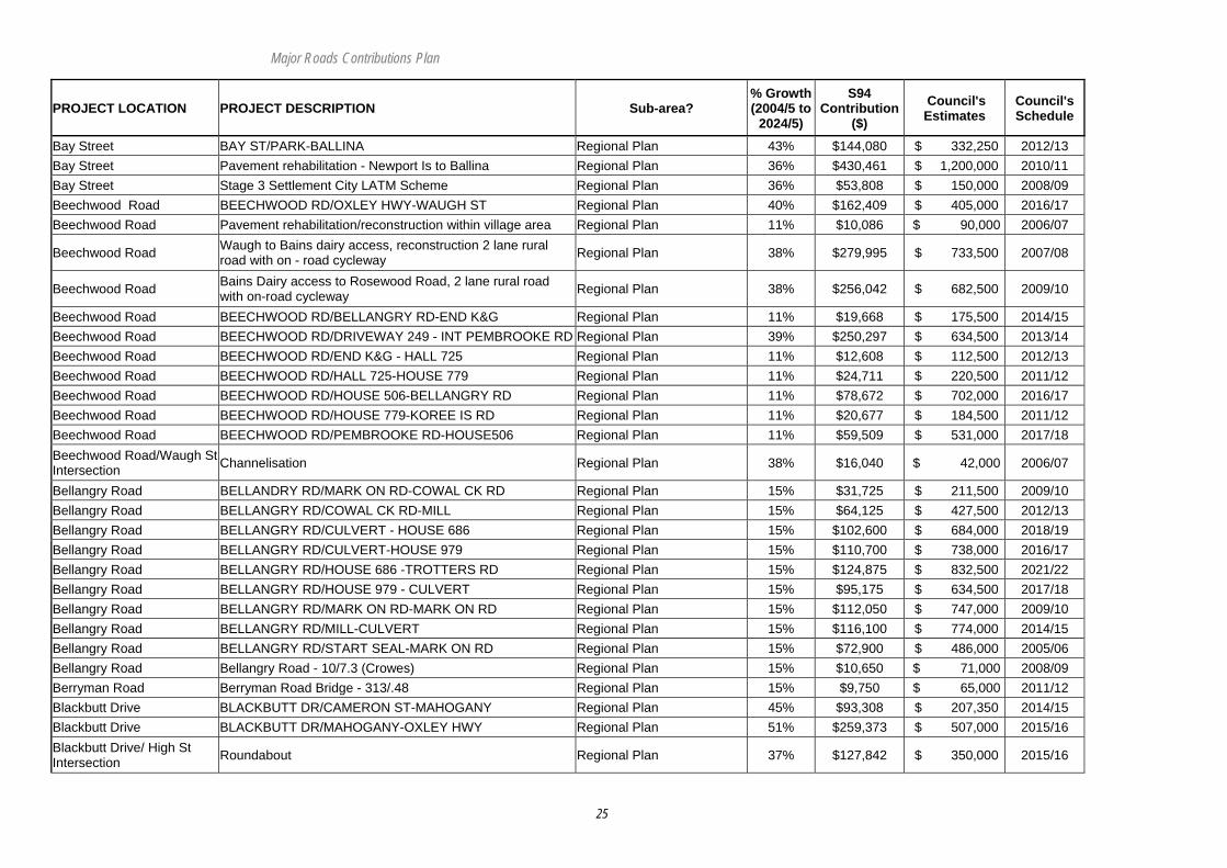
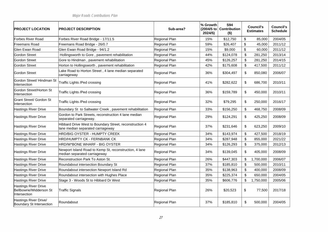
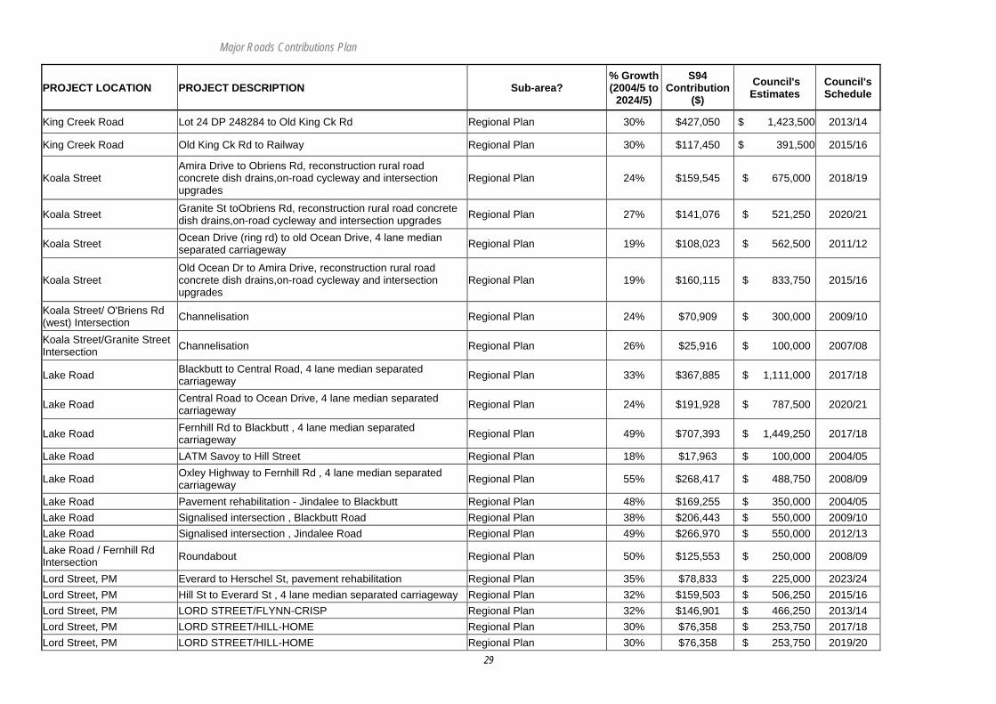
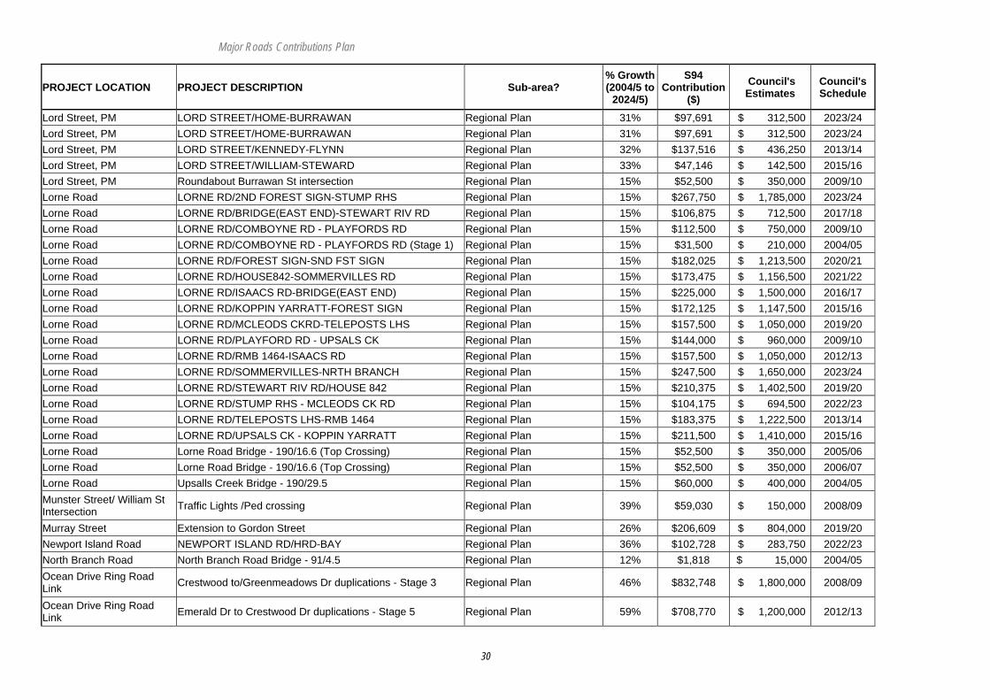
Part 4 MAJOR ROADS WORKS PROGRAM Road Facilities
PROJECT LOCATION PROJECT DESCRIPTION Sub-area? % Growth (2004/5 to
2024/5)
S94 Contribution
($) Council's Estimates
Council's Schedule
Albert Street Kendall Albert Street Bridge - 7009/0.7 Camden Haven Plan 36% $14,513 $ 40,000 2004/05 Batar Creek Road BATAR CK RD/CULVERT-HOUSE 44 Camden Haven Plan 36% $137,314 $ 378,450 2020/21 Batar Creek Road BATAR CK RD/HOUSE 44-ALBERT STREET Camden Haven Plan 36% $73,800 $ 203,400 2023/24 Batar Creek Road BATAR CREEK RD/DRIVEWAY 256 NORTH TO CULVERT Camden Haven Plan 36% $236,748 $ 652,500 2018/19
Bold Street Bold St LATM Scheme Stage 2- Intersection upgrade Tunis Street Camden Haven Plan 46% $91,772 $ 200,000 2004/05
Bold Street Bold St LATM Scheme Stage 3- Intersection upgrade Laurie Street Camden Haven Plan 46% $68,829 $ 150,000 2008/09
Bold Street Bold St LATM Scheme Stage 4 - Footpath upgrades Laurie to Seymour Phase A Camden Haven Plan 46% $160,601 $ 350,000 2006/07
Bold Street Bold St LATM Scheme Stage 4 - Footpath upgrades Laurie to Seymour Phase B Camden Haven Plan 46% $160,601 $ 350,000 2009/10
Bold Street Bold St LATM Scheme Stage 5 - remaining refuges & intersection Seymour St upgrade per mainstreet enhancement plan
Camden Haven Plan 46% $206,487 $ 450,000 2012/13
Bold Street BOLD ST/CASTLE ST-OCEAN DR Camden Haven Plan 46% $78,121 $ 170,250 2014/15 Bold Street BOLD ST/KEW RD-CASTLE STREET Camden Haven Plan 46% $58,505 $ 127,500 2014/15 Logans Crossing Road LOGANS CROSS RD/END SEAL-START SEAL Camden Haven Plan 15% $28,485 $ 189,900 2019/20 Logans Crossing Road LOGANS CROSS RD/LORNE RD-END SEAL Camden Haven Plan 15% $131,220 $ 874,800 2019/20 Logans Crossing Road LOGANS CROSS RD/START SEAL- CORRIGANSRD Camden Haven Plan 15% $11,678 $ 77,850 2022/23 The Boulevarde THE BOULEVARD/CAMDEN HEAD RD-NO 70 Camden Haven Plan 81% $91,835 $ 113,750 2007/08 The Boulevarde THE BOULEVARD/NO 65-NO 36 Camden Haven Plan 67% $406,966 $ 607,500 2014/15 The Boulevarde THE BOULEVARD/NO 70-NO 65 Camden Haven Plan 81% $82,752 $ 102,500 2010/11 The Boulevarde THE BOULEVARD/NO36-NO 33 Camden Haven Plan 67% $137,330 $ 205,000 2015/16 The Parade THE PARADE/SURF CLUB-EDITH ST Camden Haven Plan 26% $205,441 $ 793,750 2023/24 Kenwood Drive Kenwood Dr Bridge - Approaches/Protection Lake Cathie/Bonny Hills Plan 30% $24,000 $ 80,000 2006/07 Banagalay Drive BANGALAY DR/ASHDOWN DR-ROMA Port Macquarie Plan 23% $89,661 $ 396,750 2012/13 Banagalay Drive BANGALAY DR/CATHIE-PACIFIC DR Port Macquarie Plan 38% $182,031 $ 481,500 2017/18 Banagalay Drive BANGALAY DR/LIGHTHOUSE-ASHDOWN Port Macquarie Plan 9% $19,539 $ 222,750 2013/14
Major Roads Contributions Plan
23
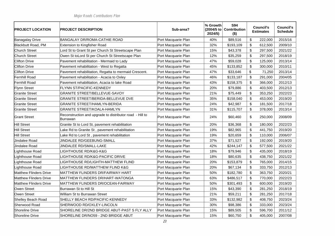
PROJECT LOCATION PROJECT DESCRIPTION Sub-area? % Growth (2004/5 to
2024/5)
S94 Contribution
($) Council's Estimates
Council's Schedule
Banagalay Drive BANGALAY DR/ROMA-CATHIE ROAD Port Macquarie Plan 40% $89,516 $ 222,000 2015/16 Blackbutt Road, PM Extension to Kingfisher Road Port Macquarie Plan 32% $193,109 $ 612,500 2009/10 Church Street Lord St to Grant St per Church St Streetscape Plan Port Macquarie Plan 15% $43,378 $ 297,500 2021/22 Church Street Owen St toLord St per Church St Streetscape Plan Port Macquarie Plan 12% $35,259 $ 297,500 2018/19 Clifton Drive Pavement rehabilitation - Mermaid to Lady Port Macquarie Plan 47% $59,028 $ 125,000 2013/14 Clifton Drive Pavement rehabilitation - West to Regatta Port Macquarie Plan 45% $133,852 $ 300,000 2010/11 Clifton Drive Pavement rehabilitation, Regatta to mermaid Crescent. Port Macquarie Plan 47% $33,646 $ 71,250 2013/14 Fernhill Road Pavement rehabilitation - Acacia to Oxley Port Macquarie Plan 46% $133,187 $ 291,000 2004/05 Fernhill Road Pavement rehabilitation, Acacia to lake Road Port Macquarie Plan 43% $158,375 $ 366,000 2012/13 Flynn Street FLYNN ST/PACIFIC-KENNEDY Port Macquarie Plan 20% $79,886 $ 403,500 2012/13 Granite Street GRANITE STREET/BELLEVUE-SAVOY Port Macquarie Plan 21% $75,449 $ 353,250 2022/23 Granite Street GRANITE STREET/BERIDA-BELLEVUE DVE Port Macquarie Plan 35% $158,040 $ 453,000 2019/20 Granite Street GRANITE STREET/HAMLYN-BERIDA Port Macquarie Plan 24% $42,987 $ 181,500 2017/18 Granite Street GRANITE STREET/KOALA-HAMLYN Port Macquarie Plan 31% $115,707 $ 378,000 2013/14
Grant Street Reconstruction and upgrade to distributor road - Hill to Burrawan Port Macquarie Plan 24% $60,460 $ 250,000 2008/09
Hill Street Granite St to Lord St, pavement rehabilitation Port Macquarie Plan 20% $36,368 $ 180,000 2022/23 Hill Street Lake Rd to Granite St , pavement rehabilitation Port Macquarie Plan 19% $82,965 $ 441,750 2019/20 Hill Street Lake Rd to Lord St , pavement rehabilitation Port Macquarie Plan 19% $20,659 $ 110,000 2006/07 Jindalee Road JINDALEE RD/GEEBUNG-SMALL Port Macquarie Plan 37% $71,527 $ 192,000 2019/20 Jindalee Road JINDALEE RD/SMALL-LAKE Port Macquarie Plan 42% $244,147 $ 577,500 2021/22 Lighthouse Road LIGHTHOUSE RD/K&G-K&G Port Macquarie Plan 18% $79,946 $ 435,000 2018/19 Lighthouse Road LIGHTHOUSE RD/K&G-PACIFIC DRIVE Port Macquarie Plan 18% $80,635 $ 438,750 2021/22 Lighthouse Road LIGHTHOUSE RD/LIGHTH-MATTHEW FLIND Port Macquarie Plan 20% $153,879 $ 765,000 2014/15 Lighthouse Road LIGHTHOUSE RD/MATTHEW FLIND K&G Port Macquarie Plan 20% $67,134 $ 333,750 2012/13 Matthew Flinders Drive MATTHEW FLINDERS DR/FAIRWAY-HART Port Macquarie Plan 50% $182,780 $ 363,750 2020/21 Matthew Flinders Drive MATTHEW FLINDERS DR/HART-WATONGA Port Macquarie Plan 63% $486,517 $ 770,000 2022/23 Matthew Flinders Drive MATTHEW FLINDERS DR/OCEAN-FAIRWAY Port Macquarie Plan 50% $301,493 $ 600,000 2019/20 Owen Street Burrawan St to Hill St Port Macquarie Plan 15% $43,390 $ 281,250 2018/19 Owen Street William St to Burrawan Street Port Macquarie Plan 21% $59,211 $ 281,250 2017/18 Shelley Beach Road SHELLY BEACH RD/PACIFIC-KENNEDY Port Macquarie Plan 33% $132,982 $ 408,750 2023/24 Sherwood Road SHERWOOD RD/OXLEY-LINCOLN Port Macquarie Plan 30% $98,386 $ 333,000 2023/24 Shoreline Drive SHORELINE DR/2ND BRIDGE ABUT-PAST S FLY ALLY Port Macquarie Plan 15% $89,505 $ 596,700 2011/12 Shoreline Drive SHORELINE DR/NO59 - 2ND BRIDGE ABUT Port Macquarie Plan 15% $60,750 $ 405,000 2007/08

Major Roads Contributions Plan
24
PROJECT LOCATION PROJECT DESCRIPTION Sub-area? % Growth (2004/5 to
2024/5)
S94 Contribution
($) Council's Estimates
Council's Schedule
Shoreline Drive SHORELINE DR/NTH SHORE DR - NO59 Port Macquarie Plan 15% $46,575 $ 310,500 2006/07 Shoreline Drive SHORELINE DR/SFLY ALLEY-RIVSIDE DR Port Macquarie Plan 15% $111,780 $ 745,200 2014/15 Stewart Street Lord St to Owen St per Town Beach Streetscape Plan Port Macquarie Plan 27% $115,381 $ 435,000 2022/23 Aston Street Extension of Aston St to Bay St Regional Plan 36% $179,359 $ 500,000 2011/12 Bagnoo Road Bagnoo Road Bridge - 16/7.6 Regional Plan 43% $13,175 $ 30,700 2004/05 Bago Road BAGO RD/CULVERT-END GUARD RAIL Regional Plan 40% $108,006 $ 269,100 2017/18 Bago Road BAGO RD/END GUARD RAIL-MARK ON RD Regional Plan 40% $306,499 $ 763,650 2018/19 Bago Road BAGO RD/KINGS CK RD-CAMERON STREET Regional Plan 34% $210,439 $ 624,600 2015/16 Bago Road BAGO RD/MARK ON RD-BAULMAN LKOUT RD Regional Plan 40% $102,588 $ 255,600 2014/15 Bago Road BAGO RD/MARK ON RD-KINGS CK RD Regional Plan 37% $260,259 $ 706,050 2013/14 Bago Road BAGO RD/MARK ON RD-RAIL BRIDGE Regional Plan 40% $352,374 $ 877,950 2007/08 Bago Road BAGO RD/RAIL BRIDGE-MARK ON ROAD Regional Plan 40% $134,737 $ 335,700 2011/12 Bago Road BAGO RD/SH 10-MARK ON ROAD Regional Plan 40% $210,855 $ 525,350 2006/07
Bago Road Rehabilitation/reconstruction of existing road pavement - Stage 2 - 4.43km to5.95km Regional Plan 40% $275,614 $ 686,700 2009/10
Ballengarra Bransdon Road BALL*GRA BRANS RD/BALANCE TO BRIDGE Regional Plan 15% $59,400 $ 396,000 2020/21
Ballengarra Bransdon Road BALL*GRA BRANS RD/BRIDGE-SCOTTS PLANS Regional Plan 15% $168,075 $ 1,120,500 2022/23
Ballengarra Bransdon Road BALL*GRA BRANS RD/END OF SEAL TOWARDS GUM SCRUB Regional Plan 15% $33,750 $ 225,000 2004/05
Ballengarra Bransdon Road BALL*GRA BRANS RD/HOUSE131-HOUSE173 Regional Plan 15% $26,325 $ 175,500 2014/15
Ballengarra Bransdon Road BALL*GRA BRANS RD/HOUSE173-HOUSE331 Regional Plan 15% $105,975 $ 706,500 2017/18
Ballengarra Bransdon Road BALL*GRA BRANS RD/ROLL PL RD-HSE131 Regional Plan 15% $89,100 $ 594,000 2012/13
Ballengarra Bransdon Road Ballengarra Bransdon Bridge - 53/4.3 Regional Plan 15% $10,500 $ 70,000 2004/05
Ballengarra Bransdon Road Ballengarra Bransdon Bridge - 53/5.9 Regional Plan 15% $6,000 $ 40,000 2004/05
Batar Creek Road BATAR CK RD/CATTLE GRID-CAUSEWAY Regional Plan 36% $352,019 $ 970,200 2012/13 Batar Creek Road BATAR CK RD/CAUSEWAY - END SEAL Regional Plan 36% $293,567 $ 809,100 2011/12 Batar Creek Road BATAR CK RD/SEAL-DAIRY SHED 256 Regional Plan 36% $282,954 $ 779,850 2016/17 Batar Creek Road Batar Creek Road Bridge - 18/5.8 Regional Plan 36% $14,513 $ 40,000 2005/06
Major Roads Contributions Plan
25
PROJECT LOCATION PROJECT DESCRIPTION Sub-area? % Growth (2004/5 to
2024/5)
S94 Contribution
($) Council's Estimates
Council's Schedule
Bay Street BAY ST/PARK-BALLINA Regional Plan 43% $144,080 $ 332,250 2012/13 Bay Street Pavement rehabilitation - Newport Is to Ballina Regional Plan 36% $430,461 $ 1,200,000 2010/11 Bay Street Stage 3 Settlement City LATM Scheme Regional Plan 36% $53,808 $ 150,000 2008/09 Beechwood Road BEECHWOOD RD/OXLEY HWY-WAUGH ST Regional Plan 40% $162,409 $ 405,000 2016/17 Beechwood Road Pavement rehabilitation/reconstruction within village area Regional Plan 11% $10,086 $ 90,000 2006/07
Beechwood Road Waugh to Bains dairy access, reconstruction 2 lane rural road with on - road cycleway Regional Plan 38% $279,995 $ 733,500 2007/08
Beechwood Road Bains Dairy access to Rosewood Road, 2 lane rural road with on-road cycleway Regional Plan 38% $256,042 $ 682,500 2009/10
Beechwood Road BEECHWOOD RD/BELLANGRY RD-END K&G Regional Plan 11% $19,668 $ 175,500 2014/15 Beechwood Road BEECHWOOD RD/DRIVEWAY 249 - INT PEMBROOKE RD Regional Plan 39% $250,297 $ 634,500 2013/14 Beechwood Road BEECHWOOD RD/END K&G - HALL 725 Regional Plan 11% $12,608 $ 112,500 2012/13 Beechwood Road BEECHWOOD RD/HALL 725-HOUSE 779 Regional Plan 11% $24,711 $ 220,500 2011/12 Beechwood Road BEECHWOOD RD/HOUSE 506-BELLANGRY RD Regional Plan 11% $78,672 $ 702,000 2016/17 Beechwood Road BEECHWOOD RD/HOUSE 779-KOREE IS RD Regional Plan 11% $20,677 $ 184,500 2011/12 Beechwood Road BEECHWOOD RD/PEMBROOKE RD-HOUSE506 Regional Plan 11% $59,509 $ 531,000 2017/18 Beechwood Road/Waugh St Intersection Channelisation Regional Plan 38% $16,040 $ 42,000 2006/07
Bellangry Road BELLANDRY RD/MARK ON RD-COWAL CK RD Regional Plan 15% $31,725 $ 211,500 2009/10 Bellangry Road BELLANGRY RD/COWAL CK RD-MILL Regional Plan 15% $64,125 $ 427,500 2012/13 Bellangry Road BELLANGRY RD/CULVERT - HOUSE 686 Regional Plan 15% $102,600 $ 684,000 2018/19 Bellangry Road BELLANGRY RD/CULVERT-HOUSE 979 Regional Plan 15% $110,700 $ 738,000 2016/17 Bellangry Road BELLANGRY RD/HOUSE 686 -TROTTERS RD Regional Plan 15% $124,875 $ 832,500 2021/22 Bellangry Road BELLANGRY RD/HOUSE 979 - CULVERT Regional Plan 15% $95,175 $ 634,500 2017/18 Bellangry Road BELLANGRY RD/MARK ON RD-MARK ON RD Regional Plan 15% $112,050 $ 747,000 2009/10 Bellangry Road BELLANGRY RD/MILL-CULVERT Regional Plan 15% $116,100 $ 774,000 2014/15 Bellangry Road BELLANGRY RD/START SEAL-MARK ON RD Regional Plan 15% $72,900 $ 486,000 2005/06 Bellangry Road Bellangry Road - 10/7.3 (Crowes) Regional Plan 15% $10,650 $ 71,000 2008/09 Berryman Road Berryman Road Bridge - 313/.48 Regional Plan 15% $9,750 $ 65,000 2011/12 Blackbutt Drive BLACKBUTT DR/CAMERON ST-MAHOGANY Regional Plan 45% $93,308 $ 207,350 2014/15 Blackbutt Drive BLACKBUTT DR/MAHOGANY-OXLEY HWY Regional Plan 51% $259,373 $ 507,000 2015/16 Blackbutt Drive/ High St Intersection Roundabout Regional Plan 37% $127,842 $ 350,000 2015/16

Major Roads Contributions Plan
26
PROJECT LOCATION PROJECT DESCRIPTION Sub-area? % Growth (2004/5 to
2024/5)
S94 Contribution
($) Council's Estimates
Council's Schedule
Buller Street/Hollingsworth Intersection Buller/Hollingsworth Intersection Traffic Signals Regional Plan 39% $86,396 $ 220,000 2015/16
Burrawan Forest Drive Burrawan Forest Drive Works Regional Plan 59% $29,341 $ 50,000 2008/09 Burrawan Forest Drive Wrights Creek Bridge - 254/1.0 Regional Plan 59% $76,816 $ 130,900 2004/05 Cameron Street Blackbutt Drive to King Street , pavement rehabilitation Regional Plan 36% $186,380 $ 520,500 2011/12 Cameron Street King St to High Street, pavement rehabilitation Regional Plan 32% $79,256 $ 249,000 2014/15
Cameron Street/Blackbutt Drive Intersection
Construction of a roundabout at the intersection of Cameron Street and Blackbutt Drive Wauchope in line with the Wauchope Traffic Study.
Regional Plan 32% $112,551 $ 350,000 2011/12
Campbell Street/High St/Range St Intersection
Campbell/High/Range Streets intersection re-alignment in line with the Wauchope Traffic Study. Regional Plan 30% $59,806 $ 200,000 2015/16
Cedar Creek Road Cedar Creek Road Bridge Regional Plan 40% $24,082 $ 60,000 2013/14 Central Road Intersection channelisation , Hindman St. Regional Plan 31% $46,115 $ 150,000 2019/20 Central Road Pavement rehabilitation - Lake to Hindman Regional Plan 23% $360,936 $ 1,544,625 2014/15 Clarence Street Munster St to School St per Town Beach Streetscape Plan Regional Plan 27% $42,035 $ 156,250 2014/15 Clarence Street School St to Grant St per Town Beach Streetscape Plan Regional Plan 18% $65,455 $ 360,000 2010/11 Colling Road Colling Road Bridge - 12/7.3km Regional Plan 15% $9,855 $ 65,700 2008/09 Comboyne Road Comboyne Road Bridge - 191/33 (Donkins Flat) Regional Plan 15% $7,050 $ 47,000 2009/10 Comboyne Road COMBYN RD/BBQ AREA - GATE 1752 Regional Plan 15% $142,425 $ 949,500 2021/22 Comboyne Road COMBYN RD/COLING RD - ENTRY TO TIP Regional Plan 15% $143,775 $ 958,500 2008/09 Comboyne Road COMBYN RD/END CH*WRE FNCE-END G*RL Regional Plan 15% $116,100 $ 774,000 2023/24 Comboyne Road COMBYN RD/ENTRY TIP - MILK SHED Regional Plan 15% $62,100 $ 414,000 2012/13 Comboyne Road COMBYN RD/GATE 1752-END CH*WRE FNCE Regional Plan 15% $112,050 $ 747,000 2023/24 Comboyne Road COMBYN RD/GIBRALTAR - COLING RD Regional Plan 15% $116,775 $ 778,500 2008/09 Comboyne Road COMBYN RD/LANSDOWNE RD - LORNE RD Regional Plan 15% $79,920 $ 532,800 2014/15 Comboyne Road COMBYN RD/LORNE RD-MILK CAN 2243 Regional Plan 15% $148,500 $ 990,000 2017/18 Comboyne Road COMBYN RD/MILK CAN 2243-STENETTS RD Regional Plan 15% $104,625 $ 697,500 2018/19 Comboyne Road COMBYN RD/MILK SHED-PONSFORD RD Regional Plan 15% $164,700 $ 1,098,000 2015/16 Comboyne Road COMBYN RD/PONSFORD RD-RIVER ST Regional Plan 15% $115,020 $ 766,800 2012/13 Comboyne Road COMBYN RD/STENETTS RD-BBQ AREA Regional Plan 15% $73,575 $ 490,500 2019/20 Comboyne Road COMBYNE RD/CNCL BOUND - GIBRALTA Regional Plan 15% $87,750 $ 585,000 2008/09 Comboyne Road Rehabilitation - Selected Areas Regional Plan 15% $87,750 $ 585,000 2009/10 Eastern Boundary Road Eastern Boundary Road Bridge - 226/1.8km Regional Plan 15% $8,850 $ 59,000 2005/06 Farrawells Road Farrawells Road Bridge - 175/2.7 Regional Plan 15% $6,000 $ 40,000 2009/10
Major Roads Contributions Plan
27
PROJECT LOCATION PROJECT DESCRIPTION Sub-area? % Growth (2004/5 to
2024/5)
S94 Contribution
($) Council's Estimates
Council's Schedule
Forbes River Road Forbes River Road Bridge - 17/11.5 Regional Plan 15% $12,750 $ 85,000 2004/05 Freemans Road Freemans Road Bridge - 26/0.7 Regional Plan 59% $26,407 $ 45,000 2011/12 Glen Ewan Road Glen Ewan Road Bridge - 94/1.2 Regional Plan 15% $9,000 $ 60,000 2011/12 Gordon Street Hollingsworth to Gore , pavement rehabilitation Regional Plan 44% $124,078 $ 281,250 2013/14 Gordon Street Gore to Hindman , pavement rehabilitation Regional Plan 45% $126,257 $ 281,250 2014/15 Gordon Street Horton to Hollingsworth , pavement rehabilitation Regional Plan 42% $175,608 $ 417,500 2011/12
Gordon Street Lake Road to Horton Street , 4 lane median separated carriageway Regional Plan 36% $304,497 $ 850,080 2006/07
Gordon Street/ Hindman St Intersection Traffic Lights /Ped crossing Regional Plan 41% $282,622 $ 686,700 2010/11
Gordon Street/Horton St Intersection Traffic Lights /Ped crossing Regional Plan 36% $159,789 $ 450,000 2010/11
Grant Street/ Gordon St Intersection Traffic Lights /Ped crossing Regional Plan 32% $79,295 $ 250,000 2016/17
Hastings River Drive Boundary St to Saltwater Creek , pavement rehabilitation Regional Plan 33% $156,250 $ 468,750 2008/09
Hastings River Drive Gordon to Park Streets, reconstruction 4 lane median separated carriageway. Regional Plan 29% $124,291 $ 425,250 2008/09
Hastings River Drive Hibbard Drive West to Boundary Street, reconstruction 4 lane median separated carriageway Regional Plan 37% $231,646 $ 623,250 2009/10
Hastings River Drive HRD/BIG OYSTER - HUMPTY CREEK Regional Plan 34% $143,974 $ 427,500 2018/19 Hastings River Drive HRD/HUMPTY CK - FERNBANK CK Regional Plan 34% $287,948 $ 855,000 2021/22 Hastings River Drive HRD/W*BONE WHARF - BIG OYSTER Regional Plan 34% $126,293 $ 375,000 2012/13
Hastings River Drive Newport Island Road to Kemp St, reconstruction, 4 lane median separated carriageway Regional Plan 34% $139,045 $ 405,000 2008/09
Hastings River Drive Reconstruction Park To Aston St. Regional Plan 26% $447,303 $ 1,700,000 2006/07 Hastings River Drive Roundabout intersection Boundary St Regional Plan 37% $185,810 $ 500,000 2010/11 Hastings River Drive Roundabout intersection Newport Island Rd Regional Plan 35% $138,963 $ 400,000 2008/09 Hastings River Drive Roundabout intersection with Hughes Place Regional Plan 35% $225,374 $ 650,000 2004/05 Hastings River Drive Stage 3 - Woods St to Hibbard Dr West Regional Plan 35% $606,776 $ 1,750,000 2005/06 Hastings River Drive Bellbowrie/Widderson St Intersection
Traffic Signals Regional Plan 26% $20,523 $ 77,500 2017/18
Hastings River Drive/ Boundary St Intersection Roundabout Regional Plan 37% $185,810 $ 500,000 2004/05

Major Roads Contributions Plan
28
PROJECT LOCATION PROJECT DESCRIPTION Sub-area? % Growth (2004/5 to
2024/5)
S94 Contribution
($) Council's Estimates
Council's Schedule
Hastings River Drive/ Parks St Intersection Traffic Signals Regional Plan 30% $29,698 $ 100,000 2014/15
Hay Street HAY ST/GORDON-HAYWARD Regional Plan 34% $38,922 $ 113,750 2011/12 Hay Street HAY ST/HAYWARD-WILLIAM Regional Plan 34% $95,809 $ 280,000 2013/14 Haydens Wharf Road Haydens Wharf Road Bridge - 101/2.6km Regional Plan 15% $3,105 $ 20,700 2009/10 High Street, Wauchope Hastings St to Campbell , Pavement rehabilitation Regional Plan 30% $47,097 $ 157,500 2022/23 High Street/Hastings St Intersection
Construction of Roundabout at intersection of High and Hastings Streets in line with the Wauchope Traffic Study. Regional Plan 30% $29,903 $ 100,000 2014/15
Hill Street/ Lake Rd Intersection Channelisation Regional Plan 18% $8,983 $ 50,000 2008/09
Hill Street/ Pacific Dr Intersection Channelisation Regional Plan 17% $35,168 $ 210,000 2010/11
Hindman Street Ring Road Link
Upgrade Hindman St , Kooloonbung Cl. to Gordon St. to dual carriageway (Stage 4) Regional Plan 35% $904,491 $ 2,612,500 2011/12
Houston Michell Drive HOUSTON MITCHELL DR/MARK ON RD TO MARK ON RD Regional Plan 52% $353,290 $ 683,250 2011/12 Houston Michell Drive HOUSTON MITCHELL DR/MARK ON RD TO MARK ON RD Regional Plan 52% $240,827 $ 465,750 2014/15
Houston Michell Drive HOUSTON MITCHELL DR/MARK ON RD TO PACIFIC HWY Regional Plan 52% $354,841 $ 686,250 2017/18
Houston Michell Drive HOUSTON MITCHELL DR/OCEAN DR TO MARK ON RD Regional Plan 52% $748,463 $ 1,447,500 2010/11 Kendall Road KENDALL RD/BRIDGE TO NO. 89 Regional Plan 27% $47,905 $ 175,000 2006/07 Kendall Road KENDALL RD/NO. 89 TO NO. 158 Regional Plan 27% $54,749 $ 200,000 2006/07 Kennedy Drive Oleander to Orr St, Pavement rehabilitation Regional Plan 40% $70,212 $ 174,000 2020/21
Kennedy Drive Oleander to Pacific Drive reconstruction, pavement widenings and intersection channelisation Regional Plan 38% $272,854 $ 713,250 2010/11
Kennedy Drive Rehabilitation - Shelly Beach Rd to Hillcrest Regional Plan 47% $233,503 $ 500,000 2008/09 Kennedy Drive/ Koala St Intersection Channelisation Regional Plan 45% $242,641 $ 542,250 2010/11
Kennedy Drive/ Pacific Dr Intersection Channelisation Regional Plan 43% $86,273 $ 200,000 2008/09
Kennedy Drive/ Shelly Beach Intersection Channelisation Regional Plan 45% $387,224 $ 870,000 2010/11
Kindee Road Kindee Road Bridge - 20/9.9 Regional Plan 15% $5,595 $ 37,300 2008/09
King Creek Road Sarahs Crescent to Narran Close Regional Plan 30% $169,425 $ 564,750 2008/09
King Creek Road Narran Close to lot 24DP 248284 Regional Plan 30% $167,625 $ 558,750 2010/11
Major Roads Contributions Plan
29
PROJECT LOCATION PROJECT DESCRIPTION Sub-area? % Growth (2004/5 to
2024/5)
S94 Contribution
($) Council's Estimates
Council's Schedule
King Creek Road Lot 24 DP 248284 to Old King Ck Rd Regional Plan 30% $427,050 $ 1,423,500 2013/14
King Creek Road Old King Ck Rd to Railway Regional Plan 30% $117,450 $ 391,500 2015/16
Koala Street Amira Drive to Obriens Rd, reconstruction rural road concrete dish drains,on-road cycleway and intersection upgrades
Regional Plan 24% $159,545 $ 675,000 2018/19
Koala Street Granite St toObriens Rd, reconstruction rural road concrete dish drains,on-road cycleway and intersection upgrades Regional Plan 27% $141,076 $ 521,250 2020/21
Koala Street Ocean Drive (ring rd) to old Ocean Drive, 4 lane median separated carriageway Regional Plan 19% $108,023 $ 562,500 2011/12
Koala Street Old Ocean Dr to Amira Drive, reconstruction rural road concrete dish drains,on-road cycleway and intersection upgrades
Regional Plan 19% $160,115 $ 833,750 2015/16
Koala Street/ O'Briens Rd (west) Intersection Channelisation Regional Plan 24% $70,909 $ 300,000 2009/10
Koala Street/Granite Street Intersection Channelisation Regional Plan 26% $25,916 $ 100,000 2007/08
Lake Road Blackbutt to Central Road, 4 lane median separated carriageway Regional Plan 33% $367,885 $ 1,111,000 2017/18
Lake Road Central Road to Ocean Drive, 4 lane median separated carriageway Regional Plan 24% $191,928 $ 787,500 2020/21
Lake Road Fernhill Rd to Blackbutt , 4 lane median separated carriageway Regional Plan 49% $707,393 $ 1,449,250 2017/18
Lake Road LATM Savoy to Hill Street Regional Plan 18% $17,963 $ 100,000 2004/05
Lake Road Oxley Highway to Fernhill Rd , 4 lane median separated carriageway Regional Plan 55% $268,417 $ 488,750 2008/09
Lake Road Pavement rehabilitation - Jindalee to Blackbutt Regional Plan 48% $169,255 $ 350,000 2004/05 Lake Road Signalised intersection , Blackbutt Road Regional Plan 38% $206,443 $ 550,000 2009/10 Lake Road Signalised intersection , Jindalee Road Regional Plan 49% $266,970 $ 550,000 2012/13 Lake Road / Fernhill Rd Intersection Roundabout Regional Plan 50% $125,553 $ 250,000 2008/09
Lord Street, PM Everard to Herschel St, pavement rehabilitation Regional Plan 35% $78,833 $ 225,000 2023/24 Lord Street, PM Hill St to Everard St , 4 lane median separated carriageway Regional Plan 32% $159,503 $ 506,250 2015/16 Lord Street, PM LORD STREET/FLYNN-CRISP Regional Plan 32% $146,901 $ 466,250 2013/14 Lord Street, PM LORD STREET/HILL-HOME Regional Plan 30% $76,358 $ 253,750 2017/18 Lord Street, PM LORD STREET/HILL-HOME Regional Plan 30% $76,358 $ 253,750 2019/20
Major Roads Contributions Plan
30
PROJECT LOCATION PROJECT DESCRIPTION Sub-area? % Growth (2004/5 to
2024/5)
S94 Contribution
($) Council's Estimates
Council's Schedule
Lord Street, PM LORD STREET/HOME-BURRAWAN Regional Plan 31% $97,691 $ 312,500 2023/24 Lord Street, PM LORD STREET/HOME-BURRAWAN Regional Plan 31% $97,691 $ 312,500 2023/24 Lord Street, PM LORD STREET/KENNEDY-FLYNN Regional Plan 32% $137,516 $ 436,250 2013/14 Lord Street, PM LORD STREET/WILLIAM-STEWARD Regional Plan 33% $47,146 $ 142,500 2015/16 Lord Street, PM Roundabout Burrawan St intersection Regional Plan 15% $52,500 $ 350,000 2009/10 Lorne Road LORNE RD/2ND FOREST SIGN-STUMP RHS Regional Plan 15% $267,750 $ 1,785,000 2023/24 Lorne Road LORNE RD/BRIDGE(EAST END)-STEWART RIV RD Regional Plan 15% $106,875 $ 712,500 2017/18 Lorne Road LORNE RD/COMBOYNE RD - PLAYFORDS RD Regional Plan 15% $112,500 $ 750,000 2009/10 Lorne Road LORNE RD/COMBOYNE RD - PLAYFORDS RD (Stage 1) Regional Plan 15% $31,500 $ 210,000 2004/05 Lorne Road LORNE RD/FOREST SIGN-SND FST SIGN Regional Plan 15% $182,025 $ 1,213,500 2020/21 Lorne Road LORNE RD/HOUSE842-SOMMERVILLES RD Regional Plan 15% $173,475 $ 1,156,500 2021/22 Lorne Road LORNE RD/ISAACS RD-BRIDGE(EAST END) Regional Plan 15% $225,000 $ 1,500,000 2016/17 Lorne Road LORNE RD/KOPPIN YARRATT-FOREST SIGN Regional Plan 15% $172,125 $ 1,147,500 2015/16 Lorne Road LORNE RD/MCLEODS CKRD-TELEPOSTS LHS Regional Plan 15% $157,500 $ 1,050,000 2019/20 Lorne Road LORNE RD/PLAYFORD RD - UPSALS CK Regional Plan 15% $144,000 $ 960,000 2009/10 Lorne Road LORNE RD/RMB 1464-ISAACS RD Regional Plan 15% $157,500 $ 1,050,000 2012/13 Lorne Road LORNE RD/SOMMERVILLES-NRTH BRANCH Regional Plan 15% $247,500 $ 1,650,000 2023/24 Lorne Road LORNE RD/STEWART RIV RD/HOUSE 842 Regional Plan 15% $210,375 $ 1,402,500 2019/20 Lorne Road LORNE RD/STUMP RHS - MCLEODS CK RD Regional Plan 15% $104,175 $ 694,500 2022/23 Lorne Road LORNE RD/TELEPOSTS LHS-RMB 1464 Regional Plan 15% $183,375 $ 1,222,500 2013/14 Lorne Road LORNE RD/UPSALS CK - KOPPIN YARRATT Regional Plan 15% $211,500 $ 1,410,000 2015/16 Lorne Road Lorne Road Bridge - 190/16.6 (Top Crossing) Regional Plan 15% $52,500 $ 350,000 2005/06 Lorne Road Lorne Road Bridge - 190/16.6 (Top Crossing) Regional Plan 15% $52,500 $ 350,000 2006/07 Lorne Road Upsalls Creek Bridge - 190/29.5 Regional Plan 15% $60,000 $ 400,000 2004/05 Munster Street/ William St Intersection Traffic Lights /Ped crossing Regional Plan 39% $59,030 $ 150,000 2008/09
Murray Street Extension to Gordon Street Regional Plan 26% $206,609 $ 804,000 2019/20 Newport Island Road NEWPORT ISLAND RD/HRD-BAY Regional Plan 36% $102,728 $ 283,750 2022/23 North Branch Road North Branch Road Bridge - 91/4.5 Regional Plan 12% $1,818 $ 15,000 2004/05 Ocean Drive Ring Road Link Crestwood to/Greenmeadows Dr duplications - Stage 3 Regional Plan 46% $832,748 $ 1,800,000 2008/09
Ocean Drive Ring Road Link Emerald Dr to Crestwood Dr duplications - Stage 5 Regional Plan 59% $708,770 $ 1,200,000 2012/13
Major Roads Contributions Plan
31
PROJECT LOCATION PROJECT DESCRIPTION Sub-area? % Growth (2004/5 to
2024/5)
S94 Contribution
($) Council's Estimates
Council's Schedule
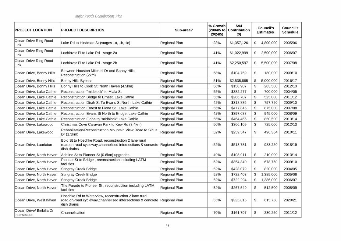
Ocean Drive Ring Road Link Lake Rd to Hindman St-(stages 1a, 1b, 1c) Regional Plan 28% $1,357,126 $ 4,800,000 2005/06
Ocean Drive Ring Road Link Lochinvar Pl to Lake Rd - stage 2a Regional Plan 41% $1,022,999 $ 2,500,000 2006/07
Ocean Drive Ring Road Link Lochinvar Pl to Lake Rd - stage 2b Regional Plan 41% $2,250,597 $ 5,500,000 2007/08
Ocean Drive, Bonny Hills Between Houston Mitchell Dr and Bonny Hills Reconstruction (2km) Regional Plan 58% $104,759 $ 180,000 2009/10
Ocean Drive, Bonny Hills Bonny Hills Bypass Regional Plan 51% $2,535,885 $ 5,000,000 2016/17 Ocean Drive, Bonny Hills Bonny Hills to Cook St, North Haven (4.5km) Regional Plan 56% $158,907 $ 283,500 2012/13 Ocean Drive, Lake Cathie Reconstruction "midblock" to Miala St Regional Plan 55% $382,277 $ 700,000 2004/05 Ocean Drive, Lake Cathie Reconstruction Bridge to Ernest, Lake Cathie Regional Plan 55% $286,707 $ 525,000 2011/12 Ocean Drive, Lake Cathie Reconstruction Dirah St To Evans St North ,Lake Cathie Regional Plan 42% $318,886 $ 757,750 2009/10 Ocean Drive, Lake Cathie Reconstruction Ernest to Fiona St , Lake Cathie Regional Plan 55% $477,846 $ 875,000 2007/08 Ocean Drive, Lake Cathie Reconstruction Evans St North to Bridge, Lake Cathie Regional Plan 42% $397,688 $ 945,000 2008/09 Ocean Drive, Lake Cathie Reconstruction Fiona to "midblock" Lake Cathie Regional Plan 55% $464,466 $ 850,500 2013/14 Ocean Drive, Lakewood Christmas Cove Caravan Park to Kew Rd (3.4km) Regional Plan 50% $366,109 $ 725,000 2012/13
Ocean Drive, Lakewood Rehabilitation/Reconstruction Mountain View Road to Sirius Dr (1.3km) Regional Plan 52% $259,547 $ 496,364 2010/11
Ocean Drive, Laurieton Bold St to Hoschke Road, reconstruction 2 lane rural road,on-road cycleway,channelised intersections & concrete dish drains
Regional Plan 52% $513,781 $ 983,250 2018/19
Ocean Drive, North Haven Adeline St to Pioneer St (0.6km) upgrades Regional Plan 49% $103,911 $ 210,000 2013/14
Ocean Drive, North Haven Pioneer St to Bridge , reconstruction including LATM facilities Regional Plan 52% $354,340 $ 678,750 2009/10
Ocean Drive, North Haven Stingray Creek Bridge Regional Plan 52% $428,079 $ 820,000 2004/05 Ocean Drive, North Haven Stingray Creek Bridge Regional Plan 52% $722,403 $ 1,385,000 2005/06 Ocean Drive, North Haven Stingray Creek Bridge Regional Plan 52% $722,294 $ 1,386,000 2006/07
Ocean Drive, North Haven The Parade to Pioneer St , reconstruction including LATM facilities Regional Plan 52% $267,549 $ 512,500 2008/09
Ocean Drive, West haven Hoschke Rd to Waterview, reconstruction 2 lane rural road,on-road cycleway,channelised intersections & concrete dish drains
Regional Plan 55% $335,816 $ 615,750 2020/21
Ocean Drive/ Binbilla Dr Intersection Channelisation Regional Plan 70% $161,797 $ 230,250 2011/12

Major Roads Contributions Plan
32
PROJECT LOCATION PROJECT DESCRIPTION Sub-area? % Growth (2004/5 to
2024/5)
S94 Contribution
($) Council's Estimates
Council's Schedule
Ocean Drive/ Bonny View Intersection Channelisation Regional Plan 47% $202,869 $ 430,500 2010/11
Ocean Drive/ Houston Mitchell Dr Intersection Roundabout Regional Plan 59% $1,246,575 $ 2,100,000 2011/12
Ocean Drive/ Kew Rd Intersection Roundabout Regional Plan 50% $99,629 $ 200,000 2013/14
Ocean Drive/ Panorama Dr (sth) Intersection Roundabout Regional Plan 64% $127,953 $ 200,000 2019/20
Ocean Drive/Crestwood Intersection Upgrade to a two lane roundabout or traffic lights Regional Plan 47% $94,161 $ 200,000 2015/16
Old Mill Road Old Mill Road - 342/0.8 Regional Plan 15% $6,750 $ 45,000 2006/07 Old School Road Old School Road - 341/3.4 Regional Plan 15% $6,750 $ 45,000 2006/07 Oxley Highway By-passed Section Major Innes Dr to The Ruins Way Regional Plan 85% $502,168 $ 592,500 2019/20
Oxley Highway By-passed Section The Ruins Way to Phillip Charley Drive Regional Plan 78% $1,224,286 $ 1,576,500 2022/23
Oxley Highway By-passed Section Wrights Rd to major Innes Dr Regional Plan 90% $367,668 $ 408,750 2018/19
Oxley Highway/King Creek Intersection Type C Intersection Regional Plan 23% $169,500 $ 750,000 2006/07
Pacific Drive Kennedy Dr to Lighthouse Rd upgrade 2 lane rural road , on road cycleway & dish drains Regional Plan 49% $113,567 $ 232,500 2013/14
Pacific Drive Leanda Street to Ocean St, Urban design incorporating shareway concepts Stage 1 Regional Plan 7% $65,605 $ 972,000 2019/20
Pacific Drive Lighthouse Rd to Waterview Cl Upgrade to tourist drive / collector road Regional Plan 29% $169,217 $ 582,857 2008/09
Pacific Drive Ocean St to Flynn St, Urban design incorporating shareway concepts Stage 2 Regional Plan 12% $72,510 $ 589,750 2022/23
Pacific Drive Shelley Beach Rd to Parklands Avenue, upgrade 2 lane urban , on road cycleway & concrete dish drain/K&G Regional Plan 19% $189,321 $ 992,500 2020/21
Pacific Drive Traffic management improvement works - Traffic management near Flynns Beach Regional Plan 12% $11,967 $ 100,000 2010/11
Pacific Hwy / Sancrox Intersection
Intersection upgrade to facilitate traffic safety and management. Regional Plan 52% $258,357 $ 500,000 2013/14
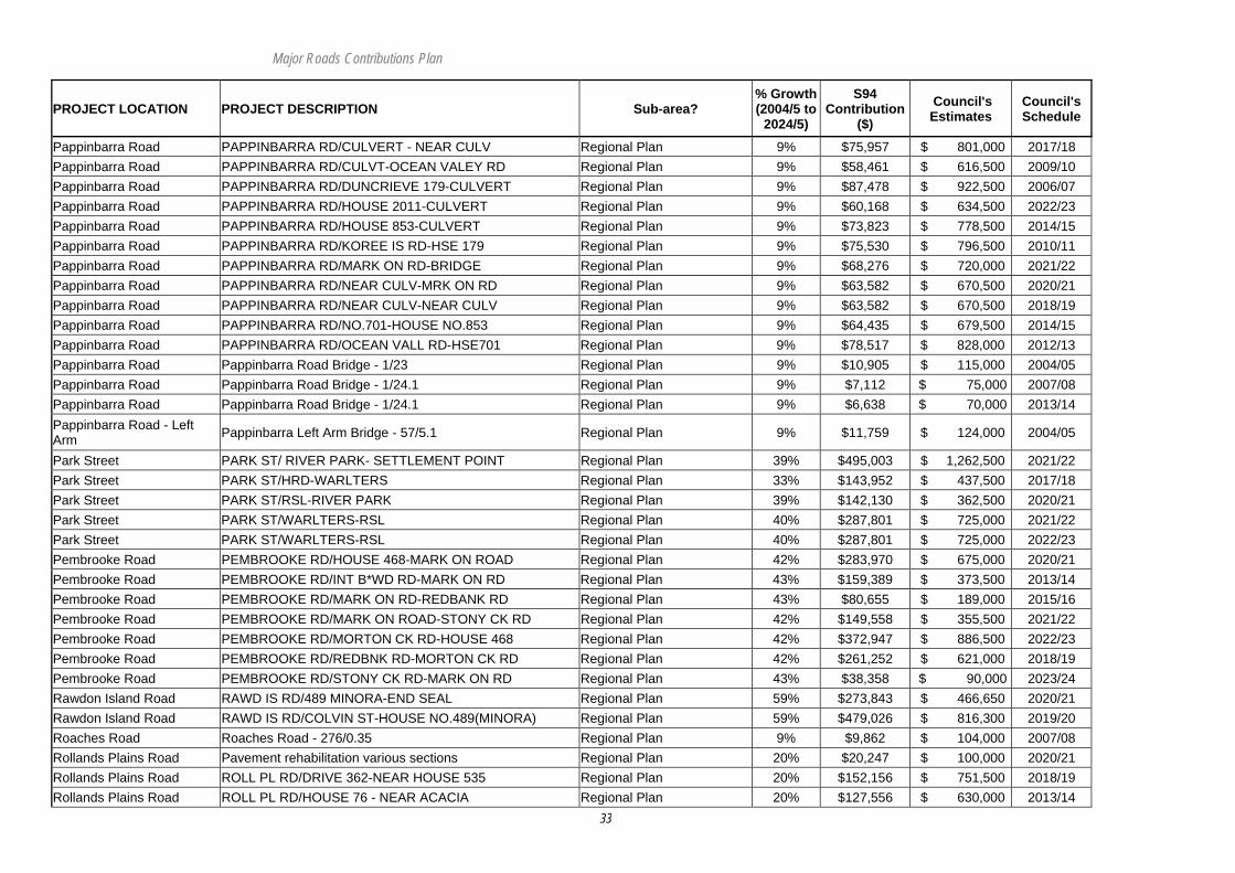
Pappinbarra Road PAPPINBARRA RD/BRIDGE - HOUSE 2011 Regional Plan 9% $62,728 $ 661,500 2021/22 Pappinbarra Road PAPPINBARRA RD/CULVERT - CULVERT Regional Plan 9% $86,625 $ 913,500 2015/16
Major Roads Contributions Plan
33
PROJECT LOCATION PROJECT DESCRIPTION Sub-area? % Growth (2004/5 to
2024/5)
S94 Contribution
($) Council's Estimates
Council's Schedule
Pappinbarra Road PAPPINBARRA RD/CULVERT - NEAR CULV Regional Plan 9% $75,957 $ 801,000 2017/18 Pappinbarra Road PAPPINBARRA RD/CULVT-OCEAN VALEY RD Regional Plan 9% $58,461 $ 616,500 2009/10 Pappinbarra Road PAPPINBARRA RD/DUNCRIEVE 179-CULVERT Regional Plan 9% $87,478 $ 922,500 2006/07 Pappinbarra Road PAPPINBARRA RD/HOUSE 2011-CULVERT Regional Plan 9% $60,168 $ 634,500 2022/23 Pappinbarra Road PAPPINBARRA RD/HOUSE 853-CULVERT Regional Plan 9% $73,823 $ 778,500 2014/15 Pappinbarra Road PAPPINBARRA RD/KOREE IS RD-HSE 179 Regional Plan 9% $75,530 $ 796,500 2010/11 Pappinbarra Road PAPPINBARRA RD/MARK ON RD-BRIDGE Regional Plan 9% $68,276 $ 720,000 2021/22 Pappinbarra Road PAPPINBARRA RD/NEAR CULV-MRK ON RD Regional Plan 9% $63,582 $ 670,500 2020/21 Pappinbarra Road PAPPINBARRA RD/NEAR CULV-NEAR CULV Regional Plan 9% $63,582 $ 670,500 2018/19 Pappinbarra Road PAPPINBARRA RD/NO.701-HOUSE NO.853 Regional Plan 9% $64,435 $ 679,500 2014/15 Pappinbarra Road PAPPINBARRA RD/OCEAN VALL RD-HSE701 Regional Plan 9% $78,517 $ 828,000 2012/13 Pappinbarra Road Pappinbarra Road Bridge - 1/23 Regional Plan 9% $10,905 $ 115,000 2004/05 Pappinbarra Road Pappinbarra Road Bridge - 1/24.1 Regional Plan 9% $7,112 $ 75,000 2007/08 Pappinbarra Road Pappinbarra Road Bridge - 1/24.1 Regional Plan 9% $6,638 $ 70,000 2013/14 Pappinbarra Road - Left Arm Pappinbarra Left Arm Bridge - 57/5.1 Regional Plan 9% $11,759 $ 124,000 2004/05
Park Street PARK ST/ RIVER PARK- SETTLEMENT POINT Regional Plan 39% $495,003 $ 1,262,500 2021/22 Park Street PARK ST/HRD-WARLTERS Regional Plan 33% $143,952 $ 437,500 2017/18 Park Street PARK ST/RSL-RIVER PARK Regional Plan 39% $142,130 $ 362,500 2020/21 Park Street PARK ST/WARLTERS-RSL Regional Plan 40% $287,801 $ 725,000 2021/22 Park Street PARK ST/WARLTERS-RSL Regional Plan 40% $287,801 $ 725,000 2022/23 Pembrooke Road PEMBROOKE RD/HOUSE 468-MARK ON ROAD Regional Plan 42% $283,970 $ 675,000 2020/21 Pembrooke Road PEMBROOKE RD/INT B*WD RD-MARK ON RD Regional Plan 43% $159,389 $ 373,500 2013/14 Pembrooke Road PEMBROOKE RD/MARK ON RD-REDBANK RD Regional Plan 43% $80,655 $ 189,000 2015/16 Pembrooke Road PEMBROOKE RD/MARK ON ROAD-STONY CK RD Regional Plan 42% $149,558 $ 355,500 2021/22 Pembrooke Road PEMBROOKE RD/MORTON CK RD-HOUSE 468 Regional Plan 42% $372,947 $ 886,500 2022/23 Pembrooke Road PEMBROOKE RD/REDBNK RD-MORTON CK RD Regional Plan 42% $261,252 $ 621,000 2018/19 Pembrooke Road PEMBROOKE RD/STONY CK RD-MARK ON RD Regional Plan 43% $38,358 $ 90,000 2023/24 Rawdon Island Road RAWD IS RD/489 MINORA-END SEAL Regional Plan 59% $273,843 $ 466,650 2020/21 Rawdon Island Road RAWD IS RD/COLVIN ST-HOUSE NO.489(MINORA) Regional Plan 59% $479,026 $ 816,300 2019/20 Roaches Road Roaches Road - 276/0.35 Regional Plan 9% $9,862 $ 104,000 2007/08 Rollands Plains Road Pavement rehabilitation various sections Regional Plan 20% $20,247 $ 100,000 2020/21 Rollands Plains Road ROLL PL RD/DRIVE 362-NEAR HOUSE 535 Regional Plan 20% $152,156 $ 751,500 2018/19 Rollands Plains Road ROLL PL RD/HOUSE 76 - NEAR ACACIA Regional Plan 20% $127,556 $ 630,000 2013/14
Major Roads Contributions Plan
34
PROJECT LOCATION PROJECT DESCRIPTION Sub-area? % Growth (2004/5 to
2024/5)
S94 Contribution
($) Council's Estimates
Council's Schedule
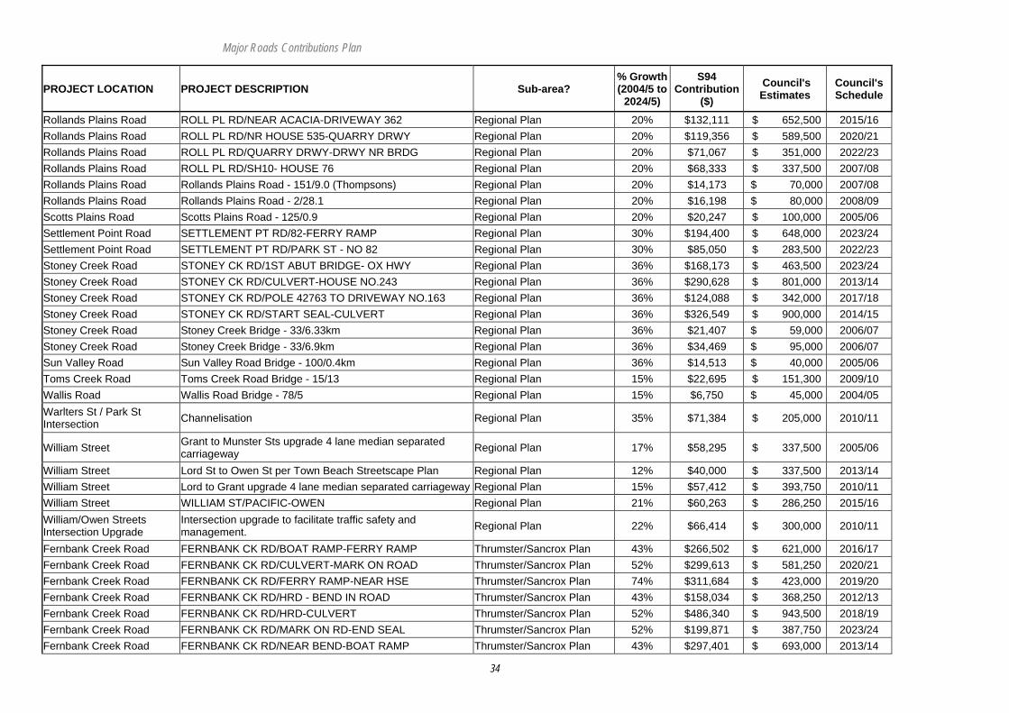
Rollands Plains Road ROLL PL RD/NEAR ACACIA-DRIVEWAY 362 Regional Plan 20% $132,111 $ 652,500 2015/16 Rollands Plains Road ROLL PL RD/NR HOUSE 535-QUARRY DRWY Regional Plan 20% $119,356 $ 589,500 2020/21 Rollands Plains Road ROLL PL RD/QUARRY DRWY-DRWY NR BRDG Regional Plan 20% $71,067 $ 351,000 2022/23 Rollands Plains Road ROLL PL RD/SH10- HOUSE 76 Regional Plan 20% $68,333 $ 337,500 2007/08 Rollands Plains Road Rollands Plains Road - 151/9.0 (Thompsons) Regional Plan 20% $14,173 $ 70,000 2007/08 Rollands Plains Road Rollands Plains Road - 2/28.1 Regional Plan 20% $16,198 $ 80,000 2008/09 Scotts Plains Road Scotts Plains Road - 125/0.9 Regional Plan 20% $20,247 $ 100,000 2005/06 Settlement Point Road SETTLEMENT PT RD/82-FERRY RAMP Regional Plan 30% $194,400 $ 648,000 2023/24 Settlement Point Road SETTLEMENT PT RD/PARK ST - NO 82 Regional Plan 30% $85,050 $ 283,500 2022/23 Stoney Creek Road STONEY CK RD/1ST ABUT BRIDGE- OX HWY Regional Plan 36% $168,173 $ 463,500 2023/24 Stoney Creek Road STONEY CK RD/CULVERT-HOUSE NO.243 Regional Plan 36% $290,628 $ 801,000 2013/14 Stoney Creek Road STONEY CK RD/POLE 42763 TO DRIVEWAY NO.163 Regional Plan 36% $124,088 $ 342,000 2017/18 Stoney Creek Road STONEY CK RD/START SEAL-CULVERT Regional Plan 36% $326,549 $ 900,000 2014/15 Stoney Creek Road Stoney Creek Bridge - 33/6.33km Regional Plan 36% $21,407 $ 59,000 2006/07 Stoney Creek Road Stoney Creek Bridge - 33/6.9km Regional Plan 36% $34,469 $ 95,000 2006/07 Sun Valley Road Sun Valley Road Bridge - 100/0.4km Regional Plan 36% $14,513 $ 40,000 2005/06 Toms Creek Road Toms Creek Road Bridge - 15/13 Regional Plan 15% $22,695 $ 151,300 2009/10 Wallis Road Wallis Road Bridge - 78/5 Regional Plan 15% $6,750 $ 45,000 2004/05 Warlters St / Park St Intersection Channelisation Regional Plan 35% $71,384 $ 205,000 2010/11
William Street Grant to Munster Sts upgrade 4 lane median separated carriageway Regional Plan 17% $58,295 $ 337,500 2005/06
William Street Lord St to Owen St per Town Beach Streetscape Plan Regional Plan 12% $40,000 $ 337,500 2013/14 William Street Lord to Grant upgrade 4 lane median separated carriageway Regional Plan 15% $57,412 $ 393,750 2010/11 William Street WILLIAM ST/PACIFIC-OWEN Regional Plan 21% $60,263 $ 286,250 2015/16 William/Owen Streets Intersection Upgrade
Intersection upgrade to facilitate traffic safety and management. Regional Plan 22% $66,414 $ 300,000 2010/11
Fernbank Creek Road FERNBANK CK RD/BOAT RAMP-FERRY RAMP Thrumster/Sancrox Plan 43% $266,502 $ 621,000 2016/17 Fernbank Creek Road FERNBANK CK RD/CULVERT-MARK ON ROAD Thrumster/Sancrox Plan 52% $299,613 $ 581,250 2020/21 Fernbank Creek Road FERNBANK CK RD/FERRY RAMP-NEAR HSE Thrumster/Sancrox Plan 74% $311,684 $ 423,000 2019/20 Fernbank Creek Road FERNBANK CK RD/HRD - BEND IN ROAD Thrumster/Sancrox Plan 43% $158,034 $ 368,250 2012/13 Fernbank Creek Road FERNBANK CK RD/HRD-CULVERT Thrumster/Sancrox Plan 52% $486,340 $ 943,500 2018/19 Fernbank Creek Road FERNBANK CK RD/MARK ON RD-END SEAL Thrumster/Sancrox Plan 52% $199,871 $ 387,750 2023/24 Fernbank Creek Road FERNBANK CK RD/NEAR BEND-BOAT RAMP Thrumster/Sancrox Plan 43% $297,401 $ 693,000 2013/14
Major Roads Contributions Plan
35
PROJECT LOCATION PROJECT DESCRIPTION Sub-area? % Growth (2004/5 to
2024/5)
S94 Contribution
($) Council's Estimates
Council's Schedule
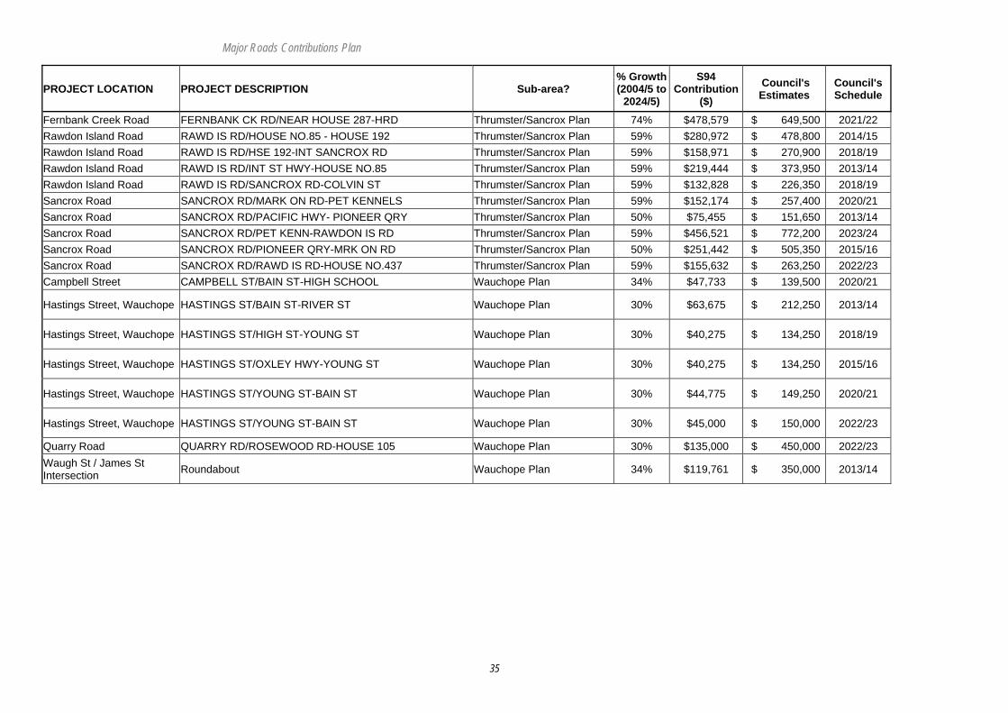
Fernbank Creek Road FERNBANK CK RD/NEAR HOUSE 287-HRD Thrumster/Sancrox Plan 74% $478,579 $ 649,500 2021/22 Rawdon Island Road RAWD IS RD/HOUSE NO.85 - HOUSE 192 Thrumster/Sancrox Plan 59% $280,972 $ 478,800 2014/15 Rawdon Island Road RAWD IS RD/HSE 192-INT SANCROX RD Thrumster/Sancrox Plan 59% $158,971 $ 270,900 2018/19 Rawdon Island Road RAWD IS RD/INT ST HWY-HOUSE NO.85 Thrumster/Sancrox Plan 59% $219,444 $ 373,950 2013/14 Rawdon Island Road RAWD IS RD/SANCROX RD-COLVIN ST Thrumster/Sancrox Plan 59% $132,828 $ 226,350 2018/19 Sancrox Road SANCROX RD/MARK ON RD-PET KENNELS Thrumster/Sancrox Plan 59% $152,174 $ 257,400 2020/21 Sancrox Road SANCROX RD/PACIFIC HWY- PIONEER QRY Thrumster/Sancrox Plan 50% $75,455 $ 151,650 2013/14 Sancrox Road SANCROX RD/PET KENN-RAWDON IS RD Thrumster/Sancrox Plan 59% $456,521 $ 772,200 2023/24 Sancrox Road SANCROX RD/PIONEER QRY-MRK ON RD Thrumster/Sancrox Plan 50% $251,442 $ 505,350 2015/16 Sancrox Road SANCROX RD/RAWD IS RD-HOUSE NO.437 Thrumster/Sancrox Plan 59% $155,632 $ 263,250 2022/23 Campbell Street CAMPBELL ST/BAIN ST-HIGH SCHOOL Wauchope Plan 34% $47,733 $ 139,500 2020/21
Hastings Street, Wauchope HASTINGS ST/BAIN ST-RIVER ST Wauchope Plan 30% $63,675 $ 212,250 2013/14
Hastings Street, Wauchope HASTINGS ST/HIGH ST-YOUNG ST Wauchope Plan 30% $40,275 $ 134,250 2018/19
Hastings Street, Wauchope HASTINGS ST/OXLEY HWY-YOUNG ST Wauchope Plan 30% $40,275 $ 134,250 2015/16
Hastings Street, Wauchope HASTINGS ST/YOUNG ST-BAIN ST Wauchope Plan 30% $44,775 $ 149,250 2020/21
Hastings Street, Wauchope HASTINGS ST/YOUNG ST-BAIN ST Wauchope Plan 30% $45,000 $ 150,000 2022/23
Quarry Road QUARRY RD/ROSEWOOD RD-HOUSE 105 Wauchope Plan 30% $135,000 $ 450,000 2022/23 Waugh St / James St Intersection Roundabout Wauchope Plan 34% $119,761 $ 350,000 2013/14
Major Roads Contributions Plan
36
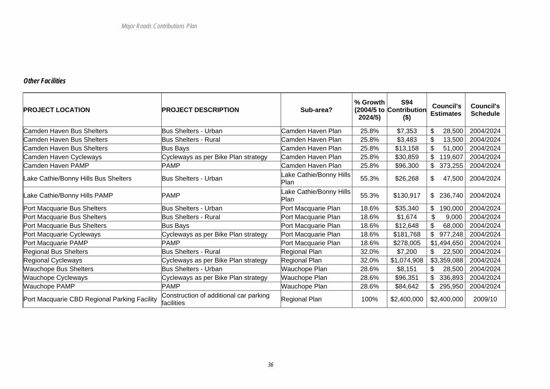
Other Facilities
PROJECT LOCATION PROJECT DESCRIPTION Sub-area? % Growth (2004/5 to
2024/5)
S94 Contribution
($) Council's Estimates
Council's Schedule
Camden Haven Bus Shelters Bus Shelters - Urban Camden Haven Plan 25.8% $7,353 $ 28,500 2004/2024 Camden Haven Bus Shelters Bus Shelters - Rural Camden Haven Plan 25.8% $3,483 $ 13,500 2004/2024 Camden Haven Bus Shelters Bus Bays Camden Haven Plan 25.8% $13,158 $ 51,000 2004/2024 Camden Haven Cycleways Cycleways as per Bike Plan strategy Camden Haven Plan 25.8% $30,859 $ 119,607 2004/2024 Camden Haven PAMP PAMP Camden Haven Plan 25.8% $96,300 $ 373,255 2004/2024
Lake Cathie/Bonny Hills Bus Shelters Bus Shelters - Urban Lake Cathie/Bonny Hills Plan 55.3% $26,268 $ 47,500 2004/2024
Lake Cathie/Bonny Hills PAMP PAMP Lake Cathie/Bonny Hills Plan 55.3% $130,917 $ 236,740 2004/2024
Port Macquarie Bus Shelters Bus Shelters - Urban Port Macquarie Plan 18.6% $35,340 $ 190,000 2004/2024 Port Macquarie Bus Shelters Bus Shelters - Rural Port Macquarie Plan 18.6% $1,674 $ 9,000 2004/2024 Port Macquarie Bus Shelters Bus Bays Port Macquarie Plan 18.6% $12,648 $ 68,000 2004/2024 Port Macquarie Cycleways Cycleways as per Bike Plan strategy Port Macquarie Plan 18.6% $181,768 $ 977,248 2004/2024 Port Macquarie PAMP PAMP Port Macquarie Plan 18.6% $278,005 $1,494,650 2004/2024 Regional Bus Shelters Bus Shelters - Rural Regional Plan 32.0% $7,200 $ 22,500 2004/2024 Regional Cycleways Cycleways as per Bike Plan strategy Regional Plan 32.0% $1,074,908 $3,359,088 2004/2024 Wauchope Bus Shelters Bus Shelters - Urban Wauchope Plan 28.6% $8,151 $ 28,500 2004/2024 Wauchope Cycleways Cycleways as per Bike Plan strategy Wauchope Plan 28.6% $96,351 $ 336,893 2004/2024 Wauchope PAMP PAMP Wauchope Plan 28.6% $84,642 $ 295,950 2004/2024
Port Macquarie CBD Regional Parking Facility Construction of additional car parking facilities Regional Plan 100% $2,400,000 $2,400,000 2009/10

Major Roads Contributions Plan
37
BIBLIOGRAPHY
• Australian Bureau of Statistics, 2001 Census • Australian Bureau of Statistics Data:
• Census Collector Districts Comparisons 1981-2001 • Population Projections by CCD Data • Structure of Dwellings by Number of Persons • Hastings Council Land Use Data • Housing Balance Data • CPI Index
• Hastings Community Profile 2003, Hastings Council, 2003 • Hastings Urban Growth Strategy 2001, Hastings Council, 2001 • Hastings Development Control Plan No.11 – Off Street Parking Code • Building Cost Guide – Australian Institute of Building Surveyors (NSW Chapter), June 1999
• Hastings Parking Strategy Study Report – Christopher Hallam & Associates Pty Ltd, July 2001
• Hastings Roads and Traffic Study Final Report – SMEC, July 2003
• Hastings Section 94 Plan for Roads Final Report – SMEC, April 2004
• Hastings Major Municipal Roads Section 94 Plan Report – Connell Wagner (NSW) Pty Ltd, May 1993