Embed Size (px)
Citation preview
20
HAWTHORNE
Little OrangeLake
LakeJohnson
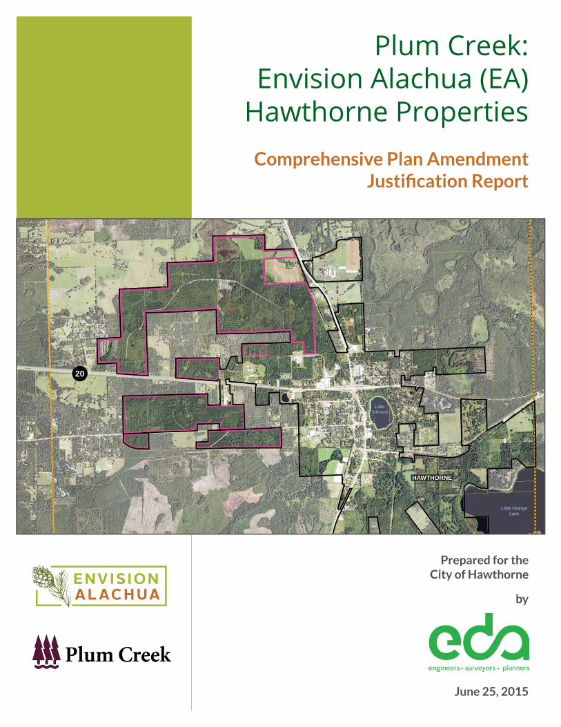
Plum Creek:Envision Alachua (EA)
Hawthorne PropertiesComprehensive Plan Amendment
Justifi cation Report
Prepared for the City of Hawthorne
by
June 25, 2015

Table of Contents Page
Executive Summary 1
Project Background 3Hawthorne Existing Conditions 3Plum Creek Land & Envision Alachua 4EA-Hawthorne Mixed Use Design Concept 6
Description of Proposed Comprehensive Plan Amendment 7Existing Future Land Use Map 7
City of Hawthorne Urban Reserve Area 8Alachua County Reserve and Extra Territorial Area Map 8
Proposed Future Land Use Maps 9 EA-Hawthorne Mixed Use Principles 11 EA-Hawthorne Mixed-Use Development Program 13
Assumptions, Densities & Intensities 13
Land Use Data & Analysis 15Regional Context 15
Local Context 17 Site Data & Analysis 17
Existing Conditions 17Physical Characteristics 19Potential Development Program 20
Level of Service / Public Facilities Analysis 23Recreation 23Public Schools 30Public Safety (Police & Fire/EMS) 37Solid Waste 41Potable Water and Wastewater 42Transportation 42
Appendix
Environmental Data and Analysis, EA-HawthorneTechnical Memorandum EA-Hawthorne - Water and WastewaterEA-Hawthorne - Transportation Data and Analysis
1
Executive Summary
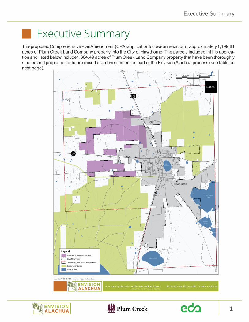
Executive SummaryThis proposed Comprehensive Plan Amendment (CPA) application follows annexation of approximately 1,199.81 acres of Plum Creek Land Company property into the City of Hawthorne. The parcels included int his applica-tion and listed below include1,364.49 acres of Plum Creek Land Company property that have been thoroughly studied and proposed for future mixed use development as part of the Envision Alachua process (see table on next page).
A community discussion on the future of East CountyCONVENED BY PLUM CREEK
Updated: 05-2015 - Sasaki Associates, Inc.
HAWTHORNE
Little OrangeLake
HoldenPond
MossLee
Lake
LakeJohnson
Lake Jeffords
Lochloosa Lake
301
20
EA-Hawthorne: Proposed FLU Amendment Area
0 2,000
100 AC
1,000 4,000 6,000 Feet
Legend
Conservation Lands
City of Hawthorne
Water Bodies
City of Hawthorne Urban Reserve Area
Proposed FLU Amendment Area
2 Plum Creek: Envision Alachua (EA) - Hawthorne PropertiesComprehensive Plan Amendment Justifi cation Report
Executive Summary
Future development in this area will help revitalize the City of Hawthorne by bringing new employment oppor-tunities and residents that will contribute to the further development and growth of the City. The vision for this area provides for the natural expansion of Hawthorne’s urban area by extending and connecting into the ex-isting street network and utility infrastructure and further supporting and utilizing the Gainesville-Hawthorne State Trail. Development in the Plum Creek Land Company property annexed into the City of Hawthorne will complement and strengthen underutilized resources in Hawthorne such as schools, retail/commercial, and residential uses. Hawthorne’s strong roadway and rail connections provide an opportunity to reinforce the Hawthorne community and economy with new economic development in the area.
As part of this Comprehensive Plan Amendment, the applicant proposes a new future land use designation, EA-Hawthorne Mixed Use. This category will allow a mix of industrial, commercial and residential devel-opment, allowing the development of a mixed-use employment center. Policies proposed will promote the effi cient use of land, discourage urban sprawl and enhance opportunities for job creation within the City of Hawthorne.
Proposed FLU Map Designation Parcel Number Existing FLU Map Designation
EA-Hawthorne Mixed Use (Approx. 1,362.68 Acres)
19265-4-0 (in City Limits)Agriculture (City)
19226-0-0 (in City Limits)19265-0-0 (Portion of)
Rural/Agriculture (County)
19279-0-019252-0-019237-0-019258-0-019246-0-019854-0-0 (Portion of)19837-0-0 (Portion of)19839-0-0 (Portion of)
Commercial (Approx. 1.81 Acres)
19826-0-019826-2-0
The EA-Hawthorne Mixed Use future land use designation will enable development of an employment center with a broad range of emerging types of advanced manufacturing and light industrial jobs, many of which may be related to proposed Research and Development (R&D) activities within the Envision Alachua Sector Plan (EASP) described below and take advantage of the proximate highway and railroad infrastructure. A broad range of employment related facilities from start-up incubators, light industrial and assembly, R&D, commercial start-ups, and live-work buildings will be integrated together in close proximity to the existing Hawthorne downtown district to foster a collaborative entrepreneurial environment that promotes economic progress throughout the City.
Areas to be designated EA-Hawthorne Mixed Use will provide compact, connected, and employment orient-ed development. It includes future residential development (south of S.R. 20), an activity hub and related commercial and retail services to provide for a balanced and sustainable community. It will be a place where residents can walk or bike to work and enjoy the many other services in the City of Hawthorne such as schools, churches, parks and civic amenities such as the Gainesville-Hawthorne State Trail.
3
Project Background
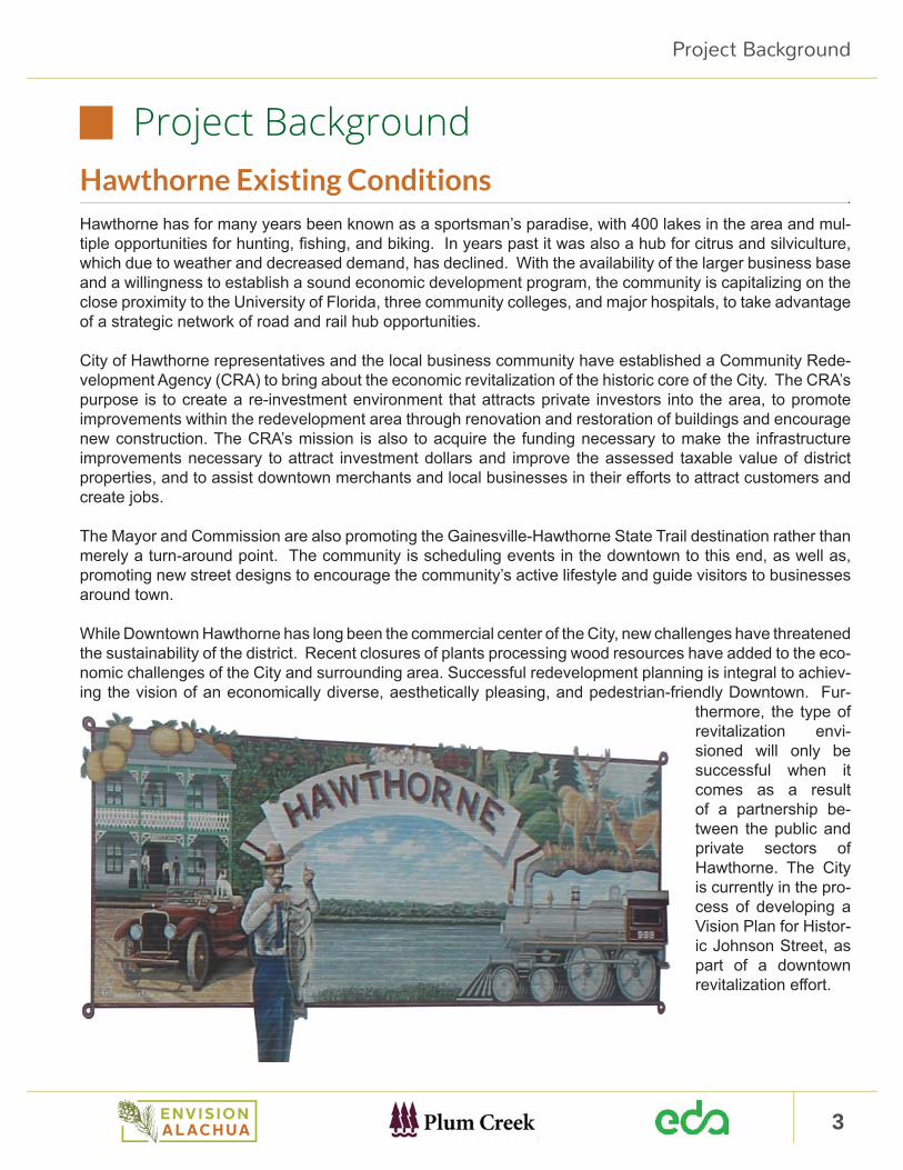
Project BackgroundHawthorne Existing ConditionsHawthorne has for many years been known as a sportsman’s paradise, with 400 lakes in the area and mul-tiple opportunities for hunting, fi shing, and biking. In years past it was also a hub for citrus and silviculture, which due to weather and decreased demand, has declined. With the availability of the larger business base and a willingness to establish a sound economic development program, the community is capitalizing on the close proximity to the University of Florida, three community colleges, and major hospitals, to take advantage of a strategic network of road and rail hub opportunities.
City of Hawthorne representatives and the local business community have established a Community Rede-velopment Agency (CRA) to bring about the economic revitalization of the historic core of the City. The CRA’s purpose is to create a re-investment environment that attracts private investors into the area, to promote improvements within the redevelopment area through renovation and restoration of buildings and encourage new construction. The CRA’s mission is also to acquire the funding necessary to make the infrastructure improvements necessary to attract investment dollars and improve the assessed taxable value of district properties, and to assist downtown merchants and local businesses in their eff orts to attract customers and create jobs.
The Mayor and Commission are also promoting the Gainesville-Hawthorne State Trail destination rather than merely a turn-around point. The community is scheduling events in the downtown to this end, as well as, promoting new street designs to encourage the community’s active lifestyle and guide visitors to businesses around town.
While Downtown Hawthorne has long been the commercial center of the City, new challenges have threatened the sustainability of the district. Recent closures of plants processing wood resources have added to the eco-nomic challenges of the City and surrounding area. Successful redevelopment planning is integral to achiev-ing the vision of an economically diverse, aesthetically pleasing, and pedestrian-friendly Downtown. Fur-
thermore, the type of revitalization envi-sioned will only be successful when it comes as a result of a partnership be-tween the public and private sectors of Hawthorne. The City is currently in the pro-cess of developing a Vision Plan for Histor-ic Johnson Street, as part of a downtown revitalization eff ort.
4 Plum Creek: Envision Alachua (EA) - Hawthorne PropertiesComprehensive Plan Amendment Justifi cation Report
Project Background
Plum Creek Land and Envision AlachuaPlum Creek Land Company (Plum Creek) convened a nearly three-year community visioning and planning process, Envision Alachua, to develop a long-term master plan for its property in Alachua County. The process has been distinguished by a program of Task Force work sessions, Community Workshops, Educational Forums, Technical Advisory Group consultation, and a comprehensive project website (www.envisionalachua.com) documenting the evolving vision.
In 2005, Alachua County government asked Plum Creek if it had a master plan of all of its holdings in the County. In response to the County’s question, and as part of Plum Creek’s ongoing process for evaluating its lands, the company paused its normal business practice of regularly buying and selling land in the County in order to consider suitable community uses, together with timber, that could be aligned with community needs. Through discussions with numerous community leaders, the company learned about land use opportunities that merited further community discussion. As a result, the Envision Alachua visioning process was launched in June 2011 to explore potential opportunities for Plum Creek’s holdings in Alachua County, including those lands within the City of Hawthorne Urban Reserve Area.
The Envision Alachua visioning process was designed to be:• A holistic approach to sustainable conservation and economic development;• An opportunity for a unique partnership and collaboration between the public and private sectors; and• An open dialogue with community leaders representing economic development, business, local gov-
ernment, education, environmental, conservation and residents in Alachua County and the City of Hawthorne
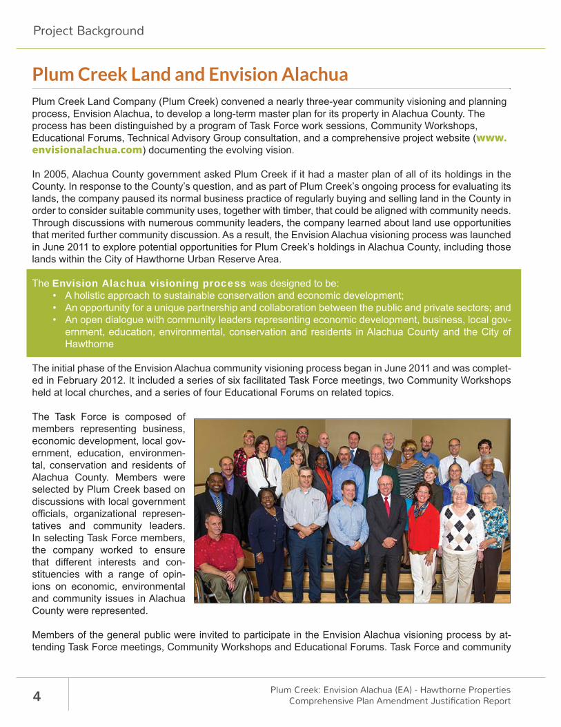
The initial phase of the Envision Alachua community visioning process began in June 2011 and was complet-ed in February 2012. It included a series of six facilitated Task Force meetings, two Community Workshops held at local churches, and a series of four Educational Forums on related topics.
The Task Force is composed of members representing business, economic development, local gov-ernment, education, environmen-tal, conservation and residents of Alachua County. Members were selected by Plum Creek based on discussions with local government offi cials, organizational represen-tatives and community leaders. In selecting Task Force members, the company worked to ensure that diff erent interests and con-stituencies with a range of opin-ions on economic, environmental and community issues in Alachua County were represented.
Members of the general public were invited to participate in the Envision Alachua visioning process by at-tending Task Force meetings, Community Workshops and Educational Forums. Task Force and community
5
Project Background
members provided input into the visioning process for Plum Creek Land Company property in Alachua Coun-ty. Through discussions with the Task Force and community, the company explored potential future economic development and conservation scenarios that could achieve long-range economic, environmental and com-munity goals. The result is a document that describes the community’s vision for potential future economic development and conservation on lands Plum Creek owns in Alachua County, entitled: Envision Alachua Task Force, Vision, Goals and Guiding Principles for Plum Creek Lands in Alachua County.
In 2012, Plum Creek continued the Envision Alachua process with Phase II convening a Technical Advisory Group along with the Task Force and community members to determine how to achieve the community’s phase I vision and goals on Plum Creek’s lands. Technical Advisory Group membership is composed of 19 members including representatives from agencies with regulatory and review authority over large-scale, land-use planning and policy decisions in Alachua County and the State. It also included individuals with specialized technical expertise in economics, conservation and community planning, as well as liaisons from the Task Force who were keepers of the vision.
The Technical Advisory Group (TAG) provided input into Phase II of Envision Alachua by helping Plum Creek advance the community’s land use and conservation strategies for Plum Creek’s lands in Alachua County. The Task Force, the community and Plum Creek evaluated the TAG’s input, as it relates to the Phase I vision, for use in creating the sector plan. TAG members were asked to help:
• Identify relevant policies, opportunities and guidelines associated with Plum Creek Land Company property in Alachua County; and
• Identify issues and opportunities to be addressed in the Plum Creek Lands Sector Plan
The Envision Alachua Phase II process consisted of fi ve Task Force meetings, four community workshops, four Technical Advisory Committee meetings and the sponsorship of one economic development forum through the Gainesville Area Chamber of Commerce. The outcome of the Phase II process was the 50-year, Long-term Master Plan (LTMP) for Plum Creek’s holdings in Alachua County shaped by the community’s vi-sion in Phase I. During Phase II, work on the subsequent Detailed Specifi c Area Plans (DSAPs) for portions of the LTMP began with the Task Force and community.
During Phase II, Plum Creek determined to use the Sector Plan process for its land-use application as it best represented the outcomes of the community’s vision. The Sector Plan is a comprehensive planning tool that:
• Ensures lands are designated for conservation and economic development;• Plans lands greater than 15,000 acres; and• Exceeds the current planning horizon of 20 years.
Recognizing that implementation of the community vision requires much more than approval of a land use change, and in response to the community vision, goals and guiding principles, separate teams addressing priority topics were formed in the three key areas of the vision – economy, conservation/environment, community. Those teams looked deeper into the issues and solutions for those topic areas.
Over 1,500 community members have been involved in the Envision Alachua process and an additional 225 presentations and key leader meetings have supported the eff ort. This comprehensive community inclusive approach has been unprecedented within the State of Florida to the degree of including the community in the planning process and allowing them to shape our plan. The Florida Chapter of the American Planning As-sociation (APA) honored Envision Alachua with its 2013 Award of Excellence in the Best Practices category.
6 Plum Creek: Envision Alachua (EA) - Hawthorne PropertiesComprehensive Plan Amendment Justifi cation Report
Project Background
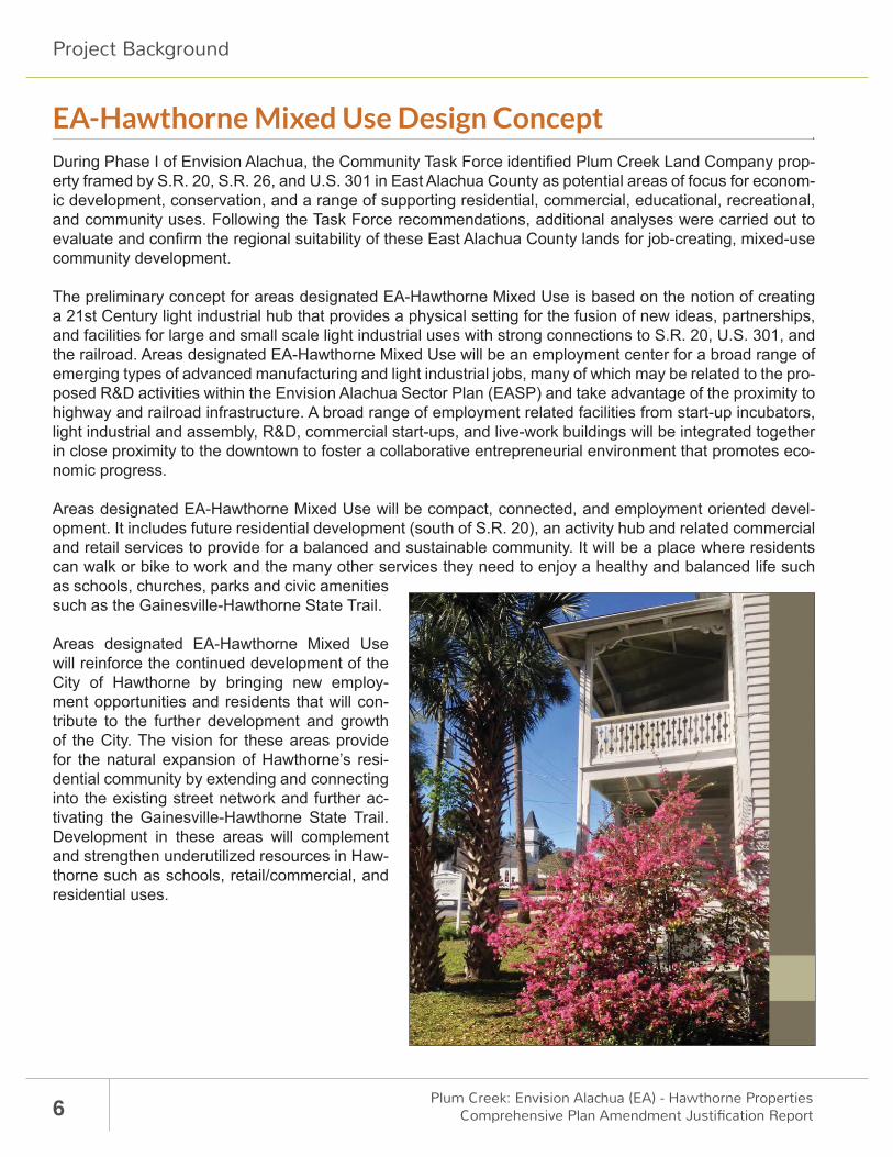
EA-Hawthorne Mixed Use Design ConceptDuring Phase I of Envision Alachua, the Community Task Force identifi ed Plum Creek Land Company prop-erty framed by S.R. 20, S.R. 26, and U.S. 301 in East Alachua County as potential areas of focus for econom-ic development, conservation, and a range of supporting residential, commercial, educational, recreational, and community uses. Following the Task Force recommendations, additional analyses were carried out to evaluate and confi rm the regional suitability of these East Alachua County lands for job-creating, mixed-use community development.
The preliminary concept for areas designated EA-Hawthorne Mixed Use is based on the notion of creating a 21st Century light industrial hub that provides a physical setting for the fusion of new ideas, partnerships, and facilities for large and small scale light industrial uses with strong connections to S.R. 20, U.S. 301, and the railroad. Areas designated EA-Hawthorne Mixed Use will be an employment center for a broad range of emerging types of advanced manufacturing and light industrial jobs, many of which may be related to the pro-posed R&D activities within the Envision Alachua Sector Plan (EASP) and take advantage of the proximity to highway and railroad infrastructure. A broad range of employment related facilities from start-up incubators, light industrial and assembly, R&D, commercial start-ups, and live-work buildings will be integrated together in close proximity to the downtown to foster a collaborative entrepreneurial environment that promotes eco-nomic progress.
Areas designated EA-Hawthorne Mixed Use will be compact, connected, and employment oriented devel-opment. It includes future residential development (south of S.R. 20), an activity hub and related commercial and retail services to provide for a balanced and sustainable community. It will be a place where residents can walk or bike to work and the many other services they need to enjoy a healthy and balanced life such as schools, churches, parks and civic amenities such as the Gainesville-Hawthorne State Trail.
Areas designated EA-Hawthorne Mixed Use will reinforce the continued development of the City of Hawthorne by bringing new employ-ment opportunities and residents that will con-tribute to the further development and growth of the City. The vision for these areas provide for the natural expansion of Hawthorne’s resi-dential community by extending and connecting into the existing street network and further ac-tivating the Gainesville-Hawthorne State Trail. Development in these areas will complement and strengthen underutilized resources in Haw-thorne such as schools, retail/commercial, and residential uses.

7
Description of Proposed Comprehensive Plan Amendment
Description of Proposed Comprehensive Plan Amendment
Existing Future Land Use Map As indicated within this application, the applicant proposes a change in future land use designation on ap-proximately 1,364.49 acres of land within the City of Hawthorne. These lands are outlined in purple on the existing Future Land Use map below.
The majority of land annexed into the City of Hawthorne and proposed for EA-Haw-thorne Mixed Use land des-ignation, currently has Alach-ua County Rural/Agricultural land use designation. Most of the surrounding parcels still remain in unincorporated ar-eas of the Hawthorne Urban Reserve Area and therefore maintain the Rural/Agricultur-al land use designation.
The parcels adjacent to City limits are bordered by a com-bination of urban Future Land Use Designations, including Industrial, Public and Com-mercial designations.
A community discussion on the future of East CountyCONVENED BY PLUM CREEK
Updated: 05-2015 - Sasaki Associates, Inc.
HAWTHORNE
Little OrangeLake
HoldenPond
MossLee
Lake
LakeJohnson
Lake Jeffords
Lochloosa Lake
301
20
EA-Hawthorne: City of HawthorneExisting Future Land Use Map
0 2,0001,000 4,000 6,000 Feet
100 AC
Legend
Conservation Lands
City of Hawthorne
Water Bodies
City of Hawthorne ExistingFuture Land Use Map
Alachua County ExistingFuture Land Use Map
Commercial
Industrial
Conservation
Light Industrial
Public
Residential - Low Density
Recreation
Residential - Moderate Density
City of Hawthorne Urban Reserve Area
EA-Hawthorne Annexation Area
Residential - High Density
Agriculture
Residential - Medium Density
Preservation
Rural/Agriculture
Rural Community Employment Agriculture
Rural Commercial Agriculture
8 Plum Creek: Envision Alachua (EA) - Hawthorne PropertiesComprehensive Plan Amendment Justifi cation Report
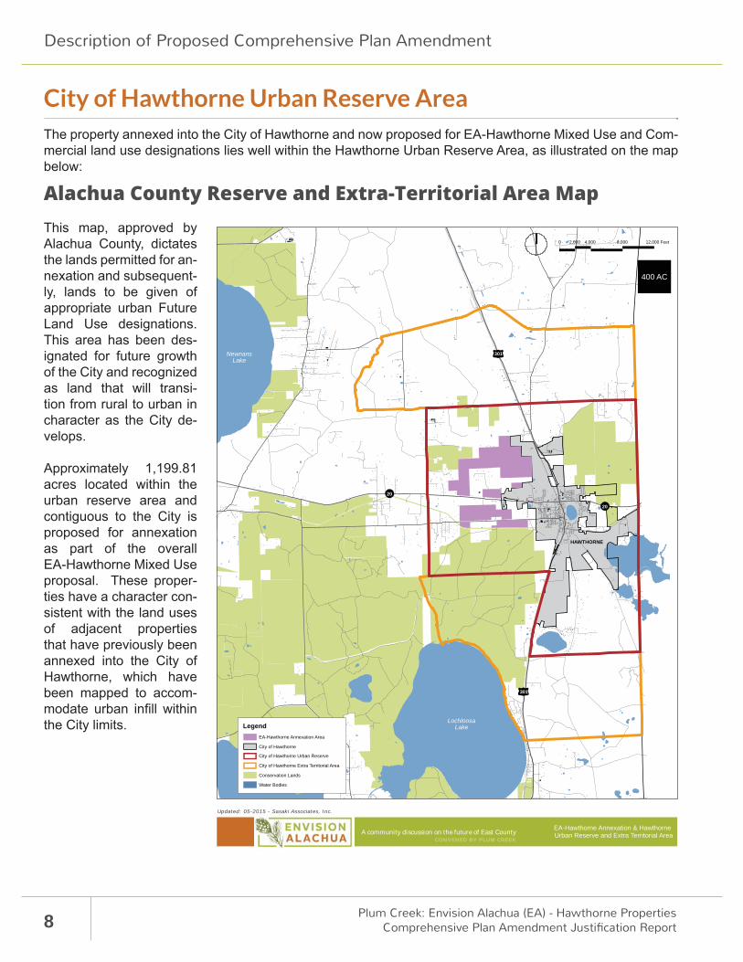
City of Hawthorne Urban Reserve AreaThe property annexed into the City of Hawthorne and now proposed for EA-Hawthorne Mixed Use and Com-mercial land use designations lies well within the Hawthorne Urban Reserve Area, as illustrated on the map below:
Alachua County Reserve and Extra-Territorial Area Map This map, approved by Alachua County, dictates the lands permitted for an-nexation and subsequent-ly, lands to be given of appropriate urban Future Land Use designations. This area has been des-ignated for future growth of the City and recognized as land that will transi-tion from rural to urban in character as the City de-velops.
Approximately 1,199.81 acres located within the urban reserve area and contiguous to the City is proposed for annexation as part of the overall EA-Hawthorne Mixed Use proposal. These proper-ties have a character con-sistent with the land uses of adjacent properties that have previously been annexed into the City of Hawthorne, which have been mapped to accom-modate urban infi ll within the City limits.
A community discussion on the future of East CountyCONVENED BY PLUM CREEK
Updated: 05-2015 - Sasaki Associates, Inc.
LochloosaLake
NewnansLake
20
20
301
301
HAWTHORNE
EA-Hawthorne Annexation & Hawthorne Urban Reserve and Extra Territorial Area
Legend
Conservation Lands
City of Hawthorne
Water Bodies
EA-Hawthorne Annexation Area
City of Hawthorne Urban Reserve
City of Hawthorne Extra Territorial Area
0 4,0002,000 8,000 12,000 Feet
400 AC
Description of Proposed Comprehensive Plan Amendment
9
Description of Proposed Comprehensive Plan Amendment
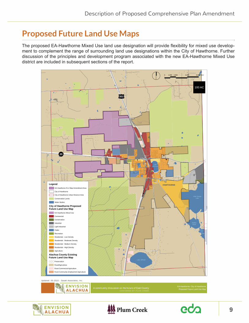
Proposed Future Land Use MapsThe proposed EA-Hawthorne Mixed Use land use designation will provide fl exibility for mixed use develop-ment to complement the range of surrounding land use designations within the City of Hawthorne. Further discussion of the principles and development program associated with the new EA-Hawthorne Mixed Use district are included in subsequent sections of the report.
A community discussion on the future of East CountyCONVENED BY PLUM CREEK
Updated: 05-2015 - Sasaki Associates, Inc.
301
20
HAWTHORNE
Little OrangeLake
HoldenPond
MossLee
Lake
LakeJohnson
Lake Jeffords
Lochloosa Lake
EA-Hawthorne: City of HawthorneProposed Future Land Use Map
0 2,000
100 AC
1,000 4,000 6,000 Feet
Legend
Conservation Lands
City of Hawthorne
Water Bodies
City of Hawthorne Urban Reserve Area
City of Hawthorne ProposedFuture Land Use Map
Commercial
Industrial
Conservation
EA-Hawthorne Mixed Use
Light Industrial
Public
Residential - Low Density
Recreation
Residential - Moderate Density
Residential - High Density
Agriculture
Residential - Medium Density
EA-Hawthorne FLU Map Amendment Area
Alachua County ExistingFuture Land Use Map
Preservation
Rural/Agriculture
Rural Community Employment Agriculture
Rural Commercial Agriculture
10 Plum Creek: Envision Alachua (EA) - Hawthorne PropertiesComprehensive Plan Amendment Justifi cation Report
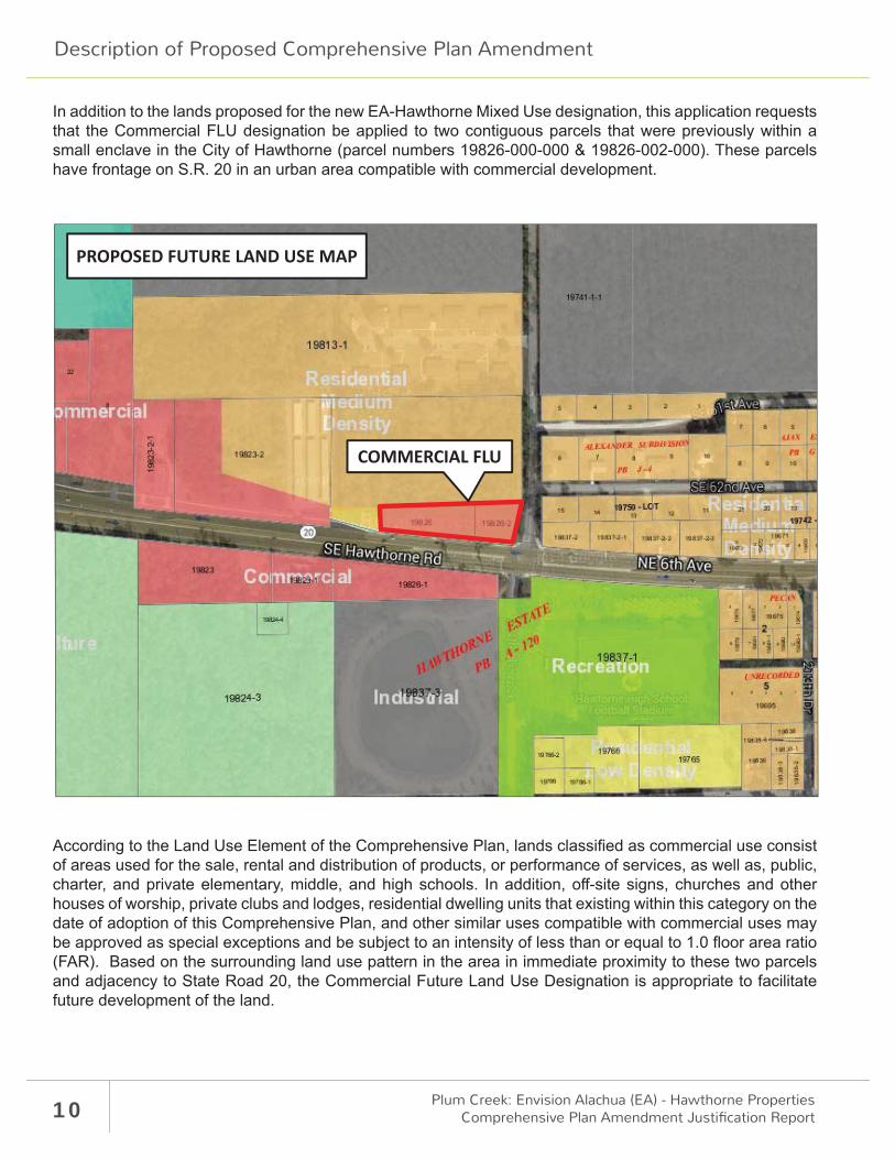
In addition to the lands proposed for the new EA-Hawthorne Mixed Use designation, this application requests that the Commercial FLU designation be applied to two contiguous parcels that were previously within a small enclave in the City of Hawthorne (parcel numbers 19826-000-000 & 19826-002-000). These parcels have frontage on S.R. 20 in an urban area compatible with commercial development.
According to the Land Use Element of the Comprehensive Plan, lands classifi ed as commercial use consist of areas used for the sale, rental and distribution of products, or performance of services, as well as, public, charter, and private elementary, middle, and high schools. In addition, off -site signs, churches and other houses of worship, private clubs and lodges, residential dwelling units that existing within this category on the date of adoption of this Comprehensive Plan, and other similar uses compatible with commercial uses may be approved as special exceptions and be subject to an intensity of less than or equal to 1.0 fl oor area ratio (FAR). Based on the surrounding land use pattern in the area in immediate proximity to these two parcels and adjacency to State Road 20, the Commercial Future Land Use Designation is appropriate to facilitate future development of the land.
PROPOSED FUTURE LAND USE MAP
COMMERCIAL FLU
Description of Proposed Comprehensive Plan Amendment
11
Description of Proposed Comprehensive Plan Amendment
EA-Hawthorne Mixed Use Principles
The following is the EA-Hawthorne Mixed Use vision for the preservation of the existing community and growth of an employment sector to provide jobs and a sustainable tax base for the City.
OVERALL VISION STATEMENT The recruitment or enablement of more primary industries, which pay higher than the average local wages (primary industries are defi ned as contributory industries to the local economy and are contributors to an increase in the standard of living of the community at large); and to provide a basis for plans and programs which are intended to ensure the maintenance of the quality of life
of the citizens of the community, while increasing their standard of living.
The vision statement is supported by the following objectives and policy statements:
• Help diversify the economy of the City by creating an economic climate conducive to attracting new development and businesses which yield net so-cial and economic benefi ts to the City.
• Encourage economic development activities which provide, either through initial stages or through ex-pansion, the opportunity for employment of local residents and/or increased municipal revenues.
• Support the equitable sharing of the full cost of public improvements between the public and pri-vate sectors. Improvements specifi cally and orig-inally attributed to EA-Hawthorne Mixed Use and the ensuing residences and businesses should be borne by those entities.
• EA-Hawthorne Mixed Use places particular em-phasis on activities which increase economic op-portunities for persons at or near the poverty level and to activities which eliminate blighted commer-cial and industrial uses.
• Encourage the City, State and Federal Govern-ments, as well as, non-profi t and for profi t entities through special programs, including grants in aid, to pursue the expansion and attraction of small and medium sized fi rms with good growth poten-tial.
Foster the accommodation of a broad mix of jobs, while actively seeking a greater proportion of living wage jobs that will have greater benefi ts to a broad cross-section of the people of the City.
Encourage a mix of large and small industries and businesses to support a strong and diverse economic base. This mix should create large number of jobs, generate substantial public revenues and involve high levels of private enterprise.
• Assist the City, State and Federal Governments with identifi cation and mitigation, where appropriate, ob-stacles to the formation and expansion of local businesses.

12 Plum Creek: Envision Alachua (EA) - Hawthorne PropertiesComprehensive Plan Amendment Justifi cation Report
• Support new business development which does not overburden infrastructure capacities. Provide adequate infrastructure capacity to support new business development, while not negatively im-pacting operations of the existing business base.
• Support development projects which broaden and enhance the City’s economic base and produce viable long term land use patterns.
• Work with the City to establish areas to be iden-tifi ed in the Comprehensive Plan as planned unit development business parks, which provide for a mix of industrial assembly, research and develop-ment, offi ce and general commercial service and retail uses.
• Encourage new commercial areas to cluster in identifi ed areas to prevent and discourage strip development.
Select commercial and industrial locations which are convenient, while compatible with the growth and future service needs of the City.
Assist the City with the strengthening and enhancement of the downtown district, carefully identifying opportunities for business, shops, restaurants, and housing. Support new construction that is planned in the context of preserving the historic character of the City core.
• Endeavor to (1) encourage the location of a number of small neighborhood centers in the community, where local residents can walk or bike; (2) Establish mixed use development along arterials; and (3) Part-ner with organizations in the business community to preserve and increase the availability of aff ordable housing at a rate consistent with population growth.
Endeavor to create partnerships to implement this community vision, such as the Hawthorne CRA with its vision planning with Florida Department of Economic Opportunity.
• Encourage downtown revitalization which encompasses a wide range of activities. Help foster the coop-eration of County government, chambers of commerce, the private sectors, civic organizations, and other key institutions; in paying particular attention to attracting commercial business.
Description of Proposed Comprehensive Plan Amendments
13
EA-Hawthorne Mixed-Use Development Program
Assumptions, Densities & IntensitiesFor the purpose of this Justifi cation Report and level of service analysis, the following scenario is proposed for the EA-Hawthorne properties.
EA-Hawthorne Mixed Use Development Program - 2030
Land Use Type Proposed Density / Intensity
Non-Residential Light Industrial 2,850,000 S.F.Commercial 150,000 S.F.
Total Non-Residential 3,000,000 S.F.
Total Jobs 3,183
Residential
Single Family 600 UnitsMulti-Family/Attached 200 Units
Total Residential 800 UnitsTotal Population 1,800
Defi nition of Density Approach and Calculations
It is important to acknowledge that planned development of this scale has never been contemplated in the City of Hawthorne. As such, there are two key considerations relating to density that need to be explored. First, while the goal is to create a compact and walkable mixed use community, it is important to recognize that the density will not materialize immediately. Instead the project is likely to start at conventional levels of density and “ramp up” over time as a sense of place emerges and users recognize the benefi ts of clustering in close proximity.
Non-Residential Program Densities
Classifi cation Minimum Intensity
Maximum Intensity
Average Intensity (Aggregate at Buildout) Metric
Light Industrial 0.05 1.0 0.17 FAR
Commercial 0.15 1.0 0.25 FAR
Description of Proposed Comprehensive Plan Amendments
14 Plum Creek: Envision Alachua (EA) - Hawthorne PropertiesComprehensive Plan Amendment Justifi cation Report
Light Industrial
The light industrial program consists of 2.85 million square feet and an assumption of 1,000 square feet per light industrial job located in areas designated EA-Hawthorne Mixed Use. While there is no generally accept-ed standard for light industrial jobs, the planning team’s research reveals that most light industrial operations are space intensive and employ fewer workers per square foot compared to R&D/Offi ce uses. Based on this assumption, the program of 2.85 million square feet of light industrial would translate into approximately 2,850 on-site employees at build-out.
The previous table provides a minimum, maximum, and average intensity for the development. When this program is applied to usable land within the development, it provides a realistic description of program in-tensities. The average intensity is a reasonable FAR for this kind of project. This represents a conventional industrial development format with one or two levels of building served by adjacent surface parking. Addition-ally, the plan must allow for agricultural uses to occur within light industrial sites given the agricultural focus of much of the research and production that is expected to fl ourish within the community. This approach does not preclude more dense commercial development from occurring. In fact, the program recommends allowing for FARs as high as 1.0 to allow for “higher-value” light industrial fi rms that may co-locate with higher education or professional offi ce users.
Commercial
The commercial program consists of 150,000 square feet, which assumes 125-150 square feet of commer-cial and service uses per household. This fi gure is in line with the existing quantity of occupied commercial per household within Alachua County. This allocation is estimated to be 75 square feet of commercial per household with an additional 50-75 square feet of service uses such as banks, lawyers, and certifi ed public accountants. While there is no generally accepted standard for the amount of commercial per household, the planning team’s research reveals that in southeast markets 50-75 square feet or 100-150 square feet includ-ing service uses per household is a reasonable target. With one commercial job per 400 square feet, the pro-gram of 150,000 square feet of commercial space would accommodate 333 on-site employees at build-out.
The previous table provides a minimum, maximum, and average intensity for the development. When this program is applied to usable land within the development, it provides a realistic description of program inten-sities. The program recommends allowing FARs as high at 1.0 to account for more clustering of users as the knowledge center gains momentum.
Residential
The residential program is designed to appeal to a broad cross section of market audiences ranging from singles and young couples to families, empty nesters, and retirees. The wide range of product types gives potential buyers a variety of housing formats and price points to choose from and allows them to remain in the community as they age and their housing needs change. Specifi cally, the program calls for 200 multi-family/attached units and 600 single family units, for a total of 800 dwelling units within the areas designated EA-Hawthorne Mixed Use.
Using US Census data to estimate average household size ranging from 1.67 to 2.5 (depending on the type of unit) yields an estimated on-site population of approximately 1,800 at build-out.
Description of Proposed Comprehensive Plan Amendment

15
Land Use Data & Analysis
Land Use Data & AnalysisRegional ContextDuring Phase I of Envision Alachua, the Community Task Force identifi ed Plum Creek Land Company prop-erty framed by S.R. 20, S.R. 26, and U.S. 301 in East Alachua County as potential areas of focus for econom-ic development, conservation, and a range of supporting residential, commercial, educational, recreational, and community uses. Following the Task Force recommendations, additional analyses were carried out to evaluate and confi rm the regional suitability of these East Alachua County lands for job-creating, mixed-use community development. Several guiding principles reinforce the suitability of EA-Hawthorne Mixed Use within the regional context:
Utilize Existing Infrastructure
The proposed EA-Hawthorne Mixed Use area in East Alachua County is served by substantial existing infrastructure, including S.R. 20, and U.S. 301 and the CSX regional transportation railroad. The presence of this existing infra-structure provides a strong basis for the focus of future economic development in the area.
Ensure Economic Progress
The proposed EA-Hawthorne Mixed Use classi-fi cation is rooted in the goal of creating a progressive community development model with future opportuni-ties for job creation and institutional partnerships. The economic engine of local institutional and commercial anchors, reinforced by the capacity and quality of existing transportation infrastructure, suggests an oppor-tunity for an “Economic Progress Corridor” along S.R. 20, linking from west to east, the University of Florida, the City of Gainesville and East Gainesville, Plum Creek Land Company property, and the City of Hawthorne.
Reinforce & Enhance Local Communities
The proposed EA-Hawthorne Mixed Use classifi cation is strategically positioned to support the protection and enhancement of existing communities in Eastern Alachua County including the City of Hawthorne. The City of Hawthorne is well positioned at the nexus of S.R. 20, U.S. 301, and the CSX rail line for future eco-nomic development opportunities. Plum Creek’s lands near the junction of U.S. 301 and S.R. 20 are already within the City’s future growth area as established in the Alachua County and City of Hawthorne Comprehen-sive Plans.
Provide Site Opportunities of Scale for Job Creation
The proposed EA-Hawthorne Mixed Use classifi cation provides an opportunity to establish large scale, shov-el-ready sites for industrial development. Currently there is a defi cit of industrial sites within Alachua County, particularly sites of at least 500 acres and larger, or sites where major jobs centers can be developed. Areas proposed for designation as EA-Hawthorne Mixed Use contain parcels of suffi cient size, served by rail and major highways, to accommodate this job opportunity.

16 Plum Creek: Envision Alachua (EA) - Hawthorne PropertiesComprehensive Plan Amendment Justifi cation Report
LEVY
MARION
PUTNAM
CLAY
BRADFORD
UNION
COLUMBIA
GIL-CHRIST
HAWTHORNESTATE TRAIL
WALDO RDGREENWAY
TRAIL
10miles
5miles
1mile
SANTA FECOLLEGE
UF2
NewnansLake
Santa Fe Lake
LochloosaLake
San FelascoHammockPreserveState Park
GumRootPark
Austin CaryMemorialForest
BaluForest
Paynes Prarie Preserve State
Park
Split RockConservation
Area
WINDSOR
EASTGAINESVILLE
HAWTHORNE
GAINESVILLE
DISTRIBUTION CENTER CLUSTER
PROGRESSCORPORATE PARK
TIOGA
HAILE PLANTATION
15miles
20
MICANOPY
WALDO
ARCHER
NEWBERRY
HIGHSPRINGS ALACHUA
LACROSSE
OrangeLake
LakeAlto Little Santa
Fe Lake
Sunshine Lake
121
24
26222
20
75
441
30141
A community discussion on the future of East CountyCONVENED BY PLUM CREEK
0 16,0008,000 32,000 48,000 Feet
0 5 10 Miles
Data Sources: Alachua County GIS, Plum Creek | Updated: 05-2015
Alachua County Anchors & AssetsJune 2015
Legend
Conservation Lands
Municipality
Water Bodies
EA-Hawthorne
Envision Alachua Sector Plan
EA-PRES
EA-RUR
EA-CON
EA-EOMU
Land Use Data & Analysis
17
Land Use Data & Analysis
Local Context Areas designated EA-Hawthorne Mixed Use will be a compact, connected, and employment oriented com-munity. It is envisioned to include nearby residential development, an activity hub and related commercial and retail services to provide for a balanced and integrated community. It will be a place where residents can walk or bike to work and the many other services they need to enjoy a healthy and balanced life such as schools, churches, parks and civic amenities such as the Gainesville-Hawthorne State Trail.
Areas designated EA-Hawthorne Mixed Use will reinforce the continued development of the City of Haw-thorne by bringing new employment opportunities and residents that will contribute to the further develop-ment and growth of the City. The vision for areas to be designated EA-Hawthorne Mixed Use provide for the natural expansion of Hawthorne’s residential community by extending and connecting into the existing street network and further activating the Gainesville-Hawthorne State Trail. Development in areas designat-ed EA-Hawthorne Mixed Use will complement and strengthen underutilized resources in Hawthorne such as schools, retail/commercial, and residential uses. Areas designated EA-Hawthorne Mixed Use have strong roadway and rail connections providing an opportunity to reinforce the Hawthorne community and economy.
The proposed EA-Hawthorne Mixed Use land use designation will provide fl exibility for mixed use develop-ment to complement the range of surrounding land use designations. Industrial uses are not permitted south of S.R. 20.
The Commercial Future Land Use designation will be applied to two parcels previously within an enclave in the City of Hawthorne. These parcels have frontage on S.R. 20 in an urban area compatible with commercial development.
Site Data & AnalysisThe following is a summary of existing site conditions related to the property. Complete data & analysis for environmental, transportation, water and wastewater contained within the Appendix of this document.
Existing ConditionsThe large majority of land to be considered under this application is in agricultural use.
Plum Creek Land Company property also include an industrial site within the City which will remain under its current zoning. This industrial site is well located, as it has direct access to the primary CSX rail line, which is an important transportation link for the EA-Hawthorne properties north of S.R. 20. The 16 mile Gaines-ville-Hawthorne State Trail provides an alternate connection (e.g. walking and cycling) between the City of Hawthorne and Gainesville.
The balance of the property has been annexed to the City along with this application for land use amend-ment and is well served by S.R. 20, U.S. 301 and C.R. 2082. The County’s classifi cation of this property is Rural/Agriculture, which allows single family residential uses of one dwelling unit per 5 acres and general agriculture use. This classifi cation is consistent with the policies of the County Comprehensive Plan, which recognizes these unincorporated areas within the Urban Reserve Area of the City of Hawthorne as rural until annexed to allow more urban uses as part of the City.

18 Plum Creek: Envision Alachua (EA) - Hawthorne PropertiesComprehensive Plan Amendment Justifi cation Report
A community discussion on the future of East CountyCONVENED BY PLUM CREEK
Updated: 05-2015 - Sasaki Associates, Inc.
301
20
HAWTHORNE
Little OrangeLake
HoldenPond
MossLee
Lake
LakeJohnson
Lake Jeffords
Lochloosa Lake
EA-Hawthorne:Proposed FLU Map Amendment Area
Legend
City of Hawthorne Urban Reserve Area
EA-Hawthorne Land Use Change Area
City of Hawthorne
0 2,0001,000 4,000 6,000 Feet
100 AC
Land Use Data & Analysis
19
Land Use Data & Analysis
Surrounding Land Uses on Properties North of S.R. 20
Direction Future Land Use Designation
North County Rural/Agriculture
East County Rural/Agriculture, City Commercial and City Agriculture
South County Rural/Agriculture, City Commercial, City Industrial, City Agriculture and Recreational use
West Rural/Agriculture
Surrounding Land Uses on Properties South of S.R. 20
Direction Future Land Use Designation
North County Rural/Agriculture, City Industrial, and City Commercial
East County Rural/Agriculture and City Residential
South County Rural/Agriculture
West County Rural/Agriculture
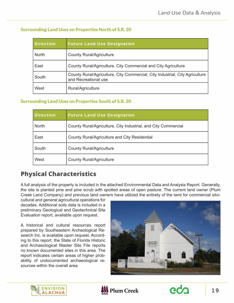
Physical CharacteristicsA full analysis of the property is included in the attached Environmental Data and Analysis Report. Generally, the site is planted pine and pine scrub with spotted areas of open pasture. The current land owner (Plum Creek Land Company) and previous land owners have utilized the entirety of the land for commercial silvi-cultural and general agricultural operations for decades. Additional soils data is included in a preliminary Geological and Geotechnical Site Evaluation report, available upon request.
A historical and cultural resources report prepared by Southeastern Archeological Re-search Inc. is available upon request. Accord-ing to this report, the State of Florida Historic and Archaeological Master Site File reports no known documented sites in this area. The report indicates certain areas of higher prob-ability of undocumented archaeological re-sources within the overall area.
20 Plum Creek: Envision Alachua (EA) - Hawthorne PropertiesComprehensive Plan Amendment Justifi cation Report
Potential Development ScenarioThe areas designated EA-Hawthorne Mixed Use, north of S.R. 20, are envisioned as becoming an ad-vanced manufacturing and light industrial hub that provides a physical setting for the fusion of new ideas, partnerships, research, best practices, and facilities for large and small scale light industrial with strong connections to S.R. 20, U.S. 301, and the railroad. It is envisioned to include nearby residential development, a multi-use activity hub and related commercial and retail services to provide for a balanced and integrat-ed community.
The vision for areas designated EA-Hawthorne Mixed Use is for a more compact advanced manufacturing and light industrial hub that is more compact than the conventional development patterns and typologies typically observed in the United States. While the conventional density for industrial parks is in the range of 0.15 FAR, the vision for the light industrial hub is to achieve a more compact form represented by an FAR in the range of 0.30. The organizations locating within the hub may not only be doing manufacturing but may also be engaged in cutting edge research to develop the new technologies and approaches that will form the basis for the factory facilities of the future. A higher density FAR approach promotes effi cient clustering of development in appropriate areas to mitigate impacts to environmentally sensitive areas.
Scenario Development Program
The overall EA-Hawthorne Mixed Use land use program is summarized below.
EA-Hawthorne Mixed Use Buildout Program
Non-Residential Sq. Ft. JobsLight Industrial 2,850,000 2,850Commercial 150,000 333Total Non-Residential 3,000,000 3,183
Residential UnitsSingle Family 600Multi-Family/Attached 200Total Residential 800
Land Use Data & Analysis
21
Land Use Data & Analysis
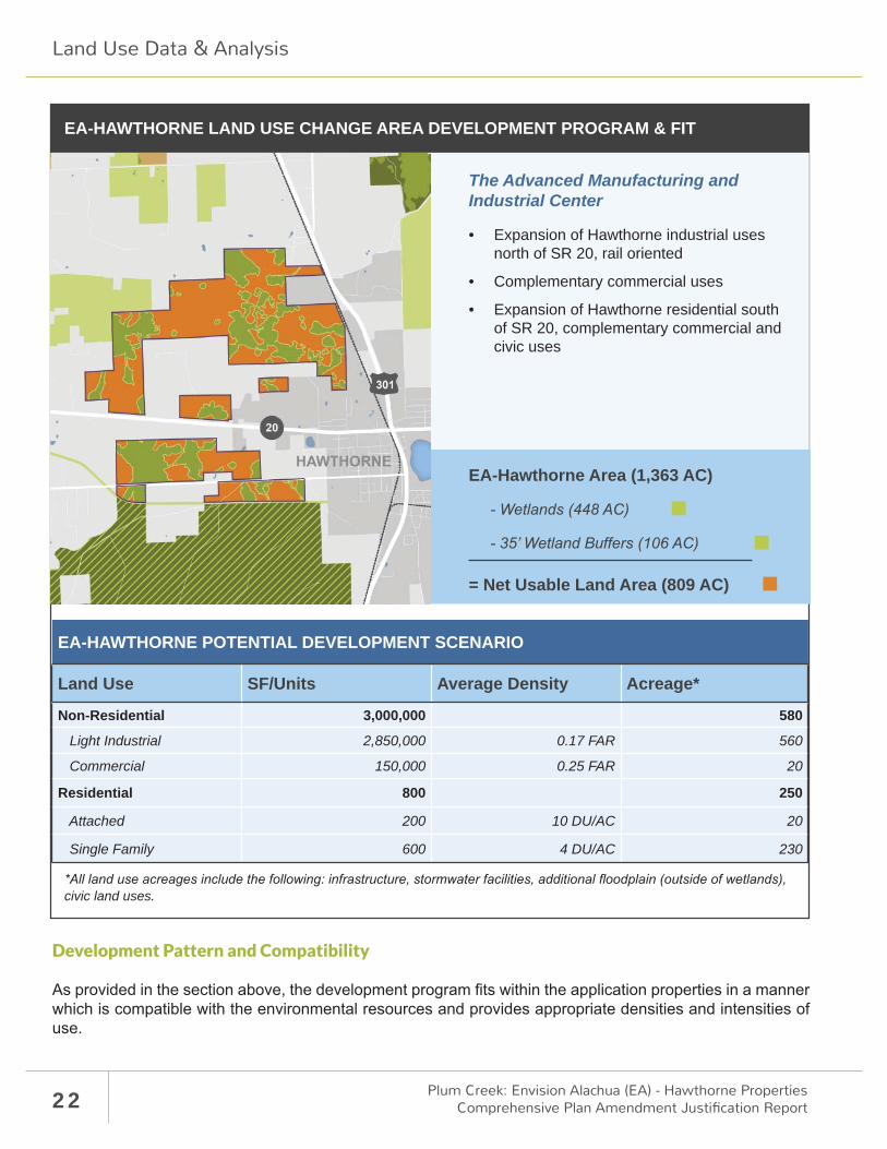
The potential development scenario for areas designated EA-Hawthorne Mixed Use is characterized by the following planning and urban design goals and principles:
The overarching goal of the EA-Hawthorne Mixed Use land use is to focus future growth in key developable areas to maximize economic development potential while minimizing development pressure on surrounding rural, agricultural and conservation areas.
An employment-driven land use program is envisioned within the areas designated EA-Hawthorne Mixed Use land use. This approach is driven by the community good favoring development within areas designat-ed EA-Hawthorne Mixed Use should create signifi cant economic progress and opportunities for the City of Hawthorne. For this reason, the land use program emphasizes advanced manufacturing, light industrial and commercial uses as catalysts for economic development within the City. The long-term vision is for a diverse mix of uses including offi ce, advanced manufacturing, light industrial, commercial, and moderate-to-low den-sity residential development.
As previously noted, EA-Hawthorne Mixed Use land use is assigned to 1,362.68 acres within the City of Haw-thorne. The EA-Hawthorne Mixed Use acreage can be broken down into several categories as shown in the table below. Of the total EA-Hawthorne Mixed Use acreage, 554 acres have been categorized as wetlands, wetland buff ers, and edges. Subtracting these wetlands, buff ers, and edges from the total EA-Hawthorne Mixed Use designated acreage yields a total of 809 net usable or developable acres.
The EA-Hawthorne Mixed Use potential development scenario assigns land uses to the net usable EA-Haw-thorne Mixed Use acres. A series of assumptions have guided this assignment of land uses. These assump-tions relate to such elements as the distribution of land allocation for major infrastructure, the defi nition of density, and the suggestion of a maximum program by land use, as described on the following page.
• Locate light industrial uses north of S.R. 20 to capitalize on rail access. Supplement with com-plementary R&D uses to create synergistic oppor-tunities.
• Design rail access to manufacturing sites in a fashion that minimizes adverse impacts to primary wetland areas.
• Create an internal access spine road to achieve suffi cient internal connectivity and minimize the use of the off -site road network.
• Strategically locate commercial and multi-use de-velopment areas to create an activity hub with a horizontal mix of the highest density residential along with R&D and service/commercial.
• Position large parcels along S.R. 20 and SE Ter-race 193 to accommodate commercial/service in conventional or higher density format.
• Locate the majority of residential land use pro-gram south of S.R. 20 as a natural extension of Hawthorne’s neighborhood character, taking ad-vantage of access to schools and recreational opportunities such as the Gainesville-Hawthorne State Trail.
• The residential program is assumed to include townhome-style product within the commercial (multi-use) hub at approximately 10 dwelling units per acre. The majority of residential units will be an average of 4 dwelling units per acre which rep-resents a lot size of approximately 8000 square feet.
22 Plum Creek: Envision Alachua (EA) - Hawthorne PropertiesComprehensive Plan Amendment Justifi cation Report
Development Pattern and Compatibility
As provided in the section above, the development program fi ts within the application properties in a manner which is compatible with the environmental resources and provides appropriate densities and intensities of use.
EA-HAWTHORNE POTENTIAL DEVELOPMENT SCENARIO
Land Use SF/Units Average Density Acreage*
Non-Residential 3,000,000 580
Light Industrial 2,850,000 0.17 FAR 560
Commercial 150,000 0.25 FAR 20
Residential 800 250
Attached 200 10 DU/AC 20
Single Family 600 4 DU/AC 230
EA-HAWTHORNE LAND USE CHANGE AREA DEVELOPMENT PROGRAM & FIT
The Advanced Manufacturing and Industrial Center
• Expansion of Hawthorne industrial uses north of SR 20, rail oriented
• Complementary commercial uses
• Expansion of Hawthorne residential south of SR 20, complementary commercial and civic uses
20
civic land uses.
EA-Hawthorne Area (1,363 AC)
= Net Usable Land Area (809 AC)
301
Land Use Data & Analysis
23
Land Use Data & Analysis
Level of Service / Public Facilities AnalysisThe following section analyzes the existing Level of Service for Hawthorne public facilities and proposed impacts related to the proposed EA-Hawthorne Mixed Use Comprehensive Plan Amendment / Land Use Change.
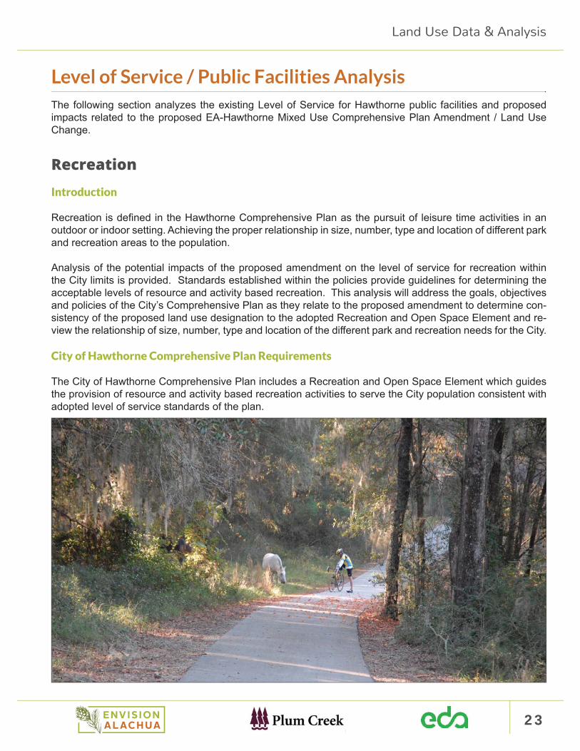
Recreation Introduction
Recreation is defi ned in the Hawthorne Comprehensive Plan as the pursuit of leisure time activities in an outdoor or indoor setting. Achieving the proper relationship in size, number, type and location of diff erent park and recreation areas to the population.
Analysis of the potential impacts of the proposed amendment on the level of service for recreation within the City limits is provided. Standards established within the policies provide guidelines for determining the acceptable levels of resource and activity based recreation. This analysis will address the goals, objectives and policies of the City’s Comprehensive Plan as they relate to the proposed amendment to determine con-sistency of the proposed land use designation to the adopted Recreation and Open Space Element and re-view the relationship of size, number, type and location of the diff erent park and recreation needs for the City.
City of Hawthorne Comprehensive Plan Requirements
The City of Hawthorne Comprehensive Plan includes a Recreation and Open Space Element which guides the provision of resource and activity based recreation activities to serve the City population consistent with adopted level of service standards of the plan.
24 Plum Creek: Envision Alachua (EA) - Hawthorne PropertiesComprehensive Plan Amendment Justifi cation Report
OBJECTIVE VI.1 The City, upon adoption of this Comprehensive Plan, shall continue to provide vehicular and pedestrian access to City owned activity and resource based recreation facilities.
Policy VI.1.1 The City shall establish provisions within the land development regulations which shall maintain the number of access points to water oriented recreational resources for the City which will meet or exceed the level of service standards, contained herein, for resource based water related activities.
OBJECTIVE VI.2 The City, by June 1, 1992, shall maintain accurate recreation activity/facility inventories so that accurate levels of service can be determined, based upon the total public and private recreation resourc-es available to the City.
OBJECTIVE VI.3 The City shall establish requirements within the land development regulations, by June 1, 1992, to require new subdivisions or resubdivisions to allocate land, as determined by standards within the regulations, for parks and recreation facilities so that the City’s recreation facilities are provided in quantities to maintain the adopted level of service standards for recreation contained herein.
Policy VI.3.3 The City shall through the annual capital improvements budgeting process, identify funding sources to correct or improve existing defi ciencies in City-owned parks and recreation facilities in accordance with the level of service standards contained herein.
OBJECTIVE VI.4 The City shall establish provisions within the land development regulations, by June 1, 1992, which shall include requirements for the provision and maintenance of open space by public agencies and private enterprise, where incompatible uses abut one another.
Policy VI.4.1 The City shall maintain the acreage currently available in open spaces as defi ned within Chap-ter 9J-5, Florida Administrative Code in eff ect upon adoption of this Comprehensive Plan.
Policy VI.4.2 The City shall, as part of the procedure for monitoring and evaluation of the Comprehensive Plan, recommend lands for the purchase of open space by public agencies and subsequent to such land purchase support such agencies in the management of such lands.
Policy VI.3.1 The City hereby establishes the following level of service standards for resource based recre-ation facilities.
ACTIVITY LEVEL OF SERVICE STANDARD
Swimming (non-pool) A 25,000 person threshold for the initial access point at a beach, stream, spring, river, lake or pond, with a 25,000 person increment for each additional access point at a beach, stream, spring, river, lake or pond within a 25 mile radius of the City.
Fishing (non-boat) A 2.500 person threshold for the initial access point, with a 2,500 person incre-ment for each additional access point within a 25 mile radius of the City.
Fishing (boat) A 4,300 person threshold for the initial boat ramp, with a 43fl person increment for each additional boat ramp, within a 25 mile radius of the City.
Land Use Data & Analysis

25
ACTIVITY LEVEL OF SERVICE STANDARD
Camping (Recreation Vehicle and tent)
A 5600 person threshold for the initial acre of camping area, with a 5,600 person increment for each additional, acre of camping area within a 25 mile radius of the City.
Picnicking A 500 person threshold for the initial picnic table, with a 500 person increment for each additional picnic table.
Bicycling A 1,000 person threshold for the initial mile of local roadway, with a 1,000 person increment for each additional mile of local roadway.
Hiking A 7,000 person threshold for the initial mile of available hiking trail, with a 7,000 person increment for each additional mile of available hiking trail. within a 25 mile radius of the City.
Nature Study A 2.500 person threshold for the initial 7.0 acres of wildlife management area. with a 2,500 person increment for each additional 7.0 acres of wildlife management area within a 25 mile radius of the City.
Policy VI.3.2 The City hereby establishes the following level of service standards for user based recreation facilities.
ACTIVITY LEVEL OF SERVICE STANDARDGolf A 32,500 person threshold for the initial 9-holes of golf course, with a 32,500 per-
son increment for each additional 9 holes of golf course.
Equipped play area A 2,500 person threshold for the initial equipped play area, with a 2,500 person increment for each additional equipped play area.
Tennis A 7,500 person threshold for the initial tennis court with a 7,500 person increment for each additional tennis court.
Baseball/softball A 6,000 person threshold for the initial ball fi eld, with a. 6,000 person increment for each additional ball fi eld.
Football/Soccer A 15,000 person threshold for the initial multi-purpose fi eld, with a 15,000 person increment for each additional multi-purpose fi eld.
Handball/racquetball A 10,000 person threshold for the initial court, with a10,000 person increment for each additional court.
Basketball A 2,500 person threshold for the initial goal, with a 2,500 person increment for each additional goal.
Swimming (pool) A 25,000 person threshold for the initial pool, with a 25,000 person increment for each additional pool.
Shuffl eboard A 10,000 person threshold for the initial court, with a 10,000 person increment for each additional court.
Land Use Data & Analysis
26 Plum Creek: Envision Alachua (EA) - Hawthorne PropertiesComprehensive Plan Amendment Justifi cation Report
Existing Recreation Facilities
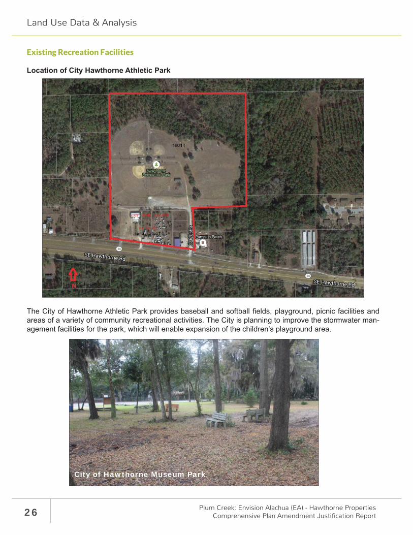
Location of City Hawthorne Athletic Park
The City of Hawthorne Athletic Park provides baseball and softball fi elds, playground, picnic facilities and areas of a variety of community recreational activities. The City is planning to improve the stormwater man-agement facilities for the park, which will enable expansion of the children’s playground area.
City of Hawthorne Museum Park
Land Use Data & Analysis
27
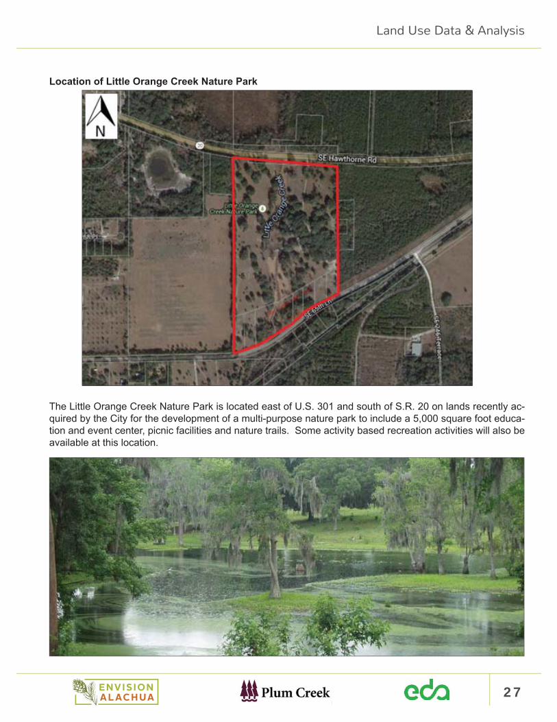
Location of Little Orange Creek Nature Park
The Little Orange Creek Nature Park is located east of U.S. 301 and south of S.R. 20 on lands recently ac-quired by the City for the development of a multi-purpose nature park to include a 5,000 square foot educa-tion and event center, picnic facilities and nature trails. Some activity based recreation activities will also be available at this location.
Land Use Data & Analysis
28 Plum Creek: Envision Alachua (EA) - Hawthorne PropertiesComprehensive Plan Amendment Justifi cation Report
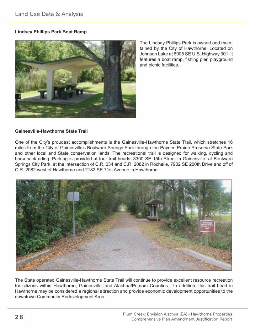
Lindsey Phillips Park Boat Ramp
The Lindsay Phillips Park is owned and main-tained by the City of Hawthorne. Located on Johnson Lake at 6905 SE U.S. Highway 301; it features a boat ramp, fi shing pier, playground and picnic facilities.
Gainesville-Hawthorne State Trail
One of the City’s proudest accomplishments is the Gainesville-Hawthorne State Trail, which stretches 16 miles from the City of Gainesville’s Boulware Springs Park through the Paynes Prairie Preserve State Park and other local and State conservation lands. The recreational trail is designed for walking, cycling and horseback riding. Parking is provided at four trail heads: 3300 SE 15th Street in Gainesville, at Boulware Springs City Park, at the intersection of C.R. 234 and C.R. 2082 in Rochelle, 7902 SE 200th Drive and off of C.R. 2082 west of Hawthorne and 2182 SE 71st Avenue in Hawthorne.
The State operated Gainesville-Hawthorne State Trail will continue to provide excellent resource recreation for citizens within Hawthorne, Gainesville, and Alachua/Putnam Counties. In addition, this trail head in Hawthorne may be considered a regional attraction and provide economic development opportunities to the downtown Community Redevelopment Area.
Land Use Data & Analysis
29
Development Program
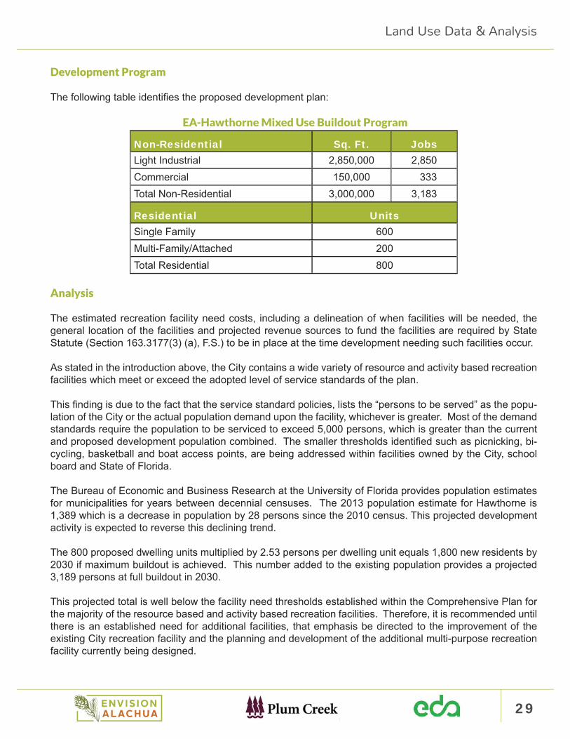
The following table identifi es the proposed development plan:
EA-Hawthorne Mixed Use Buildout Program
Non-Residential Sq. Ft. JobsLight Industrial 2,850,000 2,850Commercial 150,000 333Total Non-Residential 3,000,000 3,183
Residential UnitsSingle Family 600Multi-Family/Attached 200Total Residential 800
Analysis
The estimated recreation facility need costs, including a delineation of when facilities will be needed, the general location of the facilities and projected revenue sources to fund the facilities are required by State Statute (Section 163.3177(3) (a), F.S.) to be in place at the time development needing such facilities occur.
As stated in the introduction above, the City contains a wide variety of resource and activity based recreation facilities which meet or exceed the adopted level of service standards of the plan.
This fi nding is due to the fact that the service standard policies, lists the “persons to be served” as the popu-lation of the City or the actual population demand upon the facility, whichever is greater. Most of the demand standards require the population to be serviced to exceed 5,000 persons, which is greater than the current and proposed development population combined. The smaller thresholds identifi ed such as picnicking, bi-cycling, basketball and boat access points, are being addressed within facilities owned by the City, school board and State of Florida.
The Bureau of Economic and Business Research at the University of Florida provides population estimates for municipalities for years between decennial censuses. The 2013 population estimate for Hawthorne is 1,389 which is a decrease in population by 28 persons since the 2010 census. This projected development activity is expected to reverse this declining trend.
The 800 proposed dwelling units multiplied by 2.53 persons per dwelling unit equals 1,800 new residents by 2030 if maximum buildout is achieved. This number added to the existing population provides a projected 3,189 persons at full buildout in 2030.
This projected total is well below the facility need thresholds established within the Comprehensive Plan for the majority of the resource based and activity based recreation facilities. Therefore, it is recommended until there is an established need for additional facilities, that emphasis be directed to the improvement of the existing City recreation facility and the planning and development of the additional multi-purpose recreation facility currently being designed.
Land Use Data & Analysis
30 Plum Creek: Envision Alachua (EA) - Hawthorne PropertiesComprehensive Plan Amendment Justifi cation Report
Public Schools City of Hawthorne Comprehensive Plan Requirements
The City of Hawthorne Comprehensive Plan Public School Facility Element provides the following policies which have a bearing on the review of the proposed Comprehensive Plan Amendment:
GOAL I – THE CITY SHALL COLLABORATE WITH THE SBAC TO PLAN FOR PUBLIC SCHOOL CA-PACTIY TO ACCOMMODATE PROJECTED ENROLLMENT DEMAND WITHIN THE FIVE YEAR, TEN YEAR AND TWENTY YEAR PLANNING PERIODS.
Policy IX.1.2 Coordinating School Capacity with Growth The City of Hawthorne shall coordinate land use de-cisions rezonings with the SBAC’s Long Range Facilities Plans over the 5-year, 10-year and 20-year periods by requesting School Board review of proposed comprehensive plan amendments and rezoning that would increase residential density. This hall be done as part of a planning assessment of the impact of such land use proposal on school capacity.
Policy IX.1.3 Geographic Basis for School Capacity Planning. For purposes of coordinating land use deci-sions with school capacity planning, the School Concurrency Service Areas (SCSAs) that are established for high, middle and elementary schools as part of the Interlocal Agreement for Public School Facility Planning (‘Interlocal Agreement’) shall be used for school capacity planning. The relationship of high, middle and elementary capacity and students anticipated to be generated as a result of land use decisions shall be as-sessed in terms of its impact (1) on the school system as a whole and (2) on the applicable SCSA(s). For pur-poses of this planning assessment, existing or planned capacity in adjacent SCSAs shall not be considered.
Policy IX.1.4 Criteria for Evaluating Land Use and Development Applications In reviewing land use deci-sions, the SBAC may address the following issues as applicable:
a. Available school capacity or planned improvements to accommodate the enrollment resulting from the land use decision;
b. The provision of school sites and facilities within neighborhoods; c. The co-location of parks, recreation and neighborhood facilities with school sites; d. The linkage of schools, parks, libraries and other public facilities with bikeways, trails, and sidewalks
for safe access; e. Traffi c circulation, in the vicinity of schools including the provision of off -site signalization, signage,
access improvements, sidewalks to serve schools and the inclusion of school bus stops and turn-arounds;
f. Encouraging the private sector to identify and implement creative solutions to developing adequate school facilities in residential developments;
g. Whether the proposed location is consistent with any local government’s school design and planning policies.
Policy IX.2.1 Uniform Application of Level of Service (LOS) Standards The LOS standards established herein shall be applied consistently by all the local governments within Alachua County and by the SCAC district-wide to all schools of the same type. For combination schools, the School Board shall separately determine the capacity of each school to accommodate elementary, middle and high student and apply the LOS Standard prescribed above for elementary, middle and high levels respectively.
Land Use Data & Analysis
31
Policy IX.4.5 Determination of Adequate Capacity A concurrency review shall be conducted for all develop-ment plan approval that are subject to school concurrently in accordance with procedures for coordination of such reviews by the County and the School Board established in the Interlocal Agreement. These procedures shall provide for review of individual development proposals by SCAC staff to determine whether there is adequate public school capacity to accommodate the proposed development, and issuance by the County of a concurrency determination based on SBAC staff ’s review and recommendation. These procedures shall also provide for the SBAC in coordination with local governments in the County to prepare an annual report based on existing and projected capacity and enrollment and student generation rates that establishes max-imum thresholds for developments at or below which adequate public school capacity will be available; for developments at or below these thresholds the County may determine as part of the County’s development review process that there is adequate public school capacity without SBAC staff review of such develop-ments.
1. Adequate school capacity means there is suffi cient school capacity at the adopted LOS standards to accommodate the demand created by a proposed development for each type of school within the af-fected CSA.
2. If adequate capacity does not exist, the SBAC shall identify possible mitigation options that may be applied consistent with the policies set forth within Objective 2.5. In the event that the SBAC determines that there is not adequate capacity in accordance with the concurrency availability standard in Policy 2.4.6, then the development application may remain active pending the conclusion of the mitigation ne-gotiations and execution of a legally binding mitigation agreement in accordance with the polices under Objective 2.5.
Land Use Data & Analysis

32 Plum Creek: Envision Alachua (EA) - Hawthorne PropertiesComprehensive Plan Amendment Justifi cation Report
Public School Concurrency Analysis
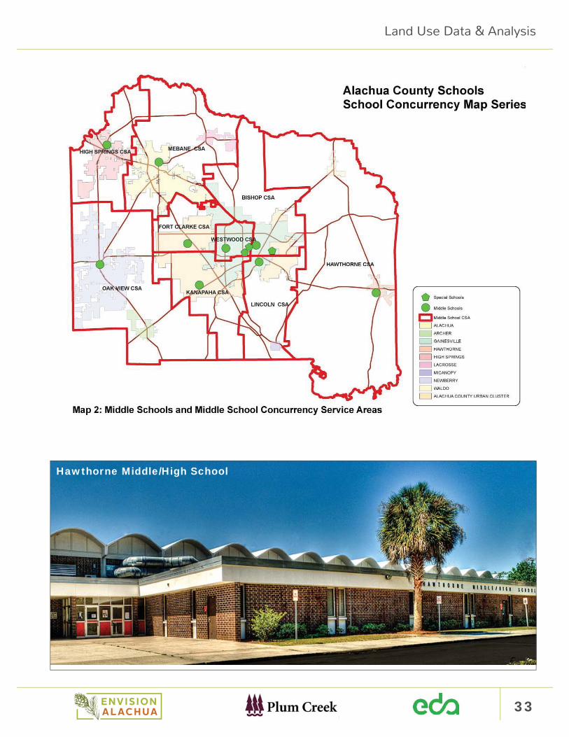
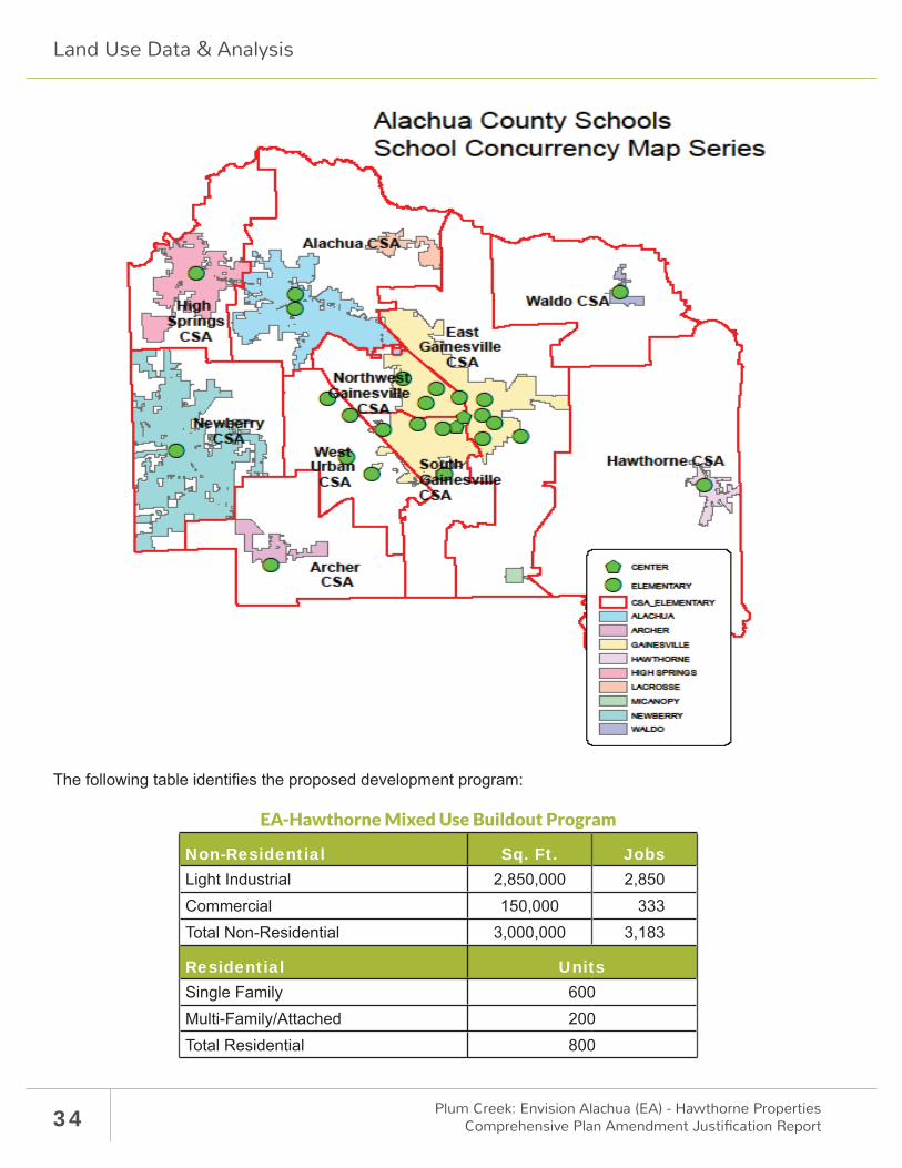
The School Concurrency Program in the City of Hawthorne is both a planning tool and a regulation that fun-damentally relates school capacity to the housing inventory that it serves. It is organized around Concurrency Service Areas (CSA) for elementary (K-5), middle (6-8) and high schools (9-12), the CSAs are shown in the following fi gures below:
Land Use Data & Analysis
33
Hawthorne Middle/High School
Land Use Data & Analysis
34 Plum Creek: Envision Alachua (EA) - Hawthorne PropertiesComprehensive Plan Amendment Justifi cation Report
The following table identifi es the proposed development program:
EA-Hawthorne Mixed Use Buildout Program
Non-Residential Sq. Ft. JobsLight Industrial 2,850,000 2,850Commercial 150,000 333Total Non-Residential 3,000,000 3,183
Residential UnitsSingle Family 600Multi-Family/Attached 200Total Residential 800
Land Use Data & Analysis
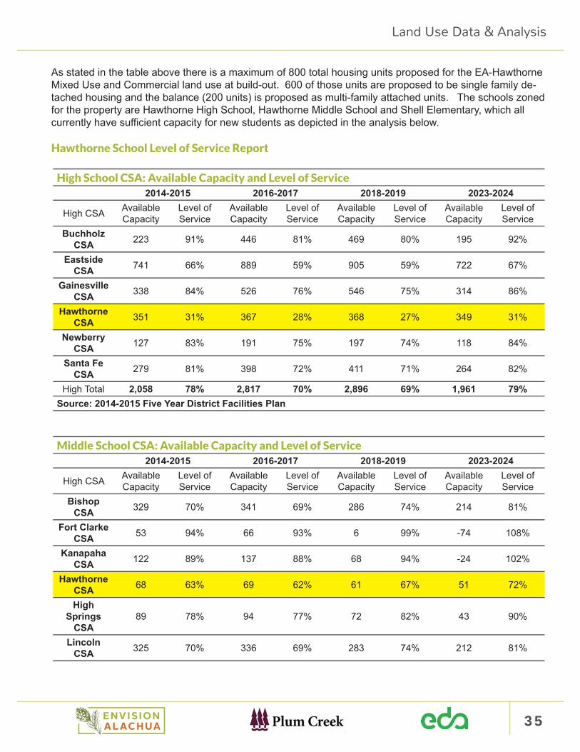
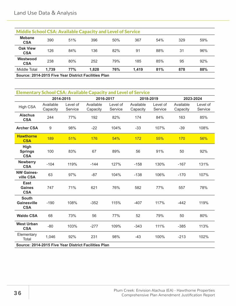
35
As stated in the table above there is a maximum of 800 total housing units proposed for the EA-Hawthorne Mixed Use and Commercial land use at build-out. 600 of those units are proposed to be single family de-tached housing and the balance (200 units) is proposed as multi-family attached units. The schools zoned for the property are Hawthorne High School, Hawthorne Middle School and Shell Elementary, which all currently have suffi cient capacity for new students as depicted in the analysis below.
Hawthorne School Level of Service Report
High School CSA: Available Capacity and Level of Service2014-2015 2016-2017 2018-2019 2023-2024
High CSA Available Capacity
Level of Service
Available Capacity
Level of Service
Available Capacity
Level of Service
Available Capacity
Level of Service
Buchholz CSA 223 91% 446 81% 469 80% 195 92%
Eastside CSA 741 66% 889 59% 905 59% 722 67%
Gainesville CSA 338 84% 526 76% 546 75% 314 86%
Hawthorne CSA 351 31% 367 28% 368 27% 349 31%
Newberry CSA 127 83% 191 75% 197 74% 118 84%
Santa Fe CSA 279 81% 398 72% 411 71% 264 82%
High Total 2,058 78% 2,817 70% 2,896 69% 1,961 79%Source: 2014-2015 Five Year District Facilities Plan
Middle School CSA: Available Capacity and Level of Service2014-2015 2016-2017 2018-2019 2023-2024
High CSA Available Capacity
Level of Service
Available Capacity
Level of Service
Available Capacity
Level of Service
Available Capacity
Level of Service
Bishop CSA 329 70% 341 69% 286 74% 214 81%
Fort Clarke CSA 53 94% 66 93% 6 99% -74 108%
Kanapaha CSA 122 89% 137 88% 68 94% -24 102%
Hawthorne CSA 68 63% 69 62% 61 67% 51 72%
High Springs
CSA89 78% 94 77% 72 82% 43 90%
Lincoln CSA 325 70% 336 69% 283 74% 212 81%
Land Use Data & Analysis
36 Plum Creek: Envision Alachua (EA) - Hawthorne PropertiesComprehensive Plan Amendment Justifi cation Report
Middle School CSA: Available Capacity and Level of ServiceMebane
CSA 390 51% 396 50% 367 54% 329 59%
Oak View CSA 126 84% 136 82% 91 88% 31 96%
Westwood CSA 238 80% 252 79% 185 85% 95 92%
Middle Total 1,739 77% 1,828 76% 1,419 81% 878 88% Source: 2014-2015 Five Year District Facilities Plan
Elementary School CSA: Available Capacity and Level of Service2014-2015 2016-2017 2018-2019 2023-2024
High CSA Available Capacity
Level of Service
Available Capacity
Level of Service
Available Capacity
Level of Service
Available Capacity
Level of Service
Alachua CSA 244 77% 192 82% 174 84% 163 85%
Archer CSA 9 98% -22 104% -33 107% -39 108%
Hawthorne CSA 189 51% 176 54% 172 55% 170 56%
High Springs
CSA100 83% 67 89% 56 91% 50 92%
Newberry CSA -104 119% -144 127% -158 130% -167 131%
NW Gaines-ville CSA 63 97% -87 104% -138 106% -170 107%
East Gaines
CSA747 71% 621 76% 582 77% 557 78%
South Gainesville
CSA-190 108% -352 115% -407 117% -442 119%
Waldo CSA 68 73% 56 77% 52 79% 50 80%
West Urban CSA -80 103% -277 109% -343 111% -385 113%
Elementary Total 1,046 92% 231 98% -43 100% -213 102%
Source: 2014-2015 Five Year District Facilities Plan
Land Use Data & Analysis
37
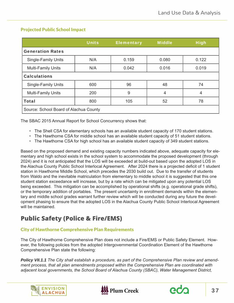
Projected Public School Impact
Units Elementary Middle High
Generation Rates
Single-Family Units N/A 0.159 0.080 0.122
Multi-Family Units N/A 0.042 0.016 0.019
Calculations
Single-Family Units 600 96 48 74
Multi-Family Units 200 9 4 4
Total 800 105 52 78
Source: School Board of Alachua County
The SBAC 2015 Annual Report for School Concurrency shows that:
• The Shell CSA for elementary schools has an available student capacity of 170 student stations.• The Hawthorne CSA for middle school has an available student capacity of 51 student stations.• The Hawthorne CSA for high school has an available student capacity of 349 student stations.
Based on the proposed demand and existing capacity numbers indicated above, adequate capacity for ele-mentary and high school exists in the school system to accommodate the proposed development (through 2024) and it is not anticipated that the LOS will be exceeded at build-out based upon the adopted LOS in the Alachua County Public School Interlocal Agreement. After 2024 there is a projected defi cit of 1 student station in Hawthorne Middle School, which precedes the 2030 build out. Due to the transfer of students from Waldo and the inevitable matriculation from elementary to middle school it is suggested that this one student station exceedance will increase, but by a rate which can be mitigated upon any potential LOS being exceeded. This mitigation can be accomplished by operational shifts (e.g. operational grade shifts), or the temporary addition of portables. The present uncertainty in enrollment demands within the elemen-tary and middle school grades warrant further review which will be conducted during any future the devel-opment phasing to ensure that the adopted LOS in the Alachua County Public School Interlocal Agreement will be maintained.
Public Safety (Police & Fire/EMS) City of Hawthorne Comprehensive Plan Requirements
The City of Hawthorne Comprehensive Plan does not include a Fire/EMS or Public Safety Element. How-ever, the following policies from the adopted Intergovernmental Coordination Element of the Hawthorne Comprehensive Plan state the following:
Policy VII.1.1 The City shall establish a procedure, as part of the Comprehensive Plan review and amend-ment process, that all plan amendments proposed within the Comprehensive Plan are coordinated with adjacent local governments, the School Board of Alachua County (SBAC), Water Management District,
Land Use Data & Analysis
38 Plum Creek: Envision Alachua (EA) - Hawthorne PropertiesComprehensive Plan Amendment Justifi cation Report
Regional Planning Council, State and other units of local government providing services but not having regulatory authority over the use of land, the Regional Planning Council, and the State.
Policy VII.1.3 The City shall establish interlocal agreements for the provision of services across jurisdic-tional boundaries.
Police
The Alachua County Sheriff ’s Department provides police protection within the City, including all areas that are the subject of this Comprehensive Plan Amendment.
Fire Protection
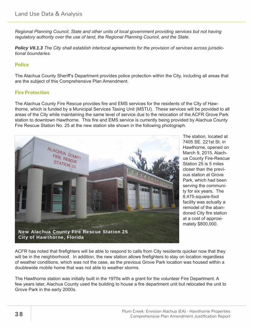
The Alachua County Fire Rescue provides fi re and EMS services for the residents of the City of Haw-thorne, which is funded by a Municipal Services Taxing Unit (MSTU). These services will be provided to all areas of the City while maintaining the same level of service due to the relocation of the ACFR Grove Park station to downtown Hawthorne. This fi re and EMS service is currently being provided by Alachua County Fire Rescue Station No. 25 at the new station site shown in the following photograph.
The station, located at 7405 SE. 221st St. in Hawthorne, opened on March 9, 2015. Alach-ua County Fire-Rescue Station 25 is 5 miles closer than the previ-ous station at Grove Park, which had been serving the communi-ty for six years. The 8,475-square-foot facility was actually a remodel of the aban-doned City fi re station at a cost of approxi-mately $800,000.
ACFR has noted that fi refi ghters will be able to respond to calls from City residents quicker now that they will be in the neighborhood. In addition, the new station allows fi refi ghters to stay on location regardless of weather conditions, which was not the case, as the previous Grove Park location was housed within a doublewide mobile home that was not able to weather storms.
The Hawthorne station was initially built in the 1970s with a grant for the volunteer Fire Department. A few years later, Alachua County used the building to house a fi re department unit but relocated the unit to Grove Park in the early 2000s.
New Alachua County Fire Rescue Station 25 City of Hawthorne, Florida
Land Use Data & Analysis

39
The City of Hawthorne then started its own department, which had to close down in 2009 after the poor economy aff ected the population’s tax base. The building stayed vacant until the City and the County en-tered into an agreement in 2013 to give the building to the County.
The eastern portion of Alachua County is served by a triad of stations located in Orange Heights, Windsor and Hawthorne. The fi re response time provided within the ACFR Fire and Emergency Medical Services Performance Update, dated December 2012, for Station 25 is provided below.
ACFR Response Time for Station No. 25
Land Use Data & Analysis
40 Plum Creek: Envision Alachua (EA) - Hawthorne PropertiesComprehensive Plan Amendment Justifi cation Report
Development Program
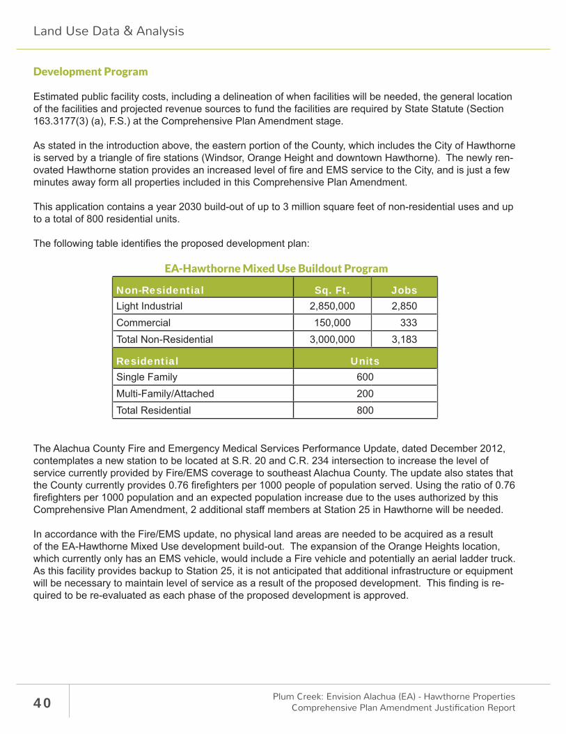
Estimated public facility costs, including a delineation of when facilities will be needed, the general location of the facilities and projected revenue sources to fund the facilities are required by State Statute (Section 163.3177(3) (a), F.S.) at the Comprehensive Plan Amendment stage.
As stated in the introduction above, the eastern portion of the County, which includes the City of Hawthorne is served by a triangle of fi re stations (Windsor, Orange Height and downtown Hawthorne). The newly ren-ovated Hawthorne station provides an increased level of fi re and EMS service to the City, and is just a few minutes away form all properties included in this Comprehensive Plan Amendment.
This application contains a year 2030 build-out of up to 3 million square feet of non-residential uses and up to a total of 800 residential units.
The following table identifi es the proposed development plan:
EA-Hawthorne Mixed Use Buildout Program
Non-Residential Sq. Ft. JobsLight Industrial 2,850,000 2,850Commercial 150,000 333Total Non-Residential 3,000,000 3,183
Residential UnitsSingle Family 600Multi-Family/Attached 200Total Residential 800
The Alachua County Fire and Emergency Medical Services Performance Update, dated December 2012, contemplates a new station to be located at S.R. 20 and C.R. 234 intersection to increase the level of service currently provided by Fire/EMS coverage to southeast Alachua County. The update also states that the County currently provides 0.76 fi refi ghters per 1000 people of population served. Using the ratio of 0.76 fi refi ghters per 1000 population and an expected population increase due to the uses authorized by this Comprehensive Plan Amendment, 2 additional staff members at Station 25 in Hawthorne will be needed.
In accordance with the Fire/EMS update, no physical land areas are needed to be acquired as a result of the EA-Hawthorne Mixed Use development build-out. The expansion of the Orange Heights location, which currently only has an EMS vehicle, would include a Fire vehicle and potentially an aerial ladder truck. As this facility provides backup to Station 25, it is not anticipated that additional infrastructure or equipment will be necessary to maintain level of service as a result of the proposed development. This fi nding is re-quired to be re-evaluated as each phase of the proposed development is approved.
Land Use Data & Analysis

41
Solid Waste
Solid Waste will not exceed the level of service established in policy IV.2.4 of the Comprehensive Plan.
Policy IV.2.4 The City hereby establishes the following level of service standards for solid waste disposal facilities:
FACILITY TYPE LEVEL OF SERVICE STANDARD
Solid Waste Landfi ll .64 tons per capita per year until 1993 and .61 tons per capita per year thereafter
Solid waste will not exceed Hawthorne’s established Level of Service Standard of 0.61 tons of solid waste per capita per year disposed (3.6 pounds solid waste per capita per day disposed). Collection of solid waste from the properties included in the application is not expected to exceed 25,218 tons of solid waste per year. Residential solid waste in the City of Hawthorne is collected by WastePro on a weekly basis. Waste Pro collects non-residential waste on a separate schedule.
Projected Solid Waste Impact
System Category Tons Per Year
Residential Projected Impact From Project (Net Increase) 3,318[800 units x 2.53 persons / dwelling units x 0.61 tons per capita/year]
Non-residential Projected Impact From Project (Net Increase) 21,900[3.0m sq. ft. non-residential] x [4lbs per 100 sq. ft.] = 120,000 lbs day/2000 = 60 tpd x 365 days/year = 21,900 tons/year
Solid Waste Facility Capacity >10 Years
New River Regional Landfi ll (NRRL)
The NRRL is an integrated solid waste management system located in Union County, Florida, and operates disposal facilities for Class I solid wastes (which includes handling of special wastes such as waste tires and white goods) as well as 19 rural collection and recycling sites throughout the three member County region, of which Alachua County and municipalities are members. Alachua County Solid Waste Capacity
Land Use Data & Analysis
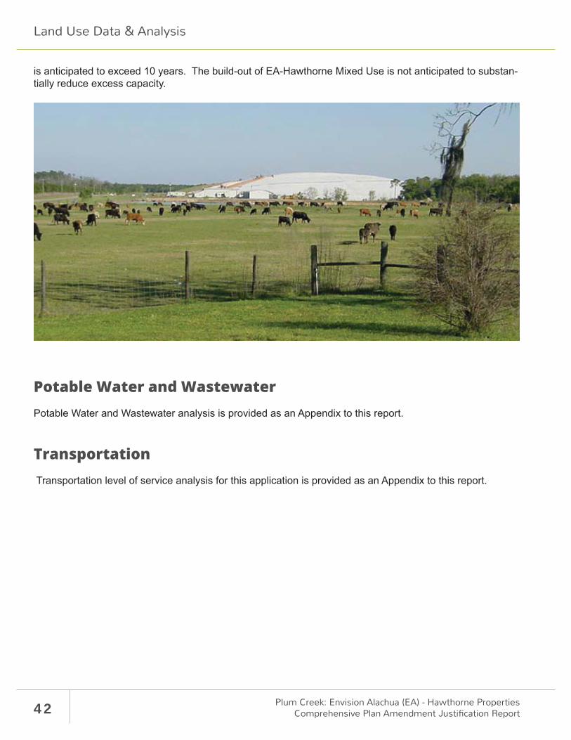
42 Plum Creek: Envision Alachua (EA) - Hawthorne PropertiesComprehensive Plan Amendment Justifi cation Report
is anticipated to exceed 10 years. The build-out of EA-Hawthorne Mixed Use is not anticipated to substan-tially reduce excess capacity.
Potable Water and WastewaterPotable Water and Wastewater analysis is provided as an Appendix to this report.
Transportation Transportation level of service analysis for this application is provided as an Appendix to this report.
Land Use Data & Analysis