Embed Size (px)
Citation preview

PLATINUM PROPERTY ADVISORS PTY LTD
REMEDIATION ACTION PLAN
175-177 Cleveland Street & 1-5 Woodburn Street, REDFERN NSW
Report E22434 AB_Rev1 14 March 2016


Remediation Action Plan 175-177 Cleveland Street and 1-5 Woodburn Street, Redfern NSW Report No. E22434 AB_Rev1
P a g e | i
REPORT DISTRIBUTION
Remediation Action Plan 175-177 Cleveland Street and 1-5 Woodburn Street, Redfern NSW EI Report No.: E22434 AB_Rev1 Date: 14 March 2016
Copies Recipient
1 Soft Copy (PDF – Secured, issued by email)
Platinum Property Advisors Pty Ltd 42-48 The Promenade, King Street Wharf, SYDNEY NSW
Original (Saved to Digital Archives) Environmental Investigations Suite 6.01, 55 Miller Street, PYRMONT NSW 2009
Author Technical Reviewer
LINDA XIAO Civil & Environmental Engineer
NATHAN FOSTER Senior Environmental Scientist
Revision Details Date Amended By
0 Original 11 March 2016 -
1 Revised Proposed Development Plans 14 March 2016 L.X.
© 2016 Environmental Investigations Australia Pty Ltd T/A Environmental Investigations (EI) This report is protected by copyright law and may only be reproduced, in electronic or hard copy format, if it is copied and distributed in full and with prior written permission by EI.


Remediation Action Plan 175-177 Cleveland Street and 1-5 Woodburn Street, Redfern NSW Report No. E22434 AB_Rev1
P a g e | ii
EXECUTIVE SUMMARY Platinum Property Advisors Pty Ltd engaged Environmental Investigations Australia Pty Ltd (EI) to conduct a Remediation Action Plan (RAP) for the property located at 175-177 Cleveland Street and 1-5 Woodburn Street, Redfern NSW (‘the site’). The purpose of this RAP is to establish a sequential process for remediation and validation works to enable site redevelopment for mixed commercial and residential land uses.
EI understands that the proposed development will involve the construction of an eight-storey building over a two-level basement car park covering the entire site area. The main objective of this RAP is to provide a strategy and work plan outline for site remediation and validation works including:
• Remediation of impacted fill/soil materials; and
• Validation of remediated areas to a standard that is acceptable for the intended land uses; and
• Strategies for conducting site remediation and validation assessment works in a manner which minimises impacts on both human health and the environment, with due regard for the safety of site workers and the general public.
Previous investigations undertaken by EI in September 2015 (EI, 2015) and GEE in May 2014 (GEE, 2014) indicated that a layer of imported fill soils (up to 3.3 m in thickness) were distributed across the site. The adopted remedial strategy for the impacted soil considered most appropriate for the current scenario is to excavate and dispose off-site. Therefore, the following works are required to remediate:
• Prior to any demolition, a detailed hazardous materials survey should be undertaken to identify any potential hazardous substances requiring management and to minimise any impact to the site soils;
• Another round of groundwater monitoring to assess onsite groundwater quality with regard to potential contamination sources at existing monitoring wells (monitoring wells BH1, BH3 & BH5 of GEE (2014) and BH1M of EI (2015). Groundwater samples collected are to be analysed for TRH, BTEX, PAHs and heavy metals. The further groundwater investigation is to be conducted prior to excavation;
• Excavation of OCP hotspot in the vicinity of BH5 (EI, 2015) via a 10 m grid down to at least 0.5 m below the fill soil surface. The excavated material is to be stockpiled and sampled for waste classification purposes;
• Characterisation of deeper fill and natural soils in the eastern portion of the site for data gap closure purposes will be coupled with in-situ waste classification. Samples will be collected at 0.5 m intervals to at least 0.5 m into underlying natural soils, and analysed for heavy metals, TRHs, BTEX, PAHs, OC/OP pesticides, PCBs and asbestos. Should contamination be identified during additional investigatory works, an RAP addendum will be issued;
• All fill soil to be excavated based on the findings of the in-situ waste classification assessment;
• Validation of the remedial excavations, involving the collection of soil validation samples and analysis for contaminants of concern. If visible or olfactory signs of contamination are detected, additional materials will be removed from the impacted zone(s) and validation samples will be collected for analysis. Subject to laboratory results the impacted zone(s) may be further remediated and revalidated, if necessary; and

Remediation Action Plan 175-177 Cleveland Street and 1-5 Woodburn Street, Redfern NSW Report No. E22434 AB_Rev1
P a g e | iii
• Following removal of fill materials from across the site, residual soils may be able to be classified as Excavated Natural Material (ENM) or virgin excavated natural materials (VENM) depending on sampling for potential contaminants, as required.
Following completion of these works a Site Validation Report will be prepared in accordance with the OEH (2011) Guidelines for Consultants Reporting on Contaminated Sites stating that the results of remediation and site validation assessment meet the criteria for the proposed commercial and residential land uses.

Remediation Action Plan 175-177 Cleveland Street and 1-5 Woodburn Street, Redfern NSW Report No. E22434 AB_Rev1
P a g e | iv
CONTENTS
EXECUTIVE SUMMARY II 1 INTRODUCTION 1
1.1 BACKGROUND AND PURPOSE 1 1.2 PROPOSED DEVELOPMENT 1 1.3 REGULATORY FRAMEWORK 2 1.4 PROJECT OBJECTIVES 2 1.5 SCOPE OF WORKS 3 1.6 DEVIATIONS FROM THIS RAP 3
2 SITE DESCRIPTION 5 2.1 PROPERTY IDENTIFICATION AND LOCATION 5 2.2 LOCAL LAND USE 5 2.3 REGIONAL SETTING 6 2.4 GROUNDWATER BORE RECORDS AND LOCAL GROUNDWATER USE 7
3 SITE CHARACTERISATION 8 3.1 SUMMARY OF PREVIOUS INVESTIGATION FINDINGS 8 3.2 SUMMARY OF CONTAMINATION REQUIRING REMEDIATION 13
4 CONCEPTUAL SITE MODEL 14 4.1 CHEMICAL HAZARDS AND CONTAMINATION SOURCES 14 4.2 CHEMICALS OF CONCERN 14 4.3 POTENTIAL SOURCES, EXPOSURE PATHWAYS AND RECEPTORS 14 4.4 DATA GAPS 14
5 REMEDIATION GOALS AND ACCEPTANCE CRITERIA 17 5.1 REMEDIATION GOALS 17 5.2 DATA GAP CLOSURE INVESTIGATIONS 17 5.3 SOIL REMEDIATION OPTIONS 17 5.4 REVIEW OF REMEDIAL TECHNOLOGIES 17 5.5 EXPECTED REMEDIAL WORKS 21 5.6 SOIL ACCEPTANCE CRITERIA 21 5.7 GROUNDWATER CRITERIA 25 5.8 DATA QUALITY OBJECTIVES 26
6 REGULATORY COMPLIANCE 29 6.1 STATE ENVIRONMENTAL PLANNING POLICY 55 29 6.2 COUNCIL OF THE CITY OF SYDNEY CONTAMINATED LAND DCP 2004 29
7 REMEDIATION STRATEGY AND METHODOLOGY 30 7.1 PREFERRED REMEDIATION STRATEGY 30 7.2 TASK 1 – SITE PREPARATION AND LICENCES / APPROVALS 30 7.3 TASK 2 – FURTHER INVESTIGATION WORKS 30 7.4 TASK 3 – REMEDIATION OF OC PESTICIDE CONTAMINATION 31 7.5 TASK 4 – IN-SITU WASTE CLASSIFICATION – SITE WIDE FILL LAYERS 31 7.6 TASK 5 – WASTE CLASSIFICATION OF STOCKPILED FILL/SOILS 32 7.7 TASK 5 – OFF-SITE DISPOSAL OF FILL/SOILS 33 7.8 TASK 6 – CERTIFICATION OF IMPORTED BACKFILL MATERIAL 34
8 CONTINGENCY MANAGEMENT AND MEASURES 35 8.1 CONTINGENCY MANAGEMENT 35 8.2 REMEDIAL CONTINGENCIES 36 8.3 CONTINGENCY MEASURES 37
9 VALIDATION PLAN 39 9.1 SOIL VALIDATION METHODOLOGY 39 9.2 SAMPLE CONTAINMENT, PRESERVATION AND HOLDING TIMES 40 9.3 VALIDATION SAMPLE ANALYSIS AND REPORTING 41 9.4 QUALITY ASSURANCE & QUALITY CONTROL PLAN 41

Remediation Action Plan 175-177 Cleveland Street and 1-5 Woodburn Street, Redfern NSW Report No. E22434 AB_Rev1
P a g e | v
10 WORK HEALTH SAFETY ISSUES 43 10.1 ACTS AND REGULATIONS 43 10.2 CODES OF PRACTICE 43 10.3 LICENCES, PERMITS AND CONSENT 44 10.4 CHEMICAL HAZARDS 44 10.5 PHYSICAL HAZARDS 44 10.6 SAFE WORK PRACTICES 44 10.7 IMMEDIATE ACTION 45 10.8 INCIDENT RESPONSE 45
11 CONSTRUCTION ENVIRONMENTAL MANAGEMENT PLAN 46 11.1 ENVIRONMENTAL MANAGEMENT RESPONSIBILITIES 46 11.2 STATUTORY REQUIREMENTS 47 11.3 TRAFFIC MANAGEMENT 47 11.4 EXCAVATIONS 47 11.5 STORMWATER MANAGEMENT AND CONTROL 47 11.6 CONTROL OF DUST AND ODOUR 48 11.7 NOISE CONTROL 48 11.8 MONITORING OF TRUCK LOADING 48
12 STATEMENT OF LIMITATIONS 49 REFERENCES 50 ABBREVIATIONS 51
TABLES
TABLE 2-1 SITE IDENTIFICATION, LOCATION AND ZONING 5 TABLE 2-2 LOCAL LAND USE 6 TABLE 2-3 REGIONAL SETTING INFORMATION 6 TABLE 3-1 SUMMARY OF PREVIOUS INVESTIGATIONS 8 TABLE 5-1 SOILS REMEDIATION TECHNOLOGY REVIEW 19 TABLE 5-2 SOIL REMEDIATION CRITERIA 21 TABLE 5-3 WASTE CLASSIFICATION WITHOUT TCLP 23 TABLE 5-4 WASTE CLASSIFICATION WITH TCLP 25 TABLE 8-1 CONTINGENCY MANAGEMENT PLANS 35 TABLE 8-2 REMEDIAL CONTINGENCIES 36 TABLE 9-1 VALIDATION SAMPLING DESIGN 39 FIGURES FIGURE 1 SITE LOCALITY PLAN FIGURE 2 PROPOSED SAMPLING LOCATION PLAN FIGURE 3 ELEVATED CHEMICAL CONCENTRATIONS APPENDICES APPENDIX A PROPOSED DEVELOPMENT PLANS
APPENDIX B GROUNDWATER SEARCH
APPENDIX C SEPP 55 NOTIFICATION REQUIREMENTS
APPENDIX D SCC CONTAMINATED LAND DCP 2004 APPENDIX 3

Remediation Action Plan 175-177 Cleveland Street and 1-5 Woodburn Street, Redfern NSW Report No. E22434 AB_Rev1 P a g e | 1
1 INTRODUCTION
1.1 BACKGROUND AND PURPOSE
Platinum Property Advisors Pty Ltd (the Client) engaged Environmental Investigations Australia Pty Ltd (EI) to prepare a Remediation Action Plan (RAP) for the property located at 175-177 Cleveland Street and 1-5 Woodburn Street, Redfern NSW (‘the site’).
As shown in Figure 1, the site is located approximately 2 km south of the Sydney Central Business District, within the Local Government Area of City of Sydney Council. The site is identified as Lots 3 & 4 Section 2 DP977379, Lot 5 DP68798, Lot 10 DP809537, Lot 1 DP1093304, Lot 1 DP724328 and Lot 15 DP57107, covering a total area of approximately 1,062.1 m2, as depicted in the site plan presented as Figure 2.
A Stage 1 and Stage 2 Environmental Site Investigation (ESI) was previously undertaken on 175-177 Cleveland Street, Redfern by Geo-Environmental Engineering in the report referenced E14002RED-R01F, dated 25 May 2014. The ESI report was required to identify the potential for contamination from past and present activities, and possible constraints on future site development.
A Detailed Site Investigation (DSI) was previously undertaken on 1-5 Woodburn Street, Redfern by EI in the report referenced E22434 AA, dated 18 September 2015. The DSI report documents intrusive investigation works, laboratory analytical results and recommendations in regards to potential risks to human health, the environment and the aesthetic uses of the land.
A Remedial Action Plan (RAP) was previously undertaken on 175-177 Cleveland Street, Redfern by Geo-Environmental Engineering in the report referenced G14002RED-R03F, dated 27 May 2014. The RAP by Geo-Environmental Engineering is now superseded by this RAP which consists of the entire development area (175-177 Cleveland Street and 1-5 Woodburn Street, Redfern NSW).
The purpose of this RAP is to establish a sequential process for remediation and validation works for the site to enable site redevelopment. The RAP was required as part of a DA package to City of Sydney Council for site redevelopment for mixed residential and commercial land use.
1.2 PROPOSED DEVELOPMENT
JPR Architects Pty Ltd (JPR) supplied EI with pre-DA concept drawings:
• Lower Basement Floor Plan to Level 7 Floor Plan, Project No. 2014067, DA2000 B to DA2008 B, dated 7 March2016; and
• Ground/L1 Plan & East Elevation – Graded Footpath to Section C & D, Project No. 2014067, DA2010 A toDA3102 B, dated 7 March 2016.
Based on the drawings provided, EI understands that the proposed development will involve the construction of a six-storey building over a two-level basement car park. Commercial/ retail land use will occupy the ground floor level, with residential apartments above. Basement excavation will involve the excavation of sub-surface material across the majority of the site area, to a depth of approximately 7.0 m below existing ground level (m BGL). Development Plans are provided in Appendix A.

Remediation Action Plan 175-177 Cleveland Street and 1-5 Woodburn Street, Redfern NSW Report No. E22434 AB_Rev1
P a g e | 2
1.3 REGULATORY FRAMEWORK
The following regulatory framework and guidelines have been considered during the preparation of this RAP:
Acts, Policy and Regulations
• City of Sydney Contaminated Land Development Control Plan 2004;
• Contaminated Land Management Act 1997;
• Protection of the Environment Operation Act 1997;
• Protection of the Environment Operations (Underground Petroleum Storage Systems) Regulation 2014;
• Protection of the Environment Operations (Waste) Regulation 2014;
• State Environment Protection Policy 55 – Remediation of Land (SEPP 55) under the Environmental Planning and Assessment Act 1997;
• Work Health and Safety Act 2011; and
• Work Health and Safety Regulations 2011.
Guidelines
• ANZECC & ARMCANZ (2000) Australian and New Zealand Guidelines for Fresh and Marine Water Quality;
• DEC (2007) Guidelines for the Assessment and Management of Groundwater Contamination;
• DEC (2006) Guidelines for the NSW Site Auditor Scheme (2nd Edition);
• EPA (1995) Sampling Design Guidelines;
• EPA (2014) Technical Note, Investigation of Service Station Sites;
• NEPM (2013) Schedule B(1) Guideline on Investigation Levels for Soil and Groundwater;
• NEPM (2013) Schedule B(2) Guideline on Site Characterisation;
• OEH (2011) Guidelines for Consultants Reporting on Contaminated Sites; and
• WorkCover (2014) Managing Asbestos In or On Soil.
1.4 PROJECT OBJECTIVES
The objective of this RAP is to guide the site remediation and validation assessment process by providing a strategy and work plan outline for:
• Data gap closure investigations to enable adequate site characterisation;
• Remediation of impacted fill/soil materials; and

Remediation Action Plan 175-177 Cleveland Street and 1-5 Woodburn Street, Redfern NSW Report No. E22434 AB_Rev1
P a g e | 3
• Validation of remediated areas to a standard that is acceptable for the intended residential/commercial land uses.
Measures are also described in this RAP with the objective of ensuring that all works are conducted while minimising impacts on human health and the environmental, with due regard for the safety of site workers and the general public.
1.5 SCOPE OF WORKS
In order to achieve the above objectives, the scope of works was as follows:
• Development of a sampling and analytical strategy for further investigations to close outstanding data gaps for adequate site characterisation;
• Definition of remediation goals and remediation acceptance criteria (RAC);
• Evaluation of available remediation options and selection of the most appropriate remedial strategy or combination of strategies;
• Guidance for remedial works to be performed in accordance with relevant legislation;
• Development of the site validation assessment requirements (involving soil validation sampling and laboratory analysis) to confirm that identified contaminated materials have been effectively remediated, as specified by the remediation strategy;
• Provision of a framework to enable contractor preparation of a Work Health and Safety Plan and other site management/planning documents including an Environmental Management Plan.
This RAP also outlines measures for the excavation, stockpiling, management and disposal of spoil, water and sediment controls, as well as a contingency plan to handle any additional contamination that may be identified during the data gap closure investigations and/or site remedial works.
1.6 DEVIATIONS FROM THIS RAP
While it may be possible to vary the sequence and/or details of the actual site remediation and validation works performed on the site to meet unforeseen site constraints, it is strongly recommended that the Project/Site Management Team involve the appointed Environmental Consultant during this process to ensure that:
• An environmental scientist/engineer is present on the site during critical stages of the site remediation/validation process, so that site works are documented and the required data is collected for environmental reporting purposes; and
• Any deviations from the works specified in this RAP are properly documented, as required under the OEH (2011) Guidelines for Consultants Reporting on Contaminated Sites.
Performing remedial works without the presence of a qualified environmental engineer/scientist when necessary may lead to project delays and extra costs due to additional environmental investigation requirements to confirm the environmental status of the site. In worst case scenarios, waste materials removed from the site without proper characterisation and/or waste classification assessment, may lead to regulatory action and potential penalties, as

Remediation Action Plan 175-177 Cleveland Street and 1-5 Woodburn Street, Redfern NSW Report No. E22434 AB_Rev1
P a g e | 4
described under the Waste Regulation 2014, the Protection of the Environment Operations Act 1997 and the Contaminated Land Management Act 1997.

Remediation Action Plan 175-177 Cleveland Street and 1-5 Woodburn Street, Redfern NSW Report No. E22434 AB_Rev1
P a g e | 5
2 SITE DESCRIPTION
2.1 PROPERTY IDENTIFICATION AND LOCATION
The site identification details and associated information are presented in Table 2-1, while the location of the site in relation to surrounding areas is shown in Figure 1.
Table 2-1 Site Identification, Location and Zoning
Attribute Description
Street Address 175-177 Cleveland Street and 1-5 Woodburn Street, Redfern NSW
Location Description The site is located approximately 2 km south of the Sydney CBD, bound by Cleveland Street (north), Eveleigh Street (west), commercial and residential buildings (south) and Woodburn street followed by commercial and residential buildings (east). Northeast corner of site: GDA94-MGA55 Easting: 888552.006, Northing: 6242191.854 (Source: http://maps.six.nsw.gov.au)
Site Area Approx. 1062.1 m2 (Ref. Project Surveyors, Job No. B1753, Drawing No. B1753-1 dated 15/10/14)
Site Owner Platinum Property Advisors Pty Ltd
Lot and Deposited Plan (DP) Lots 3 & 4 Section 2 DP977379, Lot 5 DP68798, Lot 10 DP809537, Lot 1 DP1093304, Lot 1 DP724328 and Lot 15 DP57107
State Survey Marks Two State Survey Marks (SSM) are situated in close proximity to the site: SS176731 and SS25335D both located on the corner of Regent Street and Cleveland Street (Source: http://maps.six.nsw.gov.au).
Local Government Authority City of Sydney Council
Parish Alexandria
County Cumberland
Current Zoning MD – SEPP Major Development 2005 (City of Sydney Local Environment Plan, 2012)
Current Land Uses Vacant commercial buildings
The assessment area is illustrated in Figure 2.
2.2 LOCAL LAND USE
The site is situated within an area of mixed uses. Current uses on surrounding lands are described in Table 2-2.

Remediation Action Plan 175-177 Cleveland Street and 1-5 Woodburn Street, Redfern NSW Report No. E22434 AB_Rev1
P a g e | 6
Table 2-2 Local Land Use
Direction Relative to Site Land Use Description
North Cleveland Street and commercial/residential buildings
South High density residential apartments
West Eveleigh Street followed by commercial/residential buildings
East Woodburn Street followed by commercial/residential buildings and a railway corridor
2.3 REGIONAL SETTING
Regional topography, geology, soil landscape and hydrogeological information are summarised in Table 2-3.
Table 2-3 Regional Setting Information
Attribute Description
Topography The site slopes down towards the south-west from approximate RL 19.2 m AHD at the south-west corner, to approximate RL 23 m AHD at the north-east corner (Ref. Project Surveyors, Job No. B1753, Drawing No. B1753-1 dated 15/10/14)
Site Drainage Consistent with the general slope of the site, stormwater is assumed to flow south west into drainage systems which flow in a northerly direction towards Blackwattle Bay.
Regional Geology With reference to the 1:100 000 scale Geological Series Sheet 9130 (Sydney) indicates the site likely to be underlain by the Ashfield Shale, which is characterised by black to dark grey shale and laminite. A Quaternary alluvial deposit (Qha) is located in close proximity (north) to the site which is consists of silty to peaty quartz sand, silt and clay. Ferruginous and humic cementation in places and common shell layers. Outcrops of Quaternary-aged (Holocene) Aeolian Sands (Botany Sands) are mapped approximately 90 m to the south-east of the site. Recent investigations in the area have indicated Aeolian Sands are present 50 m to the south on Eveleigh Street. An infilled palaeo channel (man-made fill over alluvial soils) is present approximately 75 m to the north.
Soil Landscapes The Soil Conservation Service of NSW Sydney 1:100,000 Soil Landscapes Series Sheet 9130 (2nd Edition) indicates that the residual landscape of the region of the site comprises the Blacktown Landscape. Soils are generally shallow to moderately deep (<100 cm) red and brown podzolic soils on crests, upper slopes and well-drained areas, and deep (150-300 cm) yellow podzolic soils and soloths on lower slopes and in areas of poor drainage.
Acid Sulfate Soil Risk With reference to the Botany Bay Acid Sulfate Soil Risk Map (1:25,000 scale; Murphy, 1997), the subject land lies within the map class description of No Known Occurrence. In such cases, acid sulphate soils (ASS) are not known or expected to occur and “land management activities are not likely to be affected by ASS materials”. Some ASS is likely to be present along the foreshores of Shepherds Bay, but the development does not extend to this area. In accordance with the Sydney Local Environmental Plan 2012 Acid Sulfate Soils Map – Sheet ASS_009, the site does not fall within any category of Acid Sulfate Soils (ASS). For an unclassified site, works do not require development consent from Council regarding ASS.

Remediation Action Plan 175-177 Cleveland Street and 1-5 Woodburn Street, Redfern NSW Report No. E22434 AB_Rev1
P a g e | 7
Attribute Description
Typical Soil Profile As described in the previous DSI by EI in September 2015 (Report Ref. E22434 AA), the typical soil profile consists of a layer of anthropogenic filling material, overlying residual clay soils and weathered shale at depth. Fill – Gravelly SAND, fine grained, dark brown to grey, with sub-angular gravel; Residual Clay – Sandy CLAY, pale brown and orange, medium to high plasticity, ironstone mottles from approximately 1.3 m BGL; Residual Clay – Silty CLAY, pale grey to brown with ironstone mottles, grading to red/brown clay with depth; and Weathered Ashfield Shale – SHALE, dark brown, extremely weathered.
Depth to Groundwater As described in the ESI by Geo-Environmental Engineering in May 2014 (Report Ref. E14002RED-R01F), standing water level was measured at approximately 2.7-4.31 m BGL.
Nearest Surface Water Feature
Blackwattle Bay and Cockle Bay, located approximately 1.8 km north-west of the site.
Groundwater Flow Direction Based on the nearest surface water feature, groundwater flow direction is inferred to be towards the northerly and north westerly direction.
2.4 GROUNDWATER BORE RECORDS AND LOCAL GROUNDWATER USE
An online search of registered groundwater bores was conducted by EI on 10 March 2016 through the NSW Natural Resource Atlas database (Ref. http://www.nratlas.nsw.gov.au). There were 43 registered bores within 500 m of the site.
All 43 registered bores have been authorised for monitoring purposes, with no standing water level data recorded. Overall, based on the registry type of the bores, no beneficial groundwater use was identified within proximity to the locality (within 500 m radius). A bore location map is attached in Appendix B.

Remediation Action Plan 175-177 Cleveland Street and 1-5 Woodburn Street, Redfern NSW Report No. E22434 AB_Rev1
P a g e | 8
3 SITE CHARACTERISATION In preparing this RAP, EI have considered the following previous investigations:
• Stage 1 and Stage 2 Environmental Site Investigation 175-177 Cleveland Street, Redfern NSW, conducted by Geo-Environmental Engineering, Ref. No: E14002RED-R01F, dated 25 May 2014 (GEE, 2014); and
• Detailed Site Investigation 1-5 Woodburn Street, Redfern NSW, conducted by EI, Ref No: E22434 AA, dated 18 September 2015 (EI, 2015).
3.1 SUMMARY OF PREVIOUS INVESTIGATION FINDINGS
A summary of the works, key findings and recommendations of the abovementioned investigations are outlined in Table 3-1.
Table 3-1 Summary of Previous Investigations
Assessment Details Project Tasks and Findings
Stage 1 & Stage 2 Environmental Site Investigation 175-177 Cleveland Street, Redfern NSW, dated 25 May 2014 (GEE, 2014)
Work Objectives The objective of the Stage 1 – PS1 was to assess the likelihood of site contamination which may have resulted from past and present activities on the site, and the likelihood of contaminating activities on adjoining land, having an impact on the site. The objective of the Stage 2 – DSI was to characterise actual soil and groundwater conditions across the site and whether they have been contaminated from past and/or present activities undertaken on and/or adjacent to the site, which could impact on the proposed development.
Scope of Works • A review of the environmental and physical setting in which the site lies, including geology, hydrogeology and topography;
• A review of the history of the site using available records including historical land titles and historical aerial photographs;
• A detailed site inspection for potential sources of contamination;
• Field investigations including:
− The drilling of 9 boreholes across accessible areas of the site;
− The installation of groundwater monitoring wells within 3 of the 9 boreholes; and
− Sampling of soil and groundwater from the boreholes and wells.
• Laboratory analysis of selected soil and groundwater samples for a broad suite of potential contaminants; and
• Preparation of this report including the comparison of the laboratory analytical results against relevant Office of Environment and Heritage (OEH)1 endorsed guidelines.
Findings • The historical information indicates that the factory building which occupies the western portion of the site (Lot 1 DP1093304, Lot 1 DP724328 and Lot15 DP 57107), was constructed prior to 1930. Little is known about the occupiers of the factory or activities which took place within the factory until 1975 when it was purchased by A.D.P.G Pty Ltd or Ultra Display Services, a company which manufactures and distributes display material and signage;

Remediation Action Plan 175-177 Cleveland Street and 1-5 Woodburn Street, Redfern NSW Report No. E22434 AB_Rev1
P a g e | 9
Assessment Details Project Tasks and Findings
• The north-east portion of the site (Lot 10 in DP809537) was being used as an open car-park for customers of the adjoining factory building. This portion of the site has been a car park since circa 1940. Prior to 1940 this part of the site was partially occupied by a multi-storey building (which according to land title records was a brewery). This multi-storey building is understood to have been constructed circa 1900;
• The main sources of potential contamination include:
− Vehicle access to parts of the site (particularly the eastern portion (Lot 10) and the vehicle loading dock in the south-western corner). This may have resulted in ‘top down’ spills or leaks of oil or fuel in isolated locations across the site. The concrete and/or asphalt pavements in these areas would have minimised any migration of contaminants into the soil profile and the local clay soils would have restricted any further downward migration of contaminants; and
− Past development of the site. With any site development works there is a possibility that fill material was used to raise site levels, or to create a level building platform. When sourced from an unknown origin, the quality of the fill is also unknown and potentially contaminated. Based on the regional topography (which was relatively flat) and the historical aerial photographs, it is considered unlikely that the site has been subjected to any substantial filling and therefore the risk of contaminated fill being present beneath the site is considered to be very low.
• Overall, the potential for soil contamination is considered to be low and the potential for groundwater contamination is considered to be lower because groundwater in this part of Sydney is likely to be confined or partly confined within the underlying, relatively low permeable, shale formation;
• During the drilling of boreholes, there were no unusual odours (that could be potentially associated with contamination) noted. Additionally, no potentially Asbestos Containing Materials (ACM) was observed below ground during sampling and logging;
• A total of 21 soil samples from the 9 boreholes were submitted to Envirolab for NATA accredited laboratory analysis of metals (arsenic, cadmium, chromium, copper, nickel, lead, mercury and zinc), TRH, BTEX, PAHs, OCPs, PCBs and asbestos and the analytical results, and 95% UCL of the arithmetic mean contaminant concentration, were compared against relevant set of ecological and health-based SAC appropriate for the proposed residential land-use with minimal access to soil;
• In summary, there were isolated detections of lead, zinc, TRH and PAHs (specifically B(a)P) within the fill layer which exceeded the health and ecological based SAC. However, after calculation of the 95% UCL of the arithmetic mean, the B(a)P concentration remained higher than the health and ecological based SAC (see Figure 3 for exceedance locations). In this regard, the fill layer will need to be remediated and/or managed as part of the proposed redevelopment works;
• An estimate of waste classifications was made to allow earthworks contractors some confidence when quoting on the project. However, to accurately classify waste, further testing of the fill layer will be necessary including leachate analysis using the Toxicity Characteristic Leaching Procedure (TCLP). Based on the analytical results and findings from the fieldwork, the following waste classifications are likely to apply:
− Fill layer is likely to be classified as General solid waste (non-putrescible) following additional testing using the TCLP method; and
− The natural soil profile (including shale bedrock) is free of any contamination and is likely to have a classification of virgin excavated natural material (VENM) which is a sub-class of general solid waste (non-putrescible) which can be re-used, rather than be disposed at a

Remediation Action Plan 175-177 Cleveland Street and 1-5 Woodburn Street, Redfern NSW Report No. E22434 AB_Rev1
P a g e | 10
Assessment Details Project Tasks and Findings
landfill. To ensure VENM classification the natural soil / bedrock must not be mixed with any fill material or other deleterious material.
• The concentrations of arsenic, cadmium, chromium, nickel, lead, mercury, TRHs, VOCs (including BTEX) and PAHs conformed to the adopted GILs, while the concentrations of copper and zinc in some monitoring wells exceeded the SAC. The metal exceedances are not considered to be significant because:
− The groundwater from the site was collected from a stratigraphy comprising shale and the concentrations of copper and zinc are commensurate with naturally occurring background concentrations;
− The concentrations are consistent across the site (including the up-hydraulic gradient wells);
− No source of metal contamination was identified in the fill and natural soils across the site; and
− The concentrations detected are commensurate with metal concentrations within the groundwater across the Sydney region.
Recommendations Based on observations made during the field investigations, the sampling and analysis program conducted at the site and with respect to the proposed land use, it is concluded that there exists some localised soil contamination relating to PAHs (specifically benzo-a-pyrene). It is the opinion of Geo-Environmental Engineering that the site can be made suitable for the proposed mixed use development, including residential apartments, by undertaking convention remediation measures. In this regard, and in accordance with local and State planning procedures, a Remedial Action Plan (RAP) will be required.
Detailed Site Investigation 1-5 Woodburn Street, Redfern NSW, dated 18 September 2015 (EI, 2015)
Work Objectives • Evaluate the potential for site contamination on the basis of historical land uses, anecdotal and documentary evidence of possible pollutant sources;
• To investigate the degree of any potential contamination by means of limited intrusive sampling and laboratory analysis, for relevant contaminants; and
• Where site contamination is confirmed, make recommendations for the appropriate management of any contaminated soils and/or groundwater.
Scope of Works • A review of relevant topographical, geological, hydrogeological and soil landscape maps for the project area;
• Search of historical aerial photographs archived at NSW Land and Property Information to review previous site use and the historical sequence of land development in the neighbouring area;
• A land titles search, also conducted through NSW Land and Property Information for information relating to historical ownership of the site;
• A search of City of Sydney records for information relating to operational site history and/or relevant environmental incidents;
• A search of NSW EPA Land Information records under the Contaminated Land Management Act (1997) and Protection of the Environment Operations Act (1997);
• A search of the Stored Chemical Information Database (SCID) and microfiche records held by SafeWork NSW relating to possible underground tank approvals and locations;
• A review of existing underground services on site;
• A detailed site walkover inspection;

Remediation Action Plan 175-177 Cleveland Street and 1-5 Woodburn Street, Redfern NSW Report No. E22434 AB_Rev1
P a g e | 11
Assessment Details Project Tasks and Findings
• Drilling of boreholes at five locations (BH1M and BH2 to BH5) across accessible areas of the site, in accordance with the minimum sampling protocol recommended under EPA (1995);
• Installation of one groundwater monitoring well to a maximum depth of 6 m (or prior refusal), constructed to standard environmental protocols to investigate potential groundwater contamination;
• Multiple level soil sampling within fill and natural soils and one round of groundwater sampling from the constructed groundwater monitoring well; and
• Laboratory analysis of selected soil and groundwater samples for relevant analytical parameters as determined from the site history survey and field observations during the investigation programme.
Findings • The site comprises a rectangular shaped block bound by a vacant lot followed by Cleveland Street (north), commercial buildings followed by Eveleigh Street (west), commercial and residential buildings (south) and Woodburn street followed by commercial and residential buildings (east). Current site buildings include a large, two-storey commercial building occupying the entire are of the site;
• A review of historical aerial photographs and land title records identified the site was used for commercial purposes since at least the 1930s. The current site building has been present on site, with minimal changes since at least the 1930s. From 22 July 1959 until 18 February, 1983 the property was leased to Superfine Printing Co. Pty Limited;
• Records made available by City of Sydney Council identified two applications for the installation of mechanical ventilation at the site. Based on the available information, the use of this ventilation system is currently unknown;
• The site was free of statutory notices issued by the NSW EPA/DECC. Surrounding properties identified during this search were considered a low risk of off-site contamination sources due to their proximity to the site (>500m) and being hydraulically across-gradient / down-gradient;
• A search carried out by WorkCover NSW Authority did not locate any records relating to historical storage of dangerous goods on-site;
• Soil sampling and analysis were conducted at five test bore locations (BH1M, BH2 – BH5) down to a maximum depth of 8.0 m BGL (see Figure 2 for borehole locations). Sampling regime was considered to be appropriate for investigation purposes and comprised a broad grid sampling pattern, with allowance for structural obstacles (e.g. building walls, underground and overhanging services and other physical obstructions);
• The sub-surface layers comprised of fill materials of various constituents, comprising dark brown to grey gravelly sands, underlain by residual clays and the Ashfield Shale at depth (approximately 5.0 m BGL in BH1M);
• Groundwater was encountered at a depth of approximately 7. 3 m BGL (BH1M);
• Multiple level soil sampling was undertaken within fill and natural soils (where achieved). Exceedances of the adopted criteria were detected within soil and fill samples for the following:
− Heavy metal concentrations for lead were reported at concentrations exceeding the HIL-B criteria in exceedances above the HIL-B criteria for BH2_0.7-0.8 (1,400 mg/kg), BH3_0.1-0.2 (1,800 mg/kg) and BH5_0.1-0.2 (1,300 mg/kg) collected within fill material. Due to hand auger refusal, the underlying natural soil could not be sampled and therefore no vertical delineation could be achieved;
− Carcinogenic PAH’s (BaP TEQ) concentrations were detected above the HIL-B criteria in

Remediation Action Plan 175-177 Cleveland Street and 1-5 Woodburn Street, Redfern NSW Report No. E22434 AB_Rev1
P a g e | 12
Assessment Details Project Tasks and Findings
samples BH2_0.7-0.8 (7.4 mg/kg), BH3_0.1-0.2 (14 mg/kg) and BH3_0.5-0.6 (9.6 mg/kg). Vertical delineation within the underlying natural soils was not achieved due to hand auger refusal in fill material;
− Organochlorine pesticides for Aldrin and Dieldrin in BH5_0.1-0.2 for (18.7 mg/kg). Due to hand auger refusal in fill material, vertical delineation within the underlying natural soil material could not be achieved;
• As the on-site groundwater conditions have not been characterised, the risk associated with groundwater contamination is currently unknown, EI recommend further investigation to characterise on-site groundwater conditions. This investigation can be undertaken during the remediation of soils on site; and
• On review of the Conceptual Site Model (CSM) developed as part of this ESA, it was concluded that the model remains valid for the proposed development. However, the following data gaps require closure by further investigations:
− An assessment of onsite groundwater quality with regard to potential onsite contamination sources;
− Further characterisation of soil material on site, including deeper sampling of fill and natural soils to close current data gaps, adequately characterise onsite soils and to vertically delineate contamination. It is recommend that these works be performed once unrestricted internal access to building structures is available; and
− The potential presence of hazardous building materials contained within the structure and on painted surfaces of the existing buildings.
Recommendations • Conduct a Hazardous Materials Survey (HMS) on structures present at the site. EI recommend that a HMS is conducted prior to demolition of site structures;
• Undertake an additional intrusive investigation to further delineate the extent of the contamination identified within the soils on site, once the site becomes readily accessible (i.e. following demolition of site structures). This investigation will also involve the sampling of the on-site groundwater monitoring well (BH1M) to characterise the on-site groundwater conditions and the associated risks at the site;
• Preparation and implementation of a Remediation Action Plan (RAP) to outline the remediation of the HIL-B exceedances identified during this DSI and any additional contamination identified during the additional investigation, including groundwater (if necessary). The RAP should also develop further soil and groundwater investigations to close/clarify any data gaps identified during this investigation;
• Any material being removed from site (including virgin excavated natural materials or VENM) be classified for off-site disposal in accordance the DECCW (2009) Waste Classification Guidelines.
• Any material being imported to the site should be assessed for potential contamination in accordance with NSW EPA guidelines as being suitable for the intended use or be classified as VENM;
• Validate that the excavated areas are left free of contamination by comparing analytical results for excavation surfaces and any backfill material, against the respective DECC/EPA thresholds; and
• Preparation of a final site validation report by a qualified environmental consultant, certifying site suitability for the proposed development.

Remediation Action Plan 175-177 Cleveland Street and 1-5 Woodburn Street, Redfern NSW Report No. E22434 AB_Rev1
P a g e | 13
3.2 SUMMARY OF CONTAMINATION REQUIRING REMEDIATION
Following a review of the previous investigations described above and an evaluation of the data against the adopted NEPM (2013) guidelines, the resulting sources of contamination that potentially require remediation have been identified:
• Widespread lead and PAH contamination in fill soils across the site;
• Organochlorine pesticide (OCP) contamination, in particular Aldrin and Dieldrin detected in BH5 (EI, 2015) in close proximity to the eastern boundary (see Figure 3 for exceedances); and
• As discussed in Section 7.3, further investigation will be required to classify deeper fill and natural soils to determine if remediation is necessary, particularly in the eastern portion of the site to delineate the extent of lead, OCP and BaP TEQ contamination identified in EI, 2015. As no groundwater was sampled in EI, 2015, another round of groundwater sampling will also be required (monitoring wells BH1, BH3 & BH5 of GEE, 2014 and BH1M of EI, 2015).

Remediation Action Plan 175-177 Cleveland Street and 1-5 Woodburn Street, Redfern NSW Report No. E22434 AB_Rev1
P a g e | 14
4 CONCEPTUAL SITE MODEL In accordance with Schedule B2 – Guideline on Site Characterisation of the National Environmental Protection (Assessment of Site Contamination) Measure 1999 Amendment 2013 (NEPM 2013) and to aid in the assessment of data collection for the site. A conceptual site model (CSM) is a representation of site-related information regarding contamination sources, receptors and exposure pathways between those sources and receptors. The development of a CSM is an essential part of all site assessments and provides the framework for identifying how the site became contaminated and how potential receptors may be exposed to contamination either in the present or the future.
4.1 CHEMICAL HAZARDS AND CONTAMINATION SOURCES
On the basis of field observations and findings on site history described in the previously mentioned investigations, the following potential chemical hazards and onsite contamination sources were identified:
• Historic commercial and manufacturing use of the site (including a company manufacturing display material and signage, printing company and car park);
• Contamination of fill soils across the site, in particular widespread lead and PAH contamination;
• Hazardous materials, including potential asbestos-containing materials (ACM) from building products; and
• Deeper, natural soils containing residual impacts, representing potential secondary sources of contamination.
4.2 CHEMICALS OF CONCERN
Based on the findings of the site contamination appraisal, and the potential for additional contamination in deeper fill soils in the eastern portion of the site, chemicals of concern at the site are considered to be:
• Soil – heavy metals (HMs including Arsenic, Cadmium, Chromium, Copper, Lead, Mercury, Nickel, Zinc), total recoverable hydrocarbons (TRHs), the monocyclic aromatic hydrocarbon compounds benzene, toluene, ethyl-benzene and xylenes (BTEX), polycyclic aromatic hydrocarbons (PAHs), organochlorine and organophosphorous pesticides (OCP/ OPPs), and asbestos; and
• Groundwater – HMs, TRHs, BTEX, PAHs, and VOCs.
4.3 POTENTIAL SOURCES, EXPOSURE PATHWAYS AND RECEPTORS
Potential contamination sources, exposure pathways and human and environmental receptors that were considered relevant for this assessment are summarised along with a qualitative assessment of the potential risks posed by complete exposure pathways in Figure 4-1.
4.4 DATA GAPS
Based on information from the site walkover inspection and site history review, EI considered a programme of intrusive investigation was warranted to address the following data gaps:
• An assessment of onsite groundwater quality with regard to potential onsite contamination sources;
• Further characterisation of soil material on site, including deeper sampling of fill and natural soils to adequately characterise onsite soils and to vertically delineate contamination, particularly in the eastern

Remediation Action Plan 175-177 Cleveland Street and 1-5 Woodburn Street, Redfern NSW Report No. E22434 AB_Rev1
P a g e | 15
portion of the site. It is recommend that these works be performed once unrestricted internal access to building structures is available; and
• The potential presence of hazardous building materials contained within site structures and on painted surfaces of the existing buildings.

Remediation Action Plan 175-177 Cleveland Street and 1-5 Woodburn Street, Redfern NSW Report No. E22434 AB_Rev1
P a g e | 16
Figure 4-1 Conceptual Site Model

Remediation Action Plan 175-177 Cleveland Street and 1-5 Woodburn Street, Redfern NSW Report No. E22434 AB_Rev1
P a g e | 17
5 REMEDIATION GOALS AND ACCEPTANCE CRITERIA
5.1 REMEDIATION GOALS
The main goal of the remediation program is to remove primary and secondary contamination sources so as to render the site suitable for residential use with minimal access to soil. This will require removal of impacted soil and remediation of groundwater (if necessary).
5.2 DATA GAP CLOSURE INVESTIGATIONS
With reference to Section 4.4, the following data gap closure investigations will be carried out to achieve adequate site characterisation in areas where elevated chemical concentrations were identified in site fill soils:
• An additional round of groundwater sampling from existing wells (monitoring wells BH1, BH3 & BH5 of GEE (2014), and BH1M of EI (2015)) will be required; and
• Further investigation will be required to classify deeper fill and natural soils in the eastern portion of the site to delineate the vertical extent of lead, OCP and PAH (BaP TEQ) contamination identified in EI (2015). This will be completed in combination with the in-situ waste classification assessment for the waste classification of all soils to be removed from site.
5.3 SOIL REMEDIATION OPTIONS
In considering the remedial options available for the site, the surrounding lands and the geological and hydrogeological limitations, the following issues have been considered:
• Prioritisation of works in areas of most concern;
• Ability of remedial method to treat contamination with respect to natural and infrastructure limitations;
• Remedial timetable;
• Cost effectiveness;
• Defensible method to ensure the site is remediated to appropriate levels / validation criteria;
• Monitoring and status of remedial works including risk based performance objectives; and
• Regulatory compliance.
5.4 REVIEW OF REMEDIAL TECHNOLOGIES
Given project requirements to excavate the entire area of the site to a depth to approximately 7.0 m BGL for a two-level basement car park, remediation options are limited. The options for heavy metal, OCP and PAH impacted material are limited to off-site disposal.
Selection and implementation of any remedial method depends initially on the proposed land use criteria to ensure protection of human health and the environment. Remedial options are then chosen by assessing the feasibility of each option to reach the clean-up goal and evaluating the costs and acceptability of the option. Risk driven remediation can also be considered depending on acceptance of materials being left on site. Remediation should

Remediation Action Plan 175-177 Cleveland Street and 1-5 Woodburn Street, Redfern NSW Report No. E22434 AB_Rev1
P a g e | 18
also consider the concepts of ecologically sustainable development (ESD), which attempts to balance acceptable environmental risk/outcomes to the social and economic costs while protecting biodiversity and heritage.
Readily available remediation techniques were considered for the site, which were then either accepted or rejected based upon their applicability to the contaminants of concern, site setting and cost/technology issues.
Several methodologies are currently available to address heavy metal, OCP, PAH, TRH and asbestos impacted soils, each with a number of advantages and disadvantages. It is likely that implementation of a combination of remedial management measures may be required, including:
• No action;
• Ongoing management;
• Capping and containment;
• Excavation and off-site disposal; and
• Natural attenuation / land farming
The review of remediation technologies focuses on soil remediation methods at this stage. This technology comparison may be updated should groundwater impacts be identified during the data gap closure investigations.
Advantages, disadvantages and suitability of available soil remedial technologies are summarised in Table 5-1.

Remediation Action Plan 175-177 Cleveland Street and 1-5 Woodburn Street, Redfern NSW Report No. E22434 AB_Rev1
P a g e | 19 Table 5-1 Soils Remediation Technology Review
Remediation Methodology Description Advantages Disadvantages Suitability
No Action ‘No Action’ can be considered if: • There is no measurable contamination; • Contaminant concentrations are below
assessment guidelines; • Contaminants are not mobile; or • Exposure to contaminated soils is unlikely.
No remediation costs. Creates minimal disturbance to the site Retains material on-site.
Not applicable to the kind of contamination encountered at the site. Contamination would remain in situ allowing potential off-site migration of contamination and impacts on groundwater. Would pose limitations on land use options. Requires an Environmental Management Plan (EMP) and ongoing monitoring.
Not Suitable Based on the results and recommendations of the previous investigations, the “do nothing” option is not considered to be suitable. Would prevent re-development.
On-going Management
“Ongoing Management” is considered appropriate for sites where site contamination presents a low or minimal risk to human health and the environment and there is no risk of off-site migration of contaminants. .
Cost effective if soils are utilised on-site. Lower disposal costs. Limited requirement to import fill material to site. Retains material on-site.
Requires an ongoing management plan. Excess spoil is required to be removed from site. Does not remove contamination.
Not Suitable Not suitable as significant spoil is required to be removed from site. Would prevent re-development.
Consolidation and/or capping
Risk minimisation approach where impacted soils are managed on-site by capping the ground surface with a clean, impermeable layer of fill material.
Effectively removes risk to human health by eliminating exposure pathways.
Importance of capping materials. Contamination would remain in situ allowing potential off-site migration of contamination and impacts on groundwater. Would pose limitations on land use options. Requires an EMP and ongoing monitoring.
Not Suitable Not suitable as the proposed development involves excavating a two level basement car park across the entire site area.
Excavation and off-site disposal
Excavate impacted materials. Transport directly to a licensed landfill facility. Re-instate site with imported clean fill material.
Fast – impacted material removed immediately, significantly reducing potential for impact to groundwater. No storage or treatment problems. Reduced vapour/odour issues as impacted materials removed from site. Minimal design and management costs.
Transfer of waste to another location (licensed waste facility). High costs associated with the disposal of waste soils and importation of clean backfill. May require some additional testing (including TCLP) to enable waste classification prior to disposal. Not in accordance of the redevelopment vision. Sustainability issues related to disposal to landfill.
Suitable This will remove potentially leachable contamination sources and prevent vertical migration to the groundwater system, and complements the requirements for the proposed site development.

Remediation Action Plan 175-177 Cleveland Street and 1-5 Woodburn Street, Redfern NSW Report No. E22434 AB_Rev1
P a g e | 20
Remediation Methodology Description Advantages Disadvantages Suitability
Natural attenuation
Allowing the contaminants to biodegrade naturally following removal of the contamination source.
No remedial excavation of site. Retains materials on site. Sustainable, cost effective remediation method.
Slow process. Potential for contamination to further impact on the groundwater aquifer and nearby environmental receptors. Unlikely to improve the geotechnical characteristics of contaminated fill. Would require Environmental Management Plan and ongoing monitoring.
Not suitable This would inhibit development as the proposed development involves excavating a two level basement car park across the entire site area.

Remediation Action Plan 175-177 Cleveland Street and 1-5 Woodburn Street, Redfern NSW Report No. E22434 AB_Rev1
P a g e | 21
5.5 EXPECTED REMEDIAL WORKS
Based on the contamination identified, and review of the available remedial options, EI considers the following remediation works, at present, are required:
• The removal of all fill soils from site;
• The waste classification and excavation of fill and natural soils prior to off-site disposal; and
• Classification of soils as Excavated Natural Materials (ENM) or Virgin Excavated Nature Materials (VENM), where required, to enable reuse of suitable materials.
A supplementary groundwater investigation is proposed for data gap closure, with regard to potential onsite contamination sources, particularly in the eastern portion of the site. Should groundwater contamination be identified during data gap closure requiring remediation, a RAP addendum will require preparation to outline remediation requirements for groundwater.
5.6 SOIL ACCEPTANCE CRITERIA
5.6.1 Soils to Remain On-Site
A number of different soil remediation criteria shall be adopted for the applicable areas of the site to be used as clean up levels. Soil remediation criteria are based on NEPM (2013):
• Residential-B Health Investigation Levels for residential settings with minimal access to soils (HIL-B);
• Health Screening Levels for Vapour Intrusion for low to high density residential (HSL-A & B).
These thresholds are presented in NEPM (2013) Schedule B1 Guideline on Investigation Levels for Soil and Groundwater. The proposed criteria with respect to the potential contaminants of concern in soils are detailed in Table 5-2.
Table 5-2 Soil Remediation Criteria
Chemical HIL B Residential with Minimal
Soil Access
HSL A & B 4
Low to High Density Residential
Arsenic - As 500 -
Cadmium - Cd 150 -
Chromium - Cr 500 Cr(VI) -
Copper - Cu 30,000 -
Lead - Pb 1,200 -
Mercury - Hg (inorganic) 120 -
Nickel – Ni 1,200 -
Zinc – Zn 60,000 -
F1 1 - 45 (0 m - <1 m)

Remediation Action Plan 175-177 Cleveland Street and 1-5 Woodburn Street, Redfern NSW Report No. E22434 AB_Rev1
P a g e | 22
Chemical HIL B Residential with Minimal
Soil Access
HSL A & B 4
Low to High Density Residential
70 (1 m - <2 m) 110 (2 m - <4 m)
200 (4 m+)
F2 2
-
110 (0 m - <1 m) 240 (1 m - <2 m) 440 (2 m - <4 m)
NL (4 m+)
F3 (>C16-C34) - -
F4 (>C34-C40) - -
Naphthalene
- 3 (0 m - <1 m) NL (1 m - <2 m) NL (2 m - <4 m)
NL (4 m+)
Carcinogenic PAHs (as B(α)P TEQ) 3
4 -
Total PAHs 400 -
Benzo(α)pyrene - -
Benzene
- 0.5 (0 m - <1 m) 0.5 (1 m - <2 m) 0.5 (2 m - <4 m)
0.5 (4 m+)
Toluene
- 160 (0 m - <1 m) 220 (1 m - <2 m) 310 (2 m - <4 m)
540 (4 m+)
Ethyl benzene
- 55 (0 m - <1 m) NL (1 m - <2 m) NL (2 m - <4 m)
NL (4 m+)
Total Xylenes
- 40 (0 m - <1 m) 60 (1 m - <2 m) 95 (2 m - <4 m)
170 (4 m+)
Heptachlor 20 -
Aldrin & Dieldrin 10 -
Edrin Ketone - -
Chlordane (Aplha & Gamma) 90 -
Trans-Nonachlor - -

Remediation Action Plan 175-177 Cleveland Street and 1-5 Woodburn Street, Redfern NSW Report No. E22434 AB_Rev1
P a g e | 23
Chemical HIL B Residential with Minimal
Soil Access
HSL A & B 4
Low to High Density Residential
OPPs - -
Total PCBs - -
Bonded Asbestos 0.04%
Friable Asbestos (FA & AF) 5 0.001%
All forms of Asbestos Not visible in surface soils
Notes: 1. To obtain F1 subtract the sum of BTEX concentrations from the C6-C10 fraction. 2. To obtain F2 subtract Naphthalene from the >C10-C16 fraction. 3. Carcinogenic PAHs HIL is based on the 8 carcinogenic PAHs and their TEFs (potency relative to Benzo(α)pyrene) – ref. footnote (6) of NEPC (2013)
Schedule (B1) Table 1A(1) for further details. 4. Health Screening Levels (HSLs) for F1, F2 and BTEXN use the sand based HSLs, ref. NEPC (2013) Schedule B1 Table 7 health risk via the inhalation and
direct contact pathways, ref. NEPC (2013) Schedule B1 Table 1A(3). 5. FA – Fibrous Asbestos, AF – Asbestos Fines (Ref. NEPM 2013, Schedule B1, Table 7). 6. Urban residential and public open space
NR – No registered criteria value, NL – Not limiting
Conformance with the criteria will be deemed to have been attained when either all validation samples show contaminant concentrations that are below the specified criteria, or, as a minimum:
• The 95% upper confidence limit (UCL) mean concentration values of each contaminant in the remediated area (i.e. across the excavated surface), are below the respective remediation criteria;
• The standard deviation is less than 50% of the respective remediation criteria; and
• No single result is more than 2.5 times (2.5 x) the respective remediation criteria.
5.6.2 Excavated Soils Intended for Off-Site Disposal
Prior to being removed from the site, excavated soils must be classified in accordance with the NSW EPA (2014) Waste Classification Guidelines (the ‘Waste Guidelines’). Under these guidelines, fill/soils may be classified into the following groups: General Solid Waste, Restricted Solid Waste or Hazardous Waste, subject to laboratory test results for total and leachable contaminant levels, the latter involving the Toxicity Characteristics Leaching Procedure (TCLP). The total contaminant concentrations and TCLP results for each parameter will then be interpreted against the respective EPA (2014) thresholds (Ref. Table 5-3 and Table 5-4), in order to classify the waste. Soils containing asbestos may also be classified as Special Waste (Asbestos Waste), assuming no other contaminant is present at such a level as to render the material Restricted Solid Waste or Hazardous Waste.
Table 5-3 Waste Classification without TCLP
Contaminant
Maximum Values of Specific Contaminant Concentration for Classification without TCLP
General Solid Waste CT1 (mg/kg)
Restricted Solid Waste CT2 (mg/kg)
Arsenic 100 400
Benzene 10 40

Remediation Action Plan 175-177 Cleveland Street and 1-5 Woodburn Street, Redfern NSW Report No. E22434 AB_Rev1
P a g e | 24
Contaminant
Maximum Values of Specific Contaminant Concentration for Classification without TCLP
General Solid Waste CT1 (mg/kg)
Restricted Solid Waste CT2 (mg/kg)
Benzo(a)pyrene 0.8 3.2
Cadmium 20 80
Chromium (VI) 100 400
Ethyl benzene 600 2400
Lead 100 400
Mercury 4 16
Moderately Harmful Pesticides (total) 250 1000
Nickel 40 160
Polychlorinated biphenyls (PCB) <50 <50
Polycyclic Aromatic Hydrocarbons (total) 200 800
Scheduled Chemicals <50 <50
Toluene 288 1152
TRH C6-C9 650 2600
TRH C10-C36 10000 40000
Xylenes (total) 1000 4000

Remediation Action Plan 175-177 Cleveland Street and 1-5 Woodburn Street, Redfern NSW Report No. E22434 AB_Rev1
P a g e | 25
Table 5-4 Waste Classification with TCLP
Contaminant
Maximum Values for Leachable Concentration and Specific Contaminant Concentration when used together
General Solid Waste Restricted Solid Waste
Leachable Concentration
Specific Contaminant
Concentration Leachable
Concentration Specific
Contaminant Concentration
TCLP1 (mg/L) SCC1 (mg/kg) TCLP2 (mg/L) SCC2 (mg/kg) Arsenic 5.0 500 20 2000
Benzene 0.5 18 2 72
Benzo(a)pyrene 0.04 10 0.16 23
Cadmium 1.0 100 4 400
Chromium (VI) 5 1900 20 7600
Ethylbenzene 30 1080 120 4320
Lead 5 1500 20 6000
Mercury 0.2 50 0.8 200
Moderately Harmful Pesticides (total) N/A 250 N/A 1000
Nickel 2 1050 8 4200
Scheduled Chemicals N/A <50 N/A <50
TRH C6-C9 N/A 650 N/A 2600
TRH C10-C36 N/A 10000 N/A 40000
Polychlorinated biphenyls (PCB) N/A <50 N/A <50
Phenol (non-halogenated) 14.4 518 57.6 2073
PAHs (total) N/A 200 N/A 800
Xylenes 50 1800 200 7200 Note: N/A = not applicable (assessed using SCC1 and SCC2 values, only)
Should the analytical results exceed the SCC2 and/or TCLP2 thresholds, then the materials will be classified as Hazardous Waste. In such cases, material stabilisation treatment with EPA approval may be required for offsite disposal. This approach is discussed in more detail under the contingency plan in Section 8.
Unexpected material may need to be segregated depending on the source of the waste.
5.7 GROUNDWATER CRITERIA
For the further investigation of groundwater at the site, analytical results for groundwater will be assessed against the following criteria:
• NEPM (2013) Groundwater Investigation Levels for the protection of Marine Waters;

Remediation Action Plan 175-177 Cleveland Street and 1-5 Woodburn Street, Redfern NSW Report No. E22434 AB_Rev1
P a g e | 26
• NEPM (2013) Groundwater Investigation Levels for the protection of Fresh Waters (where NEPM 2013 does not provide Marine Water criteria);
• NEPM (2013) Groundwater Health Screening Levels for Vapour Intrusion for Low to High Density Residential Sites (HSL A & B); and
• NEPM (2013) Groundwater Investigation Levels for Drinking Water Quality (where NEPM 2013 does not provide Marine/Fresh water criterion), based on Australian Drinking Water Guidelines (NHMRC 2011).
5.8 DATA QUALITY OBJECTIVES
In accordance with the US EPA (2006) Data Quality Assessment and the DEC (2006) Guidelines for the NSW Site Auditor Scheme, the process of developing Data Quality Objectives (DQO) was used by the EI assessment team to determine the appropriate level of data quality needed for the specific data requirements of the project. The DQO process that was applied for this assessment is documented as follows:
(a) State the Problem
The site is required to be rendered suitable for residential purposes with minimal soil access. The residential building will be situated above a double level basement car park. The site validation program will therefore need to verify that soil samples collected from the site meet the Residential-B Health Investigation Levels for residential settings (with minimal access to soils).
(b) Identify the Decision
The completeness of the remediation works will therefore be determined by the further assessment and the subsequent validation analyses. Remediation will be deemed to be complete when all validation samples of any remedial work meet the remediation criteria, and/or when the remediation goals have been attained (e.g. the contamination risk is reduced to acceptable levels). The required decisions are therefore related to answering the following two questions:
• Is the soil and groundwater quality suitable for the proposed land use?
• Will site soils and groundwater require further remediation and/or special management before the site can be used for residential purposes?
(c) Identify Inputs to the Decision
Inputs to the decision will include:
• Additional sampling and laboratory analysis;
• Soil validation sampling of any remedial works;
• Systematic soil validation sampling from remediated excavation surfaces;
• Sampling from stockpiled material for waste classification;
• In-situ sampling for waste classification;

Remediation Action Plan 175-177 Cleveland Street and 1-5 Woodburn Street, Redfern NSW Report No. E22434 AB_Rev1
P a g e | 27
• Laboratory analytical results for tested validation samples; and
• Assessment of analytical results in relation to the remediation criteria.
(d) Define the Boundary of the Assessment
Lateral – The boundary of the assessment is defined by the cadastral boundaries of the subject site (Lots 3 & 4 Section 2 DP977379, Lot 5 DP68798, Lot 10 DP809537, Lot 1 DP1093304, Lot 1 DP724328 and Lot 15 DP57107);
Vertical – The vertical extent of the works will be to the bulk excavation level of the double-level basement car park or the water table, whichever is greater;
Temporal – The findings of this assessment will hold true for as long as the site use remains passive in nature; that is, for as long as the site is used for residential land use and there are no activities taking place onsite or on the immediately adjacent properties that may compromise onsite environmental conditions.
(e) Develop a Decision Rule
Laboratory test results will be assessed against the adopted remediation criteria for soils remaining on site, against SCC/TCLP thresholds for waste classification for soils to be disposed off-site, and adopted groundwater criteria. Should remediation criteria be exceeded then additional excavations and/or investigations will be required to delineate vertical and lateral extent of contamination. Laboratory test results will be accepted if:
• All contracted laboratories are accredited by NATA for the analyses undertaken;
• All detection limits fall below the remediation criteria;
• Analyte concentrations in rinsate (i.e. blank) samples do not vary significantly from concentrations in the distilled water used for equipment rinsing;
• RPDs for duplicate samples are within accepted limits; and
• Laboratory QA/QC protocols and results comply with NEPM requirements.
Further decisions are also required following the additional investigation. This may require updating of the RAP to include soil gas (soil vapour) and groundwater remediation or management.
(f) Specify Acceptable Limits on Decision Errors
The remediation consultant must identify the potential decision errors, evaluate the potential consequences and severity of decision error consequences, define the null hypothesis and specify what level of false positive or false negative decision error will be acceptable for the validation assessment. Details are to be presented in the final validation assessment report.
Specific limits for this project are to be in accordance with the appropriate NSW EPA guidance, appropriate indicators of data quality and standard procedures for field sampling and handling:
• The null hypothesis for the investigation is that the:

Remediation Action Plan 175-177 Cleveland Street and 1-5 Woodburn Street, Redfern NSW Report No. E22434 AB_Rev1
P a g e | 28
- 95% Upper Confidence Limits (UCL) of the mean for contaminants of concern exceed the relevant HIL-B, HSL-A & B criteria across the site;
• Sampling on an 8.5 m grid will allow detection of a circular hotspot with a diameter of nominally 10.5 m with 95% certainty; and
• The acceptance of the site as validated will be based on the probability that the 95% UCL of the mean of the data will satisfy the given site criteria. Therefore a limit on the decision error will be 5% that a conclusive statement may be incorrect.
Soil and groundwater concentrations for chemicals of concern that are below investigation criteria made or approved by the NSW EPA will be treated as acceptable and indicative of suitability for the proposed land use(s).
(g) Optimise the Design for Obtaining Data
In order to identify the most resource-effective sampling and analysis design for general data that are expected to satisfy the DQOs:
• Written instructions will be used to guide field personnel in the required fieldwork activities;
• Representative soil samples will be collected from the site and analysed to for characterisation of soils. A review of the results will be undertaken to determine if additional sampling is warranted. Additional investigations would be considered to be warranted where soil concentrations are found to exceed remediation criteria endorsed by the NSW EPA, relevant to the proposed land use(s); and
• In order to facilitate the development and prevent unnecessary delays due to rework (in case of failed validation samples) the builder/subcontractor responsible for excavation works will be required to liaise closely with the environmental consultant as to required turnaround time for samples.

Remediation Action Plan 175-177 Cleveland Street and 1-5 Woodburn Street, Redfern NSW Report No. E22434 AB_Rev1
P a g e | 29
6 REGULATORY COMPLIANCE
6.1 STATE ENVIRONMENTAL PLANNING POLICY 55
In accordance with State Environmental Planning Policy 55 – Remediation of Land (SEPP 55), remediation works can be divided into two categories:
• Category 1 Remediation Works requiring development consent; or
• Category 2 Remediation Works not requiring development consent.
Under SEPP 55, the remediation works at 175-177 Cleveland Street and 1-5 Woodburn Street, Redfern NSW is considered to be Category 2 - Remediation Works, not requiring development consent.
Table D1 (Appendix C) provides a summary of the process provided in Section 9 of SEPP 55 which defines the process for identifying the remediation category.
Under Clause 16 of SEPP 55 works, meeting the definition of category 2 remediation work require notification to the Local Council a minimum 30 days prior to the commencement works.
Under Clause 18 of SEPP 55 works, meeting the definition of category 2 remediation work require notification to the Local Council a minimum 30 days after the completion of the work
The requirements for notification are detailed in Appendix C.
6.1.1 Community Consultation
As the remediation works have been characterised as Category 2 – Remediation Works not requiring Consent, there is no requirement under SEPP 55 to advertise intent to undertake remediation works or undertake public participation (community consultation) concerning the proposed remediation works.
6.2 COUNCIL OF THE CITY OF SYDNEY CONTAMINATED LAND DCP 2004
In accordance with Managing Land Contamination: Planning Guidelines under SEPP 55, the Council of the City of Sydney Contaminated Land DCP, 2004 provides the framework for the integration of land contamination management into the planning and development process within the Council of the City of Sydney local government area.
In addition to the information that must be submitted to Council in clause 16 (2) of SEPP 55, Council will require the following information to be submitted at least 30 days prior to the commencement of Category 2 remediation works:
• Copies of any Preliminary Investigation, Detailed Investigation and Remedial Action Plan for the subject site.
All Category 2 remediation works shall be conducted in accordance with the site management provisions listed in the Council of the City of Sydney Contaminated Land DCP 2004. Category 2 remediation work that does not comply with the site management provisions outlined Appendix 3 of the DCP, will be classified as Category 1 remediation work and will require consent.
A copy of Appendix 3 from the Council of the City of Sydney Contaminated Land DCP 2004 is provided in Appendix D.

Remediation Action Plan 175-177 Cleveland Street and 1-5 Woodburn Street, Redfern NSW Report No. E22434 AB_Rev1
P a g e | 30
7 REMEDIATION STRATEGY AND METHODOLOGY
7.1 PREFERRED REMEDIATION STRATEGY
Based on the assessment of remedial technologies, the potential risks to human health and the environment, and considering the cost effectiveness of each remedial technique, the preferred remedial strategy for the site is a staged approach involving:
• The completion of a hazardous materials assessment on the remaining site structures prior to any demolition;
• Data gap closure investigations; and
• Remediation of the impacted soils by excavation and disposal of impacted soils to a licensed landfill facility.
Material derived from the site, including contaminated soil, rock and fill would be removed by truck to a suitable licenced disposal facility or recycled where classified as virgin excavated natural material (VENM) or excavated natural material (ENM) in accordance with the general waste exemptions (DECCW, 2009). The potential environment impacts relating to the demolition, remediation and offsite disposal are discussed further in Section 11.
As significant groundwater impacts have not yet been identified, remedial action for groundwater at the site is not proposed at this stage, but may be considered at a later stage if warranted, following further groundwater assessment proposed as part of data gap closure investigations.
Details on the methodology to be employed for the key work tasks are described below.
7.2 TASK 1 – SITE PREPARATION AND LICENCES / APPROVALS
At least 30 days prior to the commencement of remediation, notice shall be given to the Council of the City of Sydney. A list of all required work permits will be obtained from Council and arrangements are to be made to obtain the necessary approvals from the relevant regulatory authorities.
The site developer would also need to establish an Environmental Management Plan (EMP) and Site Work Health and Safety (WHS) Plan prior to any site works. The EMP and WHS issues are outlined in Sections 10 and 11.
7.3 TASK 2 – FURTHER INVESTIGATION WORKS
Due to the identified data gaps outlined in Section 4.4 of this RAP, the following works are required in order to properly characterise the environmental status of the site. This will enable the assessment of the risks associated with potential exposure of human and ecological receptors to residual contamination. The data gap closure investigations should include:
• Prior to any demolition, a detailed hazardous materials survey should be undertaken to identify any potential hazardous substances requiring management and to minimise any impact to the site soils;
• Another round of groundwater monitoring to assess onsite groundwater quality with regard to potential contamination sources at existing monitoring wells (monitoring wells BH1, BH3 & BH5 of GEE (2014) and BH1M of EI (2015)). Groundwater samples collected are to be analysed for TRH, BTEX, PAHs and heavy metals. The further groundwater investigation is to be conducted prior to excavation; and
Remediation Action Plan 175-177 Cleveland Street and 1-5 Woodburn Street, Redfern NSW Report No. E22434 AB_Rev1
P a g e | 31
• Further investigation in the eastern portion of the site, as part of in-situ waste classification to delineate the extent of lead, OCP and BaP TEQ contamination identified in EI, 2015. It is recommend that these works be performed following demolition of site structures and the removal of the hardstand pavement. Further investigation sampling in the eastern portion of the site is discussed below in Section 7.5.
Should further contamination be identified during additional investigatory works, an addendum to the RAP will be required to address the identified contamination.
7.4 TASK 3 – REMEDIATION OF OC PESTICIDE CONTAMINATION
OCP impacted soils in the vicinity of BH5 (EI, 2015) are to be remediated by the following methodology:
• Excavation of the Aldrin and Dieldrin contamination is to be excavated via a 10 m x 10 m excavation to at least 0.5 m below the fill soil surface; and
• The excavated material is to be stockpiled and sampled for waste classification purposes. The excavated material is to be stockpiled separately from all other excavated materials, on either hardstand, or an impermeable surface (such as a plastic liner) for waste classification, as prescribed in Section 7.6.
7.5 TASK 4 – IN-SITU WASTE CLASSIFICATION – SITE WIDE FILL LAYERS
The following methodology is proposed for the bulk fill and natural soil excavation as part of the construction of the proposed basement:
• At least eight sampling points (on a 11.5 m grid), completed as test pits, are proposed to be excavated a minimum of 0.5 m into natural soils;
• Based on an approximate estimate of 1,200 m3 of fill across the site, an allowance is to be made at each test pit location for the collection of soil samples at 0.50 m intervals through the fill profile, with regular headspace screening for VOCs with a photo-ionisation detector (PID), to meet the minimum sampling density requirements for waste classification purposes,. For volumes >250 m3 and < 2,500 m3, a minimum of ten laboratory analysed samples, with a 95% UCL, will be required for adequate waste classification of site fill soils. Soil samples are to be analysed for heavy metals, TRHs, BTEX, PAHs, OC/OP pesticides (OCP/OPP), PCBs and asbestos;
• Characterisation of deeper fill and natural soils in the eastern portion of the site for data gap closure purposes will be coupled with in-situ waste classification. Samples will be collected at 0.5 m intervals to a minimum of 0.5 m in to underlying natural soils. Samples are to be analysed for heavy metals, TRHs, BTEX, PAHs, OC/OP pesticides, PCBs and asbestos. Should contamination be identified during additional investigatory works, an RAP addendum will be issued;
• All fill soil are to be excavated based on the findings of the in-situ waste classification assessment;
• Excavation of the remaining upper fill and natural residual soil layers to full depth (visually) over the entire site, with regular headspace screening of excavated materials (taken from the excavator bucket) for VOCs using a PID;
• Depending on the finding in-situ waste classification assessment, fill soils designated for offsite disposal may be directly loaded onto waiting trucks, or stockpiled separately prior to offsite disposal. Soils with headspace VOC

Remediation Action Plan 175-177 Cleveland Street and 1-5 Woodburn Street, Redfern NSW Report No. E22434 AB_Rev1
P a g e | 32
concentrations >10 ppm, heavy staining and/or odour are to be stockpiled separately from other excavated materials, for supplementary classification sampling and testing; and
• Following removal of fill materials from across the site, residual soils may be able to be classified as Excavated Natural Material (ENM) or virgin excavated natural materials (VENM) depending on sampling for potential contaminants, as required.
7.6 TASK 5 – WASTE CLASSIFICATION OF STOCKPILED FILL/SOILS
Prior to being assigned to an appropriate waste disposal facility, all waste fill/soils will be classified in accordance with the NSW EPA (2014) Waste Classification Guidelines. If prior immobilisation treatment of the waste soils is required, disposal consent will be obtained from the NSW EPA prior to spoil transport.
All excavated soils shall be stockpiled separately within the designated excavation area, or transported to a suitable compound (with appropriate waste tracking documentation) for temporary storage, to enable waste classification sampling and testing. All stockpile heights must be limited to a maximum of 2 m. After waste classification, the materials will be transported and disposed to EPA-licensed, waste landfill facilities.
In accordance with the NEPM (2013) guidelines, stockpiled fill/soils will be sampled and laboratory analysed for waste classification purposes in accordance with the following methodology:
• Collection of one sample per 25 m3 of stockpiled material for the fill/soils, as per NEPM (2013) guidelines. A minimum of three samples is required for waste classification of stockpiles < 25 m3;
• Collection of one intra-laboratory duplicate for every 10 primary samples collected and one inter-laboratory duplicate for every 20 primary samples collected;
• Collection of one rinsate blank per sampling round;
• Analysis of all samples for heavy metals, TRHs, BTEX, PAHs, OC/OP pesticides, PCBs, and asbestos; and
• Preparation of a Waste Classification Certificate detailing the interpreted soil waste classification for each stockpile, to enable appropriate off-site disposal.
The proposed sampling plan may be varied due to site constraints; however guidance from the appointed Environmental Consultant must be sought to ensure that deviations from this RAP are properly documented, as required under the OEH (2011) guidelines. Where anomalies in fill/soil consistency are noted (such as heavy staining, odour and/or presence of waste or oils), additional sampling and analysis may be necessary and guidance in this regard should be sought from the appointed Environmental Consultant.
If the stockpiled materials contain concentrations of contaminants that exceed the disposal guidelines for Restricted Solid Waste (i.e. the materials are classed as potentially Hazardous Waste), they will be held on-site pending the determination of alternative disposal arrangements and/or on-site treatment. If required, disposal consent will be sought from the EPA NSW prior to spoil transport. Contingency measures to handle and manage the disposal of spoil materials that fail to meet landfill threshold criteria are provided in Section 8.

Remediation Action Plan 175-177 Cleveland Street and 1-5 Woodburn Street, Redfern NSW Report No. E22434 AB_Rev1
P a g e | 33
7.6.1 Stockpiling of Contaminated Material
Due to the volume of soil to be removed, excavation of these soils directly onto trucks for off-site removal is recommended and would require in-situ waste classification for each of the remediation areas. These soils could alternatively be segregated and stockpiled and sampled further for waste classification as outlined within this section.
Temporary stockpiling of excavated filling may be required at suitable on-site location(s), or at an approved compound (under Waste Tracking Certificates). Remediated and validated areas will be isolated by temporary fencing (e.g. pickets) to prevent future access by trucks, plant or machinery involved in the remediation process.
All stockpiles of contaminated material (≤ 2.0 m height) must be placed within a plastic lined bunded area, and covered with weighted plastic sheeting at the end of each day. On-site stockpiles of other potentially contaminated material must be stockpiled as above if on remediated areas, but lining is not required if stockpiles are placed on yet to be remediated areas. Furthermore, stockpiles should be surrounded by star pickets and marking tape, or other suitable material, to clearly delineate their boundaries. Stockpiles shall be lightly conditioned by sprinkler to prevent dust blow. Should the stockpile remain in-situ for over 24 hours, silt fences or hay bales should be erected around each stockpile to prevent losses from surface erosion (runoff).
7.7 TASK 5 – OFF-SITE DISPOSAL OF FILL/SOILS
Classified fill/soils that are deemed suitable for disposal shall be loaded onto EPA-licensed waste vehicles for transport to the designated landfill facility. Waste transport contractors must carry a copy of the relevant Waste Classification Certificate with every transported load. Other important requirements are as follows:
7.7.1 Excavation Considerations
Excavation depths should be in accordance with DA conditions. If further excavation is required, it should not jeopardise the stability of adjoining properties and structures.
7.7.2 Loading and Transport of Contaminated Material
Direct loading of contaminated fill / soils to appropriate transport vehicles is preferred, with the transport of contaminated material off the site to be via a clearly distinguished haul route. Removal of waste materials from the site shall only be carried out by a recognised contractor holding the appropriate EPA NSW licenses, consents and approvals.
A site log shall be maintained by the contractor for each discrete excavation (numbered locations) to enable the tracking of disposed loads against on-site origin and location of the materials and corresponding (validation) sample numbers.
Measures shall be implemented to ensure no contaminated material is spilled onto public roadways or tracked off-site on vehicle wheels. Such measures will include the deployment of a vehicle washing/cleaning facility, which should be placed at a location before the egress point on the site. The facility shall be able to handle all vehicles and plant operating on-site.
All trucks transporting soils from the site are to be covered with tarpaulins (or equivalent).

Remediation Action Plan 175-177 Cleveland Street and 1-5 Woodburn Street, Redfern NSW Report No. E22434 AB_Rev1
P a g e | 34
Residue from the cleaning facility will be collected periodically and either dewatered on site in a contained bunded area or disposed as a slurry to an approved facility. Such residue will be deemed contaminated unless shown by validation to be below criteria.
The proposed waste transport route will be notified to Council and truck dispatch shall be logged and recorded by the contractor for each load leaving the site.
7.7.3 Disposal of Contaminated Material and Waste Tracking
All contaminated materials excavated and removed from the site shall be disposed at an appropriately licensed landfill facility. Copies of all necessary approvals shall be provided to the remediation consultant prior to any contaminated material being removed from the site.
Details of all contaminated materials removed from the site shall be documented by the contractor with copies of weighbridge slips, trip tickets and consignment disposal confirmation (where appropriate). Such information should be provided to the remediation consultant for reporting purposes.
7.8 TASK 6 – CERTIFICATION OF IMPORTED BACKFILL MATERIAL
Should soils be required to backfill excavations, the imported filling material is to be certified as meeting the Virgin Excavated Natural Material (VENM) or Excavated Natural Material (ENM) criteria by the supplying contractor. Analytical results presented by the contractor to validate imported filling must be derived using NATA-accredited methods, obtained on representative samples that were collected at an appropriate frequency (e.g. as described below). Visual inspection of the imported material should be conducted by the appointed Environmental Project Manager to confirm the material delivered is consistent with the description of the certified material before placement of the fill within the site. All imported clean fill validation results must be included in the final site validation report.
Should excavated materials be identified to be potentially contaminated, or potentially unsuitable for reuse on the subject site, the following confirmation procedure shall be undertaken:
• The identified material is to be visually assessed to determine whether the material can be physically isolated from other potentially contaminated material;
• Materials shall be separately stockpiled in a demarcated area, which is either concrete-paved, or to be lined with an impermeable membrane;
• Verification sampling and analysis shall be conducted on the isolated material at a nominal minimal frequency of one sample per 25 m3, with a minimum of 3 samples for each individual stockpile. For stockpiles > 250 m3 in size, a minimum of ten samples are to be collected with statistical analysis applied; and
• Subject to chemical concentrations that are within the criteria, isolated ‘clean’ materials may then be reused as filling material on-site, along with any additional imported and validated backfill materials.
NOTE: Before any soil or rock materials are imported onto the site under the VENM classification for backfilling purposes, supporting documentation must be submitted for review by the appointed Environmental Project Manager for approval.

Remediation Action Plan 175-177 Cleveland Street and 1-5 Woodburn Street, Redfern NSW Report No. E22434 AB_Rev1
P a g e | 35
8 CONTINGENCY MANAGEMENT AND MEASURES
8.1 CONTINGENCY MANAGEMENT
Contingency plans for anticipated problems that may arise on-site during the course of the site preparation works comprising remediation are presented below in Table 8-1.
Table 8-1 Contingency Management Plans
Anticipated Problems Corrective Actions
Chemical/ fuel spill Stop work, notify above site project manager. Use accessible soil or appropriate absorbent material on site to absorb the spill (if practicable). Stockpile the impacted material in a secure location, sample and determine the appropriate disposal/treatment option.
Excessive Dust Use water sprays to suppress the dust or stop site activities generating the dust until it abates.
Excessive Noise Identify the source, isolate the source if possible, modify the actions of the source or erect temporary noise barriers if required.
Excessive Odours/Vapours Stage works to minimise odours/vapours. If excessive organic odours/vapours are being generated, stop works and monitor ambient air across site for organic vapours with a PID and odours at site boundaries. Implement control measures including respirators for on-site workers, use of odour suppressants, wetting down of excavated material.
Excessive rainfall Ensure sediment and surface water controls are operating correctly. If possible divert surface water away from active work areas or excavations.
Water in excavations Collect samples and assess against relevant NSW EPA Waste Classification Guidelines (2014) assessment criteria, to enable disposal options to be formulated.
Leaking machinery or equipment Stop the identified leak (if possible). Clean up the spill with absorbent material. Stockpile the impacted material in a secure location, sample and determine the appropriate disposal/treatment option.
Failure of erosion or sedimentation control measures
Stop work, repair failed control measure.
Unearthing unexpected materials (i.e. asbestos, drums, building rubble, etc.)
Stop activities, discontinue works and isolate the area in the vicinity of the find. Contact the appointed environmental consultant to assess the identified find, collect samples, and determine the necessary requirements for management and remedial action. The identified find may require an amended to the RAP.
Unearthing underground petroleum storage systems (UPSS)
Stop activities, discontinue works and isolate the area in the vicinity of the find. Contact the appointed environmental consultant to assess the identified find, collect samples, and determine the necessary requirements for management and remedial action in accordance with the relevant Australian Standards and POEO (UPSS) Regulations. The identified find may require an amended to the RAP. Should UPSS be discovered during excavation works onsite, a round of groundwater sampling will be required from the existing groundwater monitoring should be performed.
Identification of cultural or building heritage items
Stop work and notify site project manager. Prepare action or conservation plan as required.
Equipment failures Ensure that spare equipment is on hand at site, or that the failed equipment can be serviced by site personnel or a local contractor.

Remediation Action Plan 175-177 Cleveland Street and 1-5 Woodburn Street, Redfern NSW Report No. E22434 AB_Rev1
P a g e | 36
Anticipated Problems Corrective Actions
Complaint Management Notify Client, Project Managers and Environmental Consultant (if required) following complaint. Report complaint as per management procedures. Implement control measures to address reason of complaint (if possible). Notify complainant of results of remedial actions.
8.2 REMEDIAL CONTINGENCIES
At this stage it is anticipated that the proposed remedial technologies should be effective in dealing with the contamination present, however remedial contingencies may be required should the scenarios detailed in Table 8-2 arise.
Table 8-2 Remedial Contingencies
Scenario Remedial Contingencies/Actions Required Highly contaminated soils not identified during previous investigation are encountered, particularly at site boundaries.
Work to be suspended until the Environmental Project Manager can further assess impacted soils/ materials and associated risks.
Highly impacted material identified in rock joints/discontinuities.
Additional assessment may be required to assess depth of impact and migration pathways.
Additional underground systems are encountered at the site.
Systems to be removed and the excavations appropriately validated and backfilled by experienced contractor. Tank removal works reported by appropriate environmental consultant in accordance with NSW EPA guidelines.
Asbestos wastes are encountered. Work to be suspended and asbestos work removed by a suitably qualified contactor, in accordance with WorkSafe NSW regulations.
Residual soil impacts remain on-site. Review/assess potential vapour hazard. If there is a vapour risk, soil vapour investigation may be required to establish potential receptor risks and if additional remedial measures may be required including installation of a vapour barrier or passive or active vapour extraction system.
Contaminated groundwater (including LNAPL or DNAPL) encountered.
Review of groundwater conditions on site, may require further groundwater investigations / remediation and longer-term management plan. If findings from the assessment indicate the residual contamination poses an unacceptable risk to the use of the site post-redevelopment, a RAP addendum should be prepared by a qualified person to establish the strategy and methodology of additional remediation works necessary Remedial measures may include, source removal, natural attenuation, bioremediation, PSH recovery using active pumping (including hydraulic control), installation of a groundwater permeability barrier or similar or in-situ oxidation or stabilisation. Any dewatering may require approval under the Water Management Act 2000.
Groundwater contaminant plume is identified and is migrating off-site or there are increases in concentration due to increased infiltration (following demolition).
Review contaminant increase and analytes. Review active remediation alternatives (if necessary). Ensure down-gradient monitoring is undertaken. Carry out fate and transport modelling (if required) and assess the need for further action. If plume is identified in proximity to the site boundary, and potentially migrating offsite, consider the need for notification in accord with Section 60 of the CLM Act 1997.
Changes in proposed future land uses at the site. Review of the remediation works completed for the site.

Remediation Action Plan 175-177 Cleveland Street and 1-5 Woodburn Street, Redfern NSW Report No. E22434 AB_Rev1
P a g e | 37
Where unexpected finds are identified during remediation / excavation, the appointed site auditor is to be notified.
8.3 CONTINGENCY MEASURES
In the event that additional soil contamination, in the form of odours, colour and/or oily residues, is intercepted at any time during the proposed remedial works, excavation in that area will temporarily cease and under no circumstances shall the contractor, or any site personnel undertake to move such materials, without prior advice by the appointed environmental specialist. The area shall be isolated with mobile barricades and the principal environmental consultant notified. In addition, the appointed site auditor is to be notified of the additional contamination identified.
Representative samples will be screened for VOCs using a PID and analysed according to the EPA (1995) Sampling Design Guidelines and EPA (2014) Minimum recommended soil sampling for the suspected contaminants.
Such soils may be stockpiled separately and depending on their waste classification, disposed according to the NSW EPA (2014) Waste Classification Guidelines. All impacted materials in the excavated area, as well as the stockpile footprint (should the stockpile be formed on un-protected ground), will be removed by excavation and stockpiled until all corresponding contamination has been removed.
Contaminated spoil materials that fail to meet the criteria will be handled as follows:
• Materials will be carefully excavated and placed in separately demarcated and contained locations and separately stockpiled on the basis of on-site observations and the contaminant exceedances detected;
• Stockpiles of excavated materials will be appropriately bunded with hay bales/sandbags and if required, covered and/or lined with impermeable plastic sheeting, or alternatively placed in an appropriate container e.g. waste skip, with appropriate cover;
• Sampling and analysis of segregated stockpiles will be conducted to determine the concentrations of the target contaminant parameters in the excavated materials;
• Disposal arrangements will be determined based on sampling results as follows:
− material that falls below the CT1 thresholds for General Solid Waste as outlined in Table 5-3 shall be collected and disposed direct to landfill;
− material that exceeds the CT1 screening thresholds for and shall be tested for leachability with respect to the elevated contaminants using the TCLP method, and subject to meeting the relevant disposal requirements, will be dispatched off-site for disposal as either General Solid Waste or Restricted Solid Waste; and
− those materials that exceed the TCLP2/SCC2 criteria for landfill disposal, as outlined in Table 5-4, shall be further segregated into separate stockpiles and await alternate treatment and disposal arrangements.
• Stockpiled materials that cannot be landfilled directly (i.e. those that are awaiting TCLP results or that fail the combined specific concentration and TCLP testing, or require to be stored pending treatment), will be covered by anchored geotextile to prevent erosion and wind blow of contaminated materials; and

Remediation Action Plan 175-177 Cleveland Street and 1-5 Woodburn Street, Redfern NSW Report No. E22434 AB_Rev1
P a g e | 38
• Approval of the immobilisation method for materials exceeding the leaching guidelines must be obtained from the EPA NSW and disposal consent must be sought from the Hazardous Material Advice Unit prior to the removal of such wastes from the site.
If highly contaminated soils, not identified during previous investigation, are encountered, particularly at site boundaries, then the environmental consultant is to be engaged to assess the situation and provide advice on further courses of action, including any additional measures that may be required (i.e. such as vapour risk assessment).

Remediation Action Plan 175-177 Cleveland Street and 1-5 Woodburn Street, Redfern NSW Report No. E22434 AB_Rev1
P a g e | 39
9 VALIDATION PLAN The remediation of the site will be deemed acceptable based on the achievement of the following two validation objectives:
1. Remedial Excavations – Validation of all remedial excavation areas where infrastructure or contaminated soils have been removed will involve sampling and analysis to ensure that contaminant concentrations are below the Soil Acceptance Criteria (Section 5.6). The sampling frequency will be in accordance with the NEPC (2013) and EPA (1995) sampling design guidelines and all tests shall be performed by NATA-accredited environmental analytical laboratories.
2. Backfill Materials – Should backfilling be required, validation of imported fill materials used for the backfilling of remediated areas would be required to verify their suitability for the proposed land use. Sampling shall be conducted at a nominal density of 1 sample per 25 m3 up to a volume of 250 m3, with all tests performed by NATA-accredited environmental analytical laboratories.
9.1 SOIL VALIDATION METHODOLOGY
Validation sampling would be undertaken following the removal of identified contaminated material to ensure that the vertical and lateral extent of the contamination has been defined. Should residual contamination be identified, it would be “chased out” where appropriate until material exceeding the validation criteria has been removed.
The collection of validation samples will be based on:
• Visual and olfactory observations; and
• Screening of material using a photo-ionisation detector (PID) for the presence of elevated levels of volatile organic compounds (VOCs).
All samples should be sent under appropriate ‘chain of custody’ (COCs) to NATA accredited laboratories.
If the levels of contaminants are found to exceed the criteria for solid waste, soil treatment by stabilisation and/or micro-encapsulation could be required before disposal.
Based on the above comments, the following validation sample design is proposed in Table 9-1 below.
Table 9-1 Validation Sampling Design
Remediation Area Sampling Density Potential Contaminants
OC Pesticide remedial excavation
Wall – 1 sampling location per wall or per 5.0 m length of excavation wall Base – 1 sample per 25 m2
OC/OP Pesticides
Final natural ground surface 8.5 m grid (surface and depth) TRHs, PAHs, Lead, asbestos
Groundwater Wells will be sampled following source removal and near the end of the site preparation works. Selected seepage zones will be sampled if encountered in tank pit excavation.
TRHs, BTEX, PAHs, VOCs heavy metals

Remediation Action Plan 175-177 Cleveland Street and 1-5 Woodburn Street, Redfern NSW Report No. E22434 AB_Rev1
P a g e | 40
Remediation Area Sampling Density Potential Contaminants
Stockpiled Material Any soil material stockpiled on-site will be sampled for waste classification purposes at a rate of one per 25 m3 (with a minimum of 3 samples for stockpiles <25 m3).
TRHs, BTEX, PAHs, heavy metals, OC/OP pesticides, PCBs, asbestos
Imported Fill Material If material is required to be sourced from off-site to reinstate excavations, it should be certified suitable for the intended use by sampling at a rate of one per 25 m3 (with a minimum of 3 samples for stockpiles <25 m3).
TRH, BTEX, PAHs, heavy metals, OC/OP pesticides, PCBs, asbestos
Excavation of contaminated material shall continue until the analytical results indicate compliance with the criteria (i.e. either the concentrations of all contaminants are within the criteria, or the 95% UCL average contaminant concentration for each detected parameter is within the criteria). If results indicate that additional excavation is necessary, the excavation shall be extended until the excavation surface samples indicate that the location is validated as meeting the criteria for each respective contaminant.
9.1.1 Sample Collection and Handling
Soil validation sampling will be directly from the exposed surface of excavation, or from the material brought to the surface by the backhoe/excavator bucket. Sampling data shall be recorded to comply with routine chain of custody requirements.
The general sampling, handling, transport and tracking procedures shall comprise:
• The use of stainless steel sampling equipment or direct sampling using gloved hand;
• Washing of all sampling equipment, including hand tools or excavator parts in contact with the sample, in a 3 % solution of phosphate free detergent (Decon 90) then rinsing with potable water prior to each sample being collected; transfer of the sample into new glass jars or plastic bags, with each plastic bag individually sealed to eliminate cross contamination during transportation to the laboratory;
• Labelling of the sample containers with individual and unique identification including Project No., Sample No., Sampling depth, date and time of sampling;
• Placement of the containers into a chilled, enclosed and secure container for transport to the laboratory; and
• Use of chain of custody documentation to ensure that sample tracking and custody can be cross-checked at any point in the transfer of samples from the field to ultimate hand-over to the environmental laboratory.
9.2 SAMPLE CONTAINMENT, PRESERVATION AND HOLDING TIMES
Soil samples shall be contained and preserved in accordance with the following standard environmental protocols:
• Metals – 250 g glass jar / refrigeration 4ºC / 6 months (maximum holding period);
• TRH, BTEX, PAHs, OC/OP pesticides, PCBs, VOCs – 250 g glass jar / refrigeration 4ºC / 14 days (maximum holding period);
• Asbestos – 10 Litre resealable plastic (polyethylene) bag / no refrigeration / indefinite holding time.

Remediation Action Plan 175-177 Cleveland Street and 1-5 Woodburn Street, Redfern NSW Report No. E22434 AB_Rev1
P a g e | 41
9.3 VALIDATION SAMPLE ANALYSIS AND REPORTING
Each sample obtained for soil validation purposes, respective of the contamination requiring remediation at each location, will be analysed for TRHs, Lead, PAHs, and OC/OP Pesticides and asbestos, as well as any other relevant contaminants that may be identified during data gap closure investigation.
Where material is imported to site for reclamation of remedial excavations, validation of imported materials shall include, but not be limited to, the minimum suite specified for imported fill under the EPA (2014) Technical Note (e.g. heavy metals, TRHs, BTEX, PAHs, OCPs, PCBs and asbestos).
All results shall be presented in a Validation Report, prepared by a qualified environmental consultant in accordance with the OEH (2011) Guidelines for Consultants Reporting on Contaminated Sites. This report shall be submitted to Council at the completion of the remediation works program.
The report shall confirm that the site has been remediated to a suitable standard for the proposed development and occupation and that no related adverse environmental effects have occurred as a result of the temporary works. It shall also include details of the remediation methodology, the total volume and final disposal destinations for all contaminated materials removed from site, and confirm that placed fill meets the adopted remediation criteria.
No building construction other than the necessary demolition and excavation works will commence until the remediation and validation report has been accepted by Council.
9.4 QUALITY ASSURANCE & QUALITY CONTROL PLAN
9.4.1 Field QA/QC
Quality assurance (QA) and quality control (QC) procedures will be adopted throughout the field sampling programme to ensure sampling precision and accuracy, which will be assessed through the analysis of 20 % field duplicate/replicate samples.
Appropriate sampling procedures will be undertaken to prevent cross contamination, in accordance with EI’s Standard Operating Procedures Manual, which specifies that:
• Standard operating procedures are followed;
• Site safety plans are developed prior to works commencement;
• Split duplicate field samples are collected and analysed;
• Samples are stored under secure, temperature controlled conditions;
• Chain of custody documentation is employed for the handling, transport and delivery of samples to the contracted environmental laboratory; and
• Contaminated soil, fill or groundwater originating from the site area is disposed in accordance with relevant regulatory guidelines.

Remediation Action Plan 175-177 Cleveland Street and 1-5 Woodburn Street, Redfern NSW Report No. E22434 AB_Rev1
P a g e | 42
In total, field QA/QC will include one in 20 samples to be tested as blind field duplicates, one in 20 samples to be tested as inter-laboratory duplicates (ILD), as well as one VOC trip blank sample and one equipment wash blank sample per sample batch.
9.4.2 Laboratory Quality Assurance and Quality Control
The contract laboratory will conduct in-house QA/QC procedures involving the routine analysis of:
• Reagent blanks;
• Spike recoveries;
• Laboratory duplicates;
• Calibration standards and blanks;
• QC statistical data; and
• Control standards and recovery plots.
9.4.3 Achievement of Data Quality Objectives
Based on the analysis of quality control samples (i.e. duplicates/replicates and in-house laboratory QA/QC procedures), the following data quality objectives are required to be achieved:
• Conformance with specified holding times;
• Accuracy of spiked samples will be in the range of 70-130 %;
• Field and laboratory duplicates and replicates samples will have a precision average of +/- 30 % relative percent difference (RPD), and
• Field duplicates will be collected at a frequency of 10 % of all samples.
An assessment of the overall data quality is to be presented in the Validation Report, in accordance with the DEC (2006) Guidelines for the NSW Site Auditor Scheme.

Remediation Action Plan 175-177 Cleveland Street and 1-5 Woodburn Street, Redfern NSW Report No. E22434 AB_Rev1
P a g e | 43
10 WORK HEALTH SAFETY ISSUES
10.1 ACTS AND REGULATIONS
The contractors shall ensure that all aspects of the works comply with relevant regulations, acts and guidelines. As a minimum, the following Acts and Regulations must be adhered to:
• Work Health and Safety Act 2011, No. 137, 2011; and
• Work Health and Safety Regulations 2011, SLI 2011 No. 262.
The Australian Standards are the minimum compliance standard for the work described herein. Where there is no applicable Australian Standard, ISO or other equivalent standard may be used with the prior consent.
Before undertaking works on site, all personnel will be made aware of the officer responsible for implementing health and safety procedures. All personnel should read and understand the Occupational Health and Safety Plan prior to commencing site works and sign a statement to that effect. Contractors employed at the site will be responsible for ensuring that their employees are aware of and comply with, the requirements of this document.
10.2 CODES OF PRACTICE
The Work Health and Safety Approved Codes of Practice 2011 (WHS Codes of Practice) provide practical guidance to support the WHS Act and WHS Regulations. The Codes of Practice in effect in Australia that may apply to the scope of work which should be followed include, but may not be limited to:
• How to Manage Work Health and Safety Risks, Code of Practice (December 2011);
• Managing the Work Environment and Facilities Code of Practice (December 2011);
• Work Health and Safety Consultation, Co-operation and Co-ordination Code of Practice (December 2011);
• Managing Noise and Preventing Hearing Loss at Work Code of Practice (December 2011);
• Hazardous Manual Tasks Code of Practice (December 2011);
• AS 2601 (2011) – The Demolition of Structures;
• AS 1940 (2004) – The Storage and Handling of Flammable and Combustible Liquids;
• AS 2436 (2010) – Guide to Noise and Vibration Control on Construction, Demolition and Maintenance Sites;
• AS/NZS 3012 (2010) – Electrical Installations: Construction and Demolition Sites;
• AS/NZS 2865 (1995) – Safe working in confined spaces; and
• AS 4976 (2008) – The removal and disposal of underground petroleum storage tanks.

Remediation Action Plan 175-177 Cleveland Street and 1-5 Woodburn Street, Redfern NSW Report No. E22434 AB_Rev1
P a g e | 44
10.3 LICENCES, PERMITS AND CONSENT
The contractor shall at his cost, obtain the necessary permits, approvals, consents and/or licenses to undertake the works described herein. Should the development application for the works specify any conditions specific to the demolition or remediation works, all conditions must be complied with.
It is the contractor’s responsibility, with assistance from client/owner(s) of the site to ensure that all other permits, approvals, consents or licences are current.
10.4 CHEMICAL HAZARDS
On sites of this nature, chemical compounds or substances that may be present include heavy metals, TRHs, BTEX, PAHs, OC/OP Pesticides, and asbestos. The possible risks to site personnel associated with these contaminants include:
• Ingestion of contaminated soil or water;
• Dermal contact with contaminated soil or water; and
• Inhalation of dusts or vapours containing contaminants.
The migration pathways and associated risk rating has been assessed and can be found within the conceptual site model for the site (Section 4).
10.5 PHYSICAL HAZARDS
The following hazards may be encountered during site works:
• Buried services;
• Exposure to excessive noise ;
• Exposure to dust; and
• Heavy plant equipment moving around site.
10.6 SAFE WORK PRACTICES
Personnel will endeavour, wherever possible, to avoid direct contact with potentially contaminated material. Workers are to ensure that surface waters or groundwater is not ingested or swallowed and that direct skin contact with soil and water is avoided.
All personnel on site will be required to wear the following protection at all times:
• Steel-capped boots;
• Safety glasses or safety goggles with side shields meeting AS1337-1992 requirements (as necessary);
• Hard hat meeting AS1800 -1998 requirements; and

Remediation Action Plan 175-177 Cleveland Street and 1-5 Woodburn Street, Redfern NSW Report No. E22434 AB_Rev1
P a g e | 45
• Hearing protection meeting AS1270-2002 requirements when working in the vicinity of machinery or plant equipment (if noise levels exceed exposure standards).
Contractor must prepare Health and Safety Plan in accordance with appropriate guidelines and regulations.
10.7 IMMEDIATE ACTION
If the soil is suspected of containing asbestos, the person with management or control of the workplace must assume the soil contains asbestos and cease work immediately. A competent person should take samples of the material for analysis to confirm or refute that assumption.
If confirmed, the person with management or control of the workplace must ensure control measures are implemented to minimise the release of airborne asbestos. The control measures include:
• Preparation of an asbestos management plan for the site;
• Setting the boundaries of the contamination as determined by an independent licensed asbestos assessor or competent person;
• Ensuring there is minimal disturbance of the contaminated soil until the asbestos management procedures have been implemented;
• Isolating and securing the removal work site using signs and barriers controlling dust with dust suppression techniques (such as water and wetting agents);
• Providing PPE based on the level of contamination and the control measures implemented ;
• Sampling and/or air monitoring;
• Providing education and training for workers on hazards and safe work practices to minimise airborne dust exposure; and
• Implementing decontamination procedures for the workers and the equipment as required.
10.8 INCIDENT RESPONSE
Site preparation works will include extensive demolition and site preparation including remedial works, which will involve numerous project teams, machinery and vehicles handling on site soils, some of which have been identified as contaminated and/or potentially hazardous (i.e. building waste, asbestos, USTs, contaminated soils, etc.).
While various environmental management and occupational safety plans will be developed to protect human health and the environment, incidents may occur which pose a risk to the various stakeholders. To mitigate these risks and ensure that a suitable response is carried out quickly, a response plan to any incident that may occur on site will be prepared and various responsibilities assigned. The site health hand safety plan and environmental management plan will document these procedures and responsibilities and incident contact numbers should be maintained in an on-site register.
All other relevant emergency contact numbers such as Police, Fire Brigade, and Hospital will be listed in the Work Health and Safety Plan and posted on-site for easy access.

Remediation Action Plan 175-177 Cleveland Street and 1-5 Woodburn Street, Redfern NSW Report No. E22434 AB_Rev1
P a g e | 46
11 CONSTRUCTION ENVIRONMENTAL MANAGEMENT PLAN All environmental management activities are to comply with Appendix 3 of the City of Sydney Contaminated Lands DCP 2004 (Appendix D).
11.1 ENVIRONMENTAL MANAGEMENT RESPONSIBILITIES
11.1.1 Principal Project Manager
Platinum Property Advisors Pty Ltd will appoint a Principal Project Manager (PPM) and will be responsible for the overall management of the site remedial activities.
11.1.2 Property Owner
The current owner of the site will also be responsible for the management of the site and associated remedial activities, particularly with respect to policy and operational procedures.
11.1.3 Environmental Management Coordinator
It is understood that Platinum Property Advisors Pty Ltd will appoint an Environmental Management Coordinator (EMC), who will:
• Ensure that the site remediation works are carried out in an environmentally responsible manner;
• Liaise between the appointed environmental consultant and council providing regular updates and informing of any problems encountered;
• Ensure that all environmental protection measures are in place and are functioning correctly during site remediation works; and
• Report any environmental issues to owner.
11.1.4 Demolition and Remediation Contractor
It is understood that Platinum Property Advisors Pty Ltd will appoint a Demolition and Remediation Contractor, who will:
• Ensure that all operations are carried out as identified in the RAP (demolition and remediation), as directed by the PPM and EMC;
• Induct all employees, subcontractors and authorised visitors on procedures with respect to site works, WHS and environmental management procedures;
• Report any environmental issues to EMC; and
• Maintain site induction, site visitor and complaint registers.

Remediation Action Plan 175-177 Cleveland Street and 1-5 Woodburn Street, Redfern NSW Report No. E22434 AB_Rev1
P a g e | 47
11.2 STATUTORY REQUIREMENTS
The work shall be undertaken with all due regard to the minimisation of environmental effects and to meet all statutory requirements. The successful contractor shall have in place a Construction Environmental Management Plan (CEMP) such that work on the site complies with the requirements of the following Acts:
• Protection of the Environment Operations Act (1997);
• Contaminated Land Management Act (1997); and
• Council of the City of Sydney Development Control Plan and Council of the City of Sydney Environmental Site Management; and Work Health and Safety Act (2011) (SafeWork NSW).
The contractor shall also be responsible to ensure that the site works comply with the following conditions:
• Fugitive emissions and dust leaving the confines of the site must be suitably controlled and minimised;
• Water containing any suspended matter or contaminants must not leave the site in a manner which could pollute the environment, and must be minimised and suitably controlled;
• Vehicles shall be cleaned and secured so that no mud, soil or water are deposited on any public roadways or adjacent areas; and
• Noise and vibration levels at the site boundaries must comply with the legislative requirements.
In order to achieve minimisation of adverse environmental effects, the following measures are recommended to be adopted by the appointed contractor.
11.3 TRAFFIC MANAGEMENT
All vehicular traffic shall use only routes approved by the Council to and from the selected landfill. All loads shall be tarpaulin-covered and lightly wetted to ensure that no materials or dust are dropped or deposited outside, or within the site. Each truck prior to exiting the site, shall be inspected prior to despatch and either logged out as clean (wheels and chassis), or hosed down within the wheel wash / wash down bay until designated as ‘clean’.
11.4 EXCAVATIONS
Records of all excavations and stockpile locations shall be maintained. All unsealed contaminated stockpile locations will be re-validated following spoil removal. A site diary or log will also be maintained to record daily progress, abnormal occurrences, incidents, truck movements and load characteristics.
11.5 STORMWATER MANAGEMENT AND CONTROL
Appropriate measures shall be taken to ensure that potentially contaminated water does not leave the site. Such measures should include, but not be limited to:
• Construction of stormwater diversion channel and linear drainage sumps with catch pits in the remediation area to divert and isolate stormwater from any contaminated areas;
• Provision of sediment traps including geotextiles or hay bales; and

Remediation Action Plan 175-177 Cleveland Street and 1-5 Woodburn Street, Redfern NSW Report No. E22434 AB_Rev1
P a g e | 48
• Discharge of any water to drains and water bodies must meet the appropriate effluent discharge consent condition under the Pollution Control Act or Protection of the Environmental Operations Act. This will be verified by sampling and analyses undertaken by the contractor. Laboratory analytical reports for tested discharge waters must be maintained on site and made available for inspection by Council’s representative or the relevant authority.
11.6 CONTROL OF DUST AND ODOUR
Control of dust and odour during the course of the remediation works shall be maintained by the contractor and may include but not necessarily be limited to:
• The use of a water cart, as and when appropriate, to eliminate wind-blown dust;
• Use of sprays or sprinklers on stockpiles or loads to lightly condition the material;
• Use of tarpaulin or tack-coat emulsion or sprays to prevent dust blow from stockpiles or from vehicle loads;
• Covering of stockpiles or loads with polythene or geotextile membranes;
• Restriction of stockpile heights to 2 m above surrounding site level;
• Ceasing works during periods of inclement weather such as high winds or heavy rain; and
• Regular checking of the fugitive dust and odour issues to ensure compliance with the EMP requirements, undertaking immediate remedial measures to rectify any cases of excessive dust or odour (e.g. use of misting sprays or odour masking agent).
11.7 NOISE CONTROL
Noise and vibration will be restricted to reasonable levels. All plant and machinery used on site will be noise muffled to ensure that noise emissions do not breach statutory levels. All remediation work shall be conducted in accordance with the standard Council of the City of Sydney hours of construction and work.
11.8 MONITORING OF TRUCK LOADING
All loads will be lightly conditioned and covered before leaving the site. Each load of contaminated spoil leaving the site shall be accounted for, such that its origin, despatch time, cleanliness of the vehicle, route, destination and arrival time are recorded. Appropriate (trip ticket) docket information confirming disposal shall be maintained for inspection.

Remediation Action Plan 175-177 Cleveland Street and 1-5 Woodburn Street, Redfern NSW Report No. E22434 AB_Rev1
P a g e | 49
12 STATEMENT OF LIMITATIONS The findings presented in this report are the result of discrete and specific sampling methodologies used in accordance with best industry practices and standards. Due to the site-specific nature of soil sampling from point locations, it is considered likely that all variations in subsurface conditions across a site cannot be fully defined, no matter how comprehensive the field investigation program.
While normal assessments of data reliability have been made, EI assumes no responsibility or liability for errors in any data obtained from previous assessments conducted on site, regulatory agencies (e.g. Council, EPA), statements from sources outside of EI, or developments resulting from situations outside the scope of works of this project.
Despite all reasonable care and diligence, the ground conditions encountered and concentrations of contaminants measured may not be representative of conditions between the locations sampled and investigated. In addition, site characteristics may change at any time in response to variations in natural conditions, chemical reactions and other events, e.g. groundwater movement and or spillages of contaminating substances. These changes may occur subsequent to EI’s investigations and assessment.
EI’s assessment is necessarily based upon the result of the site investigation and the restricted program of surface and subsurface sampling, screening and chemical testing which was set out in the proposal. Neither EI, nor any other reputable consultant, can provide unqualified warranties nor does EI assume any liability for site conditions not observed or accessible during the time of the investigations.
This report was prepared for the above named client and no responsibility is accepted for use of any part of this report in any other context or for any other purpose or by other third parties. This report does not purport to provide legal advice.
This report and associated documents remain the property of EI subject to payment of all fees due for this assessment. The report shall not be reproduced except in full and with prior written permission by EI.

Remediation Action Plan 175-177 Cleveland Street and 1-5 Woodburn Street, Redfern NSW Report No. E22434 AB_Rev1
P a g e | 50
REFERENCES ADWG (2011), National Health and Medical Research Council, Australian Drinking Water Guidelines 6, 2011, Version 3.1
Updated March 2015.
ANZECC/ARMCANZ (2000) Australian and New Zealand Guidelines for Fresh and Marine Water Quality, Australian and New Zealand Environment and Conservation Council and Agriculture and Resource Management Council of Australia and New Zealand, October 2000.
Chapman, G.A. and Murphy, C.L. (1989) Soil Landscapes of the Sydney 1:100 000 sheet, Soil Conservation Service of NSW, Sydney, September 1989.
DEC (2006) Soil Investigation Levels for Urban Development Sites in NSW, in Guidelines for the NSW Site Auditor Scheme, 2nd Edn., NSW Dept. of Environment and Conservation, DEC 2006/121, April 2006.
DEC (2007) Guidelines for the Assessment and Management of Groundwater Contamination, Dept. of Environment and Conservation, New South Wales, DEC 2007/144, June 2007.
NSW EPA (2014) Waste Classification Guidelines Part 1, Environment Protection Authority, New South Wales, EPA 2014/0796, November 2014.
DMR (1983) Sydney 1:100,000 Geological Series Sheet 9130 (Edition 1). Geological Survey of New South Wales, Department of Mineral Resources.
EI (2015) Detailed Site Investigation, 1-5 Woodburn Street, Redfern NSW, Environmental Investigations Australia, Report No. E22434 AA, dated 18 September 2015.
EPA (1995) Sampling Design Guidelines. Environment Protection Authority of New South Wales, Contaminated Sites Unit, EPA 95/59, September 1995.
GEE (2014) Stage 1 and Stage 2 Environmental Site Investigation 175-177 Cleveland Street, Redfern NSW, Geo-Environmental Engineering, Ref. No: E14002RED-R01F, dated 25 May 2014.
Murphy CL (1997) Acid Sulfate Soil Risk of the Botany Bay Sheet Department of Land and Water Conservation, Second Edition. Supplied by the Sydney South Coast, Geographical Information Systems Unit.
NEPM (2013) Schedule B1 Guideline on Investigation Levels for Soil and Groundwater, Schedule B2 Guideline on Site Characterisation and Schedule B4 Guideline on site-specific health risk assessments, National Environmental Protection (Assessment of Site Contamination) Measure 1999, National Environmental Protection Council, December 1999, Amendment 2013.
OEH (2011) Guidelines for Consultants Reporting on Contaminated Sites, NSW Office of Environment and Heritage (OEH), OEH 2011/0650, 23 p.
USEPA (2006) Data Quality Assessment: A Reviewers Guide – EPA QA/G-9R. USEPA Office of Environmental Information, EPA/240/B-06/002, February 2006.
WADOH (2009) Guidelines for the Assessment, Remediation and Management of Asbestos-Contaminated Sites in Western Australia. Published by the Western Australian Department of Health, May 2009.

Remediation Action Plan 175-177 Cleveland Street and 1-5 Woodburn Street, Redfern NSW Report No. E22434 AB_Rev1
P a g e | 51
ABBREVIATIONS AHD Australian Height Datum ANZECC Australian and New Zealand Environment Conservation Council ARMCANZ Agriculture and Resource Management Council of Australia and New Zealand B(a)P Benzo(a)Pyrene BTEX Benzene, Toluene, Ethyl benzene, Xylene CSM Conceptual Site Model CT Contaminant Thresholds DEC Department of Environment and Conservation, NSW DECC Department of Environment and Climate Change, NSW (formerly DEC) DP Deposited Plan DQO Data Quality Objectives EI Environmental Investigations (trading name of Environmental Investigations Australia Pty Ltd) EPA Environment Protection Authority EMP Environmental Management Plan ENM Excavated Natural Material F1 TPH C6 – C10 less the sum of BTEX concentrations F2 TPH >C10 – C16 less the concentration of naphthalene GME Groundwater monitoring event HHRA Human-health Risk Assessment HIL Health-based Investigation Level HSL Health-based Screening Level ILD Inter Laboratory Duplicate m AHD Metres relative to Australian Height Datum m BGL Metres below ground level µg/L Micrograms per litre NATA National Association of Testing Authorities, Australia NEPC National Environmental Protection Council OCP Organochlorine Pesticides OEH Office of Environment and Heritage, NSW (formerly DEC, DECC, DECCW) OPP Organophosphate Pesticides PAHs Polycyclic Aromatic Hydrocarbons PCB Polychlorinated Biphenyls PQL Practical Quantitation Limit QA/QC Quality Assurance / Quality Control RAP Remediation Action Plan TCLP Toxicity Characteristics Leaching Procedure UCL Upper Confidence Limit USEPA United States Environmental Protection Agency UST Underground Storage Tank VENM Virgin Excavated Natural Material

Remediation Action Plan 175-177 Cleveland Street and 1-5 Woodburn Street, Redfern NSW Report No. E22434 AB_Rev1
Figures

Platinum Property Advisors Pty LtdRemediation Action Plan
175-177 Cleveland Street &1-5 Woodburn Street, Redfern NSW
Site Locality Plan
Approved:
Approx Scale:
Date:
Drawn:
11-03-16
N.T.S
L.X.
N.F. 1Project: E22434 AB
Figure:
Suite 6.01, 55 Miller Street, PYRMONT 2009Ph (02) 9516 0722 Fax (02) 9518 5088
SITE
SITE

Approved:
Approx Scale:
Date:
Drawn:
11-03-16
L.X.
2Project: E22434 AB
Figure:
N.F.
Figure:
Suite 6.01, 55 Miller Street, PYRMONT 2009Ph (02) 9516 0722 Fax (02) 9518 5088
Platinum Property Advisors Pty LtdRemediation Action Plan
175-177 Cleveland Street &1-5 Woodburn Street, Redfern NSW
Sampling Location Plan
Map Source: Project Surveyors, Job No. B1753, Drawing No. B1753-1, dated 15/10/2014
Approximate site boundary
LEGEND
@ A31:200 or as shown
Existing borehole (EI, 2015)
Existing monitoring well/borehole (EI, 2015)
Proposed Test Pit
Existing monitoring well (GEE, 2014)
Existing borehole (GEE, 2014)

Approved:
Approx Scale:
Date:
Drawn:
11-03-16
L.X.
3Project: E22434 AB
Figure:
N.F.
Figure:
Suite 6.01, 55 Miller Street, PYRMONT 2009Ph (02) 9516 0722 Fax (02) 9518 5088
Platinum Property Advisors Pty LtdRemediation Action Plan
175-177 Cleveland Street &1-5 Woodburn Street, Redfern NSWElevated Chemical ConcentrationsApproximate site boundary
LEGEND
@ A31:200 or as shown
Existing borehole (EI, 2015)
Existing monitoring well/borehole (EI, 2015)
Proposed Test Pit
Existing monitoring well (GEE, 2014)
Existing borehole (GEE, 2014)
Map Source: Project Surveyors, Job No. B1753, Drawing No. B1753-1, dated 15/10/2014
Concentration in Excess of Adopted Guidelines

Remediation Action Plan 175-177 Cleveland Street and 1-5 Woodburn Street, Redfern NSW Report No. E22434 AB_Rev1
Appendix A Proposed Development Plans

DA2000
2014067RM,YS
@A31:200REV:
DRAWING:
DRAWN BY:SCALE:
PROJECT NO:
DRAWING NO:
PROJECT:
175-177 CLEVELAND ST & 1-5WOODBURN ST REDFERN
PROPOSED MIXED USE MULTI UNITRESIDENTIAL DEVELOPMENT
LOWER BASEMENT FLOOR PLAN
PLOTTED: 7/03/2016JPR Arch i tec ts P tyLeve l 4 , 50 S tan l eyE a s t S y d n e y N S WTelF a xA B Nw w w . j p r a . c o m
L tdS t ree t
2 0 1 0+ 61 2 9366 1133+ 61 2 9366 1100
52 255 001 003. a uDRAWING NOT TO SCALE IF REPRODUCED
0 42 6m
N
FILE: 2014067_DA_CLEVELAND ST
1:200 @ A3
BA DA SUBMISSION 11-09-2015B DA REVISION 07-03-2016
BDA3101
Fire
Cab
inet
6,000 5,400
6,00
05,
500
36,723
33,1
05
18,098
1,520
19.190 13.900
BICYCLE LOCKER UNITSTORES 4 BIKES
SITE BOUNDARY 99° 25' 10" 30.680 144° 41' 00" 4.22554° 3
1' 30
" 4
.330
SITE BOUNDARY 279° 14' 00" 18.23
SITE
BO
UNDA
RY
9° 4
1' 4
5"
22.
38
7° 46' 30" 7.828
SITE BOUNDARY277° 16' 30" 6.78
280° 13' 30" 11.38
SITE
BO
UNDA
RY
189
° 56'
30"
3
0.10
8
RL 13.900
STORAGE
13 CARS (RESIDENTIAL)46 BICYCLE (RESIDENTIAL)
WO
OD
BUR
N S
TREE
T
EVEL
EIG
H S
TREE
T
CLEVELAND STREET
RES
I PAR
KIN
GR
ESI P
ARKI
NG
RES
I PAR
KIN
G
RESI PARKING RESI PARKING
1:81:6.2
STRETCHERLIFT
PLANT
STORAGEBICYCLE
PARKING X 4(RESIDENTIAL)
BICYCLE PARKING X 2(RESIDENTIAL)
BICYCLE PARKING X 40(RESIDENTIAL)
CDA3102
CDA3102
DDA3102
DDA3102
ADA3100
ADA3100
REV BB-5. REPLANNING OF GARAGE ROOMS TO INCLUDEHOLDING BAY AREA FOR BINS AND SECURITY DOORSINCLUDING RECONFIGURATION OF FIRE STAIRSB-6. RELOCATION OF BICYCLE STORAGE FROM GROUNDFLOOR TO BASEMENT
B-6
B-6B-5

DA2001
2014067RM,YS
@A31:200REV:
DRAWING:
DRAWN BY:SCALE:
PROJECT NO:
DRAWING NO:
PROJECT:
175-177 CLEVELAND ST & 1-5WOODBURN ST REDFERN
PROPOSED MIXED USE MULTI UNITRESIDENTIAL DEVELOPMENT
UPPER BASEMENT FLOOR PLAN
PLOTTED: 7/03/2016JPR Arch i tec ts P tyLeve l 4 , 50 S tan l eyE a s t S y d n e y N S WTelF a xA B Nw w w . j p r a . c o m
L tdS t ree t
2 0 1 0+ 61 2 9366 1133+ 61 2 9366 1100
52 255 001 003. a uDRAWING NOT TO SCALE IF REPRODUCED
0 42 6m
N
FILE: 2014067_DA_CLEVELAND ST
1:200 @ A3
BA DA SUBMISSION 11-09-2015B DA REVISION 07-03-2016
BDA3101
Fire
Cab
inet
6,000 5,400
5,42
05,
800
5,50
0
36,723
33,1
05
18,453 18,098
36,551
24,3
49
1,520
16.700
16.700
FFL 16.800
16.95015.665
16.255
16.255
15.915
15.915
38.56 m2
ROLLER DOOR
BICYCLE LOCKER UNITSTORES 4 BIKES
RL 16.700
STORAGE
SITE BOUNDARY 99° 25' 10" 30.680 144° 41' 00" 4.22554° 3
1' 30
" 4
.330
SITE BOUNDARY 279° 14' 00" 18.23
SITE
BO
UNDA
RY
9° 4
1' 4
5"
22.
38
7° 46' 30" 7.828
SITE BOUNDARY277° 16' 30" 6.78
280° 13' 30" 11.38
SITE
BO
UNDA
RY
189
° 56'
30"
3
0.10
8
13 CARS (HOTEL)40 BICYCLE (RESIDENTIAL)
LIFTLOBBY
HOTELSTORAGE
PLANTSTO
RAG
E
WO
OD
BUR
N S
TREE
T
EVEL
EIG
H S
TREE
T
CLEVELAND STREET
MOTORBIKESPACE
HOTEL PARKING
HO
TEL
PAR
KIN
GH
OTE
L PA
RKI
NG
HOTEL PARKING
HOTEL PARKING
SEC
UR
ITY
GAR
AGE
DO
OR
1:8
1:8
1:6.2 1:6.7 1:81:8
STRETCHERLIFT
LIFT
STRETCHERLIFT
SERVICEBAY
HO
TEL
PAR
KIN
G
BICYCLE PARKING X 40(RESIDENTIAL)
NO 6-8 EVELEIGH ST3-4 STOREY
CDA3102
CDA3102
DDA3102
DDA3102
ADA3100
ADA3100
REV BB-5. REPLANNING OF GARAGE ROOMS TO INCLUDEHOLDING BAY AREA FOR BINS AND SECURITY DOORSINCLUDING RECONFIGURATION OF FIRE STAIRSB-6. RELOCATION OF BICYCLE STORAGE FROM GROUNDFLOOR TO BASEMENTB-19. FLOOR PLAN OF NO 6-8 EVELEIGH ST ADDED
B-19
B-5
B-6

DA2002
2014067RM,YS
@A31:200REV:
DRAWING:
DRAWN BY:SCALE:
PROJECT NO:
DRAWING NO:
PROJECT:
175-177 CLEVELAND ST & 1-5WOODBURN ST REDFERN
PROPOSED MIXED USE MULTI UNITRESIDENTIAL DEVELOPMENT
GROUND / LEVEL 1 FLOOR PLAN
PLOTTED: 7/03/2016JPR Arch i tec ts P tyLeve l 4 , 50 S tan l eyE a s t S y d n e y N S WTelF a xA B Nw w w . j p r a . c o m
L tdS t ree t
2 0 1 0+ 61 2 9366 1133+ 61 2 9366 1100
52 255 001 003. a uDRAWING NOT TO SCALE IF REPRODUCED
0 42 6m
N
FILE: 2014067_DA_CLEVELAND ST
1:200 @ A3
BA DA SUBMISSION 11-09-2015B DA REVISION 07-03-2016
BDA3101
B B1
L
W/DL'DRY
D
DW
1
2
3
4
5
6
7
8
9
F P
F
F
F
5,50
0
7,420 13,205
10,8
603,
700
9,89
02,
400
5,82
9
32,6
79
1,60
06,
629
25,1
49
35,180
4,84
0
1:53
1:11
1:11
1:9
1:14
1:27
PRO
POSE
D F
OO
TPAT
H G
RAD
IEN
T TO
ALI
GN
WIT
H E
XIST
ING
KER
B R
LS21.590
TK 22.880
21.620
20.920
TK 23.190
20.760 TK 23.140
TK 22.380
21.360
19.840
19.170
20.960
TK 21.210
TK 21.530
19.190
19.450
19.710
19.190
23.000
22.900
21.280
20.130
19.400
FFL 20.540
18.892
FFL 21.270
20.795
21.160
21.280
21.280
WO
OD
BUR
N S
TREE
T
EVEL
EIG
H S
TREE
T
CLEVELAND STREET
SITE BOUNDARY 99° 25' 10" 30.680 144° 41' 00" 4.22554° 3
1' 30
" 4
.330
SITE BOUNDARY 279° 14' 00" 18.23
SITE
BO
UNDA
RY
9° 4
1' 4
5"
22.
38
7° 46' 30" 7.828
SITE BOUNDARY277° 16' 30" 6.78
280° 13' 30" 11.38
SITE
BO
UNDA
RY
189
° 56'
30"
3
0.10
8
ENTRANCE
ENTRANCE
LOBBY
1:20
FFL 19.800
RECEPTION
FFL
21.
650
ENTRANCE1:20
GARBAGEROOM
(HOTEL)
LAUNDRY
LOBB
Y
FFL 19.800
FFL 21.280NO 165-173CLEVELAND ST
3 STOREY
NO 6-8 EVELEIGH ST3-4 STOREY
NO 179CLEVELAND ST
3 STOREY
GARBAGEROOM(RESI)
1:14
FFL 20.920
1:81:8
FFL 19.800
1:14
CLEANERS
1:8 1:6.7
STRETCHERLIFT
LIFT
STRETCHERLIFT
FFL 19.800 OSD & RWTANKBELOW
STAFFTOILET
STORAGE
FFL 21.100
FFL 21.100
RETAIL
FFL 19.800
B
DW
LD
P
B1
55.15 m2
1:8
K
STO
B1
DW
KD
P
LSTO
B
B B1
DW
KD
P
L
STO
FFL 21.360
1:22FALL
CDA3102
CDA3102
DDA3102
DDA3102
W/D
STO
STO
W/DL'DRY
W/D
L'DRY
ADA3100
ADA3100
EXISTING TREE
CANOPY ABOVE
LETTERBOXES
EXISTING STAIRAND FOOTPATHLEVEL
G.1
G.2
G.3
G.4
L'DRY
TYPE 1H55m2
LANDSCAPEAREA
TYPE SF44m2
TYPE SC46m2
TYPE SE55m2
REV BB-1. ACCESS TO GROUND FLOOR APARTMENTS FROM WOODBURN STREETB-2. PROPOSED REGRADING OF FOOTPATH TO EXISTING RLS OF KERBB-3. GLASS ENCLOSURE LIFT TO INCREASE VISUAL CONNECTION OF SPACESB-4. REMOVAL OF TWO HOTEL SUITES FOR RETAIL SPACE. GLASSSHOPFRONT ON EVELEIGH STREETB-5. REPLANNING OF GARAGE ROOMS TO INCLUDE HOLDING BAY AREA FORBINS AND SECURITY DOORSB-6. RELOCATION OF STORAGE FROM BASEMENT TO GROUND FLOORB-7. FIN WALL PULLED BACK ONTO BOUNDARYB-15. CONVERSION OF COMMON OPEN SPACE TO LANDSCAPINGB-16. RELOCATION OF THE LETTERBOX TO BEHIND THE FRONT ENTRY DOORB-19. FLOOR PLAN OF NO 6-8 EVELEIGH ST ADDED
B-6
B-1
B-19
B-4
B-5
B-3
B-15
B-2
B-16
B-7

DA2003
2014067RM,YS
@A31:200REV:
DRAWING:
DRAWN BY:SCALE:
PROJECT NO:
DRAWING NO:
PROJECT:
175-177 CLEVELAND ST & 1-5WOODBURN ST REDFERN
PROPOSED MIXED USE MULTI UNITRESIDENTIAL DEVELOPMENT
LEVEL 2 FLOOR PLAN
PLOTTED: 7/03/2016JPR Arch i tec ts P tyLeve l 4 , 50 S tan l eyE a s t S y d n e y N S WTelF a xA B Nw w w . j p r a . c o m
L tdS t ree t
2 0 1 0+ 61 2 9366 1133+ 61 2 9366 1100
52 255 001 003. a uDRAWING NOT TO SCALE IF REPRODUCED
0 42 6m
N
FILE: 2014067_DA_CLEVELAND ST
1:200 @ A3
BA DA SUBMISSION 11-09-2015B DA REVISION 07-03-2016
BDA3101
Fire
Cab
inet
STO
DW
F
F
F
F
P
P
7,190
35,180
2,80
05,
629
15,370 7,189
16,9
201,
600
6,62
9
25,1
49
23.000
22.900TK 22.880
TK 23.190
TK 23.140
TK 22.380
20.960
TK 21.210
TK 21.530
CDA3102
CDA3102
DDA3102
DDA3102
WO
OD
BUR
N S
TREE
T
EVEL
EIG
H S
TREE
T
CLEVELAND STREET
SITE BOUNDARY 99° 25' 10" 30.680 144° 41' 00" 4.22554° 3
1' 30
" 4
.330
SITE BOUNDARY 279° 14' 00" 18.23
SITE
BO
UNDA
RY
9° 4
1' 4
5"
22.
38
7° 46' 30" 7.828
SITE BOUNDARY277° 16' 30" 6.78
280° 13' 30" 11.38
SITE
BO
UNDA
RY
189
° 56'
30"
3
0.10
8
LOBBY
LIGHTCOURT
STRETCHERLIFT
FFL
24.
750
FFL
23.
400
FFL 23.400
LOBB
Y
NO 165-173CLEVELAND ST
3 STOREY
NO 6-8 EVELEIGH ST3-4 STOREY
NO 179CLEVELAND ST
3 STOREY
SMO
KE-P
RO
OF
WAL
L AN
D D
OO
R
LIFT
STRETCHERLIFT
LANDSCAPEBELOW
CLE
ANER
S
B B1
DW
KD
P
LSTO
EB
E
B
45.87 m2
B B1 K
P
STO
LD
DW
K
B
W/D
B1M
ENB2
B
W/D
D
B1
D
L
K
L
23.080
W/DL'DRY
W/D
L'D
RY
STO
ADA3100
ADA3100
EXISTING TREE
PRIVACY SCREEN
HIGH WINDOW
CANOPY
1.1
1.2
1.4
1.3
101
102
103
104 105
106
107
108
109110111112
113114COMMERCIAL
FFL 23.100
SUITE F21m2
BE
SUITE E26m2
BE
SUITE E26m2
BE
SUITE E26m2
BE
TYPE SA47m2
SUITE M25m2
B E
SUITE M25m2
B E
SUITE N20m2
B E
SUITE Q18m2
E
SHOWER / SPA
SUITE P24m2
B
SUITE V17m2
SUITE Z25m2
B E TYPE SD55m2
POST-ADAPTATIONKITCHEN TO COMPLY
WITH AS4299'ADAPTABLE HOUSING'
REUIREMENTS FORKITCHEN
TYPE 1I55m2
STO
TYPE 2B85m2
B
SUITE S120m2
E
B
SUITE S23m2
E
B
SUITE S23m2
E
B-19
B-9
B-10
REV BB-7. FIN WALL PULLED BACK ONTO BOUNDARYB-9. ADDITIONAL VERTICAL LOUVRE SCREEN FOR PRIVACYB-10. REPLANNING OF 3 UNITS TO A 1X ONE BED AND 1X TWOBEDROOM UNITB-19. FLOOR PLAN OF NO 6-8 EVELEIGH ST ADDED
B-7

DA2010
2014067RM,YS
@A31:100REV:
DRAWING:
DRAWN BY:SCALE:
PROJECT NO:
DRAWING NO:
PROJECT:
175-177 CLEVELAND ST & 1-5WOODBURN ST REDFERN
PROPOSED MIXED USE MULTI UNITRESIDENTIAL DEVELOPMENT
GROUND/L1 PLAN & EASTELEVATION - GRADED FOOTPATH
PLOTTED: 7/03/2016JPR Arch i tec ts P tyLeve l 4 , 50 S tan l eyE a s t S y d n e y N S WTelF a xA B Nw w w . j p r a . c o m
L tdS t ree t
2 0 1 0+ 61 2 9366 1133+ 61 2 9366 1100
52 255 001 003. a uDRAWING NOT TO SCALE IF REPRODUCED
0 42 6m
N
FILE: 2014067_DA_CLEVELAND ST
1:100 @ A3
AB DA REVISION 07-03-2016
L
D
DW
FP
F
F
1:111:111:91:141:27PROPOSED FOOTPATH GRADIENT TO ALIGN WITH EXISTING KERB RLS
21.590
TK 22.880
21.620
20.920
TK 23.140
TK 22.380
21.360
20.960
TK 21.210
TK 21.530
23.000
22.900
21.160
21.280
21.280
WOODBURN STREET
144° 41' 00" 4.225
280° 13' 30" 11.38
SITE BOUNDARY 189° 56' 30" 30.108
ENTR
ANC
E FFL 21.280
FFL 21.100
FFL 21.100
DW
L
K DWK
D
P
L
DW K
D
P
L
FFL 21.360
1:22FALL
MAINENTRANCE
EXISTING STAIRAND FOOTPATHLEVEL
NO STREETACCESS TO UNIT
STREET ACCESSTO UNIT
STREET ACCESSTO UNIT
STREET ACCESSTO UNIT EXISTIN
G STAIR
AND
FOO
TPATHLEVEL
G.1
G.2
G.3
TYPE 1H55m
2
TYPE SF44m
2
TYPE SC46m
2
TYPE SE55m
2
1:27 1:14 1:9 1:11
TK 22.380
TK 21.530TK 21.210
TK 20.96020.920
PROPOSED FOOTPATH GRADIENT TO ALIGN WITH EXISTING KERB RLS
21.160
MAIN ENTRY
REGRADING OFFOOTPATH TOEXISTING RLS
EXISTING STAIRAND FOOTPATHLEVELNO STREET
ACCESS TO UNITSTREET ACCESS
TO UNITSTREET ACCESS
TO UNITSTREET ACCESS
TO UNIT
3,10
03,
100
3,10
0
GROUND /LEVEL 1
LEVEL 2
LEVEL 3
B-2
REV BB-2. PROPOSED REGRADING OF FOOTPATH TOEXISTING RLS OF KERB
B-2
EAST ELEVATION - STREET LEVEL
GROUND/LEVEL 1 PLAN

DA3001
2014067RM,YS
@A31:200REV:
DRAWING:
DRAWN BY:SCALE:
PROJECT NO:
DRAWING NO:
PROJECT:
175-177 CLEVELAND ST & 1-5WOODBURN ST REDFERN
PROPOSED MIXED USE MULTI UNITRESIDENTIAL DEVELOPMENT
SOUTH ELEVATION
PLOTTED: 7/03/2016JPR Arch i tec ts P tyLeve l 4 , 50 S tan l eyE a s t S y d n e y N S WTelF a xA B Nw w w . j p r a . c o m
L tdS t ree t
2 0 1 0+ 61 2 9366 1133+ 61 2 9366 1100
52 255 001 003. a uDRAWING NOT TO SCALE IF REPRODUCED
0 42 6m
N
FILE: 2014067_DA_CLEVELAND ST
1:200 @ A3
BA DA SUBMISSION 11-09-2015B DA REVISION 07-03-2016
THE SITE
44.450
35.860
33.060
36.700
19.800
23.400
26.400
29.400
32.400
35.400
38.400
16.700
13.900
2,80
03,
100
3,60
03,
000
3,00
03,
000
3,00
03,
000
3,10
03,
100
3,10
03,
100
3,10
03,
100
3,00
0
WOODBURN STREET
EVELEIGH STREET
APPROVED DAPARAPET HEIGHT LVL.
GROUND / LEVEL 1
LEVEL 2
LEVEL 3
LEVEL 4
LEVEL 5
LEVEL 6
LOWER PARKING
UPPER PARKING
LEVEL 7
SITE
BO
UNDA
RY
SITE
BO
UNDA
RY
13.900
16.700
21.650
24.750
27.850
30.950
34.050
37.150
40.250
43.250
2,80
04,
950
BASEMENT CAR PARK SHOWNDASHED
GROUND / LEVEL 1
LEVEL 2
LEVEL 3
LEVEL 4
LEVEL 5
LEVEL 6
LOWER PARKING
UPPER PARKING
LEVEL 7
ROOF
REV BB-3. GLASS ENCLOSURE LIFT TO INCREASE VISUALCONNECTION OF SPACESB-12. INCREASE IN FLOOR TO FLOOR HEIGHT- BLADE WALLS PULLED BACK AND ROOF OF LEVEL 7 LOFTSPITCHED TO CREATE VISUAL SETBACK FROM STREET
B-3
B-12
B

DA3002
2014067RM,YS
@A31:200REV:
DRAWING:
DRAWN BY:SCALE:
PROJECT NO:
DRAWING NO:
PROJECT:
175-177 CLEVELAND ST & 1-5WOODBURN ST REDFERN
PROPOSED MIXED USE MULTI UNITRESIDENTIAL DEVELOPMENT
EAST ELEVATION
PLOTTED: 7/03/2016JPR Arch i tec ts P tyLeve l 4 , 50 S tan l eyE a s t S y d n e y N S WTelF a xA B Nw w w . j p r a . c o m
L tdS t ree t
2 0 1 0+ 61 2 9366 1133+ 61 2 9366 1100
52 255 001 003. a uDRAWING NOT TO SCALE IF REPRODUCED
0 42 6m
N
FILE: 2014067_DA_CLEVELAND ST
1:200 @ A3
BA DA SUBMISSION 11-09-2015B DA REVISION 07-03-2016
THE SITE
40.100
33.790
38.700
44.450
43.250
13.900
16.700
21.650
24.750
27.850
30.950
34.050
37.150
40.250
43.250
3,10
03,
100
3,10
03,
100
3,10
03,
100
3,00
02,
800
4,95
0
3,60
03,
000
3,00
03,
000
3,00
03,
000
19.800
23.400
26.400
29.400
32.400
35.400
38.400
TK 20.960TK 21.210
TK 21.530
TK 22.380
TK 22.880TK 23.140
20.920
GROUND / LEVEL 1
LEVEL 2
LEVEL 3
LEVEL 4
LEVEL 5
LEVEL 6
LOWER PARKING
UPPER PARKING
LEVEL 7
ROOF
CLEVELAND STREET
APPROVED DAPARAPET HEIGHT LVL.
GROUND / LEVEL 1
LEVEL 2
LEVEL 3
LEVEL 4
LEVEL 5
LEVEL 6
LEVEL 7
SITE
BO
UNDA
RY
SITE
BO
UNDA
RY
1:27 1:14 1:9 1:11 1:11
PROPOSED FOOTPATH GRADIENT TO ALIGN WITH EXISTING KERB RLS
BASEMENT CAR PARKSHOWN DASHED
EXISTING STAIR ANDFOOTPATH LEVELMAIN ENTRY
REV BB-11. INCREASED RESIDENTIAL COMMUNAL OPEN SPACEAND ADDITIONAL BBQ FACILITYB-12. INCREASE IN FLOOR TO FLOOR HEIGHTB-14.REVISED ELEVATION/FACADE TREATMENT
B-14
B-12

DA3003
2014067RM,YS
@A31:200REV:
DRAWING:
DRAWN BY:SCALE:
PROJECT NO:
DRAWING NO:
PROJECT:
175-177 CLEVELAND ST & 1-5WOODBURN ST REDFERN
PROPOSED MIXED USE MULTI UNITRESIDENTIAL DEVELOPMENT
WEST ELEVATION
PLOTTED: 7/03/2016JPR Arch i tec ts P tyLeve l 4 , 50 S tan l eyE a s t S y d n e y N S WTelF a xA B Nw w w . j p r a . c o m
L tdS t ree t
2 0 1 0+ 61 2 9366 1133+ 61 2 9366 1100
52 255 001 003. a uDRAWING NOT TO SCALE IF REPRODUCED
0 42 6m
N
FILE: 2014067_DA_CLEVELAND ST
1:200 @ A3
BA DA SUBMISSION 11-09-2015B DA REVISION 07-03-2016
36.700
40.100
30.410
35.700
44.450
38.700
19.800
23.400
26.400
29.400
32.400
35.400
38.400
16.700
13.900
2,80
03,
100
3,60
03,
000
3,00
03,
000
3,00
03,
000
GROUND / LEVEL 1
LEVEL 2
LEVEL 3
LEVEL 4
LEVEL 5
LEVEL 6
LOWER PARKING
UPPER PARKING
LEVEL 7
CLEVELAND STREET
APPROVED DAPARAPET HEIGHT LVL.
APPROVED DAPARAPET HEIGHT LVL.
SITE
BO
UNDA
RY
SITE
BO
UNDA
RY
BASEMENT CAR PARK SHOWNDASHED
RAMP TOCARPARK
ENTRANCE
REV BB-4. REMOVAL OF TWO HOTEL SUITES FOR RETAIL SPACE.GLASS SHOPFRONT ON EVELEIGH STREETB-11 INCREASED RESIDENTIAL COMMUNAL OPEN SPACEAND ADDITIONAL BBQ FACILITY
B-11
B-4

DA3100
2014067RM,YS
@A31:200REV:
DRAWING:
DRAWN BY:SCALE:
PROJECT NO:
DRAWING NO:
PROJECT:
175-177 CLEVELAND ST & 1-5WOODBURN ST REDFERN
PROPOSED MIXED USE MULTI UNITRESIDENTIAL DEVELOPMENT
SECTION A
PLOTTED: 7/03/2016JPR Arch i tec ts P tyLeve l 4 , 50 S tan l eyE a s t S y d n e y N S WTelF a xA B Nw w w . j p r a . c o m
L tdS t ree t
2 0 1 0+ 61 2 9366 1133+ 61 2 9366 1100
52 255 001 003. a uDRAWING NOT TO SCALE IF REPRODUCED
0 42 6m
N
FILE: 2014067_DA_CLEVELAND ST
1:200 @ A3
BA DA SUBMISSION 11-09-2015B DA REVISION 07-03-2016
38.600
7,19035.700
44.450
19.800
23.400
26.400
29.400
32.400
35.400
38.400
16.700
13.900
2,80
03,
100
3,60
03,
000
3,00
03,
000
3,00
03,
000
43.250
21.39621.173
19.247 19.3231,50
0
35.860
21.207
VENTILATION GRILLWITH FIRE DAMPER
VENTILATION GRILLWITH FIRE DAMPER
VENTILATION GRILLWITH FIRE DAMPER
WOODBURN STREET
EVELEIGH STREET
APPROVED DAPARAPET
HEIGHT LVL.
GROUND / LEVEL 1
LEVEL 2
LEVEL 3
LEVEL 4
LEVEL 5
LEVEL 6
LOWER PARKING
UPPER PARKING
LEVEL 7
ENTRY
13.900
16.700
21.650
24.750
27.850
30.950
34.050
37.150
40.250
43.250
3,10
03,
100
3,10
03,
100
3,10
03,
100
3,00
02,
800
4,95
0
1,50
0
EXISTING GROUND LINE SHOWNAS DASHED CLEVELAND STREET
ROLLER DOOR
VENTILATION GRILLWITH FIRE DAMPER
SUITE M
SUITE E
SUITE E
SUITE E
SUITE H
SUITE F
SUITE F
SUITE F
SUITE F
SUITE F
TYPE 1G
UPPER CAR PARK
LOWER CAR PARK
COMMUNAL AREA(RESIDENTIAL)
COMMUNAL AREA(HOTEL)
GARBAGEROOM
BUILDING SEPARATION
GROUND / LEVEL 1
LEVEL 2
LEVEL 3
LEVEL 4
LEVEL 5
LEVEL 6
LOWER PARKING
UPPER PARKING
LEVEL 7
ROOF
TYPE 1I
TYPE 1I
TYPE 1I
TYPE 1I
REV BB-3 GLASS ENCLOSURE LIFT TO INCREASE VISUALCONNECTION OF SPACESB-12. INCREASE IN FLOOR TO FLOOR HEIGHTB-18. SECTION ILLUSTRATING CROSS VENTILATIONTHROUGH APARTMENTSB-20. BLADE WALLS PULLED BACK AND ROOF OF LEVEL 7LOFTS PITCHED TO CREATE VISUAL SETBACK FROM STREET
B-18
B-12
B-3
B-20
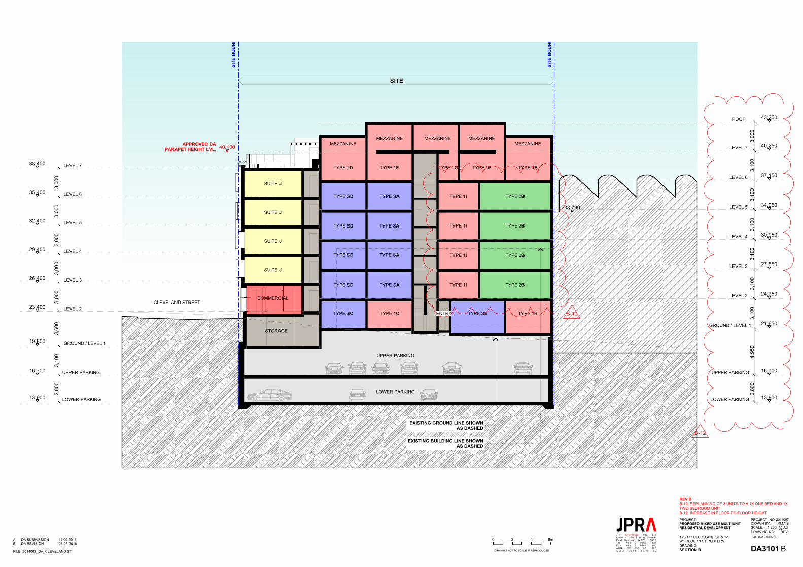
DA3101
2014067RM,YS
@A31:200REV:
DRAWING:
DRAWN BY:SCALE:
PROJECT NO:
DRAWING NO:
PROJECT:
175-177 CLEVELAND ST & 1-5WOODBURN ST REDFERN
PROPOSED MIXED USE MULTI UNITRESIDENTIAL DEVELOPMENT
SECTION B
PLOTTED: 7/03/2016JPR Arch i tec ts P tyLeve l 4 , 50 S tan l eyE a s t S y d n e y N S WTelF a xA B Nw w w . j p r a . c o m
L tdS t ree t
2 0 1 0+ 61 2 9366 1133+ 61 2 9366 1100
52 255 001 003. a uDRAWING NOT TO SCALE IF REPRODUCED
0 42 6m
N
FILE: 2014067_DA_CLEVELAND ST
1:200 @ A3
BA DA SUBMISSION 11-09-2015B DA REVISION 07-03-2016
33.790
SITE
40.100
38.700
19.800
23.400
26.400
29.400
32.400
35.400
38.400
16.700
13.900
2,80
03,
100
3,60
03,
000
3,00
03,
000
3,00
03,
000
2,80
04,
950
3,10
03,
100
3,10
03,
100
3,10
03,
100
3,00
0
UPPER PARKING
CLEVELAND STREET
TYPE 1D TYPE 1F TYPE 1G TYPE 1F TYPE 1E
MEZZANINEMEZZANINE MEZZANINE
MEZZANINE
TYPE 1B
TYPE SA
TYPE SA
COMMERCIAL
SUITE J
SUITE J
SUITE J
SUITE J
STORAGE
ENTRY
APPROVED DAPARAPET HEIGHT LVL.
GROUND / LEVEL 1
LEVEL 2
LEVEL 3
LEVEL 4
LEVEL 5
LEVEL 6
LOWER PARKING
UPPER PARKING
LEVEL 7
TYPE SA
TYPE SA
TYPE 1C
MEZZANINE
TYPE 1HTYPE SE
SITE
BO
UNDA
RY
SITE
BO
UNDA
RY
13.900
16.700
21.650
24.750
27.850
30.950
34.050
37.150
40.250
43.250
EXISTING BUILDING LINE SHOWNAS DASHED
EXISTING GROUND LINE SHOWNAS DASHED
LOWER PARKING
GROUND / LEVEL 1
LEVEL 2
LEVEL 3
LEVEL 4
LEVEL 5
LEVEL 6
LOWER PARKING
UPPER PARKING
LEVEL 7
ROOF
TYPE SC
TYPE SD
TYPE SD
TYPE SD
TYPE SD TYPE 2BTYPE 1I
TYPE 2BTYPE 1I
TYPE 2BTYPE 1I
TYPE 2BTYPE 1I
B-10
REV BB-10. REPLANNING OF 3 UNITS TO A 1X ONE BED AND 1XTWO BEDROOM UNITB-12. INCREASE IN FLOOR TO FLOOR HEIGHT
B-12

Remediation Action Plan 175-177 Cleveland Street and 1-5 Woodburn Street, Redfern NSW Report No. E22434 AB_Rev1
Appendix B Groundwater Search


Remediation Action Plan 175-177 Cleveland Street and 1-5 Woodburn Street, Redfern NSW Report No. E22434 AB_Rev1
Appendix C SEPP 55 Notification Requirements

Remediation Action Plan 175-177 Cleveland Street and 1-5 Woodburn Street, Redfern NSW Report No. E22434 AB_Rev1
Remediation Category Assessment
If the answer is NO to all the questions listed in Table C-1, the works are considered to be Category 2 remediation works under SEPP 55 (DUAP 1998).
Table C-1 Remediation Category Assessment
Are the works Yes / No
Designated development No
Carried out or to be carried out on land declared to be a critical habitat No
Likely to have a significant effect on a critical habitat or a threatened species, population or ecological community,
No
A development for which another State environmental planning policy or a regional environmental plan requires development consent
No
Carried out or to be carried out in an area or zone to which any classifications to the following effect apply under an environmental planning instrument:
No
(i) coastal protection, No
(ii) conservation or heritage conservation, No
(iii) habitat area, habitat protection area, habitat or wildlife corridor, No
(iv) environment protection, No
(v) escarpment, escarpment protection or escarpment preservation, No
(vi) floodway, No
(vii) littoral rainforest, No
(viii) nature reserve, No
(ix) scenic area or scenic protection, No
(x) wetland No
Carried out or to be carried out on any land in a manner that does not comply with a policy made under the contaminated land planning guidelines by the council for any local government area in which the land is situated (or if the land is within the unincorporated area, the Western Lands Commissioner).
No
Source: State Environmental Planning Policy No 55—Remediation of Land under the Environmental Planning and Assessment Act 1979
The requirements for notification to Council on the prior to the commencement of remediation works and post remediation validation reporting to Council are detailed below. The notification must
• be in writing;
• provide the name, address and telephone number of the person who has the duty of ensuring that the notice is given, and
• briefly describe the remediation work;

Remediation Action Plan 175-177 Cleveland Street and 1-5 Woodburn Street, Redfern NSW Report No. E22434 AB_Rev1
• show why the work is considered category 2 remediation work by reference to SEPP 55;
• specify, by reference to its property description and street address (if any), the land on which the work is to be carried out;
• provide a map of the location of the land;
• Provide estimates of the dates for the commencement and completion of the work.
Under Clauses 17 and 18 of SEPP 55 notification of the completion of remediation works must be provided to the local Council within 30 days of completion of the works. This notice must:
• be in writing prepared and signed by the person who carried out the work;
• provide the person's name, address and business telephone number;
• provide details of the person's qualifications to carry out the work;
• specify, by reference to its property description and street address (if any), the land on which the work was carried out;
• provide a map of the location of the land;
• state when the work was completed;
• specify the uses of the land, and the substances, that contaminated it in such a way as to present a risk of harm to human health or some other aspect of the environment;
• specify the uses of the land immediately before the work started;
• briefly describe the method of remediation used in the work;
• specify the guidelines that were complied with in the work;
• specify the standard of remediation achieved (in the light of the use proposed for the land);
• show in what manner the work (if a category 1 remediation work) complied with the conditions of the relevant development consent; and
• State what action must be maintained in relation to the land after the completion of the remediation work if the standard of remediation achieved is to be maintained?

Remediation Action Plan 175-177 Cleveland Street and 1-5 Woodburn Street, Redfern NSW Report No. E22434 AB_Rev1
Appendix D SCC Contaminated Land DCP 2004 Appendix 3

Appendix 3 - Criteria to be met in carrying out Category 2 remediation works
1.0 Hours of Operation
All remediation work shall be conducted in accordance with the standard City of Sydney hours of construction and work.
2.0 Soil and Water Management
All remediation works shall be conducted in accordance with a soil and water management plan prepared prior to commencement of any remediation work or activities. A copy of the plan shall be kept on-site and made available to Council Officers on request. All erosion and sediment measures must be maintained in a functional condition throughout the remediation works and sediment laden stormwater run-off shall be controlled using sediment control measures outlined in the manual Urban Stormwater -Soils and Construction (published by the NSW Department of Housing).
A summary of the soil and water management measures for category 2 remediation work in relation to stockpiles, site access, excavation pump-out, landscaping/rehabilitation and bunding are discussed below:
2.1 Stockpiles
• No stockpiles of soil or other materials shall be placed on footpaths or nature strips unless prior Council approval has been obtained.
• All stockpiles of soil or other materials shall be placed away from drainage lines, gutters or stormwater pits or inlets.
• All stockpiles of soil or other materials likely to generate dust or odours shall be covered.
• All stockpiles of contaminated soil shall be stored in a secure area and be covered if remaining more than 24 hours.
• All stockpiles be placed on a level area as a low, elongated mound.
2.2 Site Access
Vehicle access to the site shall be stabilised to prevent the tracking of sediment onto the roads and footpath. Soil, earth, mud or similar materials must be removed from the roadway by sweeping, shovelling, or a means other than washing, on a daily basis or as required. Soil washings from wheels shall be collected and disposed of in a manner that does not pollute waters.
2.3 Excavation Pump-out
All excavation pump-out water must also be analysed for suspended solid concentrations, pH and any contaminants of concern identified during the preliminary or detailed site investigation, prior to discharge to the stormwater system. The analytical results must comply with relevant EPA and ANZECC standards for water quality.
Other options for the disposal of excavation pump-out water include disposal to sewer with prior approval from Sydney Water or off-site disposal by a liquid waste transporter for treatment/disposal to an appropriate waste treatment/processing facility.
Contaminated land 25June 2004
City of Sydney Contaminated Land Development Control Plan 2004

2.4 Landscaping/Rehabilitation
All exposed areas shall be progressively stabilised and revegetated on the completion of remediation works.
2.5 Bunding
All landfarming areas for hydrocarbon contaminated soils shall be bunded to contain surface water runoff from the landfarm areas and to prevent the leaching of hydrocarbons into the subsurface. All surface water discharges from the bunded areas to Council's stormwater system shall not contain detectable levels of TPH or BTEX.
3.0 Noise
All remediation work / activities shall comply with The City of Sydney Code of Practice 1992 - for Construction of Hours / Noise within the Central Business District and Australian Standard 2436-1981 Guide to Noise Control on Construction, Maintenance Demolition Sites and the Environment Protection Authority Environmental Noise Manual for the control of construction site noise (as applicable to the relevant site).
No "offensive noise" as defined under the Protection of the Environment Operations Act, 1997 shall be created during remediation works/activities.
All associated mechanical plant, equipment and the like used during remediation works/activities shall use all practical and reasonable noise attenuating devices and measures to minimise noise being transmitted from the site.
All equipment and machinery shall be operated in an efficient manner to minimise the emission of noise.
4.0 Vibration
Vibration emissions during remediation works/activities must not result in damage to nearby premises or result in an unreasonable loss of amenity to nearby residents. The relevant provisions of the Protection of the Environment Operations Act, 1997 must be satisfied at all times.
5.0 Air Quality
5.1 Dust Control
Dust emissions shall be confined within the site boundary. The following dust control procedures may be employed to comply with this requirement:
• erection of dust screens around the perimeter of the site;
• securely covering all loads entering or exiting the site;
• use of water sprays across the site to suppress dust;
• covering of all stockpiles of contaminated soil remaining more than 24 hours; and
• keeping excavation surfaces moist.
Dust emissions shall also be controlled by ensuring vehicles leave via stabilised site access and all equipment has dust suppressors fitted. Large sites may require dust monitoring (NHMRC guidelines).
Contaminated land 26June 2004
City of Sydney Contaminated Land Development Control Plan 2004

5.2 Odour Control
No odours shall be detected at any boundary of the site during remediation works by an authorised officer relying solely on sense of smell. The following procedures may be employed to comply with this requirement:
• use of appropriate covering techniques such as the use of plastic sheeting to cover excavation faces or stockpiles;
• use of fine mist sprays;
• use of a hydrocarbon mitigating agent on the impacted areas/materials; and
• adequate maintenance of equipment and machinery to minimise exhaust emissions.
Records of volatile emissions and odours shall be logged, kept on-site and made available on request of the consent authority. Discharges from soil vapour extraction systems shall be regularly monitored in order to determine the mass of hydrocarbons that are being discharged to the atmosphere. Contingency measures for the collection and treatment of hydrocarbon offgas shall be put in place prior to the commissioning of the soil vapour extraction systems. All discharge vents from soil vapour extraction systems shall be located a minimum of 50 metres from any residential property boundary, road or recreational area. No material shall be burnt on-site.
Note: Volatile or semi-volatile compounds that could generate odours include monocyclic aromatic hydrocarbons (styrene, benzene, toluene, xylene, ethyl benzene, butyl benzene), polycyclic aromatic hydrocarbons (PAHs), hydrogen sulphide, hydrogen cyanide, pesticides, PCBs, and herbicides.
6.0 Groundwater
Any proposal to dewater will require a development application to be submitted to the Consent Authority (see Section 4.1)
Any proposal to dewater within the Botany Sands Aquifer (See Appendix 4) may constitute integrated development, as approval may be required from the Department of Infrastructure, Planning and Natural Resources (DIPNR), if dewatering is to take place onsite.
Note: DIPNR instructions to Council are that they will not endorse the extraction of groundwater in perpetuity, i.e. permanent dewatering around a development site, because it considers such a development to be unstable. For this reason, any proposed basement or other area that requires dewatering on an ongoing basis will be required to be fully tanked.
7.0 Transport
All haulage routes for trucks transporting soil, materials, equipment or machinery to and from the site shall be selected to meet the following objectives:
• must comply with all road traffic rules;
• must aim to minimise noise, vibration and odour to adjacent premises; and
• must utilise State Roads and minimise use of local roads.
Applicants may consult the consent authority prior to selecting the most suitable transport route.
Contaminated land 27June 2004
City of Sydney Contaminated Land Development Control Plan 2004

Category 2-remediation work shall ensure that all site vehicles:
• conduct deliveries of soil, materials, equipment or machinery during the hours of remediation work identified in Section 4.1;
• securely cover all loads to prevent any dust or odour emissions during transportation;
• exit the site in a forward direction; and
• do not track soil, mud or sediment onto the road.
8.0 Hazardous Materials
Hazardous and/or intractable wastes arising from the remediation work shall be removed and disposed of in accordance with the requirements of the NSW EPA and WorkCover Authority, together with the relevant regulations, namely:
(a) New South Wales Occupational Health and Safety Act 2000;
(b) Occupational Health and Safety Regulation 2001;
(c) Contaminated Land Management Act and Regulations; and
(d) Environmentally Hazardous Chemicals Act 1985 and Regulations.
Under the Protection of the Environment Operations Act 1997 the transportation of wastes that are classified as "Hazardous" (as per the NSW EPA Environmental Guidelines: Assessment, Classification and Management of Liquid and Non-Liquid Wastes, 1999) must be carried out by a transporter licensed by the NSW Environment Protection Authority.
9.0 Disposal of Contaminated Soil
The disposal of contaminated soil shall have regard to the provision of both the Protection of the Environment Operations Act and Regulations and any relevant EPA guidelines such as the NSW EPA publication NSW EPA Environmental Guidelines: Assessment, Classification and Management of Liquid and Non-Liquid Wastes (1999).
Any queries associated with the off-site disposal of waste from a contaminated site should be referred to the DEC’s Pollution Line on 131 555. If contaminated soil or other waste is transported to a site unlawfully, the owner of the waste and the transporter are both guilty of an offence.
10. Importation of Fill
All fill imported on to the site shall be validated to ensure the imported fill is suitable for the proposed land use from a contamination perspective. Fill imported on to the site shall also be compatible with the existing soil characteristic for site drainage purposes.
The consent authority may require details of appropriate validation of imported fill material to be submitted with any application for future development of the site. Hence all fill imported onto the site should be validated by either one or both of the following methods during remediation works:
• Imported fill should be accompanied by documentation from the supplier which certifies that the material is not contaminated based upon analyses of the material or the known past history of the site where the material is obtained; and/or
Contaminated land 28June 2004
City of Sydney Contaminated Land Development Control Plan 2004

Contaminated land 29June 2004
City of Sydney Contaminated Land Development Control Plan 2004
• Sampling and analysis of the fill material should be conducted in accordance with the EPA Sampling Design Guidelines (1995) to ensure that the material is not contaminated.
11.0 Containment / Capping of Contaminated Soil
Site capping is permissible where it can be shown that all other options have been exhausted, and that more preferable options for site contamination as listed in the remediation hierarchy of the ANZECC & NHMRC 1992 cannot be executed. Site auditors must, where relevant, demonstrate in their site audit reports that they have considered the technical issues associated with on-site capping or the use of other physical barriers to contain contamination.
Where site capping is carried out on a site and further maintenance is required, Council will require the placement of a covenant on the title to the land. The covenant will advise of any maintenance works required to be carried out.
If maintenance is to be carried out, the owner or person proposing to carry out the maintenance, should contact an Environmental Health Officer from Council. Records of any maintenance undertaken on the site should be kept for future reference.
12.0 Site Signage and Contact Numbers
A sign displaying the contact details at which the remediation contractor may be contacted outside working hours (and site facilitator if different to remediation contractor) shall be displayed on the site adjacent to the site access. This sign shall be displayed throughout the duration of the remediation works.
13.0 Community Consultation
Owners and/or occupants of premises adjoining, and across the road, from the site shall be notified at least two days prior to the commencement of category 2 remediation works.
14.0 Site Security
The site shall be secured to ensure against unauthorised access by means of an appropriate fence.
15.0 Occupational Health and Safety
It is the employer's responsibility to ensure that all site remediation works shall comply with all Occupational Health and Safety and Construction Safety Guidelines of the NSW WorkCover Authority. Safety monitoring for hydrocarbon emissions should be undertaken in accordance with WorkSafe Time Weighted Averages Guidelines, 1991.
16. Removal of Underground Storage Tanks
The removal of underground storage tanks shall be undertaken in accordance with NSW WorkCover requirements which includes writing to the Chief Inspector of Dangerous Goods and complying with any conditions imposed.
The tank removal shall be conducted in accordance with the Australian Institute of Petroleum's Code of Practice "The Removal and Disposal of Underground Petroleum Storage Tanks (AIP CP22-1994). In the event of conflict between the Code of Practice and NSW WorkCover requirements, the latter shall prevail.
Note: If shoring is required a development application may need to be submitted.

Contaminated land 30June 2004
City of Sydney Contaminated Land Development Control Plan 2004
17. Acid Sulphate Soils
Remediation work involving the excavation of soil should consult the Department of Urban and Transport Planning Acid Sulphate Soil Planning Map to assess weather a preliminary assessment of the potential acid sulphate soil is required.
18. Lead Contamination
An aging building stock combined with past industrial uses and concentrated vehicle use increases the risk of lead contamination (Leichhardt, 2000). It is also important to note that works that do not need development consent could expose humans or the environment to lead contamination. Consequently, those people carrying out work should consider the following when Council consent is not required.
The following circumstances may increase the risk of lead contamination occurring:
• previous history of industrial land uses;
• within close vicinity of older structures such as bridges, water tanks, and towers;
• the building/structure subject to development/activity was painted before 1970;
• evidence of demolition or renovations to pre 1970's buildings;
• soil on the site which has been sourced from a lead contaminated site; and,
• land which has been used for orchards, market gardens or other agricultural purposes in which lead arsenate could have been used.
Further information relating to the management of lead contamination can be obtained from the Department of Environment and Conservation.