Embed Size (px)
Citation preview
Plate tectonics☆ Pre-print Crameri et al. (2019)
Plate tectonics☆ Fabio Crameri*, Grace E. Shephard, and Clinton P. Conrad Centre for Earth Evolution and Dynamics, University of Oslo, Norway *www.fabiocrameri.ch
0 Abstract 2
1 Plate tectonics: A framework for understanding Earth dynamics 2 1.1 Root concepts and definitions (glossary) 2 1.2 Plate motions on Earth 3 1.3 The discovery and development of plate tectonics 4
2 The plate system 7 2.1 Plate boundaries 7 2.2 Continental vs. oceanic plates 7 2.3 What are the plates? 9 2.4 Earthquakes and volcanoes 10 2.5 Reconstructed surface kinematics 11
3 Dynamics behind plate tectonics 13 3.1 Plate motions as part of mantle convection 13 3.2 Ocean-plate tectonics 15
3.2.1 Ocean-plate formation and cooling 16 3.2.2 Ocean-plate destruction 16
3.3 The forces acting on the plates 16
4 The uniqueness of plate tectonics 18 4.1 Plate tectonics as one style of convection 18
4.1.2 Consequences 19 4.2 Mantle-surface interactions 19
4.2.1 Surface topography 19 4.2.2 Volatile cycle 20
4.3 Necessities for plate tectonics 21 4.3.1 Initiation 21 4.3.2 Maintenance 22
5 Future directions 22 5.1 Long-term Wilson cycle tectonics and the link to deep mantle 22 5.2 Additional comparisons 24 5.3 Mantle convection unified concepts 25
Acknowledgment 25
References 25
Cite as:
Crameri, F., G.E. Shephard, and C.P. Conrad (2019). Plate Tectonics☆. Reference
Module in Earth Systems and Environmental Sciences, Elsevier, doi:https://doi.org/10.1016/B978-0-12-409548-9.12393-0
2
0 Abstract Plate tectonics is the root concept underpinning our current knowledge of how Earth’s internal
dynamics are linked to geologic deformation at the surface. Since the discovery of plate
tectonics in the 1960s, geoscientists have developed a first-order understanding of a plate
system in which the Earth’s surface is broken into about a dozen mostly rigid tectonic plates
that move relative to each other at speeds of a few cm per year. The boundaries of these plates
accommodate diverging, converging, and lateral motions, and are associated with surface
features such as rift zones, mountain belts, faults, earthquakes, and volcanoes. The motions of
the plates can be detected geodetically, described kinematically, and reconstructed back in
time. This descriptive understanding of Earth’s surface deformation is now recognized as the
surface expression of a larger, dynamic framework of mantle convection. Gravity acting on
density variations within Earth’s interior generates broad-scale flow of the mantle, which
mainly drives, but can also resist, the horizontal plate motions at the surface. Within this
system, oceanic plates originate from and are recycled back into the mantle, forming a
dynamic cycle captured by the recently-described ‘ocean-plate tectonics’ concept. This
intimate relationship between surface and internal dynamics appears to be unique to the Earth,
as it is clearly different from the modes of mantle convection inferred for other rocky
planetary bodies within our solar system. Earth’s unique interplay between its interior and
surface shapes our planet’s morphology and recycles its volatiles to produce the lively and
life-bearing planet that Earth has become. How ocean-plate tectonics started, how it has
repeatedly opened and closed ocean basins, assembled and dispersed supercontinents, and
initiated and terminated fault systems, and how it continuous to operate today are still major
open questions. New techniques for studying Earth’s interior dynamics, new possibilities for
comparing Earth to other freshly-understood or recently-detected planetary bodies, and new
unifying concepts like ocean-plate tectonics bode well for future resolution of the remaining
mysteries surrounding plate tectonics today.
Keywords:
Plate tectonics; Ocean-plate tectonics; Continental drift; Seafloor spreading; Subduction;
Transform faults; Mantle convection; Mid-ocean ridges; Ocean basins; Plate tectonic
reconstruction; Supercontinent cycle; Slab pull; Ridge push; Volatile recycling; Earthquakes;
Volcanoes
1 Plate tectonics: A framework for understanding Earth dynamics Today, the Earth’s surface consists of about a dozen dominantly rigid tectonic plates that
move relative to each other, driving our planet’s geologic evolution and the development of
life. Plate tectonics represents the surface expression of deformation within Earth’s deep
interior, and is thus the mechanism by which both deep forces and primordial heat are brought
to our planet’s surface (see Figure 1). The resulting tectonic plate motions shape the planetary
surface with high mountain ranges and deep submarine basins, recycle volatiles between
Earth’s interior and its external envelopes, separate and merge biological habitats, and pose
major threats to humans and their infrastructures with sudden ground shaking and volcanic
eruptions. A hundred years of research have provided a relatively clear picture of this
fascinating geological engine for our planet, but this understanding is continually being
clarified across spatial and temporal scales and described via more integral and precise
concepts.
1.1 Root concepts and definitions (glossary) ● Continental drift is the horizontal relative movement of discrete continental plates
(Wegener, 1912).
● Plate tectonics is the horizontal relative movement of several discrete and mostly-
rigid surface-plate segments (Hess, 1962).
3
● Seafloor spreading is the horizontal divergent plate motion observed at mid-ocean
ridges (Hess, 1962).
● Subduction is the descent of oceanic lithosphere beneath another tectonic plate to
accommodate convergent plate motions (Oliver and Issacs, 1967)
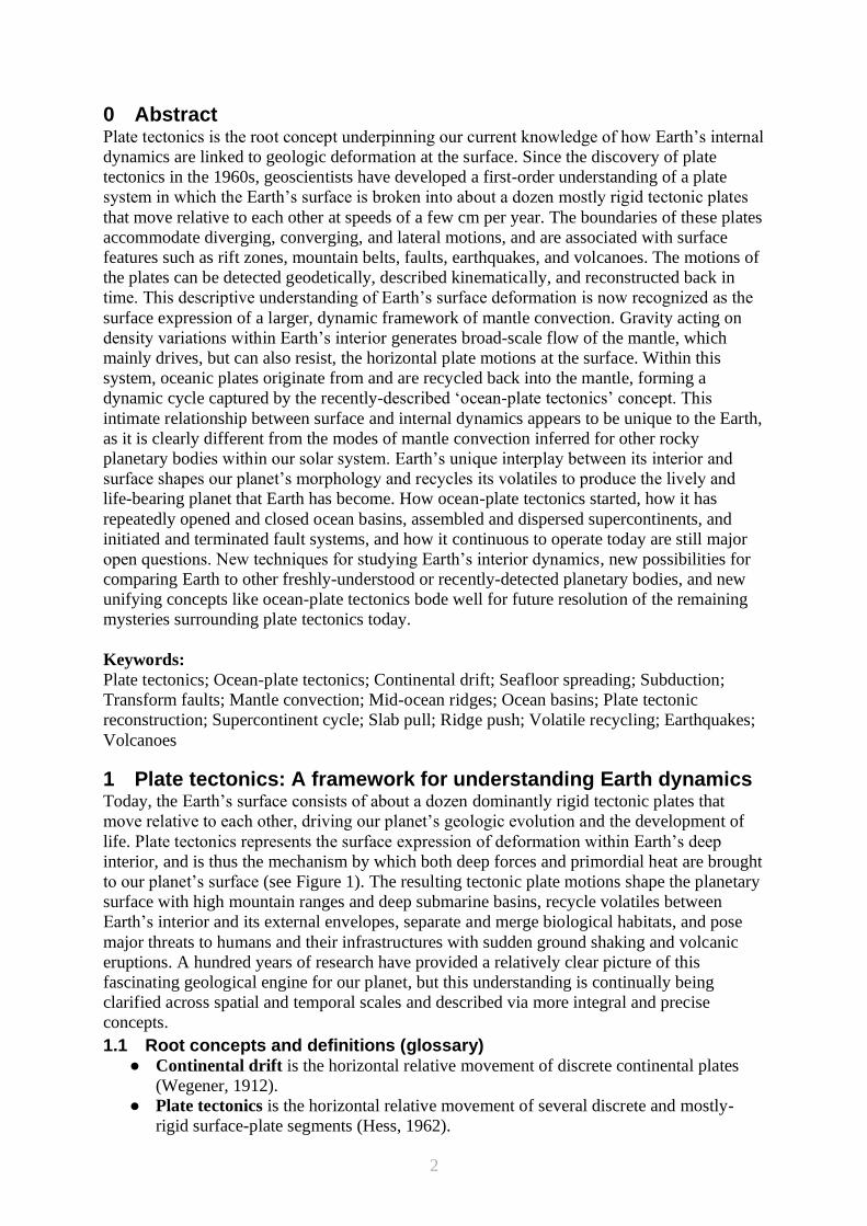
● Ocean-plate tectonics is a mode of mantle convection characterised by the
autonomous relative movement of multiple discrete, mostly rigid, oceanic plates at the
surface (Figure 1). Their motion is driven and maintained principally by the subducted
parts of these same plates, which are sinking gravitationally back into Earth’s interior
and deforming the mantle in the process (Crameri et al., 2019).
Figure 1: Cartoon image of ocean-plate tectonics. Shown are the origins of an oceanic plate
at a spreading ridge where magnetic stripes are created, the cooling phase with interaction
from the deep mantle, and the sinking phase where the subducting portions create major
earthquakes and provide the major driving force pulling the trailing plate across the surface.
Figure adjusted from Crameri et al. (2019).
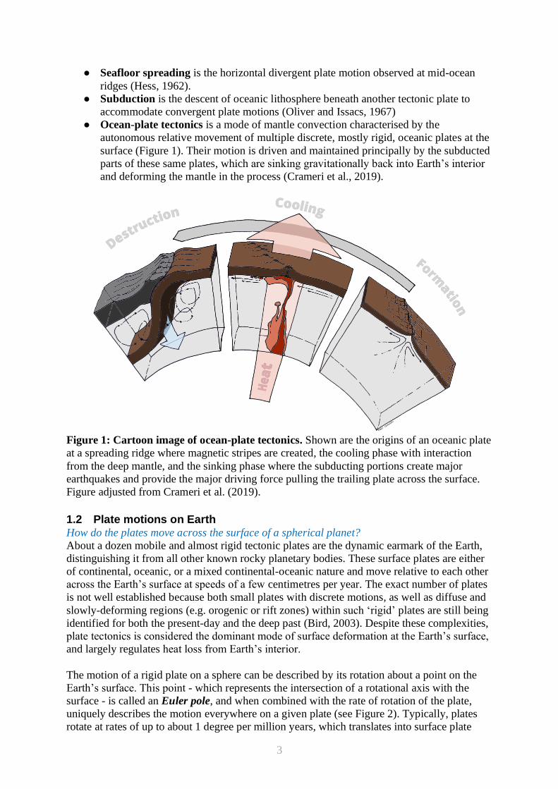
1.2 Plate motions on Earth How do the plates move across the surface of a spherical planet?
About a dozen mobile and almost rigid tectonic plates are the dynamic earmark of the Earth,
distinguishing it from all other known rocky planetary bodies. These surface plates are either
of continental, oceanic, or a mixed continental-oceanic nature and move relative to each other
across the Earth’s surface at speeds of a few centimetres per year. The exact number of plates
is not well established because both small plates with discrete motions, as well as diffuse and
slowly-deforming regions (e.g. orogenic or rift zones) within such ‘rigid’ plates are still being
identified for both the present-day and the deep past (Bird, 2003). Despite these complexities,
plate tectonics is considered the dominant mode of surface deformation at the Earth’s surface,
and largely regulates heat loss from Earth’s interior.
The motion of a rigid plate on a sphere can be described by its rotation about a point on the
Earth’s surface. This point - which represents the intersection of a rotational axis with the
surface - is called an Euler pole, and when combined with the rate of rotation of the plate,
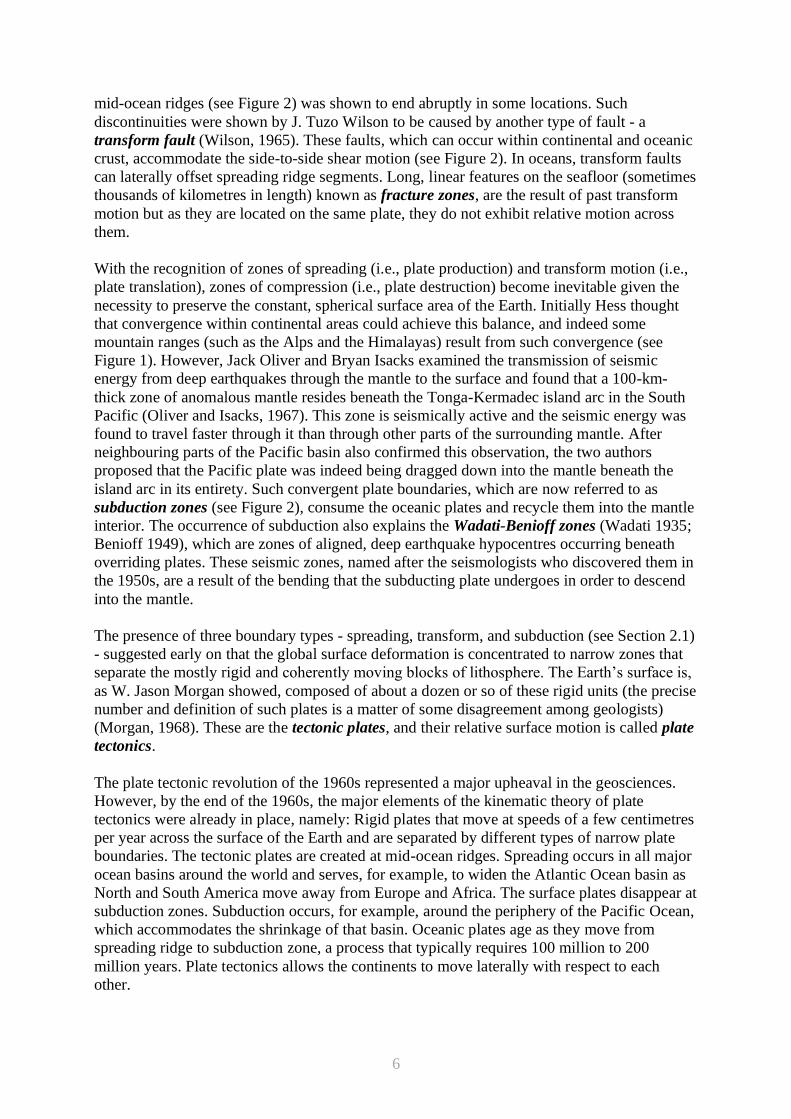
uniquely describes the motion everywhere on a given plate (see Figure 2). Typically, plates
rotate at rates of up to about 1 degree per million years, which translates into surface plate
4
motions of up to about 10 cm per year. Plate divergence is accommodated by rifting in
continental regions, and by seafloor spreading beneath the oceans. Plate convergence is
accommodated by orogenesis, if occurring within or between continental regions, and by
subduction, if it involves wholesale motion of an entire oceanic plate beneath another (usually
continental) plate. Plates move laterally against each other at transform faults.
Figure 2. How plates move across the Earth. The motion of (almost) rigid surface portions
on a sphere can be described by a rotation around a rotation axis, which cuts the surface at the
so-called Euler pole. This relative motion of the plates is mainly accommodated by localised
deformation at plate boundaries. Three general types of plate boundaries exist: transform plate
boundaries allow the plates to move alongside each other, and convergent and divergent plate
boundaries allow for plate destruction and creation, respectively. Transform and divergent
plate boundaries are almost straight features, but spreading ridges are generally offset laterally
by transform intersections. Subduction zones are usually arcuate (i.e., concave towards the
upper plate) due to interaction with mantle flow. Variations of these plate boundaries exist
depending on the given combination of upper and lower plate nature (i.e., continental or
oceanic).
1.3 The discovery and development of plate tectonics The discovery, formulation, and broad acceptance of plate tectonics was a revolutionary event
in the Earth sciences. In the nineteenth century, it became clear that some fossils and rock
types matched each other on opposite sides of the Atlantic Ocean. Together with the
observation that the continents geometrically fit together, the drift of continents across Earth’s
surface was proposed. The evidence was compiled by the German meteorologist Alfred
Wegener, who in 1915 published a book, The Origin of Continents and Oceans. In this book
he proposed the breakup of a previous supercontinent (now called Pangaea) via a process that
he called continental drift. It described the continents ploughing through the oceanic crust,
like icebergs moving through water. At the time, Wegener’s theory was largely discounted
because no known force was sufficient to drive the continental movements.
5
Later, continental motion was further supported by palaeomagnetism, which is the study of
the past global magnetic field imprinted in Earth’s rocks. Basalts, for example, which are a
type of volcanic rock, contain magnetic minerals that tend to align themselves in the direction
of Earth’s magnetic field when heated and remain in position when cooled. Thus, cold surface
rocks can be used to determine the orientation of the magnetic field at the time that they were
hot, which is normally when they formed out of molten magma or lava. In basalts erupted on
continents, such observations often pointed toward a past magnetic pole that was significantly
misaligned with the current magnetic pole. Some sequences of continental lavas even showed
palaeomagnetic poles gradually drifting farther away from the present pole with older rocks.
While most scientists attributed these observations to the gradual movement of the magnetic
pole over time, some individuals, such as S. Keith Runcorn, proposed a reverse explanation,
in which the magnetic pole remains fixed and the continents move instead (Runcorn, 1965).
An accumulation of depth-sounding data from across the world’s oceans allowed scientists to
overcome some of the challenges of the underwater environment and finally map the broad
features of the seafloor. This included the discovery of the “Great Global Rift” that was
interpreted by Bruce C. Heezen and Marie Tharp to have similar characteristics as the
exposed extensional rifts in Iceland and eastern Africa (Heezen, 1960; Tharp 1982). Even
though new seafloor was found to being created in the ocean basins, the cause of this rifting,
or seafloor spreading, remained debated. Two American scientists, geophysicist Robert S.
Dietz and navy admiral and geologist Harry H. Hess interpreted the oceanic rifting as the top
part of massive convection cells within the Earth’s mantle (Dietz 1961; Hess 1962). Although
Dietz was the first person to publish and to use the term ‘seafloor spreading’, the discovery of
seafloor spreading is credited to Hess, because he circulated drafts of his paper, titled “History
of Ocean Basins”, before Dietz’s publication. These two papers were the first attempts within
the published literature to present continental drift and seafloor spreading as the main ideas of
a unified concept: plate tectonics. Ever since, plate tectonics has been used to provide a
framework for understanding the geological processes that shape the Earth’s surface.
Important evidence for seafloor spreading was observed in the rocks of the oceanic plates.
World War II (1939–1945) spurred the development of airborne and shipborne
magnetometers, and these devices detected a background pattern of periodic variations in the
magnetic field as they traversed over the oceans. These imprinted ‘‘magnetic stripes’’ were
recognized as variations in the magnetic properties of the basaltic rocks that composed the
seafloor. Such horizontal sequences of alternating magnetic orientations on the seafloor were
more difficult to understand than the observed vertical sequences in continental basalts.
However, after Hess and Dietz published their ideas about seafloor spreading, it was Fred J.
Vine and Drummond H. Matthews, in particular, that suggested the magnetic stripes could be
interpreted as a record of basaltic rocks. The record reveals the creation of rocks at mid-ocean
ridges where they sample the magnetic field orientation at that time, followed by their
subsequent transportation away from the ridge by seafloor spreading (Vine and Matthews
1963).
Indeed, the periodic ‘normal’ (like today) and ‘reverse’ flips of the magnetic field create the
magnetic stripes, which are observed to run parallel to the mid-ocean ridges and are
symmetrical about the central rift (see Figure 1). Moreover, by relating the pattern of
magnetic stripes on the seafloor to the dated sequence of magnetic polarity reversals that are
determined from continental rocks, the age of the seafloor can be determined.
Global seafloor age observations provide a great deal of information about how the seafloor
spreading system works kinematically in nature. For example, the divergent spreading along
6
mid-ocean ridges (see Figure 2) was shown to end abruptly in some locations. Such
discontinuities were shown by J. Tuzo Wilson to be caused by another type of fault - a
transform fault (Wilson, 1965). These faults, which can occur within continental and oceanic
crust, accommodate the side-to-side shear motion (see Figure 2). In oceans, transform faults
can laterally offset spreading ridge segments. Long, linear features on the seafloor (sometimes
thousands of kilometres in length) known as fracture zones, are the result of past transform
motion but as they are located on the same plate, they do not exhibit relative motion across
them.
With the recognition of zones of spreading (i.e., plate production) and transform motion (i.e.,
plate translation), zones of compression (i.e., plate destruction) become inevitable given the
necessity to preserve the constant, spherical surface area of the Earth. Initially Hess thought
that convergence within continental areas could achieve this balance, and indeed some
mountain ranges (such as the Alps and the Himalayas) result from such convergence (see
Figure 1). However, Jack Oliver and Bryan Isacks examined the transmission of seismic
energy from deep earthquakes through the mantle to the surface and found that a 100-km-
thick zone of anomalous mantle resides beneath the Tonga-Kermadec island arc in the South
Pacific (Oliver and Isacks, 1967). This zone is seismically active and the seismic energy was
found to travel faster through it than through other parts of the surrounding mantle. After
neighbouring parts of the Pacific basin also confirmed this observation, the two authors
proposed that the Pacific plate was indeed being dragged down into the mantle beneath the
island arc in its entirety. Such convergent plate boundaries, which are now referred to as
subduction zones (see Figure 2), consume the oceanic plates and recycle them into the mantle
interior. The occurrence of subduction also explains the Wadati-Benioff zones (Wadati 1935;
Benioff 1949), which are zones of aligned, deep earthquake hypocentres occurring beneath
overriding plates. These seismic zones, named after the seismologists who discovered them in
the 1950s, are a result of the bending that the subducting plate undergoes in order to descend
into the mantle.
The presence of three boundary types - spreading, transform, and subduction (see Section 2.1)
- suggested early on that the global surface deformation is concentrated to narrow zones that
separate the mostly rigid and coherently moving blocks of lithosphere. The Earth’s surface is,
as W. Jason Morgan showed, composed of about a dozen or so of these rigid units (the precise
number and definition of such plates is a matter of some disagreement among geologists)
(Morgan, 1968). These are the tectonic plates, and their relative surface motion is called plate
tectonics.
The plate tectonic revolution of the 1960s represented a major upheaval in the geosciences.
However, by the end of the 1960s, the major elements of the kinematic theory of plate
tectonics were already in place, namely: Rigid plates that move at speeds of a few centimetres
per year across the surface of the Earth and are separated by different types of narrow plate
boundaries. The tectonic plates are created at mid-ocean ridges. Spreading occurs in all major
ocean basins around the world and serves, for example, to widen the Atlantic Ocean basin as
North and South America move away from Europe and Africa. The surface plates disappear at
subduction zones. Subduction occurs, for example, around the periphery of the Pacific Ocean,
which accommodates the shrinkage of that basin. Oceanic plates age as they move from
spreading ridge to subduction zone, a process that typically requires 100 million to 200
million years. Plate tectonics allows the continents to move laterally with respect to each
other.
7
Plate tectonics unifies a multitude of observables at the Earth’s surface through one global
concept. It explains the geographical distribution and focal mechanisms of large earthquakes,
the proximity of the most explosive volcanism to convergent plate boundaries, the topography
of the seafloor, the formation of Earth’s mountain ranges, the dynamic geographic history of
the continents, and the long-term transfer of Earth’s interior heat. As a result, plate tectonics
has become a solid foundation for scientists’ understanding of Earth dynamics and Earth
history.
2 The plate system Various observations, both direct and indirect, provide us with an increasingly clear picture of
the present-day structures and kinematics of plate tectonics, and enable us to interrogate the
dynamics of the plate tectonic system (Section 3) and its importance for Earth’s evolution and
dynamics as a planet (Section 4).
2.1 Plate boundaries Where does the Earth’s surface deform?
One key aspect of plate tectonics is the interplay between the almost rigid plate interiors and
their almost resistless plate boundaries. While the plate motion is translated through strong
plate interiors, it is the weak plate boundary regions that localise the inter-plate deformation
and ultimately allow for the plate motion in the first place. All three plate-boundary end-
members are crucially dominated by temporally evolving, three-dimensional dynamics.
Spreading ridges, the origin site of the oceanic plates, are divided horizontally into multiple,
almost perfectly straight ridge segments that are laterally offset to neighbouring segments via
transforms (see Figures 1 and 2). With regards to plate tectonics, a Mid-Ocean Ridge (MOR)
system (e.g., Parsons, 1981) initialises the oceanic lithosphere and therefore strongly controls
its later evolution. Ridges are rapidly evolving systems characterised by strong lateral
gradients in geophysical properties, both normal and parallel to the ridge axis (e.g., Magde et
al., 1997).
Transform boundaries, the side guides of the oceanic plates, connect spreading ridges with
subduction zones (see Figures 1 and 2). While transform faults might stabilise plate motion,
they are also an important source of complexity not only, but particularly in relation to,
spreading ridges (e.g., Weatherley and Katz, 2010; Gerya, 2012).
Subduction zones, the drivers of the oceanic plates, are arcuate horizontally (concave towards
the upper plate) and accommodate the single-sided vertical sinking of oceanic plates below
another, upper plate (see Figure 1 and 2). The subduction zone is probably the best studied
species of plate boundaries, due to its importance for plate dynamics, but also due to its
incredible complexity and diversity (see Crameri et al., 2019 and references therein).
2.2 Continental vs. oceanic plates How old are the different types of plates?
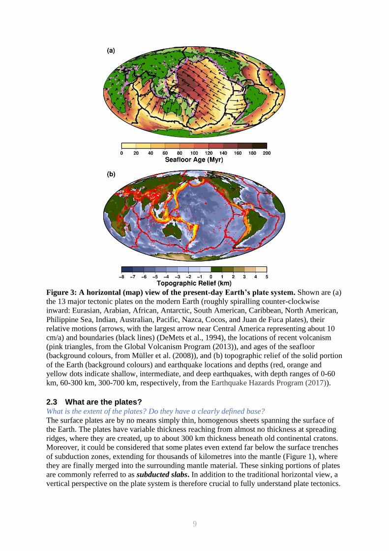
From a bird’s eye perspective, about a dozen major plates can be identified on the Earth’s
surface, bound by obvious surface marks of the plate boundaries (see Figure 3). A single
primary characteristic divides all plates into two classes: Plates that contain some continental
parts (e.g., the Eurasia plate), and plates that do not, i.e., are only oceanic (e.g., the Pacific
plate). There is no major plate that is purely continental, since they all contain at least some
small portions of oceanic lithosphere.
The continental portions of the lithosphere are distinct in terms of their surface elevation,
rendering them to literally stand out. Continental plates are, as a whole, compositionally
lighter and have a thicker root extending deeper into the mantle underneath than oceanic
plates. Not unlike an iceberg, this makes continents ‘float’ higher on top of the mantle than
8
their oceanic counterparts, including above sea level. The deep roots of continents may invoke
a drag effect, which will slow the horizontal motion of plates with significant continental
landmasses (van Summeren et al., 2012). Such plates (i.e., the North American, South
American, African, Eurasian, and Antarctic plates) move only 1-4 cm/a, significantly slower
than the global average. The continental plates are old; they are resisting portions of the
lithosphere and remain at the surface of the Earth. The oldest rocks can therefore be observed
on old continental interiors such as the Greenland, Pilbara (Western Australia) and Kaapvaal
(South Africa) cratons over 3.5 billion years ago (Laurent et al., 2014). When and how these
continents formed at the surface is to some extent still unclear.
The oceanic portions of the lithosphere tend to hide below the sea level, because oceanic
plates are, as a whole, compositionally denser than continents. Plates that are dominated by
oceanic lithosphere (i.e., the Pacific, Nazca, Cocos, Philippine Sea, Indian, and Australian
plates) tend to be bound by all three plate boundaries, since they are constantly created at
spreading ridges, move along their neighbouring plates at transform boundaries, and are
sinking back into the mantle at subduction zones. Such plates tend to move between about 5
and 10 cm/a, faster than other plates because the pull force from their subducting slabs speeds
their motion (Conrad and Lithgow-Bertelloni, 2002). Because the oceanic plates become
dense and heavy as they age, and also due to space constraints on Earth, the oceanic plates
only reach a maximum age of around 200 Million years before they subduct and disappear
from the surface. The oldest oceanic lithosphere today is around 180 Ma (where Ma stands for
millions of years ago), although some older fragments (up to 340 Ma) have been found in the
Mediterranean (Granot, 2016). Because they are constantly recycled into the planetary
interior, oceanic plates are the surface expression of the relentlessly convecting mantle.
9
Figure 3: A horizontal (map) view of the present-day Earth’s plate system. Shown are (a)
the 13 major tectonic plates on the modern Earth (roughly spiralling counter-clockwise
inward: Eurasian, Arabian, African, Antarctic, South American, Caribbean, North American,
Philippine Sea, Indian, Australian, Pacific, Nazca, Cocos, and Juan de Fuca plates), their
relative motions (arrows, with the largest arrow near Central America representing about 10
cm/a) and boundaries (black lines) (DeMets et al., 1994), the locations of recent volcanism
(pink triangles, from the Global Volcanism Program (2013)), and ages of the seafloor
(background colours, from Müller et al. (2008)), and (b) topographic relief of the solid portion
of the Earth (background colours) and earthquake locations and depths (red, orange and
yellow dots indicate shallow, intermediate, and deep earthquakes, with depth ranges of 0-60
km, 60-300 km, 300-700 km, respectively, from the Earthquake Hazards Program (2017)).
2.3 What are the plates? What is the extent of the plates? Do they have a clearly defined base?
The surface plates are by no means simply thin, homogenous sheets spanning the surface of
the Earth. The plates have variable thickness reaching from almost no thickness at spreading
ridges, where they are created, up to about 300 km thickness beneath old continental cratons.
Moreover, it could be considered that some plates even extend far below the surface trenches
of subduction zones, extending for thousands of kilometres into the mantle (Figure 1), where
they are finally merged into the surrounding mantle material. These sinking portions of plates
are commonly referred to as subducted slabs. In addition to the traditional horizontal view, a
vertical perspective on the plate system is therefore crucial to fully understand plate tectonics.
10
Determining the exact depth of plates is not straightforward and depends on how they are
defined. There are various ways to distinguish a plate from the mantle below. Major plate
discriminators include composition, temperature, material strength, and elastic integrity.
Lighter crustal rocks typically extend up to 20-50 km depth on continents, and up to 5-10 km
deep for oceans. The mantle rocks beneath the crust, referred to collectively as the
lithosphere, are usually also considered part of the tectonic plate, and may have a distinct
composition from the mantle beneath it, especially for continents (Shapiro et al., 1999). The
plates themselves are defined based on their rigidity and internal coherence, which relates to
their material strength. For oceanic plates, material strength is associated with temperatures,
with rocks that are cooler than 1000-1200° C being strong enough to remain structurally part
of the lithosphere. Such temperatures reach almost to the surface near the mid-ocean ridges,
but are found at depths of 100 km for seafloor that is 80 My old and older (Ritzwoller et al.,
2004). Rocks must be even colder, and therefore shallower, to support elastic stresses over
sustained periods without relaxing. For oceans, the elastic thickness of the lithosphere may
extend to about 30-40 km depth, for continental regions there is greater variation, ranging
from only about 10 km or less for geologically younger lithosphere to more than 100 km in
older, colder and drier cratonic areas (Tessauro et al., 2012).
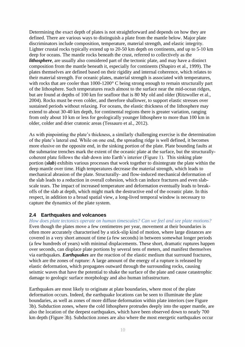
As with pinpointing the plate’s thickness, a similarly challenging exercise is the determination
of the plate’s lateral end. While on one end, the spreading ridge is well defined, it becomes
more elusive on the opposite end, in the sinking portion of the plate. Plate bounding faults at
the submarine trenches mark the extent of the oceanic plate at the surface, but the structurally-
coherent plate follows the slab down into Earth’s interior (Figure 1). This sinking plate
portion (slab) exhibits various processes that work together to disintegrate the plate within the
deep mantle over time. High temperatures decrease the material strength, which leads to
mechanical abrasion of the plate. Structurally- and flow-induced mechanical deformation of
the slab leads to a reduction in overall cohesion, which can induce fractures and even slab-
scale tears. The impact of increased temperature and deformation eventually leads to break-
offs of the slab at depth, which might mark the destructive end of the oceanic plate. In this
respect, in addition to a broad spatial view, a long-lived temporal window is necessary to
capture the dynamics of the plate system.
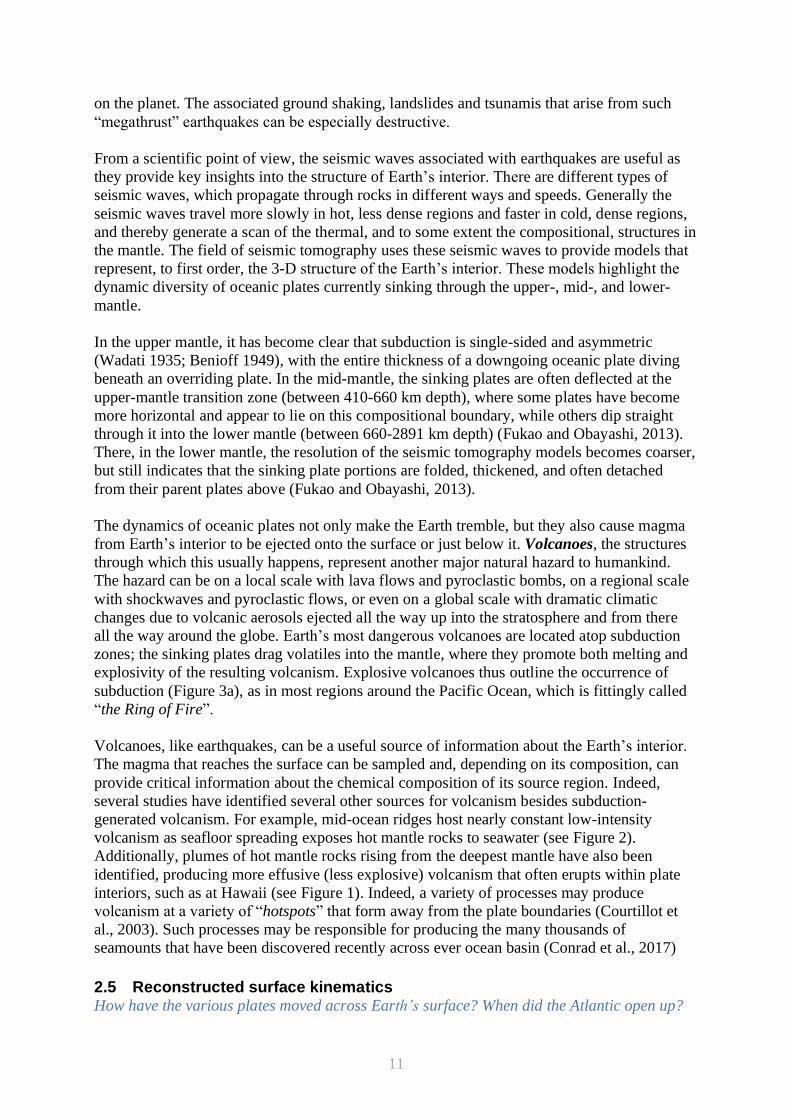
2.4 Earthquakes and volcanoes How does plate tectonics operate on human timescales? Can we feel and see plate motions?
Even though the plates move a few centimetres per year, movement at their boundaries is
often more accurately characterised by a stick-slip kind of motion, where large distances are
covered in a very short amount of time (a few seconds) in between somewhat longer periods
(a few hundreds of years) with minimal displacements. These short, dramatic ruptures happen
over seconds, can displace plate portions by several tens of meters, and manifest themselves
via earthquakes. Earthquakes are the reaction of the elastic medium that surround fractures,
which are the zones of rupture: A large amount of the energy of a rupture is released by
elastic deformation, which propagates outward through the surrounding rocks, causing
seismic waves that have the potential to shake the surface of the plate and cause catastrophic
damage to geologic surface morphology and also human infrastructure.
Earthquakes are most likely to originate at plate boundaries, where most of the plate
deformation occurs. Indeed, the earthquake locations can be seen to illuminate the plate
boundaries, as well as zones of more diffuse deformation within plate interiors (see Figure
3b). Subduction zones, where the cold lithosphere protrudes deeply into the upper mantle, are
also the location of the deepest earthquakes, which have been observed down to nearly 700
km depth (Figure 3b). Subduction zones are also where the most energetic earthquakes occur
11
on the planet. The associated ground shaking, landslides and tsunamis that arise from such
“megathrust” earthquakes can be especially destructive.
From a scientific point of view, the seismic waves associated with earthquakes are useful as
they provide key insights into the structure of Earth’s interior. There are different types of
seismic waves, which propagate through rocks in different ways and speeds. Generally the
seismic waves travel more slowly in hot, less dense regions and faster in cold, dense regions,
and thereby generate a scan of the thermal, and to some extent the compositional, structures in
the mantle. The field of seismic tomography uses these seismic waves to provide models that
represent, to first order, the 3-D structure of the Earth’s interior. These models highlight the
dynamic diversity of oceanic plates currently sinking through the upper-, mid-, and lower-
mantle.
In the upper mantle, it has become clear that subduction is single-sided and asymmetric
(Wadati 1935; Benioff 1949), with the entire thickness of a downgoing oceanic plate diving
beneath an overriding plate. In the mid-mantle, the sinking plates are often deflected at the
upper-mantle transition zone (between 410-660 km depth), where some plates have become
more horizontal and appear to lie on this compositional boundary, while others dip straight
through it into the lower mantle (between 660-2891 km depth) (Fukao and Obayashi, 2013).
There, in the lower mantle, the resolution of the seismic tomography models becomes coarser,
but still indicates that the sinking plate portions are folded, thickened, and often detached
from their parent plates above (Fukao and Obayashi, 2013).
The dynamics of oceanic plates not only make the Earth tremble, but they also cause magma
from Earth’s interior to be ejected onto the surface or just below it. Volcanoes, the structures
through which this usually happens, represent another major natural hazard to humankind.
The hazard can be on a local scale with lava flows and pyroclastic bombs, on a regional scale
with shockwaves and pyroclastic flows, or even on a global scale with dramatic climatic
changes due to volcanic aerosols ejected all the way up into the stratosphere and from there
all the way around the globe. Earth’s most dangerous volcanoes are located atop subduction
zones; the sinking plates drag volatiles into the mantle, where they promote both melting and
explosivity of the resulting volcanism. Explosive volcanoes thus outline the occurrence of
subduction (Figure 3a), as in most regions around the Pacific Ocean, which is fittingly called
“the Ring of Fire”.
Volcanoes, like earthquakes, can be a useful source of information about the Earth’s interior.
The magma that reaches the surface can be sampled and, depending on its composition, can
provide critical information about the chemical composition of its source region. Indeed,
several studies have identified several other sources for volcanism besides subduction-
generated volcanism. For example, mid-ocean ridges host nearly constant low-intensity
volcanism as seafloor spreading exposes hot mantle rocks to seawater (see Figure 2).
Additionally, plumes of hot mantle rocks rising from the deepest mantle have also been
identified, producing more effusive (less explosive) volcanism that often erupts within plate
interiors, such as at Hawaii (see Figure 1). Indeed, a variety of processes may produce
volcanism at a variety of “hotspots” that form away from the plate boundaries (Courtillot et
al., 2003). Such processes may be responsible for producing the many thousands of
seamounts that have been discovered recently across ever ocean basin (Conrad et al., 2017)
2.5 Reconstructed surface kinematics How have the various plates moved across Earth’s surface? When did the Atlantic open up?
12
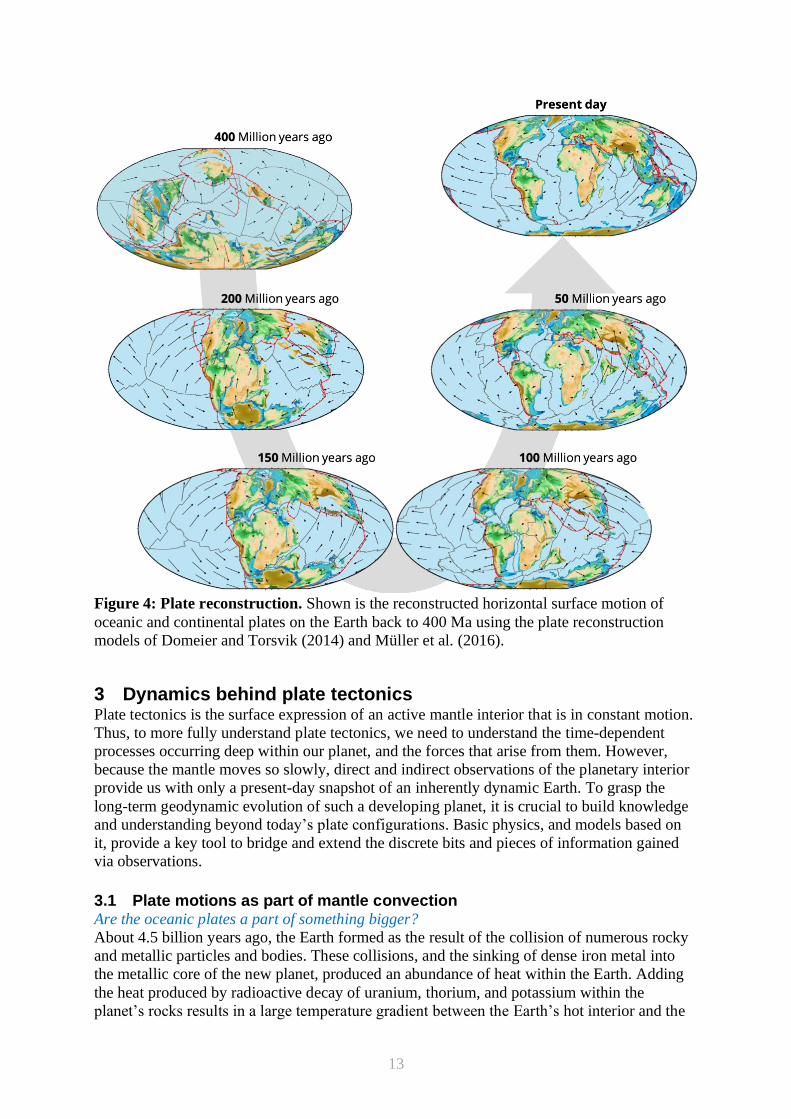
The relative motion of plates can be reconstructed using various present-day observations.
However, the further back in time the reconstructions are extended, the more uncertain they
become. Palaeomagnetism provides a key constraint on past positions of the plates (see
Section 1.3). The individual rocks of the plates register not only the polarity of the magnetic
field, but crucially also its inclination. Despite frequent polarity reversals, the overall pattern
of the magnetic field - a dipolar field with field lines streaming out of one of the Earth’s polar
regions, along and around the equator and into the opposite polar region – has remained the
same through most of Earth’s history. The angle of these magnetic field lines with the Earth’s
surface is called the magnetic field inclination, and is always steep (around 90° dip) at the
poles and is less inclined towards the equator, where it becomes horizontally aligned (around
0° dip) with the surface. As with the tape recorder of magnetic polarity, the inclination of the
magnetic field can also be preserved at the time of rock formation. In combination with
accurately dating the rocks (i.e., determining their absolute age), the magnetic field inclination
can be reconstructed through time, and with it, the latitudinal position of the given rocks and
their parent plates (see Figure 4).
Whilst providing a plate’s latitude back in time, palaeomagnetic data does not constrain the
longitude. Indeed, uncertainty in longitude presents a major obstacle to the construction of
reliable reconstructions of plate motions of the past (Torsvik et al., 2008). Furthermore,
palaeomagnetic observations are mostly only available for continental rocks - the oceanic
plates between the continents must be reconstructed with other data.
The observed ages of the present-day seafloor (see Figure 3) tell us how the oceanic plates
have moved relative to each other during recent geologic history. The Atlantic Ocean, which
has experienced minimal subduction, records the motions of North and South America away
from Eurasia and Africa since opening of this basin began approximately 180 million years
ago. Information about seafloor in Pacific Ocean (or more specifically the basin that it
describes; today it is made up on numerous plates like the Nazca, Pacific and Cocos plates),
however, is and has been constantly lost to subduction, which makes tectonic reconstructions
of that basin increasingly uncertain moving backward in time. Some details about the Pacific
basin’s lost tectonic plates have been preserved in the geologic structures along its margins.
Such constraints, when combined with palaeomagnetic data from the continents, allow
reliable plate reconstructions to be extended back to around 400 million years ago (Domeier
and Torsvik, 2014; Matthews et al., 2016; Figure 4).
13
Figure 4: Plate reconstruction. Shown is the reconstructed horizontal surface motion of
oceanic and continental plates on the Earth back to 400 Ma using the plate reconstruction
models of Domeier and Torsvik (2014) and Müller et al. (2016).
3 Dynamics behind plate tectonics Plate tectonics is the surface expression of an active mantle interior that is in constant motion.
Thus, to more fully understand plate tectonics, we need to understand the time-dependent
processes occurring deep within our planet, and the forces that arise from them. However,
because the mantle moves so slowly, direct and indirect observations of the planetary interior
provide us with only a present-day snapshot of an inherently dynamic Earth. To grasp the
long-term geodynamic evolution of such a developing planet, it is crucial to build knowledge
and understanding beyond today’s plate configurations. Basic physics, and models based on
it, provide a key tool to bridge and extend the discrete bits and pieces of information gained
via observations.
3.1 Plate motions as part of mantle convection Are the oceanic plates a part of something bigger?
About 4.5 billion years ago, the Earth formed as the result of the collision of numerous rocky
and metallic particles and bodies. These collisions, and the sinking of dense iron metal into
the metallic core of the new planet, produced an abundance of heat within the Earth. Adding
the heat produced by radioactive decay of uranium, thorium, and potassium within the
planet’s rocks results in a large temperature gradient between the Earth’s hot interior and the
14
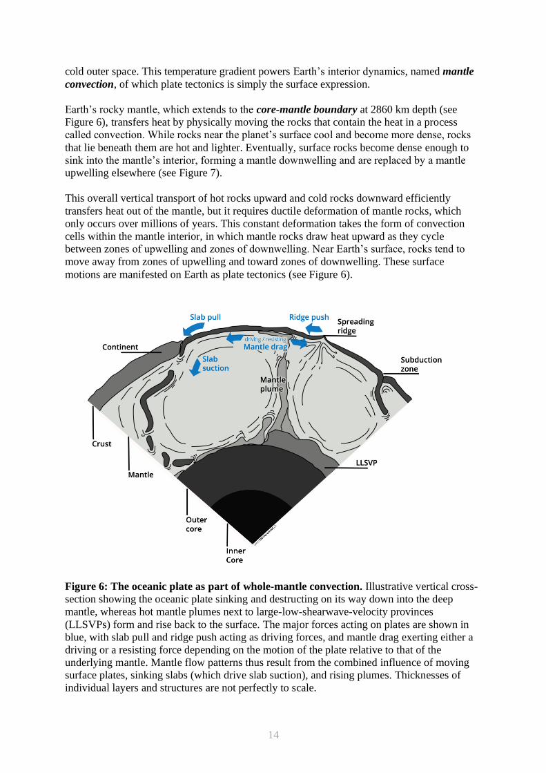
cold outer space. This temperature gradient powers Earth’s interior dynamics, named mantle
convection, of which plate tectonics is simply the surface expression.
Earth’s rocky mantle, which extends to the core-mantle boundary at 2860 km depth (see
Figure 6), transfers heat by physically moving the rocks that contain the heat in a process
called convection. While rocks near the planet’s surface cool and become more dense, rocks
that lie beneath them are hot and lighter. Eventually, surface rocks become dense enough to
sink into the mantle’s interior, forming a mantle downwelling and are replaced by a mantle
upwelling elsewhere (see Figure 7).
This overall vertical transport of hot rocks upward and cold rocks downward efficiently
transfers heat out of the mantle, but it requires ductile deformation of mantle rocks, which
only occurs over millions of years. This constant deformation takes the form of convection
cells within the mantle interior, in which mantle rocks draw heat upward as they cycle
between zones of upwelling and zones of downwelling. Near Earth’s surface, rocks tend to
move away from zones of upwelling and toward zones of downwelling. These surface
motions are manifested on Earth as plate tectonics (see Figure 6).
Figure 6: The oceanic plate as part of whole-mantle convection. Illustrative vertical cross-
section showing the oceanic plate sinking and destructing on its way down into the deep
mantle, whereas hot mantle plumes next to large-low-shearwave-velocity provinces
(LLSVPs) form and rise back to the surface. The major forces acting on plates are shown in
blue, with slab pull and ridge push acting as driving forces, and mantle drag exerting either a
driving or a resisting force depending on the motion of the plate relative to that of the
underlying mantle. Mantle flow patterns thus result from the combined influence of moving
surface plates, sinking slabs (which drive slab suction), and rising plumes. Thicknesses of
individual layers and structures are not perfectly to scale.
15
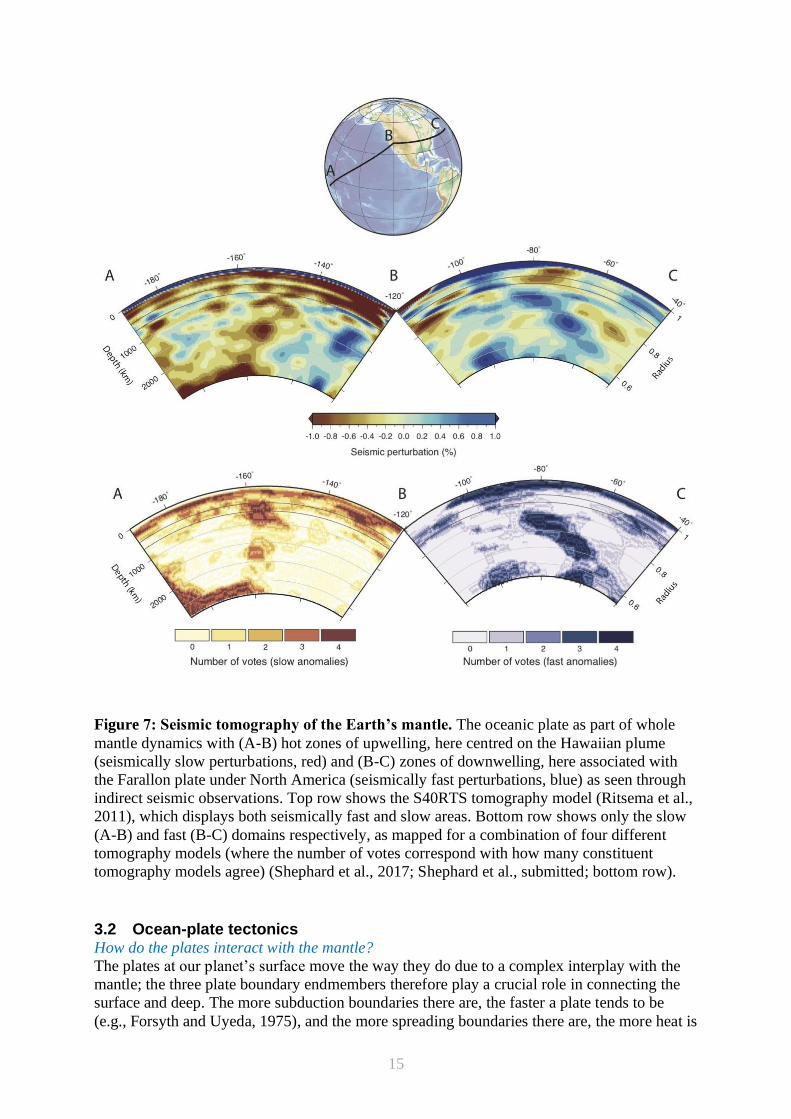
Figure 7: Seismic tomography of the Earth’s mantle. The oceanic plate as part of whole
mantle dynamics with (A-B) hot zones of upwelling, here centred on the Hawaiian plume
(seismically slow perturbations, red) and (B-C) zones of downwelling, here associated with
the Farallon plate under North America (seismically fast perturbations, blue) as seen through
indirect seismic observations. Top row shows the S40RTS tomography model (Ritsema et al.,
2011), which displays both seismically fast and slow areas. Bottom row shows only the slow
(A-B) and fast (B-C) domains respectively, as mapped for a combination of four different
tomography models (where the number of votes correspond with how many constituent
tomography models agree) (Shephard et al., 2017; Shephard et al., submitted; bottom row).
3.2 Ocean-plate tectonics How do the plates interact with the mantle?
The plates at our planet’s surface move the way they do due to a complex interplay with the
mantle; the three plate boundary endmembers therefore play a crucial role in connecting the
surface and deep. The more subduction boundaries there are, the faster a plate tends to be
(e.g., Forsyth and Uyeda, 1975), and the more spreading boundaries there are, the more heat is
16
lost. Global plate direction rearrangement events seem to be rare, which indicates that the
plates are not only driven, but also stabilised and guided by their plate boundaries. How this
interplay between plate boundaries, plate interiors and the surrounding mantle acts on the long
term is still not fully understood, even though it is a key aspect of the Earth Sciences. As such,
it is necessary to further inspect what defines, controls and characterises the oceanic plates
and their dynamics, which is also referred to as ocean-plate tectonics (Crameri et al., 2019).
3.2.1 Ocean-plate formation and cooling
While continental lithosphere remains at the Earth’s surface and records an ancient history
associated with its long journey across the planetary surface, the oceanic plates are more
ephemeral features in geologic history. As the plates move away from the mid-ocean ridges,
they cool slowly, losing heat to the ocean or atmosphere above them. This cooling represents
the primary mechanism by which the Earth loses heat from its interior. Indeed, most heat
escapes the Earth’s mantle via the oceanic plates. Around 70% heat loss is attributed to the
oceanic plates, while the small remaining part of around 30% is attributed to continental
plates (e.g., Jaupart et al. 2015). To be more specific, most of the heat escapes the planet at
the spreading ridges and their ridge flanks: A whopping 75% of the oceanic heat loss occurs
in oceanic plate portions younger than 67 My, while only 25% of it is lost through the
remaining, older oceanic plate portions (Davies and Davies, 2010).
The cooling also causes the plates to become thicker as they move away from the ridge,
because the thickness of the cold and rigid layer that comprises the plates increases as the
plates lose heat. On the flanks of the mid-ocean ridges, the plate thickness may only be a few
tens of kilometres, while the thickness may increase to 100 km or more for the oldest
lithosphere. The extra heat beneath the ridges causes the upper part of the mantle to be less
dense than it is under older lithosphere. As a result, the ridges ride high above the rest of the
seafloor, just as the low-density continents are elevated above the oceans (see Figures 1 and
3b). These elevated ridges, which transmit heat from the interior more rapidly than any other
geologic feature, are an enduring and characteristic emblem of plate tectonics.
3.2.2 Ocean-plate destruction
Subduction zones control plate speed, are single-sided, with only one of the two colliding
plates sinking asymmetrically into the mantle, and are intrinsically arcuate from a bird’s eye
view (see Figures 2 and 3). The single-sidedness arises due to a strong strength contrast
between the sinking plate and the plate interface, and an efficient lubrication effect which
decouples the two colliding plates (Crameri et al., 2012). The arcuate shape of sinking plates
and their related subduction zones are not a result of what has been called the “Ping-Pong ball
effect”, but in fact due to the sinking plate’s surrounding mantle material and the induced
flow of it (Crameri and Tackley 2014). Sinking plates tend to retreat and thereby move mantle
material behind them around the plate edges to their front side (Funiciello et al., 2003, 2004).
This induced mantle flow deforms and curves the sinking plate naturally to become arcuate.
3.3 The forces acting on the plates What drives the plates; what slows them?
Understanding plate dynamics necessitates understanding the forces acting on the system. To
describe the forces, one has to first distinguish the oceanic plate portions, which are the
intimate part of mantle convection, from the continental plate portions, which remain at the
surface and do not take part in whole-mantle overturn. Various forces, internal and external,
act on the plates and their relative importance varies depending on location and time (see
Figure 6). The key driver for oceanic plates is usually their sinking plate portion, the
subducting slab, which exerts the dominating force on the surface plate called slab pull
17
(Forsyth and Uyeda, 1975; Davies, 1981; Conrad and Lithgow-Bertelloni, 2002; Figure 6).
Not all plates have sinking plate portions attached to them (e.g., the South America plate),
which results in other forces acting as primary drivers of the plate’s horizontal surface motion.
Another driving force is attributed to spreading ridges. When plates are formed at spreading
ridges, they are thin and light compared to old plate portions closer to subduction zones. Due
to the fact that both sides of the plate (in fact all the plates) are floating on the same pool of
slowly deforming mantle material, lighter parts are pushed up further than heavier parts,
similarly to a small versus a big floating ice cube on water. Spreading ridges are therefore
higher (or further away from the gravitational centre of the Earth) than older portions of the
plate near subduction zones. This topographic difference causes a ridge push that forces the
plate from the elevated spreading ridge towards the subduction zone (see Figure 6). Generally,
it is thought that the ridge push force is much smaller than the slab pull force (Lithgow-
Bertelloni and Richards, 1998).
Yet another important force on the moving plates comes from below. This basal traction
force (or mantle drag; see Figure 6) arises from the mantle beneath the plates, which is slowly
moving but not necessarily with the same direction and speed as the surface plate. The
viscous interaction between the plate and mantle flow can act as either a driving or resisting
force on plate motion. If the plate is moving faster than the mantle, then the basal tractions
will tend to act as a drag on the plate, resisting its motion. This is generally the case for plates
driven by slab pull, which usually propels these plates more rapidly than the mantle below
them flows. On the other hand, if the mantle is moving faster than the plate, then it tends to
drag the plate along with its motion, generating basal tractions that act as the dominant
driving force for this plate. This is generally the situation for plates without major attached
slabs (e.g., the North American, South American, Eurasian, and African plates). These plates
all move more slowly (see Figure 3) than plates with a large slab pull force (e.g., the Indian,
Australian, Philippine Sea, Pacific, Nazca, and Cocos plates).
Gravity acting on the cold, dense slabs of subducted oceanic plates provides the largest energy
source for mantle convection, and thus represents the ultimate primary driver of plate
motions. The slab pull force transmits part of this driving potential directly to the subducting
plates, which support part of the weight of slabs - much like a tablecloth supports the weight
of its hanging portion. However, the mantle material around each slab also supports some of
its weight, and this component drives flow in the surrounding mantle, similar to the way that a
rock sinking slowly in honey would also drive flow of the honey. This component, sometimes
called slab suction (see Figure 6), tends to drive the flow that draws the plates around it
toward the slab (via the basal traction on these plates). The same suction force acts in the
trailing water of a sinking ship, which is why you are advised to try and swim out horizontally
before finding your way up to the surface again in such a scenario. On Earth, a slab sinking
down into the deep mantle excites flow in convection cells on either side of it. The cell
beneath the oceanic plate moves together with the trailing plate portion, which is driven
rapidly by slab pull toward the subduction zone. The cell beneath the overriding plate also
drives mantle flow toward the subduction zone, but the surface plate in this case moves more
slowly because it is driven only by basal tractions and not also by slab pull. It is thought that
the uppermost 300-600 km of a slab’s length is sufficiently coupled to the surface plate to
drive direct slab pull; the rest of the slab (including its lower mantle portion) is thought to be
supported by the mantle, and drives mantle flow directly (Conrad & Lithgow-Bertelloni,
2002).
18
Besides basal tractions that drag on plates, key resisting forces include internal and external
friction on the plates. The plate internal friction, the plate’s resistance to deform, acts
predominantly at subduction zones, where the whole plate needs to significantly bend
downwards in order to underthrust another, the upper plate. An additional external resisting
force arises in form of inter-plate friction at the plate interface of the subduction zone, and
similar frictional resistance may be exerted between neighbouring plates at transform faults.
It becomes clear that a large driving force is necessary to overcome the cumulative resistance
to plate motion. This is usually provided by slab pull. However, how to initiate the sinking of
a plate in the first place, with no pre-existing slab and slab pull, appears difficult and is,
indeed, still a major unanswered question of the Earth Sciences (see Section 4.3.2).
4 The uniqueness of plate tectonics To better understand a dynamic system like the Earth – with its apparently unique evolution
featuring a plate tectonics mode of mantle convection - it is pivotal to have comparable
planetary systems. While there are only a handful of comparable, rocky planetary bodies
within reach, studying these planetary bodies and understanding how and why they evolved
differently provides key information about the Earth itself.
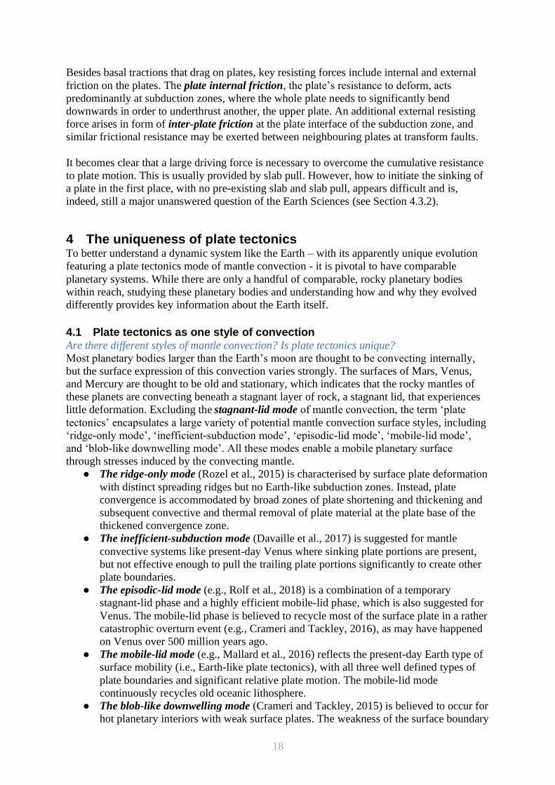
4.1 Plate tectonics as one style of convection Are there different styles of mantle convection? Is plate tectonics unique?
Most planetary bodies larger than the Earth’s moon are thought to be convecting internally,
but the surface expression of this convection varies strongly. The surfaces of Mars, Venus,
and Mercury are thought to be old and stationary, which indicates that the rocky mantles of
these planets are convecting beneath a stagnant layer of rock, a stagnant lid, that experiences
little deformation. Excluding the stagnant-lid mode of mantle convection, the term ‘plate
tectonics’ encapsulates a large variety of potential mantle convection surface styles, including
‘ridge-only mode’, ‘inefficient-subduction mode’, ‘episodic-lid mode’, ‘mobile-lid mode’,
and ‘blob-like downwelling mode’. All these modes enable a mobile planetary surface
through stresses induced by the convecting mantle.
● The ridge-only mode (Rozel et al., 2015) is characterised by surface plate deformation
with distinct spreading ridges but no Earth-like subduction zones. Instead, plate
convergence is accommodated by broad zones of plate shortening and thickening and
subsequent convective and thermal removal of plate material at the plate base of the
thickened convergence zone.
● The inefficient-subduction mode (Davaille et al., 2017) is suggested for mantle
convective systems like present-day Venus where sinking plate portions are present,
but not effective enough to pull the trailing plate portions significantly to create other
plate boundaries.
● The episodic-lid mode (e.g., Rolf et al., 2018) is a combination of a temporary
stagnant-lid phase and a highly efficient mobile-lid phase, which is also suggested for
Venus. The mobile-lid phase is believed to recycle most of the surface plate in a rather
catastrophic overturn event (e.g., Crameri and Tackley, 2016), as may have happened
on Venus over 500 million years ago.
● The mobile-lid mode (e.g., Mallard et al., 2016) reflects the present-day Earth type of
surface mobility (i.e., Earth-like plate tectonics), with all three well defined types of
plate boundaries and significant relative plate motion. The mobile-lid mode
continuously recycles old oceanic lithosphere.
● The blob-like downwelling mode (Crameri and Tackley, 2015) is believed to occur for
hot planetary interiors with weak surface plates. The weakness of the surface boundary
19
layer causes a stronger viscous coupling with the underlying, flowing mantle, which
results in more and more regular downwelling and with it, surface plate recycling.
All these strongly differing dynamic modes of mantle convection and surface mobility are
tightly linked to the thermal evolution of the planet and reflect the most efficient way for a
given planet to move heat from its interior to outer space. Additional global heat transport
mechanisms like the heat-pipe mechanism (e.g., Moore and Webb, 2013) do interact in some
circumstances strongly with the outlined dynamic modes of mantle convection.
4.1.1 Mixed Modes
A planet may switch from one tectonic style to another during its history, for example, as it
cools (O’Neill et al., 2016). It may also feature multiple modes of convection at the same
time, for example, if a planet has a heterogeneous surface or geographically diverse heating
and cooling patterns. The Earth’s style of tectonics, for example, could be considered to
combine ocean-plate tectonics (Crameri et al., 2019), in which oceanic lithosphere subducts
into the planetary interior, with convection beneath smaller buoyant and rigid lids
(continents). In another example, a tidally-locked exoplanet (an astronomically-detected
planet outside of our solar system) should be heated by stellar radiation only on one side. This
heating may lead to diffuse deformation of the planetary surface on that side, but plate
tectonics and subduction on the opposite (cold) side (van Summeren et al., 2011).
4.1.2 Consequences
Because of its plate tectonic mode, the Earth’s surface is not a dynamically closed system, in
fact, it is only the uppermost part of a global, whole-mantle flow system. This has important
consequences for the planet as a whole. The oceanic plates at the surface are regularly
recycled, including the carbon-bearing sediments and water-bearing minerals. This recycling
has important consequences for Earth’s surface environment, but also the long-term
composition of the mantle interior. The sinking plates that have been cooled at the surface for
some tens of millions of years efficiently cool the hot mantle, while also driving flow in their
surroundings. The subduction-induced mantle flow enables significant mixing of materials
within the Earth’s mantle.
The surface recycling inherent to plate tectonics causes our planet to be more geologically
active at the surface compared to stagnant-lid planets such as Mars. This activity tends to
erase the geologic history that is recorded in the surface rocks, particularly those that are
recycling into Earth’s interior. Some memory of this recycled material is maintained within
our planetary interior, and can be linked to the reconstructed history at the surface, perhaps at
most back to 200-300 million years (van der Meer et al., 2010). Such a recorded history is
much younger than we find for other planets such as Venus (surface records 500 million years
or longer) or Mars (surface records at least 4 billion years; Hartmann and Neukum, 2001).
The surfaces of these other planets may more closely resemble Earth’s continents in terms of
their age, although Earth’s actively convecting mantle causes more deformation and
volcanism on Earth’s continents than we find on other planetary surfaces.
4.2 Mantle-surface interactions How does the plate-mantle system impact our surface environment? What volatiles enter the
mantle?
4.2.1 Surface topography
The most obvious, direct observable of mantle convection is surface topography. Horizontal
and vertical flows within the plate-mantle system form prominent, kilometres-high mountain
ranges and kilometres-deep deep-sea trenches (see Figures 1 and 3a). While localised
upwelling and downwelling below plate interiors, and the volcanism that sometimes

20
accompanies it, can cause regional changes in elevation, like continental basins or seamounts,
the largest and most extensive topographic relief occurs near plate boundaries (Figure 2).
Earth’s near bi-modal surface topography generally highlights differences in plate nature,
with thick, light and therefore highly elevated continental portions opposing thin, heavy and
therefore deeper oceanic portions. The oceanic plates have a general topographic trend,
switching from high topography at the spreading ridges, where they are young and buoyant, to
largely flat abyssal plains, to low topography at the subduction trench where they have
become negatively buoyant with respect to the underlying mantle. Continental collision,
which is a fundamental phase of supercontinent formation, generally results in compression of
both colliding continents, resulting in a great mountain belts such as the Alpine – Tibetan
orogeny that resulted from collision of Africa and India into Eurasia.
Close to the subduction trench surface topography displays diverse but characteristic regional
features (Crameri et al., 2017; see Figure 2) including for both ocean-ocean and ocean-
continent subduction settings. On the subducting plate, before it enters the trench, the plate
deforms across an area known as the viscous fore-bulge. The magnitude and geometry of the
fore-bulge is mainly controlled by the sinking angle of the shallow downgoing plate portion.
After bulging upwards, the oceanic plate forms a deep subduction trench on its way down into
the mantle. Subduction trenches - the location of the actual plate interface between subducting
and overriding plates - ring the Pacific basin, including the Marianas Trench, which at its
deepest point is around 11 km below sea-level. Adjacent to the trench, a back-arc sometimes
forms on the upper plate, indicating local extension in an overall compressional setting i.e.
between the two colliding plates. The subduction zone also features an island arc, which is
usually overprinted by volcanic activity, and may produce a great mountain belt (e.g., the
Andes) or an island arc (e.g., Tonga or the Marianas islands).
Stresses from mantle convection occurring beneath the plates can also produce time-
dependent uplift or subsidence of the Earth’s surface across broad (continental-scale) regions.
This dynamic topography is generally positive (uplifting) above mantle upwelling and
negative (subsiding) above downwelling. Such topography is thought to significantly deflect
both seafloor and continental areas, by up to several hundred meters (Steinberger et al., 2019),
and can significantly impact both continental history, for example through river drainage
patterns (Shephard et al., 2010), and sea-level (Conrad and Husson, 2009).
4.2.2 Volatile cycle
The recycling of the plates that is inherent to plate tectonics has important implications for
Earth’s interior as well as its surface environment. Of particular importance is the recycling of
volatiles such as carbon and hydrogen between the Earth’s surface and its interior. Indeed,
volatile recycling is so important that it has been suggested to be responsible for allowing
plate tectonics on Earth (water) and for maintaining Earth’s habitability over geologic time
(carbon).
Water can be recycled into Earth’s interior at subduction zones. Several minerals within the
oceanic plate can become hydrated, incorporating water within their mineral structure.
Although some of this water is released by volcanism in the back-arc (and indeed helps to
induce this volcanism), some of this water can be transported deep within the mantle (van
Keken et al., 2011). Hydrated minerals are thought to store several oceans worth of minerals
within the mantle. This water can be released back to the surface by volcanism at mid-ocean
ridges and hotspots, but imbalances between the rate of influx at subduction zones and outflux
by volcanism can cause sea level change over geologic time (Karlsen et al., 2019). Because
21
the presence of water within mantle rocks is thought to lower their viscosity, the deep water
should have a significant impact on overall mantle convection as well as the Earth’s thermal
history (Crowley et al., 2011). Over the long-term, the Earth’s oceans are thought to be slowly
draining into Earth’s interior as the planet cools, and indeed the lubrication associated with
this hydration may be responsible for maintaining plate tectonics on Earth (Korenaga, 2011).
Several have noted that presence of water is one factor that distinguishes our planet (with
plate tectonics) from Venus (without plate tectonics).
Besides changing the volume of water in the oceans over geologic time, plate tectonics also
impacts sea-level by changing the shape of the ocean basins. In the past 100 million years, the
Earth’s ridge system is thought to have significantly diminished in width, primarily because
slower spreading today produces ridges that are more steeply-flanked (older, deeper, seafloor
is closer to the ridge). This additional aging of the world’s seafloor is thought to have caused
the average ocean depth to increase, dropping sea level by up 250 m since the Cretaceous. Sea
level during that time period may also have been higher due to an influx of seafloor volcanism
(including submarine flood basalts, or large igneous provinces), but the additional ~50 m of
sea level associated with volcanism may have been offset by smaller volumes of sediments
stored on the on-average younger Cretaceous seafloor. These factors, as well as dynamic
topography (which changes seafloor topography) and mountain building (which changes
ocean area), make plate tectonics the dominant factor that controls sea level change over
geologic timescales (Conrad, 2013).
Like water, carbon is also subducted into Earth’s interior and emitted back to the surface by
volcanism (Clift, 2017). Although carbon has a much smaller impact on mantle properties,
and thus may not affect Earth’s interior dynamics as greatly as water does, carbon’s impact on
Earth’s surface climate is critical. Variations in the rate of mid-ocean ridge spreading, and the
carbon released by the associated volcanism, can induce variations in Earth’s surface climate
(Müller and Dutkiewicz, 2018). More fundamentally, the recycling of surface material by
plate tectonics prevents carbon from accumulating within Earth’s surface environment, as it
does on other planets (such as Venus). The geological activity associated with plate tectonics
also prevents carbon from being permanently stored in geological formations (such as
carbonates). Indeed, the recycling of carbon by plate tectonics is thought to significantly
extend the period of potential habitability of a planet (Foley and Smye, 2018), and may be a
factor that has helped maintain a life-sustaining environment on Earth.
4.3 Necessities for plate tectonics 4.3.1 Initiation
How and when did plate tectonics start? Did it ever truly “start”?
To fully understand a physical concept like plate tectonics, it is necessary to ask not only
about how it functions today, but also about how it came to be in the first place. Answering
the latter question is challenging and involves some conceptual pitfalls. To even ask the
question, for example, “Where does plate tectonics begin?”, one has to ask multiple additional
questions beforehand.
To ask where (i.e., in what geologic setting) plate tectonics might have started, one needs to
first ask how (i.e., under what geophysical condition) it starts. To ask how it starts, one first
has to ask when it might have started (i.e., at what stage on an evolving planet). To ask when
it might have started, one has to ask how many times it started (and shut off again). To ask
how many times it might have started, one has to first ask the fundamental question if it has
ever started (or whether it has gradually evolved out of the original magma ocean phase). To-
date, it is still not clear whether plate tectonics on Earth evolved out of a magma ocean or
22
whether it originated out of a one-plate planetary system. Since we still know very little about
the origin and subsequent evolution of plate tectonics on Earth, posing and answering these
higher-level questions, is challenging and may lead to significant confusion.
Another major hurdle arises because plate tectonics erases its own traces. On present-day
Earth, oceanic plates remain younger than around 200 My because old portions sink back
down into the mantle and are therefore constantly recycled. However, in ocean-continent
collision zones some oceanic plate material can be scraped off and emplaced on continents.
These rocks sequences are characteristic for the formation of oceanic lithosphere and are
known as ophiolites. They provide us with some sparse evidence for both formation and
relative mobility (i.e., divergence and convergence) of oceanic plates back in time (see e.g.,
Stern, 2007; Condie and Pease, 2008). Ophiolites have been found to sample oceanic plate
formation and mobility (i.e., plate tectonics) back to at least 1 Ga, and possibly back even
further than 2 Ga (e.g., Scott et al., 1992). Early evidence for ocean-plate tectonics, which by
definition also necessitates the presence of deep subduction, is stored by old blueschists, a
different kind of rock that samples the low-temperature and high-pressure environments of
subduction zones. Some blueschists have been dated back to ages of around 800–700 Ma
(Maruyama et al., 1996). Samples like these support the operation of ocean-plate tectonics
with modern-style subduction for at least the past billion years (Brown, 2006). The absence of
similar samples with older ages does not, however, mean that they never existed: They simply
might not have been preserved.
4.3.2 Maintenance
How does ocean-plate tectonics remain active? How are new subduction zones formed?
To maintain plate tectonics and sustain the key driving forces, new subduction zones must be
created. However, subduction zone initiation (SZI) is still an enigmatic and poorly understood
process (Crameri et al., submitted) including for SZI events in the recent past and in the early
Earth world. Understanding the mechanisms and characteristics of SZI is compounded by
incomplete and often missing geologic evidence. In addition, the onset of a new subduction
zone is slow compared to human time scales and involves many complicated physical
processes, which are difficult to disentangle.
An interdisciplinary effort has been undertaken during recent years to combine available
information about how subduction zones form via geologic evidence, plate reconstructions,
seismic tomography, and geodynamic modelling. It has recently become clear that subduction
zones on the Earth during the last 100 My or so generally formed near pre-existing subduction
systems and in the presence of significant tectonic forcing (Crameri et al., submitted). This
indicates that subduction is self-maintaining and self-regulating on a planet like the Earth.
5 Future directions 5.1 Long-term Wilson cycle tectonics and the link to deep mantle Has plate tectonics always operated as it does today?
The longevity of plate tectonics on Earth (see Section 4.3.1) calls us to ask several questions:
Has the character of plate tectonics changed with time? Can we observe long-term patterns in
the Earth’s expression of plate tectonics? How will plate tectonics change in the future?
Answering these questions requires us to look deeply into the geological record to understand
the time history of plate tectonics. This effort has led to several advancements in our
understanding of how ocean-plate tectonics (Section 3) evolves over time as it interacts with
Earth’s interior dynamics.
23
Observations from palaeomagnetism have shown us that the continents were once assembled
together in a “supercontinent”. The existence of this most recent supercontinent, which we
now know as Pangea, was inferred from the earliest ideas about continental drift (see Section
1.3). The details of its breakup during the past 200 million years have been described by
tectonic reconstructions (Figure 4), which provide us with plate configurations of the past that
do not exist today. These “snapshots” of our planet at past times tell us a great deal about the
underlying processes that control plate motions, including the speeds and sizes of plates that
are possible, the forces that drive the plates, and how the plate dynamics change over time.
Beyond the overall breakup of Pangea, we have been able to deduce a few long-term patterns
in plate tectonic behaviour. First, plates with long subduction zones tend to move faster than
those without, and plates with large continents tend to move more slowly than ocean-
dominated plates. These trends can be explained by slab pull driving plate motions while
increased basal drag beneath continents may slow them down (van Summeren et al., 2012).
Oceanic plates may move up to about 20 cm/a for short periods of time, and continent-
dominated plates may move up to about 10 cm/a (Zahirovic et al., 2015). Plates approaching
these “plate tectonic speed limits” tend to have unusual and short-lived forces that act upon
them, such as a “push” from a rising mantle plume that may have been acting on India prior to
its collision with Asia about 70 million years ago (Cande and Stegman, 2011).
If we look at the overall patterns of global plate motions, instead of the speeds of individual
plates by themselves, we find some interesting patters. For example, we find that on average
the plates are currently diverging away from both Africa and the central Pacific. This makes
sense because Africa is surrounded by a ridge system and the Pacific hosts the East Pacific
Rise, which is world’s fastest spreading ridge (Fig. 3a). This pattern of plate divergence is
also consistent with images of the mantle from seismic tomography (Fig. 7), which show
subducted slabs around the Pacific and seismically slow velocities in the mantle beneath the
central Pacific and Africa. If we infer that downwelling and upwelling is associated with slabs
and slow seismic velocities, respectively, then the broad-scale upwelling beneath Africa and
the Pacific is consistent with the overall motion of the plates away from these areas (Conrad
and Behn, 2010). Furthermore, analysis of tectonic reconstructions shows that African and
Pacific locations of overall plate divergence seem to have remained relatively stationary for
the past 250 million years (Conrad et al., 2013). This suggests that two broad-scale
upwellings, beneath the central Pacific and Africa, have remained stable for a long period of
Earth’s history, despite major tectonic changes at the surface, such as the breakup of Pangea.
Long-term stability of flow patterns within the mantle suggests that there must be some
stabilizing influence acting on the plate-mantle system. One possibility is that two large
continent-sized structures at the base of the mantle, which have been observed in tomography
since the 1990s (Garnero et al., 2016), tend to stabilize mantle flow patterns. These structures,
which are often referred to as the “Large Low Shear Velocity Provinces” or LLSVPs (see
Figure 6), remain unmixed with the rest of the mantle because they are denser and stiffer than
other mantle rocks (Heyn et al., 2018). There is evidence from volcanism that the two
antipodal LLSVPs may have been sitting in their current locations beneath Africa and the
central Pacific for a long period of Earth history (Torsvik, 2019). If so, their stability may help
to also stabilize persistent upwelling flow of the mantle above them. What keeps these
LLSVPs in place despite active mantle flow around them? This is a topic of active research,
although mantle flow models show that plate motions tend to push dense material at the base
of the mantle into two “piles” in the current locations of the two LLSVPs (Bull et al., 2014).
Thus, Earth’s recent plate motions are consistent with the stability of LLSVPs in their current
locations. The long-term stability of mantle structures may be supported unusually stiff
24
material in the mid-mantle that permits upwelling and downwelling flows only in certain
locations, which should tend to stabilize flow patterns (Ballmer et al., 2017). The long-term
stability of mantle flow, and how it is related to mantle structures at depth and tectonic plate
motions at the surface, is currently the topic of active research.
Some clues shed light on plate tectonic patterns even further back in time. Soon after plate
tectonics was “discovered”, Wilson (1966) used marine fossils to demonstrate that a “proto-
Atlantic Ocean” existed prior to the formation of Pangea. This ocean basin has now been lost
to subduction, but it separated North America and Europe along approximately the same
boundary as the current Atlantic Ocean. This realization indicates continents may separate
along sutures from previous continental collisions, despite the fact that continental collision
tends to produce broad and enduring mountain ranges (Tibet and the Himalayas being a
current example resulting from collision of India and Eurasia). It also hints at periodic
assembly of the continents into a larger supercontinent, eventually followed by dispersal into
smaller segments that we see today. Pangea is only the most recent such a supercontinent
(Fig. 4), existing between about 350 and 200 million years ago. However, geologic
reconstructions indicate supercontinents during approximately 900-750 and 1550-1400
million years ago, which have been named Rodinia and Nuna, respectively (Li et al., 2019),
and geoscientists have predicted various future supercontinents based on different
extrapolations of current tectonic motions (Davies et al., 2018). Such cycles of supercontinent
assembly and dispersal, which are often referred to as “Wilson Cycles”, are governed by
changes to the distribution of heat within the Earth’s mantle (Rolf et al., 2012), with
supercontinents trapping heat beneath them until this heat is released by onset of ridge
spreading within the supercontinent. The supercontinent cycle can thus be thought of as a
mode of planetary convection (Section 4), although the dynamics of this interaction between
surface tectonics and mantle convection are not fully understood and remain a topic of
ongoing research.
5.2 Additional comparisons Is Earth’s tectonic evolution unique?
Astronomers are now detecting numerous planets orbiting distant stars outside of our solar
system. These planets come in a wide variety of sizes, densities, and orbital distances, but
some are thought to be rocky planets like ours, and some are about the same size. How many
of these planets exhibit plate tectonics? This is a difficult question to answer because we do
not expect to be able to detect subduction, the characteristic feature of Earth’s “ocean-plate
tectonics”, on any of these planets. It may be possible to detect atmospheric gasses that would
be indicative of active volcanism, but volcanism by itself is not a unique feature of plate
tectonics. The presence of a magnetic field, a surface ocean, or certain rock types might some
day be observable, but none of these features are thought to be indicative of plate tectonics.
Thus, we cannot expect to detect plate tectonics on a distant exoplanet.
Indeed, even if we knew the composition and interior structures of these distant worlds,
determining which ones should host plate tectonics would be challenging because we do not
know which unique features of Earth are necessary for plate tectonics to occur. Recent studies
have suggested that multiple factors may be important, with plate tectonics being more
probable on larger planets with cooler surface temperatures that permit rigid plates (Foley et
al., 2012). This would imply that the climate of a planet’s surface environment could be an
important factor, and that some worlds (like Venus) may be too hot for plate tectonics to
occur. Given that a planet’s surface environment may change over time, plate tectonics may
only be possible for a certain periods during a planet’s evolution. Other factors such as liquid
surface water, continental lithosphere, oceanic sediments, and a low-viscosity zone beneath
25
the plates (for Earth this is known as the “asthenosphere”) have also been proposed as
characteristics that facilitate plate tectonics on Earth. The frictional properties of the surface
rocks, and in particular their capacity to maintain enduring weak zones between plates, may
be critical. Thus, many factors acting together may determine a planet’s tectonic style, which
makes it difficult to estimate the galactic frequency of plate tectonics. Nevertheless, the broad
diversity of recently-discovered exoplanets has driven scientists to evaluate the tectonic
importance of a wide variety of planetary characteristics. This effort, which is continuing as
new exoplanets are discovered, has improved our understanding of plate tectonics on our own
planet.
5.3 Mantle convection unified concepts How can we communicate better about plates and the mantle?
Dedicated research efforts in the fifty-plus years since the original concept of plate tectonics
was proposed (see Section 1) has produced a wealth of information about how the tectonic
plates operate, and how intimately they are linked to global overturn of Earth’s mantle. As our
knowledge becomes more detailed and increasingly placed within a larger framework, it is
necessary to rephrase explanations and provide additional, supplementary concepts that
capture all key, updated aspects of our understanding. Even though the concept of ‘plate
tectonics’ has served us immensely throughout the last half century, it is now arguably in the
way of constructive discussions and advances. A discussion about the “the onset of plate
tectonics” fails because of the concept upon which it stands: The purely kinematic concept
“plate tectonics” captures neither its key driver (i.e., deep subduction), which often is assumed
to be one major indicator for the onset of plate motion, nor distinguishes between continental
and oceanic plate portions, nor considers any aspect of its bigger framework (i.e., mantle
convection). Unsurprisingly, current guesses for “the onset of plate tectonics” range all the
way from 800 Ma back to the very beginning of our planet’s evolution; an almost 4 Gy long
time span (e.g., Stern, 2007; Condie and Pease, 2008).
One recently defined concept aims to provide a more complete picture of the dynamics of the
oceanic plates by considering our current knowledge, and thereby facilitating communication
across the Earth Sciences’ disciplines. ‘Ocean-plate tectonics’ (see Glossary; Crameri et al.,
2019) describes ocean-plate dynamics with sufficient focus and considers its forcing and
framework. Ocean-plate tectonics distinguishes between the oceanic and continental plate
portions, describes deep subduction as its key driving mechanism, and considers the oceanic
plate as the surface expression of whole-mantle convection.
Facilitating communication with such clear and up-to-date concepts will likely build new
bridges between the individual disciplines of the Earth Sciences and beyond. The important
big picture of the oceanic plate and its role in whole-mantle convection will become even
clearer and, with it, the key remaining open questions about which we are all so curious.
Acknowledgment This work was supported by the Research Council of Norway Centres of Excellence project
223272.
References 1. Ballmer, M. D., C. Houser, J. W. Hernlund, R. M. Wentzcovitch, and K. Hirose
(2017), Persistence of strong silica-enriched domains in the Earth/'s lower mantle,
Nature Geosci, 10(3), 236-240, doi:10.1038/ngeo2898.
26
2. Benioff, H., 1949. Seismic evidence for the fault origin of oceanic deeps. Geol. Soc.
Am. Bull. 60 (12), 1837–1856.
3. Brown, M., 2006. Duality of thermal regimes is the distinctive characteristic of plate
tectonics since the Neoarchean. Geology 34 (11), 961–964.
http://dx.doi.org/10.1130/G22853A.1.
4. Bird, P. (2003), An updated digital model of plate boundaries, Geochemistry,
Geophysics, Geosystems, 4(3), doi:10.1029/2001gc000252.
5. Bull, A. L., M. Domeier, and T. H. Torsvik (2014), The effect of plate motion history
on the longevity of deep mantle heterogeneities, Earth and Planetary Science Letters,
401(0), 172-182, doi:http://dx.doi.org/10.1016/j.epsl.2014.06.008.
6. Cande, S. C., and D. R. Stegman (2011), Indian and African plate motions driven by
the push force of the Réunion plume head, Nature, 475(7354), 47-52,
doi:10.1038/nature10174.
7. Clift, P. D. (2017), A revised budget for Cenozoic sedimentary carbon subduction,
Reviews of Geophysics, 55(1), 97-125, doi:10.1002/2016RG000531.
8. Condie, K.C., Pease, V., 2008. When Did Plate Tectonics Begin on Planet Earth? vol.
440 Geological Society of America.
9. Conrad, C. P. (2013), The solid Earth’s influence on sea level, Geological Society of
America Bulletin, 125(7-8), 1027-1052, doi:10.1130/b30764.1.
10. Conrad, C. P., and M. D. Behn (2010), Constraints on lithosphere net rotation and
asthenospheric viscosity from global mantle flow models and seismic anisotropy,
Geochemistry Geophysics Geosystems, 11, Q05W05, doi:10.1029/2009GC002970.
11. Conrad, C. P., and L. Husson (2009), Influence of dynamic topography on sea level
and its rate of change, Lithosphere, 1(2), 110-120, doi:10.1130/l32.1.
12. Conrad, C.P., Lithgow-Bertelloni, C., 2002. How mantle slabs drive plate tectonics.
Science 298 (5591), 207–209. http://dx.doi.org/10.1126/science.1074161.
13. Conrad, C. P., and C. Lithgow-Bertelloni (2007), Faster seafloor spreading and
lithosphere production during the mid-Cenozoic, Geology, 35(1), 29-32,
doi:10.1130/g22759a.1.
14. Conrad, C. P., B. Steinberger, and T. H. Torsvik (2013), Stability of active mantle
upwelling revealed by net characteristics of plate tectonics, Nature, 498(7455), 479-
482, doi:10.1038/nature12203
15. Conrad, C. P., K. Selway, M. M. Hirschmann, M. D. Ballmer, and P. Wessel (2017),
Constraints on volumes and patterns of asthenospheric melt from the space-time
distribution of seamounts, Geophysical Research Letters, 44(14), 7203-7210,
doi:10.1002/2017GL074098.
16. Crameri, F., C.P. Conrad, L. Montési, and C.R. Lithgow-Bertelloni (2019), The life of
an oceanic plate, Tectonophysics, 760, 107-135, doi:10.1016/j.tecto.2018.03.016
17. Crameri, F., Tackley, P., 2014. Spontaneous development of arcuate single-sided
subduction in global 3-D mantle convection models with a free surface. J. Geophys.
Res. Solid Earth 119 (7), 5921–5942. http://dx.doi.org/10.1002/2014JB010939.
18. Crameri, F., & Tackley, P. J. (2015). Parameters controlling dynamically self‐consistent plate tectonics and single‐sided subduction in global models of mantle
convection. Journal of Geophysical Research: Solid Earth, 120(5), 3680-3706.
19. Crameri, F., & Tackley, P. J. (2016). Subduction initiation from a stagnant lid and
global overturn: new insights from numerical models with a free surface. Progress in
Earth and Planetary Science, 3(1), 30.
20. Crameri, F., Lithgow-Bertelloni, C.R., Tackley, P.J., 2017. The dynamical control of
subduction parameters on surface topography. Geochem. Geophys. Geosyst. 18 (4),
1661–1687. http://dx.doi.org/10.1002/2017GC006821.
27
21. Crameri, F., Tackley, P., Meilick, I., Gerya, T., Kaus, B., 2012. A free plate surface
and weak oceanic crust produce single-sided subduction on Earth. Geophys. Res. Lett.
39 (3), L03,306. http://dx.doi.org/10.1029/2011GL050046.
22. Crameri, F., V. Magni, M. Domeier, G.E. Shephard, K. Chotalia, G. Cooper, C.M.
Eakin, A.G. Grima, D. Gürer, Á. Király, E. Mulyukova, K. Peters, B. Robert, M.
Thielmann, Subduction zone initiation on the recent Earth strongly tied to ongoing
subduction (submitted Nat. Comms.)
23. Courtillot, V., A. Davaille, J. Besse, and J. Stock (2003), Three distinct types of
hotspots in the Earth’s mantle, Earth and Planetary Science Letters, 205(3–4), 295-
308, doi:http://dx.doi.org/10.1016/S0012-821X(02)01048-8.
24. Crowley, J. W., M. Gérault, and R. J. O'Connell (2011), On the relative influence of
heat and water transport on planetary dynamics, Earth and Planetary Science Letters,
310(3–4), 380-388, doi:10.1016/j.epsl.2011.08.035.
25. Davaille, A., Smrekar, S. E., & Tomlinson, S. (2017). Experimental and observational
evidence for plume-induced subduction on Venus. Nature Geoscience, 10(5), 349.
26. Davies, G.F., 1981. Regional compensation of subducted lithosphere: effects on geoid,
gravity and topography from a preliminary model. Earth Planet. Sci. Lett. 54 (3), 431–
441.
27. Davies, H. S., J. A. M. Green, and J. C. Duarte (2018), Back to the future: Testing
different scenarios for the next supercontinent gathering, Global and Planetary
Change, 169, 133-144, doi:https://doi.org/10.1016/j.gloplacha.2018.07.015.
28. Davies, J.H., Davies, D.R., 2010. Earth's surface heat flux. Solid Earth 1 (1), 5–24.
http:// dx.doi.org/10.5194/se-1-5-2010.
29. DeMets, C., R. G. Gordon, D. F. Argus, and S. Stein (1994), Effect of recent revisions
to the geomagnetic reversal time scale on estimates of current plate motions, Geophys.
Res. Lett., 21(20), 2191-2194, doi:10.1029/94GL02118.
30. Dietz, R.S., 1961. Continent and ocean basin evolution by spreading of the sea floor.
Nature 190 (4779), 854–857.
31. Domeier, M., & Torsvik, T. H. (2014). Plate tectonics in the late Paleozoic.
Geoscience Frontiers, 5(3), 303-350.
32. Earthquake Hazards Program (2017), Advanced National Seismic System (ANSS)
Comprehensive Catalog of Earthquake Events and Products: Various, U.S. Geological
Survey, https://doi.org/10.5066/F7MS3QZH.
33. Foley, B. J., and A. J. Smye (2018), Carbon Cycling and Habitability of Earth-Sized
Stagnant Lid Planets, Astrobiology, 18(7), 873-896, doi:10.1089/ast.2017.1695.
34. Foley, B. J., D. Bercovici, and W. Landuyt (2012), The conditions for plate tectonics
on super-Earths: Inferences from convection models with damage, Earth and
Planetary Science Letters, 331–332(0), 281-290, doi:10.1016/j.epsl.2012.03.028.
35. Forsyth, D., Uyeda, S., 1975. On the relative importance of the driving forces of plate
motion*. Geophys. J. R. Astron. Soc. 43 (1), 163–200. http://dx.doi.org/10.1111/j.
1365-246x.1975.tb00631.x.
36. Fukao, Y., Obayashi, M., 2013. Subducted slabs stagnant above, penetrating through,
and trapped below the 660 km discontinuity. J. Geophys. Res. Solid Earth 118 (11),
5920–5938.
37. Funiciello, F., Faccenna, C., Giardini, D., Regenauer-Lieb, K., 2003. Dynamics of
retreating slabs: 2. Insights from three-dimensional laboratory experiments. J.
Geophys. Res. 108 (B4), 2207. http://dx.doi.org/10.1029/2001JB000896.
38. Funiciello, F., Faccenna, C., Giardini, D., 2004. Role of lateral mantle flow in the
evolution of subduction systems: insights from laboratory experiments. Geophys. J.
Int. 157 (3), 1393–1406.
39. Garnero, E. J., A. K. McNamara, and S.-H. Shim (2016), Continent-sized anomalous
28
zones with low seismic velocity at the base of Earth's mantle, Nature Geosci, 9(7),
481-489, doi:10.1038/ngeo2733
40. Gerya, T., 2012. Origin and models of oceanic transform faults. Tectonophysics 522-
523 (0), 34–54.
41. Global Volcanism Program (2013), Volcanoes of the World, v. 4.8.3. Venzke, E (ed.).
Smithsonian Institution, https://doi.org/10.5479/si.GVP.VOTW4-2013.
42. Granot, R. (2016), Palaeozoic oceanic crust preserved beneath the eastern
Mediterranean, Nature Geoscience, 9, 701, doi:10.1038/ngeo2784
43. Hartmann, W. K., and G. Neukum (2001), Cratering Chronology and the Evolution of
Mars, Space Science Reviews, 96, 165-194, doi:10.1023/A:1011945222010.
44. Heezen, B. C. (1960). The rift in the ocean floor. Scientific American, 203(4), 98-114.
45. Hess, H.H., 1962. History of ocean basins. Petrol. Stud. 4, 599–620.
46. Heyn, B. H., C. P. Conrad, and R. G. Trønnes (2018), Stabilizing Effect of
Compositional Viscosity Contrasts on Thermochemical Piles, Geophysical Research
Letters, 45(15), 7523-7532, doi:10.1029/2018GL078799.
47. Jaupart, C., Labrosse, S., Lucazeau, F., Mareschal, J.C., 2015. Treatise on Geophysics.
Temperatures, Heat and Energy in the Mantle of the Earth, 2nd edition. Elsevier,
Oxford, pp. 223–270. http://dx.doi.org/10.1016/B978-0-444-53802-4.00126-3. Chap.
7.06.
48. Karlsen, K. S., C. P. Conrad, and V. Magni (2019), Deep Water Cycling and Sea
Level Change Since the Breakup of Pangea, Geochemistry, Geophysics, Geosystems,
20(6), 2919-2935, doi:10.1029/2019GC008232.
49. Korenaga, J. (2011), Thermal evolution with a hydrating mantle and the initiation of
plate tectonics in the early Earth, J. Geophys. Res., 116(B12), B12403,
doi:10.1029/2011jb008410.
50. Laurent, O., H. Martin, J. F. Moyen, and R. Doucelance (2014), The diversity and
evolution of late-Archean granitoids: Evidence for the onset of “modern-style” plate
tectonics between 3.0 and 2.5Ga, Lithos, 205, 208-235,
doi:https://doi.org/10.1016/j.lithos.2014.06.012.
51. Li, Z. X., R. N. Mitchell, C. J. Spencer, R. Ernst, S. Pisarevsky, U. Kirscher, and J. B.
Murphy (2019), Decoding Earth’s rhythms: modulation of supercontinent cycles by
longer superocean episodes, doi:10.1016/j.precamres.2019.01.009.
52. Lithgow-Bertelloni, C., and M. A. Richards (1998), The dynamics of Cenozoic and
Mesozoic plate motions, Rev. Geophys., 36(1), 27-78, doi:10.1029/97RG02282.
53. Magde, L.S., Sparks, D.W., Detrick, R.S., 1997. The relationship between buoyant
mantle flow, melt migration, and gravity bull's eyes at the Mid-Atlantic Ridge between
33 N and 35 N. Earth Planet. Sci. Lett. 148 (1-2), 59–67.
54. Mallard, C., Coltice, N., Seton, M., Müller, R. D., & Tackley, P. J. (2016). Subduction
controls the distribution and fragmentation of Earth’s tectonic plates. Nature,
535(7610), 140.
55. Matthews, K. J., K. T. Maloney, S. Zahirovic, S. E. Williams, M. Seton, and R. D.
Müller (2016), Global plate boundary evolution and kinematics since the late
Paleozoic, Global and Planetary Change, 146(Supplement C), 226-250,
doi:10.1016/j.gloplacha.2016.10.002.
56. Maruyama, S., Liou, J.G., Terabayashi, M., 1996. Blueschists and eclogites of the
world and their exhumation. Int. Geol. Rev. 38 (6), 485–594.
http://dx.doi.org/10.1080/00206819709465347.
57. Moore, W. B., & Webb, A. A. G. (2013). Heat-pipe earth. Nature, 501(7468), 501.
58. Morgan, W. J. (1968). Rises, trenches, great faults, and crustal blocks. Journal of
Geophysical Research, 73(6), 1959-1982.
59. Müller, R. D., M. Sdrolias, C. Gaina, and W. R. Roest (2008), Age, spreading rates,
29
and spreading asymmetry of the world's ocean crust, Geochemistry Geophysics
Geosystems, 9, Q04006, doi:10.1029/2007GC001743.
60. Müller, R. D., and A. Dutkiewicz (2018), Oceanic crustal carbon cycle drives 26-
million-year atmospheric carbon dioxide periodicities, Science Advances, 4(2),
doi:10.1126/sciadv.aaq0500.
61. Müller, R. D., Seton, M., Zahirovic, S., Williams, S. E., Matthews, K. J., Wright, N.
M., ... & Bower, D. J. (2016). Ocean basin evolution and global-scale plate
reorganization events since Pangea breakup. Annual Review of Earth and Planetary
Sciences, 44, 107-138.
62. Oliver, J., & Isacks, B. (1967). Deep earthquake zones, anomalous structures in the
upper mantle, and the lithosphere. Journal of Geophysical Research, 72(16), 4259-
4275.
63. O’Neill, C., A. Lenardic, M. Weller, L. Moresi, S. Quenette, and S. Zhang (2016), A
window for plate tectonics in terrestrial planet evolution?, Physics of the Earth and
Planetary Interiors, 255, 80-92, doi:http://dx.doi.org/10.1016/j.pepi.2016.04.002.
64. Parsons, B., 1981. The rates of plate creation and consumption. Geophys. J. Int. 67 (2),
437–448. http://dx.doi.org/10.1111/j.1365-246x.1981.tb02759.x.
65. Rolf, T., Steinberger, B., Sruthi, U., & Werner, S. C. (2018). Inferences on the mantle
viscosity structure and the post-overturn evolutionary state of Venus. Icarus, 313, 107-
123.
66. Rozel, A., Golabek, G. J., Näf, R., & Tackley, P. J. (2015). Formation of ridges in a
stable lithosphere in mantle convection models with a viscoplastic rheology.
Geophysical research letters, 42(12), 4770-4777.
67. Ritsema, J., Deuss, A. A., Van Heijst, H. J., & Woodhouse, J. H. (2011). S40RTS: a
degree-40 shear-velocity model for the mantle from new Rayleigh wave dispersion,
teleseismic traveltime and normal-mode splitting function measurements. Geophysical
Journal International, 184(3), 1223-1236.
68. Ritzwoller, M. H., N. M. Shapiro, and S. J. Zhong (2004), Cooling history of the
Pacific lithosphere, Earth and Planetary Science Letters, 226(1-2), 69-84,
doi:10.1016/j.epsl.2004.07.032.
69. Rolf, T., N. Coltice, and P. J. Tackley (2012), Linking continental drift, plate tectonics
and the thermal state of the Earth's mantle, Earth and Planetary Science Letters, 351–
352(0), 134-146, doi:10.1016/j.epsl.2012.07.011.
70. Runcorn, S. K. (1965). Palaeomagnetic comparisons between Europe and North
America. Philosophical Transactions of the Royal Society of London. Series A,
Mathematical and Physical Sciences, 258(1088), 1-11.
71. Scott, D.J., Helmstaedt, H., Bickle, M.J., 1992. Purtuniq ophiolite, Cape Smith belt,
northern Quebec, Canada: a reconstructed section of Early Proterozoic oceanic crust.
Geology 20 (2), 173–176. http://dx.doi.org/10.1130/0091-7613(1992)
020<0173:pocsbn>2.3.co;2.
72. Shapiro, S. S., B. H. Hager, and T. H. Jordan (1999), Stability and dynamics of the
continental tectosphere, Lithos, 48(1-4), 115-133, doi:10.1016/s0024-4937(99)00025-
0.
73. Shephard, G. E., Müller, R. D., Liu, L., & Gurnis, M. (2010). Miocene drainage
reversal of the Amazon River driven by plate–mantle interaction. Nature
Geoscience, 3(12), 870.
74. Shephard, G. E., Matthews, K. J., Hosseini, K., & Domeier, M. (2017). On the
consistency of seismically imaged lower mantle slabs. Scientific reports, 7(1), 10976.
75. Shephard, G.E., Houser, C., Hernlund, J.W.,Trønnes R.G., Valencia-Cardona, J.J. &
Wentzcovitch, R.M., Seismic Detection of the Iron Spin Crossover in Ferropericlase in
Earth’s Lower Mantle. submitted to Nature.
30
76. Steinberger, B., C. P. Conrad, A. Osei Tutu, and M. J. Hoggard (2019), On the
amplitude of dynamic topography at spherical harmonic degree two, Tectonophysics,
760, 221-228, doi:https://doi.org/10.1016/j.tecto.2017.11.032.
77. Stern, R., 2007. When and how did plate tectonics begin? Theoretical and empirical
considerations. Chin. Sci. Bull. 52 52 (5), 578–591.
78. Tesauro, M., P. Audet, M. K. Kaban, and S. Cloetingh (2012), The effective elastic
thickness of the continental lithosphere: Comparison between rheological and inverse
approaches, Geochemistry, Geophysics, Geosystems, 13(9),
doi:10.1029/2012gc004162.
79. Tharp, M. (1982). Mapping the ocean floor—1947 to 1977. The ocean floor: Bruce
Heezen commemorative volume. Wiley, New York, 19-31.
80. Torsvik, T. H., B. Steinberger, L. R. M. Cocks, and K. Burke (2008), Longitude:
Linking Earth's ancient surface to its deep interior, Earth and Planetary Science
Letters, 276(3–4), 273-282, doi:10.1016/j.epsl.2008.09.026.
81. Torsvik, T. H. (2019), Earth history: A journey in time and space from base to top,
Tectonophysics, 760, 297-313, doi:https://doi.org/10.1016/j.tecto.2018.09.009.
82. Van Der Meer, D. G., Spakman, W., Van Hinsbergen, D. J., Amaru, M. L., & Torsvik,
T. H. (2010). Towards absolute plate motions constrained by lower-mantle slab
remnants. Nature Geoscience, 3(1), 36.
83. van Keken, P. E., B. R. Hacker, E. M. Syracuse, and G. A. Abers (2011), Subduction
factory: 4. Depth-dependent flux of H2O from subducting slabs worldwide, J.
Geophys. Res., 116(B1), B01401, doi:10.1029/2010jb007922.
84. van Summeren, J., C. P. Conrad, and E. Gaidos (2011), Mantle convection, plate
tectonics, and volcanism on hot exo-Earths, Astrophysical Journal Letters, 736(1),
doi:10.1088/2041-8205/736/1/l15.
85. van Summeren, J., C. P. Conrad, and C. Lithgow-Bertelloni (2012), The importance of
slab pull and a global asthenosphere to plate motions, Geochemistry Geophysics
Geosystems, 13, Q0AK03, doi:10.1029/2011gc003873.
86. Vine, F. J., & Matthews, D. H. (1963). Magnetic anomalies over oceanic
ridges. Nature, 199(4897), 947-949.
87. Wadati, K., 1935. On the activity of deep-focus earthquakes in the Japan Islands and
neighbourhoods. Geophys. Mag. 8, 305–326.
88. Weatherley, S.M., Katz, R.F., 2010. Plate-driven mantle dynamics and global patterns
of mid-ocean ridge bathymetry. Geochem. Geophys. Geosyst. 11 (10). http://dx.doi.
org/10.1029/2010GC003192.
89. Wegener, A., 1912. Die Entstehung der Kontinente. Geol. Rundsch. 3 (4), 276–292.
http://dx.doi.org/10.1007/BF02202896.
90. Wilson, J. T. (1965). Transform faults, oceanic ridges, and magnetic anomalies
southwest of Vancouver Island. Science, 150(3695), 482-485.
91. Wilson, J. T. (1966), Did the Atlantic Close and then Re-Open?, Nature, 211(5050),
676-681.
92. Zahirovic, S., R. D. Müller, M. Seton, and N. Flament (2015), Tectonic speed limits
from plate kinematic reconstructions, Earth and Planetary Science Letters, 418(0), 40-
52, doi:http://dx.doi.org/10.1016/j.epsl.2015.02.037.