Embed Size (px)
Citation preview
Reviewed research article
Plate boundaries, rifts and transforms in Iceland
Páll EinarssonInstitute of Earth Sciences, University of Iceland, Sturlugata 7, 101 Reykjavík, Iceland [email protected]
Abstract – The Iceland hotspot has a pronounced effect on the appearance and structure of the plate boundarybetween the North America and Eurasia Plates that crosses the island. The thick crust produced by the excessmagmatism of the hotspot leads to a wider and more complicated plate boundary deformation zone than isobserved along normal oceanic plate boundaries. Furthermore, the relative movement of the boundary with re-spect to the roots of the hotspot leads to unstable boundaries and rift jumps, when crustal blocks or microplatesare transferred from one major plate to the other. The plate boundary zone can be divided into segments thatare physiographically relatively homogeneous and possess distinct tectonic characteristics. The segments aremore or less oblique to the relative spreading direction of the two major plates. The divergent component of themovements is taken up by diking and normal faulting and is usually concentrated in the fissure swarms of thevolcanic systems. The transcurrent component of the movements is often accommodated by strike-slip faultingon faults that are transverse to the plate boundary segment, so-called bookshelf faults, witnessing to the tran-sient nature of the segments. In highly oblique segments, such as the Reykjanes Peninsula Rift and the GrímseyOblique Rift, both types of active structures occur superimposed on each other. In the South Iceland SeismicZone, that is almost parallel to the local spreading direction, the bookshelf faults dominate the structure, pro-ducing earthquakes as large as magnitude 7. More mature transform zones, such as the Húsavík-Flatey faults,have developed strike-slip faults that are sub-parallel to the plate movements. The activity on this transformzone, however, appears to be declining because of transfer of movement over to the Grímsey zone. This issupported by the lack of Holocene volcanism along the Eyjafjarðaráll Rift that connects the transform to theKolbeinsey Ridge plate boundary off shore. A ridge-jump appears to be in progress in South Iceland, whererifting is occurring in two sub-parallel rift zones, the very active Eastern Volcanic Zone and the less activeWestern Volcanic Zone. The block between them is seismically and volcanically inert and may be defined asa microplate, the Hreppar Microplate. It is rotating in response to the southward propagation of the EasternVolcanic Zone and corresponding recess of the Western Volcanic Zone. Poles of relative rotation with respect tothe North America and Eurasia Plates are suggested near 65.2◦N, 20.1◦W, and 62.8◦N, 21.3◦W, respectively.
INTRODUCTION
Iceland is a platform of dimensions 300x500 km situ-ated astride a divergent plate boundary and on top ofa hotspot presumed to be fed by a deep mantle plume(Einarsson, 1991a, 2001). This land platform is onlya part of a much larger platform, also comprising theshelf area, 450 x 750 km wide and bounded by a welldefined shelf edge. The eastern part of this mass sitson the Eurasia Plate and the western part sits on theNorth America Plate.
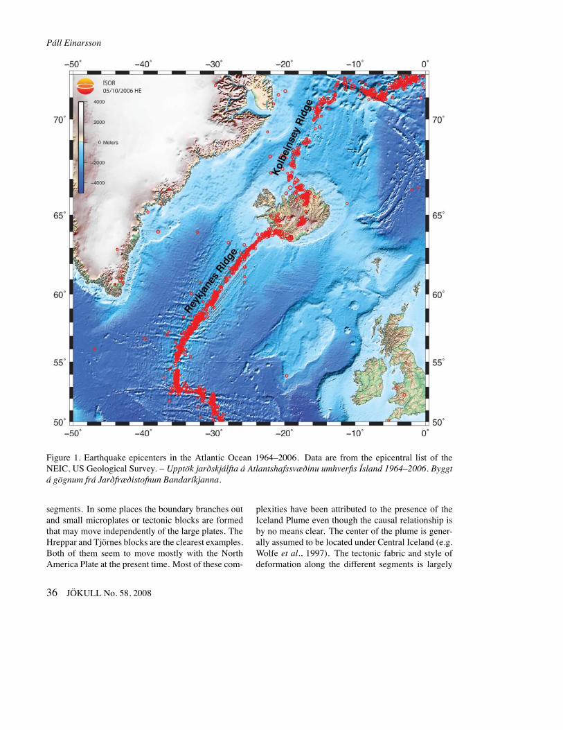
The mid-Atlantic plate boundary is relatively sim-ple in most parts of the NE-Atlantic, consisting of rift-ing and transform segments separating the two majorplates, Eurasia and North America. The boundary isclearly defined by the epicenters of earthquakes thatshow a narrow zone of deformation (Figure 1). Asit crosses the Iceland platform, however, the deforma-tion zone becomes wider, as shown by the distributionof earthquakes and volcanism in Figure 2. The bound-ary breaks up into a series of more or less oblique
JÖKULL No. 58, 2008 35
Páll Einarsson
Figure 1. Earthquake epicenters in the Atlantic Ocean 1964–2006. Data are from the epicentral list of theNEIC, US Geological Survey. – Upptök jarðskjálfta á Atlantshafssvæðinu umhverfis Ísland 1964–2006. Byggtá gögnum frá Jarðfræðistofnun Bandaríkjanna.
segments. In some places the boundary branches outand small microplates or tectonic blocks are formedthat may move independently of the large plates. TheHreppar and Tjörnes blocks are the clearest examples.Both of them seem to move mostly with the NorthAmerica Plate at the present time. Most of these com-
plexities have been attributed to the presence of theIceland Plume even though the causal relationship isby no means clear. The center of the plume is gener-ally assumed to be located under Central Iceland (e.g.Wolfe et al., 1997). The tectonic fabric and style ofdeformation along the different segments is largely
36 JÖKULL No. 58, 2008
Iceland rifts and transforms
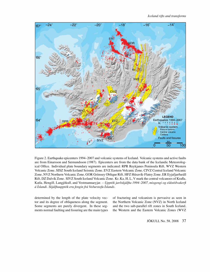
Figure 2. Earthquake epicenters 1994–2007 and volcanic systems of Iceland. Volcanic systems and active faultsare from Einarsson and Sæmundsson (1987). Epicenters are from the data bank of the Icelandic Meteorolog-ical Office. Individual plate boundary segments are indicated: RPR Reykjanes Peninsula Rift, WVZ WesternVolcanic Zone, SISZ South Iceland Seismic Zone, EVZ Eastern Volcanic Zone, CIVZ Central Iceland VolcanicZone, NVZ Northern Volcanic Zone, GOR Grímsey Oblique Rift, HFZ Húsavík-Flatey Zone, ER EyjafjarðarállRift, DZ Dalvík Zone. SIVZ South Iceland Volcanic Zone. Kr, Ka, H, L, Vmark the central volcanoes of Krafla,Katla, Hengill, Langjökull, and Vestmannaeyjar. – Upptök jarðskjálfta 1994–2007, misgengi og eldstöðvakerfiá Íslandi. Skjálftaupptök eru fengin frá Veðurstofu Íslands.
determined by the length of the plate velocity vec-tor and its degree of obliqueness along the segment.Some segments are purely divergent. In these seg-ments normal faulting and fissuring are the main types
of fracturing and volcanism is pervasive as seen inthe Northern Volcanic Zone (NVZ) in North Icelandand the two sub-parallel rift zones in South Iceland,the Western and the Eastern Volcanic Zones (WVZ
JÖKULL No. 58, 2008 37
Páll Einarsson
and EVZ). Other segments are conservative, i.e. areof transform type, such as the South Iceland SeismicZone (SISZ) and the Húsavík-Flatey Zone (HFZ) inNorth Iceland. Strike-slip faulting is dominant andvolcanism insignificant. Oblique segments containvolcanism and strike-slip tectonism in close proxim-ity to each other. The Reykjanes Peninsula Rift (RPR)and the Grímsey Oblique Rift (GOR) are examples ofthis type. There is some evidence that the two modesof deformation alternate with time.
This paper gives an overview of the structuralcharacteristics of the the plate boundary segments ofIceland. In most cases these characteristics are con-sistent with the orientation of the segments with re-spect to the plate separation vector. Exceptions areseen in South Iceland. Most of the discrepancies can,however, be explained by assuming the Hreppar blockis a microplate that rotates with respect to the NorthAmerica Plate around a pole north of Langjökull.
THE RELATIVE MOVEMENTS OF THEMAJOR PLATES
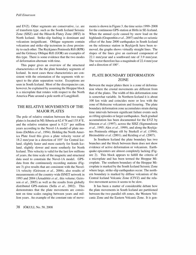
The pole of relative rotation between the two majorplates is located in NE-Siberia at 62.4◦N and 135.8◦E,and the relative rotation speed is 0.21◦ per millionyears according to the Nuvel-1A model of plate mo-tions (DeMets et al., 1994). Holding the North Amer-ica Plate fixed this gives a plate velocity vector of18.2 mm/year in a direction of 105◦ for Central Ice-land, slightly faster and more easterly for South Ice-land, slightly slower and more southerly for NorthIceland. This velocity is valid for the last few millionsof years, the time scale of the magnetic and structuraldata used to constrain the Nuvel-1A model. GPS-data from the continuously recording stations (Fig-ure 3) give results that are consistent with the Nuvel-1A velocity (Geirsson et al., 2006), also results ofmeasurements of the country-wide ISNET network in1993 and 2004 (Árnadóttir et al., this volume; Geirs-son et al., 2005) as well as the results from globallydistributed GPS-stations (Sella et al., 2002). Thisdemonstrates that the plate movements are consis-tent on time scales ranging between years and mil-lion years. An example of the constant rate of move-
ments is shown in Figure 3, the time series 1999–2008for the continuous GPS-station at Höfn in SE-Iceland.When the annual cycle caused by snow load on thehighlands (Grapenthin et al., 2007) and the co-seismiceffect of the June 2000 earthquakes in South Icelandon the reference station in Reykjavík have been re-moved, the graphs shows virtually straight lines. Theslopes of the lines give an eastward component of22.1 mm/year and a southward rate of 3.9 mm/year.The vector therefore has a magnitude of 22.4 mm/yearand a direction of 100◦.
PLATE BOUNDARY DEFORMATIONZONE
Between the major plates there is a zone of deforma-tion where the crustal movements are different fromthat of the plates. The width of this deformation zoneis somewhat variable. In Northern Iceland it is about100 km wide and coincides more or less with thezone of Holocene volcanism and fissuring. The plateboundary deformation zone accumulates strain duringtime intervals between significant failure events suchas rifting episodes or larger earthquakes. Such gradualaccumulation has been documented for the EVZ byJónsson et al. (1997), across the SISZ (Sigmundssonet al., 1995; Alex et al., 1999), and along the Reykja-nes Peninsula oblique rift by Sturkell et al. (1994),Hreinsdóttir et al. (2001), and Keiding et al. (2007).
In Southern Iceland the plate boundary has twobranches and the block between them does not showevidence of active deformation or volcanism. Earth-quake epicenters are almost completely lacking (Fig-ure 2). This block appears to fulfill the criteria ofa microplate and has been termed the Hreppar Mi-croplate. The southern boundary of the Hreppar Mi-croplate is marked by the South Iceland Seismic Zonewhere large, strike-slip earthquakes occur. The north-ern boundary is marked by diffuse volcanism of theCentral Iceland Volcanic Zone (CIVZ) and the rela-tive movement across it seems to be slow.
It has been a matter of considerable debate howthe plate movements in South Iceland are partitionedbetween the two parallel rift zones, the Western Vol-canic Zone and the Eastern Volcanic Zone. It is gen-
38 JÖKULL No. 58, 2008
Iceland rifts and transforms
Figure 3. Velocities of the continuous GPS-stations Höfn (HÖ), Skrokkalda (SK), and Ísakot(IS) with respect to Reykjavík (RE) shown as fatarrows. Thin arrows show the calculated veloc-ity of the Eurasia Plate with respect to the North-America Plate according to the Nuvel 1 model.Time-series of the displacements of the station ofHöfn with respect to Reykjavík is shown (datafrom Halldór Geirsson, Icelandic MeteorologicalOffice). Index map shows the plate boundaries.The velocities of the stations SK and IS are 3mm/a in direction 50◦ and 5 mm/a in direction70◦, respectively. – Rekhraði á samfelldu GPS-mælistöðvunum á Höfn í Hornafirði (HÖ), Skrokk-öldu (SK) og Ísakoti (IS) reiknaður miðað viðReykjavík. Þunnu örvarnar sýna rekhraðann áEvrasíuflekanum miðað við Norður-Ameríkuflek-ann reiknaðan eftir Nuvel-1-líkaninu fyrir flekareká jörðinni. Einnig er sýnd færsla sem fall af tímafyrir stöðina á Höfn í Hornafirði, reiknuð mið-að við stöðina í Reykjavík. Kortið sýnir flekaskil-in á Íslandi. Hraði stöðvanna tveggja sem eru áHreppaflekanum er: Skrokkalda 3 mm/ári í stefnu50◦ og Ísakot 5 mm/ári í stefnu 70◦.
erally assumed that the two zones are the expressionof a ridge jump, i.e. that the WVZ is a dying riftthat is being replaced by the currently much moreactive EVZ (e.g. Einarsson, 1991a). The question iswhether the ridge jump occurs by rift propagation,i.e. the EVZ propagating towards the SW while theWVZ recedes, or by activity alternating between therifts (Sigmundsson et al., 1995) and the whole WVZgradually becoming less active. The lack of evidencefor rotated structures within the Hreppar Microplate
has been evoked to support the latter hypothesis. Re-cent modeling studies of GPS data, however, appearto support rotational movements of the Hreppar Mi-croplate (La Femina et al., 2005), which is in favourof the propagating rift hypothesis. The model resultsindicate that near the Hengill triple junction as muchas 35% of the plate movements is taken up by theWVZ. This proportion dies out towards the NE andis less than 10% in the Langjökull region. This mustindicate a counter-clockwise rotation of the Hreppar
JÖKULL No. 58, 2008 39
Páll Einarsson
Microplate, considering the lack of evidence for sig-nificant irreversible internal deformation of that plate.
TECTONIC STRUCTURE OF THEPLATE BOUNDARY SEGMENTS
The plate boundary in Iceland can be divided into seg-ments, each with its tectonic and magmatic character-istics and properties. Different authors have used dif-ferent schemes for the division and there is consider-able confusion in the use of names in the literature. Inthe following text we attempt to clarify this situation.
Crustal formation occurs by magmatism in zonesof divergence. Most of the activity is linked with vol-canic systems, about 25 of which have been identi-fied on land and 10 more in the shelf areas to thenorth and south. A volcanic system is defined from itsstructural and petrologic characteristics (Sæmunds-son, 1978; Jakobsson, 1979a,b). It consists of a cen-tral volcano and a fissure swarm that transsects it in adirection nearly normal to the local spreading direc-tion. The magmatic activity has a maximum in thecentral volcano, most of it basaltic but it may con-tain acidic rocks as well (Walker, 1993). Sometimescalderas develop in the central volcano and most alsohave geothermal systems. The central volcanoes sel-dom reach high elevation. Loading of the crust by vol-canic production is compensated by subsidence of theweak and warm crust. The volcano therefore growsdownwards more than upwards. The fissure swarmsare 5–20 km wide and from a few tens to more than100 km long. They often have the structure of a gentlegraben bounded by normal faults of small throw. Thevolcanic systems are arranged side-by-side in some ofthe rift zones or are en echelon in the oblique zones.
The volcanic rift zones usually occupy a gentlesynform. Strata on their flanks tilt gently towards thezone. This is caused by sagging of the crust in re-sponse to loading of volcanic material onto the surfacewithin the zone. This loading in combination with thedivergence of the plates across the zone produces thedip according to the model of Pálmason (1980, 1986).
Transform zones form where the plate velocityvector is parallel or sub-parallel to the boundary. Thedeformation is usually not concentrated on a single
transform fault but is instead distributed over a zoneof finite width. Transform faulting occurs mainly intwo zones, the Tjörnes Fracture Zone near the northcoast and the South Iceland Seismic Zone. The accu-mulated strain in these zones is released during strike-slip earthquakes, as large as magnitude 7, that takeplace at intervals of decades to centuries (Einarsson,1991a). The transform motion is commonly achievedby strike-slip on faults that are transverse to the zone.The blocks between the faults are then slightly ro-tated. A model of books in a bookshelf provides ananalogy to this type of faulting. Bookshelf faultingmay be taken as evidence for youthfulness of thesezones. Icelandic transform zones appear to be youngand unstable.
SYSTEMATICS OF THE PLATEBOUNDARY SEGMENTS
The Reykjanes Peninsula oblique rift
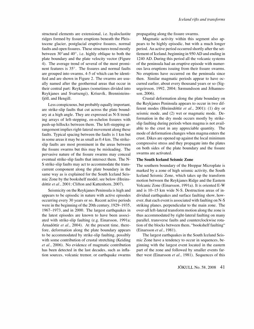
The Reykjanes Peninsula in SW Iceland is a struc-tural continuation of the Reykjanes Ridge. The wholeridge north of 56◦N is oblique to the spreading direc-tion and resembles faster spreading ridges, both withregard to topography and seismicity (Figure 1, Einars-son, 2001). This has been ascribed to the proximity tothe Iceland hotspot. The obliqueness increases as theridge approaches Iceland. As the ridge axis enters theshelf area SW of Iceland it is expressed as a series ofconstructional mounds sitting on a flat, eroded surface(Johnson and Jakobsson, 1985) left by the Pleistoceneglacier. The tectonic structure here and on the Reykja-nes Peninsula is characterized by volcanic systemsthat are arranged en echelon along the plate bound-ary. The fissure swarms of the volcanic systems areoblique to the boundary (have a trend of about 35◦,Table 1) and extend a few tens of kilometres into theplates on either side.
The plate boundary goes onshore at the SW tip ofthe Reykjanes Peninsula and extends from there witha trend of 70◦ (azimuth) along the whole peninsula.The structure of this zone is relatively homogeneousuntil it joins with the Western Volcanic Zone andthe South Iceland Seismic Zone at the Hengill TripleJunction near 64◦N and 21.4◦W. The most prominent
40 JÖKULL No. 58, 2008
Iceland rifts and transforms
structural elements are extensional, i.e. hyaloclastiteridges formed by fissure eruptions beneath the Pleis-tocene glacier, postglacial eruptive fissures, normalfaults and open fissures. These structures trendmostlybetween 30◦and 40◦, i.e. highly oblique to both theplate boundary and the plate velocity vector (Figure4). The average trend of several of the most promi-nent features is 35◦. The fissures and normal faultsare grouped into swarms, 4-5 of which can be identi-fied and are shown in Figure 2. The swarms are usu-ally named after the geothermal areas that occur intheir central part: Reykjanes (sometimes divided intoReykjanes and Svartsengi), Krísuvík, Brennisteins-fjöll, and Hengill.
Less conspicuous, but probably equally important,are strike-slip faults that cut across the plate bound-ary at a high angle. They are expressed as N-S trend-ing arrays of left-stepping, en-echelon fissures withpush-up hillocks between them. The left-stepping ar-rangement implies right-lateral movement along thesefaults. Typical spacing between the faults is 1 km butin some areas it may be as small as 0.4 km. The strike-slip faults are most prominent in the areas betweenthe fissure swarms but this may be misleading. Thepervasive nature of the fissure swarms may concealeventual strike-slip faults that intersect them. The N-S strike-slip faults may act to accommodate the trans-current component along the plate boundary in thesame way as is explained for the South Iceland Seis-mic Zone by the bookshelf model, see below (Hreins-dóttir et al., 2001; Clifton and Kattenhorn, 2007).
Seismicity on the Reykjanes Peninsula is high andappears to be episodic in nature with active episodesoccurring every 30 years or so. Recent active periodswere in the beginning of the 20th century, 1929–1935,1967–1973, and in 2000. The largest earthquakes inthe latest episodes are known to have been associ-ated with strike-slip faulting (e.g. Einarsson, 1991a;Árnadóttir et al., 2004). At the present time, there-fore, deformation along the plate boundary appearsto be accommodated by strike-slip faulting, possiblywith some contribution of crustal stretching (Keidinget al., 2006). No evidence of magmatic contributionhas been detected in the last decades, such as infla-tion sources, volcanic tremor, or earthquake swarms
propagating along the fissure swarms.Magmatic activity within this segment also ap-
pears to be highly episodic, but with a much longerperiod. An active period occurred shortly after the set-tlement of Iceland, beginning in 950AD and ending in1240 AD. During this period all the volcanic systemsof the peninsula had an eruptive episode with numer-ous lava eruptions issuing from their fissure swarms.No eruptions have occurred on the peninsula sincethen. Similar magmatic periods appear to have oc-curred earlier, about every thousand years or so (Sig-urgeirsson, 1992, 2004; Sæmundsson and Jóhannes-son, 2006).
Crustal deformation along the plate boundary onthe Reykjanes Peninsula appears to occur in two dif-ferent modes (Hreinsdóttir et al., 2001): (1) dry orseismic mode, and (2) wet or magmatic mode. De-formation in the dry mode occurs mostly by strike-slip faulting during periods when magma is not avail-able to the crust in any appreciable quantity. Themode of deformation changes when magma enters thecrust. Dikes are opened up against the local minimumcompressive stress and they propagate into the plateson both sides of the plate boundary and the fissureswarms are activated.
The South Iceland Seismic ZoneThe southern boundary of the Hreppar Microplate ismarked by a zone of high seismic activity, the SouthIceland Seismic Zone, which takes up the transformmotion between the Reykjanes Ridge and the EasternVolcanic Zone (Einarsson, 1991a). It is oriented E-Wand is 10–15 km wide N-S. Destruction areas of in-dividual earthquakes and surface faulting show, how-ever, that each event is associated with faulting on N-Sstriking planes, perpendicular to the main zone. Theover-all left-lateral transformmotion along the zone isthus accommodated by right-lateral faulting on manyparallel, transverse faults and counterclockwise rota-tion of the blocks between them, “bookshelf faulting“(Einarsson et al., 1981).
The largest earthquakes in the South Iceland Seis-mic Zone have a tendency to occur in sequences, be-ginning with the largest event located in the easternpart of the zone and followed by smaller events far-ther west (Einarsson et al., 1981). Sequences of this
JÖKULL No. 58, 2008 41
Páll Einarsson
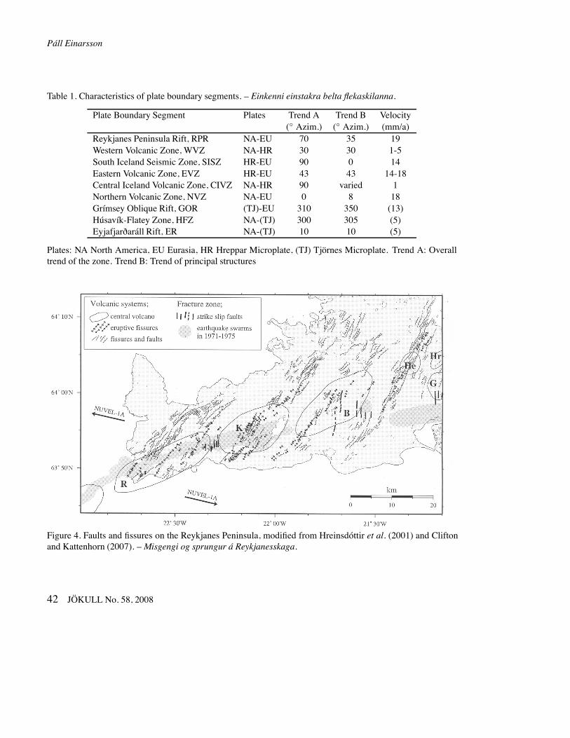
Table 1. Characteristics of plate boundary segments. – Einkenni einstakra belta flekaskilanna.
Plate Boundary Segment Plates Trend A Trend B Velocity(◦ Azim.) (◦ Azim.) (mm/a)
Reykjanes Peninsula Rift, RPR NA-EU 70 35 19Western Volcanic Zone, WVZ NA-HR 30 30 1-5South Iceland Seismic Zone, SISZ HR-EU 90 0 14Eastern Volcanic Zone, EVZ HR-EU 43 43 14-18Central Iceland Volcanic Zone, CIVZ NA-HR 90 varied 1Northern Volcanic Zone, NVZ NA-EU 0 8 18Grímsey Oblique Rift, GOR (TJ)-EU 310 350 (13)Húsavík-Flatey Zone, HFZ NA-(TJ) 300 305 (5)Eyjafjarðaráll Rift, ER NA-(TJ) 10 10 (5)
Plates: NA North America, EU Eurasia, HR Hreppar Microplate, (TJ) Tjörnes Microplate. Trend A: Overalltrend of the zone. Trend B: Trend of principal structures
Figure 4. Faults and fissures on the Reykjanes Peninsula, modified from Hreinsdóttir et al. (2001) and Cliftonand Kattenhorn (2007). –Misgengi og sprungur á Reykjanesskaga.
42 JÖKULL No. 58, 2008
Iceland rifts and transforms
type are documented in 1630–1633, 1732–1734, 1784and 1896, and historical evidence seems to indicatethat similar sequences also occurred in 1294, 1339,and 1389–1391. The inter-sequence time intervals arethus in the range 45 to 112 years. The return periodof total strain release of the zone has been estimatedabout 140 years (Stefánsson and Halldórsson, 1988;Stefánsson et al., 1993).
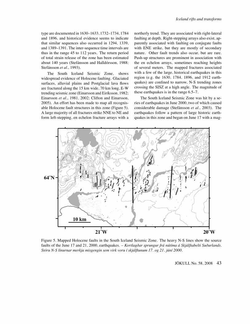
The South Iceland Seismic Zone, showswidespread evidence of Holocene faulting. Glaciatedsurfaces, alluvial plains and Postglacial lava flowsare fractured along the 15 km wide, 70 km long, E-Wtrending seismic zone (Einarsson and Eiríksson, 1982;Einarsson et al., 1981, 2002; Clifton and Einarsson,2005). An effort has been made to map all recognis-able Holocene fault structures in this zone (Figure 5).A large majority of all fractures strike NNE to NE andform left-stepping, en echelon fracture arrays with a
northerly trend. They are associated with right-lateralfaulting at depth. Right-stepping arrays also exist, ap-parently associated with faulting on conjugate faultswith ENE strike, but they are mostly of secondarynature. Other fault trends also occur, but are rare.Push-up structures are prominent in association withthe en echelon arrays, sometimes reaching heightsof several meters. The mapped fractures associatedwith a few of the large, historical earthquakes in thisregion (e.g. the 1630, 1784, 1896, and 1912 earth-quakes) are confined to narrow, N-S trending zonescrossing the SISZ at a high angle. The magnitude ofthese earthquakes is in the range 6.5–7.
The South Iceland Seismic Zone was hit by a se-ries of earthquakes in June 2000, two of which causedconsiderable damage (Stefánsson et al., 2003). Theearthquakes follow a pattern of large historic earth-quakes in this zone and began on June 17 with a mag-
Figure 5. Mapped Holocene faults in the South Iceland Seismic Zone. The heavy N-S lines show the sourcefaults of the June 17 and 21, 2000, earthquakes. – Kortlagðar sprungur frá nútíma á Skjálftabelti Suðurlands.Stóru N-S línurnar merkja misgengin sem virk voru í skjálftunum 17. og 21. júní 2000.
JÖKULL No. 58, 2008 43
Páll Einarsson
nitude 6.5 event in the eastern part of the zone. Thisimmediately triggered a flurry of activity along at leasta 90 km-long stretch of the plate boundary to the west.This activity included three events with magnitudeslarger than 5 on the Reykjanes Peninsula oblique rift(Clifton et al., 2003; Pagli et al., 2003; Árnadóttir etal., 2004). A second mainshock, also of magnitude6.5, occurred about 20 km west of the first one onJune 21. The mainshocks of the sequence occurred onN-S striking faults, transverse to the zone itself. Thesense of faulting was right-lateral strike-slip. One ofthe events of the sequence has the characteristics of a“slow earthquake”, i.e. the radiation of seismic wavesis comparatively weak for the amount of faulting ob-served by InSAR or GPS.
The two largest events of the sequence occurredon pre-existing faults and were accompanied by sur-face ruptures consisting primarily of en echelon ten-sion gashes and push-up structures (Clifton and Ein-arsson, 2005). The main zones of rupture were about15 km long, and coincided with the epicentral dis-tributions of aftershocks. Fault displacements wereof the order of 0.1–1 m at the surface. Faultingalong conjugate, left-lateral strike-slip faults also oc-curred (Bergerat and Angelier, 2003), but was lesspronounced than that of the main rupture zones. Theco-seismic displacement field of the earthquakes wascaptured by InSAR and GPS-measurements (Peder-sen et al., 2001; Árnadóttir et al., 2001). According tomodeling of these data (Pedersen et al., 2003) faultingextends from the surface to a depth of 10 km in bothevents. Maximum displacements are 2.6 m and 2.9 m,respectively.
The sense of faulting during this 2000 earthquakesequence conforms to the model of “bookshelf fault-ing“ for the South Iceland Seismic Zone. It was fur-thermore demonstrated that bookshelf faulting con-tinues to the west, along the Reykjanes Peninsulaoblique rift (Árnadóttir et al., 2004).
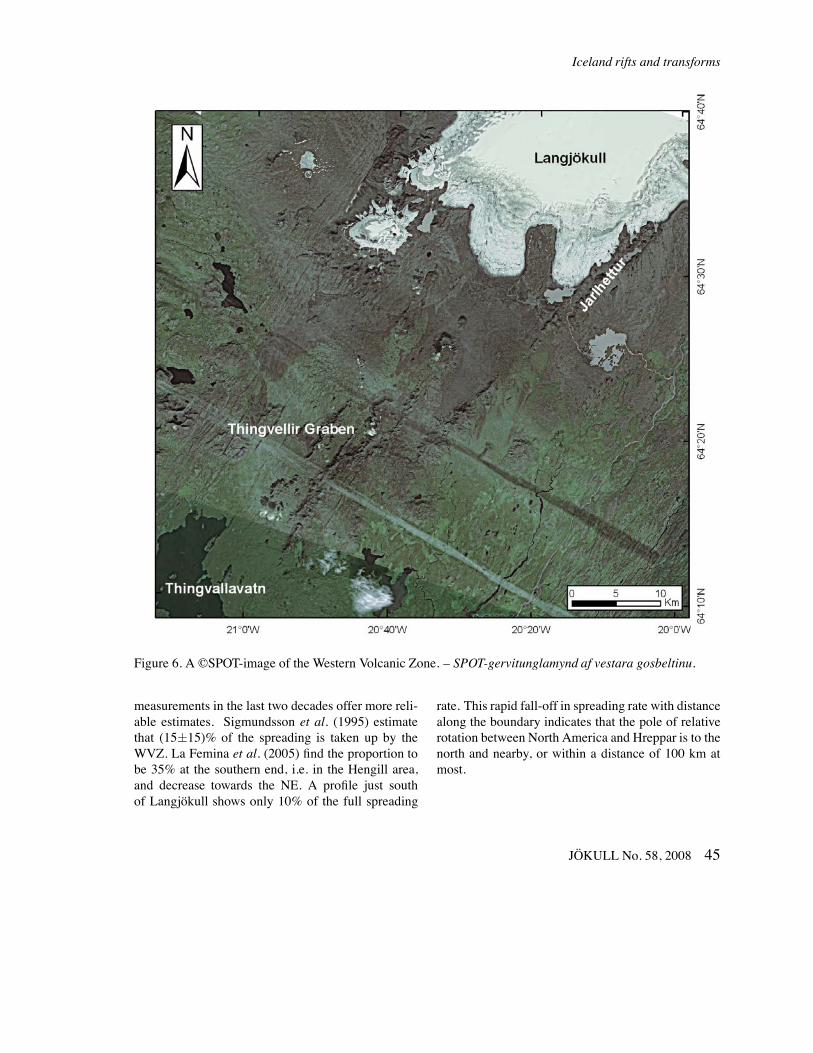
The Western Volcanic ZoneThis rift zone branches from the Reykjanes Peninsulaand the South Iceland Seismic Zone at the HengillTriple Junction. It contains the Hengill volcanicsystem with its fissure swarms, part of which isthe Þingvellir Graben partly filled by the lake Þing-
vallavatn. It then extends NE to the Langjökull area.The volcanic systems there are partly covered by theLangjökull glacier which obscures the structures. TheWestern Volcanic Zone seems to have been the mainrift in the southern part of Iceland in the last 7 mil-lion years (e.g. Kristjánsson and Jónsson, 1998). Theactivity has been dwindling in the last few millionyears and only a minor part of the total spreading isoccurring in this zone at the present. Open fissuresand eruptive fissures are common in the southern partof the zone, in the Hengill volcanic system, but be-come less prominent towards the north. Normal fault-ing is, on the other hand, quite prominent throughoutthe zone and fault throws as large as 150 m have beenreported (e.g. Gudmundsson et al., 1992), which israther unusual for Icelandic divergent zones. The fis-sure swarms of the volcanic systems are almost paral-lel to the trend of the zone itself (see Figure 2) indicat-ing spreading direction perpendicular to the zone. Theaverage trend of the most prominent extensional struc-tures is 30◦ (Figure 6), excluding the trend of the Jarl-hettur hyaloclastite ridge, that is located at the east-ern margin of the zone and has a significantly moreeasterly trend than the others (38◦). Lava shields arecommon in this zone. Volcanic activity has been lowin the last 1000 years (Sinton et al., 2006).
The rather spectacular extensional structures ofthe WVZ, the Þingvellir Graben in particular, havefrequently been taken as the type examples and proofof plate divergence in Iceland. It now seems, however,that the large topographic relief here is the telltale signof a magma-starved rift (Sæmundsson, 1986, 1992).The plate divergence is taken up by crustal stretchingand normal faulting rather than by dike intrusions andlava effusion.
The crustal dilation across the WVZ has been esti-mated bymany authors and bymanymethods. Deckeret al. (1976) measured a distance profile across theWVZ for the period 1967–1973 and concluded thatinsignificant lengthening had occurred, or about 3 mmper year. Guðmundsson (1987) estimated the crustalstretching by measuring the total widening of dilata-tional cracks in the 9000 years old lava that coversthe Þingvellir area. He estimated that about half ofthe total spreading was taken up by the zone. GPS-
44 JÖKULL No. 58, 2008
Iceland rifts and transforms
Figure 6. A ©SPOT-image of the Western Volcanic Zone. – SPOT-gervitunglamynd af vestara gosbeltinu.
measurements in the last two decades offer more reli-able estimates. Sigmundsson et al. (1995) estimatethat (15±15)% of the spreading is taken up by theWVZ. La Femina et al. (2005) find the proportion tobe 35% at the southern end, i.e. in the Hengill area,and decrease towards the NE. A profile just southof Langjökull shows only 10% of the full spreading
rate. This rapid fall-off in spreading rate with distancealong the boundary indicates that the pole of relativerotation between North America and Hreppar is to thenorth and nearby, or within a distance of 100 km atmost.
JÖKULL No. 58, 2008 45
Páll Einarsson
The Eastern Volcanic Zone
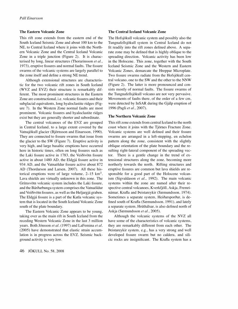
This rift zone extends from the eastern end of theSouth Iceland Seismic Zone and about 100 km to theNE, to Central Iceland where it joins with the North-ern Volcanic Zone and the Central Iceland VolcanicZone in a triple junction (Figure 2). It is charac-terised by long, linear structures (Thorarinsson et al.,1973), eruptive fissures and normal faults. The fissureswarms of the volcanic systems are largely parallel tothe zone itself and define a strong NE trend.
Although extensional structures are characteris-tic for the two volcanic rift zones in South Iceland(WVZ and EVZ) their structure is remarkably dif-ferent. The most prominent structures in the EasternZone are constructional, i.e. volcanic fissures and theirsubglacial equivalents, long hyaloclastite ridges (Fig-ure 7). In the Western Zone normal faults are mostprominent. Volcanic fissures and hyaloclastite ridgesexist but they are generally shorter and subordinate.
The central volcanoes of the EVZ are groupedin Central Iceland, to a large extent covered by theVatnajökull glacier (Björnsson and Einarsson, 1990).They are connected to fissure swarms that issue fromthe glacier to the SW (Figure 7). Eruptive activity isvery high, and large basaltic eruptions have occurredhere in historic times, often on long fissures such asthe Laki fissure active in 1783, the Veiðivötn fissureactive in about 1480 AD, the Eldgjá fissure active in934 AD, and the Vatnaöldur fissure active about 872AD (Thordarson and Larsen, 2007). All these his-torical eruptions were of large volume, 2–15 km3.Lava shields are virtually unknown in this zone. TheGrímsvötn volcanic system includes the Laki fissure,and the Bárðarbunga system comprises the Vatnaöldurand Veiðivötn fissures, as well as the Heljargjá graben.The Eldgjá fissure is a part of the Katla volcanic sys-tem that is located in the South Iceland Volcanic Zonesouth of the plate boundary.
The Eastern Volcanic Zone appears to be young,taking over as the main rift in South Iceland from thereceding Western Volcanic Zone in the last 3 millionyears. Both Jónsson et al. (1997) and LaFemina et al.(2005) have demonstrated that elastic strain accum-lation is in progress across the EVZ. Seismic back-ground activity is very low.
The Central Iceland Volcanic Zone
The Hofsjökull volcanic system and possibly also theTungnafellsjökull system in Central Iceland do notfit readily into the rift zones defined above. A sepa-rate zone may be defined that is highly oblique to thespreading direction. Volcanic activity has been lowin the Holocene. This zone, together with the SouthIceland Seismic Zone and the Western and EasternVolcanic Zones, demarcate the Hreppar Microplate.Two fissure swarms radiate from the Hofsjökull cen-tral volcano, one to the SW and the other to the NNW(Figure 2). The latter is more pronounced and con-sists mostly of normal faults. The fissure swarms ofthe Tungnafellsjökull volcano are not very pervasive.Movements of faults there, of the order of a few cm,were detected by InSAR during the Gjálp eruption of1996 (Pagli et al., 2007).
The Northern Volcanic Zone
This rift zone extends from central Iceland to the northcoast where it joins with the Tjörnes Fracture Zone.Volcanic systems are well defined and their fissureswarms are arranged in a left-stepping, en echelonpattern along the zone, consistent with the slightlyoblique orientation of the plate boundary and the re-sulting right-lateral component of the spreading vec-tor. There is a gentle change in the trend of ex-tensional structures along the zone, becoming morenortherly towards the north. Rifting structures anderuptive fissures are common but lava shields are re-sponsible for a good part of the Holocene volcan-ism (Sigvaldason et al., 1992). The main volcanicsystems within the zone are named after their re-spective central volcanoes, Kverkfjöll, Askja, Fremri-námar, Krafla and Þeistareykir (Sæmundsson, 1974).Sometimes a separate system, Heiðarsporður, is de-fined south of Krafla (Sæmundsson, 1991), and latelya separate system, Hrúthálsar, is also defined north ofAskja (Sæmundsson et al., 2005).
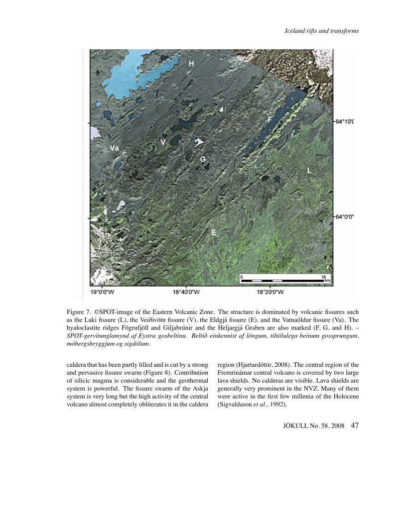
Although the volcanic systems of the NVZ allhave some of the characteristics of volcanic systems,they are remarkably different from each other. TheÞeistareykir system, e.g., has a very strong and welldeveloped fissure swarm but no caldera, and sili-cic rocks are insignificant. The Krafla system has a
46 JÖKULL No. 58, 2008
Iceland rifts and transforms
Figure 7. ©SPOT-image of the Eastern Volcanic Zone. The structure is dominated by volcanic fissures suchas the Laki fissure (L), the Veiðivötn fissure (V), the Eldgjá fissure (E), and the Vatnaöldur fissure (Va). Thehyaloclastite ridges Fögrufjöll and Giljabrúnir and the Heljargjá Graben are also marked (F, G, and H). –SPOT-gervitunglamynd af Eystra gosbeltinu. Beltið einkennist af löngum, tiltölulega beinum gossprungum,móbergshryggjum og sigdölum.
caldera that has been partly filled and is cut by a strongand pervasive fissure swarm (Figure 8). Contributionof silicic magma is considerable and the geothermalsystem is powerful. The fissure swarm of the Askjasystem is very long but the high activity of the centralvolcano almost completely obliterates it in the caldera
region (Hjartardóttir, 2008). The central region of theFremrinámar central volcano is covered by two largelava shields. No calderas are visible. Lava shields aregenerally very prominent in the NVZ. Many of themwere active in the first few millenia of the Holocene(Sigvaldason et al., 1992).
JÖKULL No. 58, 2008 47
Páll Einarsson
Figure 8. ©SPOT-image of the Krafla volcanic system and surroundings in the northern part of the NorthernVolcanic Zone. The indistinct Krafla caldera is marked with a line, also the most prominent extensional struc-tures Austaribrekka normal fault (A), Sandvatnsbrekka normal fault (S), Þrengslaborgir eruptive fissure (T),and the Krafla 1984 eruptive fissure (K). – SPOT-gervitunglamynd af eldstöðvakerfi Kröflu og næsta umhverfi.Kröfluaskjan er sýnd, einnig nokkur áberandi siggengi og gossprungur.
48 JÖKULL No. 58, 2008
Iceland rifts and transforms
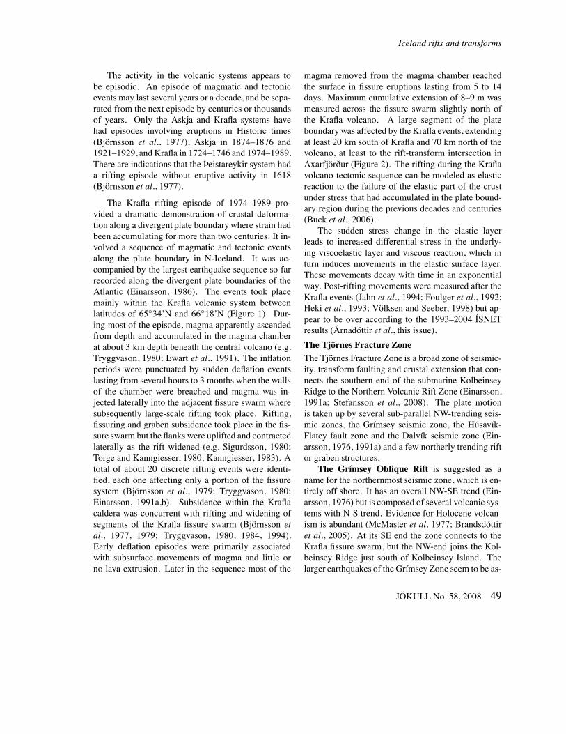
The activity in the volcanic systems appears tobe episodic. An episode of magmatic and tectonicevents may last several years or a decade, and be sepa-rated from the next episode by centuries or thousandsof years. Only the Askja and Krafla systems havehad episodes involving eruptions in Historic times(Björnsson et al., 1977), Askja in 1874–1876 and1921–1929, and Krafla in 1724–1746 and 1974–1989.There are indications that the Þeistareykir system hada rifting episode without eruptive activity in 1618(Björnsson et al., 1977).
The Krafla rifting episode of 1974–1989 pro-vided a dramatic demonstration of crustal deforma-tion along a divergent plate boundarywhere strain hadbeen accumulating for more than two centuries. It in-volved a sequence of magmatic and tectonic eventsalong the plate boundary in N-Iceland. It was ac-companied by the largest earthquake sequence so farrecorded along the divergent plate boundaries of theAtlantic (Einarsson, 1986). The events took placemainly within the Krafla volcanic system betweenlatitudes of 65◦34’N and 66◦18’N (Figure 1). Dur-ing most of the episode, magma apparently ascendedfrom depth and accumulated in the magma chamberat about 3 km depth beneath the central volcano (e.g.Tryggvason, 1980; Ewart et al., 1991). The inflationperiods were punctuated by sudden deflation eventslasting from several hours to 3 months when the wallsof the chamber were breached and magma was in-jected laterally into the adjacent fissure swarm wheresubsequently large-scale rifting took place. Rifting,fissuring and graben subsidence took place in the fis-sure swarm but the flanks were uplifted and contractedlaterally as the rift widened (e.g. Sigurdsson, 1980;Torge and Kanngiesser, 1980; Kanngiesser, 1983). Atotal of about 20 discrete rifting events were identi-fied, each one affecting only a portion of the fissuresystem (Björnsson et al., 1979; Tryggvason, 1980;Einarsson, 1991a,b). Subsidence within the Kraflacaldera was concurrent with rifting and widening ofsegments of the Krafla fissure swarm (Björnsson etal., 1977, 1979; Tryggvason, 1980, 1984, 1994).Early deflation episodes were primarily associatedwith subsurface movements of magma and little orno lava extrusion. Later in the sequence most of the
magma removed from the magma chamber reachedthe surface in fissure eruptions lasting from 5 to 14days. Maximum cumulative extension of 8–9 m wasmeasured across the fissure swarm slightly north ofthe Krafla volcano. A large segment of the plateboundarywas affected by the Krafla events, extendingat least 20 km south of Krafla and 70 km north of thevolcano, at least to the rift-transform intersection inAxarfjörður (Figure 2). The rifting during the Kraflavolcano-tectonic sequence can be modeled as elasticreaction to the failure of the elastic part of the crustunder stress that had accumulated in the plate bound-ary region during the previous decades and centuries(Buck et al., 2006).
The sudden stress change in the elastic layerleads to increased differential stress in the underly-ing viscoelastic layer and viscous reaction, which inturn induces movements in the elastic surface layer.These movements decay with time in an exponentialway. Post-rifting movements were measured after theKrafla events (Jahn et al., 1994; Foulger et al., 1992;Heki et al., 1993; Völksen and Seeber, 1998) but ap-pear to be over according to the 1993–2004 ÍSNETresults (Árnadóttir et al., this issue).
The Tjörnes Fracture ZoneThe Tjörnes Fracture Zone is a broad zone of seismic-ity, transform faulting and crustal extension that con-nects the southern end of the submarine KolbeinseyRidge to the Northern Volcanic Rift Zone (Einarsson,1991a; Stefansson et al., 2008). The plate motionis taken up by several sub-parallel NW-trending seis-mic zones, the Grímsey seismic zone, the Húsavík-Flatey fault zone and the Dalvík seismic zone (Ein-arsson, 1976, 1991a) and a few northerly trending riftor graben structures.The Grímsey Oblique Rift is suggested as a
name for the northernmost seismic zone, which is en-tirely off shore. It has an overall NW-SE trend (Ein-arsson, 1976) but is composed of several volcanic sys-tems with N-S trend. Evidence for Holocene volcan-ism is abundant (McMaster et al. 1977; Brandsdóttiret al., 2005). At its SE end the zone connects to theKrafla fissure swarm, but the NW-end joins the Kol-beinsey Ridge just south of Kolbeinsey Island. Thelarger earthquakes of the Grímsey Zone seem to be as-
JÖKULL No. 58, 2008 49
Páll Einarsson
sociated with left-lateral strike-slip faulting on NNE-striking faults (Rögnvaldsson et al., 1994). The zonehas the characteristics of an oblique rift. There is astriking similarity between the Reykjanes Peninsulaand the Grímsey Zone. The two zones are symmet-rical with respect to the plate separation vector. Thesimilarity is seen in the overall trend, the en echelonfissure swarms, transverse bookshelf faults, and theoccurrence of geothermal areas. Earthquake swarmsare common in both zones.
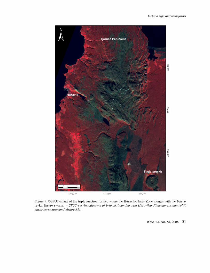
The second seismic zone, the Húsavík-FlateyZone, is about 40 km south of the Grímsey zone, andis well defined by the seismicity near its western end,where it joins with the Eyjafjarðaráll Rift. This trans-form zone can be traced on the ocean bottom to thecoast in the Húsavík town, continuing on land into thevolcanic zone, where it merges into the Þeistareykirfissure swarm (Sæmundsson, 1974; Gudmundsson etal. 1993), (Figure 9). This is a highly active seis-mic zone. The last major earthquakes occurred in1872 when the town of Húsavík suffered heavy dam-age (e.g. Björnsson and Einarsson, 1981). Volcanismonly plays a subordinate role if any.
A third zone, the Dalvík zone, is indicated byseismicity about 30 km south of the Húsavík-FlateyZone (Einarsson, 1976, 1991a). Earthquakes as largeas MS 7 have occurred in this zone, but it lacks cleartopographic expression. In spite of rather clear align-ment of epicenters, the Dalvík zone is not seen as athrough-going fault on the surface (Långbacka andGudmundsson 1995; Gudmundsson, 1995). A com-mon feature of all three seismic zones is the occur-rence of earthquakes on transverse structures (Rögn-valdsson et al., 1994), see also Figure 2, similar tothat observed in the South Iceland Seismic Zone andthe Reykjanes Peninsula.
A well-developed rift, the Eyjafjarðaráll Rift, hasbeen identified in a southward continuation of theKolbeinsey Ridge. This zone is characterised by nor-mal faulting on faults perpendicular to the spreadingvector indicating crustal extension. Signs of volcanicactivity are scarce (Brandsdóttir et al., 2005), how-ever, suggesting that this rift is starved of magmaat the present time. The rift is connected with theHúsavík-Flatey Zone in the south. Together with the
Grímsey Oblique Rift and the northernmost extensionof the Northern Volcanic Rift Zone these zones de-marcate a crustal block. It remains to be tested if itis possible or practical to define this block as a mi-croplate with its own kinematics.
Flank zonesVolcanism also occurs in zones outside the immedi-ate plate boundary. These zones are sometimes calledvolcanic flank zones, off-rift volcanic zones or in-traplate volcanic zones (e.g. Jakobsson, 1979b, Sæ-mundsson, 1978, 1986). The South Iceland VolcanicZone is a direct continuation of the Eastern VolcanicZone beyond its junction with the South Iceland Seis-mic Zone (see Figure 2). It contains several very ac-tive volcanic systems, including the Hekla and Katlavolcanic systems. Rifting structures are, however, notprominent, consistent with this zone’s intraplate set-ting. The zone has been interpreted as the propagatingtip of the Eastern Volcanic Zone into the Eurasia Plate(e.g. Óskarsson et al., 1985; Meyer et al., 1985).
The Snæfellsnes Volcanic Zone is entirely in-traplate and is not connected to the presently activeplate boundary. It contains three volcanic systems thatrest unconformably on Tertiary crust and have beenactive in the Holocene, Snæfellsjökull, Lýsuhóll andLjósufjöll. Their fissure swarms have a WNW-trend,almost parallel to the spreading vector. At its easternend it continues as a moderately active seismic zone,last active in the Borgarfjörður earthquakes of 1974(Einarsson et al., 1977; Einarsson, 1989). The ori-gin of the Snæfellsnes zone remains enigmatic eventhough most authors seem to agree that it is related tothe location of the center of the Iceland hotspot at thislatitude.
The Öræfajökull Volcanic Zone is located welleast of the presently active plate boundary. It com-prises three volcanic systems that must be consideredactive, Öræfajökull, Esjufjöll and Snæfell, althoughonly the first one has had confirmed eruptions in thelast few thousand years. The structure of this zone isonly poorly known as most of it is hidden beneath theVatnajökull glacier. It has been speculated that thiszone is the first sign of an impending ridge jump, ac-commodating the westward movement of the EurasiaPlate with respect to the Iceland mantle plume.
50 JÖKULL No. 58, 2008
Iceland rifts and transforms
Figure 9. ©SPOT-image of the triple junction formed where the Húsavík-Flatey Zone merges with the Þeista-reykir fissure swarm. – SPOT-gervitunglamynd af þrípunktinum þar sem Húsavíkur-Flateyjar-sprungubeltiðmætir sprungusveim Þeistareykja.
JÖKULL No. 58, 2008 51
Páll Einarsson
THE HREPPAR MICROPLATE AND ITSPOLES OF RELATIVE ROTATION
In two areas of Iceland the plate boundary branchesout and appears particularly complicated, i.e. in SouthIceland where rifting occurs in two sub-parallel riftzones, and at the north coast where two or threebranches of the Tjörnes Fracture Zone appear to takeup the transform motion. The question arises whetherthese complications can be better understood by defin-ing microplates. Two conditions must be fulfilled: 1)The plate must be well defined, i.e. a block of little orno internal deformation surrounded by active bound-aries. 2) A consistent set of poles of relative rotationwith respect to adjacent plates must be found.
The general idea that the two sub-parallel riftzones in South Iceland delimit a crustal block of littledeformation is not new. It appeared in the first paperson the plate tectonic interpretation of the geology ofIceland (e.g. Ward, 1971; Pálmason and Sæmunds-son, 1974) and it was inherent in the design of thefirst attempts to measure the rate of separation, e.g.the two distance profiles of Decker et al. (1971, 1976)across the two rifts. The use of the term “Hengill triplejunction“ by e.g. Foulger (1988) furthermore assumesthree plates meeting at a triple junction. The term“microplate“ for this block, however, appeared in theliterature only recently (e.g. LaFemina et al., 2005;Einarsson et al., 2006; Sinton et al., 2006) as havedirect GPS-measurements of the rate of movementsalong its boundaries (LaFemina et al., 2005; Geirssonet al., 2006). LaFemina et al. (2005), furthermore,confirmed that its internal deformation rate was con-sistent with a microplate model.
The segments comprising the plate boundary inSouth Iceland have presented irregularities or incon-sistencies that have not been satisfactorily explainedso far:1. The Western and Eastern Volcanic Zones trendobliquely to the over-all spreading vector. Yet thestructure of the zones does not reflect this, such as byen-echelon arrangement of the fissure swarms. Thevolcanic systems, with their fissure swarms trend par-allel to the zones themselves. This indicates that thespreading across the zones is perpendicular to theirtrend and oblique to the spreading of the major plates.
2. The Western and Eastern Volcanic Zones are notquite parallel and there is a significant difference be-tween the trend of extensional structures within them(Table 1). Eruptive fissures, normal faults, and hyalo-clastite ridges have trends of 40–46◦ in the easternzone, but 26–33◦ in the western one.3. The South Iceland Seismic Zone does not show ev-idence of crustal extension. It appears to behave as atransform zone and yet it trends obliquely to the over-all spreading vector of the two major plates.4. The spreading rate changes along the rift zones. Itdecreases towards NE in the WVZ and increases inthe EVZ. This implies rotation of the block betweenthe two rifts.5. The activity of the Central Iceland Volcanic Zone islow, both volcanic and seismic.
We propose that these discrepancies can be re-solved by assuming the Hreppar block behaves as arigid plate that moves independently of the two majorplates. We then attempt to constrain its poles of rota-tion and its rates of rotation with respect to the Eurasiaand North America Plates.
The first criterium for a plate, i.e. that internaldeformation is negligible, is supported by seismicitymaps, e.g. that of Einarsson and Sæmundsson (1987)and Einarsson (1991a) for the period 1981–1985 andFigure 2 for the period 1991–2006. These maps showan aseismic block surrounded by volcanically andseismically active boundaries. This block is widerthan typical deformation zones around the adjacentboundaries. We can therefore assume that the blockhas a core of very little irreversible deformation. Thisis supported by recent GPS results (LaFemina et al.,2005).
We use the following constraints to locate thepoles of rotation:1. The spreading across the Western and Eastern Vol-canic Zones is perpendicular to their trends, i.e. thepoles must be located on lines extending from theends of the zones and with the same trend.2. All three poles of relative rotation of plate pairsmust lie on the same great circle. The direction of thisgreat circle across Iceland must therefore be close toan azimuth of 15◦, i.e. the direction to the Eurasia-North-America pole of rotation.
52 JÖKULL No. 58, 2008
Iceland rifts and transforms
3. The South Iceland Seismic Zone must be approx-imately on a small circle around the pole of relativerotation between Eurasia and Hreppar.4. The direction of motion of the CGPS-stations onthe Hreppar block, those of Isakot and Sporðalda, asshown in Figure 3 must be on a small circle aroundthe North-America-Hreppar pole of rotation.
It is a rather simple geometrical exercise to lo-cate the poles from these constraints. The exact lo-cation depends on how literally one takes the con-straints. They must be near the following points: 1.The North-America-Hreppar pole is in the area northof the Langjökull glacier, near 65.2◦N and 20.1◦W. 2.The Hreppar-Eurasia pole is SW of the Vestmannaey-jar Archipelago, near 62.8◦N and 21.3◦W.
DISCUSSION AND CONCLUSIONSIceland has a plate boundary deformation zone that iswider and more complicated than is observed alongnormal oceanic plate boundaries. This is clearly seen,for example, in the distribution of seismicity in Fig-ure 1. It is generally assumed that this is, at leastpartly, due to the thick crust produced by the excessmagmatism of the hotspot. Part of the complexity isalso caused by the relative movement of the majorplates with respect to the root of the hotspot, the man-tle plume underlying the lithosphere. The activity ofthe plume produces a zone of weakness that eventu-ally develops into a plate boundary. This paper givesan overview of the present configuration of the plateboundary, its structural characteristics and how it issegmented. The main conclusions can be summarisedas follows:
1. Recent volcanic and tectonic activity in Icelandis consistent with the basic assumption of the platetectonics theory, i.e. that the surface of the Earth is di-vided into plates with insignificant internal deforma-tion, separated by plate boundary deformation zones.It has been shown that the global model of plate move-ments applies well in Iceland. Measured plate move-ments of the last few years conform with the globallydetermined plate movements of the last few millionyears.
2. The plate boundary can be traced through Ice-land as a chain of active zones, volcanic rift zones,seismically active transform zones and oblique rifts.The boundary can be divided into segments, each witha set of characteristics typical for that segment anddifferent from that of the neighbouring segments (Ta-ble 1). The main characteristics are orientation of thezone with respect to the plate velocity vector, trend ofprincipal structural elements with respect to the zone,type of volcanism, seismicity and type of faulting.
3. The two major plates, the Eurasia and NorthAmerica Plates, move apart in the Iceland area with avelocity of about 19 mm/year and the relative vectorhas a direction of about 105◦.
4. A small plate fragment (90 x 90 km), the Hrep-par Microplate, can be defined between the two vol-canic rift zones in South Iceland. A consistent setof poles of relative rotation can be defined for thismicroplate assuming perpendicular rifting within thetwo bounding rift zones. The poles are at small dis-tance from the microplate, which is consistent withthe observation that spreading rates across the bound-ing rift zones changes considerably along strike. Thisis also consistent with a propagating rift origin of themicroplate, the EVZ being the propagating rift and theWVZ the receding rift.
5. An additional microplate or crustal block maypossibly be defined within the Tjörnes Fracture Zone,but its poles of rotation remain to be determined. Dis-tributed seismicity within the block indicates consid-erable internal deformation.
6. The two segments with a large angle of oblique-ness, the Reykjanes Peninsula Rift (RPR) and theGrímsey Oblique Rift (GOR), have several similari-ties that may be common to all highly oblique plateboundaries. They have extensive volcanism and highseismic activity characterised by strike-slip faulting.The volcanic systems with their fissure swarms are ar-ranged en-echelon along the zone and a good part ofthe seismicity occurs by bookshelf faulting, with thefaults transverse to the zone. The RPR and GOR aresymmetrical with respect to the plate velocity vector.
7. The two transform boundary segments, theSouth Iceland Seismic Zone and the Húsavík-FlateyZone, contrast sharply in their structural characteris-
JÖKULL No. 58, 2008 53
Páll Einarsson
tics. The structural grain in the HFZ is strong andparallel to the zone itself. Faults in the SISZ, on theother hand, are mostly transverse to the zone and onlyslightly affect the structural grain. Most large earth-quakes in the SISZ are related to bookshelf faulting.This difference in tectonic style may be caused by thedifferent stage of maturity of the two zones. The SISZis in the stage of birth as a consequence of the ridgejump from the WVZ to the EVZ. The HFZ is a maturetransform, and dying as the rifting in the Eyjafjarðar-áll Rift is becoming magma-starved.
8. Considerable activity, both seismic and vol-canic, occurs outside the plate boundary segments.This activity implies intraplate deformation and platemodification and may be responsible for some ofthe apparent minor discrepancies between measuredmovements and movements predicted by simple rigidplate assumptions.
Acknowledgments
This paper was greatly improved by constructive re-views by Dave Hill, Pete LaFemina, and the editor,Freysteinn Sigmundsson. Extensive help and backupby the seismology group at the IcelandicMeteorologi-cal Office (IMO) and the seismology and deformationgroups at the Institute of Earth Sciences (IES), Uni-versity of Iceland, are also acknowledged. GunnarGuðmundsson and Halldór Geirsson of IMO, ÁstaRut Hjartardóttir at IES, and Hjálmar Eysteinsson atIceland GeoSurvey (ÍSOR) helped with the figuresand maps. SPOT5 images were provided by ©SPOT-image through Kolbeinn Árnason of the IcelandicGeodetic Survey.
ÁGRIPÍslenski heiti reiturinn hefur afgerandi áhrif á lögunog gerð flekaskilanna milli Norður-Ameríku- og Evr-asíuflekanna sem liggja yfir landið. Jarðskorpan undirÍslandi er þykkari en úthafsskorpan umhverfis landiðvegna mikillar eldvirkni heita reitsins. Þykkari skorpaleiðir til breiðara aflögunarsvæðis umhverfis flekaskil-in. Jarðskjálftar og eldvirkni eiga sér því stað á breið-ara svæði á Íslandi en víðast finnst við flekaskil á hafs-botni. Auk þess færast flekaskilin til miðað við ræt-ur heita reitsins í möttlinum undir niðri. Ný fleka-
skil verða til þegar miðja heita reitsins hefur fjarlægstgömlu flekaskilin um of. Flís eða smáfleki klofnarþá frá öðrum meginflekanum og límist við hinn. Slíkflekaskilastökk hafa orðið nokkrum sinnum í jarðsöguÍslands og virðast einmitt núna vera í gangi á Suður-landi.
Skipta má flekaskilunum niður í búta eða beltisem hvert um sig hefur ákveðin einkenni sem greinaþað frá öðrum beltum. Flest beltin eru skásettmeð tilliti til heildarrekstefnunnar milli meginflek-anna. Gliðnunarþáttur rekvigrans leiðir til myndun-ar ganga og siggengja sem oftast tengjast sprungu-sveimum eldstöðvakerfa. Sá þáttur rekvigrans semer samsíða flekaskilunum leiðir til sniðgengishreyf-inga. Oft stefna sniðgengin hornrétt á beltið ograða sér hlið við hlið eftir því líkt og bækur í bóka-hillu. Bókahillusprungur virðast vera fylgifiskar van-þroskaðra hjáreksbelta. Þar sem rekið er mjög ská-sett, t.d. á Reykjanesskaga og Grímseyjarbeltinu,koma báðar tegundir sprungusvæða fyrir, þ.e. snið-gengi og sprungusveimar með siggengjum og gos-virkni. Skjálftabelti Suðurlands er næstum sam-síða rekvigranum og þar eru sniðgengishreyfingará bókahillusprungum ríkjandi. Sniðgengishreyfing-unum fylgir skjálftavirkni og geta skjálftar þar náðstærðinni 7. Á þroskaðri hjáreksbeltum, eins ogt.d. Húsavíkur-Flateyjar-misgengjunum, hafa mynd-ast sniðgengi sem eru nánast samsíða beltinu sjálfu.Virkni á þessu hjáreksbelti fer þó minnkandi vegnafærslu flekaskilanna til austurs. Grímseyjarbeltiðvirðist vera um það bil að taka við hlutverki Eyja-fjarðaráls sem helsta fráreksbelti við Norðurland ogtenging við rekhrygginn fyrir norðan land, Kolbeins-eyjarhrygg. Á Suðurlandi er Eystra gosbeltið umþað bil að leysa Vestara gosbeltið af hólmi sem að-alfráreksbeltið. Bæði beltin eru virk en það eystra þómun virkara. Flísin á milli þeirra er nánast óvirk, bæðihvað varðar eldgos og skjálfta. Aflögun er óveruleg ogmá því skilgreina flísina sem smáfleka, Hreppaflek-ann. Hreppaflekinn snýst, því rek um Eystra gosbeltiðer meira norðan til en sunnar. Á móti er rek um Vest-ara gosbeltið meira sunnan til en norðar. Skilgreinamá rekpóla fyrir hreyfingar Hreppaflekans. Rekpóllmiðað við Norður-Ameríkuflekann er skammt norðanLangjökuls, nálægt 65.2◦N, 20.1◦W. Rekpóll hreyf-
54 JÖKULL No. 58, 2008
Iceland rifts and transforms
inga miðað við Evrasíuflekann er staðsettur sunnanvið landið, nálægt 62.8◦N, 21.3◦W.
REFERENCESAlex, N., P. Einarsson, M. Heinert, W. Niemeyer, B.
Ritter, F. Sigmundsson and St. Willgalis 1999. GPS-Messkampagne 1995 zur Bestimmung von Deforma-tionen der Erdkruste in Südwestisland. Zeitschrift fürVermessungswesen 124, 347–361.
Árnadóttir, Th., S. Hreinsdóttir, G. Guðmundsson, P. Ein-arsson, M. Heinert and C. Völksen 2001. Crustal de-formation measured by GPS in the South Iceland Seis-mic Zone due to two large earthquakes in June 2000.Geophys. Res. Lett. 28, 4031–4033.
Árnadóttir, Th., H. Geirsson and P. Einarsson 2004. Co-seismic stress changes and crustal deformation onthe Reykjanes Peninsula due to triggered earthquakeson June 17, 2000. J. Geophys. Res. 109, B09307,doi:10.1029/2004JB003130.
Árnadóttir, Th., H. Geirsson and W. Jiang 2008. Crustaldeformation in Iceland: Plate spreading and earth-quakes. Jökull 58, this issue.
Bergerat, F. and J. Angelier 2003. Mechanical behaviourof the Árnes and Hestfjall Faults of the June 2000earthquakes in Southern Iceland: inferences from sur-face traces and tectonic model. J. Struct. Geol. 25,1507–1523.
Björnsson, A., K. Saemundsson, P. Einarsson, E. Tryggva-son and K. Grönvold 1977. Current rifting episode innorth Iceland. Nature 266, 318–323.
Björnsson, A., G. Johnsen, S. Sigurðsson, G. Thorbergs-son and E. Tryggvason 1979. Rifting of the plateboundary in North Iceland 1975–1978. J. Geophys.Res. 84, 3029–3038.
Björnsson, H., and P. Einarsson 1990. Volcanoes be-neath Vatnajökull, Iceland: Evidence from radio-echosounding, earthquakes and jökulhlaups. Jökull 40,147–168.
Björnsson, S., and P. Einarsson 1981. Jarðskjálftar –“Jörðin skalf og pipraði af ótta“ (Earthquakes – theEarth trembled of fear, in Icelandic), Náttúra Íslands(2. Ed.), Almenna bókafélagið, Reykjavík, 121–155.
Brandsdóttir, B., C. Riedel, B. Richter, G. Helgadóttir, E.Kjartansson, T. Dahm, R. Detrick, L. Mayer, B. Calderand N. Driscoll 2005. Multibeam bathymetric mapsof the Kolbeinsey Ridge and Tjörnes Fracture Zone,N-Iceland. EGU General Assembly, Vienna. AbstractEGU05-A-07219.
Buck, W. R., P. Einarsson and B. Brandsdóttir 2006. Tec-tonic stress and magma chamber size as controls ondike propagation: Constraints from the 1975–1984Krafla rifting episode. J. Geophys. Res. 111, B12404,doi:10.1029/2005JB003879.
Clifton, A. E., C. Pagli, J. F. Jónsdóttir, K. Eythórs-dóttir and K. Vogfjörd 2003. Surface effects of trig-gered fault slip on Reykjanes Peninsula, SW Iceland.Tectonophysics 369, 145–154.
Clifton, A. and P. Einarsson 2005. Styles of surface rup-ture accompanying the June 17 and 21, 2000 earth-quakes in the South Iceland Seismic Zone. Tectono-physics 396, 141–159.
Clifton, A. E. and S. A. Kattenhorn 2007. Structural archi-tecture of a highly oblique divergent plate boundarysegment. Tectonophysics 419, 27–40.
Decker, R. W., P. Einarsson and P. A. Mohr 1971. Riftingin Iceland: New geodetic data. Science 173, 530–533.
Decker, R. W., P. Einarsson and R. Plumb 1976. Riftingin Iceland: Measuring horizontal movements. Soc. Sci.Islandica, Greinar V, 61–67.
DeMets, R., G. Gordon, D. F. Argus and S. Stein 1994.Effect of recent revisions to the geomagnetic reversaltime scale on estimates of current plate motions. Geo-phys. Res. Lett. 21, 2191–2194.
Einarsson, P. 1976. Relative location of earthquakes in theTjörnes fracture zone. Soc. Sci. Islandica, Greinar V,45–60.
Einarsson, P. 1986. Seismicity along the eastern margin ofthe North American Plate. In: Vogt, P. R. and B. E.Tucholke, eds. The Geology of North America, M, TheWestern North Atlantic Region: Geol. Soc. Am., 99–116.
Einarsson, P. 1989. Intraplate earthquakes in Iceland. In:S. Gregersen and P. W. Basham, eds. Earthquakesat North-Atlantic Passive Margins: Neotectonics andPostglacial Rebound. Kluwer Acad. Publ., 329–344.
Einarsson, P. 1991a. Earthquakes and present-day tecton-ism in Iceland. Tectonophysics 189, 261–279.
Einarsson, P. 1991b. The Krafla rifting episode 1975–1989. In: A. Gardarsson and Á. Einarsson, eds. Nát-túra Mývatns, (The Nature of lake Mývatn), 97–139,Icelandic Nature Sci. Soc., Reykjavík.
Einarsson, P. 2001. Structure and evolution of the Icelandhotspot. Deutsche Geophysikalische Gesellschaft,Mitteilungen, 1/2001, 11–14.
Einarsson, P., F. W. Klein and S. Björnsson 1977. The Bor-garfjörður earthquakes in West Iceland 1974. Seism.Soc. Am. Bull. 67, 187–208.
JÖKULL No. 58, 2008 55
Páll Einarsson
Einarsson, P., S. Björnsson, G. Foulger, R. Stefánsson andÞ. Skaftadóttir 1981. Seismicity pattern in the SouthIceland seismic zone. In: D. Simpson and P. Richards,eds., Earthquake Prediction – An International Re-view, Am. Geophys. Union, Maurice Ewing Series 4,141–151.
Einarsson, P. and J. Eiríksson 1982. Earthquake fracturesin the districts Land and Rangárvellir in the South Ice-land Seismic Zone. Jökull 32, 113–120.
Einarsson, P. and K. Sæmundsson 1987. Earthquake epi-centers 1982–1985 and volcanic systems in Iceland:A map in: Þ. Sigfússon, ed. Í hlutarins eðli, Festschriftfor Þorbjörn Sigurgeirsson, Menningarsjóður, Reykja-vík.
Einarsson, P., M. Böttger and S. Þorbjarnarson 2002.Faults and fractures of the South Iceland SeismicZone near Þjórsá. The Icelandic Power Company,Landsvirkjun, Report LV-2002/090, 8 pp.
Einarsson, P., F. Sigmundsson, E. Sturkell, Þ. Árnadót-tir, R. Pedersen, C. Pagli and H. Geirsson 2006.Geodynamic signals detected by geodetic methodsin Iceland. In: C. Hirt ed. Festschrift for Prof. G.Seeber, Wissenschaftliche Arbeiten der FachrichtungGeodäsie und Geoinformatik der Universität Han-nover, 258, 39–57.
Ewart, A., B. Voight and A. Björnsson 1991. Elastic de-formation models of Krafla Volcano, Iceland, for thedecade 1975 through 1985. Bull. Volcanol. 53, 436–459.
Foulger, G. R. 1988. Hengill triple junction, SW Iceland:1. Tectonic structure and spatial and temporal distribu-tion of local earthquakes. J. Geophys. Res. 93, 13493–13506.
Foulger, G. R., C.-H. Jahn, G. Seeber, P. Einarsson, B. R.Julian and K. Heki 1992. Post-rifting stress relaxationat the divergent plate boundary in Northeast Iceland.Nature 358, 488–490.
Geirsson, H., T. Árnadóttir, C. Völksen, W. Jiang,E. Sturkell, T. Villemin, P. Einarsson, F. Sig-mundsson and R. Stefánsson 2006. Current platemovements across the Mid-Atlantic Ridge deter-mined from 5 years of continuous GPS measure-ments in Iceland. J. Geophys. Res. 111, B09407,doi:10.1029/2005JB003717.
Geirsson, H., Th. Árnadóttir, E. Sturkell, W. Jiang, M.Rennen, C. Völksen, C. Pagli, T. Sigurdsson, T.Theodorsson, J. Erlingsson, P. Einarsson and F. Sig-mundsson 2005. Crustal deformation in Iceland de-rived from the nation-wide 1993 and 2004 ISNET
campaigns. Eos Trans. AGU 86(52), Fall Meet. Suppl.,Abstract G21B-1275.
Grapenthin, R., F. Sigmundsson, H. Geirsson, T. Arnadot-tir and V. Pinel 2006. Icelandic rhythmics: Annualmodulation of land elevation and plate spreading bysnow load. Geophys. Res. Lett. 33, L24305, doi:10.-1029/2006GL028081.
Gudmundsson, Á. 1987. Tectonics of the Thingvellir fis-sure swarm, Iceland. J. Struct. Geol. 9, 61–69.
Gudmundsson, A. 1995. Ocean-ridge discontinuities inIceland. J. Geol. Soc. London 152, 1011–1015.
Gudmundsson, Á., F. Bergerat, J. Angelier and T. Villemin1992. Extensional tectonics of southwest Iceland.Bull. Soc. géol. France 163, no. 5, 561–570.
Gudmundsson, Á., S. Brynjólfsson and M. T. Jónsson1993. Structural analysis of a transform fault-rift zonejunction in North Iceland. Tectonophysics 220, 205–221.
Heki, K., G. R. Foulger, B. R. Julian and C.-H. Jahn 1993.Plate kinematics near divergent boundaries: Geophys-ical implications of post-tectonic crustal deformationin NE-Iceland detected using the Global PositioningSystem. J. Geophys. Res. 98, 14279–14297.
Hjartardóttir, Á. R. 2008. The fissure swarm of the Askjacentral volcano. M.Sc. thesis, University of Iceland,113 pp.
Hreinsdóttir, S., P. Einarsson and F. Sigmundsson 2001.Crustal deformation at the oblique spreading Reykja-nes Peninsula, SW Iceland: GPS measurements from1993 to 1998. J. Geophys. Res. 106, 13,803–13,816.
Jahn, C.-H., G. Seeber, G. R. Foulger and P. Einarsson1994. GPS epoch measurements spanning the mid-Atlantic plate boundary in northern Iceland 1987–1990. In: Schutz, B. E. et al., ed. Gravimetry andspace techniques applied to geodynamics and oceandynamics. Geophys. Monogr. Ser. 82, AGU, Washing-ton, 109–123.
Jakobsson, S. 1979a. Petrology of Recent basalts of theeastern volcanic zone, Iceland. Acta Nat. Isl. 26, 103pp.
Jakobsson, S. 1979b. Outline of the petrology of Iceland.Jökull 29, 57–73.
Johnson, G. L. and S. P. Jakobsson 1985. Structure andpetrology of the Reykjanes Ridge between 62◦55’Nand 63◦48’N. J. Geophys. Res. 90, 10073–10083.
Jónsson, S., P. Einarsson and F. Sigmundsson 1997. Ex-tension across a divergent plate boundary, the East-ern Volcanic Rift Zone, south Iceland, 1967–1994,
56 JÖKULL No. 58, 2008
Iceland rifts and transforms
observed with GPS and electronic distance measure-ments. J. Geophys. Res. 102, 11,913–11,930.
Kanngiesser, E. 1983. Vertical component of ground de-formation in north Iceland. Annales Geophysicae 1,321–328.
Keiding, M., Th. Árnadóttir, E. Sturkell, H. Geirsson andB. Lund 2007. Strain accumulation along an obliqueplate boundary: the Reykjanes Peninsula, south-west Iceland. Geophys. J. Int. doi:10.1111/j.1365-246X.2007.03655.x.
Kristjánsson, L. and G. Jónsson 1998. Aeromagnetic re-sults and the presence of an extinct rift zone in westernIceland. J. Geodynamics 25, 99–108.
La Femina, P. C., T. H. Dixon, R. Malservisi, Th. Ár-nadóttir, E. Sturkell, F. Sigmundsson and P. Einars-son 2005. Geodetic GPS measurements in south Ice-land: Strain accumulation and partitioning in a prop-agating ridge system. J. Geophys. Res. 110, B11405,doi:10.1029/2005JB003675.
Långbacka, B. O. and A. Gudmundsson 1995. Extensionaltectonics in the vicinity of a transform fault in northIceland. Tectonics 14, 294–306.
McMaster, R. L., J.-G. Schilling and P. R. Pinet 1977. Plateboundary within Tjörnes Fracture Zone on northernIceland’s insular margin. Nature 269, 663–668.
Meyer, P. S., H. Sigurdsson and J.-G. Schilling 1985.Petrological and geochemical variations along Ice-land’s neovolcanic zones. J. Geophys. Res. 90, 10043–10072.
Óskarsson, N., S. Steinþórsson and G. E. Sigvaldason1985. Iceland geochemical anomaly: Volcanotecton-ics, chemical fractionation and isotope evolution of thecrust. J. Geophys. Res. 90, 10011–10025.
Pagli, C., R. Pedersen, F. Sigmundsson and K. Feigl2003. Triggered fault slip on June 17, 2000 onthe Reykjanes Peninsula, SW Iceland, capturedby radar interferometry. Geophys. Res. Lett. 30,doi:10.1029/2002GL015310.
Pagli, C., F. Sigmundsson, R. Pedersen, P. Einarsson, Þ.Árnadóttir and K. Feigl 2007. Crustal deformation as-sociated with the 1996 Gjálp subglacial eruption, Ice-land: InSAR studies in affected areas adjacent to theVatnajökull ice cap. Earth Planet. Sci. Lett. 259, 24–33. doi:10.1016/j.epsl.2007.04.019.
Pálmason, G. 1980. Continuum model of crustal genera-tion in Iceland, kinematic aspects. J. Geophys. 47, 7–18.
Pálmason, G. 1986. Model of crustal formation in Ice-land, and application to submarine mid-ocean ridges.In: Vogt, P. R. and B. E. Tucholke, eds. The Geologyof North America, M, The Western North Atlantic Re-gion: Geol. Soc. Am., 87–97.
Pálmason, G. and K. Sæmundsson 1974. Iceland in re-lation to the Mid-Atlantic Ridge. Ann. Rev. EarthPlanet. Sci. 2, 25–50.
Pedersen, R., F. Sigmundsson, K. Feigl and Th. Árnadóttir2001. Coseismic interferograms of two Ms=6.6 earth-quakes in the South Iceland Seismic Zone, June 2000.Geophys. Res. Lett. 28, 3341–3344.
Pedersen, R., S. Jónsson, Th. Árnadóttir, F. Sigmunds-son and K. Feigl 2003. Fault slip distribution of twoJune 2000 Mw 6.4 earthquakes in South Iceland esti-mated from joint inversion of InSAR and GPS mea-surements. Earth Planet. Sci. Lett. 213, 487–502.
Rögnvaldsson, S., A. Gudmundsson and R. Slunga 1998.Seismotectonic analysis of the Tjörnes Fracture Zone,an active transform fault in north Iceland. J. Geophys.Res. 103, 30,117–30,129.
Sella, G. F., T. H. Dixon and A. Mao 2002. REVEL: Amodel for Recent plate velocities from space geodesy.J. Geophys. Res. 107, B4, 10.1029/2000JB000033.
Sigmundsson, F., P. Einarsson, R. Bilham and E. Sturkell1995. Rift-transform kinematics in south Iceland: De-formation from Global Positioning System measure-ments, 1986 to 1992. J. Geophys. Res. 100, 6235–6248.
Sigurdsson, O. 1980. Surface deformation of the Kraflafissure swarm in two rifting events. J. Geophys. 47,154–159.
Sigurgeirsson, M. Á. 1992. Tephra formation at Reykja-nes (Gjóskumyndanir á Reykjanesi, in Icelandic), MS-thesis, University of Iceland.
Sigurgeirsson, M. Á. 2004. Chapter in the eruptive historyof the Reykjanes Peninsula, eruptive episode at 2000Years BP (Þáttur úr gossögu Reykjaness, gosskeiðfyrir um 2000 árum, in Icelandic). Náttúrufræðingur-inn 72, 21–28.
Sigvaldason, G. E., K. Annertz and M. Nilsson 1992. Ef-fects of glacier loading/deloading on volcanism: Post-glacial volcanic production rate of the Dyngjufjöllarea, central Iceland, Bull. Volc. 54, 385–392.
Sinton, J., K. Grönvold and K. Sæmundsson 2005. Post-glacial eruptive history of the Western Volcanic Zone,Iceland. Geochem. Geophys. Geosyst. 6, Q12009,doi:10.1029/2005GC001021.
JÖKULL No. 58, 2008 57
Páll Einarsson
Stefánsson, R. and P. Halldórsson 1988. Strain release andstrain build-up in the South Iceland Seismic Zone.Tectonophysics 152, 267–276.
Stefánsson, R., R. Böðvarsson, R. Slunga, P. Einarsson, S.Jakobsdóttir, H. Bungum, S. Gregersen, J. Havskov, J.Hjelme and H. Korhonen 1993. Earthquake predictionresearch in the South Iceland seismic zone and the SILproject. Bull. Seismol. Soc. Am. 83, 696–716.
Stefánsson, R., G. Gudmundsson and P. Halldórsson 2003.The South Iceland earthquakes 2000 – a challenge forearthquake prediction research. Report VI-R03017,21 pp, Icelandic Meteorological Office, Reykjavík,Iceland.
Stefansson, R., G. B. Gudmundsson, P. Halldorsson 2008.Tjörnes fracture zone. New and old seismic evidencesfor the link between the North Iceland rift zone andthe Mid-Atlantic ridge. Tectonophysics 447, 117–126,doi:10.1016/j.tecto.2006.09.019
Sturkell, E., F. Sigmundsson, P. Einarsson and R. Bil-ham 1994. Strain accumulation 1986-1992 across theReykjanes Peninsula plate boundary, Iceland, deter-mined from GPS measurements. Geophys. Res. Lett.21, 125–128.
Sæmundsson, K. 1974. Evolution of the axial rifting zonein Northern Iceland and the Tjörnes fracture zone.Geol. Soc. Am. Bull. 85, 495–504.
Sæmundsson, K. 1978. Fissure swarms and central vol-canoes of the neovolcanic zones of Iceland. Geol. J.Special Issue 10, 415–432.
Sæmundsson, K. 1986. Subaerial volcanism in the westernNorth Atlantic. In:Vogt, P. R. and B. E. Tucholke, eds.The Geology of North America, M, The Western NorthAtlantic Region: Geol. Soc. Am., 69–86.
Sæmundsson, K. 1991. Geology of the Krafla area. In: A.Gardarsson and Á. Einarsson, eds. Náttúra Mývatns,(The Nature of lake Mývatn), 24–95, Icelandic NatureSci. Soc., Reykjavík.
Sæmundsson, K. 1992. Geology of the Thingvallavatnarea. Oikos 64, 40–67.
Sæmundsson, K., H. Jóhannesson and K. Grönvold 2005.Hrúthálsar, megineldstöð í Ódáðahrauni. Paper at the
Spring Conference of the Icelandic Geoscience Soci-ety, Abstracts of Papers and Posters, 47–48, Reykja-vík.
Sæmundsson, K. and H. Jóhannesson 2006. Varðar líkurá hraunrennsli og öskufalli milli Hafnarfjarðar og Ke-flavíkur. (On the probability of lava flows and ash fall-out between Hafnarfjörður and Keflavík, in Icelandic).Íslenskar orkurannsóknir, Report ÍSOR-2006/001, 23pp.
Thorarinsson, S., K. Sæmundsson and R. S. Williams1973. ERTS-1 Image of Vatnajökull: Analysis ofglaciological, structural, and volcanic features. Jökull23, 7–17.
Thordarson, T. and G. Larsen 2006. Volcanism in Ice-land in Historical Time: Volcano types, eruption stylesand eruptive history. J. Geodynamics 43, 118–152.doi:10.1016/j.jog.2006.09.005.
Torge, W. and E. Kanngieser 1980. Gravity and heightvariations during the present rifting episode in North-ern Iceland. J. Geophys. 47, 125–131.
Tryggvason, E. 1980. Subsidence events in the Krafla area,North Iceland, 1975-1979. J. Geophys. 47, 141–153.
Tryggvason, E. 1984. Widening of the Krafla fis-sure swarm during the 1975-1981 volcano-tectonicepisode. Bull. Volcanol. 47, 47–69.
Tryggvason, E. 1994. Surface deformation at the Kraflavolcano, North Iceland, 1982–1992. Bull. Volcanol.56, 98–107.
Völksen, C. and G. Seeber 1998. Nachweis von rezen-ten Krustendeformationen in Nordisland mit GPS.Zeitschrift für Vermessungswesen 2/1998, 68–75.
Walker, G. P. L. 1993. Basaltic-volcano systems. In: H.Prichard et al., eds. Magmatic Processes and PlateTectonics 33–38, Geol. Soc. Special Publ. 76.
Ward, P. L. 1971. New interpretation of the geology of Ice-land. Geol. Soc. Am. Bull. 82, 2991–3012.
Wolfe, C. J., I. Th. Bjarnason, J. C. VanDecar and S. C.Solomon 1997. Seismic structure of the Iceland man-tle plume. Nature 385, 245–247.
58 JÖKULL No. 58, 2008


![Savage Worlds Rifts: Wormwood Conversion [WIP] … Worlds/RIFTS/Misc/SW - RIFTS - Savage... · Mystic Gadgets. Priest of Light Abilities and B o n u s e s Experienced: Begin with](https://img.pdfslide.us/doc/110x75/5b7515f07f8b9a26208d582e/savage-worlds-rifts-wormwood-conversion-wip-worldsriftsmiscsw-rifts-savage.jpg)
![PINWHEEL RIFTS EMANATING FROM THE SOUTH ...pinwheel rifts imply that the rifts formed sometime after the formation of the SPT in response to ice-shell con-vection [e.g., 8]. Processes](https://img.pdfslide.us/doc/110x75/5ffd31f8e45c2d2d17051ac6/pinwheel-rifts-emanating-from-the-south-pinwheel-rifts-imply-that-the-rifts.jpg)