Embed Size (px)
Citation preview
Plas Kynaston Canal
Key Representation
Baynon Property Services
Cartographical & Historical Research
01978 823 700 or 07796 260 666
Page 1 of 17
Revision Date 09-06-10
Revised by DBM
Introduction:
Representation for incorporation in the Wrexham LDP 2006-2021 is to be made for
the reconstruction of Plas Kynaston Canal. This would provide a Key Way to a
working economic link for Cefn Mawr and surrounding villages with the World
Heritage Site, the Pontcysyllte Aqueduct and connecting waterways.
This representation, will be submitted following further appropriate discussions with
all relevant parties, such as Flexsys, Wrexham County Borough Council, British
Waterways, The Royal Commission for Historical Monuments of Wales, CADW, and
other official bodies and the residents of Cefn Mawr and surrounding villages.
The Canal would extend for just over half a mile from the existing Trevor Basin to the
rear of the Queens Hotel in Cefn Mawr, where it will terminate with a sixty berth
marina.
The construction site for both the Canal and Marina would lie entirely within the
Flexsys site, as designated for redevelopment under the currently proposed LDP for
the area.
This representation will match many of the criteria’s set out in the guide lines of the
LDP, and the most important of those points pertaining to this application being:
Will provide employment for the local community.
Will provide physical and social regeneration.
Will contribute towards a prosperous and diverse economy.
Will provide enhancement and sustainability to the environment.
Will comply with the council’s policy of protection and provision of public
open spaces.
Will provide a green corridor for a suitable habitat following the Council’s
guidance on Bio-diversity.
Will help to mitigate climate change.
Will reduce the carbon footprint of our community.
Will improve the environmental health of the community.
Although the original construction plans submitted with this representation are
over 180 years old, they are still relevant today as the water level is the same as it
was then, and related topographical deviations form the water level are similar. Please
refer to the construction map as submitted from 1829, and note topographical
variations that are shown at the bottom of map.
The soundness of the 1829 proposal, can be drawn from the Ordnance Survey Map of
1875, showing the Plas Kynaston Canal, leading to the rear of the Queens Hotel Cefn
Mawr, that was in existence for over 100 years.
Plas Kynaston Canal
Key Representation
Baynon Property Services
Cartographical & Historical Research
01978 823 700 or 07796 260 666
Page 2 of 17
Revision Date 09-06-10
Revised by DBM
The provision of a sixty berth marina and facilities at Cefn Mawr will help to relieve
the congestion presently experienced at the Trevor Basin on the Llangollen Canal,
currently one of the UK’s busiest stretches of inland waterway. This will also help to
improve the trade for both Llangollen and Trevor by increasing the overall holding
capacity for the area, an aspect which is still, currently very limited for such a high
volume of water borne traffic.
We also see this representation as the lead for the correct route for the redevelopment
of the former site of one of the major employers of the area, Flexsys, or formerly
Monsanto Chemical Works. We are looking primarily at improving the area, and
believe that should we be successful, this former industrial site can become a centre
piece for Wrexham County, with a tourist count, within ten years to rival that of Iron
Bridge in Shropshire. This will obviously increase the pulling power for people to
visit the area upstream of the Pontcysyllte Aqueduct.
The construction of the Canal to, and the Marina at Cefn Mawr, would provide an
economically sustainable input to the community of Cefn Mawr and surrounding
villages for the duration of the LDP and beyond. This is a representation for the
present and the long term future. Under British Waterways Guidance, construction
should be designed for a life span to exceed 100 years.
This planning representation is designed to work in conjunction with the Council’s
Current LDP for Cefn Mawr and we quote the following from Chapter 6 Specific
Policies:
6.5 Cefn Mawr is in need of social, economic and environmental regeneration.
The sites of the two major employers in the area, Flexsys and Air Products have
closed and are designated under P2 of the LDP for, Mixed Use Regeneration.
Section 6.5 then continues with the very pertinent statement of:
Cefn Mawr is also historically linked to the Pontcysyllte Aqueduct and Canal World
Heritage Site and lies within the buffer zone.
This representation is designed to work in conjunction with all the requirements, and
prerequisites of World Heritage Site status and to actually complement it, whilst
simultaneously stimulating the local economy and employment prospects for the
community in general, SP11 & SP5.
Although not addressed in the current LDP, this representation will relieve the current
congestion on one of the UK’s busiest waterways, at the precise point where it is
needed most, the Trevor Basin and Pontcysyllte Aqueduct, see SP8 & SP9. This will
all be done whist simultaneously protecting and enhancing the environment, in
accordance with SP 10.
Plas Kynaston Canal
Key Representation
Baynon Property Services
Cartographical & Historical Research
01978 823 700 or 07796 260 666
Page 3 of 17
Revision Date 09-06-10
Revised by DBM
Physical Features:
1. The Canal, starts at the original branch as can still be seen today at the
Trevor Basin. This goes under the bridge which used to carry the old
horse drawn tramway to the eastern side of the Trevor Basin. The canal
then ran, or will run in a straight line across the old warehousing site to the
bridge which currently carries the access road, Queens Street, across the
bed of the former Plas Kynaston Canal. The Canal then continues for a
further length in the same direction, North Easterly crossing Tref-y-nant
Brook, before curving round and passing under a third bridge and then
heading in a southerly direction following the contour of Cefn Mawr . It is
intended to make the canal approximately 8mts wide to allow for moorings
along the straight sections in addition to the 60 berth mooring capacity at
the marina.
It is estimated that the canal length will be approximately 625mts with a
width of approximately 8mts to provide additional moorings in addition to
the marina capacity, on the straight sections, and adequate passing room
for navigation on the curved section. This will give a surface water area of
5000m2, or 0.5 hectares.
2. The Marina will be approximately 230mts in length and 30mts in width to
allow turning of the longest boats. This will give a surface water area of
6900m2, or 0.69 hectares.
This surface area will provide the holding capacity for 60 boats.
It is intended that full facilities for all boats will be provided, i.e. bowsing
for both fuel, water, and electrical supplies as required.
Additional information on facilities will be provided in a detailed planning
application to following a successful feasibility study, and completion of
discussions as previously mentioned in the introduction.
3. Therefore the approximate total water surface area of the Plas Kynaston
Canal and proposed Marina would be in the region of 1.2 Hectares.
This estimation and representation is just the first step in the process of rebuilding the
Plas Kynaston Canal and new Marina. It is necessary to estimate the wetted surface
area to be able to calculate the capacity, which is necessary to calculate the economic
viability and therefore the continued sustainability of the overall project.
Sustainability:
Sustainability is a core issue for this representation, and will be addressed more fully
on completion of detailed feasibility studies, to be conducted in conjunction with
Flexsys, The Wrexham County Borough Council and British Waterways. However in
the mean time this submission will be filled on the morning of the 16th
of July.
Plas Kynaston Canal
Key Representation
Baynon Property Services
Cartographical & Historical Research
01978 823 700 or 07796 260 666
Page 4 of 17
Revision Date 09-06-10
Revised by DBM
The aspect of sustainability will then be implemented in the design phase of a detailed
planning application / applications to be submitted to the council on completion of the
LDP and consultations with all relevant parties.
We look forward speaking to the residents of Cefn Mawr, and surrounding villages at
the Drop in Session at the George Edwards Hall, Cefn Mawr on the 22nd
June 2010.
We appreciate that this representation only specifies the wetted surface area, and that
the total land usage would be much greater, but the total land requirement will, to a
great extent depend on the integration of other directly related aspects, to be discussed
during the LDP, and hopefully presented in our Representation to the Council.
One important aspect of sustainability for an application such as this, involving the
tourist industry is the Destination. Cefn Mawr and surrounding villages have a lot to
offer, and the infrastructure, that will provide a suitable destination for people to want
to come to. This is a chance to maximise our present resources.
Cefn Mawr has a host of very important Local and National Historical Heritage that
can be maximised to improve the presentation of Cefn Mawr as a place to visit, hence
we estimate that tourist count could equal Iron Bridge, for the area within 10 years.
Transport planning for such things as tow paths & footpaths, cycle ways and road
ways with appropriate speed limits, and bus services to tie the marina in with the local
area, integrating local businesses, such as the village shopping area of Crane Street &
Well Street in Cefn Mawr, Plas Madoc Leisure Centre and Ty-Mawr Country Park
will be required.
The restoration of some of Cefn Mawr’s classic architectural heritage such as Plas
Kynaston Hall itself, would only serve to increase the appeal of Cefn Mawr as a place
to visit, and would work well with, and complement the Pontcysyllte Aqueduct. The
large areas that will be necessary for such things as tow paths, footpaths and cycle
ways and tree lining will provide for Public Open Space, P14.
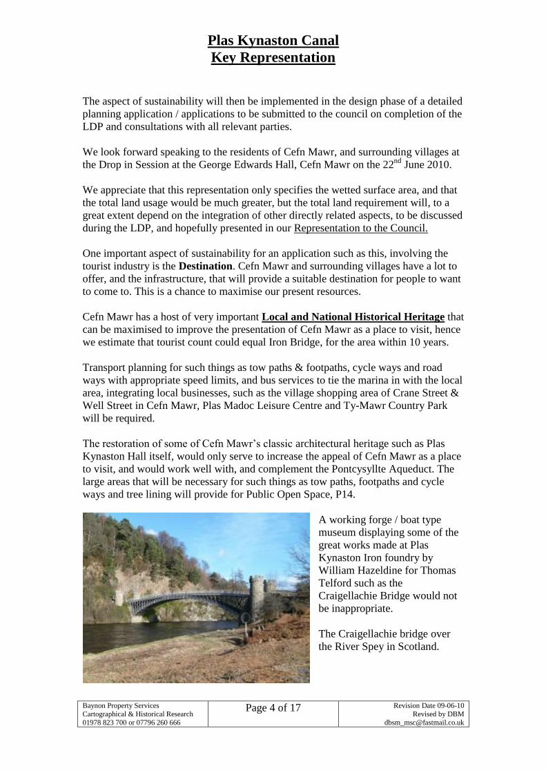
A working forge / boat type
museum displaying some of the
great works made at Plas
Kynaston Iron foundry by
William Hazeldine for Thomas
Telford such as the
Craigellachie Bridge would not
be inappropriate.
The Craigellachie bridge over
the River Spey in Scotland.
Plas Kynaston Canal
Key Representation
Baynon Property Services
Cartographical & Historical Research
01978 823 700 or 07796 260 666
Page 5 of 17
Revision Date 09-06-10
Revised by DBM
Archaeology:
This representation is made with full awareness of the archaeological heritage of the
site and all efforts are made to preserve and promote as much of the original
architecture of the Plas Kynaston Canal and surroundings as possible. This is for a
number of important reasons, and the primary of those reasons, being the aesthetic
value they add to the canal, and World Heritage Site, P11.
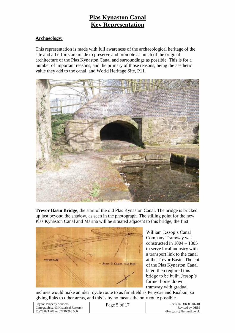
Trevor Basin Bridge, the start of the old Plas Kynaston Canal. The bridge is bricked
up just beyond the shadow, as seen in the photograph. The stilling point for the new
Plas Kynaston Canal and Marina will be situated adjacent to this bridge, the first.
William Jessop’s Canal
Company Tramway was
constructed in 1804 – 1805
to serve local industry with
a transport link to the canal
at the Trevor Basin. The cut
of the Plas Kynaston Canal
later, then required this
bridge to be built. Jessop’s
former horse drawn
tramway with gradual
inclines would make an ideal cycle route to as far afield as Penycae and Ruabon, so
giving links to other areas, and this is by no means the only route possible.
Plas Kynaston Canal
Key Representation
Baynon Property Services
Cartographical & Historical Research
01978 823 700 or 07796 260 666
Page 6 of 17
Revision Date 09-06-10
Revised by DBM
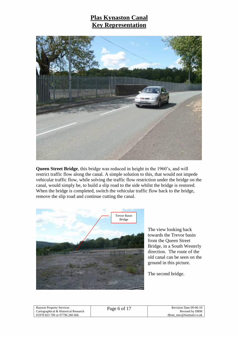
Queen Street Bridge, this bridge was reduced in height in the 1960’s, and will
restrict traffic flow along the canal. A simple solution to this, that would not impede
vehicular traffic flow, while solving the traffic flow restriction under the bridge on the
canal, would simply be, to build a slip road to the side whilst the bridge is restored.
When the bridge is completed, switch the vehicular traffic flow back to the bridge,
remove the slip road and continue cutting the canal.
The view looking back
towards the Trevor basin
from the Queen Street
Bridge, in a South Westerly
direction. The route of the
old canal can be seen on the
ground in this picture.
The second bridge.
Trevor Basin
Bridge
Plas Kynaston Canal
Key Representation
Baynon Property Services
Cartographical & Historical Research
01978 823 700 or 07796 260 666
Page 7 of 17
Revision Date 09-06-10
Revised by DBM
The Northern side of the Queen Street
Bridge. This tree lined avenue gives an
ideal example of the biodiversity
possibilities the restoration of the canal
would provide to the stark reality of the
industrial waste land that the Flexsys site
is at present. This would comply with
Councils policy of Biodiversity and
SP10 of the LDP.
Looking North East along the tree lined
route of the Canal from the Queen Street
Bridge. This section of the canal leads
from Queens Street to the bridge crossing
Tref-y-nant Brook, and on to what was
once Wards Warf. Again
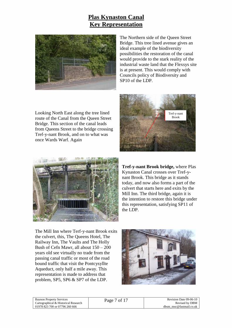
Tref-y-nant Brook bridge, where Plas
Kynaston Canal crosses over Tref-y-
nant Brook. This bridge as it stands
today, and now also forms a part of the
culvert that starts here and exits by the
Mill Inn. The third bridge, again it is
the intention to restore this bridge under
this representation, satisfying SP11 of
the LDP.
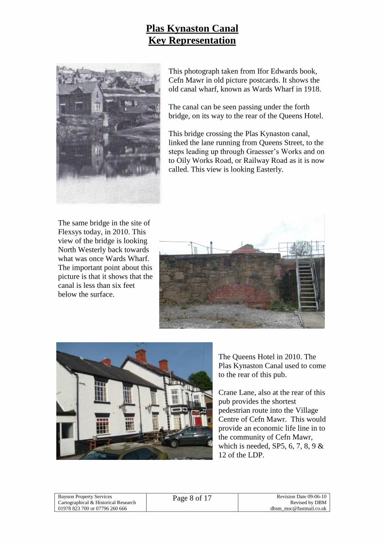
The Mill Inn where Terf-y-nant Brook exits
the culvert, this, The Queens Hotel, The
Railway Inn, The Vaults and The Holly
Bush of Cefn Mawr, all about 150 – 200
years old see virtually no trade from the
passing canal traffic or most of the road
bound traffic that visit the Pontcysyllte
Aqueduct, only half a mile away. This
representation is made to address that
problem, SP5, SP6 & SP7 of the LDP.
Tref-y-nant
Brook
Plas Kynaston Canal
Key Representation
Baynon Property Services
Cartographical & Historical Research
01978 823 700 or 07796 260 666
Page 8 of 17
Revision Date 09-06-10
Revised by DBM
This photograph taken from Ifor Edwards book,
Cefn Mawr in old picture postcards. It shows the
old canal wharf, known as Wards Wharf in 1918.
The canal can be seen passing under the forth
bridge, on its way to the rear of the Queens Hotel.
This bridge crossing the Plas Kynaston canal,
linked the lane running from Queens Street, to the
steps leading up through Graesser’s Works and on
to Oily Works Road, or Railway Road as it is now
called. This view is looking Easterly.
The same bridge in the site of
Flexsys today, in 2010. This
view of the bridge is looking
North Westerly back towards
what was once Wards Wharf.
The important point about this
picture is that it shows that the
canal is less than six feet
below the surface.
The Queens Hotel in 2010. The
Plas Kynaston Canal used to come
to the rear of this pub.
Crane Lane, also at the rear of this
pub provides the shortest
pedestrian route into the Village
Centre of Cefn Mawr. This would
provide an economic life line in to
the community of Cefn Mawr,
which is needed, SP5, 6, 7, 8, 9 &
12 of the LDP.
Plas Kynaston Canal
Key Representation
Baynon Property Services
Cartographical & Historical Research
01978 823 700 or 07796 260 666
Page 9 of 17
Revision Date 09-06-10
Revised by DBM
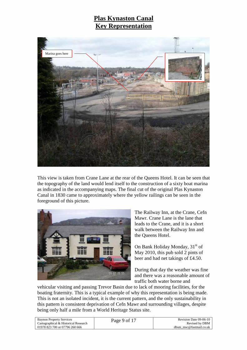
This
This view is taken from Crane Lane at the rear of the Queens Hotel. It can be seen that
the topography of the land would lend itself to the construction of a sixty boat marina
as indicated in the accompanying maps. The final cut of the original Plas Kynaston
Canal in 1830 came to approximately where the yellow railings can be seen in the
foreground of this picture.
The Railway Inn, at the Crane, Cefn
Mawr. Crane Lane is the lane that
leads to the Crane, and it is a short
walk between the Railway Inn and
the Queens Hotel.
On Bank Holiday Monday, 31st of
May 2010, this pub sold 2 pints of
beer and had net takings of £4.50.
During that day the weather was fine
and there was a reasonable amount of
traffic both water borne and
vehicular visiting and passing Trevor Basin due to lack of mooring facilities, for the
boating fraternity. This is a typical example of why this representation is being made.
This is not an isolated incident, it is the current pattern, and the only sustainability in
this pattern is consistent deprivation of Cefn Mawr and surrounding villages, despite
being only half a mile from a World Heritage Status site.
Marina goes here
Plas Kynaston Canal
Key Representation
Baynon Property Services
Cartographical & Historical Research
01978 823 700 or 07796 260 666
Page 10 of 17
Revision Date 09-06-10
Revised by DBM
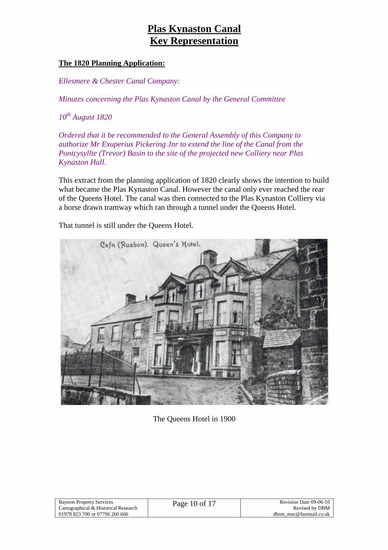
The 1820 Planning Application:
Ellesmere & Chester Canal Company:
Minutes concerning the Plas Kynaston Canal by the General Committee
10th
August 1820
Ordered that it be recommended to the General Assembly of this Company to
authorize Mr Exuperius Pickering Jnr to extend the line of the Canal from the
Pontcysyllte (Trevor) Basin to the site of the projected new Colliery near Plas
Kynaston Hall.
This extract from the planning application of 1820 clearly shows the intention to build
what became the Plas Kynaston Canal. However the canal only ever reached the rear
of the Queens Hotel. The canal was then connected to the Plas Kynaston Colliery via
a horse drawn tramway which ran through a tunnel under the Queens Hotel.
That tunnel is still under the Queens Hotel.
The Queens Hotel in 1900
Plas Kynaston Canal
Key Representation
Baynon Property Services
Cartographical & Historical Research
01978 823 700 or 07796 260 666
Page 11 of 17
Revision Date 09-06-10
Revised by DBM
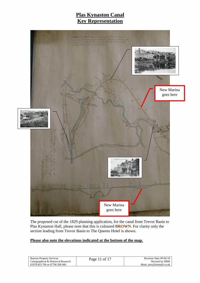
The proposed cut of the 1829 planning application, for the canal from Trevor Basin to
Plas Kynaston Hall, please note that this is coloured BROWN. For clarity only the
section leading from Trevor Basin to The Queens Hotel is shown.
Please also note the elevations indicated at the bottom of the map.
New Marina
goes here
New Marina
goes here
Plas Kynaston Canal
Key Representation
Baynon Property Services
Cartographical & Historical Research
01978 823 700 or 07796 260 666
Page 12 of 17
Revision Date 09-06-10
Revised by DBM
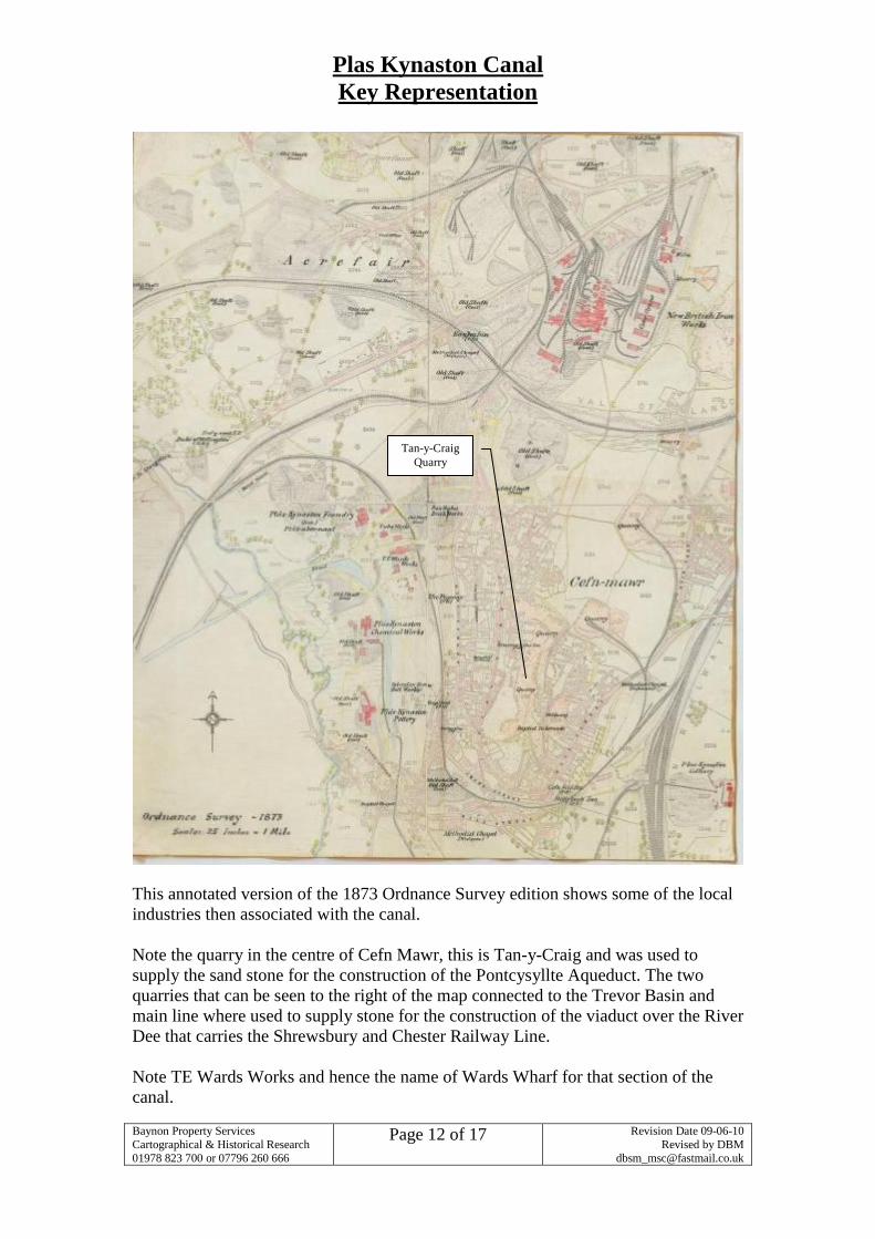
This annotated version of the 1873 Ordnance Survey edition shows some of the local
industries then associated with the canal.
Note the quarry in the centre of Cefn Mawr, this is Tan-y-Craig and was used to
supply the sand stone for the construction of the Pontcysyllte Aqueduct. The two
quarries that can be seen to the right of the map connected to the Trevor Basin and
main line where used to supply stone for the construction of the viaduct over the River
Dee that carries the Shrewsbury and Chester Railway Line.
Note TE Wards Works and hence the name of Wards Wharf for that section of the
canal.
Tan-y-Craig
Quarry
Plas Kynaston Canal
Key Representation
Baynon Property Services
Cartographical & Historical Research
01978 823 700 or 07796 260 666
Page 13 of 17
Revision Date 09-06-10
Revised by DBM
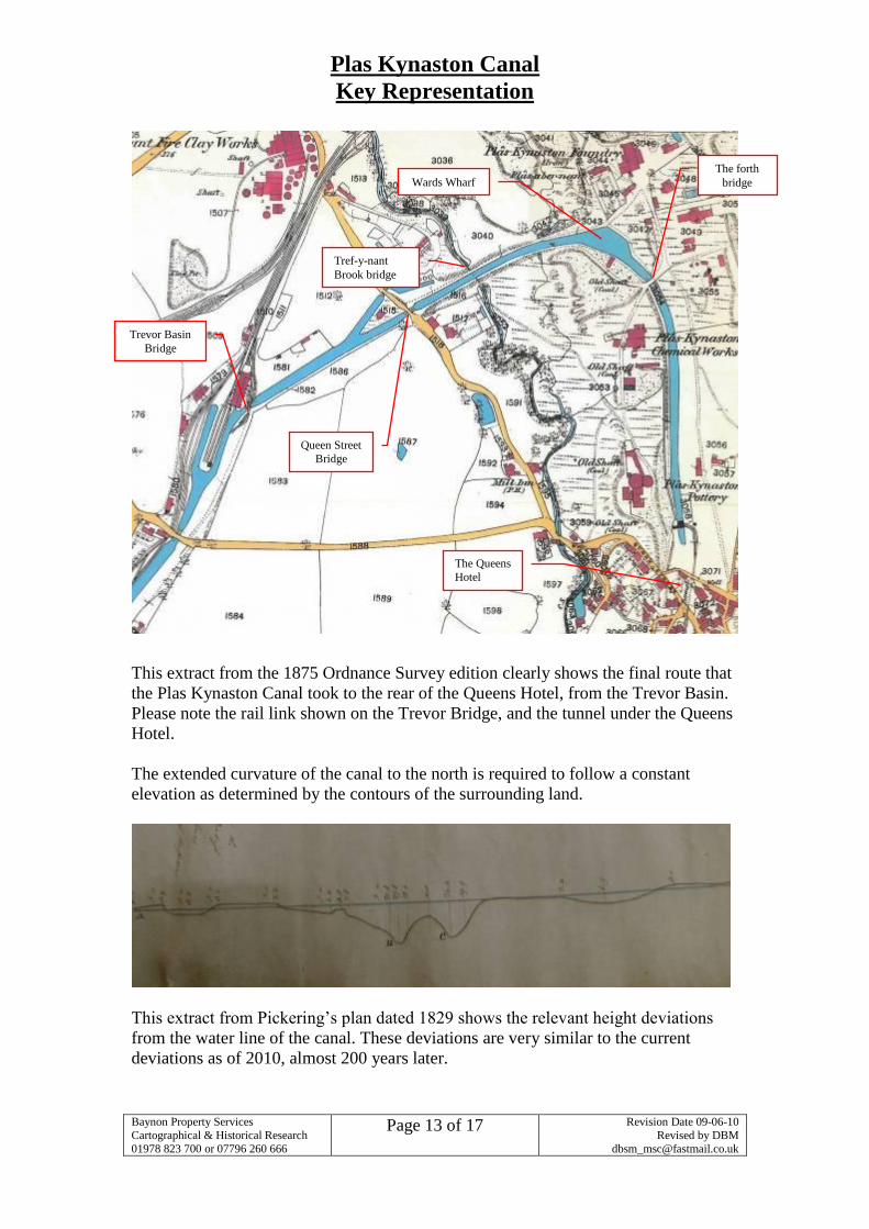
This extract from the 1875 Ordnance Survey edition clearly shows the final route that
the Plas Kynaston Canal took to the rear of the Queens Hotel, from the Trevor Basin.
Please note the rail link shown on the Trevor Bridge, and the tunnel under the Queens
Hotel.
The extended curvature of the canal to the north is required to follow a constant
elevation as determined by the contours of the surrounding land.
This extract from Pickering’s plan dated 1829 shows the relevant height deviations
from the water line of the canal. These deviations are very similar to the current
deviations as of 2010, almost 200 years later.
Wards Wharf
Tref-y-nant
Brook bridge
Trevor Basin
Bridge
Queen Street
Bridge
The forth
bridge
The Queens
Hotel
Plas Kynaston Canal
Key Representation
Baynon Property Services
Cartographical & Historical Research
01978 823 700 or 07796 260 666
Page 14 of 17
Revision Date 09-06-10
Revised by DBM
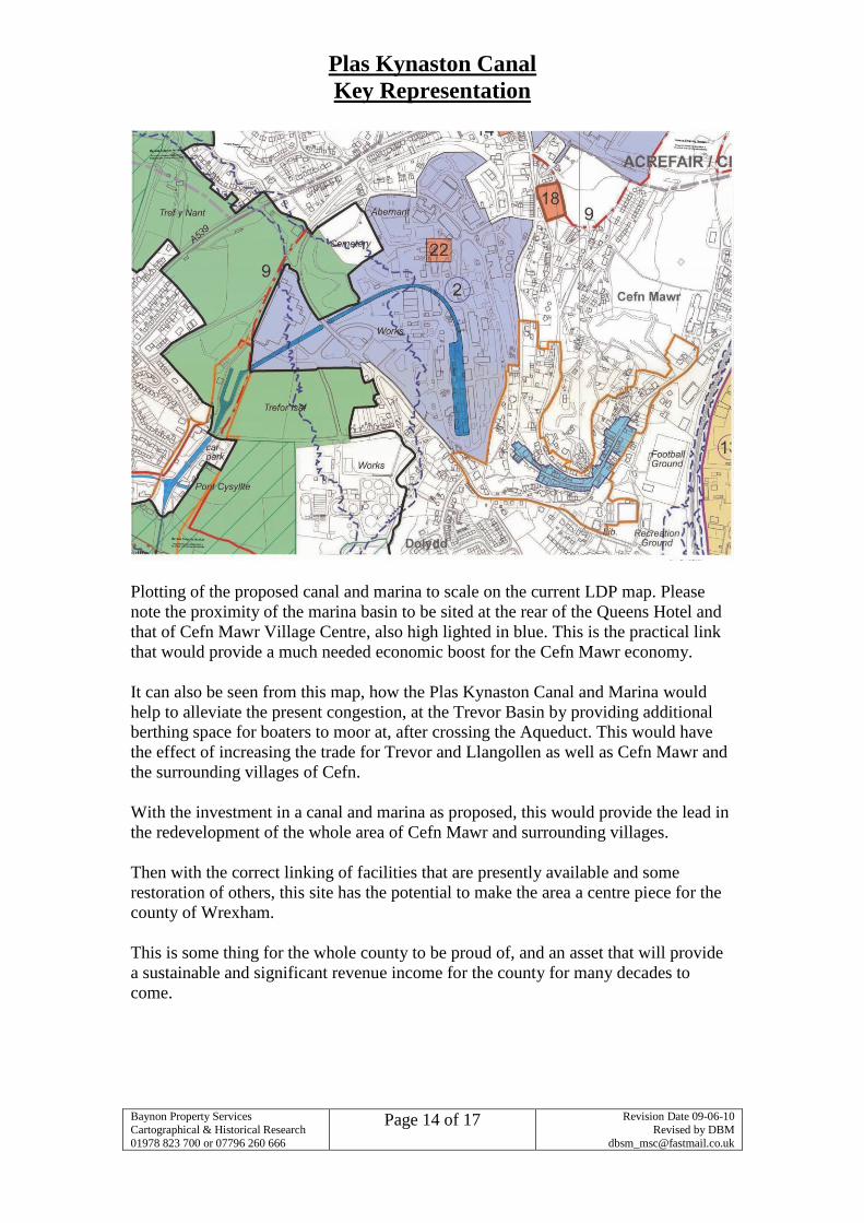
Plotting of the proposed canal and marina to scale on the current LDP map. Please
note the proximity of the marina basin to be sited at the rear of the Queens Hotel and
that of Cefn Mawr Village Centre, also high lighted in blue. This is the practical link
that would provide a much needed economic boost for the Cefn Mawr economy.
It can also be seen from this map, how the Plas Kynaston Canal and Marina would
help to alleviate the present congestion, at the Trevor Basin by providing additional
berthing space for boaters to moor at, after crossing the Aqueduct. This would have
the effect of increasing the trade for Trevor and Llangollen as well as Cefn Mawr and
the surrounding villages of Cefn.
With the investment in a canal and marina as proposed, this would provide the lead in
the redevelopment of the whole area of Cefn Mawr and surrounding villages.
Then with the correct linking of facilities that are presently available and some
restoration of others, this site has the potential to make the area a centre piece for the
county of Wrexham.
This is some thing for the whole county to be proud of, and an asset that will provide
a sustainable and significant revenue income for the county for many decades to
come.
Plas Kynaston Canal
Key Representation
Baynon Property Services
Cartographical & Historical Research
01978 823 700 or 07796 260 666
Page 15 of 17
Revision Date 09-06-10
Revised by DBM
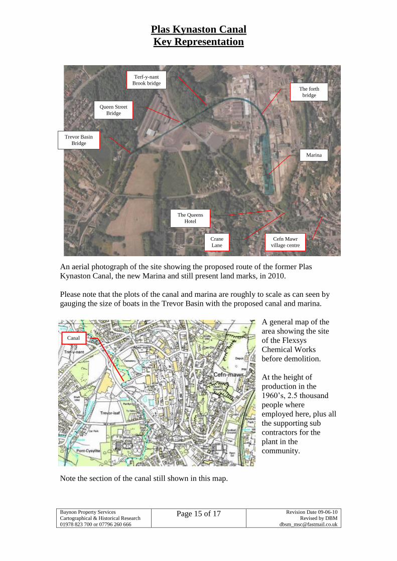
An aerial photograph of the site showing the proposed route of the former Plas
Kynaston Canal, the new Marina and still present land marks, in 2010.
Please note that the plots of the canal and marina are roughly to scale as can seen by
gauging the size of boats in the Trevor Basin with the proposed canal and marina.
A general map of the
area showing the site
of the Flexsys
Chemical Works
before demolition.
At the height of
production in the
1960’s, 2.5 thousand
people where
employed here, plus all
the supporting sub
contractors for the
plant in the
community.
Note the section of the canal still shown in this map.
The Queens
Hotel
Marina
The forth
bridge
Cefn Mawr
village centre
Terf-y-nant
Brook bridge
Queen Street
Bridge
Trevor Basin
Bridge
Crane
Lane
Canal
Plas Kynaston Canal
Key Representation
Baynon Property Services
Cartographical & Historical Research
01978 823 700 or 07796 260 666
Page 16 of 17
Revision Date 09-06-10
Revised by DBM
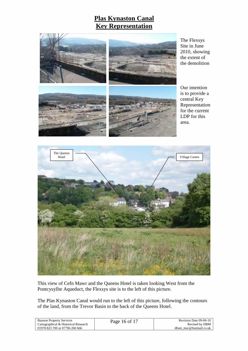
The Flexsys
Site in June
2010, showing
the extent of
the demolition
Our intention
is to provide a
central Key
Representation
for the current
LDP for this
area.
This view of Cefn Mawr and the Queens Hotel is taken looking West from the
Pontcysyllte Aqueduct, the Flexsys site is to the left of this picture.
The Plas Kynaston Canal would run to the left of this picture, following the contours
of the land, from the Trevor Basin to the back of the Queens Hotel.
The Queens
Hotel Village Centre
Plas Kynaston Canal
Key Representation
Baynon Property Services
Cartographical & Historical Research
01978 823 700 or 07796 260 666
Page 17 of 17
Revision Date 09-06-10
Revised by DBM
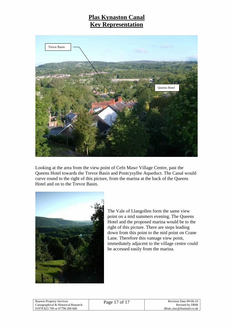
Looking at the area from the view point of Cefn Mawr Village Centre, past the
Queens Hotel towards the Trevor Basin and Pontcysyllte Aqueduct. The Canal would
curve round to the right of this picture, from the marina at the back of the Queens
Hotel and on to the Trevor Basin.
The Vale of Llangollen form the same view
point on a mid summers evening. The Queens
Hotel and the proposed marina would be to the
right of this picture. There are steps leading
down from this point to the mid point on Crane
Lane. Therefore this vantage view point,
immediately adjacent to the village centre could
be accessed easily from the marina.
Trevor Basin
Queens Hotel