Embed Size (px)
Citation preview

PLANNING & ZONING COMMISSION
AGENDA: OCTOBER 6, 2016

PLANNING AND ZONING COMMISSION
I. CALL TO ORDER
II. ROLL CALL
NOTICE OF PUBLIC MEETING City of Laredo City Hall City Council Chambers
1110 Houston Street Laredo, Texas
October 6, 2016 6:00p.m.
MEETING AGENDA
III. PLEDGE OF ALLEGIANCE
IV. CONSIDER APPROVAL OF MINUTES OF:
Regular Meeting of September 15,2016
V. CHAIRMAN AND DIRECTORS REPORT AND COMMUNICATIONS
VI. CITIZEN COMMENTS
Citizens are required to fill out a witness card and submit it to a City Planner, or designee, no later than 5:45 p.m. and identify themselves at the microphone. Comments are limited to three (3) minutes per speaker. No more than three (3) persons will be allowed to speak on any side of an issue. Should there be more than three (3) people who wish to speak on a particular issue, they need to select not more than three (3) representatives to speak for them and the presiding officer may limit the public comments further in the interest of an orderly meeting. Speakers may not pass their minutes to any other speaker. Comments should be relevant to City business and delivered in a professional manner. No derogatory remarks will be permitted.
VII. PUBLIC HEARING AND RECOMMENDATION OF AN ORDINANCE AMENDMENT TO THE LAREDO LAND DEVELOPMENT CODE:
Amending the Laredo Land Development Code of the City of Laredo by revising Article V, Section 24-78.2, General Requirements, (b) Central Business District And Arts and Entertainment District Exemptions, to clarify the parking exemption for residential uses within the districts; Providing For Publication and Effective Date.
Page 1

VIII. REVIEW AND CONSIDERATION OF THE FOLLOWING MASTER PLANS:
A. Embarcadero Southwest Quadrant Master Plan located south of Bob Bullock Loop (Loop 20) and west ofFM 1472 (Mines Rd.). District VII- Cm. George Altgelt.
B. Los Presidentes East Master Plan located south of State Highway 359 and east of Cuatro Vientos Rd. District II- Cm. Vidal Rodriguez.
C. San Isidro Northeast Subdivision Master Plan, located north of Bob Bullock Loop (Loop 20) and east of McPherson Rd. District VI- Cm. Charlie San Miguel.
IX. PUBLIC HEARING AND CONSIDERATION OF THE FOLLOWING PRELIMINARY REPLATS:
A. Replat of Lots 6, 7 and 8, Block I, Inverness Subdivision into Lots 6A, 7 A and SA, Block 1, Inverness Subdivision, located north of E. Del Mar Boulevard and east of Bermuda Drive. District VI- Cm. Charlie San Miguel.
X. CONSIDERATION OF THE FOLLOWING PRELIMINARY PLATS AND PRELIMINARY REPLATS:
A. Plat of Los Presidentes Subdivision Unit 13A located south of State Highway 359 and west of Concord Hills Blvd. District II- Cm. Vidal Rodriguez.
B. Plat ofCuatro Vientos Norte Subdivision, Phase XIII, located west ofCuatro Vientos Road and north of Wormser Road. District I- Cm. Rudy Gonzalez.
XI. CONSIDERATION OF THE FOLLOWING FINAL PLATS AND REPLATS:
A. Plat of Bulldog Boulevard and Mayela Drive R.O.W Dedication Plat is located south of
Del Mar Boulevard and west ofBob Bullock Loop District V- Cm. Roque Vela, Jr.
B. Plat of Allen Woods Subdivision located west of Bob Bullock Loop and north of Shiloh
Drive. in District VI-Cm. Charlie San Miguel.
C. Plat of Moreno Commercial Subdivision, Phase 1, located State Highway 359 and east of
Dorel Drive. District II- Cm. Vidal Rodriguez.
XII. ADJOURNMENT
THIS NOTICE WAS POSTED AT THE MUNICIPAL GOVERNMENT OFFICES, 1110 HOUSTON STREET, LAREDO, TEXAS, AT A PLACE CONVENIENT AND READILY ACCESSIBLE TO THE PUBLIC AT ALL TIMES. SAID NOTICE WAS POSTED ON FRIDAY, SEPTEMBER 30,2016 BY 6:00P.M.
Page2

DISABILITY ACCESS STATEMENT
Persons with disabilities who plan to attend this meeting and who may need auxiliary aid or services are requested to contact Ana G. Villarreal, Planner II, at (956) 794-1613, [email protected], at least two working days prior to the meeting so that appropriate arrangements can be made. The accessible entrance and accessible parking spaces are located at City Hall, II 00 Victoria Ave.
Informacion en Espaiiol: Personas que planeen asistir a esta reunion y que pueden necesitar ayuda o servicios, auxiliares como: interpretes para personas sordas o con discapacidad auditiva, lectores de Jetra grande o en Braille, o un traductor de idioma espafiol, deben comunicarse con Ana G. Villarreal, del Departamento de Planificaci6n de Ia Ciudad, 1120 San Bernardo Ave., a! (956) 794-1620, [email protected], a! menos cinco dias habiles antes de Ia reunion para que los arreglos apropiados se pueden hacer. Materiales en espaiiol se proveenin a petici6n.
ob~' Director of Planning Acting City Secretary
0 .2 """ -/) ;·....., "'0
w 0
-o
""' w 0
Page3
:::0 m (") m < m 0

DATE:
10/06/2016 VII
SUBJECT: PUBLIC HEARING AND RECOMMENDATION OF AN ORDINANCE AMENDMENT TO THE LAREDO LAND DEVELOPMENT CODE:
Amending the Laredo Land Development Code of the City of Laredo by revising Article
V, Section 24-78.2, General Requirements, (b) Central Business District And Arts and Entertainment District Exemptions, to clarify the parking exemption for residential uses within the districts; Providing For Publication and Effective Date.
INITIATED BY: STAFF SOURCE: Staff
PRIOR ACTION: None
P&Z COMMISSION RECOMMENDATION: The P & Z Commission, in a __ to __ vote, recommended __ of the proposed amendment to the Land Development Code Book.
Horacio De Leon Assistant City Manager
STAFF RECOMMENDATION: Staff sun ports the ordinance amendment.

CITY OF LAREDO ORDINANCE NO. 2016-0-
AMENDING THE LAREDO LAND DEVELOPMENT CODE OF THE CITY OF LAREDO BY REVISING ARTICLE V, SECTION 24-78.2, GENERAL REQUIREMENTS, (b) CENTRAL BUSINESS DISTRICT AND ARTS AND ENTERTAINMENT DISTRICT EXEMPTIONS TO CLARIFY THE PARKING EXEMPTION FOR RESIDENTIAL USES WITHIN THE DISTRICTS; PROVIDING FOR PUBLICATION AND EFFECTIVE DATE.
WHEREAS, the purpose of the Central Busine s District (CBD) is to provide for development and redevelopment of the City's historic urban center, with acknowledgment of the district's unique characteristics and contribution to tile comm nity; and
WHEREAS, the purpose of the Atts and Entertainment District (AE ) is top ·ovide a mixed-use environment where arts and entettainment ve ues, commercial, residential and office uses harmoniously co-exist in a higher density, pedestrian-oriented environment; and
WHEREAS, off-street parking is not a requirement for businesses within the Central Business District and the Arts and Entettainment District; d
WHEREAS, the City Cou ci seeks to cl 'fy that r uired off-street resident parking is not a requirement and is an ex mption available witllin the Q::e tral Business and Atts and Entertainment Districts; and
WHEREAS, the Planni g & Zoning Commission, after a public hearing on October 6, 2016, has recommended the Ci Council this proposed amendment to the City of Laredo Land Development Code.; a d
WHEREAS, the City Council has held a public hearing on , 2016 on this amendment and fmps the ordilia~ce appropriate, necessary and consistent with the General Plan of the City ofLaredb and i the best interest of the public health, safety and welfare.
NOW, THEREFORE BE IT ORDAINED BY THE CITY COUNCIL OF THE CITY OF LAREDO THAT:
Section 1: Atticle V, Section 24-78.2(b) of the Laredo Land Development Code is be and hereby is amended as follows:
Section 24-78.2 GENERAL REQUIREMENTS
(b) CENTRAL BUSINESS DISTRICT AND ARTS AND ENTERTAINMENT DISTRICT EXEMPTIONS Although encouraged to consider off-street parking for their customers and resideuts in their planning, customer ami resident off-street parking is not a

requirement of the individual businesses or residential uses located within the Central Business District and the Arts and Entet1ainment District. However, if such off-street parking is provided, it shall be constmcted in accordance with the provisions of Section 24-78.
Section 2: This ordinance shall be published in a manner provided by Section 2.09 (D) of the Charter of the City of Laredo.
Section 3: This ordinance shall take effect and be in force from and after publication as specified in Section 2 above.
Section 4: Severability
If any provision, section subsection, ente ce, clause, or p ase of this ordinance, or the application of the same to any person or set of circumstances is for any reason held to be unconstitutional, void or invalio, the Yalidity of the remaining pot1ions of this ordinance or their application to other e~n or sets of circumstances shall not be affected thereby, it being the intent of the City Council in adopting this ordinance that no portion hereof or provision or regulation contained herein shall become inoperative or fail by re son of any unconstitution lity, voidness or invalidity or another portion ihereof, and all revisions of this ordinance are declared to be severable for that p IJJose.
Section 5: Open Meeting
The City Council officially finds, determines, recites and declares that a sufficient written notice of e date, ho ·, place and subject of this meeting of the City Council was posted a place co~enient to the public at the City Hall of the City for the time required o law preceding this meeting as required by the Open Meeting Law, Article 6252-1 7, Texas Revised Civil Statutes Annotated; and that this meeting has bee open to the public as required by law at all times during which this ordinance and the subject matter was considered and approves and confirms su h wri ten notice and the contents and posting hereof.
PASSED BY THE CIT COUNCIL AND APPROVED BY THE MAYOR ON THIS THE DAY OF , 2016.
PETE SAENZ MAYOR
ATTEST:

HEBERTO"BETO"RAMIREZ ACTING CITY SECRETARY
APPROVED AS TO FORM: RAUL CASSO, CITY ATTORNEY
KRISTINA K. LAUREL-HALE FIRST ASSISTANT CITY ATTORNEY

AGENDA ITEM: VIII - A DATE: 10106116 APPLICANT: Mines Road Development, Ltd. ENGINEER: Camacho-Hernandez and
Associates, LLC
REQUEST: Review and consideration of Embarcadero Southwest Quadrant Master Plan. The intent is residential and commercial.
SITE: This 365.15 acre tract is located south of Bob Bullock Loop (Loop 20.) and west ofFM 1472 (Mines Rd.). The zoning for this 1093 lot development is R-1A, R-2, B-3 and B-4. This tract is located in District VII- Cm. George Altgelt.
PROPOSED ACTION: APPROVE SUBJECT TO THE FOLLOWING COMMENTS: Planning:
l. Please submit master plan revision to City of Laredo Building Department GIS Division within 10 days in a geo-referenced CAD file. 2. Conform to Section 24-56 of the Laredo Development Code regarding Parkland Dedication, if applicable. 3. Conform to Section 24-57 of the Laredo Land Development Code regarding Green Space Preservation, if applicable. 4. All improvements as Per Subdivision Ordinance.
Engineering: No comments submitted
Fire: No comments submitted.
Environmental: No comments submitted.
Water & Utilities: No comments submitted.
Traffic Safety:
l. Make sure curve on Riverbank Dr. are design for a minimum of 35 mph.
Parks & Leisure: No comments submitted.
WEBB County App: No comments submitted.
AEP Engineers: No comments submitted.
U.I.S.D.: No comments submitted.
L.I.S.D.: No comments submitted.
Page 1 of2

AT&T: No comments submitted.
NOTICE TO THE DEVELOPER: Planning: I. Only the utility easements within the plat boundaries are subject to change prior to plat recordation, due to revisions by the utility companies
Page 2 of2


I r I
BEING A 365.15 A L£<W. DESCRIPTION; LAND BEING SITUA CRE TRACT OF LAND OUT BAUllSTA GARC~T~dN PORCION 20 ABST~ A I ,530.61 TRACT OF
"' R.O.W.
'·' V.W.U.E H
LEGEND NOT TO SCALE RIGIH or WAY UNIT BOUNDARY
APPROXlloiAT£ LOCAll~ 100 YEAR FlOOOf'lAIN
~:~~~ANK DR. &. F.I.SKEN BLVD Of-WAY DEDICAllON PLAT
UllUTY EASB~ENT DRAINAGE RIGHT-Of-WAY ORAIN.O.G£ EASEI.IENT VARII\8\.E-'MDTH Ulli.J El..ECTRIC EASEI.IENT "lftASEI.tENT
.: I ~~····!
INDEX MAP -~
RIVERBANK DRIVE UNIT 3 TYPICAL STREET SECTION
lOCAL COLLECTOR TYPE. TYPICAL STREET SECTI~
• I
···~ IH
1-·~w ----------_/--~a==J~-r
FASKEN BOULEVARD TYPICAL STREET SECTION
·--iiWibii&i"'l 00
SCALE:
LOop 20
I 1"=200'
MULTI-FAMILY MULTI-FAMILY
ELEMENTARY SCHOOL
-~ --~ -~~ SA.'j~IOII«:.
-~ 1/0L (S.i,.>,lC!;)
j·-.:,::O;o•M>>
b3:2MIACS~
JAi
.':!;),.',
FASKEN BOULI::VARD TYPICAL STREET SECTION ,_........,,_, __ ..
MOTif><> , ... UAT~~~
~·.
RETAIL
~·.
IRL =
0 <(
0 C!
,C/l w
~
_,. 2UO
"" 11.1l 14U7 ..• R. ~""
'"'
"
"'
z ::s c... 0:: w I-
~
2

"' R.O.W.
U.E.
D.R. O.E. V.W.U.E. E.E.
-----
LEGEND NOT TO SCALE RIGHT Of WAY UNIT BQijNOARY
M'PROXIMAl£ LOCAllON 100 'r£AR flOOOPlAIN
RI\£RBANK OR, & FASKEN BLVD. RIGHT-OF-WAY OEOICAllON PlAT
UllUTY EASEMENT DRAINAGE RIGHT-Of-WAY
DRAINAGE EASEMENT VAAIABLE-'MDnl UTIUTY (AS(I.IENT
ELECTRIC EASEMENT
0: ~ ii UJ Q z ~ (!)
0 ii
.~ /
Res
OPEN SPACE
un STAnON $TE
\
LE~ DESCRIPTION: j BEING A 365. HI ACRE TRACT OF LAND OUT OF A 1,530.61 TRACT OF
LAND BEING SITUATED IN PORCION 20, ABSTR.-.cT 48, ORIGI~ GRANTEE 6MITISfA GARCIA, AND PORCION 21, ABSTAACT 49, ORIGINAL GAANrEE
LEONARDO GARCIA, AND SURVEY 2415, F. AND I. FAAIAS ORIGINAL GRANTEES, AS RECORDED ON 'mE DATE OF FEBRUAAY 13, 1996 IN VOWidE 382, PAGES 899-904, OFACIAI... PUBUC RECORDS OF WE88
COUNT'f, TEMS.
II EXISTJ>W 12' UruTY,\\ !;.O.!£UENT ~
.,
YOLol89,"'327& ~
~·00 YOI.-1'is.~\,~-w.c.r.
"-
..
OWNER & APPLICANT MINES ROAD DEVELOPMENT l TO. CONTACT PERSON: ARTHUR ZUNIGA 8333 MILO ROAD I LAREDO, TEXAS 78045 TEL: (956) 791-5000 FAX: (956) 791-5055
II
I SCALE: 1"=200'
DISliHG FillA FUXlDPlAij Ullll'> ~ PER IIUAS !WI AQ.ISTIII FillA LCIII Sl\ll)y CASE ll2-o&-2134P
CIVIL ENGINEER
N u.. 0 ..-1-UJ UJ :r: en UJ UJ en UJ z :J :r: ()
~ ::2
CAMACHO HERNANDEZ & ASSOCIATES CONTACT PERSON: ARTURO CAMACHO, P.E. 415 EMBASSY OAKS, SUITE 205 SAN ANTONIO, TEXAS 78216 TEL: (210) 341-6200 FAX: (210) 341-6300
DEVELOPMENT SUMMARY ~ ACRES UNITT ~" ~~ ·~ IIIULTI-FAAIILV ·~ SIN1:4-EFAMILV ... ~ 11.12 P\!BIJCRIGHTOFWAV ·~
UNIT2 ~· SINGLI:FMILY "" 1'\JBUCRIGHTOFWAY ~
RIVERBANK & FASKEN PLAT ,., PU1!UCRIGHTOFW/Io,Y 4.31
UNIT3 ~· 81N<ll..Ef.....,_Y \1,111! PIJIILICRlGJfTOFWAY ~ Ol'fi<SPACI'- '" R6CRE.OIIIONIII. PARI< ao
UNIT4 ~
SI..OCEF--Y ..• I'V8UC RIGii'T OF WAY •m
UNITS "·" SINGLEF--Y 1U4 PUOLICRIGHTOFWAY m -~~ 4.1Z
UNIT8 21.51 Sf.IGU;FMILY "~ PUI!UCRIOHTOFWAY <m
•
tLOTS
••
'"
.• " ••
••
RIVERBANK ORIVE U~IT 3 TYPICAL STREET SECTION
.. ~ . ._
FASKEN BOUI..EVARO TYPICAL STREET SECTION
,_ .......... -.."' -·"
LOCAL TYPE "A" TYPICAL STREET SECTION
.,,
"'
1-z 0~ a:::O w~ o:J ~0 01-a:::en ~w Ill$: ::2:r: W!
:J 0 en
OF

AGENDA ITEM: VIII - B DATE: 10/06/16 APPLICANT: Hill Top Farms, Ltd. ENGINEER: Howland Engineering and Surveying Co
REQUEST: Review and consideration of Los Presidentes East Master Plan. The intent is residential.
SITE: This 150.7 acre tract is located south of State Highway 359 and east of Cuatro Vientos Rd. The zoning for this 4781ot development is R-1A. This tract is located in District II- Cm. Vidal Rodriguez.
PROPOSED ACTION: APPROVE SUBJECT TO THE FOLLOWING COMMENTS: Planning:
1. Remove "Future" from Unit order. 2. Revise Unit to Phase. 3. Please submit master plan revision to City of Laredo Building Department GIS Division within 10 days in a geo-referenced CAD file. 4. Conform to Section 24-57 of the Laredo Land Development Code regarding Green Space Preservation, if applicable 5. Conform to Section 24-56 of the Laredo Development Code regarding Parkland Dedication, if applicable. 6. All improvements as Per Subdivision Ordinance
Engineering: No comments submitted.
Fire: No comments submitted.
Environmental: No comments submitted.
Water & Utilities: No comments submitted.
Traffic Safet1:: 1. Some streets will require traffic calming devices. 2. Check for sight distance at intersections with curves.
Parks & Leisure: No comments submitted.
WEBB Counti App: No comments submitted.
AEP Engineers: No comments submitted.
Water & Utilities: No comments submitted.
Traffic Safet1:: No comments submitted.
Parks & Leisure: No comments submitted.
WEBB Count1: App: No comments submitted
Page 1 of2

AEP Engineers: No comments submitted.
U.I.S.D.: No comments submitted.
L.I.S.D.: No comments submitted.
AT&T: No comments submitted.
NOTICE TO THE DEVELOPER:
Planning:
1. Only the utility easements within the plat boundaries are subject to change prior to plat recordation, due to revisions by the utility companies
Page 2 of2
1-----------·--------------·--------------------'


AGENDA ITEM: VIII- C DATE: 10/06/16 APPLICANT: San Isidro Northeast, Ltd. ENGINEER: Slay Engineering Co.
REQUEST: Review and consideration of San Isidro Northeast Subdivision Master Plan. The intent is residential and conunercial.
SITE: This 474.82 acre tract is located north of Bob Bullock Loop (Loop 20)and east of McPherson Rd. The zoning for this 1,423lot development is R-1, R-2, B-1, B-3 and B-4. This tract is located in District VI- Cm. Charlie San Miguel.
PROPOSED ACTION: APPROVE SUBJECT TO THE FOLLOWING COMMENTS: Planning:
1. Identity San Isidro Northeast La Cuesta Phase 3. 2. Provide and Label current City Limits. 3. Identify all detention ponds. 4. All improvements as Per Subdivision Ordinance.
Engineering:
1. Label all Phases.
Fire: No conunents submitted.
Environmental: No comments submitted.
Water & Utilities: No conunents submitted.
Traffic Safety: 1. Some streets will require traffic calming devices. 2. Check for sight distance at intersections with curves.
Parks & Leisure: No comments submitted.
WEBB County App: No comments submitted.
AEP Engineers: No conunents submitted.
U.I.S.D.: No conunents submitted.
L.I.S.D.: No conunents submitted.
AT&T: No conunents submitted.
NOTICE TO THE DEVELOPER: Planning:
1. Only the utility easements within the plat boundaries are subject to change prior to plat recordation, due to revisions by the utility companies.


\ \ I \
.---··
S81llaldro NorthNIII. ltl. 9901 McPheJSOO Rd, ste 201
laredo, Texaa 78045 (956)796-1101
THI&DQCtliiErir"ill.l'lfi..EASED FOR ll1! PURPOSE 01' mERIM RE\iJEWINlEliTHE AlmiORITY
• Of' '
\R0::,:-1~ •JI" IS OOTTOOE USED IIi
IIEI'ERE~~-
c
£
I
!5
~ z Q VJ
~ c al :::1 VJ

AGENDA ITEM: IX - A DATE: 10/06/16 APPLICANT: Gateway Centennial ENGINEER: Premier Engineering and Surveying
Development Co.
REQUEST: Public hearing and preliminary consideration of the replat of Lots 6, 7 and 8, Block 1 Inverness Subdivision into Lots 6A, 7 A, and SA, Block 1, Inverness Subdivision. The intent is residential. The purpose of this replat is to re-locate the property lines between Lots 6, 7 and 8, Block 1.
SITE: This 0.915 acre tract is located north of E. Del Mar Blvd. and east of Bermuda Drive. The zoning for this 3 lot development is R-1. This tract is located in District VI- Cm. Charlie San Miguel.
PROPOSED ACTION: APPROVE SUBJECT TO THE FOLLOWING COMMENTS:
Planning:
1. Revise signature block for Planning and Zoning to reflect Michael Barron as Chairman. 2. Provide GPS coordinate (NAD 83 State Plane Coordinates for Texas, South Zone) for point of
Beginning as a plat note, on the plat drawing, or in the metes and bounds description. 3. Revise and combine plat notes 1 and 3 to reflect:
1. The purpose of this Re-Plat is to: A. Re-located the property lines between Lots 6, 7, and 8, Block 1. B. Abandon 30'
4. Provide appropriate release letter for gas easement before submitting for final or at the time of submittal.
5. All improvements as Per Subdivision Ordinance.
Engineering:
1. Show all easements.
Fire: No comments submitted.
Environmental: No comments submitted.
Water & Utilities: No comments submitted.
Traffic Safety: No comments submitted.
Parks & Leisure: No comments submitted.
Page 1 of2

WEBB County App: No comments submitted.
AEP Engineers: No comments submitted.
U.I.S.D.: No comments submitted.
L.I.S.D.: No comments submitted.
AT&T: No comments submitted.
NOTICE TO THE DEVELOPER:
Planning: 1. Only the utility easements within the plat boundaries are subject to change prior to plat recordation,
due to revisions by the utility companies
Page 2 of2


PLAT NOTES: •
1. THE PURPOSE OF THIS RE-PLAT IS TO RE-LOCATE THE PROPERTY LINES BETWEEN LOTS 6, 7, & 8, BLOCK 1.
2. THIS RE-PLAT DOES NOT ATTEMPT TO ALTER, AMENDED, OR REMOVE ANY COVENANTS OR RESTRICTIONS.
3. 30' WIDE AMOCO GAS EASEMENT TO BE ABANDONED BY THIS REPLAT.
4. THE SUBJECT PROPERTY IS NOT LOCATED WITHIN THE 100 YEAR FLOODPLAIN AS PER FEMA FLOODPLAIN FIRM MAP No. 48479C1205C WITH EFFECTIVE DATE Of APRIL 2, 2008.

"""-"" GoiColnelriiCI Reoo!deodhVtl.71l\,Pgo.384
+AS-PLATTED _ sc.ou:,-~,00 ~OTSII,7,1-Bl0Cil1 NI'ER~SSSIJBOIIIIS1Cf<,VOL-16,1'G 61,P.llWCT. CITY C#' I..AREXI, \\tOO COUNTY, ru.\S
Ll N E TABLE AS- PLATTED
Unet "'~ """" Curve•
~ NS1"34'42"W 51.41' 0
" N70" 59'46"E 66.47' " u N18' 28' ll"W 139.17' " " 554' 54' Ol"E 11.42'
~ 586'10' Sl"E 21.87'
u; N72' 53' 40"E 26.53'
" N41' 34' 55'E 101.06'
~ N7S' 41' 14"E 56.97'
~ N62' 22'02"E 31.89' .
~' 507' 27' 04"E 25.15'
"' S76' 20' 32"E 27.29'
"' N77'10' 24'E 100.26'
LOT TABLE
BLOCK 1~ LOT SQ.FT.
' 11,605
' 13,552
• 13,717
LOT TABLE
BLOCK 1~ LOT SQ.FT. ... 10,066
" 12,7&0
" 16,996
50 50 100
GIW'HIC 8CAI..E IN FEET
n 11 2 s G A lfl C I A
A i1'l T E IE 5 0
LaredoCourW'/CIOO GoiiCourMTratl
Ratolded h VOl 70\, Pgs. 384
• RE-PLAT LDTSIA,IA,IA,I!I.(l(]l1 INYERHESS SU~ C!NDf I.AR£00. W£811C<Mf1Y,TE)(I,S
CURVE TAB t E ll N E TABlE
"""' Rod ius
59.60' 50.00'
6.28' "'""' 86.68' 1094.98'
.... Tangent Line II
68'17'01' 33.91'
" 07"11'45' U4' u
04'31'01' 43.18' u
" ~
" " "' ~
~
uo LU
"' m
"' "'
PLAT NOTES:
1. THE PURPOSE OF THIS RE·PI.AT IS TO RE-I.OCA.T£ THE PROPERTY UNES BETWEEN LOTS 6, 7, & 8, BLOCI( 1.
2. THIS RE-PLAT DOES NOT AmMPT TO ALTER, AMENDED, OR REMOV< ANY COVENANTS OR RESTRICOONS.
3. 30' WIDE AMOCO GAS EASEMENT TO BE ABANDONED BY THIS REPLAT.
4. lliE SUBJECT PROPERTY IS NOT LOCATED WITHIN TliE 100 YEAR fLOODPLAIN AS PER HMA FlOODPLAIN flAM MAP No. 48479C1205C WITH EFFECTIVE DATE OF APRil 2,
'"""
RE- PLAT
Course ~nKth
NS4" 51' 33"W 120.19'
S86"08'23"E 21.87'
N12" 56' D7"E 26.U
N42" 37' 22"E 101.(16'
N75" 43' 41"E 56.97'
N62' 24' 29"E 31.89'
$07' 24' 36"f 25.25'
S76"18'04"E 5.53'
576"18' 04"E 27.29~
N77"12' Sl"E 100.26'
513" 57' D7"E 132.33'
580" 34' 58"W 49.31'
580' l5' DS"W 71.53'
N14" 59' SS"W S8.84'
NlS" 14' 25"W 86.58'
S09" 24' 56"[ 136.27'
8l'.AlE:_1:!'100
CURVE TABLE
Cun~e• """' Radius "'"' Tangent
" " "
59.60' 50.00' 68'17'(11' 33.91'
6.28' 50.00' oru·4s' 3.14'
86.68' 1094.98' 04'31'01' .3.18'
CERTIFICATE OF OWNER: STATE OF ITXo\5: • · • · I-COUNTY Of WEBB: I
~~~~o~:-"'UTMANN 1 GATEWAY CENTENNIAL D£VELOPMENT, INC.
STATEOFTEXAS: ~~ COUNTY OF WEBB:
NOTARY PUBUC IN AND FOR nlE WEBB COUNTY, TEXAS MYCOMMISSIONEKPIRES·•·------
CERTIFICATE OF OWNER: STATE OF TEXAS; COUNTY OF WEBB:
ROBERT TRAUTMANN VICE PRESIDENT NORTHTOWN DEVELOPMENT, INC.
STATE OF TEXAS: COUNTY OF WEBB:
NOTARY PUBU<: IN ANO fOR THE WEBB COUNTY, TEXAS MY COMMISSION EXPIRES: _____ _
W.E s
&011'1 50 ,r GIW'HIC seAl£ ill FEfT
CERnFICATE OF OWNER: SlATEOFTtXAS: COUNTY OF WEBB:
~FERNANDO O.lAURELJRTHE UNDERSIGNEOOWNER OF THE LAND SHOWN ON THIS REPLAT, AND DESIGNATED HEREIN AS LOT &A. BLOCK 1 ltMRNESS §UBDIV~ION IN THE CJTY OF LAREDO, COUNlY OF WEBB, TD!AS, AND wtiOSE NAME IS SUIISCRIBED HERETO. HEREBY DEOICATE TO THE USE OF THE PUBUC FOREVERALlsntEETS, DRAINS. EASEMENTS AND PUBUC PlAC£.5 THEREON SHOWN FOR THE PURPOSEANDCON.SIDERATlON THEREIN EXPRESSED.
FERNANDO D. LAUREL. JR.
STATE OF TEXAS: COUNTY OF WEBB:
NOTARY PUBUC IN ANrl FOR lliE WEBB COUNlY, TEXAS MY COMMISSION lXPIRESc· -----
CERTIFICATE OF ENGINEER
STATE OF TEXAS: WEBB COUNTY:
I, HEREBY CERTIFY THAT PROPER ENGINEERING CONSirlERATION HAS BEEN GIVEN TillS REPLATTO THE MAmRS OF STR~m, lOTS, WATER, SEWER AND AP!'URTENANC~SAND DRAI~GE lAYOUT; ANI>TO ffiE BEST Of MY KNOWlEDGE THIS PLAT CONFORMS TO AU. REQUIREMENTS OF Tli£ SUSDIVISIO~ ORDINANCE, EXClPT FOR THOSE VARIAKCES THAT MAY HAVE BEEN GRANTi.D BY THE PlANNING COMMISSION OF THE CITY.
EDUARDO J. GUTIERREZ P.E. No.82657
-~-~~. -'Mi.- fit..* .. ~.··~
\&7r.~~i) .,,~\,-.1"
CERTIFICATE OF SURVEYOR
STATEOfrex.t.S: COUNTY Of WEBB:
I, EDUARDO f. GUTIERREZ, REGISTERED PROFESSfONAllANOSURVEYOR 00 HEREBY STATE THAT THIS REPlAT CORRECTlY REPRESf.NTS lliE RESUlTS OF A SURveY MAOE ON THE GROUND UNDER MY SUPI:RVISION AND DIRECTION.
EDUARDOJ. GUTIERREZ R.P.LS. N0.5839
PlAT-APPROVAL CITY ENGINEER
I HAVE R£VIEWED"rnl5 REPlAT AND ACCOMPANYING CONSTRucnON DRAWINGS IDENTIFIED AS l0156A. 7-., 8A. BLOCK 1 INVERNESS SUBDIVISION PREPAUD BY EDUARDO J. GUTIERREZ LICINSED PROFESSIONAL ENGINEER No. 81657, AND DATEDTliE_DAY DF ___ 20__.. Willi THE LAST REVISED DATE ON
'ruc.,o,~~o,o,.c,••"oc.''"""~ "'6~ ~~~:D~i~,~~IANCE WITH THE
IIDGELIORIVERA, P.E. OTY ENGINEER
I
VICINITY MAP SCA!.Eol'•2000'
PLANNING COMMISSION APPROVAL
EDUARDO A. CASTILLO, CHAIRMAN
ATTESTMENT OF PLANNING COMMISSION APPROVAL
lliE CITY OF LAIIEDO PLANNING COMMISSION APPROVED THE fiLING FOR RECORD OF TliiS REPlAT AT A PUBUC MEETlNG HElD ON lliE _DAY Of ___ ~ lO_. TliE Mlr.IEWIES OF SAID MEETING REFlECT SUCH APPROVAL.
--'---'-NAfflAN R. BRATTON DATE DIRECTOR OF PLANr.IING DEPARTMENT CITY OF LAREDO, TEXAS
CERTifiCAnON OF COUNTY ClERK
fiL£D OF RECORD AT _O'ClOCK_.M. ON lliE_DAY OF __ ~ >0_ DEPUTY•
COUNlYCI.ERK WEBB COUNTY, TEXo\S
STATE Of TEXAS: WEBB COUNTY:
~ MARGIE R. IBARRA Cl£RK OF THE COUNTY COURT IN AND FOR lliE WEBB COUNTY, DO HEREBY CERTIFY THAT THE FOREGOING INSTIIUMENT DATED TliE _ DAY Of --~ 20_, Willi ITS CERTIFICATE OF AUTliENTICATION WAS Fll£0 FOR RECORD IN M'r OfFICE ON THE _DAY OF --~ 20___, AT_O'CLOCK _.M. IN VOLUME___. PAGE(S) __ _ OFTliE PLAT RECORDS Of SAID COUNTY.
DEPUTY COUNTY aERK WEBBCOUNlY, 1fXAS
--'---'""'

AGENDA ITEM: X - A APPLICANT: Hill Top Farms, LTD
REQUEST:
DATE: 10/06/16 ENGINEER: Howland Engineering and
Surveying Co.
Preliminary consideration of the Plat of Los Presidentes Subdivision Unit 13A. The intent is residential.
SITE: This 0.69 acre tract is located south of State Highway 359 and west of Concord Hills Blvd. The zoning for this 6lot development is R-1A. This tract is located in District II- Cm. Vidal Rodriguez.
PROPOSED ACTION: APPROVE SUBJECT TO THE FOLLOWING COMMENTS:
Planning:
1. Re-name location map to vicinity map. 2. Re-name Bob Bullock Loop 20 to Jaime Zapata Memorial Highway on vicinity map. 3. On vicinity map, please provide Concord Hills Blvd to State Highway 359. 4. Add plat note for GPS point of beginning and point of commencement bearing. 5. Remove "City of Laredo, Texas" from Nathan R. Bratton's signature block. 6. The setback lines indicated on the plat shall be for reference only. The official setback line shall be
determined based on the current zoning district in accordance to Section 24.77.1 of the Laredo Land Development Code. Provide a plat note stating, "The setback shall be determined based on the current zoning in accordance to Section 24.77.1 of the Laredo Land Development Code."
7. Remove "Unless otherwise specified" from plat note# 3,4, and 5. 8. Remove "Interim" from Michael Barron signature block. 9. Remove contour lines. 10. Verify side yard setbacks for Lot 6, Block 1. 11. Show and label all utility easements. 12. Label and Identity Los Presidentes Unit 12. 13. Provide street name of Cozumel Dr. on plat. 14. Provide flood zone boundary line. 15. Provide "Subdivision" on title heading and re-name "Unit" to Phase. 16. All improvements as Per Subdivision Ordinance.
Engineering:
1. Show easements
Fire:
1. Must provide a second means of access road to Cuatro Vientos Rd. (Loop 20).
Environmental: No comments submitted.
Water & Utilities: No comments submitted.
Page 1 of2

Traffic Safety: No comments submitted.
Parks & Leisure: No comments submitted.
WEBB County App: No comments submitted
AEP Engineers: No comments submitted.
U.I.S.D.: No comments submitted.
L.I.S.D.: No comments submitted.
AT&T: No comments submitted.
NOTICE TO THE DEVELOPER:
Planning:
2. Only the utility easements within the plat boundaries are subject to change prior to plat recordation, due to revisions by the utility companies
Page 2 of2


NOTES: 1.) DRIVEWAYS, SIDEWALKS AND TREES WILL BE INSTALLED AT THE TIME OF
ISSUANCE OF BUILDING PERMITS, IN ACCORr· NCE WITH THE LAREDO LAND DEVELOPMENT CODE.
2.) ALL CURB CUTS SHALL COMPLY WITH THE SPORTATION ELEMENT OF THE CITY OF lAREDO COMPREHENSIVE PLAN1
3.) UNLESS OTHERWISE SPECIFIED, All. SUILOINJ SETBACK LINES ARE AS FOLLOWS: 20' FRONT BUILDING UNE 1 0' SIDE BUILDING LINE - (FOR CORNER L TS)
4.) UNLESS OTHERWISE SPECIFIED, ALL LOTS AR SUBJECT TO A 6' WIDE FRONT UTILITY EASEMENT.
5.) UNLESS OTHERWISE SPECIFIED, LOTS SHOWI G A SIDE UTILITY EASEMENT ARE TO BE 5' WIDE.

W00'6EI!Ueck.uo:JPUBVJ104"MMM rJ,I'9'W'1196'.:1 r ••tt·~u~·d
J,KIIIL 'XI. "ope.IR1 o(9tOIIL)~j.j.gtrXO!I'O'd oenUllo\'ofl18111"B 'N!HQL 110-HIMXJJ, 'ON UO!J,~""'~ Sldlll ILBO ... .:I'ON~ IWbl3diU
·oo ONtA3A~ns a
.:So!! $ 1:~'0"~~
~·1 f'' !i!il!; ~i~ ~~ ~~ h~~N~s ~~iil~H ;~i~i~l ·~~:llJH !!!,!:: X S "''3
::! o!:S rl' ~l~;S~o.i
z 8.-g.!!'ONf
fg ~i~~~~~ ~· ,., .c. ~Ill ~~~g~i~ ~'J. 9~il~g.,f~ <3:l ~·~.§ ~ .... ~ ~c .. .foH::;; ~
,_;! ~!~~ ·,_ ~ .r;.! .....
•"•! i i! ~·; ; 'l*~ ~ "' ·Z i :::z 8
··~ ;I ~~{::;: o., .h.S~z ~li ;.,~~~ .H -g.~:;£ :: .His :-"".:: o~ ~N ;;o o~o:;i !;:c
'l'; ~: ~w. g' ~s~H j!:.1
J 1; • ;
, @
n ; ~ ~·~ •l ;;:'if .8~
:r: ~ ~;., o: ~ 10
'! £; l· "'" oj
"' ,. ~,s
a. til h
r2 •o -· ~:J ;,.,:
m; u
§ ,g
~~ ~ ;;2 -• Uo ";;.!! ¢
:; § i·! ~. !£ ':l ~~ ~~ r.~ ! ~ ji ~ ·'ll
llli ~1 ~~ :i ~~ ts ~; ~· ~.!! ~~
" ,; ';28888i~ ., .. ,,T , .. I~ ...
~~~---··· ! ' ~ ;----+ '- -
00 ~ • ~'UI ~ :(gp"z:} c . g~ OOZ: =4,UI~:(n•J,I)
d ~ ;~ ( l33~ Nl ) ffi ........ a~ ~~ ~ _g r==·: I I"' •"''
I u. ~~ ooz: 001 ~ 0 00<
:l'IV.JS :JIHdVH'!J
::; ~ ... 8 a.l;§!' ~. -~ . . . , <(o *at:l .. ~; ::2: g !<~ § ~ ~ §
•i ~ ! g • ~- • ~ ~L ~ ~-----W~~--~ '.....__ .. -~ . ~ ~ .~ ,. ~ . ~ . •• ~~ - 8 ~ ~ "'. i5:;! "' :0: ...
~i. ~~ ~ g ~· g ··-§us 8 ~· ~~ 8 ~~ ~8 ~ ~~ ~~ ~ .9, ·- • '~ ~· ••
..J I e$~ tgS ~ ~~ ~f:i ~~ ~~~ u~ ~ m~ ~s ~ ...
i·i , 0
H o-g ," H j,. ,, !; .. '0 l~ ~~ ~~i ··' ~!! _,! -=~i
• ,. ~· .s; .!!~
~'i ~~~= gj: og
!i ~= ~i ~~
~"'~ m 0.~ 0§ om
·~~ a5 -~~~ ., ~· ~!~~ ~~ ~g~2 ~~ 5~
" ei ~~ ~; t! " ~~j h~ l:i~ tl~ £!! B 0~~ _,-,. SQ."' ;~
~.,I z5~
:::~;; ':/';i
PQ~Q '~11-LOI n6Dd f>'llOP 'Oil 'WJD.J 001 II!K 01 PQIID~ POJI JQ6JOi C JO IM --,
"Op<tJOl JO ~~:::0 'tBO>: l'OJJ~QV U0PJ0d U! ll'ilDnltfl "SUI JO 8JOW
S:3.LN:3 Cll S:3!::1d SCl,
~~ (I;J: g I .~. • •• ~ I "I • ~j!:~ § t: " ') "'X
. ~~~ ~. ~ !JI )~ l[z; ~ §•8 ~· ; !•! ' • ·~~8 , ~h 1 ~ 1h ~ • m ~ ••• " •• • , u J I' ou ~ it!<:"' ' ts ~ ~ID 1 ~ i3 ~"'a , ~ ~ ~ ~~~:J 3 ~ d~ ~~ § tl :;!: -~~ t; ~ ;;;'>i~ "le:! .... "'
2 hre I ~ ~ ~~~ ~~g ~ J ~ ~offi ~ <:1. ~o..i!: ~~~ ~ ~ ~ §!5"' I ' t ':<!"' "'~t'5 ~ ::;
• • I ~~ ' ~~ j:~ I ...._
•' I . I ~~~~ -~ ~~~~Ji .,~~~3 ,, ... "•'•·• ~:5~~:18 8i i! I"
'•··~~ l'it j1?o= 1
~~ 1d• I ~ •ii I ~ ~ ~=~~~it~ I fo ~ ~2~~ <l<>tJ!< -----~!·~-~~~"-~! --§
~12 8g !;! ~ ~~ I • -§• ~·I "-Is --~ ~§ 1;111
,_.._ "l'i~ . 1"-
~ ~ c
~
" ~ ~ c
" ,;.;o:.
'~ ., ,c cc -~ '" ""
§~§~ •'E;!
·~"··§ ;,§jB~ _,._ .. "'''"0 ~(t:>gU !~ .. ~~ ~:o:'"8d ,<:>i!='Eiii.t
'i'i•· j~~iila:~ :~t:~~~ I~~~~~ ~-~~~a I~ :iw~o ll oi!'~~ '"'!l!:i:~~!<l ifl-"~w~lt
~~~§~~~ 1 ~~-·~~ h!i!:::"i?.=
I
i~
~~ "" "0
~~ ,., 1;;8
~~- I ~~ i "c' '!)ii!~J !.t;l ·~ 'j~ i!;il:o~ i!;o; I"' "'"
-·1''' i £-'!· j t §'!~~\ $."'~: .. : ~;-:, 1 ~'· i>~io ~a
··-· f.Z' ,, •. ii ! ... --·; ~--
~~ < .. ' ~~~~~ i§o£0.._ ...
~~::;"h ~".Ill~~~
~ ~s~a~= ~-'~~~::;
6 ,tfc.wO ~ ;~~~~~ t ~~g~:ss
I "'j"'""
·~~-·~ ~··!"l -~., ... .. rii !"c~o~ ~; ,., ~. !i~"'~~ "" -·~'C8 "0
~~ ·~-In "' ffiz=> :iJz 1;;8 ~~t.Ol~
~<>~~ ,0. ~ j
~~s:Jl~:~ ~~~~~ ~~~~:s i;•~m ~~~~· ~ ~ id ~ ~ 12~~ ~ .
' ""' .I c " ~ ~1:i<.>o l'i :f
~ !~f·l ~ ~ • _g. I" • ~ -wz "" :> . ""I :, • ~ :.::::~ I• 0
' ~c; • 0 c '2" ' :::10 8,1!"' ·••h' e«""l ~~~~~~s
I )~ I
lo i I• ij
I~ '~ I·
~
' I ,. c! ~I •I
" t
8 0
i5 u
~: II ~! i ~- . ~~ ! "'~ I .. . ' ~~I.~ ~5~/D:=
> ~
~~ "" "0 0~ wz
"" 108
• e I
"I' t.~<!
' I • •
I I
zh>: I j•~h '~" ,. Ji~~ I "'1£1 ::o::>
~3~~8 ~~h~ ~~ ~=~§~
I' i!'•' .. ~;:~-"- ~ • ~·~~· • '"''"'"' :::j ~~ liito~'ii'
!~i~· '~ 1-.. ~ §! ,, gj,!E I:> 1.1 :oz'" ii ~~~;~~ 5!i~<nz0l
~:iU~
!
! I· ~ I
~~ ~· "" "0 0~ wz
"' !ii8
i ' 10 • ! I
"0 ··-~I I' ~~ lg',< E g§ .. 8 ~~ ~~ I
~~~~ )!; ~s~ 1:~~~ o ·s 5•!·§ ~b~g i~!•! -~ ie!l !:1:::1il'!tE
11:: :f:~ 11u
~ g~ ~~~ ~ ~~I.; " ' i t ~. ~ " ~10~ ~ • c • > ~~ • f ~~J ~ "" "' ;!: "' ..!. ~ ·o ,]l
~ ~ ~~5~
~~
·~i ~1:1~ )!; ... -, i'~:r
~:~ ~ "'!;:.! :;: ~'"§ ~
r ~~i "' 1, ~~~ ~ i. h§ • 'I~ .c, , ~ '"'~wQ ~ .
u =!i~~ ~J i ll!!;io:"' "'
15 -~~! j ;
~*=* 1j; I ... , ' Iii! ! I
i ~~ i
c .. ~~ •• ~-
J I~ I
I~ I~ ~
~ I

AGENDA ITEM: X- B DATE: 10/06/16 APPLICANT: 4V Holdings, LTD. ENGINEER: Porras Nance Engineering
REQUEST: Preliminary consideration of the Plat ofCuatro Vientos Norte Subdivision, Phase XIII. The intent is commercial.
SITE: This 4.0461 acre tract is located west ofCuatro Vientos Road aod north of Wormser Road. The zoning for this 2 lot development is R-IA. This tract is located in District I- Cm. Rudy Gonzalez.
PROPOSED ACTION: APPROVE SUBJECT TO THE FOLLOWING COMMENTS: Planning:
I. Rename Location Map to Vicinity Map. 2. Remove "City of Laredo" label from Nathan Bratton's signature block.
Engineering:
I. Label all easements.
Fire: No comments submitted.
Environmental: No comments submitted.
Water & Utilities: No comments submitted.
Traffic Safety: No comments submitted.
Parks & Leisure: No comments submitted.
WEBB County App: No comments submitted.
AEP Engineers: No comments submitted.
U.I.S.D.: No comments submitted.
L.I.S.D.: No comments submitted.
AT&T: No comments submitted.
NOTICE TO THE DEVELOPER: Planning:
I. A zone chaoge will be required for the intended use. 2. Only the utility easements within the plat boundaries are subject to chaoge prior to plat recordation,
due to revisions by the utility companies

NOTES:
1.- MAINTENANCE OF THE LANDSCAPING SHALL COMPLY WITH THE PROVISIONS OF APPENDIX F-2 OF SECTION 24-83 OF THE LAREDO LAND DEVELOPMENT CODE.
2.- THE SETBACKS SHALL BE DETERMINED BASED ON THE CURRENT ZONING IN ACCORDANCE TO SECTION 24.77.1 OF THE LAREDO LAND DEVELOPMENT CODE.
3.- DRIVEWAYS, SIDEWALKS AND TREES WILL BE INSTALLED AT THE TIME OF ISSUANCE OF BUILDING PERMITS IN ACCORDANCE WITH THE LAREDO LAND DEVELOPMENT CODE.
4.- ACCESS TO LOOP 20 IS SUBJECT TO TEXAS DEPARTMENT OF TRANSPORTATION REVIEW AND APPROVAL


NOTES:
STAT£ OF T£X.O.S I CQUHTY OF 11EW I
'8Kl!•R!l H u•rn•s y.yuqs Qf •v '""l"iSIR&J!QN !!C !J'NEIU! PARMI! Qf tll HC!!l!!iG'i t..m.._ Olf<ER OF 1HE LAAO SHOWN !J< 1115 Pl.lloT Al«l Drnlli<ATID ~OlEIN .I,S Q!lJRQ WJjlll$ IQIIT smlll<i!J! ot!'OC 111! 1< 1HE CITY OF LAREDO, COOIITY OF \fiE8B, 1£l<AS AND - N_..,E IS SUEI&>IIEIEO HERt:TO, HER£8Y DmC.O.TE TO tHE USE OF Tl£ PUEiLX: FOO£YER AU. STREEl!;. EASJ:IIENIS .lNO P\JBUC FV.CES 111£R!:OH !HOM< F(JI THE """""""' ... 0 CONS!OERA.TIOH 11€11£111 f"'''!£5"SSD.
•v IICUIIHI.lS, lit'-- ;-O'i!NER
--~.
""""' ~ """"' MANAGEII OF 4V AII>III<S"'Al!OI'I. ILC. <;EMER.ll PAR'IHER
STATE OF lEMS I OOJI'ITYOFV!mlll
CCRW7CA7F a'" NOfARY PUBLJC
BEfo:JIE liE. !HE IA'IOER-ED AIJn<a!ITY. ON THIS DAY PDISOHAIJ.Y APf'U.'tED A!QUI!Q M HA!'J!M I<HOI'!N TO M£ TO II£ IHE PERSON "H<OS£ NMI£ IS SlJBSCRI9Eil TO 111£ f(I!E()()I.C I<STR\JIIEMT ...0 ~ TO liE TIIAT I<E V<ECUlE!l THE 5N<E 1'011 II<[ P\JAP051'.S .U.O <:OHSIOER&li(IIS lH~ STAT!O.
lli\EH UHOal IIY H.U.O AIIO !VI._ OF OfFICE. lHIS _ DAY OF --- W_
250 ~ !00
NOTNIY PIJIIIJC I'EOO CWNIY. TEXAS MyC«T!rn-E>pi< .. tho _ooyot ""~
STAT£ OF TEXAS I COONTY OF IIE8B I
UNITED SOUTH 9TH GRACE U.I.S.O. SCHOOL PLAT
REG. IN VOL 32, PG. 75 WC.P.R
1. RO<la!O B.<LIIAZO. !HE UNOIJISlGIIED UCEHSED PRCf"ESSICII"'- ENQifE£ft IN THE STATE Of TEXAS. IIEREBY CERIII"Y !HAT PROPER O<lliHEmNG CON!OQetO.liON IUS Ball Q'>EN THIS Pl.lloT 10 1HE ~tATTERS OF S1REETS. lOTS. WATER. SEYlER .lNO .......... TEN ... CES A110 llRAIMAQE LA\"OUT; 010) TO tHE II>:ST OF MY """""'-£1.l<>E THIS I'LAT <!a<F~S TO AI..J.. F<EOURfMENIS OF 1>1; !AA!Ili'"IOOH IJIDII.lNC(. (XCEPT f(JI !HOSE VN!IA>KJ;S tHAT IIAY HA~ i1EE11 CR ... TED ar IIIE PI..OH<IIIC COIIIIISSIOH OF TilE CITY •
STATE OF TEXAS f COO~TY OF "OEBB f
"""'"""'"""' UC£HSEO PROF£SSlOH"'- EHIJIHEU TE•As ""G. NO. ~2852
~ WA"IIfE HANCE, 11£ IJNOEIISIGHEO REIJISTERm I'IICIFESSOMAl\.NIO 9JRYEYU< 01 11£ S"IATE OF TEXAS, HEREBY CERTIFY II<AT THS Pl.lloTIS 1Rl.£ ANO (:QRR[CT ANO WAS PREPAA:ED FR<llol AN AC1\1Al SURYEY OF Ill[ PROPIJ!TY WADE UNDER Mr 5U'ER ... SICI< Otl THE !lltWNI> AHII TH.U 1H[ ~ -..,OilS - n£R£0H IIEl<E PR<lf'EIO._Y Pi.A<a> '-"'Dill llf PERSONAL SUI'EIMSICt<-
WAYNE MANCE F!£QSlERW Pll<.lf"ESSIOH"'- LAND SUR>tYQR TEXAS R£<> H(l.1!2:lll
CER11F1CA7F OF aTY ENGINEER
STAT£ OF lEX..S • I COUMTY OF lfiE9EI I
I. HAYE RE\IDIEO liOS Pl.lloT Alii AIXXJMPAII"IIHG CONSIR\ICl!OI'I Dl!oiii!HCS IDEI<lFIED .I,S W!lJlll. H!J!'f '3 !llM""ff 1'\! 6 $[ !l' PREP.lRED aY: R«£UU aAL.D.O.ZO. l.'CEHSED Pll<FfSSOIVol. EMQHEEII ~o 92632. AIIO OAT£D llt£ DAY OF 20_~ M'IH 11€ LOST R!:"SEO OAT£ (II
J.Nil ID\t fOONO 11<01 Ill tHE COII'I,JAitC£ "MTI! 11-.; !a.IOOIVISIOI Of!DJ<N<CE OF lHE CHY i LAAEDO. T£X.oS
~TATE OF JEXAS t COJWTY OF MBB I
>~
lHlS PLAT: Q!lpQ J!Q!!m l!ll!Tf S!!Q\IIs!l' ''Wi' !!' HAS Brn1 Slei.OTTEO 1Q n<O CI.WSIDE!IED BY lH!: I'I.AN!OHG COIIIIISS>OH OF II<£ CITY OF I..AREOO. TEMS. M'D IS HERUIY ....... OYEO B• 9JCii COI:IIlSSIOI-IOM c .. OF l'O
AI£TES AND BOUNDS DESCRIPTION
4.0<61 ACRE lRI\CT Bei!l\1 a wt ond ~of
Porci<wl 34 ~ ol!iotT<H:t 762 ~ Jooo AntonO, 00.<, Originoj Gr-ont .. Wfth'" tho lmito af tho
City of Loredo, - C<o.onty, TaX(!o
Bein~ o ~.0461 ACte tract of lond. mO<e "" leoa. !lilu<llod in P.,.c.,., 34 • .o.b•lrncl 762. Jooe Antonio Dioz. Or;gin<i Grant••. with'" lho lmito of lho City of LOtedo. ;. Wobl> Cwnty. Texoo. said 4.041;1 Aero \Tad boinQ wt ond ~ of 4V 1-loldin93. Ltd ~ Aofe Trocl ao .-.eordod In Volumo 2147, Pogeo 100-109 of lho Wobb County O.&d Recorda ond w\ ao">d ~of 4V 1-laldlngo. Ltd. 152 '"'"" TroeL ~• reOOtded In Vol""'o 1977. P- 209-217 of ltlo Wobtl C<o.ont~ Doec! Records. Wobb C""nty Texa!l; and more p~rtloulorly doocrbod by moiH oM bwndo oo fallows. to orit:
BEGitiNitiO o\ o fwnd )!" irM rod for the Soulhooo\ corn.,. of United South 9th Gr~<lo U.I.S.O. Scl!ool Plot. oo re<<>Niod in Val..,..o JZ. P<1~e 75 of the Webb Co<.mly Plot ReCO<ds. b<>ng o point on the
:.::.;:;::./t'a~\":~:"ll,~"Po.~rl~ sl~~~j)jt,o Viento• Rd.). th~ Horthooo~ com« of lloo h..--.-,
lHENC£ South 23$44" W.ot, 303.~1 foo~ oloog oo;d Wooleoiy rigM-of-WO)IIin~ of Loop 20 (Cuatro Vien\0$ Rd ). b...,Q tho Eaote<ly boun-y fmo of the ~..-oin describo~ troo~ to o HI Ji" iron '""" lOt tho Soo.J~hooot com..,. of thio trod;
lt1ENCE North &6,1"57" W.ol 235.00 fool, along lfoo Soothorty b""ndory line of tho hore;n de00!"11>ed trooL ~o o O&t )j• n.n rod fO< tho Soull1 ... ut com« of IIlio trool:
lHENCE North 23-:>ll"«• Eo•l. 696.50 feel. <ioog lho Weoterly boun~ 1-,o of \l>e horclr! <loocrlbod tr<>et, to o •et )!• iron rod fo;..- a point on tho South bounOory llno of ool<l lkllted South 9\lo Cro"' U.I.S.O. School Plot <ll'd \foe Northw .. t com.,. of ~~o;, troot;
lHEtiCE HOtltl 89""20"56• EO$\. 2~.~ fee~ <Oong oo;.;J South Boundary line of United South 9th 0<-ode U.I.S.O. Sct>oal PiaL beinQ tho No;..-\h boundary l'"o of tho horein deOC<bed traet. to 1h<! 5011\hooot
=o~~ ~':."..-,.::·;.,P=t"::n:u;~e~;a (t~f:G:N~~~-IIne of Loop 20 (ClJotro v;..,t(l$ Rd.~ tho
8""1• of Booringo: CPS N...O ~ 12011 Ad~), Toxao Slolo Plono. 4205 South Zone. Grid Co:!<¢ino\o0-
STATE OF lEMS t .::.::U.TY«IIE9Eit
ATTES11EHT' OF PlANNINC M' at Nf'8QVAL
1>IZ CITY OF Ul<!lXII'lJ.HNI<C COIII.IISSICII APPRO\HI 11£ FUIG roR REC!JiiO OF 1115 Pl.lloT OT A f'IIIII.IC MEETING HElD !J< II<E -~OAV OF l'O_ lHf WINUIES OF SAID WE<:IIHC REIUtT SAID &PPIIOVAl.
,~=-c~:c:·=~=-c"= ._=_~ ~ ~ -~ O~Y OF
PRELIMINARY 0\\tlER!
4V HOlDINOS. LlD. 3lO'.Z aJAlRO WHlOS OR. SUITE 23B
ENGitiEER/SUR'IEYOR:
""""' "'""' ......... 304 E. CAI."ION RO.
PROJECT DATA·
"""' LD1S
PLAT OF: CUATRO VIBNTOS NORTE SUBDIVISION, PHASE XIII
'""""' """' """ (8!MI) 71&-2882 OFF. {858) 71&-2057 FAX
P.O. BOX 1170 ........ """ 71044 '"') 72<-3007 "' (8!5e) 724-1208 FX
··~ '"'
SHEET:
1 OF 1

AGENDA ITEM: XI - A DATE: 10/06/16 APPLICANT: United Independent School District ENGINEER: Civil Engineering Consultants
REQUEST:
SITE:
Final consideration of the Bulldog Boulevard and Mayela Drive R.O.W Dedication Plat. The intent is City-Right of Way.
This 3.43 acre tract is located south of Del Mar Boulevard and west of Bob Bullock Lp. This tract is located in District V- Cm. Roque Vela, Jr.
PREVIOUS COMMISSION ACTION: This item was granted preliminary plat approval by the Planning & Zoning Commission on 05/19/2016.
PROPOSED ACTION: APPROVAL


CITY OF LAREDO FIRE DEPARTMENT
Memorandum
TO: Nathan R. Bratton, Planning Director
FROM: Andres Jimenez Jr., Fire Mar~"
Steve E. Landin, Fire Chief 1/t--; THRU:
DATE: July 28, 2016
A SITE DEVELOPMENT PLAN SHOWING AN ON-SITE FIRE PROTECTION SYSTEM INCLUDING RAISED PAVEMENT MARKERS, (BLUE) MUST BE REVIEWED AND APPROVED BY THE CITY OF LAREDO FIRE DEPARMENT AT THE TIME OF ISSUANCE OF BUILDING PERMITS IN ACCORDANCE WITH NFP A 24. MORE FIRE HYDRANTS MAY BE NECESSARY DEPENDING ON THE LAYOUT OF THE STRUCTURE. ANY FIRE MAIN LINES TO BE USED FOR A BUILDING SPRINKLER SYSTEM SHALL BE INSTALLED BY A COMPANY WITH AN (R.M.E.) LICENSE ISSUED BY THE STATE OF TEXAS 28 TAC §§ 34.700 FIRE APPARATUS ACCESS ROADS SHALL HAVE AN UNOBSTRUCTED WIDTH OF NOT LESS THAN 20 FEET. AND AN UNOBSTRUCTED VERTICAL CLEARANCE OF NOT LESS THAN 13 FEET 6 INCHES.
Plat of Bulldog Boulevard and Mayela Drive R.O.W. Dedication Plat (Civil Engineering Consultants) 16-44
WE HAVE REVIEWED THE PLAT AND APPROVED AS SUBMITTED
616 E. Del Mar Blvd. Laredo, Texas 78045 (956) 718-6000 Fax (956) 725-1219
STOP FIRES BEFORE THEY START

08/19/2015 11:54 955-791-7496 LAREDO CITY ENGINEER
CITY OF LAREDO
1·4RimO, Tf,ll.~!o 1755
August 17, 2016
Mr. Jeffrey G. Puig, P.E. CEC Laredo Division 9652 McPherson Rd., Suite 7 Laredo, Texas 78045·6541
ENGINEERING DEPARTMENT
RE: Bulldog Blvd. and Mayela Dr. ROW Dedication Plat.
Dear Mr. Puig:
PAGE Bl/Bl
VIA FAX: 729·7854
construction plans for all street and storm drainage improvements have been review<"d and approved for the above referenced Plat. Be advised that this approval does not address any permit required by other Agencies.
1\pproval of construction plans given by the CU:y of Laredo · Engineering Department is not intended to relieve the Owner I Developer, Engineer, and 1 or Contractor from compliance with the Subdivision Ordinance and Drainage Standards of the City of Laredo, Texas; and of any Iiabiliti.es or responsibilities with respect to the design, construction, or operation of the project.
1\lso be advised that the above approval does not address the provisions of the Texas 1\rchitectural Barriers Act, Article 9102, Texas Civil Statutes, nor the requirements of the Americans with Disabilities Act (ADA), (P. L. 101·336), or any other state, local or federal requirement.
For more tnform.ation on the above, contact Texas Department of Licensing and Regulation, P.O. Box 12157 Austin, Texas 78711 (512) 463·3211.
Sincerely,
R~ CitY Engineer
)(C: S. Nathan R. Bratton, Planning Director.
111 ~ HOUSTON ST. P.O. BOX 579 LAREDO, TEXAS 78040~0579 (956) 791-7346 FAX (956) 791-7496

e CITY OF LAREDO . ENVIRONMENTAL SERVICES DEPARTMENT
STORM WATER MANAGEMENT DIVISION
August 09, 2016 STORM WATER POLLUTION PREVENTION PLAN NOTICE:
PROJECT NAME: Bulldog Blvd. & Mayela Dr. ROW
1. OWNER: United Independent School District ADDRESS: 201 Lindenwood CITY: Laredo STATE Texas ZIP CODE 78041 PHONE: (956) 717-6219
2. ENGINEER: Civil Engineering Consultants. Laredo. Texas ADDRESS: 9652 McPherson Rd. Suite 700 CITY: Laredo STATE Texas ZIP CODE 78045 PHONE: (956) 729-7844
3. CONTRACTOR: _,_,TB..,A,__ _______________ _
ADDRESS:. _____ ::::-:-=:---------------CITY: STATE ZIP CODE ------· --~ -----------PHONE: ______ ~~--------------
REVIEW COMMENTS: The Drainage and Stormwater Pollution Prevention Plan (SW3P) is approved for this project.
Reviewed by:
7/I!L o~(o4 /rb Victor J. Linares, P.E.
619 Reynolds Street Laredo, TX 78041 Ph: 956-794-1650 Fax: 956-727-7944
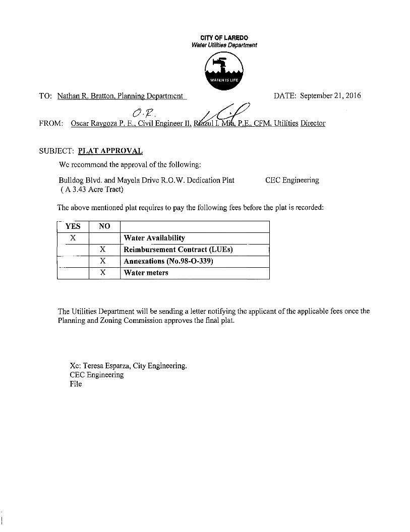
TO: Nathan R. Bratton, Planning Department
CITY OF LAREDO Water Uti/ftias Dapartlll8nt
DATE: September 21,2016
P.E. CFM Utilities Director
SUBJECT: PLAT APPROVAL
We recommend the approval of the following:
Bulldog Blvd. and Mayela Drive R.O.W. Dedication Plat (A 3.43 Acre Tract)
CEC Engineering
The above mentioned plat requires to pay the following fees before the plat is recorded:
YES NO X Water Availability
X Reimbursement Contract (LUEs)
X Annexations (No,98-0-339)
X Water meters
The Utilities Department will be sending a letter notifYing the applicant of the applicable fees once the Planning and Zoning Commission approves the final plat.
Xc: Teresa Esparza, City Engineering. CEC Engineering File

TO: Roge1io Rivera, P.E., City Engineer
o.fL
CITY OF LAREDO Water Utilities Department
DATE: September 21,2016
FROM: Oscar Raygoza P. E., Civil Engineer II, ia P. E. CFM, Utilities Director
SUBJECT: Letter of Credit for:
Bulldog Boulevard and Mayela Drive R.O.W. Dedication Plat CEC Engineering
We have no objections in accepting the cost estimates for the water and wastewater improvements as submitted by Civil Engineering Consultants for the above mentioned project.
We recommend approval of the letter of credit, if you have any questions please call at 721-2000.
TYPE OF SITE IMPROVEMENTS ESTIMATED COST
Water Distribution System ................................ Total $ Sanitary Sewer System ................................... Total $
Xc: Teresa Esparza, City Engineering Civil Engineering Consultants File
142,972.00 0.00

I
U.l$.0. J0H<1 B.JLEXANDER HlGii SCHOOL JV.T
I.OT1,8LO()K1 VOL.:III,I'0,:!&-27
O.PRW.C.T
_, •oo
VOL3103.PG.11J.20 O.l'.R.W.C.T.
-:-;J~ -~?~:J r~·~:~~:: ... ---:=.-----~-"".~""~ .... ~ ... :!...-----,jl·· ,< BlOCK1 :0 \ Mrn'---
0&1 ALEXANDER SUBOIIIISIOH VOL. 22 PGS. 17. 1! W.CJ.I.R
o••
~ .. " " " " " • " " •
RBIAINING FOR~ OF W8 .o.cRES ~~~ ~CO_lP_
VOL~ PGS.88-II! W.C-D-11-
PLAT
UIII!TAIILI! ·- ~ ~
-~ -w= " •. w
~" -u~ a
,_ ~ --- ~ ~·· OM ~-~ « •• ~w =·~ ~- S22'~01'W
110.01' ~-~ •• -·~ ~m NS:'41'sn¥
CUitYI! Ta.u!
~ ~~~
1331.71' -- 118.74'
=w .M 1271.10' -
~~
N311'16':U'E
H54'21i'01~
$&4•01$'01'W
8311'16':U'W
~ IICALE 1" •100'
"' "" ,.,
"" IICAU INI'DT
CERTIFICATE OF OWNER
$TAT1!0FTEMS
~~-
~~ OM-
IIDIG A nt.\CT Of LAND CONTANNG I..U ACRH. IIO!mOI!.UM, .aNI) O.DACIIIDOUTOif A 12AfACRE1Ro\CT 11EeCM1E11 M TR,OoCT' COIIYF1'l'D TO~ INDEP211PeNT SCHOOI.IIISTRICT, REOOROEIIIII YOUIIIII! ~PAGE. 111-H, 0FF1e1ot.L PU1N.1C IIECOROIIOF-COUNTY, 1EliM,- ALL OF AUII ,o,cq nt.\CT D&ICRIBED M ntA.CTH, CONYEYBI TO IINITED KlEP'UIO!fiiT tett001- Dltl'RICT, REilOitO£I) IN~ nta, PAGSI1.0, OITICW. PllaJC R£CORDII Of MD COUlfTY, TEXM, tmJATEO 011 PORCIOII Zl, JIJAit ,,GAIICIAOftiGIMAI. GIIANTEE,ABallto\CT .. AMI POIICIOII:ae., AGU8D1 SANC1EZ ORIGI!IALGIIAifl&, AlllTIIACT 2U, THIIIIM Ao:llli nACT III!ING llrOIIE PrUfllCUI.Afti.Y DEICIIIIItiiMI'OU.OWII;
COIIIIIENCINO AT A FOIIN) 112' IRON ROO AT 1H1! MOST NOR1HEIOH ~OF LOT 3211,111.0CK 1, OF 0 & J ~ SUIIOIIIISION lllfi II, RE.f'LAT, REC0RC1!D IHYOll..'IE 25, PAOE 37, MAP RECORDil OF WEill! ()CIUNO' TEXAS. AKI TI-E SOUTHE.I.ST CORNER OF A&\3 N::fl£ TAACT (CAI.LB)-'$.0&ACRE TJ!riCI) OESCRIIEO AS BLOCK 1-A. .o.t.ENOED TO U.ll-1>. JOHN 11. ALI'lCANDER HISH I)CIIOOI.. RECORDED tl VOI.ut.E 211. FAOE l!8. MAP RECORDS Of l're8ll COUNTY TEXAS, 1l£NCE 101/TH 22"21N8" EAIT, A OISTANCI' OF 1~ 1'eT TO A I:ET liZ' IRCW ROD OM THE IIOUTHEAIII' CORNER Of LOT 3Vo, 11L0CK I, OF BAIO 0 & J AI..EXANilER 8\.tiOMSION LtiiT IlL RE.f'LAT, AI'O THI! 80iJfHWEBT CORNER OF A 4.00 .ot:RE TRACT 0E9CR1111D A$ TRACT II. OON\IEYal TO Ulii1EO INDEPENlENT SCHOOL OISTIUCT, REC0R0ED tl ~ V03, PAOE$ 10-21), OFFICW. I'UBUC REOOR08 OF l'o£llll CO!.MY TEXAS. EIEWI3ll!E,..,..,. OF -NINO. A NOK-t..._-r POINT OF A CUR\If, AMI ALSO RINO A801/THWEST~OFT1-116 TRACT:
ALONG SAD CUf(VI; W.WIGAIW)MI OF 1U1.n fEET, N1 .o.I'IC!ll.ENGlH OF 11.10 !'Eft, ACHORDENtH30#' -.H ,...,..,.. ~.AMI A CHORD DISTNIOE Of IO.N fEET TO A FOliNO 117' IRON ROO FOR TNIIJEHT OF SAID 4.00 ACRE TRACT, !lliiNil A TNfl)ei(TI'(ljNTOF AQ.RVE TO THEIOOHTH~i I
ALOHO &oJD o.RVE W.......a A R,Mli\!B OF211.00 FEET, MARCH LENI3TH OF 111.10 !'Eft, A CHORD E1EN!1HG OF ~ M"25'1H" ~. NIC A C!tORI) OI$TNICE Of lfU41'HTlOA FOUND 117' IRON ROD FORA TNIOEHTOF SAD 4.00 ACRE TRACT, BENJ A POM'OF DEA..ECTIOH TO THE RIOHTI£REOF;
~ ~ EAST,""'---NG THE SOUTH PROPERTY UNE OF s.oJC 1UII\Cf!E.TR.'CT,AOISTANCEOF 0$1.U RET TO A FOUND 1/Z' IRON ROD AT THE SOI.ITHEIIS1ERN CORO!El't OF SAID lUI~ TAACT, BEWJNIIiTERIOR CORNEI'INIOA P0t<T OF llEFI.EC1'lOOI TO THE LHTI£l!EOF;
NORTH 2Z'1nZ" Eot4T. A OISTNICE OF 2U21'1!!ET TO A I'OIJIC) 117' RON ROO, 8EN3 AN tfTE!IIOR()(:ft'ER NCJI'(ljNTOf DEfi..ECTION TO THE LHTHEREO!';
~ 2:rJ:riO"WEin', ALONG THE EAST PROPERTY LI'IE OF SMl 1ut ACRE TRACT, A DISTNICE OF 14U.DI fEET TO ASET 117' IRON ROD, BE'INO A POINT ON &o.lO E.OST PI!OPER1Y LtiEOF &0.111ZA& ACRE TR.'CT, N11J BaNG N1 IHIERIOROORHERAKI PONT OF DEA..ECTIOHTO THE
LEFT~; ! ~ lrZI'W'WAT, A OISTNICIO 0Fll.l2 fEET TO ABET 112' IRON ROO, BEING Nlllf'TERIORCORHI:JIAKII'ONTOF DERECTICfl TO TIE LEFT
t<EREOF; ! IICIUnt IMNt"WEin', A DISTNICfOFHUT PUT lOA SET 112' IRON ROO, EIOfG A POINT ON THE WElJII!I'IOI PROPERTY LNEOF IIAID 12-oOII 1\Cf!E.TR.'CT AK1 E.OSTPROf'EitTYUNE OF A 2-00ACRE lJI.OoCT, CONVEYED TO~ DONAl, INC., A TEXAIICORP0ROii~.IIE1XlRDED tl VOLUioiE33oii,PAGES54,0FFICW.I'IJIIUCFIECXl!IOSOFWE8800UHTVTEXAII,AKIIIEINOAN~CCIRI£RN«!PONTOFilB'I.ECl'K:INTO TH~ R10HT HEREOF;
NORTH 22" 21'W WEIIT,AI.OHG THE£AST I!OI.1NONIY LINE OF 81«12 OOAORI! TR.'CT, A DISTANCE OF 21.10 FEET TOA FOUtiJ 11'1: RlN ROD AT THt 90IITH I!IOHT-oi'-WAY UNE OF Da.loiAR IIOUI.EVARO, NIO THE lfORTHE.08T CORNER OF &0.112-00ACRE TR.'CT, BEINO THE NORTHWEST CORNER N10 POI'fT OF DEFLECTION lOTI£ RKlKT I-EREOF;
NORTH frJI'WEUT, ALONG 1Hf; SOUTH RIGHT -Of..WAYU'.E OF OEL loiARIIOU.EVARil,A D1$TNII%()F 4U11 FEET TO A F01JH0 11'1: IRON ROD ATTH~ NORI11NE$1' CORNER Of 8Ail3.23 ACRE TRACT J.NDWEST PROPERTY UME OF A:lll-11 K:Slr. TRACr. OCIN\I£'I'EO TOWI'B8C<l~o~Ma~CW. DeVELOPiol9il, IMC., REOORDEO tiVOLUiolf: 31)ol.l, PAGES 388-:Jaol. OFflCW_ F\I.JUCROOOOIJ80f -OOUNTY TEMS, NCJ 11Et1G N1 EXTERIOR CORNERNIO POI'fT OF DEFLECTION TO THE RlllHT ~
lOUTH 2Z"n'IIO" EMT, ALONG mE WEST PROf'El'm' 1..-.r: OF $.0Jp :wn• ACRE TRACT, A DISI'ANCEOF IAa.h Rn TOAFOUtiJIIT RlN !'KIO, BE'ING N1 IWTERIOR CORNERNIO PONT OF OEFI.S:TION TO TI-E LEFT HEREOf;
toVTH $I'"U'1ID" EAST, AOIST»>CEOF21.21 fEET TOA I'OUMO 11'1: IRON ROo, 11EM M EX1ER10R CORH9\AKI I'OfoffOF DeFI.£CliOiol lOTI£ RIOOT HERfOF;
101/TH Z2'1fllll" EAIT, A PIST.t.HCE OF- FEETTOAFO!.tj0 112' IRCIH ROD, BEIMONI EicrERIORCORHERN«! POM'OF DERECTICfl TO TI-E RIGHT HEREOF:
IICIUnt 22"n"t1"_,-, A OIST.t.HCE OF21.2oll f'EETTO A FOONIJ 112' IRON ROD, BEIHONI EXI'EIIIOR; CORHEIIAKI POM'OF OERET10N TO THE RIOHTHEREOF; I 1011TH tl"'7''lr' WDT,A ll!STANCEOFeo.D1 Fa;l'TO A FOONIJ 112' RON ROD,IIOIONI ElCfER.IOR OCIRNERAKI P<llmOF ~TO THE RIOHT HEREOF; I ~ _ _,.,A DISTANCE Of IU:t FEET TO A FOUND 11'1: IRON 11()0, BE'IMGNI IN'TERIOR COI'ti'QAKI POINT OF OEFLECTlOH TO THE
LEFTHEREOf; ! 80VTH 17"J1W"weJT, ALOO!G Tt1E S0VTH PROPERTY LINE OF SOJI)3.zlA(:R!; TRACT IIH) THE NORTH PROPEJm' UNE OFrnEREioWNiltCJ PORTION OF liT! N:J'e&. CONVEYa!TO AI.EXAtiJER RE$oem.Al. De\laOF'IoiENTOO. LP. RKlOROEitl V0U11oE Ul', FACES-COUNTY DEED R£00RDS,AOISTNICE OF 40Uif FEET TO A FOIJMl W'RlN ROO, BE'IiGA TNIGEHT POINT OF A CURVE TOn-E LEFTteRool'i
ALONG SNDCUIW! HA.W<GA ~OF -.ot FHT, Nl NO!lBIOTHOFI1111'HT,AatORD- OF_,., !I'I"H't1" ~. AKI A CHORD OISTNICE OF M.M FEET TO A FOUND 112' IRCflj ROD FOfl TAHOENT OF SAIO 4.00 ACRE TRACT, BEING A lAMENT POIIQ' OF A CUR'JE TO mE LEFT HERSJI'; I ALONO SAm CURVE HAVING A RACill8 OF 1m,7• fEET,NI ARCH LENGTH OF- fEET, A CHORD 11EN1N3 OF8011111 Wlnt"WEIT, /IH)A CH0RC 01-ST.oHCE OF- FEET lOA FOUtiJ 11'1: IRON ROO, aElNOA POINT OF OB'I..ECTJ:lN TO TI-E RIOHTIEREIF;
Tl£loiCE, HOR'IMU"41WWQT,AOI8TNICEOfiii.IIIII'DTTO'Il't'I'OIHTOF-AKICONTAIMIMGI.U ~OFI.J\IIO,MOREORlESS
IIAIIIIIOF BSAAINO: HAD1!3 TEXAS STATE I'I.AI£S,110111Hzor.E Cli!,US FOOT
~ '~MifRIQ Mt!z•• R !fL A RSOISTERflii'ROFES8KlNAL EH<»>EER IN THE 8TATl! OF TEIWI, HEREI!YCERTlF'I'THAT PROl'ER ~EEMIG OONSIDERATION WlliiiEEHGr.rEN THI$ JV.TTO TIE W.naiSOF STREETS, LOTB. WATBI,IIEWBI. IIH) N'!UITEtWICE& NIO PIW"'-GE LAYOIJT;AHO TO THE BEST OF MYMJIOIY..a>GEta$ PLAT (lONFORMS TO ALL REOU~OFTHESUIIDIVISIOfoiOROIIoWoiCE,EXCEPTFORTHOilEVAIII.I.NCESTHATW.Y,...VEIEENORANIEOBYTHE ~MO~SSICNOFTHEaTY_
=~~~~~~~~~~:~~~;.;~ .... -~..:..~,~=~~=-ro ~~~~THAT THE PERSON E1CECU1E0 TI£- FOR THE 1'1.RP03EBAKI CONSilEAATION THEIIBII $TATW
MOTARYP\.UJC tiAKII'OR WEIIIIOOUNTY, lECAS
MYCOIIMISSION ~------
CERTFICATEOFOWNER
8TATEOFTEXAS
~~-
=~~~~~~n:'SIJ~;..~:,._..,,...,._..,~""'"'- ro liE THAT THE PERSON EXECIJTl!DTIE SAME FOR THE I'UIIPO&EB AKIC01'151lEN.TIONTI'EREIN STAlED
NOTIIRY P1M1C ltiNIO FOR- COIMTY, TElW!
MYCOMIII$SION EXFI&: _____ _
C!RTlflCATE OF 8tJRYEYOR
STATE OF TEIWI
~~-
~~~~~~=~~.:::s;~~==--:TTH8 Sl.t'EIMSION.OHTHEGfiOUMO,TtiATTH~CORHERMOHI.II.ENTS~THEFIEONWBIEI'OUliCOIIWUIII':~Y PI.ACEO UNDER~ 131.NBMS10N.
JEI'FREYO.PUO, RP.LS.ISII81
PlAT APPROVAL· CITY ENGINEER
1 HAVE REVIEWED THIS JV.T OF 8\JL 1 !!OG 80ULEVARONIO MAYB.A 0R1VE RO.W. OEDICATOI JV.l PI'IEPARBI BY IMIIBERTO~JR,P-E.I0:>-1002!i2,AKIOATEOTHE OAYOF 201_WTTHTH!:I..rOST REWIIOH OAlE OM MOHAVE FOlJM) TI£M IN COioi'IJANCE WITH THE !l1AIDM8ION OROWANCE Of THE CITY Of LAAalQ. TEXAS.
"""' 1. THIS JV.T OOES NOT ATTBFTTO ALTER,A.\IEIIO, OR llfloi0\!'I1Nf'f OO'IENOMtl ~~
2- ALL CIHICUTS9HALI.COMPI.'I'WITH THE TRANSPORTATION EL~EHT OF THE CITYOFWWX!~HSIVEA.AN.
3. !La IROn RODS lli10'MI HEREON AREA CAPPEl WITH PI.AST>C SlRIIE'Y CAPS ~~-
•. ALDW«lEA. R£StOelfTW. DEVEl.OPioENT, LP.. AUTHORIZES TH~ IJNIIEl ll«lEPEttllENl 8QfOOI. OISTRICT (laO~ TO DRAtl R1JioiOFF FROfll 3.2] ACREll ON THE '1I1..U.OOO IIOI.A.EVAAO Nm W.I'EI.A DRIVE R.O.W. IJEiliC.It.TION JV.l" IIQ'O THE EJQSTm q RCI' BTORIIIIIRAIN SYS'IBII ORIOiNALL.Y O!:SIGHEO TO HANllE THill Rl,.ff()F'F, AT 80TH PRE~ Nm POST-OEVEI.CII'Ioef ~=
PLANNING COflllfiSSION APPROVAL
THIBIV.TOF 11' 1 IQQ99Q!IIfl!H!QOOMA'ff!A !l!!!'ffBOWI'!fPICATIONPI.AT IV!liBWI SUIIoiiTTEO TOANO ~OEftEO BY THE PI.NfHI~O COiolloiiSSION OF THe CITY Of UII'EOO, TEXAS,~ lili£REB'f APPRO\!EDSYSUCH~ISSIONONTHE OAVOF :101_.
AnESTliENT OF PlANNING COIIDIIIISION APPROYAI..
THE CITY OF LAREDO Pl»>HHNG COIMISSIONN'PROI/Bl THE FII..RoiG FOR RECORD OF THill PLAT AT A PUBI.IC MEEnoo 1-ELOON mE __ O.O.Y OF 201_. THE loiH.IIUOF &OlD 11EETN0 REF\ECTi!IIJCHAPPRQVAL-
MAnwiRIIRATTtiN OIRI!CTOROFPI.NINI~ Cm'OFLAReOO,'IElW3
$TA1E0FTECAS
~~-1, a..£RK OF IHE COIJH1Y 00JRT IN AND FOR WEB8 COU'ITY, TEXM, DO HERB1Y CEIIIlA'lHATTHEFOREOOINGINSTRliiiiENTOATEOTHE OAYOF 21)1_, VIITHTH!CEKIIFICATEOF AUTHEiffiC.O.TIONWAS FILBI~IHt.ffOFFICEONTHE OAY OF 201_Al __ O'C!.OC1(__...._1NVOI.LIIIIE~P~)-OFTHEIII.IP RE00R0S C# s.w OCONTY. WITHE88~HMDAHOSEALTHII OAYOF 201~
~ l.ft'1El> IHOEPei>JOEHT SC!'!OOI. Dnm!ICT
~-lAREDO, RXM 1!llfl (ll5BJ111-«2!&
~ Cl
~ .. ~:5 :Ell. caZ ze C!;( cau 111:-
e~ .... :)J': o· 1110 ~:~a! 0 Cl ... ... :) Ill
~
1 """ "' 1

AGENDA ITEM: XI - B APPLICANT: Taxco Development
Corporation, LLC.
REQUEST:
DATE: 10/06116 ENGINEER: Howland Engineering and
Surveying Co.
Final consideration of the Plat of Allen Woods Subdivision. The intent is residential.
SITE: This 5.51 acre tract is located west of Bob Bullock Lp. and north of Shiloh Drive. This 19 lot development is zoned R-1. This tract is located in District VI-Cm. Charlie San Miguel.
PREVIOUS COMMISSION ACTION: This item was granted preliminary plat approval by the Planning & Zoning Commission on 04/07/2016.
PROPOSED ACTION: APPROVAL

n

NOTES:
1.) THE SETBACK LINES INDICATED ON THE PlAT SHALL BE FOR REFERENCE ONLY. THE OFFICIAL SETBACK LINE SHALL BE DETERMINED BASED ON THE CURRENT ZONING DISTRICT IN ACCORDANCE TO SECTION 24.77.1 OF THE LAREDO LAND DEVELOPMENT CODE.
2.) SET IRON RODS SHOWN HEREON ARE CAPPED WITH YELLOW PLASTIC SURVEY CAPS MARKED BHOWLAND SURVEYING~.
3.) DRIVEWAYS, SIDEWALKS AND TREES WILL BE INSTALLED AT THE TIME OF ISSUANCE OF BUILDING PERMITS IN ACCORDANCE WITH THE LAREDO LAND DEVELOPMENT CODE.
4.) THE DRAINAGE EASEMENT ON LOT 9, BLOCK 2, (20' & .30' WIDE) IS SUBJECT TO A MAINTENANCE AND MONITORING AGREEMENT RECORDED IN VOLUME PAGES ---- O.P.R.W.C.T.
BASIS OF BEARING:
GPS: NAD83 Texas State Planes, South Zone, US Foot
MONUMENT HELD:
Found 1 /2" iron rod being ot the southeast comer of Lot 1 0, Block 5. of Stone Creek Subdivision as recorded in Volume 20, Poge 9, of the Map Records of Webb County, Te)(os with coordinates of :
N:./171 07 448.0~ E: 674322.32
. --~ ~ .

MEMORANDUM
To: Mr. Nathan Bratton, Planning Director /)
From: Osbaldo Guzman, Parks and Leisure Services Dept. Directo'J/ H £ Date: September 21,2016 /
Re: Allen Woods Subdivision
The Allen Woods Subdivision Plat will be on the next Parks Advisory Committee Agenda for review and recommendation regarding parkland requirements. This plat consists of 18 single family residential lots and 1 commercial.
Per Ordinance 2008-0-058 the following is required:
• The Parkland Dedication Requirement is • The Neighborhood Park Improvement Fee is:
The Parks Department recommendation is as follows:
0.07 acres $5,652.00
• A Cash Payment of$3,150.00 be made by the developer in-lieu required parkland.
• A Neighborhood Park Improvement Fee of $5,652.00 be paid at the time of recordation of this plat.
Should you have any questions, please do not hesitate to contact me at (956) 795-2350. Thank you.

LAREDO CITY ENGINEER
CITY OF LAREDO
1·AR•:oo, TJ':l<~'io 17$5
August 31, 2016
ENGINEERING DEPARTMENT
Mr. Roberto Martlne7., Jr., P.E. Howland Engineering & Surveying Co. 7615 N. Bartlett Ave. Laredo, Texas 78041
RE: Allen woods Subdivision.
Dear Mr. Martinez:
PAGE 01/01
Construction plans for all street and storm drainage improvements have been reviewed and approved for the above referenced subdivision. However, this subdivision plans have been approved subject to an approval by City Manager of a BMP Facilities Maintenance and Monitoring Agreernent. Be advised that this approval does not address any permit required by other Agencies.
Approval of construction plans given by the City of Laredo · Engineering Department Is not intended to relieve the Owner I Developer, Engineer, and I or Contractor from compliance with the Subdivision Ordinance and Drainage Standards of the City of Laredo, Texas; and of any liabilities or responsibilities with respect to the design, construction, or operation of the project.
Also be advised that the above approval does not address the provisions of the Texas Architectural Barriers Act, Article 9102, Texas Civil Statutes, nor the requirements of the Americans with Disabilities Act (ADA), (P. L. 101-336), or any other state, local or federal requirement.
For mol'e information on the above, contact Texas Department of Licensing and Regulation, P.O. Box 12157 Austin, Texas 78711 (512) 463-3211.
Sincerely,
XC: Nathan R. Bratton, Planning Director.

CITY OF LAREDO Water Uti/hies Department
TO: Rogelio Rivera, P.E., City Engineer 0·/2.,
FROM: Oscar Ra oza P .E. Civil En ineer II Ria
DATE: August 29,2016
N.:.,-"fof.E. CFM Utilities Director
SUBJECT: Letter of Credit for : Allen Woods Subdivision
We have no objections in accepting the cost estimates for the water and wastewater improvements as submitted by Howland Engineering & Surveying Co. for the above mentioned project.
We recommend approval of the letter of credit, if you have any questions please call at 721-2000.
TYPE OF SITE IMPROVEMENTS ESTIMATED COST
Water Distribution System ................................ Total $ 33,430.00 Sanitary Sewer System .................................... Total $ 30,602.50
Xc: Teresa Esparza, City Engineering Howland Engineering & Surveying File

CITY OF LAREDO Water Utiliries Depat1ment
TO: Nathan R. Bratton, Planning Department DATE: August 29,2016
or:-. /.·/ ,/ FROM: Oscar Raygoza P. E., Civil Engineer II, RlliZkda, P.E., CFM, Utilities Director
SUBJECT: PLAT APPROVAL
We recommend the approval of the following:
Allen Woods Subdivision (A 5.59 acre tract)
Howland Engineering and Surveying Co.
The above mentioned plat requires to pay the following fees before the plat is recorded:
YES NO
X Water Availability
X Reimbursement Contract (LUEs)
X Annexations (No. 98- 0- 337)
X Water meters
The Utilities Department will be sending a letter notifYing the applicant of the applicable fees once the Planning and Zoning Commission approves the final plat.
Xc: Teresa Esparza, City Engineering. Howland Engineering and Surveying Co. File

CITY OF LAREDO FIRE DEPARTMENT -------
Memorandum
TO: Nathan R. Bratton, Planning Director
FROM: Andres Jimenez Jr. , Fire Marshal ~~ i- ~ · Steve E. Landin, Fire Chief ~ THRU:
DATE: June 28, 2016
A SITE DEVELOPMENT PLAN SHOWING AN ON-SITE FIRE PROTECTION SYSTEM INCLUDING RAISED PAVEMENT MARKERS, (BLUE) MUST BE REVIEWED AND APPROVED BY THE CITY OF LAREDO FIRE DEPARMENT AT THE TIME OF ISSUANCE OF BUILDING PERMITS IN ACCORDANCE WITH NFPA 24. MORE FIRE HYDRANTS MAY BE NECESSARY DEPENDING ON THE LAYOUT OF THE STRUCTURE. ANY FIRE MAIN LINES TO BE USED FOR A BUILDING SPRINKLER SYSTEM SHALL BE INSTALLED BY A COMPANY WITH AN (R.M.E.) LICENSE ISSUED BY THE STATE OF TEXAS 28 T AC §§ 34.700 FIRE APPARATUS ACCESS ROADS SHALL HAVE AN UNOBSTRUCTED WIDTH OF NOT LESS THAN 20 FEET. AND AN UNOBSTRUCTED VERTICAL CLEARANCE OF NOT LESS THAN 13 FEET 6 INCHES.
Plat of Allen Woods Subdivision (Howland Engineering and Surveying Co.) 16-36
WE HAVE REVIEWED THE PLAT AND APPROVED AS SUBMITTED
6 16 E. Del Mar Blvd. Laredo, Texas 78045 (956) 718·6000 Fax (956) 725-1219
STOP FIRES BEFORE THEY START

CITY OF LAREDO TRANSPORTATION DEPARTMENT
TRAFFIC SAFETY DIVISION APPROVAL REQUEST
To: Rogelio Rivera, PE- City Engineer Attn: Teresa Esparza, BIT- Engineering Associate IT
From: Roberto Murillo, PE, PTOE- Traffic Safety Manager J Thru: Sinai Castro, EIT • Engineering. Associate IT IJ W Subject: Allen Woods Subdivision Company: Howland Engineering
Date: July 22, 2016
The Traffic Safety Department has reviewed the submittal for the subject location. The following comments are provided:
• Approval letter is recommended.
Should you have any questions, please call me at (956) 795-2550.

' . . CITY OF LAREDO e ENVIRONMENTAL SERVICES DEPARTMENT STORM WATER MANAGEMENT DIVISION
August 31, 2016
STORM WATER POLLUTION PREVENTION PLAN NOTICE: PROJECT NAME: Allen Woods Subdivision
1. OWNER: TAXCO Development Corporation ADDRESS: 608 Gale Street CITY: Laredo STATE Texas ZIP CODE _ _ 7.:...:8=0'-'-41=------PHONE: ______________________ _
2. ENGINEER: Howland Engineering and Surveying Co.- Ricardo M. Villarre~ l, P:~ ·
ADDRESS: 7615 N. Bartlett Avenue CITY: Laredo STATE Texas ZIP CODE 78041 PHONE: (956) 722-4411
3. CONTRACTOR: --'-'TB=A_,__ _______ _____ ___ _ ADDRESS: ____________________ _
CITY: ______ STATE ___ ZIP CODE---------PHONE: ________ ___ _________ ___
REVIEW COMMENT: The Drainage and Stormwater Pollution Prevention Plan (SW3P) is approved for this project.
Re~ie~et,~~ .. 1/1/f/(~01/1 c,
Victor J. Linares, P.E.
619 Reynolds Street Laredo, TX 78041 Ph: 956-794-1650 Fax: 956-727-7944

-1
\ '
CERnF'JC.f.TE Of OWNER STATE Of TEXAS: COUNTY OF WEBB:
I, Of TAJ<CO DE\'nDPioOEHf, U.C. OF THE 1.»10 S>fOW'I ON THIS fU.T, ""!I llESK.lN~lW HEREIN AS "JUEN W000S SUBDIVISION", IH THE CIIY OF I.AR£00. COOfi!Y OF WEtiO. TtXOS, .I.NO WHOSE ~E IS SUEISCRI!IEO HEREIO, HDIEBY OEOICo\1£ TO 11-E USE: Of Tl£ PI.JSUC F'0!!£1/ER .OU. STR£Ef'S, OIWNS, ~Eifl"S IHJ PUIIUC PLO.CES THEflEl>H SHOWN FDR lHE PUR!'OSE Nl!l CO!iSIOEAATlON THEREIN EXPRESSED,
STATE Of TEJU.S: COUHTY OF WEBB:
NOTAA"'' PUIIIJC IH AND fOR THE WEe& CO<.ti!Y, WV.S
llfl' COOAOSSIOtl El<PRO•"· --------
fXMitC OEIEKIJ)N l'(:fj(l
~«
~'\01.·~·.~ .. :"·'~
""""" ,. /
/"
' ' ~ lEGAL DESCRIPTION 5.59 ACRE TRACT OF LAND
A TRACT OF LAND CONTAINING 5.59 ACRES (243,642 S.F.), more or leu, s~uoted in Porc.on 2.'1, Abstroct 283. Leonardo Solinoo, Original Grcntee, Webb County, Texas; being from o partition deed of a 51.30 ocr~ tract as recorded in l'alume 693, Page 174.' of lh~ Oeed Records of Webb County, Texas. Th•s 5.51 acre tract bein9 more particularly descnbed os tollo.,.s to '"t:
' COidldENClNG · ot a found 1/2" iron rod being on the southeast corner of Stone Creek SubdivisiO<> as per Plot recorded in Volume 20. Pagoe 9. of the ldap Records of Webb County, Texas. THENCE. N 04'27"01" W, a distance of 263.40 feel to the TRUE -POINT Of BEGINNING;
' TliENCE. N CW27'01" w. along the east boundal)' ¢1 said Stone Creek Subdivigion. a distance of 516.92 F'EET. to a set 1/ 2" ir<>n rod, for t~e northwest corner here<>!;
'
r-- " \ THENCE, N 70'~"41" E. along the most southerly liM ¢1 Village Heights Subdivision, Unit 1 as per Plat r(learded in V<>lume 16, Page .16, at the ldop Records of Webb County, Texas, a distance of 281.21 fUT, too set 1/2" !ron rod. lor the north&ast corner her~K~f;
' 1 TliENCE, S 16'00'58" E, alon~ a strip of land contoinin9 0.82 acres owned by the City of Loredo. as per deed
----1 fl?! R~O~W~).ffik---I
I /
/
recorded in Vofume 293~. Pages 234-240. ot the Offidol Public Records ¢1 Webb County. Texas. 0 distance of 3.33 I'EET too point be;ng on a curve to the left having o radius of 230.00 feet and a Chord of S 2715'31" E-89.61 feet; I
\
CERTIFICATt OF OWNER STATE OF TEX•S: COUHTY Of WEBB:
~----~-m-s ~T.c:0~~ ~l!i..~'~"'Y~,%~f"!E..l'••REPQ .. l OWNER Of" THE UHI
IN THE CITY Of' l.lR£00. COUNT'< OF" WEeB, T()OO;, .<>10 WHOS£ tW.IE IS Slll!SCiliOCD IIEREI"O, HERESY D£DICAT£ TO THE VSE OF" 11£ PliBUC fOfiEVER All STREm. DRAINS. E'.ASEWE>ITS M<!l PUOUC PLAC£S THERE011 S110WN fOR THE PURPOSii NIO CO>ISi[)[AAllON TKREI~ E<I'RESSED.
STATE OF TEXAS: COUNTY OF WEBB:
NOfAR'f P\.IEIUC If! AIID FOR THE i1UB COI..OilY, 'JEQS lt(C(lYIIISSI()N E)<I"'RES, _______ _
1'0/Nt OF _. SET 1/2'
-~
lHENCE, alon'g said curve to t~e left. an ore length <>I 90.19 Fttr, too set 1/ 2" iron rod. l<>r a non-tangency point. being pn a -second curve to the left h~ving o radius of 200-00 feet ond a Chord of N 52'51"25" [ -1308 feet; 1
lHENCE. olon9 said curve to the left, on ore length of 13.09 FEET, to o set 1/ 2" iron rod, for 0 point of tongency hereof; )
lHOICE. N 50'58'~· E. a distance cf 78.91 fUT. to o set 1/2" iron rod, bein9 c point en the west Right-of-Way of Backwoods fro~. and being on a curve ha.ing o radius of 330.00 feet and o Chord of S 39"06'33" E-50.00 feel;
I TliENCE. alo~g said curve to U.e left, an ore length cf 50.05 I'EET. for a point ol dellectiM right;
TliENCE, S 5as8'57" W, o distance of 76.99 FEET, to a set 1/2" iron rod. being on o curve to the right t>oving a radius of 250.00 feet end a Chord of S 51'53'51" W-7.98 feet;
I lHENCE, along said curve to the right. an ore length of 7.98 FEET, to o set 1/2" iron rod. being on 0 second curve the lett having a radius of 230.00 feel and a Chord of S 58"30'10" E-59.18 feet;
I 1HENCE, alorig said curve to the lett. on ore lenqlh of 59.34 FEET. to a set 1/2" iron rod. lor 0 point of deflection right; I
I THENCE, S 65'53'41" E, a distor><:o of 121.43 FEET, I<> o set. 1/2" Iron rod. b•in9 on o c~~n~e having a radius of 170.00 feet and a Chord of S 35'53"41" E-170.00 feet.
I lHENCE. olorig sold cuNe to the lett. on ore llffigth ¢1 178,02 FEET, to set 1/2" iron r<>d. f<>r a point of detlect\on right;
lHENCE. S 05'53"41" E. along the west boundary line of said 0.82 acre tract, o distance of 91.80 I'EET, to o set 1/2" iron r<>d. l<>r the southeast comer hereaf;
i "• THENCE, S 72'41"46" W. a distance of 600.93 fEET, to the TRUE POINT Of BEGINNING and containing 5.59 acres of lend. more or less.
CERTIFICATE OF' ENGINEER
STAT[ OF' TEXAS: COUNTY OF WEBB:
UEN HOUl£fl CERTIFlCATt
THIS SIJIIilMSIOH t.W' IS >lEREBY M'PI«N£0 ANO ACCEMID. 8Y litE \JEN HOLDE~ ~· -- ~' ~ ----· 21)1$
~------
-------OS AN N:r AND OEEO OF'---------,--~
--'od-
-fWUCr<N«>ftllll\IE-t:OIJNTY.lEXAS -----------
CERTIFICATE Of SURVEYOR
STATE or TEXAS: COUNTY OF' WEBB:
~ 1H[ U~~ ~ ~~ P~ UNO SUJIV£1"0R IN THE ST~TE Of TEUs. HERU1Y Ctrnlf'Y TW.T THIS PLAT IS lRVE AND WOS PREI'AREO fROII AN .t(:"'\\.ll. SUR\oU Of fliE PI!:Of'EO!TY w.o£ UND(R .... st.f'ER'>IISION. ON THE CI!OUNC. »>lT TilE CORNER IIONUUENTS SHOWN TliEREOH WHERE FOUNO OR WU. 8( PROPERLY P1.10:E0 UNDER UY SUPEIMSICN.
PLAT-APPROVAL CITY ENGINEER
l HI>.VE REV£WED THIS PlAT .lliD .t.CCOidPAAYING CONSlRI.ICTlOI'l DIUWU<GS IOENTIFlEO I<S "mEN W000S SUBOI\II~". CITY OF v.REOO. TEAAS. PREPARED 8'1' RICARDO 1.1. VII.1AAR(.I,l,. REGISTERED PROfl:5SIONN,. E~NEER. NO. 101J06 ANO OO.TEO THE -DAY OF 2016, lo.NO WIVE fOUND THEN IN CO!df'\.JANCE WITH THE SUBOMSION ORDINANCE OF 111E CITY OF t.AREIJO. TEXAS.
ROOEUO Rf.m.l. P.E. CITY ENGINEER
1.) THE SE1BAC1< UNES lNDICATEO ON 1HE P'l..llt 51iAU B[ fOR REfERENCE ONLY. THE OFFICIAL SETBACK LJIE SKOU. aE DETERUINEO E!ASEO ON THE CURRENT ZONING OlsrRICT IN ACCORDANCE TO SECTION 24.77.1 Of THE LAREDO \J.NO OEVEI..OPMU(f COOE
2.) SET IRON ROO$ SHOWN HEREON AAE CAPP81 WITH Yfl.LOW PLASTIC SlJRVtY CAPS -ED ·~0 SUFM:YINC".
3.) ORt.rW~YS. SIDE'W.ou<S AND TREES WU BE INSToiU.£0 AT TilE liME Of ISSUlNCE Of BUILDING P[Rl.illS IN ...CCOOOANCE WITH THE I.AAEDO !).NO OfVUQPMElo(f CODE.
4.) litE DfW!oiAGE EO.SEUENT ON LOT Q, BlOC!< 2. (20" ,1: 30" WIDE) IS SUBJECT TO A IU.I~CE AND UONITORINC ACREEMEtff RECOR0£0 IN ~" __ PAC6 __ O.P.R.W.C.r.
BASIS OF BEARING:
CPS: NAOBl Te•o• Stole Plcnes, Sovth Zone, US foci
MONUMENT HELD:
found 1/2" Iran rod being ot tho ooutheasl. com~ cf Lot 10, llo<:k 5, cf Stone Croll< SUbcfNioion ao reeordod In Volume 20, Page 9. of tho ldop Records cf Webb Co...,ty. Te•"" wlih coordinot" of :
,.,., __ 17107446.0~ E: 674322.32 "----·
PlANNING COMt.llSSION APPROVAL
1HIS PV<1 OF "JIUEN WOODS SUBDMSION" CITY OF LAREOO. lEMS HilS BEEN SUewiTTEO 10 AND eot.siOEREO 8'1' THE PLANNING COIAUfSSION OF 1HE CITY OF" LAF!EOO, TEK<S, AND IS HEREiff AI'PRO\IEO 8'1' SUCH COUUISSION ON THE_CIO.Y OF , 2016.
ATIESl\IENT OF' PLANNING COI.4t.11SSION APPROVAL·
TilE CIJY Of l.olREDO PUNNING COUUISS~ APP'!OVEO 1t£ FIJNC FOR R(CORO ()f' THIS PUT AT .&. PUBUC IAEEIING >lELO OH TilE -- DAY OF ·~·~""~;c--- 2016. THE: UIN1JTES OF" SAJO U((llNC REFLECT SUCK
No\'f)Wj ~. BRATTON Oli!ECTO!l OF" f'I.NII'liNC CITY 01' l,.OJIEOO, TEXAS
STATE OF TEXAS: COUNTY OF WEBB:
OWNER: TAXCO DEVELOPMENT
CORPORATION, LLC 608 GALE ST.
lAREDO, TEXAS 7804 I
~
~ .:'.:' < § ~ 9 u rn
~ ' ' Sl g < <
"' ~ .E s
0. < ;::'-~
"' ~ ~ " -::.t!.
§
z 5-g~ 0 ~:~o:i&
~ EQo, ~:g·oJi vi.S].,
a N~.g:S ~ 0 "'15 m ~~~..;
:::> N"t::r-. ~o c~
(/) VI~ a.~ \l:!,..;cg ~a:> Ea. ~ 0 '
(/) ,~.:::;
10 g "'"' a .0 ~ .s .. ".ollE
0 z< .2 z ".,.. 0
0 ~~]~ $; 8-~~il~
o£=>~~ z Oo z ~,!:;0~:6
w ~il~:gg _J tJ;~~ _J <" ... <I>
<( ~ ... ~ ~~ ..:;]C;gt;

POST DEVELOPMENT TOPOGRAPHY
--1 .• SlOifr'cmK® ~ 1o. Pos •
----i •. ue-;.,
'
I "
,_
fiNAL ENGINEERING REPORT FOR ALLEN WOODS SUBDIVISION BY RICARDO ~- VIUARREAL, P .E.
WATER SUPPLY: DESCRIPTIONS, COSTS AAD OPEIWIIUIY O,O.TE
-~ ·~~ ........ ..,. ....... , "'"-"-"
' ~ '''· i~~~ '
Tit( IU.£N WOODS SlJBOMSIOH WU eE PI!OVIOEO WITll POTABlE WA1Efl 11Y T>IE C!lY OF LMEDO. ~E SUBDMDEI!, RID lHE C!IY OF lAAEDO HAVE t:NTEREO INTO A CGNTAAcT I~ WHICII lHE C11Y OF 1,AAW0 1104 PROWIS[D 10 PROVID£ SUf"FICIE>If wATER TO TilE SUBDMSIOO F'OR AT lE.OST 30 YEliiS AAO 1HE CITY Of' IAAEDO OV.S PI>OI'ID£0 OOCWE>Il"AOON TO S\.f'F1CIEHTI.Y ES'!Aal.ISH THE L.OO<C TERN QIJAHTITY ANO ()UAUTY OF lHE AVJ.lABL.E WATER SUPPL£S TO SEJM: THE flJU OE'on.OP~ENT OF THIS SUBOM~ T>IE CITY OF I.AA£00 >otAS N1 8 '"'" OWoiETEII WATEII ~ RUNNING l.t.O~ THE NOI!Tl1 RIQif OF WAY OF STREA>o0 I.N<E II< STONE CIII:EJ( SIJBOMSION. Nl 8 INCH WA!ER LJN!; WU. BE CONNECTED TO n£ PIJSII'IC 8" WAfER UI<E 011 ~ 1.N<E II< OROER TO F'R<MD£ WATER SOMCE TO M1.EN WCOOS SUBOMSION F110U WHICH TWO J./4 r<CH DIWE!ER SI>OGL.E SEIMCO UNES .oliO EIGHT 1 INCH OW.OETER D\1.<1. SEIIVIC£ UliES fiU>I TO P.oli!S OF lots BITORE SI'UT1ING INTO TWO 3/4 INCH OWirrtR SINCU SDM::E li<ES GOING TO ll£ WF;IER BOXES FOR EACH LOT. Tl-£ COI.OUERCIO.l UlT IN lOT $. BLOCK 2, WU e<:tlNECT TI-IROIJGH .IIi El<ISlii;G 12" WATEI! LJ>.E RUNNING Wts1" F'fiOII ~ T>UJL AND ..,U. CONNECT A 1" OIWETER SINGLE SE"''IC( 1'1 ORDER TO PR<MD£ WATtR S€RVIC£ TO THE COW~ERC~ lOT
THE 8 INCH Ut£, 8 J<C!< nTnNCS, 8 INCN COlt VAI..vtS, ME: lfii)I!.IJffS, 1 INCK Sl""'-£ SEIMC£ UNE. I 1>/CH OUAl SEIM(:E lft<ES. J/4 INC>< SNilLE SUVOCE UN£5 loi<O T>1E 1E1tR BOXES fiiiV£ (I££N INSfAU..EO AT A TOTAl COST Of t IOUOCXJC TH£ SIJBDMJ£11 HAS I~ .oooriiON Ploll THE CITY OF LAREDO THE SUiol Of I IOIIOl.IOI WHICK C<lVERS "!HE COST Of "!HE WATER AV.IJI.,lBJUIY IKJ WATER l€!ER I"£ES
SEWAGE FACiunES: OESCRIPTlON, COSTS, AND QP[RASIUlY (l,I.,T[
SEW/oa. n!OM .ouDI WOODS SU!l0M$10N W1..1. BE OISPOSEO Of THROIJGtt THE smiTNfl' SEWEll SI'SID.I Of THE CITY Of INI!illO THE SUBI:MOEII, IHJ THE CITY Of I.MEOO flll\1[ Eh'TV<W HID A COHTF!.OCt 1H VIHIO;H T>1E 'ITY Of 1,AAW0 HAS Pl«lWWSEC TO PR(M()[ SU'l'lClEm SEW.<Q; DISPOSAL mR THE fUU. O[)I[LOf'loiOO Of "THIS SUB~ fOR AT LLAST 30 ~. "!HE CITY Of v.REOO HAS No! E>riSllNG 8 INCK ~ SIINIT.oJtr S£WEFj UNE THO.T RUNS EO.ST Of fOGGY UIOP Of STONE CR£EK SUEICMSION .oHD ~l.l CONNECT TROOJCH .lN D:ISIIPfG STIJIIOOT COWIPfG OUT Of No! [)(JSTJNG IWIHOU ~ THE N!ER"SECTION Of STRD.U v.NE II< ORDER TO 00010 NolO PIICMOE SEIMCE TriROOCII AlL£H WOODS TR.ll.. FROiol lHE 8 lOCK SE"MJI U~E COOUIECTED, "!Ill) 6 INCI1 IIIAWEIER Sl'ICI..E SEI'MCE N-1() EICHT 8 l'fCII DW.IETE~ DUAL SDMC;E liNES RlJN m PMRS Of lC!TS BERIRE SI'UI"IlH(l INTO TWO 6 INCK OW..ElEII Si~ SEIMC( U'<ES
ll£ 6 lOCH SlNJT.tRY SEWER UN[. w.NHOL£. Cl..E<NOUT5. & IMCK 01J.oL 5ERYIC£ UNES AND 5 R-1Ctt SiNCLt SERVICE l-"ES WERE INST..u£0 AI A TOTAl 'OST" Of • Xl,l(XX.
g '\
~
MAP OF WATER DISTRIBUTION SYSTEM AND SANITARY SEWER SYSTEM
"
' ~ ,1 •• i~&\ '
LEGEND DOUBLE SS SERVICE CONNECTION
SINGLE SS SERVICE CONNECTION
SANITARY SEWER MAN HOLE
ClEAN OUT CF;ImFICATlON:
B'f If! S!GNATURE BEUIW, I CEir.lFY l}U.T THE WATER AND SEWAGE S~CE DESCRIBED ldlOVE SHAll !It PRO\IIDEO IN COioiPUlNCE WITH TKE I.IOOE1. RVI.£S .O.OOPl'£0 UN-DER SECllON 16.:!-4J, WATER COOE.
---PROPOSED 8" SANITARY SEWER LINE
__jw:.rr'_
CERTlfiC.i.TlON:
B'f llf SIC>t<TURE BELOW, I CEI!TIFY nu.T THE WATER AN() SEWAGE SEF!\IICE F.O.CUTl£5 AS OESCRIIlED -'80'o'E 4RE TO ntE BEST OF 10' ~r.IOWI..E[)(;£. IN CO~PI_W.IC€ WITH lliE !o100E1. RUI.£5 .oooP1ED UNDER SECTIOH 1S.~4l. WATER CODE. l
RICAAOO lol. \11L.l.lRRE.o.l., P.E. NO. 101306
~ • fi1 'rl <1
M
9 -c __,
FIR£ HYDRANT
BLUE BUTTON
"' ELBOW
PLUG
GATE VALVE
SIGN
STREET LJGHT
DOUBLE WL SERVICE CONNECTION
SINGLE WI. SERVICE CONNECTION
OWNER: TAXCO DEVELOPf.IENT
CORPORATION, LLC 608 GALE ST.
LAREDO, TEXAS 78041
z 0
~ a m :::> VI
VI a 0 0 ~
z w _J _J <{
B " ' "- {i £ ;::; .5 .5
DRAWN BY: J.C.R.
OlECKED 8'1': R.t.I.V.
CRAWN OAT£: 06/03/2016
PlOTTED (l,I.,JE:
JOB No. 24386-16
ALE NAME:
STATUS:
AS-BUILT:
RtVISED DAT£:
9:AL.E: ( 24'~36" ) SHEET
IIOR: 1"=100' VER. N/A
SCALE: ( 11"•17" ) SHEll
l<lR: 1"=200' \IER. N/A
SHEET TOTAL:
2 Of 2

AGENDA ITEM: XI - C APPLICANT: ORV Moreno Land
Development LLC. REQUEST:
DATE: 10/06/16 ENGINEER: PEUA Consulting LLC.
Final consideration of the Plat of Moreno Commercial Subdivision, Phase 1. The intent is commercial.
SITE: This 6.17 acre tract is located State Highway 359 and east of Dorel Drive. The zoning for this 4 lot development is B-1.This tract is located in District II- Cm. Vidal Rodriguez.
PREVIOUS COMMISSION ACTION: This item was granted preliminary plat approval by the Planning & Zoning Commission on 06/16/2016.
PROPOSED ACTION: APPROVAL


NOTES: 1. DRIVEWAYS. SIDEWALKS. AND TREES WILL BE INSTALLED AT THE TIME OF ISSUANCE OF BUILDING PERMITS IN ACCORDANCE WITH THE LAREDO LAND DEVELOPMENT CODE.
2. ALL CURB CliTS SHALL COMPLY WITH THE TRANSPORTATION ELEMENT OF 1HE CITY OF LAREDO COMPREHENSIVE PLAN
3. THE SETBACK SHALL BE DETERMINED BASED ON THE CURRENT ZONING IN ACCORDANCE TO SECTION 24.77.10F THE LAREDO LAND DEVELOPMENT CODE.
4. FOR CLEAR VISION EASEMENT ZONE ALONG DOREL DRIVE, LIMITED CONSTRUCTION AND LANDSCAPING ZONE. STRUCTURES SHALL NOT EXCEED 2 FEET IN HEIGHT AND LANDSCAPING IN THIS AREA SHALL BE LIMITED TO SHRUBS OR PLANTS THAT DO NOT EXCEED 2 FEET IN HEIGHT. MEASURED FROM THE CENTER LINE OR ADJACENT ROADWAY, AS PER LAND DEVELOPMENT CODE 24.83.l{S)(a).
S.Tiffi POND OF THIS PLAT IS SUBJECT TO A MAINTENANCE AND MONITORING AGREEMENT DATED ----BETWEEN THE CITY OF LAREDO AND ORV MORENO LAND DEVELOPE:MENT LLC. SAID AGREEMENT ASRECORDEDINVOLUME PAGES~··--~ OFFICIAL PUBLIC RECORDS OF WEBB COUNTY TEXAS.
6. ACCESS IS LIMITED TO ONE SHARED DRIVEWAY FOR 4:;0'FS~&-~NDONESJ:DtR'ErrDRIVEWAY.F6k·tfJ'f.S-3~&r-4:-

CITY OF LAREDO FIRE DEPARTMENT
Memorandum
TO: Nathan R. Bratton, Planning Director
FROM: Andres Jimenez Jr. , Fire Marshal ~ Steve E. Landin, Fire Chief ':L I THRU:
DATE: r,YJ
August 29, 2016
A SITE DEVELOPMENT PLAN SHOWING AN ON-SITE FIRE PROTECTION SYSTEM INCLUDING RAISED PAVEMENT MARKERS, (BLUE) MUST BE REVIEWED AND APPROVED BY THE CITY OF LAREDO FIRE DEPARMENT AT THE TIME OF ISSUAL'\ICE OF BUILDING PERMITS IN ACCORDANCE WITH NFPA 24. MORE FIRE HYDRANTS MAY BE NECESSARY DEPENDING ON THE LAYOUT OF THE STRUCTURE. ANY FIRE MAIN LINES TO BE USED FOR A BUILDING SPRINKLER SYSTEM SHALL BE INSTALLED BY A COMPANY WITH AN (R.M.E.) LICENSE ISSUED BY THE STATE OF TEXAS 28 TAC §§ 34.700 FIRE APPARATUS ACCESS ROADS SHALL HAVE AN UNOBSTRUCTED WIDTH OF NOT LESS THAN 20 FEET. AND AN UNOBSTRUCTED VERTICAL CLEARANCE OF NOT LESS THAN 13 FEET 6INCHES.
Plat of Moreno Commercial Subdivision Phase 1 (PEUA Consulting L.L.C.) 16-50
WE HAVE REVIEWED THE PLAT AND APPROVED AS SUBMITTED
616 E. Del Mar Blvd. Laredo, Texas 78045 (956) 718-6000 Fax (956) 725-1219
STOP FffiES BEFORE THEY START

CITY OF LAREDO TRANSPORTATION DEPARTMENT
TRAFFIC SAFETY DIVISION APPROVAL REQUEST
To: Rogelio Rivera, PE - City Engineer Attn: Teresa Esparza, BIT-Engineering Associate II
From: Roberto Murillo, PE, PTOE -Traffic Safety Manager k / 1
I I' 1 Tbru: Sinal Castro, BIT - Engineering Associate II \jj JVV l/'-"
Subjeet: Moreno Commercial Subdivision Company: PEUA Consulting LLC
Date: September 13, 2016
The Traffic Safety Department has reviewed the submittal for the subject location. The following comments are provided:
• Approval Jetter is recommended.
Should you have any questions, please call me at (956) 795-2550.

CITY OF LAREDO ENVIRONMENTAL SERVICES DEPARTMENT
STORM WATER MANAGEMENT DIVISION
September 14, 2016
STORM WATER POLLUTION PREVENTION PLAN NOTICE: PROJECT NAME: Moreno Commercial Subdivision
1. OWNER: ORV Moreno Land Development LLC ADDRESS: 1401 E. Lane St. CITY: Laredo STATE Texas ZIP CODE 78040 PHONE: ______________________ _
2. ENGINEER: PEUA Consulting, LLC- Oscar Castillo, P.E. ADDRESS: 600 San Bernardo Suite 902 CITY: Laredo STATE Texas ZIP CODE 78040 PHONE: (956) 433-2205
3.CONTRACTOR: _________________________ _
ADDRESS: ______________________________ _
CITY: _ ___ .STATE ___ ZIP CODE----- -----PHONE: _____________________ _
REVIEW COMMENT: The Drainage and Stormwater Pollution Prevention Plan (SW3P) is approved for this project.
Thank you, Reviewed by:
Victor J. Linares, P.E.
6 I 9 Reynolds Street Laredo, TX 78041 Ph: 956-794-1 650 Fax: 956-727-7944

09/21/2015 12:47 955-791-74% LAREDO CITY ENGINEER
1-AIImo, TF.l<~0 ms
:September 20, 2016
:VIr. Oscar Castillo, P.E. i'eua Col1SUltlng, LLC. 1300 San Bernardo, Suite 902 ! .. aredo, Texas 78040
CITY OF LAREDO ENGINEERING DEPARTMENT
lf!.E: Moreno Commercial Subdivision, Phase 1.
Dear Mr. Castillo:
PAGE 01/01
Construction plans for all street and storm drainage improvements have been reviewed and approved for the above referenced. subdivision. However, this subdivision plans have been approved subject to an approval by City Manager of a l:IMP Facilities Maintenance and Monitoring Agreement. Be advised that this approval does not address any permit required by other Agendes.
Approval of construction plans given by the City of Laredo · Engineering Department is not intended to relieve the Own.er I Developer, Engineer, and 1 or Contractor from compliance with the Subdivtsion Ordinance and Drainage Standards. of the City of Laredo, Texas; and of any liabllities Ol' responsibilities with ):espcct to the design, construction, or operation of the project.
Also be advised that the above approval does not add.ress the provisio11S of the Texas Architectural Barriers Act, Article 9102, Texas Civil Statutes, nor the requirements of the Americans with Disabilities Act (ADA), (P. L. 101·336), or any other state, local or federal requirement.
For more information on the above, contact Texas Department of Licensing and Regulation, P.O. Box 12157 Austin, Texas 78711 (512) 463,3211.
~iincerely,
Rog.U~ City Engineer
XC: Nathan R. Bratton, Planning Director.
_JQlO~HO~U~STO~N~S~T·~----P~.O~-~BO~X~5~79~----~~~R~E~DO~,~T~~~7~8~04~0~-0~S~79~----~(9~56~)~79~1--7~3~46~--~FA~X~(~95~6~)7~9~1-~7~49~6~

SUBJECT: PLAT APPROVAL
CITY OF LAREDO Water Utilitlee Department
We recommend the approval of the following:
Moreno Commercial Subdivision Phase I
( A 6.17 Acre Tract )
Peua Consulting LLC
The above mentioned plat requires to pay the following fees before the plat is recorded:
YES NO
X Water Availability
X Reimbursement Contract
X Annexation ( 98- 0- 341 )
X Water meters
The Utilities Department will be sending a letter notifying the applicant of the applicable fees once the Planning and Zoning Commission approves the final plat.
Xc: Teresa Esparza, City Engineering. Peua Consulting LLC File

CITY OF LAREDO Water Utilities Department
6. (2. •
DATE: September 21,2016 TO: Rogelio Rivera, P.E. City Engineer d. FROM: Oscar Raygoza, P. E .. Civil Engineer II, 1azul I. ia, P.E., CFM, Utilities Director
SUBJECT: Letter of Credit for: Moreno Commercial Subdivision Phase 1
We have no objections in accepting the cost estimates for the water and wastewater improvements as submitted by Peua Consulting LLC for the above mentioned project.
We recommend approval of the letter of credit, if you have any questions please call at 721-2000.
TYPE OF SITE IMPROVEMENTS ESTIMATED COST
Water Distribution System ................................ Total $ 89,958.00 Sanitary Sewer System .................................... Total$ 22,524.00
Xc: Teresa Esparza, City Engineering Peua Consulting LLC File

CERTIFICAlE OF OWNER
STATE OF TEXAS COUNTY OF WElJB
l, ______ the Lllldem[!ned ov.ner of the land sho\\TI on tfus plat. dost('llllled herem as Moreno Commoretal SuhdmSion ~_I_ III tho Ctt)' of Laredo C'OIInl) of Webb. Texas \\hosenamc ISSUbscnbed 1\mto. hcr<b)' dcdloa!< tho use to !he pubhc form cr all slr<:c!S, dnnns, casements, and pubhe ploccs thereon shown_ for the purpose and oonstdc..--a~on thc-n:m expressed
STATE OF TEXAS COUNTY OF \I.'EBB
DATE
llefore me, tho understgned ou!hority, em !hiS day personally appeared, , ~oon11 to me to be the person whose name ts subscnbed to the fore~<>~ mstrument, at>d ookoowlcdged to me tlutt be exo01tted the same for !he PUlP<'""' ond con.<tdorat"'ns therel!l stated
WITNESS MY HAND AND SEAL TlilS 20\6
NOTARY PUBLIC TN AND FOR WEBB COUNTY, TEXAS MY COMMISSION EXPIRES
LIEN HOLDER CERTIFICATE
nus suhd"'"on map 1s hereb,- awro"ed and od"!'ted b,- the undcrstgoed hen holder tlus _ day of ___ , 2016
"'-------~
TtUc _________ ,asanaotanddredof ---------------
STATE OF TEXAS C'OUNrY OF WEBB
(TITLE)
(FINANCIAL INS1l1lJTIONl
Known to me to bt the person \\hose name " •ubscnbed to the forc~om~ =trumen\ and aokro\\lcd~td to me 1hl1t h< t'ecutcd the same for the pwpoS<ond consideraMn !herem expressed and lll the capaotty therel!l sUited
IVITNESS MY HAND AND SEAL OF OFFICE THIS
NOTARY PUBLIC
CERTIFICAlE OF ENGINEER
STATE OF TEXAS COUNJ Y OF ""'EBB
DAYOF ____ ~.2016
MY COMMISSION EXPIRES
PLAT APPROVAL-CITY ENGINEER
' '-:t_.. i.:..~ ;>-;;~
~· 11-M
~· 1.1567AC
I. OscarCastdlo, a R~tstored Profe;stonal Engmeer m the SUite ofT<xos_ hereby oerllfy tlutt proper engmeenng oonsul<:raMn has been gw<11 tfus plat to tho mai110"S of streets, lots. \\ater, sener and awunenances and drainage layout, and to the best of m; l.no" led~e th" plot conforms to all requm:ments oftlus subdl''iston ordinance, except f<>r those ''"""nces 1hl1t may ha' e been granted b) the P!IIJ!lllng Commtsston of the (ttY
1 ha,-., rC\"'"ed Ons plat and aocompan;m~eunstro.:Mndra\\11lgs tdrnllficd as ~-"~ C'omnLen:tal SubdmSLon Phase I prepored by PEUA t:onsultlllg LU;, Oscar t:asttllo, Regtstered Profc;stonal Ene-moerNo 95620, and dated the "'th tho last re11sed date on
~"~"~''"'~~:iooC. i':; "C"Cat>d ha'" found them m oomplLance "'!h the SuM"'""" OrdLnance of the
OSCAR CAST!LLO, P E. ~~5620
DATE
CERTIFICAlEOF SURVEYOR
SlATE OF TEXAS COUNTY Of WEBB
"""'"'""'"•"•c.,c,c,.,c,~ ~!::~;:~~-:~~~.~"';:;:~~.~~ !'.t:;~~~=;~~; made Wider m; supei'OSIOIJ, on the t!fOWid, tlutt the comer monuments sho"n thereon \\lll be proper!; placcdundcrm; super.ISion
DATE
ROGELIO RIVERA P E. R P L S. Cl rY ENGINEER
DATE
PLANNING COMI\1ISS!ON APPROVAL
nus plat. M<!!:c~~-~'!!!!!;,~••1 Subdi\1Stonl'hasc I hos been su!rmtnod to and coru;tdcred b) 1hc Plann~ CommtsswnoftheCny of Laredo. Webb Count)·, Te,as, and" hereby aP!'"'"od by such CommLssionon the ____ _
MICHAEL BARRON· CHAIRMAN IJATE
--- ---
--::_;;.~;-., ·-=-_,,_,,,
~· l.tU]AC
N89• 49' 39'W 297 85'
aogiM'n-~ ,,
•
+ I
------------·· ------'="~
A TTESTMENT OF PLANNJNG COMMJSSION APPROVAL
LEGAL DESCRIPTION MORENO COMMERCIAL SUBDIVISION PHASE 1 Being a 6.17 acre tractofland out of a tract of land com-eyed b) deed to ORV Moreno Land De,·elopment, LLC, recorded in Volume 3876. Pages 830-836, Official Public Records. Webb Count)·, Te~as. and being more pat1icularl)' described by metes and bounds as follows
Beginning at a Yi' iron rod set at the south Right-of-W8) line ofDorcl Dri\e from \\hich PK Nail found at the southwest corner of Lot I. Block l. Cheyenne Subdi,ision. Phase IV, rcwrded in Volume 24. Page 96. Map Records. Webb County. Texas. at the cas\ Right-of-Way line of Cheyenne Dri\'C. bears South 54 dcgrtts 16 minutes 56 seconds East. 87.19 feet. for the northeast comer hereof
Thence, Solillt 53 degrees 3'1 minutes 59 seconds East, 17.05feet. to a y;· tron rod set. for a non-tangent pomt of a curve to the right hereof:
Thence, along the arc of the CIIJ\'e right a distance of 146.15feet. said clli\e h.o\ing a radius of 1640.00feet, a delta of 08 degrees 35 min Illes 58 seconds. with a chord and chord bearing of 14S.91feet and S011th 01 degrees 41 minutes 01 seconds East, to a \1,"
iron rod seL for an exterior comer hereof;
Thence. Nol1h 89degrees49 minute$39 secrmds West, 197.85feet to a y; iron rod set, for an interior comer hereof:
Thence. Solllh 00 degrees 10minutes 11 seconds West, 475.50feet. to a y,'' rron rod set at the north !me of a 30' Ullht)' EasemenL recorded m Volume 2980. Pagos 381-387. D«d Records. Webb Count), Te.<as. for the southeast comer hereof:
Thence. along the nonh hne of aforementioned 30' Utihl)- EasemenL the following courses and coUTSes;
S011th 83 degrtes 31 minutes 41 seronds West, 125.18ftet to a y; iron rod set, for a point of deflection hereof,
North 3'ldegrees 17minures 36seconds Wesr, 1'l8.06feet to a If iron rod set. for a point of deflection hereof:
North 88 degrees 31 minutes 07seconds We<l', 17. 75feet. to a Y," uon rod set at the east Right-of-Way line ofDorel Dri,·e, at a non-tangent pomt of a CIIJ\'e to the right for a point of &flection hereof;
Thence, along the arc of the CIIJ\-e right a distance of 814.61feet. said CIIJ\'e ha,·ing n radius of 559.11feet, a del111 of 84 degrees 1'lminutes 13 seconds, with a chord and chord bearing of 751.'l1feet and Nortlt 39degrees 19 minutes 14 seconds Ea<l', to a y,iron rod set at a non·taDgent point of a cllJ\·e to the left. for • point ofclli\·arure hereof,
Thence, along the arc of the CIIJ\C left a distance of 167.09 feet. said clli\-e ha.-ing a radius of 408J.8J feet. a delta of 01 degrees 10 mi1111tes J9 set:o11ds. with a chord and chord bearing of 167.08feet and North 80degrees 33 mi1111tes 40soconds East, to return and close to the Point of Beginning and containing 6.17 acres of land. more or
''" Bill! is of Burings: State Plane Coordinates. Texas South Zone. NAD 1983
_,. i' le"g:o (';) i D•ec:o' (~. v. 0 -----t--------
. n~o soJ· o•· c,g·c
27 75
"" ··o·c--::;--t--m,--;-- -~sl~--~---:;:-:-
TheCtl) of Laredo P!Ll11lliflj! Commtsston "P!'""'ed the fill!ll1 for record oftlus plat ato pubhc me<tmg held on the ____ _
!2' VICINITY MAP \._:_) SCAlE: 1"- 2000'
NOTES 1 DRJVEW A YS, S!DEW ALKS, AND TREES IVILL BE INSTAJJ.EDAT THE TIME OF ISSUANCE OF BUILDING PERMITS IN ACCORDANCE 1,\m l1 Tl IE LAREDO LAND DEVELOPMENT CODE
2 ALL CURB CUTS SHALL COMPLY IVITH THE TRANSPORTATION ELEMENT OF THE CITY OF LAREOO COMPREHENSIVE PlAN
3 THE SETBACK SHALL BE DETERMINED BASED ON THE CURRENT ZONING IN ACCORDANCE TO SECTION 24 77 lOF THE LAREDO LAND DEVELOPMENT CODE
4 FORCLfAR VISION EASEMENT ZONE ALONO 1JORH. DRIVE, UMITED CONSTRUCTION AND LANDSCAPING ZONE STRUCTURES SIIALL NOT F.XCEED2 fEET IN HEIGHT AND LANDSCAPING IN TillS AREA SHALL BE LIMJTEDTO SHRUBS OR PLANTS THAT DO NOT EXCEED 2 FEET IN HEIGHT MEASURED FROM THE CENTER LINE OR ADJACENT ROADWAY. AS PER LAND DEVELOPMENT CODE 24 83 ](~)(a)
5 THE POND OF TillS PLAT IS SUBJECT 10A MAINTENANCE AND MONlTORJNG AGREEMIONT DATED ____ llHIVEEN THE C!TY OF LAREDO ANDORV MORENO LANDDEVELOPEMENT LLC SAID AGREEMENT AS RECORDED IN VOLUME __ PAGES OFFICIAl. PLIBLIC RECORDS Of V.'EBB COUNTY TEXAS
6 ACCESS IS LIMITED TO ONE SHARED DRIVEWAY FOR LOIS I &2,ANDONESHAREDDRIVEWAYFORLOTS3 &.4
LEGEND
• FOO>D112"01RONROO
:§ SET1r.1"01RONROO
---- EXlSTlNGPROPERTYBOU..O~RY
EXIS11NG RIGHT-OF·WAY UNE
E:<ISTu> RIGI-<T -OF-WAY CENTER UNE
EXISTING PROPERTY LOT LiNE
E~ISTING B-UILONGSETSAD< UNE
----------- EXIS11NG U11UTYEASEMENTUNE
--- EXIS11NG DAAINAGE EASEMENT UNE
---- PROPOSED PROPERTY BOUtC>ARY
---- PROPOSEDRoGHT-01'-W~YU'-E
- - -- "'oPoseO•IGHT-OF·WAYCEHTERCINE
- PROPOSED PROPERTY LOT UNE
PROPOSED IJTlLilY EASEMENT LINE
PROPOSED OIWNAGE EASEMENT LIN!'
PROPOSED f!LOlD<NG SETSACK UNE U11UTY DAALNAGE USEMENT DESIG .... TlON
LJTlUTY EASEMENT DESlGNA110N
BLOLD<NG SETSACKDESlG>II\11~ LNTERNAl Ac:cESS EASEMENT DESIGNATION'
NATHAN R BRATTON, PLANNING DIRECTOR CITY OF LAREDO_ TEXAS
8
•• 2,8
9
. 3;,]. :;~: ::: :::; -----l[c:c:;c_;o,----1 700<
~o <o 07 """ 2< <o -:·<- ',- · :;· c·:·- I '" 35 -u---:c,c, c"c---c,c,o"c,-+--c.c,c,c:-c--:c, .c,c,c. cc,-c, .c--_-_-.. -~t._c,c~c_ ----1 CERTIFICA lE OF COUNTY CLERK
STATE OF TEXAS COUNTY Of V.'EBB
oo=ruc,,c~c,cllic<cc.=~=o=~=c'~::;~~:~l\-·_'-_d~~ :d_'"_'_w'_"'_c=·~~~':.; ~;,;:~~: of aLllhenttOotton was ftlcd of re<ord "' m\' offioc em tho _ da\' of ___ , 20 16 at o'dook _ m lll Volume_. P'i'O{S) ___ ofthc map record< of""d Count;
IVITNESS MY HAND AND SEAL THIS
DEPUTY COUNTY CLERK WEBB COUNTY, TEXAS
DAY OF 2016
u ,.,_.0 00927 '· 390
J7C
C'J '67C9 '67 ~e
777,5
ORV Moreno Land Development LLC 1410 E. Lane St
Laredo, Texas 78040
_. ro
0..