Embed Size (px)
Citation preview

DEVELOPMENT ASSESSMENT REPORT TELEGRAPH ROAD, FITZGIBBON MARCH 2015
WOLTER CONSULTING GROUP i
DEVELOPMENT ASSESSMENT REPORT – AREA F
Development Application for a Reconfiguration of a Lot (1 into 4)
253 TELEGRAPH ROAD, FITZGIBBON REF: PL1336/F
PREPARED FOR: URBAN LAND DEVELOPMENT AUTHORITY
FEBRUARY 2013
DEVELOPMENT ASSESSMENT REPORT FITZGIBBON PRIORITY DEVELOPMENT AREA
Reconfiguration of a Lot
1 Lot into 2550 f: PL2167
Prepared For: ECONOMIC DEVELOPMENT QUEENSLAND MARCH 2015
TOWN PLANNING REPORT TELEGRAPH ROAD, FITZGIBBON REF: PL1336/G PREPARED FOR: ECONOMIC DEVELOPMENT QUEENSLAND
MARCH 2015

DEVELOPMENT ASSESSMENT REPORT TELEGRAPH ROAD, FITZGIBBON MARCH 2015
WOLTER CONSULTING GROUP ii
Development Assessment Report
Contents
EXECUTIVE SUMMARY ................................................................................................................................. 3 Summary Table ............................................................................................................................................... 3
1 INTRODUCTION ............................................................................................................................................ 1
2 PROPOSAL ................................................................................................................................................... 2
2.1 GENERAL DESCRIPTION ............................................................................................................................ 2
2.2 GENERAL JUSTIFICATION FOR PROPOSAL / DESIGN ........................................................................... 2
2.3 PROPOSAL DETAIL ..................................................................................................................................... 2
2.4 STAGING ....................................................................................................................................................... 3
2.5 SUMMARY AND LIST OF SUPPORTING SPECIALIST REPORTS ............................................................ 3
3 PRE - APPLICATION / CONSULTATION AND HISTORY ........................................................................... 4
3.1 APPROVAL HISTORY .................................................................................................................................. 4
4 SITE INFORMATION AND ANALYSIS ......................................................................................................... 5
4.1 PHYSICAL DESCRIPTION............................................................................................................................ 5
4.2 EXISTING USES ............................................................................................................................................ 5
4.3 CONTEXT ...................................................................................................................................................... 5
5 ASSESSMENT FRAMEWORK ..................................................................................................................... 7
5.1 ECONOMIC DEVELOPMENT ACT 2012 ...................................................................................................... 7
5.1.1 FITZGIBBON UDA DEVELOPMENT SCHEME ............................................................................................ 7
5.2 THE FITZGIBBON LAND USE PLAN ........................................................................................................... 8
5.2.1 FITZGIBBON PDA ZONES ........................................................................................................................... 8
5.2.2 FITZGIBBON URBAN DEVELOPMENT AREA – PRECINCT ASSESSMENT .......................................... 20
6 CONCLUSIONS AND RECOMMENDATIONS ........................................................................................... 22
APPENDICES .......................................................................................................................................................... 23

DEVELOPMENT ASSESSMENT REPORT TELEGRAPH ROAD, FITZGIBBON MARCH 2015
WOLTER CONSULTING GROUP iii
EXECUTIVE SUMMARY Summary Table
Address of Site: Telegraph Road, Fitzgibbon
Name of Development Area: Fitzgibbon Urban Development Area
Real Property Description:1 Lot 5014 on SP269197
Area of Site: Total Area of New Road – 2149m2
Area Classification: Precinct 4 – Bushland/Sports & Recreation Zone
Name of Owner:1 Economic Development Queensland formerly Urban Land Development Authority
Type of Application:2
Aspects of Development
Type of Approval Requested
PA DP
MCU
RoL
BW
OW
PA yes no
Prelodgement / Consultation:
Meeting:
Date
Contact Name / Ref
Brief Description/ Purpose of Proposal: Development Permit for Reconfiguration of a Lot (New Road)
Staged Development: No
Level of Assessment: Permissible Development
Public Notification: no yes (20 business days)
Assessment Manager / EDA Officer Previously Involved: Matt Toon – Principal Planner
Applicant Contact Person: Mitchell Hendricks (ph) 3666 5200 (f) 3666 5202
1 If it is an extensive list then attach to the overview as a schedule 2 Preliminary Approval (PA), Development Permit (DP), Material Change of Use (MCU), Reconfiguration of a Lot (RoL), Building Works (BW), Operational Works (OW).

DEVELOPMENT ASSESSMENT REPORT TELEGRAPH ROAD, FITZGIBBON MARCH 2015
WOLTER CONSULTING GROUP iv
Figure 1: Plan of Reconfiguration Source: Wolter Consulting Group
Summary of Proposal
The intent of this proposal is to subdivide one (1) lot into new road on land located on Telegraph Road,
Fitzgibbon and described as Lot 5014 on SP269197 (referred to as the subject site).
The subject site is located at the northern periphery of the Fitzgibbon Priority Development Area (PDA),
south of Telegraph Road. The proposed subdivision will provide a New Road connection to the
approved and constructed sites facilitating the area. The new road will facilitate an extension of Norris
Road and provide the missing link between Area G and the newly constructed Telegraph Road
Intersection.
The proposed reconfiguration comprises:
1 New Road (2149m2).
Due to the reconfiguration being proposed over Lot 5014 only, and does not conflict with any recent
approvals located surrounding the site or on adjoining properties, the proposal is recommended for
approval subject to reasonable and relevant conditions.
Figure 1: Simple Site Plan

WOLTER CONSULTING GROUP 1
1 INTRODUCTION
This town planning report has been prepared in support of an application seeking a Development Permit
for Reconfiguration of a Lot (New Road) on land adjoining Telegraph Road, Fitzgibbon and described as
Lot 5014 on SP269197, referred to as the subject site in this report.
This report provides the following information with respect to the assessment of the development
proposal:
Proposal Overview;
Pre Application History;
Site Information and Analysis;
Assessment Framework; and
Recommendations and Conclusion.

WOLTER CONSULTING GROUP 2
2 PROPOSAL
2.1 General Description
The intent of this proposal is to reconfigure the subject site to facilitate a New Road on land adjoining
Telegraph Road, Fitzgibbon and described as Lot 5014 on SP269197.The proposed new road
encompasses land north of Area G in the Fitzgibbon Urban Development Area (UDA) and is consistent
with the provisions of the UDA Development Scheme and conditions package for DEV2012/298 for Area
G – Subdivision of 1 into 238 Residential Lots, Parks, New Road and Balance Lots.
The development application consists of:
Reconfiguration of a Lot – (New Road)
As the Plan of Reconfiguration demonstrates, the intent is to construct the remainder of Norris Road to
provide vehicular access to Area G from Telegraph Road.
2.2 General Justification for Proposal / Design
The proposed reconfiguration is consistent with the approved development areas surrounding the
subject site facilitating residential uses. Predominantly, the site will act as the primary access point to
Fitzgibbon Chase which will accordingly act as a logical progression of development. As aforementioned,
this road is the missing link from the section of Norris Road created as part of Area G to the newly
constructed Telegraph Road Intersection.
The proposed reconfiguration facilitates the Fitzgibbon UDA as a well-connected and highly accessible
residential community in close proximity to Brisbane transport networks.
Given the nature of the proposed development, that being the subdivision to facilitate a New Road, the
proposed development is consistent with the overall intent of the development scheme, and does not
conflict with the current approvals for the area.
2.3 Proposal Detail
The proposed subdivision will create a total of 1 lot, including:
New Road (2149m2)

WOLTER CONSULTING GROUP 3
2.4 Staging
The subdivision does not require staging of endorsement.
2.5 Summary and List of Supporting Specialist Reports
The following specialist reports and information have been prepared in support of this development
application:
Plan of Reconfiguration prepared by Land Partners.
WOLTER CONSULTING GROUP 4
3 PRE - APPLICATION / CONSULTATION AND
HISTORY
3.1 Approval History
No approvals have been lodged over the subject site.
The subject site encompasses land to the north of Area G of the Fitzgibbon Urban Development Area
(DEV2012/298), which was approved on 30th May 2013. The proposed new road connection is
consistent with the conditions of this approval, specifically Condition 20 Roadworks – Norris Road and
Norris / Telegraph Road Intersection.

WOLTER CONSULTING GROUP 5
4 SITE INFORMATION AND ANALYSIS
4.1 Physical Description
Lot 5014 is located in the Fitzgibbon PDA and is bounded by Telegraph Road to the south and Area
G/Norris Road to the north. Telegraph Road extends along the northern periphery of the site and the
proposal will immerse and extend from the intersection of Telegraph Road and Norris Road to the north
of the site to connect Area G.
4.2 Existing Uses
The subject site is not currently facilitating any existing uses, however, approval for residential
development and supporting amenities has commenced on the wider and more centrally located parts of
the Fitzgibbon PDA.
Figure 2: Site Photos Source: Urban Land Development Authority
4.3 Context
The subject site is located 12km from the Brisbane Central Business District in the suburb of Fitzgibbon.
Classified as a Priority Development Area, Fitzgibbon is a predominately residential suburb, with pockets
of commercial, community, retail and industrial uses which diversify throughout the area context. The
area thrives off its well serviced public transport with the railway line aligning the south-west border of
the PDA. Carseldine Station is located on this rail line towards the south providing frequent transfers to
higher order suburbs. The locale is also serviced by several bus routes running along nearby Norris
Road and Telegraph Road, linking to major locations such as Chermside and the Brisbane CBD. The
site is positioned within walking distance to the proposed Northern Busway and to Carselgrove Avenue
which has the capacity for future bus services. Major traffic infrastructure, including Beams Road and
Gympie Road are within close proximity to the subject site.

WOLTER CONSULTING GROUP 6
Figure 3: Locality Plan (subject site depicted by red star)
Source: www.street-directory.com.au <insert source>
Subject Site

WOLTER CONSULTING GROUP 7
5 ASSESSMENT FRAMEWORK
The development application requires assessment against relevant provisions of the Economic
Development Act 2012 (ED Act) and the Fitzgibbon Development Scheme.
5.1 Economic Development Act 2012
The Economic Development Act 2012 came into effect on 1 February 2013, and enables the state
government to fast-track economic development for the benefit of Queensland.
The new Act combines provisions of the Urban Land Development Authority Act 2007 and Industrial
Development Act 1963 with the main purpose of facilitating economic development and development for
community purposes.
Key components of the Act include:
establishing a corporation sole, the Minister for Economic Development Queensland (MEDQ).
This allows functions and powers to be delegated to a new Board, the MEDQ Board, and a
commercialised business unit (Economic Development Queensland) reporting to that Board.
providing the MEDQ with a broad remit to deal in land, property and infrastructure to encourage
economic development and development for community purposes
transferring the powers and functions of the Urban Land Development Authority (ULDA) and the
Property Services Group (PSG) into the Economic Development Act
enabling the declaration of Priority Development Areas (PDA's) in parts of the state
requiring the state to consult with local government and undertake development that is consistent
with community expectation
allow the formation of Local Representative Committee for PDA's.
establishing the Commonwealth Games Infrastructure Authority to assist the MEDQ in relation to
the planning and development of the 2018 Commonwealth Games Village and other venues.
5.1.1 Fitzgibbon UDA Development Scheme
Fitzgibbon, in the northern suburbs of Brisbane, has been earmarked for development by the Urban
Land Development Authority now Economic Development Queensland. The Fitzgibbon PDA
Development Scheme (the Development Scheme), created in July 2009 and amended in July 2011,
applies to development applications submitted to Economic Development Queensland over the
Fitzgibbon PDA. The Fitzgibbon Development Scheme is one of the primary mechanisms the EDQ uses
to deliver on the main purposes of the Act. As described by the Act, the main purposes of the
Development Scheme are to facilitate:

WOLTER CONSULTING GROUP 8
a) The availability of land for urban purposes;
b) The provision of a range of housing options to address diverse community needs;
c) The provision of infrastructure for urban purposes;
d) Planning principles that give effect to ecological sustainability and best practice urban design; and
e) The provision of an ongoing availability of affordable housing options for low to moderate income
households.
Through the Development Scheme, development in the Fitzgibbon PDA will contribute to achieving the
following goals:
Promoting and maintaining liveable communities;
Promoting planning and design excellence;
Providing economic benefit; and
Protecting ecological values and optimising resource use.
5.2 The Fitzgibbon Land Use Plan
5.2.1 Fitzgibbon PDA Zones
Bushland and Open Space Zone
The site has been identified as a Bushland and Open Space Zone under the Fitzgibbon Development
Scheme. Whilst the zone is primarily facilitated for the preservation and rehabilitation of the natural
environment, the subject site has refrained from interfering with the existing corridors. In alignment with
the zone intent, the site does not engulf on the areas environmental or landscape values which are
prevalent within the area.
UDA Wide Criteria
Table 1 – UDA Wide Criteria
Assessment Criteria Response Complies
3.7 Affordable and Universal Housing All residential development (including residential components of a mixed use development) should deliver housing choice to suit a variety of households including: families, singles, couples, work-at-home occupiers, students, retirees, group accommodation households and people with special needs by offering variety in size, configuration, cost, adaptability, location and
The proposal is for new road and does not involve residential development.
N/A

WOLTER CONSULTING GROUP 9
Assessment Criteria Response Complies
tenure. Residential development should be accessible and designed in accordance with universal and sustainable design principles to meet the diverse needs of people and households over time. The affordable and universal housing components of a development should be distributed throughout the development and be finished to a suitable standard with all reasonable fixtures, services and appliances.
The proposed reconfiguration is to provide a new road, accordingly, providing accessibility to the residential development’s under construction and approved within the Fitzgibbon PDA. The proposal within the subject site does not involve residential development.
N/A
3.6 Placemaking, Urban Design and Sustainability
The form, type, and arrangement of buildings, streets and public spaces within the Fitzgibbon UDA should be designed in accordance with the following placemaking, urban design and sustainability goals. Sustainability Development should be designed to be as sustainable as possible through balancing, integrating and leveraging the ecological, social and economic opportunities in the UDA. Sub-tropical Development should be designed to be sensitive to local climatic conditions by embracing and celebrating nature, water,
The proposal within the subject site does not involve residential development. The proposed subdivision of approved Lot 5014 within the subject site is sustainable development that balances and integrates ecological, social and economic needs and opportunities. The Fitzgibbon Chase development has achieved accreditation from the Urban Development Institute of Australia as a 6 leaf EnviroDevelopment. The proposed reconfiguration will integrate with the existing road hierarchy whilst enhancing the accessibility through the area. The proposal has been strategically positioned to reflect the ecological processes which are evident in proximity to the site. The proposal also extends the opportunity for future public and private transportation disbursement. No buildings are proposed as part of this application.
N/A
N/A

WOLTER CONSULTING GROUP 10
Assessment Criteria Response Complies
openness, outdoors, space, informality, and a sense of a distinctive Queensland vernacular in building and landscape design. Smart Development should be designed to stimulate entrepreneurial activity and innovation in place, through diversity and mix of land uses and development intensity and enabling businesses to be conducted from home. Style Development should be designed to suit its time and place, and balance Queensland contrasts of:
outside and inside spaces
natural and cultural influences
private and public realms
wet and dry seasons and
urban and suburban places. Scale Development should be designed to a size that respects and reflects its suburban or urban situation at a village, neighbourhood, street, lot, building, or landscape scale.
The proposal within the subject site does not involve residential development. . The proposal has been located in a space which responds to its surrounding realms and influences through its small scale intent which ultimately aims to benefit the surrounding uses. The proposal within the subject site does not involve residential development.
N/A
3.7 Bushland/open space planning and design Bushland The bushland areas in the Fitzgibbon UDA fulfil a multi-functional role including the retention of significant environmental values, community recreation, and stormwater management. The bushland areas should provide:
For retention of locally significant wetlands, remnant vegetation and habitat for fauna such as squirrel gliders
Continued ecological corridors and linkages to areas outside of the UDA
Important landscape and visual quality values
Opportunities for habitat improvement arising from development in other parts of the UDA through the provision of vegetation and habitat offsets to improve
The proposal has sensitively recognized the adherent bushland of the area and provided the subdivision in an area which will not induce any adverse impacts on the environment. As such, the proposal does not isolate any wildlife corridors whilst preserving the surrounding habitat and biodiversity.

WOLTER CONSULTING GROUP 11
Assessment Criteria Response Complies
the existing remnant vegetation and habitat areas within the existing bushland and open space zone
Opportunities for appropriate sustainable nature based recreation
Temporary management areas for stormwater prior to its release
Enhancement of wetland communities as part of stormwater management.
Multi-functional role of open space The public open space in the Fitzgibbon UDA should fulfil a multi-functional role for community recreation, retention of significant environmental values, and stormwater management. The open space should provide:
A range of recreation settings, corridors for community paths, and attractive urban environment settings and focal points
Adequate sporting and recreational facilities to meet the needs of the local and nearby communities
Accessibility to users in conjunction with existing sporting and recreation facilities
Acknowledgement of the opportunities and constraints presented by the physical characteristics of land when considering the proposed use, landscaping and facilities
Opportunities for the incorporation of natural elements (existing trees, rocks, streams, creeks), sites of natural or cultural value, and linkage of habitats and wildlife corridors
Public safety and amenity of adjoining land users in the design of facilities and associated engineering works
Opportunities for regional or district open space to meet neighbourhood open space requirements
A clear relationship between public open space and adjoining land uses established by appropriate treatment including alignment, fencing, landscaping, and addressing issues of security and surveillance
Avoidance of solid fencing along open space areas for security, surveillance, aesthetic and maintenance reasons
The reconfiguration is for New Road and does not include any open space areas.
N/A
WOLTER CONSULTING GROUP 12
Assessment Criteria Response Complies
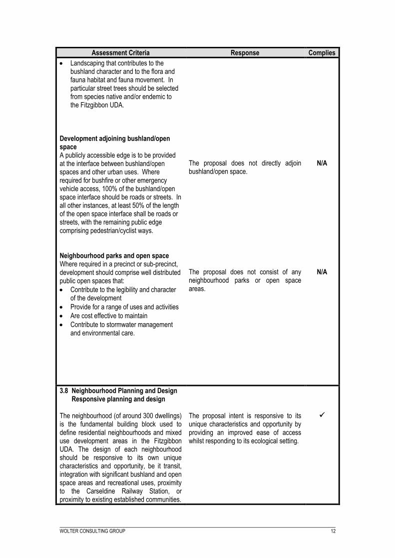
Landscaping that contributes to the bushland character and to the flora and fauna habitat and fauna movement. In particular street trees should be selected from species native and/or endemic to the Fitzgibbon UDA.
Development adjoining bushland/open space A publicly accessible edge is to be provided at the interface between bushland/open spaces and other urban uses. Where required for bushfire or other emergency vehicle access, 100% of the bushland/open space interface should be roads or streets. In all other instances, at least 50% of the length of the open space interface shall be roads or streets, with the remaining public edge comprising pedestrian/cyclist ways. Neighbourhood parks and open space Where required in a precinct or sub-precinct, development should comprise well distributed public open spaces that:
Contribute to the legibility and character of the development
Provide for a range of uses and activities
Are cost effective to maintain
Contribute to stormwater management and environmental care.
The proposal does not directly adjoin bushland/open space. The proposal does not consist of any neighbourhood parks or open space areas.
N/A
N/A
3.8 Neighbourhood Planning and Design Responsive planning and design
The neighbourhood (of around 300 dwellings) is the fundamental building block used to define residential neighbourhoods and mixed use development areas in the Fitzgibbon UDA. The design of each neighbourhood should be responsive to its own unique characteristics and opportunity, be it transit, integration with significant bushland and open space areas and recreational uses, proximity to the Carseldine Railway Station, or proximity to existing established communities.
The proposal intent is responsive to its unique characteristics and opportunity by providing an improved ease of access whilst responding to its ecological setting.

WOLTER CONSULTING GROUP 13
Assessment Criteria Response Complies
Variety, choice and identity Each neighbourhood should:
offer a wide choice in good quality housing
provide for appropriate scale local employment opportunities
encourage walking and cycling
minimise energy consumption
promote a sense of place through distinctive neighbourhood focal points
integrate local history and cultural design elements and
recognise and, where possible, preserve the existing bushland.
Neighbourhood design Each neighbourhood should comprise:
a subdivision layout that gives the neighbourhood a strong and positive identity, by responding to site characteristics, setting, landmarks and views creating easily understood Street and open-space networks
a layout in accordance with principles of crime prevention through environmental design
street and movement networks which: o optimise walkable access to
centres, schools, public transport stops and other local destinations
o provides safe, convenient and legible movement for people with disabilities, including those using wheelchairs, mobility
The proposal within the subject site does not involve residential development. The proposed subdivision of Lot 5014 is supported by a Plan of Reconfiguration. The proposal has incorporated the New Road to improve the permeability through the streetscape. As the road network is aligned with various bushland to the west, the road network will be implemented with highly legible components being approved street lighting and traffic signalling. The proposed road will integrate with the existing streetscape of Norris Road whilst incorporating a safe and convenient pedestrian pathway. The intersection which it submerges functionality with will be issued with safe crossing precautions to allow a safe network. Subsequently, providing catering for the existing residential components to the south in order of obtaining access to services located on the north of the subject site.
N/A

WOLTER CONSULTING GROUP 14
Assessment Criteria Response Complies
scooters and similar aids o deliver high levels of personal
safety, traffic safety, property safety and security; and which positively contribute to streetscape amenity and open space quality
o respect landmarks and sites of
historical importance o minimise lots fronting cul-de-sac o deliver a safe, attractive and
efficient, pedestrian and cyclist network running largely along public spaces (including streets and open spaces), fronted and/or overlooked by dwellings, avoids major breaks in surveillance on routes to and from public transport, and includes end-of- trip facilities, where appropriate, to meet the needs of cyclists
distribution and design of land uses to minimise infrastructure costs
the siting and design of buildings to conserve non-renewable energy sources to assist in design appropriate for subtropical climatic conditions; and buffer adjoining high-impact uses such as the railway and proposed busway
As Above. The site contains no landmarks or sites of historical importance. The proposed development does not front a cul-de-sac. The New Road will run directly along the open space bushland and is provided with clear sight lines from the north-south to increase surveillance. The proposed subdivision is for a reconfiguration (for a New Road) of a lot and will be delivered in a cost-effective manner. The proposal within the subject site does not involve residential development. The subdivision proposal is not for the requirement of building infrastructure.
N/A
N/A
N/A

WOLTER CONSULTING GROUP 15
Assessment Criteria Response Complies
a mix of lot sizes to enable a variety of housing types and other compatible land uses such as child care, local shops and home-based business development opportunities, arranged to minimise land use conflicts. Lot sizes address site constraints including slope and soil erosion
in areas abutting bushland areas, lots are sited and designed to incorporate bushfire protection measures and
streets are designed, located and connected to allow safe and efficient movement of fire emergency vehicles.
Buildings and Public Realm Relationships The public realm of civic spaces, parks, plazas, footpaths, urban streets and other shared community spaces should be clearly delineated from, but integrated with the private realm, and should comprise:
a sense of place reflecting the character of the location
material and plant selection appropriate to the location and relevant to the sense of place
shade trees along streets and within public and private spaces
an appropriate climate-based orientation and design, ensuring shade is provided, breezes can be shared and sunlight reaches internal and external spaces
setbacks for the movement of pedestrians and standing areas for public transport stops
at ground level, buildings designed to integrate shopping, dining, and other outdoor activities and continuous awnings to provide protection from the rain and sun and integrated with Street plantings
where appropriate, opportunities for informal and formal play
where appropriate, opportunities to reflect local history, landmarks and culture through public artworks and
The subdivision has been proposed adjacent to the Bushland and Open Space Zone. A new road is being proposed to accommodate a battered edge and provide bushfire mitigation processes. The New Road will continue the dimensions of the existing ‘Norris Road’, which has a road width of 15m providing adequate space for the movement of fire and emergency vehicles. There are no buildings proposed as part of this application. However, the New Road is well connected to development within the Fitzgibbon PDA and is clearly distinguishable from private spaces and the street.
N/A

WOLTER CONSULTING GROUP 16
Assessment Criteria Response Complies
where possible, balconies to enable surveillance and overlooking of public spaces and places.
Flood immunity Development will achieve appropriate flood immunity levels.
3.10 Transport, Access, On-site Parking and Servicing
Car Parking On site car parking areas, loading bays and service areas should either be integrated within or under buildings and sleeved by active frontages, or located away from the public realm behind buildings. The use of large blank screens to mask loading areas is not appropriate. Vehicle service area crossovers and car parking should not detract from the character of active edges. Co-location of uses and sharing of car parking spaces is encouraged to maximise efficiency. Development is required to provide car parking (unless otherwise specified in a sub- precinct) in accordance with the following rates identified in Table I Car Parking Rates. Variations to car parking rates may be considered where the development is in close proximity to public transport stations and activity nodes. Circulation Development is to support accessibility, permeability and movement for pedestrians and cyclists and appropriate movement by vehicles.
No buildings are proposed as part of this application, therefore parking is not required. As above. As above. As above. As above. The New Road integrates with the surrounding streetscape whilst supporting a high level of accessibility, permeability and movement for pedestrians.
N/A
N/A
N/A
N/A
N/A

WOLTER CONSULTING GROUP 17
Assessment Criteria Response Complies
Cycle way paths and high quality cycling facilities should be incorporated in new roads within the UDA. Development is to be designed to include safe and highly visible connections to pedestrian and cycle networks through building siting, landscape design elements and treatments. End of Trip Facilities End of trip facilities for pedestrians and cyclists should be provided as part of development for non-residential uses including secure, undercover bicycle storage facilities, showers and lockers
Cycle way paths and cycling facilities have been continued from Norris Road throughout the prevailing subject site. The pedestrian pathway network designed is sought to maximise safety and has a highly visible presence across the site. End of trip facilities are not required within the subject site locality due to the singular use being a New Road.
N/A
3.11 Environment Flora and Fauna Development should not adversely affect the environmental values of the flora and fauna within the Bush land and Open Space Zone. Where significant vegetation exists in precincts identified for development, vegetation should be retained where possible along streets and within parks. Where significant vegetation is being cleared development will be required to rehabilitate land in the Bushland and Open Space Zone in accordance with the Fitzgibbon Bushland Management Plan prepared by the ULDA. Contaminated Land Development must ensure that all land and groundwater will be fit for purpose consistent with current best practice.
Whilst the proposed subdivision is apparent within the Bush land and Open Space Zone, the locality of the New Road has been proposed on an area unrestricted from wildlife corridors. As Above. In the case of vegetation removal, significant vegetation will be rehabilitated in accordance with the Fitzgibbon Bushland Management Plan. The identification of land and groundwater as fit for purpose will be considered in the Operational Works phase.

WOLTER CONSULTING GROUP 18
Assessment Criteria Response Complies
Acid Sulfate Soils Development will demonstrate consistency with current best practice for the identification and management of acid sulfate soils.
The identification and management of acid sulfate soils will be considered in the Operational Works phase.
3.12 Lot Design Lot sizes and dimensions must enable buildings to be sited to:
protect natural and cultural features, including significant vegetation
address site constraints including slope, soil erosion, flooding and drainage
retain special features such as trees
ensure that lots are not subject to unreasonable risk, hazard, noise impacts or air quality impacts
ensure reasonable buffers between existing or potential incompatible land uses
maximise solar orientation benefits to assist energy rating targets.
Neighbourhood and lot design for mixed residential development up to 3 storeys in height and with a net residential density up to 30 dwellings per hectare, will comply with ULDA guidelines and best practice standards 11.
Other lots must have an appropriate area and dimension for siting and construction of the buildings, the provision of outdoor space, the relationship to adjoining development and public realm, safe and
The subdivided lot has been allocated to protect the biodiversity elements present. Site constraints have been assessed in the civil engineering report as part of Development Approval DEV2012/298 for Area G. The proposal has incorporated the retention of trees where possible. Sensitive uses have not been proposed as part of this application. There will be no incompatible land uses. The proposal within the subject site does not involve residential development. The proposal within the subject site does not involve residential development. The proposal within the subject site does not involve buildings.
N/A
N/A

WOLTER CONSULTING GROUP 19
Assessment Criteria Response Complies
convenient vehicle access, servicing and parking.
Lot frontages must address streets and civic and open space. This is to facilitate personal and property security, surveillance of footpaths and public open space to deter crime and vandalism.
The proposal within the subject site does not involve lot frontages applicable to this condition as the application is for a New Road.
N/A

WOLTER CONSULTING GROUP 20
5.2.2 Fitzgibbon Urban Development Area – Precinct Assessment
The Fitzgibbon UDA is divided into eight (8) precincts and one (1) sub-precinct. Land within the PDA is
also allocated a zone. As stated earlier, the subject site is located within the Bushland and Open Space
Zone of Precinct 4 (please see below). Within the Bushland and Open Space Zone, reconfiguration of a
lot is a permissible development.
Figure 4: Precinct 4 – Subject Site Source: Fitzgibbon Development Scheme
It is intended that the subject site is only a minor portion of the precinct which will comprise the New
Road to service the surrounding residential areas. The subject site is wholly contained within the
Bushfire and Open Space Zone which states, “The bushland provides an open space setting and
amenity for the emerging new suburban and urban communities in the Fitzgibbon UDA”.
Accordingly, the proposal is consistent with the intent of the precinct as it contains a subdivision for a
New Road which provides connectivity and access for the emerging suburban and urban residential
developments prevalent within the Fitzgibbon Urban Development Area. The proposal will retrospectively
open up the opportunity for enhanced public transport, pedestrian and cyclist connections to higher order
suburbs and emergency vehicle access to the PDA. The prevailing components will ensure that the
accessibility of any future development will not be compromised.
Subject Site
WOLTER CONSULTING GROUP 21
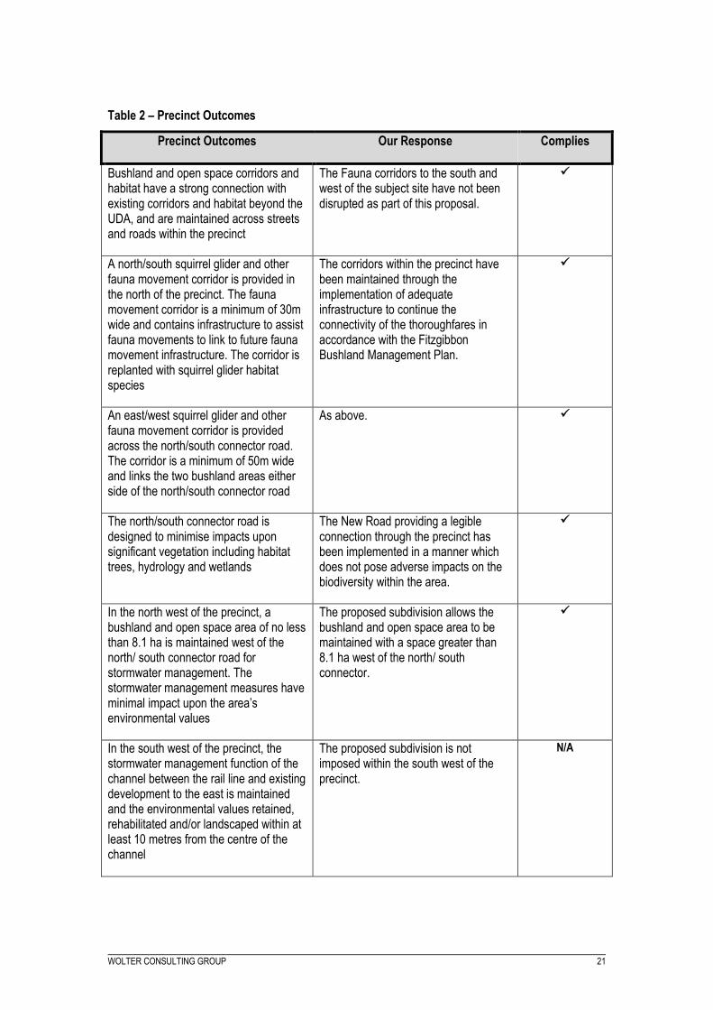
Table 2 – Precinct Outcomes
Precinct Outcomes Our Response Complies
Bushland and open space corridors and habitat have a strong connection with existing corridors and habitat beyond the UDA, and are maintained across streets and roads within the precinct
The Fauna corridors to the south and west of the subject site have not been disrupted as part of this proposal.
A north/south squirrel glider and other fauna movement corridor is provided in the north of the precinct. The fauna movement corridor is a minimum of 30m wide and contains infrastructure to assist fauna movements to link to future fauna movement infrastructure. The corridor is replanted with squirrel glider habitat species
The corridors within the precinct have been maintained through the implementation of adequate infrastructure to continue the connectivity of the thoroughfares in accordance with the Fitzgibbon Bushland Management Plan.
An east/west squirrel glider and other fauna movement corridor is provided across the north/south connector road. The corridor is a minimum of 50m wide and links the two bushland areas either side of the north/south connector road
As above.
The north/south connector road is designed to minimise impacts upon significant vegetation including habitat trees, hydrology and wetlands
The New Road providing a legible connection through the precinct has been implemented in a manner which does not pose adverse impacts on the biodiversity within the area.
In the north west of the precinct, a bushland and open space area of no less than 8.1 ha is maintained west of the north/ south connector road for stormwater management. The stormwater management measures have minimal impact upon the area’s environmental values
The proposed subdivision allows the bushland and open space area to be maintained with a space greater than 8.1 ha west of the north/ south connector.
In the south west of the precinct, the stormwater management function of the channel between the rail line and existing development to the east is maintained and the environmental values retained, rehabilitated and/or landscaped within at least 10 metres from the centre of the channel
The proposed subdivision is not imposed within the south west of the precinct.
N/A

WOLTER CONSULTING GROUP 22
6 CONCLUSIONS AND RECOMMENDATIONS
The proposal is consistent with and promotes the intention of the Economic Development Queensland
by facilitating economic development and development for community purposes. The proposal complies
with the intent of Precinct 4 in the Fitzgibbon Development Scheme and the Assessment Criteria of the
Fitzgibbon Development Scheme.
It is recommended that this Development Application for Reconfiguration of a Lot –New Road be
approved subject to reasonable and relevant conditions.

WOLTER CONSULTING GROUP 23
Appendices
A. Plan of Reconfiguration prepared by Land Partners;