Embed Size (px)
Citation preview
Planning Rationale In Support of an Application for Site Plan Approval
5371 Boundary RoadCity of Ottawa
Boundary Road Development Inc.16766 Transcanadienne
Suite 500Kirkland, Québec
H9H 4M7
Prepared By:
NOVATECHSuite 200, 240 Michael Cowpland Drive
Ottawa, OntarioK2M 1P6
April 12, 2018
Novatech File: 117217Ref: R-2018-047
M:\2017\117217\DATA\Reports\Rationale\20180402_Rationale.docx
Suite 200, 240 Michael Cowpland Drive, Ottawa ON K2M 1P6 Tel: 613.254.9643 Fax: 613.254.5867 www.novatech-eng.com
April 12, 2018
City of Ottawa Planning & Growth Management Department110 Laurier Avenue West, 4th FloorOttawa, ON K1P 1J1
Attention: Jeff Ostafichuk, Planner II
Dear Ms. McWilliams:
Reference: 5371 Boundary RoadApplication for Site Plan Approval
Our File No.: 117217
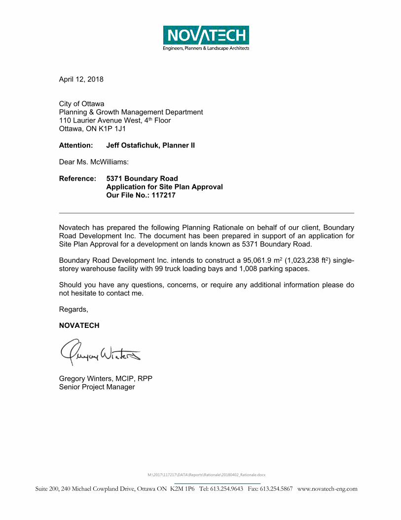
Novatech has prepared the following Planning Rationale on behalf of our client, Boundary Road Development Inc. The document has been prepared in support of an application for Site Plan Approval for a development on lands known as 5371 Boundary Road.
Boundary Road Development Inc. intends to construct a 95,061.9 m2 (1,023,238 ft2) single-storey warehouse facility with 99 truck loading bays and 1,008 parking spaces.
Should you have any questions, concerns, or require any additional information please do not hesitate to contact me.
Regards,
NOVATECH
Gregory Winters, MCIP, RPPSenior Project Manager
Planning Rationale Boundary Road Development Inc.
Novatech i
Table of Contents1.0 INTRODUCTION .........................................................................................................12.0 CONTEXTUAL ANALYSIS .........................................................................................13.0 PLANNING CONTEXT................................................................................................3
3.1 OFFICIAL PLAN ..........................................................................................................33.2 ZONING .....................................................................................................................4
4.0 PROPOSAL.................................................................................................................45.0 POLICY JUSTIFICATION ...........................................................................................7
5.1 PROVINCIAL POLICY STATEMENT (2014) ....................................................................75.2 CITY OF OTTAWA OFFICIAL PLAN (OPA 180)............................................................10
6.0 SUPPORTING STUDIES ..........................................................................................157.0 CONCLUSION...........................................................................................................16APPENDIX A SITE PLAN.......................................................................................................1
FIGURES:
Figure 1: Subject Site and surrounding context (Source: GeoOttawa)....................................2
Figure 2 Extract of Schedule A of the City of Ottawa Official Plan (Source: City of Ottawa)...3
Figure 3: Zoning of Subject Site and surrounding lands (Source: GeoOttawa).......................4
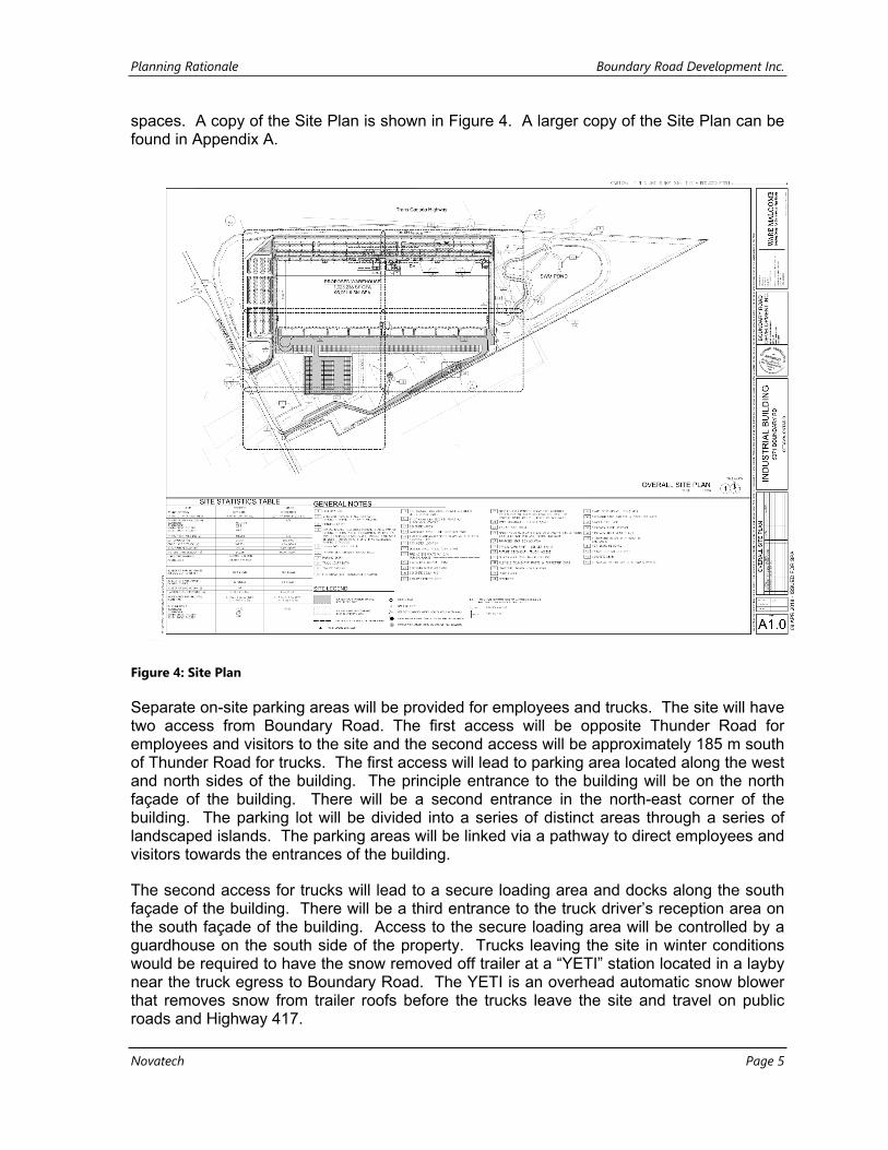
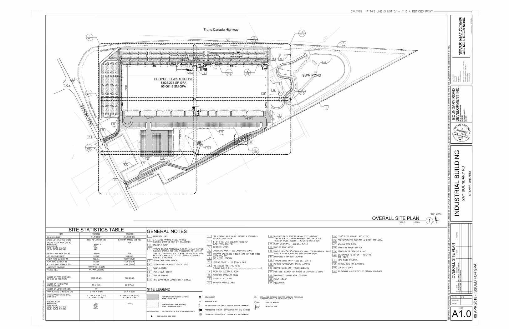
Figure 4: Site Plan ...................................................................................................................5
Planning Rationale Boundary Road Development Inc.
Novatech Page 1
1.0 INTRODUCTION
Novatech has been retained by Boundary Road Development Inc. (BRDI) to prepare this Planning Rationale in support of an application for Site Plan Control for 5371 Boundary Road. Our client intends to construct a 95,061.9 m2 (1,023,238 ft2) single-storey warehouse facility with 99 truck loading bays and 1,008 parking spaces.
This Rationale will outline the various aspects of the proposal and illustrate that the proposed development is consistent with relevant provincial and municipal policies.
2.0 CONTEXTUAL ANALYSIS
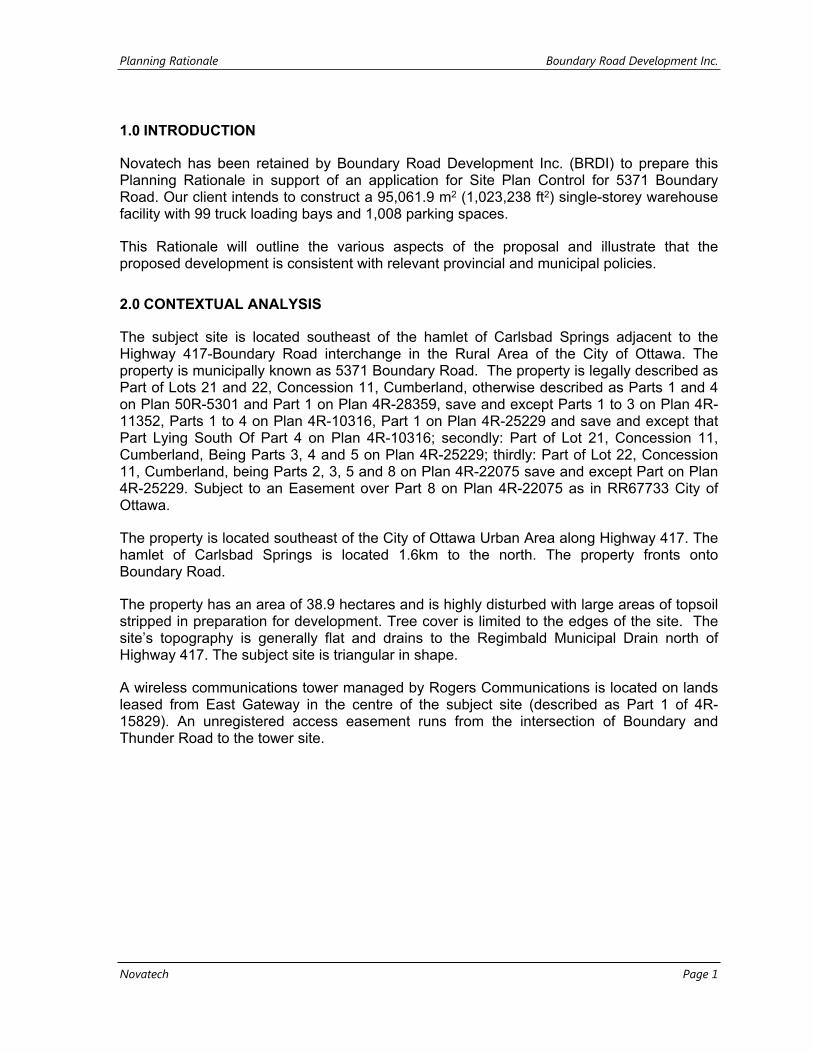
The subject site is located southeast of the hamlet of Carlsbad Springs adjacent to the Highway 417-Boundary Road interchange in the Rural Area of the City of Ottawa. The property is municipally known as 5371 Boundary Road. The property is legally described as Part of Lots 21 and 22, Concession 11, Cumberland, otherwise described as Parts 1 and 4 on Plan 50R-5301 and Part 1 on Plan 4R-28359, save and except Parts 1 to 3 on Plan 4R-11352, Parts 1 to 4 on Plan 4R-10316, Part 1 on Plan 4R-25229 and save and except that Part Lying South Of Part 4 on Plan 4R-10316; secondly: Part of Lot 21, Concession 11, Cumberland, Being Parts 3, 4 and 5 on Plan 4R-25229; thirdly: Part of Lot 22, Concession 11, Cumberland, being Parts 2, 3, 5 and 8 on Plan 4R-22075 save and except Part on Plan 4R-25229. Subject to an Easement over Part 8 on Plan 4R-22075 as in RR67733 City of Ottawa.
The property is located southeast of the City of Ottawa Urban Area along Highway 417. The hamlet of Carlsbad Springs is located 1.6km to the north. The property fronts onto Boundary Road.
The property has an area of 38.9 hectares and is highly disturbed with large areas of topsoil stripped in preparation for development. Tree cover is limited to the edges of the site. The site’s topography is generally flat and drains to the Regimbald Municipal Drain north of Highway 417. The subject site is triangular in shape.
A wireless communications tower managed by Rogers Communications is located on lands leased from East Gateway in the centre of the subject site (described as Part 1 of 4R-15829). An unregistered access easement runs from the intersection of Boundary and Thunder Road to the tower site.
Planning Rationale Boundary Road Development Inc.
Novatech Page 2
Figure 1: Subject Site and surrounding context (Source: GeoOttawa)
The property is bordered by Boundary Road and the intersection with Thunder Road to the west. Highway 417 borders the property to the north. A ditch runs along the property’s northern boundary, within the Highway 417 corridor, and leads to the Regimbald Municipal Drain on the opposite side of the highway.
There are several existing industrial/commercial uses located immediately to the south of the interchange along Boundary Road and in the subdivision on Entrepreneur Crescent, Indicum and Tradesman Roads south of the subject site. West of the subject site is an existing gas station and several dwellings.
Grey Hawk golf course is located north of the subject site on the opposite side of Highway 417 on the east side of Boundary Road.
Lands southeast of the subject site, at 5471, 5575, 5613 Boundary Road and 5554, 5508, 5570 5610, 5800 Frontier Road are owned by Taggart Miller Environmental Services Capital Region Resource Recovery Centre. An Environmental Assessment was approved by the Ministry of Environment and Climate Change for the Taggart Miller to operate a resource recovery and waste diversion facility for the industrial, commercial and institutional (IC&I) and construction and demolition (C&D) materials. The disposal of residual and non-recyclable waste will also be provided on-site. The lands are currently subject to an Official Plan Amendment and Zoning By-law amendment to permit the resource recovery and waste diversion facility. The Official Plan Amendment will amend Schedule A of the Official Plan to identify a new Solid Waste Disposal Site, and the concurrent Zoning By-law Amendment will change the zoning from RU – Rural Zone, RH – Rural Heavy Industrial Zone and RH
Planning Rationale Boundary Road Development Inc.
Novatech Page 3
[22r] – Rural Heavy Industrial Exception Zone to a new Rural Heavy Industrial Exception Zone to permit a Solid Waste Disposal Facility.
3.0 PLANNING CONTEXT
3.1 Official Plan
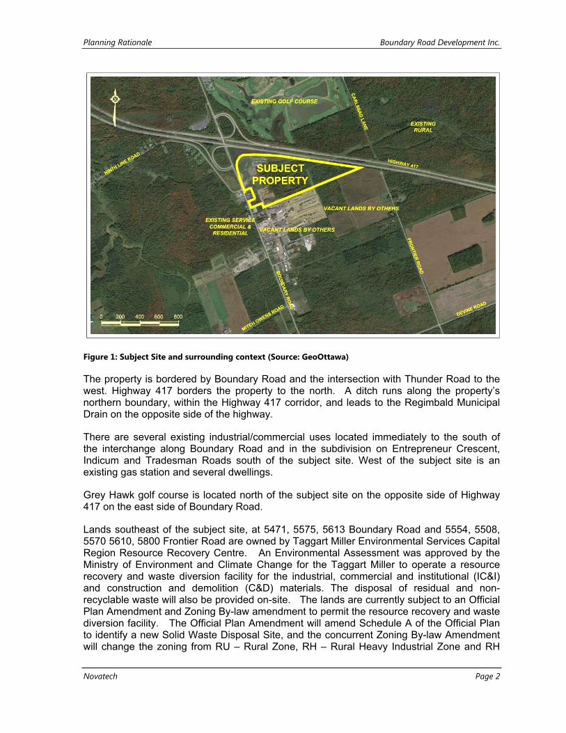
The subject site is designated as Rural Employment Area on Schedule A of the Official Plan (OPA 180) as shown in Figure 2. The subject site is part of a larger area that was designated Rural Employment Area through the adoption of OPA 180 by Council of the City of Ottawa on January 25, 2017 and approved by the Ministry of Municipal Affairs and Housing on August 8, 2017. OPA 180, amongst other matters, addressed the conversion of excess urban employment lands to non-employment designations, the re-designation of Enterprise Areas, the creation of a new Rural Employment Area designation, and amended policies and land use permissions for Employment Areas. The new Rural Employment Area designation was intended to implement a City strategy of recognizing existing business parks that are conducive for economic development near highway interchanges.
Figure 2 Extract of Schedule A of the City of Ottawa Official Plan (Source: City of Ottawa)
Section 3.7.5 of the Official Plan states that Rural Employment Areas are intended to support and encourage clustering of primarily industrial uses not suitable in the Urban Area or General Rural Area including transportation uses. The Official Plan specifically states:
“Rural Employment Areas add to the diversity of opportunities for economic development and those seeking large sites and proximity to the urban area.
Those rural employment areas located in close proximity to 400 Series Highway interchanges are uniquely suited to transportation facilities such as truck terminals,
Planning Rationale Boundary Road Development Inc.
Novatech Page 4
warehouses, courier and freight facilities that support inter – and intra-provincial movement of goods.”
The Rural Employment Area permits new heavy and light industrial uses, such as steel and concrete fabrication, farm equipment and supply centres, machine and vehicle sales service and repair, construction yards, building products yards, landscape contractors, nurseries, and new transportation, warehouse and storage operations, which are encouraged to locate on sites near arterial roads and highway interchanges.
Lands surrounding the Rural Employment Area are generally designated General Rural Area, except for lands to the northeast, opposite Highway 417, that are designated as Rural Natural Feature.
3.2 Zoning
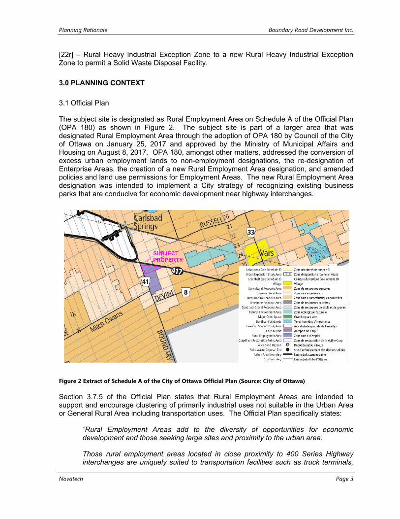
The subject site was subject to an application for Zoning By-law Amendment in 2016. Zoning By-law 2016-98 was enacted on March 23, 2016. Most of the subject site is zoned RH - Rural Heavy Industrial. The west portion of the site is zoned RH [818r] Rural Heavy Industrial Exception. The current zoning is shown in Figure 3.
Figure 3: Zoning of Subject Site and surrounding lands (Source: GeoOttawa)
4.0 PROPOSAL
Novatech is applying for Site Plan Approval on behalf of BRDI to construct a 95,061.9 m2 (1,023,238 ft2) single-storey warehouse facility with 99 truck loading bays and 1,008 parking
Planning Rationale Boundary Road Development Inc.
Novatech Page 5
spaces. A copy of the Site Plan is shown in Figure 4. A larger copy of the Site Plan can be found in Appendix A.
Figure 4: Site Plan
Separate on-site parking areas will be provided for employees and trucks. The site will have two access from Boundary Road. The first access will be opposite Thunder Road for employees and visitors to the site and the second access will be approximately 185 m south of Thunder Road for trucks. The first access will lead to parking area located along the west and north sides of the building. The principle entrance to the building will be on the north façade of the building. There will be a second entrance in the north-east corner of the building. The parking lot will be divided into a series of distinct areas through a series of landscaped islands. The parking areas will be linked via a pathway to direct employees and visitors towards the entrances of the building.
The second access for trucks will lead to a secure loading area and docks along the south façade of the building. There will be a third entrance to the truck driver’s reception area on the south façade of the building. Access to the secure loading area will be controlled by a guardhouse on the south side of the property. Trucks leaving the site in winter conditions would be required to have the snow removed off trailer at a “YETI” station located in a layby near the truck egress to Boundary Road. The YETI is an overhead automatic snow blower that removes snow from trailer roofs before the trucks leave the site and travel on public roads and Highway 417.
Planning Rationale Boundary Road Development Inc.
Novatech Page 6
The site will be landscaped to address travellers moving at highway speeds along Highway 417 and to provide visual interest to motorists crossing the bridge over the highway. It is proposed to add a large arc of mostly native trees on either end of the site fronting on to Highway 417. These trees have been selected for consistency in form and fall colour, to provide a uniform effect while still incorporating a diversity of species. These arcs are to serve as visual "book ends" for the building. The arcs of trees also make a transition from the existing woodland, that brackets the site, to the linear arrangement of more urban-tolerant trees in the parking lot. Another arc of trees is proposed for the middle of the site, to enhance the the view from the highway and to frame views to the new building.
The existing Rogers Communications tower and easement will be relocated as part of the development of the site to a new location south of the secure loading area.
An application for Draft Plan of Subdivision Approval (City File No. D07-16-14-0024) was approved for the subject site on April 26, 2017. The subdivision for the development of a rural industrial subdivision on partial services. The subdivision was intended to have a single access road to the site from a signalized intersection at Thunder Road/Boundary Road that would terminate at a cul-de-sac at the east end of the property. The proposed subdivision had five large development blocks ranging in size from 3.74 ha to 10.95 ha. A development block adjacent to Boundary road was proposed to accommodate both rural industrial and rural commercial uses in accordance with the previously noted Zoning By-law 2016-98 enacted on March 23, 2016. The proposed blocks were to be serviced by individual septic systems, approved through subsequent applications for Site Plan Approval, and through municipal water from the Carlsbad Springs Trickle Feed Water Service Area.
The Carlsbad Springs Trickle Feed System was created in 1997 by the Regional Municipality of Ottawa-Carleton to serve a large rural area within the former City of Gloucester and City of Cumberland. The residential development on Thunder Road, Boundary Road, Russell Road and within the Village of Carlsbad Springs are presently serviced by the water system.
An application for Official Plan Amendment (City File No. D01-01-14-0018) was submitted to extend the Carlsbad Springs Trickle Feed Water Service Area to an additional 22 existing properties including the subject site. The Amendment was adopted by Council on July 8, 2015 as Official Plan Amendment 153.
The proposed development site is not within the City of Ottawa sanitary service area. An on-site, private sewage collection and treatment facility is proposed with a surface discharge of the treated effluent to the Regimbald Municipal Drain immediately upstream of Highway 417.
The subject site is located within the jurisdiction of the South Nation Conservation Authority (SNCA). Under existing conditions, stormwater runoff flows overland across the subject site into a man-made drainage ditch system. The drainage ditches direct runoff into a culvert crossing under the Highway 417, at the eastern end of the site that outlet to the Regimbald Municipal Drain. The upper end of the municipal drain terminates just upstream of the culvert crossing under Highway 417.
The proposed storm drainage system will be a combination of storm sewers and ditches network throughout the site that will convey post-development peak flows to a new wet pond stormwater management facility that will be constructed at the east end of the site for water quality and quantity control. The culvert crossing under Highway 417 will remain the outlet
Planning Rationale Boundary Road Development Inc.
Novatech Page 7
for the stormwater management facility. Some of the existing drainage ditches on site have already been realigned under a permit from the South Nation Conservation Authority (Permit # 2018-CUM-R014).
As noted previously, a new proposed access will be constructed from Boundary Road to provide ingress/egress for delivery trucks. A southbound left-turn lane will be constructed on Boundary Road for the truck access. Modifications are required to access the site from the Thunder Road/Site Access/Boundary Road intersection. Modifications will include a southbound left-turn lane, a northbound left-turn lane, a northbound right-turn taper, and the installation of traffic control signals.
The Ministry of Transportation has confirmed that a Provincial Class Environmental Assessment (EA) is required for the proposed road modifications within their jurisdiction being the Highway 417 ramps to the Boundary Road/Thunder Road intersection (north leg). The EA will be conducted through a concurrent process with application for Site Plan Approval.
The subject site is in the rural area and is not serviced by public transit services. The closest service from OC Transpo is a peak hour Connection Route #222 to Vars Monday to Friday, generally 6-9 AM and 3-6 PM.
No bicycle parking will be provided as the subject site is not adequately serviced by improved cycling facilities and, by necessity, due to the site’s distance outside of the Urban Area or other settlement area and near Highway 417.
5.0 POLICY JUSTIFICATION
The following portion of this rationale will demonstrate that the proposed Site Plan is consistent with the 2014 Provincial Policy Statement and conform to the City’s Official Plan.
5.1 Provincial Policy Statement (2014)
The 2014 Provincial Policy Statement (PPS) provides policy direction on land use planning and development matters of provincial interest. All decisions affecting planning matters “shall be consistent with” policies issued under the authority of Section 3 of the Planning Act.
Section 1.1 of the PPS focuses on managing and directing land use to achieve efficient and resilient development and land use patterns. The PPS states, in Section 1.1.1, that healthy, liveable and safe communities are sustained by:
a) promoting efficient development and land use patterns which sustain the financial well-being of the Province and municipalities over the long term;
b) accommodating an appropriate range and mix of residential, employment, institutional, recreation, park and open space, and other uses to meet long-term needs;
c) avoiding development and land use patterns which may cause environmental or public health and safety concerns;
Planning Rationale Boundary Road Development Inc.
Novatech Page 8
d) avoiding development and land use patterns that would prevent the efficient expansion of settlement areas in those areas which are adjacent or close to settlement areas;
e) promoting cost-effective development patterns and standards to minimize land consumption and servicing costs;
f) improving accessibility for persons with disabilities and older persons by identifying, preventing and removing land use barriers which restrict their full participation in society;
g) ensuring that necessary infrastructure, electricity generation facilities and transmission and distribution systems, and public service facilities are or will be available to meet current and projected needs; and
h) promoting development and land use patterns that conserve biodiversity and consider the impacts of a changing climate.
The proposed development will create additional employment opportunities and broaden the range of employment uses in the area. The subject site is currently adjacent to existing industrial uses to the south (including an existing rural industrial subdivision) and will not impede the expansion of existing settlement areas.
The proposed development will provide lands for rural industrial development with convenient access to a 400-series highway interchange. This will facilitate greater and more efficient movement of goods while minimizing the impact of goods movement on existing urban and rural communities.
Rural Areas in Municipalities
Policy 1.1.4e) and f) states that healthy, integrated and viable rural areas should be supported by using rural infrastructure and public service facilities efficiently, and promoting diversification of the economic base and employment opportunities through goods and services.
The proposed development will facilitate the orderly development of lands strategically located adjacent to an existing 400-series highway interchange and will diversity the economic base. The proposed development will be serviced by an extension of the
Rural Lands in Municipalities
Policy 1.1.5.5 development shall be appropriate to the infrastructure that is planned or available, and avoid the need for the uneconomical expansion of infrastructure. As mentioned previously, an extension to the Carlsbad Springs Trickle Feed System to service an additional 22 existing properties including the subject site was adopted by Council on July 8, 2015 as Official Plan Amendment 153. A private sewage treatment plant is being proposed for the treatment of waste from the proposed development.
Planning Rationale Boundary Road Development Inc.
Novatech Page 9
Employment
Policy 1.3.1 states that planning authorities shall promote economic development and competitiveness by providing for an appropriate mix and range of employment uses to meet long-term needs, maintain a range and choices of suitable sites for employment uses which support a wide range of economic activities and ancillary uses.
The proposed development provides employment lands at a strategic location in the City of Ottawa adjacent to an interchange on a major interurban highway. The current Rural Employment Area designation, RH Zone and RH [818r] Zone permits a wide range of employment uses that are appropriate for this type of rural location including truck transport terminal and warehouse uses.
Policy 1.3.2.3 requires planning authorities to protect employment areas in proximity to major goods movement facilities and corridors for employment uses that require those locations. The proposed development is strategically located at a highway interchange and will accommodate the transfer of goods.
Infrastructure and Public Service Facilities
Policy 1.6.8.3 states that new development proposed adjacent to existing corridors and transportation facilities should be compatible with, and supportive of, the long-term purposes of the corridor. The proposed development is compatible with the existing Highway 417 interchange and adjacent industrial uses.
Wise Use and Management of Resources
Section 2.0 of the PPS provides policies related to the protection natural heritage, water agriculture, mineral and cultural heritage, and archaeological resources summarized below.
Regarding Section 2.1 (Natural Features) an Environmental Impact Statement was prepared by Kilgour & Associates dated April 4, 2018 in accordance with Policy 2.1.6 of the PPS. The report concluded that there are no provincially or locally significant wetlands, other forest remnants, wetlands found in association with significant woodlands, significant valley lands or Life Science Areas or Natural and Scientific Interest on or adjacent to the site.
Relating to Section 2.2 (Water), a ditch draining to the Regimbald Municipal Drain is located on the subject site. The Environmental Impact Statement concludes that the ditch does not provide habitat for species at risk. Additionally, Novatech prepared a Site Servicing Study dates April 10, 2018 that includes a proposed storm drainage system will be a combination of storm sewers and ditches network throughout the property that will convey post-development peak flows to a new wet pond stormwater management facility that will be constructed at the east end of the site for water quality and quantity control. The culvert crossing under Highway 417 will remain the outlet for the stormwater management facility. Some of the existing drainage ditches on site have already been realigned under a permit from the South Nation Conservation Authority.
Planning Rationale Boundary Road Development Inc.
Novatech Page 10
Relating to Section 2.3 (Agriculture), the subject site is located on lands designated as Rural Employment Area in the Official Plan and does not have any identified agricultural potential.
Relating to Section 2.4 (Minerals and Petroleum), the subject site has no known areas of mineral or petroleum potential; it will not impact areas of petroleum potential.
Relating to Section 2.5 (Mineral Aggregate Resources), the subject site has no known mineral aggregate potential; it will not impact areas of mineral aggregate potential.
Relating to Section 2.6 (Cultural Heritage and Archaeology), the subject site has not been identified by the City of Ottawa Archaeological Potential mapping as having archaeological potential.
Protecting Health and Safety
Section 3.0 of the PPS provides policies related to reducing the potential public cost and protection of residents from natural or human-made hazards.
Relating to Section 3.1 (Natural Hazards), the site is not located on lands impacted by hazardous sites, erosion and/or dynamic beach hazards, large inland lakes, or unstable soils or bedrock. Paterson Group completed a Geotechnical Assessment (Report PG4366-1) dated February 9, 2018 and concluded that the subject site is considered satisfactory for the proposed warehouse. It is expected that the proposed building can be founded on conventional spread footings bearing on the undisturbed silty sand or stiff silty clay deposits. However, due to the presence of the deep silty clay deposit, a permissible grade raise restriction will be applied for the subject site.
Regarding Section 3.2 (Human-Made Hazards), Paterson Group completed a letter report titled Phase I - Environmental Site Assessment (ESA) Update for the subject site. The letter report is an update to their earlier report titled Phase I Environmental Site Assessment (Report PE3335-1) for the previous application for Draft Plan of Subdivision dated August 29, 2014. They concluded that there were no potential environmental concerns with respect to the subject site and that a Phase II Environmental Site Assessment is not required for the property.
5.2 City of Ottawa Official Plan (OPA 180)
The Official Plan provides a vision for future growth of the City and a policy framework to guide its physical development. The subject site is designated as Rural Employment Area on Schedule A of the City of Ottawa Official Plan (OPA 180).
As noted previously in Section 3.0 of this Rationale, the Rural Employment Area permits new heavy and light industrial uses, such as steel and concrete fabrication, farm equipment and supply centres, machine and vehicle sales service and repair, construction yards, building products yards, landscape contractors, nurseries, and new transportation, warehouse and storage operations, which are encouraged to locate on sites near to arterial
Planning Rationale Boundary Road Development Inc.
Novatech Page 11
roads and highway interchanges. The RH – Zone and RH [818r] Zone are consistent with the policies of the Rural Employment Area designation in the Official Plan.
The proposed development will have vehicle traffic that would not be appropriate within a Village. The proposed development is consistent with the industrial character of the surrounding area.
Section 2.3.1 (Transportation) of the Official Plan addresses how people and goods movement infrastructure will be developed.
Policy 44 of Section 2.3.1 states:
The City will preserve strategic locations with superior access to major highways, the airport, railroads and the arterial road network for distribution centres that intercept goods transported long distances by air, rail or truck and transfer them to smaller, more energy efficient vehicles for distribution within the city. The centres reduce the cost and increase the speed of deliveries within the city and divert heavy truck traffic from local roads.
Considering this, the subject site is appropriate for the proposed development.
Site-Specific Policies and Secondary Plan Policies
Section 4.11 of the Official Plan states that further site-specific policies may be applicable to certain parts of the City, and shall conform to policies of the Official Plan, while providing additional detail and guidance. The subject site is not subject to any secondary plans or community design plans.
Walking, Cycling, Transit, Roads and Parking Lots
Policy 5 of Section 4.3 requires a transportation impact assessment report where the City determines that the development may have an impact on the transportation network in the surrounding area. A Transportation Impact Study Addendum #1 dated April 9, 2018 was prepared by Novatech to addresses the required transportation facilities necessary to support the proposed development. A summary of the findings and recommended road modifications was previously provided in Section 4.0 of this Rationale.
Policy 9 of Section 4.3 requires that larger parking areas be designed to avoid one extensive parking area and instead have several smaller-sized parking areas defined by circulation patterns and landscaping and to ensure that the layout of parking lots and adjacent buildings can be redeveloped in the future. As noted previously in Section 4.0 of this Rationale, the parking lot will be divided into a series of distinct areas through a series of landscaped islands. The parking areas will be linked via a pathway to direct employees and visitors towards the entrances of the building. Further redevelopment of the site is not likely given the size of the building and the stormwater facility, and required parking.
Planning Rationale Boundary Road Development Inc.
Novatech Page 12
Private Water and Wastewater Servicing
Policy 1 e) of Section 4.4.2 of the Official Plan states that a site plan on private individual services using an on-site wastewater system must not adversely impact the well on site or the wells of neighbouring properties. Policy 1 in Section 4.4.2.4 of the Official Plan states that the City may consider small water and wastewater works for development that comprises commercial and industrial uses that do not contain any residential uses.
Policy 4 of Section 4.4.2.4 states that the proponent of any development that includes a small water or wastewater works is required to submit the following additional information at the time of application:
a. Hydrogeology and terrain analyses that demonstrate the long-term sustainability of water supply and wastewater disposal;
b. A vulnerability assessment in accordance with the terms of reference as specified at the time of a pre-application consultation;
c. A Reasonable Use Study to determine the impact from the sewage system(s) on the groundwater, as described by the Ministry of the Environment guidelines; and
d. The identification of any risk to the water supply and the mitigation necessary to protect that supply.
Novatech prepared a Site Servicing Study dated April 12, 2018 that addresses the proposed private services for the development. The proposed development site is not within the City of Ottawa sanitary service area. An on-site, private sewage collection and treatment facility is proposed with a surface discharge of the treated effluent to the Regimbald Municipal Drain immediately upstream of Highway 417.
Cultural Heritage Resources
No buildings, structures, heritage landscapes, archaeological resources, or heritage conservation districts/environments are located on or adjacent to the subject site
The subject site is located adjacent to Highway 417, a designated Scenic-Entry Route on Schedule J of the Official Plan. Policy 2 and 3 of Section 4.6.4 Scenic-Entry Routes in the Official Plan state that development applications adjacent to a Scenic Entry Route will be assessed against the following criteria:
a. The creation of a safe and attractive environment for travellers including, where appropriate, such amenities as lay-bys, scenic lookouts, information, and directional signs to important urban and rural cultural, heritage, environmental and tourism destinations;
b. Attention to such matters as building orientation, outside storage, access and egress, landscaping, fencing, lighting and signage to create an aesthetically pleasing streetscape;
c. The protection of views to natural and cultural heritage features, mature trees, and roadside
d. vegetation along and beyond the right-of-way; e. Coordination of landscaping, berming, pathways and other features within the rights-
of-way with the creation of such features on adjacent land, including the potential to locate these features on adjacent property.
Planning Rationale Boundary Road Development Inc.
Novatech Page 13
The proposed development is in a designated Rural Employment Area and is not intended to provide an attractive lay-by or scenic lookout for travellers or visitors to Ottawa. The Site Plan addresses the above noted criteria by orienting the building so that the principle entrance to the building faces Highway 417. The truck access, and loading area functions of the warehouse will be located along the south side of the building and away from Highway 417 and Boundary Road. As noted previously in Section 4.0 of this Rationale, the site will be landscaped through planting of mostly native trees to address the views along Highway 417 and to provide visual interest to motorists crossing the bridge over the highway.
Protection of Vegetation Cover
Policies under Section 4.7.2 require that applications for Site Plan Approval are supported by a Tree Conservation Report and Landscape Plan. An Environmental Impact Statement was prepared by Kilgour & Associates dated April 4, 2018 to address tree conservation. The subject site is highly disturbed with large areas of topsoil stripped in preparation of development. Tree cover is limited to the edges of the site as shown on Figure 2 of the Environmental Impact Statement. A Landscape Plan dated April 10, 2018 is included in the application for Site Plan Approval submission.
Erosion Prevention and Protection of Surface Water
Policies under Section 4.7.3 of the Official Plan require the protection of rivers, streams, lakes, and other surface water features. There are no rivers, streams or lakes on or adjacent to the subject site. Under existing conditions, stormwater runoff flows overland across the subject site into a man-made drainage ditch system. Some of the existing drainage ditches on site have already been realigned under a permit from the South Nation Conservation Authority. As noted previously, Novatech prepared a Stormwater Management Report dated April 12, 2018. The Report states that erosion and sediment control measures will be implemented during construction and will include a combination of temporary silt fences, straw bales, ditches to convey storm runoff to the pond, berms, and silt curtains in the forebays to provide additional sediment control during construction. Permanent measures will include vegetated swales and ditches and the construction of the stormwater management facility. Stormwater runoff from the proposed development will be directed to the stormwater management facility located in the eastern corner of the site for water quality and quantity control. Outflows from the facility will directed to the culvert crossing under Highway 417. Post-development flows from the subject site will be controlled to pre-development levels for all storms up to and including the 100-year storm event. The facility will be designed to provide up to 80% total suspended solids (TSS) removal.
Protection of Endangered and Threatened Species
Policies under Section 4.7.4 of the Official Plan require the protection of endangered and threatened species. Policies 5 of Section 4.7.4 states that no development or site alteration will be permitted in significant habitat of endangered or threatened species. An Environmental Impact Statement was prepared by Kilgour & Associates dated April 4, 2018 that concluded that there were no species at risk or their habitats on site and there were no species mitigations required for the development of the site.
Planning Rationale Boundary Road Development Inc.
Novatech Page 14
Stormwater Management
Policy 1 and 2 of Section 4.7.6 in the Official plan requires a stormwater management plan to support site plan applications. As noted previously, Novatech prepared a Stormwater Management Report Servicing Study dated April 12, 2018 that includes a proposed storm drainage system will be a combination of storm sewers and ditches network throughout the property that will convey post-development peak flows to a new wet pond stormwater management facility that will be constructed at the east end of the site for water quality and quantity control. Post-development flows from the subject site will be controlled to pre-development levels for all storms up to and including the 100-year storm event. The culvert crossing under Highway 417 will remain the outlet for the stormwater management facility. Some of the existing drainage ditches on site have already been realigned under a permit from the South Nation Conservation Authority.
Landform features
The policies of Section 4.7.7 require that the educational, scientific and landscape value of Geomorphic, Geological and Landform features, including Earth Science Areas of Natural and Scientific Interest, shown on Schedule K of the Official Plan are not impaired by development applications. The subject site and surrounding area have not been identified by the City of Ottawa on Schedule K as having any of the above noted features.
Environmental Impact Statement
An Environmental Impact Statement was prepared by Kilgour & Associates dated April 4, 2018. The conclusions and recommendations of the report are addressed under sections of this Rationale regarding the City of Ottawa Official Plan policies regarding the Protection of Vegetation Cover and the Protection of Endangered and Threatened Species.
Urban Design and Compatibility
The policies of Section 4.11 in the Official Plan are intended to provide a framework for promoting high-quality urban design in all parts of the City. The polices speak generally to “Views”, “Building Design”, and “Massing and Scale”.
Views
Views to the building are generally from Highway 417 and from the bridge for Boundary Road over the highway. These views were addressed as noted previously through the section of this Rationale regarding Scenic-Entry Routes and Section 4.0 of this Rationale.
Building Design
The proposed building will be significantly larger than other existing industrial developments in the Rural Employment Zone but will be compatible with adjacent uses and is entirely consistent with the policies of the Rural Employment Area. Setbacks to the property lines will meet the requirements of the RH Zone. As noted, the principal façade and entrances will be oriented towards Highway 417. The north façade of the building will be enhanced with glass and articulation to enhance the view of the parking areas and Highway 417. The truck access, and loading area functions of the warehouse will be located along the south side of the building and away from Highway 417 and Boundary Road.
Planning Rationale Boundary Road Development Inc.
Novatech Page 15
Massing and Scale
The massing and scale of the proposed building is significantly larger than other existing industrial developments in the area but is entirely consistent with the policies of the Rural Employment Area that are intended to support and encourage clustering of primarily industrial uses not suitable in the Urban Area or General Rural Area including transportation facilities such as truck terminals and large warehouses in close proximity to 400 Series Highway interchanges.
6.0 SUPPORTING STUDIESThe application for Site Plan Approval is supported by several technical studies and plans that address in more detail the policies of Section 4.0 of the Official Plan, including:
Survey Plan; Site Plan (Section 4.11 of Official Plan – Urban Design and Compatible
Development) Architectural Elevations (Section 4.11 of Official Plan – Urban Design and
Compatible Development); Landscape Plan (Section 4.11 of Official Plan – Urban Design and Compatible
Development); Grading Plan; General Plan of Services; Site Servicing Report (Section 4.4 of Official Plan - Water and Wastewater
Servicing); Stormwater Management Report (Section 4.7 of Official Plan - Environmental
Protection); Geotechnical Study (Section 4.8 of Official Plan – Protection of Health and Safety); Transportation Impact Assessment; (Section 4.3 of Official Plan - Walking, Cycling,
Transit, Roads and Parking Lots); Environmental Impact Statement (Section 4.7 of Official Plan - Environmental
Protection); Noise Study (Section 4.8 of Official Plan – Protection of Health and Safety); Phase 1 Environmental Site Assessment (Section 4.8 of Official Plan – Protection of
Health and Safety).
Planning Rationale Boundary Road Development Inc.
Novatech Page 16
7.0 CONCLUSION
This Rationale, as supported by the associated technical studies, demonstrates that the proposed Site Plan is consistent with the Provincial Policy Statement and conforms to the policies of the City of Ottawa Official Plan.
The proposed development is an appropriate addition to the surrounding rural commercial/ industrial cluster.
NOVATECH
Gregory Winters, MCIP, RPPSenior Project Manager
Planning Rationale Boundary Road Development Inc.
Novatech
APPENDIX ASITE PLAN
B
o
u
n
d
a
r
y
R
o
a
d
Trans Canada Highway
4
r
-
2
2
0
7
5
P
A
R
T
5
p
A
R
T
4
4
r
-
2
0
7
0
6
p
A
R
T
1
P
A
R
T
3
4
r
-
2
0
7
0
6
4
r
-
2
0
7
0
6
1
.
3
Ø
C
S
P
I
n
v
=
7
4
.
5
7
C
B T
\
G
=
C
B T
\
G
=
C
B
T
\G
=
C
B
T
\G
=
SWM POND
OVERALL SITE PLAN
1
N
PROPOSED
SITE STATISTICS TABLE
REQUIRED
DRAWN BY:
JOB NO.:
PA / PM:
RE
MA
RK
SD
AT
ED
AT
ER
EM
AR
KS
vau
gh
an
. o
ntario
. L
4K
5W
4
180 b
ass p
ro
m
ills d
riv
e. u
nit 103
grap
hics
plan
nin
g
arch
itectu
re
in
terio
rs
p 905.760.1221
f 905.248.3344
civ
il en
gin
eerin
g
WM
A In
c.
a b
usin
ess n
am
e o
f
IN
DU
ST
RIA
L B
UIL
DIN
G
5371 B
OU
ND
AR
Y R
D
OT
TA
WA
, O
NT
AR
IO
09
A
PR
2
01
8 - IS
SU
ED
F
OR
S
PA
BO
UN
DA
RY
R
OA
D
DE
VE
LO
PM
EN
T IN
C.
1676
6 TR
ANSC
ANAD
IENN
ESU
ITE
500
KIRK
LAND
, QUÉ
BEC
H9H
4M7
OV
ER
ALL S
IT
E P
LA
N
A1.0
GENERAL NOTES
SITE LEGEND
15.0m
M
IN
. S
E
T
B
A
C
K
1
5
.
0
m
M
I
N
.
S
E
T
B
A
C
K
1
5
.
0
m
M
I
N
.
S
E
T
B
A
C
K
15.0m M
IN. SETBAC
K
1
0
.
0
m
M
I
N
.
S
E
T
B
A
C
K
PROPOSED WAREHOUSE
1,023,238 SF GFA
95,061.9 SM GFA