Embed Size (px)
Citation preview
PLANNING PROPOSAL
REZONE LAND USED FOR OPEN SPACES, PUBLIC RESERVES AND PUBLIC PARKS,
PRIVATE RECREATION INTRODUCE TO ZONE RE1 PUBLIC
RECREATION IN THE OBERON LEP 2013 AND REMOVE MINIMUM LOT SIZES.
OBERON LOCAL ENVIRONMETNAL PLAN 2013
AMENDED APRIL 2018
TABLE OF CONTENTS Introduction ........................................................................................................................... 1
Summary of Planning Proposal ......................................................................................... 1
Planning Context ............................................................................................................... 1
Part 1 – Objectives and Intended Outcomes ......................................................................... 2
Part 2 – Explanation of the Proposal ..................................................................................... 2
Part 3 – Justification .............................................................................................................. 5
Section A – Need for the Planning Proposal ...................................................................... 5
Section B – Relationship to the Strategic Planning Framework ......................................... 5
Section C – Environmental, social and economic impact ................................................... 6
Section D – State and Commonwealth interests ................................................................ 6
Part 4 – Mapping ................................................................................................................... 7
Part 5 – Community Consultation .......................................................................................... 7
Part 6 – Timeline ................................................................................................................... 7
APPENDICES Appendix A – Site Maps: Proposed RE1 Public Recreation zone Appendix B – Section 117 Direction Assessment Table
Oberon Council Planning Proposal – RE1 Public Recreation zone 1
Introduction
Summary of Planning Proposal
This planning proposal seeks to integrate the RE1 Public Recreation zone into the Oberon Local Environmental Plan 2013 (LEP) and apply the zone to identified public open space, public reserves and parks across the Oberon Council area. The proposal will allow for better and more appropriate regulation and management of land uses on public land in the Oberon Council area and clearly identify land intended for public recreation use. The proposal will amend the LEP to include the RE1 Public Recreation zone in the Land Use Table in Part 2 and will amend the maps associated with the LEP to apply the RE1 Public Recreation zone to identified land parcels comprising public open space and public reserves. Planning Context
During the preparation of the draft plan that became the gazetted Oberon Local Environmental Plan 2013 the RE1 Public Recreation zone was not considered for inclusion in the plan. Land comprising open space, public reserves and public parks had zoning applied consistent with the previous generic village/township zones under the Oberon Local Environmental Plan 1998 or in accordance with the zoning applied to the surrounding land parcels. The Land Use Strategy considered and adopted by Council in the preparation of the Oberon Local Environmental Plan 2013 made recommendations in relation to open space and parkland as follows:
Recreation/Open Space Land Uses Recreation and open space areas have been identified. This includes the open space throughout the urban area of Oberon and includes the existing Showground. Appropriate zoning will be required to protect these lands from development and to allow appropriate management/development commensurate with their role in meeting the recreation needs of the community. These facilities will be zoned as either RE1 Public Recreation or RE2 Private Recreation respectively depending on their ownership status. Implications for Emerging LEP Define and appropriately zone recreation lands as either RE1 Public Recreation or RE2 – ‘Private Recreation’ in accordance with the Standard LEP template.
Through the integration of the RE1 Public Recreation zone into the LEP, this planning proposal will enable the application of the RE1 zone over identified recreation and open space areas as identified in the Land Use Strategy. The planning proposal will allow the LEP to better apply land use zoning to identified open space and recreation areas and will enable the ongoing and future use of these areas consistent with the community’s expectations.
Oberon Council Planning Proposal – RE1 Public Recreation zone 2
Part 1 – Objectives and Intended Outcomes
The objectives of this planning proposal are to:
Incorporate zoning and land use provisions into the Oberon Local Environmental Plan 2013 for recreation, open space and parkland areas consistent with the Standard Instrument – Local Environmental Plan.
Appropriately zone and identify permissible compatible land uses for areas of recreation, open space and parkland in the Oberon Council area.
Identify and regulate ongoing and future land use on public recreation areas, open space and parkland in the Oberon Council area.
The intended outcome of this planning proposal is that recreation, open space and parkland areas in the Oberon Council area will be appropriately zoned with a suite of permissible land uses consistent with the expected ongoing use of the land.
Part 2 – Explanation of the Proposal
The proposed outcome will be achieved by amending the zoning table in the Oberon Local Environmental Plan 2013 to include the RE1 Public Recreation zone. The proposed content is as follows: Zone RE1 Public Recreation 1 Objectives of zone • To enable land to be used for public open space or recreational purposes. • To provide a range of recreational settings and activities and compatible land uses. • To protect and enhance the natural environment for recreational purposes. • To protect and conserve the historical and scenic quality of open space areas. 2 Permitted without consent Environmental protection works; Extensive agriculture; Intensive plant agriculture; Roads 3 Permitted with consent Animal boarding or training establishments, Boat launching ramps; Boat sheds; Camping grounds; Car parks; Caravan parks; Cemeteries; Child care centre; Community facilities; Dwelling houses; Educational establishment; Emergency services facilities; Entertainment facilities; Environmental facilities; Flood mitigation works; Food and drink premises; Function centres; Information and education facilities; Jetties; Kiosks; Markets; Places of public worship; Public administration building; Recreation areas; Recreation facilities (indoor); Recreation facilities (major); Recreation facilities (outdoor); Registered clubs; Sewerage systems; Signage; Waste or resource transfer stations; Water recreation structures; Water supply systems 4 Prohibited Any development not specified in item 2 or 3
Oberon Council Planning Proposal – RE1 Public Recreation zone 3
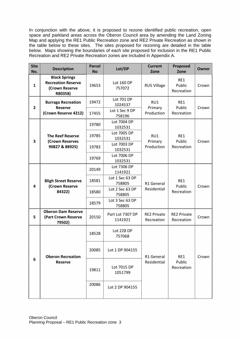
In conjunction with the above, it is proposed to rezone identified public recreation, open space and parkland areas across the Oberon Council area by amending the Land Zoning Map and applying the RE1 Public Recreation zone and RE2 Private Recreation as shown in the table below to these sites. The sites proposed for rezoning are detailed in the table below. Maps showing the boundaries of each site proposed for inclusion in the RE1 Public Recreation and RE2 Private Recreation zones are included in Appendix A.
Site No.
Description Parcel
No Lot/DP
Current Zone
Proposed Zone
Owner
1
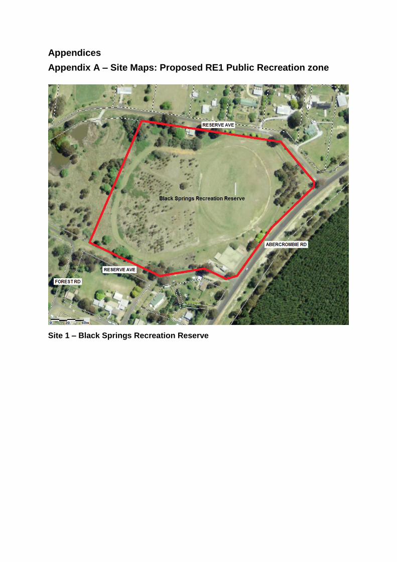
Black Springs Recreation Reserve
(Crown Reserve R80358)
19653 Lot 160 DP
757072 RU5 Village
RE1 Public
Recreation Crown
2 Burraga Recreation
Reserve (Crown Reserve 4212)
19472 Lot 701 DP 1024537
RU1 Primary
Production
RE1 Public
Recreation Crown
17455 Lot 1 Sec 9 DP
758196
3 The Reef Reserve (Crown Reserves 90827 & 88925)
19780 Lot 7004 DP
1032531
RU1 Primary
Production
RE1 Public
Recreation Crown
19785 Lot 7005 DP
1032531
19783 Lot 7003 DP
1032531
19769 Lot 7006 DP
1032531
4 Bligh Street Reserve
(Crown Reserve 84322)
20149 Lot 7306 DP
1141921
R1 General Residential
RE1 Public
Recreation Crown
18581 Lot 1 Sec 63 DP
758805
18580 Lot 2 Sec 63 DP
758805
18579 Lot 3 Sec 63 DP
758805
5 Oberon Dam Reserve (Part Crown Reserve
79502) 20150
Part Lot 7307 DP 1141921
RE2 Private Recreation
RE2 Private Recreation
Crown
6
Oberon Recreation Reserve
18528 Lot 228 DP
757068
R1 General Residential
RE1 Public
Recreation
Crown
20085 Lot 1 DP 904155
19811 Lot 7015 DP
1051799
20086
Lot 2 DP 904155
Oberon Council Planning Proposal – RE1 Public Recreation zone 4
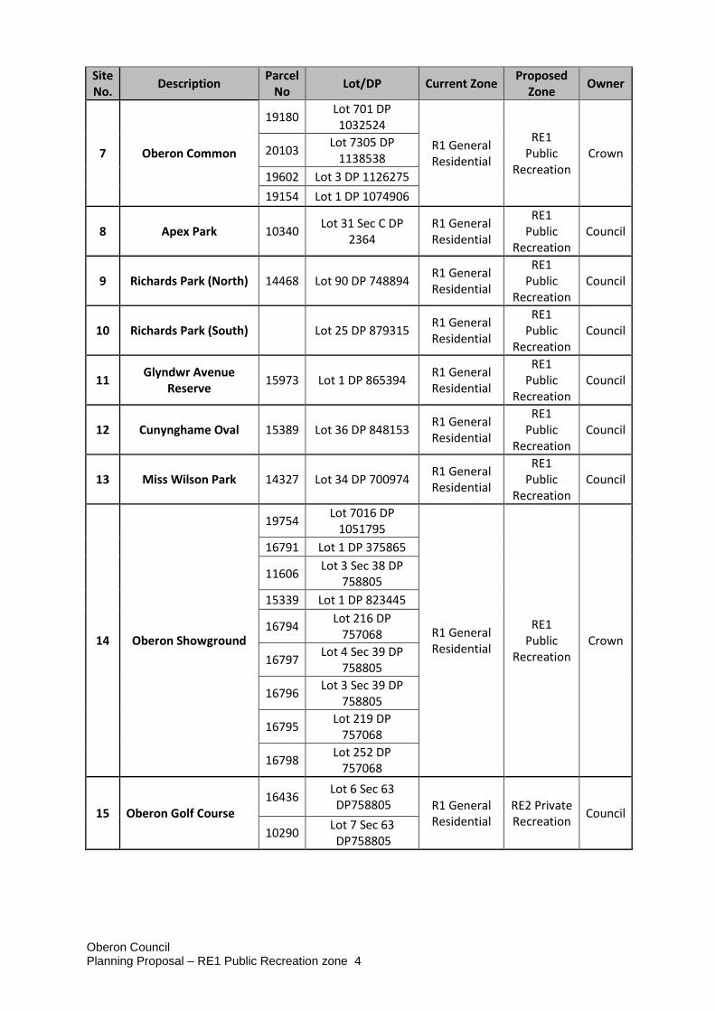
Site No.
Description Parcel
No Lot/DP Current Zone
Proposed Zone
Owner
7 Oberon Common
19180 Lot 701 DP 1032524
R1 General Residential
RE1 Public
Recreation Crown 20103
Lot 7305 DP 1138538
19602 Lot 3 DP 1126275
19154 Lot 1 DP 1074906
8 Apex Park 10340 Lot 31 Sec C DP
2364 R1 General Residential
RE1 Public
Recreation Council
9 Richards Park (North) 14468 Lot 90 DP 748894 R1 General Residential
RE1 Public
Recreation Council
10 Richards Park (South)
Lot 25 DP 879315 R1 General Residential
RE1 Public
Recreation Council
11 Glyndwr Avenue
Reserve 15973 Lot 1 DP 865394
R1 General Residential
RE1 Public
Recreation Council
12 Cunynghame Oval 15389 Lot 36 DP 848153 R1 General Residential
RE1 Public
Recreation Council
13 Miss Wilson Park 14327 Lot 34 DP 700974 R1 General Residential
RE1 Public
Recreation Council
14 Oberon Showground
19754 Lot 7016 DP
1051795
R1 General Residential
RE1 Public
Recreation Crown
16791 Lot 1 DP 375865
11606 Lot 3 Sec 38 DP
758805
15339 Lot 1 DP 823445
16794 Lot 216 DP
757068
16797 Lot 4 Sec 39 DP
758805
16796 Lot 3 Sec 39 DP
758805
16795 Lot 219 DP
757068
16798 Lot 252 DP
757068
15 Oberon Golf Course 16436
Lot 6 Sec 63 DP758805 R1 General
Residential RE2 Private Recreation
Council
10290 Lot 7 Sec 63 DP758805
Oberon Council Planning Proposal – RE1 Public Recreation zone 5
Part 3 – Justification
Section A – Need for the Planning Proposal
1. Is the planning proposal a result of any strategic study or report?
While the planning proposal has been initiated based on a request from the Department of Primary Industries – Lands in relation to the Oberon Showground, the application of the RE1 Public Recreation to recreation, open space and parkland in the Oberon Council area is consistent with the recommendations of the Land Use Strategy adopted by Council in 2012 which states:
Recreation/Open Space Land Uses Recreation and open space areas have been identified. This includes the open space throughout the urban area of Oberon and includes the existing Showground. Appropriate zoning will be required to protect these lands from development and to allow appropriate management/development commensurate with their role in meeting the recreation needs of the community. These facilities will be zoned as either RE1 Public Recreation or RE2 Private Recreation respectively depending on their ownership status. Implications for Emerging LEP Define and appropriately zone recreation lands as either RE1 Public Recreation or RE2 – ‘Private Recreation’ in accordance with the Standard LEP template.
2. Is the planning proposal the best means of achieving the objectives or intended outcomes, or is there a better way?
Applying the RE1 Public Recreation zone to public land committed for recreation, open space and parkland related uses is the best means of achieving the objectives and intended outcomes and is consistent with the approach intended with the Standard Instrument – Principal Local Environmental Plan and other Local Environmental Plans applied across New South Wales.
Section B – Relationship to the Strategic Planning Framework
3. Is the planning proposal consistent with the objectives and actions contained within the applicable regional or sub-regional strategy (including the Sydney Metropolitan Strategy and exhibited draft strategies)?
The planning proposal is consistent with the four regionally focused goals of the Central West and Orana Regional Plan (Regional Plan). These goals are: - The most diverse regional economy in NSW - A stronger, healthier environment and diverse heritage - Quality freight, transport and infrastructure networks - Dynamic, vibrant and healthy communities
Direction 29 is of particular relevance, which is “Deliver healthy built environments and better urban design”. Essentially this planning proposal is applying a layer of protection on Council’s public parks and recreation areas and therefore enabling the ongoing and
Oberon Council Planning Proposal – RE1 Public Recreation zone 6
future use of this land for public recreation purposes and adding to the community’s wellbeing. The Regional Plan identifies that transport and logistics, tourism and manufacturing are the Oberon Local Government Area’s top three economic opportunities and it is considered that the rezoning of land used for open space, public reserves and public parks to the RE1 Public Recreation Zone does not compromise these opportunities.
4. Is the planning proposal consistent with applicable State Environmental Planning Policies?
The proposal is generally consistent with applicable State Environmental Planning Policies (SEPPs). The proposal will result in the rezoning of land with long established recreational, open space and parkland uses and is not expected to result in any inconsistencies with SEPPs.
5. Is the planning proposal consistent with the applicable Ministerial Directions (s117 directions)?
The proposal is generally consistent with the applicable Ministerial Directions issued under section 117 of the Environmental Planning and Assessment Act 1979. An assessment of the proposal against the Ministerial Directions is contained in Appendix B.
Section C – Environmental, social and economic impact
6. Is there any likelihood that critical habitat or threatened species, populations or ecological communities, or their habitats, will be adversely affected as a result of the proposal?
No adverse impacts on critical habitats or threatened species, populations or ecological communities, or their habitats, are expected as a result of this proposal. The direct impacts of the planning proposal will be the application of the RE1 Public Recreation zone to land already utilised for recreation, open space and parkland uses.
7. Are there any other likely environmental effects as a result of the planning proposal and how are they proposed to be managed?
There are no expected other likely environmental effects resulting from this planning proposal. The proposal will have the effect of strengthening zoning and land use objectives applied to recreational, open space and parkland areas and will ensure development which is compatible with the public recreational nature of the subject land.
8. Has the planning proposal adequately addressed any social and economic effects?
The planning proposal will result in social improvements through the identification and appropriate land use regulation of public recreation related land. Indirect economic impacts can be expected on the communities surrounding the identified sites through better land use planning that identifies and protects land set aside for public recreational uses.
Section D – State and Commonwealth interests
9. Is there adequate public infrastructure for the planning proposal?
The planning proposal applies to existing recreational, open space and parkland areas that generally have sufficient public infrastructure in place to enable the ongoing and future use of the land for public recreation purposes.
Oberon Council Planning Proposal – RE1 Public Recreation zone 7
10. What are the views of State and Commonwealth public authorities consulted in accordance with the Gateway determination?
No consultation has been undertaken in relation to this proposal to date. Consultation with the Department of Primary Industry will occur concurrently with community consultation.
Part 4 – Mapping
The proposal will result in changes to the Land Zoning Map to apply the RE1 Public Recreation zone to the identified land parcels. The land specific to this zoning change is identified in the appendix.
Part 5 – Community Consultation
No community consultation has been undertaken in relation to this planning proposal to date. It is proposed that this planning proposal will be exhibited in accordance with the Gateway determination and the terms of the Environmental Planning and Assessment Act 1979 for a minimum period of 28 days.
Part 6 – Timeline
The proposed timeline for completion of this planning proposal is contained in the table below.
Plan Making Step Estimated
Completion
Gateway Determination September 2017
Amendment to Gateway Determination May 2018
Government Agency Consultation June 2018
Public Exhibition Period July/August 2018
Public Hearing N/A
Submissions Assessment by RPA September 2018
RPA Assessment of Planning Proposal and Exhibition Outcomes October 2018
LEP Maps prepared December 2018
Submission of Endorsed LEP to DP&E for Finalisation February 2019
Completion of LEP March 2019
Appendices
Appendix A – Site Maps: Proposed RE1 Public Recreation zone
Site 1 – Black Springs Recreation Reserve
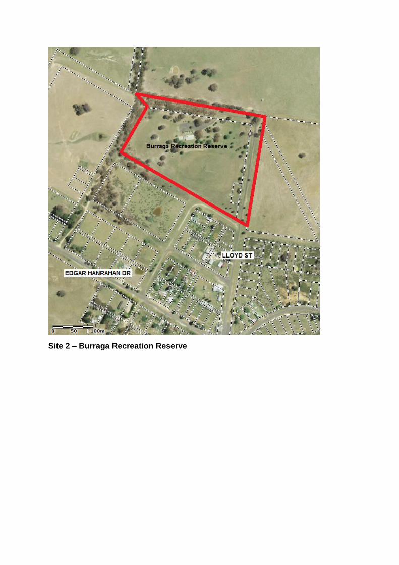
Site 2 – Burraga Recreation Reserve
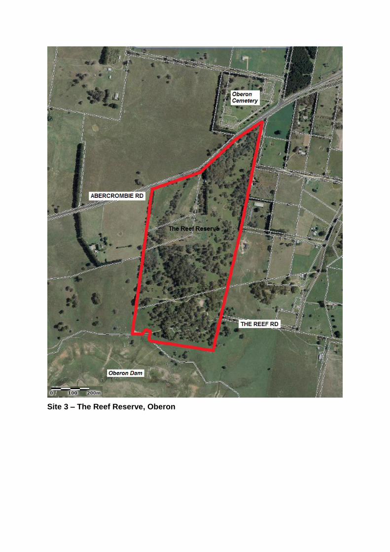
Site 3 – The Reef Reserve, Oberon
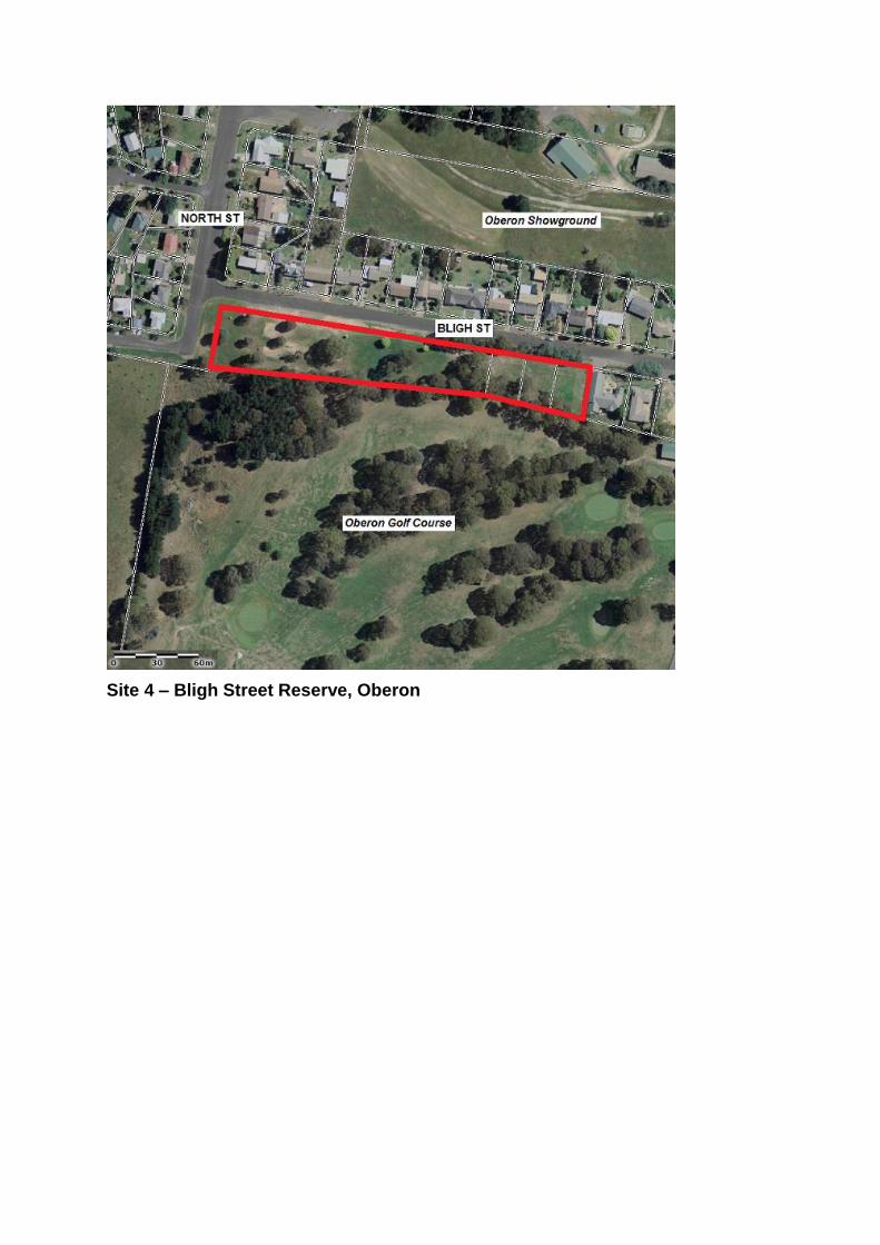
Site 4 – Bligh Street Reserve, Oberon
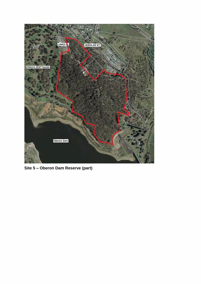
Site 5 – Oberon Dam Reserve (part)
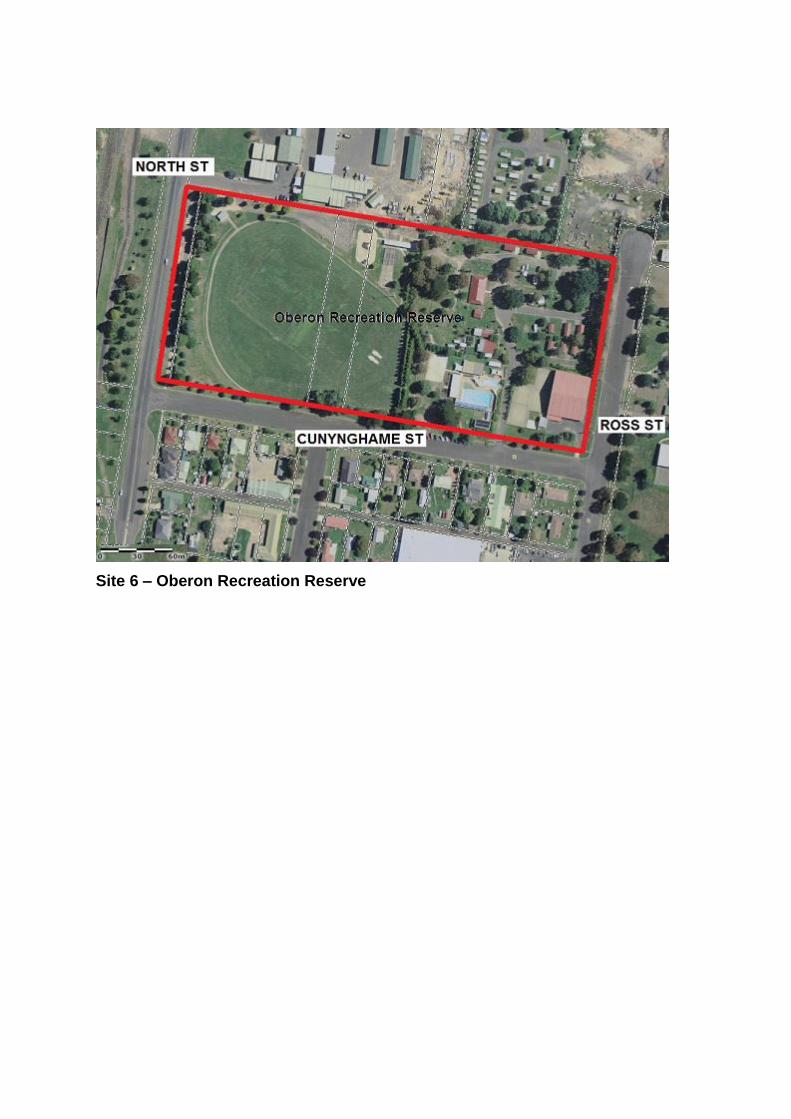
Site 6 – Oberon Recreation Reserve
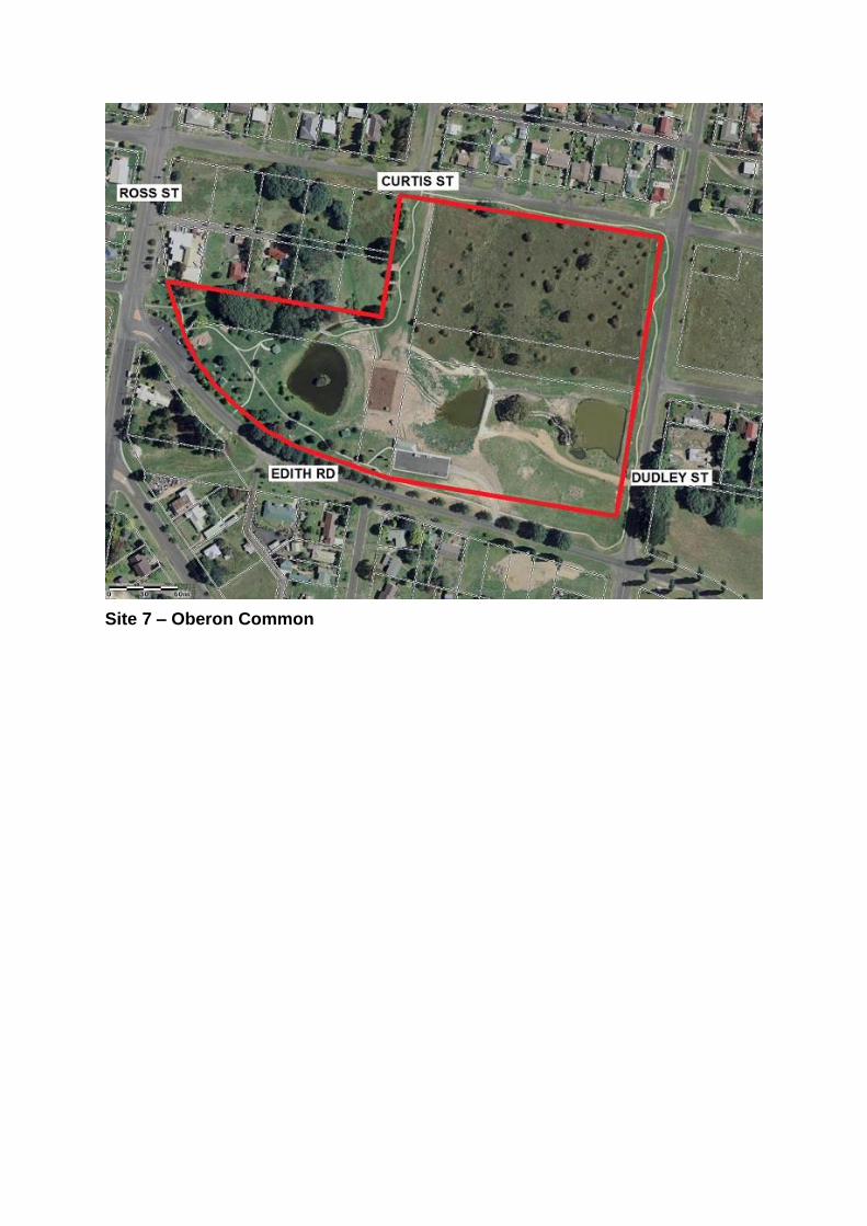
Site 7 – Oberon Common
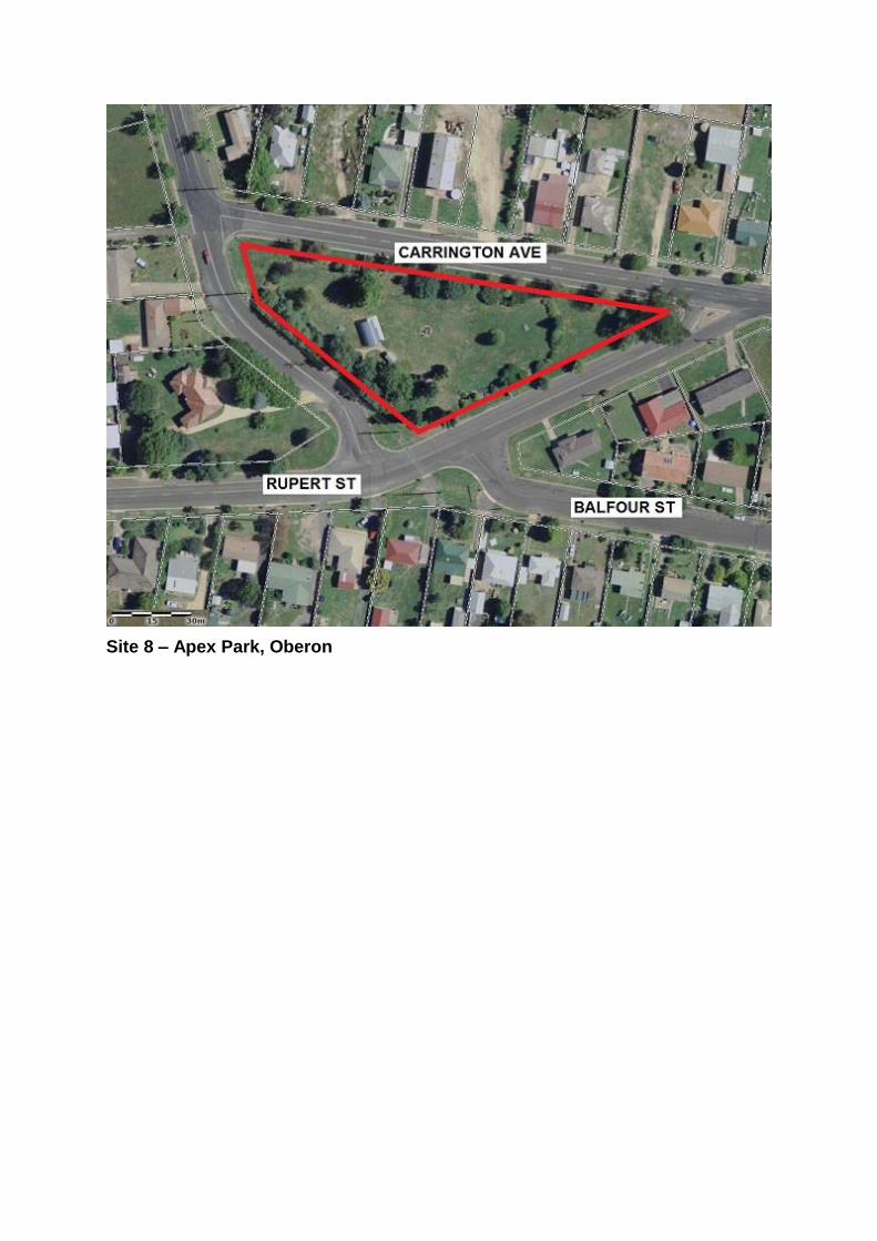
Site 8 – Apex Park, Oberon
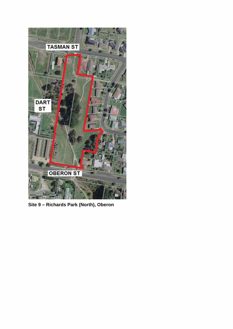
Site 9 – Richards Park (North), Oberon
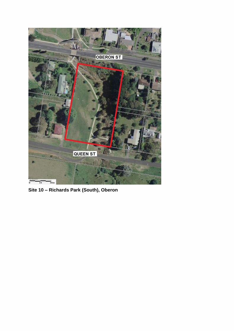
Site 10 – Richards Park (South), Oberon
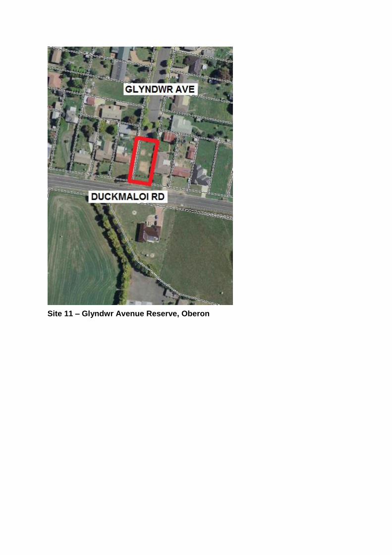
Site 11 – Glyndwr Avenue Reserve, Oberon
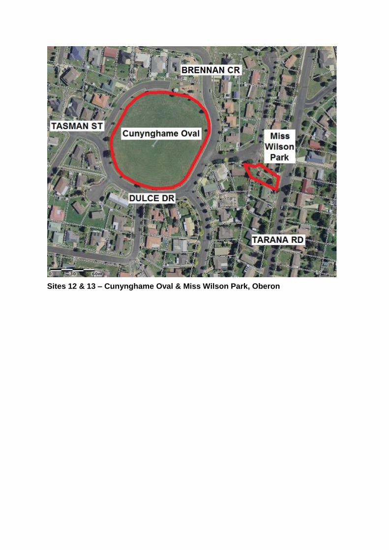
Sites 12 & 13 – Cunynghame Oval & Miss Wilson Park, Oberon
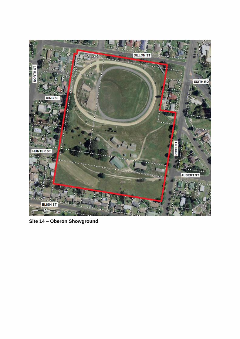
Site 14 – Oberon Showground
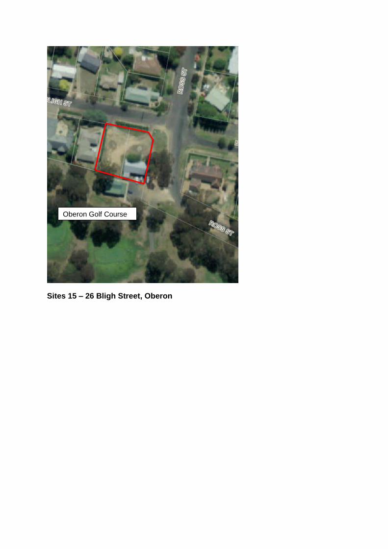
Sites 15 – 26 Bligh Street, Oberon
Oberon Golf Course
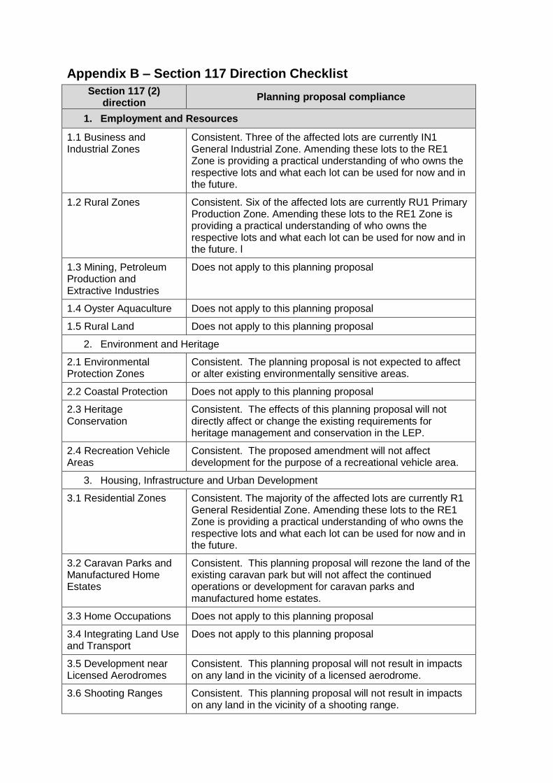
Appendix B – Section 117 Direction Checklist
Section 117 (2) direction
Planning proposal compliance
1. Employment and Resources
1.1 Business and Industrial Zones
Consistent. Three of the affected lots are currently IN1 General Industrial Zone. Amending these lots to the RE1 Zone is providing a practical understanding of who owns the respective lots and what each lot can be used for now and in the future.
1.2 Rural Zones Consistent. Six of the affected lots are currently RU1 Primary Production Zone. Amending these lots to the RE1 Zone is providing a practical understanding of who owns the respective lots and what each lot can be used for now and in the future. l
1.3 Mining, Petroleum Production and Extractive Industries
Does not apply to this planning proposal
1.4 Oyster Aquaculture Does not apply to this planning proposal
1.5 Rural Land Does not apply to this planning proposal
2. Environment and Heritage
2.1 Environmental Protection Zones
Consistent. The planning proposal is not expected to affect or alter existing environmentally sensitive areas.
2.2 Coastal Protection Does not apply to this planning proposal
2.3 Heritage Conservation
Consistent. The effects of this planning proposal will not directly affect or change the existing requirements for heritage management and conservation in the LEP.
2.4 Recreation Vehicle Areas
Consistent. The proposed amendment will not affect development for the purpose of a recreational vehicle area.
3. Housing, Infrastructure and Urban Development
3.1 Residential Zones Consistent. The majority of the affected lots are currently R1 General Residential Zone. Amending these lots to the RE1 Zone is providing a practical understanding of who owns the respective lots and what each lot can be used for now and in the future.
3.2 Caravan Parks and Manufactured Home Estates
Consistent. This planning proposal will rezone the land of the existing caravan park but will not affect the continued operations or development for caravan parks and manufactured home estates.
3.3 Home Occupations Does not apply to this planning proposal
3.4 Integrating Land Use and Transport
Does not apply to this planning proposal
3.5 Development near Licensed Aerodromes
Consistent. This planning proposal will not result in impacts on any land in the vicinity of a licensed aerodrome.
3.6 Shooting Ranges Consistent. This planning proposal will not result in impacts on any land in the vicinity of a shooting range.
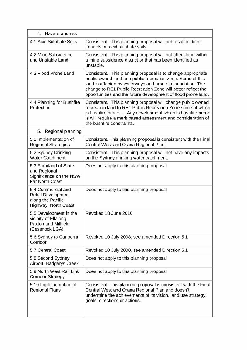
4. Hazard and risk
4.1 Acid Sulphate Soils Consistent. This planning proposal will not result in direct impacts on acid sulphate soils.
4.2 Mine Subsidence and Unstable Land
Consistent. This planning proposal will not affect land within a mine subsidence district or that has been identified as unstable.
4.3 Flood Prone Land Consistent. This planning proposal is to change appropriate public owned land to a public recreation zone. Some of this land is affected by waterways and prone to inundation. The change to RE1 Public Recreation Zone will better reflect the opportunities and the future development of flood prone land.
4.4 Planning for Bushfire Protection
Consistent. This planning proposal will change public owned recreation land to RE1 Public Recreation Zone some of which is bushfire prone. . Any development which is bushfire prone is will require a merit based assessment and consideration of the bushfire constraints.
5. Regional planning
5.1 Implementation of Regional Strategies
Consistent. This planning proposal is consistent with the Final Central West and Orana Regional Plan.
5.2 Sydney Drinking Water Catchment
Consistent. This planning proposal will not have any impacts on the Sydney drinking water catchment.
5.3 Farmland of State and Regional Significance on the NSW Far North Coast
Does not apply to this planning proposal
5.4 Commercial and Retail Development along the Pacific Highway, North Coast
Does not apply to this planning proposal
5.5 Development in the vicinity of Ellalong, Paxton and Millfield (Cessnock LGA)
Revoked 18 June 2010
5.6 Sydney to Canberra Corridor
Revoked 10 July 2008, see amended Direction 5.1
5.7 Central Coast Revoked 10 July 2000, see amended Direction 5.1
5.8 Second Sydney Airport: Badgerys Creek
Does not apply to this planning proposal
5.9 North West Rail Link Corridor Strategy
Does not apply to this planning proposal
5.10 Implementation of Regional Plans
Consistent. This planning proposal is consistent with the Final Central West and Orana Regional Plan and doesn’t undermine the achievements of its vision, land use strategy, goals, directions or actions.
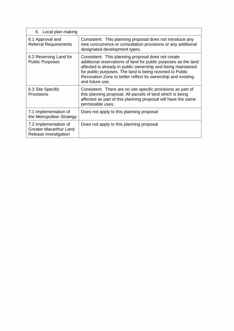
6. Local plan making
6.1 Approval and Referral Requirements
Consistent. This planning proposal does not introduce any new concurrence or consultation provisions or any additional designated development types.
6.2 Reserving Land for Public Purposes
Consistent. This planning proposal does not create additional reservations of land for public purposes as the land affected is already in public ownership and being maintained for public purposes. The land is being rezoned to Public Recreation Zone to better reflect its ownership and existing and future use.
6.3 Site Specific Provisions
Consistent. There are no site specific provisions as part of this planning proposal. All parcels of land which is being affected as part of this planning proposal will have the same permissible uses.
7.1 Implementation of the Metropolitan Strategy
Does not apply to this planning proposal
7.2 Implementation of Greater Macarthur Land Release Investigation
Does not apply to this planning proposal