Embed Size (px)
Citation preview

Planning and Environment Act 1987
Panel Report
Port Phillip Planning Scheme Amendment C122
St Kilda Road South Precinct
15 June 2017

Planning and Environment Act 1987
Panel Report pursuant to section 25 of the Act
Port Phillip Planning Scheme Amendment C122
St Kilda Road South Precinct
15 June 2017
Cathie McRobert, Chair
Dora Kouremenos

Port Phillip Planning Scheme Amendment C122 Panel Report 15 June 2017
Contents Page
Executive Summary ............................................................................................................. 1
1 Introduction ................................................................................................................ 1
1.1 The Amendment ...................................................................................................... 1 1.2 Interim controls ....................................................................................................... 3 1.3 Procedural issues ..................................................................................................... 3 1.4 Planning scheme provisions .................................................................................... 3 1.5 The Precinct ............................................................................................................. 6 1.6 Summary of issues raised in submissions ............................................................... 7 1.7 Issues dealt with in this Report ............................................................................... 8
2 Does the Amendment have a sound strategic basis? ................................................... 9
2.1 The issues ................................................................................................................ 9 2.2 Planning strategies .................................................................................................. 9 2.3 The role of the Precinct to accommodate growth ................................................ 14 2.4 The Framework as a reaction to development pressures .................................... 18 2.5 Integration of planning for the Precinct with its hinterland ................................. 20 2.6 Recommendation .................................................................................................. 23
3 Proposed zones ......................................................................................................... 24
3.1 The issues .............................................................................................................. 24 3.2 What is proposed? ................................................................................................ 24 3.3 Background ............................................................................................................ 25 3.4 The need for an integrated approach to residential zones ................................... 28 3.5 Requested changes to the zoning of specific sites ................................................ 31 3.6 Recommendations ................................................................................................ 36
4 Built form provisions ................................................................................................. 37
4.1 The issues .............................................................................................................. 37 4.2 What is proposed? ................................................................................................ 37 4.3 Precinct wide built form issues ............................................................................. 38 4.4 The St Kilda Road Neighbourhood 1 (western side and Barkly Street) ................. 53 4.5 The St Kilda Road Neighbourhood 2 (eastern side and St Kilda Junction) ............ 59 4.6 The Wellington Neighbourhood ............................................................................ 63 4.7 Carlisle Street (west of St Kilda Road) ................................................................... 67 4.8 Recommendations ................................................................................................ 68
5 The Heritage Overlay ................................................................................................ 71
5.1 The issue ................................................................................................................ 71 5.2 An extended or new heritage precinct in Wellington Street ................................ 73 5.3 17 & 17A Wellington Street, St Kilda ..................................................................... 74 5.4 129 Wellington Street (Proposed HO494) ............................................................ 76 5.5 59‐59a Wellington Street (proposed HO496) ....................................................... 79 5.6 Conclusions ............................................................................................................ 81

Port Phillip Planning Scheme Amendment C122 Panel Report 15 June 2017
5.7 Recommendations ................................................................................................ 81
6 Other issues .............................................................................................................. 82
6.1 Public realm improvements .................................................................................. 82 6.2 Managing flooding ................................................................................................. 84 6.3 Transport ............................................................................................................... 85
7 The form and drafting of the Amendment ................................................................ 91
7.1 The issues .............................................................................................................. 91 7.2 Recommendations ................................................................................................ 97
Appendix A Submitters to the Amendment
Appendix B Relevant State and Local Planning Policy
Appendix C Document list
Appendix D Recently approved development in the Precinct
Appendix E Recommended DDO27
List of Tables
Table 1 Amendment C123 GRZ and NRZ Locational Criteria ................................................. 27
Table 2 Summary of changes relevant to the Amendment (Source: Derived from Council submission to the reconvened hearing) .......................................... 28
Table 3 Suggested Council officer approach to recent changes to residential zones ...................................................................................................................... 30
List of Figures
Figure 1 Current Zoning ............................................................................................................. 4
Figure 2 Existing Overlays ........................................................................................................... 5
Figure 3 Urban Structure ............................................................................................................ 6
Figure 4 Land Use Framework .................................................................................................. 11
Figure 5 Exhibited rezonings .................................................................................................... 24
Figure 6 Amendment C123 proposed zonings for land in or near the Precinct ...................... 26
Figure 7 Review areas in or adjoining the Precinct .................................................................. 26
Figure 8 Existing zoning of 204‐208 St Kilda Road, St Kilda ..................................................... 35
Figure 9 Proposed built form framework ................................................................................. 38
Figure 10 Precinct Urban Structure (Source: Sheppard evidence Context report) ................................................................................................................... 39
Figure 11 Proposed mandatory building and street wall heights ............................................ 46

Port Phillip Planning Scheme Amendment C122 Panel Report 15 June 2017
Figure 12 Exhibited additions to the Heritage Overlay ............................................................ 71
Figure 13 17 & 17A Wellington Street: 1926 former motor garage/commercial brick building ......................................................................................................... 74
Figure 14 129 Wellington Street c.1885 single‐storey bichrome brick Victorian dwelling ................................................................................................................. 76
Figure 15 59‐59a Wellington Street (Two‐storey Victorian dwelling) .................................... 79
List of Abbreviations
C1Z Commercial 1 Zone
CAPP Community Alliance of Port Phillip
DDO27 Schedule 27 to the Design and Development Overlay
GRZ General Residential Zone
HO Heritage Overlay (a number represents its reference in the schedule)
JAAG Junction Area Action Group
MDF and C Ministerial Direction on the Form and Content of Planning Schemes under section 7(5) of the Act
MSS Municipal Strategic Statement
MUZ Mixed Use Zone
NRZ Neighbourhood Residential Zone
PPN58 Planning Practice Note 58 Structure Planning for Activity Centres
RGZ Residential Growth Zone
SBO Special Building Overlay
SPPF State Planning Policy Framework
the Amendment Port Phillip Planning Scheme Amendment C122
the Framework St Kilda Road South Urban Design and Land Use Framework November 2015

Port Phillip Planning Scheme Amendment C122 Panel Report 15 June 2017
Overview
Amendment Summary
The Amendment Port Phillip Planning Scheme Amendment C122
Common name St Kilda Road South Precinct
Brief description The Amendment proposes to implement the St Kilda Road South Urban Design and Land Use Framework November 2015 (the Framework) by introducing Design and Development and Heritage Overlay controls, rezoning land, and updating the Local Planning Policy Framework.
Subject site The Amendment applies to land generally comprising St Kilda Road between the Junction and Carlisle Street, Wellington Street, and Carlisle Street (north side between St Kilda Road and Greeves Street) (See Figure1)
Planning Authority Port Phillip City Council
Authorisation 29 May 2016 (with conditions) and 26 July 2016 (after conditions were addressed).
Exhibition 8 August ‐ 12 September 2016
Submissions Number of Submissions: 43 Opposed: 18
Submissions are listed in Appendix A of this report.
Panel Process
The Panel Cathie McRobert (Chair) and Dora Kouremenos
Directions Hearing Planning Panels Victoria, 27 February 2017
Panel Hearing Planning Panels Victoria, 21, 22, 23, 24 and 27 March and 28 April2017
Site Inspections Unaccompanied, 20 March and 4 April

Port Phillip Planning Scheme Amendment C122 Panel Report 15 June 2017
Appearances City of Port Phillip represented by Teresa Bisucci of Best Hooper who called expert evidence from:
‐ Nathan Alexander of Alexander Urbanism in urban design
‐ John Glossop of Glossop Planning in town planning
‐ Anita Brady of Lovell Chen Architects And Heritage Consultants in heritage
Junction Area Action Group (JAAG) represented by Kaye O'Connor
Community Alliance of Port Phillip (CAPP) represented by Helen Halliday, Brenda Forbath and Cath Stutterheim
Susanne Provis and Peter Love represented by Susanne Provis
Waterloo Crescent Residents Action Group represented by Dr Graham Marsh
L E B Nominees represented by Chris Townshend SC who called expert evidence from:
‐ Mark Sheppard of David Lock Associates in urban design
‐ Andrew Biacsi of Contour Consultants in town planning
SKBP Property Pty Ltd/Peter Beaconsfield represented by Jane Sharpe of counsel who called expert evidence from:
‐ Professor Rob McGauran of MGS Architects in urban design
‐ Rob Milner of 10 Consulting Group in town planning
129 Well Pty Ltd represented by Danny Hahesy of Mecone
J Jankie Pty Ltd, P and A Zimet, Jereta Pty Ltd and Temiz Nominees Pty Ltd, St Kilda Road Pty Ltd, Tooson Pty Ltd and Ronsar Holdings Pty Ltd, Saluki Investments Pty Ltd represented by Nick Sutton of Planning & Property Partners who called evidence from:
‐ Stuart McGurn of Urbis in town planning
‐ Mark Sheppard of David Lock and Associates in urban design
Date of this Report 14 June 2017

Port Phillip Planning Scheme Amendment C122 Panel Report 15 June 2017
Executive Summary
(i) Summary
Port Phillip Planning Scheme Amendment C122 (the Amendment) proposes to implement the St Kilda Road South Urban Design and Land Use Framework November 2015 (the Framework) by updating to Municipal Strategic Statement (MSS), introducing Schedule 27 to the Design and Development Overlay (DDO27), additions to the Heritage Overlay (HO) and rezoning land.
The Amendment applies to land generally comprising St Kilda Road between the Junction and Carlisle Street, Wellington Street, and Carlisle Street (north side between St Kilda Road and Greeves Street) (the Precinct).
The Minister introduced DDO27 on an interim basis until 31 December 2017.
The Panel agreed to a request from Council and others to adjourn the Hearing to enable consideration of the implications of the changes to residential zones for the Amendment. The implications of recent changes for residential zones across Port Phillip and for the achievement of the strategic intent for the Precinct are yet to be evaluated by Council.
The Amendment, which was exhibited between 8 August ‐ 12 September 2016, attracted 43 submissions with 18 submissions objecting or seeking changes to the Amendment.
The extensive work and community consultation that underpins the Amendment is evident in the broad agreement with many of the key aspects of the proposed planning framework. It is notable that there were no objecting submissions relating directly to many of the sub‐areas in the Precinct, including Carlisle Street or from landowners on St Kilda Hill and the Junction. This support extends to the principles of the urban structure underpinning built form provisions, creating a strong boulevard along St Kilda Road South, and the continued transition to increased residential uses. While the urban design principles were generally endorsed, how they were translated in the Amendment was disputed. In particular, the scale of development on the western side of St Kilda Road was contentious.
The key issues raised in the submissions related to:
the role of the Precinct in terms of growth
building heights
mandatory or performance based controls
amenity issues for adjoining established residential areas
impacts of new development and increased population on liveability
concerns around traffic and parking impacts
the need for an integrated approach to planning for the Precinct and its hinterland and the application of the residential zones.
The Panel has concluded that the Precinct has a strategic role to support growth and intensification but the emphasis on managing ‘development pressure’ has led to restrictive built form requirements that do not recognise either the reality of recent development at greater scale or optimise the opportunity presented for urban renewal, particularly on the western side of the Precinct.
Port Phillip Planning Scheme Amendment C122 Panel Report 15 June 2017
The Panel has supported development at a somewhat greater scale but not to the extent sought by some submitters. While the Panel does not consider development of a consistent scale on both sides of St Kilda Road is either practical or necessary to achieve a cohesive boulevard, it does consider it is important to maintain the principle of a transition in scale along St Kilda Road, rising to a cluster of higher rise forms that involve a tower and podium that emphasises St Kilda Hill and the Junction.
The Amendment adopted an approach to mandatory controls that focused on built form requirements that were seen as critical. The Panel endorses mandatory setbacks to protect the prominence of the Presbyterian Church on the corner Alma Road and Barkly Street and mandatory street wall heights (with some revision) of the eastern side of St Kilda Road, between Charnwood Rd and Charnwood Drive. While it considers setbacks above the street wall are equally important, the ‘exceptions’ and the need to exercise judgement if they are reduced demonstrate that discretion is necessary for effective implementation. The Panel does not consider other mandatory requirements are justified. Where changes to the General Residential Zone (GRZ) have made discretionary requirements mandatory, the Panel considers the mandatory height should be set at two storeys higher and the preferred maximum height should be referred to in the character statement and decision guidelines in the zone schedule.
The Panel considers that 17‐17A and 59‐59a Wellington Street do not meet the threshold of individual significance to justify the proposed HO. It is noted that in both cases it is only the most recent heritage assessment that elevated these properties to the status of individual local significance.
Integration of planning for the western side of St Kilda Road (south of Waterloo Crescent) and the land to the west is not evident and the development outcome for this part of the Precinct may be compromised by the tight Precinct boundary. The Panel agrees with submissions from residents and developers that proposed Review Areas work should address the extent of this part of Precinct, the appropriate zoning and the management or mitigation of impacts for hinterland areas. Until this work is undertaken, assessment through the permit process should take account of both the opportunities presented by a site and its constraints; this will inform the exercise of discretion under DDO27.
The Panel is satisfied that the planning for the Precinct has been cognisant of the implications for the public realm and opportunities to improve it. Council proposes supporting initiatives within the public realm, which will be subject to detailed planning and community consultation (as well as funding constraints). In addition to options for landscaping, the proposed assessment of the optimum future for ‘left over’ land along the western side of St Kilda Road should consider the benefit from including the space in redevelopment sites for the creation of a strong edge to the boulevard.
The Panel considers land at the eastern end of Waterloo Crescent:
should be removed from DDO27 as it does not have a frontage to, presence in or physical interaction with St Kilda Road
presents a good opportunity for improved treatment of the public space but rezoning to public use is not necessary.

Port Phillip Planning Scheme Amendment C122 Panel Report 15 June 2017
The Panel concludes there is considerable scope to edit MSS Clause 21.06‐6 and DDO27 to reduce repetition and provide a more succinct, clearer planning framework for the Precinct.
(ii) Recommendations
Based on the reasons set out in this Report, the Panel recommends that Port Phillip Planning Scheme Amendment C122 be adopted as exhibited subject to the following:
ZONES
1. Pending a more comprehensive review, in areas where there is a shift from the intent of discretionary to mandatory requirements:
change the schedule to the zone to specify a height that is greater than the preferred maximum height (say and additional two storeys/7m)
address the preferred maximum building height in the zone schedule character statement and decision guidelines or an extended DDO27 (with exemptions for development that does not exceed the preferred maximum building height).
2. Rezone 43 – 47 Charles Street to Commercial 1 Zone (rather than the exhibited schedule 5 to the General Residential Zone).
3. Maintain the existing General Residential Zone on the south side of Wellington Street to the east of Marlton Crescent, with the addition of reference to the Framework in the zone schedule (rather than the exhibited schedule 9 to the Neighbourhood Residential Zone).
4. Resolve the zoning of the rear of 204‐208 St Kilda Road through the ‘Review Areas’ process or a site specific amendment.
REFERENCE DOCUMENTS
5. Adopt Urban Design and Land Use Framework be adopted as a reference document in the City of Port Phillip Planning Scheme with a qualifying statement on the document to indicate the provisions implemented in the planning scheme contain significant modifications.
DESIGN AND DEVELOPMENT OVERLAY (SCHEDULE 27)
6. Remove the properties fronting Waterloo Crescent, and the pathway and embankment fronting St Kilda Road from the Design and Development Overlay (schedule 27).
7. Consider including land in the Precinct that is in a Neighbourhood Residential Zone or General Residential Zone in the Design and Development Overlay (schedule 27) to specify a discretionary preferred maximum height (in addition to a mandatory maximum height specified in the zone).
Design objectives
8. In the objectives remove references to ‘visual cohesion between the east and west side of St Kilda Road’.

Port Phillip Planning Scheme Amendment C122 Panel Report 15 June 2017
9. Amend the Precinct wide objective to read ‘To reinforce the key intersections of the Junction and Barkly Street, Alma Road, Inkerman Street and Carlisle Street through the scale of development, quality architecture and a strong address to each street frontage’.
Precinct‐wide provisions
10. Include in Precinct wide requirements ‘One or two additional storeys will be considered above the preferred height, where the applicant demonstrates, to the satisfaction of the responsible authority, that the following will be achieved:
a) The proposed development supports the vision and objectives for the Precinct, and
b) The development is of an exemplary quality design that makes a positive contribution to the character of the neighbourhood; and
c) The additional height:
- Results in specific design benefits; and
- Facilitates benefits to the community, such as excellent ESD performance, positive contributions to public open space or the public realm, or the provision of affordable housing; and
- Does not have an adverse impact on the streetscape, heritage values, the public realm or the amenity of adjoining properties.’
11. Move the fine grain character provision from the Area Requirements to the Precinct wide requirements and redraft it to read: ‘new development should provide a transition to the fine grain character of Vale Street, Carlisle Street, Charles Street, Blanche Street and Market Street’.
12. Remove all overshadowing of footpath requirements from DDO27. 13. Amend the street wall height in all the areas requiring a three storey street wall
to 11m. 14. Reduce the car parking height under adaptable buildings from 3.5m to 2.7m
floor to ceiling height 15. Undertake further evaluation of the implications of the building separation/side
and rear setbacks provision. 16. Delete the residential amenity requirements from DDO27 that repeat provisions
in other parts of the planning scheme.
Building height
17. Align the preferred maximum building height in metres and storeys in all the mixed use and commercial zoned areas of the Precinct as follows:
three storey height to 10.5 metres
four storey height to 14 metres five storeys should be increased to 17.5 metres, and six storeys to 21
metres. 18. Change the preferred building heights as follows:

Port Phillip Planning Scheme Amendment C122 Panel Report 15 June 2017
in 1B and 1D to six storeys
in Area 1C to eight storeys
in Areas 1E and 2F at the St Kilda junction to 18 storeys (63m)
in Areas 1E and 2C at the corner of Alma Road to 15 storeys (52.5m) in Area 3C to 14m (four storeys)
19. Change the mandatory maximum building height requirements in Areas 1I, 1H, 1G and 1F, 3A, 3B and 3C to discretionary preferred maximum building heights.
20. For the following land in a residential zone, specify the preferred maximum height in the the Design and Development Overlay (schedule 27) and a mandatory height in the relevant zone schedule:
In Area 1A a preferred maximum height of 17m (five storeys) with a mandatory maximum height of 24 metre (seven storeys) in the schedule to the General Residential Zone
Along Carlisle Street a preferred maximum height of 13m (four storey) in DDO27, with a mandatory maximum height of 17m (five storey) in the schedule to the General Residential Zone.
Street walls and setbacks
21. Change the street wall height requirements as follows:
in Areas 1C to read – The Street wall height should not exceed (17.5 m) five storeys fronting St Kilda Road and Inkerman Street.
Change the street wall provision for all areas with a mandatory street wall to be discretionary, except in Area 2D where a mandatory 11m (three storey) or the verified height of the heritage buildings including parapets, should apply.
22. Change mandatory five metre upper level setbacks to a discretionary requirement
23. Move the landscaped setbacks provision from Area Requirements to the Neighbourhood Requirements and redraft the provisions to read ‘new development located on corners, should be built to the front and side property boundary and provide a transition to adjoining properties along side streets’.
24. Insert a provision in schedule 27 to the Design and Development Overlay to relate building and street wall height to the minimum floor level determined by the relevant drainage authority or floodplain management where land is subject to inundation. For example:
Building and street wall height if land is subject to inundation If the land is in a Special Building Overlay or is liable to inundation the maximum building height and street wall height specified in this schedule is the vertical distance from the minimum floor level determined by the relevant drainage authority or floodplain management authority to the roof or parapet at any point.

Port Phillip Planning Scheme Amendment C122 Panel Report 15 June 2017
HERITAGE OVERLAY
25. Remove the following properties from the proposed Heritage Overlay:
17 and 17A Wellington Street, St Kilda (proposed HO490). 59‐59a Wellington Street (proposed HO496)
DRAFTING
26. Review the strategies in 21.06‐6 St Kilda relating to the Wellington Street
Specialised Activity Centre for consistency with the land use envisaged by the Framework.
27. Redraft the exhibited Clause 21.06‐6 (St Kilda) strategies relating to the Precinct to provide much more succinct overarching guidance for the Precinct with more specific provisions in Schedule 27 to the Design and Development Overlay. Generic guidance, policy addressed elsewhere in the planning scheme, content addressed in DDO27 should be deleted.
28. Revise Schedule 27 to the Design and Development Overlay as shown in Appendix E.
FURTHER RECOMMENDATIONS
The Panel makes the following further recommendations: 29. Apply consistent principles across the Amendment, Amendment C123 and the
Review Areas in the proposed comprehensive review. This should include consideration of locations in the Precinct where the RGZ may be appropriate.
30. Review the extent, the appropriate zoning and the management or mitigation of impacts for the hinterland areas of the Precinct’s St Kilda Road West Neighbourhood (south of Alma Road) in Council’s proposed ‘Review Areas’ work.

Port Phillip Planning Scheme Amendment C122 Panel Report 15 June 2017
Page 1
1 Introduction
1.1 The Amendment
The Amendment applies to the ‘St Kilda Road South Precinct’ (the Precinct), which generally comprises land in:
Wellington Street, Saint Kilda
The western side of St Kilda Road (between St Kilda Junction and Carlisle Street
The eastern side of St Kilda Road (between Nelson and Inkerman Streets)
Carlisle Street (north side between St Kilda Road and Greeves Street)1.
The exhibited Amendment
The Amendment proposes to give statutory effect to the St Kilda Road South Urban Design and Land Use Framework (November 2015) (the Framework) by introducing Design and Development and Heritage Overlay controls, rezoning land, and updating the Local Planning Policy Framework to reflect the vision, strategic directions, and built form and land use outcomes of the Framework.
Specifically, the Amendment proposes to change:
Clause 21.04 (Land Use) to update the strategic role of the Precinct.
Clause 21.06 (Neighbourhoods) to reflect the built form, land use, public realm, and access and parking outcomes sought for the Precinct.
The zoning of properties from the Commercial 1 Zone (C1Z) to a Mixed Use Zone (MUZ) on the north side of Wellington Street , the south side of Nelson Street, Alma Road east and west of St Kilda Road, the east side of Barkly Street, 3 to 5 Charnwood Crescent, land on the west side of St Kilda Road (nos. 3 to 5, 95, 101, and 181‐185) (see Figure 5)
Schedule 9 to the Neighbourhood Residential Zone (NRZ9), and rezone the following properties from the General Residential Zone (GRZ) to NRZ9: 72 ‐ 116 Wellington Street and 1A and 34 Marlton Crescent.
Apply a new schedule 7 to the General Residential Zone (GRZ7), and apply it to: 28 ‐ 64 Wellington Street.
Apply a new schedule 12 to the General Residential Zone (GRZ12) to 50 ‐ 86 Carlisle Street and 49 Vale Street.
Apply the Heritage Overlay (HO) to properties in Wellington Street (refer to Chapter �) and update the Incorporated Document Port Phillip Heritage Review (inclusive of the City of Port Phillip Heritage Policy and City of Port Phillip Neighbourhood Character Maps) accordingly.
Apply a new schedule, Schedule 27 to the Design and Development Overlay (DDO27) to guide renewal of the Precinct
Include the Framework as a Reference Document in DDO27.
1 The Precinct also includes some properties with a frontage to Alma Road, Barkly Street, Charles Street,
Charnwood Crescent, Inkerman Street, Market Street, Marlton Crescent, Nelson Street, Vale Street, Waterloo Crescent, Upton Road (St Kilda), and Punt Road (Windsor).

Port Phillip Planning Scheme Amendment C122 Panel Report 15 June 2017
Page 2
Include the following documents as reference documents in the Local Planning Policy Framework:
- the Framework - Heritage Appraisal: 16‐20A & 44 Wellington Street, St Kilda (Lovell Chen, 2015) - Heritage Review ‐ Wellington Street, Crimea and Redan Street (Lovell Chen,
2015)
Post‐exhibition Changes supported by Council
Council supported a number of changes in response to submissions to the exhibition of the Amendment. They were, in summary:
Include additional criteria in DDO27 (Clause 2.0 Buildings and Works) in areas where a discretionary height of ten storeys is specified, so that development:
- Moderates the height of buildings on adjoining sites. - For corner sites, this includes the site on the opposite street/laneway corner. - Transitions down in height to adjacent areas that have a lower height limit, so as
not to visually dominate or compromise the character of adjacent existing low‐scale development areas.
- Does not overwhelm adjoining/adjacent/neighbouring residential dwellings in terms of building scale or bulk, access to daylight, outlook and overshadowing.
- Does not unreasonably overshadow residential adjoining the ten storey areas in St Kilda Hill and at St Kilda Junction.
- Minimises building bulk and promotes vertical articulation in its design. - On prominent corner sites is of a high architectural standard in terms of form,
scale, massing, articulation and use of materials and provide a positive address to all street frontages.
- Supports high levels of pedestrian amenity through street definition and a sense of openness, and microclimate conditions within the public realm including acceptable levels of sunlight access and wind.
Editing to remove repetition and improve clarity or workability: - the Wellington Street Green Link applies on both sides of Wellington Street. - clarify the DDO requirement for separation distances for developments of five
storeys or over, including circumstances when a street‐wall is not required.
Apply GRZ5 to 43‐47 Charles Street as the three lots in the same ownership.
In DDO27 include the following objective from the Framework which was unintentionally omitted ‘Ensure new development reinforces prominent corners at Inkerman Street and Alma Road through development which creates a strong address to each street frontage.’
Update the Active Frontages requirement in the DDO along the western side of St Kilda Road between 20 Waterloo Crescent and 195 St Kilda Road to Residential Frontage to reflect the residential zoning of the land.
Correct the DDO27 map to include 22 Nelson Street in Area 3B (up to five storeys) (rather than Area 3A (up to ten storeys)).
Provide an exemption to mandatory maximum building heights to allow for green roofs and communal open space as well as ESD features such as solar panels.
Before the Hearing, Council circulated a tracked changes version of DDO27showing the changes that Council supported. During the course of the Hearing there were various

Port Phillip Planning Scheme Amendment C122 Panel Report 15 June 2017
Page 3
iterations of the Amendment put forward, firstly as a result of the virtual conclave between expert witnesses, and then to inform a without prejudice workshop at the Hearing.
1.2 Interim controls
On 4 April 2017 the Minister approved Amendment C145 which introduced DDO27 on an interim basis (until 31 December 2017) to ensure:
new development considers the amenity of the area and protects key aspects of the public realm.
the Precinct is protected from the risk of inappropriate intensive forms of development which may compromise the orderly planning of the Precinct.
1.3 Procedural issues
At the request of submitters, the Panel invited VicRoads to either make a submission or present at the Hearing but did not receive a response.
The Panel directed that expert witnesses presenting evidence in the same field (town planning, heritage and urban design) to meet to identify points of agreement and narrow any points of difference. A document setting out agreed points and all remaining points of difference as a result of the consultation between expert witnesses was to be tabled at the start of the Hearing.
Due to both time and diary constraints experts were unable to meet face to face. As an alternative a ‘virtual conclave’ of the experts which focussed on the format and content of the proposed DDO27. At the start of the Hearing a copy of DDO27 with tracked changes and annotations showing expert comments was tabled (Document 1).
On what was to be the final day of the Hearing, VC110 introduced changes to residential zones that applied to all planning schemes. The Panel agreed to a request from Council and the parties who were present to adjourn the Hearing until 28 April 2017 to enable consideration of the implications of the changes for the Amendment (see Chapter 3.3).
1.4 Planning scheme provisions
(i) Existing zones
The zoning of the three neighbourhoods in the St Kilda Road South Precinct and adjoining areas are shown on Figure 6.
Chapter � discusses the staged approach to implement new residential zones in Port Phillip through a concurrent Amendment C123 and further work that is planned for ‘Review Areas’, some of which adjoin the Precinct.

Port Phillip Planning Scheme Amendment C122 Panel Report 15 June 2017
Page 4
Figure 1 Current Zoning
(ii) Overlays
The following existing overlays apply to the Precinct (and surrounding area):
DDO 13 (Shrine vista) applies to the northern side of Wellington Street (western end). It includes a discretionary 33 metre building height above the Australian Height Datum. Compliance with the shrine vista height control formula described in the Shrine of Remembrance Controls (April 2014) is mandatory.
Special Building Overlay (SBO) affects a number of properties within the Precinct (in Inkerman and Market Streets and along the western side of St Kilda Road). Some properties on the eastern side of St Kilda Road around Inkerman Street are also within a SBO. The boundaries of the SBO were reviewed in 2015 as part of Amendment C111.
In the Precinct HO6 applies to St Kilda Road between Alma and Charnwood Roads, along Alma Road, the north side of Inkerman Street and south side of Wellington Street, east of Upton Road. (It also applies to part of the surrounding area, north of Argyle Street.) A number of individual HOs also apply.
DDOs which apply to the adjoining area include:
DDO21 (Carlisle Street Major Activity Centre) applies a discretionary maximum height of four storeys and mandatory maximum three‐storey street‐wall along the eastern side of St Kilda Road between Carlisle and Inkerman Streets. To the rear/east of the Precinct and fronting Inkerman Street, a three storey mandatory maximum street‐wall applies along Inkerman and Pakington Streets and a five storey discretionary height applies.
The aims of this overlay include:
To ensure new development contributes to a more coherent edge to St Kilda Road.

Port Phillip Planning Scheme Amendment C122 Panel Report 15 June 2017
Page 5
To ensure new development respects the heritage character of the former St Kilda Post Office and the heritage streetscape of St Kilda Road between Inkerman and Pakington Streets.
To enhance the amenity, human scale and experience of St Kilda Road as a pedestrian movement corridor.
Clause 22.11 – Carlisle Street Major Activity Centre Policy ‐ Encourages restricted retail premises / display based retailing and office uses that benefit from main road exposure. It also seeks to encourage a continuous active commercial edge along the St Kilda Road frontage. Residential uses are permitted above street level.
DDO6 (St Kilda Area) applies to the south east side of Fitzroy Street between St Kilda Road and Grey Street. It includes a discretionary 25.5 metre building height in the vicinity of the Junction.
Figure 2 Existing Overlays
(i) Particular and general provisions
General and particular provisions apply in all Victorian planning schemes and, as relevant, to all areas (unless varied locally). Of particular relevance are:
ResCode, which sets residential development objectives and standards through Clauses 54 (One dwelling on a lot), 55 (Two or more dwellings on a lot and residential buildings) and 58 (Apartment developments)
Clause 52.01 (Public open space contribution and subdivision)
Clause 52.06 (Car parking)

Port Phillip Planning Scheme Amendment C122 Panel Report 15 June 2017
Page 6
Clause 52.07 (Loading and unloading of vehicles)
Clause 52.10 (Uses with adverse amenity potential)
Clause 52.29 (Land adjacent to a Road Zone, Category 1, or a Public Acquisition Overlay for a Category 1 Road)
Clause 52.34 (Bicycle facilities)
Clause 52.36 (Integrated public transport planning)
1.5 The Precinct
The following description of the Precinct is largely derived from the Framework Appendix B Planning Policy and Context Report. Figure 3 from that analysis illustrates key elements of the Precinct structure.
The topography of the Precinct rises up from lower land at Carlisle Street to the crest of St Kilda Hill on Alma Road, which is the highest ground south of Melbourne’s CBD. South of Inkerman Street the topography flattens out considerably.
St Kilda Road is a major arterial corridor and the ‘spine’ of the Precinct. The heavy traffic acts as a significant barrier to pedestrian movement and discourages street life and activity. The intersection of St Kilda Road with Alma Road, Inkerman Street and Carlisle Street, and the eastern end of Wellington Street at Queens Way are also prominent locations that form gateways to/from the wider area.
Figure 3 Urban Structure2
Key landmarks include the multi‐layered intersection of major arterial roads at St Kilda Junction and St Kilda Hill, which is accentuated by the spire of the St Kilda Presbyterian
2 Page 21 UDLUF Appendix B Planning Policy And Context Report.

Port Phillip Planning Scheme Amendment C122 Panel Report 15 June 2017
Page 7
Church and the emerging cluster of high scale buildings. Other important landmarks in the area include the former St Kilda Post Office, the St Kilda Hebrew Congregation Synagogue, and the St Kilda Town Hall.
The Precinct has convenient access to tram, bus and train services, which seven tram routes currently operate in or nearby, bus routes run along Barkly and Carlisle Streets (Port Phillip’s community buses also provide crosstown services), and Balaclava and Windsor Stations are in close proximity.
Most edges of the Precinct have low scale sensitive residential interfaces, including heritage sites and precincts (see Figure 2 Overlays).
Widening of St Kilda Road South
The major redevelopment of St Kilda Junction was completed in 1974. It included expanding Queens Road to four lanes, a six lane extension passing under St Kilda Road linked to Dandenong Road, and the tram line running up Wellington Street was diverted into the underpass and Queens Road. High Street (now St Kilda Road) was widened from 20.3 to 60.3 metres and this involved the demolition, particularly on the western side, of over 150 houses, 42 shops, and 52 businesses, as well as other premises.
The widening of St Kilda Road dramatically changed the streetscape and resulted in poorly configured lots on the western side, including the small parcels of ‘leftover’ space which is difficult to develop or re‐use. The eastern side of St Kilda Road features mostly elongated sites originally developed for this retail strip. Wellington Street has lots of a consistent depth with variations in frontage width, while lot width and depth varies significantly in Carlisle Street.
Recent development pressures
The last five years have seen increased development pressure for residential development south of St Kilda Junction, which has resulted in the development of (and ongoing proposals for) higher scale building forms in the Precinct (ranging up to 28 storeys) and a notable shift towards residential land use. Appendix D sets recent and approved development.
Council submitted that the planning scheme does not currently articulate a clear and up‐to‐date strategic approach, in relation to either the preferred scale and form of new development, or the preferred land use outcomes for the Precinct.
1.6 Summary of issues raised in submissions
The key issues raised in the submissions related to:
the role of the Precinct in terms of growth
building heights
mandatory or performance based controls
concerns around traffic and parking impacts
amenity issues for adjoining established residential areas
impacts of new development and increased population on liveability
application of the New Residential Zones (Amendment C123)

Port Phillip Planning Scheme Amendment C122 Panel Report 15 June 2017
Page 8
It is notable that there were no submissions relating directly to Carlisle Street or from landowners on St Kilda Hill and the Junction.
1.7 Issues dealt with in this Report
The Panel considered all written submissions made in response to the exhibition of the Amendment; as well as further submissions, evidence and other material presented to it during the Hearing, and observations from site visits.
The Panel has reviewed a large volume of material. The Panel sometimes has to be selective in referring to the more relevant or determinative material in the report. All submissions and materials have been considered by the Panel in reaching its conclusions, regardless of whether they are specifically mentioned in the report.
This report deals with the issues under the following headings:
Does the Amendment have a sound strategic basis?
Proposed Zones
Built form provisions
The Heritage Overlay
Other issues, including public realm improvements, managing flooding and transport
The form and drafting of the Amendment
Limitations
The Panel has focussed on the issues raised in submissions, rather than assessing all aspects of the Amendment from first principles.
The Panel has sought to recognise changes to residential zones, however, Council advised that the implications for both this Amendment and Amendment C123 require further evaluation. Changes to the Ministerial Direction on the Form and Content of Planning Schemes under section 7(5) of the Act (May 2017) are also acknowledged but further revisions will be required for Schedule 27 to DDO to achieve full compliance.

Port Phillip Planning Scheme Amendment C122 Panel Report 15 June 2017
Page 9
2 Does the Amendment have a sound strategic basis?
The relevant Ministerial Directions and policy context were set out in the Amendment explanatory report and Council’s detailed Part A submission. Extracts are included in Appendix C for information. The Panel has not reviewed all elements of the background documents from first principles. The discussion in this chapter focusses on aspects of planning policy or the strategic planning analysis that underpin the Amendment that were contested in submissions and evidence.
2.1 The issues
The Amendment consistency with various aspects of planning policy was not contentious, such as policy to protect significant heritage values, support for redevelopment in the Precinct and to establish a strong boulevard along St Kilda Road South. No one opposed the intention to improve the image and liveability of the Precinct, to strengthen its sense of place or to continue the transition to increased residential uses.
There was broad acceptance of policy guidance about urban design principles, although how they were translated in the Amendment was disputed (see Chapter 4). Objecting submissions and evidence questioned the rigour of the Framework, including whether it:
adopts a suitable precinct boundary that recognises the relationship between the Precinct and the hinterland areas
appropriately recognises the recent development in the Precinct and the relevant State Government policies
gives due consideration to the potential of strategic redevelopment sites and the amalgamation of sites
provides appropriate mandatory and discretionary controls
Submissions and evidence raised the following key issues relating to the strategic justification for the Amendment:
The role of the Precinct to accommodate growth
The Framework as a reaction to development pressures
The need to integrate planning for the Precinct and its hinterland.
2.2 Planning strategies
2.2.1 The St Kilda Road South Urban Design and Land Use Framework
The Amendment proposes to implement the updated land use policy and new development controls set out in the Framework. The Framework drew on extensive analysis and existing policy to establish the strategic basis that underpins the Amendment. It aims to:
Strengthen the identity of the Precinct, particularly along St Kilda Road and Wellington Street.
Improve the functioning of the Precinct ‐ its activities, linkages and amenity ‐ for residents, workers and visitors.
Provide greater certainty and direction for the community and development industry.

Port Phillip Planning Scheme Amendment C122 Panel Report 15 June 2017
Page 10
Ensure new development and land use change within the Precinct is managed well.
The Vision for the Precinct articulates the key strategic directions for its future and is proposed to be translated to the MSS (Clause 21.06‐6 (St Kilda)):
Over the next 15+ years the St Kilda Road South Precinct will evolve as a vibrant and diverse series of neighbourhoods, each with a strong sense of place, community and local identity.
The Precinct will build on its role as a ‘niche’ retail and creative business cluster.
The liveability of the Precinct will be enhanced with more places for people to enjoy community life. Small ‘social spaces’ along the street and active uses at the ground level of buildings will provide opportunities for people to meet.
High quality, well design housing will cater for the needs of a diverse community and a range of household types.
Well‐design contemporary buildings will enhance the character and image of each neighbourhood and will sit respectfully alongside heritage sites and adjoining residential areas.
Streets will be attractive, safe and easy to move around by all forms of transport, particularly by foot or bike. Traffic and parking will be well managed as the precinct grows. ‘
The Precinct will be well connected to surrounding open spaces, community facilities and nearby activity centres.
St Kilda Road south will be enhanced as one of Port Phillip’s key urban boulevards and a gateway to the southern suburbs of Melbourne.
The landscape themes of St Kilda Road south will extend into Wellington and Carlisle Streets to form green links to the adjoining neighbourhoods and a well‐treed character throughout.
The Framework identifies three neighbourhoods ‐ St Kilda Road, Wellington Street and Carlisle Street‐ and identifies a specific character and future for each area.
The Framework’s key directions for land use are to, in summary:
Reinforce the role of St Kilda Road as a niche retail and business precinct, with a diverse range of specialty retailing, display based retail uses along the eastern side of St Kilda Road; a cluster of specialty retailing and cafes/restaurants at the intersection of Inkerman Street and St Kilda Road. Activity nodes, community focal points and creative enterprises are envisaged throughout the Precinct.
Retain the established role of Wellington Street (south side) and Carlisle Street as residential area and provide for further medium density development which respects the existing neighbourhood character and heritage of these areas.
Provide a transition to more residential use with additional opportunities housing growth: above and to the rear of commercial premises along the eastern side of St Kilda Road; residential redevelopment along the western side of St Kilda Road, Alma Road and Barkly Street; and through the transition of Wellington Street (north side) from commercial to a mixed use area with a residential focus at upper levels.

Port Phillip Planning Scheme Amendment C122 Panel Report 15 June 2017
Page 11
Figure 4 Land Use Framework
The key directions for built form Framework include strengthening the boulevard character of St Kilda Road, reflecting the topographic high point of St Kilda Hill and the Junction with a lower scale of development along Wellington and Carlisle Streets, a transition down in scale to residential areas, maintaining the visual prominence of heritage places and ‘green pedestrian links along Wellington and Carlisle streets. ‘Active’ street edges, high standards of internal amenity in new dwellings and a range of dwelling types and sizes are encouraged (see Chapter 4).
The Framework was informed by a series of analyses, established Council plans and policy, and community engagement. Council referred the Panel to the following supporting strategic planning work:
A capacity assessment by Planisphere calculated the theoretical3 likely supply of dwelling construction and retail/office floor space over the next 15+ years that would be permissible under the proposed built form controls. It anticipates a substantial net increase in residential apartments (a 151% more dwellings and a 130% increase in
3 The capacity analysis was based upon assumptions about land use and built form parameters and did not
consider projected market demand or commercial viability.

Port Phillip Planning Scheme Amendment C122 Panel Report 15 June 2017
Page 12
population4), some increase in retail and industrial floor space, and a net decrease in office floor space5 across the Precinct.
A Transport and Parking Capacity and Demand Study by Ratio considered measures to manage the demands associated with growth in the Precinct for pedestrians, cyclists, public transport, traffic and parking (see Chapter 6.3).
The Sustainable Transport Strategy (2011) seeks to improve sustainable travel choices. It prioritises walking, biking and public transport use over personal transport by widening footpaths, reallocating road space in favour of pedestrians and bike riders, and local area traffic management that reduce the convenience of car use.
The Walk Plan 2011‐2020 (2011) establishes principal pedestrian network that connects key destinations and includes creating more convenient crossings and improving the accessibility and safety of the walking environment with lighting, raised crossings, wider paths and way finding signage.
Bike Plan 2011‐2020 ‐ Pedal Power: Making Bike Riding Better (2011) proposes a commuter bike route to Wellington Street and a connecting bike route to Carlisle Street. Council highlighted that busy traffic conditions on St Kilda Road and the complexity of St Kilda Junction are major impediments and hazards to commuter riding. Arterial road crossings of St Kilda Road at Alma Road, Inkerman Street and Carlisle Street are also heavily used but protection or priority for bike riders is limited.
The Public Transport Advocacy Statement (2009) outlines key improvements Council will advocate for, including upgrading of tram stops and improving bus priority within the municipality.
Tram Stop Refurbishment Strategy 2007‐2017 (2008).
Heritage assessments also informed the Framework and are discussed in Chapter 5.
2.2.2 City of Port Phillip Housing Strategy 2007‐2017
The City of Port Phillip Housing Strategy 2007‐20176 (Housing Strategy), which sets a broad vision for housing and residential development in Port Phillip, provides the basis for the application of the residential zones. The Housing Strategy has the following objectives:
To provide opportunities for new residential development in designated locations which have the capacity for change, and which offer highest accessibility to shops, public transport and services.
To encourage the provision of a diversity of dwelling types to meet the needs of all current and future residents of Port Phillip.
To ensure new residential development respects neighbourhood character and heritage values of established residential areas.
To expect environmentally sustainable residential development.
4 A potential increase in residents in the Precinct from approximately 2,500 to 5,900. 5 A reduction in office floor space from 48,000 square metres to 40,000 square metres with an associated
reduction in employees from 2,400 to 2,000. 6 Council adopted the Housing Strategy in October 2007. Amendment C62 introduced the Housing Policy
into the Planning Scheme in June 2011. The Housing Strategy relies on 2001 and 2006 ABS Census, and 2004 Victoria in Future data. It predates Plan Melbourne and the introduction of the new residential zones into the Victoria Planning Provisions in 2013.

Port Phillip Planning Scheme Amendment C122 Panel Report 15 June 2017
Page 13
To support housing designs that are adaptable and accessible.
To promote a range of affordable housing models and projects applicable to public, community and private housing that address the housing needs of low to moderate income residents and contribute to social diversity.
To expand the supply, distribution and type of social (public and community) housing available for the benefit of current and future residents of Port Phillip.
To promote a co‐ordinated response that addresses the needs of people experiencing homelessness.
The Housing Strategy addresses where and how to accommodate housing growth. Its strategies and actions include:
Directing the majority of new residential development to “preferred housing growth areas” which are designated:
‘Substantial residential growth’ within ‘strategic redevelopment sites and precincts’. The height, scale and massing of new development shall be in accordance with any Design and Development Overlay for the area, or must respect the surrounding built form context.
‘Moderate residential growth’ within Activity Centres ‐ Major Activity Centres, Glen Huntly Road / Ormond Road Neighbourhood Activity Centre and St Kilda Road South Specialised Activity Centre, generally above ground as part of mixed use development on larger sites, or as ‘shop‐top’ housing above or to the rear of retail / commercial premises. All new development must respect the existing streetscape character and commercial context of the centre.
Limiting new residential development within “established residential areas”, including areas designated for “incremental”, “limited” and “minimal” change.
The Precinct is identified as a moderate residential growth area.
Carlisle Street Activity Centre Structure Plan (2009) and Carlisle Street Urban Design Framework, 2011
The Carlisle Street Activity Centre Structure Plan (2009) and Carlisle Street Urban Design Framework (2011)7 identify residential growth opportunities within and directly adjoining the Activity Centre. It includes a Framework for Managing Change – Established Residential Area plan that defines residential change areas outside the Activity Centre. The Structure plan also includes precinct based design guidelines for the established residential areas and informed the selection of residential zones in Amendment C123.
7 The Carlisle Street Activity Centre Structure Plan (2009) and Carlisle Street Urban Design Framework
(2011) were implemented by Amendment C80 which was approved in May 2012.

Port Phillip Planning Scheme Amendment C122 Panel Report 15 June 2017
Page 14
2.3 The role of the Precinct to accommodate growth
(i) Submissions and evidence
Council submitted that Port Phillip is one of the fastest growing municipalities in Melbourne, with new housing development exceeding growth projections.
Council accepted that the Precinct provides a strategic opportunity to accommodate housing growth to take advantage of the Precinct location, which provides main road exposure, proximity to Melbourne CBD and other business clusters, and high accessibility by road and public transport. Council submitted that the Precinct ‘is not an area where development cannot occur or is somehow stifled by Amendment C122.’ Rather, that the Amendment adopts an integrated planning approach that provides for intensification while according due weight to important objectives to protect and build upon the Precinct's liveability and urban character.
However, Council argued that, unlike Fishermans Bend and St Kilda Road North, the Precinct is not nominated as a major urban renewal precinct in Plan Melbourne and does not constitute a state significant renewal area. Council submissions referred to the local Housing Strategy as identifying strategic opportunities for well‐located housing growth in the municipality and the designation of the Precinct as an area of ‘moderate residential growth’8 has underpinned both the existing and proposed planning framework, including the review of heights across the Precinct.
Council emphasised that the Capacity Analysis9 identified five major precincts in the municipality that will provide 50,000 new dwellings, and this represents more than sixty years of estimated residential supply. Of these new dwellings, 40,000 will be delivered through the Fishermans Bend Urban Renewal Area, while 1,900 dwellings are envisaged for the Precinct.
Council referred to the introduction of the Housing Strategy in 2010 and its acceptance in subsequent Amendment processes, to counter assertions that the strategy is outdated.
It was submitted on behalf of LEB by Mr Townshend that reliance on Council’s ‘stale’ Housing Strategy is misguided and there is no basis in State policy to use the capacity analysis identification of major housing growth opportunities at Fishermans Bend to temper development outcomes for this urban renewal opportunity. He argued “it is an area for moderate change not minimal change and every approval granted in the precinct in recent times must be understood as implementing these outcomes.”
Landowners with a development interest submitted, and there was consensus amongst the planning experts that, while the specific nomination of urban renewal opportunities in Plan Melbourne is now confined to areas in the central city and the updated State Planning Policy Framework no longer refers to strategic redevelopment sites, Planning Authorities are expected to identify new urban renewal opportunities.
8 Page 43, City of Port Phillip Housing Strategy 2007‐2017, October 2007 9 Document 6

Port Phillip Planning Scheme Amendment C122 Panel Report 15 June 2017
Page 15
Planning evidence from Mr Glossop endorsed the proposed planning framework for the Precinct as strategically justified in broad terms. Under cross examination, he:
Acknowledged the Housing Strategy underpinning the Amendment is dated and there have been significant changes in both planning policy and development in the Precinct since it was adopted but he considered the underlying principles remain sound.
Noted that the Precinct ‘sits at the lower end’ (below Fishermans Bend and Major Activity Centres) of the hierarchical approach to accommodating employment and population growth in the Port Phillip Planning Scheme. While the Precinct would be a candidate for urban renewal, should support more intensive development and lends itself to developing a new character, he maintained the view that policy identifies other areas for more intensive development.
Experts agreed that the Precinct presents strategic redevelopment opportunities and, as Mr Biacsi stated, the Precinct:
.. is very well located relative to services, employment and transport, to Central Melbourne and activity centres nearby, is a strategically significant location within which there exists a number of strategic redevelopment sites and in high level policy terms, is an infill urban renewal opportunity capable of implementing the principles of Plan Melbourne and more broadly, the State and local planning policy frameworks.
Mr Milner, Mr Biacsi, Mr McGurn and Professor McGauran shared the view that the Framework and the Amendment have markedly underestimated the challenge, scope and the potential presented by the Precinct for redevelopment. These witnesses agreed that the proposed planning framework fails to adequately recognise that the Precinct is exceptionally well located in a Metropolitan context, the opportunities for intensive commercial and residential development and has capacity to absorb change. It was noted that, unlike much of inner Melbourne, much of the Precinct is not constrained by the need to protect significant heritage values or a character derived from a cohesiveness of built form.
Mr McGurn and Mr Biacsi highlighted that, unlike some other municipalities, in Port Phillip a designation as ‘Moderate Growth’ is a “preferred housing growth area” that is also applied to Major Activity centres. Mr Milner went further, suggesting the strategic and locational attributes of the Precinct, and the western side of St Kilda Road in particular, justify reclassification as a ‘Substantial Growth Area’ having regard to:
the scale and intensity of residential development already occurring in the Precinct
the Precinct’s rich public transport options
its proximity to Balaclava, St Kilda and the Inkerman / Grey Street Activity Centres, the major employment corridor at St Kilda Road North; the foreshore; Albert Park, and the St Kilda Botanical Gardens as well as a broad range of community, recreation and entertainment facilities.
At the hearing Professor McGauran commented that the take up of development at Fishermans Bend has been slower than anticipated as infrastructure is not yet available. In view of the extent of transport and other infrastructure that exists at the Precinct, he considered it currently provides a superior choice to provide well located housing within the municipality.

Port Phillip Planning Scheme Amendment C122 Panel Report 15 June 2017
Page 16
There was consensus in evidence from Mr McGurn, Mr Biacsi, Professor McGauran and Mr Alexander, that the Framework and the Amendment do not adequately recognise or encourage the consolidation of lots in the Precinct, and this is a flaw in the work undertaken to date.
Professor McGauran suggested that the Framework, and hence Amendment, appears to have been predicated on false assumptions that understate the potential to consolidate landholdings and this has, in part, been used as justification for modest uplift potential. He highlighted that 90% of the area bounded by Inkerman Street, St Kilda Road, Blanche Street and Market Street is owned by two groups and one of those groups has further substantial holdings west of Market Street and Inkerman Street. He, and other experts, considered the Amendment does not do enough to encourage consolidation of sites, particularly on the western side of the Precinct south of Alma Road:
…the desired built form and height there is unlikely to be achieved. Pushing the precinct boundary further west at a later time may encourage greater site consolidation and the achievement of the desired built form and height.
The planning and urban design witnesses considered the Amendment should be reconsidered to provide a more substantial role for the Precinct that would be reflected in the built form provisions. For example, it was Professor McGauran’s view that:
… the entire area bounded by Inkerman Street, Carlisle Street, St Kilda Road and Barkly Street should be seen as an area where transformation should be sought and that the area should be identified, like Fishermans Bend, as one where a new character will predominate of taller medium rise development to the St Kilda Road edge and medium rise in hinterland zones of 3‐5 levels depending on site consolidation.
(ii) Discussion
It is State policy to identify opportunities for increased residential densities to help consolidate urban areas and to facilitate increased housing yield in appropriate established area locations in or close to activity centres, in urban renewal precincts and on sites that offer good access to jobs, services and transport, including under‐utilised urban land10. While urban renewal precincts are now only specifically identified in Central Melbourne, planning policy foreshadows the identification of a pipeline of transit‐oriented development and urban renewal opportunities for more medium and high density housing across Metropolitan Melbourne11. Metropolitan regional housing plans, which are to implement Plan Melbourne and inform updates to local housing strategies and planning schemes, will identify the preferred locations for the medium and higher‐density housing12.
Local planning policy ‘moderate growth’ designation of the Precinct establishes it as a preferred location for residential growth with a policy predisposition that supports intensive
10 16.01‐3 Housing opportunity areas.
11 Plan Melbourne 2017 Policy 2.2.2, Plan Melbourne Implementation Plan Action 16. 12 Plan Melbourne Implementation Plan Action 19 Metropolitan regional housing plans to guide housing
growth.

Port Phillip Planning Scheme Amendment C122 Panel Report 15 June 2017
Page 17
development, albeit not necessarily at the scale or intensity envisaged for ‘substantial growth areas’. The Panel considers a case could be mounted for elevating the status of the Precinct, or parts of it, to a ‘substantial growth’ designation. In addition to the very positive locational attributes of the Precinct, this would recognise the planning intention to repair and renew the area, the reality of an evolving character with high and mid‐rise development and the development opportunities that exist.
As emphasised in the capacity analysis and Council submissions, Fishermans Bend provides major long term development opportunities of State significance. However, the Panel does not consider this justifies an approach that fails to optimise the opportunities presented elsewhere in Port Phillip. The capacity to accommodate more intensive development is constrained in extensive areas of the municipality that are identified for limited growth, partly due to the very extensive areas where significant heritage values are to be protected. This means the planning framework should support development that realises the potential for land that is subject to fewer constraints, such as the western side of St Kilda Road, to add to the supply of well‐located housing and extend the supply of land within Melbourne’s Urban Growth Boundary.
As Council highlighted, there was general agreement amongst the witnesses that the Framework, its vision and underlying principles were broadly accepted and it was the level of ambition and the translation to built form provisions that was challenged.
The Panel agrees with Mr Glossop and other experts that the strategic role of the Precinct should support intensification and this should be translated to built form provisions that optimise the development potential of redevelopment sites, while producing positive urban design outcomes. This includes providing a planning framework that promotes land assembly to achieve effective renewal of the western side of St Kilda Road. As the opportunities and constraints vary across the Precinct, the appropriate built form ambitions will also vary. The issues relating to built form provisions are addressed in Chapter 4.
(iii) Conclusion
The Panel concludes:
The Precinct has a role as a preferred location for housing growth, has excellent access to urban opportunities and is rich in transport infrastructure, and provides significant opportunities for renewal.
The strategic role of the Precinct should support intensification and this should be translated to built form provisions that optimise the development potential in the Precinct, while producing positive urban design outcomes.
This role should be translated to built form provisions that support intensification, encourage land assembly and optimise the development potential while achieving positive urban design outcomes, whereas the Framework and the Amendment appear to have had an undue focus on restricting development.
As the opportunities and constraints vary across the Precinct, the appropriate built form ambitions will also vary.

Port Phillip Planning Scheme Amendment C122 Panel Report 15 June 2017
Page 18
2.4 The Framework as a reaction to development pressures
(i) Evidence and submissions
Council submitted that recent development in the Precinct makes it obvious that the pressure for development has resulted in built forms that are excessive for the Precinct. This will likely continue, therefore the Amendment is required to manage development better. This includes within the established commercial strip along Wellington Street:
Recent development of 18‐29 storeys are considered incongruent with both the existing and preferred future character of the area, and reflect a scale of development appropriate only north of the junction …
According to Council, the scale of recent development does not fit the vision it has for this precinct:
The reality is that the Council seeks something different for this part of the municipality than the vision for St Kilda north or Fisherman’s Bend. There can be no comparison between the Precinct set out in Amendment C122 and these other locations.
Council believes the approval of taller buildings by VCAT is the result of a lack of built form guidance for the Precinct in the Planning Scheme.
Council highlighted the key differences between St Kilda Road north and St Kilda Road south. North of the junction has significantly less residential amenity issues to contend with, as unlike the Precinct, it is not surrounded by lower density residential hinterland. The north is an area already dominated by commercial and higher residential development and contains large regular shaped lots, is bounded by major open space and large roads, and there are significantly less heritage issues.
It submitted that the proposed planning framework provides a coherent urban design and heritage led response to manage the scale and form of new that is derived from extensive strategic work and analysis (coupled with the designation of the Precinct as a moderate residential growth area).
Submissions from residents endorsed the need for a planning framework to address pressures for development of what they consider to be excessive scale, to provide greater certainty that outcomes are appropriate and to avoid the demands of VCAT processes, or at least establish a framework in the planning scheme to provide a basis for decisions that is defendable at VCAT.
Submissions from those with development interests and the evidence they called challenged the adoption of a reactive, restrictive approach in the Amendment. It was argued that recent approvals are the result of merits based assessments that determined the outcomes would be acceptable in terms of policy and design outcomes.
These submissions and evidence contended failure to update the Framework, which predated significant recent development, to recognise the reality of development at a greater scale than previously envisaged is a “glaring deficiency” of the Amendment. It was noted that for example, maximum preferred building heights have been set at ten storeys

Port Phillip Planning Scheme Amendment C122 Panel Report 15 June 2017
Page 19
where taller scale buildings either exist or have been approved, some at 27 or 28 storeys. Mr Milner suggested that “the intensity and height of recent development on St Kilda Hill already significantly exceed the recommendations of the Framework and the preferred height provisions of the proposed DDO27. In this sense the proposed controls are obsolete before their approval and notably underestimate the potential of the area.
And
The trends that have been evolving in this particular part of St Kilda should be acknowledged as happening for a reason, and supported by a UDF with accompanying policies and controls that encourage rather than stifle opportunity.
Mr Biacsi commented in relation to this issue:
… Rather than recognise the underlying reasons for this development interest, investment and activity, which is entirely consistent with State planning policy, the Amendment (based on the UDF) now seeks to put in place a framework that will inevitably quell development and under‐value the strategic opportunities presented by key sites or locations throughout the Precinct.
Both the UDF and Amendment fail to acknowledge the evolving and changing context of the Precinct particularly in terms of the built form which has already occurred (or been approved) and the implications this has in terms of informing the surrounding context.
While Mr Glossop conceded under cross‐examination that the physical context of the Precinct has changed significantly over past five years, he maintained that the principles underlying the Amendment remain sound.
(ii) Discussion
Council made it clear that it does not believe the scale of recent development approved at the Junction and Hill fits its vision for this area.
The Panel recognises the differences between the Precinct and St Kilda North Precinct and that the residential interfaces and heritage aspects of neighbourhoods justify a different scale than St Kilda Road North, particularly at these interfaces.
Although the Amendment goes some way in recognising the Precinct as an urban renewal area, Council’s desire to manage what it sees as ‘development pressure’ has understated the reasonable development potential of some areas of the Precinct.
The Panel shares concerns expressed in submissions and evidence that the proposed built form provisions:
have been prepared with an undue focus on limiting the scale of development, rather than from a perspective of optimising the development potential of the significant opportunities in the Precinct, while achieving strong urban design outcomes.
have not recognised the extensive development that has occurred or been approved in recent years.

Port Phillip Planning Scheme Amendment C122 Panel Report 15 June 2017
Page 20
Rather than capitalising on the opportunity presented by an area that is so well located/identified for transformation the Panel believes that a conservative approach to redevelopment in the Precinct has been taken.
This is reflected in the tight precinct boundary, not recognising key redevelopment sites or the additional capacity resulting form lot consideration, specifying preferred heights well below the established heights in some areas, and in the selection of zones.
This conservative approach is evident in the built form provisions for the Junction and Hill where building heights are set much lower than existing development. For example, at the Junction and on St Kilda Hill where development at substantial height has been approved, the approach proposed is to ‘moderate’ the height of buildings on adjoining sites by specifying discretionary maximum heights that are much lower than the height of approved development. The relative benefits from this approach of development stepping up and down in the streetscape, rather than development of adjoining properties at a more consistent scale were not clearly articulated.
These issues undermine the Framework. It highlights that strategic planning for the area has not occurred from first principles, but from a more conservative position, resulting in built form provisions that are somewhat constrained and out of step with the significant transformation of the Precinct that is underway.
(iii) Conclusions
The Panel concludes:
The emphasis on managing ‘development pressure’, rather than assessing how to achieve built form objectives from first principles has led to a restrictive approach to the redevelopment of the Precinct that does not recognise either the reality of recent development at greater scale or the opportunity presented for urban renewal, particularly on the western side of the Precinct.
2.5 Integration of planning for the Precinct with its hinterland
(i) Evidence and submissions
Council submitted that the Framework and the Amendment have taken an integrated planning approach to protect and build upon the Precinct’s liveability and urban character. Council emphasised that:
the Framework study area and the analysis undertaken considered land beyond the Precinct.
the application of residential zones in adjoining areas through Amendment C123 was cognisant of the proposed planning framework for the Precinct. Council noted that, since adopting the Framework, Review Areas that include land adjoining the Precinct have been identified for further work. However, Council advised that as the Review Areas are outside the Precinct, this work will have no implications for the Amendment.
Council acknowledged that the Amendment focusses on properties directly fronting St Kilda Road and the left‐over sites from the road widening, but that the Framework study area allowed a broader view:

Port Phillip Planning Scheme Amendment C122 Panel Report 15 June 2017
Page 21
The framework was developed through detailed analysis and consideration of the wider surrounding area. This was a specific requirement of the study brief for the Framework and reflected in all community consultation…
Council submitted the Framework identifies the limited redevelopment potential of fine grain residential areas to the immediate west of St Kilda Road. Although some site consolidation could occur, these areas were generally considered unsuited to comprehensive urban renewal. The propensity for change in nearby areas already zoned for Mixed Use (around Inkerman Street), had been slow to redevelop (over ten years).
Council submitted the following in support of the delineation of the Precinct:
Sites directly fronting St Kilda Road between the Junction and Carlisle Street not currently included within a Design Development Overlay manage the scale and form of future development (this excludes sites south of Inkerman Street on the eastern side of St Kilda Road which are covered by DDO21 and the Carlisle Street Activity Centre Structure Plan.)
All properties within Wellington Street, to enable strategic directions for both land use and urban design to be considered holistically, recognising recent high levels of redevelopment.
Part of the north side of Carlisle Street, east of St Kilda Road, which has larger lots sizes and is currently subject to development pressure.
Small sections of Alma Road, Barkly Street and Inkerman Street, generally in a Commercial Zone, which are not covered by an existing DDO but within areas experiencing development pressure.
Evidence and submissions from CAPP, some residents and on behalf of landowners advocated a more integrated approach to planning, particularly on the western side of St Kilda Road, and this extended to the zones applied.
CAPP emphasised the need for Amendments C122 and C123 to be considered together to properly understand this area and consider likely assets and their management, linkages and disruptions. It was CAPPs view, for example, that there should be no future development, or the scaling down of the size of developments to prevent unacceptable traffic impacts for residents in the areas behind the Precinct to the west of St Kilda Road.
CAPP submitted “There has been no consideration of the impacts of C122 on the residential hinterland behind the area of the proposed amendment”. CAPP believes that C123 and C122 have not been justified by Council and that these planning processes should have been better integrated to properly understand the area.
There was consensus amongst CAPP, some local residents and the experts that an underlying flaw of the Framework was the extent of the Precinct boundary, particularly on the western side of St Kilda Road. Ms Provis agreed with CAPP and highlighted that the linear approach of the Amendment did not sufficiently take into account the interface with neighbours.
In Mr Milner’s view the Framework does not explain the logic of the Precinct boundaries and provides no meaningful consideration of land in the study area that is outside the Precinct boundary. He asserted that south of Alma Road:

Port Phillip Planning Scheme Amendment C122 Panel Report 15 June 2017
Page 22
The delivery of strategic objectives for the west side of St Kilda Road, as detailed in the Framework and the Amendment, are fundamentally compromised from the outset by the excessively narrow setting … This is a serious short‐coming that compromises the strategic justification for the recommended Framework
Mr Milner and Professor McGauran agreed a more generous boundary is more appropriate and the wider precinct at the north‐western side of St Kilda Road should have continued southward. Professor McGauran advocated the extension of the boundary to include the entire area bounded by Inkerman Street, Carlisle Street, St Kilda Road and Barkly Street, to recognise it as an area where transformation is supported. In his view the area is experiencing substantial change and, for the most part, the existing building stock west of St Kilda Road is at the end of its economic life and offers an opportunity for a new character that better aligns to its main road interface and the array of transit services, jobs and regional services accessible in nearby areas.
Mr Alexander identified that the depth of the Precinct south of 189 St Kilda Road (between Alma Road and Waterloo Crescent) to Carlisle Street is insufficient to support the development 4‐6 storeys being sought by the Amendment:
… the precinct boundary on the west side of St Kilda Road south of Alma Street is so tightly drawn that the desired height for new buildings is unlikely to be achieved along much of the street. I encourage Port Phillip to review this boundary in the future...
(ii) Discussion
Planning Practice Note 58 Structure Planning for Activity Centres (PPN58) sets out criteria for establishing a centre boundary. While this advice is designed for principal and major activity centres, the guidance can inform other planning for other centres. PPN58 indicates that a boundary should include:
sufficient land to provide for the commercial activities needed beyond a 15 year horizon
residential areas, public open space and key public land uses that are integrated into and have a strong functional inter‐relationship with the centre (even where there are limited or no development opportunities).
The Panel agrees with submissions and evidence that:
Convincing justification for the Precinct boundary has not been provided.
The tight boundary on the western side is a fundamental flaw in the Framework, undermining the important objectives of the Amendment to reinstate and repair the St Kilda Road edge and to strengthen the urban boulevard.
While the narrow parcels fronting parts of St Kilda Road do not accommodate redevelopment at a significant scale, the planning framework should promote consolidation which would enhance development options and viability, for example between Vale Street and Blanche Street and the north side of Charles Street to Waterloo Crescent.
Although the study area encompassed a broader area, consideration of the relationship between the Precinct and its hinterland is not evident in the Framework or in the

Port Phillip Planning Scheme Amendment C122 Panel Report 15 June 2017
Page 23
Amendment’s zoning and built form provisions. Further work is foreshadowed for the Residential Review Areas and should encompass the part of the Precinct to the south of Waterloo Crescent. The Panel’s recommendations for the Amendment should be seen as an interim approach to avoid stalling development while planning work proceeds.
(iii) Conclusions
The Panel concludes:
Integration of planning for the Precinct’s St Kilda Road West Neighbourhood (south of Alma Road) and the land to the west is not evident and the development outcome for this part of the Precinct may be compromised by the tight Precinct boundary. The proposed Review Areas work should address the extent of this part of Precinct, the appropriate zoning and the management or mitigation of impacts for hinterland areas.
The scope of the planned Residential Review Area work should be extended to include land in the Precinct along the western side of St Kilda Road (south of Waterloo Crescent).
2.6 Recommendation
The Panel makes the following recommendations:
Review the extent, the appropriate zoning and the management or mitigation of impacts for the hinterland areas of the Precinct’s St Kilda Road West Neighbourhood (south of Alma Road) in Council’s proposed ‘Review Areas’ work.

Port Phillip Planning Scheme Amendment C122 Panel Report 15 June 2017
Page 24
3 Proposed zones
3.1 The issues
Has an integrated approach been applied to the application of residential zones?
What are the implications of recent changes to residential zones?
Is the proposed zoning of 43 – 47 Charles Street, the south side of Wellington Street to the east of Marlton Crescent, and 204‐208 St Kilda Road appropriate?
It is notable that there were no objecting submissions to the proposed rezonings to MUZ of the GRZ12 on the north side of Carlisle Street and only one submission sought a change to the proposed NRZ9 on the south side of Wellington Street.
3.2 What is proposed?
The Amendment proposes the following changes to the zoning of land (shown in Figure 5):
Rezoning land in Wellington Street and on the western side of St Kilda Road from C1Z to MUZ. As the proposed schedule to the MUZ does not specify any local provisions, generic zone provisions apply. The proposed DDO27 addresses built form requirements for the land in the proposed MUZ.
Applying new schedules to the GRZ and NRZ on the southern side of Wellington Street (GRZ7 and NRZ9). The proposed schedules to the zones did not vary any ResCode standards.
Figure 5 Exhibited rezonings

Port Phillip Planning Scheme Amendment C122 Panel Report 15 June 2017
Page 25
In Wellington Street mandatory maximum building heights (with specified exemptions), were proposed but GRZ12 provided discretionary preferred heights.
The decision guidelines in each of the residential zones (with post‐exhibition changes proposed by Council) require consideration of:
Whether the proposal respects existing neighbourhood character, including height and form.
Whether exceeding the maximum height would achieve consistency within a heritage streetscape.
The visual impact and bulk of the proposal and its relationship with adjacent buildings.
Whether the roof form exceeding the maximum height responds to the streetscape character.
Whether architectural features contribute positively to the architecture of the building and neighbourhood character.
Whether the proposal is consistent with the Preferred Future Character statement for the Wellington Street/Carlisle Street Neighbourhood (as applicable) in the St Kilda Road South Urban Design and Land Use Framework (2015).
Whether the proposal meets the Design Objectives and Design Requirements for the for the Wellington Street/Carlisle Street Neighbourhood (as applicable) in the St Kilda Road South Urban Design and Land Use Framework (2015)
Surprisingly, the GRZ12 (applied to the northern side of Carlisle Street) included the following additional decision guidelines, although heritage values are recognised in Wellington Street through the HO:
Whether the proposal achieves consistency within a heritage streetscape (where a site is covered by a Heritage Overlay).
The impact of the proposal on adjoining or nearby heritage buildings.
3.3 Background
Amendment C123 – a staged approach to the application of residential zones
Council adopted a two staged approach to the implementation of the new residential zones, which comprised:
Stage 1 translation to meet the 30 June 2014 deadline (Amendment C113).
Stage 2 (Amendment C114) which involved further consider and consultation on potential changes in selected areas to offer increased development potential.
The Minister for Planning requested that: 1. Amendments C113 and C114 be combined into a single amendment. 2. The number of schedules to the zones be reduced. 3. The proposed ‘sliding density scale’ in the NRZ be replaced with a single site density. 4. Consideration be given to wider application of the GRZ in parts of Elwood, East St
Kilda and St Kilda.

Port Phillip Planning Scheme Amendment C122 Panel Report 15 June 2017
Page 26
Council presented two options for the Minister’s consideration (October 2015):
Option 1 Amendment C118 (the ‘preferred option’) addressed items 1, 2 and 3, while maintaining the Amendments C113 and C114 spatial application of zones.
Option 2 Amendment C123 responded to all items raised by the Minister, including retaining ‘Review Areas’ in parts of Elwood, East St Kilda, St Kilda and Ripponlea (see Figure 8) in the ‘default’ GRZ pending further strategic review as part of an updated Housing Strategy. Changes to the residential zoning that arise from the review will be implemented through a future ‘full‐exhibition’ amendment process.
The ‘Review Areas’ (see Figure 7) are considered to offer greatest accessibility to transport, shops and services, and have a greater capacity for change, being areas:
within walking distance (400m) of a major activity centre.
with frontage to a main road* forming part of the Principal Public Transport Network (PPTN).
where the established built from character is already 3+ storeys and / or an existing DDO allows for development of 3+ storeys.
in most cases, areas within a HO and areas with a consistent neighbourhood character which have been identified for ‘limited’ housing growth were excluded.
Amendment C123 proposed the zonings shown in Figure 6 for land in or near the Precinct.
Figure 6 Amendment C123 proposed zonings for
land in or near the Precinct
Figure 7 Review areas in or adjoining the Precinct

Port Phillip Planning Scheme Amendment C122 Panel Report 15 June 2017
Page 27
Table 1 summarises the criteria Amendment C123 applied to apply the GRZ and NRZ.
Table 1 Amendment C123 GRZ and NRZ Locational Criteria
Locational Criteria ‐ Amendment C123
GRZ
GRZ1: General residential areas
GRZ2: Major Activity Centre residential precincts
GRZ3: St Kilda low rise area
GRZ4: Wellington St, Alma Rd (St Kilda / St Kilda East) and St Kilda Heritage Precinct
GRZ5: Individual sites and precincts
A Areas proximate (within approximately 400m walking distance) to a major activity centre which have capacity for change based on a diverse neighbourhood character (Port Melbourne, Carlisle Street and St Kilda activity centres).
B Land with frontage to a main road adjacent to the (fixed rail) ‘Principal Public Transport Network’, excluding areas within an intact Heritage Overly precinct (unless characterised by apartment development over two storeys eg Brighton Road)
C Individual sites over 2,500m² in single ownership containing existing medium density housing.
D Land with frontage to main or collector roads serviced by bus routes.
E Land with frontage to main or collector roads which are already characterised by 2 and 3 storey medium density development.
F Land with frontage to main or collector roads which have existing built form / height controls allowing development at 3 storeys or greater.
G Land within a Heritage Overlay close to the St Kilda Activity Centre which is already characterised by 3 storey apartment development.
NRZ
NRZ1 and NRZ2: Finer grain inner neighbourhood residential areas
NRZ3: Port Melbourne heritage estates
NRZ4: Beacon Cove
NRZ5 and NRZ6 : Garden suburban neighbourhood residential areas
A Land within an existing Neighbourhood Character Overlay (i.e. Beacon Cove Residential Precinct).
B Land within an existing Heritage Overlay precinct.
C Areas within 400 metres walking distance to a major activity centre which has been identified as having a highly consistent neighbourhood character (in an approved Structure Plan and Planning Scheme Policy), where only ‘limited residential growth’ should occur.
D Areas not within walking distance to (fixed rail) public transport (ie 400m from a tram route and 800m from a train station or light rail stop).
NOTE: The identification of ‘Review Areas’ has narrowed the scope of areas that are considered to not be ‘well‐located’.
The Minister referred Amendment C123 to the Residential Zones Standing Advisory Committee (RZSAC) for consideration. The RZSAC hearing was held in November 2016. The RZSAC Report is currently being considered by the Minister for Planning.
In both the Amendment and C123 the proposed provisions are the same, except that the C122 decision guidelines refer to the Framework preferred future character statement, design objectives and design requirements for the relevant neighbourhood.
State‐wide changes to the residential zones during the Panel process
On the final day of the hearing VC110 introduced changes to residential zones that applied to all planning schemes.
The Panel agreed to a request from Council and the parties who were present to adjourn the Hearing to enable consideration of the implications of the changes for the Amendment. Table 2 summarises of the effects of the new zone provisions for the Amendment.

Port Phillip Planning Scheme Amendment C122 Panel Report 15 June 2017
Page 28
Table 2 Summary of changes relevant to the Amendment (Source: Derived from Council submission to the reconvened hearing)
Zone/ proposed schedule
GRZ 7 GRZ12 GRZ
(C123 GRZ5)
NRZ9
Neighbourhood Wellington St
Carlisle St St Kilda Rd (Western side) Wellington St
Waterloo Cres
Sth of Charles St
Carlisle‐Blanche Sts
DDO Area Not in the DDO. 1B 1A and 1B Not in the DDO
Height proposed C122
Mandatory 3 storey /10m
Discretionary 4 storey
Discretionary
4 storey/ 13m
Discretionary
Area 1A: 5 storey/17m
Area 1B: 4 storey/13m
Mandatory maximum 2 storeys/8m
VC110 Default max building height (excluding basement)
Mandatory 11m/ 3 storeys (increased from a discretionary 9m/no limit on storeys)
Mandatory maximum of 9m /2 storeys
Can Council vary the max height/ no. of storeys?
Yes. Must be greater than 11m and 3 storeys.
Yes. Must be greater than 9m/2 storeys
Exemptions to building heights
A building can exceed the maximum building heights by up to 1 metre on sloping land.
The maximum building height may be increased where applicable flood levels affect land.
Allows for the replacement of existing buildings that exceed the height or is abutted by taller existing buildings or additions/alterations where the existing building exceeds the height.
Is there a cap on the number of dwellings?
No (no change). Default 2 dwellings/ lot limit removed. (NRZ9 proposed 4 dwellings/ lot)
Is a minimum garden area required?
Yes – mandatory for lots over 400 square metres :
400 ‐ 500 square metres lot 25%
501 ‐ 650 square metres lot 30%
Above 650 square metres lot 35%
Objectives in the zone schedule.
Neighbourhood character objectives can be specified. New requirement ‐ must specify neighbourhood, heritage, environment or landscape character objectives.
Are there transitional provisions?
Yes. Transitional provisions apply to the garden area requirement and new building heights/number of storeys allowed for planning permit applications lodged before 27 March 2017 or where a planning or building permit has issued for development.
3.4 The need for an integrated approach to residential zones
(i) Submissions
Council submitted that the Framework, and consequently the Amendment, took the new residential zones into account. Since adopting the Framework, Council noted that the

Port Phillip Planning Scheme Amendment C122 Panel Report 15 June 2017
Page 29
Review Areas where identified for further work and that process may identify further development opportunities near the Precinct13.
Council emphasised that submissions at the reconvened hearing were the views of officers. Council’s formal position on the Amendment was adopted on 1 February 2017 and:
… any substantive changes to that position will need to occur through the adoption of the Amendment where Council will give due consideration to any changes recommended by the Panel. Alternatively, if the changes are deemed to be transformational, this would have to be pursued through an open and transparent process where interested and affected stakeholders are invited to participate in the process.
Council supported endeavours to resolve as many issues as possible as part of the Amendment but highlighted that:
… the recent introduction of the provisions and the lack of clarity in the operation and workability of some elements, some of the impacts of the changes to the Residential Zones are unclear or difficult to ascertain at this point in time. In such instances, it may be that further work is required (preferably in conjunction with a more holistic review of Council’s Housing Strategy) which would sit outside of the scope of this Amendment.
Nevertheless, Council officers provided advice to the Panel on potential implications of changes to the residential zones (see Table 3). The Panel has summarised the Council officer views relating to the changes:
These changes are not material to the strategic basis of Amendment.
The impact on overall development rates across Port Phillip is expected to be minimal as two thirds of new dwellings in Port Phillip are being developed in the C1Z and MUZ.
The GRZ and NRZ proposed by the Amendment remain appropriate, albeit with some changes that are required to align with VC110, particularly relating to building heights.
The rationale for applying the GRZ to ‘land with frontage to a main road adjacent to the (fixed rail) ‘Principal Public Transport Network’ (excepting areas within an intact Heritage Overlay precinct) and to ‘land with frontage to main or collector roads which are already characterised by 2 and 3 storey medium density development’ continues to align with the purpose of the GRZ.
A detailed analysis of the impacts of the new Garden Area Requirement has not been undertaken and will occur as part of Council’s review of its Housing Strategy.
To assist the Panel, Council identified exhibited built form provisions that do not align with the new zone provisions and, where relevant, suggested some ‘without prejudice’ changes (see Table 3 and discussion in Chapter 4):
In the NRZ7, the potential for an increased number of dwellings on large lots, even with the Garden Area Requirement, is tempered by the 9m/two storey mandatory height limit that would apply and in the case of Wellington Street, the presence of the HO and a large number of significant buildings.
13 2 February 2017 report to Council
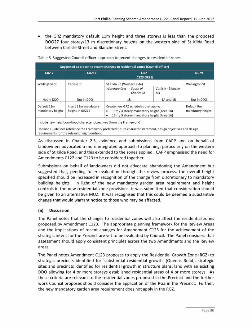
Port Phillip Planning Scheme Amendment C122 Panel Report 15 June 2017
Page 30
the GRZ mandatory default 11m height and three storeys is less than the proposed DOO27 four storey/13 m discretionary heights on the western side of St Kilda Road between Carlisle Street and Blanche Street.
Table 3 Suggested Council officer approach to recent changes to residential zones
Suggested approach to recent changes to residential zones (Council officer)
GRZ 7 GRZ12 GRZ (C123 GRZ5)
NRZ9
Wellington St Carlisle St St Kilda Rd (Western side) Wellington St
Waterloo Cres South of Charles St
Carlisle ‐ Blanche Sts
Not in DDO Not in DDO 1B 1A and 1B Not in DDO
Default 11m mandatory height
Insert 13m mandatory height in GRZ12
Create new GRZ schedules that apply:
13m / 4 storey mandatory height (Area 1B)
17m / 5 storey mandatory height (Area 1A)
Default 9m mandatory height
Include new neighbour‐hood character objectives (from the Framework)
Decision Guidelines reference the Framework preferred future character statement, design objectives and design requirements for the relevant neighbourhood.
As discussed in Chapter 2.5, evidence and submissions from CAPP and on behalf of landowners advocated a more integrated approach to planning, particularly on the western side of St Kilda Road, and this extended to the zones applied. CAPP emphasised the need for Amendments C122 and C123 to be considered together.
Submissions on behalf of landowners did not advocate abandoning the Amendment but suggested that, pending fuller evaluation through the review process, the overall height specified should be increased in recognition of the change from discretionary to mandatory building heights. In light of the new mandatory garden area requirement and height controls in the new residential zone provisions, it was submitted that consideration should be given to an alternative MUZ. It was recognised that this could be deemed a substantive change that would warrant notice to those who may be affected.
(ii) Discussion
The Panel notes that the changes to residential zones will also affect the residential zones proposed by Amendment C123. The appropriate planning framework for the Review Areas and the implications of recent changes for Amendment C123 for the achievement of the strategic intent for the Precinct are yet to be evaluated by Council. The Panel considers that assessment should apply consistent principles across the two Amendments and the Review areas.
The Panel notes Amendment C123 proposes to apply the Residential Growth Zone (RGZ) to strategic precincts identified for ‘substantial residential growth’ (Queens Road), strategic sites and precincts identified for residential growth in structure plans, land with an existing DDO allowing for 4 or more storeys established residential areas of 4 or more storeys. As these criteria are relevant to the residential zones proposed in the Precinct and the further work Council proposes should consider the application of the RGZ in the Precinct. Further, the new mandatory garden area requirement does not apply in the RGZ.
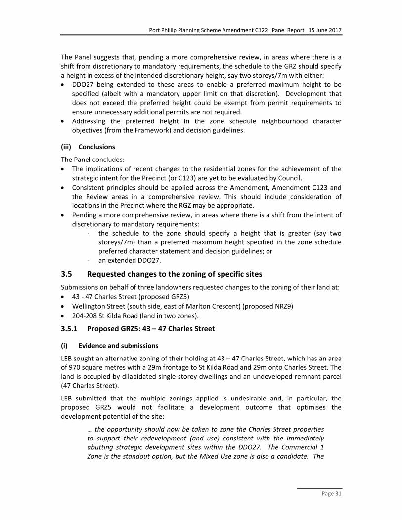
Port Phillip Planning Scheme Amendment C122 Panel Report 15 June 2017
Page 31
The Panel suggests that, pending a more comprehensive review, in areas where there is a shift from discretionary to mandatory requirements, the schedule to the GRZ should specify a height in excess of the intended discretionary height, say two storeys/7m with either:
DDO27 being extended to these areas to enable a preferred maximum height to be specified (albeit with a mandatory upper limit on that discretion). Development that does not exceed the preferred height could be exempt from permit requirements to ensure unnecessary additional permits are not required.
Addressing the preferred height in the zone schedule neighbourhood character objectives (from the Framework) and decision guidelines.
(iii) Conclusions
The Panel concludes:
The implications of recent changes to the residential zones for the achievement of the strategic intent for the Precinct (or C123) are yet to be evaluated by Council.
Consistent principles should be applied across the Amendment, Amendment C123 and the Review areas in a comprehensive review. This should include consideration of locations in the Precinct where the RGZ may be appropriate.
Pending a more comprehensive review, in areas where there is a shift from the intent of discretionary to mandatory requirements:
- the schedule to the zone should specify a height that is greater (say two storeys/7m) than a preferred maximum height specified in the zone schedule preferred character statement and decision guidelines; or
- an extended DDO27.
3.5 Requested changes to the zoning of specific sites
Submissions on behalf of three landowners requested changes to the zoning of their land at:
43 ‐ 47 Charles Street (proposed GRZ5)
Wellington Street (south side, east of Marlton Crescent) (proposed NRZ9)
204‐208 St Kilda Road (land in two zones).
3.5.1 Proposed GRZ5: 43 – 47 Charles Street
(i) Evidence and submissions
LEB sought an alternative zoning of their holding at 43 – 47 Charles Street, which has an area of 970 square metres with a 29m frontage to St Kilda Road and 29m onto Charles Street. The land is occupied by dilapidated single storey dwellings and an undeveloped remnant parcel (47 Charles Street).
LEB submitted that the multiple zonings applied is undesirable and, in particular, the proposed GRZ5 would not facilitate a development outcome that optimises the development potential of the site:
… the opportunity should now be taken to zone the Charles Street properties to support their redevelopment (and use) consistent with the immediately abutting strategic development sites within the DDO27. The Commercial 1 Zone is the standout option, but the Mixed Use zone is also a candidate. The

Port Phillip Planning Scheme Amendment C122 Panel Report 15 June 2017
Page 32
inclusion of these properties within a residential zone, with mandatory height/site coverage controls, is not consistent with the achievement of a new character and land use vision for the land fronting St Kilda Road.
At the Hearing Mr Biacsi supported extending the C1Z to the Charles Street properties. He commented the GRZ mandatory building height and 35% garden area ‘make a mockery of UDLUF and DDO aspirations for St Kilda Road’. Alternatively, a change to the MUZ is in the right direction. Mr Glossop acknowledged under cross examination that he had not specifically addressed the GRZ5 but agreed that commercial uses at ground floor along the St Kilda Road frontage would be consistent with the Framework. He noted that Charles Street is narrow and responded to questions that the MUZ may be a better fit than the C1Z.
CAPP highlighted that Charles Street does not form a continuous streetscape, and noted:
The group of terraces at the end of the street create both an asset requiring protection but also an intrusion from the point of view of coherent planning along St Kilda Road. This interface needs careful management. Three houses to the south fall into Amendment 122, other buildings alongside it without heritage listing abut the Inkerman Street MUZ. It seems unnecessarily complex to propose a medley of different zones in this area.
(ii) Discussion
As noted in Chapter 2, the Framework, and therefore the Amendment, did not critically examine opportunities for site consolidation and therefore underestimated redevelopment opportunities. This is a location where the single ownership changes the development potential but is not recognised by the planning framework proposed by the Amendment.
The Panel agrees with evidence and submissions that the proposed GRZ does not align well with the strategic intent for this area. The recent changes to introduce mandatory building height and garden area requirements add to the justification for an alternative zoning.
Either the MUZ or C1Z could implement the strategic intent for this area, however, the C1Z is preferred as it would continue the zoning along St Kilda Road to the north and the south. The recommended inclusion of land along the western side of St Kilda Road in the “Review Area” would facilitate a more integrated approach to planning in that part of the Precinct with land to the west.
Residents and CAPP raised issues relating to the capacity of the area to accommodate more intensive development, traffic and parking impacts, the transition to residential hinterlands and the protection of valued character and interface treatments. These are legitimate issues that will need to be addressed through the permit process, in the context of the framework provided by DDO27.
3.5.2 Proposed NRZ9 ‐ Wellington Street (south side, east of Marlton Crescent)
(i) Evidence and Submissions
Council noted that the application of the residential zones involved detailed consideration of each HO and the GRZ was applied where there is capacity for development and established apartments. It submitted that the proposed NRZ9 is appropriate to provide greater certainty

Port Phillip Planning Scheme Amendment C122 Panel Report 15 June 2017
Page 33
about development capacity, while facilitating development at a density and scale that respects the low‐density, fine‐grain character and heritage significance.
Mr Glossop noted that HO6 applies to this area and was satisfied that the proposed NRZ9 is consistent with PPN78 and the principles Council applied to the residential zones.
Whilst JAAG strongly supported the proposed NRZ along the south side of Wellington Street, Jankie Pty Ltd argued that the purposes of the NRZ do not align with the existing conditions at the eastern end of the proposed NRZ9. The new mandatory garden area requirement of the NRZ reaffirmed this view.
Jankie submitted that the heritage precinct does not justify the application of the NRZ9 in this context, as HO6 will continue to address the protection of heritage values. Jankie relied on evidence from Mr McGurn (which pre‐dated changes to the residential zones).
Mr McGurn acknowledged the designation of this part of Wellington Street as ‘minimal change’ in the Housing Strategy and that urban design, amenity and heritage policy would be relevant and may ‘temper’ development outcomes. However, it was his view that the proposed NRZ9 purposes, four lot maximum subdivision and maximum 8 metre height, are inappropriate given the locational attributes of this area. The character and land use along Wellington Street is mixed, the laneway separates sites from residential properties to the rear, and there is development opportunity, particularly for consolidated land parcels. He highlighted:
The excellent locational attributes of the eastern end of Wellington Street, which is 260mfrom Windsor Train Station and adjoins the intersection of Dandenong Road and Chapel Street (a major strategic transport corridor) and the Windsor Activity Centre.
Existing development in this area, including the Astor Theatre.
Apartments or townhouses on the majority sites between Chapel Street and Marlton Crescent already exceed mandatory NRZ provisions.
Further, Mr McGurn’s assessment of this area against Planning Practice Note 78 ‘Applying the Residential Zones’ concluded the NRZ is not the appropriate zone because:
This is not an area where housing growth should be restricted given its locational context with excellent supporting transport and other infrastructure.
The area has good access to local shopping and community services.
This is not an area where single dwellings prevail.
The area is not an area of ‘recognised’ or ‘consistent’ neighbourhood character or an area with environmental or landscape significance. It is in fact highly varied displaying examples of single storey dwellings, older style apartments and contemporary multi storey apartment buildings, along with commercial uses on the north side.
This is not an area where ‘single dwellings’ and ‘dual occupancies under some circumstances’ are the expected housing typology.
Mr McGurn considered that the Amendment should be abandoned or, if it is not abandoned, application of the MUZ or RGZ should be contemplated.

Port Phillip Planning Scheme Amendment C122 Panel Report 15 June 2017
Page 34
(ii) Discussion
The Panel agrees with Mr McGurn that the block between Chapel Street and Marlton Crescent does not correspond with the criteria for applying the NRZ.
PPN78 indicates that principles for applying residential zones should be considered together. RZSAC addressed the effect of the HO as a basis for applying the NRZ, in the following principles:
P25 Existing overlays should be a factor when considering which zone to apply. The overarching consideration is whether the overlay should be accompanied by a restrictive zone or whether the overlay provisions should be allowed to operate with a less restrictive zone. In many instances this should result in translating the Residential 1 Zone to a GRZ.
P26 The existence of the Heritage Overlay does not automatically justify applying the NRZ14.
The RZSAC commented that another zone may be appropriate where heritage precincts are characterised by more intensive development, as is the case in this part of Wellington Street. Further, this area does not satisfy the PPN78 expectation that the NRZ should apply to areas “where more than 80% of lots currently accommodate detached dwellings” and “may not have good supporting transport infrastructure or other infrastructure, facilities and services …”.
However, irrespective of whether the NRZ or GRZ applies, the new mandatory requirements for residential zones are likely to limit development at the eastern end of the southern side of Wellington Street as:
HO6 is likely to constrain demolition of buildings that contribute to the significance of the Precinct
the combination of the extent of existing development and the new garden area requirement create very significant challenges for further development, even if sites are consolidated.
In view of the quite fine grained approach adopted in applying proposed residential zones in Port Phillip, the Panel consider it is acceptable to distinguish this part of Wellington Street from land to the west. The Panel considers that the existing GRZ (the status quo) should be maintained as analysis relating to either the RGZ or MUZ has not occurred and those who may be affected have not been consulted.
3.5.3 Area 2B ‐ 204‐208 St Kilda Road
204‐208 St Kilda Road, which consists of multiple titles, is an irregular land parcel of 1,012 square metres with access at the rear from Pummeroy Lane (from St Kilda Road) and southern laneway from Frampton Street. It is currently occupied by a single‐storey commercial building, built to the street and both side boundaries.
14 Page v Residential Zones Standing Advisory Committee Stage One Overarching Issues Report June 2014
Port Phillip Planning Scheme Amendment C122 Panel Report 15 June 2017
Page 35
The Amendment includes the property in DDO27 Area 2B and does not proposed changes to the existing zoning C1Z that applies to St Kilda Road frontage or the GRZ1 that applies to the rear portion.
(i) Submissions and evidence
It became apparent at the hearing that, while the Amendment proposes to apply DDO27 to the entire land holding, two of the titles that form this land holding are in two zones (the C1Z and the GRZ1) and one parcel (the most south easterly) is entirely in the GR1Z.
Figure 8 Existing zoning of 204‐208 St Kilda Road, St Kilda
It was submitted that the dual zoning should be resolved as part of the Amendment to avoid ambiguity and technical difficulties at the permit stage.
(ii) Discussion
The Panel agrees that the zoning of this land should be resolved. However, it is conscious that adjoining properties to the east and south of the GRZ land have not had an opportunity to present their view on the appropriate zoning of the land.
The land appears to have been included in a ’Review Area’ and that process should resolve the anomalous zoning. There is also the option of the landowner seeking a separate Amendment or to advance a combined Amendment and permit process if plans for the site need to be resolved in advance of the ‘Review Areas’ process.
(iii) Conclusions
The Panel concludes:
The proposed GRZ does not align well with the strategic intent for the western side of St Kilda Road in the vicinity of Charles Street and the recent changes to introduce mandatory building height and garden area requirements add to the justification for an alternative zoning. The C1Z would continue the zoning along St Kilda Road to the north and the south of Charles Street, pending the recommended review to ensure there is an integrated approach to planning between St Kilda Road and Barkly Street to the south of Alma Road.

Port Phillip Planning Scheme Amendment C122 Panel Report 15 June 2017
Page 36
As the proposed NRZ9 has not been justified for the eastern end of Wellington Street (southern side), the existing GRZ (with the addition of reference to the Framework) should be maintained.
The dual zoning of 204‐208 St Kilda Road should be resolved through the ‘Review Areas’ process or a site specific amendment process.
3.6 Recommendations
The Panel makes the following recommendations:
Apply consistent principles across the Amendment, Amendment C123 and the Review Areas in the proposed comprehensive review. This should include consideration of locations in the Precinct where the RGZ may be appropriate.
Pending a more comprehensive review, in areas where there is a shift from the intent of discretionary to mandatory requirements:
change the schedule to the zone to specify a height that is greater than the preferred maximum height (say and additional two storeys/7m)
address the preferred maximum building height in the zone schedule character statement and decision guidelines or an extended DDO27 (with exemptions for development that does not exceed the preferred maximum building height).
Rezone 43 – 47 Charles Street to Commercial 1 Zone (rather than the exhibited schedule 5 to the General Residential Zone).
Maintain the existing General Residential Zone on the south side of Wellington Street to the east of Marlton Crescent, with the addition of reference to the Framework in the zone schedule (rather than the exhibited schedule 9 to the Neighbourhood Residential Zone).
Resolve the zoning of the rear of 204‐208 St Kilda Road through the ‘Review Areas’ process or a site specific amendment.

Port Phillip Planning Scheme Amendment C122 Panel Report 15 June 2017
Page 37
4 Built form provisions
4.1 The issues
Is the overall rationale for the built form provisions sound?
Will the proposed built form provisions achieve the stated objectives for each precinct?
Some submissions questioned the rationale behind some of the built form objectives (or how they are implemented), in particular:
Re‐enforcing the established urban structure and built form elements of the Precinct and each neighbourhood.
How reinforcing the topographic high point of St Kilda Hill and St Kilda Junction as the entry point to the Precinct and the transition point to St Kilda Road North was translated into the built form provisions.
The need for consistency between built form on both sides of St Kilda Road to achieve a cohesive boulevard streetscape.
Maintaining the visual prominence of and view lines to the St Kilda Presbyterian Church
The use of mandatory provisions.
Landscaped setback requirements and protecting fine grain heritage character.
4.2 What is proposed?
The Amendment proposes to apply DDO27 to guide renewal of most of the Precinct and implement the built form outcomes in the Framework. In Carlisle Street and the majority of the southern side of Wellington Street, built form is managed through zone provisions, including proposed schedules to the NRZ and GRZ which set overall height limits. Figure 9 illustrates the proposed overall building heights, street wall heights and setbacks in the Precinct.

Port Phillip Planning Scheme Amendment C122 Panel Report 15 June 2017
Page 38
Figure 9 Proposed built form framework
A combination of discretionary and mandatory built form controls are proposed.
4.3 Precinct wide built form issues
4.3.1 Urban Structure and building height
(i) Submissions and evidence
A key design objective in the DDO is ‘to reinforce the established urban structure and built form elements of the Precinct and each neighbourhood’. Council submitted:
The built form parameters in respect of each neighbourhood has taken into account a number of considerations including: the existing streetscape character, the development patterns, the topography, the street layout and widths, lots sizes and configurations, significant landmarks and sensitive interface conditions
The Framework identifies the following features of the Precinct:
key intersections at St Kilda Junction, Alma Road, Inkerman Street and Carlisle Street
the metropolitan highpoint of the Hill at Alma Road
the high rise development at the Hill and Junction
heritage landmarks such as the church and spire
established low scale residential areas and fine grain streetscapes.

Port Phillip Planning Scheme Amendment C122 Panel Report 15 June 2017
Page 39
Figure 11, which is from Mr Sheppard’s evidence, illustrates key elements of the urban structure the Framework support (although it does not extend as far as the Junction).
Figure 10 Precinct Urban Structure (Source: Sheppard evidence Context report)
One of the key elements of the urban structure of the Precinct is the high point of St Kilda Hill, and Junction. The Amendment proposes a ten storey discretionary height as a scale that will mediate recent high rise development. There are eight remaining redevelopment sites within the proposed ten storey height areas. Council highlighted that no submissions opposing the proposed heights were received from affected landowners.
After much strategic work and analysis this is an area which the Council considers appropriate for a range of building heights of up to 10 storeys
LEB Nominees and SKBP opposed the extent to which building heights reduce moving away from the Junction and Hill. They submitted that the capacity of redevelopment sites should be maximised and, as their sites are at a sufficient distance away and within the substantial slope of the Road, they would not compete with the significantly taller buildings on the Hill.
The urban design expert witnesses all supported the objective of emphasising the topography of the Hill as an appropriate urban design response for the Precinct and that taller buildings would support this objective. Mr Alexander identified opportunities for higher buildings on the north side of Alma Road and possibly immediately south of the
Port Phillip Planning Scheme Amendment C122 Panel Report 15 June 2017
Page 40
Barkly Street and St Kilda Road intersection. He supported provision for predominantly four to six storey heights along the majority of St Kilda Road, and during cross examination stated that a six storey height along the length of the boulevard would be reasonable.
Professor McGauran and Mr Sheppard endorsed the objective of emphasising the Hill, however they consider, given the significant slope of 20m (equivalent to six storeys), development of up to 15 storeys could be accommodated without compromising the primacy of the Hill and Junction, where buildings above 26 storeys are already located.
Mr Sheppard agreed with Council’s analysis of the Urban Structure of the Precinct and suggested that in order to re‐enforce that structure, key intersections should be marked by taller buildings than those proposed in the Amendment. In particular, for the LEB land on the corner of Inkerman Street, on the western side of St Kilda Road, he advocated a 12 storey ‘landmark’ building. He suggested this was an appropriate scale compared to the emerging seven storeys being approved in the mixed use area along Inkerman Street. Mr Alexander did not agree that a tall building is necessary as additional height is only one way to mark an intersection and that quality Architecture could be used instead.
Mr Sheppard considered the proposed heights along St Kilda Road are low in the context of objectives to create an urban boulevard. He used the urban design ‘rule of thumb’ that the height of buildings should be set at half the width of the road to define the road space:
…given the approximately 60m width of St Kilda Road, it could be said that 30m high buildings (approximately 8‐9 storeys) is the minimum scale to achieve spatial definition.
He highlighted that four storeys would only just be visible above the tree line, six storeys would go some way in establishing an urban boulevard, however, for the significant road width of St Kilda Road, heights of at least eight storeys would be required to appropriately define the road space.
(ii) Discussion
The Panel recognises the key elements to reinforce the urban structure of the Precinct are:
high rise development at the hill and junction
marking the key intersections of Alma Road, Inkerman Street and Carlisle Street
creating an urban boulevard along St Kilda Road
scaling down development moving south towards the residential hinterland.
The Panel agrees with Mr Sheppard that eight storey development would be an appropriate scale to create an Urban Boulevard along such a wide road. Council has attempted to balance this objective, seeking to protect amenity of adjoining neighbourhoods and the transition to lower buildings on flatter land along Brighton Road, preferring a four to six storey maximum height along the Road. The Panel believes a more strategic approach is to promote six to eight storey development where possible, whilst protecting residential amenity through appropriate setbacks at sensitive interfaces. A strategic imperative is to create an Urban Boulevard and the planning for the area should seek to create the appropriate conditions to achieve this objective.

Port Phillip Planning Scheme Amendment C122 Panel Report 15 June 2017
Page 41
Although important intersections can be marked by quality architecture, the Panel recognises that also encouraging additional building height at these nodes, is appropriate for an arterial road, such as St Kilda Road.
The Panel notes the scale of the tallest buildings at the Junction is between 18‐28 storeys. At Alma Road the scale of recent development drops down to between 9‐13 storeys, on the western side, and nine on the eastern. Council proposes six to eight storeys on the eastern side, and ten storeys for the western.
The Panel regards the ten storey height proposed by Council for the Junction, at nearly one third the scale of the tallest buildings at this location, low. Although, it is acknowledged that the decision guidelines provide for consideration of the scale of adjoining development, the Panel questions the merit of setting heights that anticipate major variation in the scale of adjoining buildings in terms of both strategic policy and urban design outcomes.
Buildings up to 18 storeys at the Junction would provide a better transition and strong urban morphology at this location. Scaling down to between 13‐15 storeys at Alma Road (instead of the proposed 8 ‐10) will emphasise the hill and intersection at the approximate scale of existing or approved development. This scale is more achievable on the western side and south eastern corner where the development parcels are larger.
At the next key intersection moving south is Inkerman Street. The Panel recognises the transition to lower existing and emerging residential forms here of predominately five to six storeys with a couple of seven storey approvals. The Panel is not convinced by evidence that 12 or 13 storey developments at the LEB and SKBP sites should be identified as the preferred maximum height, appropriate for this context. While the topography would mean development at this scale would not compete with taller development on the hill, these heights compromise the experience of an increasing building scale moving along St Kilda Road towards the Hill and Junction. Further, development at that scale would be approximately double the height of the emerging forms along Inkerman Street. It also suggests a tower and podium form, which has not been envisaged for the southern part of the Precinct and is not necessary to define the boulevard. As heights are discretionary, an exemplary proposal at greater height could be considered.
The Panel believes that a couple of storeys above the surrounding development would be sufficient to mark the Inkerman St intersection, suggesting nine storeys here. This is unlikely to be achievable of the eastern side of St Kilda Road, where the lot sizes are constrained and the recently completed redevelopment of the heritage post office is at six storeys.
At the Carlisle Street and St Kilda Road intersection, the Amendment proposes a preferred maximum of five storeys. Existing development is at two to four storeys. VC110 now makes this a mandatory control, therefore the Panel believes a preferred five storey height with a mandatory seven storeys would be sufficient to mark the corner while recognising the intent of the Amendment’s discretionary provision (refer to Chapter 3)
Site conditions will mean the proposed preferred heights may not be achievable on all sites, however they are in line with the strategic objectives of the Amendment and in consideration of sensitive interfaces.

Port Phillip Planning Scheme Amendment C122 Panel Report 15 June 2017
Page 42
(iii) Conclusions
The Panel endorses the proposed urban structure for the Precinct but questions how it has been translated in the proposed built form provisions, particularly in the context of broader objectives to optimise strategic redevelopment opportunities.
The built form provisions at the Junction to Alma Road should recognise the existing scale of development. Therefore, the Panel considers a preferred maximum height of 16‐18 storeys at the Junction down to 13‐15 storeys at Alma Road, would provide a better scale transition than the proposed ten storeys.
Key intersections should be marked by taller forms that scale down moving south along St Kilda Road for example 13‐15 storeys at Alma Road, nine storeys at Inkerman Street and up to seven storeys at Carlisle Street.
If definition of an Urban Boulevard on such a wide road was considered in isolation from its hinterland, significantly taller development along St Kilda Road would be a sound response. However, encouraging heights of between six to eight storeys along the remainder of the street, except where sensitive heritage issues apply, provides for a transition to lower scale development in adjoining residential areas and to the south in Brighton Road.
4.3.2 Creating a cohesive boulevard streetscape
All the submissions and evidence at the Hearing agreed that the western side of St Kilda Road does not have a clear development pattern due to the demolition of buildings to widen St Kilda Road in the 1970’s and the creation of a strong boulevard was supported.
Council proposed that visual cohesion and strengthening of the boulevard character could be recreated through greater consistency in overall building scale and street walls across opposite sides of St Kilda Road and along each side of St Kilda Road.
The proposed building heights and setbacks for each neighbourhood and area, seek to achieve particular urban design objectives. Zero building setbacks are proposed along St Kilda Road and the north side of Wellington Street to achieve visual consistency and to promote greater interaction and activity at the street interface. Building and street wall heights together with upper level setbacks are proposed to maintain solar access to some southern footpaths and are a key unifying element of the built form. They can also reduce the perception of scale. On the north eastern side of St Kilda Road there is a well‐established street wall height of approximately three storeys due to the presence of heritage buildings. As the western side does not have a clear development pattern, the Framework adopted the scale on the eastern side:
Creating visual cohesion within the streetscape by reinforcing a similar building scale on both sides of St Kilda Road is a key design objective.
Council recognises that some flexibility on the western side is needed and so the proposed three storey street wall and building heights are discretionary controls.
There was consensus amongst the experts that consistency between the east and west side of St Kilda Road, particularly regarding building heights, is not practical or required given the significant width of the road. Mr Milner highlighted that as the west and the east sides of St Kilda Road present quite different opportunities, constraints and context, consistent urban

Port Phillip Planning Scheme Amendment C122 Panel Report 15 June 2017
Page 43
edge treatment in terms of height and density on both sides of the boulevard is not necessary. Professor McGauran agreed and felt consistency should not be pursued at the expense of redevelopment opportunities. Given, the presence of tall buildings and variations in lot sizes, lack of particular character or cohesiveness of built form, and the opportunities for renewal of older redundant commercial buildings, he believes the proposed built form requirements do not optimise the strategic development opportunities presented by the land:
These factors in my opinion support greater forms of development than envisaged by the DDO, in particular for larger sites with multiple street frontages…
The urban design experts emphasised that a consistent tree canopy along the footpaths and medians would be a practical way of achieving visual cohesion and a strong boulevard. Mr Alexander and Mr Sheppard shared the view that consistent street walls, upper level setbacks and zero ground level setbacks are more important to achieve a boulevard in the case of St Kilda Road than the overall building height.
(i) Discussion
Panel site visits supported the expert view that given the substantial width (60m) of the road, varying contexts of each side, and the significant slope of 20m along St Kilda Road, visual cohesion between the built form on the east and west sides is not necessary to achieve a strong Boulevard. On the eastern side of St Kilda Road, the justification of provisions is clearly based on the heritage fabric and its established context. However, the Panel does not agree that a similar built form need to be ascribed to the western side: the urban fabric here requires re‐establishing and presents new development opportunities. Development on the western side is not be unduly constrained by the heritage character of the shops on the opposite side of the road.
The Panel believes that a significant element of a Boulevard is the treatment of the public realm and agrees with the urban design experts that a consistent treatment of the public realm, and particularly a canopy of trees along the footpath and median strips would go a long way in achieving this on St Kilda Road South.
The Panel also agrees with the evidence that for St Kilda Road it is the zero setbacks to the road, street walls and upper level setbacks that will create visual cohesion and define the streetscape. However, a consistent building heights between the opposite sides of St Kilda Road, is not seen as necessary by any of the experts given the substantial slope of the Road, and its width. The Panel agrees. Therefore, the reference to consistent building heights between the east and west sides of the Road should be removed from the Amendment. Rather, the objective should promote consistent building heights along each side of St Kilda Road.
Panel notes that the proposed building heights in DDO27 vary by area as follows:
On the western side moving north from Carlisle Street the Amendment proposes five storeys, four storeys, six storeys, four storeys, five storeys, four storeys, ten storeys.

Port Phillip Planning Scheme Amendment C122 Panel Report 15 June 2017
Page 44
On the eastern side of St Kilda Rd moving north from Inkerman Street, the Amendment proposes six storeys, eight storeys, six storeys, four storeys, six storeys, eight storeys, ten storeys.
The Panel has already indicated that the height provisions in the Amendment should reinforce the urban structure of the Precinct and that six to eight storey building heights between key intersections is desirable.
(ii) Conclusions
The objective of visual cohesion between the east and west side of St Kilda Road is not necessary or practical.
Consistency in built form along each side of the road should be encouraged, using street wall heights, upper level setbacks and zero ground level setbacks
South of Waterloo Crescent, six to eight storey building heights should be encouraged between taller forms at key intersections.
Strong public realm treatments will be vital to a strong boulevard outcome.
4.3.3 Views to the St Kilda Presbyterian Church
One of the objectives in DDO27 is:
To protect the established views to the St Kilda Presbyterian Church and Spire when viewed from Barkly Street, Alma Road and St Kilda Road…
Mandatory height controls which transition to the Church and Spire as well as mandatory front setbacks are proposed to maintain these views. The Amendment identifies view lines from Alma Road turning from Barkly Street and also the view travelling south along Barkly Street for protection. There were no objecting submissions to these provisions.
(i) Evidence
Mr Alexander, Professor McGauran and Mr Biacsi did not feel that the spire is significant enough to warrant transitioning down to it and did not support the proposed mandatory height controls. Mr Alexander noted that:
Even if all the other buildings on the north side of Alma Road between Barkly Street and SKRS were 10 storeys, the church building would still be very visible on its corner, and would still be seen against the skyline from the south side of Alma Street directly opposite the church.
Mr Alexander advocated a narrow gap between the spire and neighbouring building as a more effective way to maintain a view to the spire against the sky and supported a mandatory landscape setback along the north side of Alma Road and Barkly Street.
(ii) Discussion
The Panel inspections confirmed the prominence of the Church and its spire in views from Alma Street, St Kilda Road and Barkly Street. The Panel also noted the significant view of the church while travelling south along Punt Road.
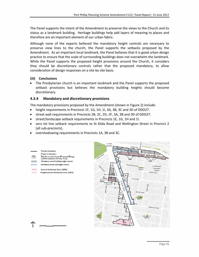
Port Phillip Planning Scheme Amendment C122 Panel Report 15 June 2017
Page 45
The Panel supports the intent of the Amendment to preserve the views to the Church and its status as a landmark building. Heritage buildings help add layers of meaning to places and therefore are an important element of our urban fabric.
Although none of the experts believed the mandatory height controls are necessary to preserve view lines to the church, the Panel supports the setbacks proposed by the Amendment. As an important local landmark, the Panel believes that it is good urban design practice to ensure that the scale of surrounding buildings does not overwhelm the landmark. While the Panel supports the proposed height provisions around the Church, it considers they should be discretionary controls rather that the proposed mandatory, to allow consideration of design responses on a site by site basis.
(iii) Conclusions
The Presbyterian church is an important landmark and the Panel supports the proposed setback provisions but believes the mandatory building heights should become discretionary.
4.3.4 Mandatory and discretionary provisions
The mandatory provisions proposed by the Amendment (shown in Figure 2) include:
height requirements in Precincts 1F, 1G, 1H, 1I, 3A, 3B, 3C and 3D of DDO27.
street wall requirements in Precincts 2B, 2C, 2D, 2F, 3A, 3B and 3D of DDO27.
street/landscape setback requirements in Precincts 1E, 1G, 1H and 1I.
zero lot line setback requirements to St Kilda Road and Wellington Street in Precinct 2 (all sub‐precincts).
overshadowing requirements in Precincts 1A, 3B and 3C.

Port Phillip Planning Scheme Amendment C122 Panel Report 15 June 2017
Page 46
Figure 11 Proposed mandatory building and street wall heights
VC110 introduced the following changes during the course of the Panel hearing:
The ‘maximum building height’ clause in the Schedule to NRZ9, GRZ7 and GRZ12.
The NRZ9 maximum number of dwellings on a lot was deleted.
Mandatory heights and garden area standards apply in the residential zones in Wellington and Carlisle Streets.
Council noted that the community supports the use of mandatory provisions because they provide greater certainty, particularly regarding overall building heights, however developers preferred discretionary and performance based controls.
Council argued that mandatory controls assist in realising the urban design vision for the Precinct, protect established character, ensure that appropriate scale relationships with adjacent areas are maintained and provide certainty about the scale of future development.
In considering the appropriateness of adopting mandatory controls Mr Glossop noted PPN59 establishes the following principles:
Fundamentally, the Victoria Planning Provisions should provide discretion to allow applications to be tested against objectives and performance criteria, rather than mandatory requirements.
‘Performance based’ controls are preferred, in order to allow for variation, innovation, unforeseen uses and development or circumstances peculiar to particular sites (such as slope, site area and interfaces).
Mandatory provisions are the exception and may be a preferable to discretionary provisions in limited situations, particularly where an area displays high heritage values, has a strong and consistent neighbourhood character, or is environmentally sensitive or constrained.
PPN59 establishes the following criteria that should determine whether the benefits of the mandatory provisions outweigh any loss of opportunity and the flexibility inherent in a performance based system:
Is the mandatory provision strategically supported?
Is the mandatory provision appropriate to the majority of proposals?
Does the mandatory provision provide for the preferred outcome?
Will the majority of proposals not in accordance with the mandatory provision be clearly unacceptable?
Will the mandatory provision reduce administrative costs?
Mr Glossop noted that mandatory controls are being applied more than in the past, citing Fishermans Bend, DDO26 for St Kilda Road North mandatory height controls and DDO8 South Melbourne Central mandatory street wall requirements. He noted that the Framework articulates the need for mandatory building heights:
in some low scale residential precincts to protect the character and heritage aspects of these areas and at the ‘gateway’ to the Precinct (Areas 1F,1I).
to establish a clear street wall and street setback along the St Kilda Road spine.
Mr Glossop considered that, on balance, the policy in the Port Phillip Planning Scheme, justifies mandatory controls in some circumstances (particularly the mandatory street wall

Port Phillip Planning Scheme Amendment C122 Panel Report 15 June 2017
Page 47
height and zero setback requirements on the eastern side of St Kilda Road). Ultimately, it was his view that the urban design and heritage justification for these controls should determine whether they should be mandatory.
Mr Alexander supported the mandatory provisions of the Amendment and recommended the proposed discretionary setbacks and street‐wall heights should be made mandatory on the western side of St Kilda Road.
Mr Glossop and Mr Alexander believe the use of mandatory controls in the Precinct is justified, while Mr Sheppard advocated the mandatory street wall height on the eastern side of St Kilda Road should be increased with discretionary upper level, side and rear setbacks for the Precinct.
There was a general consensus amongst the remaining experts that mandatory controls are not warranted in the Precinct as they believe performance based controls provide the flexibility to achieve better outcomes.
(i) Discussion
While the Panel has referred to PPN59 for guidance on mandatory controls, it is conscious of the recent State Government shift towards the greater use of mandatory controls. For example, the recent Amendments VC110 applies mandatory height controls in the NRZ and GRZ. On the other hand, the recently adopted Better Apartment Design Guidelines do not include mandatory provisions, but encourage a design response based on an analysis of the urban context.
In considering the proposed controls for this Precinct, the Panel firstly thought about whether the outcomes being sought were based on sound planning and urban design principles. Secondly, would these outcomes be best achieved by mandatory or discretionary controls? The Panel believes that generally, the Amendment is balanced in its proposed use of mandatory controls. Building heights are mainly discretionary except for Wellington Street and around the Presbyterian Church. The mandatory street wall heights, and zero lot setbacks are appropriate for the eastern side of St Kilda Rd, seeking to reinforce the heritage elements of the streetscape, but perhaps less so for Wellington Street.
The Panel recognises upper level setbacks have an important role, particularly on the eastern side of St Kilda Road. However, the variation in lot sizes along the western side, and likely inconsistent development outcomes, mean that mandatory provisions here are less justified. Further, the exceptions in the post‐exhibition DDO27 to the ‘mandatory’ five metre upper level setback demonstrate that the mandatory status of the requirement is not justified. These exceptions require the exercise of judgement and this is not appropriate in a mandatory provision.
The Panel considered these requirements in greater detail within each neighbourhood.
VC110 applies mandatory controls in locations not envisaged in the Framework or the exhibited Amendment. In these areas, the Panel believes that the proposed discretionary heights should be translated to mandatory controls, by recognising a likely one or two additional storeys, and setting both a preferred and a maximum mandatory height.

Port Phillip Planning Scheme Amendment C122 Panel Report 15 June 2017
Page 48
(ii) Conclusions
The approach to the application of mandatory controls in the exhibited Amendment was reasonable, however the Panel does not agree with all of the provisions proposed.
The upper level setbacks above the street wall are not justified, as demonstrated by the ‘exceptions’ and the need to exercise judgement if they are reduced.
Translating discretionary heights into mandatory controls as a result of recent changes to residential zones should allow an extra one to two storeys by setting with the preferred maximum height identified in the schedule to the zone character statements and decision guidelines or an extend DDO27.
4.3.5 Landscaped setbacks and fine grain character
DDO27 proposes:
Landscaped setbacks on the western side of St Kilda Rd at Vale Street, Carlisle Street, Waterloo Crescent, Charles Street, Barkly Street and Alma Rd in Area 1A, 1B, 1C, 1D 1E, 1F, 1G, 1H & 1I.
Zero, minimal or landscaped setback consistent with adjoining properties on the eastern side of St Kilda Road at Charnwood Crescent, Alma Rd, Inkerman Street, Argyle Street, Charnwood Rd, Octavia Street in Area 2A, 2B, 2C, 2D
For the western side of St Kilda Road, new development should protect and respect the fine grain heritage character of Vale, Blanche, Market and Charles Streets and Waterloo Crescent. A similar requirement is not proposed for the eastern side of the Road.
(i) Submissions and evidence
Submissions were received opposing the proposed landscape setbacks along the side streets, where new development on a corner would be required to provide setbacks consistent with adjoining properties. A related provision requiring new development to protect and respect the fine grain character of side streets was also opposed by some submitters and in urban design evidence.
Council submitted that in some areas of the Precinct, a landscaped setback is important to achieve a sense of consistency with adjoining residential properties. The majority of street setbacks are discretionary in the residential streets to allow for design response that are cognisant of the varying front setbacks observed in the side streets.
According to Professor McGauran, the requirement to provide landscaped setbacks to interfacing side streets such as Blanche Street, fails to prioritise the boulevard cohesiveness and instead exposes hinterland residential streetscapes to St Kilda Road. He did not support the proposed landscaped setback as he believes it undermines the stated streetscape ambitions to reinstate the urban edge of St Kilda Road. He suggested a more typical response is that commercial main street development is to build to the street and back onto a rear lane.
Mr Sheppard did not agree with the provision that development be ‘required to protect and respect’ the fine grain character and suggested the provision be changed to ‘should’. He acknowledged that whilst aspects of Market Street are fine grained, these form a relatively small proportion of an otherwise eclectic streetscape. He noted a number of large light industrial properties are likely to undergo future development.

Port Phillip Planning Scheme Amendment C122 Panel Report 15 June 2017
Page 49
(ii) Discussion
The Panel agrees with Professor McGauran that in order to re‐establish the urban edge along the western side of St Kilda Road, development should reinstate the typical form of commercial development, being built out to front and corner boundaries. From there it can then transition to the adjoining properties. The Panel suggests a new precinct wide discretionary provision that provides for a zero setback from the front and corner boundaries facing St Kilda Road, with an appropriate transition to adjoining properties being determined on the basis of a response to the particular context and circumstances of the site in question.
Given the strategic importance of reinstating the St Kilda Road boulevard, the Panel considers the requirement ‘protect and respect’ fine grain character accords undue deference to the residential hinterland. Some of the proposed Area Requirements also refer to a ‘fine grain heritage’ character along Vale, Blanche, Charles and Market Street. Although there is old building stock here, it is predominately free of heritage overlays and one of the few areas in Port Phillip with lesser heritage constraints. How this provision would be interpreted is also unclear. Therefore, the provision should be redrafted to provide a ‘transition to’ the fine grain character. With regard to Market Street, which contains a variety of forms and uses, new development should also respond by providing a compatible transition in built form.
(iii) Conclusions
The re‐establishment of the boulevard edge along St Kilda Road is strategically important, therefore development should be built out to the front and corner property boundaries.
The provision requiring landscaped setbacks should be redrafted to provide a transition to adjoining properties, instead of a landscaped setback along the length of the side street boundary.
The provision requiring new development to ‘protect and respect’ the fine grain heritage character of various streets should be redrafted to read ‘provide a transition to the fine grain character…’ This provision should be moved from the specific area provisions to the neighbourhood provisions.
4.3.6 Consistent use of building heights
(i) Submissions and evidence
Evidence and submissions were presented regarding the setting of heights and the number of metres required to achieve modern commercial development. A submission made by 129 Well Pty Ltd advocated for a one metre increase in the overall height provision of Area 3C, from 13m (four storeys) to 14m (four storeys). They submitted that to achieve high amenity apartments 3.2m floor to ceiling (FTC) heights are often required, coupled with a four metre minimum ground level and 300‐400mm ground floor level above natural ground. They also referred to the more generous provisions used by the City of Stonnington.
Mr Sheppard advocated for an 11m (three storey) street wall along the eastern side St Kilda Road, instead of the proposed 10m. He believed that 10m is unreasonably constraining

Port Phillip Planning Scheme Amendment C122 Panel Report 15 June 2017
Page 50
given the need for floor‐to‐floor dimensions of up to 5m for larger retail uses at ground floor and 3.1m for apartments. Mr Sheppard was opposed to the Amendment’s proposed 3.5m (FTC) parking heights for the purpose of adaptable future uses and advocated its deletion.
(ii) Discussion
The Panel notes that the recently released Better Apartment Design Standards do not recommend a particular floor to ceiling height for apartments. The Panel referred to DDO5 of the Stonnington Planning Scheme that applies to the Waverly Road Neighbourhood Activity Centre. It specifies 15m (four storeys) and 11m (three storeys) to apply to land in MUZ and C1Z with an average height of 3.7m. On the other hand, DDO26 for the St Kilda North Precinct refers to heights without specifying the number of storeys.
The average floor heights proposed for the MUZ and C1Z in the Precinct vary between 3.25 (four storeys) to 3.5m (10 storeys) and for ground and upper level parking areas. The Panel believes that a more consistent approach throughout the Precinct is preferable and recommends an average 3.5m for the commercial and mixed‐use developments, as it allows for a generous four to five metre ground floor and 3.1m‐3.2m apartment level. The parking levels at ground and above should be reduced to a 2.7m FTC height which is adequate for a future habitable use.
Panel believes that the four storey height of 13m and 13.5m (retail frontage) should be increased to 14m in all the mixed use and commercial zoned areas of the Precinct, three storeys should be increased to 10.5, five storeys should be increased to 17.5m, and six storeys to 21m. The 11m (three storey) street wall should apply to all the areas with a proposed three storey street wall.
4.3.7 Residential interfaces, setbacks and residential amenity
(i) What is being proposed?
The Amendment proposes to apply the objectives of clause 55.04, so that their consideration is mandatory for all development adjoining residential zones, including where separated by a laneway. Developments with a residential interface should also incorporate upper level setbacks to avoid amenity impacts.
For developments of four storeys or less in a residential or mixed‐use zone, the ResCode provisions will apply.
For development with an overall building height of five storeys or more:
Development above the street‐wall height and development below the street ‐wall height where the adjoining site has an existing building with habitable room windows / balconies facing the side or rear boundary must be set back a minimum of 4.5 metres from common side and rear boundaries and at least 9 m from existing buildings on the same or an adjoining site(s); or
Development may be constructed to a side boundary (0m setback) where:
The adjoining site has a blank boundary wall, with no habitable room windows or balconies, which has been constructed within 200mm of the boundary; or

Port Phillip Planning Scheme Amendment C122 Panel Report 15 June 2017
Page 51
The adjoining site has not been developed above the street‐wall height or where no street‐wall height is specified, the adjoining site has not been developed to or above the preferred height;
Providing:
The primary living areas of all proposed dwellings have a main window(s)/ balconies oriented to the front or rear of the site.
The proposed development does not unreasonably compromise the ability of the adjoining site(s) to be developed
There are no existing habitable windows / balconies on the adjoining site within 4.5m of the proposed development.
A permit may not be granted to construct a building or construct or carry out works which are not in accordance with this requirement unless allowed by Clause 2.0 of this schedule.
Under the heading of residential amenity, DDO27 proposes minimum sizes for one, two and three bedroom apartments of 50 square metres, 70 square metres and 95 square metres respectively.
(ii) Submissions
Council submitted that the Amendment specifies setback and separation distances to provide adequate living and storage and reasonable opportunity for daylight access to habitable room windows, cross ventilation, visual and acoustic privacy, opportunities for an outlook and a sense of space and open sky views from the street level. These provisions supplement State wide provisions, such as the Better Apartment Design Standards. Council considered the size of apartments can be fundamental to achieving a high standard of amenity and separation distances between buildings provide for improved outlook, sense of openness and potential for reduced screening devices.
Council noted that DDO27 provides flexibility for development to be built boundary to boundary in specific circumstances.
(iii) Evidence
Mr Biacsi disagreed with the application of the ResCode objectives to developments. He believes references to Clause 54.05 should be deleted from the Amendment and should not apply to C1Z land.
Mr Sheppard considered the proposed setbacks at residential interfaces should be discretionary to provide sufficient flexibility to effectively deal with the issue of equitable development (for example, greater setbacks for larger development sites would be more equitable compared to equally applying a reciprocal four and a half metre setback requirement on a small abutting site).
Mr Sheppard and Mr Biacsi opposed minimum apartment sizes. Mr Sheppard commented:
It is unclear why the future residents of St Kilda Road South have internal amenity requirements that differ to that deemed acceptable by the Victorian State Government under the Better Apartment Design Standards.

Port Phillip Planning Scheme Amendment C122 Panel Report 15 June 2017
Page 52
Mr Sheppard recommended deletion of all the residential amenity requirements in DDO27.
(iv) Discussion
The Better Apartment Design Standards have now been adopted into Planning Schemes under Clause 58 and Clause 55.07. As part of these changes, apartment developments up to four storeys in a residential zone will be assessed against existing Clause 55 standards as well as Clause 55.07 to ensure that development respects existing or preferred neighbourhood character.
Apartment developments of five or more storeys will be assessed against selected Clause 55 standards as well as Clause 58, to ensure that development reflects the existing or preferred urban context. Given this, the Panel supports the mandatory consideration of the objectives of Clause 55.04 for new development in the Precinct.
Regarding the application of the mandatory side and rear setback provisions, the Panel agrees with Mr Sheppard that greater flexibility is required to accommodate the large variation in lot sizes present throughout the Precinct. The Panel notes that the proposed mandatory four and a half metres and nine metre side boundary setbacks could impose a major constraint on narrow lots if there is an existing habitable room window, notably along the eastern side of St Kilda Road. The Panel considers the typical commercial form with the ‘base’ levels below the street wall able to build to boundaries should apply in the Precinct to retail, commercial and mixed use areas, with interface treatments to adjoining residential zoned properties ‐ this form of development should be expected by the abutting residential development.
The Panel endorses the concept of equitable development whereby the provision of light and separation above the base level is shared between adjoining developments as an efficient approach to redevelopment. However, the assessment and submissions on the issue were limited. The Panel is also aware that this type of provision has been put forward elsewhere, such as in the development of the Better Apartment Design Standards and in Moreland, and considers a consistent approach would be desirable. There should be further consideration of how this objective is implemented.
The Panel notes that minimum apartment sizes are not provided in the Better Apartment Design Standards, however Clause 58 and 55.07 do address the other residential amenity requirements contained in the DDO27. The Panel does not believe the minimum apartment sizes have been adequately justified by Council and should be removed from the Amendment, as well as the other residential amenity requirements that are now addressed by Clause 58.
(v) Conclusion
The Panel concludes:
It is appropriate for ResCode objectives, as distinct from standards, to be mandatory and the building separation and interface requirements should be discretionary.
Residential Amenity requirements that are addressed elsewhere in the planning scheme and minimum apartment sizes should be deleted from DDO27.

Port Phillip Planning Scheme Amendment C122 Panel Report 15 June 2017
Page 53
‘Equitable’ side boundary setback and building separation should be assessed further to clarify the implications for redevelopment in the Precinct and promote a consistent approach to the issue.
4.3.8 Loss of views
(i) Submissions
Some submissions were concerned that new development would block existing views and decrease property values.
Council submitted that property values and private views were not direct considerations if the planning system and therefore DDO27 does not include controls to maintain views from private property.
… the planning scheme does not seek to protect views in this part of the municipality. Whilst the Act allows for a consideration of economic matters at section 12, the individual impacts to the extent they exist must be weighed against the additional economic benefits derived from the Amendment overall.
(ii) Discussion
The Panel agrees with Council’s response to submitters’ concerns about the loss of private views from their properties and a consequent devaluation of property. Whilst it is understood that views are important to residents, case law has established the principle of ‘no right to a view’. DDO27 does identify key views in the public realm such as the Presbyterian church and spire and seeks to protect these. In addition, DDO13 applies to a small part of the Precinct and seeks to protect views to the Shrine.
4.4 The St Kilda Road Neighbourhood 1 (western side and Barkly Street)
The Amendment seeks to recreate a coherent edge to St Kilda Road, preserve the views to the Presbyterian Church and spire, to reinforce the street edge of Inkerman Street, enhance the corner of Carlisle Street, to retain the low scale of Barkly Street and promote high rise buildings north of Waterloo Crescent to emphasise the topography of the Hill.
Requirements that apply include:
zero lot setbacks from St Kilda Road
discretionary three storey street wall height
mandatory five metre upper level setback that can be varied under certain conditions
no overshadowing of eastern kerb line of St Kilda Road and the southern kerb line of Alma Road and Inkerman Street
landscaped setback provisions
character provisions
building height provisions.
Submissions by LEB, and SKBP Property objected to the proposed built form provisions for Areas 1B and 1C.

Port Phillip Planning Scheme Amendment C122 Panel Report 15 June 2017
Page 54
4.4.1 Area 1B (Charles Street)
The proposed DDO27 specifies the following Area 1B requirements:
The street‐wall height should not exceed 10m (three storeys).
Development should not exceed the maximum building height of 13m (four storeys).
New development is required to protect and respect the fine grain heritage character of Vale, Blanche and Charles Streets and Waterloo Crescent.
New development should provide a landscaped setback to Waterloo Crescent, Vale Street and Charles Street generally consistent with adjoining properties.
(i) Submissions and evidence
Council submitted that four storeys is appropriate given the context. Charles Street is a narrow one‐way street mainly characterised by small lots and single dwellings.
As discussed in Chapter 3, LEB Nominees sought rezoning of their land to C1Z. The application of the recently revised GRZ would apply a mandatory three storey height limit as the default provision, whereas DDO27 proposed a discretionary four storey height.
The discretionary three storey street wall height and overall four storey building height, are not supported by LEB.
Mr Sheppard and Professor McGauran questioned the Area 1B requirement to ‘protect and respect’ the fine grain heritage character of Charles Street. Mr Sheppard highlighted that 43‐47 Charles Street is a large, amalgamated site in single ownership situated opposite a development site (245 St Kilda Road to the north) and are part of the St Kilda Road streetscape and future development of this land should respond this context. He recommended that a street wall height of three storeys should only apply to the side streets and not along St Kilda Road as 43‐47 Charles Street forms part of the broader western portion of St Kilda Road, which differs markedly in character to the eastern side of the street.
… it is unclear why the street wall height of the western side of St Kilda Road is limited to 3 storeys.
He considers that 47 Charles Street, the remnant ‘triangle’ portion of the site, is capable of comfortably accommodating street wall heights higher than three storeys.
4.4.2 Area 1C
The proposed DDO27 specifies the following Area 1C requirements:
Development must provide a zero setback from the street frontage on Inkerman Street.
street‐wall height should not exceed 10m (three storeys) fronting St Kilda Road and 17m (five storeys) fronting Inkerman Street.
A maximum building height of 20m (six storeys).
New development is to protect and respect the fine grain heritage character of Market and Blanche Streets.
New development should provide a landscaped setback to Blanche Street generally consistent with adjoining properties.

Port Phillip Planning Scheme Amendment C122 Panel Report 15 June 2017
Page 55
(i) Submissions
Submissions from both LEB and SKBP highlighted that their land presents desirable redevelopment sites with excellent access to the public transport network, frontages and addresses to St Kilda Road, and they are large enough to accommodate transitioning down to lower residential buildings.
The LEB sites could also be developed to mark the key intersection of Inkerman Street gateway to St Kilda15 and support the proposed DDO27 objective:
To ensure new development reinforces prominent corners at Inkerman Street and Alma Road through development which creates a strong address to each street frontage.
LEB submitted that recent approvals in the area of 13‐26 storeys respond to policy and indicate the potential of the area for urban renewal.
SKBP land has a planning application for a 13 storey mixed use building that is currently before Council, but is on hold pending this Amendment.
According to SKBP the development controls underestimate the potential of the area for urban renewal. They submitted that proposed discretionary three storey street wall and 4‐6 storey discretionary height limit unnecessarily curtail development in this area, particularly considering their land’s strategic location, interface with St Kilda Road, lack of heritage constraints and streetscape character constraints.
Council replied that the urban design analysis had not provided for the greater height advocated and that the proposed heights rely on abutting the MUZ. Regarding the LEB land, Council pointed out that the separate titles in LEB ownership would not be able to achieve the heights being proposed by Mr Sheppard, and that the exercise of discretion would take account of the benefits of consolidation and the capacity for development at additional heights.
(ii) Evidence
Mr Sheppard was critical of the overall height provisions in DDO27. Whilst allowing for greater height at prominent corners he considers the proposed discretionary building height of six storeys for Area 1C, is insufficient to capitalise on the strategic opportunity of the site to accommodate more intensive developments, and fails to recognise the scale of existing buildings along Inkerman Street where there are also two recent seven storey approvals. The LEB land at 80‐92 Inkerman Street occupies a prominent corner within the broader movement network at a key intersection within the St Kilda Road south area. Mr Sheppard pointed to comparable properties in Area 1E where a discretionary ten storey height is proposed (despite hosting a 13 storey building).
Given these conditions, Mr Sheppard recommended a discretionary maximum building height of 12 storeys for Area 1C on the following grounds:
15 Page 9, Urban Design and Land Use Framework

Port Phillip Planning Scheme Amendment C122 Panel Report 15 June 2017
Page 56
It is lower than the existing condition in the Barkly Street area and respects the intent of DDO27 for taller development atop St Kilda Hill that transitions down to the south.
12 storeys is a sufficient height to achieve a clear podium‐tower typology sought by existing aspects of the MSS when considered within the context of a five storey street wall (that he advocates).
It capitalises upon the land’s strategic location and proximity to services and transport consistent with State and local strategic planning policy.
It will ‘mark’ the key intersection of Inkerman Street and St Kilda Road in a manner that contributes to broader urban legibility, and is consistent with the Precinct‐wide objective to reinforce prominent corners.
It will not overwhelm St Kilda Road, which is almost twice as wide as a 12 storey building.
The discretionary nature of the height control allows for context‐responsive design, to respond to sensitive residential abuttals that will temper the ultimate built form.
Professor McGauran agreed with Mr Sheppard that a higher built form is warranted in Area 1C:
The proposed scale of 4 to 6 storeys is ‘out of scale’ with the size and traffic load of St Kilda Road…there are smaller and less busy streets in Melbourne which are now being developed with buildings of 6 to 10 storeys or more…St Kilda Road demands a more robust capital city rather than suburban street scale.
Professor McGauran recommended that on larger aggregated sites, a scale in the order of 13‐15 storeys transitioning down to the three to six level hinterland scale (such as the former depot), is appropriate. It was his view:
…it makes no sense to suggest the edge of St Kilda Road should only be invested with the same height capacity.
Professor McGauran believes that taller forms in Area 1C would not undermine the objective of maintaining the hierarchy of scale with taller built form on the hill or skyline character, as they would sit well beneath the ridge of development on the St Kilda Hill.
Area 1C should have the height limit increased to a preferred height commensurate with that sought in similar main road locations such as Kingsway and in the context of what has already been approved in the northern part of this section of the corridor…
Mr Alexander does not support buildings of ten storeys in this area due to amenity impacts over adjoining properties. He also disagreed with Mr Sheppard that the corner of Inkerman Street justified a 12 storey height in order to create a landmark, stating that height is only one way of marking a significant corner, architectural quality would be another.
Mr Sheppard and Professor McGauran do not believe the Amendment provides a rationale for the restriction of street walls to a discretionary three storeys on St Kilda Road. Mr Sheppard questioned how the proposed five storey street walls along Inkerman Street were intended to ‘turn the corner’ to a three storey St Kilda Road street wall. He recommended that the:

Port Phillip Planning Scheme Amendment C122 Panel Report 15 June 2017
Page 57
… street wall height for Area 1C be increased to 5 storeys (discretionary) to relate to that within Inkerman Street.
Professor McGauran advocates for a street wall of six levels stating that the 10m street wall height will not accommodate the Amendment objective to create vibrant street life, as higher floor to floor heights are required in mixed use areas. He suggested that the proposed height will realistically only deliver two commercial levels and provided the example in Chapel Vision refresh, where two commercial levels had a 10m height provision and three levels were set at 13m.
Mr Alexander supported a three storey street wall along the western side of St Kilda Road to achieve built form consistency between the east and west sides. In addition he recommended that the street wall height on the west side should be mandatory instead of the proposed discretionary provision.
Council submitted that there is less need for a mandatory street wall height to the west of St Kilda Rd as there are fewer heritage assets to protect on that side of the road.
The Amendment also provides for a mandatory five metre upper level setback that can be varied by two metes if the building is under six storeys and varied by 3m above six storeys. There was some differences amongst the experts, Mr Sheppard was supportive in principle but believed the variation provision was confusing and should be redrafted as a discretionary control. Mr Alexander believes that the five metre upper level setback should be more consistent and not allow for the variations.
(iii) Discussion
The Panel makes some recommendations about this Precinct to provide an interim framework pending further assessment, as identified in discussion of the Precinct Boundary. It strongly recommends inclusion of this area in the planned work relating to the Residential Review Areas. The Precinct boundary should be extended to include a more substantial area, that better supports the redevelopment of the St Kilda Road interface.
A site visit by the Panel confirmed a predominate scale of five to six storeys along Inkerman Street. In urban design terms, development along arterial roads is expected to be higher than along the secondary streets. The mixed use area around Inkerman Street already has a couple of seven storey approvals, and a height limit is not specified. It is probable that this scale will continue within the Inkerman St MUZ.
The Panel does not support the DDO27 approach where development along the west side of St Kilda Road has preferred heights that are lower than those currently being approved in the hinterland neighbourhood. In addition, the Panel strongly supports the establishment of the proposed urban boulevard along St Kilda Road, which, as already discussed, requires a six to eight storey building scale. The Panel considers a four to six storey height in precinct 1B and 1C is somewhat low given the context of the lots fronting onto the busy arterial and the emerging character. The larger land parcels and amalgamated lots can also accommodate setbacks that mitigate impacts on adjoining residential properties.
During his evidence, Mr Sheppard presented an urban context assessment for the LEB land to illustrate the potential to deliver a 12 storey development with minimum offsite impacts

Port Phillip Planning Scheme Amendment C122 Panel Report 15 June 2017
Page 58
to adjoining properties. The Panel recognises that this concept was not a designed proposal and the Panel has treated it as a concept to present possibilities. Even though this scale may be achievable, the Panel has reservations about the effect of development at this scale on the objective to locate taller development on the Hill and Junction. It is predicated on a podium and tower form that has not been envisaged for the southern end of St Kilda Road. Integration with the lower forms at approximately half that height in the mixed use area and the double storey houses within the proposed NRZ would also be challenging. The discretionary nature of preferred maximum heights should place the onus on the applicant to demonstrate that a departure from the heights would meet the range of relevant planning objectives for the Precinct.
The discretionary nature of the proposed three storey street‐wall provision allows for flexibility in its application, however the Panel agrees with Mr Sheppard that the accepted urban design practice of a higher street‐wall along primary arterials, such as St Kilda Road, and stepping down along the secondary streets such as Inkerman Street. The Amendment proposes the opposite where a five storey street wall along Inkerman Street is expected to step down to a preferred three storeys. Further, as discussed in above, a strong street wall treatment is desirable to define the edge of the boulevard and the width of St Kilda Road can absorb development at significance scale. Therefore, Panel supports a five storey street wall at the corner of Inkerman Street.
As discussed in Chapter 4.3.4 the proposed ‘mandatory’ five metre upper level setback with variations is problematic and is not supported by the Panel.
Regarding Area 1B at Charles Street, the Panel believes that six storeys should be the preferred maximum height here, in order to better contribute to the urban boulevard. The Panel notes that under the changed GRZ provisions, a mandatory height now applies, which Council proposed should be four storeys. As this was previously a discretionary control that would have allowed for one or two more levels, the Panel believes it is reasonable to set the mandatory maximum height at eight storeys if the GRZ is maintained. As noted in Chapter 3, the Panel has recommended that the land be zoned C1Z to align with the zoning of land to the north and the south. This would address issues resulting from the introduction of a mandatory height due to recent residential zone changes, rather than the discretionary provisions envisaged by the Framework.
Panel conclusion
The Panel concludes that:
A preferred height of six to eight storeys should apply along this section of St Kilda Road.
The corners of Inkerman Street could accommodate some extra height to emphasise the urban structure of the Precinct and mark the corner.
A five storey street wall height is appropriate for turning the corner from Inkerman Street
The mandatory five metre upper level setback with allowed variations should become a discretionary control.
The large amalgamated sites could accommodate eight storey development and provide a transition to sensitive interfaces.

Port Phillip Planning Scheme Amendment C122 Panel Report 15 June 2017
Page 59
4.4.3 Waterloo Crescent
The DDO27 map shows some properties that are fronting Waterloo Crescent as well as the embankment and pathways facing St Kilda Road as being in Area 1B.
(i) Submissions and Evidence
Submissions from Waterloo Crescent Resident’s Action Group and residents objected to the inclusion of 20, 22 and 31‐39 Waterloo Crescent in DDO27 and the application of a four storey height. They submitted that Waterloo Crescent is predominately two storeys and that four storeys would be out of context and would destroy the feel of the neighbourhood. They were also concerned about the added pressure of more vehicles using the right of way which is already dangerous for residents wanting to exit onto St Kilda Road.
Mr Alexander stated that Waterloo Crescent was an example of a frontage to St Kilda Road that was not developable at all or to the height limit proposed:
The level change there between SKRS and Waterloo Crescent makes this frontage impossible to develop without a massive government intervention, which I regard as financially and politically unfeasible.
Council responded to these submissions that DDO27 is proposed to apply to all properties fronting St Kilda Road.
(ii) Discussion
The Panel agrees with Mr Alexander and residents, that the properties at the eastern end of Waterloo Crescent interact directly with Waterloo Crescent and belong to this neighbourhood. DDO27 should be removed from these properties as they do not have a frontage to, presence in or physical interaction with St Kilda Road and the limited redevelopment potential means this is likely to continue to be the case.
4.5 The St Kilda Road Neighbourhood 2 (eastern side and St Kilda Junction)
DDO27 provides the following objectives for the eastern side of St Kilda Road:
To reinforce the characteristic hard‐edge alignment of built form to the street (through zero setback of the street wall).
To reinforce the fine grain commercial streetscape character.
To ensure new development respects the scale of the Victorian‐era shop‐fronts between Charnwood Road and Alma Road.
To ensure new development maintains the prominence of the landmark St Kilda Post Office.
To provide for high quality development that enhances the prominent corner of Wellington Street and St Kilda Road as an entry point to the Junction and the Precinct.
The neighbourhood requirements for the western and eastern side are the same, except that the zero setback applying to St Kilda Road and Wellington Street is mandatory.

Port Phillip Planning Scheme Amendment C122 Panel Report 15 June 2017
Page 60
4.5.1 Area 2B (south of Alma Rd)
The proposed area specific controls are:
the street wall height to St Kilda Road must not exceed 10m (three storeys)
development should not exceed the maximum building height of 20m (six storeys)
new development should provide a zero, minimal or landscaped setback to Inkerman Street, Argyle Street, Alma Road, Charnwood Road and Octavia Street generally consistent with adjoining properties
New development should not cast a shadow beyond the southern kerb line of Alma Road and Inkerman Street between 10am and 3pm at the Spring Equinox (21 September).
(i) Evidence and submissions
Council submitted that a discretionary height of six storeys has been proposed in Area 2B compared to the four storeys in 2D because the fewer heritage buildings in this location allow greater development potential. Council commented:
The Framework also provides that the six storey scale is the upper range of building that could be achieved on the majority of sites noting that there was a wide range of development capacity.
Council submitted the proposed discretionary height control allows design flexibility to respond to the difference in the capacity of individual sites.
Mr McGurn’s evidence summarised the submitters land opposing the Amendment as follows:
204‐208 St Kilda Road : has an area of 1,012 square metres with a 13 metre frontage to St Kilda Road and rear access via Pummeroy Lane.
212‐222 St Kilda Road: is zoned C1Z. It has an area of 1,255 square metres with frontages to St Kilda Road and Argyle Street.
276‐290 St Kilda Road is zoned C1Z. It is 1,787 square metres and has rear access from Post Office Place.
The submitters sought a discretionary 11m street‐wall rather than the proposed 10m mandatory street‐wall, and building heights of eight storeys rather than the proposed six.
Mr Sheppard’s evidence stated that a greater height would meet the objectives for the Precinct equally well, if not better:
Given the height of recent building at St Kilda Hill, which range upward from 13 storeys, a consistent building height of, say, 8 storeys would achieve a transitional step, visual cohesion and greater definition of the built edge.
He did not agree with Council that six storeys is the upper range of building height that could be achieved on the majority of sites in the sub‐area. He considered even the smaller 30 metre deep sites backing onto a laneway could accommodate seven to eight storeys. Mr Sheppard referred to provisions in DDO10 of the Stonnington Planning Scheme where upper level setbacks and laneway width, help reduce the impact of seven to eight storey developments on neighbouring properties.

Port Phillip Planning Scheme Amendment C122 Panel Report 15 June 2017
Page 61
(ii) Discussion
The Panel recognises that the variety of land holding sizes, depths, interface conditions and heritage values in Area 2B, provide for a range of potential development outcomes. The smaller lots have a depth of about 30m and larger sites (such as 204‐208 St Kilda Road) have a depth of 60m. Whilst many of the lots in Area 2B abut a laneway, others back directly onto existing residential properties. The residential neighbourhoods abutting Area 2B, include the GRZ as well as the NRZ. The proposed discretionary six storey building height could allow for one or two additional levels for large lots and is a reasonable scale to transition to the lower rise neighbourhoods while contributing to a well‐defined urban boulevard.
The Panel also notes that DDO21 applies to St Kilda Road, south of Inkerman Street to Carlisle Street and abutting Area 2B. It applies a four storey discretionary height limit and a mandatory three storey street wall to this area. The Panel sees urban design merit in a three storey street wall along the eastern side of St Kilda Road. However, as this area is relatively free of heritage buildings it should be set at 11m and changed to a discretionary control, to facilitate modern and commercially viable redevelopment.
(iii) Conclusions
The Panel concludes that in Area 2B:
a six storey discretionary height is appropriate
a three storey (11m) discretionary street wall should apply.
4.5.2 Area 2D (Charnwood Rd)
Area 2D applies to a group of heritage shops in the C1Z which are classified as ‘significant’ within HO6. In addition to the Precinct wide controls the following area specific controls apply:
the street wall height to St Kilda Road must not exceed 10m (three storeys)
development should not exceed the maximum building height of 13.5m (four storeys)
new development should provide a zero, minimal or landscaped setback to Charnwood Road and Charnwood Crescent, generally consistent with adjoining properties.
(i) Evidence and submissions
Council submitted that a lower overall discretionary height of four storeys is proposed for the group of significant heritage shops on the eastern side in Area 2D, because, in additions to heritage considerations, they adjoin sensitive residential areas and the proposed scale reflects realistic development outcomes.
Council submitted that for all the land that was subject to evidence before the Panel on the eastern side of St Kilda Road, except 276‐290, the individual lot sizes would be unable to achieve the proposed heights in DDO27. The discretionary nature of proposed controls provides scope for additional height where justified on a site by site basis.
Submissions relating to 102‐112 St Kilda Road (Zimet Land), which consists of a row of six adjoining two storey shopfront dwellings, sought:
discretionary rather than mandatory street wall heights
increased maximum street wall height to 11m and building height to six storeys.

Port Phillip Planning Scheme Amendment C122 Panel Report 15 June 2017
Page 62
In his evidence, Mr Sheppard was supportive of the proposed street wall height provisions given the consistent setback and heights of existing buildings in the area, but considered
…the street wall height is unreasonably constraining given the need for floor ‐ to ‐floor dimensions of up to 5m for larger retail uses and 3.1m for residential levels…
He recommended the street wall height should be increased to 11m and did not believe this would detract from the visual cohesion of the area as some buildings already have parapets.
Regarding the overall height for area 2D, Mr Sheppard recommended six storeys instead of the proposed four. He did not agree with the Framework justification that four storeys are appropriate due to the adjoining sensitive residential interface and the size or depth of lots. Mr Sheppard noted that in Area 2B north of Inkerman Street, a maximum height of 6 storeys is proposed alongside an equivalent interface. These properties also back onto a laneway and are affected by the same heritage overlay schedule. In addition, parts of Area 2B have similar sized lots as those in Area 2D, therefore he found it difficult to understand why the “realistic development outcomes” are so different.
As noted in relation to Area 2B, Mr Sheppard considered small lot sizes (30m depth) have the capacity to accommodate higher forms of seven or eight level building, with a five metre setback from St Kilda Road and a nine metre upper separation from the back laneway. He referred to similar locations such as Sydney Road, Brunswick and Chapel Street, Prahran that have a strong heritage fabric, that support overall building heights of at least six storeys.
(ii) Discussion
Although the buildings in Area 2D are of recognised heritage value, this does not necessarily limit height and development potential to four storeys, as shown by the recent redevelopment of the historic Post Office on the corner of Inkerman Street to a height of six storeys. As Mr Sheppard pointed out, Area 2B shares similar attributes to 2D ‐ including significant heritage buildings, small sites and sensitive residential interfaces ‐ however a six storey height is proposed for Area 2B.
As previously discussed, the Panel considers a scale of six to eight storeys along St Kilda Road would help achieve a well‐defined Urban Boulevard. Mr Sheppard provided evidence that up to 8 storeys could be accommodated on the lots in Area 2D using the provisions in DDO10 from the Stonnington Planning Scheme. However, it is noted that these provisions are being used to prevent the underdevelopment of sites on Dandenong Road, consequently the amenity of residents is not protected to the degree provided by DDO27, proposing the ResCode provisions. As the DDO10 provisions were not tested during the hearing, the Panel supports the use of Clause 54 and 55.
The Panel considers a discretionary preferred four storey height in Area 2D is appropriate to recognise the values of low scale heritage buildings. The discretionary nature of the control provides the opportunity for some added height where it is demonstrated that the site can accommodate higher forms without compromising the range of planning considerations.
Mr Sheppard strongly advocated for a small increase in the street wall height. This would assist in the redevelopment potential of the historic buildings into viable modern

Port Phillip Planning Scheme Amendment C122 Panel Report 15 June 2017
Page 63
commercial or retail premises. The verified height of the heritage buildings has not been provided to the Panel, however, the Panel supports the preservation of the existing street‐wall which is a key part of the Heritage fabric of the shops. Mr Sheppard’s evidence stated that the street wall, including the parapets, is 11m. The Panel believes that the parapets should be included in verifying the street wall height.
The Panel agrees that the upper level setback of 5m is important to maintain the prominence of the Heritage shops but, as discussed in Chapter 4.3.4, the proposed mandatory requirement would not be workable.
(iii) Conclusions
The Panel concludes that in Area 2D:
A four storey discretionary building height is appropriate in recognition of the heritage fabric of the HO6 precinct.
The mandatory three storey street‐wall should be set at 11m (or as verified including parapets) to preserve the heritage fabric, whilst supporting redevelopment.
4.6 The Wellington Neighbourhood
Four objecting submissions to the Amendment were concerned with building heights, the mandatory nature of controls, rezoning (see Chapter 3) and new heritage overlays (see Chapter �) in the Wellington Neighbourhood.
4.6.1 Northern side of Wellington Street (DDO27 Area 3)
Area 3 of DDO27 applies to the northern side of Wellington Street. A combination of discretionary and mandatory controls apply with mandatory heights of 10, five and four storeys. Other mandatory controls include a three storey street wall in precinct 3A and 3B, no shadow to the southern kerb line of Wellington Street and an upper level setback of 5m. The MUZ is proposed for the majority of properties along the north side of the road and near the junction on the southern side, while residential zones are proposed for most of the southern side.
(i) Evidence and submissions
Council submitted that the controls on the north side will ensure building heights that transition in scale and reflect the heritage and neighbourhood context, while maximising solar access to the southern footpath of Wellington Street. Council considers the mandatory maximum overall heights are necessary to achieve the design objectives for the street and have been set in recognition of the fine grain residential development to the south where a HO6 applies to about half the street. The changes in the maximum overall heights occurs not only between the north and south of Wellington Street but also to the east and west of Upton Road, with the majority of properties proposed for mandatory controls.
Council submitted:
A more robust built form is proposed for the north side of Wellington Street as this reflects the existing and emerging patterns and respects the differences in character along the northern part of the street.

Port Phillip Planning Scheme Amendment C122 Panel Report 15 June 2017
Page 64
Four storeys is proposed to the east of Upton Road as it reflects the “average building scale” given that buildings range from one to five storeys with most buildings being two to three storeys in scale….balancing the impact of that side of the street with the southern side of the street which provides for much lower scale residential development.
Ten storeys is proposed closer to the junction both to the north and south sides of Wellington Street.
Mr Alexander supports the proposed built form controls stating
Given the existing and recent construction along Wellington Street, I am of the opinion that the proposed heights and setback controls strike the right balance, with the two storey difference between the two sides of the street a sensible difference that will not be visually jarring and minimises overshadowing and overlooking.
He also believes mandatory controls are warranted. However, he highlighted that the framework and the Amendment appear to neglect the option of higher buildings on Nelson Street responding to the width of Queens Way. He considered higher buildings could be contemplated there.
The owners of 129 Wellington Street in Area 3C, objected to the mandatory two storey street wall, four storey building height and the proposed HO (discussed in Chapter �). They submitted that Wellington Street is not an area of any special or exceptional character and disagreed with the reference to the ‘village’ feel of the Street. It was submitted that the proposed height does not acknowledge the contribution that this area can make to the nearby activity areas and the opportunity for a mixed use landmark building of a taller form to address Chapel Street, Queens Way and Wellington Street:
We note the Amendment appears to consider the context for Wellington Street within the confines of the Port Phillip council area without consideration being given to the interaction of Wellington Street with Chapel Street Major Activity Centre located directly opposite the site…no consideration has been given to the role this site may play when viewed from the Dandenong Road and Chapel Street intersection.
129 Wellington Street sought a 14 metre height limit instead of the proposed 13m, to allow for a better quality mixed use development:
In order to achieve high amenity apartments our recent experience is that floor heights of 3.2m are often required. These coupled with a 4m minimum ground floor commercial space and typical 300‐400mm ground floor level above natural ground, would require an overall height of approximately 14m.
They also objected to the proposed mandatory height limit and argued that a fairly consistent four and five storey scale has emerged on the northern side of Wellington Street. Further, mandatory heights are a ‘clumsy’ way to achieve the objective of solar access to the southern footpath of Wellington Street, as this can be achieved using design techniques such as varying setbacks, heights and building angles.

Port Phillip Planning Scheme Amendment C122 Panel Report 15 June 2017
Page 65
(ii) Discussion
During site visits to Wellington Street, the Panel observed that the northern side of Wellington Street is dominated by new four and five storey developments. In addition to a street frontage to Wellington Street, these properties have a frontage to Nelson Street and the Princess Highway/Queens Way and the embankment. This presents an entirely different context to Wellington Street and provides an excellent opportunity for higher built form to be considered. However, the Framework and the Amendment do not address this opportunity.
The Panel also notes that the east end of Wellington Street is closer to the Chapel Street Activity Centre than St Kilda Road, and that Windsor Train Station is less than a five minute walk away. However, the Framework and Amendment do not address this strategic context. It appears to the Panel that the planning for the eastern end of Wellington Street has occurred without consideration of its role in the wider context and its interface with the significant public transport and commercial uses just outside the Port Phillip boundary in Stonnington.
Council submitted that mandatory height controls are necessary to maintain a relative scale between the north and south sides of the road, to respect the heritage values. The Panel is not convinced that such a scale transition between the opposite sides of the Street for this purpose is necessary. For example, building elements could be incorporated without a significant impact of in the Wellington Street streetscape. Property frontages along Nelson Street and the Princess Highway could accommodate significant scale, while setbacks from Wellington Street could render those levels unseen. The Panel was not presented with evidence or analysis to indicate that the majority of proposals not in accordance with the mandatory provision will be clearly unacceptable16.
Therefore, the Panel does not believe mandatory height limits along the northern side of Wellington Street have been justified and believes these should be discretionary controls. In addition, the Panel believes the street wall provisions should be discretionary as existing street wall heights range between three and five storeys (particularly more recent development).
The Panel believes the proposed green pedestrian link along the southern footpath is a sound strategy but does not support the overshadowing provision for this purpose. The level of solar protection proposed for Wellington Street is warranted for significant open spaces or locations used intensively by pedestrians. The overshadowing implications of existing development was not presented to the Panel. It is also noted that street planting will contribute to shading of the footpath, as will the taller building forms proposed for the western end of the Wellington street. For these reasons, the Panel believes this control has not been justified.
16 PPN59

Port Phillip Planning Scheme Amendment C122 Panel Report 15 June 2017
Page 66
(iii) Conclusions
The Panel concludes:
The mandatory height requirements along the northern side of Wellington Street have not been justified and they should be changed to discretionary controls.
The mandatory street wall provisions should be discretionary.
The height limit in Area 3C should be changed from 13m to a 14m (four storeys) discretionary height limit.
The overshadowing control should be removed from the Amendment.
4.6.2 Southern Side of Wellington Street
Objectives for the southern side of Wellington Street are to re‐enforce the established two to three storey scale and to achieve consistency within the wider context of the streetscape.
(i) Evidence and submissions
Council submitted that on the southern side of Wellington Street, east of Upton Road there is an established pattern of mostly single detached dwellings within a HO and the proposed NRZ9 establishes a two storey mandatory height with landscaped setbacks. To the west of Upton Road, there are one to three storey buildings including apartments and GRZ7 with a mandatory three storeys is proposed.
10 storeys is proposed through DDO27, closer to the intersection with St Kilda Road.
A submission from Jankie Pty Ltd, related to their land located at the eastern end of Wellington Street (114 and 116), on the southern side with a site area of 1322 square metres. Jankie objected to the mandatory limits of two storey building height and four dwellings on a lot that would apply under application of the NRZ9 (for zoning discussion see Chapter 3).
(ii) Discussion
During a site visit to Wellington Street the Panel observed that 114 and 116 Wellington Street, although having a Wellington Street address, are on the corner of Dandenong Road adjoining the Astor Theatre. Their immediate context is the frontage to the arterial road, more so than Wellington Street. As already discussed, this part of Wellington Street is close to the Windsor Train Station and Chapel Street Activity Centre only a five minute walk away.
As Mr McGurn demonstrated, moving west along Wellington Street, past the Jankie properties is 110 Wellington Street where a yellow brick 1970’s, three storey apartment block is located, and is a dominant form in this part of the streetscape. Next door there is a substantial double storey townhouse development. As three storey development is already located in this Area, the Panel does not believe limiting the scale of new development to two storeys has been adequately justified. In addition, the Panel believes more should be made of the area’s redevelopment potential given its strategic location, recognising that the HO provides a mechanism to ensure the protection of heritage values is taken into account where relevant.

Port Phillip Planning Scheme Amendment C122 Panel Report 15 June 2017
Page 67
(iii) Conclusions
The Panel concludes:
The Amendment has not justified the application of a mandatory two storey height limit between Marlton Court and Dandenong Road.
4.7 Carlisle Street (west of St Kilda Road)
The built form controls affecting Carlisle Street include land in Area 1A of DDO27 zoned GRZ, along St Kilda Road up to Vale Street, and the GRZ12 with a four storey discretionary height limit along the northern properties of Carlisle Street near the intersection with St Kilda Road. Requirements include a discretionary three storeys street wall and building heights of five storeys, landscaped setbacks to Vale and Carlisle Street and a mandatory overshadowing control for the southern footpath of Carlisle Street. Since exhibition of the Amendment, State‐wide changes to residential zones mean that building heights in the GRZ are now mandatory and a new garden area requirement applies (see Chapter 3).
(i) Submissions and evidence
Council submitted that it has applied the GRZ where there is capacity for new development and established apartment development. Council indicated that it was satisfied to apply the new GRZ to Carlisle Street, however, it supported varying the GRZ schedule to specify a mandatory maximum four storey height (rather than the default mandatory three storey height). At the corner of St Kilda Road, Council maintained its support for the five storey maximum building height in DDO27.
Mr Alexander supported the proposed controls as being in line with the objectives and current development in the area, but gave evidence before the new residential zones provisions were introduced.
No submissions were received objecting to the proposed controls for Carlisle Street.
(ii) Discussion
The new GRZ now proposes mandatory heights for the northern side of Carlisle Street and for the corner of St Kilda Road up to Vale Street, where the Amendment proposed discretionary heights. The Panel does not agree with the direct translation of the exhibited discretionary controls of four and five storeys to mandatory controls, as this does not accommodate the potential to consider the merits of additional heights implied by a discretionary control. The Panel suggests that a higher mandatory height (increased by one or two storeys) should be specified in the schedule to the GRZ however, a lower preferred height could also be included in the zone character statement and decision guidelines or an extended DDO27. Developments could qualify for an additional storey or two, subject to demonstrating the Framework and other planning objectives are satisfied.
Regarding Area 1A, as discussed earlier, six to eight storey heights should be encouraged along St Kilda Road to better contribute to an urban boulevard. In addition, the intersection with St Kilda Road could be marked by a taller building to emphasise the urban structure of the Precinct. Therefore, the Panel considers the preferred maximum building height of five storeys in this Area is set a little low and suggests a preferred height of five storeys and a

Port Phillip Planning Scheme Amendment C122 Panel Report 15 June 2017
Page 68
mandatory maximum height of seven storeys. As noted elsewhere the Panel strongly recommends that this area form part of the Council’s planned Residential Review Area.
As discussed for Wellington Street, the Panel does not support overshadowing provisions for the purpose of establishing a green link along a local street. This provision is more appropriate for the preservation of solar access to significant open space or town squares and should therefore be removed from the Amendment.
(iii) Conclusions
The Panel concludes:
Specify a height limit along Carlisle Street to maximum mandatory five storeys in the schedule to the GRZ. A preferred maximum height of four storeys should be specified in an extended DDO27.
Increase the height in Area 1A to a maximum of seven storeys with a preferred five storeys.
Remove all overshadowing of footpath provisions from DDO27
4.8 Recommendations
The following recommendation relates to the zoning of land in the Precinct:
Reconsider the Precinct boundary, zoning and built form provisions on the western side of St Kilda Road between Charles, Barkly and Carlisle Streets as part of the planned Residential Review Areas.
The following recommendations relate to reference documents:
Adopt the Urban Design and Land Use Framework as a reference document in the City of Port Phillip Planning Scheme with a qualifying statement on the document to indicate the provisions implemented in the planning scheme contain significant modifications.
The following recommendations relate to Design and Development Overlay (Schedule 27):
Remove the properties fronting Waterloo Crescent, and the pathway and embankment fronting St Kilda Road from DDO27.
Consider including land in the Precinct that is in a Neighbourhood Residential Zone or General Residential Zone in the Design and Development Overlay (Schedule 27) to specify a discretionary preferred maximum height (in addition to a mandatory maximum height specified in the zone).
Design objectives
In the objectives remove references to ‘visual cohesion between the east and west side of St Kilda Road’.
Amend the Precinct wide objective to read ‘To reinforce the key intersections of the Junction and Barkly Street, Alma Road, Inkerman Street and Carlisle Street through the scale of development, quality architecture and a strong address to each street frontage’.

Port Phillip Planning Scheme Amendment C122 Panel Report 15 June 2017
Page 69
Precinct‐wide provisions
Include in Precinct wide requirements ‘One or two additional storeys will be considered above the preferred height, where the applicant demonstrates, to the satisfaction of the responsible authority, that the following will be achieved:
a) The proposed development supports the vision and objectives for the Precinct, and
b) The development is of an exemplary quality design that makes a positive contribution to the character of the neighbourhood; and
c) The additional height:
- Results in specific design benefits; and
- Facilitates benefits to the community, such as excellent ESD performance, positive contributions to public open space or the public realm, or the provision of affordable housing; and
- Does not have an adverse impact on the streetscape, heritage values, the public realm or the amenity of adjoining properties.’
Move the fine grain character provision from the Area Requirements to the Precinct wide requirements and redraft it to read: ‘new development should provide a transition to the fine grain character of Vale Street, Carlisle Street, Charles Street, Blanche Street and Market Street’.
Remove all overshadowing of footpath requirements from DDO27.
Amend the street wall height in all the areas requiring a three storey street wall to 11m.
Reduce the car parking height under adaptable buildings from 3.5m to 2.7m floor to ceiling height
Undertake further evaluation of the implications of the building separation/side and rear setbacks provision.
Delete the residential amenity requirements from DDO27 that repeat provisions in other parts of the planning scheme.
Building height
Align the preferred maximum building height in metres and storeys in all the mixed use and commercial zoned areas of the Precinct as follows:
Three storey height to 10.5 metres
four storey height to 14 metres
five storeys should be increased to 17.5 metres, and six storeys to 21 metres.
Change the preferred building heights as follows:
in 1B, 1D to six storeys
in Area 1C to eight storeys

Port Phillip Planning Scheme Amendment C122 Panel Report 15 June 2017
Page 70
in Areas 1E and 2F at the St Kilda junction to 18 storeys (63m)
in Areas 1E and 2C at the corner of Alma Rd to 15 storeys (52.5m)
in Area 3C to 14m (four storeys)
Change the mandatory maximum building height requirements in Areas 1I, 1H, 1G and 1F, 3A, 3B and 3C to discretionary preferred maximum building heights.
For the following land in a residential zone, specify the preferred maximum height in the DDO27 and a mandatory height in the relevant zone schedule:
In Area 1A a preferred maximum height of 17m (five storeys) with a mandatory maximum height of 24 metre (seven storeys) in the schedule to the General Residential Zone
Along Carlisle Street a preferred maximum height of 13m (four storey) in DDO27, with a mandatory maximum height of 17m (five storey) in the schedule to the General Residential Zone
Street walls and setbacks
Change the street wall height requirements as follows:
in Areas 1C to read – The Street wall height should not exceed (17.5 m) five storeys fronting St Kilda Road and Inkerman Street.
Change the street wall provision for all areas with a mandatory street wall to be discretionary, except in Area 2D where a mandatory 11m (three storey) or the verified height of the heritage buildings including parapets, should apply.
Change mandatory five metre upper level setbacks to a discretionary requirement
Move the landscaped setbacks provision from Area Requirements to the Neighbourhood Requirements and redraft the provisions to read ‘new development located on corners, should be built to the front and side property boundary and provide a transition to adjoining properties along side streets’.
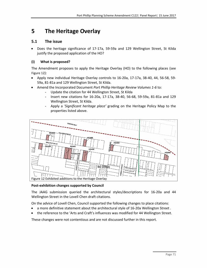
Port Phillip Planning Scheme Amendment C122 Panel Report 15 June 2017
Page 71
5 The Heritage Overlay
5.1 The issue
Does the heritage significance of 17‐17a, 59‐59a and 129 Wellington Street, St Kilda justify the proposed application of the HO?
(i) What is proposed?
The Amendment proposes to apply the Heritage Overlay (HO) to the following places (see Figure 12):
Apply new individual Heritage Overlay controls to 16‐20a, 17‐17a, 38‐40, 44, 56‐58, 59‐59a, 81‐81a and 129 Wellington Street, St Kilda.
Amend the Incorporated Document Port Phillip Heritage Review Volumes 1‐6 to: - Update the citation for 44 Wellington Street, St Kilda - Insert new citations for 16‐20a, 17‐17a, 38‐40, 56‐68, 59‐59a, 81‐81a and 129
Wellington Street, St Kilda. - Apply a ‘Significant heritage place’ grading on the Heritage Policy Map to the
properties listed above.
Figure 12 Exhibited additions to the Heritage Overlay
Post‐exhibition changes supported by Council
The JAAG submission queried the architectural styles/descriptions for 16‐20a and 44 Wellington Street in the Lovell Chen draft citations.
On the advice of Lovell Chen, Council supported the following changes to place citations:
a more definitive statement about the architectural style of 16‐20a Wellington Street .
the reference to the ‘Arts and Craft’s influences was modified for 44 Wellington Street.
These changes were not contentious and are not discussed further in this report.

Port Phillip Planning Scheme Amendment C122 Panel Report 15 June 2017
Page 72
(ii) Planning and policy context
There is clear state and local policy support for the protection of places of heritage significance.
The objectives for planning in Victoria in the Act include ‘to conserve and enhance those buildings, areas or other places which are of scientific, aesthetic, architectural or historical interest, or otherwise of special cultural value.’ 17 This intent is reaffirmed and amplified in the following State planning policies:
Clause 11.04‐4 (Liveable communities and neighbourhoods), which is reinforced in Initiative 4.7. of Plan Melbourne
Clause 11.06‐9 (Cultural heritage and landscapes), which highlights the importance of cultural heritage and landscapes as economic and community assets.
Clause 15.03‐1 (Heritage conservation) which aims ‘To ensure the conservation of places of heritage significance’ through strategies that include:
Identify, assess and document places of natural and cultural heritage significance as a basis for their inclusion in the planning scheme.
Provide for the conservation and enhancement of those places which are of, aesthetic, archaeological, architectural, cultural, scientific, or social significance, or otherwise of special cultural value.
Encourage appropriate development that respects places with identified heritage values and creates a worthy legacy for future generations.
Retain those elements that contribute to the importance of the heritage place.
Encourage the conservation and restoration of contributory elements.
Ensure an appropriate setting and context for heritage places is maintained or enhanced.
Support adaptive reuse of heritage buildings whose use has become redundant.
State policy to protect significant heritage places is amplified in the following local policy MSS Clause 21.05‐1 (Heritage) and the Clause 22.04 Heritage Policy, which aims, amongst other things, to:
To retain and conserve all significant and contributory heritage places.
To discourage the demolition of significant and contributory heritage places.
To ensure all new development and redevelopment of significant and contributory places is respectfully and harmoniously integrated with the surrounding character.
To promote design excellence (in terms of building siting, scale, massing, articulation and materials) which clearly and positively supports the heritage significance of all Heritage Overlay areas.
17 Section 4(d) of the Act and Clause 10.02.

Port Phillip Planning Scheme Amendment C122 Panel Report 15 June 2017
Page 73
To ensure that new development and any publicly visible additions and/or alterations in or to a heritage place maintains the significance of the heritage place and employs a contextual design approach.
The Amendment proposes to update the incorporated document Port Phillip Heritage Review – Volumes 1 – 6 (Version 21, 21 March 2017), which includes the City of Port Phillip Heritage Policy Map and the City of Port Phillip Neighbourhood Character Policy Map.
The local planning policy framework and the Practice note indicate the threshold for inclusion in the HO is ‘local significance’. The key issue to be addressed is whether the proposed additions to the HO reach the threshold of local heritage significance to justify its inclusion in the overlay to ensure significant heritage values are considered in future planning decisions.
(iii) The assessment underpinning proposed Heritage Overlays
Evidence from Anita Brady outlined the assessment of heritage significance18 in the Precinct that informed the Framework and underpinned the proposed application of the HO. The assessments undertaken by Lovell Chen comprised the:
Heritage Appraisal, 16‐20a & 44 Wellington Street, St Kilda (May 2015) which concluded that both 16‐20a and 44 Wellington Street are of local historical and architectural significance; both were recommended for individual inclusion in the HO.
Draft Heritage Review, Wellington, Crimea and Redan Streets, St Kilda (October 2015) which reviewed the heritage significance of specific properties in those streets and assessed the merits of precinct based heritage controls in Wellington Street, recognising the role of the street as a former tram route. Properties in Crimea and Redan streets that were identified as warranting consideration for inclusion in the HO will be the subject of a separate future Planning Scheme amendment.
Heritage Review, Wellington Street, St Kilda, (March 2017) which assessed specific properties in Wellington Street 38‐40, 56‐58 and 59 Wellington Street ‐ as well as those identified by Lovell Chen as potentially having heritage significance in the initial research and field work.
5.2 An extended or new heritage precinct in Wellington Street
(i) Submissions and evidence
At the hearing JAAG sought greater protection of heritage values in Wellington Street through either extension of the existing precinct (HO6) or a new precinct(s). JAAG questioned Lovell Chen’s findings that Wellington Street, or substantial parts thereof, did not warrant inclusion in the HO.
18 Ms Brady advised that the Lovell Chen assessments reviewed the previous heritage assessments for
each property; undertook historical research to assist in documenting the history of the buildings and understanding the degree of alteration; inspected each property from the public domain; undertook a comparative analysis to with similar properties included in the Port Phillip HO; and assessed each building against the HERCON criteria to determine the heritage significance.
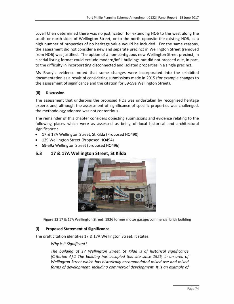
Port Phillip Planning Scheme Amendment C122 Panel Report 15 June 2017
Page 74
Lovell Chen determined there was no justification for extending HO6 to the west along the south or north sides of Wellington Street, or to the north opposite the existing HO6, as a high number of properties of no heritage value would be included. For the same reasons, the assessment did not consider a new and separate precinct in Wellington Street (removed from HO6) was justified. The option of a non‐contiguous new Wellington Street precinct, in a serial listing format could exclude modern/infill buildings but did not proceed due, in part, to the difficulty in incorporating disconnected and isolated properties in a single precinct.
Ms Brady’s evidence noted that some changes were incorporated into the exhibited documentation as a result of considering submissions made in 2015 (for example changes to the assessment of significance and the citation for 59‐59a Wellington Street).
(ii) Discussion
The assessment that underpins the proposed HOs was undertaken by recognised heritage experts and, although the assessment of significance of specific properties was challenged, the methodology adopted was not contentious.
The remainder of this chapter considers objecting submissions and evidence relating to the following places which were as assessed as being of local historical and architectural significance :
17 & 17A Wellington Street, St Kilda (Proposed HO490)
129 Wellington Street (Proposed HO494)
59‐59a Wellington Street (proposed HO496)
5.3 17 & 17A Wellington Street, St Kilda
Figure 13 17 & 17A Wellington Street: 1926 former motor garage/commercial brick building
(i) Proposed Statement of Significance
The draft citation identifies 17 & 17A Wellington Street. It states:
Why is it Significant?
The building at 17 Wellington Street, St Kilda is of historical significance (Criterion A).1 The building has occupied this site since 1926, in an area of Wellington Street which has historically accommodated mixed use and mixed forms of development, including commercial development. It is an example of

Port Phillip Planning Scheme Amendment C122 Panel Report 15 June 2017
Page 75
a purpose‐built motor garage with a separate commercial tenancy at ground floor level, and spaces above. It was constructed at a time when motor car ownership and usage was increasing, and motor garages were being built across inner Melbourne. Most were built for a single purpose, i.e. to service motor vehicles, although some also incorporated other uses, as is the case with no 17 Wellington Street. In this way the building is an unusual example of its type, although it no longer reads as a former garage. The use of the building as a motor garage, or a motor vehicle related operation from the 1920s until at least the mid‐1970s, is also of note.
Aesthetically, no 17 Wellington Street, St Kilda, is significant as a largely externally intact former garage which combined other uses (Criterion E).2 It has simple interwar detailing, with a symmetrically composed presentation to Wellington Street. The first floor facade has a wide stepped horizontal band above ground floor level and a cornice below the dentilated parapet. The eastern ground floor bay originally contained a vehicle opening, which was subsequently modified and is now infilled. This would also have been a prominent element to Wellington Street. As a building type, the historical multi‐purpose use and spaces is also of note.
(ii) Submissions and evidence
The owners of 17‐17A Wellington Street objected in September 2015 to the draft Framework identification of their property as individually significant. The submission noted that the building façade is not original and a severe fire in the 1980s burnt the building to a shell. Photographs from the owner and research by Lovell Chen confirmed there had been post‐fire repair to the ground floor façade (including the roller door); cement dressing to the first floor façade; the first floor window in the front façade was replaced (apparently in a ‘like‐for‐like’ form); and in 2007 the ground floor façade was modified to facilitate restaurant use, with a new wall where the roller door had previously been.
Ms Brady highlighted in her evidence that the draft citation acknowledged that the ground floor façade was not original and noted the citation notes it is not significant. She maintained the view that the property is individually significant, stating:
With regard to the first floor and after reviewing the documentation provided to and from Council, it is evident that the painted render contrast (cement dressing) is not original. However, the stepped horizontal band separating ground and first floor, the cornice and brick dentilated parapet are original. The uniform window openings are original and although the windows have been replaced, these match the original detail. The replacement of original fabric in a like‐for‐like manner is supported by Council’s Heritage Policy. The original interwar detailing at first floor level described in the statement of significance remains evident and the historical significance of the building as a purpose‐built motor garage with spaces above also remains as outlined in the statement of significance.
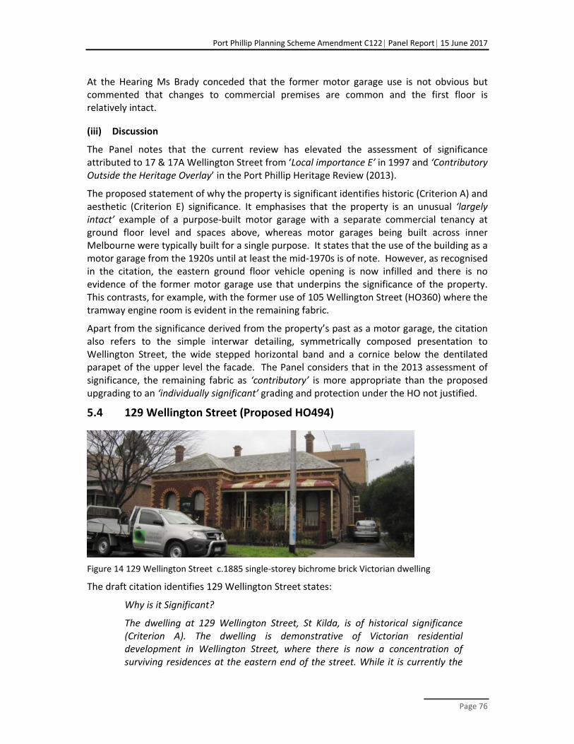
Port Phillip Planning Scheme Amendment C122 Panel Report 15 June 2017
Page 76
At the Hearing Ms Brady conceded that the former motor garage use is not obvious but commented that changes to commercial premises are common and the first floor is relatively intact.
(iii) Discussion
The Panel notes that the current review has elevated the assessment of significance attributed to 17 & 17A Wellington Street from ‘Local importance E’ in 1997 and ‘Contributory Outside the Heritage Overlay’ in the Port Phillip Heritage Review (2013).
The proposed statement of why the property is significant identifies historic (Criterion A) and aesthetic (Criterion E) significance. It emphasises that the property is an unusual ‘largely intact’ example of a purpose‐built motor garage with a separate commercial tenancy at ground floor level and spaces above, whereas motor garages being built across inner Melbourne were typically built for a single purpose. It states that the use of the building as a motor garage from the 1920s until at least the mid‐1970s is of note. However, as recognised in the citation, the eastern ground floor vehicle opening is now infilled and there is no evidence of the former motor garage use that underpins the significance of the property. This contrasts, for example, with the former use of 105 Wellington Street (HO360) where the tramway engine room is evident in the remaining fabric.
Apart from the significance derived from the property’s past as a motor garage, the citation also refers to the simple interwar detailing, symmetrically composed presentation to Wellington Street, the wide stepped horizontal band and a cornice below the dentilated parapet of the upper level the facade. The Panel considers that in the 2013 assessment of significance, the remaining fabric as ‘contributory’ is more appropriate than the proposed upgrading to an ‘individually significant’ grading and protection under the HO not justified.
5.4 129 Wellington Street (Proposed HO494)
Figure 14 129 Wellington Street c.1885 single‐storey bichrome brick Victorian dwelling
The draft citation identifies 129 Wellington Street states:
Why is it Significant?
The dwelling at 129 Wellington Street, St Kilda, is of historical significance (Criterion A). The dwelling is demonstrative of Victorian residential development in Wellington Street, where there is now a concentration of surviving residences at the eastern end of the street. While it is currently the

Port Phillip Planning Scheme Amendment C122 Panel Report 15 June 2017
Page 77
last dwelling on the north side at this end, it was originally part of a more extensive group which continued further eastwards to Chapel Street. These dwellings were demolished in the late 1960s, as part of the broader work involving the St Kilda Junction upgrade. The association with Wellington Street is also significant in that the street is evident as an early main road in the 1855 Kearney map of Melbourne. It historically accommodated a tram line, which was also removed in the late 1960s, but underscores the importance of the road in the St Kilda context. The dwelling, while not large, is a handsome example of an Italianate villa, which befits its ‘main road’ address and provides evidence of the prestigious residential status of Wellington Street in the nineteenth century.
Architecturally, no 129 Wellington Street, St Kilda is a well resolved and substantially externally intact example of an 1880s single‐storey Victorian brick Italianate villa (Criterion E).2 It is also prominently sited at the east end of Wellington Street. The bichrome brickwork, combined with the highly visible slate‐clad hipped roof forms and chimneys enhance its presentation. The verandah form is also of note.
(i) Submissions and evidence
The owners of 129 Wellington Street sought deletion of proposed HO494, arguing that the heritage significance of the property does not justify its protection. The submission noted that:
the extension to the rear was not particularly sympathetic
when the property was purchased approximately three years ago (with an intention to redevelop the site consistent with other development on the north side of the street), it was not identified as having any heritage significance
the property was passed over by various heritage studies.
It was submitted that a mixed use redevelopment of the site would provide the opportunity to improve activation and surveillance of the adjoining park, to improve the currently unattractive interface with Queens Way and to address the corner of Queens Way and Chapel Street with a taller form.
An assessment by Mr Raworth was appended to the submission on behalf of the property owner. Unfortunately, the assessment could not be tested because he was overseas when the hearing was held. His assessment acknowledged that the property is a substantially intact Victorian dwelling with a later addition to the rear but he considered the building to be ‘representative, that is to say typical and unremarkable’ and there are many other examples, including in significantly intact streetscapes, in the municipality. He commented that ‘this modest level of architectural interest, ie representative only, might be considered of contributory value in the context of a heritage precinct…’ Mr Raworth concurred with the Lovell Chen view that an extended or new precinct HO for Wellington Street properties is not justified. He expressed the view that the proximity of the property to modern infill development also detracts from the significance the house may have had within the street. Thus, he did not support the view that this building is of individual significance due to its historical associations with Wellington Street:

Port Phillip Planning Scheme Amendment C122 Panel Report 15 June 2017
Page 78
..it is not possible to understand the history of Wellington Street as an example of a Victorian residential development through the protection and retention of this single dwelling in isolation….. In terms of its associations with the tram line that was once present in the street, the road and street itself may be significant but the individual house is not directly associated with the tram line. In the absence of the tram line itself, the value of retaining the house to suggest its former presence is questionable.
Ms Brady acknowledged that, while the grading of the heritage significance of the property has differed, it was more highly graded as ‘A2’ when Wellington Street was in the City of Prahran. Given the time that has elapsed since earlier assessments, it was reasonable to reassess the property. It was her view that:
The dwelling at 129 Wellington Street is still demonstrably an historic dwelling, and acknowledged by Mr Raworth as being (to the front part of the building) an intact late Victorian villa. The significance of this individual property does not rely on an adjacency to other significant or contributory properties. It has significance in its own right, irrespective of the presence of non‐heritage development, and that significance is greater than a ‘modest level of architectural interest’.
While Ms Brady acknowledged that the concentration of surviving Victorian houses tend to be on the south side of the Wellington Street (generally in HO6), she questioned the degree to which the visual and spatial separation from other Victorian dwellings in the street diminishes its significance. Ms Brady considered the significance of the house draws on, but does not rely solely on the association with Wellington Street as an early and prestigious street in St Kilda. The combination of an early history, and a tram line, goes directly to the important history of the street.
Ms Brady accepted there are many similar examples in the municipality but noted that:
the threshold for inclusion in the HO is local significance ‐ being ‘Exceptional’ is not the test.
a limit should not be put on the number of similar dwellings which are protected by heritage controls and placing controls on more of these ‘deserving dwellings will maintain evidence of this important phase of Victorian development in St Kilda.’
It was Ms Brady’s view that the property
..is clearly a Victorian dwelling, and one which is a remnant of a once larger collection. That is part of its inherent historical significance. It is also in the vicinity of other Victorian dwellings in the eastern section of Wellington Street. On this basis, it is able to ‘illustrate’ aspects of the history of the Victorian development of the street, which goes directly to its historical significance.
(ii) Discussion
The Panel notes that the previous assessment of significance attributed to 129 Wellington Street identified the property as “A2’ grading in the Prahran Character & Conservation Study (1992) Building Grading Register, ‘Local importance D’ in 1997 Field Notes and was not identified in the Port Phillip Heritage Review (2013).

Port Phillip Planning Scheme Amendment C122 Panel Report 15 June 2017
Page 79
Despite a heritage precinct existing directly opposite this site on the southern side of Wellington Street, assessments when the Precinct was created and more recently to inform the Framework and the Amendment did not recommend the inclusion of this property in either the existing precinct or a new precinct. The Panel agrees with Mr Raworth that this brings into question the references in the citation to historical associations with other Victorian houses in Wellington Street. The Panel also agrees with Mr Raworth that Wellington Street may have historic significance as an important road but there is now no apparent link between the property and the tramline that no longer exists.
Therefore, the justification of an individual HO largely falls to whether the building is of sufficient significance and this is a matter of judgement. Whereas the value of some aspects of our heritage are being addressed through ‘gap’ studies, such as industrial properties and more recent development is being increasingly recognised, this does not apply to Victorian houses. As the property was not included when heritage protection was extensively applied to this local area suggests that its proposed designation as individually significant appears to be marginal. Nevertheless, there is consensus that the property is an intact, representative example of a Victorian house, and comparable houses have been accepted as reaching the threshold of local heritage significance to justify inclusion in the HO.
5.5 59‐59a Wellington Street (proposed HO496)
Figure 15 59‐59a Wellington Street (Two‐storey Victorian dwelling)
(i) Proposed Statement of Significance
The draft citation identifies 59‐59A Wellington Street states:
Why is it Significant?
The property at 59‐59A Wellington Street, St Kilda, is of local historical significance. It was originally constructed in c.1885 as a single dwelling, one of a number of Victorian residential dwellings in Wellington Street at this time. It was subdivided into two dwellings in c.1909, with the western bay added between 1909 and c.1925‐35 to accommodate this change.
Architecturally, the property presents as a generally symmetrical two‐storey form distinguished by a two‐storey verandah with decorative iron work,

Port Phillip Planning Scheme Amendment C122 Panel Report 15 June 2017
Page 80
canted bay windows and a slate clad roof. While not the original form of the building, the presentation of the facade with the western bay addition, is demonstrative of the early subdivision of the building and represents a comparatively early change in the history of the property.
(ii) Submissions and evidence
The owner of 59‐59a Wellington Street, St Kilda objected to the inclusion of their property in the HO based on an assessment by heritage consultant John Briggs, who concluded, in summary, that the double‐storey Victorian building is:
a relatively unremarkable example of a type that is widely represented in the municipality
not part of a cohesive streetscape with any prevailing character or heritage context and its visibility from the street is limited by the building’s location between modern buildings of at least five storeys right up to the boundary.
Ms Brady acknowledged that the building is not part of a cohesive streetscape and is adjoined by modern buildings, which limit the visibility of the historic dwelling from Wellington Street. However, she maintained that the dwellings:
clearly reads as survivors from an earlier period in a collection of such dwellings distributed along Wellington Street.
are examples of double‐storey Victorian dwellings, and placing an individual heritage control on them will assist with the retention of the municipality’s Victorian heritage and evidence of this important historical phase in St Kilda.
(iii) Discussion
The Panel notes that the current review has elevated the assessment of significance attributed to 56‐58 Wellington Street from ‘Local importance D’ in 1997 to ‘Contributory Outside the Heritage Overlay’ in the Port Phillip Heritage Review (2013). The recent assessment as contributory suggests that the place is on the margins of the threshold of significance.
Unfortunately, the Panel did not have the benefit of evidence from Mr Briggs and his views were not tested at the Hearing.
Many of the same issues as discussed in relation to 129 Wellington Street apply to this property, that is, it has been overlooked when heritage protection has been applied to this area and many apparently better examples of Victorian houses are protected in the locality. While the Panel accepted that the HO should apply to 129 Wellington Street, this property is less intact and its context means that it has less ‘presence’ in the street or linkage to the heritage precinct on the other side of the street. The Panel considers the threshold of individual significance to justify protection through the HO should be higher than ‘reading as a survivor of the era’, particularly when many better examples have been protected in the immediate locality.

Port Phillip Planning Scheme Amendment C122 Panel Report 15 June 2017
Page 81
5.6 Conclusions
The Panel concludes:
In the absence of remaining fabric that illustrates the former motor garage use, 17 and 17A Wellington Street does not meet the threshold of individual significance to justify the proposed HO.
There is consensus that 129 Wellington Street is an intact, representative example of a Victorian house and comparable houses have been accepted as reaching the threshold of local heritage significance
59‐59a Wellington Street, St Kilda does not reach the threshold of individual local heritage significance to justify its inclusion in the HO.
5.7 Recommendations
The Panel makes the following recommendations:
Remove the following properties from the proposed Heritage Overlay:
17 and 17A Wellington Street, St Kilda (proposed HO490).
59‐59a Wellington Street (proposed HO496)

Port Phillip Planning Scheme Amendment C122 Panel Report 15 June 2017
Page 82
6 Other issues
6.1 Public realm improvements
(i) The issue
Does the Amendment recognise and implement opportunities to improve the public realm?
(ii) Submissions
CAPP highlighted that the potential increase in population will make this area one of the most densely populated areas in the City of Port Phillip but ‘there is little evidence that C122 provides adequately for such liveability enhancements for increasing numbers of residents in the area.’ CAPP submitted that, in addition to supporting the predicted increases in population, the additional public open space in the area would enhance environmental outcomes, including city cooling.
CAPP argued that many remnant sites on the western side of St Kilda Road are too small for any redevelopment and this land should be either incorporated into adjoining zones or designated for landscaped open space. Remnant land at the eastern end of Waterloo Crescent was identified as an opportunity to improve the public realm and for a pedestrian overpass (discussed in Chapter 6.3). CAPP believes the embankment and remnant land in this area should be removed from the DDO and be rezoned for public purpose.
Council submitted that the proposed land use and built form controls place strong emphasis on new development that strengthen identity and place, creates a great place to live and is easily accessible for all. Specifically, by requirements that the public realm include:
ground level uses and 'active edges’ that activate the public realm
pedestrian scale street‐walls, building heights and recessed upper level to ensure development does not overwhelm the street
well‐articulated building design on large sites to maintain a fine urban grain
maintaining solar access to the southern footpaths
create landscaped setbacks (green links) along Wellington and Carlisle Streets
locating vehicle access and car parking to the rear of sites.
Council referred to public realm improvements and public infrastructure upgrades that help to implement the Framework and support planning scheme provisions. They including improvements to footpaths, street tree plantings and street lighting. Council cited the example of improvement works to the Wellington Street (that were underway during the Panel process) comprising improved intersections, extending the central median, new kerb outstands, simplification of traffic movements and new trees in the central median. These works support the Framework objectives by improving traffic management, connections for pedestrian and bike riders; reducing traffic volumes in the street and increasing the potential for footpath trading; they also support the Greening Port Phillip ‐ Council's Urban Forest Strategy.

Port Phillip Planning Scheme Amendment C122 Panel Report 15 June 2017
Page 83
Council acknowledged that the Framework does not specifically propose new open space sites within the Precinct, although a series of neighbourhood 'pause places' will provide opportunities for people to meet and rest and open space is identified as one option for the future re‐use of the Council owned car park at 98 Inkerman Street. Improvements to existing local open spaces (including Jim Duggan Reserve, Alma Park, Crimea Street Reserve, Pakington Street Reserve and Waterloo Crescent) will seek to increase the functionality and capacity of these spaces and will be informed by public consultation.
The Framework identifies improvements in walking and cycling routes through the Precinct and beyond.
Council advised that the Framework identifies that some sites on the western side of St Kilda Road that were 'left over' from the road widening could be used to help reinstate the building edge (potentially through consolidation with other adjoining sites) or as public spaces that encourage activity along the street. During the hearing, Council advised that a project is underway to clarify the future of these remnant parcels of land.
Council responded that, although the DDO applies to the embankment and strip of land between St Kilda Road and Waterloo Crescent, the embankment and pathways are in Public ownership (Council and VicRoads) and would not be subject to development. Council does not consider it necessary to remove these sites from the DDO.
(iii) Discussion
Public realm improvements are central to the renewal of the Precinct and the maintenance of its liveability for existing and future residents. The planning scheme provisions are directed primarily at managing development of the private realm, while being cognisant of the implications for the public realm and opportunities to improve it. The Panel is satisfied that the Framework recognises the importance of supporting initiatives within the public realm. Their implementation will be need more detailed planning and community consultation, within the context provided by the Framework.
With regard to ‘left over’ land along the western side of St Kilda Road, the Panel endorses Council’s intention to assess the optimum future of the underused land, either as landscaped public space or for development as part of adjoining sites. It is noted that the latter option may well produce a better outcome where the adjoining land has redevelopment potential and the space can contribute to creating a strong edge to the boulevard.
The Panel agrees with CAPP that the land at Waterloo Crescent presents a good opportunity for improved treatment of the public space. However, rezoning to public use is not necessary to achieve that outcome. As Council suggested, it is common practice to include small public open spaces in the zone that applies to the surrounding land. The viability of an overpass, should be considered as part of the project that is currently being undertaken.
As discussed in Chapter 4, while securing the amenity and safety of green links and other important pedestrian and cycling routes are endorsed, the Panel questions the justification for the proposed solar access requirements along the length of the nominated roads.

Port Phillip Planning Scheme Amendment C122 Panel Report 15 June 2017
Page 84
(iv) Conclusions
The Panel concludes:
The planning scheme provisions are cognisant of the implications for the public realm and opportunities to improve it and Council proposes supporting initiatives within the public realm (which will be subject to detailed planning, community consultation, and funding constraints).
In addition to options for landscaping, the proposed assessment of the optimum future for ‘left over’ land along the western side of St Kilda Road should consider the benefit from including the space in redevelopment sites for the creation of a strong edge to the boulevard.
The land at the eastern end of Waterloo Crescent presents a good opportunity for improved treatment of the public space but rezoning to public use is not necessary.
While securing the amenity and safety of green links and other important pedestrian and cycling routes are endorsed, the Panel questions the justification for the proposed solar access requirements along the length of the nominated roads.
6.2 Managing flooding
(i) The issue
Has planning for the Precinct and the Amendment recognised the effects of flooding?
(ii) Submissions
CAPP submitted that the history of St Kilda Road and it topography requires planned flood mitigation measures in the area. It highlighted that on the western side of St Kilda Road between Blanche and Vale Streets the Shakespeare Main Drain is liable to flooding. While the Special Building Overlay (SBO)19 explicitly addresses the issue, CAPP submitted that other elements of the planning framework proposed by the Amendment (and Amendment C123) need to take account of measures required to mitigate the impact of flooding.
Council advised that the SBO, which was reviewed in 2015 (Amendment C111) affects a small number of properties within the Precinct ‐ in lnkerman Street, Market Street and St Kilda Road between lnkerman and Carlisle Streets. Council noted that, in addition to the SBO, the Planning Scheme encourages new development to manage additional pressure on the local drainage system through on‐site storm‐water retention and reuse. Further, Council and Melbourne Water have an on‐going program of infrastructure works to reduce flooding impacts.
Council submitted that, as is the normal practice at the planning permit stage, the proposed DDO27 provisions need to be read in conjunction with SBO provisions, including the need to take raised floor levels into account in areas subject to flooding.
19 The SBO affects properties within the Precinct in Inkerman Street and Market Streets and along the
western side of St Kilda Road between Inkerman and Carlisle Streets. The boundaries of the SBO were reviewed in 2015 (Amendment C111).

Port Phillip Planning Scheme Amendment C122 Panel Report 15 June 2017
Page 85
(iii) Discussion
As Council noted, in addition to the zoning and the proposed DDO27, the recently updated SBO specifically addresses flooding issues in parts of the Precinct. However, the proposed DDO27 does not explicitly acknowledge the implications for nominated building and street wall height of requirements for minimum floor areas in areas prone to flooding. The recent changes to the residential zones address this issue as follows:
Building height if land is subject to inundation
If the land is in a Special Building Overlay, Land Subject to Inundation Overlay or is land liable to inundation the maximum building height specified in the zone or schedule to the zone is the vertical distance from the minimum floor level determined by the relevant drainage authority or floodplain management authority to the roof or parapet at any point.
A comparable provision in DDO27 would avoid floor to floor heights being compromised for the mix of uses envisaged for the Precinct. This is particularly important where the heights specified are mandatory limits but would also clarify expectations where heights are discretionary.
(iv) Conclusion
The Panel concludes:
DDO27 should specifically provide for building and street wall height in areas subject to flooding that take account of the need to set floor levels that avoid inundation.
(v) Recommendation
Insert a provision in Schedule 27 to the Design and Development Overlay to relate building and street wall height to the minimum floor level determined by the relevant drainage authority or floodplain management where land is subject to inundation. For example:
Building and street wall height if land is subject to inundation If the land is in a Special Building Overlay or is liable to inundation the maximum building height and street wall height specified in this schedule is the vertical distance from the minimum floor level determined by the relevant drainage authority or floodplain management authority to the roof or parapet at any point.
6.3 Transport
(i) The issue
Has planning for the Precinct addressed the implications of more intensive development for all modes of transport?
(ii) Submissions
CAPP, Ms Provis and other resident submitted that there should be no future development, or the scaling down of the size of developments due to the intractable nature of traffic

Port Phillip Planning Scheme Amendment C122 Panel Report 15 June 2017
Page 86
issues on the western side of St Kilda Road (between Alma Road and Carlisle Street) and the associated impacts for residents in the areas behind. It was submitted that, as the Amendment fails to recognise the lack of vehicular access to the sites facing St Kilda Road and major car parking issues, it is probable that either sites will be unable to be developed or they will rely on access from residential streets such as Charles Street.
Residents also raised concerns about the impacts of increased traffic and parking from new development on local roads to the east of St Kilda Road, particularly to Charnwood Crescent, Wellington Street and Nelson Street, and the imperative to ensure new developments incorporate adequate car parking.
Concerns about the effects of intensive forms of development extended to:
the need to ensure pedestrian safety, particularly on St Kilda Road, with improved crossing points, access to public transport and traffic calming measures.
the strain on the public transport system which is already struggling to meet current demand.
CAPP submitted that problems such as the width of St Kilda Road and opportunities for pedestrian access have been identified but are not resolved. It argued that the Amendment should ‘embrace opportunities for pedestrian overpasses, byways or alternative pathways and provide a clear investment strategy for location of open space throughout the Amendment C122 area and its hinterland. CAPP suggested there would be substantial benefit to the community from an elevated link at the eastern end of at Waterloo Crescent to take advantage of the topography, provide a safe link to the eastern side of St Kilda Road and the centrally located tram stop.
Council submitted that planning for the Precinct recognised the implications of the area becoming more dense for the capacity of the road network, access and parking. Council referred the Panel to the Transport, Parking Capacity and Demand Study20 which considered the demands of projected growth in the Precinct for each transport mode (including walking, cycling, public transport, traffic and access, and car parking) and identified parameters for access and parking rates.
Council summarised the Transport Study conclusions as:
the main barrier to pedestrians is St Kilda Road which requires pedestrians to cross more than 50 metres of road reserve which includes ten traffic and parking lanes and a tram corridor;
to allow bike riding as a viable mode choice, future development needs to accommodate amenity for bicycle ownership including ease of access and secure parking;
from the forecast development, the Study calculated approximately 1000 additional residents will be seeking to use public transport services on a daily basis;
an estimated 4,834 vehicle trips per day will be generated across the study area with the forecast development changes, over the next 15
20 St Kilda Road South Precinct Transport and Parking Capacity and Demand Study Stage 2 Final Report
Ratio Consultants June 2015

Port Phillip Planning Scheme Amendment C122 Panel Report 15 June 2017
Page 87
years … (comprising) 2825 trips per day being generated west of St Kilda Road, 1230 trips generated east of St Kilda Road and 778 trips generated within Wellington Street. The traffic is most likely to disperse along St Kilda road and then in an east ‐west direction.
Public car parking in the Precinct is almost entirely on‐street with surveys indicating the following: lnkerman Street , Wellington Streets and Alma Road, as well as
several minor local streets, are experiencing high parking demands during the weekday day and evening ;
Alma Road and lnkerman Street are experiencing high demands during the daytime on Saturday; and
lnkerman Street Wellington Streets and Alma Road are experiencing moderate demands during Saturday evenings.
All new development is expected to provide onsite parking for residents and employees. Council acknowledged that policy21 supports reduced car parking provision, however, where dispensations are granted parking permits will not be issued. Car parking controls such as time‐based restrictions also manage on‐street parking.
Council strategies accord priority to walking, biking and public transport use over personal transport. The Panel was referred to a range of strategic planning work that informed the Framework, including:
The Sustainable Transport Strategy (2011), which seeks to improve sustainable travel choices by widening footpaths, reallocating road space in favour of pedestrians and bike riders, and local area traffic management that reduce the convenience of car use.
The Walk Plan 2011‐2020 (2011) establishes a walking network that connects key destinations and includes implementing the principal pedestrian network, creating more convenient crossings and improving the accessibility and safety of the walking environment with lighting, raised crossings, wider paths and way finding signage.
Bike Plan 2011‐2020 ‐ Pedal Power: Making Bike Riding Better (2011) proposes a commuter bike route to Wellington Street and a connecting bike route to Carlisle Street. Council highlighted that bike riders travelling to the city encounter busy traffic conditions only suitable for confident bike riders, with exposure of bike lanes on St Kilda Road and the complexity of St Kilda Junction identified as major impediments and hazards to commuter riding. Arterial road crossings of St Kilda Road at Alma Road, Inkerman Street and Carlisle Street are also heavily used but provide limited protection or priority for bike riders.
The Public Transport Advocacy Statement (2009) outlines key improvements Council will advocate for, including upgrading of tram stops and improving bus priority within the municipality.
Tram Stop Refurbishment Strategy 2007‐2017 (2008)
Council noted that DDO27:
requires applications to include a traffic and parking report which includes consideration of the cumulative impacts of development.
21 Clause 21.03

Port Phillip Planning Scheme Amendment C122 Panel Report 15 June 2017
Page 88
'General design requirements' direct vehicle access to the side or rear of lots, wherever possible, and ideally access would be provided at the nearest lane or other main roads such as Alma Road, lnkerman and Carlisle Streets. Council submitted that:
Under these scenarios access is considered to have a limited impact to local streets, mostly being contained to peak hour. Vehicle access arrangements are carefully considered, looking at multiple access points so that traffic generation does not concentrate in one particular side street.
Council also acknowledged that potential amenity impacts include noise from vehicles, but submitted that residential properties abutting laneways that provide vehicle access to properties in the C1Z should expect some amenity impacts.
Council advised that:
A Parking Overlay that would apply across the whole of the City of Port Phillip is being considered, together with sustainable parking rates across a range of mixed use precincts/activity centres.
The Framework objectives to enhance pedestrian and cycling linkages will largely be implemented outside the Planning Scheme, with detailed strategies and initiatives to be implemented through capital works, advocacy to VicRoads and Public Transport Victoria (PTV)22. These include:
- Working with VicRoads to improve pedestrian crossing times at St Kilda Junction and across St Kilda Road.
- improved bike riding facilities and links throughout the Precinct, including protected bike lanes along St Kilda Road.
- the predicted development capacity would support advocacy to influence PTV decisions about public transport capacity and levels of service.
(iii) Discussion
The Panel is satisfied that the Framework was informed by analysis of the implications of more intensive development for each mode of transport and parking. This analysis does identify existing peak hour congestion (with acceptable operation of intersections) and significant areas where car parking pressures already exist. The analysis suggested there is compelling evidence that there will be a net increase in alternative travel trips across the Precinct, particularly residents commuting to work from the Study Area, and identified numerous ways to improve the existing conditions. As Council highlighted, many of the initiatives to address transport issues sit outside the purview of the planning scheme and the Amendment.
The Panel considers the benefits of living in inner city and other highly accessible locations often involves accepting a higher level of congestion than is reasonably expected in areas with lower levels of service and infrastructure; this is likely to continue as the Precinct is renewed.
The Panel has commented earlier that the proposed planning for the ‘Review Areas’ should incorporate the part of the Precinct to the west of St Kilda Road (south of Waterloo
22 Section 3.4 of the Framework.

Port Phillip Planning Scheme Amendment C122 Panel Report 15 June 2017
Page 89
Crescent) to enable an integrated approach to planning for the area. Traffic and access management in this area does not promote permeability for vehicles movements and the proposed work should specifically address implications for both existing properties and new development. While there should be further consideration of traffic management, particularly to the west of St Kilda Road, this should not stall revitalisation of the Precinct.
Whereas Council submitted that a Parking Overlay and rates would be addressed more broadly, the Amendment proposed the following detailed Precinct‐specific changes to MSS Clause 21.06:
6.6.41 Ensure new use and development is self‐sufficient in on‐site car parking.
6.6.42 Ensure that new development provides on‐site car, bicycle and motor‐cycle parking, and loading facilities as follows:
Dwellings: 1 car space to each 1 and 2 bedroom dwelling; 2 car spaces to each 3 or more bedroom dwelling.
Office: A ‘sustainable rate’ of 3.0 car spaces per 100m2.
For residential development, secure bicycle parking at a rate of 1 space per dwelling and publicly accessible bicycle parking for visitors at a rate of 1 space per 5 dwellings
Motor‐cycle parking at a minimum rate of 1 motor‐cycle parking space for every 100 car parking spaces to be provided on‐site within new development
Residential and mixed use development proposals meet their obligations to provide on‐site accessible car parking
In mixed use and commercial developments, provision of a loading bay
In residential developments of six or more storeys, provision of off‐street loading facilities and allocated spaces for service vehicles.
The rates proposed apply the standard Clause 52.06 parking rate for dwellings and the standard rate for office is reduced from 3.5 spaces to 3 spaces to each 100 square metres of net floor area and the loading bay requirements. The guidance proposed regarding loading bays is also quite generic, although a specific requirement is introduced for residential development of six or more storeys. A more significant change is the increase in the standard Clause 52.34 standards rate of provision of bicycle spaces from 1 space to each 5 dwellings plus 1 visitor space to each ten dwellings developments of four or more storeys to 1 space per dwelling plus 1 visitor space per five dwellings.
The Panel notes the ad hoc approach to specifying parking rates in the Port Phillip Planning scheme. For example, the rates proposed by the Amendment for dwellings and offices are the same as apply in the Carlisle Street Activity Centre (Clause 22.11), Bay Street Activity Centre Policy (Clause 22.14) refers to parking rates in the external document the City of Port Phillip’s Sustainable Transport Policy and Parking Rates Report (2007), while a Parking Overlay applies to Fishermans Bend which specified a lower rate of parking for office space (and as a consequence a lower rate of parking for motor cycles). The Panel considers that, rather than the area‐specific approach proposed, such detailed requirements are more appropriately addressed on a consistent municipality wide basis or across the relevant centres.

Port Phillip Planning Scheme Amendment C122 Panel Report 15 June 2017
Page 90
Nevertheless, the Panel accepts these rates as they align with those in the Carlisle Street Activity Centre and the absence of submissions at the hearing suggested there is broad acceptance of the proposed parking rates and loading requirements. Only Professor McGauran questioned the level of parking to be sought on the basis that comparable transit rich areas are seeking lower rates.
The permit process has an important role in ensuring development satisfies policy and requirements, including for vehicle and pedestrian access and the provision for parking. The constraints in an area and of specific sites may temper the development outcomes that would otherwise be achieved under the planning framework.
The Panel is not aware of Waterloo Crescent being identified as a key east‐west pedestrian or cycling link to justify it as a location for investment in a major St Kilda Road overpass. It is noted that, while the Study recommended improvements to St Kilda pedestrian crossings and nominated a number of locations, it did not identify Waterloo Crescent as a location for improvements. Further, the necessary specific assessment of an option such as an overpass in this location and consultation with VicRoads and the community have not occurred. The Panel does not consider specific reference to this option in the Amendment has been justified.
(iv) Panel Conclusions
The Panel concludes that:
The Framework was informed by analysis of the implications of more intensive development for each mode of transport and parking.
Many of the initiatives to address transport issues sit outside the purview of the planning scheme and the Amendment. The Panel does not consider specific reference the Amendment to the option of an elevated pedestrian link at Waterloo Crescent has been justified.
An integrated approach should be adopted to planning for the land to the west of St Kilda Road (between Waterloo Crescent and Carlisle Street) and this extends to responses to challenging traffic management issues.
The proposed area specific parking and loading requirements are accepted as they were not challenged at the Hearing but should be relocated to the extended DDO27. However, the Panel considers a more consistent approach across the municipality or centres/zones should be developed and implemented, as foreshadowed in submissions from Council.
The assessment of vehicle and pedestrian access and the provision for parking through the permit process may temper the development outcomes.

Port Phillip Planning Scheme Amendment C122 Panel Report 15 June 2017
Page 91
7 The form and drafting of the Amendment
7.1 The issues
Are the proposed MSS provisions appropriate?
Does DDO27 satisfy Ministerial Direction on the Form and Content of Planning Schemes under section 7(5) of the Act (MDF and C)?
Does DDO27 include unnecessary content?
Are the DDO27 provisions clear?
The Panel’s role is to consider submissions relating to the exhibited version of Amendment documents. However, it has taken into account the multiple iterations of the proposed DDO27 put forward by parties to the hearing to address issues they raised. These iterations ranged from the exhibited version, to a pre‐hearing version incorporating changes supported by Council in response to submissions, revisions in expert evidence with a policy neutral version in Mr Glossop’s evidence statement, an annotated version resulting from the ‘virtual conclave’ of experts tabled at the start of the hearing, and the ‘without prejudice’ versions from parties at the end of the hearing.
The discussion in this chapter focuses on the drafting of Amendment documents. The Panel recommendations or reasons for them, in preceding chapters are not restated but are incorporated in the recommended DDO27 in Appendix E. This includes recommendations relating to mandatory requirements, which involve significant redrafting (see Chapter 4.1.4).
(i) Evidence and submissions
Council officers endorsed a number of policy neutral changes put forward in Appendix E of evidence from Mr Glossop. These changes involved:
Deleting unnecessary reference to or duplication of State and local policy, including: - an objective and requirement to incorporate Crime Prevention Through
Environmental Design (CPTED) Principles in the design of new buildings and the public realm
- broad statements about vibrant, safe and attractive places, high architectural standards, diversity of dwelling types, and best practice ESD
- Clause 22.06 (locally contextual urban art) and Clause 22.04 Heritage Policy
Deleting superfluous reference to granting of permit for discretionary requirements
Drawing a clear distinction between mandatory and discretionary requirements through consistent use of the words “must” and “should”
Deleting superfluous reference to granting of permit for discretionary requirements.
Council officers also endorsed some changes to enhance the clarity and readability of the DDO. For example, the inclusion of height maps within the DDO.
Otherwise, Council did not support revisions proposed by parties on the basis that they change the intent of the Amendment.
Alternative DDO formats were considered, including using tables to set out sub‐precinct based objectives and built form requirements (as in Port Phillip DDO1 and DDO7), to approach most recently approved through DDO26 for St Kilda Road North. Council noted

Port Phillip Planning Scheme Amendment C122 Panel Report 15 June 2017
Page 92
that each approach has advantages and disadvantages but submitted that the Panel should not recommend a change to a tabular format without strong grounds. On this point Mr Glossop noted the structural logic of presenting precinct wide and then more localised provisions, the desirability of consistent formats in planning schemes and that the Minister’s authorisation of the Amendment was conditional on some changes. However, he commented:
… It is fair to say that this a cumbersome control to read and apply and there is merit in learning from this experience (DDO26) in this amendment.
While the information is clearly expressed in the exhibited DDO27, the layout requires a user to peruse the entire document to ascertain requirements that are relevant for each individual precinct. A more efficient approach could be to consolidate neighbourhood objectives, preferred character statement and requirements into one location, following all precinct‐wide objectives and requirements.
Mr Glossop considered the Amendment faithfully translates the intent of the Framework. On balance, he endorsed the proposed selection of tools as appropriate, although he observed it may have been more efficient to rely on the DDO27 for implementation of built form for all land in the study area, rather than the proposed mix of zones and overlays.
Other expert witnesses were critical of the length, clarity and unnecessary content in the DDO27. For example, Mr Biacsi expressed the strong view that DDO27 requires substantial redrafting to remove ‘irrelevant or superfluous verbiage’:
It is important that DDO’s be drafted in such a way that they avoid duplication either within the tool itself or with other provisions of the Planning Scheme. Generic provisions or statements of general principle should also be avoided in the drafting of provisions. The DDO is heavily populated with general or motherhood‐style statements of design principle. The inclusion of these only adds to the cumbersome nature of the DDO which at present is already 22 pages in length.
He considered:
The inconsistent terminology is confusing and needs to be clarified and resolved. For example:
- references to the ‘mandated building height’, ‘discretionary maximum height’, discretionary height’, ‘required height’ and ‘overall height’
- the lack of clarity in terms such as ‘low‐rise’, mid‐rise’, ‘high‐rise’ and ‘taller high‐rise’.
The preferred character statements are in general terms, meaningless, unhelpful or otherwise confusing in terms of their relevance and the actual outcomes sought for each individual neighbourhood.
The general nature of many of the statements causes particular objectives to be generic and therefore serving no real purpose.
The combination of general and particular objectives for the neighbourhoods is cumbersome and confusing and needs to be simplified to achieve a clearer message.

Port Phillip Planning Scheme Amendment C122 Panel Report 15 June 2017
Page 93
(ii) Discussion
Are MSS proposed MSS provisions appropriate?
There was consensus in the evidence and submissions that DDO27 was the primary tool to implement the Framework and little attention was given to the proposed additions of a vision and strategies for the Precinct to the MSS. However, the Panel considers the three pages of new strategies for the Precinct is not warranted. Much of the content simply repeats the content of the DDO27 or refers to other policy in the planning scheme. Further, while some strategies are very generic, others provide detailed requirements, such as the specification of parking and loading requirements (that are repeated in DDO27).
Where an area specific framework provides detailed provisions for an area there is no reason for this level of detail in the MSS. There is a clear need to redraft the exhibited Clause 21.06‐6 (St Kilda) strategies to provide a much more succinct overarching guidance for the Precinct with more specific provisions in DDO27 but the Panel has not undertaken that task.
The Panel also queries the retention of the Wellington Street Specialised Activity centre strategies in clause 21.06 to encourage consolidation commercial and office uses and discourage new residential uses. Although the reference to zoning defining the Specialised Activity centre creates ambiguity under the proposed zoning regime, these strategies appear to be inconsistent with the proposed change to identify with the land use intentions for Wellington Street in the Framework and the Amendment.
Does DDO27 satisfy Ministerial Direction the form and content of planning schemes?
The Amendment must satisfy the updated Ministerial Direction on the Form and Content of Planning Schemes under section 7(5) of the Act (gazetted on 9 April 2017) (MDF and C) which stipulates the format of the schedule to the DDO and requires design objective to be included. It specifies:
a maximum of five objectives may be inserted (whereas the proposed DDO27 includes 68 design objectives over five pages)
buildings and works requirements in a dot point form
The decision guidelines in the schedule are “… in addition to those specified in Clause 43.02 and elsewhere in the scheme which must be considered, …’ .
The MDF and C refers back to the head clause 43.02 to identify relevant content for each element of the schedule.
Although the MDF and C was updated after the hearing, the Panel’s review of the drafting of Amendment documents has sought to adhere, to the extent possible, to the current guidance. This includes a more disciplined, succinct approach to design objectives.
The option of a table to set out built form provisions, as provided for in schedules to the Activity Centre Zone and some existing DDOs, was considered as a means to communicate provisions in a clear, succinct way but this option does not appear to be consistent with the format specified in the MDF and C.

Port Phillip Planning Scheme Amendment C122 Panel Report 15 June 2017
Page 94
Minimising duplication and unnecessary content
The Panel considers there is significant scope to edit the proposed DDO27. An edited version in Appendix E incorporates changes that extend beyond the various iterations that were put forward by parties at the Hearing. The changes have not been tracked, as the document would be unintelligible.
The Panel agrees with submissions and evidence that drafting of the MSS and the DDO27 should avoid duplication of other planning scheme provisions.
Clause 65 establishes generic decision guidelines which include, in summary:
The purpose of the zone, overlay or other provision and any matter required to be considered in the zone, overlay or other provision.
The orderly planning of the area.
The effect on the amenity of the area.
The proximity of the land to any public land.
The use, development or management of the land so as to minimise any flood hazard.
The MDF and C indicates a clear intent to ensure schedules do not duplicate content that is addressed in the DDO head clause and elsewhere in the planning scheme.
The DDO head clause provides a wide scope for development provisions and decision guidelines in schedules. It provides for requirements in a schedule relating to building setbacks, building height, plot ratio, landscaping and ‘Any other requirements relating to the design or built form of new development’.
The decision guidelines in the DDO head clause provide for consideration of the following matters (as relevant), which are in addition to the decision guidelines in Clause 65:
The State Planning Policy Framework and the Local Planning Policy Framework, including the Municipal Strategic Statement and local planning policies.
The design objectives of the relevant schedule to this overlay.
The provisions of any relevant policies and urban design guidelines.
Whether the bulk, location and appearance of any proposed buildings and works will be in keeping with the character and appearance of adjacent buildings, the streetscape or the area.
Whether the design, form, layout, proportion and scale of any proposed buildings and works is compatible with the period, style, form, proportion, and scale of any identified heritage places surrounding the site.
Whether any proposed landscaping or removal of vegetation will be in keeping with the character and appearance of adjacent buildings, the streetscape or the area.
The layout and appearance of areas set aside for car parking, access and egress, loading and unloading and the location of any proposed off street car parking

Port Phillip Planning Scheme Amendment C122 Panel Report 15 June 2017
Page 95
Whether subdivision will result in development which is not in keeping with the character and appearance of adjacent buildings, the streetscape or the area.
Any other matters specified in a schedule to this overlay.
The Panel endorses the sentiment in expert evidence that the DDO should avoid ‘motherhood’ statements and should not repeat other parts of the planning scheme. The Panel’s review of DDO27 has adopted a principle that only content that adds to the more generic guidance provided in the DDO head clause or other parts of the planning scheme should be retained.
There is extensive scope to rationalise the content in DDO27 precinct‐wide and neighbourhood design objectives, character statements and requirements to reduce the extensive duplication and distinguish between the design objectives and their implementations through requirements.
The Panel considers the inclusion in the DDO of a map of consolidated built form provisions (Figure 10 of this report updated to reflect Panel recommendations) would assist in understanding the built form provisions. The addition of an Urban Structure map for the Precinct (based on the figure 3 Framework map and the presentation in Mr Sheppard’s evidence) would also enhance the clarity, communicate the basis for built form provisions more effectively and facilitate a more concise approach to design objectives.
The Panel notes that references to the scale of development as high rise, medium rise etc. are not precise in some requirements but, provided the expressions are used consistently, they provide guidance about the building typology sought and are supported by prescriptive provisions.
Does the drafting of DDO27 clearly indicate which provisions are mandatory and discretion?
Quite apart from the substantive issue of whether a provision should be mandatory or discretionary, the schedule drafting should make it clear when a permit cannot be granted for development that does not satisfy a provision.
Unfortunately, schedules to overlays are often read in isolation from the head clause. The DDO head clause states:
A permit may be granted to construct a building or construct or carry out works which are not in accordance with any requirement in a schedule to this overlay, unless the schedule specifies otherwise.
Hence, the starting point for drafting development requirements is that they are discretionary and the schedule must specify that a permit may not be granted to vary a provision that is intended to be mandatory. To reinforce the distinction, the recommended DDO27:
uses the established planning scheme drafting practice to use ‘should’ for discretionary provisions. The DDO head clause makes a statement that a permit may be granted to vary the provision redundant.
For mandatory provisions ‘must’ is used, together with a specific statement that a permit may not be granted to vary the requirement.

Port Phillip Planning Scheme Amendment C122 Panel Report 15 June 2017
Page 96
Corrections to maps
Corrections to mapping that were identified during the Panel process are annotated on maps recommended version of the DDO27 in in Appendix E. This includes:
Post exhibition corrections to area boundaries (see Chapter 1.1)
only showing the area to which the DDO applies, rather than including the residentially zoned land in Wellington and Carlisle Streets.
Residential zone schedules
The Panel notes that Changes to residential zones during the course of the hearing (see Chapter 3.3) require revisions to proposed zone schedules.
Council proposed the following character statements that were derived from the Framework:
Schedule 7 to the General Residential Zone (Wellington Street)
• Reinforce the established 2‐3 storey scale west of Upton Road, allowing for new well‐designed ‘infill’ development on larger sites consistent with the established neighbourhood character.
• Maintain the established street rhythm of space between buildings and landscaping in the frontage setback.
• Ensure development makes a positive contribution to the creation of Wellington Street as a landscaped (green) pedestrian link.
Schedule 12 to the General Residential Zone (Carlisle Street)
• Reinforce the prevailing low to midrise scale of residential development along Carlisle Street.
• Ensure the height of new development respects and responds to the scale of existing residential buildings, through a comparable street‐wall height and recessed upper level/s.
• Maintain the street rhythm of space between buildings and landscaping in the frontage setback.
• Ensure buildings are designed to provide an active residential edge to the street, though ground level entries and windows, and upper level windows and balconies, which address the street.
• Maintain solar access to the southern footpath of the Carlisle Street primary pedestrian link.
• Ensure development makes a positive contribution to the development of Carlisle Street as a landscaped (green) pedestrian link.
Schedule 9 Neighbourhood Residential Zone (Wellington Street)
• Maintain and reinforce the established pattern of mostly single, detached, low scale (1‐2 storey) dwellings and fine grain of the heritage area, east of Upton Road.
Port Phillip Planning Scheme Amendment C122 Panel Report 15 June 2017
Page 97
• Maintain the established street rhythm of space between buildings and landscaping in the frontage setback.
• Ensure development makes a positive contribution to the creation of Wellington Street as a landscaped (green) pedestrian link.
The Panel endorses the inclusion of these statements23 with the deletion (tracked above) of references to the street wall in GRZ12 as landscaped setbacks are sought and the solar access along streets, reads as an implementation measure rather than a statement of character.
It is noted that the Minister requested a reduction in the number of schedules to residential zones proposed by Amendment C123. Council advised that it is proposed to rationalise the schedules at the time of the approval of Amendment C123 or through a subsequent amendment. The Panel has not reviewed the GRZ and NRZ schedules across the municipality but encourages any rationalisation of the number of schedules to extend to the residential zones proposed in the Amendment.
(iii) Conclusions
The Panel concludes there is considerable scope to edit MSS Clause 21.06‐6 and DDO27 to reduce repetition and provide a more succinct, clearer planning framework for the Precinct.
7.2 Recommendations
The Panel makes the following recommendations:
Review the strategies in 21.06‐6 St Kilda relating to the Wellington Street Specialised Activity Centre for consistency with the land use envisaged by the Framework.
Redraft the exhibited Clause 21.06‐6 (St Kilda) strategies relating to the Precinct to provide much more succinct overarching guidance for the Precinct with more specific provisions in Schedule 27 to the Design and Development Overlay. Generic guidance, policy addressed elsewhere in the planning scheme, content addressed in DDO27 should be deleted.
Revise Schedule 27 to the Design and Development Overlay as shown in Appendix E.
23 It is noted that the Panel considers the existing GRZ should be retained at the most eastern end of the
southern side of Wellington Street.

Port Phillip Planning Scheme Amendment C122 Panel Report 15 June 2017
Appendices
Appendix A Submitters to the Amendment
No. Submitter
1 Ana Ristevski
2 Kristine & Rod Bowshell
3 Michael Sabey
4 Sallie E Hoarebury
5 Maree Tehan & Tim Lane
6 Tony Browne
7 Virginia Browne
8 Vicki Jaeger
9 Jo Livermore
10 owners of the The Ascent ‐ 101 St Kilda Road
11 Montezuma Developments Pty Ltd
12 Lesong Lu
13 R & M Stevenson
14 Ben O'Hagan
15 Junction Area Action Group
16 129 Well Pty Ltd
17 Kaye O'Connor
18 Kane Glenister
19 Elena Gavriliouk
20 Hannah & Sharron Audas
21 John Christiansen
22 Naichanok Jantanawan
23 Edward Fletcher
24 J Jankie Pty Ltd
25 Ms Joanna Bates
26 Owners of 102‐112 St Kilda Road St Kilda
27 National Trust
28 Kate Brown

Port Phillip Planning Scheme Amendment C122 Panel Report 15 June 2017
Appendices
29 Jocelyn Kumar
30 Andrew Warrington
31 L E B Nominees
32 L E B Nominees
33 Community Alliance of Port Phillip
34 Owner of 331‐335 St Kilda Road
35 Public Transport Victoria
36 Sokolski Co. Design Pty Ltd
37 M & E Wilson
38 Spacious Group Pty Ltd
39 Owners of 204‐208 & 212‐222 St Kilda Road
40 Susanne Provis & Peter Love
41 Saluki Investments Pty Ltd
42 South East Water
43 Sonja Bauer

Port Phillip Planning Scheme Amendment C122 Panel Report 15 June 2017
Appendices
Appendix B Relevant State and Local Planning Policy The following extracts from Council’s Part A submission to the Panel set out planning policy, and Ministerial Directions that Council submitted the Amendment supports and implements.
Does the Amendment comply with the requirements of any Minister’s Direction applicable to the amendment?
The amendment is consistent with Ministerial Direction No. 9 – Metropolitan Melbourne under Section 12 of the Act. To support the guiding principles, Plan Melbourne 2017‐2050 identifies seven outcomes, together with policy directions that will be taken to reach these outcomes. The three outcomes and associated directions that relate to Amendment C122 are listed below.
Outcome 2 – Melbourne provides housing choice in locations close to jobs and services
Direction 2.1 – Manage the supply of new housing in the right locations to meet population growth and create a sustainable city.
Direction 2.1 sets out the housing distribution for regions in Melbourne.
The Inner Metro region (comprising the LGAs of Port Phillip, Melbourne and Yarra) is shown to have net dwelling additions of 215,000 from 2015‐2051 under the VIF 2016 projections or 230,000 dwellings under an aspirational scenario. Port Phillip is one of three Local Government Areas within the Inner Metro Region.
Direction 2.2 – Deliver more housing closer to jobs and public transport
Direction 2.4 – Facilitate decision‐making processes for housing in the right locations
Direction 2.5 – Provide greater choice and diversity of housing.
Outcome 4 – Melbourne is a distinctive and liveable city with quality design and amenity
Direction 4.1 – Create more great public places across Melbourne - Policy 4.1.3 – Strengthen Melbourne’s network of boulevards - St Kilda Road is noted as one of Melbourne’s grand boulevards, which are wide,
generous, tree‐lined spaces that can accommodate relatively tall buildings. Policy 4.1.3 states: ‘Melbourne should aim to create contemporary boulevards that enhance the city’s distinctiveness, extending these into parts of the metropolis that lack boulevards’.
Direction 4.3 – Achieve and promote design excellence - Policy 4.3.1 – Promote urban design excellence in every aspect of the built
environment.
Direction 4.4 – Respect Melbourne’s heritage as we build for the future - Policy 4.4.1 – Recognise the value of heritage when managing growth and
change states ‘There will need to be continuous identification and review of currently unprotected heritage sites and targeted assessments of heritage sites in areas identified a likely to be subject to substantial change’.
Direction 4.6 – Strengthen community participation in the planning of our city - Policy 4.6.1 – Create diverse opportunities for communities to participate in
planning.

Port Phillip Planning Scheme Amendment C122 Panel Report 15 June 2017
Appendices
Outcome 5 – Melbourne is a city of inclusive, vibrant and healthy neighbourhoods
Direction 5.1 – Create a city of 20‐minute neighbourhoods Direction 5.2 – Create neighbourhoods that support safe communities and healthy
lifestyles
Plan Melbourne 2017‐2050 identifies places of state significance that will be the focus for investment and growth. St Kilda Road, north of the Junction is identified as a place of state significance, with the purpose: ‘to provide for the continued growth of knowledge and high‐skilled firms in the central city while continuing to be a major area for tourism, retail, residential, entertainment, sporting and cultural activities’.
St Kilda Road is also noted as ‘significant precinct’ in the context that the Metro Tunnel that will link it to national employment and innovation clusters. Map 4 of Plan Melbourne 2017- 2050 shows the location of this precinct.
The amendment complies with:
Ministerial Direction 11 – Strategic Assessment of Amendments.
the Ministerial Direction on the Form and Content of Planning Schemes under section 7(5) of the Act (see discussion in Chapter 7 of this report).
How does the Amendment support or implement the State Planning Policy Framework and any adopted State policy?
The Amendment and the St Kilda Road South Urban Design and Land Use Framework are consistent with, and give effect to, the State Planning Policy Framework (SPPF), in particular:
Clause 11.02‐1 ‐ Supply of urban land:
Ensure a sufficient supply of land is available for residential, commercial, retail, industrial, recreational, institutional and other community uses.
Ensure the ongoing provision of land and supporting infrastructure to support sustainable urban development.
Plan to accommodate projected population growth over at least a 15 year period.
Provide clear direction on locations where growth should occur.
Clause 11.04‐1 ‐ Delivering jobs and investment:
Define a new city structure to deliver an integrated land use and transport strategy for Melbourne’s changing economy.
Clause 11.04‐2 ‐ Housing choice and affordability:
Provide a diversity of housing in defined locations that cater for different households that are close to jobs and services.
Understand and plan for expected housing needs.
Reduce the cost of living by increasing housing supply near services and public transport.
Clause 11.04‐4 ‐ Liveable communities and neighbourhoods:
Create a city of 20‐minute neighbourhoods.
Protect Melbourne and its suburbs from inappropriate development.
Create neighbourhoods that support safe communities and healthy lifestyles.

Port Phillip Planning Scheme Amendment C122 Panel Report 15 June 2017
Appendices
Plan for future social infrastructure.
Make the city greener.
Respect heritage while building for the future.
Achieve and promote design excellence.
Clause 15.01‐1 ‐ Urban design:
Ensure safe, functional and good quality environments with a sense of place and cultural identity.
Promote good urban design to make the environment more liveable and attractive.
Ensure new development or redevelopment contributes to community and cultural life by improving safety, diversity and choice, the quality of living and working environments, accessibility and inclusiveness and environmental sustainability.
Clause 15.01‐2 ‐ Urban design principles:
Application of design principles to development proposals relating to: development context; the public realm; safety; landmarks, views and vistas; pedestrian spaces; heritage; energy and resource efficiency, and architectural quality.
Clause 15.01‐5 ‐ Cultural identity and neighbourhood character:
Ensure development responds and contributes to existing sense of place and cultural identity.
Clause 15.03‐1 ‐ Heritage Conservation:
Provide for the protection of natural heritage sites and man‐made resources and the maintenance of ecological processes and biological diversity.
Provide for the conservation and enhancement of those places which are of, aesthetic, archaeological, architectural, cultural, scientific, or social significance, or otherwise of special cultural value.
Encourage appropriate development that respects places with identified heritage values and creates a worthy legacy for future generations.
Retain those elements that contribute to the importance of the heritage place.
Encourage the conservation and restoration of contributory elements.
Ensure the appropriate setting and context for heritage places is maintained or enhanced.
Support adaptive reuse of heritage buildings whose use has become redundant.
Clause 16.01‐2 ‐ Location of residential development:
Encourage higher density housing development on sites that are well located in relation to activity centres, employment corridors and public transport.
Ensure an adequate supply of redevelopment opportunities within the established urban area to reduce the pressure for fringe development.
Clause 16.01‐4 ‐ Housing diversity:
Encouraging the development of well‐designed medium to high‐density housing which respects neighbourhood character and makes better use of existing infrastructure.
How does the Amendment support or implement the Local Planning Policy Framework, and specifically the Municipal Strategic Statement?

Port Phillip Planning Scheme Amendment C122 Panel Report 15 June 2017
Appendices
The amendment supports and implements the Local Planning Policy Framework. The amendment implements a range of objectives and strategies contained in Clause 21 – Municipal Strategic Statement as follows:
Clause 21.01‐1 – Municipal Strategic Statement
Providing opportunities for housing growth within designated strategic locations which offer greatest accessibility to shops, services and public transport.
Limiting development within established residential areas to that which respects existing neighbourhood character and heritage values.
Protecting and reinforcing the key elements of Port Phillip’s urban structure including; places and precincts of heritage significance, traditional linear retail strips, key boulevards, and the network of parks and open spaces.
Reinforcing the diverse character of individual residential neighbourhoods and the distinct place identity of retail strips across Port Phillip.
Clause 21.05‐1 ‐ Heritage
Protecting, conserving and enhancing all identified significant and contributory places, including buildings, trees and streetscapes.
Protecting the original subdivision patterns within heritage places.
Supporting the restoration and renovation of heritage buildings and discourage their demolition.
Encouraging high quality design that positively contributes to identified heritage values.
Ensuring that new development respects and enhances the scale, form and setbacks of nearby heritage buildings.
Encouraging urban consolidation only where it can be achieved without affecting heritage significance.
Maintaining the visual prominence of historic buildings, local landmarks and icons.
Clause 21.05‐2 – Urban Structure and Character
Ensuring development reflects the change in topography from the rise at St Kilda Hill to the flatness of South Melbourne and Port Melbourne to the northwest and Elwood to the south.
Identifying areas where a new built form character will be created and areas where the existing built form character should be maintained.
Requiring new development to respect the preferred character of an area.
Ensuring that new development at increased densities provides a transition in scale to any adjoining lower‐rise development.
Ensuring new development does not unreasonably affect the amenity of adjoining properties by way of overshadowing, privacy, or visual bulk.
Clause 21.06‐6 – St Kilda
Responding to and building on the ‘Vision’ and ‘Local Strategies’ for the St Kilda Road South Precinct expressed in Clause 21.06‐6 ‐ St Kilda.

Port Phillip Planning Scheme Amendment C122 Panel Report 15 June 2017
Appendices
Appendix C Document list
No. Date Description Presented by
1 21/03/17 Experts virtual conclave re‐draft of DDO 27 LEB
2 21/03/17 Response to conclave version DDO 27 Mr Alexander
3 21/03/17 Response to conclave version DDO 27
3a. deleted tracked changes
Mr Glossop
4 21/03/17 Port Phillip City Council Part B submission Council
5 22/03/17 Ministers Letter introducing interim built form controls Council
6 22/03/17 Housing growth in Port Phillip Council
7 22/03/17 Virtual conclave DDO27 with tracked changes LEB
8 22/03/17 Junction Area Action Group (JAAG) submission JAAG
9 22/03/17 3‐5 St Kilda Rd – VCAT ref 493/2011 JAAG
10 22/03/17 Community Alliance of Port Phillip (CAPP) CAPP
11 22/03/17 Submission by Susanne Provis and Peter Love Ms Provis
12 22/03/17 Waterloo Cresc Residents Action Group submission Dr Marsh
13 22/03/17 Expert Urban Design Evidence Mr Sheppard
14 23/03/17 Commercial 1 Zone LEB
15 23/03/17 LEB Nominees Pty Ltd Submissions LEB
16 23/03/17 DDO1 Port Melbourne Mixed Use Growth Area LEB
17 23/03/17 Submissions on behalf of SKBP Pty Ltd Property Ms Sharpe
18 24/03/17 A3 Aerial View Professor McGauran
19 24/03/17 A3 Council Map Building Heights St Kilda Rd Sth Professor McGauran
20 24/03/17 A3 Council Map Building Heights St Kilda Rd Nth Professor McGauran
21 24/03/17 A3 Map identifying recent development and height Professor McGauran
22 24/03/17 129 Well Pty Ltd Submission Mr Hahesy
23 24/03/17 Bryce Raworth Letter Zimet and others
24 24/03/17 Submissions on behalf of P. Zimet, A. Zimet, Jerata Pty Ltd and Temiz Nominees Pty Ltd; St Kilda Rd Pty Ltd; Tooson Pty Ltd, Ronsar Holdings Pty Ltd & Ceyton Pty Ltd; Saluki Investments Pty Ltd; and J Jankie Pty Ltd
Zimet and others
25 24/03/17 A3 Maps Identifying submitters properties Mr Sutton
26 24/03/17 Port Phillip Housing Strategy 2007 Council
27 25/03/17 DDO27 as exhibited with comments LEB
28 25/03/17 DDO27 conclave version LEB
Port Phillip Planning Scheme Amendment C122 Panel Report 15 June 2017
Appendices
No. Date Description Presented by
29 25/03/17 DDO26 Council
30 25/03/17 DDO27 provided in a Table Format Council
31 25/03/17 Closing submission on behalf of P. Zimet, A. Zimet, Jerata Pty Ltd and Temiz Nominees Pty Ltd; St Kilda Rd Pty Ltd; Tooson Pty Ltd, Ronsar Holdings Pty Ltd & Ceyton Pty Ltd; Saluki Investments Pty Ltd; and J Jankie Pty Ltd
Zimet and others
32 25/03/17 Aerials showing properties of submitters Zimet and others
33 25/03/17 Copies of property titles Zimet and others
34 25/03/17 Reply submission on behalf of Port Phillip City Council Council
35 28/04/17 Council’s Response to Panel re VC110 Council
36 28/04/17 Better Apartment Design Standards package Council
37 28/04/17 JAGG Statement Mr Brown
38 28/04/17 Further submission CAPP CAPP
39 28/04/17 Further submission LEB Mr Kane
40 28/04/17 Further submission SKBP Zimet and others
41 28/04/17 DDO27 redraft & practice note version Zimet and others

Port Phillip Planning Scheme Amendment C122 Panel Report 15 June 2017
Appendices
Appendix D Recently approved development in the Precinct Current Applications and permits issued (2012‐2017)
Approved Planning Permits and Development Jan 2012 ‐ Jan 2017
Address Details Status
109 & 192 St Kilda Road 6 storeys mixed use development At referral
54‐60 St Kilda Road 10 storey building, Cafe/dwellings Awaiting VCAT decision
331‐335 St Kilda Road 13 storey building, Cafe/dwellings On hold
Address Details Status
245‐249 St Kilda Road 8 storey building
Office/dwellings
Decision not to grant permit
11‐15 Wellington Street 10 storey residential building
VCAT permit issues 16/1/2012
113 Wellington Street 5 storey building
VCAT issued 2013, Amended permit issued 10/08/2016
25‐29 Alma Road 9 storeys, Office/dwellings VCAT issued 21/8/2015
2‐8 St Kilda Road 18 storeys, Restaurant/dwellings VCAT Issued 24/8/2012
3‐5 St Kilda Road Change from 26 to 28 storeys, Shop/dwellings
Ministerial approval 7/9/2011
Amended 15/7/14
35‐37 Wellington Street 5 storeys, Office/dwellings Permit approved 12/01/2016
8‐12 Punt Rd, 3‐7 Wellington Street
26 storeys, mixed use development
VCAT permit issued 25/8/2016
42 Barkly Street, St Kilda Road frontage
15 storey mixed use development VCAT permit issued 11/1/2013
78‐82 Carlisle Street 5 storeys Approved 12/01/2016
88 Carlisle Street 5 storeys, 69 dwellings Approved 6/10/2015
95 Wellington Street 4 storeys, residential
Ground level cafe
Approved 30/05/2012

Port Phillip Planning Scheme Amendment C122 Panel Report 15 June 2017
Appendices
Appendix E Recommended DDO27 --/--/20-- Proposed C122
SCHEDULE 27 TO THE DESIGN AND DEVELOPMENT OVERLAY
Shown on the planning scheme map as DDO27.
ST KILDA ROAD SOUTH PRECINCT – ST KILDA ROAD AND WELLINGTON STREET NEIGHBOURHOODS This Overlay applies to land generally fronting Alma Road, Barkly Street, St Kilda Road (south of the St Kilda Junction), and Wellington Street shown in Map 1.
Map 1: St Kilda Road South Precinct and Neighbourhoods
Update all Maps to
reflect recommended

Port Phillip Planning Scheme Amendment C122 Panel Report 15 June 2017
Appendices
1.0 Design Objectives
General To reinforce the urban structure (shown in Map 2 of this schedule), identity and legibility of the Precinct and each neighbourhood, including:
Renewal of the precinct, particularly on the western side of St Kilda Road, to accommodate significant housing growth, including higher density housing.
A strong boulevard treatment of St Kilda Road as a primary urban boulevard connecting St Kilda Road North and Brighton Road.
Clusters of high quality high-rise development at the topographic high point of St Kilda Hill (north of Waterloo Crescent) and St Kilda Junction to mark the gateway to the Precinct, transitioning to lower scale of development along Wellington and Carlisle Streets and adjoining residential areas and heritage precincts.
Low to mid-rise residential character along Barkly Street Marking the key intersections of the Junction and Barkly St, Alma Rd, Inkerman St and Carlisle St with robust built form
The fine grain commercial character of development on the eastern side of St Kilda Road, including Victorian-era shop-fronts between Charnwood Road and Alma Road. A reinstated street edge along the western side of St Kilda Road with buildings that address the street.
A mixed residential and commercial character with a ‘village feel’ in Wellington Street with an activity hub at the western end of the street.
Enhanced ‘green’ primary pedestrian links along Wellington and Carlisle Streets.
To create visually cohesive streetscapes with well-defined street edges and consistency in street-wall heights and overall building scale within sections of the streetscape along each side of St Kilda Road.
To optimise the development potential of larger sites and encourage lot consolidation to achieve more intensive development and positive urban design outcomes.
To maintain and preserve:
views to the St Kilda Presbyterian Church from Barkly Street, Alma Road, St Kilda Road and Punt Road and the visual prominence of the church in the streetscape.
the visual prominence of the former St Kilda Post Office.
To contribute to a vibrant, safe and attractive public realm with active edges at ground level and an enhanced pedestrian environment.
To ensure new development is of a high architectural standard in terms of its form, scale, massing, articulation, and use of materials; and internal amenity for residents.
To ensure buildings are designed to facilitate a variety of future uses.
To encourage the adaptive reuse of buildings which contribute to the heritage or built from character of the streetscape.
To ensure the amenity of adjoining and nearby residential development is not unreasonably impacted.

Port Phillip Planning Scheme Amendment C122 Panel Report 15 June 2017
Appendices
Map 1: Precinct Urban Structure
2.0 Buildings and works
- Precinct-Wide Requirements Map 2 provides an overview of preferred maximum building height, street wall heights
and frontage types.
Map 2: Overview of built form requirements
Insert an urban structure map based on
Figure 3 of this report and the map in
evidence of M Sheppard (extended to

Port Phillip Planning Scheme Amendment C122 Panel Report 15 June 2017
Appendices
A permit for a development that exceeds a preferred maximum building or street wall height should demonstrate to the satisfaction of the Responsible Authority that the additional height:
▪ Satisfies the relevant Design Objectives in this schedule.
▪ Contributes to achieving greater overall consistency of scale in the streetscape.
▪ Is designed to reduce the visual dominance of levels above the street-wall.
▪ Will not detract from the distinct higher-rise built form outcomes sought at St Kilda Hill or the Junction.
▪ Moderates the difference between low-rise or mid-rise development and existing taller high rise structures (in areas where the preferred maximum height is seven storeys or greater).
▪ Is of an exemplary quality design that makes a positive contribution to the character of the neighbourhood
▪ Results in specific design benefits.
▪ Facilitates benefits to the community, such as excellent ESD performance, positive contributions to public open space or the public realm, or the provision of affordable housing.
Does not have an adverse impact on the streetscape, heritage values, the public realm or the amenity of adjoining properties.
Building separation / side and rear setbacks
For development with an overall building height of 5 storeys or more:
• Development above the street-wall height must be set back a minimum of 4.5 metres from common side and rear boundaries and at least 9m from existing buildings on the same or an adjoining site(s); or
• Development may be constructed to a side boundary (0m setback) where:
The adjoining site has a blank boundary wall, with no habitable room windows or balconies, has been constructed within 200mm of the boundary; or
The adjoining site has not been developed above the street-wall height;
The primary living areas of all proposed dwellings have a main window(s) / balconies oriented to the front or rear of the site.
The proposed development does not unreasonably compromise the ability of the adjoining site(s) to be developed
There are no existing habitable windows / balconies on the adjoining site within 4.5m of the proposed development.
NOTE - This requirement does not apply to development in a Residential Zone of 4 storeys or less where the provisions of ResCode (Clause 54 and 55, as applicable) apply.
Street-walls
The street-wall should be built to the front and side boundaries, unless otherwise specified.
Development should create a visual distinction between the lower (street-wall) levels and upper levels of a building through setbacks / recessed development, well articulated design and the use of varying materials and colour.
Review the efficacy of
building separation

Port Phillip Planning Scheme Amendment C122 Panel Report 15 June 2017
Appendices
In areas where the preferred maximum height is seven storeys or greater is specified development should provide the visual distinction between upper and lower levels, ameliorate wind effects and provide access to sunlight and sky views.
Street-wall is the front façade of a building where it is built on or within 5 metres of the street boundary. The height is to be measured from the pavement or ground level adjoining the site.
Setbacks
Development should have a zero setback to street frontages, unless otherwise specified.
Where front setbacks are provided:
- the maximum street-wall height specified applies within 5 metres of the street frontage.
- the setback area should include well-designed landscaping and planting and clearly defined pedestrian access-ways that are visible from the street.
Active frontages and passive surveillance
Pedestrian entrances and access-ways should open directly to the street, have adequate weather protection, be clear glazed and designed as a key feature of the façade.
The design of frontages of all new developments should avoid blank walls, large areas of reflective surfaces and high fences.
At upper levels, windows and balconies or terraces should overlook the street and laneways.
Lighting should be incorporated in the façade design to provide visual interest and to contribute to a sense of safety at night. Developments which abut lanes should include lighting, entry doors and habitable room windows, to provide for passive surveillance.
New retail or commercial development should provide active frontage to any adjoining street specified on Map 3 (except on laneways) to provides visual interest and activity for pedestrians at the street edge. This includes:
- For a ‘retail active edge’ clear-glazing of at least 80% of the width of street frontage (for each individual premises) and to a height of 2 metres from footpath level. Pedestrian entries should be level with the footpath and be every 10 - 15 metres.
- For a ‘commercial active edge’ at least 60% clear-glazing between a height of 1 metre and 2 metres above the footpath level. Pedestrian entries should be at least every 30 metres.
New ground level residential development should have a clear address to any adjoining street (except on laneways) as specified on Map 2 and should incorporate multiple entries and clear glazing at street level to allow for surveillance whilst still providing privacy.
Map 3: Active frontages

Port Phillip Planning Scheme Amendment C122 Panel Report 15 June 2017
Appendices
Adaptable Buildings
Development along a Retail frontage should provide a minimum floor to floor height of 4.0 metres.
Car parking at or above ground level within buildings should incorporate floor to ceiling heights of 2.7 metres to enable future adaptation for habitable uses.
Design detail
The scale, form and landscape treatment of new development on corners sites should be provide a transition to adjoining properties along side streets.
Development should respect the form, massing and siting of heritage buildings on or near the development site.
Corner sites should address both street frontages with either door openings or street level windows.
On sites with a frontage over 10 metres in width, building facades should be well articulated through variations in form, materials, openings, colours or the inclusion of vertical design elements to re-establish a fine grain character.
All visible sides of a building should be fully designed and include variations in form, materials, openings and colour.
Balconies and garage or car park doors should be designed as an integral part of the building façade.
Rooftop building services (lift over-runs / plant rooms) should be integrated into the design of the building, screened from surrounding streets and adjoining properties.
On-site bin and waste storage areas should be provided at the rear of the site, be screened from public view and not impede pedestrian access.

Port Phillip Planning Scheme Amendment C122 Panel Report 15 June 2017
Appendices
Awnings or verandas providing weather protection should match the height and coverage of the footpath of awnings or verandas on adjoining properties.
Development should use materials, colours and finishes that complement the appearance and character of the neighbourhood and street.
Roof and vertical gardens are encouraged in new or refurbished buildings.
Interfaces with residential zones
Developments should incorporate noise attenuation and suppression measures to ensure noise does not unreasonably affect the amenity of public areas and nearby residences.
Development adjoining properties in a residential zone, including where separated by a laneway, should avoid amenity impacts and must meet the following objectives of Clause 55.04 - Amenity Impacts of the Port Phillip Planning Scheme:
- Clause 55.04-1 (Side and Rear Setbacks)
- Clause 55.04-2 (Walls on boundaries)
- Clause 55.04-3 (Daylight to existing windows)
- Clause 55.04-4 (North facing windows)
- Clause 55.04-5 (Overshadowing of open space)
- Clause 55.04-6 (Overlooking)
- Clause 55.04-7 (Internal views)
- Clause 55.04-8 (Noise impacts).
A permit may not be granted to construct a building or construct or carry out works which are not in accordance with this requirement.
Vehicular access, car parking, and loading areas
The visibility of car parking and loading areas and vehicle entrances from the public realm should be minimised. Open and at-grade car parks should not be located in front setback areas.
Vehicle access and crossovers should be:
- provided from the rear or side of lots wherever possible
- limited to one per site frontage
- no more than 6m wide.
Car parks located above ground should be at the rear of the site or sleeved with rooms presenting to the street.
Exhaust stacks or vents from underground car parks should be located away from main pedestrian areas and incorporated into the building design or adequately screened.
Building and Street-wall heights
A basement is not a storey for the purposes of calculating the number of storeys contained in a building.
If the land is in a Special Building Overlay the preferred maximum building height specified in this schedule is the vertical distance from the minimum floor level determined by the relevant drainage authority or floodplain management authority to the roof or parapet at any point.
The following circumstances will be taken into account in the assessment of building and street wall heights that exceed the requirements of this schedule:

Port Phillip Planning Scheme Amendment C122 Panel Report 15 June 2017
Appendices
- to allow architectural features such as domes, towers, masts and building services, including enclosed stairwells that do not exceed the required height by more than 4 metres and do not exceed 10% of the gross floor area of the top building level.
- to replace an immediately pre-existing building and the new building does not exceed the building height or contain a greater number of storeys than the pre-existing building.
- to increase the street wall height by up to 1 metre to accommodate balcony balustrades.
- there are existing buildings on both abutting allotments that face the same street and the new building does not exceed the building height or contain a greater number of storeys than the lower of the existing buildings on the abutting allotments.
- where the slope of the natural ground level of any cross section wider than 8m is 2.5 degrees or more to increase the street-wall height or overall by no more than 1 metre.
- an extension to an existing building does not exceed the building height of the existing building or contain a greater number of storeys than the existing building.
Where a street-wall is required, all levels above the designated street-wall should be set back 5m from the front façade so as to be visually recessive.
This requirement may be varied to reduce the setback by up to 2m from the front façade for buildings up to 6 storeys and by up to 3m from the front façade for those above 6 storeys, where:
- the design of upper levels renders it distinctly different and visually recessive through variations in form, openings and detailed design (materials and colour) and,
- development will not create additional overshadowing of the opposite footpath, and
- it is demonstrated the significance, definition and prominence of heritage fabric on or adjoining a site in a Heritage Overlay is maintained.
Neighbourhood Requirements
The following requirements are additional to the precinct wide requirements and relate specifically to the Neighbourhood. They must be read and applied in conjunction with the precinct wide requirements.
St Kilda Road Neighbourhood – Area No. 1 Western side and Barkly Street (St Kilda Hill) (DDO27-1)
Map 3: St Kilda Road Neighbourhoods – Area No. 1, 2 and 3

Port Phillip Planning Scheme Amendment C122 Panel Report 15 June 2017
Appendices
Requirements applying to all areas within the neighbourhood
Development should provide a zero setback from the street frontage along St Kilda Road unless it is demonstrated that a setback would result in a well-designed, safe, and publicly accessible space at ground level to enhance activation of the street. New development should provide a transition to the fine grain character of Vale St, Charles St, Blanche St and Market St. New development in Areas 1E, 1G, 1H and 1I must provide a landscaped front setback to maintain pedestrian views to the Church and the landscaped character of Alma Road and Barkly Street of:
- at least 2 metres to the northern side of Alma Road
- at least 3 metres at 44-46 Barkly Street
A permit may not be granted to vary this requirement.
- Requirements applying to specific areas within the neighbourhood
Area 1A
The street-wall height should not exceed 11m (3 storeys).
Development should not exceed the preferred maximum building height of 17m (5 storeys).
Area 1B and 1D
The street-wall height should not exceed 11m (3 storeys).
Development should not exceed the preferred maximum building height of 21m (6 storeys).
Area 1C
At the corner of Inkerman Street and St Kilda Road the street-wall height should not exceed 17.5m (5 storeys).
Development should not exceed the preferred maximum building height of 28m (8 storeys).
Consider mapping
Areas on one map
i t d f th
Note: Mandatory height

Port Phillip Planning Scheme Amendment C122 Panel Report 15 June 2017
Appendices
Area 1E
Development should not exceed the preferred maximum building height of:
- 63m (18 storeys) at the Junction
- 52.5m (15 storeys) along Alma Rd.
Area 1F
Development should not exceed the maximum preferred building height of 28 m (8 storeys).
Area 1G
Development should not exceed the maximum preferred building height of 21m (6 storeys).
Area 1H
Development should not exceed the preferred maximum building height of 17.5m (5 storeys).
Area 1I
Development should not exceed the preferred maximum building height of 14m (4 storeys).
Front, side and rear setbacks should be in accordance with the applicable requirements of Clause 54 or 55.
- St Kilda Road Neighbourhood - Area No. 2 - Eastern side and St Kilda Junction
Map 3: St Kilda Road Neighbourhood - Area No. 2 - Eastern side and St Kilda Junction
- Requirements applying to entire neighbourhood
Development should have a zero setback to St Kilda Road and Wellington Street.

Port Phillip Planning Scheme Amendment C122 Panel Report 15 June 2017
Appendices
-
- Requirements applying to specific areas within the neighbourhood
Area 2A
Development should not exceed the preferred maximum building height of 14m (4 storeys).
Area 2B
The street-wall height to St Kilda Road should not exceed 11m (3 storeys).
Development should not exceed the maximum building height of 21m (6 storeys).
Area 2C
The street-wall height to St Kilda Road should not exceed 11m (3 storeys).
Development should not exceed the preferred maximum building height of 52.5m (15 storeys).
Area 2D
The street-wall height to St Kilda Road must not exceed 11m (3 storeys).
A permit may not be granted to vary this requirement unless allowed by Clause 2.0 of this schedule.
Development should not exceed the preferred maximum building height of 14m (4 storeys).
Area 2E
Development should not exceed the preferred maximum building height of 28m (8 storeys).
Area 2F
The street-wall height to Wellington Street should not exceed 11m (3 storeys)
Development on the corner of Wellington Street and St Kilda Road (at 2 St Kilda Road and 3 Wellington Street) should not express the street-wall requirement for Wellington Street on the St Kilda Road frontage.
Development should not exceed the preferred maximum building height of 63m (18 storeys).
- Wellington Street Neighbourhood - Area No. 3 (DDO27-3)
Map 5: Wellington Street Neighbourhood - Area No.3
- Requirements applying to the neighbourhood
Retain the regular spacing between buildings East of Upton Road.

Port Phillip Planning Scheme Amendment C122 Panel Report 15 June 2017
Appendices
Reinforce the established 2-3 storey scale to achieve consistency within the wider context of the streetscape along the southern side of Wellington Street.
Ensure new development respects the heritage values and lower two storey scale of the ‘Tecoma Court’ heritage shops/dwellings.
In Area 3A:
- New buildings should not be setback to Wellington Street unless a setback would result in a well-designed, safe, and publicly accessible space at ground level to enhance activation of the street.
- The street-wall height to Wellington Street should not exceed 11m (3 storeys).
- Development should not exceed the preferred maximum building height of 35m (10 storeys).
In Area 3B
- New buildings should not be setback to Wellington Street unless a setback would result in a well-designed, safe, and publicly accessible space at ground level to enhance activation of the street
- The street-wall height along:
Wellington Street should not exceed 11m (3 storeys).
Nelson Street should not exceed 17.5m (5 storeys).
- Development should not exceed the preferred maximum building height of 17.5m (5 storeys).
In Area 3C
- New development should have a landscaped front setback generally consistent with adjoining properties.
- Front, side and rear setbacks should be provided in accordance with the requirements of Clause 54 or 55 (as applicable).
- Development should not exceed the preferred maximum building height of 14m (4 storeys).
- Levels above 2 storeys should be recessed and have regard to adjoining development.
In Area 3D
- New development should have a landscaped front setback to Wellington Street generally consistent with adjoining properties.
- Development should not exceed the preferred maximum building height of 10.5m (3 storeys).
3.0 Application requirements
An application to construct a building or construct or carry out works must be accompanied by the following information, as appropriate:
A site analysis and urban context report, which demonstrates how the proposal achieves the relevant objectives of this schedule.
Development proposals for buildings over 5 storeys should be accompanied by a wind study analysis to demonstrate that pedestrian spaces will not be affected by additional wind.
A Traffic and Parking Assessment Report which includes an examination of the cumulative impacts of traffic and parking in the Precinct.
--/--/20--

Port Phillip Planning Scheme Amendment C122 Panel Report 15 June 2017
Appendices
Development proposals must be accompanied by a shadow analysis to demonstrate how any relevant solar access or overshadowing requirements are met.
Decision guidelines
Before deciding on an application, in addition to the decision guidelines in Clause 65, the Responsible Authority must consider whether the proposed buildings or works achieve the design objectives of this schedule.
5.0 Reference documents --/--/20-- Proposed C122
St Kilda Road South Urban Design and Land Use Framework(November, 2015).
--/--/20--
Add a note to the reference document to make it explicit
that the approved planning provisions contain
significant modifications the recommendations of this