Embed Size (px)
Citation preview

3
Agenda Planning and Economic Committee 11 September 2013 - #4100704
PLANNING AND ECONOMIC COMMITTEE
11 SEPTEMBER 2013 1
MATERIAL CHANGE OF USE (IMPACT) HOUSE - 40 ISLAND POINT ROAD PORT DOUGLAS, 125L OWEN STREET PORT DOUGLAS, 34 MURPHY STREET PORT DOUGLAS – DIVISION 10 M Henderson : 8/8/1282 : #3961105
PROPOSAL: HOUSE APPLICANT: G J WEARNE & J WEARNE
C/- VICTOR FEROS TOWN PLANNING CONSULTANTS
PO BOX 1256 CAIRNS QLD 4870 LOCATION OF SITE: 40 ISLAND POINT ROAD PORT DOUGLAS,
125L OWEN STREET PORT DOUGLAS, 34 MURPHY STREET PORT DOUGLAS
PROPERTY: LOT 5 ON SR836119, LOT 125 ON SP144708,
LOT 126 ON SP144708 PLANNING DISTRICT: PORT DOUGLAS AND ENVIRONS PLANNING AREA: RESIDENTIAL 1 / CONSERVATION PLANNING SCHEME: DOUGLAS SHIRE PLANNING SCHEME 2008 REFERRAL AGENCIES: NOT APPLICABLE NUMBER OF SUBMITTERS: NONE APPLICABLE STATUTORY ASSESSMENT DEADLINE: 8 OCTOBER 2013 APPLICATION DATE: 2 MAY 2013 DIVISION: 10 APPENDIX: 1. EXECUTIVE PLAN 2. APPROVED PLAN(S) & DOCUMENT(S)

4
Agenda Planning and Economic Committee 11 September 2013 - #4100704
LOCALITY PLAN
RECOMMENDATION: That Council approves the development application for a House over land described as Lot 5 on SR836119, Lot 125 on SP144708, and Lot 126 on SP144708, located at 40 Island Point Road Port Douglas, 125L Owen Street Port Douglas and 34 Murphy Street Port Douglas, subject to the following: APPROVED DRAWING(S) AND / OR DOCUMENT(S) The term ‘approved drawing(s) and / or document(s)’ or other similar expressions means:
Drawing or Document Reference Date Proposed Site Plan & Proposed Floor Plan Undercroft Level
Drawing ref. no. A301 Rev8 prepared by Charles Wright Architects Pty Ltd (Council ref no 4042845)
15 May 2013
Proposed Floor Plan Level 1 & Level 2
Drawing ref. no. A302 Rev7 prepared by Charles Wright Architects Pty Ltd (Council ref no 4042845)
15 May 2013
Proposed Floor Plan Level 1 & Level 2 (GFA)
Drawing ref. no. A303 Rev7 prepared by Charles Wright Architects Pty Ltd (Council ref no 4042845)
15 May 2013
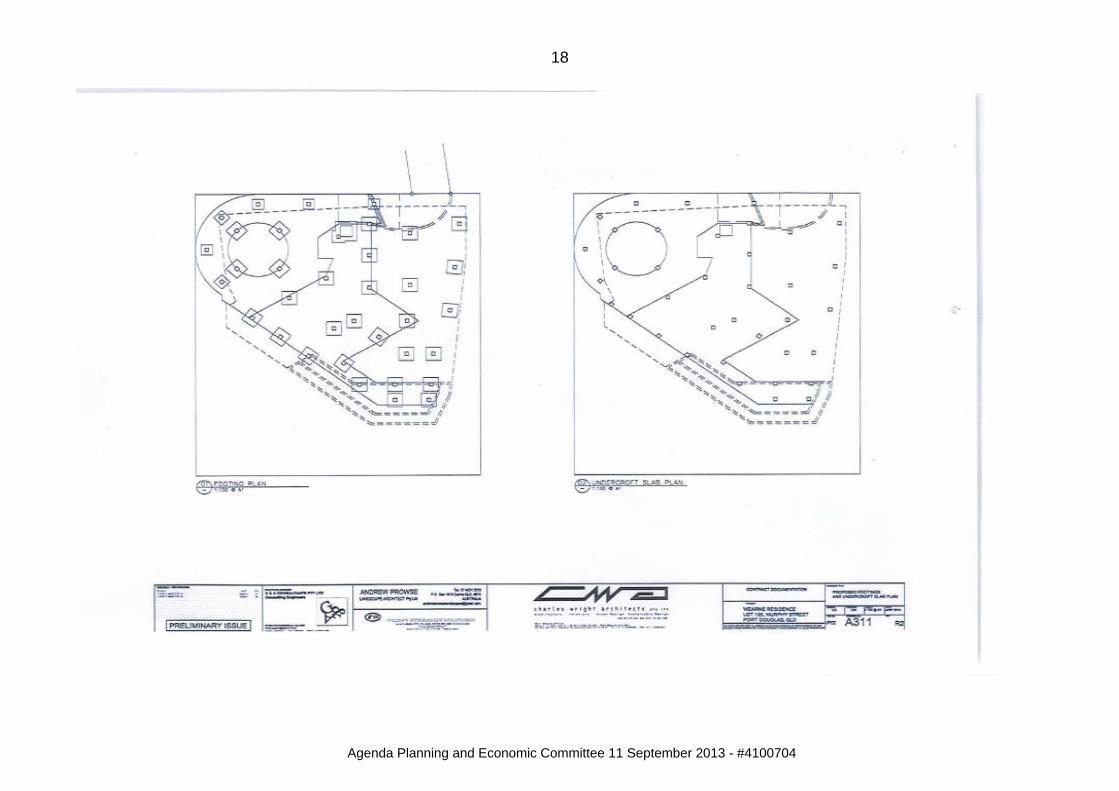
Proposed Footings & Undercroft Slab Plan
Drawing ref. no. A311 Rev2 prepared by Charles Wright Architects Pty Ltd (Council ref no 4042845)
15 May 2013
Proposed Section A & Section B
Drawing ref. no. A411 Rev6 prepared by Charles Wright Architects Pty Ltd (Council ref no 4042845)
15 May 2013
Proposed South Elevation & East
Drawing ref. no. A401 Rev7 prepared by Charles Wright Architects Pty Ltd
1 May 2013

5
Agenda Planning and Economic Committee 11 September 2013 - #4100704
Drawing or Document Reference Date Elevation (Council ref no 4042845) Proposed North Elevation & West Elevation
Drawing ref. no. A402 Rev7 prepared by Charles Wright Architects Pty Ltd (Council ref no 3960687)
1 May 2013
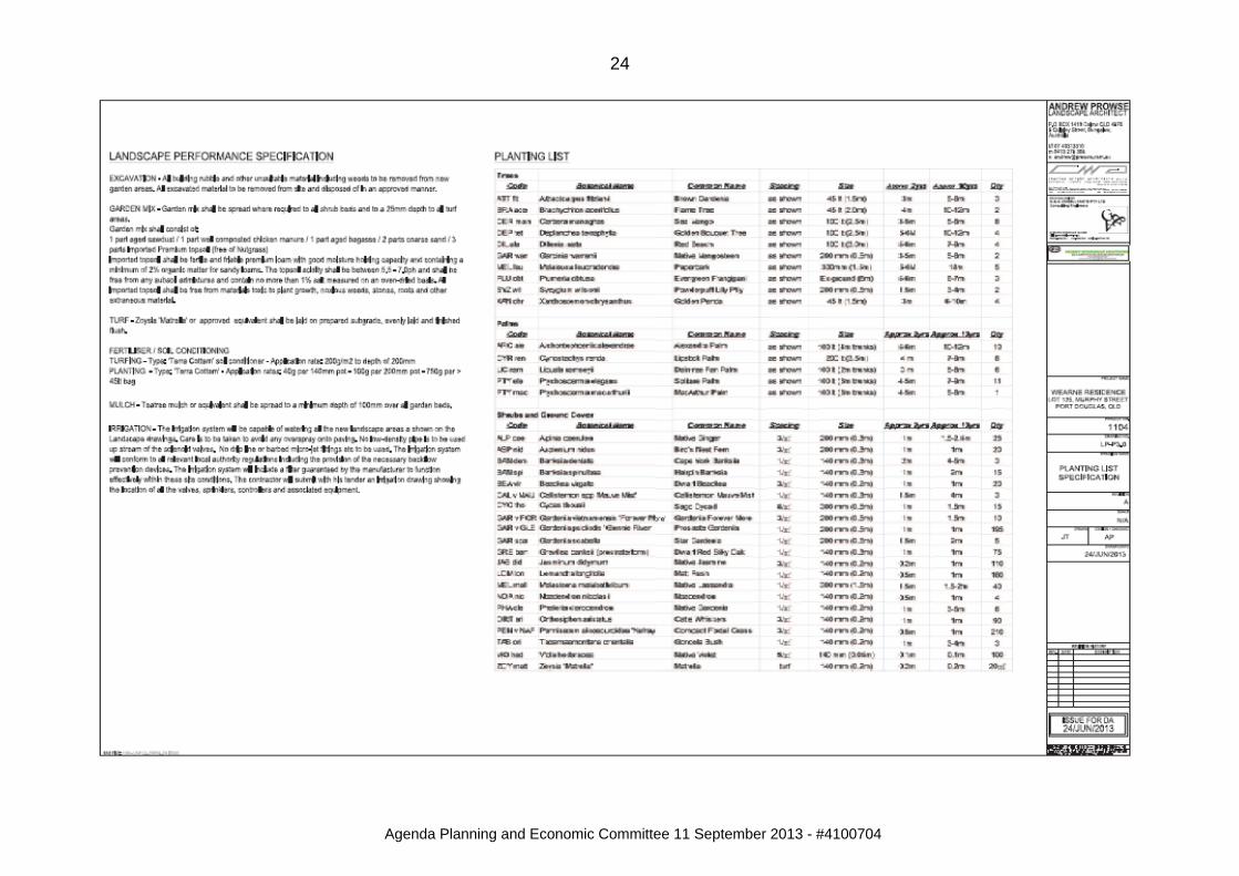
Landscaping Cover Sheet Drawing ref. no. LP-P1.0 Rev A prepared by Andrew Prowse Landscape Architect (Council ref no 4020562)
24 Jun 2013
Landscape Planting Plan Drawing ref. no. LP-P2.0 Rev A prepared by Andrew Prowse Landscape Architect (Council ref no 4020562)
24 Jun 2013
Detail Plan & Specification
Drawing ref. no. LP-P3.0 Rev A prepared by Andrew Prowse Landscape Architect (Council ref no 4020562)
24 Jun 2013
Landscape Elevations Drawing ref. no. LP-E1.0, 2.0, 3.0 & 4.0 prepared by Andrew Prowse Landscape Architect (Council ref no 4020562)
12 Apr 2013
ASSESSMENT MANAGER CONDITIONS 1. Carry out the approved development generally in accordance with the
approved drawing(s) and/or document(s), and in accordance with:- a. The specifications, facts and circumstances as set out in the
application submitted to Council; b. The following conditions of approval and the requirements of Council’s
Planning Scheme and the FNQROC Development Manual. Except where modified by these conditions of approval Timing of Effect 2. The conditions of the Development Permit must be effected prior to
Commencement of Use, except where specified otherwise in these conditions of approval.
Water Supply and Sewerage Works External 3. Undertake the following water supply and sewerage works external to the
site to connect the site to existing water supply and sewerage infrastructure:-

6
Agenda Planning and Economic Committee 11 September 2013 - #4100704
a. Extend a water main across Murphy Street with a 100DN road crossing terminating near the access driveway. Bore a 50mm conduit under the access driveway such that future water services can be made to the services easement on Lot 126 on SP144708.
The external works outlined above constitute Operational Works. Three (3)
copies of a plan of the works at A1 size and one (1) copy at A3 size must be endorsed by the Chief Executive Officer prior to commencement of such works. Such work must be constructed in accordance with the endorsed plan to the satisfaction of the Chief Executive Officer prior to Commencement of Use.
Water Supply and Sewerage Works Internal 4. Undertake the following water supply and sewerage works internal to the
subject land:- a. The development must be serviced by a single internal water and
sewerage connection made clear of any buildings or structures; b. Provide a conduit for water and other services located within the
services easement finishing within the body of the allotment. All the above works must be designed and constructed in accordance with
the FNQROC Development Manual. All works must be carried out in accordance with the approved plans, to the
requirements and satisfaction of the Chief Executive Officer prior to Commencement of Use.
Damage to Council Infrastructure 5. In the event that any part of Council’s existing sewer / water or road
infrastructure is damaged as a result of construction activities occurring on the site, including but not limited to; mobilisation of heavy construction equipment, stripping and grubbing, the applicant/owner must notify Cairns Regional Council immediately of the affected infrastructure and have it repaired or replaced at the developer’s/owners/builders cost, prior to the Commencement of Use.
7
Agenda Planning and Economic Committee 11 September 2013 - #4100704
Vegetation Clearing 6. Existing vegetation on the land must be retained in all areas in accordance
with the approved plans and report prepared by Andrew Prowse (Council Ref No 4020562), except those affected by the construction of access driveways and/or the installation of services as detailed on the approved plans.
Landscaping 7. Sixty (60) per cent of the total proposed species for landscaping must
consist of native and endemic species. Areas affected by building works must be landscaped. In particular:
a. Landscaping to obscure views of supporting structures;
b. Landscaping with screening qualities must be retained/planted along
side and rear boundaries to obscure views of neighbouring property; All landscaping works must be undertaken in accordance with the endorsed
plans and report prepared by Andrew Prowse (Council Ref No 4020562) prior to the issue of a Certificate of Classification or Commencement of Use, whichever occurs first.
Vegetation/Landscaping 8. All trees to be retained are to be protected in accordance with the
requirements of the Australian Standard Protection of trees on development sites AS 4970-2009.
9. Any necessary pruning of trees is to be in accordance with the requirements
of the Australian Standard Pruning of amenity trees AS4373-2007. 10. Infestations of the Class 3 Pest Plant Lantana (Lantana camara) are to be
eradicated from the allotment. Building Colours 11. The exterior finishes and colours of Buildings are non-reflective and blend
with the natural colours of the surrounding environment. Roofs and structures (including water tanks) must be of moderately dark to darker shades of green, grey, blue and brown.
The applicant must provide colour samples prior to the issue of the
Development Permit for Building Works. The above requirements must be made known in writing to all prospective purchasers.

8
Agenda Planning and Economic Committee 11 September 2013 - #4100704
Sediment and Erosion Control 12. Soil and water management measures must be installed/implemented prior
to discharge of water from the site, such that no external stormwater flow from the site adversely affects surrounding or downstream properties (in accordance with the requirements of the Environmental Protection Act 1994, and the FNQROC Development Manual).
Earthworks 13. All retaining walls greater than 900mm high must be designed, detailed and
certified by a suitably qualified engineer (RPEQ), in accordance with FNQROC clause D2.13.
14. The completed final earthworks drawings must be submitted to a suitably
qualified geotechnical engineer (RPEQ) to certify that the risk to person and property by the proposed development is Low, in accordance with the AGS 2007.
Drainage 15. The applicant is to provide a detailed drawing that must be endorsed by the
Chief Executive Officer illustrating the stormwater structure that discharges onto Murphy Street.
ADVICE 1. This approval, granted under the provisions of the Sustainable Planning Act
2009, shall lapse four (4) years from the day the approval takes effect in accordance with the provisions of Section 339 and 341 of the Sustainable Planning Act 2009.
2. The applicant/owner is advised that this approval does not approve the
construction of the building work. A Development Permit for Building Work must be obtained in order for construction to commence.
3. All building site managers must take all action necessary to ensure building
materials and / or machinery on construction sites are secured immediately following the first cyclone watch and that relevant emergency telephone contacts are provided to Council Officers, prior to commencement of works.
4. This approval does not negate the requirement for compliance with all other
relevant Local Laws and other statutory requirements.

9
Agenda Planning and Economic Committee 11 September 2013 - #4100704
5. For information relating to the Sustainable Planning Act 2009 log on to www.dsdip.qld.gov.au. To access FNQROC Manual, Local Laws and other applicable Policies log on to www.cairns.qld.gov.au.
6. The site is located within a pest quarantine area declared under section 4(1)
of the Plant Protection (Electric Ant) Quarantine Notice 2006. The Plant Protection (Electric Ant) Quarantine Notice 2006 places restrictions on the movement of electric ants and ‘high risk items’ within and out of the pest quarantine area and places certain obligations and restrictions on land owners within the quarantine area. For further information on the Plant Protection (Electric Ant) Quarantine Notice 2006 consult either the Department of Employment, Economic Development and Innovation (21-23 Redden Street, Cairns), Council’s Land Protection Unit, or the following website: - www.dpi.qld.gov.au.
LAND USE DEFINITIONS* In accordance with Douglas Shire Planning Scheme the approved land use of ‘House’ is defined as follows:
“Means the use of premises comprising one Dwelling Unit, located on one lot for the exclusive residential use of one Household. The use includes: Outbuildings/structures incidental to and necessarily associated with
the residential use;
the care of children in accordance with the Child Care (Family Day Care) Regulation 1991;
accommodation for a member or members of the extended family of the
Household occupying the House and for personal staff; and
a display house which displays to the general public the type of construction or design offered by a builder/developer, for a maximum period of twelve (12) months and which then converts to a House for the exclusive use of one Household.”
*This definition is provided for convenience only. This Development Permit is limited to the specifications, facts and circumstances as set out in the application submitted to Council and is subject to the abovementioned conditions of approval and the requirements of Council’s Planning Scheme and the FNQROC Development Manual.

10
Agenda Planning and Economic Committee 11 September 2013 - #4100704
EXECUTIVE SUMMARY: Council is in receipt of a Material Change of Use application for the purpose of a House at 34 Murphy Street Port Douglas. An existing concrete driveway provides access to the site via Island Point Road. The proposed House is generally in accordance with relevant Codes of the Douglas Shire Planning Scheme 2008 and is able to be conditioned to comply. The House is recommended for approval subject to conditions. TOWN PLANNING CONSIDERATIONS: Background The site is located on the south western slope of Flagstaff Hill and slopes from the north to the south of the site. The site also contains a major crossfall. The land is undeveloped and contains existing vegetation. To the south west, west and north west, the site is adjoined by undeveloped land containing mature vegetation. To the north east, the site is adjoined by a reserve that contains an existing constructed driveway. The site has frontage to the Owen Street road reserve, which is unconstructed at that point north of Murphy Street and contains mature vegetation. Houses in the immediate vicinity of the subject site have been constructed in a variety of architectural styles, including houses with Asian and Mediterranean features, as well as houses incorporating contemporary Australian design features. The land is comprised of three lots – Lot 125 which is located in the Residential 1 Planning Area and is the site intended for the House to be located, Lot 5 which is located in the Conservation Planning Area is subject to an easement for access purposes, and Lot 126 is located in the Residential 1 Planning Area and contains an easement for the purposes of services and drainage. The land is located in the Port Douglas & Environs Locality and the Special Management Area 1 – Flagstaff Hill. A Material Change of Use approval (DSC ref no MCU 3B 028/00) was issued over the land for the purpose of a House 7 September 2000, however the House was never constructed and the approval has since lapsed. Proposal It is proposed to construct a three (3) storey house containing an undercroft level and two (2) residential levels. The undercroft level is to include area for vehicle parking, access driveway and an entry foyer. Level 1 contains two (2) bedrooms, lounge, kitchen, amenities area, outdoor living areas and swimming pool. Level 2 contains a single bedroom, study and outdoor living areas and a small swimming pool. Access to the site is via the existing constructed driveway over land to the northeast. Vehicular access is via Island Point Road.

11
Agenda Planning and Economic Committee 11 September 2013 - #4100704
Douglas Shire Planning Scheme Assessment
Douglas ShirePort Douglas and Environs Planning Locality
Code Applicability
Compliance
Locality Port Douglas and Environs Locality Code
Complies – see comment
below
Planning Area Residential 1 Planning Area Code
Complies – see comment
below Conservation Planning Area Code Complies
Overlay Acid Sulfate Soils Code - Cultural Heritage and Valuable Sites Code Complies Natural Hazards Code -
Defined Use House Code Complies
General Codes
Design & Siting of Advertising Devices Code - Filling and Excavation Code Complies – see comment
below Landscaping Code Complies Natural Areas and Scenic Amenity Code Complies Vehicle Parking and Access Code Complies
Port Douglas & Environs Locality Code At the outset of the application process concerns were raised by Council officers as the proposed development is for a three-storey building which exceeds the maximum height limitation of two storeys (Performance Criteria P1). Council officers raised concerns that the proposed design would result in a building mass with the potential to have detrimental visual impacts on the Flagstaff Hill area as well as potential for creating adverse amenity impacts on surrounding properties. A request for further information was issued, and in response the applicant provided an extensive response including a meeting and presentation, detailed visual analysis and amended landscaping plans. The information provided allayed Council officer concerns, and gave further justification that the proposal as designed will essentially present as a two storey House when viewed from both surrounding properties and from public areas (the applicant actually erected scaffolding on the site to the proposed heights to demonstrate visual impact). It is considered that the proposal is consistent with the intent of the Douglas Shire Planning Scheme in terms of mitigation of visual impact. Residential 1 & Conservation Planning Area Codes The application is over three parcels of land, with Lot 5 which provides access to the site located in the Conservation Planning Area. The access is already constructed and no further vegetation is proposed to be removed. The proposal complies with the requirements of the Code. The remaining parcels of land are located in the Residential 1 Planning Area. Performance Criteria 9-12 deal with development on sloping sites. P9 requires buildings/structures are designed and sited to be responsive to the constraints of sloping sites. The approval is conditioned to ensure compliance with the requirements of the Code. Further, the approval contains conditions requiring landscaping of the site in order to screen the House from view and the use of external wall and roof colours that will complement the surrounding vegetation and viewshed.

12
Agenda Planning and Economic Committee 11 September 2013 - #4100704
Filling and Excavation General Code The purpose of this Code is to ensure that filling and excavation do not: • affect visual/scenic amenity values of the Shire; • cause flooding and drainage problems; • impact upon the environment of an area; • cause land instability; or • adversely impact upon utility services It is noted that the design technique for the development involves utilisation of a pier construction technique to minimise excavation and filling. It is further noted that the only excavation for the building works will consist of temporary benching to allow a machine on site to excavate the footings, and that there will be no permanent cut/fill works associated with the proposed House. The approval is conditioned to ensure compliance with the requirements of the Code. There is currently a concrete spoon drain running down the north western boundary of Lot 126 which will serve Lot 125 for the purposes of stormwater runoff capture, diverting stormwater along the drain to a field inlet pit located in the north western corner of Lot 126. The field inlet pit which is to provide a lawful point of discharge for Lot 125 is connected to a 225mm diameter underground concrete pipe to a headwall at the discharge point on Murphy Street. The approval is conditioned to ensure no external stormwater flow from the site adversely affects surrounding or downstream properties. Queensland Development Code Assessment The siting of the proposed development does not comply with the Acceptable Solutions of the Queensland Development Code with respect to site coverage, front, side and rear setbacks. The application has been assessed by Building Services (Council ref no 4061045) who have advised that:
“The proposed siting layout request generally appears to satisfy the performance criteria stated in MP 1.2 of the Queensland Development Code, it is considered acceptable to approve the siting of a new dwelling. The proposed structure will not impose on the streetscape or neighbouring properties therefore approval recommended.”
Public Notification / Submissions The proposed development is Impact Assessable and was publicly notified in accordance with the requirements of the Sustainable Planning Act 2009. No submissions were received.

13
Agenda Planning and Economic Committee 11 September 2013 - #4100704
INFRASTRUCTURE CHARGES: The proposed development does not trigger Developer’s Infrastructure Charges. Michelle Henderson Planning Officer Action Officer Graham Boyd Acting General Manager Planning & Environment

14
Agenda Planning and Economic Committee 11 September 2013 - #4100704
APPENDIX 1 – EXECUTIVE PLAN

15
Agenda Planning and Economic Committee 11 September 2013 - #4100704
APPENDIX 2 - APPROVED PLAN(S) & DOCUMENT(S)

16
Agenda Planning and Economic Committee 11 September 2013 - #4100704

17
Agenda Planning and Economic Committee 11 September 2013 - #4100704
18
Agenda Planning and Economic Committee 11 September 2013 - #4100704

19
Agenda Planning and Economic Committee 11 September 2013 - #4100704

20
Agenda Planning and Economic Committee 11 September 2013 - #4100704

21
Agenda Planning and Economic Committee 11 September 2013 - #4100704

22
Agenda Planning and Economic Committee 11 September 2013 - #4100704

23
Agenda Planning and Economic Committee 11 September 2013 - #4100704
24
Agenda Planning and Economic Committee 11 September 2013 - #4100704

25
Agenda Planning and Economic Committee 11 September 2013 - #4100704

26
Agenda Planning and Economic Committee 11 September 2013 - #4100704

27
Agenda Planning and Economic Committee 11 September 2013 - #4100704

28
Agenda Planning and Economic Committee 11 September 2013 - #4100704