Embed Size (px)
Citation preview

GENERIC PLAN OF MANAGEMENT
FORCOMMUNITY LAND AND
CROWN RESERVESPLANNING DISTRICT SIX
Adopted 13 December 2006
Amended 18 December 2013
Prepared by PARKS AND LANDSCAPE TEAM BUSHLAND AND BIODIVERSITY TEAM
Phone: 02 9847 6666 Fax: 02 9847 6929
Email: [email protected]
N O
F M
AN
AG
EMEN
TD
ISTR
ICT
SIX
Amended 27 February 2020

_______________________ District 6 – Community Land and Crown Reserves Generic Plan of Management ____________________
FOREWORDThis Plan of Management has been prepared to comply with the Local Government Act 1993 and the Crown Lands Act 1989. The plan covers Hornsby Shire Council’s Open Space community land and land under Council's care, control and management (generally Crown land). This land includes parks and reserves, bushland and community facilities such as community centres, where the land is owned or managed by Council.
In order to be consistent with other Council Planning Documents, the Generic Plans of Management for community land and Crown reserves have utilised the nine Planning Districts within the Shire. The delineation of Districts is shown in Figure 1, including District 6 highlighted in bold font. Figure 2 depicts District 6 including suburbs within the District, subject of this Plan of Management.
This Plan of Management applies to community land within District 6, the suburbs of Arcadia, Berrilee, Berowra Creek, Berowra Waters, Canoelands, Dural, Fiddletown, Forest Glen, Galston, Glenhaven, Glenorie, Laughtondale, Maroota, Middle Dural, Singletons Mill and Wisemans Ferry.
This Plan of Management supersedes the Generic Plans of Management for Parks and Reserves, Sportsgrounds, and Bushland previously adopted by Council where applicable to District 6. Where specific Plans of Management exist in relation to any reserve in District 6, this is stated in the Categorisation Mapping & Asset Information entry relating to that land.
COMMUNITY INPUT INTO THE PLANS OF MANAGEMENT The Local Government Act 1993 requires that all Plans of Management be placed on public display for a minimum period of 28 days. A minimum period of 42 days after the draft is placed on exhibition is allowed for written submissions to be made to Council (s.38). By writing a submission, members of the community are given the opportunity to participate in the future direction of management of the Shire’s Open Space.
Submissions allow the community (including residents, interest groups, sporting clubs and Government agencies), to express opinions, provide information and suggest alternatives to the proposed Management strategies for community land within the Shire. On closure of the period of public comment, and after consideration of submissions received, Council may decide to amend the draft Plan of Management, or adopt it without further amendment. If Council decides to amend the draft plan, it must publicly exhibit the amendments as above until such time as the draft can be adopted without further amendment unless the amendments are of a minor nature (S.40 and S.40A).
PUBLIC HEARING A public hearing will be held in respect of the Generic draft Plans of Management for community land that has been recategorised.(s.40 (3)) The community land has been recategorised in accordance with the amendments to the Local Government Act and following development of guidelines for categorisation from the Local Government (General) Amendment (Community Land Management) Regulation 1999.
The Asset and Inventory section identifies land that is to be recategorised by this Plan of Management.
Further information can be obtained from the Parks and Landscape Team, Phone: 9847 6853.
Page i

_______________________ District 6 – Community Land and Crown Reserves Generic Plan of Management ____________________
0 2 4 6 81Kilometers
/LEGEND: HORNSBY SHIREPLANNING DISTRICTS
DISTRICT 6
5
7
6
82a
4
3
39
2
1
Figure 1. Hornsby Shire Council Planning Districts
Page ii

_______________________ District 6 – Community Land and Crown Reserves Generic Plan of Management ____________________
0 2 4 6 81Kilometers
/PLANNING DISTRICT 6 & SUBURBS
DISTRICT 6
5
7
8 2a
4
3
396
MIDDLEDURAL
BERRILEE
ARCADIA
GLENORIE
FOREST GLEN
CANOELANDS
WISEMANS FERRY
GALSTON
DURALGLENHAVEN
SINGLETONS MILL
LAUGHTONDALE
FIDDLETOWN
BEROWRA CREEK
DISTRICT BOUNDARY
Figure 2. District 6 – Suburbs
Page iii

_______________________ District 6 – Community Land and Crown Reserves Generic Plan of Management ____________________
TABLE OF CONTENTS
FOREWORD iCOMMUNITY INPUT INTO THE PLANS OF MANAGEMENT iPUBLIC HEARING i1.0 INTRODUCTION 1
1.1 Purpose of the Plan of Management 11.2 Structure of the Document 11.3 Process for Preparing this Plan of Management 1
2.0 MANAGEMENT CONTEXT 22.1 Land Covered by this Plan 22.2 Management Authority, Ownership & Tenure 22.3 Relationship to Other Plans of Management 2
3.0 PLANNING CONTEXT 43.1 Local Government Act 1993 43.2 Crown Lands Act 1989 53.3 Other Relevant Legislation 63.4 Council Plans & Strategies 8
4.0 DESCRIPTION OF THE LAND 15 4.1 Catchment Context 15
4.2 Topography, Geology & Soils 15 4.3 Native Vegetation 16
4.4 Fauna & Habitat 16 4.5 Aboriginal Cultural Heritage 17
4.6 European Cultural Heritage 175.0 VALUE STATEMENT 18
5.1 Values of all Categories of Land 185.2 Values of Parks & Sportsgrounds 185.3 Values of Natural Areas 185.4 Values of General Community Use & Areas of Cultural Significance 18
6.0 STATEMENT OF SIGNIFICANCE 197.0 BASIS FOR MANAGEMENT 20
7.1 Core Objectives Under the Local Government Act 1993 207.2 Management Objectives for Hornsby Shire 23
8.0 MANAGEMENT ISSUES 258.1 Management Issues for Natural Areas 258.2 Management Issues for Parks & Sportsgrounds 268.3 Management Issues for Areas of General Community Use 268.4 Management Issues for Areas of Cultural Significance 27
9.0 WHAT DEVELOPMENT IS ALLOWED UNDER THE PLAN OF MANAGEMENT 27
9.1 Hornsby Shire Local Environmental Plan 1994 27 9.2 Community Land 28 9.3 Masterplans 30
9.4 Leases & Licences 30PART II – ACTION PLAN 371.0 ACTION PLAN FOR ALL CATEGORIES OF COMMUNITY LAND 37 1.1 Operating Standards 39
1.2 Equity & Access 41 1.3 Anti-Social Behaviour 42
Page iv

_______________________ District 6 – Community Land and Crown Reserves Generic Plan of Management ____________________
1.4 Reserve Naming & Dedications 42 1.5 Protecting Fauna & Fauna Habitats 43 1.6 Conservation of Resources 43 1.7 Heritage Listings 43 1.8 Impacts of Developments & Activities 44 1.9 Leases & Licences 44 1.10 Communications Towers 45 1.11 Volunteer Insurance 45 1.12 Funding 462.0 ACTION PLAN FOR PARKS & SPORTSGROUNDS 47 2.1 Notifications 47 2.2 Protecting the Natural Environment 48 2.3 Availability of Facilities & Grounds 50 2.4 Maintenance of Facilities & Grounds 50 2.5 Risk Management 55 2.6 General Use: Dogs, Fireworks, Fairs 55 2.7 Use for Access or Storage 57 2.8 Community & Neighbour Issues 573.0 ACTION PLAN FOR NATURAL AREAS 59 3.1 Bushland & Biodiversity Protection 59 3.2 Community Involvement & Awareness 63 3.3 Boundary Management 64 3.4 Domestic & Feral Animal Control 65 3.5 Bush Fire Management 66 3.6 Walking & Recreation 67 3.8 Watercourses 69 3.9 Authorities’ Works & Projects 70 3.10 Strategic Planning & Assessment of Developments 70 3.11 Funding 714.0 ACTION PLAN FOR AREAS OF CULTURAL SIGNIFICANCE 72 4.1 Aboriginal Heritage 72 4.2 European Cultural Heritage 735.0 ACTION PLAN FOR AREAS OF GENERAL COMMUNITY USE 74 5.1 Standard of Community Centres 74 5.2 Equity & Access to Community Centres/Other Community Assets & Facilities 74 5.3 Fees & Audit 75 5.4 Risk Management 76PART III – CATEGORISATION, MAPPING & ASSET INFORMATION 77 ARCADIA 78 Arcadia Park 78 Calabash Road Bushland 82 Halls Creek Reserve 85 Sunnyridge Road Bushland 88 Bar Island 92 Collingridge Bushland, Calabash Creek Bushland & Calabash Point Bushland 95 Neverfail Bay Bushland 98 Vacant Land – Cobah Point 1 & Cobah Point 2 101 Bay Road Bushland 104 Dusthole Bay/Berowra Waters West Parkland 107 Furber Park 110 Woolwash Bay 113
Page v

_______________________ District 6 – Community Land and Crown Reserves Generic Plan of Management ____________________
Vacant Land – Calabash Point 1 & Calabash Point 2 116Charltons Creek Road Bushland 119
CANOELANDS 122Canoelands Rural Fire Service 122Pumpkin Point Creek Bushland 125
DURAL 128 Dural Park 128
Muraban Road Bushland 131FIDDLETOWN 134
Bloodwood Road Bushland & Aboriginal Area 134FOREST GLEN 137
Short Street Bushland (Vacant Land – Forest Glen) 137GALSTON 140 Fagan Park 140
Galston Rural Sports Facility 145 Forsters Reserve 147 Galston Library 150
Galston Recreational Reserve (including Hayes Oval) 152Galston Park Bushland 158Johnson Road Bushland 161Karalee Road Bushland 164Knights (Towner) Road Bushland 167Nancy Place Park 170Plantation Strip – Mid Dural Road, Galston 173
Tim Brownscombe Reserve 176Galston Village Common 179
GLENORIE 181Cairnes Road Playground & Bushland 181Glenorie Park Sportsfield, Bushland & Kindergarten 184Plantation Strip, Cairnes Road Glenorie 188Plantation Strip – Taupo Road Glenorie 190Tekapo Road Bushland 193
MAROOTA 196Campbell Crescent Bushland 196
Molesworth Park 199Wisemans Ferry Bushland & Former Tip Site Maroota 202
WISEMANS FERRY 205Singleton Mill Road Bushland & Wisemans Ferry Cemetery 205One Tree Reach Wetland 208Wisemans Ferry Lookout 211Wisemans Ferry Public Wharf 214Wisemans Ferry Recreation Reserve 217
BIBLIOGRAPHY 220APPENDIX 1 – Best Management Practices for Sportsturf 222APPENDIX 2 – Hornsby Shire LEP 1994 – Minor Council Works 224APPENDIX 3 – Park Rules 226APPENDIX 4 – Leasing & Licencing Community Land 227APPENDIX 5 – Rural Sports Facility Masterplan 228APPENDIX 6 – Plan of Management – Galston Rural Sports Facility 229
Page vi

_______________________District 6 – Draft Community Land and Crown Reserves Generic Draft Plan of Management ______________
PART I - MANAGEMENT STRATEGY
1.0 INTRODUCTION
1.1 PURPOSE OF THE PLAN OF MANAGEMENT
The Plan of Management identifies the values of Hornsby Shire Council’s open space, the objectives for management of those values, the issues affecting the land and the strategies for managing, using and developing the land.
The Plan of Management has been prepared in accordance with the Local Government Act 1993 that requires plans of management to be prepared by Councils for all community lands, and the Crown Lands Act 1989. Other land under Council care, control and management such as Crown Land has been included in the Plan to ensure a consistent approach to land management.
This Plan of Management is a generic plan, which applies to multiple areas of land. Hornsby Shire Council’s community land will be managed in accordance with the core objectives established in the Local Government Act 1993.
The Plan of Management outlines Council’s objectives and strategic intentions and establishes a program for determining priorities, implementation and measuring performance.
1.2 STRUCTURE OF THE DOCUMENT
The Plan is presented in three parts:
Part 1 is the Management Strategy including background information, statutory planning information, the basis for Council’s management, values of the land, objectives for management of the land and authorised uses for the land. This part looks at major management issues relevant to community land to determine outcomes and broad objectives for management.
Part 2 is the Action Plan, which outlines how the objectives will be achieved and actions necessary to fulfil the strategies. This part of the Plan also identifies the manner in which Council will assess its performance in relation to achieving its goals.
Part 3 is the Categorisation Mapping and Asset Information, which contains categorisation maps and provides asset information for all Community and Crown land.
The Plan of Management sets strategic directions and objectives for each category of land. The management issues and Action Plan are also linked to each category of land.
1.3 PROCESS FOR PREPARING THIS PLAN OF MANAGEMENT
The process for preparing this Plan of Management has included:
� Literature review of statutory planning documents and relevant environmental, open space, heritage and Aboriginal studies and reports;
� Consultation with key stakeholders and community members including representatives from government departments, Aboriginal groups and community groups;
� A Public Hearing into the proposed categorisation of the community land as required under the Local Government Act will be undertaken during the period of public exhibition of the plan; and
� Field investigations regarding environmental and recreational values by appropriately qualified consultants and Council staff.
Page 1
_______________________ ______________ District 6 – Draft Community Land and Crown Reserves Generic Draft Plan of Management
2.0 MANAGEMENT CONTEXT
2.1 LAND COVERED BY THIS PLAN
The Plan applies to all community land within Planning District 6, in accordance with the Local Government Act. It also applies to Crown Land managed under the Crown Lands Act where this land is under the care, control and management of Council.
2.2 MANAGEMENT AUTHORITY, OWNERSHIP AND TENURE
The manager of the land covered by this plan is Hornsby Shire Council. The land is owned partly by Hornsby Shire Council and partly by the Crown; hence the provisions of the Local Government Act 1993 and the Crown Lands Act 1989 apply in the preparation of this plan of management.
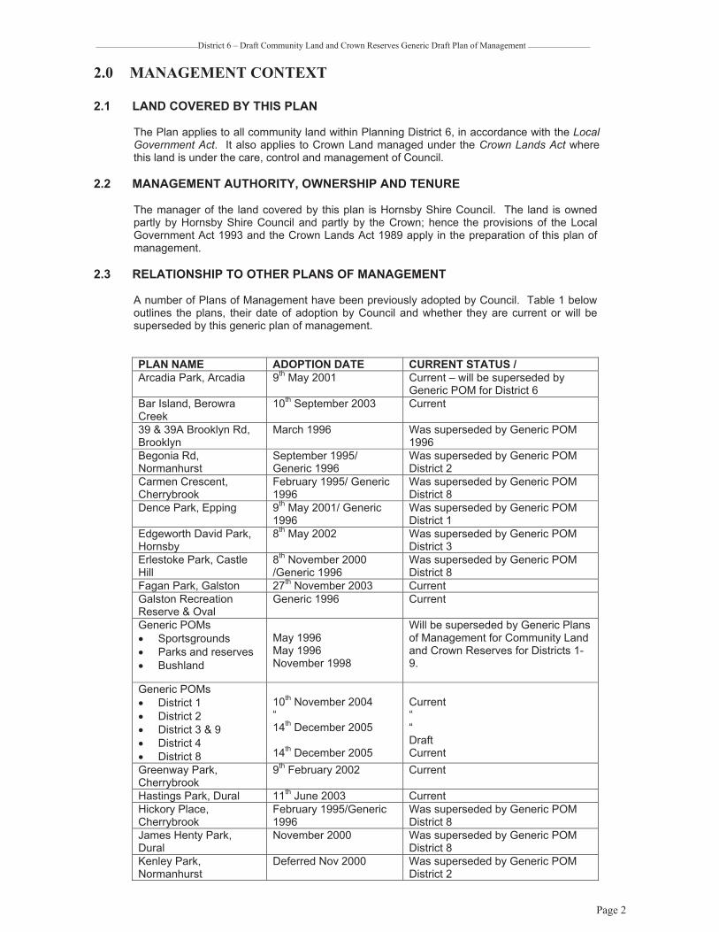
2.3 RELATIONSHIP TO OTHER PLANS OF MANAGEMENT
A number of Plans of Management have been previously adopted by Council. Table 1 below outlines the plans, their date of adoption by Council and whether they are current or will be superseded by this generic plan of management.
PLAN NAME ADOPTION DATE CURRENT STATUS / Arcadia Park, Arcadia 9th May 2001 Current – will be superseded by
Generic POM for District 6 Bar Island, Berowra Creek
10th September 2003 Current
39 & 39A Brooklyn Rd, Brooklyn
March 1996 Was superseded by Generic POM 1996
Begonia Rd, Normanhurst
September 1995/ Generic 1996
Was superseded by Generic POM District 2
Carmen Crescent, Cherrybrook
February 1995/ Generic 1996
Was superseded by Generic POM District 8
Dence Park, Epping 9th May 2001/ Generic 1996
Was superseded by Generic POM District 1
Edgeworth David Park, Hornsby
8th May 2002 Was superseded by Generic POM District 3
Erlestoke Park, Castle Hill
8th November 2000 /Generic 1996
Was superseded by Generic POM District 8
Fagan Park, Galston 27th November 2003 Current Galston Recreation Reserve & Oval
Generic 1996 Current
Generic POMs � Sportsgrounds � Parks and reserves � Bushland
May 1996 May 1996 November 1998
Will be superseded by Generic Plans of Management for Community Land and Crown Reserves for Districts 1-9.
Generic POMs � District 1 � District 2 � District 3 & 9 � District 4 � District 8
10th November 2004 “14th December 2005
14th December 2005
Current““DraftCurrent
Greenway Park, Cherrybrook
9th February 2002 Current
Hastings Park, Dural 11th June 2003 Current Hickory Place, Cherrybrook
February 1995/Generic 1996
Was superseded by Generic POM District 8
James Henty Park, Dural
November 2000 Was superseded by Generic POM District 8
Kenley Park, Normanhurst
Deferred Nov 2000 Was superseded by Generic POM District 2
Page 2

_______________________ ______________ District 6 – Draft Community Land and Crown Reserves Generic Draft Plan of Management
Brickpit Park, Normanhurst
10th November 2004 Current
Lillian Fraser Garden, Pennant Hills
November 2000 Current
Lyndon Way, Beecroft May 1994/Generic 1996 Was superseded by Generic POM District 1
Neighbourhood Parks � Roslyn Park,
Cherrybrook � Robert Road,
Cherrybrook � Yarrabin Cres,
Berowra
November 1995/Generic 1996
Roslyn and Robert Road Parks were superseded by Generic POM District 8 and Yarrabin will be superseded by Generic POM for District 5.
Orr Playground- Northumberland Ave, Mt Colah
March 96 Was superseded by Generic POM 1996 and will be superseded by Generic POM for District 4.
Pembroke Street, Epping
February 95 / Generic 1996
Was superseded by Generic POM District 1
Pennant Hills Park Included in Generic POM for Sportsgrounds, Parks and Reserves and Bushland 1996
Significant area plan to be prepared
Ruddock Park, Westleigh
29th October 2003 Was superseded by Generic POM District 2
Significant Areas – Bushland
November 2000 Current
Somerville Park, Eastwood
13th February 2002 Was superseded by Generic POM District 1
Storey Park, Hornsby 8th November 2000 Was superseded by Generic POM District 3
Swan Place, Pennant Hills
June 1996 Was superseded by Generic POM District 2
Unwin Park, Waitara June 1995 Was superseded by Generic POM District 3
West Epping Park, Epping
November 2000 Was superseded by Generic POM District 1
Table 1: The relationship of this Plan of Management to existing plans adopted by Council
Page 3

_______________________District 6 – Draft Community Land and Crown Reserves Generic Draft Plan of Management ______________
3.0 PLANNING CONTEXT
3.1 LOCAL GOVERNMENT ACT 1993 3.1.1 Classification and Categorisation
All Council land has been classified as ‘community’ or ‘operational’. Community land in Hornsby Shire has been categorised in accordance with the guidelines in the Local Government Amendment (Community Land Management) Regulation 1999 (6B-6JA). In accordance with Council policy to apply consistent management to community and Crown land, all Crown land under Council’s care, control and management has also been categorised.
The Asset and Inventory in Part 3 of this Plan of Management includes the categorisation of the community and Crown lands under Council’s care, control and management within Hornsby Shire.
The Local Government Act establishes core objectives for all categories of community land. Council must manage the community land in accordance with the core objectives of the relevant category of land. Council or community objectives comply with the core objectives established within the Act. The significance of the prescribed core objectives is to ensure that any activities or uses of the land are consistent with the core objectives for that category of land.
The core objectives for land categories applicable to this Plan of Management are contained in Section 7.
3.1.2 Community Land Comprising Habitat of Endangered or Threatened Species and requirements under the NSW Threatened Species Act (1995)
The Local Government Act requires that a plan of management for community land, all or part of which is declared to be critical habitat under the Threatened Species Conservation Act 1995, is to apply to that area only and not other areas of land. To date there are no declared critical habitats for any endangered species in the Hornsby Shire, however, a number of reserves contain Endangered Ecological Communities listed under Part 3 of Schedule 1 of the Threatened Species Conservation Act 1995. Where community land is directly affected by any recovery plan prepared under the Threatened Species Conservation Act 1995, it then requires measures specified in the plan to be taken by a specified council or in respect of the land, the plan of management for that land is to apply to that area only and not other areas of land. Therefore land that contains Endangered Ecological Communities has been included in a plan of management prepared for Significant Areas Bushland Plans of Management & Action Plans in 2000. The following reserves which occur in Planning District 6 and are also included in that plan are:
� Tekapo Road Reserve � Tim Brownescombe Reserve � Cairnes Road Reserve
Due to further field survey and additional listings, the following reserves will be added to an amended Significant Areas Bushland Plans of Management & Action Plans document yet to be prepared:
� Arcadia Park � Calabash Creek Bushland � Pumpkin Point Creek Bushland � Short Street Bushland � Forsters Reserve � Galston Recreation Reserve � Glenorie Park � One Tree Reach Wetland
Page 4

_______________________District 6 – Draft Community Land and Crown Reserves Generic Draft Plan of Management ______________
In addition Tekapo Rd Reserve will be removed from the Significant Areas Bushland Plans of Management & Action Plans when it is updated as the reserve was found not to contain Sydney Turpentine- Ironbark Forest.
All current and draft Recovery Plans (RP) and Threat Abatement Plans (TAP) have been reviewed in the preparation of this plan. The Draft Large Forest Owl Recovery Plan was reviewed as Powerful Owls have been recorded in Furber Park and Muraban Road Bushland however there are no specific actions for Council. Likewise, the Darwinia biflora Recovery Plan was reviewed as this Vulnerable Species was recorded at Bay Road Bushland, however this site is not included in the Recovery Plan and there are no specific actions for Council. The Threat Abatement Plan for Red Fox was reviewed as foxes occur on many Council managed reserves and whilst there are no specific actions listed for Council in the Recovery Plan, Council is actively involved in joint fox baiting programs with the National Parks and Wildlife Division of DEC as part of the Urban Feral Animal Action Group. This plan identifies fox control as an issue for areas categorised as bushland, identifies the fox control program as one of the land management goals for the Bushland and Biodiversity Team, identifies fox control as an action in areas categorised as bushland and identifies performance measures for the program.
3.2 CROWN LANDS ACT 1989
Crown Land under Council’s care, control and management will be managed in accordance with section 11 of the Crown Lands Act 1989.
These principles are:
� “To observe environmental protection principles in relation to the management and administration of Crown land;
� To conserve wherever possible, the natural resources of Crown land (including water, soil, flora, fauna and scenic quality);
� To encourage appropriate public use and enjoyment of Crown land;
� To encourage multiple use of Crown land;
� To use and manage Crown land in such a way that both the land and its resources are sustained in perpetuity where appropriate;
� To deal with Crown land in the best interests of the State consistent with the above principles.”
Additionally, its uses, activities, developments and agreements must be broadly defined by the purposes of the reservation. The types of public purposes used for reserving Crown land under the Crown Lands Act 1989 broadly define the uses and activities permissible on Crown lands and are listed in Table 2.
No Purpose and Date of Gazettal Gazetted 15.12.59
1 Access 2 Accommodation 3 Caravan Park 4 Community Purposes 5 Environmental Protection 6 Government Purposes 7 Heritage Purposes 8 Public Recreation 9 Public Recreation and Coastal Environmental Protection 10 Rural Services 11 Showground 12 Travelling Stock
Page 5

_______________________District 6 – Draft Community Land and Crown Reserves Generic Draft Plan of Management ______________
13 Urban Services 14 Water 15 Dedicated – Public Park 16 Acquired – Future Public Requirements
Gazetted 22.5.92 17 The Accommodation, Guidance, Education and Welfare of
Homeless or Needy Young Persons Gazetted 2.9.94
18 Public Entertainment 19 Public Amusement
Gazetted 24.3.95 20 Tourist Facilities and Services 21 Community and Sporting Club Facilities 22 Recreation Facilities and Services 23 Aquatic Sporting Services
Gazetted 17.11.95 24 Port Services and Facilities
Gazetted 27.3.98 25 Racecourse and Recreation Facilities
Table 2: Purposes for which Crown land may be used.
Case Law In addition land uses on Crown lands are influenced by case law judgements. With respect to
land reserved for Public Purposes case law requires that any use must be conducive and ancillary to the Reserve’s public purpose. In order to change a reservation, a land assessment is required under the Crown Lands Act 1989. This can be waived if the new reserve purpose is considered to be consistent with the Principles of Land Management and it is in the public interest to do so.
Council as Trust Managers may lodge Development Applications for a proposed development on a Crown reserve without the need for the Crown (as owner) to endorse the application, provided a copy of the application is forwarded to the Crown within 14 days of lodgement. “Notwithstanding the above, substantial improvements / developments should not unreasonably alienate the reserve from public use, should be ancillary or incidental to the purpose of the reservation and be consistent with any recommendations of an approved Plan of Management under the Crown Lands Act, 1989.”
Where the proponent is a lessee or licensee of the Trust, the consent of the Crown as owner of the land, will still be required prior to lodgement of a Development Application. Proponents are required to consider the following prior to lodgement of a development application:
� The existence of any unresolved land claims under the Aboriginal Land Rights Act, 1983;
� Commonwealth and State Native Title laws and regulations; � Whether the proposed development is consistent with the reserve purpose; and � Whether the proposal is consistent with the relevant adopted Plan of Management.
3.3 OTHER RELEVANT LEGISLATION
Council is required to comply with all relevant legislation that applies to the use and management of land. This Plan of Management is required to be consistent with the planning and assessment provisions of the Environmental Planning and Assessment Act 1979 and the relevant sections of the following acts, policies and plans:
3.3.1 Commonwealth Legislation
Environment Protection and Biodiversity Conservation Act 1999 (EPBC Act) The EPBC Act relates to biodiversity conservation issues of national interest. It
provides the framework for environmental assessment of projects having national importance, and the listing of nationally endangered species. The EPBC Act identifies several matters of national environmental significance, including
Page 6

_______________________District 6 – Draft Community Land and Crown Reserves Generic Draft Plan of Management ______________
nationally threatened species and communities, migratory species, wetlands protected under the Ramsar Convention and world heritage areas. Development proposals require assessment and approval under the Act where they are assessed as being likely to have a significant impact on such matters.
Actions requiring approval under the EPBC Act do not include the preparation of plans, agreements or the issuing of approvals, but may include physical activities that follow from these. One specific implication of the EPBC Act for biodiversity planning is that impacts on threatened species must be assessed separately under both Commonwealth and State legislation using different criteria (Land & Environment Planning and Environs Australia 2001).
3.3.2 NSW Legislation Environmental Planning and Assessment Act 1979 State Environmental Planning Policy No 19 -- Bushland in Urban Areas
(1) Hornsby Shire is specifically named on Schedule 1 of State Environmental Planning Policy 19 – Bushland in Urban Areas, as being an area to which the SEPP applies. Hence this plan of management has been prepared to comply with the aims and objectives of SEPP 19.
The general aim of this Policy is to protect and preserve bushland within the urban areas referred to in Schedule 1 because of:
(a) its value to the community as part of the natural heritage; (b) its aesthetic value; and (c) its value as a recreational, educational and scientific resource.
(2) The specific aims of this policy are:
(a) to protect the remnants of plant communities which were once characteristic of land now within an urban area;
(b) to retain bushland in parcels of a size and configuration which will enable the existing plant and animal communities to survive in the long term;
(c) to protect rare and endangered flora and fauna species; (d) to protect habitats for native flora and fauna; (e) to protect wildlife corridors and vegetation links with other nearby
bushland;(f) to protect bushland as a natural stabiliser of the soil surface; (g) to protect bushland for its scenic values, and to retain the unique visual
identity of the landscape; (h) to protect significant geological features; (i) to protect existing landforms, such as natural drainage lines,
watercourses and foreshores; (j) to protect archaeological relics; (k) to protect the recreational potential of bushland; (l) to protect the educational potential of bushland; (m) to maintain bushland in locations which are readily accessible to the
community, and (n) to promote the management of bushland in a manner which protects
and enhances the quality of the bushland and facilitates public enjoyment of the bushland compatible with its conservation.”
Noxious Weeds Act 1993 Under provisions of this Act, Council is responsible for the control of weeds on public land and land owned by Council. The Act provides for the identification, categorisation and control of noxious weeds.
Page 7

_______________________District 6 – Draft Community Land and Crown Reserves Generic Draft Plan of Management ______________
Catchment Management Authorities Act 2003
The Catchment Management Act 1989 was recently changed to the Catchment Management Authorities Act 2003 which establishes catchment authorities to prepare and implement catchment action plans. Associated legislation is the NaturalResources Commission Act 2003 which requires the establishment of state-wide environmental standards and targets.
Catchment Management Authorities (CMAs) have been appointed for all areas of NSW. Planning District 6 lies within the Hawkesbury-Nepean CMA area.
Catchment Blueprint A blueprint was approved by Cabinet in 2002 for the Hawkesbury-Nepean Catchment. The Blueprint is State government policy, and sets the overarching natural resource priorities for the catchment. This District 6 Generic Plan is consistent with the Hawkesbury-Nepean Catchment Blueprint.
3.4 COUNCIL PLANS AND STRATEGIES
3.4.1 Hornsby Shire Council Strategic Plan 1998 – 2006 Council has developed a Strategic Plan for the period leading up to the Shire’s Centenary in 2006. The aim of the Plan is to identify key directions for Council’s programs, activities and resource allocations. These directions, with other information, will shape Council’s future Management Plans and Operating Plans and Budgets.
Council’s Vision Statement is:
“Creating a living environment” through:
� Engaging the community in the future of the Shire through education, two-way communication and open decision-making;
� Protecting the natural environment through Council policies and planning controls, total catchment management, integrated education and compliance, and an environmental management system;
� Conserving resources through a reduce-reuse-recycle approach, integrated environmental planning, and changing the internal work culture;
� Facilitating increased social well being through providing equitable access for all groups in the community to information, services and facilities; improved public health and safety in the Shire and equitable provision of sporting, recreational and cultural facilities;
� Aligning service provision to meet changing needs through an improved capacity to lead, predict and adapt to changing needs in the community; best value in Council services; and maximising benefits from the use of technology;
� Integrating land use and transport planning through use of more sustainable modes of transport such as public transport, walking, bicycles and alternative fuelled vehicles; establishment of effective partnerships in working towards shared goals with other agencies and community groups;
� Facilitating a diverse local economy through promoting the Shire’s attributes as an employment centre, land-use planning controls, efficient transport solutions, meeting local needs locally and promoting Eco-tourism; and
� Achieving financial sustainability through increased financial capacity for expenditure on Council’s strategic priorities and a strong financial position for Council.
Page 8

_______________________District 6 – Draft Community Land and Crown Reserves Generic Draft Plan of Management ______________
3.4.2 Council Land Management Goals From its current Principal Activity Service Plan 2003-2006, the purpose of Council’s Environment Division is ‘to develop and implement effective water and land management within appropriate industry and community standards and provide effective and efficient programs for: parks, leisure and recreation, landscape design, environmental health and protection, aquatic ecosystem management, bushland management, sustainable land management, property cleansing / maintenance and fire mitigation in the Shire.’ (HSC 2003).
The Parks and Landscape Team’s ongoing objectives are:
� Provide for the planning, administration, asset management and maintenance of the Shire’s parks, sportsgrounds, playgrounds and treescape on streets;
� Implement Plans of Management for crown /community land; � Provide ranger patrols of parks; � Respond efficiently to applications to prune or remove trees on private and
public land; � Assess the impacts on trees of development proposals; � Promote good tree management and retention of healthy trees; � Achieve tree planting and other streetscape beautification projects as funding
allows;� Move further towards sustainable asset management; � Support the Hornsby Shire Sports Council; and � Lodge applications for grant funding for parks development.
The Bushland and Biodiversity Management Team’s ongoing objectives are:
� Implement plans of management for natural areas; � Contract bush regeneration; � Undertake noxious weed control in bushland; � Maintain bushwalking tracks; � Undertake guided walks program; � Bushland management and biodiversity conservation planning; � Perform environmental assessments of development applications; � Integrated bushland/ bushfire management; � Support Bushcare program/ Bushcare Code; � Joint management of Berowra Valley Regional Park and Trust; � Support Council and community committees; � Assist Works Division with Rural Roads Plan of Management; � Fox Control Programme; � Manage the Service Level Agreement between the Rural Fire Service and
Council; and � Manage ISO 9002 and ISO 14001 accreditation.
3.4.3 Leisure Strategic Plan A comprehensive review of Council’s leisure facilities was recently completed in May 2003 with a Stage 2 Report on Demand, Supply and Service Gap Analysis and Stage 3 Report on Recommended Strategies and Action Plans. The Plan included a review of the leisure resources within Hornsby Shire including parks, sportsgrounds, community facilities, aquatic centres and other Council facilities.
The Plan identified the following key service needs:
� Additional sports grounds – particularly for cricket and senior soccer; � Purpose built facilities for equestrian groups; � Various upgrading requirements at many parks and sports grounds; � Improved communication between Council and sports groups and between
different sports groups;
Page 9

_______________________District 6 – Draft Community Land and Crown Reserves Generic Draft Plan of Management ______________
� Additional passive parks in some areas; � Expansion, improvement or disposal of many low value small parks; � More safe cycling and walking routes; � A greater diversity of play spaces/ facilities; � More youth-specific leisure facilities; � More activity options for older adults; � More and/ or better distributed leisure information; � More access to/ interpretation of natural areas; � New and upgraded indoor sports courts; � upgraded and modernised aquatic centres; � Additional meeting places in some districts; � Upgrading of some community centres; � Improved programming of community centres and senior’s centres; � Improved access to a range of facilities for aged and disabled people; � Community cultural development initiatives, improved spaces for performing
and visual arts; and � Additional library materials and floor space.
This Plan of Management for Community Land and Crown Reserves has been reviewed in light of the completion of the Leisure Strategic Plan.
3.4.4 Sports Facility Strategy To expand upon the LSP council has formulated a Sports Facility Strategy adopted in April 2006. The SFS was aimed at identifying at a higher resolution than the LSP, the adequacy of the condition and distribution of outdoor sporting facilities to meet current and future needs.
It confirmed the finding of the LSP that sports that had unmet facility needs were principally soccer, cricket and netball, but also some other sports such as softball, equestrian sports, skate facilities and BMX facilities.
For District 6, the key actions, directions and policies arising from the SFS are:
� Upgrade the playing surface at Dural Park (completed September 2006); � Move softball from Dural Park to Hayes Park, Galston (completed in September
2006); � Develop a Rural Sports Facility at 18-20 Bayfield Road, Galston (expected to
commence construction in 2007); � Consult with schools to develop sportsground facilities at the schools for
community use (Galston High School listed – negotiations not yet commenced); and
� Consider skate and BMX facilities in Galston (Galston Recreation Reserve under consideration).
In addition, during June-October 2006, Arcadia Oval was regraded in order to improve ground surface conditions suitable for soccer.
3.4.5 Biodiversity Conservation Strategy Council adopted the Biodiversity Conservation Strategy in August 2004 to provide direction for Council and the community on conserving Hornsby Shires unique biodiversity. One of the key findings of the strategy is that the open space system inadequately conserves many of the Shire’s vegetation communities including Endangered Ecological Communities in the Hornsby Shire, especially Blue Gum High Forest and Sydney Turpentine Ironbark Forest. Subsequently, a key objective of the strategy is the net improvement of indigenous vegetation in Hornsby Shire.
To achieve this objective, the strategy includes actions for achieving biodiversity conservation outcomes on Community Land and Crown Reserves. All of the generic
Page 10

_______________________District 6 – Draft Community Land and Crown Reserves Generic Draft Plan of Management ______________
Plans of Management for Community Land and Crown Reserves will reflect these objectives and actions to manage natural areas for conservation.
3.4.6 Catchment Remediation Strategic Plan As part of the continuing strategy to reduce stormwater pollution in the Shire’s waterways, Hornsby Shire Council has developed a catchment remediation Strategic Plan and corresponding budget for water remediation Shire-wide. The strategy serves as a framework for expenditure for funds raised under the Catchment Remediation Rate (CRR) and identifies specific water quality improvements, asset maintenance and lifecycle costing. Installation of water quality devices occur on an ongoing basis and are monitored, maintained by contractors and reported under the CRR program.
3.4.7 Catchment Management for Sports turf Areas The Hawkesbury Nepean Catchment Management Trust (now disbanded) developed various best management practices for sports turf areas which are applicable in the Hornsby Shire. Appendix 2 contains an information leaflet developed by the Hawkesbury Nepean Catchment Management Trust for best management practices of sports turf areas. Implementation of best management practices is of particular importance where sports fields adjoin bushland and waterway areas. The aims are to promote the sustainable use of water and nutrient application to sports turf areas.
3.4.8 Water Management Plan and Water Cycle Management Strategy Council adopted the HSC Water Management Plan and Water Conservation Policy in December 2004. This policy applies to all Council assets and practices. One of the findings from this work was that Aquatic Centres, Parks and Reserves and Public Buildings are the largest users of water. This plan targets a 20% reduction in water uses within these areas as well as increasing Council’s reuse of water within its management practices. These objectives and the implementation of water saving practices are applicable to all Council Community land and Crown reserves.
The Sustainable Water Cycle Management Strategy was adopted by Council November 2005. Some of the high priority actions include water reuse and sewer harvesting.
3.4.9 Tree Management Plan In 1999 Council adopted the following vision statement in regards to the management of vegetation in Hornsby Shire:
‘To ensure sustainable conservation and management of locally native and culturally significant vegetation across Hornsby Shire whilst accommodating a diverse range of compatible community activities.’’
The Tree Management Plan includes a Tree Management Policy, Tree Preservation Order, a Street Tree Management Plan, and a Significant Tree Register and seeks to clarify existing legislation relevant to tree management in public and private land.
Guidelines established in the Tree Management Plan will be applied to management of trees on community land within Hornsby Shire. In 2000 Council amended the Tree Management Plan to expand the list of exempt species including a number of noxious and environmental weeds.
Tree Management Practices are currently under review with a Discussion Paper titled Changes to Tree Management Practices being released in 2003.
3.4.10 Hornsby Open Space Plan The Hornsby Open Space Plan was prepared in 1997 and provided an overview of open space quality both generally and within the Planning Districts:
Page 11

_______________________District 6 – Draft Community Land and Crown Reserves Generic Draft Plan of Management ______________
� Generally, open space is well distributed with some more isolated residential areas being less well served with local open space. Residents in these areas however, may be compensated by the large areas of surrounding bushland, which can provide alternative and appropriate settings for informal recreation such as bushwalking or relaxation. These natural areas generally rated low, except when they were combined with sportsgrounds and parks. However, these areas provide intrinsic qualities, which are of value to the community regardless of the level of development of structures or facilities;
� Small open space areas, specifically, small parks, are generally low in quality; � Most sportsgrounds in the Shire also incorporate natural areas and parks; � Sportsgrounds are generally high in quality, with a small proportion in the north of
the Shire rating medium; � Natural areas occupy a significant part of the physical area of open space land; � The local government area includes large areas of national park which are not
owned or managed by Hornsby Council; � The quality and number of open space areas were significantly lower in the
northern areas of the Shire, when compared to the amount and quality of open space in the south. This may accurately reflect population distribution; and
� Upgrading quality, particularly useability attributes of open space with low quality ratings, may assist council in meeting current and future recreation demand.
�
3.4.11 Council’s Bushland Restoration Strategy With the large amount of natural areas within the Shire and the limited resources available, Council has developed the following criteria to assist in prioritising bushland regeneration and restoration works:
� Conservation of core bushland areas which are the largest, the least disturbed and zoned appropriately for their protection;
� Protection / restoration of bushland areas considered to be of high conservation significance and of national, state, regional and local significance, including threatened species, endangered populations or endangered ecological communities;
� Conservation of fauna habitat especially where there is core bushland and bushland corridors;
� Eradication of serious noxious weeds required to be controlled under the Noxious Weeds Act (1993);
� Bush regeneration on a catchment basis so as to address areas at the headwaters of the catchment and drainage lines that are likely to be a source for further weed invasion; and
� Bush regeneration in areas with active community Bushcare involvement.
3.4.12 Management of Community Centres / Council Owned Community Facilities Council’s Management Plan in its program “People Services” has set a management goal ‘to manage and administer the provision of community facilities through Community halls and centres in the Shire’.
Council is committed to providing fair and equitable access to its community facilities and in promoting partnership agreements between Council and community groups for the best possible use of community facilities. Council is also committed to providing a fair and equitable process for community groups to have access to available Council owned facilities for their lease or licence. It does so in order to effectively and equitably utilise the facilities so that they return optimum benefits to Council and the community and that they meet social and community needs identified through Council’s planning process.
In exercising its authority under Section 377 of the Local Government Act, Council has delegated its responsibility for the care, control and management of community centres to various management committees through Deeds of Agreement.
Page 12

_______________________District 6 – Draft Community Land and Crown Reserves Generic Draft Plan of Management ______________
Agreements include the objective that Council intends that halls ‘be made available for the recreation and enjoyment of members of the public’. It also provides that Associations shall have care and control of halls and shall manage them on behalf of Council; and shall manage halls in close co-operation with Council as a place for the recreation, enjoyment and welfare of the public.
3.4.13 Council’s Facility Management Policies Council has acknowledged its role in facility management in a document entitled ‘Operations Manual for Hall Committees’. Council’s role in facility management is defined in the following terms:
� The dispersal of communities within the Shire over 25 suburbs and many rural and river settlements, calls for the provision of facilities for community use;
� Community groups require localised facilities for social, educational, cultural and recreational purposes, and a Community Centre is an effective response to these needs;
� Size, scope and facilities of each centre differ according to the variety and magnitude of local needs;
� Council has delegated the management of most of its Community Centres to publicly elected Committees appointed under Section 377 of the Local Government Act; and
� Management of community facilities by representatives of user groups and local residents ensure that services provided by the facility conforms by and large to user requirements and to the needs of the local community.
3.4.14 Management CriteriaThe following policies may be applied as a basis for management of Community Centres:
� Centres are available for use by the community at acceptable standards; � Centres are available for use by all sections of the community, and no person or
group will be denied access, excepting those engaging in activities that are deemed illegal or counter to the welfare of the community;
� Fees charged for users of Centres are fair and reasonable; � Centres are maintained at safety standards prescribed by law; and � Management of Centres shall not be done on a profit-making basis.
3.4.15 Expressions of Interest (EOI) The EOI process applies to leasing or licensing of community facilities that have become available where it is determined they be used for meeting a community need. Community facilities identified in this process are to be targeted to not for profit, community organisations.
Community organisations offering expressions of interest must demonstrate to Council that they:
� Are incorporated and have current Public Liability Insurance that satisfies the requirements of Council’s Risk and Insurance Manager;
� Have in place effective management and financial systems; � Are meeting a social and community need consistent with Council’s planning
processes (including Council’s Social Plan 2000-2005); � Are able to supply a copy of their latest audited statement and annual report; and � Have links with the local community by identifying a consultation process, any
current partnerships or collaborative arrangements and funding sources.
Allocation of the community facility to community groups will be based on a process of consultation and assessment against criteria identified. An integral part of Council’s decision making process in assessing applications is that organisations:
Page 13

_______________________District 6 – Draft Community Land and Crown Reserves Generic Draft Plan of Management ______________
� Demonstrate that they are meeting a clearly defined need; � Demonstrate their consultative links to the community; and � Demonstrate their ability to run a quality service based on sound operational and
financial management.
Leases and licences granted must be permissible within the zoning table as set out in the Hornsby Shire LEP (1994) and must comply with the core objectives of the Local Government Act (NSW) 1993. Council must manage the community land in accordance with the core objectives of the relevant category of land.
In addition, any use of the facility would be subject to prior development consent from Council. Accordingly it would be expected that organisations successful in securing a premises obtain the necessary approvals.
Organisations successful in securing premises will enter into a licensing or lease arrangement with Council. Council’s policies (CSISAS 12 – Delegation of Authority to Grant Lease / Licence Agreements, CSISAS 13 - Use of Council Buildings by Kindergartens and CSISAS 14 - Lease/Licence of Council Land) are applicable to community organisations entering into a formal lease or licence.
3.4.16 Hornsby Shire Council Social Plan 2000 – 2005 The Social Plan was adopted by Council in February 2000. The overall function of the Social Plan is to set parameters and priorities with regard to key social issues and needs in Hornsby Shire based on available information and discussions with the local community. It is designed to assist in planning for future services and facilities as well as looking at community life in Hornsby.
The Plan has been developed following active discussion between Council, community service providers and community members about social issues, needs and how they may be addressed.
The Plan is annually reviewed, with a major review planned for 2004 to be presented to Council and the community
3.4.17 Hornsby Shire Heritage Study A comprehensive study of the environmental heritage of Hornsby Shire was prepared in 1993. The study involved preparation of a brief history of the Shire and a comprehensive field survey and analysis. The study included a strategy for the conservation of Hornsby Shire’s valuable heritage and a comprehensive inventory of heritage items. The study resulted in heritage provisions being included in the Hornsby Shire Local Environment Plan (LEP), 1994. These provisions enable the effective management of the heritage resources of Hornsby. The LEP includes individually listed heritage items (buildings, gardens, trees, structures and archaeological sites) and heritage conservation areas (areas of collective historic importance and character) that were identified in the Heritage Study.
A Heritage Development Control Plan (DCP) has also been developed and applies to heritage items, heritage conservation areas and lands in the vicinity of heritage items and heritage conservation areas as identified under the Hornsby LEP. The purpose of the DCP is to provide guidance and outline specific controls for development relating to heritage items and heritage conservation areas.
Where development is proposed for community land identified as having historical significance, applications and work will be implemented in accordance with the requirements of the Hornsby Shire Heritage Development Control Plan 1995.
3.4.18 Aboriginal Heritage Study An Aboriginal Heritage Study was commissioned in 1996 to undertake a survey and provide management recommendations for aboriginal sites within the Shire. The main
Page 14

_______________________District 6 – Draft Community Land and Crown Reserves Generic Draft Plan of Management ______________
priority for the management of all Aboriginal sites that occur on community land is their preservation in consultation with the Aboriginal community.
All sites within natural areas will be managed for the conservation and protection of Aboriginal cultural heritage. The National Parks and Wildlife Service is the state government authority responsible for the protection and conservation of objects, places or features of significance to Aboriginal people. The Metropolitan Local Aboriginal Land Council (established under the Aboriginal Land Rights Act, 1983 for the acquisition of land for the provision of land rights) envisages its role as the custodian of all sites and places in the metropolitan area and to protect and preserve Aboriginal Heritage. Council land managers will liaise with the Land Council and the NSW National Parks and Wildlife Service (Aboriginal Heritage Officer) on any proposed protection works or any new sites that are discovered on land managed by Council.
3.4.19 State of Environment Reporting State of the Environment Reporting is a key mechanism for assessing progress towards sustainability and is a record of the Shire’s environmental quality. It includes reports on the sectors of air, land, water, biodiversity, waste, noise, Aboriginal heritage, non-Aboriginal heritage and includes social indicators. The twelve highest priority environmental issues identified each year are to be addressed in the following Corporate Management Plan.
4.0 DESCRIPTION OF THE LAND Planning District 6 includes the suburbs of Arcadia, Berrilee, Berowra Creek, Canoelands, Dural, Fiddletown, Forest Glen, Galston, Glenhaven, Glenorie, Laughtondale, Maroota, Middle Dural, Singletons Mill and Wisemans Ferry. Hassell (1997) described the distribution and the quality of the open space within Planning District 6 as:
“Planning District 6 is the largest in terms of area of all planning districts in Hornsby Shire. It includes Glenhaven, Dural, Middle Dural, Galston, Arcadia, Glenorie, Berrilee, Forest Glen, Canoelands and Wisemans Ferry, extending to the far north west boundary of the Local Government Area. Again, like prior districts, large parts of this area, in the centre and north west, are occupied by national park, being the Marramarra National Park. Distribution of open space is erratic, with a concentration in the more populated/ developed areas to the south of the district. The more rural areas of the district in the north and north west show an extreme lack of open space resources, however there is greater access from these areas to national parks.
Specifically, there are three areas of high quality open space – a natural area in Berowra Waters Westside Park, a park/ reserve being Fagan Park, Arcadia and a sportsground/ park/ natural area at Galston Park and Galston Nature Reserve. Each of these open spaces is located to the south of Planning District 6.
There is a high number of natural areas, however these are mostly low in quality. There are few single function parks, with most open spaces mixed in purpose. The key issue for Planning District 6 appears to be the distribution, given the significant lack of resources in the far north and north western parts of the district.”
4.1 CATCHMENT CONTEXT
The whole of Planning District 6 lies within the catchment of the Hawkesbury River.
4.2 TOPOGRAPHY, GEOLOGY AND SOILS
In District 6, the geology is divided between the Shire’s predominant geological formation, Hawkesbury Sandstone, in the majority of the district, and overlying Wianamatta Shales on the ridge lines along Old Northern Road. Typically, Hawkesbury Sandstone gives rise to shallow, coarse soils of low-moderate fertility,
Page 15

_______________________District 6 – Draft Community Land and Crown Reserves Generic Draft Plan of Management ______________
while Wianamatta Shales give rise to slightly higher fertility clay soils. Mittagong Formation of sandstone and siltstone occurs above Hawkesbury Sandstone and Wianamatta Shale at Glenorie and Fiddletown. At Canoelands Hawkesbury sandstone shale occurs. Several Jurassic volcanic diatremes are present at Fiddletown and Dural. Tertiary sands occur at Maroota. Near the Hawkesbury River Narrabeen Group of shales are present and in creek beds Quaternary Alluvium of sand, mud and silt occurs.
4.3 NATIVE VEGETATION
The Hornsby Shire has a particularly high diversity of native plant species when compared to other local government areas, with in the order of 1000 species (Fallding et al, 1994) and a total of 26 threatened plant species occurring (Hornsby Shire Biodiversity Conservation Strategy, 2004).
Apart from the area of Berowra Valley Regional Park and Marramarra National Park there are large areas of native vegetation on deeply dissected sandstone in the district remains uncleared. Historically, the flatter and relatively fertile ridge top Wianamatta Shales supported Turpentine Ironbark Forest which has been cleared for roads and farming. In District 6 sand rich deposits have been cleared for sand extraction. District 6 contains some very significant native vegetation within public reserves.
Plant species, populations and ecological communities of conservation significance within the study District 6
� Communitieso Critically endangered Sydney Turpentine-Ironbark Forest
Blue Gum High Forest o Endangered Swamp Oak Floodplain Forest,
Coastal Saltmarsh Swamp Mahogany Forest Floodplain Paperbark Scrub Floodplain Reedland
o Regionally significant Narrow-leaved Apple Slopes Forest Coachwood Rainforest Grey Myrtle Rainforest Rough-barked Apple –Forest Oak Forest
o Locally significant Mangrove Swamp Blackbutt Gully Forest
� SpeciesCallistemon linearifolius Vulnerable Darwinia biflora Vulnerable Grevillea parviflora subsp. supplicans Endangered Lasiopetalum joyceae Vulnerable Melaleuca deanei Vulnerable Olearia cordata Vulnerable Persoonia mollis subsp. maxima Endangered Tetratheca glandulosa Vulnerable
4.4 FAUNA AND HABITAT
The Hornsby Shire provides habitat for a diverse range of fauna species, with a total of 388 native terrestrial vertebrate animal species occurring, or likely to occur in the Shire. This includes 29 frogs, 51 reptiles, 55 mammals and 253 birds. In addition, 18 introduced fauna species have been recorded (Fallding et al, 1994). Large bushland areas exist in District 6 within the Shire except for fragmentation by roads, rural and
Page 16

_______________________District 6 – Draft Community Land and Crown Reserves Generic Draft Plan of Management ______________
urban development in the south-western part of the District. Up to 42 endangered or threatened fauna species may occur within the Hornsby Shire, these comprising 10% of total native terrestrial vertebrate species. These endangered or threatened species are reliant on the remaining bushland within and surrounding the Shire for their continued existence (Fallding et al, 1994, Hornsby Shire Biodiversity Conservation Strategy, 2004).
Fauna species and populations of conservation significance within District 6 reserves � Species
Glossy Black-cockatoo VulnerableKoala VulnerableMasked Owl VulnerablePowerful Owl VulnerableRed-crowned Toadlet Vulnerable
4.5 ABORIGINAL CULTURAL HERITAGE
The Aboriginal language group of the area was the Darug people and within the district known Aboriginal heritage items such as engravings, drawings, axe grinding grooves, scatters and middens exist.
There are bushland areas in District 6 with known Aboriginal relics:
- Bloodwood Road Aboriginal Area; and - Bar Island.
4.6 EUROPEAN CULTURAL HERITAGE
Items of heritage significance There are 5 parks and reserves with items of heritage significance listed in the Hornsby LEP in Planning District 6:
� Fagan Park Group including Netherby, farm buildings, packing shed, brick kiln, clay pit and bushland Regional
� Galston Branch Library – former church Regional � Galston Park & Memorial Local� Bar Island Cemetery, Church ruins & Memorial State (nominated) � Wisemans Ferry Cemetery State
Page 17

_______________________District 6 – Draft Community Land and Crown Reserves Generic Draft Plan of Management ______________
5.0 VALUE STATEMENT The Hornsby Shire Recreation Needs Study 1991 and telephone survey of 200 residents have identified a number of environmental, recreational and social values of open space in Hornsby Shire.
5.1 VALUES OF ALL CATEGORIES OF LAND
Open space, whether it be bushland, sportsgrounds, neighbourhood parks or other, plays a range of roles in the Shire and is valued in different ways by the community.
Environmental, recreational and social values of open space in Hornsby Shire include:
� Scenic amenity; � Catchment protection; � Biodiversity conservation; � Recreation; � Environmental education; � Cultural heritage conservation; and � Community purposes including participation in open space management.
5.2 VALUES OF PARKS AND SPORTSGROUNDS
� Exercise/ sport including organised sport, walking, cycling etc; � Relaxation; � Somewhere for children to play; � Open space; � For family recreation; � Aesthetics; � The large number and type of parks; � Clean and well maintained nature; � Small neighbourhood parks; � Knowing that they are there; � Trees and shade; and � For dog walking.
5.3 VALUES OF NATURAL AREAS
� The natural bushland and wildlife; � Aesthetics; � Bushland is a large contributing factor to landscape character; � Bushland is a repository for natural heritage; � Bushwalking; � Bird watching; and � Protection of soils and waterways in the catchment.
5.4 VALUES OF GENERAL COMMUNITY USE AND AREAS OF CULTURAL SIGNIFICANCE
� A social meeting place; � They are free. � Involvement in open space management and community activities; � Items of European cultural heritage; � Sites of Aboriginal archaeological or anthropological significance; � Knowing that they are there; � Safety; � Solitude; and � Relaxation.
Page 18

_______________________District 6 – Draft Community Land and Crown Reserves Generic Draft Plan of Management ______________
6.0 STATEMENT OF SIGNIFICANCE Council’s open space areas are significant because:
� They have important natural values;
� They feature items of cultural heritage significance including European heritage, street trees, bushland, church buildings, monuments and memorials;
� They provide an educational resources including community centres , a variety of garden and park styles and natural systems;
� They provide important visual quality featuring bushland and creekline landscape elements, distinct park character zones and garden space; and
� They provide recreation and leisure features providing for informal picnic and BBQ, informal recreation and sporting activities, and venues for events.
Council’s natural areas are significant because:
� They provide a ‘green space’ in the built environment, contributing to the landscape quality and scenic amenity of urban areas;
� They provide important habitat for native plants and animals which would otherwise become locally or regionally extinct;
� They provide a corridor for the movement of migratory and nomadic animals, particularly birds, through the urban area;
� They are important for scientific studies, providing a record of the original landscape and vegetation and the changes wrought by urban development;
� They are an important educational resource, and often the first point of contact with nature for many urban residents;
� They provide nearby schools and other educational institutions with natural areas which can be visited and where it is feasible to carry out studies requiring repeat investigations;
� They enable urban residents to undertake recreational pursuits in a bushland setting.
� In addition to these general features, reserves in Planning District 6 are significant because they:
� Conserve 2 vegetation communities that are critically endangered in Australia under the EPBC Act 1999, 7 vegetation communities that are endangered in NSW under the TSC Act 1995, 4 regionally significant vegetation communities in the Sydney Region and 2 vegetation communities that are locally significant in the Hornsby area;
� Conserve 2 endangered and 6 vulnerable plant species; � Conserve 5 vulnerable species of fauna; � Contain 2 reserves with known Aboriginal sites; and � Contain 5 reserves with European cultural heritage.
Page 19

_______________________District 6 – Draft Community Land and Crown Reserves Generic Draft Plan of Management ______________
7.0 BASIS FOR MANAGEMENT
7.1 CORE OBJECTIVES UNDER THE LOCAL GOVERNMENT ACT 1993
7.1.1 Core Objectives for Sportsgrounds The core objectives of community land categorised as a sportsground are:
a) “To encourage, promote and facilitate recreational pursuits in thecommunity involving organised and informal sporting activities and games,and
b) To ensure that such activities are managed having regard to any adverseimpact on nearby residences.”
7.1.2 Core Objectives for Parks The core objectives of community land categorised as a park are:
a) “To encourage, promote and facilitate recreational, cultural, social andeducational pastimes and activities, and
b) To provide for passive recreational activities or pastimes and for thecasual playing of games, and
c) To improve the land in such a way as to promote and facilitate its use toachieve the other core objectives for its management.”
7.1.3 Core Objectives for Areas of Cultural Significance The core objectives for community land categorised as an area of cultural significance are:
1) “The core objectives for management of community land categorised asarea of cultural significance are to retain and enhance the culturalsignificance of the area (namely its Aboriginal, aesthetic, archaeological,historical, technical or research or social significance) for past, presentand future generations by the active use of conservation methods.
2) Those conservation methods may include any or all of the followingmethods:
a) The continuous protective care and maintenance of the physicalmaterial of the land or of the context and setting of the area of culturalsignificance;
b) The restoration of the land, that is, the returning of the existingphysical material of the land to a known earlier state by removingaccretions or by reassembling existing components without theintroduction of new material;
c) The reconstruction of the land, that is, the returning of the land asnearly as possible to a known earlier state;
d) The adaptive reuse of the land, that is, the enhancement orreinforcement of the cultural significance of the land by theintroduction of sympathetic alterations or additions to allow compatibleuses (that is, uses that involve no changes to the cultural significanceof the physical material of the area, or uses that involve changes thatare substantially reversible or changes that require a minimumimpact);
Page 20

_______________________District 6 – Draft Community Land and Crown Reserves Generic Draft Plan of Management ______________
e) The preservation of the land, that is, the maintenance of the physical material of the land in its existing state and the retardation of deterioration of the land.
3) A reference in subsection (2) to land includes a reference to any buildings erected on the land.”
7.1.4 Core Objectives for Areas of General Community Use The core objectives of community land categorised as general community use are:
“To promote, encourage and provide for the use of the land, and to provide facilities on the land, to meet the current and future needs of the local community and of the wider public:
a) In relation to public recreation and the physical, cultural, social and intellectual welfare or development of individual members of the public, and
b) In relation to purposes for which a lease, licence or other estate may be granted in respect of the land (other than the provision of public utilities and works associated with or ancillary to public utilities).”
7.1.5 Core Objectives for Natural Areas The core objectives for management of community land categorised as a natural area are:
a) “To conserve biodiversity and maintain ecosystem function in respect of the land, or the feature or habitat in respect of which the land is categorised as a natural area, and
b) To maintain the land, or that feature or habitat, in its natural state and setting, and
c) To provide for the restoration and regeneration of the land, and
d) To provide for community use of and access to the land in such a manner as will minimise and mitigate any disturbance caused by human intrusion, and
e) To assist in and facilitate the implementation of any provisions restricting the use and management of the land that are set out in a recovery plan or threat abatement plan prepared under the Threatened Species Conservation Act 1995 or the Fisheries Management Act 1994.”
The core objectives of management of community land categorised as bushland are:
a) “To ensure the ongoing ecological viability of the land by protecting the ecological bio-diversity and habitat values of the land, the flora and fauna (including invertebrates, fungi and micro-organisms) of the land and other ecological values of the land;
b) To protect the aesthetic, heritage, recreational, educational and scientific values of the land;
c) To promote the management of the land in a manner that protects and enhances the values and quality of the land and facilitates public
Page 21

_______________________District 6 – Draft Community Land and Crown Reserves Generic Draft Plan of Management ______________
d) enjoyment of the land, and to implement measures directed to minimisingor mitigating any disturbance caused by human intrusion;
e) To restore degraded bushland;
f) To protect existing landforms such as natural drainage lines, watercoursesand foreshores;
g) To retain bushland in parcels of a size and configuration that will enablethe existing plant and animal communities to survive in the long term; and
h) To protect bushland as a natural stabiliser of the soil surface.”
The core objectives for management of community land categorised as wetland are:
a) “To protect the biodiversity and ecological values of wetlands, withparticular reference to their hydrological environment (including waterquality and water flow), and to the flora, fauna and habitat values of thewetlands, and
b) To restore and regenerate degraded wetlands, and
c) To facilitate community education in relation to wetlands, and thecommunity use of wetlands, without compromising the ecological values ofthe wetlands.”
The core objectives for management for community land categorised as escarpment are:
a) “To protect any important geological, geomorphological or scenic featuresof the escarpment, and
b) To facilitate safe community use and enjoyment of the escarpment.”
The core objectives for management of community land categorised as a watercourse are:
a) “To manage watercourses so as to protect the biodiversity and ecologicalvalues of the instream environment, particularly in relation to water qualityand water flows, and
b) To manage watercourses so as to protect the riparian environment,particularly in relation to riparian vegetation and habitats and bank stability,and
c) To restore degraded watercourses, and
d) To promote community education, and community access to and use ofthe watercourse, without compromising the other core objectives of thecategory.”
The core objectives for management of community land categorised as foreshore are:
a) To maintain the foreshore as a transition area between the aquatic and theterrestrial environment, and to protect and enhance all functionsassociated with the foreshore’s role as a transition area, and
b) To facilitate the ecologically sustainable use of the foreshore, and tomitigate impact on the foreshore by community use.”
Page 22

_______________________District 6 – Draft Community Land and Crown Reserves Generic Draft Plan of Management ______________
7.2 MANAGEMENT OBJECTIVES FOR THE HORNSBY SHIRE
7.2.1 Aims and Objectives for all Categories of Land in the Hornsby Shire The aims and objectives for all categories of land in the Hornsby Shire are:
� To protect and restore the natural environment and ecosystem functions, particularly bushland, waterways, biodiversity, habitat features and corridors;
� To protect the scenic quality, natural landscape character and aesthetic values of the open space;
� To protect, conserve, enhance and where appropriate restore cultural Aboriginal and European heritage;
� To enhance community understanding and appreciation of Hornsby’s natural and cultural heritage through interpretation and other appropriate facilities and activities;
� To promote sustainable management and development of open space;
� To reduce fertiliser usage and application rates on sports turf;
� To remove nutrients before they escape to adjacent water bodies through the use of best management practices e.g. rough areas, contour drains, sediment ponds;
� To minimise the irrigation requirements through appropriate turf selection, use of indigenous landscapes and irrigation based on daily climatic conditions;
� To provide facilities for both passive and active recreation in consideration of the needs of the current and future community, user groups and locality characteristics at an appropriate level that will minimise any impacts;
� To provide ancillary facilities to enhance the community use of the land;
� To ensure open space and recreational facilities are distributed appropriately and with consideration to equity of access;
� For park management to respond to opportunities and constraints to improve the quality of open space;
� To seek an increase in the use of open space through a variety of activities, multi-use where appropriate and design flexibility;
� To encourage community involvement in the use and management of Council’s open space through community volunteer and other programs;
� To provide opportunities for the involvement of indigenous and NESB communities in management of Council’s open space; and
� To provide integrated walking and cycle track links within the open space system where appropriate, connecting to public transport, footpaths and other networks.
7.2.2 Aims and Objectives for Bushland in the Hornsby Shire In addition to the above core objectives as set out in Section 36E of the Local Government Act (1993), the following specific aims have been developed for bushland management in the Hornsby Shire.
Page 23

_______________________District 6 – Draft Community Land and Crown Reserves Generic Draft Plan of Management ______________
General aim
� To conserve Hornsby Shire’s bushland for public recreation and education whilst protecting its natural, cultural and aesthetic values. Bushland management will be undertaken on a total catchment basis with a regional perspective.
Specific aims
� Protect, conserve, enhance, restore and regenerate the Shire’s unique natural flora and fauna;
� Protect, conserve and restore biodiversity within the Shire including threatened animal and plant species, endangered populations and endangered ecological communities;
� Ameliorate threatening processes such as pollution from urban runoff and stormwater, weed invasion, dieback, inappropriate fire and feral animals;
� Preserve our natural and cultural heritage including Aboriginal sites and historic features;
� Protect, conserve and enhance the aesthetic and scenic qualities of the bushland environment;
� Provide the community with well maintained bushland for low impact recreational activities consistent with conservation of the bushland;
� Promote community and neighbour participation in bushland management;
� Provide opportunity for low impact scientific and educational inquiry into the bushland environment consistent with other objectives; and
� Manage and protect bushland on a total catchment basis with particular attention to the urban interface.
7.2.3 Aims For Significant Areas comprising Endangered Ecological Communities in the Hornsby Shire The Threatened Biota Conservation Plan adopted by Council, outlines management recommendations for threatened species, populations and ecological communities occurring within the Shire. Recommendations for the following Endangered Ecological Communities are relevant to the Plans of Management contained within this document.
Blue Gum High Forest: Publicly owned remnants must be conserved as fully as possible and linked to other remnants. Wherever feasible, remnants should be conserved and enhanced:
� Cease mowing parks where there is opportunity to rehabilitate this endangered community;
� Undertake professional bush regeneration works in sites affected by weed invasion;
� Curtail excessive recreational use in areas that could be rehabilitated;
� Prevent further substantial losses of this community;
� Map this community on private land and apply protective zoning; and
Page 24

_______________________District 6 – Draft Community Land and Crown Reserves Generic Draft Plan of Management ______________
� Undertake a project to link remnants using appropriate species to be planted along road reserves, other open space and in gardens.
Sydney Turpentine-Ironbark Forest Wherever feasible, remnants should be conserved and enhanced through long-term protection involving expansion and linking of remnants:
� Cease mowing in parks where there is opportunity to rehabilitate this endangered community;
� Undertake professional bush regeneration works in sites affected by weed invasion;
� Curtail excessive recreational use in areas that could be rehabilitated;
� Prevent further substantial losses of this community;
� Map this community on private land and apply protective zoning; and
� Undertake a project to link remnants using appropriate species to be planted along road reserves, other open space and in gardens.
8.0 MANAGEMENT ISSUES
8.1 MANAGEMENT ISSUES FOR NATURAL AREAS
The management issues for nature areas are:
� Loss of vegetation to urban development;
� Bushfire management especially too frequent and/or too cool fires;
� Land clearing;
� Weed invasion by Small-leaved Privet, Large-leaved Privet, Wandering Jew, Lantana, Pampas Grass, Turkey Rhubarb, Cats Claw Creeper, Morning Glory, Madeira Vine, Genista;
� Expansion pressure on bushland versus urban development;
� Stormwater pollution due to urban runoff;
� Altered drainage;
� Sedimentation, erosion;
� Rubbish dumping;
� Encroachments;
� Predation by cats and foxes;
� Impacts of rabbits;
� Loss of urban trees with hollows;
� Mowing in parks;
� Illegal trail and bmx bike riding;
Page 25

_______________________District 6 – Draft Community Land and Crown Reserves Generic Draft Plan of Management ______________
� Loss of pollinators due to European Honeybee;
� Isolation of populations of flora and fauna;
� Unauthorised creation and use of tracks; and
� Lack of track interpretation.
8.2 MANAGEMENT ISSUES FOR PARKS AND SPORTSGROUNDS
Management issues for parks are sportsgrounds are:
� Need for quality parks and sportsgrounds for the varied needs of its present and future population;
� Need to evaluate underutilised land or facilities for possible disposal for provision of new facilities;
� Pressure on larger sites to provide for varied recreation needs;
� Provision of facilities for a range of ages and abilities and both genders;
� Achieving cost effective provision of facilities;
� Achieving good community partnerships in park and sportsground management;
� Level of maintenance and asset management for park assets;
� Provision of shade;
� Provision close to residential areas;
� Safety of equipment where provided;
� Vandalism and anti-social behaviour;
� Pedestrian and disabled/ stroller access;
� Rubbish / litter;
� Fencing;
� Toilet facilities;
� Dog control;
� Lack of facilities including sports grounds, equestrian, indoor sports courts, leash free dog runs; and
� Need for upgraded aquatic centres.
8.3 MANAGEMENT ISSUES FOR AREAS OF GENERAL COMMUNITY USE
The management issues for areas of general community use are:
� Level of maintenance;
� Provision for activities for different age groups;
� Lack of youth-specific leisure facilities;
Page 26

_______________________District 6 – Draft Community Land and Crown Reserves Generic Draft Plan of Management ______________
� Lack of activity facilities for older adults;
� Need for upgrading of community centres;
� Lack of access to a range of facilities for aged and disabled people; and
� Lack of spaces for performing and visual arts;
8.4 MANAGEMENT ISSUES FOR AREAS OF CULTURAL SIGNIFICANCE
The management issues for areas of cultural significance are:
� Deterioration of heritage items or structures;
� Effective liaison with indigenous and NESB communities; and
� Lack of funding for maintenance or restoration of heritage items or structures.
9.0 WHAT DEVELOPMENT IS ALLOWABLE UNDER THE PLAN OF MANAGEMENT The Hornsby Shire Local Environment Plan 1994 (HSLEP) sets out in general terms types of developments permissible within a zone, either with or without Council’s consent, exempt and complying development and prohibited developments.
9.1 HORNSBY SHIRE LOCAL ENVIRONMENTAL PLAN 1994All development and activities in Community Land and Crown Reserves are to be carried out in accordance with the zoning of Open Space A or Open Space B zoning under the Hornsby Shire LEP 1994 below:
Objectives:
a) “to ensure there is provision of adequate open space to meet the needs of thecommunity and to enhance the environmental quality of the Hornsby area (for OpenSpace A Public Recreation – Local) or
b) to ensure there is provision of adequate open space to meet the needs of the regionalcommunity and to enhance the environmental quality of the Hornsby area (for OpenSpace B Public Recreation – District).
c) to encourage a diversity of recreational settings and facilities.
d) to protect and preserve areas of urban bushland which are considered valuable interms of their ecology.”
Without Development Consent:Bushfire hazard reduction (except ancillary buildings), gardening and landscaping may be carried out without development consent, but may require approval under Part V of the EP&A Act, 1979. In addition development carried out by or on behalf of the Council for the purposes of the following may be carried out on any land without development consent (HSLEP 1994) for the following (subject to notification provisions):
(a) construction or maintenance of stormwater drainage, water quality treatment devices, water tanks, recreation areas, public amenities, temporary storage facilities;
Page 27

_______________________District 6 – Draft Community Land and Crown Reserves Generic Draft Plan of Management ______________
(b) installation or maintenance of street furniture, such as seats, Council information signs, street signs, street lights, bus shelters, garbage and recycling containers and bins, bollards, flag poles, telephone kiosks and the like, but not fixed outdoor vending machines;
(c) construction and maintenance of roads, footpaths, cycleways, parking areas, fire trails, walking tracks and other public pedestrian areas, roads, including tree planting and repaving, street surfacing, reconstruction of kerbs, gutters and the like;
(d) installation or maintenance of park furniture including seats, picnic tables, barbecue units and shelters, awnings and shade structures, gazebos and pergolas, bollards, playground equipment, flag poles, bridges, staircases, boardwalks, lighting (excluding ovals, tennis courts and the like), Council information signs;
(e) installation and maintenance of goal posts, sight screens, fencing and similar ancillary sporting structures on sporting or playing fields for use in the playing/performance of sporting events (excluding grandstands, dressing sheds and other structures);
(f) installation and maintenance of temporary structures for special events, including marquees, booth toilets, stages, tents, scaffolds and the like;
(g) bush fire hazard reduction carried out in accordance with a bush fire management plan under the Rural Fires Act 1997;
(h) bush regeneration, landscaping, gardening, tree planting, tree maintenance and tree removal.
Only With Development Consent Agricultural structures, agriculture, aquaculture, buildings ancillary to bushfire hazard reduction, gardening or landscaping, camp or caravan sites, car parks, cemeteries, child care centres; communication facilities; community facilities; dams; demolition; entertainment facilities; forestry; intensive animal establishments; intensive horticulture establishments; public buildings; recreation areas; recreation facilities; utility installations, subdivision.
ProhibitedDevelopment that is not permitted without development consent or permitted only with development consent.
9.2 COMMUNITY LAND
This Plan approves activities permissible under the HSLEP as it is considered that the zoning and development controls on these lands appropriately reflect Council’s management aims.
As Council considers necessary, development allowable under this Plan of Management may include the following, where it complies with the core objectives for the relevant categorisation:
� Asset maintenance such as renewal / replacement of assets and upgrades;
� Change of sporting uses where change is not significant e.g. from one ball sport to another;
� Landscaping, gardening and reclamation of surplus grassed areas for bush regeneration, restoration or planting of wildlife corridors;
� Provision of facilities ancillary to existing uses including seating, picnic and barbecue facilities, shelters, lighting for security or night training, drainage, irrigation, goal posts, dug-outs, cricket wickets, car parking, access roads, fencing, and pathways;
� Development of leash free dog runs;
� Tree planting, removal and maintenance;
Page 28

_______________________District 6 – Draft Community Land and Crown Reserves Generic Draft Plan of Management ______________
� Development of safe bike tracks and skateboard areas;
� Provision of play spaces/ facilities;
� Provision of youth-specific leisure facilities;
� Signage including interpretive signage;
� Provision of indoor sports facilities;
� Provision of upgraded aquatic centres;
� Use of community land categorised as ‘park’, ‘sportsground’ or ‘general community use’ for the temporary storage of materials associated with maintenance activities where there will be no adverse impacts on the community land or adjoining properties;
� The staging of special events such as fetes, festivals, carol singing, movie or musical events, fun runs, gala sports carnivals, intercity bike rides, marathon stages, community education;
� The staging of community-operated markets;
� Installation of temporary structures for special events e.g. marquees, booth toilets, stages, tents, sound systems etc;
� Weed control and bushland regeneration and restoration;
� Feral animal control programs;
� Maintenance, closure and upgrade of walking tracks;
� Minor erosion control and soil stabilisation works;
� Bushland and wetland regeneration and restoration;
� Works and studies that promote the scientific or educational value of bushland;
� Purpose built facilities for equestrian groups, including bridle trails;
� Upgrading of community centres;
� Access to a range of facilities for aged and disabled people; and
� Spaces for performing and visual arts.
Council recognises the social and economic values of sportsgrounds and reserves to the community including the construction, maintenance and use of facilities.
Some minor Council works and activities can take place without obtaining development consent as outlined in the Exempt and Complying Development – Development Control Plan (2000). Where minor Council works or activities are proposed, Council will consider environmental impacts and if considered necessary, alternatives to a proposal. Where there are no justifiable alternatives to a proposal to facilitate the public’s enjoyment in parks and sportsgrounds, the nature of impacts and means to minimise them will be addressed as outlined in the Action Plan of this Plan of Management.
Where other minor Council works are undertaken, proposals may still require assessment under Part V of the Environmental Planning and Assessment Act 1979 and may also require exhibition of the proposal.
Page 29

_______________________District 6 – Draft Community Land and Crown Reserves Generic Draft Plan of Management ______________
Major development that is acceptable under the core objectives for the relative category may require a Development Application under Part IV of the Environmental Planning and Assessment Act 1979.
If there is any further development of community land other than authorised by this Plan of Management, or a change in the categorisation of any community land is proposed, amendment and re-exhibition of the Plan of Management will be required.
9.3 MASTERPLANS
Masterplans will be prepared on an as needs basis to detail proposed uses of individual reserves. Consultation with the community including neighbours, user groups and other key stakeholders will be undertaken at this stage. Masterplans will be consistent with the categorisation of the land in the individual reserve, the core objectives of that category of land and other matters raised in this plan of management.
9.4 LEASES AND LICENCES
Pursuant to the provisions of Section 46 Parts (1)(b), (2), (4)(a) and (5) of the Local Government Act 1993, Council may lease or license Community Land in a Plan of Management for purposes that are also consistent with the land categorisation.
The Local Government Act requires that all grants of all estates and any lease or licence of community land is expressly authorised by a Plan of Management. In accordance with the Act, this Plan of Management expressly authorises leasing and licencing which formalises the use of community land by groups, commercial organisations and / or individuals providing facilities or services for public use that is also in accordance with the core objectives for the category of land and objectives of this Plan of Management.
Activities must be compatible with the zoning of the reserve and provide benefits, services or facilities for users of the land. The terms and conditions of a lease should ensure property management and maintenance, and that the interests of Council and the public are protected.
A lease is generally required where exclusive control of all or part of an area by a party is proposed or desirable in the interest of management of the area. A licence is generally required where intermittent or short-term occupation or control of all or part of an area is proposed. A number of licences can apply at the same time provided there is no conflict of interest.
The maximum allowable period for leases/ licences on community land under the Local Government Act 1993 is 21 years for purposes consistent with the categorisation and core objectives of the particular area of community land. Community land may only be leased or licensed if public notice is given, unless exempted under the Local Government Act 1993. Activities exempted are listed in Appendix 5.
A lease, licence or other estate may be granted for the provision of public utilities and works associated with or ancillary to public utilities, or may be granted, in accordance with an express authorisation in a plan of management.
Future Uses When current leases expire, Council should reassess the lease and licensing arrangements. Issues to be considered when reassessing leases or entering into new agreements include:
� Ensuring all leases and licences are based on a sound asset management basis with rents and charges having regard to market values and other social and economic factors;
� Ensuring all leases and licences meet the requirements of relevant State and Local Government Acts and Council town planning controls;
Page 30

_______________________District 6 – Draft Community Land and Crown Reserves Generic Draft Plan of Management ______________
� Ensuring proposed activities are compatible with the core objectives established in the Local Government Act;
� Negotiating greater financial returns which will contribute to management and maintenance of community land; and
� Requiring the lessee to carry out improvement works to the leased facility.
All future lease / licence arrangements entered into shall be in accordance with Council’s Policies CSISAS 12 – Delegation of Authority to Grant Lease / Licence Agreements,CSISAS 13 - Use of Council Buildings by Kindergartens and CSISAS 14 - Lease/Licence of Council Land and in accordance with requirements of the Local Government Act 1993. Council Policy CSISAS 14 states that the maximum length of lease/licence of Council land will generally be five (5) years. Council may however give consideration to granting an additional period of tenure where special circumstances warrant this occurring. Where a lease arrangement has been entered into with Council for community land, subleasing of the land must be in accordance with the requirements of section 47C of the Local Government Act 1993.
This Plan of Management authorises the following types of leases and licences for community land within Hornsby Shire.
9.4.1 Leasing and Licensing of Sports Facilities The granting of leases/ licences will be authorised for use of sportsgrounds for activities permissible under this Plan of Management, the Hornsby Shire Local Environment Plan 1994, the Local Government Act 1993 and pursuant to Development Consent if required. The following types of sports facility licences will be granted for the exclusive use of sports grounds (including playing fields, change rooms, and canteen) or courts (including netball, basketball and/or tennis courts) at nominated times.
9.4.1.1 Seasonal Licences for Sportsgrounds The granting of licences will be authorised as required for sports that run on either a summer (September to March) or a winter (March to September) competition basis. The range of sports possible include but are not restricted to, Clubs and Associations engaged in Australian Rules Football, Rugby League or Rugby Union Football, Soccer, Baseball, Softball, T-Ball, Cricket, Athletics, Touch Football, Hockey, Netball, Basketball and Tennis.
Licences may cover competition events on Saturdays, Sundays and public holidays (after 8am) and Friday and Saturday evenings (twilight events in summer). Licences may also cover training Monday to Friday including some during daylight hours, but predominantly for training from 5pm to 10pm. During these times of use the Club or Association will have exclusive use of the sportsground.
To manage wear and maintain the use of grounds use within carrying capacity and to meet the needs of Hornsby Shire residents, preference will be given to Associations and Clubs based in Hornsby Shire.
9.4.1.2 Licences for School Use of Sportsgrounds The granting of licences will be authorised for Schools for the exclusive use of sports facilities at times during weekdays. The range of sports permissible may include but will not be limited to Australian Rules Football, Rugby League or Rugby Union Football, Soccer, Baseball, Softball, T-Ball, Cricket, Athletics, Touch Football, Hockey, Netball, Basketball and Tennis.
Page 31

_______________________District 6 – Draft Community Land and Crown Reserves Generic Draft Plan of Management ______________
9.4.1.3 Licences for Casual Hire of Sportsgrounds The granting of licences will be authorised for casual events including, but not limited to, the playing of Australian Rules Football, Rugby League or Rugby Union Football, Soccer, Baseball, Softball, T-Ball, Cricket, Athletics, Touch Football, Hockey, Netball, Basketball and Tennis; for community events including organised fetes, festivals, parades and performances that may include stall holders engaging in a trade or business; and small-scale private sector events including markets, promotional events, parties, weddings, filming and photography. These events may generally be held between the hours of 8am and 10pm. Specific approval will be required to licence events proposed outside these hours.
9.4.2 Leasing and licensing of Recreation Facilities
Tennis CourtsA lease may be granted for use of tennis courts for coaching and other ancillary activities as a trade or business, on weekdays and weekends mainly during daylight hours. Leases may also provide for sub-letting of the facilities for casual bookings after 7:30am and possibly up to 10pm. Periodical exclusive use will be granted.
Generally, lease agreements for tennis courts between a lessee and Council include that tennis courts must be available to members of the public for at least 50% of the available court time. The remaining 50% may be used by the lessee for the exclusive use of members of the Club and their guests. Agreements provide that in allocating the available times, members of the public must not be unfairly discriminated against. This arrangement may vary as individual situations are assessed.
9.4.3 Licences for Special Events Licences may be issued for the staging of special events such as fetes, festivals, fairs, circuses, markets, musicals, theatre, movies, fun runs, charity performances or events, gala sports carnivals, community carol singing, large picnics, family reunions, weddings, community education events, pet and animal events, miscellaneous community events, and small scale private sector events such as promotional events, parties, filming and photography.
9.4.4 Leasing and Licensing of Park Facilities
Seasonal Hire The granting of licences will be authorised for use of certain parks or a portion of those parks for seasonal hire. Activities may include but will not be limited to community groups using designated parks or a portion of those parks for regular market days, model boat / plane activities, community fund-raising events that may include stall-holders engaging in a trade or business, small scale private sector events including markets, promotional events, parties, filming and photography permissible under the Hornsby Shire Local Environment Plan 1994, and other uses permitted under this Plan of Management. These events may generally be held between the hours of 8am and 10pm. Specific approval will be required to licence events proposed outside these hours.
9.4.5 Leases and Licences in Natural Areas Buildings in bushland are used by community groups such as scouts, girl guides and sporting clubs associated with natural area values. The leasing of buildings in bushland in community open space are to be considered on individual merits and
Page 32

_______________________District 6 – Draft Community Land and Crown Reserves Generic Draft Plan of Management ______________
may be granted by Council for a period not exceeding 21 years. Public notice will be given if the Council proposes to grant a lease or licence for a period exceeding five years or for five years or less for a use not exempted by the regulations.
With respect to natural areas, a lease or licence may be granted for the erection or use of the following buildings and structures pursuant to Development Consent:
� Walkways; � Pathways; � Bridges; � Causeways; � Observation platforms; and � Signs.
A lease or licence may also be granted for the purposes of:
� Information kiosks; � Refreshment kiosks (but not restaurants); � Work sheds or storage sheds required in connection with the maintenance of
the land; and � Toilets or restrooms.
9.4.6 Leasing or Licensing arrangements for General Community Use Leasing and Licensing of Community Centres / Council Owned Community Facilities
Organisations successful in securing premises will enter into a licensing or lease arrangement with Council. Council’s policies CSISAS 12 – Delegation of Authority to Grant Lease / Licence Agreements, CSISAS 13 - Use of Council Buildings by Kindergartens and CSISAS 14 - Lease/Licence of Council Land, are applicable to community organisations entering into a formal lease or licence.
Under these policies, the following may apply:
� Rent will be assessed by a market valuation undertaken by Council’s Valuer, with such rent being reviewed annually in accordance with the Consumer Price Index;
� Where community based non-profit groups are of the opinion they will not be able to afford to pay the rental determined, they may make written application to Council to have this rental reduced;
� The market rental will be reviewed by Council’s Valuer every three (3) to five (5) years; and
� The maximum length of the lease/licence of Council land will generally be five (5) years. Council may give consideration to granting an additional period of tenure where special circumstances warrant this occurring.
A lease will be appropriate where exclusive possession of premises is given to a successful organisation. A licence will be appropriate where the right to occupy is non-exclusive.
The following types of licences may be granted for the exclusive use a Community Centre / Council Owned Community Facility including facilities and furniture.
Annual licences Annual licences in the form of hiring agreements may be granted to regular user groups of the Community Centre. Regular bookings include but are not limited to various forms of recreation classes (dancing, martial arts, and aerobics),
Page 33

_______________________District 6 – Draft Community Land and Crown Reserves Generic Draft Plan of Management ______________
educational classes and community group meetings (church groups, sports clubs, Probus club).
Fees charged for regular users are in accordance with the Fee Schedule adopted by Council after public exhibition for twenty eight (28) days as required by the Local Government Act 1993.
Casual Hire Community Centres are available for casual use at times when they are not being used by regular hirers. Hiring permits are issued on the basis of prior bookings made. Charges for casual use are in accordance with the Fees Schedule adopted by Council after public exhibition for twenty eight (28) days as required by the Local Government Act 1993.
Casual bookings include but are not limited to weddings, birthday parties and community functions.
9.4.7 Other Leases and Licences
Crossing of Reserves Section 46 of the Local Government Act prevents councils from granting leases, licences or other estates over community land for private purposes except in the uses described in Section 116 (3 -5) of the Local Government (General) Regulation 2005. Short term, casual use will only be granted for a purpose consistent with the core objectives for the category of land and for a purpose referred to in section 46 (4) (a) (i) (ii) of the Local Government Act for:
“(a) The provision of goods, services ,and facilities, and the carrying out of activities, appropriate to current and future needs within the local community and of the wider public in relation to any of the following:
I. public recreation; II. the physical, cultural, social and intellectual welfare or development of
persons.”
In addition Section (5) outlines the matters which are covered by subsection (4) (a) (ii) to include, but not be limited to:
“maternity welfare centres, infant welfare centres, kindergartens, nurseries, child care centres, family day-care centres, surf life saving clubs, restaurants or refreshment kiosks.”
Although this prohibition does not extend to Crown Land, Council aims to manage such lands in accordance with all community land. This Plan of Management therefore does not allow for the granting of leases, licences or other estates over, or crossing of, Crown Land under the care, control and management of Council for private purposes in the same manner as community land as detailed in the above paragraphs, except where specifically authorised under the Crown Lands Act.
Liquor Licences Although granting of liquor licences are subject to other approvals and are not at the sole discretion of Council, this Plan of Management allows for Council to give permission as the landowner for liquor licences on community land subject to other necessary approvals. Applications for liquor licences will be considered on individual merits and will only be considered when other relevant criteria are met.
Page 34
_______________________District 6 - Draft Community Land and Crown Reserves Generic Draft Plan of Management ______________
Casual Liquor Licences The consumption of alcohol in reserves under the care, control and management of Hornsby Shire Council will be allowable BUT ONLY WITH WRITTEN COUNCIL CONSENT under the following conditions:
People will not be allowed to enter or remain in reserves in an intoxicated state;
People will not be permitted to consume alcohol in reserves while junior games are in progress; and
People will not be permitted to consume alcohol within 10 metres of children's play areas.
The 'Public Reserves Notice' contained in Appendix 4 allows for this.
Granting of Estates This Plan of Management allows Council to grant 'an estate' over community land for the provision of public utilities and works associated with or ancillary to public utilities in accordance with the Local Government Act 1993. Estates may also be granted across community land for 'the provision of pipes, conduits or other connections under the surface of the ground for the connection of premises adjoining the community land to a facility of the council or other public utility provider that is situated on the community land. Estates will be granted in accordance with the requirements of the Local Government Act 1993.
An estate in respect of community land is authorised by this Plan of Management for the purpose of a 'public road' under the following conditions (S.47F):
Where the provision of that road is consistent with the core objectives; Where that road is necessary to facilitate enjoyment of the land or any facility
on that land; and Where other means of access other than public road access have been
considered.
Granting of Estates – Conservation Agreements This plan allows Council to enter into a conservation agreement, including a Biobanking agreement under the Threatened Species Conservation Act 1995 with the Minister administering the National Parks and Wildlife Act and Threatened Species Conservation Act 1995 to provide for the maintenance of biodiversity values in perpetuity.
Radio Transmitter Towers This Plan of Management will allow for a lease to be established for use of a radio transmitter tower including associated infrastructure, for purposes that comply with the core objectives of the Local Government Act and where a Development Application is approved. Uses permissible will include but will not be limited to use by amateur radio clubs. Community Gardens on Community Land In recent years, Council has been approached with proposals to develop community gardens on community land within Hornsby Shire. The aim of developing such gardens is to provide an opportunity to provide accessible, strategically located gardens that also contribute to community waste management and education.
Where appropriate community gardens could be developed as a component of parks where such development does not reduce the utility of open space for other uses. Community gardens are not permissible within natural areas.
For community gardens to be successful they must be well supported by the community, easily accessible to residential areas, secure, visible, have good access to solar and water resources, and have secure tenure to allow long term use.
Page 35

_______________________District 6 – Draft Community Land and Crown Reserves Generic Draft Plan of Management ______________
Page 36
This Plan of Management allows for leases to be established for the development of community gardens where they comply with the core objectives of the Local Government Act and where considered appropriate by Council.
Reverse Vending Machines This Plan of Management allows Council to enter into a lease/ licence agreement to provide for the installation of Reverse Vending Machines.
9.4.8 Residential Leases Where a residence exists on community land, this Plan of Management
authorises a residential lease for a period agreed between council and the tenant up to 5 years. Where appropriate, the lease will provide that the tenant performs duties to assist with security of the community land and community access to it.
9.4.9 Telecommunications Towers This Plan of Management will allow establishment of telecommunications facilities where the proposal has considered Council’s Policy for Telecommunication Facilities PSA 10, where the towers are low impact under the Telecommunications Act or have minimised impact to a degree acceptable to Council and where there is an approved Development Application.

____
____
____
____
____
Dis
trict
6 -
Com
mun
ity L
and
and
Cro
wn
Res
erve
s Gen
eric
Dra
ft Pl
an o
f Man
agem
ent _
____
____
____
___
PAR
T II
- AC
TIO
N P
LAN
**
*As
requ
ired
by t
he L
ocal
Gov
ernm
ent
Act
(199
3),
Part
2 of
the
Pla
n of
Man
agem
ent
has
been
dev
elop
ed t
o pr
ovid
e sp
ecifi
c st
atem
ents
on
how
the
ob
ject
ives
of t
he P
lan
of M
anag
emen
t will
be a
chie
ved.
Follo
win
g ar
e de
finiti
ons
of th
e te
rms
used
in th
e Ac
tion
Plan
.
Leve
ls o
f Ser
vice
and
Man
agem
ent S
tate
men
ts a
re b
road
indi
catio
ns o
f how
Cou
ncil’s
obj
ectiv
es m
ight
be
achi
eved
, and
wha
t use
rs a
nd th
e ge
nera
l pub
lic
may
exp
ect i
n th
e pr
ovis
ion
of th
e se
rvic
e th
at c
omm
unity
land
aim
s to
pro
vide
.
Act
ions
are
spe
cific
mea
sure
s to
be
unde
rtake
n to
faci
litat
e th
e ac
hiev
emen
t of s
trate
gies
.
Perf
orm
ance
Mea
sure
s ar
e ho
w C
ounc
il w
ill ev
alua
te th
e am
ount
of p
rogr
ess
mad
e re
lativ
e to
the
timef
ram
e es
tabl
ishe
d fo
r the
act
ions
, or w
heth
er th
e fin
al
achi
evem
ent i
s re
alis
ed.
This
sec
tion
of t
he P
lan
will
be a
sses
sed
annu
ally
. I
t pr
ovid
es a
fra
mew
ork
for
man
agem
ent
cons
iste
nt w
ith t
he a
ntic
ipat
ed a
vaila
bilit
y of
res
ourc
es a
nd
antic
ipat
ed c
omm
unity
nee
ds.
Rev
iew
of E
nviro
nmen
tal F
acto
rs
The
Actio
n Pl
an c
onta
ins
elem
ents
tha
t ad
dres
s th
e ne
ed t
o as
sess
the
env
ironm
enta
l im
pact
s of
an
activ
ity,
such
as
oper
atin
g an
d m
aint
aini
ng a
sp
orts
grou
nd.
Mea
sure
s to
min
imis
e su
ch im
pact
s ar
e co
ntai
ned
in th
e Ac
tion
Plan
.
Def
initi
ons
The
man
ager
, tea
m o
r ind
ivid
ual r
espo
nsib
le fo
r man
agin
g ea
ch a
ctio
n ite
m is
list
ed in
the
Man
agem
ent T
eam
sec
tion
of th
e O
pera
tions
Pla
n. A
bbre
viat
ions
fo
r eac
h of
the
code
s us
ed in
this
sec
tion
of th
e O
pera
tions
Pla
n ar
e as
follo
ws:
HSC
– V
ario
us H
orns
by C
ounc
ilM
BB–
Man
ager
Bus
hlan
d &
Biod
iver
sity
M
C
– Man
agem
ent C
omm
ittee
sM
CC
–
Man
ager
Cor
pora
te &
Com
mun
ity
MC
S – M
anag
er C
omm
unity
Ser
vice
sM
ES–
Man
ager
Eng
inee
ring
Serv
ices
M
F – M
anag
er F
inan
ceM
HR
–
Man
ager
Hum
an R
esou
rces
M
PL
– Man
ager
Par
ks &
Lan
dsca
peM
RI
– M
anag
er R
isk
& In
sura
nce
MTP
S – M
anag
er T
own
Plan
ning
Ser
vice
s M
TRS
– M
anag
er T
raffi
c &
Roa
d Sa
fety
M
WC
– M
anag
er W
ater
Cat
chm
ents
M
WM
–
Man
ager
Was
te M
anag
emen
t N
L – N
eigh
bour
ing
Land
hold
ers
P–
Prop
onen
tPA
T– P
arks
Ass
et T
eam
PSU
–
Park
s Se
rvic
e U
nit
RFS
– R
ural
Fire
Ser
vice
SU–
Spor
tsgr
ound
Use
rs
The
timin
g de
term
ined
for i
mpr
ovem
ents
will
be s
ubje
ct to
the
avai
labi
lity
of fu
nds
and
will
requ
ire re
visi
on if
circ
umst
ance
s al
ter.
Page
37

____
____
____
____
____
Dis
trict
6 -
Com
mun
ity L
and
and
Cro
wn
Res
erve
s Gen
eric
Dra
ft Pl
an o
f Man
agem
ent _
____
____
____
___
Tim
ing
for a
ctio
ns is
as
follo
ws:
S (S
hort
Term
) -
Actio
n co
mpl
eted
with
in 2
yea
rs
M (M
ediu
m T
erm
) -
Actio
n co
mpl
eted
with
in 2
- 4
year
s L
(Lon
g Te
rm) -
Ac
tion
com
men
ced
afte
r 4 y
ears
O
(Ong
oing
) -
Actio
n ca
rried
out
on
a re
gula
r bas
is fo
r the
term
of t
his
plan
Plan
of M
anag
emen
t Ass
essm
ent
Asse
ssm
ent o
f tar
gets
will
take
pla
ce in
rev
iew
s of
the
Actio
n Pl
an a
t int
erva
ls n
o gr
eate
r th
an fi
ve y
ears
. M
onito
ring
of a
ctio
ns s
et o
ut w
ithin
this
Pla
n of
M
anag
emen
t will
occu
r on
an a
nnua
l bas
is.
Asse
ssm
ent w
ill in
clud
e qu
alita
tive
and
quan
titat
ive
revi
ews
of ta
rget
s.
Page
38

____
____
____
____
____
Dis
trict
6 -
Com
mun
ity L
and
and
Cro
wn
Res
erve
s Gen
eric
Dra
ft Pl
an o
f Man
agem
ent _
____
____
____
___
1.0
A
CTI
ON
PLA
N F
OR
ALL
CA
TEG
OR
IES
OF
CO
MM
UN
ITY
LAN
D
1.1
OPE
RAT
ING
STA
ND
ARD
S
Man
agem
ent S
tate
men
t A
ctio
n M
gtTe
amTi
me
Fram
ePe
rfor
man
ce M
easu
res
1.1A
Env
ironm
enta
l Sus
tain
abili
ty
Ensu
re th
e ad
join
ing
land
use
s m
inim
ise
impa
cts
on th
e na
tura
l en
viro
nmen
t.
� Pr
ovid
e a
rear
set
back
to d
evel
opm
ents
on
priv
ate
prop
ertie
s th
at a
djoi
n bu
shla
nd.
� En
sure
that
act
ive
uses
of C
ounc
il or
C
row
n la
nd h
ave
a m
inim
um im
pact
on
bush
land
.
MTP
S
MPL
O�
The
impr
oved
con
ditio
n of
bus
hlan
d ed
ges,
cor
e an
d cr
eeks
.
1.1B
Mai
nten
ance
Per
sonn
el
Skille
d an
d ex
perie
nced
labo
ur is
us
ed to
impl
emen
t spe
cial
ist
wor
ks a
s sp
ecifi
ed in
the
Serv
ice
Leve
l Agr
eem
ent.
� W
orks
incl
udin
g tra
ffic
cont
rol,
pest
icid
e ap
plic
atio
ns, p
runi
ng o
f tre
es a
nd s
hrub
s,
hedg
es a
nd a
rbor
icul
tura
l wor
k is
to b
e ca
rried
out
by
suita
bly
qual
ified
and
/ or
tra
ined
sta
ff.
� Ap
prop
riate
trai
ning
is p
rovi
ded
for s
taff
invo
lved
in th
e ab
ove
task
s.
MPL
(PAT
/ PS
U)
O O
� St
aff c
arry
ing
out s
peci
alis
t mai
nten
ance
wor
ks
spec
ified
in th
e Se
rvic
e Le
vel A
gree
men
t, ar
e ap
prop
riate
ly s
kille
d an
d tra
ined
.
1.1C
Cou
ncil
Staf
f Hea
lth a
nd S
afet
y St
anda
rds
At a
ll tim
es C
ounc
il em
ploy
ees
and
cont
ract
ors
will
com
ply
with
O
ccup
atio
nal H
ealth
and
Saf
ety
Stan
dard
s.
� Tr
ain
Cou
ncil
staf
f in
Occ
upat
iona
l Hea
lth
and
Safe
ty S
tand
ards
. �
Mai
ntai
n w
ork
prac
tices
to c
ompl
y w
ith
Occ
upat
iona
l Hea
lth a
nd S
afet
y st
anda
rds.
�
Enco
urag
e st
aff t
o re
port
brea
ches
of
Occ
upat
iona
l Hea
lth a
nd S
afet
y st
anda
rds
to th
e de
sign
ated
OH
&S o
ffice
rs.
MPL
/ M
BB/
MH
R
O�
Safe
Wor
k M
etho
d St
atem
ents
are
regu
larly
pr
epar
ed, r
evie
wed
and
com
mun
icat
ed to
sta
ff.
Page
39

____
____
____
____
____
Dis
trict
6 -
Com
mun
ity L
and
and
Cro
wn
Res
erve
s Gen
eric
Dra
ft Pl
an o
f Man
agem
ent _
____
____
____
___
1.1D
Leg
isla
tive
Stan
dard
s Se
rvic
es a
re p
rovi
ded
to a
gree
d na
tiona
l and
indu
stry
sta
ndar
ds,
loca
l byl
aws,
the
LEP
and
polic
ies
and
stan
dard
s re
sulta
nt fr
om
publ
ic c
onsu
ltatio
n.
� St
aff a
re u
p to
dat
e an
d fa
milia
r with
the
rele
vant
legi
slat
ion
impa
ctin
g up
on th
e le
vel a
nd s
tand
ard
of C
ounc
il se
rvic
es.
MPL
O�
Activ
ities
of C
ounc
il up
hold
legi
slat
ive
requ
irem
ents
.
1.1E
Tec
hnic
al S
tand
ards
Th
e de
sign
of a
ny n
ew s
truct
ures
on
com
mun
ity la
nd m
ust c
ompl
y w
ith th
e re
leva
nt b
uild
ing
stan
dard
s.
� N
ew b
uild
ings
and
stru
ctur
es c
ompl
y w
ith
the
rele
vant
bui
ldin
g st
anda
rds.
H
SCO
� Al
l new
bui
ldin
gs a
nd s
truct
ures
on
com
mun
ity la
nd
com
ply
with
the
rele
vant
bui
ldin
g st
anda
rds.
Mon
itorin
g re
quire
men
ts w
ill co
mpl
y w
ith th
ose
spec
ified
in
Serv
ice
Leve
l Agr
eem
ents
.
� W
ork
will
be m
onito
red
to a
sses
s co
mpl
ianc
e w
ith re
quire
men
ts s
peci
fied
in
the
Serv
ice
Leve
l Agr
eem
ent.
MPL
PAT)
/ (P
SU)
O�
Serv
ice
Leve
l Agr
eem
ent w
ork
is m
onito
red
and
repo
rts g
ener
ated
to re
flect
mon
itorin
g ou
tcom
es.
1.2
EQU
ITY
AN
D A
CC
ESS
Man
agem
ent S
tate
men
t A
ctio
n M
gtTe
amTi
me
Fram
ePe
rfor
man
ce M
easu
res
1.2A
Dis
able
d / S
trol
ler A
cces
s Pr
ovid
e ac
cess
for d
isab
led
user
s an
d st
rolle
rs o
nto
com
mun
ity la
nd
whe
re p
ossi
ble.
� Ad
dres
s un
suita
ble
acce
ss, p
rovi
ding
ac
cess
pat
hs w
here
app
ropr
iate
and
as
finan
ces
allo
w.
� Sa
tisfy
the
requ
irem
ents
of t
he D
isab
ility
Dis
crim
inat
ion
Act 1
992
and
the
Anti-
Dis
crim
inat
ion
Act 1
977.
�
Whe
re p
arki
ng a
reas
are
pro
vide
d fo
r the
co
mm
unity
on
com
mun
ity la
nd, p
rovi
de
appr
opria
te n
umbe
r of p
arki
ng s
pace
s in
ac
cord
ance
with
the
requ
irem
ents
of t
he
Acce
ss a
nd M
obilit
y D
CP,
to a
llow
acc
ess
for u
sers
with
dis
abilit
ies.
HSC
M O S
� D
isab
led
/ stro
ller a
cces
s is
pro
vide
d in
to
appr
opria
te a
reas
of c
omm
unity
land
. �
Req
uire
men
ts o
f the
Dis
abilit
y D
iscr
imin
atio
n Ac
t an
d An
ti-D
iscr
imin
atio
n Ac
t are
met
as
reso
urce
s an
d co
nditi
ons
allo
w.
Page
40

____
____
____
____
____
Dis
trict
6 -
Com
mun
ity L
and
and
Cro
wn
Res
erve
s Gen
eric
Dra
ft Pl
an o
f Man
agem
ent _
____
____
____
___
1.2B
Equ
ity o
f Acc
ess
to C
ounc
il R
eser
ves
and
Faci
litie
s
Striv
e to
pro
vide
equ
al
oppo
rtuni
ty o
f acc
ess
to
com
mun
ity la
nd fo
r all
sect
ors
of
the
com
mun
ity.
� C
onsi
der h
isto
rical
use
whe
n as
sess
ing
faci
litie
s fo
r allo
catio
n.
� W
hen
oppo
rtuni
ties
aris
e to
revi
ew
allo
catio
n of
faci
litie
s, w
eigh
ting
is to
be
give
n to
gro
ups
with
fem
ale,
dis
able
d, n
on-
Engl
ish
spea
king
bac
kgro
und
and
othe
r m
embe
rshi
p ba
ses.
HSC
O�
Equi
ty o
f acc
ess
is c
onsi
dere
d w
hen
an o
ppor
tuni
ty
aris
es to
revi
ew a
lloca
tion
of u
se o
f Cou
ncil
faci
litie
s.
Rec
ogni
se th
e ro
le o
f com
mun
ity
spor
ts c
lubs
in u
sing
Cou
ncil
faci
litie
s to
ope
rate
spo
rt.
� W
hen
oppo
rtuni
ties
to re
dist
ribut
e al
loca
tion
of C
ounc
il fa
cilit
ies
aris
e, th
e pr
inci
ple
of s
atis
fyin
g th
e gr
eate
st
dem
onst
rate
d re
crea
tion
or le
isur
e ne
ed.
� Im
plem
ent r
elev
ant f
indi
ngs
of th
e Le
isur
e St
rate
gic
Plan
200
3.
� O
ppor
tuni
ties
to s
atis
fy re
crea
tion
need
s ar
e ta
ken
whe
n re
view
ing
allo
catio
n of
Cou
ncil
faci
litie
s.
Man
agem
ent S
tate
men
t A
ctio
n M
gtTe
amTi
me
Fram
ePe
rfor
man
ce M
easu
res
1.2C
Una
utho
rised
Cam
ping
C
ounc
il re
cogn
ises
that
all
peop
le
shou
ld h
ave
acce
ss to
priv
ate
or
publ
ic h
ousi
ng w
hich
mee
ts th
eir
indi
vidu
al n
eeds
, and
that
all
peop
le h
ave
a rig
ht to
enj
oy
publ
ic re
serv
es fo
r act
iviti
es th
at
do n
ot im
pact
on
othe
r use
rs’
enjo
ymen
t.
� C
ounc
il w
ill en
list a
ppro
pria
te s
uppo
rt se
rvic
es to
ass
ist i
n pr
ovid
ing
alte
rnat
ive
acco
mm
odat
ion
for h
omel
ess
peop
le in
pu
blic
rese
rves
whe
n co
mpl
aint
s ar
ise.
HSC
O�
The
supp
ort o
f age
ncie
s ab
le to
ass
ist t
he
hom
eles
s w
here
con
flict
s be
twee
n pa
rk u
sers
and
un
auth
oris
ed c
ampe
rs o
ccur
.
Peop
le w
ill be
enc
oura
ged
not t
o ca
mp
in p
ublic
rese
rves
unl
ess
in
desi
gnat
ed c
ampi
ng a
reas
or
othe
rwis
e us
e pu
blic
rese
rves
in
way
s th
at im
pact
on
acce
ss b
y ot
her u
sers
.
� R
ange
rs a
nd P
arks
mai
nten
ance
sta
ff w
ill pa
trol p
arks
to d
isco
urag
e or
pre
vent
pe
ople
from
una
utho
rised
cam
ping
in
publ
ic re
serv
es.
MEH
P/M
PLO
� Pa
rks
are
patro
lled
as re
sour
ces
allo
w,
disc
oura
ging
una
utho
rised
cam
ping
in re
serv
es.
Page
41

____
____
____
____
____
Dis
trict
6 -
Com
mun
ity L
and
and
Cro
wn
Res
erve
s Gen
eric
Dra
ft Pl
an o
f Man
agem
ent _
____
____
____
___
1.3
AN
TI-S
OC
IAL
BEH
AVIO
UR
Man
agem
ent S
tate
men
t A
ctio
n M
gtTe
amTi
me
Fram
ePe
rfor
man
ce M
easu
res
1.3A
Van
dalis
m
Dev
elop
and
impl
emen
t pro
gram
s to
min
imis
e in
cide
nts
of a
nti-
soci
al b
ehav
iour
on
com
mun
ity
land
.
� D
esig
n fu
ture
faci
litie
s to
allo
w e
asy
surv
eilla
nce
whe
re p
ossi
ble.
�
Mai
ntai
n su
rvei
llanc
e pa
trols
as
requ
ired.
�
Prov
ide
secu
rity
light
ing
as a
ppro
pria
te.
MPL
MEH
PM
PL
O O O
� Fa
cilit
ies
with
in p
arks
and
spo
rtsgr
ound
s ar
e de
sign
ed to
redu
ce o
ppor
tuni
ties
for v
anda
lism
. �
Surv
eilla
nce
patro
ls a
re c
arrie
d ou
t at k
now
n pr
oble
m ti
mes
. �
Ligh
ting
is p
rovi
ded
whe
re re
quire
d.
1.4
RES
ERVE
NAM
ING
AN
D D
EDIC
ATIO
NS
Man
agem
ent S
tate
men
t A
ctio
n M
gtTe
amTi
me
Fram
ePe
rfor
man
ce M
easu
res
1.4A
Nam
ing
of R
eser
ves
and
Ded
icat
ions
Th
e na
min
g of
rese
rves
and
de
dica
tions
are
und
erta
ken
acco
rdin
g to
Cou
ncil
crite
ria.
� N
amin
g pr
efer
ence
is g
iven
to g
eogr
aphi
cal
nam
es (s
uch
as ro
ad a
nd s
ubur
b),
abor
igin
al n
ames
, his
toric
al n
ames
, or
nam
es o
f dec
ease
d pe
rson
s w
ho h
ave
mad
e a
maj
or c
ontri
butio
n to
the
rese
rve
or
early
his
tory
of t
he re
serv
e’s
loca
lity.
HSC
O�
Inte
grity
and
mea
ning
is m
aint
aine
d w
hen
nam
ing
com
mun
ity la
nd.
Ded
icat
ions
on
com
mun
ity la
nd
com
pris
ing
of p
laqu
es, s
igns
and
ot
her s
truct
ures
are
mad
e n
reco
gniti
on o
f sub
stan
tial
cont
ribut
ions
to th
e co
nser
vatio
n an
d m
aint
enan
ce o
f tha
t lan
d an
d re
quire
writ
ten
Cou
ncil
perm
issi
on. O
ther
ded
icat
ions
will
be a
sses
sed
on a
n in
divi
dual
ba
sis.
� As
sess
men
t on
mer
its, v
isua
l am
enity
and
ap
plic
able
sta
ndar
ds is
und
erta
ken
prio
r to
appr
oval
of a
ny d
edic
atio
n.
HSC
O�
Ded
icat
ions
with
in c
omm
unity
land
hav
e hi
gh m
erit
and
sign
ifica
nce.
Page
42

____
____
____
____
____
Dis
trict
6 -
Com
mun
ity L
and
and
Cro
wn
Res
erve
s Gen
eric
Dra
ft Pl
an o
f Man
agem
ent _
____
____
____
___
1.5
PRO
TEC
TIN
GFA
UN
A AN
D F
AUN
A H
ABIT
ATS
Man
agem
ent S
tate
men
t A
ctio
n M
gtTe
amTi
me
Fram
ePe
rfor
man
ce M
easu
res
1.5A
Fau
na Im
pact
s N
ativ
e fa
una
is p
rote
cted
and
ha
bita
t con
serv
ed o
n co
mm
unity
la
nd.
� Al
l wor
k is
to m
inim
ise
impa
cts
on n
ativ
e fa
una
and
habi
tat.
� D
ead
tree
hollo
ws
are
reta
ined
unl
ess
they
po
se a
risk
to ri
sk to
life
or p
rope
rty.
Hol
low
s fro
m d
ange
rous
tree
s ar
e re
loca
ted
on p
ublic
land
nea
rby.
�
Pest
icid
e us
e is
con
side
rate
of i
mpa
cts
upon
faun
a.
HSC
O�
Faun
a ha
bita
t is
enha
nced
and
con
serv
ed w
here
po
ssib
le.
1.6
CO
NSE
RVA
TIO
N O
F R
ESO
UR
CES
Man
agem
ent S
tate
men
t A
ctio
n M
gtTe
amTi
me
Fram
ePe
rfor
man
ce M
easu
res
1.6A
Red
uctio
n of
Res
ourc
e U
se a
nd E
nerg
y Ef
ficie
ncy
Use
of r
ecyc
led
mat
eria
ls a
nd
ener
gy re
duct
ion
prog
ram
s ar
e im
plem
ente
d in
cap
ital w
orks
pr
ojec
ts a
nd m
aint
enan
ce
prog
ram
s.
� In
crea
se u
se o
f rec
ycle
d m
ater
ials
in
capi
tal w
orks
pro
ject
s an
d m
aint
enan
ce
prog
ram
s.
� R
ecyc
ling
of g
reen
was
te.
� R
educ
tion
of e
lect
ricity
and
wat
er u
se.
HSC
O�
Hig
her p
erce
ntag
e of
recy
cled
mat
eria
l is
used
in
capi
tal w
orks
and
mai
nten
ance
pro
gram
s.
� G
reen
was
te is
recy
cled
.. �
Mea
sure
s fo
r red
ucin
g th
e us
e of
wat
er d
eriv
ed
from
dam
sto
rage
s an
d en
ergy
der
ived
from
non
-re
new
able
fuel
s ar
e in
vest
igat
ed.
1.7
HER
ITAG
E LI
STIN
GS
Man
agem
ent S
tate
men
t A
ctio
n M
gtTe
amTi
me
Fram
ePe
rfor
man
ce M
easu
res
1.7A
Her
itage
Lis
ted
Site
s an
d A
reas
To
pre
serv
e he
ritag
e lis
ted
area
s w
ithin
Hor
nsby
Shi
re fo
r fut
ure
gene
ratio
ns.
� M
anag
e he
ritag
e-lis
ted
area
s in
ac
cord
ance
with
this
Pla
n of
Man
agem
ent
and
the
Hor
nsby
Shi
re L
EP.
HSC
HSC
ST O
� Ar
eas
are
man
aged
and
pre
serv
ed in
acc
orda
nce
with
this
Pla
n of
Man
agem
ent a
nd th
e H
orns
by
Shire
LEP
.
Page
43

____
____
____
____
____
Dis
trict
6 -
Com
mun
ity L
and
and
Cro
wn
Res
erve
s Gen
eric
Dra
ft Pl
an o
f Man
agem
ent _
____
____
____
___
1.8
IM
PAC
TS O
F D
EVEL
OPM
ENTS
AN
D A
CTI
VITI
ES
Man
agem
ent S
tate
men
t A
ctio
n M
gtTe
amTi
me
Fram
ePe
rfor
man
ce M
easu
res
1.8A
Impa
cts
of D
evel
opm
ents
and
Act
iviti
es
Iden
tify
and
addr
ess
impa
cts
of
deve
lopm
ents
and
act
iviti
es o
n ne
ighb
ourin
g pr
oper
ties
whe
re
deve
lopm
ent a
ppro
val i
s no
t re
quire
d.
� Ad
dres
s pa
rkin
g re
quire
men
ts a
nd im
pact
s of
add
ition
al tr
affic
from
pro
pose
d de
velo
pmen
ts.
� Ad
dres
s im
pact
s of
noi
se a
nd li
ghtin
g fro
m
prop
osed
dev
elop
men
ts a
nd a
ctiv
ities
on
neig
hbou
ring
prop
ertie
s.
HSC
O�
Pote
ntia
l im
pact
s of
pro
pose
d de
velo
pmen
ts a
nd
activ
ities
suc
h as
par
king
, tra
ffic;
noi
se a
nd li
ghtin
g on
nei
ghbo
urin
g pr
oper
ties
are
addr
esse
d.
1.9
LEAS
ES A
ND
LIC
ENC
ES
Man
agem
ent S
tate
men
t A
ctio
n M
gtTe
amTi
me
Fram
ePe
rfor
man
ce M
easu
res
1.9A
Lea
ses
& L
icen
ces
Leas
es a
nd li
cenc
es a
re g
rant
ed
in a
ccor
danc
e w
ith th
e re
quire
men
ts o
f the
Loc
al
Gov
ernm
ent R
egul
atio
n an
d Ac
t.
� C
ondi
tions
app
ly to
ens
ure
prop
osed
ac
tiviti
es o
n co
mm
unity
land
com
ply
with
co
re o
bjec
tives
of t
he L
GA.
�
Leas
es a
nd li
cenc
es a
re g
rant
ed in
ac
cord
ance
with
the
requ
irem
ents
of t
he
Loca
l Gov
ernm
ent A
ct a
nd L
ocal
G
over
nmen
t Am
endm
ent (
Com
mun
ity
Land
Man
agem
ent)
Reg
ulat
ion
1999
and
in
acco
rdan
ce w
ith C
ounc
il’s p
olic
ies
for
leas
ing
and
licen
sing
of C
ounc
il la
nd.
HSC
O O
� Al
l act
iviti
es o
n co
mm
unity
land
com
ply
with
the
core
obj
ectiv
es o
f the
Loc
al G
over
nmen
t Act
and
R
egul
atio
ns.
� Le
ases
and
lice
nces
com
ply
with
the
requ
irem
ents
of
the
LGA
and
with
Cou
ncil’s
pol
icie
s.
1.9B
Use
/Sal
e of
Alc
ohol
in R
eser
ves
Appl
icat
ions
to C
ounc
il fo
r us
e/sa
le o
f alc
ohol
in p
ublic
re
serv
es a
re c
onsi
dere
d in
divi
dual
ly.
� ‘P
ublic
Res
erve
s N
otic
e’ p
erm
its u
se /
sale
of
alc
ohol
in p
ublic
rese
rves
sub
ject
to
Cou
ncil
appr
oval
and
app
rova
l of o
ther
re
leva
nt b
odie
s.
� C
ounc
il ap
prov
es /
reje
cts
appl
icat
ions
for
such
lice
nces
on
indi
vidu
al m
erits
.
MPL
/M
BB
MPL
/M
BB
S O
� R
eser
ves
notic
e is
pos
ted.
� Ap
plic
atio
ns fo
r use
/ sa
le o
f alc
ohol
in p
ublic
re
serv
es a
re c
onsi
dere
d on
indi
vidu
al m
erits
su
bjec
t to
appr
oval
of o
ther
rele
vant
bod
ies.
Page
44
____
____
____
____
____
Dis
trict
6 -
Com
mun
ity L
and
and
Cro
wn
Res
erve
s Gen
eric
Dra
ft Pl
an o
f Man
agem
ent _
____
____
____
___
1.9C
Res
erve
Cro
ssin
gs
Res
erve
cro
ssin
gs a
re o
nly
gran
ted
in a
ccor
danc
e w
ith th
e re
quire
men
ts o
f the
Loc
al
Gov
ernm
ent A
ct a
nd R
egul
atio
n,
and
Cro
wn
Land
s Ac
t (w
here
re
leva
nt).
� N
o re
serv
e cr
ossi
ngs
for p
rivat
e pu
rpos
es
are
appr
oved
afte
r 31s
t Dec
embe
r 200
0,
exce
pt in
acc
orda
nce
with
the
stat
ed
legi
slat
ion
and
as o
utlin
ed in
this
PO
M.
MPL
/M
BBO
No
licen
ces
for c
ross
ing
of re
serv
es fo
r priv
ate
purp
oses
are
gra
nted
afte
r 31s
t Dec
embe
r 200
0,
exce
pt in
acc
orda
nce
with
the
stat
ed le
gisl
atio
n an
d as
out
lined
in th
is P
OM
.
1.10
C
OM
MU
NIC
ATIO
NS
TOW
ERS
Man
agem
ent S
tate
men
t A
ctio
n M
gtTe
amTi
me
Fram
ePe
rfor
man
ce M
easu
res
1.10
A C
omm
unic
atio
ns T
ower
s on
Com
mun
ity L
and
Allo
w th
e lo
dgem
ent a
nd
asse
ssm
ent o
f Dev
elop
men
t Ap
plic
atio
ns fo
r com
mun
icat
ions
to
wer
s.
� If
appr
oved
, com
mun
icat
ions
tow
ers
gene
rate
inco
me
for t
he m
anag
emen
t of
com
mun
ity la
nd.
HSC
O�
Cou
ncil
deriv
es in
com
e fro
m a
ny a
ppro
ved
com
mun
icat
ions
tow
ers
and
appl
ies
it to
m
anag
emen
t of c
omm
unity
land
.
1.11
VOLU
NTE
ERIN
SUR
ANC
E
Man
agem
ent S
tate
men
t A
ctio
n M
gtTe
amTi
me
Fram
ePe
rfor
man
ce M
easu
res
1.11
A V
olun
teer
Insu
ranc
e Vo
lunt
eer g
roup
s w
orki
ng o
n co
mm
unity
land
are
cov
ered
by
appr
opria
te in
sura
nce
as re
quire
d by
Cou
ncil’s
Ris
k an
d In
sura
nce
Man
ager
.
� R
egis
ter v
olun
teer
wor
kers
with
the
Ris
k an
d In
sura
nce
Man
ager
prio
r to
wor
k be
ing
unde
rtake
n, a
s re
quire
d.
� Pr
ovid
e in
stru
ctio
n in
saf
e w
ork
met
hods
to
volu
ntee
r gro
ups.
HSC
/
MR
IO
� Vo
lunt
eer w
orke
rs a
re re
gist
ered
prio
r to
wor
king
on
com
mun
ity la
nd.
Page
45
____
____
____
____
____
Dis
trict
6 -
Com
mun
ity L
and
and
Cro
wn
Res
erve
s Gen
eric
Dra
ft Pl
an o
f Man
agem
ent _
____
____
____
___
1.12
FU
ND
ING
Man
agem
ent S
tate
men
t A
ctio
n M
gtTe
amTi
me
Fram
ePe
rfor
man
ce M
easu
res
1.12
A F
unds
Rec
eive
d fr
om U
ser F
ees
Fund
s de
rived
from
use
of
com
mun
ity la
nd a
re a
lloca
ted
in
acco
rdan
ce w
ith th
e Lo
cal
Gov
ernm
ent A
ct.
� M
oney
der
ived
from
use
of c
omm
unity
land
is
exp
ende
d on
com
mun
ity la
nd a
cqui
sitio
n an
d co
mm
unity
land
man
agem
ent
requ
irem
ents
in a
ccor
danc
e w
ith S
.409
of
the
Loca
l Gov
ernm
ent A
ct 1
993.
HSC
O�
Fund
s de
rived
from
com
mun
ity la
nd u
se a
re
allo
cate
d to
futu
re c
omm
unity
land
man
agem
ent
and
acqu
isiti
on.
1.12
B T
hrou
gh L
ife C
osts
Ad
opt a
n ap
prop
riate
leve
l of
fund
ing
for m
aint
enan
ce o
f fa
cilit
ies
with
in a
fina
ncia
l yea
r an
d ov
er th
e w
hole
life
of a
n as
set.
� D
eter
min
e le
vel o
f fun
ding
requ
ired
to
mai
ntai
n co
mm
unity
land
faci
litie
s in
ac
cord
ance
with
the
Plan
of M
anag
emen
t. �
Annu
ally
ado
pt a
n ap
prop
riate
bud
get t
o al
low
for m
aint
enan
ce o
f com
mun
ity la
nd.
HSC
HSC
O O
� Fa
cilit
ies
are
mai
ntai
ned
with
in b
udge
t and
in
acco
rdan
ce w
ith th
e Pl
an o
f Man
agem
ent.
1.12
C F
ees
Set a
nd m
aint
ain
an a
ppro
pria
te
leve
l of h
ire fe
es fo
r use
of
faci
litie
s on
com
mun
ity la
nd.
� Fe
es a
re s
et a
ccor
ding
to c
omm
unity
se
rvic
e an
d co
st re
cove
ry p
rinci
ples
. H
SCO
� Le
vel o
f fee
s is
det
erm
ined
& a
dopt
ed b
y C
ounc
il an
nual
ly.
Page
46

____
____
____
____
____
Dis
trict
6 -
Com
mun
ity L
and
and
Cro
wn
Res
erve
s Gen
eric
Dra
ft Pl
an o
f Man
agem
ent _
____
____
____
___
2.0
AC
TIO
N P
LAN
FO
R P
AR
KS
AN
D S
POR
TSG
RO
UN
DS
2.1
NO
TIFI
CAT
ION
S
Man
agem
ent S
tate
men
t A
ctio
n M
gtTe
amTi
me
Fram
ePe
rfor
man
ce M
easu
res
2.1A
Par
k an
d Sp
orts
grou
nd A
vaila
bilit
y C
ounc
il w
ill de
term
ine
the
stat
us
of g
roun
d cl
osur
es d
ue to
wea
ther
by
2pm
on
wee
kday
s.
� U
ser g
roup
s w
ill be
not
ified
at t
he e
arlie
st
poss
ible
con
veni
ence
of c
hang
es to
sp
orts
grou
nd a
nd p
ark
avai
labi
lity
due
to
wet
wea
ther
in a
ccor
danc
e w
ith H
orns
by
Shire
Spo
rts C
ounc
il Ad
opte
d W
ritte
n Pr
oced
ures
. �
Mai
ntai
n a
‘Wet
Wea
ther
Lin
e’ to
allo
w
user
s 24
hou
rs a
day
, 7 d
ays
a w
eek
acce
ss to
info
rmat
ion
on g
roun
d av
aila
bilit
y af
fect
ed b
y w
eath
er.
MPL
(PAT
/ PS
U)
MPL
O O O
� 90
% s
atis
fact
ion
as m
easu
red
by th
e ‘to
be
impl
emen
ted’
end
of s
easo
n us
er s
urve
y.
� W
et W
eath
er L
ine
100%
acc
urat
e at
all
times
.
2.1B
Not
ifica
tion
of W
orks
U
ser g
roup
s w
ill be
not
ified
of t
he
need
to c
ance
l eve
nts
due
to
maj
or m
aint
enan
ce o
r cap
ital
wor
ks.
Res
iden
ces
/ bus
ines
ses
/ par
k us
ers
will
be n
otifi
ed o
f any
pr
opos
ed w
orks
whi
ch m
ay
impa
ct o
n th
em.
� N
otify
use
r gro
ups
at th
e ea
rlies
t pos
sibl
e co
nven
ienc
e of
cha
nges
to s
ports
grou
nd
and
park
ava
ilabi
lity
due
to m
ajor
m
aint
enan
ce o
r cap
ital w
orks
. �
Giv
e re
side
nts
/ bus
ines
ses/
par
k us
ers
48
hour
s no
tice
in w
ritin
g of
any
pro
pose
d w
ork
that
will
affe
ct th
em d
etai
ling
loca
tion,
da
te a
nd ti
me
of w
ork,
unl
ess
othe
rwis
e di
rect
ed.
MPL
(PAT
/ PS
U)
O�
Maj
or u
ser g
roup
s ar
e al
way
s no
tifie
d of
maj
or
mai
nten
ance
or w
orks
that
will
impa
ct u
pon
the
use
of th
e pa
rk o
r ova
l. �
Res
iden
ts /
busi
ness
es a
re n
otifi
ed in
acc
orda
nce
with
the
Serv
ice
Leve
l Agr
eem
ent.
Page
47

____
____
____
____
____
Dis
trict
6 -
Com
mun
ity L
and
and
Cro
wn
Res
erve
s Gen
eric
Dra
ft Pl
an o
f Man
agem
ent _
____
____
____
___
2.2
PRO
TEC
TIN
G T
HE
NAT
UR
AL E
NVI
RO
NM
ENT
Man
agem
ent S
tate
men
t A
ctio
n M
gtTe
amTi
me
Fram
ePe
rfor
man
ce M
easu
res
2.2A
Use
of P
estic
ides
Th
e us
e of
pes
ticid
es in
par
ks
and
spor
tsgr
ound
s w
ill be
kep
t to
a m
inim
um to
com
ply
with
the
rele
vant
cod
es o
f pra
ctic
e an
d le
gisl
atio
n to
min
imis
e an
y he
alth
ef
fect
s an
d / o
r im
pact
s on
the
envi
ronm
ent.
Broa
d le
af, g
rass
wee
ds a
nd
gras
s lik
e w
eeds
are
effe
ctiv
ely
kept
und
er c
ontro
l and
/ or
el
imin
ated
.
� U
se o
f pes
ticid
es w
ill co
mpl
y w
ith th
e re
leva
nt c
odes
of p
ract
ice
� U
se m
inim
um to
xici
ty s
pray
s fo
r tre
atin
g w
eeds
in p
arks
and
spo
rtsgr
ound
s an
d sp
ray
whe
n de
sira
ble
gras
ses
are
dorm
ant.
� Se
lect
ion
of a
ppro
pria
te g
rass
spe
cies
�
Staf
f util
isin
g he
rbic
ides
are
to b
e su
itabl
y qu
alifi
ed a
nd /
or tr
aine
d.
� U
tilis
e qu
ality
inte
grat
ed tu
rf m
anag
emen
t pr
actic
es o
n sp
orts
grou
nds
to d
evel
op
vigo
rous
den
se tu
rf to
min
imis
e w
eed
infe
stat
ion
and
turf
pest
s an
d di
seas
es.
� W
eed
cont
rol t
o be
impl
emen
ted
as fu
ndin
g al
low
s.�
Sele
ctio
n of
low
toxi
city
line
mar
king
pr
oduc
ts.
MPL
(PAT
/ PS
U)
O O S O O O
� Pe
stic
ide
use
is m
inim
ised
and
com
plie
s w
ith th
e re
leva
nt c
odes
of p
ract
ice.
�
Prog
ram
me
for t
reat
ing
wee
ds is
impr
oved
thro
ugh
appl
icat
ion
timin
g an
d m
etho
ds.
� Ap
prop
riate
gra
ss s
peci
es a
re s
elec
ted.
�
Staf
f util
isin
g he
rbic
ides
are
sui
tabl
y qu
alifi
ed a
nd /
or tr
aine
d.
� In
tegr
ated
turf
man
agem
ent p
ract
ices
are
im
plem
ente
d on
spo
rtsgr
ound
s.
� Li
nem
arki
ng m
ater
ials
do
not d
amag
e tu
rf.
Page
48

____
____
____
____
____
Dis
trict
6 -
Com
mun
ity L
and
and
Cro
wn
Res
erve
s Gen
eric
Dra
ft Pl
an o
f Man
agem
ent _
____
____
____
___
Man
agem
ent S
tate
men
t A
ctio
n M
gtTe
amTi
me
Fram
ePe
rfor
man
ce M
easu
res
2.2B
Use
of F
ertil
iser
s Fe
rtilis
ers
are
appl
ied
to m
aint
ain
a sa
fe, w
ear r
esis
tant
pla
ying
su
rface
.
� Sp
orts
grou
nds
and
gard
ens
are
ferti
lised
w
ith a
ppro
pria
te fe
rtilis
er a
t bes
t pos
sibl
e ap
plic
atio
n tim
es.
� An
nual
soi
l ana
lysi
s te
sts
are
carri
ed o
ut fo
r se
lect
ed tu
rfed
spor
tsgr
ound
s.
� Fe
rtilis
ing
prog
ram
is im
plem
ente
d ea
ch
year
for e
ach
turfe
d sp
orts
grou
nd.
� Pl
ant s
peci
es a
re c
hose
n fo
r low
ferti
liser
re
quire
men
t whe
re a
ppro
pria
te.
MPL
(PAT
/ PS
U)
O�
Spor
tsgr
ound
s an
d ga
rden
s ar
e fe
rtilis
ed in
an
envi
ronm
enta
lly s
usta
inab
le m
anne
r.
2.2C
Ero
sion
Con
trol
Eros
ion
cont
rol m
easu
res
are
impl
emen
ted
for w
orks
whe
re
ther
e is
pot
entia
l for
ero
sion
of
expo
sed
soil.
� Al
l act
iviti
es re
sulti
ng in
exp
osed
soi
l are
to
be a
sses
sed
for p
oten
tial e
rosi
on o
f ex
pose
d so
il in
to a
wat
erco
urse
. �
Whe
re p
oten
tial f
or e
rosi
on is
iden
tifie
d,
eros
ion
cont
rol m
easu
res
are
to b
e im
plem
ente
d.
MPL
(PAT
/ PS
U)
O�
Activ
ities
resu
lting
in e
xpos
ed s
oil a
re a
sses
sed.
� Er
osio
n co
ntro
l mea
sure
s ar
e im
plem
ente
d as
re
quire
d.
2.2D
Gar
dens
– S
peci
es S
elec
tion
Plan
t spe
cies
use
d in
par
ks a
nd
spor
tsgr
ound
s ad
join
ing
bush
land
ar
e to
be
com
patib
le w
ith th
e na
tura
l are
as.
� U
se in
dige
nous
pla
nts
or o
ther
non
-in
vasi
ve s
peci
es in
gar
den
area
s of
par
ks
and
spor
tsgr
ound
s ad
join
ing
bush
land
.
MPL
O�
Indi
geno
us p
lant
s or
oth
er n
on-in
vasi
ve s
peci
es a
re
used
in g
arde
n ar
eas
whe
re a
djoi
ning
bus
hlan
d.
Page
49

____
____
____
____
____
Dis
trict
6 -
Com
mun
ity L
and
and
Cro
wn
Res
erve
s Gen
eric
Dra
ft Pl
an o
f Man
agem
ent _
____
____
____
___
2.3
AVA
ILAB
ILIT
Y O
F FA
CIL
ITIE
S AN
D G
RO
UN
DS
Man
agem
ent S
tate
men
t A
ctio
n M
gtTe
amTi
me
Fram
ePe
rfor
man
ce M
easu
res
2.3A
Par
ks B
ooki
ng S
ervi
ce
Dur
ing
norm
al b
usin
ess
hour
s a
resp
onsi
ve b
ooki
ng s
ervi
ce w
ill be
av
aila
ble.
� En
sure
a b
ooki
ng o
ffice
r or o
ther
Cou
ncil
staf
f mem
ber w
ill be
ava
ilabl
e be
twee
n 8.
30am
and
5.0
0pm
to ta
ke b
ooki
ng d
etai
ls
and
answ
er e
nqui
ries.
MPL
ST�
Book
ing
serv
ice
is a
lway
s av
aila
ble
durin
g C
ounc
il’s b
usin
ess
hour
s.
2.4
MAI
NTE
NAN
CE
OF
FAC
ILIT
IES
AND
GR
OU
ND
S
Man
agem
ent S
tate
men
t A
ctio
n M
gtTe
amTi
me
Fram
ePe
rfor
man
ce M
easu
res
2.4A
Gen
eral
Mai
nten
ance
of
Park
s an
d Sp
orts
grou
nds
Sp
orts
grou
nds
and
park
s w
ill be
m
aint
aine
d in
a s
afe
and
aest
hetic
ally
ple
asin
g co
nditi
on
cons
iste
nt w
ith th
e ty
pe o
f re
crea
tiona
l use
.
� U
nder
take
rout
ine
safe
ty a
nd s
uita
bilit
y in
spec
tions
and
mai
nten
ance
. �
Spor
ts g
roun
ds a
re m
arke
d be
fore
the
days
pl
ay to
the
spor
ting
code
s sp
ecifi
catio
ns
and
stan
dard
s.
� M
aint
enan
ce p
asse
s in
clud
e ch
ecks
of
recr
eatio
nal f
acilit
ies
with
in p
arks
. �
Ran
dom
ly s
urve
y us
ers
once
per
ann
um to
ga
uge
satis
fact
ion
with
pro
vide
d se
rvic
es.
MPL
MPL
MPL
MPL
MPL
O O O O O
� C
arry
out
mai
nten
ance
ope
ratio
ns in
acc
orda
nce
with
ext
erna
l con
tract
or i
nter
nal S
ervi
ce L
evel
Ag
reem
ents
. �
Gro
unds
are
alw
ays
corre
ctly
mar
ked
and
read
y fo
r the
iden
tifie
d sp
ortin
g co
de b
efor
e th
e da
y of
pl
ay.
� R
eque
sts
for m
aint
enan
ce a
re re
spon
ded
to o
r ac
tione
d w
ithin
12
wor
king
day
s.
� Tu
rf on
spo
rtsgr
ound
s is
mai
ntai
ned
at a
hei
ght o
f 75
mm
or l
ess,
bar
e ar
eas
repa
ired
follo
win
g th
e w
inte
r sea
son
and
wee
ds c
ontro
lled
whe
re b
udge
t al
low
s.
2.4B
Lev
el o
f Ser
vice
Park
s an
d sp
orts
grou
nds
will
be
prov
ided
with
a le
vel o
f ser
vice
tre
atm
ent c
onsi
sten
t with
the
leve
l of c
omm
unity
use
.
� Le
vel o
f ser
vice
gra
ding
will
be a
lloca
ted
on
a re
serv
e by
rese
rve
basi
s as
hig
h, m
ediu
m
or lo
w, w
hich
is g
ener
ally
dai
ly fo
r hig
h,
mon
thly
or f
ortn
ight
ly fo
r med
ium
and
qu
arte
rly o
r as
requ
este
d fo
r low
. Th
is
frequ
ency
may
be
chan
ged
acco
rdin
g to
w
eath
er o
r bud
get c
onst
rain
ts.
MPL
O�
Mai
nten
ance
is im
plem
ente
d in
acc
orda
nce
with
Se
rvic
e Le
vel A
gree
men
ts.
Page
50

____
____
____
____
____
Dis
trict
6 -
Com
mun
ity L
and
and
Cro
wn
Res
erve
s Gen
eric
Dra
ft Pl
an o
f Man
agem
ent _
____
____
____
___
Man
agem
ent S
tate
men
t A
ctio
n M
gtTe
amTi
me
Fram
ePe
rfor
man
ce M
easu
res
2.4C
Upk
eep
of A
men
ities
Am
eniti
es, i
nclu
ding
toile
ts,
show
ers
and
chan
ge ro
oms,
will
be m
ade
avai
labl
e at
all
maj
or
spor
ting
grou
nds,
in a
saf
e an
d ae
sthe
tical
ly p
leas
ing
cond
ition
.
� M
onito
r am
eniti
es to
ens
ure
they
are
av
aila
ble
in a
n ac
cept
able
con
ditio
n.
MPL
O�
Faci
litie
s ar
e av
aila
ble
at a
ll id
entif
ied
maj
or
grou
nds
in a
saf
e an
d ac
cept
able
con
ditio
n at
all
times
.
Amen
ities
will
be p
rovi
ded
in
maj
or P
arks
whe
re a
ppro
pria
te.
� As
sess
the
need
for a
men
ities
in
spor
tsgr
ound
s an
d pa
rks
that
do
not
prov
ide
thes
e se
rvic
es.
MPL
O�
Amen
ities
con
stru
cted
as
requ
ired.
2.4D
Bal
l Cou
rts
Ball
cour
ts w
ill be
mai
ntai
ned
in a
us
eabl
e an
d sa
fe c
ondi
tion.
�
Cou
rts a
re c
lear
ly m
arke
d fo
r the
spo
rting
co
des
play
ed o
n th
em.
� D
amag
ed s
urfa
ces,
net
s, fe
ncin
g an
d po
les
will
be re
plac
ed.
MPL
(PAT
/ PS
U)
O O
� Al
l cou
rts in
clud
ing
netb
all,
tenn
is a
nd b
aske
tbal
l co
urts
are
cle
arly
mar
ked.
�
Req
uest
s fo
r mai
nten
ance
are
resp
onde
d to
or
actio
ned
with
in 1
2 w
orki
ng d
ays.
�
Mai
nten
ance
is im
plem
ente
d in
acc
orda
nce
with
Se
rvic
e Le
vel A
gree
men
ts.
� C
ourt
resu
rfaci
ng is
ass
esse
d an
d ca
rried
out
as
fund
s be
com
e av
aila
ble.
2.4E
Par
ks F
urni
ture
Pa
rks
furn
iture
will
be m
aint
aine
d to
a s
afe
and
aest
hetic
ally
pl
easi
ng s
tand
ard.
� Fu
rnitu
re in
par
ks a
nd s
ports
grou
nds
incl
udin
g se
ats,
tabl
es, r
ubbi
sh b
ins
and
sign
s w
ill be
regu
larly
mai
ntai
ned.
�
Furn
iture
in p
arks
and
spo
rtsgr
ound
s th
at
has
been
van
dalis
ed w
ill be
repa
ired
or
repl
aced
as
fund
s be
com
e av
aila
ble.
If t
he
furn
iture
pos
es a
pub
lic h
azar
d it
will
be
rem
oved
.
MPL
(PAT
/ PS
U)
/ M
WM
O O
� R
eque
sts
for m
aint
enan
ce a
re re
spon
ded
to o
r ac
tione
d w
ithin
12
wor
king
day
s.
� M
aint
enan
ce is
impl
emen
ted
in a
ccor
danc
e w
ith
Serv
ice
Leve
l Agr
eem
ents
.
Page
51

____
____
____
____
____
Dis
trict
6 -
Com
mun
ity L
and
and
Cro
wn
Res
erve
s Gen
eric
Dra
ft Pl
an o
f Man
agem
ent _
____
____
____
___
2.4F
Bar
bequ
es
Barb
eque
s in
par
ks a
nd
spor
tsgr
ound
s w
ill be
cle
an a
nd
oper
able
.
� Ba
rbeq
ues
will
be c
lean
ed o
nce
a w
eek.
M
PL(P
AT /
PSU
)
O�
Barb
eque
s ar
e op
erab
le 9
5% o
f the
tim
e.
� R
eque
sts
for m
aint
enan
ce a
re re
spon
ded
to o
r ac
tione
d w
ithin
12
wor
king
day
s.
� M
aint
enan
ce is
impl
emen
ted
in a
ccor
danc
e w
ith
Serv
ice
Leve
l Agr
eem
ents
.
Page
52

____
____
____
____
____
Dis
trict
6 -
Com
mun
ity L
and
and
Cro
wn
Res
erve
s Gen
eric
Dra
ft Pl
an o
f Man
agem
ent _
____
____
____
___
Man
agem
ent S
tate
men
t A
ctio
n M
gtTe
amTi
me
Fram
ePe
rfor
man
ce M
easu
res
2.4G
Fen
ces
Park
and
spo
rtsgr
ound
fenc
ing
will
be m
aint
aine
d in
a s
afe
cond
ition
.
� R
epla
ce d
amag
ed fe
ncin
g as
requ
ired.
M
PL(P
AT /
PSU
)
O�
Req
uest
s fo
r mai
nten
ance
are
resp
onde
d to
or
actio
ned
with
in 1
2 w
orki
ng d
ays.
�
Mai
nten
ance
is im
plem
ente
d in
acc
orda
nce
with
Se
rvic
e Le
vel A
gree
men
ts.
2.4H
Tap
s an
d B
ubbl
ers
Taps
and
bub
bler
s in
par
ks a
nd
spor
tsgr
ound
s w
ill be
ope
ratio
nal.
� R
epor
ts o
f lea
king
taps
or b
ubbl
ers
will
be
resp
onde
d to
pro
mpt
ly.
MPL
(PAT
/ PS
U)
O�
Req
uest
s fo
r mai
nten
ance
are
resp
onde
d to
or
actio
ned
with
in 3
wor
king
day
s.
� M
aint
enan
ce is
impl
emen
ted
in a
ccor
danc
e w
ith
Serv
ice
Leve
l Agr
eem
ents
.
2.4I
Sig
ns
Sign
s ar
e le
gibl
e an
d ar
e er
ecte
d in
hig
hly
visi
ble
loca
tions
with
in
park
s an
d sp
orts
grou
nds.
� In
stal
l sig
ns in
hig
hly
visi
ble
loca
tions
. �
Rep
lace
dam
aged
/van
dalis
ed s
igns
whe
re
they
hav
e be
en re
nder
ed il
legi
ble.
MPL
(PAT
/ PS
U)
O O
� Si
gns
are
visi
ble.
� D
amag
ed s
igns
are
repl
aced
as
requ
ired.
2.4J
Pla
ygro
unds
C
ounc
il w
ill co
mpl
y w
ith th
e Au
stra
lian
Stan
dard
s fo
r pl
aygr
ound
s an
d pl
ay e
quip
men
t.
� D
esig
n an
d m
aint
ain
play
grou
nds
and
play
eq
uipm
ent t
o re
leva
nt s
afet
y st
anda
rds
whe
re p
ossi
ble.
�
Und
erta
ke s
afet
y in
spec
tions
and
regu
lar
mai
nten
ance
in a
ccor
danc
e w
ith S
ervi
ce
Leve
l Agr
eem
ents
.
MPL
(PAT
/ PS
U)
O O
� Sa
fety
in p
layg
roun
ds a
nd fo
r pla
ygro
und
equi
pmen
t is
uphe
ld to
Aus
tralia
n St
anda
rds
(AS
1924
, AS
4422
and
AS
4486
). �
Mai
nten
ance
is im
plem
ente
d in
acc
orda
nce
with
in
tern
al S
ervi
ce L
evel
Agr
eem
ents
. �
Com
preh
ensi
ve in
spec
tions
are
und
erta
ken
on a
qu
arte
rly b
asis
.
Page
53

____
____
____
____
____
Dis
trict
6 -
Com
mun
ity L
and
and
Cro
wn
Res
erve
s Gen
eric
Dra
ft Pl
an o
f Man
agem
ent _
____
____
____
___
Man
agem
ent S
tate
men
t A
ctio
n M
gtTe
amTi
me
Fram
ePe
rfor
man
ce M
easu
res
2.4K
Tre
e M
aint
enan
ce S
tand
ards
Tr
ees
are
mai
ntai
ned
by s
uita
bly
qual
ified
and
/ or
trai
ned
pers
onne
l in
acco
rdan
ce w
ith th
e Se
rvic
e Le
vel A
gree
men
t and
Au
stra
lian
Stan
dard
s.
� Tr
ee w
orks
are
car
ried
out i
n ac
cord
ance
w
ith W
ork
Cov
er C
ode
of P
ract
ice:
Am
enity
Tr
ee In
dust
ry 1
998
and
conf
orm
to A
S 43
73 –
199
6.
� Al
l wor
k is
to b
e un
derta
ken
in a
ccor
danc
e w
ith th
e sp
ecifi
catio
ns in
the
inte
rnal
Se
rvic
e Le
vel A
gree
men
ts o
r ext
erna
l co
ntra
cts.
�
Staf
f are
to a
ppro
pria
tely
trai
ned
for t
he
task
s th
ey p
erfo
rm.
� Tr
ees
are
unde
rpru
ned
to re
mov
e ob
stru
ctio
n to
foot
path
s, ro
adw
ays,
traf
fic
visi
bilit
y, e
lect
ric p
ower
line
s, li
ghtin
g,
priv
ate
and
publ
ic d
rivew
ays
or c
ross
ings
(to
min
imum
3 m
). �
Tree
s ar
e pr
uned
to p
rovi
de m
inim
um 1
m /
optim
um 3
m c
lear
ance
from
pro
perty
roof
, gu
tterin
g, a
nd w
alls
with
out a
ffect
ing
the
natu
ral f
orm
of t
he tr
ee.
� Tr
ees
in re
serv
es a
re re
mov
ed o
f de
adw
ood
with
a d
iam
eter
abo
ve 1
5 -
20m
m.
MPL
(PAT
/ PS
U)
O�
Tree
wor
k is
car
ried
out i
n ac
cord
ance
with
rele
vant
st
anda
rds
and
code
s.
� St
aff t
rain
ing
prog
ram
s im
plem
ente
d as
requ
ired.
�
Wor
k is
impl
emen
ted
in a
ccor
danc
e w
ith
spec
ifica
tions
in th
e Se
rvic
e Le
vel A
gree
men
t. �
Obs
truct
ions
from
tree
s on
com
mun
ity la
nd a
re
min
imis
ed.
Page
54

____
____
____
____
____
Dis
trict
6 -
Com
mun
ity L
and
and
Cro
wn
Res
erve
s Gen
eric
Dra
ft Pl
an o
f Man
agem
ent _
____
____
____
___
2.5
RIS
KM
ANAG
EMEN
T
2.5A
Spo
rtsgr
ound
s Pa
rks
and
Land
scap
e Te
am a
nd
spor
tsgr
ound
use
rs a
re
resp
onsi
ble
for c
heck
ing
the
risk
man
agem
ent a
spec
ts o
f sp
orts
field
s.
� Pa
rks
and
Land
scap
e to
che
ck
spor
tsgr
ound
s on
a re
gula
r bas
is in
ac
cord
ance
with
the
inte
rnal
Ser
vice
Lev
el
Agre
emen
t.
� U
sers
are
requ
ired
to c
heck
gro
unds
im
med
iate
ly p
rior t
o us
e to
det
erm
ine
if ap
prop
riate
for p
lay
as p
art o
f the
ir lic
ence
co
nditi
ons.
MPL
(PAT
/ PS
U)
SU
O�
Spor
tsgr
ound
s ar
e ch
ecke
d re
gula
rly b
y Pa
rks
and
Land
scap
e Te
am in
acc
orda
nce
with
the
Serv
ice
Leve
l Agr
eem
ent.
� U
sers
are
aw
are
of th
eir r
espo
nsib
ility
to c
heck
sp
orts
grou
nds
for s
afet
y pr
ior t
o pl
ay.
2.5B
Use
r Gro
ups
Publ
ic L
iabi
lity
Spor
ts c
lubs
, sch
ool a
nd o
ther
or
gani
sed
grou
ps u
sing
par
ks a
nd
spor
tsgr
ound
s ha
ve a
ppro
pria
te
publ
ic li
abilit
y co
ver a
s re
quire
d by
Cou
ncil.
� Ap
prop
riate
leve
ls o
f cov
er a
re d
eter
min
ed
thro
ugh
cons
ulta
tion
with
the
Ris
k an
d In
sura
nce
Man
ager
. �
Ensu
re o
rgan
ised
use
r gro
ups
have
ap
prop
riate
insu
ranc
e co
ver a
s re
quire
d,
befo
re g
roun
ds a
re a
lloca
ted.
MPL
/ M
RI
O O
� R
isk
and
Insu
ranc
e M
anag
er is
con
sulte
d.
� O
rgan
ised
use
r gro
ups
have
app
ropr
iate
insu
ranc
e co
ver p
rior t
o us
ing
faci
litie
s in
par
ks a
nd
spor
tsgr
ound
s.
2.6
GEN
ERAL
USE
:DO
GS,
FIR
EWO
RK
S,FA
IRS
Man
agem
ent S
tate
men
t A
ctio
n M
gtTe
amTi
me
Fram
ePe
rfor
man
ce M
easu
res
2.6A
Dog
s En
cour
age
resp
onsi
ble
exer
cisi
ng
of d
ogs
with
in p
arks
and
sp
orts
grou
nds
and
prov
ide
leas
h fre
e do
g ru
ns w
here
app
ropr
iate
.
� N
otic
es a
re e
rect
ed in
par
ks a
nd
spor
tsgr
ound
s re
gard
ing
resp
onsi
bilit
y of
do
g ow
ners
. �
Prov
ide
a nu
mbe
r of l
eash
free
dog
runs
in
appr
opria
te p
arks
and
spo
rtsgr
ound
s.
� Fo
llow
ing
inve
stig
atio
ns, R
eser
ves
notic
es
are
amen
ded
if re
quire
d to
allo
w fo
r pr
ovis
ion
of le
ash
free
dog
runs
.
MPL
MPL
MPL
S M M
� R
eser
ves
notic
es a
re e
rect
ed in
par
ks a
nd
spor
tsgr
ound
s.
� C
ounc
il co
nsid
er p
rovi
sion
of l
eash
free
dog
runs
in
appr
opria
te p
arks
. �
Res
erve
s no
tice
is a
men
ded
if re
quire
d to
allo
w fo
r le
ash
free
dog
run.
Page
55

____
____
____
____
____
Dis
trict
6 -
Com
mun
ity L
and
and
Cro
wn
Res
erve
s Gen
eric
Dra
ft Pl
an o
f Man
agem
ent _
____
____
____
___
2.6B
Use
of F
irew
orks
in R
eser
ves
Use
of f
irew
orks
with
in p
arks
and
sp
orts
grou
nds
com
ply
with
C
ounc
il an
d W
ork
Cov
er
requ
irem
ents
for s
uch
activ
ities
.
� Pr
opos
als
for f
irew
orks
dis
play
s ha
ve
Cou
ncil’s
dev
elop
men
t con
sent
whe
re
nece
ssar
y an
d W
ork
Cov
er A
utho
rity
cons
ent.
P / H
SC
O�
Prop
osal
s ha
ve a
ppro
ved
Dev
elop
men
t Ap
plic
atio
ns a
nd a
ppro
val f
rom
Wor
k C
over
Au
thor
ity a
s re
quire
d.
2.6C
Circ
uses
, Fet
es a
nd F
airs
C
ircus
es, f
etes
and
fest
ival
s w
ithin
par
ks a
nd s
ports
grou
nds
com
ply
with
Cou
ncil’s
re
quire
men
ts fo
r cer
tific
atio
n an
d in
sura
nce.
� En
sure
par
ks a
nd s
ports
grou
nds
are
not
allo
cate
d fo
r use
by
circ
uses
usi
ng w
ild a
nd
exot
ic a
nim
als.
�
Ensu
re a
ny c
ircus
, fet
e or
fest
ival
has
the
appr
opria
te c
ertif
icat
ion
for a
mus
emen
t eq
uipm
ent a
nd in
sura
nce
as re
quire
d by
C
ounc
il’s R
isk
and
Insu
ranc
e M
anag
er.
MPL
MPL
/ M
RI
O O
� N
o ci
rcus
es u
sing
wild
and
exo
tic a
nim
als
take
pl
ace
in p
arks
and
spo
rtsgr
ound
s.
� Li
cenc
es fo
r circ
uses
, fet
es a
nd fa
irs a
re o
nly
gran
ted
to a
pplic
ants
with
app
ropr
iate
cer
tific
atio
n an
d in
sura
nce.
Page
56

____
____
____
____
____
Dis
trict
6 -
Com
mun
ity L
and
and
Cro
wn
Res
erve
s Gen
eric
Dra
ft Pl
an o
f Man
agem
ent _
____
____
____
___
2.7
USE
FO
R A
CC
ESS
OR
STO
RAG
E
Man
agem
ent S
tate
men
t A
ctio
n M
gtTe
amTi
me
Fram
ePe
rfor
man
ce M
easu
res
2.7A
Airc
raft
and
Vehi
cula
r Acc
ess
Res
trict
acc
ess
into
par
ks a
nd
spor
tsgr
ound
s to
mai
nten
ance
an
d em
erge
ncy
vehi
cles
as
requ
ired.
� Pr
even
t gen
eral
airc
raft
and
vehi
cula
r ac
cess
to u
naut
horis
ed a
reas
of p
arks
and
sp
orts
grou
nds
by u
se o
f fen
cing
and
gat
es.
� Pr
ovid
e op
portu
nitie
s fo
r acc
ess
of
mai
nten
ance
and
em
erge
ncy
vehi
cles
as
requ
ired.
�
Airc
raft
land
ings
rest
ricte
d to
em
erge
ncy
serv
ices
and
occ
asio
nal a
ppro
ved
com
mun
ity fu
ndra
isin
g ev
ents
.
MPL
MPL
MPL
O O
� G
ener
al v
ehic
ular
and
airc
raft
acce
ss in
to p
arks
an
d sp
orts
grou
nds
is re
stric
ted.
�
Emer
genc
y an
d m
aint
enan
ce v
ehic
le a
nd a
ircra
ft ac
cess
is p
rovi
ded
as re
quire
d.
2.8
CO
MM
UN
ITY
AND
NEI
GH
BO
UR
ISSU
ES
Man
agem
ent S
tate
men
t A
ctio
n M
gtTe
amTi
me
Fram
ePe
rfor
man
ce M
easu
res
2.8A
Bou
ndar
y M
anag
emen
t En
cour
age
good
nei
ghbo
ur
rela
tions
with
sur
roun
ding
pr
oper
ties
whi
le e
nsur
ing
priv
ate
use
of c
omm
unity
land
onl
y oc
curs
in a
ccor
danc
e w
ith th
e gu
idel
ines
est
ablis
hed
in th
e Lo
cal G
over
nmen
t Act
.
� R
espo
nd p
rom
ptly
to c
ompl
aint
s fro
m
adjo
inin
g pr
oper
ties
whe
re c
ompl
aint
s re
late
to u
se o
f par
ks a
nd s
ports
grou
nds.
� In
form
adj
oini
ng la
ndho
lder
s of
re
quire
men
ts o
f Loc
al G
over
nmen
t Act
to
prev
ent p
rivat
e us
e of
com
mun
ity la
nd.
� C
onsu
lt w
ith s
porti
ng g
roup
s w
here
ne
gativ
e im
pact
s ar
e di
rect
ly a
ssoc
iate
d w
ith th
eir u
se.
If ne
gativ
e im
pact
s as
soci
ated
with
a p
artic
ular
gro
up c
ontin
ue,
cons
ider
real
loca
ting
field
s to
oth
er s
ports
.
MPL
MPL
MPL
O S O
� Ad
join
ing
prop
ertie
s ar
e in
form
ed o
f leg
al
limita
tions
rega
rdin
g pr
ivat
e us
e of
com
mun
ity
land
.�
Spor
ting
grou
ps a
re g
iven
opp
ortu
nity
to a
ddre
ss
prob
lem
s in
tern
ally
bef
ore
Cou
ncil
cons
ider
s re
allo
catio
n of
gro
und.
Page
57

____
____
____
____
____
Dis
trict
6 -
Com
mun
ity L
and
and
Cro
wn
Res
erve
s Gen
eric
Dra
ft Pl
an o
f Man
agem
ent _
____
____
____
___
2.8B
Com
mun
ity A
dver
tisin
g Al
low
opp
ortu
nity
for c
omm
unity
ad
verti
sing
with
in p
arks
and
sp
orts
grou
nds.
� C
ompl
y w
ith re
quire
men
ts o
f Exe
mpt
and
C
ompl
ying
Dev
elop
men
t DC
P fo
r sig
ns,
sign
dis
play
s, c
omm
unity
ban
ners
and
no
tices
.�
Ensu
re s
igna
ge c
ompl
ies
with
the
Out
door
Ad
verti
sing
DC
P in
rela
tion
to C
omm
unity
Ad
verti
sing
whe
re re
quire
d.
� R
emov
e si
gnag
e w
hich
doe
s no
t com
ply
with
the
DC
P.
MPL
MPL
MPL
O O O
� O
nly
com
plyi
ng s
igns
and
ban
ners
are
dis
play
ed in
pa
rks
and
spor
tsgr
ound
s.
� Ad
verti
sing
sig
nage
com
plie
s w
ith th
e O
utdo
or
Adve
rtisi
ng D
CP
as re
quire
d.
� Ill
egal
sig
ns a
re re
mov
ed.
Page
58

____
____
____
____
____
Dis
trict
6 -
Com
mun
ity L
and
and
Cro
wn
Res
erve
s Gen
eric
Dra
ft Pl
an o
f Man
agem
ent _
____
____
____
___
3.0
AC
TIO
N P
LAN
FO
R N
ATU
RA
L A
REA
S
3.1
BU
SHLA
ND
AN
D B
IOD
IVER
SITY
PRO
TECT
ION
Man
agem
ent S
tate
men
t A
ctio
n M
gtTe
amTi
me
Fram
ePe
rfor
man
ce M
easu
res
3.1A
Mai
nten
ance
of B
iodi
vers
ity
Bush
land
Man
agem
ent p
rogr
ams
aim
to c
onse
rve,
rest
ore
and
enha
nce
the
Shire
’s b
iodi
vers
ity.
� C
ontin
ued
fund
ing
of b
ush
rege
nera
tion
and
rest
orat
ion.
�
Seek
gra
nt fu
ndin
g fo
r env
ironm
enta
l re
stor
atio
n w
orks
that
con
serv
e bi
odiv
ersi
ty.
� C
o-or
dina
te a
ll bu
sh re
gene
ratio
n an
d no
xiou
s w
eed
cont
rol p
rogr
ams
for t
he b
est
stra
tegi
c ou
tcom
e.
� Im
plem
ent C
ounc
il’s B
iodi
vers
ity S
trate
gy
for t
he S
hire
to d
irect
ope
ratio
nal
prog
ram
s.
� Ef
fect
iven
ess
of b
ushl
and
man
agem
ent
prog
ram
s is
mon
itore
d th
roug
h tim
e.
MBB
O�
Hea
lthy
dive
rse
natu
ral a
reas
. �
Parti
cipa
tion
in b
iodi
vers
ity m
onito
ring
prog
ram
s.
3.1B
Res
tora
tion
and
Reg
ener
atio
n of
Bus
hlan
d, E
scar
pmen
ts, F
ores
hore
s an
d W
ater
cour
ses
Bush
land
, esc
arpm
ents
, fo
resh
ores
and
wat
erco
urse
s af
fect
ed b
y w
eed
inva
sion
are
to
be re
gene
rate
d an
d re
stor
ed.
� A
rest
orat
ion
and
rege
nera
tion
prog
ram
is
to b
e im
plem
ente
d in
are
as a
ffect
ed b
y w
eed
inva
sion
usi
ng a
ppro
pria
te b
ush
rege
nera
tion
tech
niqu
es.
� Bu
shla
nd re
gene
ratio
n pr
ogra
ms
initi
ated
en
sure
that
reso
urce
s ar
e al
loca
ted
for
cont
inue
d m
aint
enan
ce a
nd c
onse
rvat
ion
of n
atur
al a
reas
thro
ugh
time.
MBB
As fund
ing
perm
its
O
� Bu
shla
nd h
ealth
is im
prov
ed th
roug
h re
stor
atio
n.
� Bu
shla
nd h
ealth
is m
aint
aine
d th
roug
h tim
e. Pa
ge 5
9

____
____
____
____
____
Dis
trict
6 -
Com
mun
ity L
and
and
Cro
wn
Res
erve
s Gen
eric
Dra
ft Pl
an o
f Man
agem
ent _
____
____
____
___
3.1C
Tot
al C
atch
men
t Man
agem
ent
Nat
ural
are
as a
re re
stor
ed u
sing
to
tal c
atch
men
t man
agem
ent
prin
cipl
es.
� C
ounc
il’s b
ush
rege
nera
tion
stra
tegy
and
on
goi
ng w
orks
pro
gram
s ar
e in
line
with
To
tal C
atch
men
t Man
agem
ent a
nd
inte
grat
ed m
anag
emen
t prin
cipl
es.
MBB
O�
Tota
l cat
chm
ent m
anag
emen
t prin
cipl
es a
re u
sed
in re
stor
atio
n pr
ojec
ts.
3.1D
Con
serv
atio
n of
Nat
ive
Faun
a H
abita
t N
ativ
e fa
una
is p
rote
cted
and
ha
bita
t con
serv
ed in
nat
ural
ar
eas.
� R
esto
ratio
n w
ork
is to
con
side
r im
pact
s on
na
tive
faun
a an
d en
hanc
e fa
una
habi
tat.
� D
ead
trees
are
not
rem
oved
from
nat
ural
ar
eas
unle
ss th
ey p
ose
a ris
k to
life
or
prop
erty
. Hol
low
s fro
m d
ange
rous
tree
s ar
e re
loca
ted
with
in th
e bu
shla
nd a
reas
whe
re
poss
ible
. �
Rem
oval
of f
irew
ood
and
the
rem
oval
of
bush
rock
are
not
per
mitt
ed in
nat
ural
ar
eas.
MBB
� O
�
Nat
ive
faun
a is
div
erse
in n
atur
al a
reas
. �
Faun
a ha
bita
t is
enha
nced
and
con
serv
ed.
3.1E
Prio
rity
Giv
en to
Res
tora
tion
of T
hrea
tene
d B
iota
Hab
itat
Thre
aten
ed s
peci
es, e
ndan
gere
d po
pula
tions
and
end
ange
red
ecol
ogic
al c
omm
uniti
es a
re a
hig
h pr
iorit
y fo
r res
tora
tion
and
prot
ectio
n w
orks
.
� Th
e Th
reat
ened
Bio
ta M
anag
emen
t Pla
n is
im
plem
ente
d an
d co
ntin
ually
upd
ated
. �
Dat
abas
es fo
r thr
eate
ned
spec
ies
are
cont
inua
lly u
pdat
ed.
� H
igh
cons
erva
tion
bush
land
is id
entif
ied
and
prio
ritis
ed fo
r res
tora
tion.
MBB
O�
Stab
le a
nd p
rote
cted
thre
aten
ed s
peci
es
popu
latio
ns.
� En
dang
ered
eco
logi
cal c
omm
uniti
es id
entif
ied
and
cons
erve
d.
3.1F
Fau
na C
orrid
ors
Mai
ntai
ned
and
Enha
nced
Fa
una
corri
dors
and
urb
an li
nks
are
mai
ntai
ned
and
enha
nced
. �
Impl
emen
t the
reco
mm
enda
tions
of t
he
Dev
elop
men
t and
Man
agem
ent o
f Fau
na
Cor
ridor
s re
port.
�
Con
tinue
to p
rom
ote
publ
ic e
duca
tion
on
faun
a co
rrido
rs a
nd n
ativ
e fa
una
cons
erva
tion.
MBB
O As fund
ing
perm
its
� Fa
una
Cor
ridor
s an
d lin
ks a
re m
aint
aine
d an
d en
hanc
ed.
Page
60

____
____
____
____
____
Dis
trict
6 -
Com
mun
ity L
and
and
Cro
wn
Res
erve
s Gen
eric
Dra
ft Pl
an o
f Man
agem
ent _
____
____
____
___
3.1G
Min
imis
e Im
pact
s of
Act
iviti
es o
n B
ushl
and
Activ
ities
in c
omm
unity
land
bu
shla
nd w
ill be
und
erta
ken
only
w
ith c
ompl
ianc
e of
all
rele
vant
le
gisl
atio
n w
ith th
e ov
eral
l aim
of
prot
ectio
n an
d co
nser
vatio
n of
bu
shla
nd.
� En
sure
that
all
activ
ities
in b
ushl
and
are
asse
ssed
for p
oten
tial e
nviro
nmen
tal
impa
cts.
�
Ensu
re th
at a
ll ac
tiviti
es a
re c
arrie
d ou
t with
co
nsid
erat
ion
of b
ushl
and
prot
ectio
n an
d in
clud
e re
gene
ratio
n an
d m
itiga
tion
wor
ks.
HSC
/ P
O�
Prot
ectio
n of
nat
ural
are
as
Land
scap
ed a
nd p
ark
area
s ad
jace
nt to
nat
ural
are
as s
houl
d be
wel
l mai
ntai
ned
to p
reve
nt
wee
d pr
opag
ules
ent
erin
g bu
shla
nd a
reas
whe
re re
sour
ces
allo
w.
� M
aint
ain
land
scap
ed a
reas
of c
omm
unity
la
nd to
ass
ist i
n pr
otec
ting
bush
land
from
ad
ditio
nal w
eed
inva
sion
. �
Cre
ate
buffe
r zon
es a
nd b
orde
rs b
etw
een
land
scap
ed a
reas
and
nat
ural
are
as.
HSC
O�
Land
scap
ed a
reas
do
not i
mpa
ct o
n bu
shla
nd a
nd
gene
tic in
tegr
ity is
mai
ntai
ned.
�
Prot
ectio
n of
nat
ural
are
as fr
om w
eed
inva
sion
.
3.1H
Rev
eget
atio
n an
d La
ndsc
apin
g A
djoi
ning
Bus
hlan
d R
eveg
etat
ion
and
land
scap
ing
wor
k ad
join
ing
natu
ral a
reas
sh
ould
be
com
pose
d of
loca
lly
occu
rring
indi
geno
us p
lant
s.
� R
eveg
etat
ion
and
land
scap
ing
wor
ks o
n co
mm
unity
land
are
des
igne
d so
urci
ng
indi
geno
us p
lant
spe
cies
.
HSC
O�
Gen
etic
inte
grity
of n
atur
al a
reas
is m
aint
aine
d.
3.1I
Reh
abili
tatio
n of
Adj
oini
ng C
omm
unity
Lan
d –
Spec
ies
Sele
ctio
n In
dige
nous
spe
cies
sho
uld
be
used
to re
habi
litat
e de
grad
ed
area
s of
com
mun
ity la
nd
adjo
inin
g na
tura
l are
as.
� R
eveg
etat
ion
and
land
scap
ing
wor
ks o
n co
mm
unity
land
adj
oini
ng n
atur
al a
reas
sh
ould
be
com
pose
d of
loca
lly o
ccur
ring
indi
geno
us p
lant
s.
HSC
O�
Loca
lly in
dige
nous
pla
nt m
ater
ial i
s ut
ilised
in a
ll re
habi
litat
ion
and
land
scap
ing
wor
ks o
n co
mm
unity
la
nd a
djoi
ning
nat
ural
are
as.
Page
61

____
____
____
____
____
Dis
trict
6 -
Com
mun
ity L
and
and
Cro
wn
Res
erve
s Gen
eric
Dra
ft Pl
an o
f Man
agem
ent _
____
____
____
___
3.1J
Res
tora
tion
of G
rass
Are
as
Surp
lus
gras
sed
area
s on
co
mm
unity
land
adj
acen
t to
natu
ral a
reas
may
be
recl
aim
ed
for p
lant
ing
of in
dige
nous
ve
geta
tion
to in
crea
se b
uffe
r zo
nes
and
prom
ote
ecol
ogic
al
sust
aina
bilit
y an
d bi
o-di
vers
ity.
� Id
entif
y gr
asse
d ar
eas
of c
omm
unity
land
su
rplu
s to
the
need
s of
act
ive
and
pass
ive
recr
eatio
n.�
Plan
t are
as w
ith in
dige
nous
veg
etat
ion
or
hold
com
mun
ity p
lant
ing
days
whe
re
appr
opria
te.
� En
sure
ong
oing
fund
ing
for m
aint
enan
ce o
f pl
ante
d ar
eas
is a
vaila
ble
with
in th
e re
stor
atio
n pr
ojec
t.
MPL
/M
BB
HSC
O As fund
ing
perm
its
O
� In
crea
sed
biod
iver
sity
of b
ushl
and
rem
nant
s.
3.1K
Wor
ks a
nd P
arks
Sta
ff Tr
aini
ng In
Bus
hlan
d M
anag
emen
t Bes
t Pra
ctic
e In
tegr
ated
bus
hlan
d m
anag
emen
t is
ach
ieve
d ac
ross
Cou
ncil
divi
sion
s.
� Pu
rsue
in-h
ouse
trai
ning
of s
taff
in n
ativ
e ve
geta
tion
best
man
agem
ent p
ract
ices
and
pr
otec
tion
mea
sure
s.
� Ef
fect
ive
com
mun
icat
ion
is in
pla
ce fo
r any
pr
ojec
ts a
djac
ent o
r nea
r nat
ural
are
as.
MBB
M�
Goo
d en
viro
nmen
tal m
anag
emen
t thr
ough
out
Cou
ncil
divi
sion
s.
3.1L
Bus
hlan
d St
aff T
rain
ing
in C
urre
nt B
ushl
and
Man
agem
ent B
est P
ract
ice
Bush
land
Man
agem
ent P
rogr
ams
are
base
d on
cur
rent
rese
arch
an
d te
chni
ques
.
� En
sure
all
bush
land
sta
ff ar
e tra
ined
in
curre
nt te
chni
ques
. �
Purs
ue re
sear
ch o
ppor
tuni
ties
with
ed
ucat
iona
l ins
titut
ions
and
oth
er a
genc
ies.
� M
BB
O�
Parti
cipa
tion
in b
ushl
and
man
agem
ent r
esea
rch
prog
ram
s.
Page
62

____
____
____
____
____
Dis
trict
6 -
Com
mun
ity L
and
and
Cro
wn
Res
erve
s Gen
eric
Dra
ft Pl
an o
f Man
agem
ent _
____
____
____
___
3.2
CO
MM
UN
ITY
INVO
LVEM
ENT
AND
AW
AREN
ESS
Man
agem
ent S
tate
men
t A
ctio
nM
gtTe
amTi
me
Fram
ePe
rfor
man
ce M
easu
res
3.2A
Bus
hcar
e Pr
ogra
m
Bush
care
act
iviti
es a
re
enco
urag
ed a
nd w
ell m
anag
ed.
� H
orns
by B
ushc
are
is w
ell r
esou
rced
and
st
affe
d to
enc
oura
ge a
nd s
uppo
rt co
mm
unity
Bus
hcar
e ac
tiviti
es.
� Vo
lunt
eer B
ushc
are
wor
k is
don
e ac
cord
ing
to th
e Bu
shca
re C
ode.
�
Bush
care
gro
ups
are
serv
iced
with
tool
s,
mat
eria
ls a
nd p
rofe
ssio
nal t
rain
ing.
�
Enco
urag
e su
stai
nabl
e pr
actic
es a
nd o
n si
te c
ompo
stin
g of
wee
ds o
n Bu
shca
re
site
s.�
Prom
ote
and
give
reco
gniti
on to
com
mun
ity
grou
ps fo
r Bus
hcar
e ac
tiviti
es.
MBB
O�
Bush
care
Gro
ups
are
wel
l man
aged
and
car
ing
for
an in
crea
sed
amou
nt o
f the
Shi
re’s
bus
hlan
d.
Com
mun
ity in
volv
emen
t and
pa
rtici
patio
n is
fost
ered
with
in
bush
land
man
agem
ent.
� C
omm
unity
pla
ntin
g da
ys a
re s
uppo
rted
and
reso
urce
d.
� C
omm
unity
edu
catio
n an
d aw
aren
ess
prog
ram
s ar
e un
derta
ken
to p
rom
ote
biod
iver
sity
and
nat
ural
are
a m
anag
emen
t. �
Wee
d bu
ster
s w
eek
and
Nat
iona
l Bi
odiv
ersi
ty m
onth
act
iviti
es a
re
unde
rtake
n.
MBB
O�
Nat
ural
are
as m
anag
ed w
ith a
n in
form
ed a
nd
invo
lved
com
mun
ity.
3.2B
Com
mun
ity N
urse
ry
Cou
ncil’s
com
mun
ity n
urse
ry is
ac
cess
ible
to B
ushc
are
volu
ntee
rs a
nd re
side
nts.
� C
ounc
il’s n
urse
ry w
ill pr
ovid
e m
ater
ials
and
fa
cilit
ies
for c
omm
unity
vol
unte
ers.
�
Activ
ely
prom
ote
biod
iver
sity
thro
ugh
parti
cipa
tion
in th
e co
mm
unity
nur
sery
pr
ogra
m.
MBB
O�
Com
mun
ity a
ctiv
ely
invo
lved
in b
iodi
vers
ity
cons
erva
tion.
Page
63
____
____
____
____
____
Dis
trict
6 -
Com
mun
ity L
and
and
Cro
wn
Res
erve
s Gen
eric
Dra
ft Pl
an o
f Man
agem
ent _
____
____
____
___
3.2C
Sci
entif
ic a
nd E
duca
tiona
l Pro
ject
s Sc
ient
ific
and
educ
atio
nal p
roje
cts
with
in c
omm
unity
land
nat
ural
ar
eas
are
allo
wab
le w
ith
perm
issi
on.
� Ap
prov
al in
writ
ing
may
be
give
n by
the
land
man
ager
to s
tude
nts,
rese
arch
fa
cilit
ies,
or l
earn
ing
inst
itutio
ns w
here
it is
co
nsid
ered
that
the
proj
ect h
as a
low
im
pact
on
the
envi
ronm
ent a
nd is
co
nsis
tent
with
the
aim
s an
d ob
ject
ives
of
this
Pla
n of
Man
agem
ent t
o co
nser
ve
natu
ral a
reas
.
MBB
O�
Educ
atio
nal r
esea
rch
and
lear
ning
abo
ut th
e en
viro
nmen
t is
fost
ered
.
3.3
BO
UN
DAR
Y M
ANAG
EMEN
T
Man
agem
ent S
tate
men
t A
ctio
n M
gtTe
amTi
me
Fram
ePe
rfor
man
ce M
easu
res
3.3A
Dem
arca
tion
of B
ound
arie
s Th
e bo
unda
ry o
f nat
ural
are
as
shou
ld b
e w
ell d
efin
ed to
m
inim
ise
the
impa
ct o
f any
ne
gativ
e ex
tern
al in
fluen
ces.
� In
vest
igat
e m
etho
ds fo
r cle
arly
def
inin
g th
e na
tura
l are
a su
ch a
s si
gnag
e, lo
g ba
rrier
s or
fenc
ing.
MBB
/ M
PL /
NL
L�
Nat
ural
are
a is
wel
l-def
ined
.
3.3B
Enc
roac
hmen
ts
Encr
oach
men
ts s
uch
as g
arde
n ex
tens
ions
, stru
ctur
es, o
r any
pr
ivat
e us
e of
pub
lic, c
omm
unity
or
cro
wn
land
is p
rohi
bite
d.
� W
ork
co-o
pera
tivel
y w
ith C
ounc
il’s ra
nger
s an
d pr
oper
ty o
wne
rs to
rem
ove
exis
ting
encr
oach
men
ts.
� En
sure
that
no
new
enc
roac
hmen
ts o
n pu
blic
land
occ
ur, t
hrou
gh a
n in
crea
sed
Cou
ncil
com
plia
nce
role
. �
Enco
urag
e ne
ighb
ours
to c
reat
e an
d m
aint
ain
buffe
r zon
es o
n pr
ivat
e la
nd
bord
erin
g bu
shla
nd.
HSC
/ M
PL(P
SU)
MBB
L O
� In
tact
nat
ural
are
as w
ith n
o en
croa
chm
ents
.
Page
64

____
____
____
____
____
Dis
trict
6 -
Com
mun
ity L
and
and
Cro
wn
Res
erve
s Gen
eric
Dra
ft Pl
an o
f Man
agem
ent _
____
____
____
___
3.3C
Dum
ping
of G
arde
n an
d O
ther
Was
te
Dum
ping
of g
arde
n cl
ippi
ngs
and
rubb
ish
is p
rohi
bite
d in
nat
ural
ar
eas.
� In
crea
se p
ublic
aw
aren
ess
thro
ugh
an
educ
atio
n pr
ogra
m.
� In
vest
igat
e du
mpi
ng e
vent
s an
d se
ek
pros
ecut
ions
. �
Issu
e on
the
spot
fine
s w
hen
poss
ible
.
MPL
/ M
WM
O�
No
dum
ped
rubb
ish
or g
arde
n cl
ippi
ngs
in
bush
land
.
3.4
DO
MES
TIC
AN
D F
ERAL
AN
IMAL
CO
NTR
OL
Man
agem
ent S
tate
men
t A
ctio
nM
gtTe
amTi
me
Fram
ePe
rfor
man
ce M
easu
res
3.4A
Dom
estic
Ani
mal
s D
omes
tic a
nim
als
are
cont
rolle
d on
pub
lic la
nd.
� En
cour
age
resp
onsi
ble
pet o
wne
rshi
p th
roug
h a
publ
ic e
duca
tion
cam
paig
n.
� Im
poun
dmen
t of f
ree
roam
ing
dogs
und
er
the
Com
pani
on A
nim
als
Act.
MEH
PM
/ O
� R
espo
nsib
le p
et o
wne
rshi
p re
sults
in v
ery
low
im
pact
on
nativ
e fa
una
popu
latio
ns.
3.4B
Fer
al A
nim
als
The
impa
ct o
f fer
al a
nim
als
on
nativ
e fa
una
is m
inim
ised
. �
Dev
elop
and
impl
emen
t a h
uman
e fe
ral
anim
al c
ontro
l pro
gram
for t
arge
t spe
cies
as
app
ropr
iate
. �
Con
tinue
to im
plem
ent t
he fo
x co
ntro
l pr
ogra
m in
co-
oper
atio
n w
ith re
gion
al la
nd
man
ager
s.
MBB
MEH
P
O�
Fera
l ani
mal
con
trol i
s un
derta
ken
in C
ounc
il m
anag
ed n
atur
al a
reas
.
Page
65

____
____
____
____
____
Dis
trict
6 -
Com
mun
ity L
and
and
Cro
wn
Res
erve
s Gen
eric
Dra
ft Pl
an o
f Man
agem
ent _
____
____
____
___
3.5
BU
SHFI
RE
MAN
AGEM
ENT
Man
agem
ent S
tate
men
t A
ctio
n M
gtTe
amTi
me
Fram
ePe
rfor
man
ce M
easu
res
3.5A
Fue
l Loa
ding
Bu
shla
nd fu
el lo
ads
are
man
aged
on
the
urba
n in
terfa
ce a
t ac
cept
able
leve
ls w
ith th
e R
ural
Fi
re S
ervi
ce (R
FS).
� Bu
shfir
e m
anag
emen
t act
iviti
es a
re in
line
w
ith th
e ap
prov
ed D
istri
ct F
ire R
isk
Man
agem
ent P
lan.
�
Fuel
load
ings
will
be m
onito
red
in b
ushl
and
area
s.
� H
azar
d re
duct
ion
prog
ram
s w
ill be
un
derta
ken
in b
ushl
and
rese
rves
as
requ
ired
and
in c
onju
nctio
n w
ith b
ush
rege
nera
tion
whe
re a
ppro
pria
te.
� R
EFs
or E
nviro
nmen
tal I
mpa
ct A
sses
smen
t C
ode
will
be p
repa
red
for a
ll ha
zard
re
duct
ion
activ
ities
.
RFS
MBB
&RFS
O�
Bush
land
fuel
load
s ar
e m
anag
ed to
redu
ce
bush
fire
risk.
3.5B
Ass
et P
rote
ctio
n Zo
nes
Asse
t pro
tect
ion
zone
s in
new
la
nd re
leas
es, s
ubdi
visi
ons
and
deve
lopm
ents
are
pro
vide
d on
the
priv
ate
prop
erty
in a
reas
adj
oini
ng
bush
land
rese
rves
.
� Fo
r new
dev
elop
men
ts a
djoi
ning
bus
hlan
d re
serv
es, a
sset
pro
tect
ion
zone
s an
d pe
rimet
er ro
ads
and
trails
will
be p
rovi
ded
on p
rivat
e pr
oper
ty.
� In
dev
elop
ed a
reas
Inne
r Pro
tect
ion
Zone
s w
ill ge
nera
lly o
ccur
on
the
priv
ate
prop
erty
.
MBB
O�
Dev
elop
men
ts p
rovi
de a
sset
pro
tect
ion
and
fire
fight
ing
acce
ss w
ithin
the
priv
ate
prop
erty
.
3.5C
Fire
Tra
ils
Fire
Tra
ils w
ithin
nat
ural
are
as a
re
mai
ntai
ned
and
upgr
aded
to b
est
man
agem
ent s
tand
ards
.
� Fi
re tr
ails
are
mai
ntai
ned
acco
rdin
g to
C
ounc
il’s c
ode
for F
ire T
rails
and
RFS
st
anda
rds.
RFS
O�
Fire
trai
ls a
re m
aint
aine
d us
ing
best
env
ironm
enta
l pr
actic
e to
a h
igh
stan
dard
.
Page
66

____
____
____
____
____
Dis
trict
6 -
Com
mun
ity L
and
and
Cro
wn
Res
erve
s Gen
eric
Dra
ft Pl
an o
f Man
agem
ent _
____
____
____
___
Fire
Tra
il m
aint
enan
ce a
ctiv
ities
ar
e un
derta
ken
in a
n en
viro
nmen
tally
sen
sitiv
e w
ay to
en
sure
min
imal
impa
ct o
n na
tura
l ar
eas.
� R
EF’s
are
und
erta
ken
for a
ny fi
re tr
ail
cons
truct
ion
and
upgr
ade
wor
ks.
� Be
st e
nviro
nmen
tal p
ract
ice
and
miti
gatio
n m
easu
res
are
unde
rtake
n w
ithin
wor
ks to
re
duce
ero
sion
and
sed
imen
t and
ve
geta
tion
dam
age.
�
Mou
ntai
n Bi
ke R
idin
g is
allo
wab
le o
n fir
e Tr
ails
man
aged
by
Cou
ncil.
RFS
MBB
O�
Fire
trai
ls a
re m
aint
aine
d us
ing
best
env
ironm
enta
l pr
actic
e to
a h
igh
stan
dard
.
3.6
WAL
KIN
G A
ND
REC
REA
TIO
N
Man
agem
ent S
tate
men
t A
ctio
n M
gtTe
amTi
me
Fram
ePe
rfor
man
ce M
easu
res
3.6A
For
mal
Bus
hwal
king
Tra
cks
Form
alis
ed b
ushl
and
track
s ar
e pr
ovid
ed in
nat
ural
are
as fo
r pa
ssiv
e re
crea
tion
such
as
bush
wal
king
and
bus
hlan
d ed
ucat
ion.
� Fo
rmal
ised
bus
hlan
d tra
cks
are
cons
truct
ed a
nd m
aint
aine
d to
reco
gnis
ed
stan
dard
s in
acc
orda
nce
with
reco
gnis
ed
com
mun
ity n
eeds
. �
REF
’s a
re u
nder
take
n fo
r the
con
stru
ctio
n or
maj
or u
pgra
de o
f any
wal
king
trac
ks
thro
ugh
bush
land
. �
Dev
elop
and
impl
emen
t a ri
sk a
sses
smen
t an
d tra
ck u
pgra
de p
rogr
am.
� C
umul
ativ
e en
viro
nmen
tal i
mpa
cts
of th
e re
crea
tiona
l and
edu
catio
nal u
se o
f tra
cks
are
mon
itore
d.
� Th
e us
e of
wal
king
trac
ks fo
r mou
ntai
n an
d ot
her b
ike
ridin
g an
d ho
rse
ridin
g is
pr
ohib
ited,
unl
ess
spec
ifica
lly a
utho
rised
an
d si
gnpo
sted
.
MBB
O S L
� H
igh
qual
ity, l
ow im
pact
bus
hlan
d w
alki
ng tr
acks
ar
e pr
ovid
ed fo
r pas
sive
recr
eatio
n.
Page
67

____
____
____
____
____
Dis
trict
6 -
Com
mun
ity L
and
and
Cro
wn
Res
erve
s Gen
eric
Dra
ft Pl
an o
f Man
agem
ent _
____
____
____
___
3.6B
Info
rmal
Tra
ils a
nd R
ecre
atio
n Th
e in
trodu
ctio
n an
d us
e of
in
form
al tr
ails
and
bik
e tra
cks
thro
ugh
natu
ral a
reas
is
disc
oura
ged.
� U
nnec
essa
ry in
form
al tr
ails
to b
e cl
osed
, st
abilis
ed a
nd re
gene
rate
d.
� Th
e us
e of
info
rmal
trai
ls fo
r mou
ntai
n an
d ot
her b
ike
ridin
g is
pro
hibi
ted.
�
Activ
ely
disc
oura
ge p
ublic
pas
sage
thro
ugh
to p
rivat
ely
owne
d pr
oper
ty.
MBB
L�
Frag
men
tatio
n an
d er
osio
n is
min
imis
ed in
nat
ural
ar
eas.
The
use
of n
eigh
bour
hood
par
ks,
track
-hea
ds a
nd fa
cilit
ies
adjo
inin
g na
tura
l are
as a
re
utilis
ed fo
r pas
sive
recr
eatio
n.
� Pr
omot
e bu
shla
nd v
alue
s an
d pa
ssiv
e re
crea
tiona
l fac
ilitie
s su
ch a
s pi
cnic
king
in
park
are
as a
nd tr
ack-
head
s ad
join
ing
natu
ral a
reas
.
MBB
/ M
PLO
� Pr
ovis
ion
of c
ompa
tible
pas
sive
recr
eatio
nal
faci
litie
s.
3.7
INTE
RPR
ETIV
ESI
GN
S
Man
agem
ent S
tate
men
t A
ctio
n M
gtTe
amTi
me
Fram
ePe
rfor
man
ce M
easu
res
3.7A
Inte
rpre
tive
Sign
s In
terp
retiv
e si
gnag
e an
d en
viro
nmen
tal e
duca
tion
is
enco
urag
ed w
here
app
ropr
iate
on
wal
king
trac
ks.
� In
terp
retiv
e si
gnag
e is
inst
alle
d in
stra
tegi
c si
tes
whe
n it
prov
ides
and
pro
mot
es
com
mun
ity a
war
enes
s an
d en
viro
nmen
tal
educ
atio
n.
� Vi
sual
and
env
ironm
enta
l im
pact
is
cons
ider
ed p
rior t
o ap
prov
al o
f int
erpr
etiv
e si
gnag
e.
MBB
O�
Gre
ater
pub
lic a
war
enes
s an
d un
ders
tand
ing
of th
e na
tura
l are
a en
viro
nmen
t.
Page
68

____
____
____
____
____
Dis
trict
6 -
Com
mun
ity L
and
and
Cro
wn
Res
erve
s Gen
eric
Dra
ft Pl
an o
f Man
agem
ent _
____
____
____
___
3.8
WAT
ERC
OU
RSE
S
Man
agem
ent S
tate
men
t A
ctio
n M
gtTe
amTi
me
Fram
ePe
rfor
man
ce M
easu
res
3.8A
Min
imis
e Im
pact
s of
Dev
elop
men
ts a
nd A
ctiv
ities
on
Wat
erco
urse
s D
evel
opm
ents
and
act
iviti
es a
re
unde
rtake
n us
ing
best
m
anag
emen
t pra
ctic
es fo
r wat
er
sens
itive
des
ign.
� D
A’s
and
REF
’s a
re c
ontin
ued
to b
e as
sess
ed to
incl
ude
best
pra
ctic
e in
ac
cord
ance
with
Tot
al C
atch
men
t M
anag
emen
t (TC
M) p
rinci
ples
and
st
orm
wat
er m
anag
emen
t pla
ns to
ens
ure
min
imal
impa
cts
to b
ushl
and.
MW
C�
Sust
aina
ble
deve
lopm
ent.
3.8B
Rem
edia
tion
and
Res
tora
tion
of W
ater
cour
ses
Purs
ue re
med
iatio
n an
d en
hanc
emen
t of w
ater
cou
rses
th
roug
h na
tura
l are
as.
Min
imis
e po
lluta
nt im
pact
s on
bu
shla
nd a
nd ri
paria
n ve
geta
tion.
� C
ontin
ue to
util
ise
the
Cat
chm
ent
Rem
edia
tion
Rat
e (C
RR
) pro
gram
to
addr
ess
urba
n ru
noff
in n
atur
al a
reas
. �
CR
R d
evic
es a
nd a
djac
ent l
ands
capi
ng w
ill us
e lo
cally
occ
urrin
g in
dige
nous
nat
ive
plan
ts a
nd w
ill be
mai
ntai
ned.
�
Site
s fo
r CR
R d
evic
es s
houl
d be
pla
ced
adja
cent
to b
ushl
and
in p
refe
renc
e to
site
s w
ithin
bus
hlan
d.
MW
CO
� W
ater
qua
lity
pollu
tant
s ar
e re
duce
d in
nat
ural
ar
eas.
� Bu
shla
nd re
mna
nts
not c
ompr
omis
ed b
y C
RR
de
vice
s.
Rip
aria
n re
stor
atio
n in
clud
es
rest
orat
ion
of n
atur
al c
reek
pr
oces
ses
and
ripar
ian
vege
tatio
n.
� R
ipar
ian
rest
orat
ion
cons
ider
s bo
th
vege
tatio
n co
rrido
rs a
nd c
reek
pro
cess
es.
� G
rant
fund
ing
is p
ursu
ed fo
r rip
aria
n re
stor
atio
n pr
ojec
ts.
MBB
O�
Nat
ural
ripa
rian
corri
dors
are
rest
ored
.
Page
69

____
____
____
____
____
Dis
trict
6 -
Com
mun
ity L
and
and
Cro
wn
Res
erve
s Gen
eric
Dra
ft Pl
an o
f Man
agem
ent _
____
____
____
___
3.9
A
UTH
OR
ITIE
S’W
OR
KS
AND
PR
OJE
CTS
Man
agem
ent S
tate
men
t A
ctio
n M
gtTe
amTi
me
Fram
ePe
rfor
man
ce M
easu
res
3.9A
Sub
mis
sion
s on
Pro
pose
d Pr
ojec
ts
Cou
ncil
will
stay
info
rmed
on
Stat
e or
Fed
eral
pro
posa
ls w
hich
im
pact
on
bush
land
.
� C
ounc
il of
ficer
s w
ill as
sess
and
mak
e su
bmis
sion
s to
any
Sta
te o
r Fed
eral
pr
opos
als
whi
ch fr
agm
ent o
r neg
ativ
ely
impa
ct o
n H
orns
by’s
bus
hlan
d en
viro
nmen
t.
MBB
O�
Hor
nsby
’s b
ushl
and
envi
ronm
ent i
s co
nsid
ered
in
Stat
e or
Fed
eral
pro
posa
ls.
3.9B
Lia
ison
Reg
ardi
ng W
orks
Ef
fect
ive
liais
on is
pur
sued
with
ot
her g
over
nmen
t aut
horit
ies
unde
rtaki
ng w
orks
with
in C
ounc
il m
anag
ed n
atur
al a
reas
.
� Li
aiso
n w
ith g
over
nmen
t bod
ies
such
as
Sydn
ey W
ater
, RTA
and
Pac
ific
Pow
er is
un
derta
ken
prio
r to
wor
ks b
eing
und
erta
ken
in
natu
ral a
reas
.
HSC
O�
Wor
ks w
ithin
bus
hlan
d by
oth
er a
utho
ritie
s is
in
tegr
ated
and
miti
gate
d.
3.10
ST
RAT
EGIC
PLA
NN
ING
AN
D A
SSES
SMEN
T O
F D
EVEL
OPM
ENTS
Man
agem
ent S
tate
men
t A
ctio
n M
gtTe
amTi
me
Fram
ePe
rfor
man
ce M
easu
res
3.10
A S
trat
egic
Pla
nnin
gN
atur
al A
reas
are
con
serv
ed
thro
ugh
appr
opria
te p
lann
ing
inst
rum
ents
.
Hig
h co
nser
vatio
n bu
shla
nd is
co
nser
ved
thro
ugh
the
plan
ning
pr
oces
s.
� D
evel
op p
lann
ing
inst
rum
ents
to a
ssis
t in
biod
iver
sity
con
serv
atio
n.
� Bu
shla
nd re
serv
es c
reat
ed th
roug
h th
e pl
anni
ng p
roce
ss a
re v
iabl
e, h
ave
high
co
nser
vatio
n va
lue
and
incl
uded
with
in
Cou
ncils
Ass
et M
anag
emen
t sys
tem
. �
Frag
men
tatio
n of
bus
hlan
d ar
eas
shou
ld b
e m
inim
ised
and
dis
cour
aged
with
in th
e pl
anni
ng p
roce
ss.
MTP
S
MPA
S an
d O
� Ec
olog
ical
ly S
usta
inab
le D
evel
opm
ent.
Page
70

____
____
____
____
____
Dis
trict
6 -
Com
mun
ity L
and
and
Cro
wn
Res
erve
s Gen
eric
Dra
ft Pl
an o
f Man
agem
ent _
____
____
____
___
3.10
B D
evel
opm
ent A
sses
smen
t D
A as
sess
men
t is
unde
rtake
n fo
r im
pact
s to
bus
hlan
d as
wel
l as
cons
erva
tion
of b
ushl
and
rese
rves
.
Hig
h co
nser
vatio
n bu
shla
nd is
co
nser
ved
thro
ugh
the
plan
ning
pr
oces
s.
� C
ontin
ue d
evel
opm
ent a
pplic
atio
n as
sess
men
t for
dev
elop
men
ts im
pact
ing
on
or a
djoi
ning
nat
ural
are
as.
� Fr
agm
enta
tion
of b
ushl
and
area
s sh
ould
be
min
imis
ed a
nd d
isco
urag
ed w
ithin
the
plan
ning
pro
cess
.
MTP
S
MBB
S an
d O
� Ec
olog
ical
ly S
usta
inab
le D
evel
opm
ent.
3.11
FUN
DIN
G
Man
agem
ent S
tate
men
t A
ctio
n M
gtTe
amTi
me
Fram
ePe
rfor
man
ce M
easu
res
3.11
A A
dequ
ate
Fund
ing
Res
ourc
es fo
r Bus
hlan
d R
egen
erat
ion
and
Res
tora
tion
Fund
ing
is s
ough
t to
ensu
re
appr
opria
te re
sour
ces
are
avai
labl
e pr
ior t
o un
derta
king
re
gene
ratio
n an
d re
stor
atio
n pr
ogra
ms.
� C
ontin
ued
fund
ing
of p
rogr
ams
by C
ounc
il.
� G
rant
fund
ing
is s
ough
t for
rest
orat
ion
proj
ects
from
all
poss
ible
sou
rces
. �
Prof
essi
onal
bus
h re
gene
rato
rs a
re
empl
oyed
to u
nder
take
rest
orat
ion
prog
ram
s w
here
ver p
ossi
ble.
MBB
O�
Res
tora
tion
and
rege
nera
tion
proj
ects
are
via
ble
and
appr
opria
tely
fund
ed.
Page
71

____
____
____
____
____
Dis
trict
6 -
Com
mun
ity L
and
and
Cro
wn
Res
erve
s Gen
eric
Dra
ft Pl
an o
f Man
agem
ent _
____
____
____
___
4.0
AC
TIO
N P
LAN
FO
R A
REA
S O
F C
ULT
UR
AL
SIG
NIF
ICA
NC
E
4.1
AB
OR
IGIN
AL H
ERIT
AGE
Man
agem
ent S
tate
men
t A
ctio
n M
gtTe
amTi
me
Fram
ePe
rfor
man
ce M
easu
res
4.1
A A
borig
inal
Arc
haeo
logi
cal S
ites
Abor
igin
al a
rcha
eolo
gica
l site
s ar
e pr
otec
ted.
�
Abor
igin
al s
ites
are
man
aged
acc
ordi
ng to
N
atio
nal P
arks
and
Wild
life
Serv
ice
(NPW
S) g
uide
lines
. �
Any
new
site
s di
scov
ered
are
reco
rded
and
re
porte
d to
the
NPW
S an
d th
e M
etro
polit
an
Loca
l Abo
rigin
al L
and
Cou
ncil.
�
The
loca
tion
of fr
agile
and
sen
sitiv
e si
tes
is
kept
con
fiden
tial.
� Po
tent
ial i
mpa
cts
and
miti
gatio
n m
easu
res
are
cons
ider
ed p
rior t
o an
y bu
shla
nd o
r bu
shfir
e m
itiga
tion
wor
ks, o
r any
oth
er
wor
ks a
re u
nder
take
n ne
ar a
ny A
borig
inal
si
tes
.
MBB
/M
PLO
� Ab
orig
inal
Her
itage
is p
rote
cted
in n
atur
al a
reas
.
4.1B
Abo
rigin
al A
nthr
opol
ogic
al S
ites
Abor
igin
al a
nthr
opol
ogic
al s
ites
are
prot
ecte
d.
� Ab
orig
inal
site
s ar
e m
anag
ed a
ccor
ding
to
Nat
iona
l Par
ks a
nd W
ildlif
e Se
rvic
e (N
PWS)
gui
delin
es.
� An
y ne
w s
ites
disc
over
ed a
re re
cord
ed a
nd
repo
rted
to th
e N
PWS
and
the
Met
ropo
litan
Lo
cal A
borig
inal
Lan
d C
ounc
il.
� Th
e lo
catio
n of
frag
ile a
nd s
ensi
tive
site
s is
ke
pt c
onfid
entia
l. �
Pote
ntia
l im
pact
s an
d m
itiga
tion
mea
sure
s ar
e co
nsid
ered
prio
r to
any
bush
land
or
bush
fire
miti
gatio
n w
orks
, or a
ny o
ther
w
orks
are
und
erta
ken
near
any
Abo
rigin
al
site
s.
MBB
/M
PLO
� Ab
orig
inal
Her
itage
is p
rote
cted
in n
atur
al a
reas
.
Page
72
____
____
____
____
____
Dis
trict
6 -
Com
mun
ity L
and
and
Cro
wn
Res
erve
s Gen
eric
Dra
ft Pl
an o
f Man
agem
ent _
____
____
____
___
4.1C
Lia
ison
with
the
Abo
rigin
al C
omm
unity
C
ounc
il w
ill lia
ise
with
the
Abor
igin
al c
omm
unity
con
cern
ing
man
agem
ent o
f site
s on
co
mm
unity
and
Cro
wn
land
.
Cou
ncil
will
liais
e w
ith:
� th
e N
atio
nal P
arks
and
Wild
life
Serv
ice.
�
the
Met
ropo
litan
Loc
al A
borig
inal
Lan
d C
ounc
il an
d ot
her r
elev
ant L
ocal
Abo
rigin
al
Land
Cou
ncils
. �
othe
r Abo
rigin
al g
roup
s.
MBB
/M
PLO
� Ab
orig
inal
Her
itage
is p
rote
cted
in c
onsu
ltatio
n w
ith
the
tradi
tiona
l Abo
rigin
al o
wne
rs o
f the
land
.
4.2
EUR
OPE
AN C
ULT
UR
AL H
ERIT
AGE
Man
agem
ent S
tate
men
t A
ctio
n M
gtTe
amTi
me
Fram
ePe
rfor
man
ce M
easu
res
4.2A
Cul
tura
l Her
itage
Eu
rope
an c
ultu
ral h
erita
ge s
ites
and
item
s ar
e pr
otec
ted.
�
Cou
ncil’s
her
itage
pla
nner
is c
onsu
lted
rega
rdin
g an
y cu
ltura
l her
itage
site
s.
� Po
tent
ial i
mpa
cts
and
miti
gatio
n m
easu
res
are
cons
ider
ed p
rior t
o an
y bu
shla
nd o
r bu
shfir
e m
itiga
tion
wor
ks, o
r any
oth
er
wor
ks a
re u
nder
take
n ne
ar a
ny c
ultu
ral
herit
age
site
s or
item
s.
MTP
S/M
BBM
PL
O�
Cul
tura
l her
itage
site
s an
d ite
ms
are
prot
ecte
d in
na
tura
l are
as.
Page
73

____
____
____
____
____
Dis
trict
6 -
Com
mun
ity L
and
and
Cro
wn
Res
erve
s Gen
eric
Dra
ft Pl
an o
f Man
agem
ent _
____
____
____
___
5.0
AC
TIO
N P
LAN
FO
R A
REA
S O
F G
ENER
AL
CO
MM
UN
ITY
USE
5.1
STAN
DAR
D O
F C
OM
MU
NIT
YC
ENTR
ES
Man
agem
ent S
tate
men
t A
ctio
n M
gtTe
amTi
me
Fram
ePe
rfor
man
ce M
easu
res
5.1A
Hal
ls a
nd E
quip
men
t C
entre
s / f
acilit
ies
will
be
avai
labl
e fo
r use
by
the
com
mun
ity a
t an
acce
ptab
le
stan
dard
.
� M
anag
emen
t Com
mitt
ees
will
ensu
re th
at
halls
and
equ
ipm
ent a
re in
spec
ted
on a
re
gula
r bas
is.
MC
/ M
CS
O�
Cle
aran
ce a
t bi-a
nnua
l ins
pect
ions
by
Cou
ncil.
5.2
EQU
ITY
AND
AC
CES
S TO
CO
MM
UN
ITY
CEN
TRES
/OTH
ERC
OM
MU
NIT
YA
SSET
S AN
D F
ACIL
ITIE
S
Man
agem
ent S
tate
men
t A
ctio
n M
gtTe
amTi
me
Fram
ePe
rfor
man
ce M
easu
res
5.2A
Acc
ess
Cen
tres
/ fac
ilitie
s ar
e av
aila
ble
for u
se b
y al
l sec
tions
of t
he
com
mun
ity.
� H
iring
pol
icie
s of
Cen
tres
/ fac
ilitie
s ar
e in
clus
ive.
� R
emov
al o
f bar
riers
to a
cces
s by
peo
ple
with
dis
abilit
ies
and
stro
llers
.
MC
S
MC
S
O O
� N
o re
stric
tive
clau
ses
in h
iring
con
ditio
ns.
� C
entre
s / f
acilit
ies
and
amen
ities
are
whe
el c
hair
acce
ssib
le.
Page
74

____
____
____
____
____
Dis
trict
6 -
Com
mun
ity L
and
and
Cro
wn
Res
erve
s Gen
eric
Dra
ft Pl
an o
f Man
agem
ent _
____
____
____
___
5.2B
Equ
ity
Cou
ncil
will
prov
ide
fair
and
equi
tabl
e op
portu
nitie
s to
co
mm
unity
faci
litie
s fo
r co
mm
unity
gro
ups.
� Le
ases
and
lice
nces
are
con
side
red
whe
re
activ
ities
com
ply
with
the
core
obj
ectiv
es o
f th
e Lo
cal G
over
nmen
t Act
(s.3
6E –
36N
) an
d th
e zo
ning
as
set o
ut in
the
Hor
nsby
Sh
ire L
EP 1
994.
�
Leas
ing
and
licen
sing
of c
omm
unity
fa
cilit
ies
will
be in
acc
orda
nce
with
C
ounc
il’s P
olic
ies
CSI
SAS
12 –
Del
egat
ion
of A
utho
rity
to G
rant
Lea
se /
Lice
nce
Agre
emen
ts, C
SISA
S 13
– U
se o
f Cou
ncil
Build
ings
by
Kind
erga
rtens
and
CSI
SAS
14
–Le
ase/
Lice
nce
of C
ounc
il La
nd).
�C
ounc
il w
ill ca
ll fo
r Exp
ress
ions
of I
nter
est
for l
easi
ng a
nd li
cens
ing
whe
re
appr
opria
te.
MC
S /
MC
C
MC
S /
MC
C
MC
S /
MC
C
O�
Leas
es a
nd li
cenc
es a
re g
rant
ed o
nly
whe
re
activ
ities
com
ply
with
the
core
obj
ectiv
es o
f the
Lo
cal G
over
nmen
t Act
and
with
the
Hor
nsby
Shi
re
LEP
1994
. �
Leas
es a
nd li
cenc
es a
re g
rant
ed in
acc
orda
nce
with
Cou
ncil
Polic
ies
CSI
SAS
12, C
SISA
S 13
and
C
SISA
S 14
. �
Expr
essi
ons
of In
tere
st a
re c
alle
d fo
r by
Cou
ncil
whe
re a
ppro
pria
te.
5.3
FEES
AN
D A
UD
IT
Man
agem
ent S
tate
men
t A
ctio
n M
gtTe
amTi
me
Fram
ePe
rfor
man
ce M
easu
res
5.3A
Fee
s an
d C
harg
es
Fees
cha
rged
are
fair
and
reas
onab
le.
� Fe
es c
harg
ed fo
r the
use
of C
omm
unity
C
entre
s / f
acilit
ies
are
equi
vale
nt to
thos
e ch
arge
d fo
r sim
ilar f
acilit
ies.
MC
/ M
CS
O�
Fees
are
sub
mitt
ed fo
r rev
iew
by
Cou
ncil
each
ye
ar.
5.3B
Aud
iting
N
o pr
ofits
sha
ll be
mad
e fro
m th
e op
erat
ion
of C
entre
s / f
acilit
ies.
�
Inco
me
and
expe
nditu
re o
f Com
mun
ity
Cen
tres
are
revi
ewed
on
a re
gula
r bas
is b
y M
anag
emen
t Com
mitt
ees
and
acco
unts
fo
rwar
ded
to th
e Fi
nanc
e Br
anch
.
MC
/ M
CS
/ M
F
O�
Audi
t of I
ncom
e an
d Ex
pend
iture
.
Page
75

____
____
____
____
____
Dis
trict
6 -
Com
mun
ity L
and
and
Cro
wn
Res
erve
s Gen
eric
Dra
ft Pl
an o
f Man
agem
ent _
____
____
____
___
5.4
RIS
KM
ANAG
EMEN
T
Man
agem
ent S
tate
men
t A
ctio
n M
gtTe
amTi
me
Fram
ePe
rfor
man
ce M
easu
res
5.4A
Com
mun
ity C
entr
es/ F
acili
ties
Cen
tres
/ fac
ilitie
s ar
e m
aint
aine
d at
lega
lly p
resc
ribed
saf
ety
stan
dard
s.
� Pe
riodi
c re
view
and
insp
ectio
n of
C
omm
unity
Cen
tres
by M
anag
emen
t C
omm
ittee
s.
MC
/ M
CS
/ M
RI
O�
Ris
k an
d sa
fety
aud
its c
ompl
eted
suc
cess
fully
.
5.4B
Oth
er C
omm
unity
Ass
ets
Oth
er c
omm
unity
ass
ets
/ fa
cilit
ies
are
mai
ntai
ned
at le
gally
pr
escr
ibed
saf
ety
stan
dard
s.
� Pe
riodi
c re
view
and
insp
ectio
n by
ass
et
man
ager
s.M
AO
� R
isk
and
safe
ty a
udits
com
plet
ed s
ucce
ssfu
lly. Page
76

_________________________ District 6 – Community Land and Crown Reserves Generic Plan of Management _____________________
PART 111 – CATEGORISATION MAPPING & ASSET INFORMATION
As required under the Local Government Act, Part 3 contains maps of community land in District 6. For the purpose of consistent approaches to land management, Crown land under Council’s care, control and management has also been categorised and mapped.
Basic asset information is provided for all land in District 6 under Council’s care, control and management (community and Crown land). Asset information provided includes:
� Land use and condition;
� Level of service grading (where applicable);
� Existing leases on community land;
� Identification of community land with a heritage listing; and
� Identification of community land that will be the subject of a future significant Plan of Management.
Page 77

_________________________ District 6 – Community Land and Crown Reserves Generic Plan of Management _____________________
Page 78
ARCADIA Property Arcadia Park Reserve No. 159Oracle Fixed Asset No. 105497 Matman Equipment No. 2.159.0.0.0.0 Address 127X Arcadia Road, Arcadia Lot & DP Lot 76 DP 752048 (Freehold) Area 152,853 sq m Zoning Open Space A (Public Recreation - Local) Land Owner Hornsby Shire Council Classification Community Land Community Land Category Sportsground, Park, General Community Use, Natural Area Subcategories Bushland, Watercourse (Calabash Creek)Recategorised since Last POM NoRelationship to Other Plans Supersedes the specific Plan of Management adopted in May 2001. Will be
included in Significant Areas (Bushland) Plan of Management when it is reviewed
Description & Site Analysis Four elements described separately below form distinctive settings within Arcadia Park including Bushland, the Sportsfield and associated open space, the Fire Brigade precinct, and the former tip site at the northeastern corner of the site Facilities Provided – Sportsfield Arena� Sportsfield� Astroturf Cricket pitch � Informal open space � Toilets � Picnic tables x 5 under cover of single shelter � Water collection tanks from shelter and toilet block facilities � 1 x 240L bin adjacent to park shelter � Standard park rules sign � 1.8m high chain mesh fence with barbed wire along former tip site boundary,
northern side of oval � Rural fence type with timber post and wire along eastern park boundary with
adjacent residence Facilities Provided – Arcadia Berrilee Volunteer Bush Fire Brigade � Arcadia Berrilee Volunteer Rural Fire Service and Flag pole � Timber seating � Existing building for adapted re-use to be determined (former tip gateway toll) � Telco Tower
Natural & Cultural Heritage – Park and Bushland� Bushland open space � Soil derived from Hawkesbury Sandstone with small area of Winamatta Shale � Vegetation community C: E. gummifera, E. haemastoma, E.oblonga –
Woodland � Vegetation community A: E.piperita, a.costata –Open forest � Vegetation Community TI: Syncarpia glomulifera - E. paniculata - A. costata
Sydney Turpentine-Ironbark Forest � Site contains no known Aboriginal relics or European heritage items (Koettig,
1996, Hornsby Shire LEP, 1994) � In 1942 Council purchased a 40 acre property following the death of the owner
John Hastie, removed the old wooden home that had been the Arcadia Post Office and relocated the farm shed. In 1952 the Arcadia Berrilee Volunteer Rural Fire Service was located in Arcadia Park. Cricket was one of the earliest sports played on the park and still continues.
The former tip site remains closed to the public while natural processes are at work reducing pollutants from the ground. The sportsfield is beyond view to the right of picture

_________________________ District 6 – Community Land and Crown Reserves Generic Plan of Management _____________________
Page 79
New environments are being created on the former tip site where this low point now contains a mini wetland, teeming with life
The bushland sector of the park contains rare species and is in good condition
The Arcadia Berrilee Rural Fire Service is situated at the street frontage and surrounded by the sportsfield and open space on three sides.
Conservation Status� The threatened flora species: Tetratheca glandulosa and Grevillea parviflora
have been recorded in this reserve � Sydney Turpentine-Ironbark Forest is of national conservation significance as
it is listed as a Critically Endangered Ecological Community (for areas over 1 ha) under the Environment Protection and Biodiversity Conservation Act (1999) and an Endangered Ecological Community under the Threatened Species Conservation Act (1995)– a small area of this plant community is in Arcadia Park
Condition / Impacts� Revegetation of the former tip site is in good condition with some annual
weeds and exotic grasses invading the area � The bushland has severe weed infestation along the drainage line with
Lantana and Privet (KMC weed rating 2/4/3(3) and this extends down to the creek. Bushland adjacent to the sportsfield has scattered weeds (KMC 1/3/1(2) but is generally in fair to good condition
� The expanded sportsfield has been improved and is in good condition
Overall condition Good

_________________________ District 6 – Community Land and Crown Reserves Generic Plan of Management _____________________
Page 80
Main Weeds� Privet, Lantana, Whiskey Grass, Kikuyu, Arundo, exotic grasses
Management Recurrent Expenditure� Tree maintenance � Mowing � Cleaning and maintenance toilet facilities � Inspection and maintenance of water tanks � Maintenance of CRR leachate treatment device � Inspection and maintenance of sportsfield � Change of season sportsground works � Fertilising� Turfing worn areas � Topdressing � Spraying � Bushland / landscape regeneration works � Rabbit control by baiting � Rubbish collection, 2 x 240L bins (general waste and recycling) once a week
Exceptional Expenditure� A leachate control device has been installed adjacent to this reserve at
Arcadia Tip on Arcadia Road, Arcadia (Asset ID 50) � Further development of Park area on former tip site
Comments� In 2006 the surface of the sportsground was regraded and improved to make it
suitable for future soccer competition � The flat area of the former tip site, immediately to the north of the
sportsground, will be made accessible for picnickers and visitors by removal of the fence, turfing and relocation of picnic facilities
� There are informal tracks in the bushland area � There is a bridal trail along Bay Rd, adjacent to the road boundary of Arcadia
Park� A rabbit problem exists in the Park, also impacting on revegetation areas.
Baiting is undertaken annually � Bushland revegetation is taking place on the former tip site � A designated Wildlife Protection Area
Level of Service Grading Medium Existing Leases None

_________________________ District 6 – Community Land and Crown Reserves Generic Plan of Management _____________________
Page 81
"
!(
!(
!(
!(
ROAD
ARCADIA
ROAD
R
ARCADIA
CLO
SE
0 30 60 90 12015Meters
/LEGEND: ARCADIA PARK
Land Owner: Hornsby Shire Council
Land Categories: Natural Area,Sportsground, Park (rehabilitation),General Community Use
SPORTSGROUND
PARK (under regeneration)NATURAL
AREA
GENERAL COMMUNITY USE
ARCADIARD
Grevillea parviflorasubsp. supplicans
Tetrathecaglandulosa
VEGETATION COMMUNITY
D
VEGETATIONCOMMUNITY
A
NATURALAREA
Threatened flora species as noted
Leachate control device (former tip site)
OPERATIONAL LAND

_________________________ District 6 – Community Land and Crown Reserves Generic Plan of Management _____________________
Page 82
Property Calabash Road Bushland Reserve No. 147Oracle Fixed Asset No. 229038 Matman Equipment No. 1.25.3.0Address Calabash Road (58 - 62), Arcadia Lot & DP Lot 233 DP 752048 (Crown Reserve R84500 for Rubbish Depot with Council
notified as Trustees 1/11/1963) Area 125,287 sq m Zoning Environmental Protection B (River Catchment)
Rural AR (Large Holdings – Rural Landscapes)
Land Owner Crown Classification N/ACommunity Land Category Natural Area Subcategories Bushland, watercourse (tributary of Banks Creek)Recategorised since Last POM YesRelationship to Other Plans This plan supersedes the Generic Parks and Reserves Plan of Management
adopted 1996 and the draft Generic Bushland Plan of Management dated 1998
Description & Site Analysis Facilities Provided� Bushland open space
Natural & Cultural Heritage� Site contains no known Aboriginal relics or European heritage items (Koettig,
1996, Hornsby Shire LEP, 1994) � Soil derived from Hawkesbury Sandstone � Vegetation community A: E. piperita, A. costata – Open Forest � Vegetation community D: E. punctata, E. gummifera, E. haemastoma -
Woodland
Calabash Road Bushland
Conservation Status� Both of these plant communities are well conserved � The threatened flora species: Tetratheca glandulosa and Grevillea parviflora
have been recorded in this reserve

_________________________ District 6 – Community Land and Crown Reserves Generic Plan of Management _____________________
Page 83
Condition / Impacts� This sandstone ridgetop bushland is in very good condition KMC (1/1/1(1) with
only roadside exotic grasses noted. Overall condition � Very good Main Weeds � Whiskey Grass, African Lovegrass
ManagementRecurrent Expenditure� Tree / vegetation roadside maintenance � Bushfire mitigation
Exceptional Expenditure� None
Comments� There is a walking track (unmade Crown road) along the ridge that forms the
northern boundary of this reserve.
Level of Service Grading N/AExisting Leases None

_________________________ District 6 – Community Land and Crown Reserves Generic Plan of Management _____________________
Page 84
0 50 100 150 20025Meters
/LEGEND:
CALABASH ROAD BUSHLANDLand Owner: Crown Land R84500 for Rubbish Depot. Council Trustees 1963Land Category: Natural Area
!( Threatened flora; Tetratheca glandulosa
Calabash Road Fire Trail
Tributary of Banks Cree k

_________________________ District 6 – Community Land and Crown Reserves Generic Plan of Management _____________________
Page 85
Property Halls Creek Reserve Reserve No. 526Oracle Fixed Asset No. 229032 Matman Equipment No. 1.69.3.0Address 4X Bay Road, Arcadia Lot & DP Lot 7022 DP 93850 (Crown Reserve R87842 for Public Recreation with care,
control and management devolving to Council- Halls Creek Reserve Trust) Area 205,778 sq m Zoning Environmental Protection B (River Catchment)
Rural AA (Large Holdings – Agricultural Landscapes)
Land Owner Crown Classification N/ACommunity Land Category Natural Area Subcategories Bushland, Watercourse Recategorised since Last POM YesRelationship to Other Plans This plan supersedes the Generic Parks and Reserves Plan of Management
adopted 1996 and the draft Generic Bushland Plan of Management dated 1998
Description & Site Analysis Facilities Provided� Bushland open space
Natural & Cultural Heritage� Site contains no known Aboriginal relics or European heritage items (Koettig,
1996, Hornsby Shire LEP, 1994) however may occur if surveyed � Soil derived from Hawkesbury Sandstone � Vegetation community A: E. piperita, A. costata – Open Forest � Vegetation community C: E. gummifera, E. haemastoma, E. oblonga–
Woodland
Halls Creek Reserve; rocky outcrops
Conservation Status� Both these plant communities are well conserved
Condition / Impacts� This bushland reserve is steep sandstone and in very good condition. There
may be some weed infestation on the boundaries with surrounding rural properties and the creekline. The unmade road reserve which forms the only public access is very weed infested and in poor condition.
Overall Condition� Very good
_________________________ District 6 – Community Land and Crown Reserves Generic Plan of Management _____________________
Page 86
Main Weeds� Lantana, Bridal Creeper, Whiskey Grass, Bidens within unmade road reserve
Management Recurrent Expenditure� Bushfire mitigationExceptional Expenditure� N/A
Comments� There is a large cleared area that appears to be an encroachment into the
reserve from an adjoining rural property � The only public access is an unmade road off Bay Rd. and there are no trails
Level of Service Grading N/AExisting Leases None

_________________________ District 6 – Community Land and Crown Reserves Generic Plan of Management _____________________
Page 87
0 50 100 150 20025Meters
/LEGEND:
HALLS CREEK RESERVE
Land Owner: Crown Land R87842for Public Recreation. Care, control and management devolves to Council
Land Category: Natural Area
Halls Creek
BAY ROAD
BAYROAD
HALLS CREEK RESERVENATURAL AREA

_________________________ District 6 – Community Land and Crown Reserves Generic Plan of Management _____________________
Page 88
Property Sunnyridge Road Bushland Reserve No. 145Oracle Fixed Asset No. 229029 Matman Equipment No. 1.134.3.0 Address 21X Sunnyridge Road, Arcadia Lot & DP Lot 7008 DP 93790 (Crown Reserve R7146 for Water Supply and Access made in
1888 – care, control and management devolves to Council Area 264,405 sq m Zoning Environmental Protection B (River Catchment)
Rural AR (Large Holdings – Rural Landscapes)
Land Owner Crown Classification N/ACommunity Land Category Natural Area Subcategories Bushland, Watercourse (Colah creek and tributaries)Recategorised since Last POM YesRelationship to Other Plans This plan supersedes the Generic Parks and Reserves Plan of Management
adopted 1996 and the draft Generic Bushland Plan of Management dated 1998
Description & Site Analysis Facilities Provided� Bushland open space
Natural & Cultural Heritage� Site contains no known Aboriginal relics or European heritage items (Koettig,
1996, Hornsby Shire LEP, 1994) however may occur if fully surveyed
Natural & Cultural Heritage� Vegetation community A: E. piperita -A. costata- open forest � Vegetation community C: C. gummifera, E. haemastoma– Woodland � Vegetation community D: E. punctata, C. gummifera, E. haemastoma –
Woodland � Vegetation community G: E. haemastoma, A. hispida, Banksia ericifolia – Low
Open Woodland � Vegetation community O1: Ceratopetalum apetalum – Warm Temperate
Rainforest
Conservation Status� Vegetation community O1 - Warm Temperate Rainforest is poorly conserved
in the Sydney region and is regarded as being of Regional Conservation Significance.
Condition / Impacts� From the limited survey no weeds were found and the bushland is in very
good condition. There are likely to be weeds adjacent to the rural properties and possibly along the creek.
Overall condition� Very good
Main Weeds� Whiskey and other exotic grasses

_________________________ District 6 – Community Land and Crown Reserves Generic Plan of Management _____________________
Page 89
Sunnyridge Road Bushland
ManagementRecurrent Expenditure� Bushfire mitigation Exceptional Expenditure� N/A
Comments� There are high tension powerlines traversing this reserve � The reserve is a very steep valley and adjoins private bushland � There appears to be an encroachment from neighbouring rural property
Level of Service Grading N/AExisting Leases None

_________________________ District 6 – Community Land and Crown Reserves Generic Plan of Management _____________________
Page 90
0 50 100 150 20025Meters
/LEGEND:
SUNNYRIDGE ROAD BUSHLAND
Land Owner: Crown Land R7146for Water Supply and Access
Land Category: Natural Area
SUNN
YRID
GE
ROAD
BANKSIA ROAD
Col
ahCre
ek

_________________________ District 6 – Community Land and Crown Reserves Generic Plan of Management _____________________
Page 91
NB: For Description & Analysis of the two bushland reserves listed below, refer BEROWRA CREEK section; combined bushland entry titled Collingridge Bushland, Calabash Creek and Calabash Point Bushland:
Property Calabash Creek Bushland - Refer Berowra Creek section, combined bushland entry; Collingridge Bushland, Calabash Creek, Calabash Road Bushland
Reserve No. 444Oracle Fixed Asset No. 229049 Matman Equipment No. 1.23.3.0Address Calabash Creek, Arcadia Lot & DP Lot 7021 DP 93848 (Crown Reserve R45642 for Public Recreation with Care
Control and Management Devolving to Council)
Property Calabash Point Bushland - Refer Berowra Creek section, combined bushland entry; Collingridge Bushland, Calabash Creek, Calabash Point Bushland
Reserve No. 147Oracle Fixed Asset No. 229027, 229031 Matman Equipment No. 1.24.3.0Address Calabash Creek, Calabash Road, Arcadia Lot & DP Lots 179 and 7009 DP 752048 (Crown Reserve R45642 for Public Recreation with
care, control and management devolving to Council)

_________________________ District 6 – Community Land and Crown Reserves Generic Plan of Management _____________________
Page 92
BAR ISLAND Property Bar Island – Refer also to specific Plan Of ManagementReserve No. 405Oracle Fixed Asset No. 105330 - 105332 Matman Equipment No. 1.6.3.0Address Bar Island Lot & DP Lot 22A and Lot 23A DP 752040, (Freehold); Lot 24 DP 752040 (Crown Reserve
R64999 for Public Recreation notified 1934 with Council made trustees) Area 231,474 sq m Zoning Open Space A (Public Recreation - Local)
Land Owner Crown, Hornsby Shire Council Classification Community Land Community Land Category Natural Area, Area of Cultural Significance Subcategories Bushland, Foreshore Recategorised since Last POM NoRelationship to Other Plans The Bar Island Plan of Management (2003) is the current Plan of Management for
this reserve. This District Plan of Management does not override the Bar Island Plan of Management
Description & Site Analysis Facilities Provided� Relics of cemetery and St. Johns Church� Memorial � Informal open space
Natural & Cultural Heritage� Site contains significant Aboriginal relics and European heritage items listed
as being of Regional significance and recommended for listing as State significance (Higginbotham 2003, S Lavelle & A Jean 1994, Koettig 1996, Hornsby Shire LEP, 1994)
� Soil derived from Narrabeen Sediments � Vegetation Community Q1: A. floribunda, Allocasuarina torulosa – Open
Woodland / Open Forest� Vegetation community CS: Casuarina glauca, Sporobolus virginicus, Suaeda
australis - Coastal Saltmarsh
Conservation Status� Vegetation community Q1 comprises part of the Narrabeen Slopes Forest
Community and is of regional conservation significance. � Vegetation community CS is of State conservation significance as it is listed as
an Endangered Ecological Community under the Threatened Species Conservation Act (1995) Coastal Saltmarsh in the NSW North Coast, Sydney Basin and South East Corner Bioregions
� A population of Platysace clelandii – a rare species - occurs on the southern section of the island
� A small population of the tree Alphitonia excelsa (Red Ash) – a locally restricted species - occurs on the western section of the island

_________________________ District 6 – Community Land and Crown Reserves Generic Plan of Management _____________________
Page 93
Bar Island
Condition / Impacts� The core bushland of the island is in very good condition. � The areas around the Historic site and graveyard are being actively restored
and are now in good condition. Woody weeds have been removed and there is continuing herbaceous and exotic grass weed infestation near the foreshore
Overall Condition� Good
Main Weeds� Lantana, Erharta, Vinca
Management Recurrent Expenditure� Tree maintenance � Bush regeneration � Maintenance of historic site
Exceptional Expenditure� New wharf infrastructure � Heritage grave restoration � Walking track construction
Level of Service Grading Low Existing Leases None

_________________________ District 6 – Community Land and Crown Reserves Generic Plan of Management _____________________
Page 94
0 20 40 60 8010Meters
/LEGEND:
BAR ISLAND
Land Owner: Crown Land R64999for Public Recreation with Council TrusteesLand Categories: Natural Area,Area of Cultural Significance
Land Owner: Hornsby Shire Council
HAWKESBURY
RIVER
AREA OFCULTURAL
SIGNIFICANCE
NATURAL AREA
MARRAMARRACREEK
BEROW
RACREEK
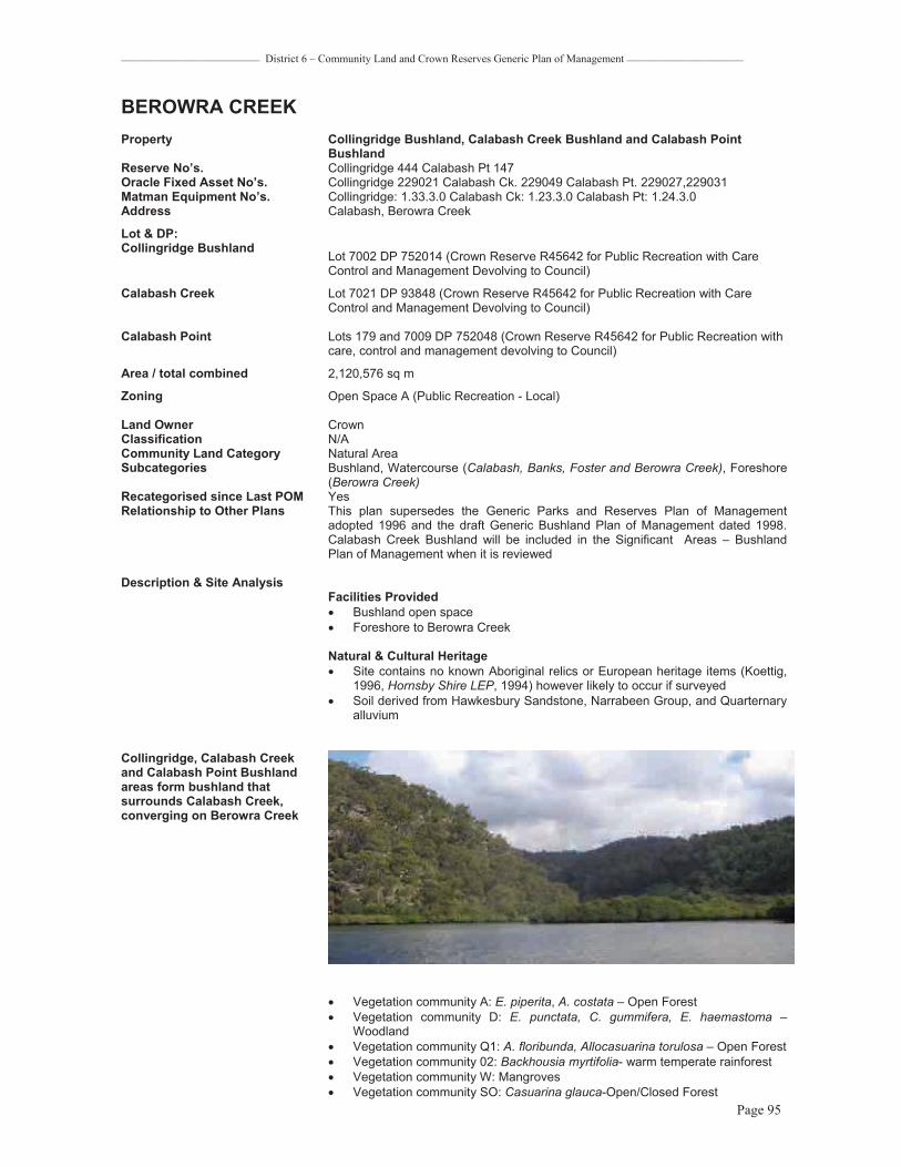
_________________________ District 6 – Community Land and Crown Reserves Generic Plan of Management _____________________
Page 95
BEROWRA CREEKProperty Collingridge Bushland, Calabash Creek Bushland and Calabash Point
BushlandReserve No’s. Collingridge 444 Calabash Pt 147 Oracle Fixed Asset No’s. Collingridge 229021 Calabash Ck. 229049 Calabash Pt. 229027,229031 Matman Equipment No’s. Collingridge: 1.33.3.0 Calabash Ck: 1.23.3.0 Calabash Pt: 1.24.3.0 Address Calabash, Berowra Creek
Lot & DP: Collingridge Bushland Lot 7002 DP 752014 (Crown Reserve R45642 for Public Recreation with Care
Control and Management Devolving to Council)
Calabash Creek Lot 7021 DP 93848 (Crown Reserve R45642 for Public Recreation with Care Control and Management Devolving to Council)
Calabash Point Lots 179 and 7009 DP 752048 (Crown Reserve R45642 for Public Recreation with care, control and management devolving to Council)
Area / total combined 2,120,576 sq m
Zoning Open Space A (Public Recreation - Local)
Land Owner Crown Classification N/ACommunity Land Category Natural Area Subcategories Bushland, Watercourse (Calabash, Banks, Foster and Berowra Creek), Foreshore
(Berowra Creek)Recategorised since Last POM YesRelationship to Other Plans This plan supersedes the Generic Parks and Reserves Plan of Management
adopted 1996 and the draft Generic Bushland Plan of Management dated 1998. Calabash Creek Bushland will be included in the Significant Areas – Bushland Plan of Management when it is reviewed
Description & Site Analysis Facilities Provided� Bushland open space� Foreshore to Berowra Creek
Natural & Cultural Heritage� Site contains no known Aboriginal relics or European heritage items (Koettig,
1996, Hornsby Shire LEP, 1994) however likely to occur if surveyed � Soil derived from Hawkesbury Sandstone, Narrabeen Group, and Quarternary
alluvium
Collingridge, Calabash Creek and Calabash Point Bushland areas form bushland that surrounds Calabash Creek, converging on Berowra Creek
� Vegetation community A: E. piperita, A. costata – Open Forest � Vegetation community D: E. punctata, C. gummifera, E. haemastoma –
Woodland � Vegetation community Q1: A. floribunda, Allocasuarina torulosa – Open Forest � Vegetation community 02: Backhousia myrtifolia- warm temperate rainforest � Vegetation community W: Mangroves � Vegetation community SO: Casuarina glauca-Open/Closed Forest

_________________________ District 6 – Community Land and Crown Reserves Generic Plan of Management _____________________
Page 96
� Vegetation community CS: Coastal saltmarsh
Conservation Status� Vegetation community CS and SO are of state conservation significance and
listed under the TSC Act as Coastal Saltmarsh in the NSW North Coast, Sydney Basin and South East Corner Bioregions and SO as Swamp Oak Floodplain Forest
� Vegetation community 02 Warm temperate rainforest is of regional conservation significance
� Vegetation community Q1 comprises part of the Narrabeen Slopes Forest Community – regional conservation significance
� Vegetation community W Mangroves is of local significance
Condition / Impacts� All the core and ridgetop bushland is in very good condition KMC(1/1/1(1) � The foreshore areas are all in very good condition and the mangroves all
appear in good health.
Overall Condition � Very good
ManagementRecurrent Expenditure� Bushfire mitigation� Foreshore estuary management of mangroves and saltmarsh
Exceptional ExpenditureN/A
Comments� These large areas of Council managed Crown reserves adjoin other large
natural areas of Crown land which adjoin Marramarra National Park. The trail access is managed by crown lands
� The access to these areas is mainly by water only or off the crown fire trails. The bushland is generally steep and there are no formalised walking tracks
� There are powerlines running through this reserve to the residential area of Neverfail Bay
Level of Service Grading N/AExisting Leases None

_________________________ District 6 – Community Land and Crown Reserves Generic Plan of Management _____________________
Page 97
0 200 400 600 800100Meters
/LEGEND:
COLLINGRIDGE BUSHLANDLand Owner: Crown Land R45642 with care, control and management devolved to CouncilLand Category: Natural Area
MARRAMARRANATIONAL
PARK
CALABASHPOINT
BUSHLAND
CALABASHPOINT
BUSHLAND
CALABASHCREEK
BUSHLAND
COLLINGRIDGE BUSHLAND
CUNIOPOINT
BUSHLAND -ADJACENT DISTRICT 5
ADJACENTNEVERFAIL
BAYBUSHLAND
Fire Trails
BEROWRA CREEK
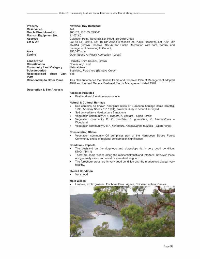
_________________________ District 6 – Community Land and Crown Reserves Generic Plan of Management _____________________
Page 98
Property Neverfail Bay BushlandReserve No. 444Oracle Fixed Asset No. 105102, 105103, 229061 Matman Equipment No. 1.107.3.0 Address Calabash Point, Neverfail Bay Road, Berowra Creek Lot & DP Lot 18 DP 20441, Lot 18 DP 25543 (Freehold as Public Reserve), Lot 7001 DP
752014 (Crown Reserve R45642 for Public Recreation with care, control and management devolving to Council)
Area 256,397 sq m Zoning Open Space A (Public Recreation - Local)
Land Owner Hornsby Shire Council, Crown Classification Community Land Community Land Category Natural Area Subcategories Bushland, Foreshore (Berowra Creek)Recategorised since Last POM
Yes
Relationship to Other Plans This plan supersedes the Generic Parks and Reserves Plan of Management adopted 1996 and the draft Generic Bushland Plan of Management dated 1998
Description & Site Analysis Facilities Provided� Bushland and foreshore open space
Natural & Cultural Heritage� Site contains no known Aboriginal relics or European heritage items (Koettig,
1996, Hornsby Shire LEP, 1994), however likely to occur if surveyed � Soil derived from Hawkesbury Sandstone � Vegetation community A: E. piperita, A. costata – Open Forest � Vegetation community D: E. punctata, E. gummifera, E. haemastoma –
Woodland � Vegetation community Q1: A. floribunda, Allocasuarina torulosa – Open Forest
Conservation Status� Vegetation community Q1 comprises part of the Narrabeen Slopes Forest
Community and is of regional conservation significance
Condition / Impacts� The bushland on the ridgetops and downslope is in very good condition.
KMC(1/1/1(1)� There are some weeds along the residential/bushland interface, however these
are generally minor and could be classified as good. � The foreshore areas are in very good condition and the mangroves appear very
healthy.
Overall Condition � Very good
Main Weeds� Lantana, exotic grasses, Fishbone Fern , Agave, Chinese Lantern, Cassia

_________________________ District 6 – Community Land and Crown Reserves Generic Plan of Management _____________________
Page 99
Management Recurrent Expenditure� Tree maintenance � Bushfire Mitigation
Exceptional Expenditure� N/A
Comments � This bushland adjoins MarraMarra National Park, Crown Land and residential properties along Berowra Creek at Neverfail Bay
� The Cobah ridge trail ends in this bushland. There is a good lookout at this point. � There are many garden escapee weeds on private properties adjoining the
Reserve
Level of Service Grading N/AExisting Leases None

_________________________ District 6 – Community Land and Crown Reserves Generic Plan of Management _____________________
Page 100
0 50 100 150 20025Meters
/LEGEND:
NEVERFAIL BAY BUSHLAND
Land Owner: Crown Land R45642 care, control and management devolves to CouncilLand Category: Natural Area
NEVERFAIL BAY BUSHLAND
NATURAL AREANEVERFAIL
BAY
COLLINGRIDGE POINT
Bero
wra
Cre
ek
MARRAMARRANATIONAL
PARK
Land Owner: Hornsby Shire Council
Coba Ridge Fire Trail
COLLINGRIDGE BUSHLANDADJACENT

_________________________ District 6 – Community Land and Crown Reserves Generic Plan of Management _____________________
Page 101
Property Vacant Land - Cobah Point 1 and Cobah Point 2 Reserve No. None Oracle Fixed Asset No Cobah Pt 1: 105089
Cobah Pt 2: 105090 Matman Equipment No. Cobah Pt 1: 1.31.3.0
Cobah Pt 2: 1.32.3.0 Address Cobah Point, Berowra Creek
Lot & DP Cobah Pt 1: Lot 12 DP 23821 Freehold as public reserve Cobah Pt 2: Lot 30A DP 24236 Freehold as public reserve
Area Cobah Pt 1: 1,577 sqm Cobah Pt 2: 972 sqm
Zoning Open Space A (Public Recreation - Local)
Land Owner Hornsby Shire Council Classification Community Community Land Category Natural Area Subcategories Bushland, Foreshore (Berowra Creek)Recategorised since Last POM Not included in any former POM Relationship to Other Plans None
Description & Site Analysis Facilities Provided� Foreshore and bushland open space
Natural & Cultural Heritage� Site contains no known Aboriginal relics or European heritage items (Koettig,
1996, Hornsby Shire LEP, 1994) however likely to occur if surveyed � Vegetation community Q1: A. floribunda, Allocasuarina torulosa – Open Forest
Cobah Point
Conservation Status� Vegetation community Q1 comprises part of the Narrabeen Slopes Forest
Community – a significant community in the Hornsby Local Government Area
Condition / Impacts� Both of these blocks are in good condition with minor weed infestation.

_________________________ District 6 – Community Land and Crown Reserves Generic Plan of Management _____________________
Page 102
Overall Condition � good
Management Recurrent Expenditure� Tree maintenance � Bushfire mitigation
Exceptional Expenditure� N/A
Comments � There appears to have been some vegetation removal on Cobah Pt. 1 and evidence of rubbish dumping along the foreshore.
� There appears to be an encroachment of water tanks and other items on Cobah Pt. 2.
Level of Service Grading N/AExisting Leases none

_________________________ District 6 – Community Land and Crown Reserves Generic Plan of Management _____________________
Page 103
0 30 60 90 12015Meters
/LEGEND:
COBAH POINT
Land Owner: Hornsby Shire CouncilLand Category: Natural Area
NATURAL AREA
MARRAMARRA CREEK
COBAH POINT
NATURAL AREA
BEROWRA
CREEK

_________________________ District 6 – Community Land and Crown Reserves Generic Draft Plan of Management _____________________
Page 104
BEROWRA WATERSProperty Bay Road Bushland Reserve No. 146Oracle Fixed Asset No. 105421, 229023, 229035 Matman Equipment No. 1.7.3.0Address Bay Road, Berowra Waters Road, Dusthole Point, Berowra Waters Lot & DP Lot 185 DP 752048, (Crown Reserve R80810 for Public Recreation with Council
Trustees notified in 1958), Lot 7010 DP 752048 (Crown Reserve R45642 for Public Recreation with care, control and management devolving to Council), Lot 7012 DP 752048 (Crown Reserve R76292 for Public Recreation with Council Trustees notified in 1954)
Area 114,896 sq m Zoning Open Space A (Public Recreation - Local)
Land Owner Crown Classification N/ACommunity Land Category Natural Area Subcategories Bushland, Watercourse (Crossland Creek)Recategorised since Last POM YesRelationship to Other Plans This plan supersedes the Generic Parks and Reserves Plan of Management
adopted 1996 and the draft Generic Bushland Plan of Management dated 1998
Description & Site Analysis Facilities Provided� Bushland open space
Natural & Cultural Heritage� Site contains no known Aboriginal relics or European heritage items (Koettig,
1996, Hornsby Shire LEP, 1994) however possible if surveyed � Soil derived from Hawkesbury Sandstone � Vegetation community A: E. piperita, A. costata – Open Forest � Vegetation community F: E. racemosa, C. gummifera, A. costata – Woodland � Vegetation community G: E. haemastoma, A. hispida, Banksia ericifolia – Low
Open Woodland � Vegetation community Q1: A. floribunda, Allocasuarina torulosa – Open Forest � Vegetation community O2: Backhousia myrtifolia - Warm temperate rainforest � Vegetation community W: Mangroves
Bay Road Bushland contains open forest, woodlands, warm temperate rainforest gullies and mangroves along Crosslands Creek leading into Dusthole Bay / Berowra Creek

_________________________ District 6 – Community Land and Crown Reserves Generic Draft Plan of Management _____________________
Page 105
Conservation Status� Vegetation community 02 Warm temperate rainforest is of regional
conservation significance � Vegetation community Q1 comprises part of the Narrabeen Slopes Forest
Community and is of regional conservation significance � Vegetation community W Mangroves is of local significance
Condition / Impacts� Bushland in very good condition KMC(1/1/1(1) � There is some minor weed infestation at the downstream section where the
reserve meets Dusthole Bay which would be rated as fair
Overall ConditionVery good
Main Weeds� Lantana, Crofton Weed, Parramatta Grass, Watsonia
ManagementRecurrent Expenditure� Tree Maintenance � Bushfire Mitigation
Exceptional Expenditure� None
Comments � There are no formalised walking tracks and access into bushland is steep and difficult
� There is access up the creek from the bottom of the reserve behind the playground at Dusthole Bay
Level of Service Grading N/AExisting Leases None

_________________________ District 6 – Community Land and Crown Reserves Generic Draft Plan of Management _____________________
Page 106
0 50 100 150 20025Meters
/LEGEND:
BAY ROAD BUSHLAND
Land Owner: Crown Land R76292for Public Recreation with Council made Trustees 1954
Land Category: Natural Area
BAY ROADBUSHLAND
NATURAL AREA
Cr oss land
s Creek
ADJACENT CROWN
LAND

_________________________ District 6 – Community Land and Crown Reserves Generic Draft Plan of Management _____________________
Page 107
Property Dusthole Bay / Berowra Waters West Parkland Reserve No. 180Oracle Fixed Asset No. 229113, 229195 Matman Equipment No. 3.180.0.0.0.0 Address 129X Bay Road, Berowra Waters Road, Berowra Waters Lot & DP Lot 7020 DP 1057993 (Crown Reserve R91194 for boat ramp and car parking with
Council Trustees), Permissive Occupancies 1974/39 for tidal baths and 1983/8 for community berthing
Area 253,981 sq m Zoning Open Space A (Public Recreation - Local)
Land Owner Crown Classification N/ACommunity Land Category General Community Use, Natural Area Subcategories Watercourse (Crosslands Creek)Recategorised since Last POM YesRelationship to Other Plans This plan supersedes the Generic Parks and Reserves Plan of Management
adopted 1996 and the draft Generic Bushland Plan of Management dated 1998. This plan does not override the Berowra Waters Plan of Management prepared by Connell Wagner Pty Ltd on behalf of the Department of Land and Water Conservation and Hornsby Shire Council and adopted by Council on 1 September 1999. The Berowra Waters Plan of Management provides for the detailed management and development of this land
Description & Site Analysis Facilities Provided� Boat launching ramp and pontoon� Car park� Park and Playground � Fishing; cleaning and washing facilities � BBQ (covered x 2), Picnic shelters (x 2), open Picnic setting (x 2), bench seats � Toilet block � Bin recycling station � Timber post and steel railing to eastern carpark interface with park � Steel fence to playground � Telegraph poles laid as edge to western carpark boundary
Natural & Cultural Heritage� Site contains no known Aboriginal relics or European heritage items (Koettig,
1996, Hornsby Shire LEP, 1994) � Vegetation community Q1: A. floribunda, Allocasuarina torulosa – Open Forest � Vegetation community W: Mangroves – intertidal vegetation along Crosslands
Creek at western park edge � Marine environment including adjacent to eastern wall at Marina providing
important Soft-bottom Benthos habitat (including layers of mud, silt sand and benthic organisms).
Conservation Status � Vegetation community Q1 comprises part of the Narrabeen Slopes Forest
community and is of regional conservation significance � Vegetation community W is a significant community in the Hornsby Local
Government Area
Condition / Impacts� Carpark � Mangrove community in good condition
ManagementRecurrent Expenditure� Tree maintenance � Mowing � Cleaning and maintenance of toilet facilities � Maintenance of Catchment Remediation (pollutant trap and water
treatment)devices � BBQ cleaning and maintenance � Fish cleaning tables and pontoon cleaning and maintenance � Boat ramp cleaning and maintenance � Line marking to carpark including car spaces, speed bumps and pedestrian
crossing

_________________________ District 6 – Community Land and Crown Reserves Generic Draft Plan of Management _____________________
Page 108
� Rubbish collection, 12 x 240L plus recycling station, four times a week by commercial contractor
� Inspection and maintenance of playground equipment
Exceptional Expenditure� Surface repairs to boat ramp and car park as required. � Repairs to picnic and bbq facilities as required. � Replacement of pontoon and fish cleaning facilities � Playground repairs as required.
View looking north over parkland with water to right of picture
Comments� A pit insert has been installed in this reserve to capture gross pollutants in the
car park (Asset ID 107) � An underground Rocla water treatment device has been installed adjacent to
the boat ramp (Asset ID 105) � An extension to the floating pontoon is planned � The Berowra Waters Plan of Management provides for the construction of a
multi-deck carpark, foreshore boardwalk and relocated picnic and play facilities
Level of Service Grading HighExisting Leases None

_________________________ District 6 – Community Land and Crown Reserves Generic Draft Plan of Management _____________________
Page 109
0 10 20 30 405Meters
/LEGEND: DUSTHOLE BAY
Land Owner: Crown Land R91194 for boatlaunching ramp and parking area with care,control and management devolving to CouncilPO (Permissive Occupancy) 1974/39 for tidal bathsPO 1983/8 for community berthingLand Categories: General Community Use,Natural Area
BAY ROAD ADJACENTBUSHLAND
FURBER PARKADJACENT BUSHLAND
" CRR devices
PO 1974/39 PO 1983/8
NATURALAREA
GENERAL COMMUNITY
USE
Crosslands Creek
BAY ROAD
PARK
DUSTHOLE BAYPARK
PARK
GENERAL COMMUNITY
USE
PARK
PARK
PARK
GENERAL COMMUNITY USE (Carpark& Boat Ramp
facilities)

_________________________ District 6 – Community Land and Crown Reserves Generic Draft Plan of Management _____________________
Page 110
Property Furber ParkReserve No. 180Oracle Fixed Asset No. 105633 -105635 Matman Equipment No. 1.57.3.0Address Bay Road (83X, 130, 130A), Berowra Waters Lot & DP Lot 1 DP 318160, Lot 2 DP 1003377, Lot 1 DP 1093193(Freehold) Area 375,951 sq m
Zoning All zoned Open Space A (Public Recreation - Local) except part of Lot 1 DP 318160 and part of Lot 1 DP 1003193 which is zoned Environmental Protection B (River Catchment)
Land Owner Hornsby Shire Council Classification Community [Note part of Furber Park, being part of Lot 1 DP 318160 and part of
Lot 33 DP 14065, has been reclassified as operational land] Community Land Category Natural Area Subcategories Bushland Recategorised since Last POM NoRelationship to Other Plans This plan supersedes the Generic Parks and Reserves Plan of Management
adopted 1996 and the draft Generic Bushland Plan of Management dated 1998
Description & Site Analysis Facilities Provided� Bushland open space
Natural & Cultural Heritage� Site contains no known Aboriginal relics or European heritage items (Koettig,
1996, Hornsby Shire LEP, 1994) � Soil derived from Hawkesbury Sandstone � Vegetation community F: E. racemosa, C. gummifera, A. costata – Woodland � Vegetation community A: E. piperita, A. costata – Open Forest � Vegetation community Q1: A. floribunda, Allocasuarina torulosa – Open Forest
Conservation Status� Vegetation community Q1 comprises part of the Narrabeen Slopes Forest
Community and is of regional conservation significance
Condition / Impacts� The bushland upslope of the access road is in very good condition � Behind the foreshore houses the bushland is in very good condition. KMC
1/1/1(1)� There are many weed species on the road reserve along Bay Rd. and
adjacent to private property
Overall Condition� Very good
Main Weeds� Coral Trees, Mother of Millions, Cotoneaster, Lantana, exotic grasses, all
within road reserve
Furber Park foreshore

_________________________ District 6 – Community Land and Crown Reserves Generic Draft Plan of Management _____________________
Page 111
Management Recurrent Expenditure� Tree maintenance � Bushfire mitigation
Exceptional Expenditure� N/A
Comments � There are no formalised tracks or easy access to this reserve. The bushland behind the residential properties is very steep
� A designated Wildlife Protection Area � Part of Lot 1 DP 318160 and Lot 33 DP 14065 are classified as operational
land and an easement to private property was created under Sec 88b of the Conveyancing Act.
Level of Service Grading N/A
Existing Leases None

_________________________ District 6 – Community Land and Crown Reserves Generic Draft Plan of Management _____________________
Page 112
0 30 60 90 12015Meters
/LEGEND: FURBER PARK
Land Owner: Hornsby Shire Council
Land Category: Natural Area
NATURALAREA
ADJACENTBAY ROAD BUSHLAND
FURBER PARK
Cross
lands
BAY ROAD
Cre
ek
Threatened flora on adjacent land to south of site
DUSTHOLE BAY - adjacent site
BEROWRA WATERS MARINA
BEROWRA CREEK

_________________________ District 6 – Community Land and Crown Reserves Generic Draft Plan of Management _____________________
Page 113
Property Woolwash Bay Reserve No. 32Oracle Fixed Asset No. 10570-10588 Matman Equipment No. 1.142.3.0 Address Berowra Creek (Woolwash Bay), Berowra Waters Lot & DP Lots 1-16, 18 & 19 DP 25755, Lot B 391873 (Freehold) Area 75,712 sq m Zoning All zoned Open Space A (Public Recreation - Local) except Lots 18 & 19 DP 25755
which are zoned Environmental Protection B (River Catchment) Land Owner Hornsby Shire Council Classification Community Land Community Land Category Natural Area Subcategories Bushland, Watercourse, (Berowra Creek) Foreshore Recategorised since Last POM YesRelationship to Other Plans This plan supersedes the Generic Parks and Reserves Plan of Management
adopted 1996 and the draft Generic Bushland Plan of Management dated 1998
Description & Site Analysis Facilities Provided� Bushland open space � Foreshore access to Berowra Creek
Natural & Cultural Heritage� Site contains no known Aboriginal relics or European heritage items (Koettig,
1996, Hornsby Shire LEP, 1994) � Soil derived from Hawkesbury Sandstone � Vegetation community F: E. racemosa, C. gummifera, A. costata – Woodland � Vegetation community Q1: A. floribunda, Allocasuarina torulosa – Open Forest � Vegetation community A: E. piperita, A. costata – Open Forest � Vegetation community G: E. haemastoma, A. hispida, Banksia ericifolia – Low
Open Woodland
Woolwash Bay
Conservation Status� Vegetation community Q1 comprises part of the Narrabeen Slopes Forest
Community and is of regional conservation significance
Condition / Impacts� The bushland and foreshore vegetation is all in very good condition
KMC1/1/1(1)
Overall Condition� Very good
Main Weeds � Some Fishbone Fern and Cape Daisy on boundary with the private property
Management Recurrent Expenditure� Tree maintenance � Bushfire mitigation
Exceptional Expenditure� N/A

_________________________ District 6 – Community Land and Crown Reserves Generic Draft Plan of Management _____________________
Page 114
Comments� This reserve is water access only with no formalised tracks or access points
Level of Service Grading N/A
Existing Leases None

_________________________ District 6 – Community Land and Crown Reserves Generic Draft Plan of Management _____________________
Page 115
0 30 60 90 12015Meters
/LEGEND: WOOLWASH BAY
Land Owner: Hornsby Shire Council
Land Category: Natural Area
BEROWRA VALLEY
REGIONAL PARK
NATURALAREA
BEROWRAVALLEY
REGIONALPARK
FURBER PARK
Berowra Creek
WOOLWASH BAY
BEROWRA VALLEY
REGIONAL PARK
NATURALAREA
NATURALAREA

_________________________ District 6 – Community Land and Crown Reserves Generic Draft Plan of Management _____________________
Page 116
Property Vacant Land - Calabash Point 1 and Calabash Point 2 Reserve No. 556Oracle Fixed Asset No Calabash Pt 1: 105807
Calabash Pt 2: 105090 Matman Equipment No. none Address Calabash Point, Berowra Waters Lot & DP Calabash 1: Lot 13 DP 13591 Freehold as public reserve
Calabash 2: Lot 18 DP 202186 Freehold as public reserve Area 1: 1,290 sqm 2: 630sqm
Zoning Open Space A (Public Recreation - Local) Land Owner Hornsby Shire Council Classification Community Land Community Land Category Natural Area Subcategories Bushland, Foreshore (Berowra Creek)Recategorised since Last POM NoRelationship to Other Plans This plan supersedes the Generic Parks and Reserves Plan of Management
adopted 1996 and the draft Generic Bushland Plan of Management dated 1998
Description & Site Analysis Facilities Provided� Foreshore and bushland open space
Natural & Cultural Heritage� Site contains no known Aboriginal relics or European heritage items (Koettig,
1996, Hornsby Shire LEP, 1994) however likely to occur if surveyed � Vegetation community Q1: A. floribunda, Allocasuarina torulosa – Open Forest
Lot 13 DP 13591 – Open forest understorey
Lot 18 DP 202186 – Open forest understorey
Conservation Status� Vegetation community Q1 comprises part of the Narrabeen Slopes Forest
Community and is of regional conservation significance
Condition / Impacts� The condition of both of these blocks are good with little weed infestation
apparent

_________________________ District 6 – Community Land and Crown Reserves Generic Draft Plan of Management _____________________
Page 117
Overall Condition � Very good
Management Recurrent Expenditure� Bushfire mitigation� Tree maintenance
Exceptional Expenditure� N/A
Comments � Part of Calabash Pt. 2 has been reclassified as operational land to facilitate a land exchange with the neighbouring Lot 17
Level of Service Grading N/A
Existing Leases None

_________________________ District 6 – Community Land and Crown Reserves Generic Draft Plan of Management _____________________
Page 118
0 30 60 90 12015Meters
/LEGEND:
VACANT LAND CALABASH
Land Owner: Hornsby Shire Council
Land Category: Natural Area
CALABASH POINT
NATURAL AREA
NATURAL AREA

_________________________ District 6 – Community Land and Crown Reserves Generic Draft Plan of Management _____________________
Page 119
BERRILEEProperty Charltons Creek Road Bushland Reserve No. 146Oracle Fixed Asset No. 229085 Matman Equipment No. 1.27.3.0Address 4-6X Charltons Creek Road, Berrilee Lot & DP Lot 7016 DP 93851 (Crown Reserve R32084 for Public Recreation with care
control and management devolving to Council) Area 21,013 sq m
Zoning Open Space A (Public Recreation - Local) Land Owner Crown Classification N/ACommunity Land Category Natural Area Subcategories Bushland Recategorised since Last POM No as it has not been included in any former Plan of Management Relationship to Other Plans None
Description & Site Analysis Facilities Provided� Bushland open space
Natural & Cultural Heritage� Site contains no known Aboriginal relics or European heritage items (Koettig,
1996, Hornsby Shire LEP, 1994) however possible if surveyed. � Soil derived from Hawkebury Sandstone � Vegetation community D: E. punctata, E. gummifera, E. haemastoma –
Woodland
Conservation Status� Vegetation community D is well conserved
Bushland view
Condition / Impacts � Core of bushland is very good � Areas of the reserve are in poor to very poor condition KMC1/4/4(4) and
appear to have had past dumping problems � The road edges are in fair condition with a lot of exotic grasses
Overall condition � Good

_________________________ District 6 – Community Land and Crown Reserves Generic Draft Plan of Management _____________________
Page 120
Main Weeds � Bridal Creeper, Lantana, Asparagus Fern, Fishbone Fern, Whiskey Grass,
African Lovegrass, Parramatta Grass, a lot of Pittosporums
Management Recurrent Expenditure� Tree / roadside vegetation maintenance � Noxious weed control � Bushfire mitigation
Exceptional ExpenditureN/A
Comments � This bushland is level for a short distance and then drops very steeply with good views across a deep valley
� Adjoins BVRP and is a possible future addition
Level of Service Grading N/A
Existing Leases None

_________________________ District 6 – Community Land and Crown Reserves Generic Draft Plan of Management _____________________
Page 121
0 10 20 30 405Meters
/LEGEND:
CHARLTONS CREEK ROAD BUSHLAND
Land Owner: Crown Lands with care, controland management devolved to CouncilLand Category: Natural Area
BEROWRA VALLEY REGIONAL PARK
NATURALAREA
CHARLTONS CREEK ROAD BUSHLAND
Vegetation Community D: E.Punctata, E.Gummifera, E.Haemastoma - Woodland, Shale/ Sandstone Transition Forest
BAY ROAD
CH
AR
LTO
NS
CR
EEK
RO
AD
BEROWRA VALLEY REGIONAL PARK

_________________________ District 6 – Community Land and Crown Reserves Generic Draft Plan of Management _____________________
Page 122
CANOELANDSProperty Canoelands Rural Fire Service Reserve No. 527Oracle Fixed Asset No. 229210 Matman Equipment No. 8.140.30Address Old Northern Road, Canoelands Lot & DP Lot 104 DP 752029 (Crown Reserve R85554 for Rural Fire Service Purposes with
Council made Trustees 26/5/1995, excluding an area 152 sq m at corner Telstra uses as exchange)
Area 2,530 sq m
Zoning Rural AR (Large Holdings – Rural Landscapes) Land Owner Crown Classification N/ACommunity Land Category General Community Use, Natural Area Subcategories Bushland Recategorised since Last POM YesRelationship to Other Plans This plan supersedes the Generic Parks and Reserves Plan of Management
adopted 1996 and the draft Generic Bushland Plan of Management dated 1998
Description & Site Analysis Facilities Provided� Canoelands Bush Fire Station� Bushland open space
Natural & Cultural Heritage � Site contains no known Aboriginal relics or European heritage items (Koettig,
1996, Hornsby Shire LEP, 1994) � Soil derived from Hawkesbury Sandstone � Vegetation community D: E. punctata, E. gummifera, E. haemastoma -
Woodland
Bushland
Conservation Status� Vegetation community D is well conserved � The core bushland areas are in very good condition � There are edge effect weeds around the station facility and along the road and
trail edges.
Overall condition � Good
Main Weeds� Whiskey grass, Pampas Grass, African Lovegrass
Management Recurrent Expenditure� Tree maintenance � Mowing � Building maintenance � Parking area maintenance
_________________________ District 6 – Community Land and Crown Reserves Generic Draft Plan of Management _____________________
Page 123
Exceptional Expenditure� Repair and replacement of facilities as required due to wear and tear and
vandalism� Bushfire mitigation� Noxious weed control
Comments � Telecom exchange also located on this land parcel � There is a short trail from the fire brigade building to some Telstra
infrastructure
Level of Service Grading Low
Existing Leases None

_________________________ District 6 – Community Land and Crown Reserves Generic Draft Plan of Management _____________________
Page 124
0 5 10 15 202.5Meters
/LEGEND: CANOELANDS
RURAL FIRE SERVICE
Land Owner: Crown Lands R85554 for Bush Fire Brigade Purposes with Council Trustees
Land Categories: Natural Area, General Community Use
GENERAL COMMUNITY USE
CANOELANDS RD
OLDNORTHERN
RD
NATURALAREA
SHIREBOUNDARY
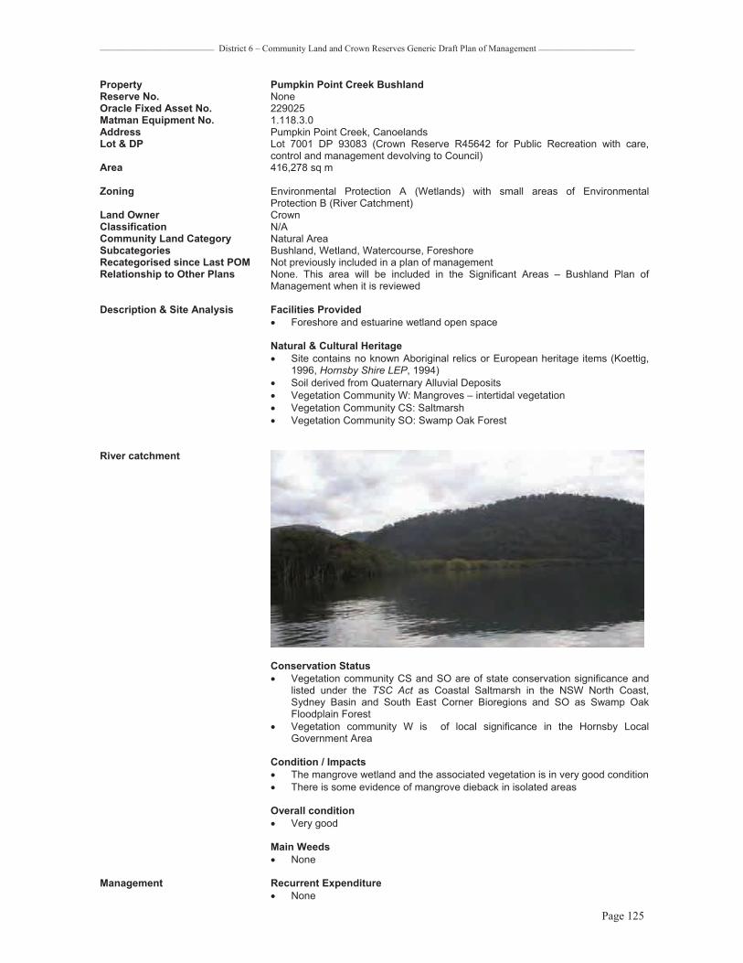
_________________________ District 6 – Community Land and Crown Reserves Generic Draft Plan of Management _____________________
Page 125
Property Pumpkin Point Creek Bushland Reserve No. None Oracle Fixed Asset No. 229025 Matman Equipment No. 1.118.3.0 Address Pumpkin Point Creek, Canoelands Lot & DP Lot 7001 DP 93083 (Crown Reserve R45642 for Public Recreation with care,
control and management devolving to Council) Area 416,278 sq m
Zoning Environmental Protection A (Wetlands) with small areas of Environmental Protection B (River Catchment)
Land Owner Crown Classification N/ACommunity Land Category Natural Area Subcategories Bushland, Wetland, Watercourse, Foreshore Recategorised since Last POM Not previously included in a plan of management Relationship to Other Plans None. This area will be included in the Significant Areas – Bushland Plan of
Management when it is reviewed
Description & Site Analysis Facilities Provided� Foreshore and estuarine wetland open space
Natural & Cultural Heritage � Site contains no known Aboriginal relics or European heritage items (Koettig,
1996, Hornsby Shire LEP, 1994) � Soil derived from Quaternary Alluvial Deposits � Vegetation Community W: Mangroves – intertidal vegetation � Vegetation Community CS: Saltmarsh � Vegetation Community SO: Swamp Oak Forest
River catchment
Conservation Status� Vegetation community CS and SO are of state conservation significance and
listed under the TSC Act as Coastal Saltmarsh in the NSW North Coast, Sydney Basin and South East Corner Bioregions and SO as Swamp Oak Floodplain Forest
� Vegetation community W is of local significance in the Hornsby Local Government Area
Condition / Impacts � The mangrove wetland and the associated vegetation is in very good condition � There is some evidence of mangrove dieback in isolated areas
Overall condition � Very good
Main Weeds � None
Management Recurrent Expenditure� None

_________________________ District 6 – Community Land and Crown Reserves Generic Draft Plan of Management _____________________
Page 126
Exceptional Expenditure� Saltmarsh and mangrove health monitoring program
Mangrove Swamp and Saltmarsh exist within the reserve, of State Conservation Significance
Comments� This is a significant mangrove swamp with areas of saltmarsh. A creek runs
through the mangroves � Access to one private property is gained via the creek and the reserve. This
property is an inholding being land locked by this reserve and Marramarra National Park
� It is a significant habitat area surrounded by NPWS estate
Level of Service Grading N/A
Existing Leases None

_________________________ District 6 – Community Land and Crown Reserves Generic Draft Plan of Management _____________________
Page 127
0 80 160 240 32040Meters
/LEGEND:
PUMPKIN POINT CREEK BUSHLAND
Land Owner: Crown Lands R45642 for Public Recreation with care, controland management devolved to CouncilLand Category: Natural Area
BEROWRA VALLEY
REGIONAL PARK
NATURALAREA
HAK
ES
BUR
YR
IVE
R
PUMPKIN POINT CREEK BUSHLAND
Vegetation: Saltmarsh, Mangroves, Swamp Oak Woodland
Pumpkin Point Creek
BEROWRA VALLEY
REGIONAL PARK

_________________________ District 6 – Community Land and Crown Reserves Generic Draft Plan of Management _____________________
Page 128
DURALProperty Dural ParkReserve No. 208Oracle Fixed Asset No. 229056, 229143 Matman Equipment No. 2.208.0.0.0.0 Address 40 & 40X Quarry Road, Dural Lot & DP Lots 1116 & 1117 DP 822289 (Crown Reserve R500116 for Public Recreation in
1897 with Council made trustees in 1965) Area 64,033 sq m
Zoning Open Space A (Public Recreation - Local) Land Owner Crown Classification N/ACommunity Land Category Sportsground, General community use, Natural Area Subcategories Bushland Recategorised since Last POM YesRelationship to Other Plans This plan supersedes the Generic Parks and Reserves Plan of Management
adopted 1996 and the draft Generic Bushland Plan of Management dated 1998
Description & Site Analysis Facilities Provided� Dural District Rural Fire Service� Tennis Courts with night lighting and Pro-Shop, Clubhouse with minor
refreshment provision / kiosk, kitchen, toilets� Sportsfield, changerooms toilets and kiosk � Carpark � Waste water management system � Bushland open space
Natural & Cultural Heritage � Soil derived from Hawkesbury Sandstone � Vegetation community C: E. gummifera, E. haemastoma, E. oblonga–
Woodland � Site contains no known Aboriginal relics or European heritage items (Koettig,
1996, Hornsby Shire LEP, 1994) � Dedicated as a reserve from sale for public recreation in 1897, it was only in
1965 that Council was made trustees and in 1984 that two sportsfields were developed on the site, the land previously being used by some residents as a rubbish dump. The Bush Fire Brigade has been at the site since 1957 and their area extended over the years and in recent times in 1996
View towards Amenities Building from western edge of sportsfield, adjacent to bushland area
Conservation Status� This vegetation community is well conserved
Condition / Impacts � There was evidence of some past degradation but bushland restoration by the
bushcare volunteers has the area in good condition � The bushland areas within Dural Park form a buffer to adjacent properties and
roadway and are in very good condition Overall condition � Very good Main Weeds � Minor exotic grasses around edges of the bushland and sportsfield

_________________________ District 6 – Community Land and Crown Reserves Generic Draft Plan of Management _____________________
Page 129
Tennis courts and Clubhouse
Dural District Fire Brigade HQ
ManagementRecurrent Expenditure� Tree maintenance � Mowing � Rubbish collection, 3 x 240L bins twice a week � Maintenance and cleaning changeroom and toilet facilities � Sportsfield line marking � Change of season works � Spraying for noxious weeds and pests � Bushcare � Wastewater Treatment maintenance
Exceptional Expenditure� Repair and replacement of facilities as required � Tennis Court and field perimeter fence replacements � Maintenance to fixed assets eg. carpark � Regrading and returfing oval
Comments � Powerline high tension easement runs through the natural area � A Bushcare Group known as the Quarry Road group is restoring bushland
areas in this park
Level of Service Grading High
Existing Leases Tennis Club

_________________________ District 6 – Community Land and Crown Reserves Generic Draft Plan of Management _____________________
Page 130
")
0 20 40 60 8010Meters
/LEGEND: DURAL PARK
Land Owner: Crown Lands R500116 for PublicRecreation in 1897 Hornsby Council trustees in 1965Land Categories: Natural Area,Sportsground, General Community UseVegetation: Shale/ Sandstone Transition Forest
SPORTSGROUND
NATURALAREA
NATURALAREA
NATURALAREA
NATURALAREA
GENERALCOMMUNITY
USEQUARRY RD
Fire Trails: Quarry Rd Powerline Trail No.1 and Pyes Creek Private Fire Trail
") Red-crowned Toadlet Vulnerable Species
NATURALAREA

_________________________ District 6 – Community Land and Crown Reserves Generic Draft Plan of Management _____________________
Page 131
Property Muraban Road Bushland Reserve No. 68Oracle Fixed Asset No. 10595 &10596, 229123 Matman Equipment No. 1.103.3.0 Address 25X, 39, 41X Muraban Road, Dural Lot & DP Lot 251 DP 40545, Lot 5 DP 258191, Lot 14 DP 618482 (Freehold as Public
Reserve) Area 100,192 sq m Zoning Open Space A (Public Recreation – Local ): Lot 5 DP 258191
Open Space B (Public Recreation - Regional): Lot 14 DP 618482; Environmental Protection B (River Catchment) & Rural BR (Small Holdings - Rural Landscapes): Lot 251 DP 40545
Land Owner Hornsby Shire Council Classification Community Land Community Land Category Natural Area Subcategories Bushland, Watercourse (Cabbage Tree Hollow Creek)Recategorised since Last POM YesRelationship to Other Plans This plan supersedes the Generic Parks and Reserves Plan of Management
adopted 1996 and the draft Generic Bushland Plan of Management dated 1998.
Description & Site Analysis Facilities Provided� Bushland open space
Natural & Cultural Heritage � Site contains no known Aboriginal relics or European heritage items (Koettig,
1996, Hornsby Shire LEP, 1994) however they may occur if surveyed � Soil derived from Hawkesbury Sandstone � Vegetation community A: E. piperita, A. costata – Open Forest � Community C: E. gummifera, E. haemastoma, E. oblonga– Woodland � Vegetation community L: E. pilularis, A. costata, S. glomulifera – Tall Open
Forest� Vegetation community O1: Ceratopetalum apetalum – Warm Temperate
Rainforest
Conservation Status� Vegetation community L is a significant community in the Hornsby Local
Government Area � Vegetation community 01 warm temperate rainforest is of regional
conservation significance � Powerful Owls have been sighted along this watercourse
Muraban Road Bushland sandstone outcrops
Condition / Impacts � The bushland is in very good condition � There may be some minor weed infestation from adjoining rural interfaces
Overall condition � Very good

_________________________ District 6 – Community Land and Crown Reserves Generic Draft Plan of Management _____________________
Page 132
Main Weeds � None
Management Recurrent Expenditure� Tree / vegetation management � Bushfire mitigation
Exceptional Expenditure� N/A
Comments � This reserve adjoins BVRP and could be considered as a future addition � The other boundary adjoins rural properties with a lot of private bushland � There are no formal trails in this reserve, and the access handle is bushland
making entry difficult with much of the bushland being a steep valley
Level of Service Grading N/A
Existing Leases None

_________________________ District 6 – Community Land and Crown Reserves Generic Draft Plan of Management _____________________
Page 133
0 50 100 150 20025Meters
/LEGEND:
MURABAN ROAD BUSHLAND
Land Owner: Hornsby Shire CouncilLand Category: Natural Area
BEROWRAVALLEY
REGIONAL PARK
NATURALAREA
MURABAN ROAD BUSHLAND
Cabbag e Tree Ho llow Creek
Rowlands Fire Trail
MURABAN ROAD

_________________________ District 6 – Community Land and Crown Reserves Generic Draft Plan of Management _____________________
Page 134
FIDDLETOWNProperty Bloodwood Road Bushland & Aboriginal Area Reserve No. 417Oracle Fixed Asset No. 229079, 229129 Matman Equipment No. none Address Bloodwood Road (23X), Fiddletown Lot & DP Lot 7005 DP 93846 (Crown R73207 for Preservation of Aboriginal Engravings in
1933), Lot 7006 DP 93846 (Crown R63910 for Preservation of Aboriginal Engravings in 1933 ) with care, control and management devolving to Council.
Area 35,298 sq m
Zoning Environmental Protection B (River Catchment) & Rural AR (Large Holdings – Rural Landscapes): Lot 7005 DP 93846; Rural AA (Large Holdings – Agricultural Landscapes): Lot 7006 DP 93846
Land Owner Crown Classification N/ACommunity Land Category Natural Area, Area of Cultural Significance Subcategories Bushland, Watercourse Recategorised since Last POM YesRelationship to Other Plans This plan supersedes the Generic Parks and Reserves Plan of Management
adopted 1996 and the draft Generic Bushland Plan of Management dated 1998.
Description & Site Analysis Facilities Provided� Natural Area
Natural & Cultural Heritage� Soil derived from Hawkesbury Sandstone � Vegetation community A: E. piperita, A. costata – Open Forest � Vegetation community D: E. punctata, C. gummifera, E. haemastoma -
Woodland � Site reserved for preservation of Aboriginal engravings – axe grinding grooves,
engravings present
Conservation Status� Vegetation communities A and D are well conserved
Aboriginal art; rock engraving

_________________________ District 6 – Community Land and Crown Reserves Generic Draft Plan of Management _____________________
Page 135
Condition/ Impacts � The core bushland areas are in very good condition � There are edge effect weeds around the cleared area and along the edge of
the private property � The creekline vegetation below the rock platform is in poor condition. There is
a large sediment plug in the lower creekline area in this reserve due to clearing upstream
Overall condition� Good
Main Weeds � Edge weeds are Crofton and Scotch Thistle � Weeds in creek line include Crofton and Wild Tobacco
Management Recurrent Expenditure� Noxious weed control � Bushfire mitigation
Exceptional Expenditure� NA
Comments � A fire trail passes through the reserve passing under powerlines and ending at a private property
� There is a large cleared encroachment on the South eastern corner
Level of Service Grading NA
Existing Leases None

_________________________ District 6 – Community Land and Crown Reserves Generic Draft Plan of Management _____________________
Page 136
0 25 50 75 10012.5Meters
/LEGEND:
BLOODWOOD ROAD BUSHLANDAND ABORIGINAL AREA
Land Owner: Crown Land R63910 and R73207 for the Preservation of Aboriginal carvings and drawingsLand Categories: Natural Area,Area of Cultural Significance
NATURALAREA
BLO
ODW
OO
DRO
AD
Fidd
leto
wn
Cre
ek
AREA OF CULTURAL
SIGNIFICANCE
NATURALAREA

_________________________ District 6 – Community Land and Crown Reserves Generic Draft Plan of Management _____________________
Page 137
FOREST GLENProperty Short Street Bushland (Vacant land – Forest Glen in land register) Reserve No. 418Oracle Fixed Asset No. 229117 Matman Equipment No. none Address Old Northern Road, Forest Glen Road and Short Street, Forest Glen Lot & DP Lot 1 Section 2 DP 758648 (Crown R61814 for Public Recreation with care, control
and management devolving to Council) Area 11,731 sq m
Zoning Rural AA (Large Holdings – Agricultural Landscapes) Land Owner Crown Classification N/ACommunity Land Category Natural Area Subcategories Bushland Recategorised since Last POM YesRelationship to Other Plans This plan supersedes the Generic Parks and Reserves Plan of Management
adopted 1996 and the draft Generic Bushland Plan of Management dated 1998. This area will be included in the Significant Areas – Bushland Plan of Management when it is reviewed
Description & Site Analysis Facilities Provided� Bushland open space
Natural & Cultural Heritage � Site contains no known Aboriginal relics or European heritage items (Koettig,
1996, Hornsby Shire LEP, 1994) � Soil derived from Wianamatta Shale � Vegetation Community TI: Syncarpia glomulifera - E. paniculata - A. costata
Sydney Turpentine-Ironbark Forest
View from roadway within bushland
Conservation Status� Sydney Turpentine-Ironbark Forest is of national conservation significance as it
is listed as a Critically Endangered Ecological Community (for areas over 1 ha) under the Environment Protection and Biodiversity Conservation Act (1999) and an Endangered Ecological Community under the Threatened Species Conservation Act (1995)
Condition/ Impacts � The area is heavily impacted on by cleared areas, wide tracks and a road
through it. The bushland not impacted is in fairly good condition KMC 1/1/3(2)

_________________________ District 6 – Community Land and Crown Reserves Generic Draft Plan of Management _____________________
Page 138
Overall condition � Fair
Main Weeds � Whiskey grass, coreopsis, bidens, exotic grasses
Management Recurrent Expenditure� Tree/vegetation roadside maintenance � Busfire mitigation
Exceptional Expenditure� N/A
Comments � The driveway / road through the land is an existing use access. The area is degraded by the cleared areas and heavily compacted track.
Level of Service Grading N/AExisting Leases None
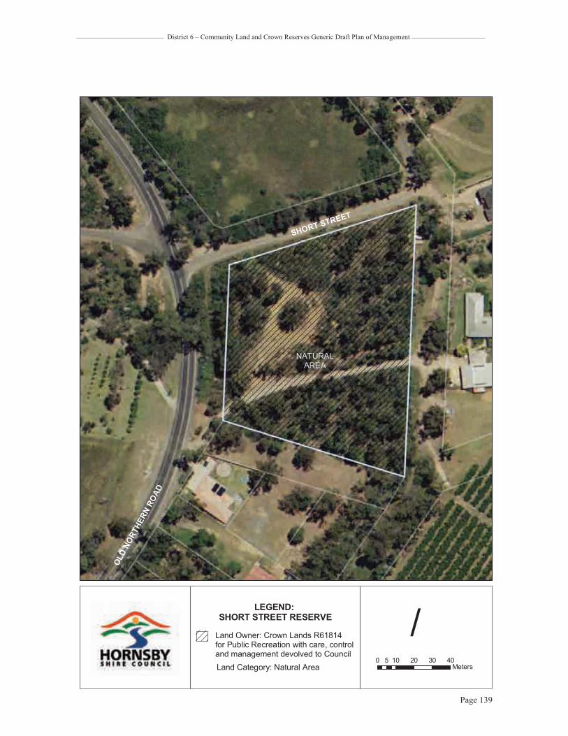
_________________________ District 6 – Community Land and Crown Reserves Generic Draft Plan of Management _____________________
Page 139
0 10 20 30 405Meters
/LEGEND:
SHORT STREET RESERVE
Land Owner: Crown Lands R61814 for Public Recreation with care, controland management devolved to CouncilLand Category: Natural Area
NATURALAREA
SHORT STREET
OLD
NORT
HERN
ROAD

_________________________ District 6 – Community Land and Crown Reserves Generic Plan of Management _____________________
Page 140
GALSTONProperty Fagan Park – Refer to current specific Plan Of Management Reserve No. 436Oracle Fixed Asset No. 229043-229048, 229052, 229088 Matman Equipment No. 9.436.0.0.0.0 Address 38-48X, 50X Bayfield Road, Arcadia Road, Galston Lot & DP Lot 1 DP 558731; Lots 12-14, 16-18, Section 2 DP 975148 (Crown Reserve
R91692 for Community Purposes with Council Trustees vide Deed of Agreement)
Area 570,530 sqm Zoning Open Space B (Public Recreation – District) Land Owner Crown Classification N/ACommunity Land Category Park, Natural AreaSubcategories Bushland, Watercourse Recategorised since Last POM NoRelationship to Other Plans The Fagan Park Plan of Management (2004) is the current Plan of Management.
This Plan does not override that plan.
Description & Site Analysis Facilities Provided� Gardens of Many Nations (Bicentennial Gardens Project including some
buildings and various garden designs from a range of nations)� Ecogarden (Permaculture Community Garden) � Heritage buildings (Netherby Homestead) and Rural Museum � Centenary Garden with trail and seating � Northern Playground and southern playgrounds � Carrs Bush natural area and integrated picnic facilities � Vast open space � Former farm dam with wharf and shelter facility � Interpretive, historical and directional park signage � Picnic and BBQ facilities � Caretaker’s Cottage � Maintenance buildings and yards � Toilets � Carpark
Natural & Cultural Heritage� Soil derived from Wianamatta Shale � Vegetation community TI: Syncarpia glomulifera, E. paniculata, A. costata –
Sydney Turpentine-Ironbark Forest – Carrs Bush � Fagan Park (including original homestead and addition at Netherby, fruit
packing shed, dairy shed, windmill, water tank, machinery shed, brick kiln site, clay pit and bushland) are heritage listed and are regarded as being of regional conservation significance (Hornsby Shire LEP 1994)
� Site contains no known Aboriginal relics (Koettig, 1996) Conservation Status� Reserve contains significant bushland habitat (Land and Environment
Planning, 1994). Sydney Turpentine-Ironbark Forest is of national conservation significance as it is listed as a Critically Endangered Ecological Community (for areas over 1 ha) under the Environment Protection and Biodiversity Conservation Act (1999) and an Endangered Ecological Community under the Threatened Species Conservation Act (1995)
This Rural Valley Viewshed is part of a Heritage Control Zone, as detailed in the adopted Fagan Park Plan of Management, which includes Netherby Homestead and related farm buildings

_________________________ District 6 – Community Land and Crown Reserves Generic Plan of Management _____________________
Page 141
Entry to Netherby Homestead showing interpretive signage
A playground and picnic area exists adjacent to the southern carpark, Netherby Homesteadand Ecogarden. A second playground is located in the northern park sector, adjacent to the Carrs Bush Natural Area
Condition / Impacts � Well maintained by permanent park staff and interest groups � Park is closed to public overnight � Bushland restoration has been undertaken in Carrs Bush and the area is
generally good to very good throughout with some areas of weed infestation, especially along Carrs Road
Overall condition � Good Main Weeds � Bridal Creeper, Wandering Jew, Bidens, and exotic grasses in Carrs Bush.
ManagementRecurrent Expenditure� Tree maintenance � Gardens maintenance � Picnic and bbq facility maintenance � Playground equipment inspection and maintenance � Mowing � Rubbish collection, 10 x 240L twice a week � Cleaning and maintenance of toilet facilities � Track maintenance � Carpark maintenance � Bush regeneration � Bushcare � Rabbit control

_________________________ District 6 – Community Land and Crown Reserves Generic Plan of Management _____________________
Page 142
Trail and picnic shelter shown within Carrs Bush Natural Area
Picnic and bbq facilities, northern park sector, adjacent to the Carrs Bush
As well as bushland and heritage buildings, Fagan Park is well-known for its’ vast open spaces as well as lakes and wildlife
Management cont…Exceptional Expenditure� Heritage Building, farm relic and fence restorations � Building maintenance including maintenance buildings, Caretaker’s house,
Gardens of Many Nations buildings � Maintenance of park signage

_________________________ District 6 – Community Land and Crown Reserves Generic Plan of Management _____________________
Page 143
Comments� Caretaker’s house is located on the site with resident Caretaker � A Bushcare group is active in Carrs Bush � Carrs Bush is a designated Wildlife Protection Area � Refer to Fagan Park Plan of Management
Level of Service Grading HighExisting Leases None

_________________________ District 6 – Community Land and Crown Reserves Generic Plan of Management _____________________
Page 144
RD
BAYF
IELD
RD
ARCADIA
ROAD
ROAD
RO
AD
B AY FI E
L DR
OAD
RO
ADROAD
BAYFIE
LD
MANSFIE
ARCA
DIA
ARC
AD
IA
CARRS
RO
AD
RO
AD
MANSFIE
0 60 120 180 24030Meters
/LEGEND: FAGAN PARK
Land Owner: Crown Lands R91692 for PublicRecreation with Hornsby Council trusteesLand Categories: Natural Area (Bushland,Watercourse), Park[See Fagan Park POM 2004 Map 4.1 HeritageIssues for further detail]
Vegetation: Sydney Turpentine-Ironbark Forest
NATURALAREA
NATURALAREA
PARKARCADIA
RD
BA
YFIELDR
D
GRIBBE
NMOUNT
RD
CARRS RD

_________________________ District 6 – Community Land and Crown Reserves Generic Plan of Management _____________________
Page 145
Property Galston Rural Sports Facility Reserve No. Oracle Fixed Asset No. Matman Equipment No. Address 18X – 20X Bayfield Road, Galston Lot & DP Lot DPArea App. 40,000 sq m Zoning Rural BA (Small Holdings – Agricultural Landscapes) Land Owner Hornsby Shire Council Classification Community Land Community Land Category SportsgroundSubcategories N/ARecategorised since Last POM Not previously included Relationship to Other Plans This plan includes a Plan of Management, formerly included in the Statement of
Environmental Effects for Development Application 53/2005, revised in August 2005. The Galston Rural Sports Facility Plan of Management forms Appendix 6 to this Plan. The DA Masterplan is also attached at Appendix 5.
Description & Site Analysis This facility has Development approval with construction commencing in 2007. Masterplan will guide the approved development (see Annexure).
Facilities proposed� Equestrian and Canine exercise and performance facilities / external arenas� Toilets� Perimeter screen planting � Carparks
Natural & Cultural Heritage � Site contains no known Aboriginal relics (Koettig, 1996) � Formerly rural lands acquired by Council � Soil derived from Wianamatta Shale � Remnant Vegetation community TI, Sydney Turpentine-Ironbark Forest is
evident on adjacent road reserves and links with the Carrs Bush forest of Fagan Park on the other side of Bayfield Road
Management � Refer to existing Plan of Management
Leases & Licences � Leases or licences may be granted to equestrian sports groups and canine activities groups as allowed under the POM. The duration of these leases and licences may vary from casual short term hire, seasonal hire or for periods of several years but always on a time share basis. Times of use are expected to be Saturdays, Sundays and weekday afternoons for organised activities. An indicative time share arrangement for the use of the park forms part of the development consent. This will be subject to refinement and evolution as the park gets nearer to completion

_________________________ District 6 – Community Land and Crown Reserves Generic Plan of Management _____________________
Page 146
0 20 40 60 8010Meters
/LEGEND:
GALSTON RURALSPORTS FACILITY
Land Owner: Hornsby Shire CouncilLand Category: Sportsground
MANSFIELD ROAD
BA
YFIELDR
OA
D
SPORTSGROUND(current development project)
ADJACENTFAGANPARK

_________________________ District 6 – Community Land and Crown Reserves Generic Plan of Management _____________________
Page 147
Property Forsters Reserve Reserve No. 378Oracle Fixed Asset No. 229162 Matman Equipment No. 1.56.3.0Address Sallaway Road (18-20X), Galston Lot & DP Lot 90 DP 752048 (Crown Reserve R80585 for Public Recreation in 1958 and
Crown Reserve R84516 for Rubbish Depot in 1963 with care, control and management devolving to Council)
Area 4,470 sq m
Zoning Rural BR (Small Holdings – Rural Landscapes) Land Owner Crown Classification N/ACommunity Land Category Natural Area Subcategories Bushland, Watercourse Recategorised since Last POM YesRelationship to Other Plans This plan supersedes the Generic Parks and Reserves Plan of Management
adopted 1996 and the draft Generic Bushland Plan of Management dated 1998. This area will be included in the Significant Areas – Bushland Plan of Management when it is reviewed
Description & Site Analysis Facilities Provided� Bushland open space
Natural & Cultural Heritage � Site contains no known Aboriginal relics or European heritage items (Koettig,
1996, Hornsby Shire LEP, 1994) � Soil derived from Hawkesbury Sandstone � Vegetation Community A: E. piperita, A.costata– Open Forest � Vegetation community F: E.racemosa, C.gummifera, A.costata- Woodland � Vegetation community TI: Syncarpia glomulifera - E. paniculata - A. costata
Sydney Turpentine-Ironbark Forest � Reserve contains significant habitat for fauna (Land and Environment
Planning, 1994)
Bushland view from Sallaway Road
Conservation Status� Sydney Turpentine-Ironbark Forest is of national conservation significance as
it is listed as a Critically Endangered Ecological Community (for areas over 1 ha) under the Environment Protection and Biodiversity Conservation Act (1999) and an Endangered Ecological Community under the Threatened Species Conservation Act (1995)
� Forsters Reserve is a designated Wildlife Protection Area
Condition / Impacts � The bushland ranges from good condition to very poor. The core upslope
vegetation is in good condition. Along the creek and Sallaway Road there is serious privet and vine weed infestation KMC(2/4/4(4)
� The bushland adjacent to the trail and rural property boundary is in very poor condition
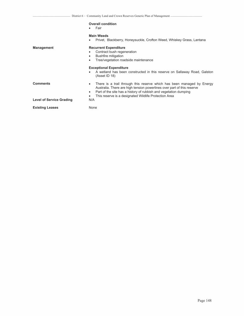
_________________________ District 6 – Community Land and Crown Reserves Generic Plan of Management _____________________
Page 148
Overall condition � Fair
Main Weeds � Privet, Blackberry, Honeysuckle, Crofton Weed, Whiskey Grass, Lantana
Management Recurrent Expenditure� Contract bush regeneration � Bushfire mitigation� Tree/vegetation roadside maintenance
Exceptional Expenditure� A wetland has been constructed in this reserve on Sallaway Road, Galston
(Asset ID 18)
Comments � There is a trail through this reserve which has been managed by Energy Australia. There are high tension powerlines over part of this reserve
� Part of the site has a history of rubbish and vegetation dumping � This reserve is a designated Wildlife Protection Area
Level of Service Grading N/A
Existing Leases None
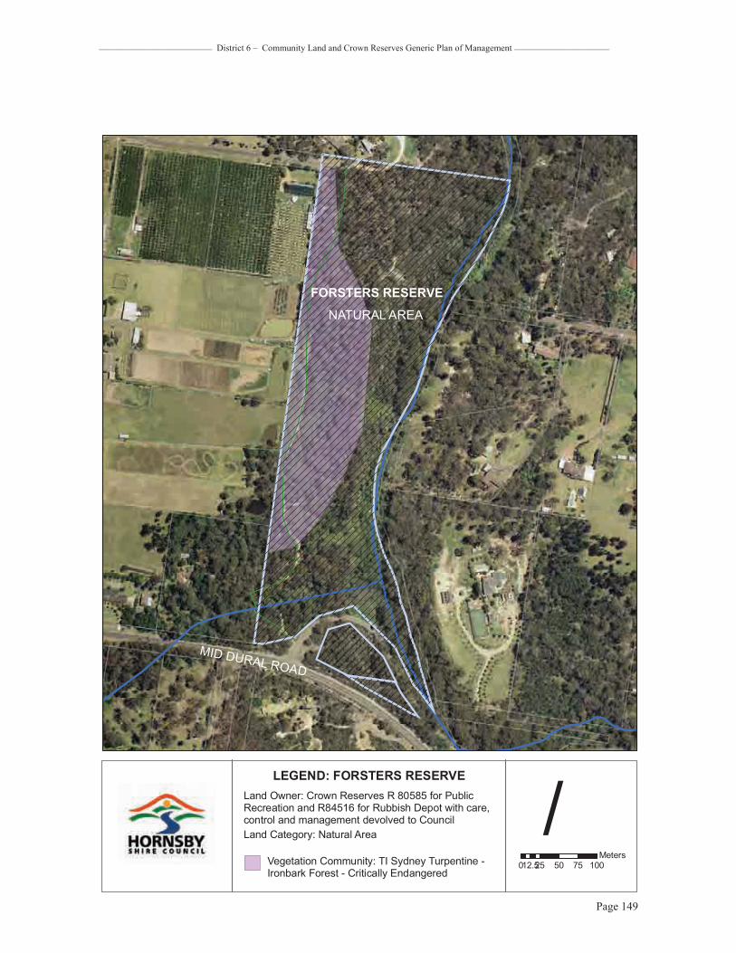
_________________________ District 6 – Community Land and Crown Reserves Generic Plan of Management _____________________
Page 149
/0 25 50 75 10012.5
Meters
LEGEND: FORSTERS RESERVELand Owner: Crown Reserves R 80585 for Public Recreation and R84516 for Rubbish Depot with care, control and management devolved to CouncilLand Category: Natural Area
Vegetation Community: TI Sydney Turpentine -Ironbark Forest - Critically Endangered
FORSTERS RESERVENATURAL AREA
MID DURAL ROAD

_________________________ District 6 – Community Land and Crown Reserves Generic Plan of Management _____________________
Page 150
Property Galston Library Reserve No. 525Oracle Fixed Asset No. 229301 Matman Equipment No. Address Galston Road (357), Galston Lot & DP Lot 1 DP 136221 (Freehold) Area 541 sq m Zoning Rural BA (Small Holdings – Agricultural Landscapes) Land Owner Hornsby Shire Council Classification Community Land Community Land Category General Community Use Subcategories N/ARecategorised since Last POM NoRelationship to Other Plans This plan supersedes the Generic Parks and Reserves Plan of Management
adopted 1996 and the draft Generic Bushland Plan of Management dated 1998
Description & Site Analysis Facilities Provided� Library� Toilets � Smith Family clothing bin
Natural & Cultural Heritage � Site contains no known Aboriginal relics (Koettig, 1996) � Former Church of England is listed as being of local heritage significance
(Hornsby Shire LEP, 1994) � Soil derived from Wianamatta Shale
Galston Library occupies the former Church of England, of local heritage significance
Condition / Impacts � Some weed species along fencelines
Main Weeds � Privet growing along fence boundaries and Camphor laurel present
Management Recurrent Expenditure� Tree maintenance � Mowing � Building maintenance � Cleaning and maintenance toilet facilities � Rubbish collection once a week by commercial contractor (1 x 125L general
waste, 1 x 240L paper recycle)
Exceptional Expenditure� Repairs and replacement of facilities as required� Carparking at road edge maintenance
Level of Service Grading Low
Existing Leases None

_________________________ District 6 – Community Land and Crown Reserves Generic Plan of Management _____________________
Page 151
0 5 10 15 202.5Meters
/LEGEND: GALSTON LIBRARY
Land Owner: Hornsby Shire Council
Land Category: General Community Use
GENERAL COMMUNITY USE
GALSTON RD

_________________________ District 6 – Community Land and Crown Reserves Generic Plan of Management _____________________
Page 152
Property Galston Recreation Reserve including Hayes Oval Reserve No 415Oracle Fixed Asset No 229042, 229066, 229067 Matman Equipment No. 2.415.0.0.0.0 Bushland 1.59.3.0 Address 412A, 412X Galston Road, Galston Lot & DP Lot 181, 197 DP 752048 (Crown Land D500223 for Public Recreation and
Showground dedicated 25/10/1929 with Council Trustees); Lots 216 and 7017 DP 752048 (Crown Reserve R81698 for Public Recreation and the Preservation of Native Flora and Fauna 19/06/1959 with Council Trustees)
Area 400,215 sq m
Zoning Open Space A (Public Recreation - Local) Land Owner Crown Classification N/ACommunity Land Category Sportsground, Natural Area, General Community Use Subcategories Bushland, Watercourse (Colah Creek)Recategorised since Last POM Yes
Relationship to Other Plans This plan supersedes the Generic Parks and Reserve, Generic Sportsground Plans of Management adopted in 1996, and the draft Generic Bushland Plan of Management dated 1998. This area will be included in the Significant Areas – Bushland Plan of Management when it is reviewed
Description & Site Analysis Facilities Provided� Sportsfield (signage denotes Galston Recreation Reserve adjacent to northern
sportsfield)� 1 x astroturf cricket wicket � Basketball / netball courts x 2 west of sportsfield with night lighting � 1 x large picnic shelter containing 20 x Picnic settings, 6 x bench seats, 4 x
electric BBQ, 3 x 240L bins� Toilet block adjacent to carpark and large shelter � Playground � Expansive garden beds with timber edging surround the playground and large
shelter area � Picnic shelter and BBQ associated with playground, 1 x 240L bin � Timber bridge crossing over rock swale to playground edge � 3 x park bench within playground area � Picnic settings x 2 and wood-fired BBQ behind western end of pool facility � Carpark accessible from northern park access � Lighting to pathway linking with Netball courts from central carpark � Range of fence types including mesh to courts, post and rail perimeter fence,
post and wire, and steel post and rail surrounds to War Memorial � Dural & District Historical Society History Cottage occupies the northeastern
corner of Galston Recreation Reserve � World War I War Memorial adjacent to History Cottage (former park kiosk)
contains several plinths (old and new), a rock memorial and pebble beds, plus one adjacent picnic setting
� Bushland open space � Swimming pool and gymnasium� Sportsfield (signage denotes Hayes Oval adjacent to southern Reserve
sportsfield)� Informal open space (signage denotes Hayes Park in open space adjoining
Hayes Oval), 2 x 240L bins � Picnic settings x 2 to Hayes Park informal open space plus 5 x bench seats � Kiosk and toilet block on northern sportsfield edge, 4 x 240L bins � Water tank � Tap / bubbler � Hayes Oval has field lighting and 5 x soccer fields, 1 x cricket wicket, 1 x goal
square � Small pick-up bay at southern park end � Mesh fence to sportsfield perimeter and post and rail to street and carpark
frontage
General / shared facilities � Extensive natural area surrounds western and southern park and field
boundaries, also a designated Wildlife Protection Zone � Carpark and lighting between fields from central park access

_________________________ District 6 – Community Land and Crown Reserves Generic Plan of Management _____________________
Page 153
South-southwestern view towards Hayes Oval from within informal open space, eastern park sector
View over Galston Recreation Reserve sportsfield from the playground
Natural & Cultural Heritage� Soil is derived from Hawkesbury Sandstone and Wianamatta Shale � Vegetation Communities L (E. pilularis- A. costata- S. glomulifera – Tall Open
Forest) and TI Sydney Turpentine-Ironbark Forest (S. glomulifera- A. costata-E. paniculata – Tall Open Forest)
� The land was set aside for a recreation ground and water reserve in the 1880’s when subdivided and sold in this part of the Parish of North Colah. In the early 1890’s a group of Trustees were appointed including John Waddell, Albert Thomas, Sam Geelan and Walter Hayes as the Recreation Ground Trust. The Galston Annual Show was staged at the newly completed Galston Recreation Ground in 1894 and was held there until 1938. Council took on the role of Trustee from the local people following the destruction of the pavilion by bushfire in 1911. A memorial to those who died in World War 1 was erected in 1919 and built by local people including stonemason Joe Booth. In 1969 the swimming pool was opened, and in the 1970’s two soccer fields, tennis courts and bushwalking track were provided. The original kiosk was operated from the 1946 to 1970 by Mr A. R. Blaxland and his wife. The building was renovated in 1998 and is now known as ‘History Cottage’ housing the Dural and District Historical Society
� Site contains no known Aboriginal relics (Koettig, 1996)

_________________________ District 6 – Community Land and Crown Reserves Generic Plan of Management _____________________
Page 154
� In 1994 Galston Oval was renamed Hayes Oval as a named feature within Galston Recreation Reserve
� William John Hayes settled in Galston in 1881 and was said to have played a leading role in the establishment of Galston Recreation Reserve along with his brother Walter Hayes
Playground view with vegetated rock swale in foreground
Large picnic shelter and barbecues for group gatherings
Conservation Status� Vegetation community L is locally significant in the Hornsby Local Government
Area� Vegetation community TI Sydney Turpentine-Ironbark Forest is of national
conservation significance as it is listed as a Critically Endangered Ecological Community (for areas over 1 ha) under the Environment Protection and Biodiversity Conservation Act (1999) and an Endangered Ecological Community under the Threatened Species Conservation Act (1995)
� Galston Recreation Reserve, War Memorial and natural and cultural plantings are heritage listed and regarded as being of local conservation significance (Hornsby Shire LEP 1994)
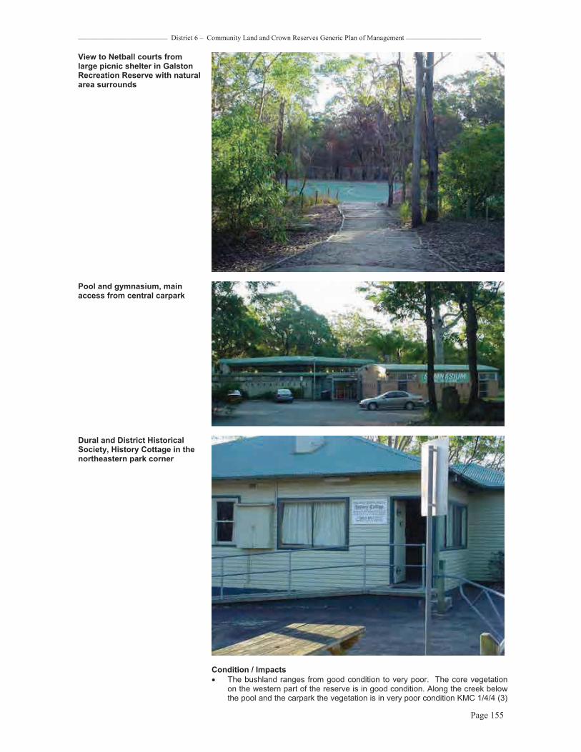
_________________________ District 6 – Community Land and Crown Reserves Generic Plan of Management _____________________
Page 155
View to Netball courts from large picnic shelter in Galston Recreation Reserve with natural area surrounds
Pool and gymnasium, main access from central carpark
Dural and District Historical Society, History Cottage in the northeastern park corner
Condition / Impacts � The bushland ranges from good condition to very poor. The core vegetation
on the western part of the reserve is in good condition. Along the creek below the pool and the carpark the vegetation is in very poor condition KMC 1/4/4 (3)

_________________________ District 6 – Community Land and Crown Reserves Generic Plan of Management _____________________
Page 156
with a major privet infestation. Weeds occur along the oval batter slope and under the powerlines
� The bushland adjacent to the scout hall is in poor condition KMC 1/4/3(3) which threatens the Turpentine-Ironbark Forest
Overall condition � Fair Main Weeds � Privet, inkweed, castor oil plant
Dedication plinth to all women involved in wars, an addition to the historical World War I Memorial in the northeastern park corner
Management Recurrent Expenditure� Line marking � Change of season sportsfield works � Tree maintenance � Mowing � Fertilising � Turfing worn areas � Topdressing � Spraying for insect pests and noxious weeds � Track maintenance � Fence maintenance � Inspection and maintenance playground equipment, softfall safety surfacing
and furniture � Lighting maintenance � Rubbish bin collection, 10 x 240L once a week
Exceptional Expenditure� Maintenance of timber retaining walls � Repair and replacement of playground equipment as required � Repair and replacement playground Astroturf as required � Repair of tracks, timber steps, timber retaining walls as required � Fence replacement required
Comments � A designated Wildlife Protection Area � “History Cottage” is located on this reserve � Potential for Catchment Remediation works/ stream remediation to be carried
out in the creekline at the rear of the pool � There is rubbish dumping near the carpark. � There are major power lines through the reserve � There are fire trails, trails under power lines and walking tracks through the
reserve. The major trails could be considered for multi use. Potential for BMX grounds near the sportsgrounds
Level of Service Grading HighExisting Leases Dural & District Historical Society, History Cottage

_________________________ District 6 – Community Land and Crown Reserves Generic Plan of Management _____________________
Page 157
0 40 80 120 16020Meters
/LEGEND:
GALSTON RECREATION RESERVE,GALSTON POOL & HAYES OVAL
Land Owner: Crown Lands
Land Categories: Natural Area,Sportsground, General Community UseVegetation Community L: E.pilularis - A. costata - S. glomulifera
SPORTSGROUND(HAYES OVAL)
GAL
STO
NRD
VEGETATION COMMUNITY L
Cola
hC
reek
NATURALAREA
GEN. COMM.
USE

_________________________ District 6 – Community Land and Crown Reserves Generic Plan of Management _____________________
Page 158
Property Galston Park Bushland Reserve No 472Oracle Fixed Asset No 105128, 229026, 229039, 229055, 229097, 229103 Matman Equipment No. 1.58.3.0Address Matthew Close (18X), Crosslands Road (58-60X), Galston Lot & DP Lot 2 DP 202545 (Freehold subject to Declaration of Trust), Lot 7 DP 240287, Lot 1
DP 567189, Lot 1 DP 568238 (Department of Planning with care, control and management devolving to Council), Lot 204 DP 854878 (Freehold as Public Reserve)
Area 942,534 sq m Zoning All land is zoned Open Space A (Public Recreation – District) except Lot 7 DP
240287 which is zoned Open Space A (Public Recreation - Local) Land Owner Hornsby Shire Council, RTA, Minister Administering the EP&A Act Classification Community Community Land Category Natural Area Subcategories Bushland, Watercourse (Berowra Creek and tributaries) Recategorised since Last POM YesRelationship to Other Plans This plan supersedes the Generic Parks and Reserves Plan of Management
adopted 1996 and the draft Generic Bushland Plan of Management dated 1998
Description & Site Analysis Facilities Provided� Bushland Open Space
Natural & Cultural Heritage� Site contains no known Aboriginal relics (Koettig, 1996) � Remaining elements of a sandstone cottage and steps are present in the
reserve� Soil derived from Hawkesbury Sandstone � Vegetation community A: E. piperita, A. costata – Open Forest � Vegetation Community C: E. gummifera, E. haemastoma, E. oblonga–
Woodland � Vegetation Community D: E.punctata, C.gummifera, E. haemastoma,–
Woodland � Vegetation Community G: E. haemastoma, E. A.hispida, B.ericifolia– Low
Woodland � Vegetation Community 01: Ceratopetalum apetalum Warm temperate
rainforest
Weathered rock formation in Galston Park bushland
Conservation Status� Vegetation community 01 Warm temperate rainforest is of regional
conservation significance
Condition / Impacts � The bushland is in very good condition KMC(1/1/1(1). There are weed

_________________________ District 6 – Community Land and Crown Reserves Generic Plan of Management _____________________
Page 159
infestations opposite Crosslands and along Galston Roads which are being treated. There are also some weed outbreaks along Berowra Creek and where stormwater enters the reserve which would be classified as fair
Overall condition � Very good
Main Weeds � Wandering Jew, Ageritina, Coreopsis, African Lovegrass, Whiskey Grass � Pittosporum
Management Recurrent Expenditure� Contract bush regeneration � Bushfire mitigation � Tree/vegetation roadside maintenance
Exceptional Expenditure� N/A
View of bushland sector containing sandstone cottage remnants
Comments � A designated Wildlife Protection Area � There are no formal trails or walking tracks in this reserve and access is
difficult� There is access to the reserve along Crosslands Road and off the end of
Matthew Close where there also evidence of dumping of domestic waste
Level of Service Grading N/A
Existing Leases None

_________________________ District 6 – Community Land and Crown Reserves Generic Plan of Management _____________________
Page 160
0 90 180 270 36045Meters
/LEGEND:
GALSTON PARKLand Owner: Hornsby Shire Council
Land Category: Natural Area
NATURALAREA
GALSTON PARK
CROSSLANDS ROAD
GALSTON ROAD
Land Owner: Environmental Protection AuthorityLand Owner: RTA
Fire Trails
BEROWRAVALLEY
REGIONALPARK
BEROWRAVALLEY
REGIONALPARK

_________________________ District 6 – Community Land and Crown Reserves Generic Plan of Management _____________________
Page 161
Property Johnson Road Bushland Reserve No 79Oracle Fixed Asset No 105163 Matman Equipment No 1.75.3.0Address Johnson Road (46X), Galston Lot & DP Lot 209 DP 255719 (Freehold as Public Reserve) Area 19,755 sq m Zoning Part Environmental Protection B (River Catchment) and part Rural BR (Small
Holdings – Rural Landscapes)
Land Owner Hornsby Shire Council Classification Community Land Community Land Category Natural Area Subcategories Bushland, Watercourse (tributary of Colah Creek)Recategorised since Last POM
Yes
Relationship to Other Plans This plan supersedes the Generic Parks and Reserves Plan of Management adopted 1996 and the draft Generic Bushland Plan of Management dated 1998
Description & Site Analysis Facilities Provided� Bushland open space
Natural & Cultural Heritage � Site contains no known Aboriginal relics or European heritage items (Koettig,
1996, Hornsby Shire LEP, 1994) � Soil derived from Hawkesbury Sandstone � Vegetation community A: E. piperita, A. costata – Open Forest
Bridle Trail
Conservation Status� Vegetation community A is well conserved � Reserve contains significant habitat for fauna (Land and Environment Planning,
1994)
Condition / Impacts � The bushland is in generally poor condition with the body of the reserve above
the creek being good. The watercourse has serious weed infestation KMC (3/4/4(4) and there are weeds along the property boundaries.
� The informal walking / bridle trail is in good condition
Overall condition � Fair
Main Weeds � Privet, Honeysuckle, Bidens, Wandering Jew, Pittosporum
Management Recurrent Expenditure� Tree / vegetation management � Noxious weed control � Bushfire mitigation

_________________________ District 6 – Community Land and Crown Reserves Generic Plan of Management _____________________
Page 162
Exceptional Expenditure� N/A
Comments � The unmade portions of School and Johnson Roads form part of this bushland. There is an informal trail from the end of School Road linking with Johnson Road, used as a bridle trail
� This reserve contains a powerline easement
Gymea Lily in bushland
Level of Service Grading N/A
Existing Leases None
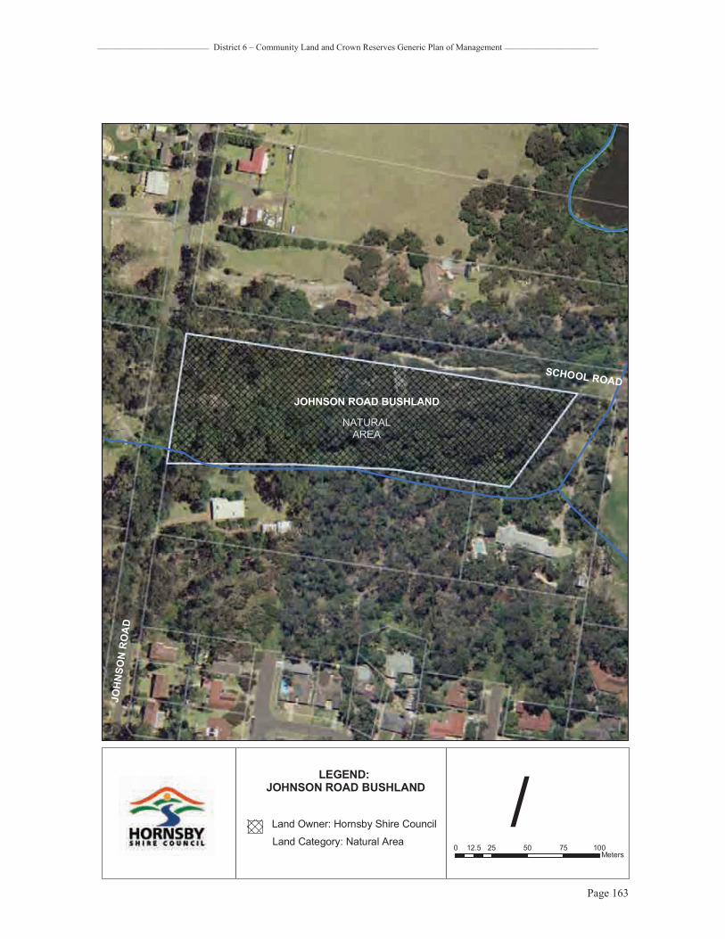
_________________________ District 6 – Community Land and Crown Reserves Generic Plan of Management _____________________
Page 163
0 25 50 75 10012.5Meters
/LEGEND:
JOHNSON ROAD BUSHLAND
Land Owner: Hornsby Shire CouncilLand Category: Natural Area
NATURALAREA
JOHNSON ROAD BUSHLAND
SCHOOL ROAD
JOH
NSO
NR
OA
D

_________________________ District 6 – Community Land and Crown Reserves Generic Plan of Management _____________________
Page 164
Property Karalee Road Bushland Reserve No 80Oracle Fixed Asset No 105166 Matman Equipment No 1.79.3.0Address Karalee Road (16X), Galston Lot & DP Lot 13 DP 243183 (Freehold as Public Reserve) Area 7,038 sq m Zoning Open Space B (Public Recreation – District)
Land Owner Hornsby Shire Council Classification Community Land Community Land Category Natural Area Subcategories Bushland Recategorised since Last POM NoRelationship to Other Plans This plan supersedes the Generic Parks and Reserves Plan of Management
adopted 1996 and the draft Generic Bushland Plan of Management dated 1998
Description & Site Analysis Facilities Provided� Bushland open space
Natural & Cultural Heritage � Site contains no known Aboriginal relics or European heritage items (Koettig,
1996, Hornsby Shire LEP, 1994) � Soil derived from Hawkesbury Sandstone � Vegetation community A: E. piperita, A. costata – Open Forest
Conservation Status� Vegetation community A is well conserved
Overall condition � Bushland is in very good condition (API only)
Main Weeds � No weed infestation is evident
Typical bushland view

_________________________ District 6 – Community Land and Crown Reserves Generic Plan of Management _____________________
Page 165
Management Recurrent Expenditure� Bushfire mitigation� Tree/vegetation management
Exceptional ExpenditureN/A
Comments� This small area of bushland is borders BVRP on two boundaries and private
rural properties on the other. It is in a steep valley and has no public access except through the bushland of BVRP adjoining Knight s Rd bushland at the end of Towner Rd. There are no formal trails in this reserve or leading to this area of bushland
� Recommend this bushland as an addition to BVRP
Level of Service Grading N/A
Existing Leases None

_________________________ District 6 – Community Land and Crown Reserves Generic Plan of Management _____________________
Page 166
0 25 50 75 10012.5Meters
/LEGEND:
KARALEE ROAD BUSHLAND
Land Owner: Hornsby Shire CouncilLand Category: Natural Area
NATURALAREA
KARALEE ROAD BUSHLAND
BEROWRA VALLEYREGIONAL PARK
KA
RALEE
RO
AD
Easement line
_________________________ District 6 – Community Land and Crown Reserves Generic Plan of Management _____________________
Page 167
Property Knights (Towner) Road Bushland Reserve No 81Oracle Fixed Asset No 105173, 105174 Matman Equipment No 1.83.3.0Address 101 Knights Road, Galston Lot & DP Lot 12 DP 243183, Lot 7 DP 245728 (Freehold as Public Reserve) Area 40,472 sq m Zoning Open Space B (Public Recreation - District)
Land Owner Hornsby Shire Council Classification Community Land Community Land Category Natural Area Subcategories Bushland, Watercourse (Charlton Creek)Recategorised since Last POM YesRelationship to Other Plans This plan supersedes the Generic Parks and Reserves Plan of Management
adopted 1996 and the draft Generic Bushland Plan of Management dated 1998
Description & Site Analysis Facilities Provided� Bushland open space
Natural & Cultural Heritage � Soil derived from Hawkesbury Sandstone � Vegetation community A: E. piperita, A. costata – Open Forest � Site contains no known Aboriginal relics or European heritage items (Koettig,
1996, Hornsby Shire LEP, 1994)
Conservation Status� Vegetation community A is well conserved
Condition / Impacts � The core bushland is in very good condition and an excellent example of
sandstone flora. � There are some roadside lantana and exotic grasses; minor weeds present in
the drainage lines KMC (1/1/3(2) but these are isolated. The main creek was unsurveyed
Overall condition � Very good
Main Weeds � Crofton, Lantana, African Lovegrass, Whiskey Grass, Pittosporum

_________________________ District 6 – Community Land and Crown Reserves Generic Plan of Management _____________________
Page 168
Core bushland is in very good condition
ManagementRecurrent Expenditure� Tree / vegetation roadside management � Bushfire mitigation
Exceptional Expenditure� N/A
Comments� There are no formal trails in this reserve. Knights Rd turns into unmade road
which is bushland and then continues on as Towner. Public access is via the end of Towner Road
� The bushland is a steep rocky gully with Charlton Creek running through it. The bushland adjoins BVRP downstream
Level of Service Grading N/A
Existing Leases None

_________________________ District 6 – Community Land and Crown Reserves Generic Plan of Management _____________________
Page 169
0 25 50 75 10012.5Meters
/LEGEND:
KNIGHTS ROAD BUSHLAND
Land Owner: Hornsby Shire CouncilLand Category: Natural Area
NATURALAREA
KNIGHTS ROAD BUSHLAND
BEROWRA VALLEYREGIONAL PARK
KARA
LEE
ROAD
KNIGHTS ROAD

_________________________ District 6 – Community Land and Crown Reserves Generic Plan of Management _____________________
Page 170
Property Nancy Place ParkReserve No 315Oracle Fixed Asset No 105198, 105698 Matman Equipment No 5.315.0.0 Address 35X, 37X Nancy Place, Galston Lot & DP Lot 8 DP 259528, Lot 50 DP 259440 (Freehold as Public Reserve) Area 2,267 sq m Zoning Most is zoned Rural BA (Small Holdings – Agricultural Landscapes) except the
accessway to Lot 8 DP 259528 which is zoned Residential AR (Low Density – Rural Village)
Land Owner Hornsby Shire Council Classification Community Land Community Land Category ParkSubcategories N/ARecategorised since Last POM YesRelationship to Other Plans This plan supersedes the Generic Parks and Reserves Plan of Management
adopted 1996 and the draft Generic Bushland Plan of Management dated 1998
Description & Site Analysis Facilities Provided� Playground� Informal open space � Picnic setting
Natural & Cultural Heritage� Site contains no known Aboriginal relics or European heritage items (Koettig,
1996, Hornsby Shire LEP, 1994) � Soil derived from Wianamatta Shale
View looking north towards playground
ManagementRecurrent Expenditure� Tree maintenance and mowing � Inspection and maintenance of playground equipment
Exceptional Expenditure� Repair and replacement of playground equipment as required � Repair and replacement furniture and fencing as required � Maintenance drainage swale along residential, western park boundary �
Comment � Limited access and recreation value � This land could be considered for reclassification

_________________________ District 6 – Community Land and Crown Reserves Generic Plan of Management _____________________
Page 171
Level of Service Grading Low
Existing Leases None

_________________________ District 6 – Community Land and Crown Reserves Generic Plan of Management _____________________
Page 172
0 5 10 15 202.5Meters
/LEGEND:
NANCY PLACE PARK
Land Owner: Hornsby Shire CouncilLand Category: Park
PARK
NANCY
PLACE
MARTIN ROAD

_________________________ District 6 – Community Land and Crown Reserves Generic Plan of Management _____________________
Page 173
Property Plantation Strip - Mid Dural Road, Galston Reserve No 316Oracle Fixed Asset No 105000 Matman Equipment No. Address 32X Mid Dural Road, Galston Lot & DP Lot 132 DP 255851 (Freehold) Area 4,265 sq m
Zoning Residential AR (Low Density - Rural Village) Land Owner Hornsby Shire Council Classification Community Land Community Land Category ParkSubcategories N/ARecategorised since Last POM NoRelationship to Other Plans This plan supersedes the Generic Parks and Reserves Plan of Management
adopted 1996 and the draft Generic Bushland Plan of Management dated 1998
Description & Site Analysis Facilities Provided� Pathway
Natural & Cultural Heritage� Site contains no known Aboriginal relics or European heritage items (Koettig,
1996, Hornsby Shire LEP, 1994) � Soil derived from Wianamatta Shale � Vegetation Community: Site contains remnant trees of Shale Sandstone
Transition Forest
View looking east. Reserve follows pathway over roadside embankment
View looking west towards corner with Johnson Road
Conservation Status� Shale Sandstone Transition Forest is of State conservation significance as it is
listed as an Endangered Ecological Community under the Threatened Species Conservation Act (1995)
Condition / Impacts � Vehicular use and use as a trail for horses impacts on this roadside reserve.
Diminished groundcover is evident due to these uses.
Management Recurrent Expenditure� Mowing and vegetation management. � Tree maintenance

_________________________ District 6 – Community Land and Crown Reserves Generic Plan of Management _____________________
Page 174
Exceptional Expenditure� Pathway repairs
Comments � Easement and pathway access to Hakea Crescent from Mid Dural road � The Arcadia Pony Club is on Johnson Road adjacent to the western end of the
reserve, providing a useful corridor for riders � Planting in the reserve of exotic and native trees and shrubs by adjoining
residents over many years is evident
Level of Service Grading Low
Existing Leases None

_________________________ District 6 – Community Land and Crown Reserves Generic Plan of Management _____________________
Page 175
0 20 40 60 8010Meters
/LEGEND:
PLANTATION STRIPMID-DURAL ROAD
Land Owner: Hornsby Shire Council
Land Category: Park
PARKMID-DURAL ROAD
JOH
NSO
NR
OA
D

_________________________ District 6 – Community Land and Crown Reserves Generic Plan of Management _____________________
Page 176
Property Tim Brownscombe Reserve Reserve No none Oracle Fixed Asset No 229165 Matman Equipment No 1.78.3.0Address Fishburns Road (5X), Galston Lot & DP Lot 2 DP 870158 (Freehold as Public Reserve) Area 4,201 sq m Zoning Rural BA (Small Holdings – Agricultural Landscapes) Land Owner Hornsby Shire Council Classification Community Land Community Land Category Natural Area Subcategories Bushland Recategorised since Last POM NoRelationship to Other Plans This reserve was included in the Significant Areas (Bushland) Plans of
Management and Action Plans. This plan does not override that plan
Description & Site Analysis Facilities Provided� Bushland open space
Natural & Cultural Heritage� Site contains no known Aboriginal relics or European heritage items (Koettig,
1996, Hornsby Shire LEP, 1994) � Soil derived from Wianamatta Shale � Vegetation community TI: Syncarpia glomulifera, E. paniculata, A. costata –
Sydney Turpentine-Ironbark Forest � Vegetation community BG: Blue Gum High Forest � The late Keith Brownscombe and his family dedicated this portion of their
property to Hornsby Council in 1998 in memory of their son Tim, who tragically passed away. Tim Brownscombe loved nature and the tall trees which are now protected in this reserve. Keith worked with the volunteer bush regeneration group and assisted Council in the ongoing conservation of this important endangered vegetation up until his passing in mid-2006.
Conservation Status� Sydney Turpentine-Ironbark Forest is of national conservation significance as it
is listed as a Critically Endangered Ecological Community (for areas over 1 ha) under the Environment Protection and Biodiversity Conservation Act (1999)and an Endangered Ecological Community under the Threatened Species Conservation Act (1995)
� Blue Gum High Forest is of national conservation significance as it is listed as a Critically Endangered Ecological Community (for areas over 1 ha) under the Environment Protection and Biodiversity Conservation Act (1999) and has received a preliminary listing as a Critically Endangered Ecological Community under the Threatened Species Conservation Act (1995)
Condition / Impacts � The bushland has been actively restored with most of the reserve now in very
good condition. The upper portion of the reserve within the Blue Gum section is in fair condition KMC 1/3/4(3) but being actively restored by volunteers.
Overall condition � Good
Main Weeds � Wandering Jew, Honeysuckle, Erharta
Management Recurrent Expenditure� Bushcare� Tree / vegetation maintenance � Fence maintenance � Bushfire mitigation
Exceptional Expenditure� Replacement of fences
Comments � There is an active bushcare group in this reserve � There was contract bush regeneration for approximately 4 years within this
area but this ceased in 2004 and the volunteers are continuing to restore and

_________________________ District 6 – Community Land and Crown Reserves Generic Plan of Management _____________________
Page 177
maintain the reserve.� There are a lot of rabbits impacting on this reserve
Bushland
Level of Service Grading N/A
Existing Leases None

_________________________ District 6 – Community Land and Crown Reserves Generic Plan of Management _____________________
Page 178
0 10 20 30 405Meters
/LEGEND: TIM BROWNESCOMBE
RESERVELand Owner: Hornsby Shire CouncilLand Category: Natural Area
NATURAL AREA
FISHBURNS ROAD
TIMBROWNESCOMBE
RESERVE
Vegetation:Blue Gum High Forest (BGHF)Vegetation:Turpentine Ironbark Forest(STIF)
CROSSLANDS ROAD
Easement
BGHF
STIF

_________________________ District 6 – Community Land and Crown Reserves Generic Plan of Management _____________________
Page 179
Property Galston Village Common, Galston Reserve No Oracle Fixed Asset No 229277 and 229322 Matman Equipment No Address 5A Arcadia Road, Galston Lot & DP Lot 20 DP 878940 (Freehold) and Lot 7 DP 1042134 (Freehold as Public Reserve) Area 1083 sq m Zoning Lot 20 DP 878940 is zoned Open Space A (Public Recreation – Local) and Lot 20
DP 878940 is Business C (Neighbourhood)
Land Owner Hornsby Shire Council Classification Community Land Community Land Category ParkSubcategories N/ARecategorised since Last POM N/ARelationship to Other Plans Not previously included in Plan of Management.
Development of this land is subject to the Galston Village Development Control Plan
Description & Site Analysis Facilities Provided� Informal open space� Picnic shelter x 1 � Park benches x 3
Natural & Cultural Heritage � Site contains no known Aboriginal relics or European heritage items (Koettig,
1996, Hornsby Shire LEP, 1994) � Soil derived from Wianamatta Shale
Park View looking southeast
Management Recurrent Expenditure� Edging, mulching and tree and garden maintenance � Mowing
Exceptional Expenditure� Repair / replacement timber garden edge � Repair furniture � Repair street kerbs / rollover kerbs � Repair shelter (non-standard with cement-rendered posts and tiled roof)
Level of Service Grading Low
Existing Leases None

_________________________ District 6 – Community Land and Crown Reserves Generic Plan of Management _____________________
Page 180
0 10 20 30 405Meters
/LEGEND:
GALSTON VILLAGE COMMON,GALSTON
Land Owner: Hornsby Shire CouncilLand Category: Park
PARK
ARC
ADIA
RO
AD
GALSTON ROAD

_________________________ District 6 – Community Land and Crown Reserves Generic Plan of Management _____________________
Page 181
GLENORIEProperty Cairnes Road Playground & Bushland Reserve No 311Oracle Fixed Asset No 105466 Matman Equipment No 5.311.0.0 Address 25X Cairns Road, 3X Wirra Place, Glenorie Lot & DP Lot 41 DP 253532 (Freehold as Public Reserve) Area 4,709 sq m Zoning Open Space A (Public Recreation - Local)
Land Owner Hornsby Shire Council Classification Community Land Community Land Category Park, Natural Area Subcategories Bushland, Watercourse (Glenorie Creek)Recategorised since Last POM YesRelationship to Other Plans This reserve was included in the Significant Areas (Bushland) Plans of Management
and Action Plans. This plan does not override that plan except for its reclassification to include watercourse. The reclassification will be included in the Significant Areas (Bushland) Plans of Management and Action Plans when it is updated
Description & Site Analysis Facilities Provided� Playground and informal open space� Bushland and Glenorie Creek (tributary to Colah Creek) � Tap / bubbler � Picnic setting x 1 and bench seat x 2 � Chain mesh fence � Bridge crossing over Glenorie Creek
Natural & Cultural Heritage� Site contains no known Aboriginal relics or European heritage items (Koettig,
1996, Hornsby Shire LEP, 1994) � Soil derived from Hawkesbury Sandstone and Wianamatta Shale � Small patch of vegetation community TI: Syncarpia glomulifera- E. paniculata-
A. costata Sydney Turpentine-Ironbark Forest
View towards playground from northern edge with park bushland sector
Conservation Status� The bushland on this site is of national conservation significance as it is listed
as a Critically Endangered Ecological Community (for areas over 1 ha) under the Environment Protection and Biodiversity Conservation Act (1999) and an Endangered Ecological Community under the Threatened Species Conservation Act (1995)

_________________________ District 6 – Community Land and Crown Reserves Generic Plan of Management _____________________
Page 182
Condition / Impacts� Most of the natural areas condition is poor with the creeklines being very poor.
KMC 3/4/4(4) � The playground is in good condition
Overall condition � Very poor (natural area)
Main Weeds� Willow Tree, Privet, Honeysuckle and groundcovers including Wandering Jew,
Crofton Weed, Bidens and exotic grasses
Management Recurrent Expenditure � Tree maintenance and mowing � Playground inspection and maintenance � Bushcare � Noxious weed control
Exceptional Expenditure� Repairs and replacement of playground equipment and safety surfacing
(Astroturf) as required � Repairs and replacement of furniture and fencing as required � Repairs, replacement, installation of pavement as required � Repairs, replacement bridge crossing as required
Comments � Potential for Catchment Remediation/ riparian restoration of two creeks in the reserve
� Glenorie Creek and tributary pass through this reserve from culvert entries at the southern and northeastern park corners. The creeks are contained within bushland
� The southern corner of the park has cultural plantings as a result of adjacent residents’ maintenance of this portion of the park. This is not seen as adverse to the park but should be limited from other park areas where only native regeneration is encouraged
� There was a Bushcare Group named Tecoma Place Bushland attempting restoration in the creek area up to 2004 but they are no longer active
Level of Service Grading Low-Medium
Existing Leases None

_________________________ District 6 – Community Land and Crown Reserves Generic Plan of Management _____________________
Page 183
0 10 20 30 405Meters
/LEGEND:
CAIRNES ROAD PLAYGROUND & TECOMA DRIVE BUSHLAND
Land Owner: Hornsby Shire CouncilLand Categories: Natural Area, Park
PARK
TECO
MA
DRIV
E
CAIRNES
ROADW
IRRAPLACE
Text
Glenorie Creek
Vegetation Community: Sydney Turpentine-Ironbark Forest
NATURALAREA
NATURALAREA

_________________________ District 6 – Community Land and Crown Reserves Generic Plan of Management _____________________
Page 184
Property Glenorie Park: Sportsfield, Bushland & Kindergarten Reserve No 312Oracle Fixed Asset No 229091, 229248, 229296,Matman Equipment No 2.312.0.0.0.0 Address Old Northern Road (1761, 1763X, 1765X), Glenorie Lot & DP Lot 172 DP 48207 (Crown Reserve R98016 for Kindergarten with Council
Trustees); Lot 7010 DP 93789 (Crown land D500408 for Public Recreation in 1894 with care, control and management devolving to Council); Lot 152 DP 752014 (Crown land D500408 land added to the park in 1972)
Area 20,875 sq m Zoning All is zoned Open Space A (Public Recreation - Local) except Lot 172 DP 48207
which is zoned Special Uses A (Community Purposes). Land Owner Crown Classification N/ACommunity Land Category Sportsground, General Community Use, Natural Area (Crown Land) Subcategories Bushland Recategorised since Last POM YesRelationship to Other Plans This plan supersedes the Generic Parks and Reserves Plan of Management
adopted 1996 and the draft Generic Bushland Plan of Management dated 1998. This area will be included in the Significant Areas – Bushland Plan of Management when it is reviewed
Description & Site Analysis Facilities Provided� Carpark � Sportsfield (soccer posts, cricket wicket),cricket shed and toilets� Council Child Care Centre � Bushland open space � Two CRR sediment basins have been installed in the bushland reserve (Asset
ID 192)
Glenorie Park Sportsfield
Natural & Cultural Heritage� Soil derived from Wianamatta Shale � Vegetation community TI: Syncarpia glomulifera- E. paniculata- A. costata
Sydney Turpentine-Ironbark Forest � Site contains no known Aboriginal relics or European heritage items (Koettig,
1996, Hornsby Shire LEP, 1994) � Dedicated for public recreation in 1894 it has been a centre for a wide range of
activities in early days with the Annual Fruit and Flower Show from 1907 to 1928, as well as being home ground for the Glenorie Cricket Club until it moved to the Baulkham Hills Shire. In the 1980s after years of being in a poor condition, the park received an upgrade in conjunction with a large building program in the adjoining Glenorie Public School
Conservation Status� Sydney Turpentine-Ironbark Forest is of national conservation significance as
it is listed as a Critically Endangered Ecological Community (for areas over 1 ha) under the Environment Protection and Biodiversity Conservation Act (1999) and an Endangered Ecological Community under the Threatened Species Conservation Act (1995)
Condition / Impacts� The natural area is generally good. Some areas (especially adjacent to
boundaries) are infested with Privet and Pittosporum are in poor condition. � Where the Bushcare Group is actively restoring, vegetation is in good
condition
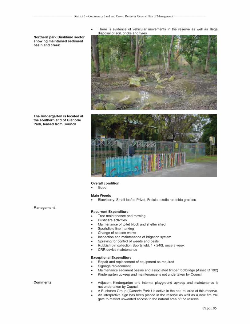
_________________________ District 6 – Community Land and Crown Reserves Generic Plan of Management _____________________
Page 185
� There is evidence of vehicular movements in the reserve as well as illegal disposal of soil, bricks and tyres
Northern park Bushland sector showing maintained sediment basin and creek
The Kindergarten is located at the southern end of Glenorie Park, leased from Council
Overall condition � Good
Main Weeds� Blackberry, Small-leafed Privet, Freisia, exotic roadside grasses
ManagementRecurrent Expenditure� Tree maintenance and mowing � Bushcare activities � Maintenance of toilet block and shelter shed � Sportsfield line marking � Change of season works � Inspection and maintenance of irrigation system � Spraying for control of weeds and pests � Rubbish bin collection Sportsfield, 1 x 240L once a week � CRR device maintenance
Exceptional Expenditure� Repair and replacement of equipment as required � Signage replacement � Maintenance sediment basins and associated timber footbridge (Asset ID 192) � Kindergarten upkeep and maintenance is not undertaken by Council
Comments � Adjacent Kindergarten and internal playground upkeep and maintenance is not undertaken by Council
� A Bushcare Group (Glenorie Park ) is active in the natural area of this reserve. � An interpretive sign has been placed in the reserve as well as a new fire trail
gate to restrict unwanted access to the natural area of the reserve

_________________________ District 6 – Community Land and Crown Reserves Generic Plan of Management _____________________
Page 186
Level of Service Grading Medium - High
Existing Leases Glenorie Kindergarten
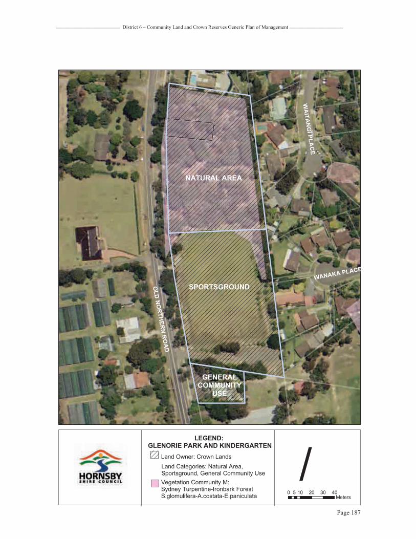
_________________________ District 6 – Community Land and Crown Reserves Generic Plan of Management _____________________
Page 187
"
0 10 20 30 405Meters
/LEGEND:
GLENORIE PARK AND KINDERGARTENLand Owner: Crown LandsLand Categories: Natural Area, Sportsground, General Community Use
SPORTSGROUND
WA
ITAN
GI PLA
CE
WANAKA PLACEO
LDNO
RTHER
NR
OAD
GENERALCOMMUNITY
USE
NATURAL AREA
Vegetation Community M:Sydney Turpentine-Ironbark ForestS.glomulifera-A.costata-E.paniculata

_________________________ District 6 – Community Land and Crown Reserves Generic Plan of Management _____________________
Page 188
Property Plantation Strip, Cairnes Road, GlenorieReserve No. Oracle Fixed Asset No. 105207 Matman Equipment No. Address 1X Cairns Road, Glenorie Lot & DP Plantation Strip Lot 12 DP 253944 (Freehold as Public Reserve) Area 1,030 sq m Zoning Open Space A (Public Recreation – Local) Land Owner Hornsby Shire Council Classification Community Land Community Land Category ParkSubcategories NoRecategorised since Last POM N/ARelationship to Other Plans Not previously included in a Plan of Management
Description & Site Analysis Facilities Provided� Informal open space � Plantation strip� Bus Stop
Natural & Cultural Heritage� Site contains no known Aboriginal relics. (Koettig, 1996, Hornsby Shire LEP,
1994) � Soil derived from Wianamatta Shale
Conservation Status� Glenorie Memorial Hall (Mission Hall) is heritage listed and regarded as being
of local conservation significance (Hornsby Shire LEP 1994)
Condition / Impacts � Good
Cairnes Road Plantation strip contains the bus shelter and remains to the left side of the roadway siding. The strip does not include the native buffer planting to the right side of the roadway
ManagementRecurrent Expenditure� Tree maintenance � Mowing
Exceptional Expenditure� An ecosol pit basket RSF10 has been installed in this reserve on Cairnes
Road, Glenorie (Asset ID 193)
Comments � The Plan of Management does not apply to land classified as Operational, including the Hall and Memorial Garden adjacent to the Plantation Strip, which are maintained by Council
� Part of the existing landscape, including several significant native and non-native trees exist within the designated roadway corridor
� The bus stop within the Plantation Strip is accessed via a roadway siding that runs parallel with Old Northern Road, not within Council land
� Standpipe and water main in road reserve adjacent to plantation strip
Level of Service Grading Low Existing Leases None

_________________________ District 6 – Community Land and Crown Reserves Generic Plan of Management _____________________
Page 189
"
0 10 20 30 405Meters
/LEGEND:
CAIRNES ROAD PLANTATION STRIP
Land Owner: Hornsby Shire CouncilCategorisation: Operational Land
ADJACENT GLENORIE MEMORIAL HALL & WAL BUCKINGHAM MEMORIAL
GARDEN
TECOMA DRIVE
CAIRNES
ROAD
OLD NORTHERN ROAD
POST
OFFIC
ER
OA
D
" CRR Device
PARK
Community Land Category: ParkLand Owner: Hornsby Shire Council
PARK

_________________________ District 6 – Community Land and Crown Reserves Generic Plan of Management _____________________
Page 190
Property Plantation Strip - Taupo Road, Glenorie Reserve No 314Oracle Fixed Asset No 105208 Matman Equipment No Address 2X Taupo Road, Glenorie Lot & DP Lot 74 DP 258001 (Freehold as Public Reserve) Area 3,502 sq m Zoning Residential AR (Low Density – Rural Village)
Land Owner Hornsby Shire Council Classification Community Land Community Land Category Natural Area Subcategories Bushland Recategorised since Last POM NoRelationship to Other Plans This plan supersedes the Generic Parks and Reserves Plan of Management
adopted 1996 and the draft Generic Bushland Plan of Management dated 1998
Description & Site Analysis Facilities Provided� Roadside vegetated buffer
Natural & Cultural Heritage � Site contains no known Aboriginal relics or European heritage items (Koettig,
1996, Hornsby Shire LEP, 1994) � Soil derived from Hawkesbury Sandstone � Vegetation community D: E. punctata, E. gummifera, E. haemastoma -
Woodland � Vegetation community A: E. piperita, A. costata – Forest
Conservation Status� Vegetation communities A and D are well conserved
Condition / Impacts � Vegetation condition is generally good, with few weeds but disturbance from
tracks and driveways has fragmented the roadside vegetation
Overall condition � Good
Main Weeds � Kikuyu, Coreopsis
View within bushland

_________________________ District 6 – Community Land and Crown Reserves Generic Plan of Management _____________________
Page 191
Management Recurrent Expenditure� Tree / vegetation roadside maintenance � Bushfire mitigation
Exceptional Expenditure� Removal of track hazards
Comments � Remnant vegetation is degraded by informal tracks, evidence of BMX bike track at the northern end and constructed driveway access at the southern end
Level of Service Grading N/AExisting Leases None

_________________________ District 6 – Community Land and Crown Reserves Generic Plan of Management _____________________
Page 192
0 10 20 30 405Meters
/LEGEND:
PLANTATION STRIP, TAUPO ROAD GLENORIE
Land Owner: Hornsby Shire CouncilLand Category: Natural Area
NATURAL AREA
TAUPOROAD
OLD
NO
RTH
ERN
RO
AD
NA
TUR
AL
AR
EA

_________________________ District 6 – Community Land and Crown Reserves Generic Plan of Management _____________________
Page 193
Property Tekapo Road BushlandReserve No 82Oracle Fixed Asset No 105302-105305 Matman Equipment No 1.71.3.0Address 3X Tekapo Road, 46-48 Tecoma Road Glenorie Lot & DP Lot 66-68 DP 258001; Lot 88 DP 585835 (Freehold as Public Reserve) Area 12,900 sq m Zoning Open Space A (Public Recreation - Local); Residential AR (Low Density – Rural
Village)
Land Owner Hornsby Shire Council Classification Community Land Community Land Category Natural Area Subcategories Bushland, Watercourse (Glenorie Creek)Recategorised since Last POM YesRelationship to Other Plans This reserve was included in the Significant Areas (Bushland) Plans of
Management and Action Plans. This plan overrides that plan as the reserve does not contain Sydney Turpentine-Ironbark Forest. The reserve will be removed from the Significant Areas (Bushland) Plans of Management and Action Plans when it is updated
Description & Site AnalysisFacilities Provided� Bushland open space� Water quality CRR device
Natural & Cultural Heritage � Site contains no known Aboriginal relics or European heritage items (Koettig,
1996, Hornsby Shire LEP, 1994) � Soil derived from Hawkesbury Sandstone � Vegetation community D: E. punctata, E. gummifera, E. haemastoma -
Woodland � Vegetation community A: E. piperita, A. costata – Forest
Conservation Status� Vegetation communities A and D are well conserved
Condition / Impacts � The creek areas are degraded with a lot of weed infestation and considered to
be in poor condition. There are also weeds along the rural and suburban boundary interface
� The core of the bushland not affected by the creek is very good �
View of well-conserved forest community at Tekapo Road Bushland

_________________________ District 6 – Community Land and Crown Reserves Generic Plan of Management _____________________
Page 194
Overall condition� Good
Main Weeds � Privet, Wild Tobacco, Blackberry, Crofton Weed, Bridal Creeper
Management Recurrent Expenditure� Maintenance of CRR device � Tree maintenance � Noxious weed control � Bushfire mitigation
Exceptional Expenditure� A gross pollutant device (trash rack) has been installed adjacent to this
reserve on Tecoma Drive, Glenorie (Asset ID 19)
Comments � Monthly water testing has been carried out upstream of the gross pollutant device in Glenorie Creek on Tekapo Avenue, Glenorie since 1999/2000. In 2001/2002 physical indicators were ranked “fair”, chemical indicators were ranked “very poor” and primary contact was ranked “very poor” (Hornsby Shire Council 1999)
� A possible site for CRR riparian restoration work � Rabbits are a problem in the reserve
Level of Service Grading N/A
Existing Leases None

_________________________ District 6 – Community Land and Crown Reserves Generic Plan of Management _____________________
Page 195
0 10 20 30 405Meters
/LEGEND: TEKAPO ROAD
BUSHLAND
Land Owner: Hornsby Shire CouncilLand Category: Natural Area
NATURAL AREA
TECOMA
ROAD
TEKAPOROAD
BUSHLAND
TEKAPO ROAD
CRR Device
WANAKA ROAD
"

_________________________ District 6 – Community Land and Crown Reserves Generic Plan of Management _____________________
Page 196
MAROOTAProperty Campbell Crescent Bushland Reserve No 422Oracle Fixed Asset No 229022 Matman Equipment No None Address 7X Campbell Crescent, Maroota Lot & DP Lot 7012 DP 1061542 (Crown Land R84849 for Preservation of Flora with Council
made Trustees 14/9/1979) Area 1,378,362 sq m Zoning Environmental Protection B (River Catchment); Open Space A (Public Recreation -
Local); Rural AR (Large Holdings - Rural Landscapes) Land Owner Crown Classification N/ACommunity Land Category Natural Area (Crown Land) Subcategories Bushland, Watercourse (Glenorie Creek)Recategorised since Last POM YesRelationship to Other Plans This plan supersedes the Generic Parks and Reserves Plan of Management
adopted 1996 and the draft Generic Bushland Plan of Management dated 1998
Description & Site Analysis Facilities Provided� Bushland open space
Natural & Cultural Heritage � Site contains no known Aboriginal relics or European heritage items (Koettig,
1996, Hornsby Shire LEP, 1994), however there would be a high potential for Aboriginal sites if the reserve was surveyed
� Soil derived from Hawkesbury Sandstone � Vegetation community A: E. piperita, A. costata – Open Forest � Vegetation community D: E. punctata, E. gummifera, E. haemastoma -
Woodland � Vegetation Community G: E. haemastoma, A. hispida, Banksia ericifolia – Low
Open Woodland � Vegetation Community H: Acacia suaveolens, Allocasuarina distyla,
Angophora hispida - Rock Platform Heath
Conservation Status� Vegetation Community H is considered a Regionally Significant Community as
it an important habitat for threatened plant species � Vegetation Communities A, D and G are well conserved
Condition / Impacts � Vegetation condition is generally very good. � Some weed infestations occur at drainage watercourses and the rural
boundary interface with these areas considered in fair condition
Overall condition � Very good
Main Weeds � Crofton Weed, Privet, Whiskey Grass
Management Recurrent Expenditure� Fire trail/gate maintenance � Vegetation/ tree maintenance on roadsides � Bushfire mitigation
Exceptional Expenditure� N/A
Comments � There is a short fire trail through the eastern part of the reserve which is proposed for closure
� There is evidence of some old rubbish dumping and areas of past disturbance � This is a large bushland area that has not been fully surveyed for condition or
threatened species
Level of Service Grading N/AExisting Leases None

_________________________ District 6 – Community Land and Crown Reserves Generic Plan of Management _____________________
Page 197
View within reserve

_________________________ District 6 – Community Land and Crown Reserves Generic Plan of Management _____________________
Page 198
0 80 160 240 32040Meters
/LEGEND: CAMPBELL CRESCENT
BUSHLANDLand Owner: CrownLand Category: Natural Area
NATURAL AREA
CAMPBELL CRESCENTBUSHLAND
Vegetation: Shale Sandstone Transition Forest
Fire Trails
NORTHER
NSH
IRE
BOUN
DARY
ROAD
OLD

_________________________ District 6 – Community Land and Crown Reserves Generic Plan of Management _____________________
Page 199
Property Molesworth Park Reserve No 423Oracle Fixed Asset No 229093 Matman Equipment No NoneAddress 1X Laughtondale Gully Road, Maroota Lot & DP Lot 84 DP 752029 (Crown Land R54600 for Public Recreation with Private
Trustees in 1922) Area 18,201 sq m Zoning Rural AR (Large Holdings – Rural Landscapes)
Land Owner Crown Classification N/ACommunity Land Category Natural Area (Crown Land), General Community Use Subcategories Bushland Recategorised since Last POM NoRelationship to Other Plans This plan supersedes the Generic Parks and Reserves Plan of Management
adopted 1996 and the draft Generic Bushland Plan of Management dated 1998
Description & Site AnalysisNatural & Cultural Heritage� Soil derived from Hawkesbury Sandstone � Vegetation Community G: E. haemastoma, A. hispida, Banksia ericifolia – Low
Open Woodland � Site contains no known Aboriginal relics or European heritage items (Koettig,
1996, Hornsby Shire LEP, 1994) � On 4 February 1920 the Windsor and Richmond Gazette reported the first
sports day as being held on this site which included cricket and bicycle races. At that time Mr Molesworth, MLA was seeking to secure land for a park. In 1921 the park was set aside by the Department of Lands and in 1922 private trustees were gazetted. A local resident wrote to her local member in 1992 asking what had happened about the development of Molesworth Park. Council also began its own investigation into the park’s location and found the park after meeting with local residents in 1992. The site visit revealed that the park consisted of native vegetation, material stockpile and a 65 year old cricket wicket
View showing sandy floor derived from Hawkesbury Sandstone
View showing reedy embankment

_________________________ District 6 – Community Land and Crown Reserves Generic Plan of Management _____________________
Page 200
Park view
Conservation Status� Vegetation community G is well conserved
Condition / Impacts � The bushland is in very good condition and an excellent example of sandstone
vegetation � There are some weeds near the roadside and around the materials stockpile
site at the southeastern corner of the reserve
Overall condition � Very good
Main Weeds � Blackberry, Lantana, Kikuyu and Whiskey Grass
Management Recurrent Expenditure� Tree / vegetation maintenance � Bushfire mitigation
Exceptional Expenditure� N/A
Comments � There is a materials stockpile on the reserve � There are two unauthorised tracks through the reserve to the adjoining private
land
Level of Service Grading N/A
Existing Leases None

_________________________ District 6 – Community Land and Crown Reserves Generic Plan of Management _____________________
Page 201
0 10 20 30 405Meters
/LEGEND:
MOLESWORTH PARK
Land Owner: Crown LandsLand Categories: Natural Area,General Community Use
LAUGHTO
NDALEGULL
YROAD
GENERALCOMMUNITY
USE
NATURAL AREA
OLD NORTHERN ROAD

_________________________ District 6 – Community Land and Crown Reserves Generic Plan of Management _____________________
Page 202
Property Wisemans Ferry Bushland and former tip site, Maroota Reserve No 530Oracle Fixed Asset No 229037 Matman Equipment No Address Old Northern Road, Maroota Lot & DP Lot 7001 DP 93558 (Crown Land R87245 for Rubbish Depot with Council Trustees
in 1969) Area 149,292 sq m Zoning Environmental Protection B (River Catchment); Rural AR (Large Holdings – Rural
Landscapes)Land Owner Crown Classification N/ACommunity Land Category General Community Use, Natural Area Subcategories Bushland, Watercourse Recategorised since Last POM YesRelationship to Other Plans This plan supersedes the Generic Parks and Reserves Plan of Management
adopted 1996 and the draft Generic Bushland Plan of Management dated 1998
Description & Site Analysis Facilities Provided� Former rubbish tip – now closed� Remediation area � Bushland open space
Natural & Cultural Heritage � Soil derived from Hawkesbury Sandstone � Vegetation Community A : E. piperita, A. costata – Open Forest and
Vegetation community D: E. punctata, E. gummifera, E. haemastoma -Woodland
� Site contains no known Aboriginal relics or European heritage items (Koettig, 1996, Hornsby Shire LEP, 1994)
View showing bushland fringe in background and former tip site requiring regeneration
Conservation Status� Vegetation communities A and D are well conserved
Condition / Impacts � The bulk of the bushland is in very good condition � There is an area of weed infestation on the downslope edge of the former tip
site
Overall condition � Very good

_________________________ District 6 – Community Land and Crown Reserves Generic Plan of Management _____________________
Page 203
Main Weeds � Castor Oil Plant, Crofton Weed, exotic grasses
Management Recurrent Expenditure� Maintenance of remediation site � Tree/ vegetation management � Noxious weed control � Bushfire mitigation
Exceptional Expenditure� Remediation and revegetation of former tip
Comments � The rubbish tip was closed in February 2006. A closure plan has been prepared and submitted to the NSW EPA for approval
� Monthly water testing has been carried out in the final leachate pond at Wisemans Ferry Tip since 1996. In 2001/2002 physical indicators were ranked “very poor” and chemical indicators were ranked “very poor”
Level of Service Grading N/A
Existing Leases None

_________________________ District 6 – Community Land and Crown Reserves Generic Plan of Management _____________________
Page 204
0 30 60 90 12015Meters
/LEGEND:
WISEMANS FERRY RUBBISH TIP
Land Owner: Crown Lands
Land Category: General Community Use,Natural Area
NATURAL AREA
OLD NORTHERN ROAD
GENERALCOMMUNITY
USE

_________________________ District 6 – Community Land and Crown Reserves Generic Plan of Management _____________________
Page 205
WISEMANS FERRYProperty Singleton Mill Road Bushland & Wisemans Ferry Cemetery Reserve No 310Oracle Fixed Asset No’s 106030, 106031, 229024, 229086, 229139, 229186, 229211, 229218 Matman Equipment No’s 2.203.0.0, 1.126.3.0, 1.127.3.0 Address Singleton Road, Wisemans Ferry Lot & DP Lot 7004 DP 93995 (Crown - General Cemetery controlled by Council), Lots
99951- 99955 DP 42000 (Crown land R45642 for Public Recreation notified 24/08/1910 with care, control and management devolving to Council include Crown Lands within 402.3m (20 chain) of the H.W.M. of the southern shores of the Hawkesbury River and its arms between Wisemans Ferry and Brooklyn)
Area 525,290 sq m
Zoning Lot 7004 DP 93995 is zoned Special Uses A (Community Purposes) and Lots 99951- 99955 DP 42000 are zoned Open Space A (Public Recreation - Local)
Land Owner Crown Classification NACommunity Land Category General Community Use, Natural Area Subcategories Bushland, Foreshore Recategorised since Last POM YesRelationship to Other Plans This plan supersedes the Generic Parks and Reserves Plan of Management
adopted 1996
Description & Site Analysis Facilities Provided� Cemetery� Bushland open space
Natural & Cultural Heritage � Site contains no known Aboriginal relics (Koettig, 1996) � Site contains European heritage items listed as being of State heritage
significance (Hornsby Shire LEP, 1994) being the resting places of many early settlers and convicts
� Soil derived from Hawkesbury Sandstone and Narrabeen Group sediments � Vegetation community R: Angophora bakeri – Open Forest � Vegetation community A: E. piperita, A. costata – Open Forest � Vegetation community O2: Backhousia myrtifolia – Rainforest � Vegetation community T: Eucalyptus eximia - Woodland � Vegetation community W: Mangrove Swamp
View from bushland track over cemetery
Conservation Status� Vegetation community O2: Warm Temperate Rainforest is poorly conserved in
the Sydney region and is regarded as being of Regional Conservation Significance

_________________________ District 6 – Community Land and Crown Reserves Generic Plan of Management _____________________
Page 206
� Vegetation community R: Narrow-leaved Apple Slopes Forest is poorly conserved in the Sydney region and is regarded as being of Regional Conservation Significance
� Vegetation community W has an important role in the ecological health and productivity of the estuary and is regarded as being of Local Conservation Significance
� Communities A and T are well conserved
Condition / Impacts � The bushland is in very good condition and an excellent example of Narrabeen
Slopes vegetation � There is some roadside lantana and exotic grasses near the cemetery that
would be classified as fair
View from upper cemetery area, encircled by bushland, with views out over the Hawkesbury River
Overall Condition � Very good
Main Weeds � Lantana, Wild Tobacco, exotic grasses
ManagementRecurrent Expenditure� Tree maintenance � Mowing � Cemetery operations � Noxious weed control � Bush fire mitigation
Exceptional Expenditure � N/A
Comments � The cemetery is still in operation � Singleton Mill Road splits through the reserve adjacent to the foreshore, where
a strip of bushland forms an edge with the waterway � This reserve is a designated Wildlife Protection Area
Level of Service Grading Low
Existing Leases None

_________________________ District 6 – Community Land and Crown Reserves Generic Plan of Management _____________________
Page 207
0 100 200 300 40050Meters
/LEGEND:
WISEMANS FERRYCEMETERY AND BUSHLAND
Land Owner: Crown Lands
Land Category: General Community Use,Natural Area
SINGLETON ROAD
GENERALCOMMUNITY
USE
NATURAL AREA

_________________________ District 6 – Community Land and Crown Reserves Generic Plan of Management _____________________
Page 208
Property One Tree Reach Wetland (unnamed bushland - Singleton Mill in land register) Reserve No none Oracle Fixed Asset No 229065 Matman Equipment no None Address Singleton Road, Wisemans Ferry Lot & DP Lot 101 DP 752029 (Crown Reserve R45642 for Public Recreation notified
24/08/1910 with care control and management devolving to Council)
Area 40,757 sq m Zoning Environmental Protection A (Wetlands) Land Owner Crown Classification N/ACommunity Land Category Natural AreaSubcategories Bushland Recategorised since Last POM NoRelationship to Other Plans It has not been included in any former Plan of Management. This area will be
included in the Significant Areas – Bushland Plan of Management when it is reviewed
Description & Site Analysis Facilities Provided� Bushland / wetland open space
Natural & Cultural Heritage � Site contains no known Aboriginal relics or European heritage items (Koettig,
1996, Hornsby Shire LEP, 1994) � Soil derived from Hawkesbury Sandstone � Vegetation Community SF1: Swamp Mahogany Forest, Community SF2:
Floodplain Paperbark Scrub and Community SF3: Floodplain Reedland
Conservation Status� Swamp Mahogany Forest, Floodplain Paperbark Scrub and Floodplain
Reedland are forms of Swamp Sclerophyll Forest on Coastal Floodplains of the NSW North Coast, Sydney Basin and South East Corner Bioregions. These forest communities are of State conservation significance and are listed as an Endangered Ecological Community under the Threatened Species Conservation Act (1995)
View showing floodplain vegetation in foreground
Condition / Impacts � The wetland is in very good condition and an excellent example of floodplain
vegetation � There is some roadside lantana and exotic grasses (1/1/1(1) but these are
isolated. The main waterbody was unsurveyed
Overall condition � Very good

_________________________ District 6 – Community Land and Crown Reserves Generic Plan of Management _____________________
Page 209
Main Weeds � Lantana, Blackberry, Kikuyu, Bidens
Management Recurrent Expenditure� Tree/vegetation maintenance � Bushfire mitigation
Exceptional Expenditure� Waterbird and ecological survey � Ongoing monitoring of wetland health
Comments� This is a highly significant reserve in Hornsby Shire and more active
monitoring and management may be required in the future
Level of Service Grading N/A
Existing Leases None

_________________________ District 6 – Community Land and Crown Reserves Generic Plan of Management _____________________
Page 210
0 25 50 75 10012.5Meters
/LEGEND: VACANT LAND
SINGLETON ROAD WISEMANS FERRY
Land Owner: Crown LandsLand Category: Natural Area
HAWKESBURY
RIVER
NATURAL AREA
SINGLETONROAD
Vegetation:Swamp sclerophyll forestSwamp oak woodlandSaltmarsh

_________________________ District 6 – Community Land and Crown Reserves Generic Plan of Management _____________________
Page 211
Property Wisemans Ferry Lookout (also known as Hawkins Lookout) Reserve No 144Oracle Fixed Asset No 106064 Matman Equipment No 1.157.3.0 Address Old Northern Road, Wisemans Ferry Lot & DP Lot 3 DP 232210 (Freehold as Public Reserve) Area 111,410 sq m
Zoning Environmental Protection B (River Catchment) Land Owner Hornsby Shire Council Classification Community Land Community Land Category Natural Area, Park Subcategories Bushland, Watercourse Recategorised since Last POM Yes
Relationship to Other Plans This plan supersedes the Generic Parks and Reserves Plan of Management adopted 1996 and the draft Generic Bushland Plan of Management dated 1998
Description & Site Analysis Facilities Provided� Vehicular egress / parking area� Bushland open space
Natural & Cultural Heritage � Soil derived from Hawkesbury Sandstone � Vegetation community A: E. piperita, A. costata - Forest � Vegetation community D: E. punctata, E. haemastoma - Woodland � Vegetation community O2: Backhousia myrtifolia - Closed Forest � Vegetation community R: Angophora bakeri - Forest � Vegetation community SO: Casuarina glauca- Swamp Oak Floodplain Forest � Vegetation community T: E. eximia - Woodland � Site contains no known Aboriginal relics or European heritage items (Koettig,
1996, Hornsby Shire LEP, 1994), although there would be a high potential for Aboriginal sites to occur if the area were surveyed
� The 10 ha park was sold to Hornsby Shire Council in 1967 funded by the sale of other Council land. The location allows visitors to view the Hawkesbury River from above a junction of Singletons Road and Old Northern Road. The name ‘Hawkins Lookout’ is the same as that in the Baulkham Hills Shire, being named after an overseer on the original North Road. The park was developed in 1978, and received an upgrade in 1993. Funds will be spent in 2006 to relocate the lookout to a new position and remove environmental weeds
Former lookout site to be upgraded in 2006
Conservation Status� Vegetation Community SO, Swamp Oak Floodplain Forest, is an Endangered
Ecological Community in NSW listed under the Threatened Species Conservation Act (1995)
� Vegetation Community R Narrow-leaved Apple Slopes Forest and vegetation community O2 Grey Myrtle Rainforest are Regionally Significant Community in the Sydney Region

_________________________ District 6 – Community Land and Crown Reserves Generic Plan of Management _____________________
Page 212
� The threatened flora species Olearia cordata has been recorded in this reserve � Vegetation communities A, D and T are well conserved
Condition / Impacts � All the core bushland condition is very good KMC1/1/1(1). At the cleared picnic
area the vegetation is poor condition and below the lookout is also an infestation of Robinia and in fair condition
� The bottom 100m of the riparian area is also in fair condition
Overall condition � Good
Main Weeds � Privet, Lantana, Coral Tree, small and large Purple Top, Paddys Lucerne,
Blackberry - North American Dewberry, Cotton Bush, Cassia, Paspalum, Bidens, Rhodes Grass, Sunshine Wattle, Turkey Rhubarb
Management Recurrent Expenditure� Tree / vegetation management � Mowing � Bushfire mitigation� Maintenance of picnic table and facilities � Noxious weed control � Chain mesh fence repair
Exceptional Expenditure� Upgrade of facilities at lookout including fences, furnishings � Riparian vegetation restoration at foreshore
Comments � This is a large bushland area extending from the ridgetop of Old Northern Road all the way to the foreshore of the Hawkesbury River
� A designated Wildlife Protection Area
Level of Service Grading Low – This will be reviewed following planned reserve upgrade
Existing Leases None

_________________________ District 6 – Community Land and Crown Reserves Generic Plan of Management _____________________
Page 213
0 40 80 120 16020Meters
/LEGEND:
WISEMANS FERRY LOOKOUT
Land Owner: Hornsby Shire Council
Land Categories: Park, Natural Area
NATURAL AREA
OLD NORTHERN ROAD
PARK

_________________________ District 6 – Community Land and Crown Reserves Generic Plan of Management _____________________
Page 214
Property Wisemans Ferry Public Wharf Reserve No 309Oracle Fixed Asset No 105402 - 105406 Matman Equipment No 6.309.0.0 Address River Road, Wisemans Ferry Lot & DP Crown Land- Permissive Occupancy to Council Area 83 sq m Zoning Not zoned Land Owner Crown Classification N/ACommunity Land Category General Community Use Subcategories N/ARecategorised since Last POM YesRelationship to Other Plans This plan supersedes the Generic Parks and Reserves Plan of Management
adopted 1996
Description & Site Analysis Facilities Provided� Vehicular ferry crossing point and ferry � Timber Wharf / jetty x 1, concrete wharf and mooring points (in water and to
forshore)� Boat ramp and carpark / turning bay � Pathway with lighting
Natural & Cultural Heritage � The public wharf and ferry site contains no known Aboriginal relics but the
cable ferry is listed in the Hornsby Shire LEP as an item of local significance (Koettig, 1996, Hornsby Shire LEP, 1994)
� The ferry was established by Solomon Wiseman in 1827 after he wrote to the Colonial Secretary informing him that he had built a punt and requesting a lease of the ferry on the Hawkesbury near his residence. The ferry service continued for many years. As late as 1894 Wisemans Ferry was the principal crossing place for large herds of cattle bound for the Sydney market. Hornsby Council now operates the ferry service, which is the longest established ferry service in Australia
� The foreshore contains active bush regeneration sites
View from southernmost jetty showing mooring point, timber jetty in mid-ground and historic cable ferry making the crossing from the northern end of the reserve
Conservation Status� The cable ferry is an item of local heritage significance
Condition / Impacts � Good
Main Weeds � Aquatic weeds are evident along the foreshore
Management Recurrent Expenditure� Mowing
Exceptional Expenditure� Repair of wharf and foreshore retaining wall / embankment as required � Maintenance of pathway and lighting as required

_________________________ District 6 – Community Land and Crown Reserves Generic Plan of Management _____________________
Page 215
Level of Service Grading Low
Existing Leases None

_________________________ District 6 – Community Land and Crown Reserves Generic Plan of Management _____________________
Page 216
"
0 25 50 75 10012.5Meters
/LEGEND:
WISEMANS FERRY PUBLIC WHARFLand Owner (Wharf 2 only): Crown Lands
Land Category: General Community Use
RIVERROAD
WISEMANS FERRY RECREATION
RESERVE ADJACENT
WHARF 1
WHARF 2
CARPARK & BOATRAMP
CAR FERRY
RECREATION RESERVE BOUNDARY
NB: Subject site including foreshore land neither owned by Council or the Crown below the tidal flow line

_________________________ District 6 – Community Land and Crown Reserves Generic Plan of Management _____________________
Page 217
Property Wisemans Ferry Recreation Reserve Reserve No 203Oracle Fixed Asset No 105450 Matman Equipment No 2.203.0.0 Address River Road, Wisemans Ferry Lot & DP Lot 4 DP 566926 (Freehold) Area 83,703 sq m Zoning Open Space A (Public Recreation - Local) Land Owner Hornsby Shire Council Classification Community Land Community Land Category Sportsground, Park Subcategories N/ARecategorised since Last POM NoRelationship to Other Plans This plan supersedes the Generic Parks and Reserves Plan of Management
adopted 1996 and the Generic Sportsground Plan of Management adopted 1996
Description & Site Analysis Facilities Provided� Sports fields (x 2) with cricket wickets (1x Astroturf)� Cricket nets� Tennis courts with lighting � Blockwork tennis practice wall � Picnic shelter over 3 picnic settings to courts � Picnic tables (uncovered) x 4, one within playground enclosure � Toilets � Playground, fenced � Bench seats x 4, one within playground enclosure � Hornsby Shire Council Centenary Plaque on sandstone boulder at park
frontage� Informal parking area
Natural & Cultural Heritage � Soil derived from Hawkesbury Sandstone � Site contains no known Aboriginal relics or European heritage items (Koettig,
1996, Hornsby Shire LEP, 1994) � The land is part of an area granted to Solomon Wiseman in 1830. The large flat
area in front of his home Cobham Hall was used mustering cattle en route to the Sydney market. In 1964 the Wisemans Ferry Chamber of Commerce wrote to Hornsby Shire Council asking for the provision of recreation and sporting areas and fields adjacent to the wharf. The land was purchased from Mr N. A. Hansen of Maroota in 1967 and was partially developed as park and sportsground in the mid 1980s.
Management Recurrent Expenditure� Tree maintenance � Mowing � Spraying for weeds and pests � Inspection and maintenance playground equipment and softfall � Inspection and cleaning toilet facilities � Trash rack litter removal � Rubbish collection, 1 x 240L wheelie bin, 2 x 55L Pebblecrete bins, once a
week
Exceptional Expenditure� Repair and replacement of facilities as required due to wear and tear and
vandalism� Repair fences as necessary (includes post and wire, pool fence, pine bollards
fence types) � Repaint tennis wall � Maintenance tennis courts, nets, surface and lighting as required � Repair toilet facilities as required
Condition / Impacts � Good. Bush regeneration is active along the foreshore frontage

_________________________ District 6 – Community Land and Crown Reserves Generic Plan of Management _____________________
Page 218
View towards Berowra Creek from main sportsfield / open space area
Playground
Comments / other � Contract bush regeneration has commenced in Wisemans Ferry Recreation
Reserve � A ski jump litter trap has been installed in this reserve on Old Northern Road,
Wisemans Ferry (Asset ID 38)
Comment � It has been suggested that the Wisemans Ferry Bowling Club may wish to take on management of part of the reserve for the purpose of providing recreation facilities. This may be through a lease or licence for an extended period or through a delegation of authority under the Local Government Act. From time to time, seasonal licences may be granted to community sports clubs for the use of the facilities
Level of Service Grading Medium
Existing Leases None

_________________________ District 6 – Community Land and Crown Reserves Generic Plan of Management _____________________
Page 219
"
0 20 40 60 8010Meters
/LEGEND:
WISEMANS FERRYRECREATION RESERVE
Wisemans Ferry Recreation ReserveLand Owner: Hornsby Shire Council
Land Categories: Park, Sportsground
RIVER
ROAD
SPORTSGROUND
PARK
PARK
Catchment remediation device
ADJACENTPUBLIC WHARF
REC. RESERVEBOUNDARY
_________________________ District 6 – Community Land and Crown Reserves Generic Plan of Management _________________
BIBLIOGRAPHY
Aboriginal Land Rights Act (1983), New South Wales Legislation
Buchanan, Robin (1984) Bush Regeneration – Recovering Australian Landscapes
Centre for Integrated Catchment Management (1999) Berowra Creek Catchment Stormwater Management Plan
Commonwealth of Australia (1996) The National Strategy for the Conservation of Australia’s Biological Diversity
Connell Wagner (1998) Berowra Waters Draft Plan of Management
Coombes, David (1995) Rare and Threatened Fauna and Flora Survey of Berowra Valley Bushland Park
Conacher Travers Pty Ltd (2003) Berowra Valley Regional Park Draft Plan of Management prepared for the Berowra Valley Regional Park Trust and the NSW National Parks and Wildlife Service
Crown Lands Act (1989) New South Wales Legislation
EGIS Consulting (1999) Lane Cove River Catchment Stormwater Management Plan and Pollution Source Inventory
Environmental Planning and Assessment Act (1979)
ESP Ecological Surveys and Planning (1999) Threatened Biota Conservation Plan
Hassell Pty Ltd. (1997). Hornsby Open Space Plan
Hornsby Ku-ring-gai Bushfire Management Committee (1999) Draft Bush Fire Risk Management Plan
Hornsby Shire Council (1990) Berowra Valley Bushland Park – Draft Plan of Management Stage 1 & 2
Hornsby Shire Council (1990) Inventory of Bushland Reserves
Hornsby Shire Council (1994). Hornsby Shire Local Environment Plan
Hornsby Shire Council (1995). Heritage Development Control Plan
Hornsby Shire Council (1996) Parks and Reserves Generic Plan of Management
Hornsby Shire Council (1996) Sportsgrounds Generic Plan of Management
Hornsby Shire Council (1997). Access and Mobility Development Control Plan
Hornsby Shire Council (1997) Catchment Remediation Program – Five Year Plan
Hornsby Shire Council (1997) Code for Bushcare Program
Hornsby Shire Council (1997) Sensitive Urban Lands Study
Hornsby Shire Council (1998) Bushland Generic Plan of Management
Hornsby Shire Council (1998) Indigenous Plants for the Bushland Shire
Hornsby Shire Council (1999). Exempt and Complying Development – Development Control Plan
Hornsby Shire Council (1999). Tree Management Plan
Hornsby Shire Council (2000). Hornsby Shire Council Social Plan 2000 - 2005
Hornsby Shire Council (2000) Significant Areas - Bushland Plans of Management and Action Plans
Hornsby Shire Council (2000). Tree Management Plan
Hornsby Shire Council (2000) Water Quality Sampling Manual
Hornsby Shire Council (2001) Management Plan 2003 – 2006
Hornsby Shire Council (2001) Principal Activity Service Plan 2003 – 2006
Page 220
_________________________ District 6 – Community Land and Crown Reserves Generic Plan of Management _________________
Hornsby Shire Council (2003) Hornsby Leisure Strategic Plan Stage 2 Report – Demand, Supply and Service Gap Analysis. Prepared for Hornsby Shire Council by Recreation Planning Associates
Hornsby Shire Council (2003) Hornsby Leisure Strategic Plan Stage 3 Report – Recommended Strategies and Action Plans. Prepared for Hornsby Shire Council by Recreation Planning Associates
Hornsby Shire Council (2004) Hornsby Shire Biodiversity Conservation Strategy
Howard, J & Rawling, J (1992) Urban Bushland Management - Into the Melting Pot, conference proceedings
Land and Environment Planning (1994) Fauna Corridors and Vegetation Links in the Hornsby Shire
Local Government Act (1993)
Local Government Amendment (Community Land Management) Act 1998
Local Government (General) Amendment (Community Land Management) Regulation 1999
Manidis Roberts (1991). Hornsby Shire Recreation Needs Study
Margrit Koettig Archaeological Services (1996) Hornsby Shire Aboriginal Heritage Study
National Parks and Wildlife Act (1974 ), New South Wales Legislation
National Parks and Wildlife Service (1997) Draft NSW Biodiversity Strategy
National Parks and Wildlife Service (1997) Urban Bushland Biodiversity Survey of Western Sydney
National Parks and Wildlife Service (1999) Regional Fox Control Program
National Parks and Wildlife Service (1999) Draft Fire Management Plan for Berowra Valley Regional Park
National Parks and Wildlife Service (2000) Darwinia biflora Draft Recovery Plan
National Parks and Wildlife Service (2003) Saving our Threatened Native Animals and Plants: Recovery and Threat Abatement in Action – 2003 Update
National Trust of Australia (1999) Bush Regenerator’s Handbook
Nature Conservation Council (1992) Bushland in our Cities and Suburbs Parts 1 & 2, Seminar Proceedings
Noxious Weed Committee – Sydney North (1998) Regional Noxious Weed Strategy
NSW Agriculture (1997) New South Wales Weed Strategy
Smith P. & Smith J. (1990). Hornsby Shire Bushland Survey. Report for Hornsby Shire Council. P & J Smith Ecological Consultants, Blaxland
Smith P & J (1990), Vegetation and Fauna of Berowra Valley Bushland Park, P&J Smith Ecological Consultants, Blaxland
Smith P & J (1990), Vegetation and Fauna of Pennant Hills Park, P&J Smith Ecological Consultants, Blaxland
Sydney Regional Organisation of Councils (1997) Green Web – Sydney, A Vegetation Management Plan for the Sydney Region
Urban Bushland Management Consultants (1999) Development and Management of Wildlife Corridors in Hornsby Shire
Urban Bushland Management Consultants (1997) Weed Mapping of Bushland Areas in Hornsby Shire
Webb, McKeown & Associates (2000) Berowra Creek Estuary Management Study and Management Plan
Webb, McKeown & Associates (1999) Cowan Creek Catchments Stormwater Management Plan
Page 221

_________________________ District 6 – Community Land and Crown Reserves Generic Plan of Management _________________
APPENDIX 1: BEST MANAGEMENT PRACTICES FOR SPORTSTURF
_______________________________________________________________________________________________________________________________________
Page 222

_________________________ District 6 – Community Land and Crown Reserves Generic Plan of Management _________________
Page 223

_________________________ District 6 – Community Land and Crown Reserves Generic Plan of Management _________________
APPENDIX 2: HORNSBY SHIRE LEP 1994 – MINOR COUNCIL WORKS
_______________________________________________________________________________________________________________________________________
MINOR COUNCIL WORKS
Savings
Section 6(3) of the Hornsby Shire Local Environmental Plan 1994 permits Council to undertake the following minor works without obtaining development consent:
“6. (3) Development carried out by or on behalf of the Council for the purposes of the following may be carried out on any land without development consent:
a) construction or maintenance of stormwater drainage, water quality treatment devices, water tanks, recreation areas, public amenities, temporary storage facilities;
b) installation or maintenance of street furniture, such as seats, Council information signs, street signs, street lights, bus shelters, garbage and recycling containers and bins, bollards, flag poles, telephone kiosks and the like, but not fixed outdoor vending machines;
c) construction and maintenance of roads, footpaths, cycleways, parking areas, fire trails, walking tracks and other public pedestrian areas, roads, including tree planting and repaving, street surfacing, reconstruction of kerbs, gutters and the like;
d) installation or maintenance of park furniture including seats, picnic tables, barbecue units and shelters, awnings and shade structures, gazebos and pergolas, bollards, playground equipment, flag poles, bridges, staircases, boardwalks, lighting (excluding ovals, tennis courts and the like);
e) information signs; f) installation and maintenance of goal posts, sight screens, fencing and similar ancillary sporting
structures on sporting or playing fields for use in the playing/performance of sporting events (excluding grandstands, dressing sheds and other structures);
g) installation and maintenance of temporary structures for special events, including marquees, booth toilets, stages, tents, scaffolds and the like;
h) bush fire hazard reduction carried out in accordance with a bush fire management plan under the Rural Fires Act 1997;
i) bush regeneration, landscaping, gardening, tree planting, tree maintenance and tree removal.”
The proposals are assessed under Part V of the Environmental Planning and Assessment Act, 1979.
Council is required to notify and exhibit minor work proposals. Section 6(4) – (5) of the Hornsby Shire Local Environmental Plan 1994 requires that:
“(4) The Council shall not undertake any works in accordance with subclause (3), unless it has given written notice to such persons who own or occupy the land adjoining the land on which the work is to be undertaken and the Council has considered any written submission made in relation to the works.
(5) Regardless of subclause (4), the Council need not give written notice of a work proposed to be undertaken in accordance with subclause (2), where, in the opinion of the Council, the work is of a minor nature or has previously been the subject of community consultation.”
The Notification Protocol on the following page details the circumstances and procedures for the notification and exhibition of minor work proposals.
Page 224

_________________________ District 6 – Community Land and Crown Reserves Generic Plan of Management _________________
MINOR WORKS - NOTIFICATION ELEMENT
Objective of element
To enable community notification and participation in Council’s minor works proposals, which do not require development consent.
Performance criteria Residents and land owners should be advised of Council’s minor works proposals, which could potentially affect the residents or property.
The notification should encourage public participation and provide sufficient opportunity for input prior to the commencement of the minor work.
Prescriptive Measures Residents or property owners should notified of the following works: � the installation or maintenance of stormwater
drainage lines, on private property or in road reserves in front of residential properties;
� the construction or re-surfacing of roads on road reserves in front of residential properties;
� the construction of new fire trails, footpaths, bicycle paths and the like, in proximity to residential properties;
� the installation of new street and park furniture; � the erection of new grandstands, dressing sheds
and other structures at parks and ovals; � bush fire hazard reduction (as required by the
Rural Fires Act 1997);� the removal of trees listed as heritage items in
Schedule D of the Hornsby Shire Local Environmental Plan 1994 or which are assessed as significant;
Residents or property owners are not required to be notified in the following circumstances: � the proposal has been previously exhibited for
community comment as part of Plans of Management or works programs;
� the maintenance of street and park furniture in public places and road reserves;
� the installation or maintenance of sporting structures (excluding the erection of new grandstands, dressing sheds and other structures) at public ovals and parks;
� the installation of temporary structures on public land, if in accordance with the Plan of Management for the land;
� road maintenance works, drainage works or tree removal works which need to be undertaken urgently to maintain public health and safety;
� minor road maintenance works (such as the repair of potholes);
� bush regeneration, landscaping, gardening, tree planting, tree maintenance or tree removal (except trees listed as heritage items in Schedule D of the Hornsby Shire Local Environmental Plan 1994 or which are assessed as significant);
The notification shall be in the form of a letter (either posted or delivered) to the owner or resident advising of the proposed work, when it will commence and the construction period. It should also provide the opportunity to inspect any documentation.
The notification should provide for a minimum period of 14 days for the inspection of documentation and submission of resident’s comments.
The Council may amend the minor work proposal on the basis of the submissions.
If the commencement of minor works is delayed by poor weather or other circumstances, the proposal is not required to be re-notified. Any residents directly affected by a delayed proposal should be given 2 days notice prior to the commencement of works.
Page 225

_________________________ District 6 – Community Land and Crown Reserves Generic Plan of Management _________________
APPENDIX 3: Park Rules
_______________________________________________________________________________________________________________________________________
Page 226

_________________________ District 6 – Community Land and Crown Reserves Generic Plan of Management _________________
APPENDIX 4: Leasing and Licensing of Community Land
_______________________________________________________________________________________________________________________________________
Extract from the Local Government (General) Amendment (Community Land Management) Regulation 1999 Regarding Leasing and Licensing of Community Land
“6JF Leases, licences and other estates in respect of community land:
(1) For the purposes of section 46 (1) (b) (iii) of the Act, the use or occupation of community land for the following events is prescribed as a purpose in respect of which a council may grant a licence in respect of community land on a short-term casual basis:
(a) the playing of a musical instrument, or singing, for fee or reward;
(b) engaging in a trade or business; (c) delivering a public address; (d) commercial photographic sessions; (e) picnics and private celebrations such as weddings and family gatherings; (f) filming for cinema or television; (g) the agistment of stock.
(2) However, the use or occupation of community land for events listed in subclause (1) is prescribed only if the use or occupation does not involve the erection of any building or structure of a permanent nature.
6JG Exemptions from section 47A (Leases, licences and other estates in respect of community land - terms of 5 years or less)
(1) Leases, licenses and other estates granted for the following purposes are exempt from the provisions of section 47A of the Act:
(a) residential purposes, where the relevant community land has been developed for the purposes of housing owned by the Council;
(b) the provision of pipes, conduits or other connections under the surface of the ground for the connection of premises adjoining the community land to a facility of the Council or other public utility provider that is situated on the community land;
(c) use and occupation of the community land for events such as: (i) a public performance (that is, a theatrical, musical or other entertainment for the
amusement of the public); (ii) the playing of a musical instrument, or singing for fee or reward; (iii) engaging in a trade or business; (iv) playing of any lawful game or sport; (v) delivering a public address; (vi) conducting a commercial photographic session; (vii) picnics and private celebrations such as weddings and family gatherings; (viii) filming for cinema or television.
(2) However, the use or occupation of community land for the events listed in subclause (1) (c) is exempt only if:
(a) The use or occupation does not involve the erection of any building or structure of a permanent nature, and
(b) In the case of any use or occupation that occurs only once, it does not continue for more than 3 consecutive days, and
(c) In the case of any use or occupation that occurs more than once, each occurrence is for no more than 3 consecutive days, not including Saturday and Sunday, and the period from the first occurrence until the last occurrence is not more than 12 months.
Page 227

_________________________ District 6 – Community Land and Crown Reserves Generic Plan of Management _________________
APPENDIX 5: RURAL SPORTS FACILITY MASTERPLAN
_______________________________________________________________________________________________________________________________________
Page 228
_________________________ District 6 – Community Land and Crown Reserves Generic Plan of Management _________________
APPENDIX 6: _______________________________________________________________________________________________________________________________________
Hornsby Shire Council
Plan of Management
Galston Rural Sports Facility
June 2005
Note
This Plan of Management is intended for the provision of information as to the operation of the Galston Rural Sports facility to assist in the assessment of Development Application 53/2004 for the facility. It is not intended to be a Plan of Management under the Local Government Act (1993).
The Plan of Management is intended to direct the environmental and operational management of the proposed Rural Sports Facility at 18 and 20 Bayfield Road, Galston NSW.
INTENDED USE OF THE GALSTON RURAL SPORTS FACILITY
The Galston Rural Sports Facility proposed to be located at 18 and 20 Bayfield Road, Galston, is intended to be used for activities associated with equestrian and canine disciplines only. The Facility shall not be used for activities which are likely to exceed the environmental capacity of the site in terms of people numbers, horse numbers or vehicle / trailer / horse float numbers.
Hours of Operation.
Hours will be from 7AM until 6PM Monday to Saturday and from 8AM to 6PM Sundays & Public Holidays. Gates to the carpark will be controlled by the Facility Supervisor who will be responsible for unlocking and locking daily at opening and closing times respectively. There will be no night lighting so as not to encourage after hours use, and a fence with locked gates will prevent vehicle, horse and pedestrianentry in hours when the facility is closed. Licensees of the facility will not be permitted to use the facility out of hours.
Site Occupation and Usage Limitations
The use of the Galston Rural Sports Facility (the ‘Facility’) by club or organisation for organised events shall not occur without the club or organisation first obtaining a Periodic Licence from Hornsby Council (‘Council’) under the provisions of the Galston Rural Sports Facility Plan of Management and in accordance with the following requirements.
Page 229

_________________________ District 6 – Community Land and Crown Reserves Generic Plan of Management _________________
Periodic licensees (or licensees) are clubs and organisations conducting equestrian and canine activities that have been scheduled by the club and for which Hornsby Shire Council has issued a licence. All other users of the Facility shall be known as ‘casual users’. Casual users are expected to be comprised of horseriders, dog owners and other park visitors engaging in non-organised, non-active recreation, using the facility during periods when the facility is not occupied by a licensee. Periodic licensees and casual users shall be collectively known as ‘users of the Facility’.
Park notices at the facility will advise casual users that use of the Facility is reserved for the use of licence holders during certain periods. Licensees will be required to have a copy of the licence at the Facility to demonstrate their right to occupation of the Facility, and to advise any casual users of the existence of this license.
One Periodic Licence may apply to a number of regular or non-regular periods for a single club or organisation. It may be issued for a term, for example, one day, or set days per month over periods ranging from several months to up to five years. Council shall not issue more than one Periodic Licence for any period of time unless the users can demonstrate to Council’s satisfaction that the combined uses will not exceed the capacity of the Facility to accommodate the combined uses having regard to the requirements of this Plan of Management. Council has obtained membership figures for the clubs and organisations likely to use the facility, and made allowance for some growth in numbers, to satisfy itself that the clubs will be able to operate their ordinary events without exceeding the capacity of the facility.
In addition to the requirements imposed by the Galston Rural Sports Facility Plan of Management, the Application for the Periodic Licence shall:
(a) only be made such that the main organising person of the large scale use is identified as the Applicant;
(b) nominate the club or other name of the large scale user; (c) require the Applicant to confirm the maximum number of vehicles including
trailers and visitors proposed to be at the facility at any time during proposed events
(d) require the Applicant to confirm the period of time that the large scale use will be conducted at the Facility; and
(e) require the Applicant to identify the part / parts of the Facility that will be used by the large scale user during the applicable time period.
In its consideration of an Application for a Periodic Licence for the conducting of events at the Facility, Council shall ensure that events do not exceed the capacity of the Facility to accommodate the use. Council shall not grant a Periodic Licence for a period of time where the parking demand generated by the proposed use plus the parking demand of any likely casual users of the Facility at the same time, is likely to exceed:
26 car and horse floats and 25 additional cars, or 97 cars without floats
Page 230

_________________________ District 6 – Community Land and Crown Reserves Generic Plan of Management _________________
In addition to the requirements imposed by the Galston Rural Sports Facility Plan of Management, the Periodic Licence shall contain conditions requiring that:
(a) the number of vehicles with / without trailers / horse floats shall not exceed that number identified by the large scale user in the Application for the Periodic Licence;
(b) the club or association is not to be present at the Facility prior to or after the period of time nominated in the club or associations licence;
(c) the Applicant is to ensure that the vehicles of the users are directed towards appropriate parking spaces (determined by whether the vehicle is with or without a horse float / trailer) and that horse floats are parked so that the end of the float used for unloading and loading is directed away from the site boundary and neighbouring properties;
(d) the Applicant is to ensure that no vehicles associated with the user club are parked within the road reserves near the Facility and that club members and associated users are aware of their obligations in this regard before attending the Facility;
(e) the Applicant is responsible to ensure that any animal or other waste is collected at the completion of events in accordance with the Waste and Odour Management provisions of this Plan of Management;
(f) The Applicant is to ensure that portable toilets are to be provided if more than 200 people are proposed to attend an event at the Facility, and in any case proposed attendance shall not result in excess parking as in (a) above;
(g) The Applicant is to ensure that the horse wash bays are locked at the end of the event, and that no more than 72 horses shall use the wash bays at any event unless the wash bay storage tank contents are emptied into a sullage tanker; and
(h) The Applicant is to inform Council using contact information supplied with the licence, if during an event a matter arises requiring urgent attention, eg full waste bins, sewer, water or electricity supply problems.
Council shall issue a fine of an amount to be determined to any licensee that breaches the requirements of the Periodic Licence, and shall in its formal warning advise the large scale user of the nature and timing of the breach/es. Any licensee that receives a third such formal warning within a 12 month period shall have the Periodic Licence revoked and shall not be issued a Periodic Licence within the subsequent 6 month period. Each Periodic Licence issued by Council shall notify the licensee of these requirements.
Hire fees for use of the facility may be charged, as set by Council from time to time
Individual users and 10 or less of users not engaging in periodic club use will be allowed unlicensed use of facilities for these purposes during hours of operation, as long as these activities are deemed by council to be of a non-organised nature, and as long as another licensed use is not occurring.
The Facility Supervisor and his staff shall monitor licensed and unlicensed use of the facility on every day that the facility is open, and take action to prevent activities which are deemed to be in breach of this Plan of Management, licence conditions, or regulations displayed on Park Rules signs (see below).
Page 231

_________________________ District 6 – Community Land and Crown Reserves Generic Plan of Management _________________
Licence ConditionsThe following standard conditions will apply:
� The need for licensees to ensure that parking capacity is not exceeded at any time as stated above
� The need for licensees to provide parking marshalls to supervise efficient and orderly parking within car parking areas, fill the car park from the north then working south; ensure separation of vehicles from arenas and pedestrian/animal areas; prevent conflicts between the use of the cross country riding course and cars entering and leaving the facility; and to place ‘car park full’ sign at the facility entrance when necessary;
� The need for licensees to leave the premises in a clean, tidy state; having collected and placed animal waste and other waste in receptacles provided;
� Public address systems will be restricted to use between 8AM and 5PM on weekends or public holidays, using only the loudspeakers supplied at the facility;
� The PA system is to be used for essential announcements only, not for entertainment or commentary;
� A requirement that hirers enforce upon competitors and attendees at events standards of behaviour to reduce noise impacts on adjoining residences, particularly to minimise noise in the car park such as loud conversation and slamming doors;
� A requirement that licensees will inform any casual users attempting to use the facility during licensed events of the Park Rule prohibiting such use, and that the licensee will contact Council on the number provided if casual users disregard the Park Rule;
� Dog events will be restricted to arenas 1 and 2 only to confine potential noise; � Prohibition on the sale and consumption of alcohol unless the relevant club
obtains a liquor licence and Council’s written consent is obtained;� A requirement that the user clubs and organisations will carry public liability
insurance to meet Council’s requirements from time to time;� A requirement that owners of dogs that commence barking at dog events at
the facility separate their dog from other dogs to avoid encouraging a spread of barking; and
� A requirement that dog owners do not leave their dogs unattended at the facility.
Park Rules Signs.
While licensees will be subject to licence conditions, all visitors to the facility will be subject to regulations displayed on Park Rules signs, similar to those erected at most public reserves that are managed by Hornsby Council. The current version of the Park Rules used at existing parks is attached to this Plan of Management. It is intended that a purpose made Park Rules sign for the Facility be formulated byadding, through a resolution of Council, special rules to allow horse and dog access while containing noise and impacts associated with these animal-related activities as set out in this Plan of Management. These regulations are designed to curb behaviour which may create noise, disturbance or damage. They are enforceable with prescribed fines under the Local Government Act (1993).
Page 232

_________________________ District 6 – Community Land and Crown Reserves Generic Plan of Management _________________
The Park Rules signs will be erected at entrances to the Facility and in the car park, and other conspicuous locations at the facility. Special rules for the Facility will require visitors to:
� Park horsefloats with the rear facing towards the arenas; � Observe a 10 km/hour speed limit on all vehicle movements on site; � Keep noise to a minimum, particularly noise from carpark activities, use of
public address systems, noisy dogs (requiring separation or removal), loud conversation, car noise and any other noise capable of affecting neighbouring properties;
� Keep horses and dogs under control at all times while at the facility; � Collect animal waste and place within bins provided; � Not use the facility when it is in use for a licensed event unless participating in
the event;
Environmental Leadership
A Facility Supervisor shall be identified by Council who shall be responsible for the environmental management of the Facility. The Facility Supervisor shall ensure that best practice obligations are understood and observed by staff in relation to the management and maintenance of the Facility. Council, through the role of Facility Supervisor shall strive for excellence in environmental leadership at the Facility.
Administration of Plan of ManagementCouncil, through the Facility Supervisor, shall be responsible for administration and implementation of environmental management and operational programs outlined in this Plan of Management.
Management Committee Council may in future resolve to appoint a management committee under section 377 of the Local Government Act 1993. If appointed, such a committee would be responsible for the implementation of this Plan of Management or its successors. Hornsby Shire Council would monitor and, if necessary, direct such a committee in its management of the facility.
Legal and Other Requirements
Council, through the Facility Supervisor, shall ensure that legal and associated requirements are adhered to, including but not limited to those under the provisions of the Environmental Planning and Assessment Act 1979, the Local Government Act 1993 and the Protection of the Environment Operations Act 1997.
Environmental Training
Council, through the Facility Supervisor, shall provide appropriate environmental training for staff and users of the Facility.
General Procedures
Council, through the Facility Supervisor, shall ensure that all general procedures associated with administration, management, staff and contractor operations, comply
Page 233
_________________________ District 6 – Community Land and Crown Reserves Generic Plan of Management _________________
with relevant legislation, Workcover requirements, occupational health and safety requirements, subordinate guidelines and best practice expectations.
Traffic and Parking
The facility has been designed within the constraints of the site, and certain large scale events cannot be held at the facility due to parking limitations. Plans for the facility show various parking configurations. It will be licensees’ responsibility to ensure that a suitable parking configuration is chosen, and that vehicles are marshalled by the licensee to park efficiently according to the chosen configuration.
It shall be a standard condition of any licence issued that the licensee shall be responsible for ensuring that the event does not generate excess parking demand leading to parking on nearby roads.
The Facility Supervisor shall monitor compliance with this and other licence conditions. Licensees risk fines and cancellation of licences for breaches of conditions.
‘No Stopping’ signs shall be erected along Bayfield Road and Mansfield Road outside the boundary of the facility, to further deter overflow parking. Council officers will monitor parking patterns and will issue parking infringement notices if there arebreaches of parking restrictions.
The sight distance for vehicles turning from Mansfield Road into Bayfield Road will be maintained by the Facility Supervisor through the regular mowing of roadside vegetation as part of ongoing site maintenance.
Waste and Odour Management
Amenities, public facilities (such as toilets) and change facilities shall be routinely cleaned by Council or its Contractors.
Council shall provide waste collection facilities at appropriate locations within the Facility for recyclable waste materials, green waste, animal waste and other general waste for re-use and / or disposal by Council or its Contractors. Excluding animal waste, Council shall ensure that waste is collected from the site weekly and as early after each weekend as possible, or more regularly if on site waste generation requires more regular collection. A licence condition will require licensees to make arrangements with Council for additional waste collection as required.
Signs will be erected requiring both casual horseriders and those at licensed events to collect manure that their horses have deposited at the facility and place in the bin provided.
The animal waste receptacles shall be water proof, insect proof, bird proof and vermin proof, for example, wheely bins. Separate horse and dog bins shall be provided for animal waste collection and temporary storage. Horse and Dog waste bins shall be checked daily by the Facility Supervisor and emptied as required. Council may use the horse waste off site for fertiliser. Dog waste and other putrescible waste shall go into the general putrescible waste stream.
Page 234

_________________________ District 6 – Community Land and Crown Reserves Generic Plan of Management _________________
All licensed users of the Facility shall collect any litter or animal waste and dispose of such waste in the appropriate bins provided. The relevant user shall ensure that the animal waste is collected off the ground at the end of each event. Each user of the day stall and / or lunging yard shall ensure that the used part of the relevant building and surrounds is cleaned and free of animal or other waste at the end of usage.
Picture signage shall be provided above or attached to each bin to identify the waste which is to be placed in each bin, and additional signage is to be provided directing users to the waste collection points. Signage shall be erected adjacent to the car parking area and at appropriate locations to ensure that all users, whether licensed or unlicensed, are made fully aware of their obligations in relation to waste collection and disposal when using the Facility in accordance with these requirements.
Safety, Security and Crime
Access to the western and northern sides of the Galston Rural Sports Facility for vehicles, pedestrians and animals shall be denied outside of operating hours by installation of continuous fencing along these frontages from the proposed access driveway to and around the curtilage of the retained dwelling-house/s. Periodic Licence Applicants shall ensure that all parking and access is contained to within the confines of the site.
There are two existing cottages at 18 and 20 Bayfield Road. It is intended to retain the cottage at 18 Bayfield for the long term and 20 for the short term. The cottages are to be let for residential tenancy at rental market valuations. The income will be used to offset the Facility’s operating costs.
It will be a condition of the leases that the tenants are to report any after hours intrusion, and especially incidents involving disturbance or damage, to Council or to the Police if necessary and at the time of the intrusion if possible.
Energy Conservation
The electrical fittings and fixtures for the Facility shall be chosen on the basis of maximising energy conservation. The Facility Supervisor shall be responsible for correct selection of energy efficient electrical fittings and fixtures.
Waste Management
See Waste and Odour Management provisions above.
Waste shall be collected as required following daily inspection by the facility Supervisor. To control noise, waste collection shall be confined to the opening hours of the Facility.
Hazardous Materials, Oils and Chemical Management
No hazardous materials, oils and chemicals are permitted to be stored on the site. Pesticides, mainly herbicides, may be required to be used from time to time. These applications will be kept to the minimum to control weeds and other pests and will be
Page 235

_________________________ District 6 – Community Land and Crown Reserves Generic Plan of Management _________________
applied by appropriately qualified staff using pesticides for the purposes for which they are licensed, and operating under Council’s adopted Safe Work Method Statements and the Pesticides Act. It is likely that pesticide application will be mainly confined to herbicides for weed control, using a pesticide of relatively low toxicity such as Glyphosate. Chemicals for rabbit control may be necessary from time to time. Use of any other pesticides is likely to be seldom. The facility will be closed to visitors at times of such pesticide application.
Fertilisers may be required from time to time to ensure that turfed arena surfaces maintain good cover to avoid erosion and dust generation. Prior to fertiliser application, soil analysis or other means of determining nutrient deficiency will be undertaken by a suitably qualified person, and an appropriate fertiliser, application rate and timing will be devised, with the aim of applying fertiliser at a rate at which it will be entirely taken up by turf growth. Any excess nutrients that may be carried by stormwater will be collected in water quality control ponds on site, and the nutrients further stripped by uptake in aquatic plants, minimising any nutrient release to downstream watercourses.
Fuels and oils will be used on site in maintenance machinery.
All such materials shall be stored off-site, and only the quantity required for use by staff on the site for any given day is permitted to be transported to and stored upon the site on that day. All staff who are likely to be required to handle hazardous materials, oils and chemicals shall be properly trained in the areas of handling the materials and spill clean-up procedures, including where to find emergency equipment and how to use it. This shall be the responsibility of the Facility Supervisor.
Ground maintenance
Maintenance of the facility will be aimed at presenting the facility in a safe, enjoyable, sustainable and aesthetically pleasing state. Council will be responsible for grasscutting, turf maintenance, maintenance of drains and water quality ponds, sewage treatment/disposal units and nutrient reduction devices and care of landscaped areas. Council will also be responsible for the maintenance of structures which it has installed such as buildings, fences and carparks. Any structures installed by licensees will be their responsibility, however, Council will monitor the condition to ensure they are maintained by licensees in a safe and visually pleasing condition and do not unduly deteriorate.
Landscaping provided for screen planting will be established as the first stage of construction. The planting will be maintained to retain the integrity of the visual screen. Maintenance will involve pruning in accordance with Australian Standards for amenity horticulture, as well as removal and replacement of any dead trees. Supplementary irrigation will be available as required during the landscape establishment phase.
Page 236

_________________________ District 6 – Community Land and Crown Reserves Generic Plan of Management _________________
Water Quality Management A Soil and Water Management Plan accompanies DA 53/2005. It is to be implemented by the Facility Supervisor in conjunction with this Plan of Management. The S&WMP contains measures to conserve water and protect downstream waterways, specifically water quality control ponds and drainage lines to direct water into the ponds. The Facility Supervisor shall be responsible for the maintenance of these items in accordance with the maintenance specifications contained within the S&WMP. The ponds shall be maintained to minimise weeds, and minimum water levels shall be maintained in extended dry periods in order to manage the survival of aquatic plants.
Noise and Vibration Management
The Facility shall comply in full with the recommendations of Report No. 04-772-R1 -Noise Impact Assessment by Reverb Acoustics (‘the Report’) dated January 2005, as amended by any subsequent documentation prepared by that company seeking to amend the contents of the original Report and subject to any conditions of development consent. This requirement extends to Council, the Facility Supervisor, other staff and Contractors involved with the site, Facility users and visitors.
The Report makes recommendations for design and management measures to control noise at the facility. The design of the facility incorporates the recommendations, while management recommendations have been incorporated above in this Plan of Management, under the headings ‘Licence Conditions’ and ‘Park Rules Signs”. These provisions shall be enforced by the Facility Supervisor through daily monitoring of the use of the Facility.
The locations of public address loudspeakers have been shown on plan, positioned so as to provide adequate coverage of the Facility at low volumes so as to avoid noise pollution outside the Facility. The Facility supervisor shall arrange the calibration as recommended in the report, and shall ensure that the loudspeakers are maintained in the inwards and downwards facing positions as recommended in the Report.
Measures in the Report to control construction noise and vibration shall be included in building contracts by Council’s Manager, Parks & Landscape.
The Facility Supervisor shall ensure that maintenance activity, including waste collection and deliveries of supplies by trucks occurs during park opening hours, except for emergency repairs.
Land Management
Prior to excavation or filling of the land, all topsoil shall be stripped from the areas to be excavated and filled, and stockpiled in a manner which prevents the flow of sediment laden runoff into the downstream catchment area. Upon completion of site works in any given area, stockpiled topsoil plus any additional required imported topsoil shall be prepared and spread for seeding or planting of stabilising turf and plants to minimise the length of time that any excavated / filled area remains exposed to the weather.
Page 237

_________________________ District 6 – Community Land and Crown Reserves Generic Plan of Management _________________
The Facility Supervisor shall be responsible for the identification and removal of weed species. All areas of the Facility shall be regularly inspected by the Facility Supervisor for weeds and any weeds discovered shall be removed upon discovery.
Air Quality Management
See Waste and Odour Management provisions above.
MANAGEMENT OF RESIDENTIAL COTTAGES
There are two existing cottages at 18 and 20 Bayfield Road. It is intended to retain the cottage at 18 Bayfield for the long term and 20 for the short term. The cottages are to be let for residential tenancy at rental market valuations. The income will be used to offset operating costs. The tenants will have a role in providing surveillance of the facility.
The cottages will not be subdivided from the remainder of the facility, but a curtilage around the cottages will be maintained as a private area for the use of the tenants.
Page 238
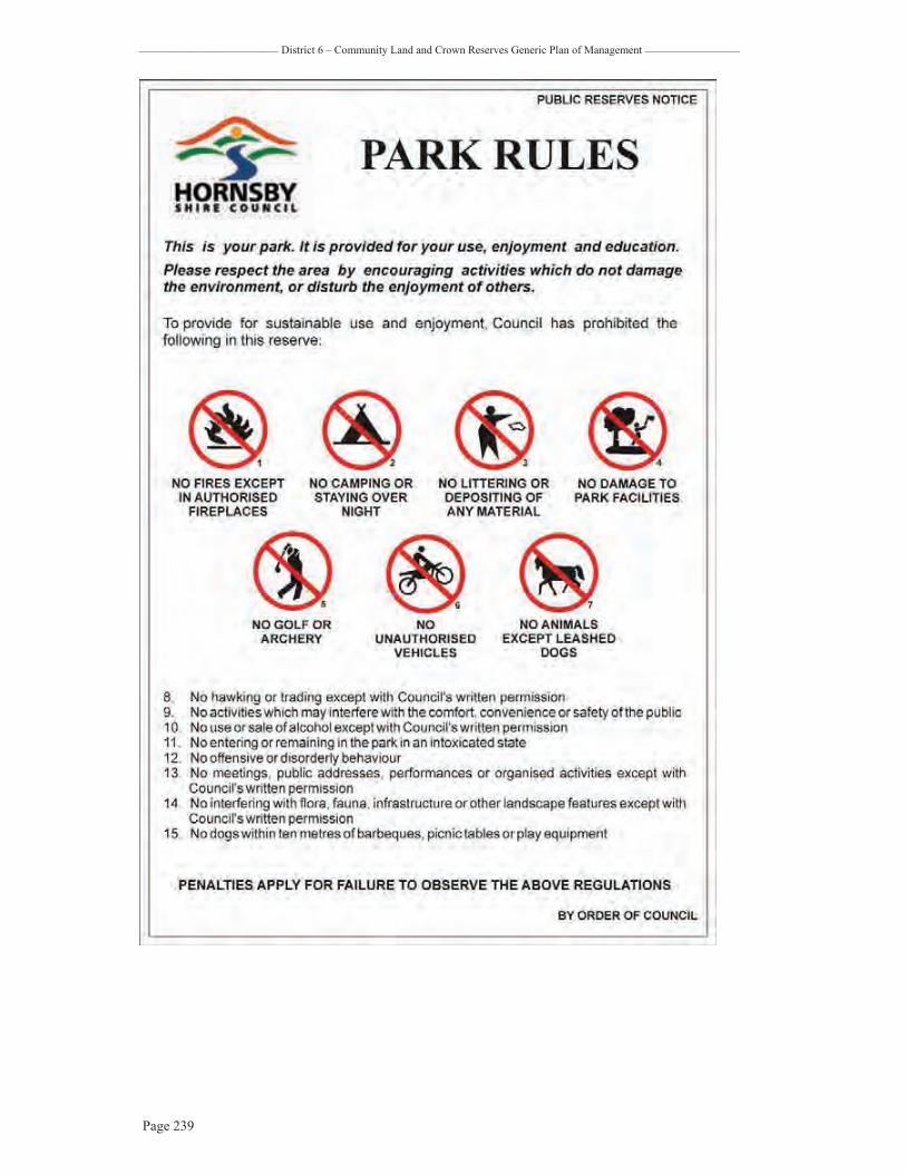
_________________________ District 6 – Community Land and Crown Reserves Generic Plan of Management _________________
Page 239
![walkeronline.files.wordpress.com · Web viewQuestion 26] 2011 HSC. Question 27) 2009 HSC. Question 26 OR 27 – 2008 HSC. Question 22c – 2007 HSC. Question 25 – 2007 HSC . Question](https://img.pdfslide.us/doc/110x75/5f729fa6ab3ff2103b11719e/web-view-question-26-2011-hsc-question-27-2009-hsc-question-26-or-27-a-2008.jpg)