Embed Size (px)
Citation preview

Pinos Altos ProjectAnalyst Tour
June 26 , 2006
2
Analyst Tour June 2006
Esta presentación contiene ciertas “declaraciones previsoras” (según el significado de la Ley de Reforma al Litigio de Valores Bursátiles Privados de 1995 de los Estados Unidos) que incluye cierto número de riesgos e incertidumbres. No existe la certeza de que dichas declaraciones serán precisas ya que los resultados reales y eventos futuros pueden ser diferentes de aquellos anticipados en dichas declaraciones. Los riesgos y las incertidumbres están publicados bajo el título “Factores de Riesgo” en el Reporte Anual de la Compañía en el Formulario 20-F presentado ante Reguladores de Valores Bursátiles de Canadá y ante la Comisión de Valores de Bolsa de los Estados Unidos (U.S. Securities and Exchange Commision). Ciertas medidas financieras mencionadas en esta presentación tales como costos de dinero en efectivo por onza y costos de mina por tonelada no son medidas reconocidas por los Principios de Contabilidad Generalmente Aceptadas de los Estados Unidos (U.S.GAAP). La conciliación de estas medidas financieras con la medida más cercana a los principios del U.S. GAAP, así como la información técnica respecto a las reservas minerales y estimaciones de recursos se proporcionan en el comunicado de prensa de la Compañía anunciando las ganancias del segundo trimestre de 2005, que ha sido presentado ante la Securities and Exchange Commissiony que se encuentra publicado en la página electrónica de la Compañía en www.agnico-eagle.com
DECLARACIÓN PREVISORA FORWARD LOOKING STATEMENTThe information in this document has been prepared as at June 26, 2006. Certain statements and information contained in this document constitute “forward-looking statements” within the meaning of the United States Private Securities Litigation Reform Act of 1995, or forward looking information under provisions of Canadian provincial securities laws. When used in this document, the words “anticipate”, “expect”, “estimate,” “forecast,”“planned” and similar expressions are intended to identify forward-looking statements or information.
Such statements and information may include without limitation: statements regarding future rates of return, and the sensitivity of those rates of return to gold prices, gold grades, capital and operating costs, currency exchange rates, timing of capital expenditures and other assumptions; estimates of future mineral production and sales; estimates of mine life; estimates of future mining costs, cash costs, minesite costs and other expenses; estimates of future capital expenditures and other cash needs, and expectations as to the funding thereof; statements and information as to the projected development of certain ore deposits, including estimates of exploration, development, and production and other capital costs, and estimates of the timing of such exploration, development and production or decisions with respect to such exploration, development and production; estimates of reserves and resources, and statements and information regarding the anticipated future exploration and feasibility study results; the anticipated timing of events with respect to the Company’s minesites; statements and information regarding the sufficiency of the Company’s cash resources. Such statements and information reflect the Company’s views as at the date of this document and are subject to certain risks, uncertainties and assumptions, and undue reliance should not be placed on such statements and information. Many factors, known and unknown, could cause the actual results to be materially different from those expressed or implied by such forward looking statements and information. Such risks include, but are not limited to: the volatility of prices of gold and other metals; uncertainty of mineral reserves, mineral resources, mineral grades and mineral recovery estimates; uncertainty of future production, capital expenditures, and other costs; currency fluctuations; financing of additional capital requirements; cost of exploration and development programs; mining risks; risks associated with foreign operations; risks related to title issues at the Pinos Altos project and governmental and environmental regulation. For a more detailed discussion of such risks and other factors, see the Company’s Annual information Form and Annual Report on Form 20-F, as amended, for the year ended December 31, 2005, as well as the Company’s other filings with the Canadian Securities Administrators and the U.S. Securities and Exchange Commission. The Company does not intend, and does not assume any obligation, to update these forward-looking statements and information.
Certain of the foregoing statements and information, primarily related to projects, are based on preliminary views of the Company with respect to, among other things, grade, tonnage, processing, mining methods, capital costs, and location of surface infrastructure and actual results and final decisions may be materially different from those currently anticipated.
About Agnico-Eagle
Agnico-Eagle is a long established Canadian gold producer with operations located in Quebec and exploration and development activities in Canada, Finland, Mexico and the United States. Agnico-Eagle's LaRonde Mine is Canada's largest gold deposit. The Company has full exposure to higher gold prices consistent with its policy of no forward gold sales. It has paid a cash dividend for 26 consecutive years.
3
Analyst Tour June 2006
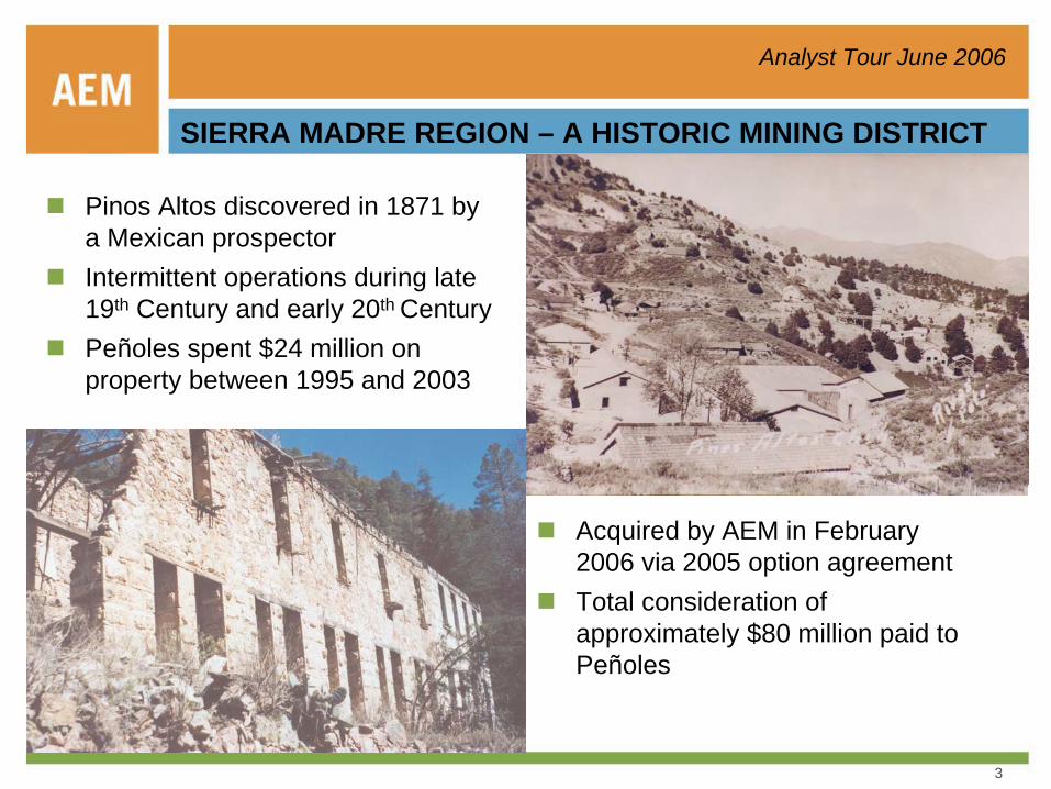
SIERRA MADRE REGION – A HISTORIC MINING DISTRICT
Pinos Altos discovered in 1871 by a Mexican prospectorIntermittent operations during late 19th Century and early 20th CenturyPeñoles spent $24 million on property between 1995 and 2003
Acquired by AEM in February 2006 via 2005 option agreementTotal consideration of approximately $80 million paid to Peñoles

4
Analyst Tour June 2006
GROWING GOLD AND SILVER RESOURCE
MonterdeMonterde
Pinos Altos Project
Current 2.1 Moz Au & 52.6 Moz Ag combined resource
$22.4 M exploration and feasibility study underway
5
Analyst Tour June 2006
Ojinaga
Delicias
Jiménez
Janos
Camargo
Buenaventura
N.C. GrandesAhumada
Tomochic
La Junta Cuauhtémoc
Madera
Creel
Guachochi
Juárez
CHIHUAHUA SANTA EULALIA
NAICA
PARRAL
STA. BARBARA
SN. FCO. DEL ORO
BISMARK
PINOS ALTOS
100Kilómetros
Dolores Dolores
El SauzalEl Sauzal
OcampoOcampo
Mulatos
MonterdeMonterdePalmarejoPalmarejo
TERRAZAS
BOLIVARBOLIVAR
1000
N
kilometres
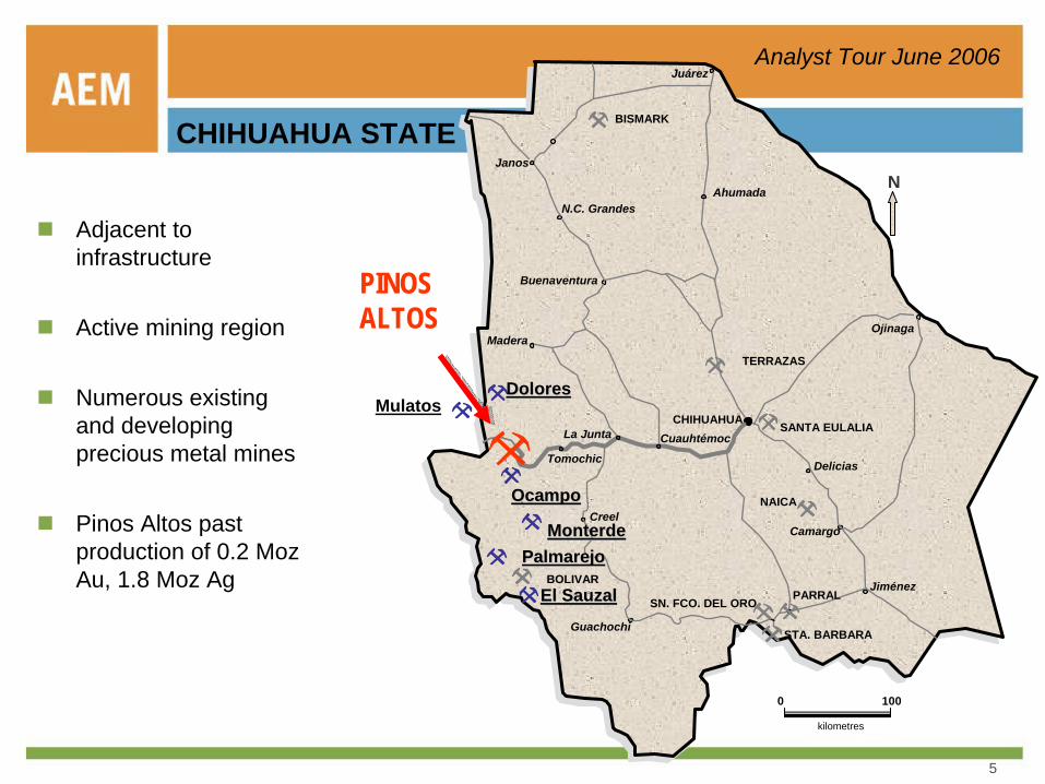
Adjacent to infrastructure
Active mining region
Numerous existing and developing precious metal mines
Pinos Altos past production of 0.2 MozAu, 1.8 Moz Ag
CHIHUAHUA STATE
6
Analyst Tour June 2006
KEY GOALS FOR 2006
Resource conversion for Q2, 2007 feasibility studyBaseline environmental and technical studies complete by Q1, 2007Environmental permit application ready for submittal by Q2, 2007Staff project with key personnel – largely Mexican NationalsSecure additional surface rights for explorationDiscover additional resourcesPrepare underground drilling platform for deep exploration

7
Analyst Tour June 2006
BUDGET BREAKDOWN
$ 3.3Feasibility
$ 1.6Ramp
$ 22.4
$ 0.3
$ 11.9
$ 5.3
G&A
TOTAL EXPENSES
Exploration & Land Acquisition
Definition drilling
* All budget expenditures in US$, millions. Excludes $ spent in Q1, 2006.
8
Analyst Tour June 2006
HIGHLIGHTS OF PROGRAM
Resource to reserve conversion29,800 m of drilling
Feasibility study by Q2, 2007By technical services group NW Quebec - Mexico project team - Consultants
Concurrent environmental studies and permit documentationBy Mexico consultants and staff with support from NW Quebec
Surface rightsEjido land - negotiating for temporary occupation and purchaseProject land - Fix minimum 400 ha area and purchase infrastructureEstablish community relations and sustainable development programs
Exploration outside of current resource envelope Deep exploration via 16,100 m drillingExploration via 5,800 m drilling
Underground ramp – Santo Niño ( 2,400 m including 760 m in 2006)Provides drill platform for further resource conversion and deep exploration
9
Analyst Tour June 2006
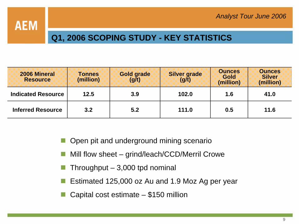
Q1, 2006 SCOPING STUDY - KEY STATISTICS
11.6
41.0
Ounces Silver
(million)
111.0
102.0
Silver grade (g/t)
0.5
1.6
Ounces Gold
(million)
5.2
3.9
Gold grade (g/t)
3.2Inferred Resource
12.5 Indicated Resource
Tonnes (million)
2006 Mineral Resource
Open pit and underground mining scenario
Mill flow sheet – grind/leach/CCD/Merril Crowe
Throughput – 3,000 tpd nominal
Estimated 125,000 oz Au and 1.9 Moz Ag per year
Capital cost estimate – $150 million

10
Analyst Tour June 2006
SATELLITE IMAGE – OCAMPO CALDERA
0 25
kilometers
11
Analyst Tour June 2006
Lithology of Pinos Altos and Ocampo Region
Alluvium Andesites
Upper Volcanic Supergroup
Epithermal Gold Occurrence
Lower Volcanic Complex
Pre-Volcanic Metamorphic Rocks
Quaternary
Middle to Upper Tertiary
Upper Cretaceous to Lower Tertiary
Pre-Cambrian
Diorite to GrandioritePorphyritic Rhyolite (Domes and Dikes)
Granite
Intrusive Rocks
Road
Mineral Rights
Town
Probable Resurgence Zones of the Ocampo Caldera
Inferred position of main ring-fracture of the Ocampo Caldera
Breccia Vein, Vein Zoneor Stockwork
Fault
Concheño
El Madroño
Bravo
Pinos Altos
Former Gold-Silver Producers, Prospects
Reference UTM NAD27; Source: Peñoles 1999
Scale: 1:50,0005.01.00 10.0 km
REGIONAL GEOLOGY - OCAMPO CALDERA
12
Analyst Tour June 2006
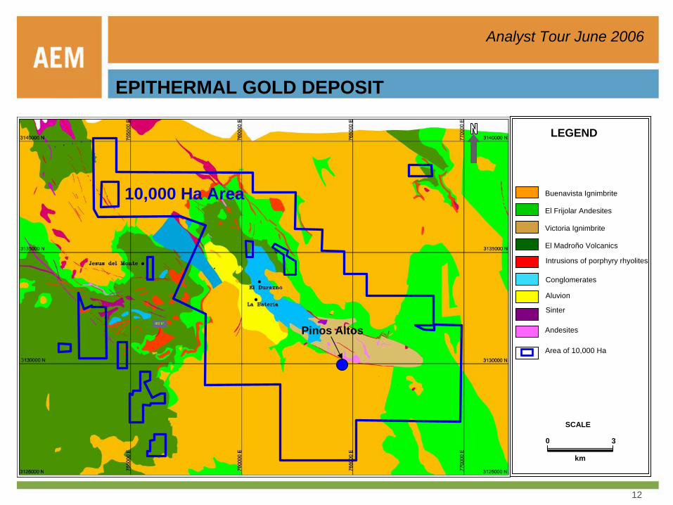
EPITHERMAL GOLD DEPOSIT
LEGEND
Intrusions of porphyry rhyolites
Conglomerates
Aluvion
Sinter
Buenavista Ignimbrite
El Frijolar Andesites
Victoria Ignimbrite
El Madroño Volcanics
Andesites
Area of 10,000 Ha
0 3
km
SCALE
10,000 Ha Area
Pinos Altos
13
Analyst Tour June 2006
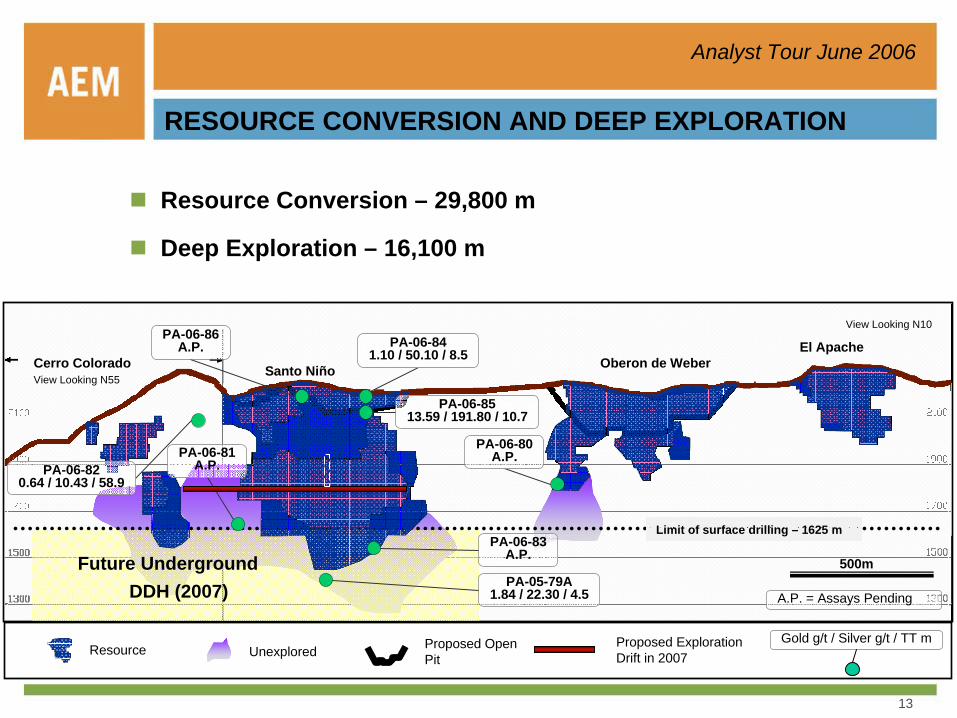
RESOURCE CONVERSION AND DEEP EXPLORATION
Future UndergroundDDH (2007)
Limit of surface drilling – 1625 m
Resource Conversion – 29,800 m
Deep Exploration – 16,100 m
PA-06-8513.59 / 191.80 / 10.7
PA-06-86A.P.
PA-06-81A.P.
PA-05-79A1.84 / 22.30 / 4.5
PA-06-83A.P.
PA-06-80A.P.
PA-06-841.10 / 50.10 / 8.5Cerro Colorado
View Looking N55Santo Niño Oberon de Weber
El Apache
Gold g/t / Silver g/t / TT m
PA-06-820.64 / 10.43 / 58.9
Resource Unexplored Proposed Open Pit
Proposed Exploration Drift in 2007
A.P. = Assays Pending
500m
View Looking N10

14
Analyst Tour June 2006
VictoriaIgnimbrite
BuenavistaIgnimbrite
Hole: PA-05-093.6g Au/tm113.1g Ag/tm 26 m
Hole: BSN592.6g Au/tm31.5g Ag/tm 27.5 m
Hole: PA-05-1111.6g Au/tm99.6g Ag/tm 35 m
Hole: SN1925-2811.3g Au/tm320.6g Ag/tm 6 m
Hole: SN1925-307.8g Au/tm197.8g Ag/tm 7 m
Hole: SN1925-584.5g Au/tm108.6g Ag/tm 7 m
Hole: SN1925-583.4g Au/tm93.2g Ag/tm 6.5 m
Faul
tZo
neSa
nto
Niño
Ande
site
Ore
zon
eSanto Niño Sector(Transverse section – 4720E)
Hole: PA-05-453.2g Au/tm140.9g Ag/tm
Hole: BCOW-014.9g Au/tm246.4g Ag/tm
Hole: BCOW-130.35g Au/tm7.3g Ag/tm
Hole: BCOW-091.3g Au/tm22.5g Ag/tm
Hole: BCOW-177.4g Au/tm221.0g Ag/tm
6.5 m
Hole: PA-05-483.9g Au/tm109.3g Ag/tm 13 m
15 m
19.8 m
7 m4.9 m
Oberon de Weber Sector(Transverse section – 5840E)
VictoriaIgnimbrite
BuenavistaIgnimbrite
Fault
Zone
Sant
o Ni
ñoAn
desit
e
Ore zo
ne
50 m50 m
VictoriaIgnimbrite
BuenavistaIgnimbrite
Hole: PA-05-093.6g Au/tm113.1g Ag/tm 26 m
Hole: BSN592.6g Au/tm31.5g Ag/tm 27.5 m
Hole: BSN592.6g Au/tm31.5g Ag/tm 27.5 m
Hole: PA-05-1111.6g Au/tm99.6g Ag/tm 35 m
Hole: SN1925-2811.3g Au/tm320.6g Ag/tm 6 m
Hole: SN1925-307.8g Au/tm197.8g Ag/tm 7 m
Hole: SN1925-584.5g Au/tm108.6g Ag/tm 7 m
Hole: SN1925-583.4g Au/tm93.2g Ag/tm 6.5 m
Faul
tZo
neSa
nto
Niño
Ande
site
Ore
zon
eSanto Niño Sector(Transverse section – 4720E)
Hole: PA-05-453.2g Au/tm140.9g Ag/tm
Hole: BCOW-014.9g Au/tm246.4g Ag/tm
Hole: BCOW-130.35g Au/tm7.3g Ag/tm
Hole: BCOW-091.3g Au/tm22.5g Ag/tm
Hole: BCOW-177.4g Au/tm221.0g Ag/tm
6.5 m
Hole: PA-05-483.9g Au/tm109.3g Ag/tm 13 m
15 m
19.8 m
7 m4.9 m
Oberon de Weber Sector(Transverse section – 5840E)
VictoriaIgnimbrite
BuenavistaIgnimbrite
Fault
Zone
Sant
o Ni
ñoAn
desit
e
Ore zo
ne
50 m50 m50 m50 m
RESOURCE CONVERSION AND DEEP EXPLORATION
NNENNE
15
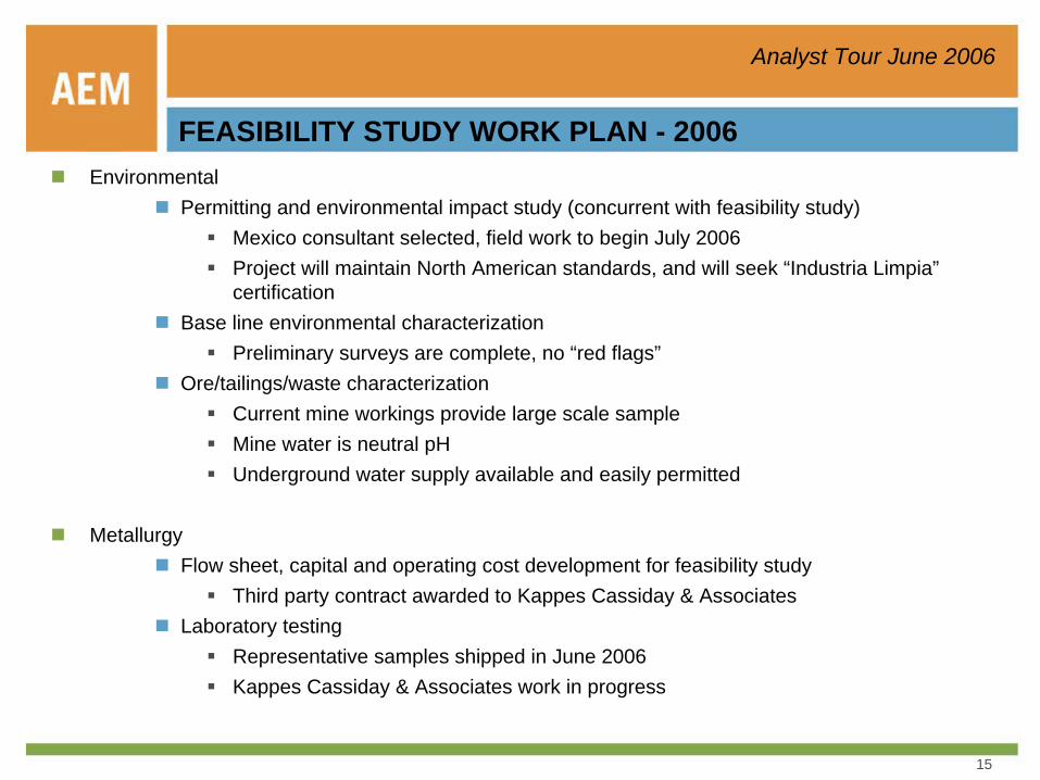
Analyst Tour June 2006
FEASIBILITY STUDY WORK PLAN - 2006Environmental
Permitting and environmental impact study (concurrent with feasibility study)Mexico consultant selected, field work to begin July 2006Project will maintain North American standards, and will seek “Industria Limpia”certification
Base line environmental characterizationPreliminary surveys are complete, no “red flags”
Ore/tailings/waste characterizationCurrent mine workings provide large scale sampleMine water is neutral pHUnderground water supply available and easily permitted
Metallurgy Flow sheet, capital and operating cost development for feasibility study
Third party contract awarded to Kappes Cassiday & AssociatesLaboratory testing
Representative samples shipped in June 2006Kappes Cassiday & Associates work in progress
16
Analyst Tour June 2006
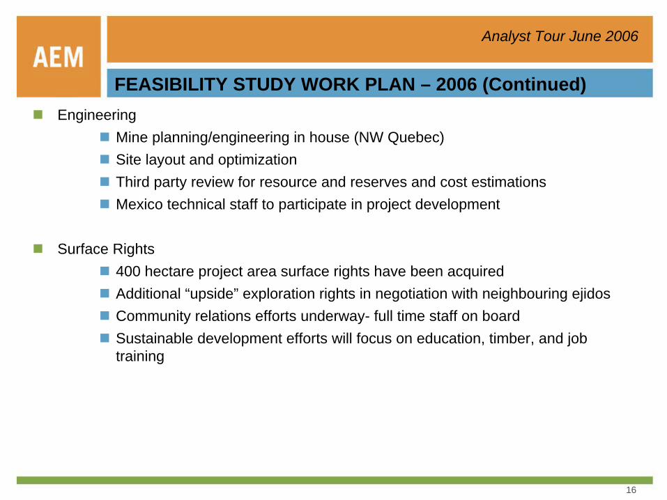
FEASIBILITY STUDY WORK PLAN – 2006 (Continued)Engineering
Mine planning/engineering in house (NW Quebec)Site layout and optimizationThird party review for resource and reserves and cost estimationsMexico technical staff to participate in project development
Surface Rights400 hectare project area surface rights have been acquiredAdditional “upside” exploration rights in negotiation with neighbouring ejidosCommunity relations efforts underway- full time staff on boardSustainable development efforts will focus on education, timber, and job training
17
Analyst Tour June 2006
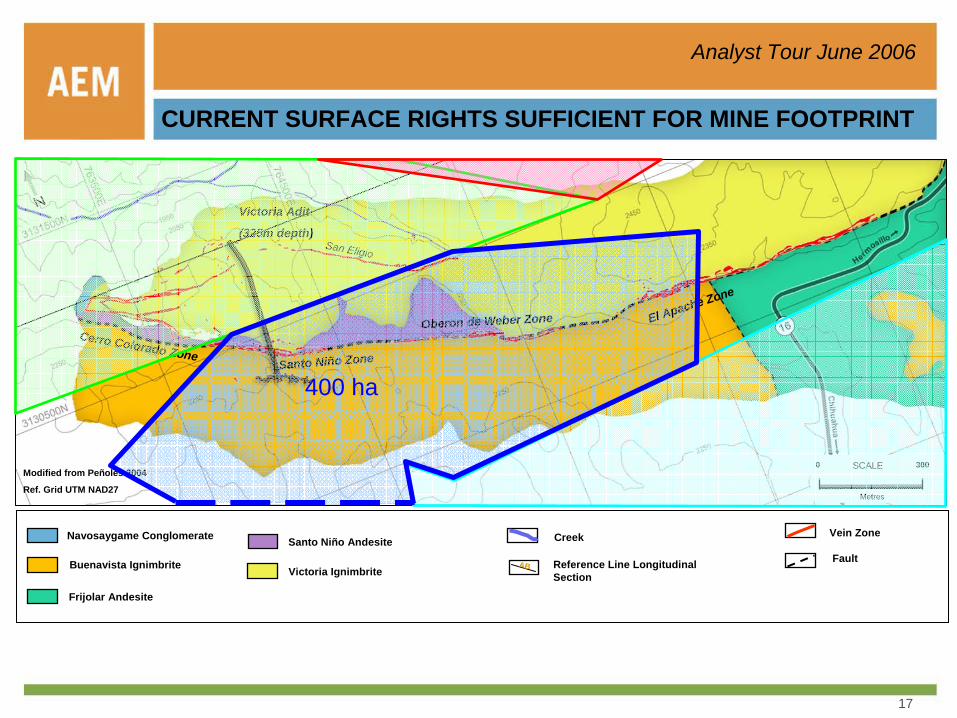
Frijolar Andesite
Navosaygame Conglomerate
Victoria Ignimbrite
Vein Zone
Fault
Creek
Reference Line Longitudinal Section
ABBuenavista Ignimbrite
Santo Niño Andesite
Modified from Peñoles 2004
Ref. Grid UTM NAD27
San Eligio
Oberon de Weber Zone El Apache Zone
Victoria Adit
(325m depth)
Cerro Colorado ZoneSanto Niño Zone
0 300SCALE
Metres
400 ha
CURRENT SURFACE RIGHTS SUFFICIENT FOR MINE FOOTPRINT
18
Analyst Tour June 2006
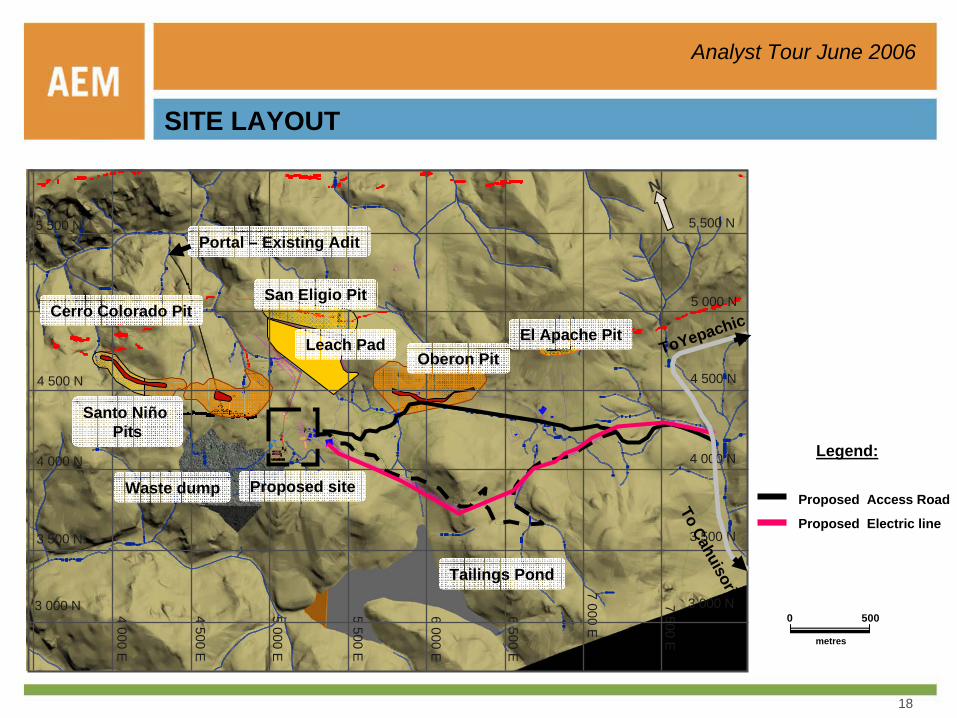
SITE LAYOUT
5 000 E
4 500 E
4 000 E
5 500 E
6 000 E
6 500 E
7 000 E
7 500 E
3 500 N
3 000 N
4 000 N
4 500 N
5 000 N
5 500 N
3 500 N
3 000 N
4 000 N
4 500 N
5 000 N
5 500 N
Tailings Pond
Waste dump
Oberon PitEl Apache Pit
Cerro Colorado Pit
Santo Niño Pits
San Eligio Pit
Leach Pad ToYepachic
To Cahuisori
Proposed Access RoadProposed site
Proposed Electric line
Portal – Existing Adit
Legend:
N
0 500
metres
19
Analyst Tour June 2006
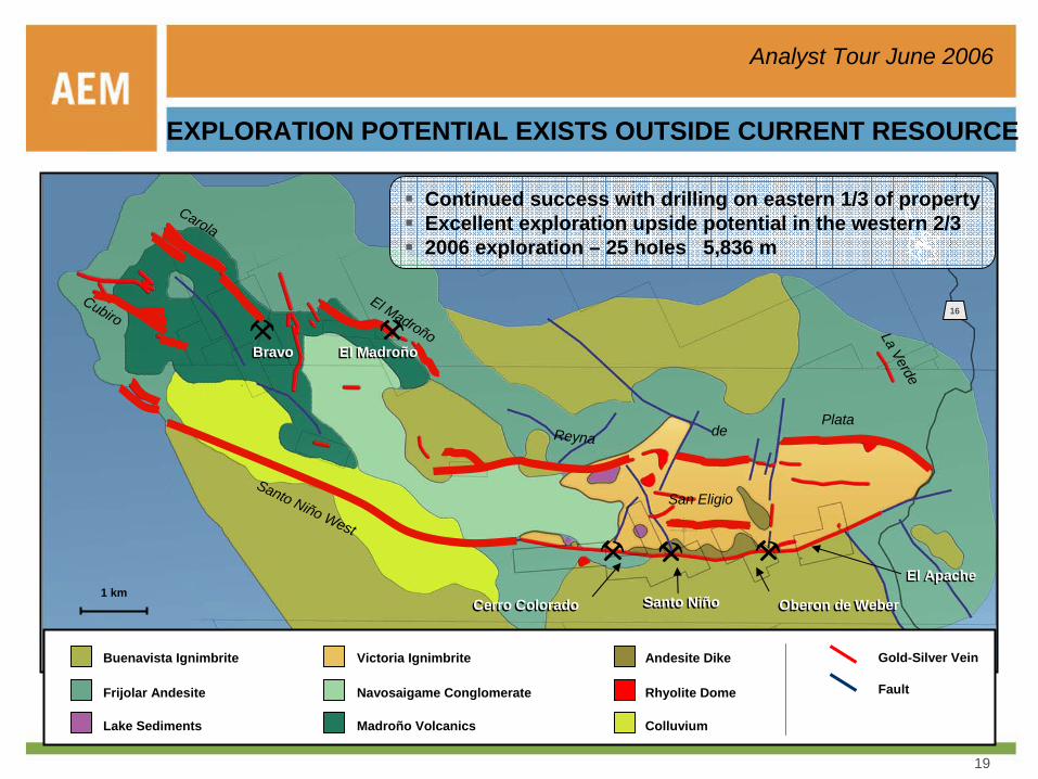
EXPLORATION POTENTIAL EXISTS OUTSIDE CURRENT RESOURCE
1 km
Buenavista Ignimbrite
Frijolar Andesite
Lake Sediments
Victoria Ignimbrite
Navosaigame Conglomerate
Madroño Volcanics
Andesite Dike
Rhyolite Dome
Colluvium
Fault
Gold-Silver Vein
Cerro ColoradoCerro Colorado Santo NiñoSanto Niño Oberon de WeberOberon de Weber
El ApacheEl Apache
ReynaPlata
de
El Madroño
Carola
San Eligio
La Verde
16Cubiro
Continued success with drilling on eastern 1/3 of propertyExcellent exploration upside potential in the western 2/32006 exploration – 25 holes 5,836 m
Santo Niño West
BravoBravo El MadroñoEl Madroño
20
Analyst Tour June 2006
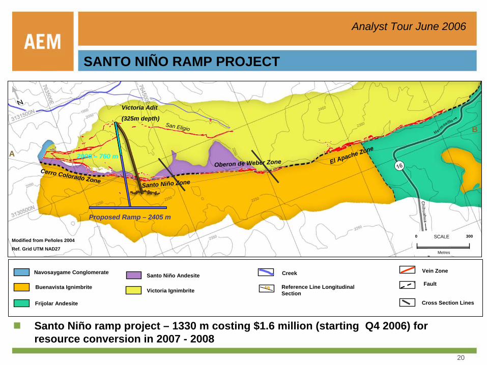
SANTO NIÑO RAMP PROJECT
Frijolar Andesite
Navosaygame Conglomerate
Victoria Ignimbrite
Vein Zone
Fault
Creek
Reference Line Longitudinal Section
ABBuenavista Ignimbrite
Santo Niño Andesite
Modified from Peñoles 2004
Ref. Grid UTM NAD27
San Eligio
Oberon de Weber Zone El Apache Zone
Victoria Adit
(325m depth)
Cerro Colorado ZoneSanto Niño Zone
0 300SCALE
Metres
Proposed Ramp – 2405 m
2006 – 760 m
Santo Niño ramp project – 1330 m costing $1.6 million (starting Q4 2006) for resource conversion in 2007 - 2008
Cross Section Lines
A
B
21
Analyst Tour June 2006
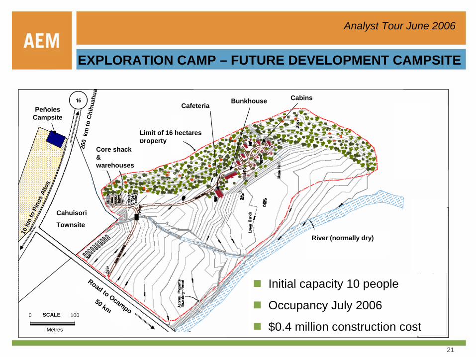
EXPLORATION CAMP – FUTURE DEVELOPMENT CAMPSITE
Initial capacity 10 people
Occupancy July 2006
$0.4 million construction cost
PeñolesCampsite
Cahuisori
Townsite
10 k
m to
Pin
os A
ltos
260
km
to C
hihu
ahua
Road to Ocampo50 km
Limit of 16 hectares property
16
Core shack & warehouses
CafeteriaBunkhouse
River (normally dry)
0 100
Metres
SCALE
Cabins

22
Analyst Tour June 2006
PINOS ALTOS CAHUISORI, CHIHUAHUA, MEXICO
EXPLORATION CAMP – ARTIST’S IMAGE
23
Analyst Tour June 2006
PROJECT OPPORTUNITIES
Concurrent permitting and feasibility strategy will minimize overall project schedulePermit designs can allow flexibility for future relocation of facilities when future reserves are discoveredFeasibility will consider early open-pit development for improved cash flow and RORFeasibility will incorporate trade-off studies including a low-grade heap leach component and dry stack tailingsPinos Altos presents an opportunity for internal growth within the property area and a good foundation for future acquisitions and growth in MexicoUnparalleled access and infrastructure for Sierra Madre development- key elements include access, communications, power, water, and housingUpside opportunity for metallurgy, especially silver recoveryLarge property positionAbility to attract and maintain excellent professional Mexican workforce- minimum expatriate requirementOpportunity to capitalize on AEM’s underground mining expertiseStable geopolitics- mining is a welcome industry in Mexico
24
Analyst Tour June 2006
0
2000
4000
6000
8000
10000
12000
14000
16000
1998 1999 2000 2001 2002 2003 2004 2005 2006F 2007F
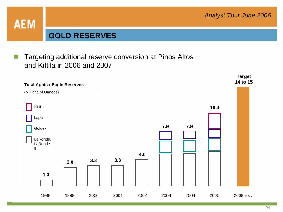
Targeting additional reserve conversion at Pinos Altos and Kittila in 2006 and 2007
GOLD RESERVES
3.0 3.3 3.34.0
10.4
7.97.9
1.3
Target14 to 15Total Agnico-Eagle Reserves
(Millions of Ounces)
1999 2000 2001 2002 2003 2004 20051998
LaRonde, LaRonde II
Goldex
Lapa
Kittila
2008 Est.
25
Analyst Tour June 2006
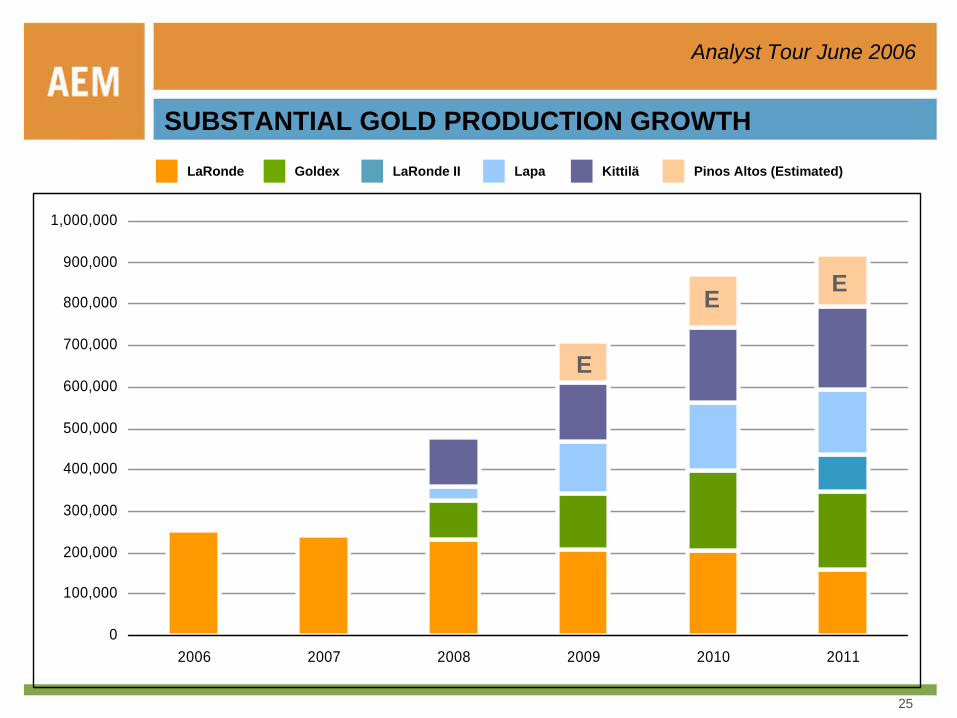
SUBSTANTIAL GOLD PRODUCTION GROWTHLaRonde Goldex LaRonde II Lapa
0
100,000
200,000
300,000
400,000
500,000
600,000
700,000
800,000
900,000
1,000,000
2006 2007 2008 2009 2010 2011
Kittilä Pinos Altos (Estimated)
E
E E
26
Analyst Tour June 2006
NO HAY PREGUNTAS, VAMOS A LA CARNE ASADA!
27
Analyst Tour June 2006
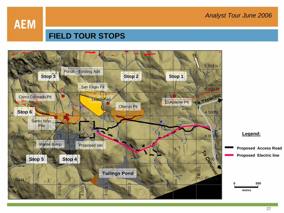
FIELD TOUR STOPS
5 000 E
4 500 E
4 000 E
5 500 E
6 000 E
6 500 E
7 000 E
7 500 E
3 500 N
3 000 N
4 000 N
4 500 N
5 000 N
5 500 N
3 500 N
3 000 N
4 000 N
4 500 N
5 000 N
5 500 N
Tailings Pond
Waste dump
Oberon PitEl Apache Pit
Cerro Colorado Pit
Santo Niño Pits
San Eligio Pit
Leach PadTo Yepachic
To Cahuisori
Proposed Access RoadProposed site
Proposed Electric line
Portal – Existing Adit
Legend:
N
0 500
metres
Stop 1Stop 2Stop 3
Stop 5 Stop 4
Stop 6