Embed Size (px)
Citation preview
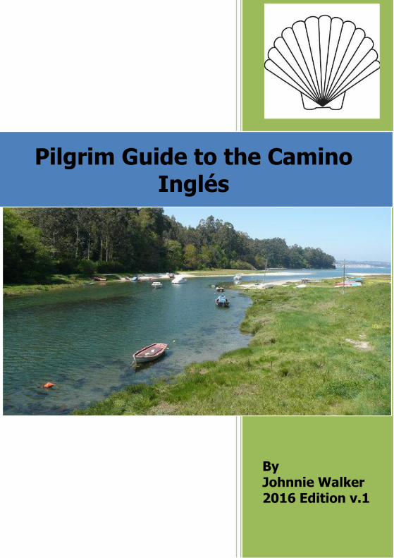
By Johnnie Walker 2016 Edition v.1
Pilgrim Guide to the Camino Inglés

- 2 -
A Pilgrim Guide to The Camino Inglés
Johnnie Walker Using this guide
This guide is regularly updated between editions. Pilgrims who have walked
the route are invited to help others by sending any comments or
suggestions to:
You do not need to take all of this guide with you on your pilgrimage. Many people read the background notes and so on at home and only take the
walking directions with them. Similarly the maps are provided for context.
They are not essential to walk the route.
Introduction
“The pilgrimage way to Compostela enjoyed widespread fame throughout
medieval Europe. Land and sea alike were furrowed with routes rich in spirituality leading to Santiago de Compostela. The maritime routes drew
pilgrims from Scandinavia, Flanders, England, Scotland and Ireland on their way to destinations such as Ribadeo, Viveiro, Ferrol and A Coruña. Blessed
by an exceptionally strategic location, the latter two coastal enclaves are the starting points for the two alternative itineraries that make up the
English Way.
The history of the Camino Inglés may be traced back to the 12th century.
History records that in 1147, a troop of English, German and Flemish Crusaders visited the tomb of St. James. They were en route to the Holy
Land. As part of that expedition they also took part in the Siege of Lisbon,
where they helped the first King of Portugal to take the city that would become capital of the kingdom.
There is also evidence of a number of important pilgrimages along
the Camino Inglés. Icelandic monk Nicolás Bergsson left a written

- 3 -
description of his journey on foot from Iceland to Rome via Santiago. This
journey took him five years, from 1154 to 1159. Two centuries later, during
the Hundred Years’ War between France and England, the English came to Santiago by sea. This is evidenced by the English ceramics and coins
from the 14th and 15th centuries found in excavations of the Cathedral of Santiago.
There is further evidence of the existence of these maritime pilgrimages in
the gifts or offerings made to the Apostle. The most celebrated of these
being the portable altarpiece made of alabaster which was donated in 1456 by the priest John Goodyear, or the Cross of pearls donated by King James
IV of Scotland (1475-1513).
The pilgrims were able to use the hospitals of the Franciscan Order of
Sancti Spiritus, under the auspices of noble Fernán Pérez de Andrade, “El Bueno” (The Good). Along the Ferrol section, they could use their services
in Ferrol, Neda, Miño, Paderne and Betanzos. Along the route that starts from A Coruña, they had hospitals in the town and further on, in Sigrás and
O Poulo. The records from these hospitals register the deaths of English,
Nordic, German, French and Italian pilgrims showing the magnitude of pilgrims along this route.
The schism between King Henry VIII (1509–1547) and the Catholic Church
over his divorce from Catherine of Aragon which led to the establishment of the Church of England saw an end to pilgrims arriving on the Camino Inglés
and the route was not used for centuries until its revival in modern times”.
(Source: adapted from www.xacobeo.es, Camino Inglés)

- 4 -
Source: Xacobeo
If this is your first camino
Many people choose the Camino Inglés because it is a complete and relatively short 3 or 5 day route to Santiago. Short it may be, but it does
have challenges, and prospective pilgrims are advised to heed the advice to prepare in advance and carry as little weight as possible.
Please look at the website of the Pilgrim Association where you live. These
organisations have a wealth of information and advice for pilgrims:
English language associations
Australia – Australian Friends of the Camino http://www.afotc.org/
Canada – Canadian Company of Pilgrims http://santiago.ca/

- 5 -
Ireland – Camino Society Ireland http://www.caminosociety.ie/
South Africa – Confraternity of Saint James SA http://www.csjofsa.za.org/
United Kingdom – Confraternity of Saint James UK http://www.csj.org.uk/ USA – American Pilgrims on the Camino http://www.americanpilgrims.org/
Pilgrim Passport (Credencial) and the Compostela
The Compostela is the traditional certificate awarded to pilgrims arriving at
the tomb of St. James in the Cathedral of Santiago. To receive the Compostela pilgrims must have walked or travelled on horseback at least
the last 100 kms to Santiago. Those using bicycles must have travelled at least the last 200 kms. On arrival at the Pilgrims’ Office in Santiago the
Compostela is awarded when pilgrims present their credencial or pilgrim
passport containing stamps (sellos) which they have obtained along the way. Credenciales are also essential for pilgrims who wish to sleep in
albergues (pilgrim accommodation) along the route. They are available from pilgrim organisations in English speaking countries or, depending on
the departure point, from the Church of Santiago in A Coruña or the Tourist
Office in Ferrol. They may also be ordered online here: https://www.santiagodecompostela.me/products/official-pilgrim-credencial-
pilgrim-passport-from-the-pilgrims-office-in-santiago Sellos may be obtained in Churches, town halls, albergues, hotels, hostels, bars and restaurants and so on along the way. You should obtain at least 2
sellos per day.
Departure points
This guide describes the routes from A Coruña and Ferrol. The route from A
Coruña to Santiago de Compostela is approximately 72 kms in length and
therefore those travelling this arm of the Camino Inglés are not entitled to receive a Compostela, for which a journey of at least 100 kms is required.
The route from Ferrol is approximately 118 kms.
Both routes meet at Hospital de Bruma – 32 kms from A Coruña and 77 kms from Ferrol.

- 6 -
Statistics – Pilgrims walking the Camino Inglés
There has been a remarkable growth in the number of pilgrims travelling the Camino Inglés. In 2000 only 98 pilgrims walked the route compared to
9247 in 2015.
(Source: La Oficina de Acogida al Peregrino of Santiago de Compostela)
Internet resources
A number of internet sites offer useful information about the Camino Inglés. These include:
http://www.caminodesantiago.me/
With the largest English speaking interactive pilgrims’ forum.
http://www.santiago-compostela.net/ingles/index_ci_en.html
For photographs of the route.
http://www.xacobeo.es/2006/adjuntos/descargas/25_The_English_
Way.pdf
For a very well presented downloadable general guide to the route in
English – not worth printing if using this guide.
http://caminodesantiago.consumer.es/los-caminos-de-
santiago/ingles/ For strip maps, photographs and general information.
http://www.mundicamino.com/
With much information and graphic profiles.
www.turgalicia.es
Go to publications – Mapas de Galicia – Mapas Camiños de Santiago – for a map of the routes in Galicia.
Go to publications – and then Aloxamentos – for a list of registered hotels
and hostels – the index covers the main points on the route.
- 7 -
Maps of the route
The Camino Inglés is very well waymarked and you do not need a detailed map to make your way to Santiago. Indeed many pilgrims walk the route
without a guidebook let alone maps. They simply follow the waymarks from place to place.
Maps of sections of the route are provided in this guide so that you may
see the relation of one place to another. They are not provided for route
finding. The section maps are taken from the excellent website provided by Peter Robins:
http://pilgrimdb.github.io. You can check scale, distances and zoom in and
out using this site.
Peter Robins has charted this and many other routes using base maps provided here: http://www.ign.es/ign/main/index.do.
Distances, Albergues, Other Accommodation
On the Ferrol arm of the route there are albergues and other
accommodation options at each of the main places along the route. The albergues are in Neda, Pontedeume, Miño, Betanzos, Presedo, Hospital de
Bruma and Sigüeiro.
Distances
In the last two years more accommodation along the route has become
available and more is planned in future. The distances between the main towns on the route are as follows:
Ferrol – Pontedeume 29 kms (via albergue at Neda)
Ferrol – Pontedueme 23 kms (alternative route)
Pontedeume – Betanzos 20 kms Betanzos – Hospital de Bruma 29 kms
Hospital de Bruma – Sigüeiro 24 kms Sigüeiro – Santiago de Compostela 16 kms

- 8 -
For those who find the distance from Betanzos to Hospital de Bruma
daunting there is now the option of sleeping at the albergue in Presedo or
using the support service provided by the Hostal O Mesón Novo. If you have booked a room in the Hostal they will pick you up and drop you off.
For example if you wish to stop before the steep hill at 18 kms on the way from Betanzos they wlll pick you up at the Bar Julia, take you to the Hostal
and drop you back at the foot of the hill the next day. For more details: http://boardinghouse-mesonnovo.blogspot.com.es/
The daily stages you walk can be from town to town or the length of stages can be varied depending on the distance between the various
accommodation options and the time you have available.
Prices. Along this route there is a wide range of accommodation options at
different price levels. These range from municipal albergues, private albergues, pensions and hotels.
Luggage forwarding service
If you want to walk without your rucksack, you can send your luggage ahead through the “Paq Mochila” service run by the Spanish postal system
(Correos). Prices are reasonable – 2016: 5€ for a single bag of up to 20kg for one stage only; 4€ per stage, if booking five or more stages. For more
information: www.elcaminoconcorreos.es.
Flora and Fauna on the Camino Inglés
Along the route you will see many species of trees and wild flowers.
Species of trees include lemon and philadelphus, oak, chestnut and pine. You will also see the predominant and invasive eucalyptus – allegedly
imported from Australia early in the last century in exchange for Merino
sheep. Wild flowers include orchids, lilies, white campion, cow parsley, vetch, and foxgloves ... to name but a few. Along the way you will also see
many vegetable gardens and walk through lush tree tunnels.
- 9 -
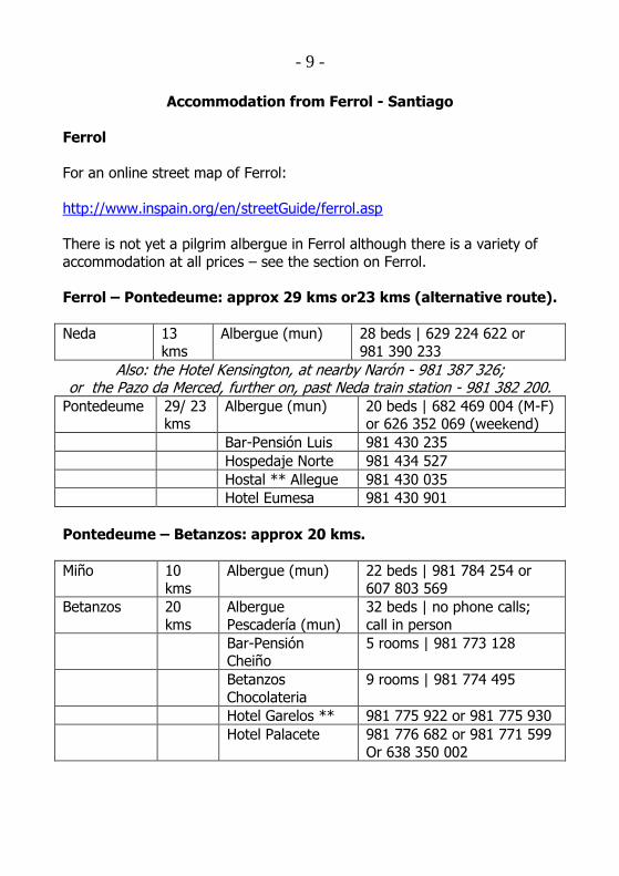
Accommodation from Ferrol - Santiago
Ferrol
For an online street map of Ferrol:
http://www.inspain.org/en/streetGuide/ferrol.asp
There is not yet a pilgrim albergue in Ferrol although there is a variety of
accommodation at all prices – see the section on Ferrol.
Ferrol – Pontedeume: approx 29 kms or23 kms (alternative route).
Neda 13
kms
Albergue (mun) 28 beds | 629 224 622 or
981 390 233
Also: the Hotel Kensington, at nearby Narón - 981 387 326; or the Pazo da Merced, further on, past Neda train station - 981 382 200.
Pontedeume 29/ 23 kms
Albergue (mun) 20 beds | 682 469 004 (M-F) or 626 352 069 (weekend)
Bar-Pensión Luis 981 430 235
Hospedaje Norte 981 434 527
Hostal ** Allegue 981 430 035
Hotel Eumesa 981 430 901
Pontedeume – Betanzos: approx 20 kms.
Miño 10
kms
Albergue (mun) 22 beds | 981 784 254 or
607 803 569
Betanzos 20
kms
Albergue
Pescadería (mun)
32 beds | no phone calls;
call in person
Bar-Pensión Cheiño
5 rooms | 981 773 128
Betanzos
Chocolateria
9 rooms | 981 774 495
Hotel Garelos ** 981 775 922 or 981 775 930
Hotel Palacete 981 776 682 or 981 771 599
Or 638 350 002

- 10 -
Betanzos – Hospital de Bruma: approx 29 kms | 31 kms to Meson
do Vento.
Presedo 12 kms Albergue (mun) 20 beds | 608 616 533
(María José)
Bruma 29 kms Albergue (mun) 25 beds | 981 692 921 (Carmen and Benino)
Meson do
Vento
31 kms Pensión **
O Mesón Novo
981 692 776 or 678 585 431
(Antonio)
Hotel Canaima 981 692 891
Hospital de Bruma – Sigüeiro: approx 24 kms.
Buscas 8 kms Casa Rural Doña
María
981 681 430 or 675 680 108
2 km before
Poulo
11 kms Casa Rural Antón
Veiras
981 682 302 or 686 715 005
or 629 026 743
Also at Poulo, 13 kms, there is an option to go 3 kms (to the right) off the Camino to Ordes, where there is a good selection of accommodation,
eg the Hostal Louro: 981 680 831. Sigüeiro 24
kms Albergue de Delia (pvt)
687 279 398 (María José)
Albergue O Fogar
da Chisca (pvt)
626 592 444 or 981 691 783
(Jose-Chus)
Hotel B&B
SigüeiroHostel
981 973 636 or 615 499 071
Sigüeiro – Santiago: approx 16 kms.
4.5 kms past Sigüeiro
4.5 kms
Hotel San Vicente 981 694 571 or 981 694 992 or 629 565 362

- 11 -
Other pilgrim accommodation:
Betanzos and Sigüeiro: Very basic accommodation is provided for pilgrims in the local sports hall. Enquire at the Tourist Office in Betanzos and the
Town Hall (ayuntamiento) in Sigüeiro.
How to get there
Fly to A Coruña with Veuling or Iberia from London and walk from there to
Santiago or take a bus to Ferrol:
http://www.vueling.com/EN/
http://www.iberia.com/flight-offers/La-Coruna/
http://www.coruna-ya.com/transporte-interurbano/marina-
lucense/ferrol.html
The airport bus from A Coruña costs 1.50€. It stops at the bus station if
you wish immediate onward travel to Ferrol.
It is also possible to go by train by taking the Eurostar from London to
Paris, then a sleeper from Paris to Irun and a regional train to A Coruña.
http://www.seat61.com is a useful site for planning train travel in Europe. You can then take either a bus or a train from A Coruña to Ferrol. The last
train runs at 20.59hrs at the time of writing and the last bus at 21.30hrs. From the train station in A Coruña to the bus station is about a 5 minute
walk. There is also a train from Madrid – Ferrol. This journey can be done
by overnight sleeper.
Or
Fly to Santiago with Ryanair or Easyjet and get a bus to Ferrol or A Coruña:
http://www.ryanair.com | http://www.easyjet.com.
- 12 -
There is a bus every half hour or so from Santiago Airport to the Estación
Central de Autobuses in the city, from which there are several buses
each day to Ferrol.
Once in the bus station at Ferrol, you need to walk the only obvious way into the city streets, then in the first big plaza you come to, take the major
right-hand street which leads (after a kilometre or so) to the starting point in Ferrol Harbour. The Tourist Office where you can obtain a credencial and
sello is in this square as described below.
From Oviedo and Asturias: Getting to Ferrol from Oviedo - The narrow-
gauge FEVE train leaves Oviedo at 07.30 or 14.30; the scenic journey takes 7 hrs. (see www.feve.es)
How to find a place to stay
The internet is a rich source of information on accommodation: www.turgalicia.es is particularly recommended, as it gives contact and
location details for all types of bookable accommodation. So too is the local
Tourist Office, which will have a list of accommodation of different prices - and they may also express an opinion on the most suitable. Whilst many
pilgrims want to book in advance to be sure of a bed and to avoid trailing around hostels with a rucksack at the end of a hard day’s walking, there
are bargains to be had arranging at the last moment. If you are going to do this, however, make sure you avoid any local fiestas.
You should check out in advance how to get to the Tourist Office or town centre from your point of arrival at the airport/bus station. Helpful sources
of information: http://www.tourspain.org/coruna/maps.asp
http://www.worldmapfinder.com/GoogleMaps/En_Europe_Spain_Ferrol.html
Travelling by bus or taxi on the Camino
All of the bars along the route have telephone numbers for local taxis and information about buses.

- 13 -
Throughout the A Coruña arm, and from Bruma/Mesón do Vento on the
joint route, it is not too difficult to leave the Camino and walk to the parallel
main N550 road (A Coruña to Santiago) where there are buses in both directions. These are at hourly and sometimes 2 hourly intervals with the
last bus being at 7pm, except on a Friday.
There are hotels and hostales along the road at Mesón do Vento, Ordenes and Sigüeiro that provide useful and inexpensive alternatives for meals and
lodgings.
Language – what to do if you think you are lost
Spanish and Gallego, which is closer to Portuguese in many ways, have
equal status in Galicia. Most people in towns speak both languages, but in
the countryside Gallego is more commonly used. Place-names on sign-posts may be in either language, for example Ordenes (Spanish) or Ordes
(Gallego), although Gallego is now more common.
Whilst along the Camino Inglés you will not encounter many local people
who can speak English, they are becoming more used to pilgrims from outside Spain. If you make an effort to talk to them they will go out of their
way to be helpful. Those who do not speak Spanish can still make this journey but could take a phrase book and/or learn some phrases such as
how to ask directions or book a room.
The route from both A Coruña and Ferrol is well marked with granite
waymarks and yellow arrows on lamp-posts, trees, walls, on the ground etc. Pay particular attention at junctions where you should proceed in
the direction of the arrow or waymark. This guide gives very specific directions. It is very unlikely that you will get lost. However if you feel that
you may have lost your way a rule of thumb is that, unless otherwise
indicated in this Guide, if you have not encountered an arrow or waymark for 1 km (or roughly 15 mins walking) you should:
a) Go back to the last arrow and check that you followed the direction
correctly; or b) Ask directions from a local person.
- 14 -
Asking directions can be daunting if you do not speak Spanish but local
people will recognise you are a pilgrim and will try to be helpful. If there is
no one around and you are near houses then knock on a door or stop a passing car. Keep your communication simple. Often pointing at where you
want to get to in the guide book will be sufficient. Also useful are the words “donde” (pronounced donday) meaning “where” or “donde está” meaning
“where is” plus an indication of where you want to go. Other key words are “El Camino” and “La Ruta”.
For example: “Donde está el camino?” or “donde está la ruta?” – “where is the camino?” or “where is the route?”
Another tip is to look slightly ahead in the guidebook to identify where you
are heading next – for example, if the guidebook says “follow the road
ahead until you come to the bus station” simply ask someone “donde está la Estación Central de Autobuses” or simply say “donde” and point at the
phrase “Estación Central de Autobuses” in the guidebook.
Drinking Water
Bottles of water are available to buy in bars and shops. Those on or near
the route are indicated in this guide. There are also drinking fountains (fuentes) along the route. Care should be taken with these. Generally those
with safe drinking water will be marked “Potable” and those to be avoided marked “No potable”. At times there are also clear warning signs. If in
doubt do not use water from unmarked taps or fountains. Often local
people will tell you if the water is safe to drink. If all else fails and you feel you are running out of water simply knock on the door of a house and seek
assistance.
Definitions used in this guide
KSO – keep straight on
Fuente – a drinking water fountain Potable – drinkable water
No potable – water which is not drinkable Lavadero – a communal place for washing clothes

- 15 -
Cruceiro – a stone cross, usually with figures carved on each side, often
placed at parish boundaries
Hórreo – a grain store Panadería – a bread shop; may also sell pies etc
Timetables (Horarios)
All train and bus times, office and Church opening times or Mass times
provided in this guide are correct at 2016 – but you should always check
current timetables, as they change from time to time.
A Coruña (to start in Ferrol see page 29)
Where to stay
As a coastal resort popular with the Spanish there is a full range of hotels and hostels at all prices.
All accommodation is listed here: www.turgalicia.es. The website is available in English and you can search for lists of accommodation in the
main points on the route.
Tourist Office Oficina de Turismo de A Coruña
Plaza de María Pita, 6
Postcode: 15001 Website : www.turismocoruna.com
E-mail: [email protected] Telephone: (+34) 981 923 093
A Coruña Tourist Office, dependent on La Xunta de Galicia, keeps open all year with the following working hours:
Monday to Friday: from 9am to 8.30pm (7.30pm November-January). Saturdays: from 10am to 2pm and 4pm – 8pm.
Sundays and Bank Holidays: from 10am to 7pm.

- 16 -
Credenciales and information about the local Amigos Association
Available for a donation from the Church of Santiago in the Rúa Santiago, near the harbour and main square. This is the starting point of the route.
The church is the oldest in A Coruña and has been restored.
Masses: Daily at 7pm* Sundays and Feasts at 11.30, 12.30 and 7pm*
(* 8pm July and August)
A Coruña – Hospital de Bruma (Albergue) 32 kms or +2 kms to Mesón do Vento (Hostels)
Strong and experienced walkers may walk the route from A Coruña to
Hospital de Bruma in one day. Others may prefer to walk part of the route
on day one to have a shorter distance to walk the following day.
There are various options:
Walk to the 2 star hotel A’ Marisqueira, approximately 8 kms from
the start of the route. Walk to the Hostal La Paz, approximately 10.5 kms from the start
of the route.
Walk to the Hostal Mesón Vasco, approximately 12 kms from the
start of the route.
At each of these points you can return to A Coruna by bus/taxi, or stay
overnight continuing on the next morning. There is also a new municipal albergue in Sergude, 19 kms.

- 17 -
A Coruña – Anceis
Base Map – IGN topo maps from IDEE

- 18 -
Church of Santiago, A Coruña
From the West door of the Church of Santiago walk down the Rúa de Santiago. The Rúa de Santiago is near the harbour and the central square
Plaza de María Pita. On your right as you walk down, note a yellow arrow and waymark tile on the wall of house number 15.
Take the first Right at the bottom of the short hill and turn into the Calle de María Barbeito which immediately brings you into the impressive Plaza
de María Pita with the Ayuntamiento building dominating the far side. To your left is one of two tourist offices in the city.
Cross the square diagonally to the left corner and leave to the Left passing the Church of San Jorge (St George) on your right. Proceed along the Calle
San Agustín, passing on your left the Plaza del Humor with its amusing sculptured figures. KSO until you reach the Church of San Nicolás on your
left. Turn Left down the Rúa San Nicolás which shortly becomes the Rúa Bailen after a junction. KSO this short street and at the bottom turn Right
into the Calle Real. KSO past the Obelisk on your left and into the area

- 19 -
known as Cantones with its wide streets. Cross over to the side with
gardens, benches and trees but stay on the pavement keeping straight on
in the direction you were walking when passing the Obelisk. Cross a road at traffic lights and pass a government building on your left. There is another
Tourist Information office just opposite on your right. KSO and shortly reach the gates of the Puerto de A Coruña. 1 km
Passing the gates of the Puerto de A Coruña on your left keep in a dead
straight line on the pavement and follow it up over the overpass into the
area called Santa Lucia. Pass the Avenida de Fernandez Latorre on your left and take the next Left into the Rúa Santa Lucia. As you move along the
Rúa Santa Lucia it bends round to the right and becomes the Calle Castiñeiras de Abajo and at the bottom you will be facing an overpass and
just beyond it the modern parish church of San Pedro de Mezonzo. Cross
over the road at the crossing to the park and cross the park bearing left uphill. Cross the Paseo de Alexandre Bóveda keeping the motorway
overpass to your immediate right. Pass gardens and the Plaza de Cuatro Caminos on your left. Cross the Calle Castro Chane and it becomes clear
that the road you are on is the Calle de los Caballeros with a road sign at a
walkway to your right over the motorway. KSO ahead at the next junction with the Calle Perpetuo Socorro. KSO passing the bus station over to
your left. 2.5 kms
KSO past the bus station on your left and shortly after this pass under a bridge. If you walk on the right hand side of the road you will see a
waymark. Cross the road at this waymark, at the lights, and walk first Left
round the blocks of flats, then Right to walk up the Avenida de Monelos. Shortly cross at a pedestrian crossing as indicated by arrows and keep
straight ahead up the Avenida de Molenos, with blocks of flats on either side. There is no street sign immediately obvious but keep going straight up
hill. As you cross the Calle Rafael Dieste look to your left and see the
Church of Santa María de Oza.
KSO at the junction with the Calle de Vicente Aleixandre and also cross the next junction on your left. Keep on the pavement veering left at a large
junction with a roundabout and shortly cross over the junction with the Calle Jerónimo Vázquez Franco and, in the direction of the “Santiago N-
550” sign, KSO uphill on the Avenida Monelos. Near the top of the hill at

- 20 -
House Number 8 on the right hand side of the road there is a waymark and
a yellow arrow taking you off to the Right down a lane. 4 kms
KSO and shortly, at House Number 6, there is a fuente on your right – the
water is NOT drinkable. KSO and at House Number 18 veer Left. Almost immediately, to the right of House Number 40, there is a new (2016)
development being constructed: a flight of stone steps, leading to a more main road. When complete, you should be able to climb these steps, walk
ahead and then cross the road (carefully!) to continue – until then you may
have to go left past Houses 40 and 42 then work your way round to the right to continue. Once on the other side of the road take the tarmac lane
between the two large stone circular constructions on your left and House Number 108 on your right. Continue on this lane, turning Left when you
reach a T-junction with a green wire fence. From here you can see the next
place you will walk through, Portazgo, off to your right. KSO eventually coming out onto the main road at the end of the lane. Note the fuente on
your left just before the main road. Facing you on the wall opposite is a waymark. Follow this Right. Move over to the left hand side of the road
and follow the arrows across the bridge over the motorway to pass the
Centro Comercial Alcampo on your right in Portazgo.
[Alternatively at House Number 8 above you could KSO the road passing on your Left the Centro Oncológico. You will see to your left the distinctive
spires of the Capilla Labaca, the chapel of the hospital which was formerly named Hospital Labaca. KSO until you cross over the motorway to enter
Portazgo, passing on your right the Centro Comercial Alcampo, then a
petrol station and the sign for Portazgo].
KSO through Portazgo and, after House Number 35, turn Left down a clearly waymarked lane. KSO and shortly turn Right following arrows on
the ground. KSO and at the bottom of this road, the Rúa Eduardo Blanco
Amor, turn Left following the waymark on the pavement opposite. It may be obscured by parked cars. Follow the Rúa Jorge Gullién to the bottom
and cross over, veering slightly Left following the arrows. Shortly follow the arrows Right at a floral roundabout and KSO with the railway to your
right and the river to your left. There is a granite waymark pointing Right along the promenade. KSO until the very end of the promenade in
approximately 4 kms. There are no further arrows until you reach the
- 21 -
end. This is a lovely walk and there are benches and tables if you wish to
have a picnic lunch.
At the end of the promenade go up some steps and you will see the next
waymark on the pavement opposite indicating that you turn Right. If you cross to this waymark you will see adjacent to it (left) an information
board, seats and a fuente facing the Bridge of Burgo. This strategically placed bridge was the objective of the last mission of Sir John Moore’s
Reserve Troops engaged in action at the Battle of A Coruña, one of the
battles of the Peninsular War. During this battle Sir John Moore was mortally wounded and was buried in A Coruña.
The 2 star hotel A’ Marisqueira is to the right 800 yards across the bridge:
http://www.hotelamarisqueira.com
Otherwise follow the waymark and arrows slightly uphill and shortly pass
the Church of Santiago de O Burgo. 8pm Mass. Sello available. KSO ahead and soon the route veers Left at a junction with a Cruceiro. Note that a
few steps to the right there are two 2** Hostales: the O Mesón and the
Casa Julio.
Hostal O Mesón** Avenida da Coruña, 25
15670 Culleredo Telephone: (+34) 981 660 065
Casa Julio ** Avenida da Coruña 19
15670 Culleredo Telephone: (+34) 981 660 089
KSO following the arrows and soon at the next junction with a small roundabout turn Left. KSO passing under the motorway. A little after this
veer Right up the Rúa Pelamios following the direction of the waymark and arrows. Just after House Number 7 veer Right. KSO Right at House
Number 5. At the top of the incline at the STOP sign turn Right. KSO uphill passing on your left the Parish Church of San Julian de Almeiras. Pass
on your right a statue of the Caballero of Almeiras and an Information

- 22 -
Board. KSO. If you look back you will see views of the river and to your
right is the long runway and buildings of A Coruña airport. KSO passing
the Municipal Sports Centre and a football ground on your left. KSO following the road downhill. Turn Left at House 16 up the Rúa Arcebispo
Xelmírez. KSO along this minor road through trees and then downhill turning Right at a Camino sign. KSO Right at the roundabout and veer
Left at the next junction. KSO downhill passing a restaurant and the 2** Pensión La Paz on your right:
Pensión La Paz Cuesta de Alvedro, 41
15180 Culleredo Telephone (+34) 981 650 101
KSO downhill following frequent signs and at the bottom turn Left. After a little turn Right across the road. Cross a small bridge and KSO uphill with
the Restaurante Casa German on your right. Come out onto a road. The route carries on straight across the road but turn Left here if you wish to
go to the 2** Hostal Mesón Vasco which is 1/3 of a kilometre along the
road. It is clearly signposted:
Hostal Mesón Vasco La Telva-Sigras
15181 Cambre Telephone (+34) 981 660 262
To follow the route KSO across the road and proceed uphill veering Left
where marked. Follow the waymark to turn Right to the Church of Santiago de Sigrás with an old pilgrim hospital adjacent. You will pass a
shrine to St Anthony on your left. The shrine is dated 1815 with the legend
round the edge, “Si buscas milagros, mira” i.e. “If you are looking for miracles, look!” KSO for another 125m up the hill and on the right is the
Church of Santiago de Sigrás which is nearly always closed. To the left of the Church is a dilapidated pilgrim hospital. There is a fine 18th century
Calvary nearby. The west front of the church has a stone inset saying Re-edifase el año de 1600. From the outside a stained glass roundel depicting
Santiago Matamoros can be seen. From the graveyard behind the Church

- 23 -
there are good views of the surrounding hills. Many of the graves are
surrounded by low clipped box hedges.
After the Church, continue up the narrow road. There are houses on either
side. At a V junction bear Left and 40m later turn Right. The road continues for 600m until a crossroads with houses on each corner.
Continue straight across and follow the road for a further 400m until you eventually come out on the main road at a junction. A yellow arrow on the
road directs you to bear Left and cross the junction following the signpost
to Anceis.
Church of Santiago de Sigrás
Follow the road across the motorway. You will see remnants of faded yellow arrows in this section. Keep your eyes peeled for them.
Follow the road round passing the house La Rocha with a very clear yellow arrow opposite. KSO ahead on a minor road. The route is clearly
waymarked and the route becomes more scenic and pastoral.
Pass through the square in Anceis with the first of a series of Information
Boards for the Camiño Inglés and a handsome fuente with a statue of St Anthony. Many of these boards have English translations giving historical
information.
- 24 -
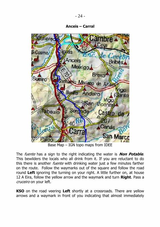
Anceis – Carral
Base Map – IGN topo maps from IDEE
The fuente has a sign to the right indicating the water is Non Potable.
This bewilders the locals who all drink from it. If you are reluctant to do this there is another fuente with drinking water just a few minutes farther
on the route. Follow the waymarks out of the square and follow the road
round Left ignoring the turning on your right. A little further on, at house 12 A Eira, follow the yellow arrow and the waymark and turn Right. Pass a
cruceiro on your left.
KSO on the road veering Left shortly at a crossroads. There are yellow
arrows and a waymark in front of you indicating that almost immediately

- 25 -
you veer Right at house number 25. Shortly leave the minor road at a
waymark. KSO this leafy track at the end of which come out onto a minor
road turning Right with a yellow arrow and waymark. KSO on this road rising up a little and at a junction at house 115 KSO ahead. Very shortly at
the junction at the top of the road, where waymarks might be confusing, turn LEFT at the sign board Right Alta Mira and Left to Sigrás.
Shortly after turning Left there are more yellow arrows and approximately
0.5 kms further on an Information Board welcoming the pilgrim to Carral.
Carral – Hospital de Bruma and Mesón do Vento
Base Map – IGN topo maps from IDEE

- 26 -
Come off the country path onto a minor road at a junction and KSO ahead.
Pass a panadería (you may choose to buy lunch here to eat at the rest area
ahead) on your left immediately after the junction and KSO downhill passing house Lameira on your right and a rest area for pilgrims with picnic
tables, fuente, shelter and Information Board. 17 kms
Shortly after the rest area at a junction KSO gently uphill. At the next junction at a bus stop turn Left with a yellow arrow and waymark. KSO
this undulating road passing on your right an outdoor sports area with
football and basket ball nets in Sergude.
KSO downhill, passing another Information Board marking the Parish of San Julian de Sergude.
There is now a municpal albergue in Sergude with 30 beds. Admission after 1pm.
Municipal Albergue Sergude
Passing through Sergude there is a very useful shop/bar with sandwiches
and groceries on the right. KSO downhill to leave Sergude passing house 54 with a lavadero opposite. 19 kms
KSO downhill crossing a small stream and then at a junction follow the
waymarks and turn Right uphill. Pass a lavadero on your left and shortly at
a junction follow the road round to the Left at house 12. Shortly at a
- 27 -
junction follow the road Right and KSO passing a waymark. KSO until
reaching the main road at the end.
KSO across the road onto another minor road passing on your left another
Information Board announcing your entry into the Parish of Santa Baia de Cañás. Shortly after this crossing follow the road round Right and just a
little later at a waymark follow the road which now becomes a path veering Left. KSO gently downhill through trees then eventually through a small
group of houses coming out at a junction with a minor road. Turn Left.
Pass downhill between houses and come out at the Café/Bar Centro (which does not provide food) in Sarandones. 21 kms
Turn Left. Across the road is an Information Board and the Capilla de San
Juan. Cross the River Barcia. On the far side pass to your right house No14,
with two Escudos, where Felipe II stayed on his way to A Coruña to sail to England to marry Mary on 25 July 1554 in Winchester Cathedral.
KSO through the village slightly uphill and at the end of the village just before the road veers left there is the Café/Bar Quintanas which sells hot
and cold drinks and provisions. As the road veers left the route goes off to
the Right up a minor road. Shortly pass house number 7 Orueiro and KSO ignoring the turn to the Right. KSO gently uphill veering Right at house
number 23. Pass a house with a small factory building adjacent on your left and shortly a modern terracotta painted house on your right. KSO gently
uphill and after a further 1 km pass house 38 on your left.

- 28 -
KSO uphill and in approximately 1 km more reach the top of this section of
the ascent. There is bus stop on your left. Follow the road round to a
junction at Cruz de Veira. 24 kms
The arrows indicate that the route continues across the road but if you turn Left almost immediately you will find a very handy bar. However it may not
be open out of high season.
Veer Right on the road if you are not going to the Bar and almost
immediately Left at an Information Board and a waymark. KSO uphill on this minor road for a further 0.5 km and at a stone house number 2 KSO
the road you are on veering to the Right. KSO uphill and the road shortly becomes a wide track. After 2 kms the path levels out and you pass farm
buildings on your right and off to the left a telecommunications mast.
KSO following the track as it winds round passing the mast on your left. Come onto a road at an Information Board at As Travesas. 27 kms
This is the highest point on the route at over 450 metres above sea level.
At this point especially in inclement weather you could simply turn Right onto the road and KSO until you reach Mesón Do Vento before which there
are yellow arrows off to the left indicating a road turning to Hospital de Bruma.
To follow the waymarked route turn Right onto the road then immediately
Left and then immediately Right to pass behind houses on a path parallel
to the road.
KSO on the path with very faded yellow arrows on telegraph poles on your left. After 250 metres turn Right at a waymark. Follow the shady grassy
track straight ahead through the trees. This may be heavy going in wet
conditions. After approximately 800 metres come out on to the road and turn Left. 29kms
KSO the road passing house number 22 with the road to the right
signposted Herves. KSO past the Casa Avelina which is a useful bar on your right. KSO following the arrows with a large electricity station ahead
on your right. Ignore any arrows indicating a Left turn at this point and

- 29 -
KSO for approximately 0.5 km and when you are at the end of the
electricity station there is a clearly marked Left turn onto a farm road. If
going to Mesón do Vento you can KSO on here for another 2 kms. To follow the route turn Left as indicated and KSO this road for approximately
750 metres and turn Right at a granite waymark. This waymark has an arrow on each side and is the point where the route from Ferrol joins
shortly before Hospital de Bruma.
Follow this track with farm buildings to the right and at the end veer Left.
Follow this path turning Right at the waymark then crossing a small stream with stepping stones continuing straight ahead. A little after the
stream three paths converge keep on the right hand path following the waymark straight ahead. On passing a hórreo at a house on the corner
emerge into Hospital de Bruma.
Turn Left to pass down the road to reach the albergue or Right to go to
Mesón do Vento. 32 kms
The description of the route from Hospital de Bruma to Santiago starts on
Page 64.
Ferrol
Where to stay
Name Rating Address Tel/fax Email
Carris
Almirante
H **** Maria, 2 981 333 073
902 105 173
Gran Hotel Ferrol
H**** Estrada de Castela, 75
981 330 226 981 330 228
reservas@granhoteldeferrol. com
Parador de Ferrol
H*** Praza do C.Almirante
Azarola
Gressillón, s/n
981 356 720 981 356 721

- 30 -
El Suizo HR*** Dolores, 67 981 300 400 981 300 306
Valencia H*** Ctra de
Catabois, 390
981 370 352
981 318 011
reservas@hotelvalenciaferrol.
com
Almendra HR* Almendra,
s/n
981 358 190
981 358 192
America HR*** Sánchez
Calviño,
70-76
981 370 208
Real HR* Dolores,
11-13
981 369 255
981 369 256
Silva H* Rio Castro,
42
981 310 552
981 320 409
Val de Serantes
PR*** Lugar de Serantellos,
280
608 581 424
Magallanes PR** Estrada de Castela,
401
981 311 648
Porta Nova II
PR** Naturalista López
Seoane, 33-35
981 359 772 650 943 787
hotelvaldovino@gmail. com
Zahara PR** Pardo Bajo,
28
981 351 231
El Cairo PR* Dolores, 32 981 353 266 [email protected]
Casa Ángel PR* Rúa
Magdalena, 45
981 351 060
O Choyo II PR* Carlos III,
70
981 948 908
Hostal da
Magdalena
PR* Magdalena,
98
981 355 615
El Eden PR** San Andrés, 4
981 359 531
- 31 -
NB – Sello and departure point
It is important that you obtain a sello in Ferrol to demonstrate to the
Pilgrims’ Office in Santiago that you have walked more than 100 kms in
order to qualify for the Compostela. There is no requirement for that sello to be from the Tourist Office and you may have your credencial stamped in
your hostel etc.
Some hotels and hostels are located further into town and may suggest
that you join the route at a point other than that suggested in this guide. If you follow their directions however you may miss the scenic path around
the bay as the route leaves Ferrol.
Tourist Office
Email: [email protected]. There are three main offices:
Information kiosk at the Port – Punto de Información Porto de
Curuxeiras (Telephone: (+34) 619 177 402).
Tourist Office, Praza de España.
Xunta de Galicia Tourist Office – Praza Camilo Jose Cela, s/n
(Telephone: (+34) 981 337 131).
Open
Every day of the week from 10am to 2pm and 4pm – 8pm.
(Note: In winter months Saturdays and Sundays: 10.30am to 2pm and 4pm to 6.30pm).

- 32 -
Ferrol – Pontedeume approximately 29 kms
Base Map – IGN topo maps from IDEE

- 33 -
Ferrol – Pontedeume approximately 29 kms
Imagine yourself getting off of the boat … pick a set of harbour steps and
the route begins!
Leave the Port of Ferrol passing the Tourist Booth which opens at 10am. See the naval building in front of you and cross at the pedestrian crossing.
In front of the Farmacia on the waterfront a stone marks the start of the
Camino Inglés. Go through the arch into Calle de Carmen Cruxeiras, noting the first waymark on the wall on your right. Due to major works in the old
streets around the port, follow temporary arrows until they bring you out at the Calle del Espiritu Santo, where you will see the first tile waymark high
up on the wall of the corner building beside a play area. Follow this street
round left and uphill here, continue straight on past the Plaza del Cardinal de Arriba with the Church of San Francisco on your right and pass onto the
Calle San Francisco. You will then pass the hotel, the Parador de Turismo, on your right with a Cruceiro and an Obelisk. [Whatever the stage of the major works around this area, you need to end up going up the Calle San Francisco – a street you may have come down to get to the port in the first place]. Move on to the Rúa Real past the row of 12 palm trees at the Praza de
Amboxe. KSO to the Praza de Armas with the Casa de Concello dominating the left side. At the first corner with a waymark tile on the wall take the
first Right into the Rúa Terra – the rays of the arrow pointing to the
direction of travel.
At the bottom of the Rúa Terra turn Left passing the Praza do Constitución. Cross the road and observe the next waymark (at the

- 34 -
entrance to the El Canton Parking ramp) pointing through the small tree
lined avenue behind the bandstand. Pass through the tree lined avenue to
the main road, then follow the road round to the left, with the tree lined avenue on your left. When this tree lined avenue comes to an end cross
over on to the Rúa Taxonera. There are many bars open early on this stretch – ideal for pilgrims leaving early in the morning.
The Rúa Taxonera becomes Rúa McMahon and at this point you will see the
first yellow arrows on lamp posts. The signs indicate that across the road to
your right is a Zona Militar.
KSO following the Avenida McMahon. Pass a football pitch to your right and follow the road to the left as indicated by the waymark tile on the
column of the wall on your right hand side. Follow the road down Estrada
de Caranza following it right where it joins the Avenida Esteiro and proceed to the roundabout (you have now travelled just over 3 kms). Turn Right
following the arrows and KSO until you reach a roundabout with a sculpture and a sign indicating the Avenida do Mar to your right.
Turn Right and follow the Avenida do Mar keeping the sea to your right hand side all of the way to the end. At points you can move down to walk
closer to the sea moving back up later. Towards the end pass a multicoloured sports centre and a football pitch on your left.
As you pass the road sign you will see a yellow arrow on the lamp post in
front of you indicating a turn to the Left. About 200m later a granite
marker indicates the same. Go under the motorway and straight across the road to the right hand side. Proceed down to the Lidl store and just before
it turn Right. 6.5 kms. Follow the arrows down the right hand side of the Lidl store and turn Right after a short distance at the waymark tile on the
post opposite the Renault showroom.
Carry straight on with the bay on your right hand side and factories on your
left. There are seats and a fuente on this stretch. Towards the end of this section, ignore red and white arrows. Fluorescent yellow arrows mark the
route accurately.
- 35 -
At the end of this track at the road turn Right and proceed to the
roundabout and turn Left. Go to the sign “A Faisca” and turn Right to
cross the motorway. On the other side immediately turn Right at the yellow arrow on the waymark. Follow the path with the railway on your left.
Keep on the path as it passes under the railway and KSO veering Right onto a minor road. Follow the waymark on the wall opposite and proceed
up the Camino do Vilar. Go up the Camino do Vilar (ignoring - early on - a false sign on a marker pointing down to the right to go under the
motorway) eventually veering left at a tile waymark, at the bar O’ Copeteo,
and finally Right at the junction with the road. A granite marker beside the bus stop opposite clearly points you downhill. Proceed down, under the
bridge and round to the left to the beautiful Parish Church of San Martin de Xubia, which is derived from a 12th Century Benedictine monastery. 9 kms.
A Cruceiro and large modern statue of the Sacred Heart of Jesus make a
nice resting place here, in the shade of trees, with an interesting Information Board about another Camino (that of San Andrés de Teixido,
which starts hereabouts and goes to the northern coast of Galicia – this explains the red and white arrows).
Here there are two options: follow the route to the left, via the Albergue at Neda; or take an alternative route (shorter by 6km) across the water by a
pedestrian bridge running alongside the railway track bridge.
Alternative route – Proceed downhill on the minor road between the Sacred Heart statue and the Church and graveyard, and take the path to
the Left before the tunnel under the railway bridge. Follow this path,
pedestrian bridge, then path again – with the railway line on your right – across the water until it reaches Neda station. Just before the station turn
Left, then Right to rejoin the route below (see Page 40: “uphill on a track below a retaining wall supporting the motorway”).
Otherwise – A few steps uphill (left) from the Sacred Heart statue you will see a waymark to the Right, follow this road until it branches Right. KSO
following the arrows straight ahead on a forest path which you follow Right under the motorway. KSO until the track branches right onto a
tarmac road – ignore the Left turn under the road and KSO passing a large pedestrian bridge over the motorway. Do not cross – pass underneath
following arrows to the right and KSO veering Right at pylons onto to a

- 36 -
tarmac minor road. KSO and at the next pedestrian bridge do a U-turn
hard Right to cross over it. Turn Right at the end of the bridge and KSO
this forest path. At the end of the path follow the arrows to the right on a minor road turning Right at the end of a wall on your right, down to old
mill buildings, one with a sign: “Lugar do Outeiro de Xubia”. Follow the path Left and cross the path on top of the stone-built, tidal mill dam. At the end of the path on top of the wall, follow the arrow to the
Right, walking between the houses and the river.
KSO to the end of the path as it joins a walkway at a waymark. At this
point you have a choice.
1. Turn Left and go to the end of the road and turn Right again to
access the shops, restaurants and Town Hall on the right for a sello in Narón. If you started your walk in Ferrol in the afternoon then
the Hotel Kensington here (tel. 981 387 326) is a good option for the night, with very reasonably priced pleasant rooms and a good
menú del día, and they’ll give you a sello. The dining room has
inspiring pictures of the other caminos in Galicia. From the centre of Narón, proceed straight along the main street. Cross the bridge
which takes you over the Ría Xubia into Neda. After crossing you will see a waymark indicating a sharp Right turn along the river
bank – which is a very pleasant walk past the albergue, from which you follow the route below along the river.
2. Turn Right along a promenade with seats and fuentes. This is a very good place to stop and rest and perhaps have lunch.
KSO for some time until the waymarks indicate a Right turn to a “Double Hoop” bridge over the river.

- 37 -
Facing you is the albergue:
There are 28 beds with parking for bicycles. There is a dormitory
and bathroom facilities for the disabled. The 2 telephone numbers listed are: 629 224 622 and 981 390 233. You will need to call one
of these numbers to ask the hospitalero to come and unlock the
door for you. He will give you a key to lock the albergue if you go out for the evening and also provide you with a sello. There are
restaurants and a supermarket nearby. These are within 5-10 mins walk. 14 kms
If you came via Narón (1 above) you KSO along the river bank. If you came via route 2 (over the bridge), you turn Right along the riverbank.
KSO along the riverbank following the obvious route with sufficient reassuring waymarks. The walk is very pleasant. After some time a yellow
arrow will mark a Left turn taking the path you are on onto a minor road. KSO passing a cemetery on the right and at the end of the small road turn
Right onto the main Road.
Almost immediately turn Right to go anti-clockwise round the Iglesia de
Santa Maria which has a plaque:

- 38 -
“Dedicated to the pilgrims who visit this site on their way to Saint James of
Compostela”.
Asociación O Camiño Inglés Año Santo 2004 Holy Year. 15 kms
The Church is usually closed. If you find it open you will see in the upper register of the reredos behind the main altar a striking “English Gothic”
statue of Christ in chains. It is believed that this statue was brought from England in the first part of the 16th century by an Englishman, John Dutton.
The Parish Office is across the car park beside the cemetery. If it is open it may be possible to get the key of the Church. Sello available.
Moving round the Church cross through a children’s play area across a
small bridge and between houses following the waymarks. KSO with a
walled garden on your left and you will reach a street called Paraíso. There is an old house on Paraíso where you join it, dated 1792, with the
inscription ‘IHS’ – which likely identifies it as a Jesuit foundation. Turn Right along Paraíso, which in time becomes the Rúa Real.
When you arrive at an old building with a clock tower on your left you have reached the medieval Hospice of the Holy Spirit, which was run by a
hospitaller order to help pilgrims. This building has now been restored and modernized for use by the local council (ayuntamiento orconcello). To the
right of the stairs leading up to the small plaza by the tower is a lone conifer, which is known locally as “El Arbol de Los Ingleses”, or the tree of
the English; reportedly it was planted by members of the Confraternity of
St. James in the 2004 Holy Year. Although the Camino carries on straight along the Rúa Real, it is worth the brief diversion of going up these stairs,
then turning Right along the main road to visit the Casa da Cultura, which is on the left a short way down the road. On the first floor are some
spotless toilets and a very helpful visitor information office, which will
provide a sello, as well as abundant information on the Camino and places to stay all the way along it. They are extremely friendly and delighted to
welcome pilgrims. Closed on Saturdays and Sundays. To get back to the Camino, walk down the alley between two houses opposite the Casa de
Cultura (stone paved alley, house on the right is currently painted green) and turn Left into the Rúa Real.
- 39 -
Continue along the Rúa Real with 17th and 18th century houses, as far as
Rúa do Castro. Notice house 66 on the right with the inscription “Año de
1786” above the window.
At number 84 is a useful shop for provisions. Opening hours are irregular. If you need supplies, go uphill to the main road which has bars and a shop.
At the junction beside house number 92 Rúa Real turn Left and KSO
passing a cemetery on your right. KSO then veer Left at building number
29 following the arrows.
Divert briefly to the right to visit the interesting Church of San Nicolás with its splendid cruceiro, one of the oldest in Galicia. (If closed, the key to the
Church may be kept in the Bar next door Casa Rios, which is also a grocery
shop.) Inside the Church there is a fine monument to the Andrade family, the most powerful in the area in the Middle Ages. Then Neda was one of
the minor ports of disembarkation for pilgrims. Go back to the Rúa Real to pick up yellow arrows again.
Cross the main road and walk along it to the right. Pass under the motorway bridge ahead then a waymark to the Left takes you uphill on a
track below a retaining wall supporting the motorway. At the main road at the top of the hill go Right. After about 150m note the waymark across the
road at the bus shelter and cross over. This is a good place to rest on a hot day before the further climb ahead. Take this waymarked turn to the Left,
on to the Camino do Murallon, then follow the arrows uphill. Soon two
roads turn to the Right. Take the second, larger road, and shortly cross the motorway. KSO.
There is a brief climb and at the top of the hill at Silva turn Right. KSO with
beautiful views gradually going downhill until a waymarked Left turn. KSO
following arrows and on the left of the road at the corner just before Conces de Arriba sign there is a lavadero with a shaded picnic area. The
locals say the water is drinkable and it is deliciously cold.
From the lavadero KSO, slightly uphill, with great views across the Ferrol estuary, and to the nearby Navantia shipyard in Fene. KSO following
waymarks, ignoring a turnoff on the left into the hamlet of Casanova.

- 40 -
Follow the waymarks straight on, going slightly downhill to reach another
lavadero, marked 1916, with a shelter and seating area. Locals arrive
regularly to fill water containers for drinking, so it’s also safe to fill bottles here.
The road winds down then gently uphill to the left, all well waymarked.
Turn Right at a T-junction and proceed down to the main road, passing another lavadero marked 1957 on your left. Go straight across passing the
Cafetería Lembranza with the Café Bar A Ponte on the left and almost
immediately pass the Casa do Concello of Fene on your right. Sello available at reception on the ground floor. 19.5 kms
Go to the end of the road and turn Left. Almost immediately turn Right.
KSO on Left at house 21 then KSO through the hamlets of Perlio and
Mundin, and bear Left at a lavadero. Then KSO on uphill. As the road veers left take the waymarked forest path, which is a beautiful shaded
section.
KSO uphill and veer Left at a fork keeping to the forest path. At the top,
turn Right down a grassy path parallel to and slightly below the road. On the right is a spectacularly large camino symbol, pointing in the right
direction, sprayed on the end of a cylindrical tank in a garden. KSO following the path under the Viaduct Romariz, veer Left after passing
under the road, and veer Right when you can see the sign for the Fene Ferrol N-652 turnoff on adjacent motorway. At the end of the path turn
Right onto a minor road. KSO the road Right and at the end of the lane
cross the road carefully and take up the path almost opposite to the Right. Follow this up to the main road at Cafeteria Vilar do Colo approx 3 kms
from Fene. 22.5 kms
The Cafeteria is a typical motorway service station place, which won’t serve
food until 1pm. Although not especially friendly, the menu is cheap, the toilets handy and the shop a good place to stock up on provisions. To
follow the camino, though, do not walk towards the Cafeteria, but instead, turn sharp Left and cross the road. On the other side, follow the waymark
to the Left, then go Right at the roundabout. Walk along this minor road, with trees on your left and the industrial estate on your right. Just before
the road bends round to the right, go Right following a waymark onto a

- 41 -
path. After a short while, cross a tarmac road and continue on the path on
the other side. Follow the path round until a waymark leads you into the
trees. The path goes over rough ground initially then joins a track through the trees. KSO until reaching a minor road with an arrow indicating a
Right turn. Almost immediately cross over the motorway. At the end of the bridge turn Left onto a track then turn Right following the arrows onto a
forest path. KSO and at the end turn Left and immediately Right. Go downhill and turn Left at a sign for Lodeiro. Halfway down this hill follow a
waymark turning Right, and at the end turn Left. Follow the road downhill
looking for the Right turn at the bottom.
KSO following waymarks, initially on the level, then downhill. A damp path heading into trees leads to an ancient stone-slab bridge crossing a small
stream which you then follow, with the stream on your right. You come out
to the road by a striking ancient millhouse and barn, apparently still inhabited. Turn Left where you meet the road, making a steep but short
climb upwards before the road levels out, then continue downhill, crossing the main road and going down the steps, turning immediate Left and going
down and under the railway bridge. Then enter Cabañas. 27 kms
KSO with the beautiful sandy beach to your right, with lots of cafés and the
odd water tap for re-filling bottles amongst the trees, and follow the road round Left at waymarks, then Right to cross the bridge into Pontedeume.
This famous bridge at one time had 116 arches, with a Chapel at arches 21
and 22. Take it to cross the River Eume and enter Pontedeume. 29 kms

- 42 -
Pontedeume
Where to stay
Albergue de Peregrinos. Municipal albergue with 20 beds located at Antiguos almacenes - Lonjas de Raxoi, Pontedeume 15609. At the end of
the bridge into Pontedeume turn Right. Shortly when the road bends Left, KSO along the river front. There is a group of cottages on the left. The
albergue is the fourth door. Contact numbers for the hospitalero are on the
door: Monday to Friday 682 469 004, Saturday and Sunday 626 352 069.
Other accommodation. After the bridge at the roundabout take the first exit left and cross at the crossing. On your right is the Calle San Agustín
where there are three very reasonably priced establishments: The
Hospedaje Norte - Telephone: 981 434 527; the Bar Louis with rooms - Telephone: 981 430 235; and the Allegue 2 star Pensión - Telephone: 981
430 035. A more expensive option, which is beside the bridge and the bus stop/station, is the Hotel Eumesa - Telephone: 981 430 901.

- 43 -
Mass and sellos There is a Mass at 8pm (7pm in winter) with a Pilgrim’s Blessing in the Church of Santiago. A sello is available after Mass or in the Priest’s house,
“the Rectory”, immediately opposite.
Detour to the Church of San Miguel de Breamo
High above Pontedeume lies the solitary Romanesque 12th Century Church
of San Miguel de Breamo. It is rarely open. There are two ways of visiting the Church:
1. Go up to the Church of Santiago behind which is a notice board
illustrating the way to get there through the forest. It is advisable to sketch it on a piece of paper to take with you as
waymarking has faded. Go up the steps behind the notice
board and proceed up the Rúa Fonta Nova at house number 8. Turn Right and continue up...up...up until you reach the
Church. If you follow this route all of the way you will not have the clear vistas of the bay which you get on the road so it is
possible, after the first stretch, to turn Right to follow the road
to the Church.
2. Follow the yellow arrows up the Rúa Real for about 1km then follow the road sign on the right to the Church of San Miguel
de Breamo.
Church of San Miguel de Breamo

- 44 -
Pontedeume – Betanzos approximately 20 kms
Base Map – IGN topo maps from IDEE

- 45 -
Proceed up the Calle Real almost opposite the bridge. The first waymark tile is immediately on the left hand side. Pass the Plaza Real going steadily
uphill towards the Church of Santiago. Turn Left and either take the steps up to the Church (for sello at the Rectory) or pass along turning Right at
the fuente and cruceiro in the Calle de San Agustín. In the Plaza de San
Roque there is a very useful supermercado with all provisions including much fresh fruit.
KSO steadily uphill following waymarks and veering Left onto Souto da
Vila continuing uphill and looking back at very nice views of Pontedeume.
At approximately 1 km or so from the Church of Santiago there is a right hand turn with a road sign to the “Igrexa San Miguel de Breamo 3 kms”.
Continue straight ahead following yellow arrows. At the sign “Tabacos” on the left there is a shop with a bar behind.
Just a few steps beyond the shop, at house number 70, take a Right
following the yellow arrow on the ground uphill between buildings. KSO
steadily uphill veering Left with a yellow arrow on the ground. A farm track meets from the right. Almost immediately at a waymark turn Right onto a
slightly larger road. Then turn Left approximately 100 yards later at a house called Cermuzo.
KSO and after approximately 1 km follow the waymark to the Left downhill. Shortly after on the right is a picnic area with a working fuente with excellent water and a lavadero - useful after the climb out of Pontedeume. 3 kms
Shortly after the picnic area at house no 5, Euiña, follow waymark to the
Right onto a country track. Go straight ahead under the vine-covered

- 46 -
pergola. Follow the track through open countryside – this stretch can be
very boggy in wet weather. Then follow the track as it veers Left through
trees. KSO following the track until after 1 km emerge at a main road and take a Left turn and then immediately Right following the waymarks.
After a rough start this path becomes quite pleasant passing through trees
on either side. After 500 metres or so pass a small seating area under the trees on the Left. Further along there are two larger picnic areas (not in
the shade), the first on your left, the second on your right. Keep following
the track till it eventually veers right and comes out at a main road with a roundabout on your right. The golf course is straight ahead.
Cross the road and follow the waymarked path to the Left with one of the
greens of the golf course on your right. Follow the path with the golf course
on either side. KSO without turning right or left passing across a small wooden bridge over a brook. Continue on the dirt track through the trees.
Follow this path and at a waymark turn Left to cross the motorway over the bridge.
At the end of the bridge follow the waymark taking the path to the Right. Follow this track, initially downhill before going uphill with the motorway on
your right. KSO with a waymark to the left. KSO uphill for approximately 500 metres and turn Right and immediately Left following waymarks and
KSO on this track through the trees.
At the end of the track where it meets a road follow waymarks to the Left.
At the junction with a STOP sign turn Right into Viadeiro. 6 kms
KSO through the village following the waymarks. At the end of the village follow the waymarked fork to the Left. Follow the road downhill to a STOP
sign and follow waymarks and yellow arrows to the Right onto another
minor road continuing gently downhill.
At the next junction follow the waymark and turn Left again continuing downhill. At the bottom of the road turn Right and on the right,
approximately 7.5 kms from Pontedeume at the village of Bañobre, is the Guntín concrete works with a picnic area opposite beside the river with a
fuente. This is a most welcome place to rest.
- 47 -
Leave the picnic area across the Ponte Baxoi and turn Right along the
track with the river on your right. Pass under the bridge following the
yellow arrows and at a Y junction at the end of the track follow the arrows marked on the tree to the Right. Pass under the motorway high above
following the path.
KSO following the path under three motorway flyovers. Follow the track up passing a toll building on your left and walk parallel to the motorway
(motorway 60 sign on your left) for a little bit. Follow the path to the end
and turn Right as indicated by the tile and yellow arrow on the wall opposite. Follow this minor road downhill and enter Miño following the tile
waymark along the Rúa Fonte. 10 kms
Keep on the Rúa Fonte passing on your right a modern building of flats
named the “Edificio Camino Inglés”. Come out onto a plaza and immediately opposite is a sign to the Albergue de Peregrinos 1 km with
an arrow to the Left. Pass through the square to the far Left hand corner and follow the yellow arrows out of the plaza. The road ahead forks – take
the Left-hand fork (onto the Rúa Pardiñeira); the left hand fork is not
particularly well marked, but markers are seen again further on.
At the top of the climb the Camino Inglés continues straight across the main road, on the Rúa Real. For those going to the albergue there is a sign
pointing to the right. A few steps to the left here will bring you to the main shopping streets of Miño, which has a good selection of pharmacies, banks,
restaurants and shops.
If going to the Albergue in Miño
Turn Right at the top of the Rua Pardiñeira and continue downhill on the
main road passing a modern block of flats on the left hand side with
gardens in front followed by a children’s play area. Pass 3 restaurants on the right hand side which may also be useful for both those continuing on
the Camino Inglés and those going to the albergue.
Cross the road bridge over the railway line and follow the sign at the end turning immediately Right. Follow this round reaching the Rúa Telle. Turn
Left following the sign for the albergue.

- 48 -
At the bottom of the Rúa Telle pass a children’s play area on the right hand
side and follow the road round with the motorway flyover on your right.
KSO to the albergue 1 km from the turning at the Rúa Pardiñeira.
Albergue de Miño – Opened 1999. 22 beds. Telephone: 981 784 254.
Hours: 1pm – 3pm and 4pm – 9pm. It is necessary to call the Civil Guard to get admittance and a sello. Closes at 11pm – Pilgrims must leave by 10am.
To continue on the Camino Inglés out of Miño
Pilgrims staying at the albergue retrace their steps to the point where the
route crosses the main road at the junction with the Rúa Pardiñeira and turn Right at the waymark sign.
Others – simply cross the road and KSO ahead slightly left – see the waymark on the wall.
KSO between buildings and immediately come to a useful supermarket on
your right. Shortly after on the left is the unpromising-looking Bar A
Buchaca, which does very good food at reasonable prices. Continue up this street past the Bar Vidal on the left and through the buildings on your right
catch a glimpse of the estuary.
KSO ahead along the Rúa a Barrosa passing at number 30 the “Edificio Camiño de Santiago”.
At a pedestrian crossing with the sign leaving Miño there is a sign down to the Right. Cross over and walk downhill Right to the bridge over the
railway in front of you.
Follow the waymark over the bridge and at the end turn sharp Right and
follow this road right to the bottom to walk along it parallel to the beach. Shortly pass an area with car parking and showers for bathers. Just past
this is the Café Bar “A Ría” with a pleasant garden area – a nice quiet place to stop for a drink or snack.

- 49 -
Towards the end of the road pass the Bar Restaurant Almeda which serves
meals.
Follow the waymarks and arrows to the Right. Cross the bridge over the
river and turn Left at house number 2 following the waymark. Follow this road uphill to the top, gradually rising level with and then above the
motorway you could see from the bottom high above. The climb is approximately 100 metres over a distance of about 500 metres.
At the top fortunately there is a children’s play area with picnic tables and seats (though with no shade) for a well earned rest. 12 kms
At the end of the picnic area take a sharp Left turn and go downhill
following the waymark.
Follow this minor road twisting and turning gradually going downhill. 700
metres further on reach the end of this peaceful and shaded road – there is a yellow arrow on the ground and a granite waymark opposite with the tile
missing indicating a Right turn.
Continue uphill passing a lavadero (unusable) on the left marked Año 1933.
13 kms Shortly beyond turn Left at the building in front of you with a yellow arrow and tile. KSO following the arrows into Viñas passing the
cemetery and the Iglesia San Pantaleón das Viñas. There is a water tap in the unlocked, gated courtyard to the right of the Church entrance.

- 50 -
At the end of the village turn Left passing along beside the school on your
left. To the right is a view of the estuary below.
At house number 19 KSO following the arrow and waymarks. Continue on
following the road down to the Right with a road joining from the left. KSO ignoring a right turn. A little later look carefully for arrows indicating a
Right turn at the second road on the right. Pass house number 17 close to a hórreo. Come out between houses at the end of this road and turn
Right. There is a road sign pointing to Porto.
Pass on the left a house with a sign O Barreiro.
Follow the road with arrows as it winds its way downhill. At the end of the
road, at the bottom with the Café Navedo opposite, turn immediate Left
with a waymark on the opposite side of the road and arrows on the left hand side of the road. Just before the sign leaving Viñas follow the
waymarked Left turn. Follow the arrows round at the side of a house with a tile on the wall. Follow this road as it winds its way uphill.
KSO uphill past house 76 A Canteira. Keep a look out at the Y junction for the yellow arrow pointing to the Right. Follow this road round to the bus
shelter – a good stopping place on a hot afternoon.
From the bus shelter follow the waymarks up a grassy path to the Right. At the top turn Left onto a minor road and almost immediately turn Right
following the waymarks. Follow this road steeply uphill for 300 m or so,
then more gently up, then downhill, before undulating onwards with good views of the Ría de Betanzos opening out on the right. After a further
kilometre or so, pass a sign saying “P. de Souto. Gas”, then a little further on find a fuente marked 1884 (with deliciously cold drinkable water) at the
side of the road. This is a great resting place.
A little after the fuente pass a house to your right with the word “Gas” on a
tile on the wall. Follow the yellow arrows to the Right and KSO until the sign for Arua and at the waymark with a well placed bench in the shade
turn Right.

- 51 -
Follow the road downhill ignoring right turns – follow the arrows straight
ahead and then uphill continuing on to enter San Paio. 17.5 kms
KSO and just beyond the hamlet at the bottom of the hill there are steps
on the Right down to another fuente. Continue up this road passing a house to the left and continue 400 metres more to the end at the Church of
San Martiño do Tiobre.
At the end of the wall at the Church take a Left and then an immediate
Right following the waymarks. Pass a children’s play area on your Left and continue downhill passing through O Barrall. At this point Betanzos is
clearly in sight in front of you.
At the junction at the bottom of the hill follow the arrows and the waymark
taking the road to the Right. Near the bottom of the hill pass a lavadero on the left and a few metres ahead KSO (DO NOT turn Right) down past a
modern red house. Continue on this road more steeply downhill. At the bottom cross a small bridge over a stream and turn Left.
Follow the waymarks Right slightly uphill and at the main road cross over and KSO the track ahead.
At the end of the road entering Betanzos at house number 34 turn Right.
Shortly at the end of the road go Left and continue down to cross the Río Mandeo into Betanzos. 20 kms
You can pass through the arch in front of you - which is a remnant of the medieval town walls of this charming old town - turning Left and Right to
make your way up to the main square. The Tourist Office is on the right hand side of the square.
Betanzos
Oficina de Tourismo Betanzos Praza de Galicia, 1
Telephone: 981 776 666 http://www.betanzos.es

- 52 -
Summer opening (July – September; for other times check website) -
Monday: 10am to 2pm
Tuesday to Friday: 10am to 2pm and 4.30pm to 7.30pm. Saturday, Sunday and Feast Days: 11am to 2pm.
If you find the Tourist Office closed, try the Museo das Marinas, just up the
hill to your right as you face away from the Tourist Office. Staff there are very friendly and happy to give advice or provide maps and sellos. There
are also toilets.
The Tourist Office can provide maps of the city, as does the Library nearby,
and a list of hotels and hostales near the centre, as follows:
Where to stay
Albergue de Peregrinos “Casa da Pescadería”. Municipal albergue with
32 beds located at Rúa Pescadería, 4. (Turn right at the end of the Rúa Santiago). Modern accommodation - opened 2013 - on 3 floors:
kitchen/sitting area; and two floors of beds. Disabled access. No telephone
bookings accepted – pilgrims turn up in person, between 1pm and 10pm, to book a bed.
Hotels
Hotel Palacete, Avda de Castilla, 38
Tel (+34) 981 776 682 or 981 771 599 or 638 350 002
www.hotelpalacetedebetanzos.com [email protected]
Hotel Garelos 2*, Rua Alfonso IX, 8
Tel (+34) 981 775 922
Tel (+34) 981 775 930 www.hotelgarelos.com

- 53 -
Hostels
Name Address Tele: Rooms
Betanzos
Chocolateria
Pintor Seijo Rubio, 1 (+34) 981 774 495 9
Cheiño Rúa Venezuela (+34) 981 773 128 5
Note the rooms in the Betanzos Chocolateria are in an apartment in a
separate building to the bar; and the rooms at the Bar-Pension Cheiño are very basic, plus all 5 rooms share the one bathroom.
Mass and sellos
The Church of Santiago appears only to have a 1pm mass on Festivos (Feast Days) but the Church of San Francisco, easily found in the Old Town
and served by Franciscan Nuns and Friars who are pilgrim friendly, has a 6.30pm Mass each day – there is a sign in each Church listing Mass times in
Betanzos. The list is also available in the Tourist Office.
Sello available at other times from the convent office at the Church of San
Francisco, the sacristy of the Church of Santiago, with a picture of Santiago on horseback, and from the Tourist Office.
Visits
The main Churches of Santa Maria, Santiago and San Francisco.
The O Pasatempo, a sort of rural Spanish Victorian theme park erected in 1893 by a couple of local men who made their fortune in South America
and came home to share the wealth and cultural excitement with their
home town. It is built into a hillside, with mosaic grottoes a la Gaudi, a greenhouse of exotic plants, sculptures of wonders like airplanes, lions,
pyramids, and a monumental relief map of the Panama Canal. It is still very well-used and beloved of the townspeople, now incorporated into a
park with a topiary labyrinth and playgrounds. The O Pasatempo is towards
the back of the main park, accessed via covered walkways. It is wonderfully weird and old-fashioned, and it is free!

- 54 -
Betanzos – Hospital de Bruma approximately 29 kms +2 kms to
hostal at Mesón do Vento
Betanzos – Leiro
Base Map – IGN topo maps from IDEE
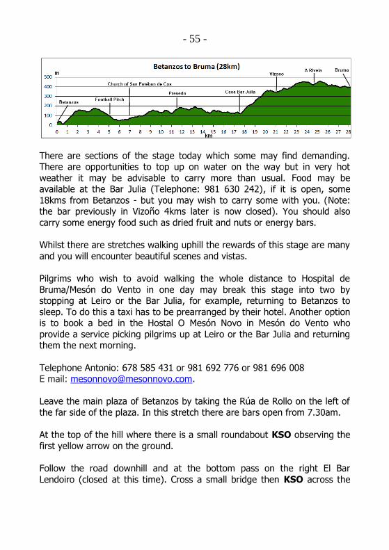
- 55 -
There are sections of the stage today which some may find demanding. There are opportunities to top up on water on the way but in very hot
weather it may be advisable to carry more than usual. Food may be available at the Bar Julia (Telephone: 981 630 242), if it is open, some
18kms from Betanzos - but you may wish to carry some with you. (Note: the bar previously in Vizoño 4kms later is now closed). You should also
carry some energy food such as dried fruit and nuts or energy bars.
Whilst there are stretches walking uphill the rewards of this stage are many
and you will encounter beautiful scenes and vistas.
Pilgrims who wish to avoid walking the whole distance to Hospital de
Bruma/Mesón do Vento in one day may break this stage into two by stopping at Leiro or the Bar Julia, for example, returning to Betanzos to
sleep. To do this a taxi has to be prearranged by their hotel. Another option is to book a bed in the Hostal O Mesón Novo in Mesón do Vento who
provide a service picking pilgrims up at Leiro or the Bar Julia and returning them the next morning.
Telephone Antonio: 678 585 431 or 981 692 776 or 981 696 008 E mail: [email protected].
Leave the main plaza of Betanzos by taking the Rúa de Rollo on the left of
the far side of the plaza. In this stretch there are bars open from 7.30am.
At the top of the hill where there is a small roundabout KSO observing the
first yellow arrow on the ground.
Follow the road downhill and at the bottom pass on the right El Bar
Lendoiro (closed at this time). Cross a small bridge then KSO across the
- 56 -
main road passing in front of a shop and follow the Left turning at house
number 28 indicated by the yellow arrow on the wall.
Follow this minor road steadily uphill turning Right at the tile on the wall
and a sign O Coto. KSO at a junction with a house named Picheira climbing steadily out of Betanzos. At a fork in the road take the Right fork (see the
pilgrim ahead of you on the rooftop), then take the Left hand fork indicated by the waymark. KSO heading uphill on this pleasant road
through trees. When it levels out at a junction KSO ahead passing an
enclosed area with a modern small wooden building to the left. Shortly cross the bridge over the railway line. KSO gently uphill.
After a little the road levels out and you come to a junction with a road
coming from the right – turn Left following waymarks. KSO to cross the
bridge passing over the motorway.
At the other side of the bridge turn hard Right at the waymark and the sign Xanrozo. Proceed downhill and after a little way take the second
waymark turn on the Left and then pass a house on the right marked Juan
Rozo. Just past Juan Rozo there is a lavadero down on the right hand side. Just past the lavadero KSO at 2 waymarked junctions one shortly after the
other. KSO crossing another road coming round a bend from the right and follow the waymark at the junction. KSO up this road past a house on the
left forking Right as indicated by the waymark.
Follow this road to the top and at the STOP sign turn Left onto a more
major road – there is a yellow arrow nailed to a lamp post across the road.
Immediately pass a house on the right called Rex Urdir. Shortly after passing this house there are two waymarks and a yellow arrow indicating a
turn to the Right onto a more minor road with a bench on the left hand
side.
Follow the road gradually downhill following the waymarks and avoiding left or right turns until you reach the football pitch at Limiñón. Cross over to the
first Information Board about the Camino Inglés placed at junctions in this area. KSO on a country path going downhill with the football pitch to your
left. KSO, the path is well waymarked at all junctions. At a waymarked
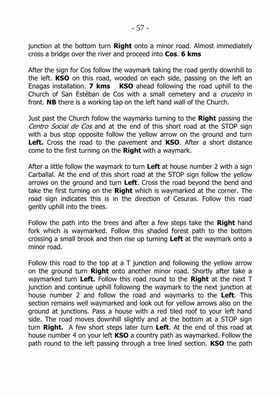
- 57 -
junction at the bottom turn Right onto a minor road. Almost immediately
cross a bridge over the river and proceed into Cos. 6 kms
After the sign for Cos follow the waymark taking the road gently downhill to
the left. KSO on this road, wooded on each side, passing on the left an Enagas installation. 7 kms KSO ahead following the road uphill to the
Church of San Estéban de Cos with a small cemetery and a cruceiro in front. NB there is a working tap on the left hand wall of the Church.
Just past the Church follow the waymarks turning to the Right passing the Centro Social de Cos and at the end of this short road at the STOP sign
with a bus stop opposite follow the yellow arrow on the ground and turn Left. Cross the road to the pavement and KSO. After a short distance
come to the first turning on the Right with a waymark.
After a little follow the waymark to turn Left at house number 2 with a sign
Carballal. At the end of this short road at the STOP sign follow the yellow arrows on the ground and turn Left. Cross the road beyond the bend and
take the first turning on the Right which is waymarked at the corner. The
road sign indicates this is in the direction of Cesuras. Follow this road gently uphill into the trees.
Follow the path into the trees and after a few steps take the Right hand
fork which is waymarked. Follow this shaded forest path to the bottom crossing a small brook and then rise up turning Left at the waymark onto a
minor road.
Follow this road to the top at a T junction and following the yellow arrow
on the ground turn Right onto another minor road. Shortly after take a waymarked turn Left. Follow this road round to the Right at the next T
junction and continue uphill following the waymark to the next junction at
house number 2 and follow the road and waymarks to the Left. This section remains well waymarked and look out for yellow arrows also on the
ground at junctions. Pass a house with a red tiled roof to your left hand side. The road moves downhill slightly and at the bottom at a STOP sign
turn Right. A few short steps later turn Left. At the end of this road at house number 4 on your left KSO a country path as waymarked. Follow the
path round to the left passing through a tree lined section. KSO the path

- 58 -
with waymarks and faint yellow arrows on the trees and at the end turn
Left to join a minor road as indicated by the waymark. At the bottom of
the road at the STOP sign turn Right onto a more major road at a sign Presedo. 12 kms
Cross the Presedo bridge. Proceed uphill on this main road being vigilant
for occasional but fast traffic. As the road turns see the waymark sign taking a path off to the Left. Follow this path going gently then more
steadily meandering uphill through the trees for 500 metres emerging at
some buildings onto a small road. If staying at the Albergue in Presedo, follow the sign at these buildings down to the right, and cross the main
road in Presedo, leading you to the Church of Santa María.
Albergue de Peregrinos. Municipal albergue, in a single storey building,
to the left of the Church and cemetery, beyond the carpark. 20 beds. Telephone (María José): 608 616 533. Basic albergue, and not much
kitchen equipment or utensils – but the bar-restaurant “Mesón-Museo” is nearby, about 10 minutes walk along the main road to the right.
If not going to the Albergue KSO at the buildings crossing a minor road and taking up the path on the other side again at the waymark. After a
very short section at another waymark at a fork in the path turn Right. In this section, about 10 minutes walk from the buildings, is the “camino”
entrance to the “Mesón-Museo” bar-restaurant. Keep on this level section until it meets a minor road coming from the right – there is an arrow on a
stone to the left – turn Left. KSO this road to a small ruined cottage
covered in vegetation and at the end turn Left with a yellow arrow on a fence post opposite.
KSO to the end of the road. At the waymark turn Right continuing uphill
to the shelter at the end of the road and turn Left. As you turn Left you
can see the next waymark indicating a Right turn at a small brick building. Follow the path through the trees turning Left onto a minor road at a
waymark. KSO passing on your left an Information Board indicating you have arrived at Leiro at a large covered seated recreation area useful in
wet weather. There are two taps. Pass the parish Church of Leiro with a cruceiro. Cross the road to the waymark taking turns Left and Right
following the directions of the waymarks. At one point the path turns right
- 59 -
then immediately left. Follow the path round a large field to the bottom
where there is a waymark indicating a Right turn. Follow this lovely forest
path - sometimes on tarmac - all the way until it rises gently emerging beside a house and shortly thereafter a minor road – turn Left.
Leiro – Poulo
Base Map – IGN topo maps from IDEE
Follow the road and at the end follow the waymark Left turning. As the road turns to the left cross carefully and turn Right at the waymark onto a
- 60 -
grassy path. Follow the path along a quiet section with the river bubbling to
the left below. Follow this path until it rises away from the river with a
yellow arrow on a tree indicating that you fork up to the Right. Emerge out onto another path turning Right at a house which you pass on your left
hand side. Shortly along this road keep your eyes open for a yellow arrow on the ground indicating a Left turn. Take the path to the Left
immediately passing a house on the right hand side and turning Right downhill at this house. Almost immediately join the road with yellow arrows
on the ground and a waymark opposite. Follow the road down and shortly
you will see the Casa Julia/Bar Julia on the right hand side. 18 kms
The opening hours are erratic but you can telephone ahead to find out if the bar is open (Telephone: 981 630 242). Shortly after the Bar Julia at the
bottom of the road is a fountain.
A significant climb lies ahead, amounting to about 350 metres in 3 kms.
From the fountain, proceed up the hill past the modern Church of San Tomé de Vilacoba. There are toilets behind the Church. Then follow the
road round until a waymark indicates a hard Left turn and you move more
steeply uphill. At the end of the tarmac road at a house there is an opportunity to look back at vistas across the valley. Leave the tarmac and
continue uphill on a forest track, following the waymarks first veering right, then bending left. Follow this forest path all the way up until it turns Right
at the top at the waymark. 21 kms
At the top of the steep section follow the path to the Right. KSO and after
a short distance come out between farm buildings with pasture to the right. Turn Left up a short incline and enter the small hamlet of Fontela. KSO
ignoring turns to the left passing a pink house, Villa Fatima, on the corner. KSO the road ahead. Pass a very well placed shaded seated area with a
fuente (not treated drinking water) and an Information Board indicating
you have now reached Vizoño.
Follow the waymarks ahead and carry straight on up the path. Follow this path as it meanders gently uphill between trees and shortly encounter a
waymark, turn Left and keep going gently uphill. Pass a cruceiro in a clearing with a forest path coming from the left. Follow the waymarker just
past the cruceiro taking the Right hand path.

- 61 -
Follow the path up and round as it moves parallel to the motorway below
on the right hand side and then follow the path down to the Left away from the motorway. Follow the path down to join a road waymarked
opposite. Turn Right, effectively doubling back heading back towards the motorway. Shortly after follow the waymark to turn up Right at the sign
which says As Travesas and after a short distance cross the motorway over a bridge.
After the bridge follow the road as it winds its way uphill and then follow a waymark to a Left hand turn. See farm building to the right but keep on
the road you are on veering to the Left. The road levels out just after some farm buildings. KSO passing farm buildings to the right hand side. After
800 metres there is a crossroads. Turn Left at the marker taking the minor
road following some small pylons. After about 500 metres, at the waymark, take the minor road Right.
Follow arrows through a small hamlet – pass a red house number 1, A
Rivela, and at the junction immediately following the house follow the
waymark and turn Right.
Come to the end of this road at a junction with a larger road and straight across the road to the left is a waymark. Follow along the track straight
ahead turning when waymarked. Having gone downhill gradually at the bottom of the grassy path you are now on you will find a large path on the
left. Continue downhill to the Right. Continue on downhill following a
yellow arrow on a tree on the left at a junction. At the bottom take the stepping stones over a small brook and KSO ahead on the other side.
Come out at some farm buildings at a T junction and follow the arrows to
the Right. After a little at a waymark turn Left. This waymark has “two
faces” as it is here the route from A Coruña joins the route from Ferrol. Follow this track with farm buildings to the right and at the end veer Left.
Follow this path turning Right at the waymark then crossing a small stream with stepping stones, continuing straight ahead. A little after the
stream three paths converge. Keep on the right hand, waymarked path.
- 62 -
On passing a hórreo and a house on the corner turn left at the junction into
Hospital de Bruma. 29 kms
For those staying in Mesón do Vento:
1. Turn Right and go up to the top of the road taking the left hand fork then proceeding Left along the main road walking on the hard
shoulder. KSO until you approach a roundabout at a TV Mast - see the sign for the Hotel-Restaurante Canaima in front of you.
However cars on this road drive very fast – so option 2 is probably
safer and more comfortable.
OR
2. Turn Left on entering Bruma and follow the waymark sign to the
left and walk down to the albergue. Just before the albergue turn Right at a children’s play area and KSO this quieter road for 2km
to Mesón do Vento. After the children’s play area the road becomes a dirt track – go Left at the first fork in the track, and Left again at
the next fork, then turn Right at the Stop sign beside a house,
where a tarmac road runs across the track left to right. When you reach the main road turn Right for the hostales and garage. Turn
Left to go into Mesón do Vento. There are cafe-bars, grocery stores, ATMs, a farmacia and the local parish Church of St Andrew.
At Mesón do Vento you have a choice of accommodation on each side of
the road – both are reasonably priced:
Hotel Canaima - Telephone: 981 681 401. Comedor with Menu del Día
opening 9pm or 9.30pm. Not always open for breakfast.
Pensión** O Mesón Novo - Telephone: 981 692 776 or 678 585 431. Rooms are en-suite, elegant and very comfortable. This hostal is cleaner,
newer and better appointed than the Hotel Canaima, although cheaper.
The staff is very welcoming and speak English. Highly recommended. No Menu del Día but excellent tapas and raciones available all the time.
Possible to phone ahead and ask for meals to be prepared. Breakfast from 6am.

- 63 -
Note that if you are staying at O Mesón Novo or Hotel Canaima, you rejoin
the Camino the next day simply by walking towards Mesón do Vento from
the O Mesón Novo and taking the first road on the left, marked “A Barcula”. Shortly, at a fork in the road, take the Right, marked “Buscas”. Follow this
for a kilometre or so to a crossroads, where you will see a tiled waymarker pointing Right.
For those staying at the albergue:
On entering Bruma follow the waymark tile opposite to the Left and walk down into the village. The municipal albergue with 25 beds is at the
bottom. It is run by the hospitalera and her husband, Carmen and Benino. They live nearby in the village.
Telephone: 981 692 921.
There is a small cooker and pots for cooking in the albergue and there is also the “Restaurante Casa Graña” (new 2016) only 20 metres away. The
restaurant is open 7.30am to 10pm, in season.
If the Albergue is full, you might be offered the opportunity of sleeping in
the polideportivo (sports hall) a few hundred metres from Mesón do Vento. Those who have taken this option report uncomfortable conditions.
Hospital de Bruma as mentioned in the introduction was an important
junction of the two arms of the Camino Inglés and has many interesting
buildings still. The medieval Church of San Lourenzo (normally closed) is at the far end of the village on the Left. The original nave is now the village
Church. The arch between the original nave and chancel has been filled in to form the east wall of the present Church. On the outer side of this
blocked arch the former chancel has been taken down to shoulder height.
Part of the medieval hospice is incorporated in the farm cottage next door to the Church.
For those leaving the albergue there is a helpful notice: “Bar Novo 8 kms”.
Also note that the Bar Cruceiro, 13 kms from Bruma, serves sandwiches and will prepare lunch if you telephone ahead. Telephone: 626 311 199.
Carolina the owner speaks English fluently.

- 64 -
Hospital de Bruma – Sigüeiro approximately 24 kms
The route today is very straightforward and well waymarked.
Follow the arrows out of Bruma and KSO for 1 km to Seixo. KSO to
Cabeza de Lobo with the Church of San Pedro and a cruceiro. A little further on there is a Café/Bar O Porto which appears to keep irregular
opening hours. 3 kms
Just past the Café Bar O Porto, on the right, is a 6m-tall grey granite statue
of Santiago in his pilgrim guise, which was erected in the 2010 Holy Year. It’s a great spot for a group photo. Nearby are some rather more bizarre
sculptures.

- 65 -
Follow the waymarks through the hamlets of Carreira and Mámoas. Just
before reaching Carballeira there is a comfortable bench on the right by a
fuente. Just past Carballeira, look out for a stone marker on the right to an off-road section of the camino, smoothly surfaced with crushed granite and
passing amongst shady hedgerows. This ends with a turn Left, then Right onto a track which leads round to a minor road at a T-junction. Turn Right
into A Pereira, from where you continue into the village of A Rúa, in the parish of Buscas. 8 kms
The Bar Novo is on the left as you enter and provides sandwiches. Opposite is the Casa Rural, DoñaMaría - Telephone 981 681 430. The Church of San
Paio is close to the road on the right and a cruceiro. The Church has a small 18th Century statue of San Paio, a child martyr, on the outer wall.
There is another, larger bar on the right just past the Church, the Bar La
Rúa.
Proceed out of Buscas following the waymarks. 1 km after leaving Buscas the road bends right. Shortly afterwards take a left turn on to a track, then
when the route passes under the road, cross the road and pass a house on
the left. Follow the route to the Left signed by a waymark and on your right is a Casa Rural, the Antón Veiras - Telephone 981 682 302. Shortly
after this you will see the parish Church of San Xulian de Poulo off to your right.
The route from here, through the trees, is pleasant and well waymarked.
After 1km KSO bearing left as the track turns into a minor road. KSO
following the waymarks into Calle de Poulo. 13 kms

- 66 -
Poulo – Sigüeiro
Base Map – IGN topo maps from IDEE
At the cruceiro on the left is the Café-Bar O Cruceiro. This is the last stop
for food and drink before Sigüeiro. Carolina the owner speaks English and she is happy to fill water bottles with fresh, cold spring water.
At the junction there is a road off to the right with a sign Ordes 3 kms
where there is a good selection of accommodation etc. The Hostal Louro is
recommended - down the steps from the main square at Rúa do Recreo, 19. Tel: 981 680 831.
If going on to Sigüeiro from the cruceiro at the Bar follow the arrows past
the Church, Capilla de NS de la Mercedes and follow signs to Pereira. Keep

- 67 -
a look out for the next waymark, which is left off the road onto a forest
track. Shortly veer right at a waymark and then, having followed the arrows
on a forest path section, come to a junction. KSO following a kerb of granite blocks on the left of the path and after a short distance you will see
the next waymark. Turn left on to the road for a short while, veering right as the road bends left. Shortly, veer Left onto another forest track. Keep
on this track, crossing two other tracks and then a minor road, until you arrive at a Left turn at a waymarked T-junction, where there is an
Information Board about the Camiño Real. KSO following the waymarks
until you turn Right along a road then Left to pass houses. At the end of this road cross a main road with a bus stop which is useful for a rest on a
hot day. This is opposite a sign Husquarnh and a road sign to A Burata. 18 kms
Cross over, passing the bus stop on your right, and proceed down and under the motorway. Follow the arrows and shortly turn Right on to a long
straight broad track and KSO for approximately 4 kms until you come to another bus stop. 22 kms
KSO past the bus stop passing on your right a series of industrial buildings dominated by the Televés building. KSO down this road and at the bottom
ignore a turn to the left and follow the road round Right. KSO, ignoring the road to the left, until you come to a waymark leading you onto a path
off to the Left through trees. Walk through this well waymarked path through the trees until you emerge at the local swimming pool. Sigüeiro is
no more than a few hundred metres away. Pass around the swimming pool
Right then follow the arrows into the square and enter Sigüeiro.
After a modern sculpture dedicated to the Camino Inglés opposite the Centro Cultural, turn Right following the Rúa Lengűelle and take the first
turn on the Left - see a waymark tile high on a column at this turning.
From this street, the Rúa do Tambre, take the first Right into Rúa Camiño Real, which leads to the main road. Turn Left onto the main road, passing
a wooden waymark at the bus shelter, and the Bar-Restaurante Miras on your left. From here, just a little further along the road ahead of you is the
bridge over the Río Tambre. 24 kms
- 68 -
Where to stay
Albergue de Delia. Private albergue which sleeps 8, located at Rúa do Portiño, 21 (the street across the main road from where the wooden
waymark and bus shelter are). 1 bunkbed in each of three rooms, plus 1 double room – all with a shared bathroom, lounge, kitchen with all facilities
and large garden. Bed and breakfast. Opening hours: 12.30 – 10pm. Telephone 687 279 398 (María José).
Albergue O Fogar da Chisco. Private albergue with 10 beds, located at Rúa do Campo, 4 (from the Calle Real, turn left onto Rúa de Ourense, then
left again onto Rúa do Campo). 5 bunkbeds in one room, with shared bathroom, lounge, kitchen with all facilities, lounge and small patio. There
is also one private double bedroom, with its own bathroom. Breakfast at
Cafeteria “CHE” nearby. Telephone 626 592 444 or 981 691 783 (José-Chus).
Hotel SigueiroHostel. Boutique hotel beside the park and river at the
bottom of the Rúa do Mediodía (the street across the main road from the
Bar-Restaurante Miras). Small hotel with 9 twin rooms. Bed and Breakfast. Website: www.sigueirohostel.com. Telephone: 981 973 636 or 615 499
071. Email: [email protected].
Also, by permission of the Ayuntamiento it is possible for pilgrims to sleep in the local sports centre or polideportivo but you may only arrive after 5pm
and by arrangement – Telephone: 981 691 478 or 616 408 598 or 659 975
171 or check with the hospitalera in Bruma. There are mattresses and showers. The polideportivo is close by the swimming pool you pass on your
way into Sigüeiro. Very basic.
There are regular buses into Santiago from Sigüeiro. The bus stop is to the
left of the bar-restaurante Miras whilst the taxi stand is opposite it – both are on the opposite side of the road from the bar.

- 69 -
Mass and sello
Both available at the Church of Barciela dedicated to St Andrew. Mass at 7pm Tuesday to Saturday (6pm in the winter); Sunday at 12.30pm.
Pilgrim’s blessing and Sello available after Mass. The Church is just across the bridge after the Bar-Restaurante Miras and is on the route to Santiago.

- 70 -
Sigüeiro – Santiago de Compostela approximately 16 kms
Base Map – IGN topo maps from IDEE

- 71 -
Cross the bridge over the River Tambre and at the end of the bridge follow
the waymark to the Left. You may notice some discrepancies between the
mileage on the waymarks in this section and those given in this guide. This is due to changes to the route and the waymarks having been moved
without the distance plates also being changed. Go up the lane and veer to the Right passing the Church on your left.
There is a water tap on the wall behind the Church, next to the cemetery gate. If your bottles are not full, this is your last chance until the outskirts
of Santiago.
Go up the incline in front of you with the parish cemetery to your left. KSO
a forest path. After approximately 1km the path emerges onto a minor road. Turn Right following the waymark. Follow this road to the STOP sign
and cross the main road taking up a forest path opposite with the waymark sign on the right hand side. Ignore the immediate left turn at a house. KSO
up the path going steadily uphill.
Stay on this path on a fairly long straight stretch to a T-junction at the end
with a waymark indicating a Left turn. Ignore the arrow pointing right.
Keep on this path downhill a short distance to a crossroads and follow the waymark turning Right. After a short while rising gently on this path follow
the waymark and turn Right. Follow this path along and then gently
downhill close to and parallel to the motorway. Veering gently Left to a staggered crossroads KSO ahead following the waymark.
Follow this path up round as it skirts to the left hand side of a large field
with trees on your left. As you pass the field on your right avoid the left

- 72 -
turn following the waymark straight ahead. Proceed downhill on the path
and KSO through a tunnel under the motorway. 3.5 kms
Shortly after the tunnel follow the waymark sign and turn Left. Soon at a
junction on the road carry on straight ahead and follow the arrows along a wide path between trees. Follow the path as it winds its way eventually
down to the road but shortly before then follow the waymark sign and turn Left. KSO downhill following the arrows, go through a crossroads and pass
the rear of the Hotel San Vicente. 4.5 kms
Hotel San Vicente. Telephone: 981 694 571 or 981 694 992 or 629 565
362. (José Ignacio). http://www.hotelsanvicente.com
To follow the route KSO at the next crossroads and shortly reach a picnic
area with a cruceiro. 5 kms
KSO passing the Church of Nosa Señora da Agualda on the Left and KSO to the end of the road between the houses and turn Left at the waymark.
Shortly follow the yellow arrows and walk along the left hand hard shoulder
of the N550 keeping close to the barrier. Take care here. Then veer Left and pass over a gravel path in front of a house and cross the road to go
downhill to turn Right into a tunnel below the N550. Pass under the road and shortly after walking up a gentle incline follow the waymark
(11.185km) to the Left along a path. At the end of this path as you reach a minor road at a farm building. Turn Right. 6 kms
Shortly turn Left and proceed up a track with electricity pylons on your Left. KSO this path through the trees, turning Right at a waymark after 0.5
kms. KSO gradually descending. Cross a brook and shortly turn Left at a waymark and pass under the railway. KSO the path as it rises up an
incline. Turn Left at a T junction following the waymark. 7 kms
KSO following the waymarks ignoring any turns and proceed gently
downhill through the forest. At the bottom turn Left and cross a bridge over the river Sionlla (the same river as at Lavacolla on the Camino Francés) and after an incline follow the path Right at a waymark. KSO this path as it ascends following it Left and then straight ahead ignoring any
turns. After a long incline KSO as the wide path meanders downhill.

- 73 -
Eventually turn left at a waymark, then you will come to a house on your
left with a walled garden followed by a smaller house. 9 kms
KSO what has now become a minor country road. Eventually turn Left
onto another minor road and KSO through the village O Barral. 10 kms On the right, after the bus stop in O Barral, is a restored (2013) lavadero
with shade and seating. KSO uphill and at house number 23, at a bus stop, veer Left along a forest path, following the waymark. If it is has not been
removed, the mileage on this waymark will say 5.545km. KSO until the path
comes out on a road with a modern office building occupied by Telsís facing you.
You are now in the industrial outskirts of Santiago and on the final stage of
your journey. Unlike other routes to Santiago, such as the Camino Francés and the Vía de la Plata, the pilgrim’s entrance into the city on the Camino Inglés is not heralded with far off views of the spires of the Cathedral which
get closer. Unless you glance just the right way at just the right moment, you will not see the Cathedral until you are almost upon it. For those who
have not walked into Santiago before that wonder has yet to come.
KSO passing the café bar Poligono on the right. 11 kms
KSO across two roundabouts then pass to the Right of a large walled
cemetery. Do not turn left at the end of the cemetery wall - KSO leaving the industrial estate behind and come to a house number 66 on the left
with a waymark tile. 12 kms
KSO the road as it moves between houses. After 300 metres pass the Café
Bar Miro on the left. At the STOP sign immediately after the bar follow waymarks to the Left and pass in front of the Café Bar Adega Bello. A little
further on observe the yellow arrow on the lamp post and pavement and
follow the road Right – KSO until at house number 59 Rúa do Tambre in Meixonfrio notice a waymarked turning to the Right. 13 kms
Follow the road downhill slightly passing a lavadero on your left then rising
up to the top of the road to the trees with a waymark opposite indicating a Left turn.

- 74 -
KSO along this street passing on your left the Centro Libredón at number
94 with scallop shell decorations on the window grills. At house number 58
KSO ahead, passing an office called “Gestoría José Luís Rey” on the right. The road swings down to the left, and if you look ahead here, you will get a
glimpse of the Cathedral spires. The road comes to a junction with a Left hand turning marked by a waymark indicating only 1.635 km to go! 14.5
kms.
Turn Left and follow the road round to the right, then the left and at the
Café Bar Garcia Lorca note the yellow arrow on the kerb opposite with a waymark. Cross over and down into a small park taking the first Right
path with arches on your left. KSO to the end of the park, then fork Left to walk up to the statue of Pablo Iglesias after whom the park in named and,
using the pedestrian crossings, cross to the diagonal opposite of where you
are now to the Rúa da Pastoriza. (Note: at the second pedestrian crossing do not take the main road that bends down to your right). On the
roundabout behind you there is a large modern sculpture of a pilgrim. Walk along the Rúa da Pastoriza away from the sculpture. You are now heading
for the old town of Santiago and the Cathedral. Look for the towers of the
Cathedral appearing above the rooftops.
Shortly, after the Church on the left, the road becomes the Rúa dos Basquiños. KSO until you come to a government building dealing with
emigration on the left at which point cross over and proceed down a lower road on the right hand side, the Rúa Santa Clara, past the Convento del
Carmen.
You are now entering the old town of Santiago. For those who have not
visited before the medieval city with all of its streets, plazas and lanes can be at first confusing. Here you are near the site of the Porta Poennae, the
gate in the medieval walled city of Santiago where pilgrims travelling on the
Camino Inglés traditionally entered. Hence you will shortly walk along the street named after it – the Porta da Pena. The final stages of the Camino Inglés are simple – you should keep straight on ahead all the way along the Rúa Santa Clara, becoming the Rúa dos Loureiros, the Porta da Pena and
the Rúa da Troia, and when the road narrows with buildings on either side come to the end and turn Right. KSO ignoring the left turn and pass down
into the Plaza Inmaculada with the Cathedral rising above you on the left.
- 75 -
KSO ahead down the steps under the arch in front of you and reach the
monumental Plaza del Obradoiro in Santiago de Compostela. 16 kms
Congratulations –You have arrived!

- 76 -
The Pillar, the Hug and the Tomb
Each day pilgrims arrive at the Cathedral Square but their journey is not at an end, they still have things to do.
Entering the Cathedral pilgrims first touch the pillar depicting the Tree of
Jesse, where you can actually put your fingers into grooves marked by centuries of hands. This is closed off for restoration at this time but you can
easily see the handprint.
Then they walk to the back of the high altar to rise behind the statue of St
James to give him the traditional "abrazo" – a warm hug of thanks.
Then pilgrims descend to the tomb of the Saint to pray quietly, thanking
God for all that has been encountered on the journey here.
Seal of Approval – the Compostela
Pilgrims to Santiago de Compostela carry a Pilgrim Passport also called a
credencial with them. They have these stamped everywhere they stop on the way. This document gives access to the network of refuges provided
along the routes.
Near the Cathedral is the Pilgrims’ Office, just like Passport Control! There the Pilgrim Passport is stamped with the final seal of the Cathedral of
Santiago. Those pilgrims who have walked or travelled on horseback at
least the final 100 kms, or travelled by bicycle at least the final 200 kms, will have their name written in Latin on the Compostela, the certificate
attesting to their pilgrimage. The office is in Rua Carretas: with your back to the Cathedral main doors, walk down the slope in front of the Parador
and turn right into Rua Carretas. Walk along this street and the office is the
last (white) building on your left. The main entrance is just round the corner, to the left.
Pilgrims’ Mass
Each morning around 11am people start to make their way to the
Cathedral. It fills quickly and by noon at busy times of the year, as the

- 77 -
pilgrims mingle with tourists and visitors to the city, it is standing room
only.
At the stroke of noon the cantor intones the entrance antiphon such as
“Laudate Dominum omnes gentes” and to the sound of the great organ 1000 voices repeat: “All people praise the Lord”. The procession enters.
Many of the priests are still wearing their walking boots under their vestments. A long list of the countries from which pilgrims have arrived in
the last 24 hours is read.
The Mass which follows is deeply moving, with different accents and
languages contributing. For the pilgrims there is a profound sense of gratitude, relief and celebration that the journey has ended.
For them perhaps...but even during the Mass still they come...rising behind the altar and hugging the statue of St James.
Holy Smoke – The Botafumeiro
The Botafumeiro (literally “smoke spreader” in Galician) is one of the most
famous and popular symbols of the Cathedral of Santiago de Compostela.
This is a huge censer that swings across the transept of the Cathedral through a pulley system pulled by eight men called tiraboleiros. It weighs
53 kgs and measures five feet in height. It is suspended from a height of 20 metres and can reach a speed of 70 miles per hour.
Some say the Botafumeiro was used as a deodorant in medieval times
when the Cathedral was full of pilgrims who hadn’t washed for the duration
of their journey. Others say that the billows of incense it produces symbolise the prayers of the pilgrims.
There are certain times of the year when the Botefumeiro is used for
liturgical purposes at the beginning of the Mass just as a priest would
normally use incense. At many other times it is used at the end of the Mass by special arrangement. You may be lucky and see it. It is always used at
the 7.30pm Pilgrims’ Mass on a Friday evening.

- 78 -
Day is done
During many months of the year there is an Evening Service in the
Cathedral from 8.30pm to 9.30pm – only for pilgrims who have travelled to
Santiago by foot, bicycle or on horseback.