Embed Size (px)
Citation preview
PUBLIC ENVIRONMENTAL REVIEW
Pilbara Iron Ore and Infrastructure Project:
Stage A Port and North-South Railway
for Fortescue Metals Group Limited
ENVIRON Australia Pty Ltd Suite 7, The Russell Centre 159 Adelaide Terrace East Perth WA 6006 Australia Telephone: +618 9225 5199 Ref: Stage A PER Rev 4 - Sept 04 Facsimile: +618 9225 5155 September 2004

(This page has been left blank intentionally)
Attachment 1 Invitation to make a submission The Environmental Protection Authority (EPA) invites people to make a submission on this proposal. If you are able to, electronic submissions emailed to the EPA Service Unit project officer would be most welcome. Fortescue Metals Group Limited (FMG) proposes to construct a port facility at Port Hedland and a connecting railway to its proposed mining operations some 345 km to the southeast. (The proposed mining operations will be assessed separately and does not form part of this assessment). FMG will from the outset make its railway and port facilities available to other users, including general freight and those who have mineral deposits in the Pilbara. In accordance with the Environmental Protection Act, a Public Environmental Review (PER) has been prepared which describes this proposal and its likely effects on the environment. The PER is available for a public review period of 8 weeks from Monday 20th September 2004 closing on 15th November 2004. Comments from government agencies and from the public will help the EPA to prepare an assessment report in which it will make recommendations to government. Why write a submission? A submission is a way to provide information, express your opinion and put forward your suggested course of action - including any alternative approach. It is useful if you indicate any suggestions you have to improve the proposal. All submissions received by the EPA will be acknowledged. Submissions will be treated as public documents unless provided and received in confidence subject to the requirements of the Freedom of Information Act, and may be quoted in full or in part in the EPA’s report. Why not join a group? If you prefer not to write your own comments, it may be worthwhile joining with a group interested in making a submission on similar issues. Joint submissions may help to reduce the workload for an individual or group, as well as increase the pool of ideas and information. If you form a small group (up to 10 people) please indicate all the names of the participants. If your group is larger, please indicate how many people your submission represents. Developing a submission You may agree or disagree with, or comment on, the general issues discussed in the PER or the specific proposals. It helps if you give reasons for your conclusions, supported by relevant data. You may make an important contribution by suggesting ways to make the proposal more environmentally acceptable. When making comments on specific elements of the PER: • clearly state your point of view; • indicate the source of your information or argument if this is applicable; • suggest recommendations, safeguards or alternatives. Points to keep in mind By keeping the following points in mind, you will make it easier for your submission to be analysed: • attempt to list points so that issues raised are clear. A summary of your submission is helpful; • refer each point to the appropriate section, chapter or recommendation in the PER; • if you discuss different sections of the PER, keep them distinct and separate, so there is no
confusion as to which section you are considering; • attach any factual information you may wish to provide and give details of the source. Make sure
your information is accurate.
Remember to include: • your name; • address; • date; and • whether and the reason why you want your submission to be confidential. Information in submissions will be deemed public information unless a request for confidentiality of the submission is made in writing and accepted by the EPA. As a result, a copy of each submission will be provided to the proponent but the identity of private individuals will remain confidential to the EPA. The closing date for submissions is: 15th November 2004 Submissions should ideally be emailed to [email protected] OR addressed to: Environmental Protection Authority PO Box K822 OR Westralia Square PERTH 141 St George’s Terrace WA 6842 PERTH WA 6000 Attention: Juliet Cole
Public Environmental Review Pilbara Iron Ore and Infrastructure Project: Stage A Port and N-S Railway September 2004 for Fortescue Metals Group Limited Page i
Ref: Stage A PER Rev 4 - Sept 04 ENVIRON
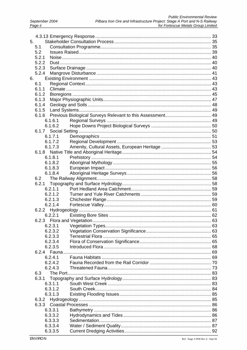
TABLE OF CONTENTS 1. Introduction ................................................................................................................. 1
1.1 Background ............................................................................................................. 1 1.2 Project Overview ..................................................................................................... 1 1.3 Purpose Of This Document ..................................................................................... 2 1.4 The Proponent......................................................................................................... 3 1.5 Timing and Staging of Project ................................................................................. 3 1.5.1 Technical Interrelationships..................................................................................... 4 1.5.2 Timing Overlaps ...................................................................................................... 5 1.6 Project Area............................................................................................................. 5
2. Project Justification and Evaluation of Alternatives..................................................... 7 2.1 Project Justification ................................................................................................. 7 2.2 State and National Benefits..................................................................................... 8 2.3 Evaluation of Alternatives........................................................................................ 8 2.3.1 Railway.................................................................................................................... 9 2.3.2 Port Location ......................................................................................................... 11 2.3.3 No Development Option ........................................................................................ 12
3. Legislative Framework .............................................................................................. 13 3.1.1 Relevant Legislation and Policies.......................................................................... 13 3.1.2 Key Decision Making Authorities........................................................................... 14 3.1.3 Approvals Process ................................................................................................ 15 3.1.4 Land Use Zoning................................................................................................... 17
3.1.4.1 Rail ........................................................................................................ 17 3.1.4.2 Port ........................................................................................................ 17
4. The Project................................................................................................................ 19 4.1 Key Characteristics ............................................................................................... 19 4.2 The Railway........................................................................................................... 20 4.2.1 Alignment .............................................................................................................. 20 4.2.2 Materials Sources.................................................................................................. 21 4.2.3 Construction Activities ........................................................................................... 21 4.2.4 Rail Facilities ......................................................................................................... 24 4.2.5 Locomotives and Rail Cars ................................................................................... 24 4.2.6 Ancillary Services .................................................................................................. 24 4.2.7 Dangerous Goods ................................................................................................. 25 4.2.8 Waste Management .............................................................................................. 25 4.2.9 Inspection, Maintenance and Monitoring............................................................... 25 4.2.10 Workforce and Accommodation ............................................................................ 26 4.2.11 Stock and Access Management............................................................................ 26 4.2.12 Fire Management .................................................................................................. 26 4.3 The Port................................................................................................................. 27 4.3.1 Layout.................................................................................................................... 27 4.3.2 Materials Sources.................................................................................................. 27 4.3.3 Site Preparation and Drainage.............................................................................. 27 4.3.4 Dredging and Reclamation.................................................................................... 28 4.3.5 Construction Activities ........................................................................................... 28 4.3.6 Port Facilities......................................................................................................... 30
4.3.6.1 Ore Handling Facilities .......................................................................... 30 4.3.6.2 Shiploading............................................................................................ 31 4.3.6.3 Wharf Facilities and Berth ..................................................................... 31
4.3.7 Ancillary Services .................................................................................................. 32 4.3.8 Dangerous Goods ................................................................................................. 32 4.3.9 Waste Management .............................................................................................. 33 4.3.10 Inspection, Maintenance and Monitoring............................................................... 33 4.3.11 Workforce and Accommodation ............................................................................ 33 4.3.12 Access Management............................................................................................. 33
Public Environmental Review September 2004 Pilbara Iron Ore and Infrastructure Project: Stage A Port and N-S Railway Page ii for Fortescue Metals Group Limited
ENVIRON Ref: Stage A PER Rev 4 - Sept 04
4.3.13 Emergency Response........................................................................................... 33 5. Stakeholder Consultation Process ............................................................................ 35
5.1 Consultation Programme....................................................................................... 35 5.2 Issues Raised........................................................................................................ 39 5.2.1 Noise ..................................................................................................................... 40 5.2.2 Dust ....................................................................................................................... 40 5.2.3 Surface Drainage .................................................................................................. 40 5.2.4 Mangrove Disturbance .......................................................................................... 41
6. Existing Environment ................................................................................................ 43 6.1 Regional Context................................................................................................... 43 6.1.1 Climate .................................................................................................................. 43 6.1.2 Bioregions ............................................................................................................. 45 6.1.3 Major Physiographic Units..................................................................................... 47 6.1.4 Geology and Soils ................................................................................................. 48 6.1.5 Land Systems........................................................................................................ 49 6.1.6 Previous Biological Surveys Relevant to this Assessment.................................... 49
6.1.6.1 Regional Surveys .................................................................................. 49 6.1.6.2 Hope Downs Project Biological Surveys ............................................... 50
6.1.7 Social Setting ........................................................................................................ 50 6.1.7.1 Demographics ....................................................................................... 51 6.1.7.2 Regional Development .......................................................................... 53 6.1.7.3 Amenity, Cultural Assets, European Heritage ....................................... 53
6.1.8 Native Title and Aboriginal Heritage...................................................................... 54 6.1.8.1 Prehistory .............................................................................................. 54 6.1.8.2 Aboriginal Mythology ............................................................................. 55 6.1.8.3 European Impact ................................................................................... 56 6.1.8.4 Aboriginal Heritage Surveys .................................................................. 56
6.2 The Railway Alignment.......................................................................................... 58 6.2.1 Topography and Surface Hydrology...................................................................... 58
6.2.1.1 Port Hedland Area Catchment............................................................... 59 6.2.1.2 Turner and Yule River Catchments ....................................................... 59 6.2.1.3 Chichester Range.................................................................................. 59 6.2.1.4 Fortescue Valley.................................................................................... 60
6.2.2 Hydrogeology ........................................................................................................ 61 6.2.2.1 Existing Bore Sites ................................................................................ 62
6.2.3 Flora and Vegetation............................................................................................. 63 6.2.3.1 Vegetation Types................................................................................... 63 6.2.3.2 Vegetation Conservation Significance................................................... 63 6.2.3.3 Terrestrial Flora ..................................................................................... 65 6.2.3.4 Flora of Conservation Significance........................................................ 65 6.2.3.5 Introduced Flora .................................................................................... 68
6.2.4 Fauna .................................................................................................................... 69 6.2.4.1 Fauna Habitats ...................................................................................... 69 6.2.4.2 Fauna Recorded from the Rail Corridor ................................................ 70 6.2.4.3 Threatened Fauna ................................................................................. 73
6.3 The Port................................................................................................................. 83 6.3.1 Topography and Surface Hydrology...................................................................... 83
6.3.1.1 South West Creek ................................................................................. 83 6.3.1.2 South Creek........................................................................................... 84 6.3.1.3 Existing Flooding Issues........................................................................ 85
6.3.2 Hydrogeology ........................................................................................................ 85 6.3.3 Coastal Processes ................................................................................................ 86
6.3.3.1 Bathymetry ............................................................................................ 86 6.3.3.2 Hydrodynamics and Tides ..................................................................... 86 6.3.3.3 Sedimentation........................................................................................ 87 6.3.3.4 Water / Sediment Quality....................................................................... 87 6.3.3.5 Current Dredging Activities.................................................................... 92
Public Environmental Review Pilbara Iron Ore and Infrastructure Project: Stage A Port and N-S Railway September 2004 for Fortescue Metals Group Limited Page iii
Ref: Stage A PER Rev 4 - Sept 04 ENVIRON
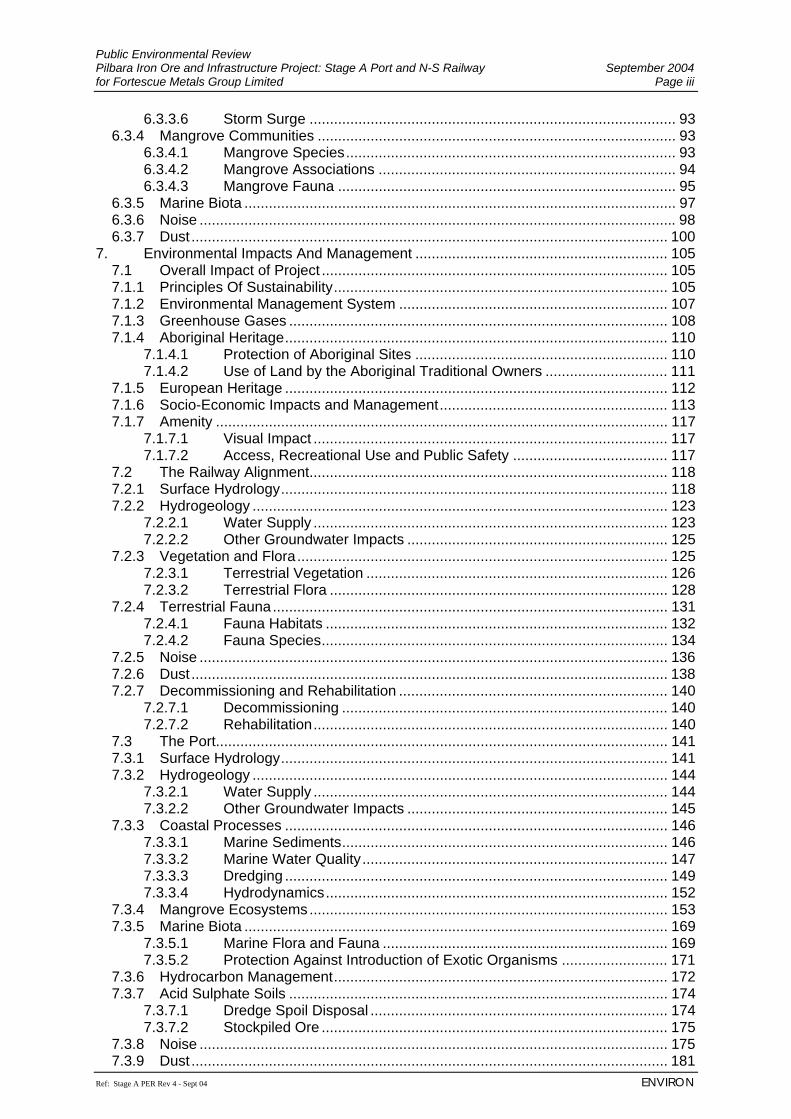
6.3.3.6 Storm Surge .......................................................................................... 93 6.3.4 Mangrove Communities ........................................................................................ 93
6.3.4.1 Mangrove Species................................................................................. 93 6.3.4.2 Mangrove Associations ......................................................................... 94 6.3.4.3 Mangrove Fauna ................................................................................... 95
6.3.5 Marine Biota .......................................................................................................... 97 6.3.6 Noise ..................................................................................................................... 98 6.3.7 Dust ..................................................................................................................... 100
7. Environmental Impacts And Management .............................................................. 105 7.1 Overall Impact of Project ..................................................................................... 105 7.1.1 Principles Of Sustainability.................................................................................. 105 7.1.2 Environmental Management System .................................................................. 107 7.1.3 Greenhouse Gases ............................................................................................. 108 7.1.4 Aboriginal Heritage.............................................................................................. 110
7.1.4.1 Protection of Aboriginal Sites .............................................................. 110 7.1.4.2 Use of Land by the Aboriginal Traditional Owners .............................. 111
7.1.5 European Heritage .............................................................................................. 112 7.1.6 Socio-Economic Impacts and Management........................................................ 113 7.1.7 Amenity ............................................................................................................... 117
7.1.7.1 Visual Impact ....................................................................................... 117 7.1.7.2 Access, Recreational Use and Public Safety ...................................... 117
7.2 The Railway Alignment........................................................................................ 118 7.2.1 Surface Hydrology............................................................................................... 118 7.2.2 Hydrogeology ...................................................................................................... 123
7.2.2.1 Water Supply ....................................................................................... 123 7.2.2.2 Other Groundwater Impacts ................................................................ 125
7.2.3 Vegetation and Flora........................................................................................... 125 7.2.3.1 Terrestrial Vegetation .......................................................................... 126 7.2.3.2 Terrestrial Flora ................................................................................... 128
7.2.4 Terrestrial Fauna................................................................................................. 131 7.2.4.1 Fauna Habitats .................................................................................... 132 7.2.4.2 Fauna Species..................................................................................... 134
7.2.5 Noise ................................................................................................................... 136 7.2.6 Dust ..................................................................................................................... 138 7.2.7 Decommissioning and Rehabilitation .................................................................. 140
7.2.7.1 Decommissioning ................................................................................ 140 7.2.7.2 Rehabilitation....................................................................................... 140
7.3 The Port............................................................................................................... 141 7.3.1 Surface Hydrology............................................................................................... 141 7.3.2 Hydrogeology ...................................................................................................... 144
7.3.2.1 Water Supply ....................................................................................... 144 7.3.2.2 Other Groundwater Impacts ................................................................ 145
7.3.3 Coastal Processes .............................................................................................. 146 7.3.3.1 Marine Sediments................................................................................ 146 7.3.3.2 Marine Water Quality........................................................................... 147 7.3.3.3 Dredging .............................................................................................. 149 7.3.3.4 Hydrodynamics.................................................................................... 152
7.3.4 Mangrove Ecosystems........................................................................................ 153 7.3.5 Marine Biota ........................................................................................................ 169
7.3.5.1 Marine Flora and Fauna ...................................................................... 169 7.3.5.2 Protection Against Introduction of Exotic Organisms .......................... 171
7.3.6 Hydrocarbon Management.................................................................................. 172 7.3.7 Acid Sulphate Soils ............................................................................................. 174
7.3.7.1 Dredge Spoil Disposal ......................................................................... 174 7.3.7.2 Stockpiled Ore ..................................................................................... 175
7.3.8 Noise ................................................................................................................... 175 7.3.9 Dust ..................................................................................................................... 181
Public Environmental Review September 2004 Pilbara Iron Ore and Infrastructure Project: Stage A Port and N-S Railway Page iv for Fortescue Metals Group Limited
ENVIRON Ref: Stage A PER Rev 4 - Sept 04
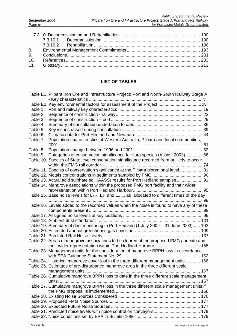
7.3.10 Decommissioning and Rehabilitation .................................................................. 190 7.3.10.1 Decommissioning ................................................................................ 190 7.3.10.2 Rehabilitation....................................................................................... 190
8. Environmental Management Commitments ............................................................ 193 9. Conclusions............................................................................................................. 201 10. References.............................................................................................................. 203 11. Glossary .................................................................................................................. 213
LIST OF TABLES Table E1. Pilbara Iron Ore and Infrastructure Project: Port and North-South Railway Stage A
- Key characteristics ............................................................................................. viii Table E2. Key environmental factors for assessment of the Project ................................... xvii Table 1. Port and railway key characteristics ..................................................................... 19 Table 2. Sequence of construction - railway....................................................................... 22 Table 3. Sequence of construction – port ........................................................................... 29 Table 4. Summary of consultation undertaken to date ....................................................... 36 Table 5. Key issues raised during consultation .................................................................. 39 Table 6. Climatic data for Port Hedland and Newman........................................................ 44 Table 7. Population characteristics of Western Australia, Pilbara and local communities,
2001...................................................................................................................... 51 Table 8. Population change between 1996 and 2001 ........................................................ 52 Table 9. Categories of conservation significance for flora species (Atkins, 2003).............. 66 Table 10. Species of State level conservation significance recorded from or likely to occur
within the FMG rail corridor................................................................................... 74 Table 11. Species of conservation significance at the Pilbara bioregional level................... 81 Table 12. Metals concentrations in sediments sampled by FMG ......................................... 90 Table 13. Actual acid sulphate soil (AASS) results for Port Hedland samples ..................... 91 Table 14. Mangrove associations within the proposed FMG port facility and their wider
representation within Port Hedland Harbour......................................................... 95 Table 15. Base noise levels for LA10, LA1 and LAmax as allocated to different times of the day
.............................................................................................................................. 98 Table 16. Levels added to the recorded values when the noise is found to have any of these
components present ............................................................................................. 99 Table 17. Assigned noise levels at key locations ................................................................. 99 Table 18. Ambient dust standards ...................................................................................... 101 Table 19. Summary of dust monitoring in Port Hedland (1 July 2002 – 31 June 2003)...... 102 Table 20. Estimated annual greenhouse gas emissions .................................................... 109 Table 21. Predicted Rail Noise Levels................................................................................ 137 Table 22. Areas of mangrove associations to be cleared at the proposed FMG port site and
their wider representation within Port Hedland Harbour ..................................... 155 Table 23. Management units for the consideration of mangrove BPPH loss in accordance
with EPA Guidance Statement No. 29................................................................ 162 Table 24. Historical mangrove cover lost in the three different management units. ........... 166 Table 25. Estimates of pre-disturbance mangrove area in the three different scale
management units. ............................................................................................. 167 Table 26. Cumulative mangrove BPPH loss to date in the three different scale management
units. ................................................................................................................... 167 Table 27. Cumulative mangrove BPPH loss in the three different scale management units if
the FMG proposal is implemented...................................................................... 168 Table 28. Existing Noise Sources Considered ................................................................... 176 Table 29. Proposed FMG Noise Sources ........................................................................... 177 Table 30. Expected Future Noise Sources ......................................................................... 177 Table 31. Predicted noise levels with noise control on conveyors...................................... 179 Table 32. Noise conditions set by EPA in Bulletin 1066 ..................................................... 179
Public Environmental Review Pilbara Iron Ore and Infrastructure Project: Stage A Port and N-S Railway September 2004 for Fortescue Metals Group Limited Page v
Ref: Stage A PER Rev 4 - Sept 04 ENVIRON
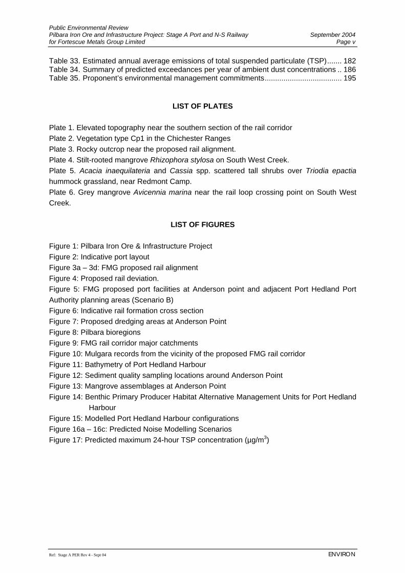
Table 33. Estimated annual average emissions of total suspended particulate (TSP)....... 182 Table 34. Summary of predicted exceedances per year of ambient dust concentrations .. 186 Table 35. Proponent’s environmental management commitments..................................... 195
LIST OF PLATES
Plate 1. Elevated topography near the southern section of the rail corridor Plate 2. Vegetation type Cp1 in the Chichester Ranges Plate 3. Rocky outcrop near the proposed rail alignment. Plate 4. Stilt-rooted mangrove Rhizophora stylosa on South West Creek. Plate 5. Acacia inaequilateria and Cassia spp. scattered tall shrubs over Triodia epactia hummock grassland, near Redmont Camp. Plate 6. Grey mangrove Avicennia marina near the rail loop crossing point on South West Creek.
LIST OF FIGURES Figure 1: Pilbara Iron Ore & Infrastructure Project Figure 2: Indicative port layout Figure 3a – 3d: FMG proposed rail alignment Figure 4: Proposed rail deviation. Figure 5: FMG proposed port facilities at Anderson point and adjacent Port Hedland Port Authority planning areas (Scenario B) Figure 6: Indicative rail formation cross section Figure 7: Proposed dredging areas at Anderson Point Figure 8: Pilbara bioregions Figure 9: FMG rail corridor major catchments Figure 10: Mulgara records from the vicinity of the proposed FMG rail corridor Figure 11: Bathymetry of Port Hedland Harbour Figure 12: Sediment quality sampling locations around Anderson Point Figure 13: Mangrove assemblages at Anderson Point Figure 14: Benthic Primary Producer Habitat Alternative Management Units for Port Hedland
Harbour Figure 15: Modelled Port Hedland Harbour configurations Figure 16a – 16c: Predicted Noise Modelling Scenarios Figure 17: Predicted maximum 24-hour TSP concentration (µg/m3)
Public Environmental Review September 2004 Pilbara Iron Ore and Infrastructure Project: Stage A Port and N-S Railway Page vi for Fortescue Metals Group Limited
ENVIRON Ref: Stage A PER Rev 4 - Sept 04
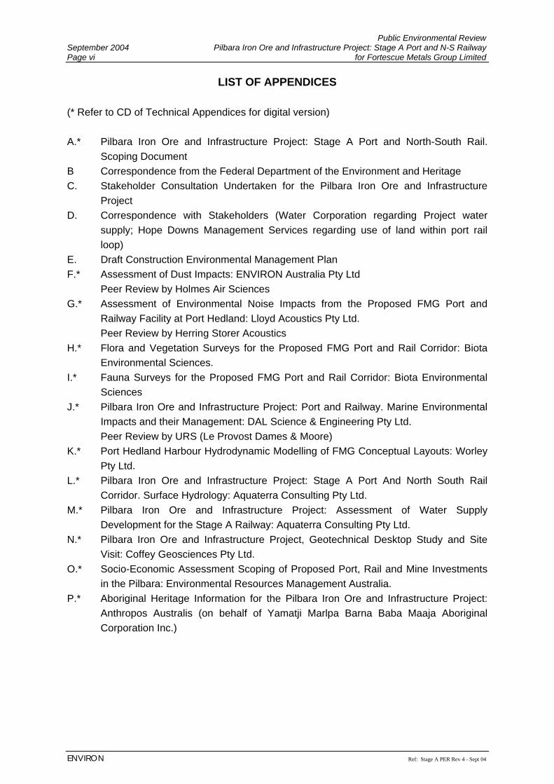
LIST OF APPENDICES (* Refer to CD of Technical Appendices for digital version) A.* Pilbara Iron Ore and Infrastructure Project: Stage A Port and North-South Rail.
Scoping Document B Correspondence from the Federal Department of the Environment and Heritage C. Stakeholder Consultation Undertaken for the Pilbara Iron Ore and Infrastructure
Project D. Correspondence with Stakeholders (Water Corporation regarding Project water
supply; Hope Downs Management Services regarding use of land within port rail loop)
E. Draft Construction Environmental Management Plan F.* Assessment of Dust Impacts: ENVIRON Australia Pty Ltd Peer Review by Holmes Air Sciences G.* Assessment of Environmental Noise Impacts from the Proposed FMG Port and
Railway Facility at Port Hedland: Lloyd Acoustics Pty Ltd. Peer Review by Herring Storer Acoustics H.* Flora and Vegetation Surveys for the Proposed FMG Port and Rail Corridor: Biota
Environmental Sciences. I.* Fauna Surveys for the Proposed FMG Port and Rail Corridor: Biota Environmental
Sciences J.* Pilbara Iron Ore and Infrastructure Project: Port and Railway. Marine Environmental
Impacts and their Management: DAL Science & Engineering Pty Ltd. Peer Review by URS (Le Provost Dames & Moore) K.* Port Hedland Harbour Hydrodynamic Modelling of FMG Conceptual Layouts: Worley
Pty Ltd. L.* Pilbara Iron Ore and Infrastructure Project: Stage A Port And North South Rail
Corridor. Surface Hydrology: Aquaterra Consulting Pty Ltd. M.* Pilbara Iron Ore and Infrastructure Project: Assessment of Water Supply
Development for the Stage A Railway: Aquaterra Consulting Pty Ltd. N.* Pilbara Iron Ore and Infrastructure Project, Geotechnical Desktop Study and Site
Visit: Coffey Geosciences Pty Ltd. O.* Socio-Economic Assessment Scoping of Proposed Port, Rail and Mine Investments
in the Pilbara: Environmental Resources Management Australia. P.* Aboriginal Heritage Information for the Pilbara Iron Ore and Infrastructure Project:
Anthropos Australis (on behalf of Yamatji Marlpa Barna Baba Maaja Aboriginal Corporation Inc.)
Public Environmental Review Pilbara Iron Ore and Infrastructure Project: Stage A Port and N-S Railway September 2004 for Fortescue Metals Group Limited Page vii
Ref: Stage A PER Rev 4 - Sept 04 ENVIRON
EXECUTIVE SUMMARY Introduction The Fortescue Metals Group Limited (FMG) is proposing to develop the Pilbara Iron Ore and Infrastructure Project in the Pilbara region in the north of Western Australia. This Project will be assessed in stages: Stage A involves the construction and operation of a Port and North-South Railway that FMG will make accessible to third parties; Stage B comprises the development of iron ore mining operations that will utilise the Stage A infrastructure. Future development of satellite orebodies and associated infrastructure will be dealt with at subsequent project stages. The Pilbara Iron Ore and Infrastructure Project Stage A (the Project) incorporates Port facilities at Anderson Point in Port Hedland and a railway stretching south-southeast some 345 km to resources in the East Pilbara at Mindy Mindy. It is proposed to initially transport 45 million tonnes per annum (Mtpa) but the railway will be designed to be capable of transporting 100 Mtpa, to ensure future railway duplication is not required. FMG will make available its railway and port facilities to other users, who also have mineral deposits in the Pilbara, but are currently unable to gain access to existing infrastructure for export of their ore at commercially competitive rates and timeslots. The proposed railway has been located for much of its length in close proximity to the existing BHP Billiton Iron Ore (BHPBIO) railway and the corridor proposed for the Hope Downs project, but does deviate on some occasions where there are significant environmental, heritage or engineering constraints. FMG is pursuing the development of its own port and railway facilities as it has not yet been able to gain access to the existing BHPBIO infrastructure, and the proposed Hope Downs infrastructure may not be constructed and/or not available to FMG to meet FMG’s timing requirements. It is FMG’s expectation that, due to inherent cost and inefficiency issues, only one of the proposed FMG or Hope Downs railways will be constructed. The proposed port facility will be developed on the western side of Port Hedland Harbour at Anderson Point. The twin 750 m shipping berth will allow for two 250,000 DWT vessels to be berthed. One berth will be serviced by a wharf and shiploader whilst the other is a parking berth only. The Project is subject to a formal assessment (set at Public Environmental Review) under Part IV of Western Australian Environmental Protection Act 1986. FMG’s iron ore mining proposals will be assessed separately to allow timely commencement of construction of the infrastructure component.
Public Environmental Review September 2004 Pilbara Iron Ore and Infrastructure Project: Stage A Port and N-S Railway Page viii for Fortescue Metals Group Limited
ENVIRON Ref: Stage A PER Rev 4 - Sept 04
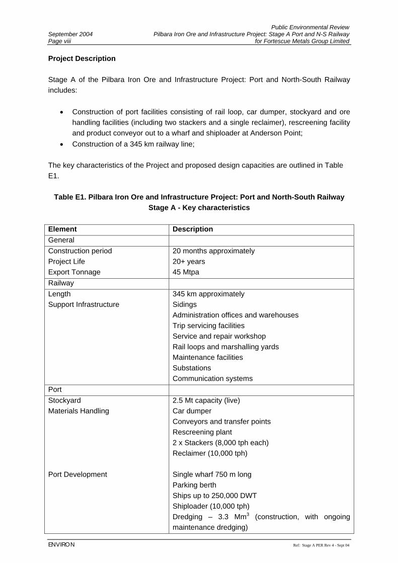
Project Description Stage A of the Pilbara Iron Ore and Infrastructure Project: Port and North-South Railway includes:
• Construction of port facilities consisting of rail loop, car dumper, stockyard and ore handling facilities (including two stackers and a single reclaimer), rescreening facility and product conveyor out to a wharf and shiploader at Anderson Point;
• Construction of a 345 km railway line; The key characteristics of the Project and proposed design capacities are outlined in Table E1.
Table E1. Pilbara Iron Ore and Infrastructure Project: Port and North-South Railway Stage A - Key characteristics
Element Description General Construction period Project Life Export Tonnage
20 months approximately 20+ years 45 Mtpa
Railway Length Support Infrastructure
345 km approximately Sidings Administration offices and warehouses Trip servicing facilities Service and repair workshop Rail loops and marshalling yards Maintenance facilities Substations Communication systems
Port Stockyard Materials Handling Port Development
2.5 Mt capacity (live) Car dumper Conveyors and transfer points Rescreening plant 2 x Stackers (8,000 tph each) Reclaimer (10,000 tph) Single wharf 750 m long Parking berth Ships up to 250,000 DWT Shiploader (10,000 tph) Dredging – 3.3 Mm3 (construction, with ongoing maintenance dredging)
Public Environmental Review Pilbara Iron Ore and Infrastructure Project: Stage A Port and N-S Railway September 2004 for Fortescue Metals Group Limited Page ix
Ref: Stage A PER Rev 4 - Sept 04 ENVIRON
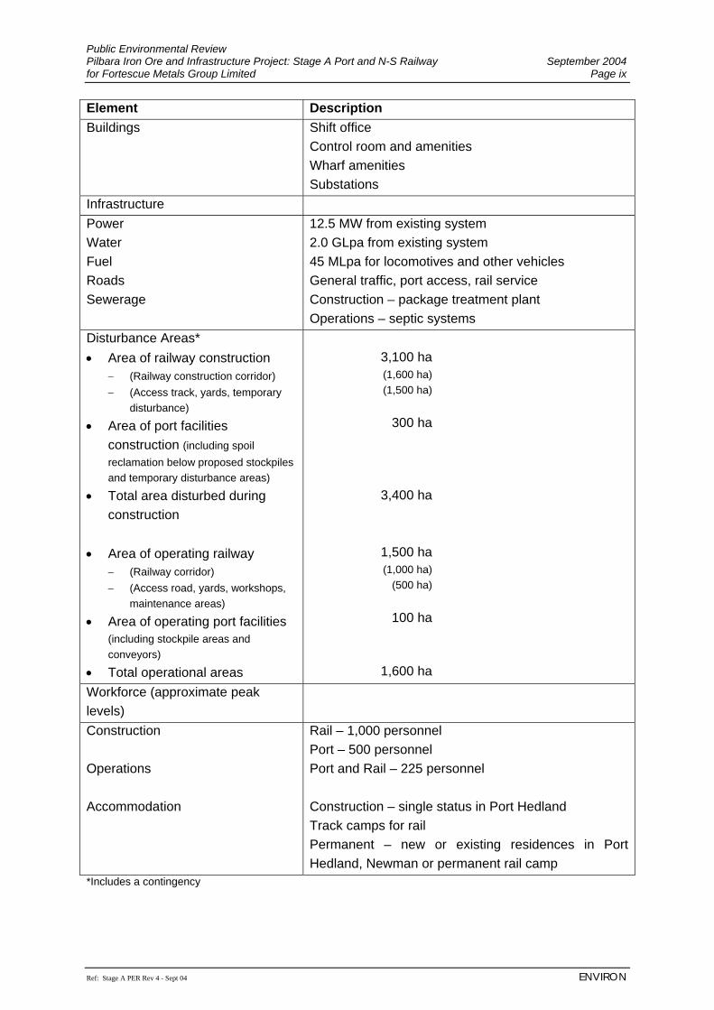
Element Description Buildings
Shift office Control room and amenities Wharf amenities Substations
Infrastructure Power Water Fuel Roads Sewerage
12.5 MW from existing system 2.0 GLpa from existing system 45 MLpa for locomotives and other vehicles General traffic, port access, rail service Construction – package treatment plant Operations – septic systems
Disturbance Areas* • Area of railway construction
− (Railway construction corridor) − (Access track, yards, temporary
disturbance)
• Area of port facilities construction (including spoil reclamation below proposed stockpiles and temporary disturbance areas)
• Total area disturbed during construction
• Area of operating railway
− (Railway corridor) − (Access road, yards, workshops,
maintenance areas)
• Area of operating port facilities (including stockpile areas and conveyors)
• Total operational areas
3,100 ha (1,600 ha) (1,500 ha)
300 ha
3,400 ha
1,500 ha (1,000 ha)
(500 ha)
100 ha
1,600 ha Workforce (approximate peak levels)
Construction Operations Accommodation
Rail – 1,000 personnel Port – 500 personnel Port and Rail – 225 personnel Construction – single status in Port Hedland Track camps for rail Permanent – new or existing residences in Port Hedland, Newman or permanent rail camp
*Includes a contingency
Public Environmental Review September 2004 Pilbara Iron Ore and Infrastructure Project: Stage A Port and N-S Railway Page x for Fortescue Metals Group Limited
ENVIRON Ref: Stage A PER Rev 4 - Sept 04
Existing Environment The Project is located in the Pilbara region which is classified as arid-tropical, with most rain falling during the hot summers. The region is prone to cyclonic activity between November and April and much of the low-lying areas surrounding Port Hedland harbour, including parts of the proposed port location, are within the storm surge zone. The drainage channels in the region are ephemeral, only flowing after heavy rainfall events. The proposed port facilities and railway corridor cross four major physiographic units within the Fortescue District, known as Abydos Plain, Chichester Range, Fortescue Valley and Hamersley Ranges (the Project skirts the eastern-most edge of the Hamersley Ranges within this physiographic unit). The landscape of these units varies from valleys and low stony hills with granite outcrops on the plains to the coast, to rounded hills and ranges through to valleys. The entire FMG port and North-South rail development sits within the Fortescue Botanical District and the vegetation of the Project area is typically open, and frequently dominated by spinifex, wattles and occasional eucalypts. Environmental Issues and Management The key environmental issues associated with the development of the Project are noise, dust, surface drainage, mangroves, vegetation and significant flora species. The full list of environmental factors is outlined in Table E2. Noise The results of the noise modelling undertaken for the proposed FMG port facility indicate that, under worst-case meteorological conditions, the noise levels from the FMG port facility by itself, are predicted to comply with the night-time assigned levels under the Environmental Protection (Noise) Regulations 1997 (the noise regulations) at the most stringent noise sensitive premises in Port Hedland, Wedgefield, South Hedland and White Hills. However, if existing noise levels are already above the assigned noise levels under the noise regulations, as they are at Port Hedland, any additional noise sources being proposed are required to be 5 dB(A) below the assigned noise levels. Taking this into consideration, FMG’s port facilities would exceed the lower assigned noise levels during the night at some locations in Port Hedland, due to existing noise sources. To address this issue, FMG will investigate noise mitigation measures to reduce noise as far as is reasonably practicable and in particular, investigate partial enclosure of the loadout and shiploader conveyors. Assuming a reduction of 7 dB(A) from this plant can be achieved, the predicted noise levels would comply with the noise regulations at all noise sensitive premises. Notwithstanding the above, FMG’s proposed port facilities would not result in an increase in the ambient noise levels currently experienced in Port Hedland. It has been recognised by the
Public Environmental Review Pilbara Iron Ore and Infrastructure Project: Stage A Port and N-S Railway September 2004 for Fortescue Metals Group Limited Page xi
Ref: Stage A PER Rev 4 - Sept 04 ENVIRON
EPA that Port Hedland relies on industry for its long-term sustainability. With this in mind, the EPA has considered in previous assessments that it “may be appropriate for allowable noise levels to be slightly higher in Port Hedland than is normally the case in other areas of the State”. If this were necessary, approval would be sought by FMG through regulation 17 of the noise regulations to vary the assigned noise levels. The night-time noise level from the proposed railway is predicted to range from LAeq (8 hour) 20 dB to 45 dB at noise sensitive premises adjacent to the corridor. When combined with the rail noise levels from the existing railway, it has been determined that the proposed FMG railway complies with the criteria prescribed in the preliminary draft EPA Guidance for Road and Rail Transportation Noise, at all locations except the White Hills rural residential development and two remote farming stations. FMG is constrained in these areas by the existing rail line, proposed Hope Downs rail alignment and topography, such that the proposed alignment represents the most suitable alignment through these areas. To address the issue of train noise, FMG will manage train operations to reduce noise to as low as reasonably practical. However, where it is not practicable to achieve the criteria prescribed in the preliminary draft EPA Guidance for Road and Rail Transportation Noise, FMG will ensure that train noise is below the night-time transportation noise criterion of LAeq (8 hour) 55 dB, which has been used for similar projects in Western Australia, including the Hope Downs, Port Hedland proposed project. FMG will prepare a noise management strategy specific for its port and rail operations and adopt management measures to minimise noise impacts. Noise management measures will be developed in co-operation with other operators in the Port Hedland area. Dust Dust has historically been an issue in the Port Hedland area, and one which impacts on the residents of the town, particularly in the vicinity of ore stockpiles and ore loading and off-loading facilities at the port. Results of the dust modelling undertaken for the Project indicates that the Project will achieve a lower dust emission rate (per tonne of iron ore shipped) compared to established operations and will result in a small increase in the dust levels experienced in Port Hedland townsite. The increase in the Port Hedland townsite will be small because the prevailing wind conditions (westerly and easterlies) will not transport high dust concentrations from the FMG project site towards the townsite. However, increased dust levels are predicted in Wedgefield, due to higher dust concentrations being transported from the port on the prevailing westerly winds that are typically experienced during the summer months. Dust management measures will comprise, but will not be limited to:
Public Environmental Review September 2004 Pilbara Iron Ore and Infrastructure Project: Stage A Port and N-S Railway Page xii for Fortescue Metals Group Limited
ENVIRON Ref: Stage A PER Rev 4 - Sept 04
• A dust extraction system for the car dumping facility will be installed, which will include an induced draught at the dumping point and wet scrubbing;
• Conveyor transfer points will be totally enclosed, with water sprays jets at each loading point to wet the surface of the ore;
• Allowance has been made if necessary for future installation of insertable dry, reverse pulse gas filters at the transfer points in the unlikely event that the use of water sprays proves to be inadequate for dust control;
• Dust emitted from the belt conveyors will be controlled through proper maintenance of belt scrapers to dislodge material sticking to the belt;
• The conveyors from the car dumper to the screening building and out to the shiploader will be covered;
• Stackers will be automated to minimise the drop heights to stockpiles and the stacker booms will be fitted with spray heads to minimise the emissions of dust;
• The stockpile area will be fitted out with a fixed water cannon based spray system to reduce the likelihood of dust from wind erosion; and
• The feasibility of planting a vegetation shelter belt along the western side of the stockpiles will be investigated. Such a shelter belt, if feasible, would reduce the wind speed and therefore reduce wind erosion from the stockpiles and surrounding area.
The Dust Management Plan will be prepared prior to commencement of construction. The Plan will be developed in consultation with the relevant government agencies and key stakeholders in the Port Hedland area. The plan will detail the dust mitigation management measures, including:
• Integrated ore moisture monitoring and management system maintaining ore moisture through the use of sprays and water cannons. It is proposed that the Bureau of Meteorology weather forecasts for Port Hedland will be obtained on a regular basis (at least daily) to help optimise the effectiveness of water sprays by applying these before forecast strong winds occur;
• Regularly checking on the operation of the dust control equipment and ensuring that the required maintenance and repairs are conducted in a timely manner;
• Use of water carts on high traffic areas (roads, dredge deposition areas and laydown areas) during construction;
• Use of a real time continuous dust monitoring network to provide real time feedback on the effectiveness of the dust control measures;
• Sealing of Port operational areas, where practicable; • Optimise vehicle movements; • Minimise vegetation clearing; • Progressively rehabilitate disturbed areas to minimise potential for dust generation;
and • Undertake visual inspections of port construction areas to ensure dust control
management measures are implemented and remain effective.
Public Environmental Review Pilbara Iron Ore and Infrastructure Project: Stage A Port and N-S Railway September 2004 for Fortescue Metals Group Limited Page xiii
Ref: Stage A PER Rev 4 - Sept 04 ENVIRON
Surface Drainage Construction of the port will require the disturbance of approximately 300 ha of mostly mudflats; however the Project has been designed and located to not significantly alter or restrict the flow of surface waters in the area. The proposed port facilities will require the disposal of dredge spoil at Anderson Point, which will block some existing minor mudflat channels. However, as these channels are minor and the flow areas available for surface water drainage into the creeks essentially remain unaltered, existing surface water flood levels in South Creek and South West Creek will not be impacted by construction of the dredge spoil areas. To minimise the impact on surface drainage and tidal flushing the following measures will be implemented:
• design of the footprint of dredge spoil areas to minimise clearing and hydraulic impacts;
• extensive use of culverts and trestles to allow unimpeded movement of water, where required; and
• suitable design and construction of offshore structures. The construction of the railway over 345 km has potential to interrupt surface water drainage features that naturally occur along the corridor. These natural drainage features include major rivers and their tributaries, creeks, floodplains, sheet flow areas, marshes and springs. The railway alignment crosses several major rivers and their floodplains in the Turner River, Yule River and Upper Fortescue River Catchments. Bridges will be constructed over the larger channels, while smaller channels and sheetflow areas with dependent downstream vegetation will be maintained with culverts. Bridges and culverts will generally be aligned perpendicular to major channels and any adverse impact on water flow will be managed through the provision of guide banks, hydraulically streamline flow areas, and riprap or similar scour protection blankets. Mangroves The proposed development would result in the clearing of approximately 22 ha of core mangal closed canopy associations (approximately 2% of the current core mangal habitat within Port Hedland Harbour; Paling et al., 2003), in addition to a further 87 ha of open mudflat with scattered samphires and occasional low Avicennia marina (the more open form of this single association of Paling et al., 2003). The total clearing would amount to approximately 10% of the harbour’s current mangrove assemblage cover; a similar impact to that presented by the proposed Hope Downs port site (HDMS, 2002). Most of this clearing (80%), however, impacts on a very low mangrove cover unit at the top end of the tidal range.
Public Environmental Review September 2004 Pilbara Iron Ore and Infrastructure Project: Stage A Port and N-S Railway Page xiv for Fortescue Metals Group Limited
ENVIRON Ref: Stage A PER Rev 4 - Sept 04
The Project has been designed to minimise impact on the mangroves through the placement of facilities, use of culverts and other structures to maintain tidal flows and adequate flushing of mangroves. This has included significant re-design of the reclamation area, to pull it back out of the core mangrove area, and ensure it has an irregular shape, which avoids tidal creek areas as far as possible (as described in Section 2.3.2, Evaluation of Alternatives). Whilst the loss of mangroves has been minimised by this re-design, FMG also commits to implementing a suitable off-set package relating to mangal in the locality. Two EPA Guidance Statements are relevant to the assessment of impacts on mangroves in Port Hedland Harbour:
1. Guidance Statement for the protection of tropical arid zone mangroves along the Pilbara coastline (EPA Guidance Statement No. 1, May 2001).
2. Benthic Primary Producer Habitat Protection for Western Australia’s Marine
Environment (EPA Guidance Statement No. 29, June 2004) Port Hedland harbour is not specifically identified as a conservation area in the EPA’s “Guidance Statement for the protection of tropical arid zone mangroves along the Pilbara coastline” (EPA, 2001). With regard to the “Benthic Primary Producer Habitat Protection for Western Australia’s Marine Environment” Guidance Statement, three scales of management unit have been considered to place the impacts of the FMG proposal on mangrove BPPH in several different contexts as follows:
• Port Hedland harbour: The inner Port Hedland harbour • Hedland port limits: From 6 km west of Oyster Inlet (W) to 6 km east of Six Mile
Creek (E) • Geomorphic unit: From 6 km west of Oyster Inlet (W) to Ridley Creek (E)
Vegetation, Flora and Fauna The Project area supports a wide range of vegetation types and flora species: 122 vegetation types and a total of 762 taxa of terrestrial vascular flora from 218 genera belonging to 69 families have been recorded. No Declared Rare Flora species were recorded during field surveys for the Project and none would be expected to occur in the habitats present along the proposed rail corridor. There are thus no flora species of significance known from the corridor that are listed under the Environment Protection and Biodiversity Conservation (EPBC) Act 1999. Sixteen Priority flora were recorded during the survey of the FMG rail corridor, and a further five species have been previously recorded within the area during other surveys. These include:
Public Environmental Review Pilbara Iron Ore and Infrastructure Project: Stage A Port and N-S Railway September 2004 for Fortescue Metals Group Limited Page xv
Ref: Stage A PER Rev 4 - Sept 04 ENVIRON
• Priority 1 species: Eremophila spongiocarpa ms., Goodenia omearana ms, and Josephinia ?sp. Marandoo (M.E. Trudgen 1554);
• Priority 2 species: Euphorbia clementii, Gonocarpus ephemerus, Indigofera ixocarpa, Ischaemum albovillosum, Olearia fluvialis, Paspalidium retiglume, Stylidium weeliwolli;
• Priority 3 species: Abutilon trudgenii ms., Bulbostylis burbidgeae, Eriachne tenuiculmis, Goodenia nuda, Gymnanthera cunninghamii, Hibiscus brachysiphonius, Phyllanthus aridus, Polymeria sp. Hamersley (M.E. Trudgen 11353), Sida sp. Wittenoom (W.R. Barker 1962) and Themeda sp. Hamersley Station (ME Trudgen 11,431); and
• Priority 4 species: Goodenia stellata. Vegetation clearing will be required for a construction corridor of generally less than 40 m wide, access track, yards and temporary disturbance areas such as borrow pits, laydown areas, water bores, dams and construction camps. Cut and fill will be required where the proposed rail corridor traverses ridges and valleys, which would extend the limit of clearing beyond the immediate vicinity of the rail line. Where practicable existing borrow pits will be used and areas of temporary disturbance will be located in already disturbed areas. However, this may not be practicable in all cases and therefore the total estimated area of disturbance (3,100 ha) includes a contingency factor, although it is expected that the actual area of disturbance will be less. Areas not required during operations will be rehabilitated (Section 7.2.7.2). The position of priority flora populations and individuals will be taken into account during the final design of the railway. If complete avoidance is not possible prior approval will be sought from the Department of Conservation and Land Management. Two species of Schedule fauna and four Priority listed species were recorded from the FMG rail corridor during the survey. A further three Schedule species and five Priority species were not recorded during the survey, but either have been during surveys for the Hope Downs project or are considered likely to occur in the area. These threatened fauna species are: Species State Level Federal Level Mulgara Dasycercus cristicaudaƒ† Schedule 1 Vulnerable Bilby Macrotis lagotis† Schedule 1 Vulnerable Pilbara Olive Python Liasis olivaceus barroni*† Schedule 1 Vulnerable Woma Aspidites ramsayi† Schedule 4 - Peregrine Falcon Falco peregrinusƒ† Schedule 4 - Ramphotyphlops ganei† Priority 1 - Spectacled Hare-wallaby Lagorchestes conspicillatus Priority 3 - Ghost Bat Macroderma gigas† Priority 4 - Short-tailed Mouse Leggadina lakedownensisƒ† Priority 4 - Grey Falcon Falco hypoleucos Priority 4 - Bush Stone-curlew Burhinus grallarius† Priority 4 - Australian Bustard Ardeotis australisƒ† Priority 4 - Western Pebble-mound Mouse Pseudomys chapmani† Priority 4 - Star Finch Neochmia ruficauda subclarescens† Priority 4 - ƒ Recorded during the FMG survey
Public Environmental Review September 2004 Pilbara Iron Ore and Infrastructure Project: Stage A Port and N-S Railway Page xvi for Fortescue Metals Group Limited
ENVIRON Ref: Stage A PER Rev 4 - Sept 04
* Recorded previously from the Hope Downs Minesite † Recorded on the previously assessed rail corridor
Three species recorded during the survey; Diplodactylus mitchelli (Pilbara form); Ctenotus affin. robustus (a skink); and Ctenotus affin. uber johnstonei (a skink) are considered to be otherwise significant at the scale of the Pilbara bioregion. None of the habitat types along the FMG rail corridor appear to be unique or significant at the bioregion scale, with the exception of the Fortescue Marshes, which is well recognised as a regionally significant wetland. The proposed rail corridor however only intersects the western margin of this extensive area. Several other habitat types are significant on a local scale and support either apparently restricted suites of species or individual species which are, or may be of regional significance. Conclusion The proposed Project has been designed to minimise the environmental impacts associated with the construction and operation of the port and rail facilities. FMG will make available its railway and port facilities to other users, who also have mineral deposits in the Pilbara region, therefore reducing the need for duplication and further environmental impact. FMG is considerate of the current noise and dust emissions issues at Port Hedland and has undertaken to design, construct and operate the Project to minimise these impacts. Additionally, FMG will work with government agencies and stakeholders to address cumulative impacts in the Port Hedland area, and achieve improved environmental standards wherever practicable. FMG has made a number of formal commitments with respect to this Project to demonstrate its commitment to constructing and operating in an environmentally responsible manner. The formal commitments will be implemented to the satisfaction of the Environmental Protection Authority.
Public Environmental Review Pilbara Iron Ore and Infrastructure Project: Stage A Port and N-S Railway September 2004 for Fortescue Metals Group Limited Page xvii
Ref: Stage A PER Rev 4 - Sept 04 ENVIRON
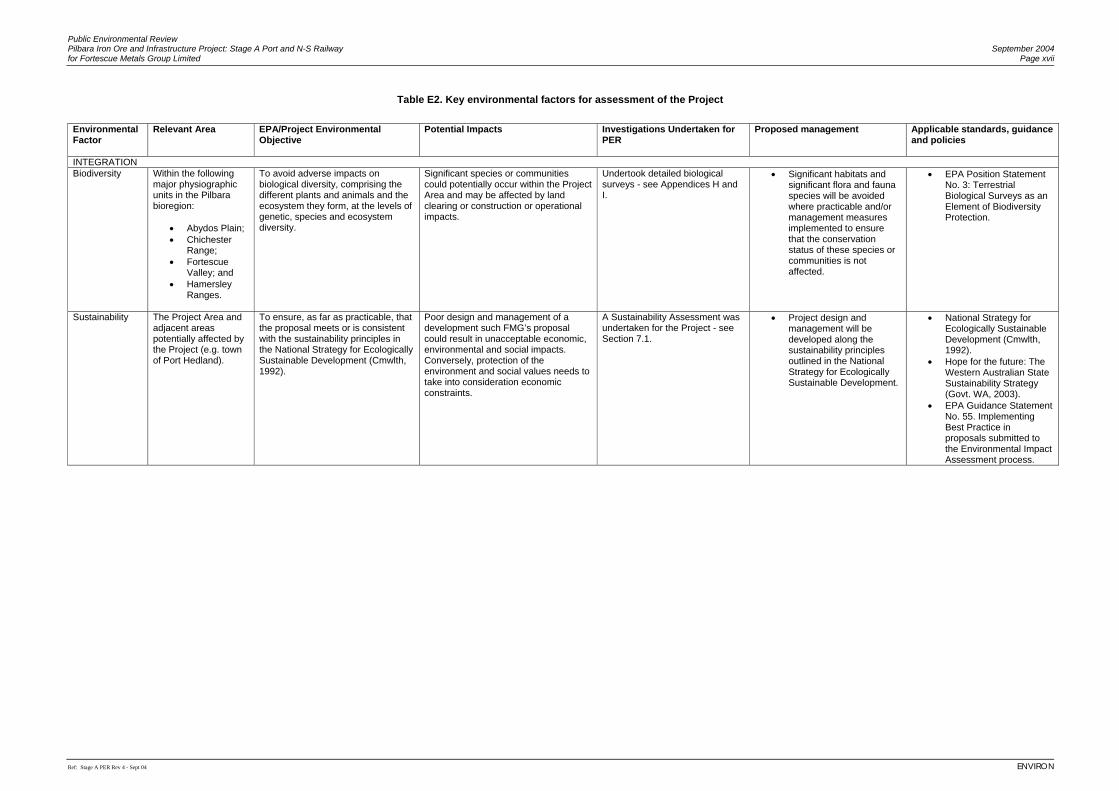
Table E2. Key environmental factors for assessment of the Project
Environmental Factor
Relevant Area EPA/Project Environmental Objective
Potential Impacts
Investigations Undertaken for PER
Proposed management Applicable standards, guidance and policies
INTEGRATION Biodiversity Within the following
major physiographic units in the Pilbara bioregion:
• Abydos Plain; • Chichester
Range; • Fortescue
Valley; and • Hamersley
Ranges.
To avoid adverse impacts on biological diversity, comprising the different plants and animals and the ecosystem they form, at the levels of genetic, species and ecosystem diversity.
Significant species or communities could potentially occur within the Project Area and may be affected by land clearing or construction or operational impacts.
Undertook detailed biological surveys - see Appendices H and I.
• Significant habitats and significant flora and fauna species will be avoided where practicable and/or management measures implemented to ensure that the conservation status of these species or communities is not affected.
• EPA Position Statement No. 3: Terrestrial Biological Surveys as an Element of Biodiversity Protection.
Sustainability The Project Area and adjacent areas potentially affected by the Project (e.g. town of Port Hedland).
To ensure, as far as practicable, that the proposal meets or is consistent with the sustainability principles in the National Strategy for Ecologically Sustainable Development (Cmwlth, 1992).
Poor design and management of a development such FMG’s proposal could result in unacceptable economic, environmental and social impacts. Conversely, protection of the environment and social values needs to take into consideration economic constraints.
A Sustainability Assessment was undertaken for the Project - see Section 7.1.
• Project design and management will be developed along the sustainability principles outlined in the National Strategy for Ecologically Sustainable Development.
• National Strategy for Ecologically Sustainable Development (Cmwlth, 1992).
• Hope for the future: The Western Australian State Sustainability Strategy (Govt. WA, 2003).
• EPA Guidance Statement No. 55. Implementing Best Practice in proposals submitted to the Environmental Impact Assessment process.
Public Environmental Review Pilbara Iron Ore and Infrastructure Project: Stage A Port and N-S Railway September 2004 for Fortescue Metals Group Limited Page xviii
Ref: Stage A PER Rev 4 - Sept 04 ENVIRON
Environmental Factor
Relevant Area EPA/Project Environmental Objective
Potential Impacts
Investigations Undertaken for PER
Proposed management Applicable standards, guidance and policies
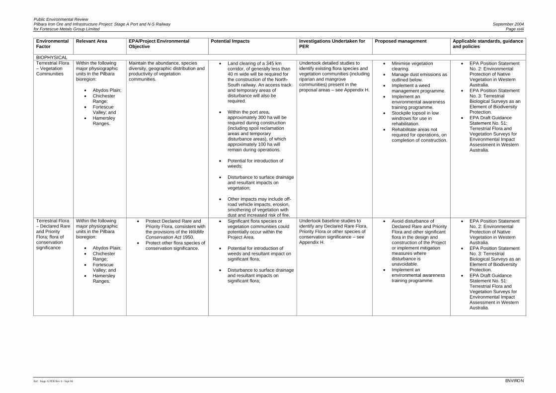
BIOPHYSICAL Terrestrial Flora – Vegetation Communities
Within the following major physiographic units in the Pilbara bioregion:
• Abydos Plain; • Chichester
Range; • Fortescue
Valley; and • Hamersley
Ranges.
Maintain the abundance, species diversity, geographic distribution and productivity of vegetation communities.
• Land clearing of a 345 km corridor, of generally less than 40 m wide will be required for the construction of the North-South railway. An access track and temporary areas of disturbance will also be required.
• Within the port area,
approximately 300 ha will be required during construction (including spoil reclamation areas and temporary disturbance areas), of which approximately 100 ha will remain during operations.
• Potential for introduction of
weeds;
• Disturbance to surface drainage and resultant impacts on vegetation;
• Other impacts may include off-
road vehicle impacts, erosion, smothering of vegetation with dust and increased risk of fire.
Undertook detailed studies to identify existing flora species and vegetation communities (including riparian and mangrove communities) present in the proposal areas – see Appendix H.
• Minimise vegetation clearing.
• Manage dust emissions as outlined below.
• Implement a weed management programme.
• Implement an environmental awareness training programme.
• Stockpile topsoil in low windrows for use in rehabilitation.
• Rehabilitate areas not required for operations, on completion of construction.
• EPA Position Statement No. 2: Environmental Protection of Native Vegetation in Western Australia.
• EPA Position Statement No. 3: Terrestrial Biological Surveys as an Element of Biodiversity Protection.
• EPA Draft Guidance Statement No. 51: Terrestrial Flora and Vegetation Surveys for Environmental Impact Assessment in Western Australia.
Terrestrial Flora – Declared Rare and Priority Flora; flora of conservation significance
Within the following major physiographic units in the Pilbara bioregion:
• Abydos Plain; • Chichester
Range; • Fortescue
Valley; and • Hamersley
Ranges.
• Protect Declared Rare and Priority Flora, consistent with the provisions of the Wildlife Conservation Act 1950.
• Protect other flora species of conservation significance.
• Significant flora species or vegetation communities could potentially occur within the Project Area.
• Potential for introduction of
weeds and resultant impact on significant flora;
• Disturbance to surface drainage
and resultant impacts on significant flora;
Undertook baseline studies to identify any Declared Rare Flora, Priority Flora or other species of conservation significance – see Appendix H.
• Avoid disturbance of Declared Rare and Priority Flora and other significant flora in the design and construction of the Project or implement mitigation measures where disturbance is unavoidable.
• Implement an environmental awareness training programme.
• EPA Position Statement No. 2: Environmental Protection of Native Vegetation in Western Australia.
• EPA Position Statement No. 3: Terrestrial Biological Surveys as an Element of Biodiversity Protection.
• EPA Draft Guidance Statement No. 51: Terrestrial Flora and Vegetation Surveys for Environmental Impact Assessment in Western Australia.
Public Environmental Review Pilbara Iron Ore and Infrastructure Project: Stage A Port and N-S Railway September 2004 for Fortescue Metals Group Limited Page xix
Ref: Stage A PER Rev 4 - Sept 04 ENVIRON
Environmental Factor
Relevant Area EPA/Project Environmental Objective
Potential Impacts
Investigations Undertaken for PER
Proposed management Applicable standards, guidance and policies
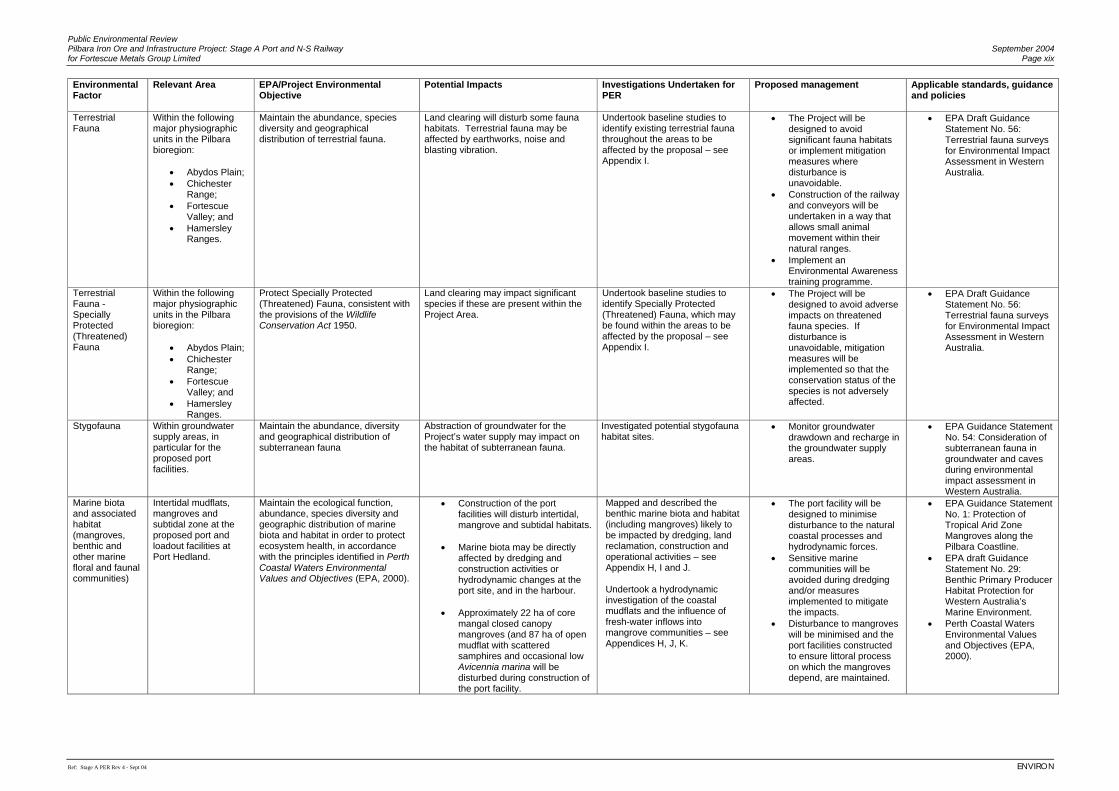
Terrestrial Fauna
Within the following major physiographic units in the Pilbara bioregion:
• Abydos Plain; • Chichester
Range; • Fortescue
Valley; and • Hamersley
Ranges.
Maintain the abundance, species diversity and geographical distribution of terrestrial fauna.
Land clearing will disturb some fauna habitats. Terrestrial fauna may be affected by earthworks, noise and blasting vibration.
Undertook baseline studies to identify existing terrestrial fauna throughout the areas to be affected by the proposal – see Appendix I.
• The Project will be designed to avoid significant fauna habitats or implement mitigation measures where disturbance is unavoidable.
• Construction of the railway and conveyors will be undertaken in a way that allows small animal movement within their natural ranges.
• Implement an Environmental Awareness training programme.
• EPA Draft Guidance Statement No. 56: Terrestrial fauna surveys for Environmental Impact Assessment in Western Australia.
Terrestrial Fauna - Specially Protected (Threatened) Fauna
Within the following major physiographic units in the Pilbara bioregion:
• Abydos Plain; • Chichester
Range; • Fortescue
Valley; and • Hamersley
Ranges.
Protect Specially Protected (Threatened) Fauna, consistent with the provisions of the Wildlife Conservation Act 1950.
Land clearing may impact significant species if these are present within the Project Area.
Undertook baseline studies to identify Specially Protected (Threatened) Fauna, which may be found within the areas to be affected by the proposal – see Appendix I.
• The Project will be designed to avoid adverse impacts on threatened fauna species. If disturbance is unavoidable, mitigation measures will be implemented so that the conservation status of the species is not adversely affected.
• EPA Draft Guidance Statement No. 56: Terrestrial fauna surveys for Environmental Impact Assessment in Western Australia.
Stygofauna Within groundwater supply areas, in particular for the proposed port facilities.
Maintain the abundance, diversity and geographical distribution of subterranean fauna
Abstraction of groundwater for the Project’s water supply may impact on the habitat of subterranean fauna.
Investigated potential stygofauna habitat sites.
• Monitor groundwater drawdown and recharge in the groundwater supply areas.
• EPA Guidance Statement No. 54: Consideration of subterranean fauna in groundwater and caves during environmental impact assessment in Western Australia.
Marine biota and associated habitat (mangroves, benthic and other marine floral and faunal communities)
Intertidal mudflats, mangroves and subtidal zone at the proposed port and loadout facilities at Port Hedland.
Maintain the ecological function, abundance, species diversity and geographic distribution of marine biota and habitat in order to protect ecosystem health, in accordance with the principles identified in Perth Coastal Waters Environmental Values and Objectives (EPA, 2000).
• Construction of the port facilities will disturb intertidal, mangrove and subtidal habitats.
• Marine biota may be directly
affected by dredging and construction activities or hydrodynamic changes at the port site, and in the harbour.
• Approximately 22 ha of core
mangal closed canopy mangroves (and 87 ha of open mudflat with scattered samphires and occasional low Avicennia marina will be disturbed during construction of the port facility.
Mapped and described the benthic marine biota and habitat (including mangroves) likely to be impacted by dredging, land reclamation, construction and operational activities – see Appendix H, I and J. Undertook a hydrodynamic investigation of the coastal mudflats and the influence of fresh-water inflows into mangrove communities – see Appendices H, J, K.
• The port facility will be designed to minimise disturbance to the natural coastal processes and hydrodynamic forces.
• Sensitive marine communities will be avoided during dredging and/or measures implemented to mitigate the impacts.
• Disturbance to mangroves will be minimised and the port facilities constructed to ensure littoral process on which the mangroves depend, are maintained.
• EPA Guidance Statement No. 1: Protection of Tropical Arid Zone Mangroves along the Pilbara Coastline.
• EPA draft Guidance Statement No. 29: Benthic Primary Producer Habitat Protection for Western Australia’s Marine Environment.
• Perth Coastal Waters Environmental Values and Objectives (EPA, 2000).
Public Environmental Review Pilbara Iron Ore and Infrastructure Project: Stage A Port and N-S Railway September 2004 for Fortescue Metals Group Limited Page xx
Ref: Stage A PER Rev 4 - Sept 04 ENVIRON
Environmental Factor
Relevant Area EPA/Project Environmental Objective
Potential Impacts
Investigations Undertaken for PER
Proposed management Applicable standards, guidance and policies
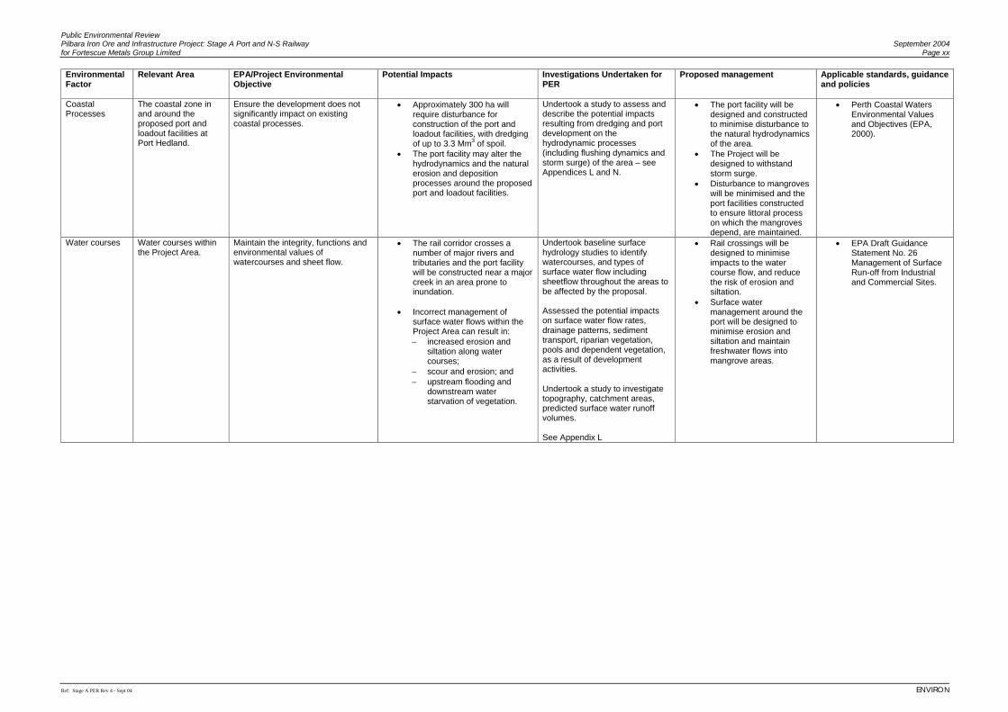
Coastal Processes
The coastal zone in and around the proposed port and loadout facilities at Port Hedland.
Ensure the development does not significantly impact on existing coastal processes.
• Approximately 300 ha will require disturbance for construction of the port and loadout facilities, with dredging of up to 3.3 Mm3 of spoil.
• The port facility may alter the hydrodynamics and the natural erosion and deposition processes around the proposed port and loadout facilities.
Undertook a study to assess and describe the potential impacts resulting from dredging and port development on the hydrodynamic processes (including flushing dynamics and storm surge) of the area – see Appendices L and N.
• The port facility will be designed and constructed to minimise disturbance to the natural hydrodynamics of the area.
• The Project will be designed to withstand storm surge.
• Disturbance to mangroves will be minimised and the port facilities constructed to ensure littoral process on which the mangroves depend, are maintained.
• Perth Coastal Waters Environmental Values and Objectives (EPA, 2000).
Water courses Water courses within the Project Area.
Maintain the integrity, functions and environmental values of watercourses and sheet flow.
• The rail corridor crosses a number of major rivers and tributaries and the port facility will be constructed near a major creek in an area prone to inundation.
• Incorrect management of
surface water flows within the Project Area can result in: − increased erosion and
siltation along water courses;
− scour and erosion; and − upstream flooding and
downstream water starvation of vegetation.
Undertook baseline surface hydrology studies to identify watercourses, and types of surface water flow including sheetflow throughout the areas to be affected by the proposal. Assessed the potential impacts on surface water flow rates, drainage patterns, sediment transport, riparian vegetation, pools and dependent vegetation, as a result of development activities. Undertook a study to investigate topography, catchment areas, predicted surface water runoff volumes. See Appendix L
• Rail crossings will be designed to minimise impacts to the water course flow, and reduce the risk of erosion and siltation.
• Surface water management around the port will be designed to minimise erosion and siltation and maintain freshwater flows into mangrove areas.
• EPA Draft Guidance Statement No. 26 Management of Surface Run-off from Industrial and Commercial Sites.
Public Environmental Review Pilbara Iron Ore and Infrastructure Project: Stage A Port and N-S Railway September 2004 for Fortescue Metals Group Limited Page xxi
Ref: Stage A PER Rev 4 - Sept 04 ENVIRON
Environmental Factor
Relevant Area EPA/Project Environmental Objective
Potential Impacts
Investigations Undertaken for PER
Proposed management Applicable standards, guidance and policies
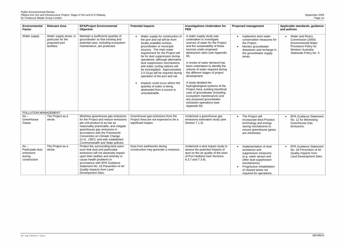
Water supply
Water supply areas, in particular for the proposed port facilities.
Maintain a (sufficient) quantity of groundwater so that existing and potential uses, including ecosystem maintenance, are protected.
• Water supply for construction of the port and rail will be from locally available surface, groundwater or municipal sources. The main water requirement for the Project will be for dust suppression during operations, although alternative dust suppression mechanisms and water cycling options will be investigated. Approximately 2.0 GLpa will be required during operation of the port and rail.
• Impacts could occur where the
quantity of water is being abstracted from a source is unsustainable.
A water supply study was undertaken to investigate sources of water for the Project, and the sustainability of these sources under proposed abstraction rates (see Appendix M). A review of water demand has been undertaken to identify the volume of water required during the different stages of project development. A study detailed the hydrogeological systems of the Project Area, existing beneficial uses of groundwater (including ecosystem maintenance) and any proposed groundwater extraction operations (see Appendix M).
• Implement strict water conservation measures for the Project.
• Monitor groundwater drawdown and recharge in the groundwater supply areas.
• Water and Rivers Commission (2000). Environmental Water Provisions Policy for Western Australia: Statewide Policy No. 5
POLLUTION MANAGEMENT Air – Greenhouse Gases
The Project as a whole.
Minimise greenhouse gas emissions for the Project and reduce emissions per unit product to as low as reasonably practicable, and mitigate greenhouse gas emissions in accordance with the Framework Convention on Climate Change (U.N., 1997), and with established Commonwealth and State policies.
Greenhouse gas emissions from the Project Area are not expected to be a significant impact.
Undertook a greenhouse gas emissions estimation study (see Section 7.1.3).
• The Project will incorporate Best Practice technology and energy saving mechanisms to ensure greenhouse gases are minimised.
• EPA Guidance Statement No. 12 for Minimising Greenhouse Gas Emissions.
Air – Particulate dust emissions during construction
The Project as a whole.
Protect the surrounding land users such that dust and particulate emissions will not adversely impact upon their welfare and amenity or cause health problems in accordance with EPA Guidance Statement No. 18 Prevention of Air Quality Impacts from Land Development Sites.
Dust from earthworks during construction may generate a nuisance.
Undertook a dust impact study to assess the potential impacts of dust on the air quality of the town of Port Hedland (see Sections 6.3.7 and 7.3.9).
• Implementation of dust avoidance and suppression measures (e.g. water sprays and other dust suppression mechanisms).
• Progressive rehabilitation of cleared areas not required for operations.
• EPA Guidance Statement No. 18 Prevention of Air Quality Impacts from Land Development Sites.
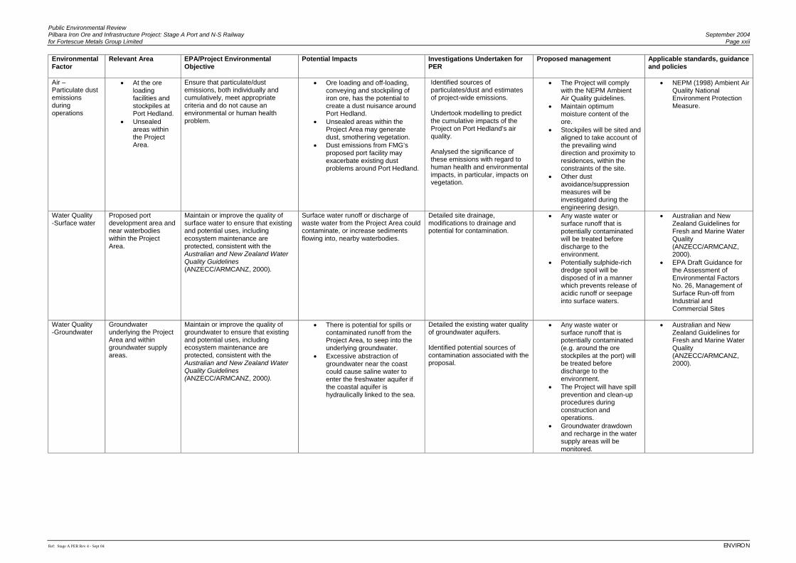
Public Environmental Review Pilbara Iron Ore and Infrastructure Project: Stage A Port and N-S Railway September 2004 for Fortescue Metals Group Limited Page xxii
Ref: Stage A PER Rev 4 - Sept 04 ENVIRON
Environmental Factor
Relevant Area EPA/Project Environmental Objective
Potential Impacts
Investigations Undertaken for PER
Proposed management Applicable standards, guidance and policies
Air – Particulate dust emissions during operations
• At the ore loading facilities and stockpiles at Port Hedland.
• Unsealed areas within the Project Area.
Ensure that particulate/dust emissions, both individually and cumulatively, meet appropriate criteria and do not cause an environmental or human health problem.
• Ore loading and off-loading, conveying and stockpiling of iron ore, has the potential to create a dust nuisance around Port Hedland.
• Unsealed areas within the Project Area may generate dust, smothering vegetation.
• Dust emissions from FMG’s proposed port facility may exacerbate existing dust problems around Port Hedland.
Identified sources of particulates/dust and estimates of project-wide emissions. Undertook modelling to predict the cumulative impacts of the Project on Port Hedland’s air quality. Analysed the significance of these emissions with regard to human health and environmental impacts, in particular, impacts on vegetation.
• The Project will comply with the NEPM Ambient Air Quality guidelines.
• Maintain optimum moisture content of the ore.
• Stockpiles will be sited and aligned to take account of the prevailing wind direction and proximity to residences, within the constraints of the site.
• Other dust avoidance/suppression measures will be investigated during the engineering design.
• NEPM (1998) Ambient Air Quality National Environment Protection Measure.
Water Quality -Surface water
Proposed port development area and near waterbodies within the Project Area.
Maintain or improve the quality of surface water to ensure that existing and potential uses, including ecosystem maintenance are protected, consistent with the Australian and New Zealand Water Quality Guidelines (ANZECC/ARMCANZ, 2000).
Surface water runoff or discharge of waste water from the Project Area could contaminate, or increase sediments flowing into, nearby waterbodies.
Detailed site drainage, modifications to drainage and potential for contamination.
• Any waste water or surface runoff that is potentially contaminated will be treated before discharge to the environment.
• Potentially sulphide-rich dredge spoil will be disposed of in a manner which prevents release of acidic runoff or seepage into surface waters.
• Australian and New Zealand Guidelines for Fresh and Marine Water Quality (ANZECC/ARMCANZ, 2000).
• EPA Draft Guidance for the Assessment of Environmental Factors No. 26, Management of Surface Run-off from Industrial and Commercial Sites
Water Quality -Groundwater
Groundwater underlying the Project Area and within groundwater supply areas.
Maintain or improve the quality of groundwater to ensure that existing and potential uses, including ecosystem maintenance are protected, consistent with the Australian and New Zealand Water Quality Guidelines (ANZECC/ARMCANZ, 2000).
• There is potential for spills or contaminated runoff from the Project Area, to seep into the underlying groundwater.
• Excessive abstraction of groundwater near the coast could cause saline water to enter the freshwater aquifer if the coastal aquifer is hydraulically linked to the sea.
Detailed the existing water quality of groundwater aquifers. Identified potential sources of contamination associated with the proposal.
• Any waste water or surface runoff that is potentially contaminated (e.g. around the ore stockpiles at the port) will be treated before discharge to the environment.
• The Project will have spill prevention and clean-up procedures during construction and operations.
• Groundwater drawdown and recharge in the water supply areas will be monitored.
• Australian and New Zealand Guidelines for Fresh and Marine Water Quality (ANZECC/ARMCANZ, 2000).
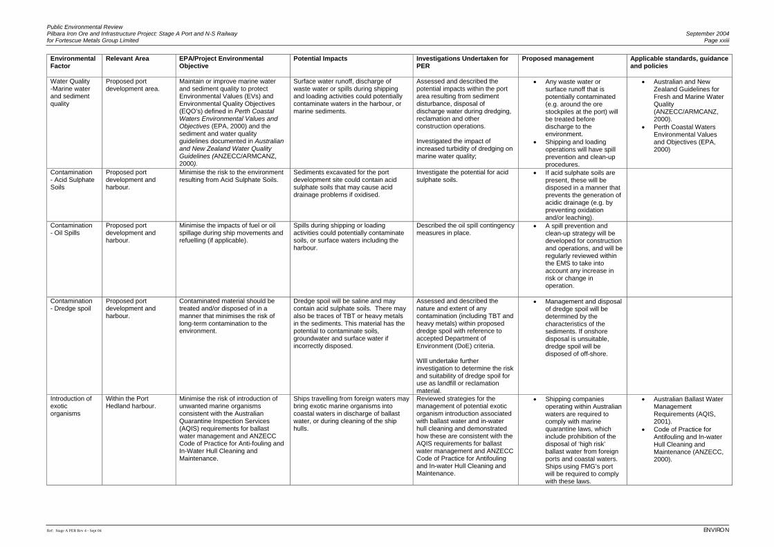
Public Environmental Review Pilbara Iron Ore and Infrastructure Project: Stage A Port and N-S Railway September 2004 for Fortescue Metals Group Limited Page xxiii
Ref: Stage A PER Rev 4 - Sept 04 ENVIRON
Environmental Factor
Relevant Area EPA/Project Environmental Objective
Potential Impacts
Investigations Undertaken for PER
Proposed management Applicable standards, guidance and policies
Water Quality -Marine water and sediment quality
Proposed port development area.
Maintain or improve marine water and sediment quality to protect Environmental Values (EVs) and Environmental Quality Objectives (EQO’s) defined in Perth Coastal Waters Environmental Values and Objectives (EPA, 2000) and the sediment and water quality guidelines documented in Australian and New Zealand Water Quality Guidelines (ANZECC/ARMCANZ, 2000).
Surface water runoff, discharge of waste water or spills during shipping and loading activities could potentially contaminate waters in the harbour, or marine sediments.
Assessed and described the potential impacts within the port area resulting from sediment disturbance, disposal of discharge water during dredging, reclamation and other construction operations. Investigated the impact of increased turbidity of dredging on marine water quality;
• Any waste water or surface runoff that is potentially contaminated (e.g. around the ore stockpiles at the port) will be treated before discharge to the environment.
• Shipping and loading operations will have spill prevention and clean-up procedures.
• Australian and New Zealand Guidelines for Fresh and Marine Water Quality (ANZECC/ARMCANZ, 2000).
• Perth Coastal Waters Environmental Values and Objectives (EPA, 2000)
Contamination - Acid Sulphate Soils
Proposed port development and harbour.
Minimise the risk to the environment resulting from Acid Sulphate Soils.
Sediments excavated for the port development site could contain acid sulphate soils that may cause acid drainage problems if oxidised.
Investigate the potential for acid sulphate soils.
• If acid sulphate soils are present, these will be disposed in a manner that prevents the generation of acidic drainage (e.g. by preventing oxidation and/or leaching).
Contamination - Oil Spills
Proposed port development and harbour.
Minimise the impacts of fuel or oil spillage during ship movements and refuelling (if applicable).
Spills during shipping or loading activities could potentially contaminate soils, or surface waters including the harbour.
Described the oil spill contingency measures in place.
• A spill prevention and clean-up strategy will be developed for construction and operations, and will be regularly reviewed within the EMS to take into account any increase in risk or change in operation.
Contamination - Dredge spoil
Proposed port development and harbour.
Contaminated material should be treated and/or disposed of in a manner that minimises the risk of long-term contamination to the environment.
Dredge spoil will be saline and may contain acid sulphate soils. There may also be traces of TBT or heavy metals in the sediments. This material has the potential to contaminate soils, groundwater and surface water if incorrectly disposed.
Assessed and described the nature and extent of any contamination (including TBT and heavy metals) within proposed dredge spoil with reference to accepted Department of Environment (DoE) criteria. WIll undertake further investigation to determine the risk and suitability of dredge spoil for use as landfill or reclamation material.
• Management and disposal of dredge spoil will be determined by the characteristics of the sediments. If onshore disposal is unsuitable, dredge spoil will be disposed of off-shore.
Introduction of exotic organisms
Within the Port Hedland harbour.
Minimise the risk of introduction of unwanted marine organisms consistent with the Australian Quarantine Inspection Services (AQIS) requirements for ballast water management and ANZECC Code of Practice for Anti-fouling and In-Water Hull Cleaning and Maintenance.
Ships travelling from foreign waters may bring exotic marine organisms into coastal waters in discharge of ballast water, or during cleaning of the ship hulls.
Reviewed strategies for the management of potential exotic organism introduction associated with ballast water and in-water hull cleaning and demonstrated how these are consistent with the AQIS requirements for ballast water management and ANZECC Code of Practice for Antifouling and In-water Hull Cleaning and Maintenance.
• Shipping companies operating within Australian waters are required to comply with marine quarantine laws, which include prohibition of the disposal of ‘high risk’ ballast water from foreign ports and coastal waters. Ships using FMG’s port will be required to comply with these laws.
• Australian Ballast Water Management Requirements (AQIS, 2001).
• Code of Practice for Antifouling and In-water Hull Cleaning and Maintenance (ANZECC, 2000).
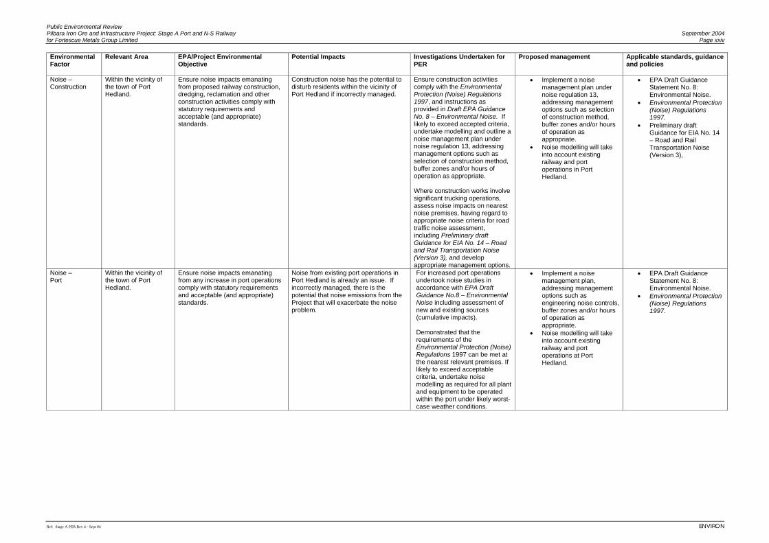
Public Environmental Review Pilbara Iron Ore and Infrastructure Project: Stage A Port and N-S Railway September 2004 for Fortescue Metals Group Limited Page xxiv
Ref: Stage A PER Rev 4 - Sept 04 ENVIRON
Environmental Factor
Relevant Area EPA/Project Environmental Objective
Potential Impacts
Investigations Undertaken for PER
Proposed management Applicable standards, guidance and policies
Noise – Construction
Within the vicinity of the town of Port Hedland.
Ensure noise impacts emanating from proposed railway construction, dredging, reclamation and other construction activities comply with statutory requirements and acceptable (and appropriate) standards.
Construction noise has the potential to disturb residents within the vicinity of Port Hedland if incorrectly managed.
Ensure construction activities comply with the Environmental Protection (Noise) Regulations 1997, and instructions as provided in Draft EPA Guidance No. 8 – Environmental Noise. If likely to exceed accepted criteria, undertake modelling and outline a noise management plan under noise regulation 13, addressing management options such as selection of construction method, buffer zones and/or hours of operation as appropriate. Where construction works involve significant trucking operations, assess noise impacts on nearest noise premises, having regard to appropriate noise criteria for road traffic noise assessment, including Preliminary draft Guidance for EIA No. 14 – Road and Rail Transportation Noise (Version 3), and develop appropriate management options.
• Implement a noise management plan under noise regulation 13, addressing management options such as selection of construction method, buffer zones and/or hours of operation as appropriate.
• Noise modelling will take into account existing railway and port operations in Port Hedland.
• EPA Draft Guidance Statement No. 8: Environmental Noise.
• Environmental Protection (Noise) Regulations 1997.
• Preliminary draft Guidance for EIA No. 14 – Road and Rail Transportation Noise (Version 3),
Noise – Port
Within the vicinity of the town of Port Hedland.
Ensure noise impacts emanating from any increase in port operations comply with statutory requirements and acceptable (and appropriate) standards.
Noise from existing port operations in Port Hedland is already an issue. If incorrectly managed, there is the potential that noise emissions from the Project that will exacerbate the noise problem.
For increased port operations undertook noise studies in accordance with EPA Draft Guidance No.8 – Environmental Noise including assessment of new and existing sources (cumulative impacts). Demonstrated that the requirements of the Environmental Protection (Noise) Regulations 1997 can be met at the nearest relevant premises. If likely to exceed acceptable criteria, undertake noise modelling as required for all plant and equipment to be operated within the port under likely worst-case weather conditions.
• Implement a noise management plan, addressing management options such as engineering noise controls, buffer zones and/or hours of operation as appropriate.
• Noise modelling will take into account existing railway and port operations at Port Hedland.
• EPA Draft Guidance Statement No. 8: Environmental Noise.
• Environmental Protection (Noise) Regulations 1997.
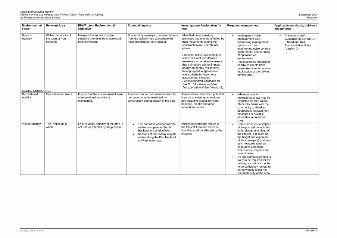
Public Environmental Review Pilbara Iron Ore and Infrastructure Project: Stage A Port and N-S Railway September 2004 for Fortescue Metals Group Limited Page xxv
Ref: Stage A PER Rev 4 - Sept 04 ENVIRON
Environmental Factor
Relevant Area EPA/Project Environmental Objective
Potential Impacts
Investigations Undertaken for PER
Proposed management Applicable standards, guidance and policies
Noise – Railway
Within the vicinity of the town of Port Hedland.
Minimise the impact to noise sensitive premises from increased train movement.
If incorrectly managed, noise emissions from the railway may exacerbate the noise problem in Port Hedland.
Identified noise sensitive premises that may be affected by train movements during the construction and operational phase. Predicted noise level increases where relevant and detailed measures to be taken to ensure that train noise will not impact unduly on nearby residences, having regard to appropriate noise criteria for train noise assessment, including Preliminary draft Guidance for EIA No. 14 – Road and Rail Transportation Noise (Version 3).
• Implement a noise management plan, addressing management options such as engineering noise controls, buffer zones and/or hours of operation as appropriate.
• Potential noise impacts on nearby residents have been taken into account in the location of the railway turning loop.
• Preliminary draft Guidance for EIA No. 14 – Road and Rail Transportation Noise (Version 3).
SOCIAL SURROUNDS Recreational Activity
Coastal areas, rivers. Ensure that the environmental value of recreational activities is maintained.
Access to some coastal areas used for recreation may be restricted by construction and operation of the port.
Assessed and described potential impacts to existing recreational use including access to rivers, beaches, creeks and other recreational areas.
• Where access to recreational areas may be restricted by the Project, FMG will consult with the community to develop appropriate management measures or suitable alternative recreational sites.
Visual Amenity The Project as a whole.
Ensure visual amenity of the area is not unduly affected by the proposal.
• The port development may be visible from parts of South Hedland and Wedgefield.
• Sections of the railway may be visible along the Port Hedland to Wittenoom road.
Assessed landscape values of the Project Area and describe how these will be affected by the proposal
• Reduction of visual impact of the port will be included in the design and siting of the Project (e.g. such as the height and alignment of the conveyors) and may use measures such as vegetative screening where visual impacts are unavoidable.
• No special management is likely to be required for the railway, as this is expected to be sufficiently remote to not adversely affect the visual amenity of the area.
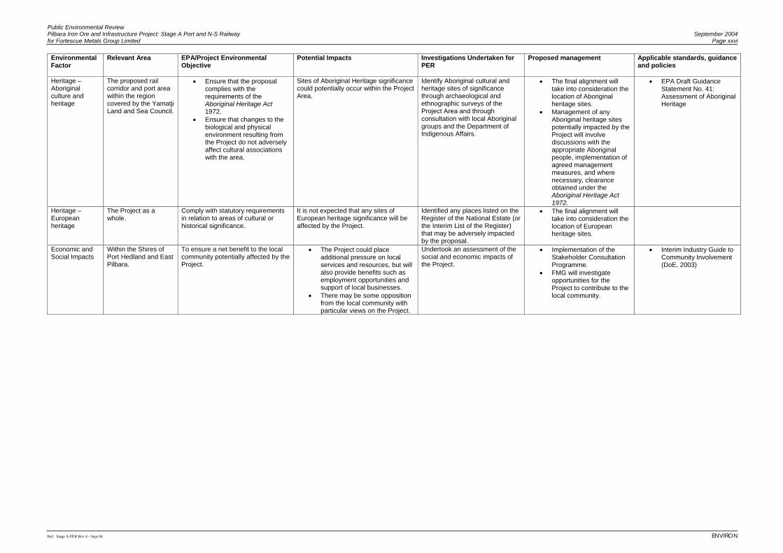
Public Environmental Review Pilbara Iron Ore and Infrastructure Project: Stage A Port and N-S Railway September 2004 for Fortescue Metals Group Limited Page xxvi
Ref: Stage A PER Rev 4 - Sept 04 ENVIRON
Environmental Factor
Relevant Area EPA/Project Environmental Objective
Potential Impacts
Investigations Undertaken for PER
Proposed management Applicable standards, guidance and policies
Heritage – Aboriginal culture and heritage
The proposed rail corridor and port area within the region covered by the Yamatji Land and Sea Council.
• Ensure that the proposal complies with the requirements of the Aboriginal Heritage Act 1972.
• Ensure that changes to the biological and physical environment resulting from the Project do not adversely affect cultural associations with the area.
Sites of Aboriginal Heritage significance could potentially occur within the Project Area.
Identify Aboriginal cultural and heritage sites of significance through archaeological and ethnographic surveys of the Project Area and through consultation with local Aboriginal groups and the Department of Indigenous Affairs.
• The final alignment will take into consideration the location of Aboriginal heritage sites.
• Management of any Aboriginal heritage sites potentially impacted by the Project will involve discussions with the appropriate Aboriginal people, implementation of agreed management measures, and where necessary, clearance obtained under the Aboriginal Heritage Act 1972.
• EPA Draft Guidance Statement No. 41: Assessment of Aboriginal Heritage
Heritage – European heritage
The Project as a whole.
Comply with statutory requirements in relation to areas of cultural or historical significance.
It is not expected that any sites of European heritage significance will be affected by the Project.
Identified any places listed on the Register of the National Estate (or the Interim List of the Register) that may be adversely impacted by the proposal.
• The final alignment will take into consideration the location of European heritage sites.
Economic and Social Impacts
Within the Shires of Port Hedland and East Pilbara.
To ensure a net benefit to the local community potentially affected by the Project.
• The Project could place additional pressure on local services and resources, but will also provide benefits such as employment opportunities and support of local businesses.
• There may be some opposition from the local community with particular views on the Project.
Undertook an assessment of the social and economic impacts of the Project.
• Implementation of the Stakeholder Consultation Programme.
• FMG will investigate opportunities for the Project to contribute to the local community.
• Interim Industry Guide to Community Involvement (DoE, 2003)
Public Environmental Review Pilbara Iron Ore and Infrastructure Project: Stage A Port and N-S Railway September 2004 for Fortescue Metals Group Limited Page 1
Ref: Stage A PER Rev 4 - Sept 04 ENVIRON
PUBLIC ENVIRONMENTAL REVIEW Pilbara Iron Ore and Infrastructure Project:
Stage A Port and North-South Railway
for Fortescue Metals Group Limited
1. INTRODUCTION
1.1 BACKGROUND Historically, within the Pilbara region of Western Australia (WA), a network of four privately owned and operated rail systems serving four separate port operations, was developed between the mid 1960s and early 1970s. Since then, the Pilbara has become established as a major centre for iron ore exports to the world market. Many of the regional towns and communities are predominantly mining orientated and dependent on this industry for their survival and prosperity. The number of mining operations and supporting rail network has progressively been expanded to serve the demand and growth in iron ore output. Consolidation of the iron ore industry in WA has lead to the rail network now being owned by two companies; BHP Billiton Iron Ore (BHPBIO) and Hamersley Iron (HI) (part of the Rio Tinto Group of Companies). Apart from the linkage between the two port facilities of Nelson Point and Finucane Island in Port Hedland, both now owned by BHPBIO, the railway networks and ports have remained independent from one another and access to this infrastructure in the region remains restricted. The Pilbara region is the focus of a new wave of major iron ore mining developments, in response to growing international demand for steel. However, access to rail and port infrastructure remains the limiting factor in the development of the Pilbara iron ore industry. 1.2 PROJECT OVERVIEW Fortescue Metals Group Limited (FMG) holds a large number of tenements in the Western, Central and Eastern Pilbara for the exploration and development of iron ore deposits. FMG is proposing to construct a port facility at Port Hedland and a connecting railway to its proposed mining operations some 345 km to the southeast1. FMG will from the outset make its railway and port facilities available to other users, including general freight and those who have mineral deposits in the Pilbara, but are currently unable to gain access to existing infrastructure for export of their ore at commercially competitive rates and timeslots. The Pilbara Iron Ore and Infrastructure Project: Port and North-South Railway (Stage A) (The Project) is located in the Pilbara region in the north of WA. The Project railway stretches from the proposed port facilities at Port Hedland, south-southeast to resources in the East Pilbara at Mindy Mindy (see Figure 1). The majority of the proposed railway will run 1 FMG’s mining operations are not considered in this Public Environmental Review.
Public Environmental Review September 2004 Pilbara Iron Ore and Infrastructure Project: Stage A Port and N-S Railway Page 2 for Fortescue Metals Group Limited
ENVIRON Ref: Stage A PER Rev 4 - Sept 04
parallel to, and in close proximity to the existing BHPBIO Newman to Port Hedland railway and the proposed Hope Downs railway alignment. The most southerly extent of the railway is approximately 100 km northwest of the Newman townsite. The proposed FMG port facility is situated on land vested with Port Hedland Port Authority (PHPA) and adjacent Unallocated Crown Land. The port will consist of a rail loop, stockyard and a conveyor system that will transfer iron ore from the stockyard to a new wharf and shiploader that will be located at Anderson Point. FMG’s Pilbara Iron Ore and Infrastructure Project is planned to initially transport 45 million tonnes per annum (Mtpa) of iron ore, from FMG owned resources and from the Mindy Mindy JV resource. FMG holds 50 percent of the issued capital of Pilbara Iron Ore Pty Ltd, the joint venture company that holds the Mindy Mindy tenements. It is FMG’s intention that the railway and port facilities would be accessible to other parties, and function as an open-access transport system. Third party use would be based on a fee for use at commercially competitive rates. The railway’s formation and track will be designed and constructed so it is capable, through the construction of additional sidings, of transporting 100 Mtpa. There is little additional capital expense or environmental impact, during the initial stage of construction, to ensure the primary line has a potential capacity of 100 Mtpa. This will enable future expansions to increase rail capacity for open access use without the need to duplicate the railway. Future expansions of the port will be to 70 Mtpa. 1.3 PURPOSE OF THIS DOCUMENT An Environmental Referral for the Pilbara Iron Ore and Infrastructure Project: North-South Railway and Port, was submitted to the WA Environmental Protection Authority (EPA) on 2 December 2003. The EPA advertised the level of assessment for the Project as a Public Environmental Review (PER) on 15 December 2003. A Scoping Document outlining the proposed scope of works for the environmental impact assessment was also prepared and submitted to the EPA on 14 April 2004. This PER document has been prepared according to Part IV Division 1 of the WA Environmental Protection Act 1986 for proposals of local or regional significance that raise a number of significant environmental factors, some of which are considered complex and require detailed assessment. The EPA considers that such proposals should be subject to a formal public review period, which in the case of this Project was set at eight weeks, and the setting of environmental conditions under Part IV of the Act to ensure they are implemented and managed in an environmentally acceptable manner.
Public Environmental Review Pilbara Iron Ore and Infrastructure Project: Stage A Port and N-S Railway September 2004 for Fortescue Metals Group Limited Page 3
Ref: Stage A PER Rev 4 - Sept 04 ENVIRON
1.4 THE PROPONENT The Proponent for the Project is Fortescue Metals Group Limited. The address is:
Fortescue Metals Group Limited PO Box 910 West Perth WA 6872 www.fmgl.com.au Telephone: +61 8 9266 0111 Facsimile: +61 8 9266 0188 ACN 002 594 872
It is intended that the ownership of the proposed port and rail facilities described in this PER will reside with the Pilbara Infrastructure Fund (PIF). The PIF will be owned independently of FMG, although FMG will commercially retain, or purchase approximately 40% ownership of the PIF. This will enable part ownership by other parties and a separate operating structure to FMG and its proposed mining operations, thereby providing a truly ‘open access’ user regime. The relevant contacts are:
Fortescue Metals Group Limited ENVIRON Australia Pty Ltd
Laura Todd Brian Bell
Head of Environment Principal, Environmental Consultant
Telephone: +618 9266 0111 Telephone: +61 8 9225 5199
Facsimile: +618 9266 0188 Facsimile: +61 8 9225 5155
[email protected] [email protected] 1.5 TIMING AND STAGING OF PROJECT To expedite the environmental assessment process and allow timely commencement of construction of the infrastructure component, FMG are undertaking the Environmental Impact Assessment of the Pilbara Iron Ore and Infrastructure Project in two stages. These are:
• Stage A: The proposed port and North-South rail infrastructure that is the subject of this PER;
Public Environmental Review September 2004 Pilbara Iron Ore and Infrastructure Project: Stage A Port and N-S Railway Page 4 for Fortescue Metals Group Limited
ENVIRON Ref: Stage A PER Rev 4 - Sept 04
• Stage B: Development of FMG’s mining operations in the eastern Chichester Plateau and the Mindy Mindy Joint Venture mine, and the East-West Railway, not addressed in this PER and the subject of another formal assessment.
Separate Environmental Assessment documents will be submitted for Stage B and any future stages of FMG’s development of its Chichester resources. The Minister for the Environment in her appeal determination on the level of assessment for this Project indicated that “there is merit in the mining and infrastructure proposals being assessed as an integrated Project, although it is acknowledged that there are timing and practical issues constraining this”. As such, the Minister has encouraged the EPA to undertake the assessment of the separate stages of the overall Project concurrently where possible, such that linkages and interrelationships between the two can be considered and incorporated into the environmental assessment process. To facilitate this process, the following synopsis, describing interrelationships and how the two projects will overlap is provided. 1.5.1 Technical Interrelationships There are three areas where technical issues regarding mining (Stage B Project) affect environmental issues at the Port (Stage A Project). These have been considered and discussed in this PER and are summarised below. Influence of ore characteristics on dust generation at the Port: particle size distribution and moisture content of the ore being mined have a significant influence on potential for dust generation at the Port. This has been considered in the Air Quality Study for this PER and is discussed in Section 7.3.9. Influence of the wet beneficiation process on dust generation at the Port: as mentioned above, a significant factor in determining dust generation at the Port is the moisture content of the ore. The moisture content of the ore will be high as a result of the wet beneficiation undertaken at the mine, which will reduce dust generation at the Port. This is discussed in Section 7.3.9. Influence of no crushing on noise and dust generation at the Port: a decision by FMG to ensure there is no crushing at the Port will have a significant influence on the potential for noise and dust at the Port. Crushing activities can be significant noise and dust sources, so the decision to locate these activities at the mine will reduce the potential environmental impacts at the Port. This is discussed in Sections 7.3.8 and 7.3.9.
Public Environmental Review Pilbara Iron Ore and Infrastructure Project: Stage A Port and N-S Railway September 2004 for Fortescue Metals Group Limited Page 5
Ref: Stage A PER Rev 4 - Sept 04 ENVIRON
1.5.2 Timing Overlaps Both the Stage A and Stage B projects have been set at a Public Environment Review (PER) level of assessment with an eight week public comment period. Whilst the public comment periods will not overlap, the EPA will be assessing both projects concurrently. The Stage B PER will also include a section on interrelationships with the Stage A PER, so that these can be considered as part of the Stage B assessment. Provided all project approvals are in place, construction of the Stage A Project is scheduled to commence in the first half of 2005, with the first shipment of ore in early 2007. Construction of Stage B is anticipated to commence on receipt of environmental approvals for this stage. FMG is currently pursuing the State Agreement process (the Government of Western Australia has indicated this is their preference). However, this is an extended process and it is possible that FMG may not be able to obtain a State Agreement Act within the timeframe required to secure project funding. If this is the case FMG may be obliged to apply for tenure under the Mining Act. FMG are currently pursuing both processes in parallel. The key constraints to the Project timing are:
• gaining environmental approvals; • gaining of appropriate tenure; • availability of construction materials, supplies, plant and equipment; and • efficiency of construction and commissioning phases (dependent on equipment and
personnel availability, weather, environmental constraints etc.). FMG is cognisant of the fact that an approval for Stage A does not guarantee approval of any subsequent stages that are part of an independent Environmental Impact Assessment (EIA) Process. 1.6 PROJECT AREA The Project area for Stage A of the Pilbara Iron Ore and Infrastructure Project is defined as the North-South 2 km wide2 rail corridor extending from Port Hedland to the Mindy Mindy deposit as shown on Figure 1, and the proposed rail loop and port facilities located at Port Hedland as shown on Figure 2. The port terminal for the FMG North-South rail corridor is located on the sandy lowlands in the southwest sector of Port Hedland harbour adjacent to the BHPBIO Port Hedland-Shay Gap Railway. The southern terminal for the rail corridor is located on the southern flank of the Fortescue Valley adjacent to the proposed Mindy Mindy Mine Site. 2 In some areas FMG has undertaken environmental and heritage surveys over a wider corridor to provide flexibility in Project design. However, the rail corridor for which approval is being sought is 2 km wide.

Public Environmental Review September 2004 Pilbara Iron Ore and Infrastructure Project: Stage A Port and N-S Railway Page 6 for Fortescue Metals Group Limited
ENVIRON Ref: Stage A PER Rev 4 - Sept 04
(This page has been left blank intentionally)
Public Environmental Review Pilbara Iron Ore and Infrastructure Project: Stage A Port and N-S Railway September 2004 for Fortescue Metals Group Limited Page 7
Ref: Stage A PER Rev 4 - Sept 04 ENVIRON
2. PROJECT JUSTIFICATION AND EVALUATION OF ALTERNATIVES 2.1 PROJECT JUSTIFICATION The rapid expansion in world steel production, predominately driven by recent production growth in China, has resulted in the iron ore demand exceeding supply, a situation which is forecast to continue. By 2007, accounting for current expansions planned by all major players and smaller prospective projects, it is conservatively estimated that there will be a shortfall in global seaborne trade in iron ore of at least 80 Mtpa. Australia, and in particular the Pilbara region of WA, is well positioned to meet significant amounts of this global supply shortfall if additional projects can be brought on line in the near future. FMG’s Pilbara Iron Ore and Infrastructure Project is one such project. FMG has established positive commercial ties with the expanding Asian market, particularly China. The rail and port infrastructure for the export of iron ore from the Pilbara is currently controlled exclusively by BHPBIO and HI. Inability to gain access to this infrastructure has prevented a number of iron ore projects commencing in the Pilbara. The Hope Downs (Hancock Prospecting and Kumba Resources JV) project is under review and in September 2002 received approval to build its own railway to, and port facility at Port Hedland. However, Hope Downs is still continuing negotiations with BHPBIO in an attempt to gain access to BHPBIO’s existing railway, under a “Rail access agreement” between Hope Downs and BHPBIO, following a Supreme Court appeal decision in Hope Downs’ favour in November 2003. However, the Hope Downs Project has to date been unable to negotiate a satisfactory outcome with BHPBIO and the access agreement does not include the Mining Area C rail lines or the rail lines which would be required to reach Hope Downs’ proposed port facilities at Harriet Point, Port Hedland. To date no open-access agreement has been reached or appears imminent for any of the operating railways in the Pilbara. Previous parties trying to negotiate with BHPBIO and HI have been unsuccessful for many years. There is also no guarantee that FMG will be able to gain access either to the existing BHPBIO rail infrastructure or to the proposed Hope Downs railway should it be built. Due to this uncertainty FMG must control its own future by pursuing the development of its own independent port and railway infrastructure. In July 2004 FMG lodged a request with the National Competition Council for the BHPBIO Mt Newman Line to be declared for use by other parties. If successful this declaration will allow the FMG to access the BHPBIO rail line. FMG believe that such rail access could be operated in a more efficient and sustainable manner, than operating independent closed access rail. The outcome of this declaration process will not be determined for some time. This process will not affect the FMG Environmental Approvals as:
• FMG's proposed port and rail facilities (the subject of this PER) would still be required under this scenario;
Public Environmental Review September 2004 Pilbara Iron Ore and Infrastructure Project: Stage A Port and N-S Railway Page 8 for Fortescue Metals Group Limited
ENVIRON Ref: Stage A PER Rev 4 - Sept 04
• FMG still intend to develop mining operations and the associated rail spur (the subject of the Stage B PER, which is yet to be released).
The Stage A railway will commence at FMG’s proposed port and loadout facilities at Port Hedland and terminate at its proposed Mindy Mindy JV mine site, located approximately 100 km northwest of Newman (Figure 1). FMG will develop true open-access rail and port infrastructure, made available at a commercially competitive cost that will stimulate resource development across the Pilbara region. In addition to ore from FMG’s own mines, the infrastructure will enable iron ore and other minerals from isolated resources in the region to be carried to the port, thereby opening up the region’s resources, and value adding to the socio-economics of the region. 2.2 STATE AND NATIONAL BENEFITS Construction of a multi-user port and railway to the proposed FMG mines is necessary for the operation of the Pilbara Iron Ore and Infrastructure Project. The development of the port and North-South railway to FMG’s iron ore resources will provide a number of significant benefits including:
• sufficient capacity to meet the transport requirements of all of FMG’s proposed developments in the area (45 Mtpa);
• rail and port capacity will also be available for other operations in the area, such as the proposed Hope Downs Iron Ore Project and any other third parties, further to expansion;
• creation of significant direct and indirect employment opportunities through materials purchase, construction and operation. Stage A of the Project will directly employ around 1,500 people during the peak construction stage and around 225 people on-site for operating the port and rail;
• the construction phase of the North-South railway and port facilities and mine infrastructure will require an expenditure of approximately A$1.85 billion, which represents a significant contribution to the State’s economy;
• workforce for construction and operation of the port and North-South railway will be prioritised from the towns of Port Hedland and Newman and the Pilbara region;
• FMG’s operational workforce will not be fly in-fly out (FIFO) and will be housed in the regional townships of Port Hedland and Newman; and
• regional community capacity building through local employment opportunities, including meaningful vocational training and employment for local indigenous people.
2.3 EVALUATION OF ALTERNATIVES As part of FMG’s business planning and project feasibility studies a number of alternatives for the transportation and export of iron ore have been considered. Alternatives that have been eliminated include the transport of iron ore by road trains and overland conveyors due to environmental (energy efficiency/greenhouse gas emissions), economic and safety
Public Environmental Review Pilbara Iron Ore and Infrastructure Project: Stage A Port and N-S Railway September 2004 for Fortescue Metals Group Limited Page 9
Ref: Stage A PER Rev 4 - Sept 04 ENVIRON
reasons. Rail is the only efficient means of transport of large quantities of material over such long distances. FMG has had high-level discussions with BHPBIO regarding the option of FMG using BHPBIO’s railway to Port Hedland. However, to date these discussions indicate that access to BHPBIO’s rail infrastructure is unlikely in the foreseeable future. Whilst this option will still be pursued, FMG is continuing the development of its own port and railway facilities, to provide certainty to the development of FMG’s iron ore resources. HI’s infrastructure is too distant from FMG’s resources to consider using this as an economic option. It is probable that the proposed Hope Downs infrastructure will not be available for use by FMG, or it may not be constructed in time to meet FMG’s timing requirements to commence export of iron ore. FMG therefore requires its own secure infrastructure system which will be open to other users on reasonable commercial terms. FMG does not expect both proposed railways (i.e. FMG’s and Hope Downs’ railways) will be constructed, due to the cost and inefficiency that can be avoided by sharing infrastructure. However, if both FMG’s Project and Hope Downs’ Project proceed, it is likely that each project will require its own port facilities, due to future export tonnages likely under FMG’s open-access user regime. 2.3.1 Railway With the selection of railway as the preferred means of transport various options have been evaluated. One of the primary objectives in the selection of the FMG preferred corridor and its design is to optimise its proximity to the existing BHPBIO and the proposed Hope Downs rail corridor (including the non-substantial changes to the Hope Downs railway alignment in the Chichester Ranges) to minimise impact on the environment and the community, while simultaneously optimising operating benefits. Similarly, by paralleling the Hope Downs’ corridor (which has recently been assessed by the EPA; Hope Downs Management Services [HDMS], 2002) for much of its length, there is abundant information available on the receiving environment that can be utilised by FMG to assist in placing its proposed Project into a regional context and supplement its own detailed surveys. FMG’s railway does deviate from the Hope Downs/BHPBIO corridors in some locations where there are significant environmental, Aboriginal heritage or engineering constraints (Figures 3a – 3d):
• Just south of South Hedland, FMG’s proposed railway was realigned to cross the South West Creek and continue up the western side of the Great Northern Highway, before the existing road bridge, due to concerns that the original alignment further east, would increase the risk of flooding in South Hedland (Figure 4).
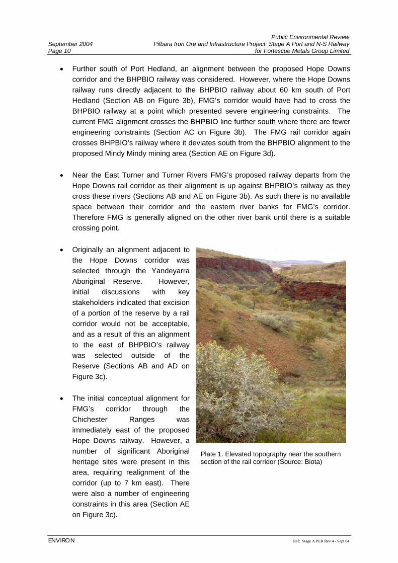
Public Environmental Review September 2004 Pilbara Iron Ore and Infrastructure Project: Stage A Port and N-S Railway Page 10 for Fortescue Metals Group Limited
ENVIRON Ref: Stage A PER Rev 4 - Sept 04
• Further south of Port Hedland, an alignment between the proposed Hope Downs corridor and the BHPBIO railway was considered. However, where the Hope Downs railway runs directly adjacent to the BHPBIO railway about 60 km south of Port Hedland (Section AB on Figure 3b), FMG’s corridor would have had to cross the BHPBIO railway at a point which presented severe engineering constraints. The current FMG alignment crosses the BHPBIO line further south where there are fewer engineering constraints (Section AC on Figure 3b). The FMG rail corridor again crosses BHPBIO’s railway where it deviates south from the BHPBIO alignment to the proposed Mindy Mindy mining area (Section AE on Figure 3d).
• Near the East Turner and Turner Rivers FMG’s proposed railway departs from the
Hope Downs rail corridor as their alignment is up against BHPBIO’s railway as they cross these rivers (Sections AB and AE on Figure 3b). As such there is no available space between their corridor and the eastern river banks for FMG’s corridor. Therefore FMG is generally aligned on the other river bank until there is a suitable crossing point.
• Originally an alignment adjacent to
the Hope Downs corridor was selected through the Yandeyarra Aboriginal Reserve. However, initial discussions with key stakeholders indicated that excision of a portion of the reserve by a rail corridor would not be acceptable, and as a result of this an alignment to the east of BHPBIO’s railway was selected outside of the Reserve (Sections AB and AD on Figure 3c).
• The initial conceptual alignment for
FMG’s corridor through the Chichester Ranges was immediately east of the proposed Hope Downs railway. However, a number of significant Aboriginal heritage sites were present in this area, requiring realignment of the corridor (up to 7 km east). There were also a number of engineering constraints in this area (Section AE on Figure 3c).
Plate 1. Elevated topography near the southern section of the rail corridor (Source: Biota)
Public Environmental Review Pilbara Iron Ore and Infrastructure Project: Stage A Port and N-S Railway September 2004 for Fortescue Metals Group Limited Page 11
Ref: Stage A PER Rev 4 - Sept 04 ENVIRON
• In some cases it has been necessary to deviate the railway formation away from the BHPBIO route, to avoid topographical constraints, or reduce impacts on the existing BHPBIO railway, drainage structures, or on natural drainage systems (see Section 7.2.1)
2.3.2 Port Location A number of options were considered for the Port layout. If Hope Downs were to construct its port facility then consideration was given to constructing FMG’s unloading and stockpile facilities to the southeast of the Hope Downs Port facility near South West Creek, and sharing the Hope Downs’ conveyor, loadout facilities and berths at Harriet Point. However, if the Hope Downs infrastructure is not committed to, and/or completed in time for FMG’s Project, then FMG would have to construct its own overland conveyor and loadout facilities to a berth at Anderson Point. In addition, discussions with Hope Downs have indicated that a sharing arrangement is not feasible, and that PHPA is prepared to issue a lease to FMG over Anderson Point. An alternative location further south with the rail loop, unloading and stockpile facilities located south of the BHPBIO rail line was considered to reduce the engineering constraints associated with constructing the facilities on the coastal mudflats. Existing tenure held by other parties, combined with existing zoning/land use requirements that FMG’s proposed activities would not comply with, prevented FMG from gaining access to this area. This option would also require a long conveyor to the proposed berth facilities at Anderson Point, which is neither practical nor commercially viable. FMG considered constructing the rail loop to the east of the proposed stockpile area. However, this was not possible due to the space constraints imposed by the Hope Downs alignment and location of their marshalling yards. This option would have moved the car dumper closer to Wedgefield and hence increased potential noise impacts on this community. FMG also considered constructing the stockpile area in the centre of the rail loop. There are safety issues associated with access to the centre of the rail loop, with personnel crossing the railway line. This would also have moved the car dumper closer to Wedgefield and hence increased potential noise impacts. It would also have limited expansion options particularly for additional stockpile capacity. Constructing the rail loop to the west of the proposed stockpile area was selected for further development as it moved the car dumper away from Wedgefield, fitted in with PHPA’s long term planning requirements and allowed for future expansion of stockpiles and addition of a second rail loop with minimal further environmental impact. Figure 2 shows the selected layout for FMG’s port facilities. Originally the proposed location for the disposal of spoil reclamation was to extend further north and designed to be rectangular in shape, but this
Public Environmental Review September 2004 Pilbara Iron Ore and Infrastructure Project: Stage A Port and N-S Railway Page 12 for Fortescue Metals Group Limited
ENVIRON Ref: Stage A PER Rev 4 - Sept 04
was moved further south and made irregular in shape to reduce the impacts on the mangroves at Anderson Point. The proposed rail loop is constrained by the existing BHPBIO railway to the south and west, and the proposed dredge spoil reclamation location to the east. The rail loop cannot be moved further south to minimise disturbance to the mangroves as this would require a turning circle that is too tight, creating operating difficulties and increasing the risk of derailment and increased noise from train wheels. The rail loop crossing of South West Creek has been designed to allow adequate tidal flushing and maintain creek flows. Freshwater flows through the area within the rail loop are already constrained by the BHPBIO rail embankment to the south. Other considerations for the layout of the port facilities were:
• locating the rail dumper as close as possible to the stockyard to reduce costs and environmental impacts, which required the crossing of the BHPBIO and proposed Hope Downs railways;
• locating the stockpiles as close as possible to the shiploading berth to allow safe practical ship trimming to occur;
• grade constraints for loaded heavy haul trains (0.33% or 0.175°) and the requirement for ‘at grade’ crossings;
• a rail loop length capable of having a loaded train before and an empty train after the car dumper, and straights before and after the loop to reduce wagon indexer loads;
• the minimum radii of the rail loop before noise from wheel squeal becomes an issue; • locating the berths to meet PHPA’s long term requirements and taking into account
tidal currents for manoeuvring ships and ships alongside; • locating dredge spoil to maximise its utilisation within current and future
developments, whilst minimising impacts on mangroves; and • impacts of the development on drainage flows including tidal flows and storm surge.
2.3.3 No Development Option The “no project” option would result in the loss of opportunity to add value to Australia’s raw materials, loss of employment opportunities and economic benefit, particularly within local regional communities and loss of potential for future developments in downstream processing of raw materials. The increasing global demand for iron ore would then be met through the development of other projects elsewhere, predominantly overseas, with the loss of the associated benefits to Western Australia.
Public Environmental Review Pilbara Iron Ore and Infrastructure Project: Stage A Port and N-S Railway September 2004 for Fortescue Metals Group Limited Page 13
Ref: Stage A PER Rev 4 - Sept 04 ENVIRON
3. LEGISLATIVE FRAMEWORK 3.1.1 Relevant Legislation and Policies The Environmental Protection Act 1986 is the principal statute relevant to environmental protection in Western Australia. The Act makes provision for the establishment of the Environmental Protection Authority (EPA), for the prevention, control and abatement of pollution and for the conservation, preservation, protection, enhancement and management of the environment. The Act also provides for the control and licensing of potentially polluting activities, land clearing, and is the Act under which the State environmental approvals process operates. Other state environmental and related legislation relevant to the Project includes the following:
• Aboriginal Heritage Act 1972 • Agriculture and Related Resources Protection Act 1976 • Bush Fires Act 1954 • Conservation and Land Management Act 1984 • Contaminated Sites Act 2003 • Explosives and Dangerous Goods Act 1961 • Dangerous Goods (Transport) Act 1998 • Land Administration Act 1997 • Occupational Safety and Health Act 1984 • Pollution of Waters by Oil and Noxious Substances Act 1987 • Private Railways (Level Crossings) Act 1966 • Rail Safety Act 1998 • Rights in Water and Irrigation Act 1914 • Soil and Land Conservation Act 1945 • Town Planning & Development Act 1928 • Western Australian Marine Act 1982 • Western Australian Marine (Sea Dumping) Act 1981 • Wildlife Conservation Act 1950
Commonwealth legislation of relevance to the Project includes the following:
• Environment Protection and Biodiversity Conservation Act 1999 (EPBC Act 1999) • Environmental Protection (Sea Dumping) Act 1981 • National Native Title Act 1993.
Under the EPBC Act 1999 an action requires approval from the Federal Environment and Heritage Minister if the action has, will have, or is likely to have, a significant impact on a matter of national environmental significance such as:
Public Environmental Review September 2004 Pilbara Iron Ore and Infrastructure Project: Stage A Port and N-S Railway Page 14 for Fortescue Metals Group Limited
ENVIRON Ref: Stage A PER Rev 4 - Sept 04
• World Heritage properties; • National Heritage places; • Ramsar wetlands of international importance; • listed threatened species and communities; • migratory species protected under international agreements; • nuclear actions; and • the Commonwealth marine environment.
Stage A of the Project was referred to the Federal Department of Environment and Heritage (DEH) in June 2004 due to the possibility of listed rare fauna species occurring within the Project Area (Section 6.2.4.3). The DEH determined that the Project is not a ‘Controlled Action’ and therefore does not require approval under Part 9 of the EPBC Act 1999 before the Project can proceed (Appendix B). 3.1.2 Key Decision Making Authorities The key Decision Making Authorities (DMAs) involved in the environmental assessment of FMG’s Project are the State EPA and the Department of Environment (DoE) that provides advice to the EPA. Consultation on the assessment of impacts on biodiversity has been undertaken, and continues to be undertaken with the Department of Conservation and Land Management (CALM). Similarly, consultation regarding the assessment of impacts on water resources has been undertaken, and will continue with the Water and Rivers Commission (WRC) section of the DoE. FMG is currently involved in discussions with the State Government that may result in the parties negotiating either:
1. A special Act for the construction and operation of a) the rail; or b) the rail and port infrastructure; or 2. A special Act with an Agreement (“State Agreement”) for the construction and
operation of a) the rail; b) the port; or c) the rail, port and mines.
If the Project is located on Miscellaneous Licences issued under the Mining Act 1978, approvals from the Department of Industry and Resources (DoIR) will also be required. Alternatively, Land Act tenure would require compliance with the Land Administration Act 1997.
Public Environmental Review Pilbara Iron Ore and Infrastructure Project: Stage A Port and N-S Railway September 2004 for Fortescue Metals Group Limited Page 15
Ref: Stage A PER Rev 4 - Sept 04 ENVIRON
Other DMAs involved in the Project approvals include:
• Department of Indigenous Affairs (DIA); • Department of Land Information (DLI); • Department of Agriculture (AgWA); • Fisheries Western Australia (FWA); • Department for Planning and Infrastructure (DPI); and • Port Hedland Port Authority (PHPA).
3.1.3 Approvals Process It has been determined by the EPA that the Project requires a formal level of environmental assessment as a PER. The process for submission and assessment of a PER is outlined below:
1. The Proponent refers the proposal to the EPA to set the level of assessment; 2. The EPA determines the level of assessment as a PER and advertises this decision
and the length of the public review period, subject to appeal; 3. The Proponent prepares an Environmental Scoping Document outlining the scope of
works for the PER assessment; 4. The EPA agrees to the Environmental Scoping Document as a basis for the PER; 5. A draft PER is prepared by the Proponent and submitted to the EPA Service Unit for
comment; 6. The final draft of the PER (this document) is submitted to the EPA for authorisation to
release as a public document; 7. The PER is released for public review period of 8 weeks; 8. Any submissions received by the EPA at the end of the review period are provided to
the Proponent, for the Proponent to summarise and respond; 9. The EPA undertakes an assessment of the proposal;; 10. The EPA ‘Report and Recommendations’ is published. 11. A two week statutory appeal period commences; 12. The Minister determines any appeals on the EPA’s Report and Recommendations,
and consults with the key Decision Making Authorities to seek agreement on whether or not, and in what manner the proposal may be implemented.
13. The Minister issues a Statement (provided approval for the Project is given).
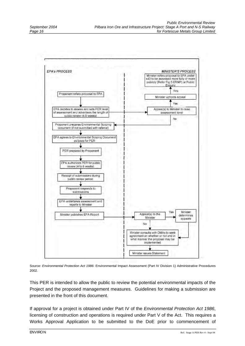
Public Environmental Review September 2004 Pilbara Iron Ore and Infrastructure Project: Stage A Port and N-S Railway Page 16 for Fortescue Metals Group Limited
ENVIRON Ref: Stage A PER Rev 4 - Sept 04
Source: Environmental Protection Act 1986: Environmental Impact Assessment (Part IV Division 1) Administrative Procedures 2002.
This PER is intended to allow the public to review the potential environmental impacts of the Project and the proposed management measures. Guidelines for making a submission are presented in the front of this document. If approval for a project is obtained under Part IV of the Environmental Protection Act 1986, licensing of construction and operations is required under Part V of the Act. This requires a Works Approval Application to be submitted to the DoE prior to commencement of
Public Environmental Review Pilbara Iron Ore and Infrastructure Project: Stage A Port and N-S Railway September 2004 for Fortescue Metals Group Limited Page 17
Ref: Stage A PER Rev 4 - Sept 04 ENVIRON
construction, and an Application for Licence to Operate submitted to the DoE, prior to commencement of commissioning. Parts of the Project may be constructed on tenure granted under the Mining Act 1978, and therefore a Notice of Intent will also be required to be submitted to the DoIR for approval, before construction can commence. 3.1.4 Land Use Zoning 3.1.4.1 Rail For much of its length, the proposed rail alignment passes through grazing land and is generally between 2 - 3 km from the existing BHPBIO line and the proposed Hope Downs alignment. Near the light industrial area of Wedgefield FMG’s proposed rail passes within approximately 1.5 km of light industrial properties with residences permitted under town planning provisions as ‘care-taker residences’. From Port Hedland to its proposed terminus at Mindy Mindy, the rail corridor crosses:
• Pastoral leases; • Mining Act tenure (including Section 19 tenure); • State agreement tenure and file notation areas; • Protected Aboriginal areas at Abydos and Woodstock and a DIA registered site; • Unallocated crown land; • Reserved crown land; • Crown land under lease; • Petroleum pipeline licence; • Freehold (e.g. communications tower)
FMG is consulting with all registered interest holders that its proposed railway will impact. 3.1.4.2 Port The proposed port facility will be located mostly on PHPA land within the town of Port Hedland boundary, with some Unallocated Crown Land in the southeast corner of the proposed port area. The land on which FMG propose to develop its port facility is zoned industrial (Port Hedland Port Authority [PHPA], 2003b) intended for port dependent industry, and is adjacent to existing operational port facilities. PHPA has issued a master plan for the Port of Port Hedland for public comment. The master plan is encapsulated in their publication titled “Port Hedland Planning Study, Ultimate Development Plan”. Figure 5 overlays the proposed FMG port facilities layout at Anderson Point and adjacent area on PHPA ‘Scenario B – 250,000 DWT Bulk Berths‘. The proposed usage of Area ‘A’ and ‘B’ in the PHPA master plan have been designated for storage of bulk materials, such as iron ore and the northern two berths at Anderson Point berth area have been designated for bulk cargo, such as iron ore.
Public Environmental Review September 2004 Pilbara Iron Ore and Infrastructure Project: Stage A Port and N-S Railway Page 18 for Fortescue Metals Group Limited
ENVIRON Ref: Stage A PER Rev 4 - Sept 04
In general, the proposed FMG iron ore port facilities conforms with PHPA proposed usage of the Anderson Point area and fits into the PHPA proposed layout. However the FMG layout does not identically match the layouts, for example, the berths are closer to Anderson Point and the stockpile extends to the north of Area A. The final berth location and orientation will be confirmed during detail design after the completion of a number of engineering studies such as mooring analysis, manoeuvrability simulations and other factors, and confirming the results and their implications with PHPA. It is not thought that any such changes will cause additional environmental impacts, however this will be confirmed with the relevant regulatory authority at the time any such changes are proposed. The proposed land reclamation with dredge spoil whilst different from that proposed by PHPA does not preclude later expansion to meet the PHPA master plan. The FMG reclamation area differs as it is directed at meeting FMG’s requirements to create elevated land for its stockyard and a laydown area adjacent to the wharf. Discussions with PHPA to date indicate that it intends to offer an option to FMG to develop Anderson Point, which if taken up would lead to a lease over Anderson Point. In the PHPA Port Planning Study (PHPA, 2003b), three broad environmental issues were identified as potentially constraining the extent of industrial and Port development:
• mangroves • noise • dust
PHPA identified the need to minimise mangrove loss within the port area, whilst acknowledging that it is not possible to avoid all mangroves, particularly within the Anderson Point area. FMG has designed the Project to minimise direct mangrove loss and indirect impacts (Section 7.3.4). The Planning Study also identifies that new developments will be expected to implement best practice noise and dust management measures, which FMG has addressed in Sections 7.3.8 and 7.3.9. Surrounding landuse includes the townsites of Port Hedland and South Hedland, light industry (Wedgefield industrial area), industrial estate (Boodarie Resource Processing Estate; designated for heavy industry and downstream processing), pastoral lease (Boodarie) and export facilities (Nelson Point and Finucane Island). The emergence of other industries at the Port and the gradual development and growth of Port Hedland will be taken into consideration in FMG’s own operation reviews and planning. Wherever practicable FMG’s own future operation changes and possible expansions will take into consideration these external changes and their influences.
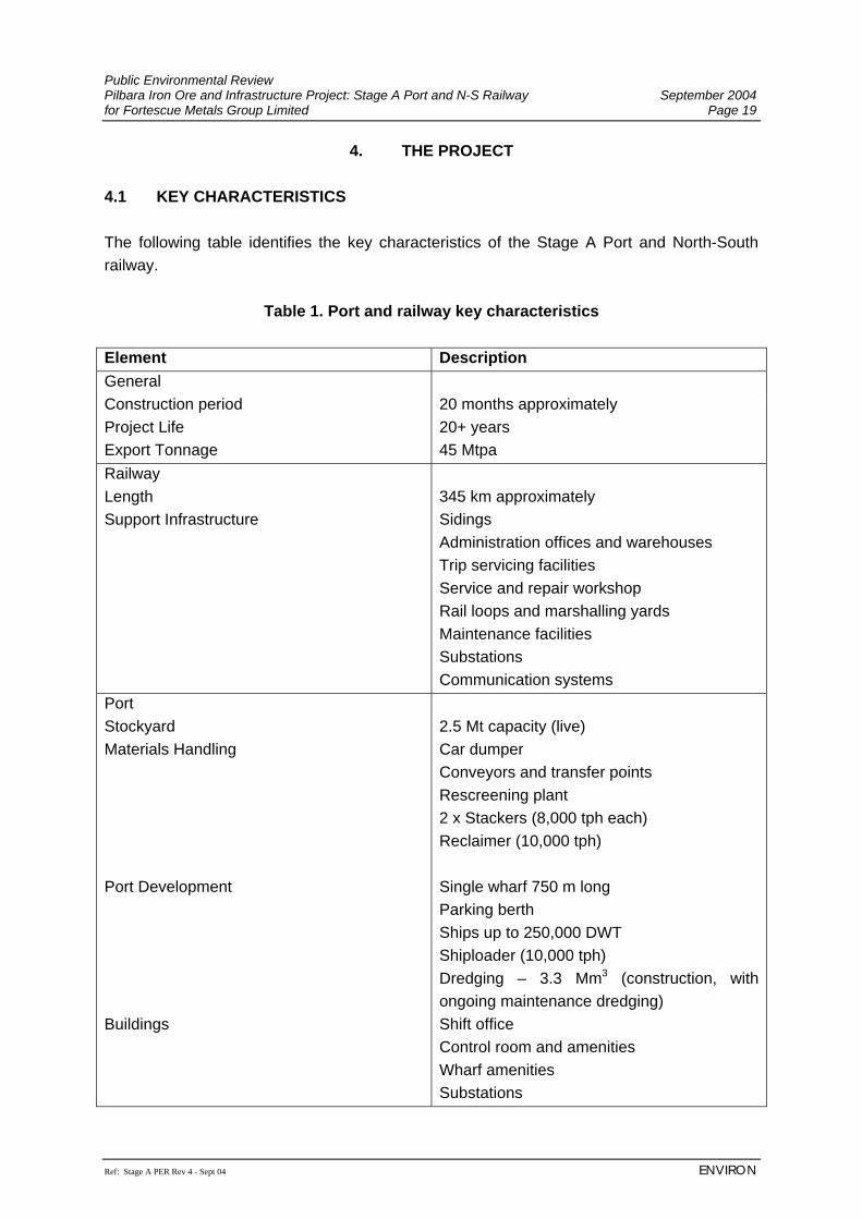
Public Environmental Review Pilbara Iron Ore and Infrastructure Project: Stage A Port and N-S Railway September 2004 for Fortescue Metals Group Limited Page 19
Ref: Stage A PER Rev 4 - Sept 04 ENVIRON
4. THE PROJECT 4.1 KEY CHARACTERISTICS The following table identifies the key characteristics of the Stage A Port and North-South railway.
Table 1. Port and railway key characteristics Element Description General Construction period Project Life Export Tonnage
20 months approximately 20+ years 45 Mtpa
Railway Length Support Infrastructure
345 km approximately Sidings Administration offices and warehouses Trip servicing facilities Service and repair workshop Rail loops and marshalling yards Maintenance facilities Substations Communication systems
Port Stockyard Materials Handling Port Development Buildings
2.5 Mt capacity (live) Car dumper Conveyors and transfer points Rescreening plant 2 x Stackers (8,000 tph each) Reclaimer (10,000 tph) Single wharf 750 m long Parking berth Ships up to 250,000 DWT Shiploader (10,000 tph) Dredging – 3.3 Mm3 (construction, with ongoing maintenance dredging) Shift office Control room and amenities Wharf amenities Substations
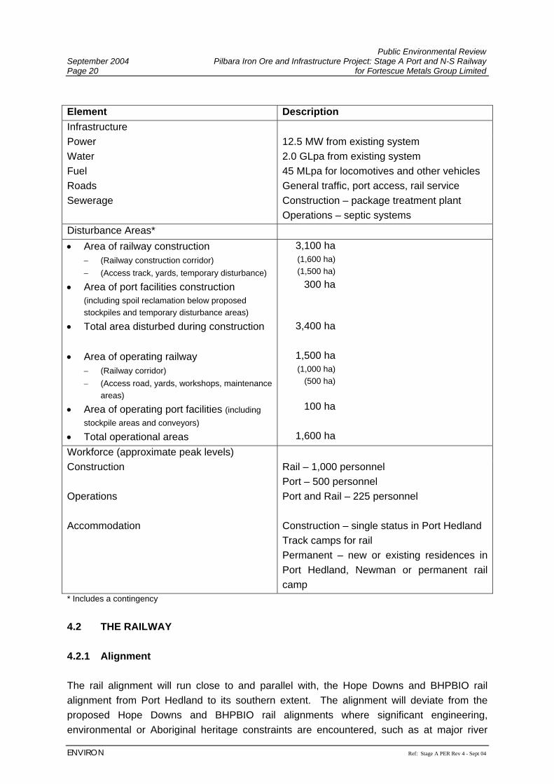
Public Environmental Review September 2004 Pilbara Iron Ore and Infrastructure Project: Stage A Port and N-S Railway Page 20 for Fortescue Metals Group Limited
ENVIRON Ref: Stage A PER Rev 4 - Sept 04
Element Description Infrastructure Power Water Fuel Roads Sewerage
12.5 MW from existing system 2.0 GLpa from existing system 45 MLpa for locomotives and other vehicles General traffic, port access, rail service Construction – package treatment plant Operations – septic systems
Disturbance Areas* • Area of railway construction
− (Railway construction corridor) − (Access track, yards, temporary disturbance)
• Area of port facilities construction (including spoil reclamation below proposed stockpiles and temporary disturbance areas)
• Total area disturbed during construction • Area of operating railway
− (Railway corridor) − (Access road, yards, workshops, maintenance
areas)
• Area of operating port facilities (including stockpile areas and conveyors)
• Total operational areas
3,100 ha (1,600 ha) (1,500 ha)
300 ha
3,400 ha
1,500 ha (1,000 ha)
(500 ha)
100 ha
1,600 ha Workforce (approximate peak levels) Construction Operations Accommodation
Rail – 1,000 personnel Port – 500 personnel Port and Rail – 225 personnel Construction – single status in Port Hedland Track camps for rail Permanent – new or existing residences in Port Hedland, Newman or permanent rail camp
* Includes a contingency 4.2 THE RAILWAY 4.2.1 Alignment The rail alignment will run close to and parallel with, the Hope Downs and BHPBIO rail alignment from Port Hedland to its southern extent. The alignment will deviate from the proposed Hope Downs and BHPBIO rail alignments where significant engineering, environmental or Aboriginal heritage constraints are encountered, such as at major river
Public Environmental Review Pilbara Iron Ore and Infrastructure Project: Stage A Port and N-S Railway September 2004 for Fortescue Metals Group Limited Page 21
Ref: Stage A PER Rev 4 - Sept 04 ENVIRON
crossings. The railway alignment commences at the proposed FMG port facilities at Port Hedland and travels to the west of South Hedland (approximately 2.5 km away, Figure 3a) and then south-southeast to the FMG iron ore resources (Figure 3b – 3d). The exact length of rail will not be finalised until the specific route within the 2 km wide corridor, and train loadout facilities at the mining operations, are defined. 4.2.2 Materials Sources Wherever possible, fill material for the rail embankment will be sourced from material recovered from construction of the railway cuttings. If material cannot be sourced from within the rail access corridor or rail cuts, a series of borrow pits will be required to supply suitable fill material for the railway embankment and formation. The location of these borrow pits are constrained by the availability of suitable construction material. However, they will be located away from sensitive environments, such as significant vegetation, surface drainage and Aboriginal heritage sites, and will be free-draining. If required, borrow pits will be spaced out along the length of the rail corridor to minimise haulage distance and also concentrated disturbance. Ballast material will be provided from local existing or new quarries. If FMG develops new quarries, appropriate approvals will be sought. However, this may also be undertaken separately by a contract ballast supplier. 4.2.3 Construction Activities The railway will be constructed using specifically profiled concrete sleepers and a continuously welded rail. These will be bedded on a layer of ballast around 250 mm deep on the rail formation. A series of culverts will support the rail track across major surface drainage features, such as creeks and floodways. Where major waterways, such as rivers, need to be crossed then elevated bridges will be constructed to support the rail track (see Figure 6). The more significant of these water courses will be monitored by a simple solar powered detection device that will allow for early warning of any significant water rise, and prevent trains from entering that section of the track. This early detection will allow for quick response to ensure the integrity of the railway is maintained and environmental impact is minimised. Construction activities will follow the sequence and management measures as outlined in Table 2.
Public Environmental Review September 2004 Pilbara Iron Ore and Infrastructure Project: Stage A Port and N-S Railway Page 22 for Fortescue Metals Group Limited
ENVIRON Ref: Stage A PER Rev 4 - Sept 04
Table 2. Sequence of construction - railway Aspect Construction
Activity Description
Detailed Surveying Engineering, environmental, archaeological and anthropological surveys are used both in routing and to determine any special construction techniques or mitigation measures required. Once the rail route and design have been defined by the known constraints and with input from stakeholders, then the engineering aspects are finalised and a detailed survey is undertaken to identify project layout and constraints to be avoided.
Clear and Grubbing Graders, bulldozers and scrapers are used to clear the rail corridor ready for construction to commence. During this process, sites of heritage significance and priority flora are fenced off, severed pastoral fences are repaired, and topsoil and vegetation are removed and stored separately for use during rehabilitation once the railway is completed.
Temporary Facilities Temporary facilities such as construction camps, water supply, mobile workshops, batching plants, etc. are established. Many of these facilities are established progressively with the active front of construction.
Bulk Earthworks and Rail Formation Construction
Once initial clearing and grubbing has been completed, a fleet of heavy earthmoving equipment such as graders, bulldozers, scrapers, dump trucks, water carts, compact rollers and loaders are utilised in the construction of the rail embankment and formation. Excavation and placement of suitable material must be undertaken in a specific manner to ensure the integrity of the rail formation is maintained and able to withstand the weight of the loaded rolling stock and weathering by the natural elements.
Culvert Construction The location of culverts will be identified during the initial surveys of natural drainage systems. Placement of corrugated, galvanised iron culverts will be undertaken during the bulk earthworks stage. The culverts will be surrounded by concrete stabilised fill, placed at specific heights to enable uninterrupted water flow and protected both upstream and downstream with rock armour. Culverts will be designed to allow no rail formation over topping for peak flow Average Return Interval (ARI) events of 1 in 20 years.
Railway
Blasting In areas that have large amounts of rock, blasting will be used to break up the rocks. For this Project a detailed cut to fill model will be established to minimise the practicable extent of blasting required and also the need to source additional borrow material.
Public Environmental Review Pilbara Iron Ore and Infrastructure Project: Stage A Port and N-S Railway September 2004 for Fortescue Metals Group Limited Page 23
Ref: Stage A PER Rev 4 - Sept 04 ENVIRON
Aspect Construction Activity
Description
Borrow Pits and Quarries
A number of borrow pits will be required to supply suitable construction material. These will be opened and rehabilitated progressively to keep pace with the active front of rail formation earthworks. Similarly, if an existing quarry cannot be utilised to source ballast material then another quarry will be developed to supply this material.
Bridge Construction Independent bridge construction crews will work on separate bridges at the same time to ensure their completion and integration with the rail formation being built. Bridge superstructure will be built off site and transported to specific areas for assembly where more than one span is required. Bridges will be designed so that they shall not be overtopped by a 1 in 50 peak flow ARI event.
Site Rehabilitation Site rehabilitation will be undertaken progressively wherever practicable. However, much of the rehabilitation works can only be undertaken towards the end of construction activities and once the bulk of disturbance has been completed. Disturbed areas will be used as temporary laydown areas for sleepers and culverts to help minimise the extent of disturbance.
Sleeper and Track Laying
Once the rail formation has been sufficiently progressed by the earthworks construction crew, sleeper and track laying will commence. A train carrying lengths of pre-welded track, approximately 400 m in length, will be used to transport the material to site. The train will place the track which will then be automatically clipped into place on the sleepers. The train will then roll forward over the newly laid track and another length of track will be pulled off and clipped into place prior to welding the rail.
Ballast Laying Ballast will be brought in via ballast trains and dumped over the recently laid track. Specialist train equipment such as rail tampers and regulators will be utilised to compact and form-up the ballast bed to around 200 mm - 250 mm around the rail sleepers and track.
Signals Signals and communications will be incorporated into the track during and after construction, including signal lights at level crossings and switch pads.
Commissioning Commissioning will comprise the running of light high-rail vehicles along the new railway, followed by a series of incrementally loaded trains until fully loaded trains are run and the rail track is opened for operations.
Public Environmental Review September 2004 Pilbara Iron Ore and Infrastructure Project: Stage A Port and N-S Railway Page 24 for Fortescue Metals Group Limited
ENVIRON Ref: Stage A PER Rev 4 - Sept 04
Aspect Construction Activity
Description
Demobilisation and Final Rehabilitation
Prior to departure, the supervising engineers will retain a small team of construction equipment and contractors to undertake final rehabilitation works, completing any outstanding rehabilitation and repair work, demobilise construction camps and temporary facilities along the rail corridor, remove waste materials and repair pastoral fences etc. A construction camp will be retained and used as a maintenance camp for ongoing maintenance operations.
4.2.4 Rail Facilities It is anticipated that rail movements will be controlled remotely from a train operations control centre. Depending on the ramp up and scheduling of mining operations, demand by customers and use by third parties, it is anticipated that the number of train movements along the railway will vary. However, at full capacity for FMG’s Project (45 Mtpa), on average 5.5 iron ore trains per day will be required. Facilities associated with the North-South railway will include rail loops, train marshalling yards, maintenance facilities, sidings, administration offices, warehouse, trip servicing facilities, substation and communication systems. 4.2.5 Locomotives and Rail Cars The trains could weigh up to 35,600 t and be in the order of 2.5 km long, comprising three locomotives and 240 ore cars. Initially the operations are anticipated to comprise 200 to 220 ore cars. Each ore car will contain 126 t of ore, will be similar to those used by BHPBIO and capable of going through a BHPBIO twin cell dumper. Approximately 45 MLpa of diesel will be required to fuel the locomotives and other vehicles. 4.2.6 Ancillary Services An access road will be constructed adjacent to the railway, (for maintenance, construction and recovery operations) or where appropriate shared with BHPBIO. Power for the maintenance facilities will be supplied from the existing Western Power supply grid. Water for operation of the railway will be provided from existing or new bores established near the rail corridor (Section 7.2.2.1). The proposed alignment crosses the North West Highway and these crossings will be signalled. The siting of temporary facilities required during construction will take into consideration the location of:
Public Environmental Review Pilbara Iron Ore and Infrastructure Project: Stage A Port and N-S Railway September 2004 for Fortescue Metals Group Limited Page 25
Ref: Stage A PER Rev 4 - Sept 04 ENVIRON
• significant flora populations or vegetation communities; • significant fauna habitats or threatened fauna populations; • sites of Aboriginal heritage significance; • proximity to water supplies; • topographic constraints and potential impacts on the surface hydrology of the site; and • areas prone to flooding.
Existing areas of disturbance will be used, if practicable, to minimise the extent of clearing required for temporary facilities. 4.2.7 Dangerous Goods It is unlikely that operational activities will require the presence of any significant volume of dangerous or hazardous substances to be either stored or used on site. Some limited quantities of solvents, paints, cleaning products and bonding agents will be required. Storage of diesel fuel for train refuelling will be the key hazardous substance on site due to its volume. The bulk of the diesel storage will be at the train marshalling yards and workshop facilities away from the Port facility. All diesel storage vessels and facilities will be constructed and operated in compliance with relevant legislation and standards. 4.2.8 Waste Management A local waste management and recycling contractor will be utilised to collect and remove waste from site, reusing and recycling waste wherever practicable. An education program will be delivered to the workforce to raise awareness of waste management to help reduce waste generation and encourage reuse and recycling. Waste that cannot be reused or recycled will be disposed of at the Port Hedland or other landfill facilities, in accordance with relevant legislation and standards. 4.2.9 Inspection, Maintenance and Monitoring Inspection work (both aerial and ground patrolling) associated with the railway will be conducted in accordance with all statutory requirements and the specific operator’s inspection and maintenance program developed for this Project. Inspection patrols will be scheduled on a regular basis and will be used to detect third party activity near the railway, potential erosion areas, weed germination or other conditions potentially requiring possible remedial measures. Liaison with land holders will be maintained to ensure that they remain aware of the restrictions on working in the vicinity of the railway and to gather early warning of any of their activities that may affect the railway.
Public Environmental Review September 2004 Pilbara Iron Ore and Infrastructure Project: Stage A Port and N-S Railway Page 26 for Fortescue Metals Group Limited
ENVIRON Ref: Stage A PER Rev 4 - Sept 04
Routine maintenance of the access/maintenance road will consist of regular checks on track condition and repairs as required. Emergency repairs or replacements along the railway will be conducted in the unlikely event of a major breakdown of the system, such as railway damage or derailment. Day-to-day operations of the transport of iron ore by railway pose few direct environmental issues. Field operators will undertake regular route inspections and maintain ongoing liaison with the community, pastoralists, tenement holders and other stakeholders. They will respond to maintenance requirements such as track, ballast and formation repairs, erosion, noise, dust and weed control. A comprehensive environmental monitoring programme will be developed in the Environmental Management Plan (EMP) and implemented prior to construction. The draft Construction EMP is presented in Appendix E. The general strategy will be to delineate those areas in the Project area that are ecologically sensitive Monitoring frequency will vary with the sensitivity of the environment and will be detailed in the EMP. 4.2.10 Workforce and Accommodation The construction workforce for the rail will be accommodated in construction camps near the proposed railway alignment, or in single persons quarters in the Hedland area. Operational staff will be accommodated in new or existing residences in Port Hedland or Newman, or a permanent rail camp located along the railway. 4.2.11 Stock and Access Management Fences disturbed during construction of the railway will be maintained and reinstated on completion of construction unless another agreement with the land holder is reached. Public access will be restored except where the risk to the public would be unacceptable (e.g. within operational and maintenance areas) and level crossings constructed. Stock management measures (including fencing requirements) and access for pastoral and other activities, during and post-construction will be agreed with landholder. 4.2.12 Fire Management Fires are part of the natural Pilbara landscape as a result of lightning strikes (particularly during summer) and Aboriginal land management practices. The spinifex grasslands are particularly prone to wildfires. Severe damage to the environment can occur when the frequency of fires is too high, fires are too hot, or fires are lit with the intent of causing damage to the environment and property, or as a result of negligence.
Public Environmental Review Pilbara Iron Ore and Infrastructure Project: Stage A Port and N-S Railway September 2004 for Fortescue Metals Group Limited Page 27
Ref: Stage A PER Rev 4 - Sept 04 ENVIRON
Construction activities can increase the risk of fire, particularly if inadequate fire protection measures are in place (such as buffer zones free of vegetation around welding areas) or the workforce does not take care to prevent fires. FMG will prepare and implement a Fire Management Plan to include work procedures for all welding and grinding work, personnel fire hazard procedures, fire response vehicles on site and bushfire contingency plans (Sections 7.2.3 and 7.2.4). FMG will use best practice rail grinding technologies and dust suppression systems to reduce fire risk. During operations, FMG will ensure locomotive engines are well maintained to reduce the risk of sparks from the engine exhaust. The construction and operational workforce will undergo Environmental Awareness training that will include fire protection and prevention measures, including restricted clearing within high fire risk areas. Track maintenance crews will be trained in fire fighting, and maintenance machinery will have water and fire fighting equipment on board. 4.3 THE PORT 4.3.1 Layout The proposed port facility will be developed on the south-western side of Port Hedland Harbour. The port facilities will comprise of a rail loop, car dumper, stockyard and ore handling facilities (including two stackers and a single reclaimer), rescreening facility and product conveyor out to a wharf and shiploader at Anderson Point. Adjacent to the wharf will be a parking berth consisting of mooring dolphins only. A product conveyor from the car dumper to the primary screenhouse will be mounted on an elevated truss to allow tidal and freshwater exchange within the rail loop. 4.3.2 Materials Sources Geotechnical investigations for the port site were undertaken by Coffey Geosciences (2004) (Appendix N). High ground within the proposed stockyard area will be used to construct the bunding for dredge spoil. The subsurface conditions encountered in the high ground are generally sandy with some fines at depth. For embankment construction, the more sandy (low fines content) materials will be used as a base drainage layer. The more clayey materials will be used within the upper zone of the embankments. Dredge spoil will be used as fill within the bunded area, beneath the proposed stockyard. 4.3.3 Site Preparation and Drainage Site preparation for the Port facility will require initial clearing and grubbing, followed by construction of the dredge spoil bund wall for foundation of the stockyard and ore handling facilities. The spoil deposition areas will predominantly be located over the low-lying bare
Public Environmental Review September 2004 Pilbara Iron Ore and Infrastructure Project: Stage A Port and N-S Railway Page 28 for Fortescue Metals Group Limited
ENVIRON Ref: Stage A PER Rev 4 - Sept 04
mudflats, and the final boundaries have been shaped to avoid clearing and hydraulic impact in the mangrove communities. Detailed drainage design will take into account surface water flow regimes, channel hydraulics and tidal flushing to determine the most appropriate drainage design and culvert widths, to allow adequate drainage of the port area, whilst ensuring the hydrological processes in the mangrove areas are not adversely affected (Section 7.3.1) 4.3.4 Dredging and Reclamation Approximately 36.8 ha will be disturbed during dredging activities including 17.8 ha of mudflats and 19.0 ha of subtidal area within the existing Port Hedland turning basin (Figure 7). This turning basin has been dredged to a navigable depth of 9.3 m and FMG propose to deepen this area to between 14.6 m and 19.5 m navigable depth. Approximately 3.3 Mm3 of dredge spoil will be used to reclaim the area beneath the proposed FMG stockpiles and at Anderson Point (Figure 2), which covers approximately 175 ha. Within the spoil deposition areas, deposition will be managed to settle the solids and decant the free water (following treatment) for discharge back into the harbour. Upon completion of the dredging, the spoil deposition areas will be drained, levelled, covered and seeded. The stockyard area will be protected from ocean storm surge flood events by the slightly raised perimeter road constructed around the dredge spoil deposition area. The road will also contain local stormwater runoff within the spoil deposition area, which will be harvested and used for dust control. Acid sulphate soils (ASS) are not expected to be a significant problem for the Project (Section 6.3.3.4). However, should detailed geotechnical investigations indicate that ASS are present, disturbance of ASS will be avoided where practicable. If this is not practicable, management of ASS will be determined on the outcome of detailed geotechnical investigations and a management plan developed and implemented, should ASS be present (Section 7.3.7.1). Disposal of ASS will be done in a manner which minimises oxidation of the material and prevents release of acidic runoff or seepage to the environment. If significant amounts of the spoil cannot be used for structural fill, then the unsuitable materials (e.g. soft/high plasticity muds) will need to be either disposed of offshore or used onshore in areas where they are not needed for support of structures or stockpiles. This would only be undertaken with detailed environmental, geotechnical and planning investigations and correct permitting. 4.3.5 Construction Activities Construction of the proposed port development will follow the sequence and management measures outlined in Table 3.
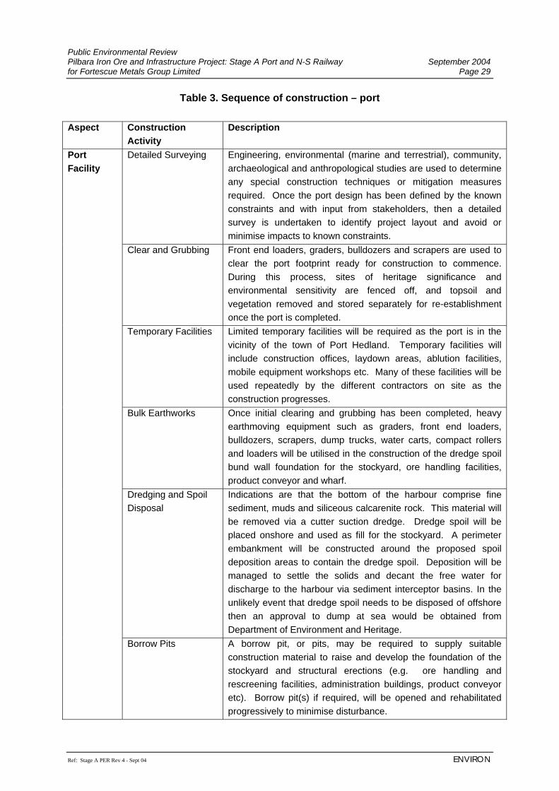
Public Environmental Review Pilbara Iron Ore and Infrastructure Project: Stage A Port and N-S Railway September 2004 for Fortescue Metals Group Limited Page 29
Ref: Stage A PER Rev 4 - Sept 04 ENVIRON
Table 3. Sequence of construction – port Aspect Construction
Activity Description
Detailed Surveying Engineering, environmental (marine and terrestrial), community, archaeological and anthropological studies are used to determine any special construction techniques or mitigation measures required. Once the port design has been defined by the known constraints and with input from stakeholders, then a detailed survey is undertaken to identify project layout and avoid or minimise impacts to known constraints.
Clear and Grubbing Front end loaders, graders, bulldozers and scrapers are used to clear the port footprint ready for construction to commence. During this process, sites of heritage significance and environmental sensitivity are fenced off, and topsoil and vegetation removed and stored separately for re-establishment once the port is completed.
Temporary Facilities Limited temporary facilities will be required as the port is in the vicinity of the town of Port Hedland. Temporary facilities will include construction offices, laydown areas, ablution facilities, mobile equipment workshops etc. Many of these facilities will be used repeatedly by the different contractors on site as the construction progresses.
Bulk Earthworks Once initial clearing and grubbing has been completed, heavy earthmoving equipment such as graders, front end loaders, bulldozers, scrapers, dump trucks, water carts, compact rollers and loaders will be utilised in the construction of the dredge spoil bund wall foundation for the stockyard, ore handling facilities, product conveyor and wharf.
Dredging and Spoil Disposal
Indications are that the bottom of the harbour comprise fine sediment, muds and siliceous calcarenite rock. This material will be removed via a cutter suction dredge. Dredge spoil will be placed onshore and used as fill for the stockyard. A perimeter embankment will be constructed around the proposed spoil deposition areas to contain the dredge spoil. Deposition will be managed to settle the solids and decant the free water for discharge to the harbour via sediment interceptor basins. In the unlikely event that dredge spoil needs to be disposed of offshore then an approval to dump at sea would be obtained from Department of Environment and Heritage.
Port Facility
Borrow Pits A borrow pit, or pits, may be required to supply suitable construction material to raise and develop the foundation of the stockyard and structural erections (e.g. ore handling and rescreening facilities, administration buildings, product conveyor etc). Borrow pit(s) if required, will be opened and rehabilitated progressively to minimise disturbance.
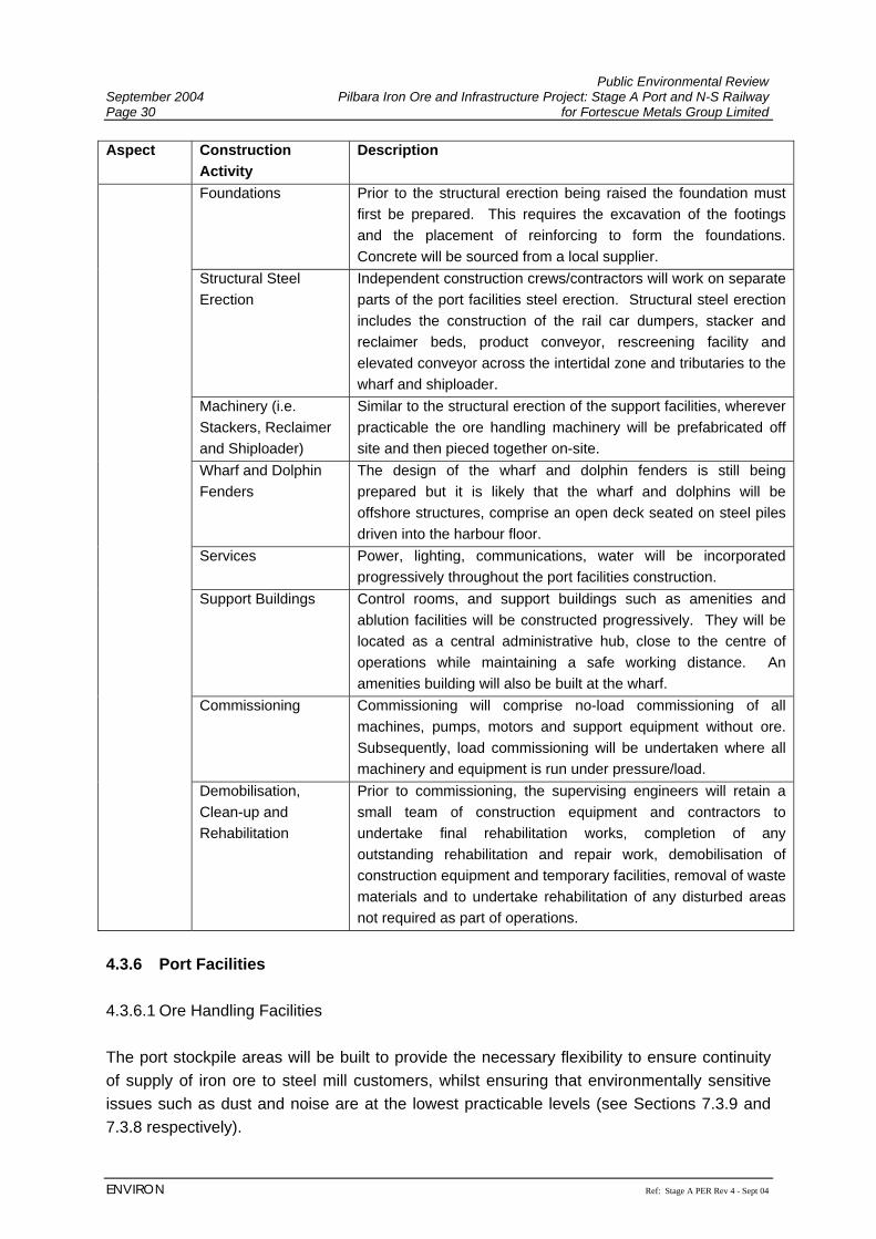
Public Environmental Review September 2004 Pilbara Iron Ore and Infrastructure Project: Stage A Port and N-S Railway Page 30 for Fortescue Metals Group Limited
ENVIRON Ref: Stage A PER Rev 4 - Sept 04
Aspect Construction Activity
Description
Foundations Prior to the structural erection being raised the foundation must first be prepared. This requires the excavation of the footings and the placement of reinforcing to form the foundations. Concrete will be sourced from a local supplier.
Structural Steel Erection
Independent construction crews/contractors will work on separate parts of the port facilities steel erection. Structural steel erection includes the construction of the rail car dumpers, stacker and reclaimer beds, product conveyor, rescreening facility and elevated conveyor across the intertidal zone and tributaries to the wharf and shiploader.
Machinery (i.e. Stackers, Reclaimer and Shiploader)
Similar to the structural erection of the support facilities, wherever practicable the ore handling machinery will be prefabricated off site and then pieced together on-site.
Wharf and Dolphin Fenders
The design of the wharf and dolphin fenders is still being prepared but it is likely that the wharf and dolphins will be offshore structures, comprise an open deck seated on steel piles driven into the harbour floor.
Services Power, lighting, communications, water will be incorporated progressively throughout the port facilities construction.
Support Buildings Control rooms, and support buildings such as amenities and ablution facilities will be constructed progressively. They will be located as a central administrative hub, close to the centre of operations while maintaining a safe working distance. An amenities building will also be built at the wharf.
Commissioning Commissioning will comprise no-load commissioning of all machines, pumps, motors and support equipment without ore. Subsequently, load commissioning will be undertaken where all machinery and equipment is run under pressure/load.
Demobilisation, Clean-up and Rehabilitation
Prior to commissioning, the supervising engineers will retain a small team of construction equipment and contractors to undertake final rehabilitation works, completion of any outstanding rehabilitation and repair work, demobilisation of construction equipment and temporary facilities, removal of waste materials and to undertake rehabilitation of any disturbed areas not required as part of operations.
4.3.6 Port Facilities 4.3.6.1 Ore Handling Facilities The port stockpile areas will be built to provide the necessary flexibility to ensure continuity of supply of iron ore to steel mill customers, whilst ensuring that environmentally sensitive issues such as dust and noise are at the lowest practicable levels (see Sections 7.3.9 and 7.3.8 respectively).
Public Environmental Review Pilbara Iron Ore and Infrastructure Project: Stage A Port and N-S Railway September 2004 for Fortescue Metals Group Limited Page 31
Ref: Stage A PER Rev 4 - Sept 04 ENVIRON
Crushing and screening of ore will be undertaken at the mines. FMG will be handling direct shipped ore (DSO) from Mindy Mindy and DSO and/or beneficiated ore from the Chichester deposits. The port facility has been designed to handle these types of ore, and dust management measures have taken into account that the DSO and beneficiated ore will have a high moisture content (refer to Appendix F). Trains arriving at this facility from the mines will be unloaded using a rotary dumper, a pair of wagons at a time, in a continuous process. The ore will pass from the dumper, via a conveyer to a transfer point, then to one of two travelling stackers for stockpiling and quality analysis. The product stockpile configuration and equipment proposed will allow the maximum flexibility in the manner in which ore product is arranged in stockpiles and reclaimed. Ore product will be reclaimed from the stockpiles by a boom reclaimer at over 10,000 tph and then taken by conveyer to the shipping berth to be loaded by a shiploader. The reclaimer and stackers will be automated, whilst the shiploader will be manned. The shiploading facility is designed to resist category five cyclones. It is possible that additional stockpiles will be required in the future and these will be constructed on reclaimed land. However, these are not considered within the scope of this PER and environmental approval for expansion of these facilities would be sought separately if they are required in the future. 4.3.6.2 Shiploading Within the Port Hedland Port, FMG will construct and operate a shiploading terminal with a capacity of 45 Mtpa. The ship loader, stackers and the reclaimer will be designed for loading ships during wind speed up to 80 kph. An automatic sampling station will be designed to carry out chemical analysis and assaying of the ore. This will ensure that each shipment meets customer specifications for quality, size and distribution. 4.3.6.3 Wharf Facilities and Berth The port facilities will disturb approximately 109 ha of the intertidal zone (which includes proposed dredge areas) including approximately 22 ha of mangroves and 87 ha of open mudflats (Section 6.3.5). The twin shipping berth will allow for two 250,000 DWT vessels to be berthed. One berth will be serviced by a wharf and shiploader whilst the other is a parking berth only. All marine structures, including fender dolphins, will be designed and constructed to effectively manage part laden berthing or departing of such loaded vessels. All steel work associated with the marine facilities will be coated with sacrificial anode and electronic cathode protection.
Public Environmental Review September 2004 Pilbara Iron Ore and Infrastructure Project: Stage A Port and N-S Railway Page 32 for Fortescue Metals Group Limited
ENVIRON Ref: Stage A PER Rev 4 - Sept 04
FMG will support the use of successfully trialed Dynamic Under Keel Clearance (DUKC). This technology will ensure that ships are loaded to the maximum capacity for the channel and tidal movements on the day of sailing. Marine towage will be supplied by a contractor, which follows present practice in the Port Hedland harbour. Dredging of the harbour to accommodate the additional berths at Anderson Point will be required and a cutter suction dredge will be used to enable sufficient ship docking and turning clearance depth to be excavated. The maximum quantity of dredge spoil to be created is estimated at 3.3 Mm3. Dredge spoil will be utilised as bulk fill for reclamation of the stockyard and surrounding facilities. Initial geotechnical studies by Coffey (2004) have indicated that the dredge spoil is likely to be suitable for this purpose. This will be confirmed by further geotechnical work prior to construction. If dredge spoil exists that is unsuitable as foundation material, it will be disposed of off-shore or in a land disposal area, where it is not required to be used as structural fill. If required, approvals for off-shore disposal will be applied for from the Commonwealth as required under the Environment Protection (Sea Dumping) Act 1981. 4.3.7 Ancillary Services Water for the port facilities will be provided by the Water Corporation from expansion of its existing scheme water system (see Section 7.3.2.1). Approximately 2.0 GLpa will be required, mainly for dust suppression at the port. However, FMG has identified a number of dust minimisation methods to reduce the volume of water required (Section 7.3.9). FMG has investigated other dust suppressants (such as spray on chemicals and organic compounds) that create a crust on the surface of the stockpiles, although these have been found to be impractical due to the requirement to constantly move product from stockpiles. FMG will investigate in collaboration with the Water Corporation non-potable water sources for dust suppression such as grey water, brackish water or waste water. Approximately 12.5 MW of power will be provided to the port facility via the existing grid by the addition of extra generating capacity at the Port Hedland power station operated by Alinta Gas. 4.3.8 Dangerous Goods It is unlikely that operational activities at the port will require the presence of any significant volume of dangerous or hazardous substances to be either stored or used on site. Some limited quantities of solvents, paints, cleaning products and bonding agents will be required. All hazardous or dangerous goods will be stored and used in compliance with relevant legislation and standards.
Public Environmental Review Pilbara Iron Ore and Infrastructure Project: Stage A Port and N-S Railway September 2004 for Fortescue Metals Group Limited Page 33
Ref: Stage A PER Rev 4 - Sept 04 ENVIRON
4.3.9 Waste Management A local waste management and recycling contractor will be utilised to collect and remove waste from the port site, reusing and recycling waste wherever practicable. An Environmental Awareness training programme will encourage waste reduction and reuse and recycling. Waste that cannot be reused or recycled will be disposed of at the Port Hedland or other landfill facilities, in accordance with relevant legislation and standards. 4.3.10 Inspection, Maintenance and Monitoring FMG will manage its port facilities to ensure there are no unacceptable impacts on the environment as a result of its operations. Ongoing monitoring and community consultation will enable FMG to evaluate and modify management measures. Harbour maintenance is expected to be limited. Some maintenance dredging is likely to be required when sediments build up in the berthing pockets and main channel. However, the time taken to build up sediments that require removal can be considerable. Once the initial dredging has been undertaken by FMG, dredge maintenance will be undertaken by PHPA. Spoil will be disposed of either onshore or offshore depending on its nature. 4.3.11 Workforce and Accommodation The construction workforce will be accommodated in single persons quarters in Port Hedland. Operational staff will be accommodated in new or existing residences in the Port Hedland area. 4.3.12 Access Management During construction and operation of the port facility, access to the general public will be restricted in the Anderson Point and the South West Creek areas. Access to recreational fishing areas will be discussed with key stakeholders with the view to establishing an acceptable outcome for all parties, without compromising public safety or the port’s operations. 4.3.13 Emergency Response Preparedness for cyclonic events or other emergencies will be built into management systems and procedures. Emergency drills and regular audits will ensure that staff and facilities are able to handle cyclonic events and to minimise adverse environmental impacts as far as practicable that result from any damage sustained on site.

Public Environmental Review September 2004 Pilbara Iron Ore and Infrastructure Project: Stage A Port and N-S Railway Page 34 for Fortescue Metals Group Limited
ENVIRON Ref: Stage A PER Rev 4 - Sept 04
(This page has been left blank intentionally)
Public Environmental Review Pilbara Iron Ore and Infrastructure Project: Stage A Port and N-S Railway September 2004 for Fortescue Metals Group Limited Page 35
Ref: Stage A PER Rev 4 - Sept 04 ENVIRON
5. STAKEHOLDER CONSULTATION PROCESS The stakeholder consultation process for the Project was initiated by FMG prior to submission of the Environmental Referral in December 2003. A consultation strategy was prepared by FMG to facilitate effective communication with the regulators, local and wider community and other stakeholders, and to allow issues raised during the consultation process to be taken into consideration in the design and planning of this Project. 5.1 CONSULTATION PROGRAMME The Proponent has continued to consult with stakeholders regarding the Project on a regular basis. Consultation has included public presentations, government presentations and one on one discussions with pastoral lease holders, environmental groups, community groups, local members of parliament, government departments, members of local Aboriginal communities, Native Title claimants, working groups and their legal representative body the Pilbara Native Title Services (PNTS). All stakeholders have been contacted in writing where the Project area intersects land in which the stakeholders hold a registered interest. Follow up meetings have been arranged where requested by stakeholders to further discuss the Project and the potential impacts. A Stakeholder consultation strategy has been implemented to ensure that the concerns and interests of stakeholders are taken into consideration in design and development of the Project. The consultation strategy includes but is not limited to community updates, mail outs, newsletters, website information, display materials, letters, personal visits, newspaper articles, radio advertising, site tours, presentations and community meetings. The consultation strategy has been included in the Project scheduling and will continue throughout the life of the Project. A list of consultation activities held is shown in Table 4 and a summary of issues raised and FMG’s response are presented as Appendix C.
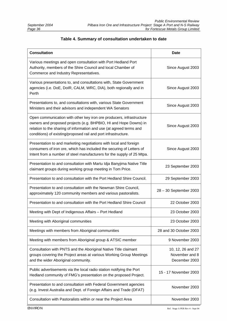
Public Environmental Review September 2004 Pilbara Iron Ore and Infrastructure Project: Stage A Port and N-S Railway Page 36 for Fortescue Metals Group Limited
ENVIRON Ref: Stage A PER Rev 4 - Sept 04
Table 4. Summary of consultation undertaken to date
Consultation Date
Various meetings and open consultation with Port Hedland Port Authority, members of the Shire Council and local Chamber of Commerce and Industry Representatives.
Since August 2003
Various presentations to, and consultations with, State Government agencies (i.e. DoE, DoIR, CALM, WRC, DIA), both regionally and in Perth
Since August 2003
Presentations to, and consultations with, various State Government Ministers and their advisors and independent WA Senators
Since August 2003
Open communication with other key iron ore producers, infrastructure owners and proposed projects (e.g. BHPBIO, HI and Hope Downs) in relation to the sharing of information and use (at agreed terms and conditions) of existing/proposed rail and port infrastructure.
Since August 2003
Presentation to and marketing negotiations with local and foreign consumers of iron ore, which has included the securing of Letters of Intent from a number of steel manufacturers for the supply of 25 Mtpa.
Since August 2003
Presentation to and consultation with Martu Idja Banyjima Native Title claimant groups during working group meeting in Tom Price.
23 September 2003
Presentation to and consultation with the Port Hedland Shire Council. 29 September 2003
Presentation to and consultation with the Newman Shire Council, approximately 120 community members and various pastoralists.
28 – 30 September 2003
Presentation to and consultation with the Port Hedland Shire Council 22 October 2003
Meeting with Dept of Indigenous Affairs – Port Hedland 23 October 2003
Meeting with Aboriginal communities 23 October 2003
Meetings with members from Aboriginal communities 28 and 30 October 2003
Meeting with members from Aboriginal group & ATSIC member 9 November 2003
Consultation with PNTS and the Aboriginal Native Title claimant groups covering the Project areas at various Working Group Meetings and the wider Aboriginal community.
10, 12, 26 and 27 November and 8 December 2003
Public advertisements via the local radio station notifying the Port Hedland community of FMG’s presentation on the proposed Project.
15 - 17 November 2003
Presentation to and consultation with Federal Government agencies (e.g. Invest Australia and Dept. of Foreign Affairs and Trade (DFAT)
November 2003
Consultation with Pastoralists within or near the Project Area November 2003
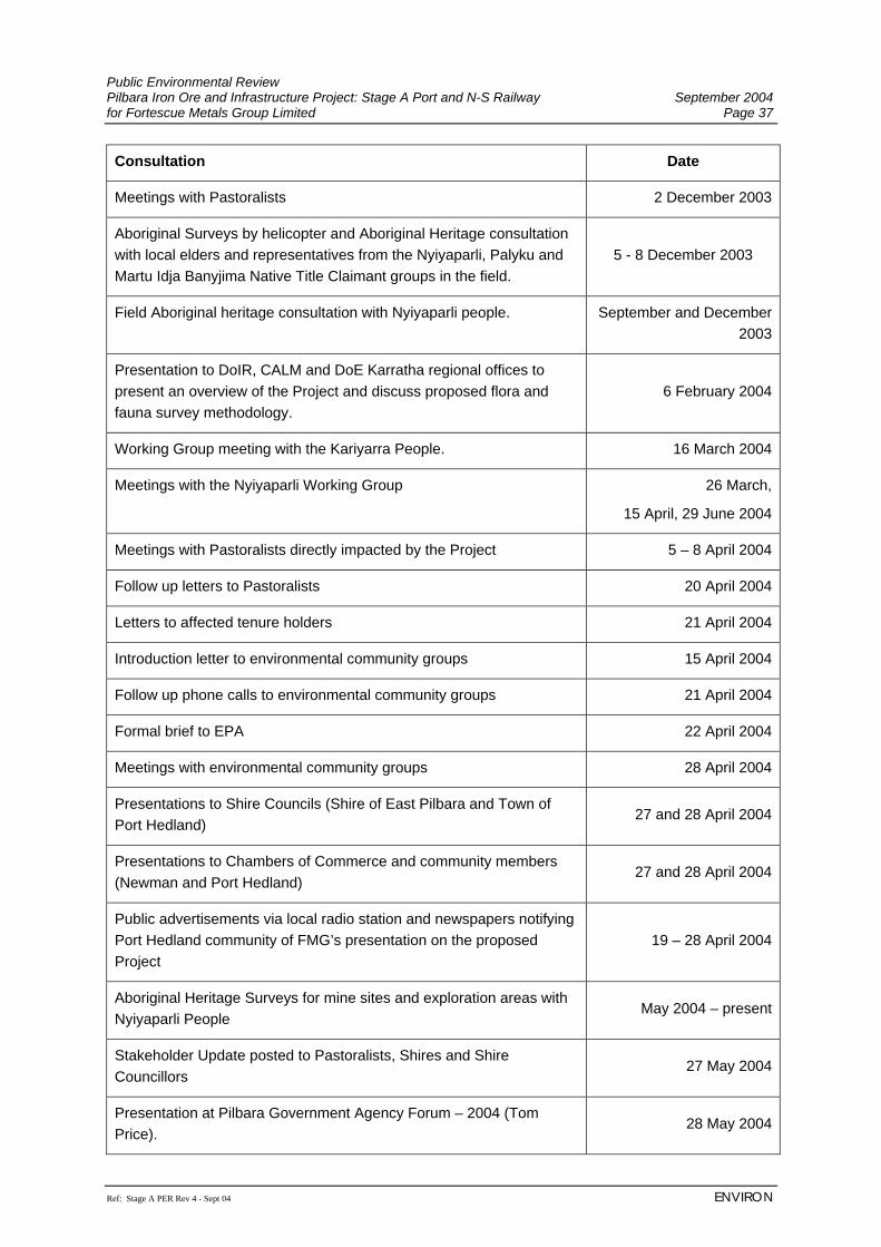
Public Environmental Review Pilbara Iron Ore and Infrastructure Project: Stage A Port and N-S Railway September 2004 for Fortescue Metals Group Limited Page 37
Ref: Stage A PER Rev 4 - Sept 04 ENVIRON
Consultation Date
Meetings with Pastoralists 2 December 2003
Aboriginal Surveys by helicopter and Aboriginal Heritage consultation with local elders and representatives from the Nyiyaparli, Palyku and Martu Idja Banyjima Native Title Claimant groups in the field.
5 - 8 December 2003
Field Aboriginal heritage consultation with Nyiyaparli people. September and December 2003
Presentation to DoIR, CALM and DoE Karratha regional offices to present an overview of the Project and discuss proposed flora and fauna survey methodology.
6 February 2004
Working Group meeting with the Kariyarra People. 16 March 2004
Meetings with the Nyiyaparli Working Group 26 March,
15 April, 29 June 2004
Meetings with Pastoralists directly impacted by the Project 5 – 8 April 2004
Follow up letters to Pastoralists 20 April 2004
Letters to affected tenure holders 21 April 2004
Introduction letter to environmental community groups 15 April 2004
Follow up phone calls to environmental community groups 21 April 2004
Formal brief to EPA 22 April 2004
Meetings with environmental community groups 28 April 2004
Presentations to Shire Councils (Shire of East Pilbara and Town of Port Hedland)
27 and 28 April 2004
Presentations to Chambers of Commerce and community members (Newman and Port Hedland)
27 and 28 April 2004
Public advertisements via local radio station and newspapers notifying Port Hedland community of FMG’s presentation on the proposed Project
19 – 28 April 2004
Aboriginal Heritage Surveys for mine sites and exploration areas with Nyiyaparli People
May 2004 – present
Stakeholder Update posted to Pastoralists, Shires and Shire Councillors
27 May 2004
Presentation at Pilbara Government Agency Forum – 2004 (Tom Price).
28 May 2004
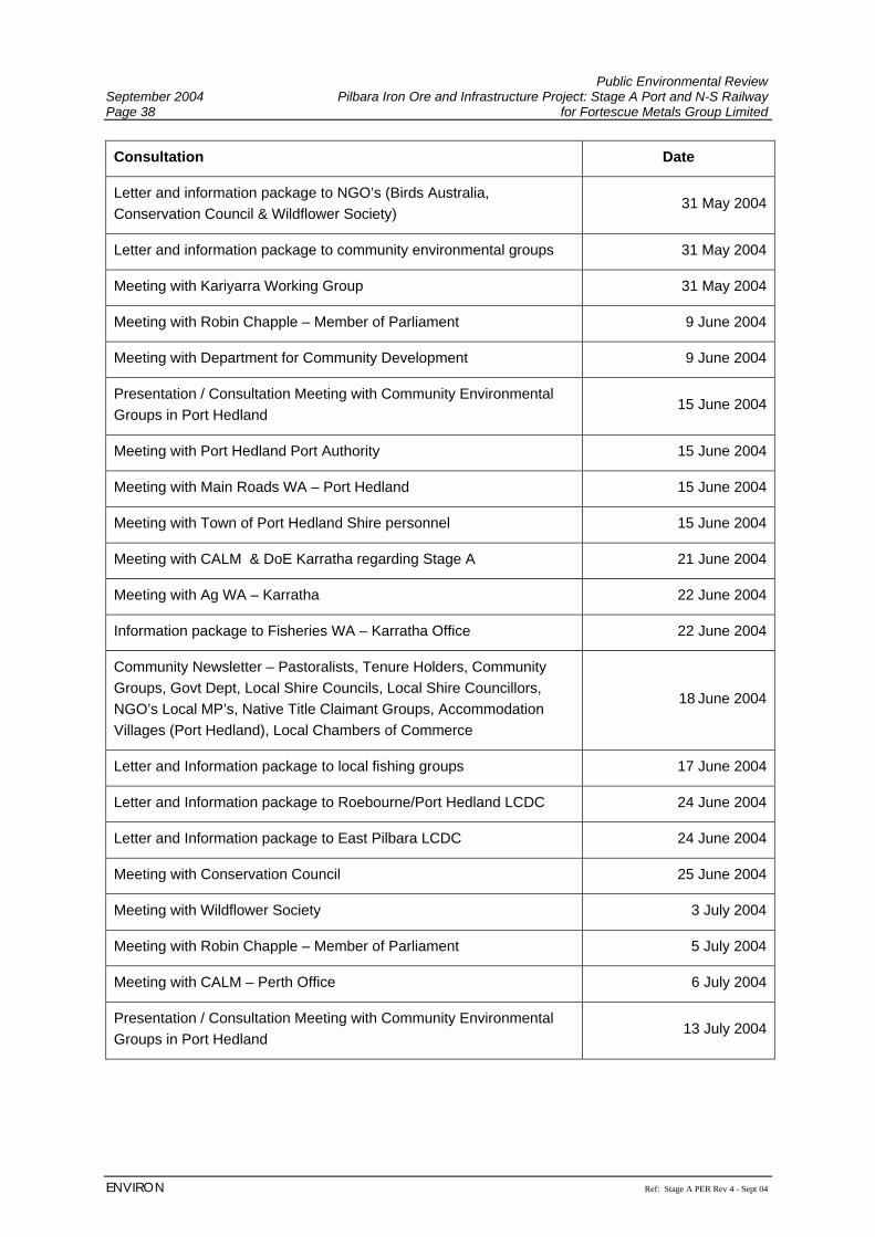
Public Environmental Review September 2004 Pilbara Iron Ore and Infrastructure Project: Stage A Port and N-S Railway Page 38 for Fortescue Metals Group Limited
ENVIRON Ref: Stage A PER Rev 4 - Sept 04
Consultation Date
Letter and information package to NGO’s (Birds Australia, Conservation Council & Wildflower Society)
31 May 2004
Letter and information package to community environmental groups 31 May 2004
Meeting with Kariyarra Working Group 31 May 2004
Meeting with Robin Chapple – Member of Parliament 9 June 2004
Meeting with Department for Community Development 9 June 2004
Presentation / Consultation Meeting with Community Environmental Groups in Port Hedland
15 June 2004
Meeting with Port Hedland Port Authority 15 June 2004
Meeting with Main Roads WA – Port Hedland 15 June 2004
Meeting with Town of Port Hedland Shire personnel 15 June 2004
Meeting with CALM & DoE Karratha regarding Stage A 21 June 2004
Meeting with Ag WA – Karratha 22 June 2004
Information package to Fisheries WA – Karratha Office 22 June 2004
Community Newsletter – Pastoralists, Tenure Holders, Community Groups, Govt Dept, Local Shire Councils, Local Shire Councillors, NGO’s Local MP’s, Native Title Claimant Groups, Accommodation Villages (Port Hedland), Local Chambers of Commerce
18 June 2004
Letter and Information package to local fishing groups 17 June 2004
Letter and Information package to Roebourne/Port Hedland LCDC 24 June 2004
Letter and Information package to East Pilbara LCDC 24 June 2004
Meeting with Conservation Council 25 June 2004
Meeting with Wildflower Society 3 July 2004
Meeting with Robin Chapple – Member of Parliament 5 July 2004
Meeting with CALM – Perth Office 6 July 2004
Presentation / Consultation Meeting with Community Environmental Groups in Port Hedland
13 July 2004
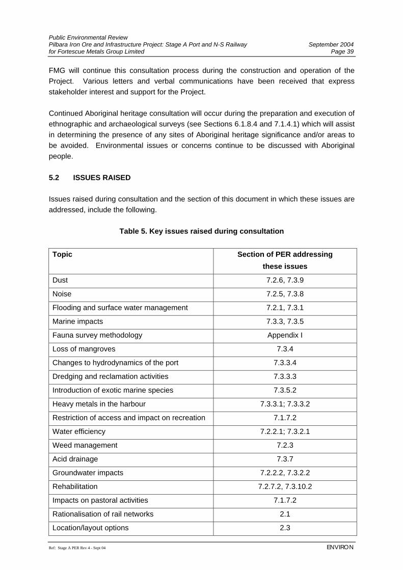
Public Environmental Review Pilbara Iron Ore and Infrastructure Project: Stage A Port and N-S Railway September 2004 for Fortescue Metals Group Limited Page 39
Ref: Stage A PER Rev 4 - Sept 04 ENVIRON
FMG will continue this consultation process during the construction and operation of the Project. Various letters and verbal communications have been received that express stakeholder interest and support for the Project. Continued Aboriginal heritage consultation will occur during the preparation and execution of ethnographic and archaeological surveys (see Sections 6.1.8.4 and 7.1.4.1) which will assist in determining the presence of any sites of Aboriginal heritage significance and/or areas to be avoided. Environmental issues or concerns continue to be discussed with Aboriginal people. 5.2 ISSUES RAISED Issues raised during consultation and the section of this document in which these issues are addressed, include the following.
Table 5. Key issues raised during consultation
Topic Section of PER addressing these issues
Dust 7.2.6, 7.3.9
Noise 7.2.5, 7.3.8
Flooding and surface water management 7.2.1, 7.3.1
Marine impacts 7.3.3, 7.3.5
Fauna survey methodology Appendix I
Loss of mangroves 7.3.4
Changes to hydrodynamics of the port 7.3.3.4
Dredging and reclamation activities 7.3.3.3
Introduction of exotic marine species 7.3.5.2
Heavy metals in the harbour 7.3.3.1; 7.3.3.2
Restriction of access and impact on recreation 7.1.7.2
Water efficiency 7.2.2.1; 7.3.2.1
Weed management 7.2.3
Acid drainage 7.3.7
Groundwater impacts 7.2.2.2, 7.3.2.2
Rehabilitation 7.2.7.2, 7.3.10.2
Impacts on pastoral activities 7.1.7.2
Rationalisation of rail networks 2.1
Location/layout options 2.3
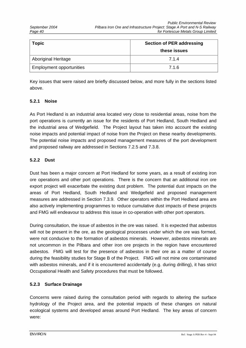
Public Environmental Review September 2004 Pilbara Iron Ore and Infrastructure Project: Stage A Port and N-S Railway Page 40 for Fortescue Metals Group Limited
ENVIRON Ref: Stage A PER Rev 4 - Sept 04
Topic Section of PER addressing these issues
Aboriginal Heritage 7.1.4
Employment opportunities 7.1.6
Key issues that were raised are briefly discussed below, and more fully in the sections listed above. 5.2.1 Noise As Port Hedland is an industrial area located very close to residential areas, noise from the port operations is currently an issue for the residents of Port Hedland, South Hedland and the industrial area of Wedgefield. The Project layout has taken into account the existing noise impacts and potential impact of noise from the Project on these nearby developments. The potential noise impacts and proposed management measures of the port development and proposed railway are addressed in Sections 7.2.5 and 7.3.8. 5.2.2 Dust Dust has been a major concern at Port Hedland for some years, as a result of existing iron ore operations and other port operations. There is the concern that an additional iron ore export project will exacerbate the existing dust problem. The potential dust impacts on the areas of Port Hedland, South Hedland and Wedgefield and proposed management measures are addressed in Section 7.3.9. Other operators within the Port Hedland area are also actively implementing programmes to reduce cumulative dust impacts of these projects and FMG will endeavour to address this issue in co-operation with other port operators. During consultation, the issue of asbestos in the ore was raised. It is expected that asbestos will not be present in the ore, as the geological processes under which the ore was formed, were not conducive to the formation of asbestos minerals. However, asbestos minerals are not uncommon in the Pilbara and other iron ore projects in the region have encountered asbestos. FMG will test for the presence of asbestos in their ore as a matter of course during the feasibility studies for Stage B of the Project. FMG will not mine ore contaminated with asbestos minerals, and if it is encountered accidentally (e.g. during drilling), it has strict Occupational Health and Safety procedures that must be followed. 5.2.3 Surface Drainage Concerns were raised during the consultation period with regards to altering the surface hydrology of the Project area, and the potential impacts of these changes on natural ecological systems and developed areas around Port Hedland. The key areas of concern were:
Public Environmental Review Pilbara Iron Ore and Infrastructure Project: Stage A Port and N-S Railway September 2004 for Fortescue Metals Group Limited Page 41
Ref: Stage A PER Rev 4 - Sept 04 ENVIRON
• Obstruction of natural surface drainage patterns by the railway, and/or other infrastructure associated with the Project, resulting in water starvation of vegetation communities (e.g. mulga communities) downstream of the obstruction, leading to vegetation death;
• Pollution of surface waters from sedimentation (during construction) or hydrocarbon spills from the Project;
• Obstruction of creeks and river flow through construction of inadequate river crossings for the railway;
• Diversion of waters from the upper catchment of South West Creek and South Creek to flow into South Creek due to construction of the railway. There was concern over the increased risk of flooding of South Hedland and/or Wedgefield, following heavy rainfall in the upper catchment of South Creek;
• Obstruction of natural surface drainage in the Port area and subsequent increased risk of flooding in South Hedland and/or Wedgefield, following heavy rainfall.
The potential impacts and management of changes to surface drainage are addressed in Sections 7.2.1 and 7.3.1. 5.2.4 Mangrove Disturbance Concerns were expressed in the early stages of Project development over the area of mangroves that would need to be disturbed by the Project. As a result, FMG refined its Project layout to reduce impacts on mangrove communities within the constraints imposed by the existing BHPBIO railway, and engineering requirements for the Project. The potential impacts on mangrove communities and the proposed management measures are dealt with in Section 7.3.4 and in more detail in Biota Environmental Science’s report in Appendix H.

Public Environmental Review September 2004 Pilbara Iron Ore and Infrastructure Project: Stage A Port and N-S Railway Page 42 for Fortescue Metals Group Limited
ENVIRON Ref: Stage A PER Rev 4 - Sept 04
(This page has been left blank intentionally)
Public Environmental Review Pilbara Iron Ore and Infrastructure Project: Stage A Port and N-S Railway September 2004 for Fortescue Metals Group Limited Page 43
Ref: Stage A PER Rev 4 - Sept 04 ENVIRON
6. EXISTING ENVIRONMENT 6.1 REGIONAL CONTEXT 6.1.1 Climate The Pilbara region from Port Hedland south to the FMG mining tenements is classified as arid-tropical, becoming more arid inland. Climatic data provided by the Bureau of Meteorology (www.bom.gov.au) for four Pilbara weather stations indicate that peak rainfall occurs in the summer months between January and March with a smaller peak in May and June. Climatic conditions in the Pilbara are influenced by tropical cyclone systems predominantly between January and March. These cyclones normally develop over the ocean north of Australia and follow a south-westerly course parallel to the northwest coast. However, at some point, two thirds of these cyclones change direction and head southeast, crossing the coast and moving inland, bringing heavy rainfall. Rainfall during May and June is generally a result of cold fronts moving across the south of the State, which occasionally extend into the Pilbara. Annual average rainfall for the Pilbara ranges from 180 mm to over 400 mm (Beard, 1975) with the Bureau of Meteorology data indicating an annual average of 312 mm at Newman to 454 mm at Wittenoom. Average maximum summer temperatures are generally between 35°C and 40°C and winter maximum temperatures generally between 22°C and 30°C. In this climate, annual evaporation rates greatly exceed the mean annual rainfall. The local climate is influenced to some degree by the topography with rainfall highest around the Hamersley Ranges whose summits exceed 900 m above mean sea level (Beard, 1975). Climatic data for Port Hedland and Newman are presented in Table 6 as these represent the climatic extremes for the proposed rail corridor and port.
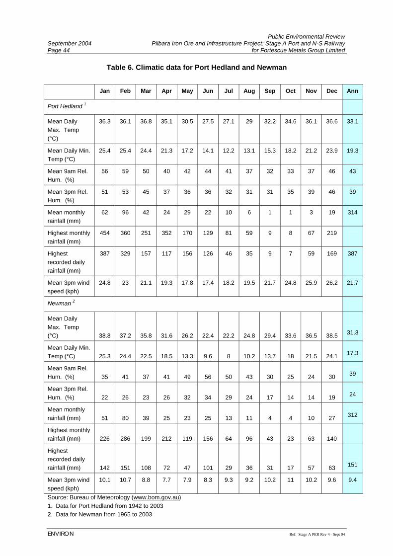
Public Environmental Review September 2004 Pilbara Iron Ore and Infrastructure Project: Stage A Port and N-S Railway Page 44 for Fortescue Metals Group Limited
ENVIRON Ref: Stage A PER Rev 4 - Sept 04
Table 6. Climatic data for Port Hedland and Newman
Jan Feb Mar Apr May Jun Jul Aug Sep Oct Nov Dec Ann
Port Hedland 1
Mean Daily Max. Temp (°C)
36.3 36.1 36.8 35.1 30.5 27.5 27.1 29 32.2 34.6 36.1 36.6 33.1
Mean Daily Min. Temp (°C)
25.4 25.4 24.4 21.3 17.2 14.1 12.2 13.1 15.3 18.2 21.2 23.9 19.3
Mean 9am Rel. Hum. (%)
56 59 50 40 42 44 41 37 32 33 37 46 43
Mean 3pm Rel. Hum. (%)
51 53 45 37 36 36 32 31 31 35 39 46 39
Mean monthly rainfall (mm)
62 96 42 24 29 22 10 6 1 1 3 19 314
Highest monthly rainfall (mm)
454 360 251 352 170 129 81 59 9 8 67 219
Highest recorded daily rainfall (mm)
387 329 157 117 156 126 46 35 9 7 59 169 387
Mean 3pm wind speed (kph)
24.8 23 21.1 19.3 17.8 17.4 18.2 19.5 21.7 24.8 25.9 26.2 21.7
Newman 2
Mean Daily Max. Temp (°C) 38.8 37.2 35.8 31.6 26.2 22.4 22.2 24.8 29.4 33.6 36.5 38.5 31.3
Mean Daily Min. Temp (°C) 25.3 24.4 22.5 18.5 13.3 9.6 8 10.2 13.7 18 21.5 24.1 17.3
Mean 9am Rel. Hum. (%) 35 41 37 41 49 56 50 43 30 25 24 30 39
Mean 3pm Rel. Hum. (%) 22 26 23 26 32 34 29 24 17 14 14 19 24
Mean monthly rainfall (mm) 51 80 39 25 23 25 13 11 4 4 10 27 312
Highest monthly rainfall (mm) 226 286 199 212 119 156 64 96 43 23 63 140
Highest recorded daily rainfall (mm) 142 151 108 72 47 101 29 36 31 17 57 63 151
Mean 3pm wind speed (kph)
10.1 10.7 8.8 7.7 7.9 8.3 9.3 9.2 10.2 11 10.2 9.6 9.4
Source: Bureau of Meteorology (www.bom.gov.au) 1. Data for Port Hedland from 1942 to 2003 2. Data for Newman from 1965 to 2003
Public Environmental Review Pilbara Iron Ore and Infrastructure Project: Stage A Port and N-S Railway September 2004 for Fortescue Metals Group Limited Page 45
Ref: Stage A PER Rev 4 - Sept 04 ENVIRON
Newman experiences greater extremes of temperature than Port Hedland. Although average annual rainfall is similar for both stations, Newman’s rainfall exceeds that of Port Hedland’s between June and December, and Port Hedland receives more rainfall than Newman in summer between January and March. Winds are predominantly east-southeasterly at both stations between May and August with stronger west-northwesterly winds between September and March. Port Hedland experiences stronger winds (annual average wind speed of 21.7 kph) in general than Newman (annual average wind speed of 9.4 kph). 6.1.2 Bioregions The Interim Biogeographic Regionalisation for Australia (IBRA) recognises 85 bioregions (Thackway and Cresswell, 1995; Environment Australia, 2000). The Pilbara Bioregion has four main components, based on the physiographic work of Beard (1975) (Section 6.1.3). From north to south along the FMG rail corridor, these are (Figure 8): Roebourne Plains (PIL4) The Roebourne Plains subregion, which contains the port site and the northern-most portion of the rail corridor, is described as: “Quaternary alluvial plains with a grass savanna of mixed bunch and hummock grasses, and dwarf shrub steppe of Acacia translucens over Triodia pungens. Samphire, Sporobolus and Mangal occur on marine alluvial flats. Arid tropical with summer rain.” Chichester Range (PIL3) South of the Roebourne Plains, the rail corridor traverses the Chichester Range subregion, which comprises: “Archaean granite and basalt plains supporting shrub steppe characterised by Acacia pyrifolia over Triodia pungens hummock grasses. Snappy Gum tree steppes occur on ranges.” Fortescue Plains (PIL2) South of the Chichester Range, the rail corridor traverses the Fortescue Plains subregion, which comprises: “Alluvial plains and river frontages. Salt marsh, mulga-bunch grass, and short grass communities on alluvial plains. River Gum woodlands fringe the drainage lines. This is the northern limit of Mulga (Acacia aneura).” Hamersley Range (PIL1) The Hamersley subregion is described as “A mountainous area of Proterozoic sedimentary ranges and plateaux with Mulga low woodland over bunch grasses on fine textured soils and Snappy Gum over Triodia brizoides on skeletal sandy soils of the ranges.” (IBRA Revision 5.1; Environment Australia, 2000). This subregion contains the southern-most part of the proposed rail corridor.
Public Environmental Review September 2004 Pilbara Iron Ore and Infrastructure Project: Stage A Port and N-S Railway Page 46 for Fortescue Metals Group Limited
ENVIRON Ref: Stage A PER Rev 4 - Sept 04
With increasing survey work in the Pilbara, it is becoming apparent that this region is one of the centres of biodiversity in the State. The eastern portion of the Pilbara in particular is located in a transitional zone between the floras of the Eyrean (central desert) and southern Torresian (tropical) bioclimatic regions, and contains elements of both floras (see van Leeuwen and Bromilow (2002) for more detail). In recognition of this high species diversity and the high levels of endemism in the region, the Pilbara has recently been nominated as one of 15 national biodiversity “hotspots” by the Federal Minister for the Environment and Heritage. The Pilbara Bioregion is also listed as a high priority for funding for land purchase under the National Reserves System Co-operative Program due to the limited representation of the area in conservation reserves. Portions of various pastoral leases in the region have been nominated for exclusion for public purposes in 2015, when the leases come up for renewal. Many of the nominating submissions are from CALM, with the intention of adding these areas to the existing conservation estate in order to provide a more comprehensive, adequate and representative reserve system. Of relevance to the proposed FMG rail development are:
• the proposed exclusion of some 46,660 ha from Mulga Downs Station between the Great Northern Highway and the existing BHPBIO rail line; and
• the proposed exclusion of some 135,537 ha from Marillana Station, mainly north of the Munjina – Roy Hill Road.
These areas have been identified for exclusion to protect the highly significant Fortescue Marshes, which is listed as a nationally important wetland (Environment Australia, 2001), based on the following criteria:
• It is a good example of a wetland type occurring within a biogeographic region in Australia;
• It is a wetland which plays an important ecological or hydrological role in the natural functioning of a major wetland system/complex;
• It is a wetland which is important as the habitat for animal taxa at a vulnerable stage in their life cycles, or provides a refuge when adverse conditions such as drought prevail; and
• The wetland is of outstanding historical or cultural significance. Fortescue Marshes are also listed as an ‘Indicative Place’3 on the Register of the National Estate (natural heritage) due to its importance for conservation of waterbirds.
3 An Indicative Place is a site for which data provided to or obtained by the Heritage Division of the Australian Department of Environment and Heritage has been entered into the database. However, a formal nomination has not been made and the Department has not prepared all the data necessary for a nomination.
Public Environmental Review Pilbara Iron Ore and Infrastructure Project: Stage A Port and N-S Railway September 2004 for Fortescue Metals Group Limited Page 47
Ref: Stage A PER Rev 4 - Sept 04 ENVIRON
6.1.3 Major Physiographic Units The study area lies entirely within the Fortescue Botanical District of the Pilbara Region, as defined by Beard (1975). The major physiographic units are: Abydos Plain Extending from Cape Preston east to Pardoo Creek, and south to the Chichesters; including alluvial plains, low stony hills and granite outcrops; comprising largely granitic soils, with alluvial sands on the coastal portion. Chichester Plateau A plateau of mainly basalts, with included siltstone, mudstone, shale, dolomite and jaspilite; forming a watershed between numerous rivers flowing north through the Abydos Plain to the coast, and the Fortescue drainage on the southern side of the range. Fortescue Valley Occupying a trough between the Chichester and Hamersley Plateaux; the eastern portion drains into the Fortescue Marshes, while the western portion drains through a valley through the Chichester Plateau. Hamersley Plateau Rounded hills and ranges, predominantly of jaspilite and dolomite with some shale, siltstone and volcanics. Based on Beard (1975), the proposed rail corridor traverses 11 vegetation units (note that some species names have been changed from the original citation to reflect current nomenclature): 1. Mangals on the coast at Port Hedland; 2. Tidal mudflats at Port Hedland; 3. Acacia stellaticeps dwarf shrubs over Triodia epactia4 hummock grassland, principally
near the coast; 4. Acacia inaequilatera shrubs over Triodia epactia hummock grassland on the broad
granite plain south to the Chichester Range; 5. Coolibah Eucalyptus victrix and River Red Gum E. camaldulensis woodland in the major
drainage systems such as the Yule and Turner Rivers; 6. Acacia inaequilatera shrubs over mixed Triodia epactia and Triodia wiseana hummock
grassland on the Chichester Range; 7. Patches of short grassland on the cracking clays of the Chichesters; 8. Snappy Gum Eucalyptus leucophloia scattered trees over Triodia wiseana hummock
grassland, with Mulga Acacia aneura4 low woodland in valleys, on the southern side of the Chichester Range;
4 Note that this taxon is considered a species complex.
Public Environmental Review September 2004 Pilbara Iron Ore and Infrastructure Project: Stage A Port and N-S Railway Page 48 for Fortescue Metals Group Limited
ENVIRON Ref: Stage A PER Rev 4 - Sept 04
9. Mulga groves on the plain surrounding the Fortescue Marshes; 10. A narrow stretch of succulent steppe dominated by various halophytes (this represents
the westernmost extent of the Fortescue Marsh, and leads into an area of short tussock grassland further to the west); and
11. Twin-leaf Mallee Eucalyptus gamophylla scattered mallees over Triodia basedowii hummock grassland on the low footslopes of the Hamersley Range.
6.1.4 Geology and Soils Underlying geology typically influences the distribution of vegetation types and affects fauna habitat parameters. The study area crosses a large variety of geological types. On the Geological Survey of Western Australia 1:500,000 scale mapsheets (Thorne and Trendall, 2001), these are (from Port Hedland southwards):
• clay, mud, silt and sand on tidal areas and coastal dunes (Qm); • alluvium - unconsolidated silt, sand and gravel in major river channels (e.g. the
Turner, Yule and Fortescue Rivers) (Qa); • undivided Quaternary deposits fringing major river systems, mainly on the northern
Abydos Plain but also occurring broadly in the Fortescue Valley (Qx); • granitoid rocks of various ages on the central and southern Abydos Plain (Agp, Agf
and Agt ); • Tumbiana basalts (AFt and AFtc), Maddina basalts (AFmk and AFm), Jeerinah
basalts (AFjo and AFj) occurring broadly over the Chichester Range; • metamorphosed chert, banded iron formation (BIF), mudstone and siltstone of the
Marra Mamba Formation along the southern edge of the Chichester Range (AHm); • undivided Cainozoic deposits, of partly consolidated colluvium and alluvium, and
silcrete and laterite in the central Fortescue Valley area and on the colluvial fans the Hamersley Range (Czx); and
• Boolgeeda Iron Formation (PHb) and Weeli Wolli Formation (PHj) on the Hamersley Range.
The dominant soil types in the region comprise:
• duplex soils on the granite plains; and • uniform and skeletal soils on the stony hills.
Subordinate soil types comprise:
• creek alluvia in the numerous drainage lines dissecting the area; and • localised areas of gilgai cracking clays associated with the basalts of the
Chichesters.
Public Environmental Review Pilbara Iron Ore and Infrastructure Project: Stage A Port and N-S Railway September 2004 for Fortescue Metals Group Limited Page 49
Ref: Stage A PER Rev 4 - Sept 04 ENVIRON
6.1.5 Land Systems Land System (rangelands) mapping covering the Project area has been prepared by Agriculture Western Australia (Agwest, 2002). This mapping integrates vegetation, geological and physiographic information. The proposed rail corridor was overlain on this mapping and it intersects 23 Land Systems types from north to south as follows:
1. Littoral 9. Boolaloo 17. Jamindie 2. Uaroo 10. Granitic 18. Christmas 3. Macroy 11. White Springs 19. Adrian 4. Mallina 12. McKay 20. Coolibah 5. Talga 13. Rocklea 21. Brockman 6. Robe 14. Wona 22. Cowra 7. River 15. Capricorn 23. Boolgeeda 8. Calcrete 16. Newman
Two of these Land Systems (Brockman and Calcrete LS) were not present within the proposed Hope Downs rail corridor (Biota and Trudgen, 2002) and/or the Chichester and Hamersley Range Extensions to this corridor (Biota, 2003a and c). For all of the Land System units, the area within the FMG rail corridor comprises less than 6% of the mapped extent of the Land System in the Pilbara (based on mapping by Agwest, 2002). Therefore construction of the railway will not disturb any restricted Land System units. 6.1.6 Previous Biological Surveys Relevant to this Assessment 6.1.6.1 Regional Surveys Like most of the Pilbara region, the area surrounding and including the proposed FMG rail corridor has historically been poorly sampled. A biological survey of the Abydos-Woodstock Reserve (How et al., 1991) represents the only published biological survey directly of relevance to the Project area. This survey defined the following broad vegetation and habitat units (Tinley, 1991):
• Granite Plains − Acacia inaequilatera shrublands over Triodia epactia hummock grasslands on
dominant duplex red earths; − Acacia orthocarpa shrublands on leached, slightly acid, shallow stony red
earths on granite; − Triodia lanigera hummock grasslands in seasonally waterlogged areas; − Triodia brizoides treeless hummock grasslands on stony ferricrete soils; and − Corymbia hamersleyana over Triodia wiseana hummock grasslands on stony
calcrete soils.
Public Environmental Review September 2004 Pilbara Iron Ore and Infrastructure Project: Stage A Port and N-S Railway Page 50 for Fortescue Metals Group Limited
ENVIRON Ref: Stage A PER Rev 4 - Sept 04
• Bottomlands and Creeks − River gums Eucalyptus camaldulensis and Cadjeputs Melaleuca argentea in
major creeks; − Wattle Acacia scrub over grasses on floodplain alluvia; − Hummock grasslands of various spinifex species on the mosaic soils of
bottomland saline flats - Triodia wiseana (deep loamy gradational, alkaline, non-sodic to calcareous soils), T. epactia, T. longiceps (strongly alkaline or calcareous soils), T. secunda (calcareous sodic clays); and
− Melaleuca scrub thicket on deep, alkaline, duplex calcareous clays over calcrete.
Sampling by CALM staff has also occurred on a sporadic basis on hilltops of the Hamersley Range, cracking clays of the Chichesters and within the Fortescue Marshes. 6.1.6.2 Hope Downs Project Biological Surveys The most recent and directly relevant survey was the systematic biological survey completed for the proposed Hope Downs mine, port and rail developments (HDMS, 2000; Biota and Trudgen, 2002; Biota, 2001a; HDMS, 2002; Biota, 2003 a - d). This work comprised detailed seasonal sampling of flora, fauna vegetation and mangrove communities. The baseline flora survey compiled a dataset of 286 quadrats (Biota and Trudgen, 2002), whilst 33 systematic fauna trapping sites were established as part of the fauna survey (Biota, 2002a). Additional work was also subsequently completed in areas where the Hope Downs rail corridor was realigned (parallel to Weeli Wolli Creek (Biota, 2004a and b) and in the Chichester Range (Biota, 2004c and d). These studies added a further 51 flora quadrats and 19 systematic fauna survey grids. This recent work provided systematic contextual sampling along the same general corridor as the FMG proposal amounting to 337 flora quadrats and 52 fauna trapping grids. The proposed sites for the mine, rail corridor and port for the Hope Downs proposals are in close proximity to the proposed FMG port and rail corridor. In some areas the rail corridors overlap and the data arising from these earlier surveys is of direct relevance to the current assessment. These data have therefore been used as the principal references both for local context and to provide for the assessment of biodiversity impacts in areas where the Project footprints overlap. 6.1.7 Social Setting The social setting within which the Project will be developed is described in Environmental Resources Management (2004) (Appendix O), and is summarised below.
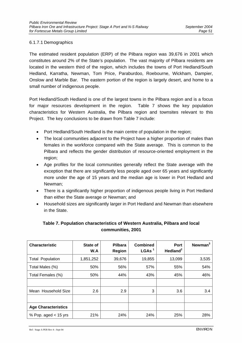
Public Environmental Review Pilbara Iron Ore and Infrastructure Project: Stage A Port and N-S Railway September 2004 for Fortescue Metals Group Limited Page 51
Ref: Stage A PER Rev 4 - Sept 04 ENVIRON
6.1.7.1 Demographics The estimated resident population (ERP) of the Pilbara region was 39,676 in 2001 which constitutes around 2% of the State’s population. The vast majority of Pilbara residents are located in the western third of the region, which includes the towns of Port Hedland/South Hedland, Karratha, Newman, Tom Price, Paraburdoo, Roebourne, Wickham, Dampier, Onslow and Marble Bar. The eastern portion of the region is largely desert, and home to a small number of indigenous people. Port Hedland/South Hedland is one of the largest towns in the Pilbara region and is a focus for major resources development in the region. Table 7 shows the key population characteristics for Western Australia, the Pilbara region and townsites relevant to this Project. The key conclusions to be drawn from Table 7 include:
• Port Hedland/South Hedland is the main centre of population in the region; • The local communities adjacent to the Project have a higher proportion of males than
females in the workforce compared with the State average. This is common to the Pilbara and reflects the gender distribution of resource-oriented employment in the region;
• Age profiles for the local communities generally reflect the State average with the exception that there are significantly less people aged over 65 years and significantly more under the age of 15 years and the median age is lower in Port Hedland and Newman;
• There is a significantly higher proportion of indigenous people living in Port Hedland than either the State average or Newman; and
• Household sizes are significantly larger in Port Hedland and Newman than elsewhere in the State.
Table 7. Population characteristics of Western Australia, Pilbara and local
communities, 2001
Characteristic State of W.A
Pilbara Region
Combined LGAs 1
Port Hedland2
Newman3
Total Population 1,851,252 39,676 19,855 13,099 3,535
Total Males (%) 50% 56% 57% 55% 54%
Total Females (%) 50% 44% 43% 45% 46%
Mean Household Size 2.6 2.9 3 3.6 3.4
Age Characteristics
% Pop. aged < 15 yrs 21% 24% 24% 25% 28%
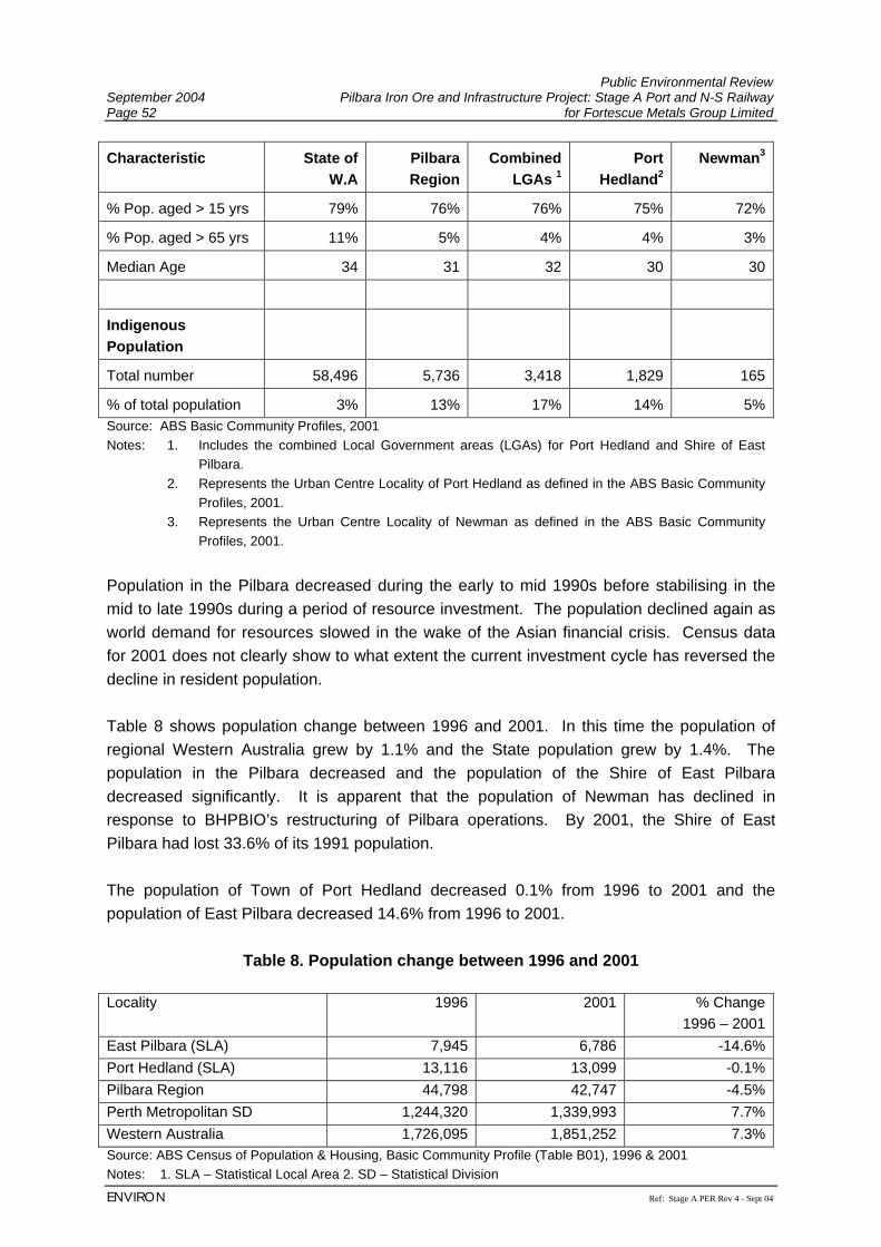
Public Environmental Review September 2004 Pilbara Iron Ore and Infrastructure Project: Stage A Port and N-S Railway Page 52 for Fortescue Metals Group Limited
ENVIRON Ref: Stage A PER Rev 4 - Sept 04
Characteristic State of W.A
Pilbara Region
Combined LGAs 1
Port Hedland2
Newman3
% Pop. aged > 15 yrs 79% 76% 76% 75% 72%
% Pop. aged > 65 yrs 11% 5% 4% 4% 3%
Median Age 34 31 32 30 30
Indigenous Population
Total number 58,496 5,736 3,418 1,829 165
% of total population 3% 13% 17% 14% 5%Source: ABS Basic Community Profiles, 2001 Notes: 1. Includes the combined Local Government areas (LGAs) for Port Hedland and Shire of East
Pilbara. 2. Represents the Urban Centre Locality of Port Hedland as defined in the ABS Basic Community
Profiles, 2001. 3. Represents the Urban Centre Locality of Newman as defined in the ABS Basic Community
Profiles, 2001. Population in the Pilbara decreased during the early to mid 1990s before stabilising in the mid to late 1990s during a period of resource investment. The population declined again as world demand for resources slowed in the wake of the Asian financial crisis. Census data for 2001 does not clearly show to what extent the current investment cycle has reversed the decline in resident population. Table 8 shows population change between 1996 and 2001. In this time the population of regional Western Australia grew by 1.1% and the State population grew by 1.4%. The population in the Pilbara decreased and the population of the Shire of East Pilbara decreased significantly. It is apparent that the population of Newman has declined in response to BHPBIO’s restructuring of Pilbara operations. By 2001, the Shire of East Pilbara had lost 33.6% of its 1991 population. The population of Town of Port Hedland decreased 0.1% from 1996 to 2001 and the population of East Pilbara decreased 14.6% from 1996 to 2001.
Table 8. Population change between 1996 and 2001
Locality 1996 2001 % Change
1996 – 2001East Pilbara (SLA) 7,945 6,786 -14.6%Port Hedland (SLA) 13,116 13,099 -0.1%Pilbara Region 44,798 42,747 -4.5%Perth Metropolitan SD 1,244,320 1,339,993 7.7%Western Australia 1,726,095 1,851,252 7.3%Source: ABS Census of Population & Housing, Basic Community Profile (Table B01), 1996 & 2001 Notes: 1. SLA – Statistical Local Area 2. SD – Statistical Division
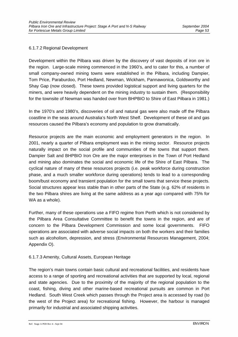
Public Environmental Review Pilbara Iron Ore and Infrastructure Project: Stage A Port and N-S Railway September 2004 for Fortescue Metals Group Limited Page 53
Ref: Stage A PER Rev 4 - Sept 04 ENVIRON
6.1.7.2 Regional Development Development within the Pilbara was driven by the discovery of vast deposits of iron ore in the region. Large-scale mining commenced in the 1960’s, and to cater for this, a number of small company-owned mining towns were established in the Pilbara, including Dampier, Tom Price, Paraburdoo, Port Hedland, Newman, Wickham, Pannawonica, Goldsworthy and Shay Gap (now closed). These towns provided logistical support and living quarters for the miners, and were heavily dependent on the mining industry to sustain them. (Responsibility for the townsite of Newman was handed over from BHPBIO to Shire of East Pilbara in 1981.) In the 1970’s and 1980’s, discoveries of oil and natural gas were also made off the Pilbara coastline in the seas around Australia’s North West Shelf. Development of these oil and gas resources caused the Pilbara’s economy and population to grow dramatically. Resource projects are the main economic and employment generators in the region. In 2001, nearly a quarter of Pilbara employment was in the mining sector. Resource projects naturally impact on the social profile and communities of the towns that support them. Dampier Salt and BHPBIO Iron Ore are the major enterprises in the Town of Port Hedland and mining also dominates the social and economic life of the Shire of East Pilbara. The cyclical nature of many of these resources projects (i.e. peak workforce during construction phase, and a much smaller workforce during operations) tends to lead to a corresponding boom/bust economy and transient population for the small towns that service these projects. Social structures appear less stable than in other parts of the State (e.g. 62% of residents in the two Pilbara shires are living at the same address as a year ago compared with 75% for WA as a whole). Further, many of these operations use a FIFO regime from Perth which is not considered by the Pilbara Area Consultative Committee to benefit the towns in the region, and are of concern to the Pilbara Development Commission and some local governments. FIFO operations are associated with adverse social impacts on both the workers and their families such as alcoholism, depression, and stress (Environmental Resources Management, 2004; Appendix O). 6.1.7.3 Amenity, Cultural Assets, European Heritage The region’s main towns contain basic cultural and recreational facilities, and residents have access to a range of sporting and recreational activities that are supported by local, regional and state agencies. Due to the proximity of the majority of the regional population to the coast, fishing, diving and other marine-based recreational pursuits are common in Port Hedland. South West Creek which passes through the Project area is accessed by road (to the west of the Project area) for recreational fishing. However, the harbour is managed primarily for industrial and associated shipping activities.
Public Environmental Review September 2004 Pilbara Iron Ore and Infrastructure Project: Stage A Port and N-S Railway Page 54 for Fortescue Metals Group Limited
ENVIRON Ref: Stage A PER Rev 4 - Sept 04
The region is also culturally and environmentally diverse, and is well known for its heritage assets. There are a variety of natural attractions in the region, including the Karijini and Millstream/Chichester National Parks and the Dampier Archipelago. The Shire of Port Hedland has recently completed a cultural development plan and facilities include the Matt Dunn Cultural Centre (theatre, music and movies), and the Courthouse Arts Centre & Gallery. In the public domain there are art installations such as banners and sculptures. The Port Hedland port operations are also an attraction for visitors. A review of the databases of the Australian Heritage Commission (AHC), Heritage Council of Western Australia (HCWA), National Trust and the Port Hedland and East Pilbara Shires’ Municipal Inventory indicated there were no sites of European Heritage significance within or near FMG’s Project area. However, the town of Port Hedland has an interesting history, and there is a heritage trail (which will not be directly impacted by the Project). 6.1.8 Native Title and Aboriginal Heritage The proposed port development and a large portion of the proposed railway corridor crosses the Kariyarra (WC99/3) Native Title claim, with the remainder of the railway corridor crossing (from North to South) the Kariyarra Yinjibarndi (WC95/053), Palyku (WC99/16), Martu Idja Banyjima (WC98/62); and the Nyiyaparli (WC99/4) Native Title claims. All of these Native Title claims are currently registered under the Native Title Act 1993. The Native Title claims collectively represent the Aboriginal Traditional Owners of the land over which FMG wishes to construct the proposed port and railway. FMG has signed Protocols with all of the above Native Title claimant groups (with the exception of the Kariyarra Yinjibarndi with whom negotiations are in progress) and their Representative Body, the Pilbara Native Title Service (PNTS). The PNTS is a service division of the Yamatji Marlpa Barna Baba Maaja Aboriginal Corporation Inc, the Native Title Representative Body under the Native Title Act 1993 for these claimant groups in the Pilbara region. The Protocols establish the procedure by which Aboriginal heritage surveys and Native Title negotiations are being conducted between FMG, these affected Native Title claimant groups and their legal representative body, the PNTS. 6.1.8.1 Prehistory Recent excavations of rockshelters in the region have produced archaeological evidence from the Pleistocene era ranging from 18,000 Before Present Day (BP) to 26,000 BP and have consequently revealed that the initial (Pleistocene) Aboriginal occupation of the arid zone occurred at around 26,000 to 22,000 years BP at a time of increasingly dry climate which reached its peak at around 18,000 BP. The increased aridity during the last glaciation caused reductions in the availability of water and food resources, which forced the abandonment of many arid areas until conditions improved in the mid-Holocene age.
Public Environmental Review Pilbara Iron Ore and Infrastructure Project: Stage A Port and N-S Railway September 2004 for Fortescue Metals Group Limited Page 55
Ref: Stage A PER Rev 4 - Sept 04 ENVIRON
During the mid to late Holocene, a number of indicators of Aboriginal intensification have been identified by archaeologists which include an increase in site usage, an increased rate of site establishment, the use of marginal environments, the introduction of new tools types, specialised seed grinding and water procurement, storage and conservation techniques, increased complexity of exchange programs and increasingly complex social and ceremonial organisation.
Archaeological research of Holocene settlement patterns on the Pilbara coast have suggested that changes apparent in the archaeological record came about through social, economic and logistical restructuring, indirectly due to the effects of resource stress. Additionally, it is suggested that certain sites in the mid to late Holocene may represent increased group interaction involving economic interdependence and shared ceremonial activity (particularly ceremonies centred on Thalu, or increase sites) initiated as a result of the pressures associated with survival in an increasingly arid environment rather than population increases. Finally, periods of semi-sedentism may have occurred immediately after the wet season when resources were abundant. The Abydos Plain contains an abundance of rock engravings. Similar engravings are found elsewhere in the Pilbara notably on the Burrup Peninsula adjacent to the towns of Dampier and Karratha. Most of the granite outcrops on the Woodstock/Abydos pastoral leases and the Abydos Plain generally contain engravings. The number of motifs varies from a few simple tracks to hundreds of often complex engravings. A range of motifs are present; tracks and human figures are common, but depictions of animals and weapons also occur. Dates for engravings near Woodstock/Abydos pastoral leases range between 160 and 11,545 years BP, and engravings on the Burrup Peninsula have been dated to at least 3,000 years old. Speculative ages of 17,000 years BP and greater have been put forward based on the presence of desert varnish. The engravings located on the Woodstock and Abydos pastoral leases near the upper reaches of the Yule and Turner Rivers are listed on the Register of the National Estate. This area is also a Protected Area under the Aboriginal Heritage Act 1972 (Anthropos Australis, 2004; Appendix P). 6.1.8.2 Aboriginal Mythology All engravings, particularly the human figures as well as other designs are of current significance to the Aboriginal Traditional Owners, who believe that they represent the physical manifestations of the ancestral beings that roamed the earth before humans occupied the land. There are natural features within the Abydos Plain, the Chichester Range, the Fortescue Plain and the Hamersley Range such as hills, creeks, springs, claypans, rockholes and rockshelters which the Aboriginal Traditional Owners believe are also the physical manifestations of the ancestral beings. Stories and songs are told today about the travels
Public Environmental Review September 2004 Pilbara Iron Ore and Infrastructure Project: Stage A Port and N-S Railway Page 56 for Fortescue Metals Group Limited
ENVIRON Ref: Stage A PER Rev 4 - Sept 04
and exploits of the ancestral beings along the Dreaming Tracks which represent the pathways travelled in the Dreaming. 6.1.8.3 European Impact The Aboriginal Traditional Owners lived in relative isolation until European settlers took up pastoral leases in the region in the late 1800s, displacing and indenturing Aboriginal people as seasonal labourers. Aboriginal men were employed as shepherds and station workers, women were engaged as 'domestics' at station homesteads. They received food and provisions in return for their services. Notwithstanding this impact, the Aboriginal Traditional Owners maintained their connection to country through ritual and hunting and gathering activities. During the early mining boom in the 1950s and 1960s there was little regard for the protection of cultural heritage or for consultation with the Aboriginal Traditional Owners in the region. Prior to the advent of the Native Title Act 1993, the involvement of Aboriginal people in the protection of their cultural heritage in the region was minimal. Consultation with Aboriginal people was not an essential prerequisite for compliance with the Aboriginal Heritage Act 1972, and their involvement was a matter of negotiation. However, since Native Title claims were lodged post 1994, the Aboriginal Traditional Owners have been involved in the management and protection of their cultural heritage and are able to seek compensation for any loss of their Native Title rights and interests. 6.1.8.4 Aboriginal Heritage Surveys Aboriginal heritage surveys (ethnographic and archaeological) of the proposed port and railway corridor are currently (July 2004) being negotiated with the affected Native Title claimant groups to ensure consultation with and the participation of, the relevant Aboriginal Traditional Owners. These surveys will include the use of archival research; a formal field survey for Aboriginal ethnographic and archaeological sites as well as consultation with the Aboriginal Traditional Owners as representatives of the affected Native Title claimant groups. All surveys will be completed prior to the commencement of construction of the Project. A comprehensive survey of FMG’s proposed port area is currently scheduled for the end of July 2004. It is planned to commence surveys of the railway corridor in late August 2004. In addition to heritage matters it will also include specific discussions and consultation with the Aboriginal people, on environmental impacts. The archival research required for Aboriginal heritage surveys, involves a search of the Register of Aboriginal Sites conducted at the Department of Indigenous Affairs in order to access Aboriginal site files pertaining to previously recorded sites within the area and heritage survey reports detailing previous heritage surveys conducted in the region.
Public Environmental Review Pilbara Iron Ore and Infrastructure Project: Stage A Port and N-S Railway September 2004 for Fortescue Metals Group Limited Page 57
Ref: Stage A PER Rev 4 - Sept 04 ENVIRON
The object of the archival research is to:
• ensure that any previously recorded Aboriginal sites which may be located within, or in close proximity to the port, railway corridor and/or mines are identified in advance;
• gain an appreciation of the type of Aboriginal sites previously recorded in the region to provide an indication of the site types likely to be encountered during the surveys; and
• gain an appreciation of site patterning throughout the region to provide an indication of the general distribution of sites and identify areas of high and low potential for sites in the region.
On the basis of previous Aboriginal ethnographic and archaeological surveys conducted in the region and consultation with the Aboriginal Traditional Owners, a number of different types of Aboriginal sites are expected to be encountered. Definitions of these sites are as follows:
Artefact scatter refers to a location where a range of activities have occurred such as the manufacture and maintenance of tools and the processing of foods. Such sites will often contain a wider range of lithic materials than quarries and knapping floors; Ceremonial refers to a location where the Aboriginal Traditional Owners have practiced and/or continue to practice ceremonial activities; Gnamma hole/water source refers to a natural or artificial rock cavity, which holds water after rain or is linked to the water table; Grinding patches refers to patches of smoothed rock of varying size. In the Pilbara region these are believed to be seed grinding patches, elsewhere though they are linked to ceremonial practices. Grinding patches are frequently associated with engraving sites throughout the Pilbara; Midden refers to a location usually on the coast or adjacent to a creek which contains the remains of shellfish and bone; Modified tree refers to a tree, which has trunks and/or limbs that have been modified by the removal of bark and/or wood. Aboriginal people removed (and continue to remove) wood and bark for material items such as shields and baskets or to access native honey inside hollows in the tree; Mythological refers to a location which may be a natural feature such as a hill or waterhole which has a name, story and/or song about a particular ancestral being(s) known to the Aboriginal Traditional Owners and which is of current significance to them;
Public Environmental Review September 2004 Pilbara Iron Ore and Infrastructure Project: Stage A Port and N-S Railway Page 58 for Fortescue Metals Group Limited
ENVIRON Ref: Stage A PER Rev 4 - Sept 04
Quarry refers to a location from which stone used to manufacture flakes or ground stone artefacts has been extracted; Reduction area (or knapping floor) refers to a cluster of stone artefacts, which represent the remains of an episode (or episodes) of stone artefact manufacture. Artefacts within a knapping floor can usually be conjoined back together; and Rock art refers to art placed on a rock surface that may be created by additive (such as painting or drawing) or subtractive (such as abrading or engraving) processes. The Woodstock/Abydos pastoral leases are known to be an extremely rich rock art province with all of the art panels being engravings on the ubiquitous granitic domes and granite and dolerite boulders and dykes.
The Aboriginal Traditional Owners that have participated in surveys to date were previously chosen by their respective Native Title Working Groups at formal meetings. To date, FMG has commissioned the following Aboriginal heritage surveys:
1. Ethnographic ‘constraints’ survey (by helicopter) of the proposed mines and the southern portion of the railway corridor (north of the Chichester Ranges and the proposed Mindy Mindy mine), and the Mt Nicholas mine and exploration areas within and adjacent to the Chichester Ranges; and
2. Specific work program clearance surveys (ethnographic and archaeological) of the
proposed Mt Nicholas mine and exploration resource drilling and hydrogeological drilling areas at Christmas Creek, Mt Lewin and Mt Nicholas) (Stage B of the Project).
The results of the preliminary ethnographic survey have revealed that there are several ethnographic sites of significance to the Aboriginal Traditional Owners which FMG has agreed to avoid and protect. The results of the ongoing work program clearance surveys have revealed that there are ethno-archaeological sites (mainly stone artefact scatters) in the region which are presently being avoided during FMG’s exploratory drilling program. 6.2 THE RAILWAY ALIGNMENT 6.2.1 Topography and Surface Hydrology Topographically, along the rail corridor, the Abydos plain rises from the coastal lowlands to around 300 m – 400 m above mean sea level adjacent to the Chichester Range. On the Abydos Plain, the rail corridor crosses three main catchments (Figure 9), namely the Port Hedland Area Catchment, the Turner River Catchment and the Yule River Catchment. In common with most Pilbara catchments, these catchments contain ephemeral drainages, that
Public Environmental Review Pilbara Iron Ore and Infrastructure Project: Stage A Port and N-S Railway September 2004 for Fortescue Metals Group Limited Page 59
Ref: Stage A PER Rev 4 - Sept 04 ENVIRON
only flow following rainfall events, with the exception of isolated springs and pools. The following descriptions of the catchment areas through which FMG’s proposed rail corridor pass are taken from Aquaterra (2004b) (Appendix L). 6.2.1.1 Port Hedland Area Catchment The Port Hedland Area Catchment contains several creeks draining to the coast between the Turner River Catchment and the De Grey River Catchment. These creeks from west to east are the South West Creek, South Creek, Beebingarra Creek, Petermarer Creek and Tabba Creek. Over this initial 50 km, the rail corridor passes solely through the South West Creek catchment (Figure 9). Through this area, the rail corridor is typically aligned parallel to and away from the main surface drainages except where it crosses over the main South West Creek flow channel near to the Main Roads Department WA (MRD) North West Coastal Highway road bridge. This MRD road bridge waterway has been designed to pass the 20 year ARI flood event (Main Roads Department, 1975) and floodwaters from floods in excess of this level discharge over the highway embankment. 6.2.1.2 Turner and Yule River Catchments South from the Port Hedland Area Catchment, the rail corridor passes through the Turner River and Yule River Catchments (Figures 3a, 3b and 9). In the Turner River Catchment, the corridor crosses the Turner River East, Chinnamon Pool, Gillam Creek, Turner River and numerous smaller drainage channels. Within the Yule River Catchment, the corridor crosses Coorong Creek, Yule River and several branches of Coonarrie Creek. The rail corridor has been aligned to cross perpendicular to the main drainage channels and floodplains. These main drainages support eucalypt woodland in their floodplains and have alluvial gravel-sandy beds that may become mobile during flood events. All drainage channels are ephemeral, responding to rainfall events. Following significant rainfall, the channels typically carry large discharges, possibly for a few days, which then retreat to isolated pools. In the main channels, smaller discharges may persist for a few weeks. During the large flood events, floodwater overflows the main river channels into the surrounding floodplains. 6.2.1.3 Chichester Range The Chichester Range, located along the southern edge of the Abydos Plain, steeply rises some 100 m to 150 m above the plain. The plateau forms the catchment divide between drainages discharging northwards across the Abydos Plain to the coast, and those discharging southwards to the Fortescue River Valley. The FMG rail corridor winds through the plateau, to achieve a uniform gradient and to avoid the rugged peaks. Through this plateau area, the corridor initially crosses the upper portions of the Yule and Shaw Rivers, which discharge northwards to the coast, and then crosses
Public Environmental Review September 2004 Pilbara Iron Ore and Infrastructure Project: Stage A Port and N-S Railway Page 60 for Fortescue Metals Group Limited
ENVIRON Ref: Stage A PER Rev 4 - Sept 04
smaller drainages discharging southwards to the Fortescue River. Drainage pathways through the plateau area are characterised by typically smaller catchments, steeper gradients and steep sided valleys, as compared with drainages on the Plain. Following rainfall, these steeper drainage pathways respond and flow rapidly, but typically for a comparatively short duration. On the southern flanks of the Chichester Range, where the drainages discharge southwards to the Fortescue River Valley, the drainage pathways become less steep. 6.2.1.4 Fortescue Valley The Fortescue Valley occupies a trough between the Chichester and Hamersley Plateaux. The Goodiadarrie Hills (Figure 3c), effectively cuts the Fortescue River into two separate river systems. West from the Goodiadarrie Hills, the Lower Fortescue River Catchment drains to the coast, whereas east from the hills the Fortescue Marshes receives drainage from the Upper Fortescue River Catchment. The FMG rail corridor crosses through the Fortescue Marsh area upstream from the Goodiadarrie Hills adjacent to the existing BHPBIO railway. The Fortescue Marshes is an extensive intermittent wetland occupying an area around 100 km long by typically 10 km wide located on the floor of the Fortescue Valley. The marsh has an elevation around 400 m above sea level. To the north, the Chichester Range rises to over 500 m above sea level, whereas to the south the Hamersley Ranges rises to over 1,000 m above sea level. Following significant rainfall events, runoff from the 31,000 km2 Upper Fortescue River Catchment drains to the marshes. For the smaller runoff events, isolated pools form on the marshes opposite the main drainage inlets, whereas for the larger events the whole marsh area floods. Large floods in the early 1970’s are reported to have caused inundation up to the existing BHPBIO railway track level (pers. com. Geoff Liddell, BHPBIO). On the southern and northern flanks of the Fortescue Valley, numerous creeks discharge to the marshes. On the lower, less steep valley flanks rainfall runoff tends to flow overland rather than along defined creek courses. These water courses and sheetflow areas frequently support scrub and mulga woodlands, particularly in the lower lying areas. The Fortescue River, Weeli Wolli Creek and other main channels entering the marshes typically support eucalypt woodland in their floodplains. After crossing the marshes, the FMG rail corridor follows the route of the existing BHPBIO railway around the southern edge of the Fortescue Valley crossing Weeli Wolli Creek and terminating at the base of the Hamersley Ranges at Mindy Mindy mine site around 450 m above sea level (Figure 9).
Public Environmental Review Pilbara Iron Ore and Infrastructure Project: Stage A Port and N-S Railway September 2004 for Fortescue Metals Group Limited Page 61
Ref: Stage A PER Rev 4 - Sept 04 ENVIRON
6.2.2 Hydrogeology The hydrogeology of the rail route is summarised below. More information can be found in Aquaterra (2004a) (Appendix M). The North-South railway route crosses four groundwater areas:
i. Coastal plain alluvial deposits (chainages5 0 m to 66,000 m); ii. Regional granite terrain (chainage 66,000 m to 216,000 m); iii. Fortescue Group and Marra Mamba Iron Formation (chainage 216,000 m to
254,000 m); and iv. Wittenoom Formation (chainage 254,000 m to 346,000 m).
The alluvial deposits of the coastal plain generally comprise clay, silt and sand, with minor gravel. The deposits range in thickness from about 15 m to 50 m, generally being thickest along drainage lines. In the southern part of the groundwater area extensive areas of calcrete have been mapped. Generally, groundwater occurrences are associated with sand and gravel units within the alluvium, augmented by weathered basement and/or calcrete. The regional granite terrain comprises medium to coarse grained biotite granodiorite with common pegmatite veining. Groundwater is mostly associated with fracturing and intrusions of pegmatite and/or dolerite rocks. The Fortescue Group comprises the Tumbiana Formation, (a sequence of reworked volcano-clastic rocks, carbonates and chert; interbedded with thin dolomitic limestone); Meddina Basalt and Jeerinah Formation. The Jeerinah Formation consists of basal quartz sandstone (Woodiana Member) and a sequence of interbedded carbonaceous pelite, chert and minor sandstone (Geological Survey of Western Australia, 1997). In general, the groundwater occurs within fractured rock aquifers. The Marra Mamba Formation comprises chert, shale and banded iron formation (BIF). Groundwater yields from the Marra Mamba Formation occur predominantly where the formation is mineralised. Local permeability may also occur associated with fault/fracture zones. The Wittenoom Formation comprises the West Angelas and Paraburdoo Members, a sequence of dolomite, pelite and chert; and the Bee Gorge Member, a sequence of pelite and minor chert and carbonaceous units. Groundwater occurrence within the formation occurs generally in the Paraburdoo Member dolomite, where it is weathered. Locally, significant yields can also be obtained from both the West Angela Member (where it is manganiferous) and the Bee Gorge Member (where it is associated with fractures or faults).
5 Chainages are distance along the corridor, with 0 km at Port Hedland.
Public Environmental Review September 2004 Pilbara Iron Ore and Infrastructure Project: Stage A Port and N-S Railway Page 62 for Fortescue Metals Group Limited
ENVIRON Ref: Stage A PER Rev 4 - Sept 04
Where the North-South railway route crosses the Wittenoom Formation it is mostly overlain by the alluvial deposits of the Fortescue River. The alluvial deposits consist of interbedded clay, silt, sand and gravel with recorded thicknesses of over 50 m. These deposits form local alluvial aquifers. Along the valley sides, where the alluvial deposits are either thin or absent, groundwater occurrence is associated with fractured dolomite and dissolution features. 6.2.2.1 Existing Bore Sites Information stored on the DoE’s Water Information (WIN) database was used to identify existing bores within approximately 10 km of the North-South railway alignment. The bores identified include:
• bores installed by BHPBIO for construction and maintenance of their existing railway line;
• bores installed by Main Roads Western Australia; • stock bores installed by pastoralists.
Generally bores located along the alluvial plain south of Port Hedland as far as railway chainage 66,000 m draw groundwater from alluvial sediments or calcrete horizons. These bores are mostly shallow (less than 50 m depth) with modest to low yields, i.e. less than 500 m3/d, and near surface groundwater levels. Recorded salinities vary from about 400 mg/L to 8,000 mg/L total dissolved solids (TDS). Bores along the granite terrain between railway chainage 66,000 m and 216,000 m generally source groundwater from fractured rock aquifers, commonly associated with quartz veining, or pegmatite or dolerite intrusions. A few bores draw groundwater from shallow alluvium and calcrete. Bore yields vary between minor flows (10 m3/d) and flows in excess of 1,000 m3/d. Groundwater levels range between 1 m and 21 m below ground level (m bgl). Groundwater quality within the granitic terrain is generally good (1,000 mg/L TDS or less). Within the Fortescue Group and Marra Mamba Iron Formation, railway chainage 216,000 m to 254,000 m, bores intersect fractured rock aquifers within a variety of lithological units (chert, pelite, granite and basalt). Yields of up to 900 m3/d have been recorded for the bores along this section of the alignment. Salinity has only been recorded at one location, indicating fresh groundwater (less than 1,000 mg/L TDS). Bores along the section between railway chainage 254,000 m and the end of the North-South railway spur at Mindy Mindy generally draw groundwater from alluvial deposits associated with the Fortescue River, apart from a few bores located near the northern limit of the river valley where the alluvium is thin or absent. In these northern areas bores have been completed into fractured fresh-rock, commonly dolomite or chert breccia. Yield for bores intersecting fractured rock aquifers vary greatly (10 m3/d to 700 m3/d). Bores into the
Public Environmental Review Pilbara Iron Ore and Infrastructure Project: Stage A Port and N-S Railway September 2004 for Fortescue Metals Group Limited Page 63
Ref: Stage A PER Rev 4 - Sept 04 ENVIRON
Fortescue River alluvium, however, commonly intersect gravel and sand units and production rates are more predictable, commonly ranging from 200 m3/d to 500 m3/d. 6.2.3 Flora and Vegetation Flora and vegetation assessments of the Project area were undertaken by Biota Environmental Sciences (2004e) (Appendix H). 6.2.3.1 Vegetation Types A total of 122 terrestrial vegetation types were defined for the proposed rail corridor, representing a wide range of structural and floristic variants. These mainly comprised:
• hummock grasslands of spinifex Triodia species with a variable shrub overstorey on plains, hillslopes and crests (dominating the majority of the Project area);
• tall shrublands of Acacia species, usually with an overstorey of Corymbia, in creeklines;
• open forests or woodlands of Cadjeput Melaleuca argentea, River Red Gum Eucalyptus camaldulensis and/or Coolibah E. victrix over tall shrublands of Acacia or Melaleuca spp. on river banks and beds;
• Mulga Acacia aneura woodlands and tall shrublands over spinifex or various grasses on the plains of the Fortescue Valley; and
• variable vegetation on cracking clays of the Fortescue Valley (ranging from tussock grasslands to high open shrublands of Snakewood Acacia xiphophylla).
Maps of the distribution of these vegetation types and descriptions of the vegetation types are provided in Appendix H. Cleared or heavily disturbed areas were not specifically surveyed but are indicated on the mapping as 'Dist'. 6.2.3.2 Vegetation Conservation Significance The vegetation types of high conservation significance within the FMG rail corridor include those previously identified by Biota and Trudgen (2002), as well as some newly described types. The 22 vegetation types considered to be of the highest conservation significance within the rail corridor comprise: Abydos Plain Ar3-Ar7 Granite, quartz and dolerite outcrop vegetation types Ah5a Acacia inaequilatera scattered tall shrubs over Triodia aff. lanigera (dwarf form) mid-
dense hummock grassland Apt1 and Apt2
Hummock grasslands dominated by Triodia secunda
Apt5 and Hummock grasslands dominated by Triodia angusta
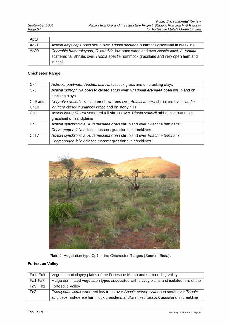
Public Environmental Review September 2004 Pilbara Iron Ore and Infrastructure Project: Stage A Port and N-S Railway Page 64 for Fortescue Metals Group Limited
ENVIRON Ref: Stage A PER Rev 4 - Sept 04
Apt8 Ac21 Acacia ampliceps open scrub over Triodia secunda hummock grassland in creekline Ac30 Corymbia hamersleyana, C. candida low open woodland over Acacia colei, A. tumida
scattered tall shrubs over Triodia epactia hummock grassland and very open herbland in soak
Chichester Range Cx4 Astrebla pectinata, Aristida latifolia tussock grassland on cracking clays Cx5 Acacia xiphophylla open to closed scrub over Rhagodia eremaea open shrubland on
cracking clays Ch9 and Ch10
Corymbia deserticola scattered low trees over Acacia aneura shrubland over Triodia lanigera closed hummock grassland on stony hills
Cp1 Acacia inaequilatera scattered tall shrubs over Triodia schinzii mid-dense hummock grassland on sandplains
Cc3 Acacia synchronicia, A. farnesiana open shrubland over Eriachne benthamii, Chrysopogon fallax closed tussock grassland in creeklines
Cc17 Acacia synchronicia, A. farnesiana open shrubland over Eriachne benthamii, Chrysopogon fallax closed tussock grassland in creeklines
Fortescue Valley Fx1- Fx9 Vegetation of clayey plains of the Fortescue Marsh and surrounding valley Fa1-Fa7, Fa9, Fh1
Mulga dominated vegetation types associated with clayey plains and isolated hills of the Fortescue Valley
Fc2 Eucalyptus victrix scattered low trees over Acacia stenophylla open scrub over Triodia longiceps mid-dense hummock grassland and/or mixed tussock grassland in creekline
Plate 2. Vegetation type Cp1 in the Chichester Ranges (Source: Biota).
Public Environmental Review Pilbara Iron Ore and Infrastructure Project: Stage A Port and N-S Railway September 2004 for Fortescue Metals Group Limited Page 65
Ref: Stage A PER Rev 4 - Sept 04 ENVIRON
Hamersley Range Hd1 Acacia dictyophleba scattered tall shrubs over Crotalaria cunninghamii, Trichodesma
zeylanicum var. grandiflorum open shrubland on sand dunes Hp4 Acacia aneura groved low open forest over Eremophila forrestii subsp. forrestii
scattered low shrubs over Triodia pungens scattered hummock grasses and Aristida contorta, Enneapogon polyphyllus open annual grassland
Refer to Biota (2004e) (Appendix H) for a discussion on the conservation significance of each vegetation type. Potential impacts on these vegetation types are considered in Section 7.2.3.1. 6.2.3.3 Terrestrial Flora A total of 762 taxa of terrestrial vascular flora from 218 genera belonging to 69 families were recorded from the FMG rail corridor (see Appendix H). Eleven of these species were introduced flora. In addition, five mangrove species were recorded (Section 6.3.4.1). By comparison, 760 species of vascular flora from 233 genera and 70 families were recorded from the initial survey of the Hope Downs rail corridor between Port Hedland and Weeli Wolli Creek, which was of a similar length and, being adjacent to the FMG corridor, covered a similar range of habitats (see Biota and Trudgen, 2002). The most noticeable difference between the two survey areas is in the lack of aquatic plants from the FMG rail corridor (probably a reflection of recent flood events which had scoured the permanent pools during this survey), and the fewer daisies within the FMG rail corridor (more Asteraceae species would be expected later in the year following winter rainfall). The families with the greatest number of native flora taxa within the proposed FMG rail corridor were those that are predominant in the vegetation of the eastern Pilbara. The best represented families were the Poaceae (grasses; 121 taxa), Papilionaceae (peas; 76 taxa), Malvaceae (Hibiscus etc; 65 taxa) and Mimosaceae (wattles; 63 taxa). The best represented genera were Acacia (61 taxa), Sida (29 taxa), Tephrosia (21 taxa), and Cassia and Ptilotus (19 taxa each). In contrast, 22 families and 111 genera recorded within the FMG rail corridor were represented by only one taxon (see Biota, 2004e). 6.2.3.4 Flora of Conservation Significance Declared Rare and Priority Flora While all native flora are protected under the Wildlife Conservation Act 1950-1979, some species are assigned an additional level of conservation significance based on the number of known populations and the perceived threats to these populations (Table 9). Species of the highest conservation significance are designated Declared Rare Flora (DRF) (either extant or presumed extinct). Species that appear to be rare or threatened, but for which there is insufficient data to properly evaluate their conservation significance, are assigned to one of four Priority flora categories.
Public Environmental Review September 2004 Pilbara Iron Ore and Infrastructure Project: Stage A Port and N-S Railway Page 66 for Fortescue Metals Group Limited
ENVIRON Ref: Stage A PER Rev 4 - Sept 04
Table 9. Categories of conservation significance for flora species (Atkins, 2003).
Declared Rare Flora - Extant Taxa. Taxa that have been adequately searched for and are deemed to be in the wild either rare, in danger of extinction or otherwise in need of special protection. Declared Rare Flora - Presumed Extinct. Taxa which have not been collected, or otherwise verified, over the past 50 years despite thorough searching, or of which all known wild populations have been destroyed more recently. Priority 1 - Poorly Known Taxa. Taxa which are known from one or a few (generally <5) populations which are under threat. Priority 2 - Poorly Known Taxa. Taxa which are known from one or a few (generally <5) populations, at least some of which are not believed to be under threat. Priority 3 - Poorly Known Taxa. Taxa which are known from several populations, at least some of which are not believed to be under threat. Priority 4 - Rare Taxa. Taxa which are considered to have been adequately surveyed and which whilst being rare, are not currently threatened by any identifiable factors.
In addition, some flora species are listed as triggers for Federal referral under the Environment Protection and Biodiversity Conservation (EPBC) Act 1999. In the Pilbara, only the two DRF species (Lepidium catapycnon and Thryptomene wittweri) are currently listed under the EPBC Act 1999. Significant Flora Previously Recorded from the Project Area A search of CALM’s Threatened (Declared Rare) and Priority Flora database and the Western Australian Herbarium Specimen database was commissioned for the area bounded by 20°00’ - 23°00’S and 118°00’ - 121°00'E. This search yielded 275 location records of 68 taxa. The search was of a very large area and only 15 records (of 11 taxa) were actually within 10 km of the proposed rail corridor (Appendix H):
• Lepidium catapycnon (DRF) – known from approximately 5 km SE from the southern rail loop and near Weeli Wolli Creek, 8 km NNE of the rail corridor;
• Eremophila spongiocarpa ms. (Priority 1) – 100 km N of Marillana Homestead along BHPBIO railway line to Port Hedland (approximately 500 m W of rail corridor), ca. 22 km W of Marillana Homestead on S edge of Fortescue Marsh (3 km NE of rail corridor), and 30 km W of Marillana Homestead (on rail corridor);
• Eriachne sp. Hamersley Ranges hilltops (S. van Leeuwen 4199) (Priority 1) – 40 km ESE of Munjina (Auski) Roadhouse at Koodaiderie (7 km SW of rail corridor);
• Ptilotus appendiculatus var. minor (Priority 1) – Boodarie (10 km W of the rail corridor near Port Hedland);
• Stylidium weeliwolli (Priority 2) – Head of Weeli Wolli Creek, E of Hamersley Ranges (less than 1 km NE of rail corridor);
• Bulbostylis burbidgeae (Priority 3) – Gallery Hill Tors in Abydos-Woodstock Reserve (2 km W of rail corridor);
Public Environmental Review Pilbara Iron Ore and Infrastructure Project: Stage A Port and N-S Railway September 2004 for Fortescue Metals Group Limited Page 67
Ref: Stage A PER Rev 4 - Sept 04 ENVIRON
• Cynanchum sp. Hamersley (M. Trudgen 2302) (Priority 3) – Woodstock Station (7 km E of rail corridor);
• Goodenia nuda (Priority 3) – Weeli Wolli Creek, between Roy Hill and Wittenoom (7 km NE of rail corridor);
• Gymnanthera cunninghamii (Priority 3) – 1 km W of Boodarie Landing in the Port Hedland area (3 km W of the rail corridor) and near Woodstock Station (5 km E of rail corridor); and
• Triumfetta leptacantha (Priority 3) – 40 km ESE of Munjina (Auski) Roadhouse at Koodaiderie (7 km SW of rail corridor).
In addition, the following Priority flora were recorded during the surveys of the nearby Hope Downs rail corridor (Biota and Trudgen, 2002; HDMS, 2002), and some of these populations lie within the FMG rail corridor:
• Priority 1 species: Eriachne sp. Hamersley Range hilltops (S. van Leeuwen 4199) (identified as Eriachne “lanata”);
• Priority 2 species: Euphorbia clementii, Gonocarpus ephemerus, Ischaemum albovillosum, Olearia fluvialis, Indigofera ixocarpa, Stylidium weeliwolli;
• Priority 3 species: Abutilon trudgenii ms., Bulbostylis burbidgeae, Eriachne tenuiculmis, Goodenia nuda, Gymnanthera cunninghamii, Hibiscus brachysiphonius, Phyllanthus aridus, Sida sp. Wittenoom (W.R. Barker 1962), Themeda sp. Hamersley Station (ME Trudgen 11,431), Triumfetta leptacantha; and
• Priority 4 species: Goodenia stellata. Significant Flora Recorded from the Project Area No DRF species were recorded during the field survey of FMG’s rail corridor and none would be expected to occur in the habitats present along the proposed rail corridor. There are thus no flora species of significance known from the corridor that are listed under the EPBC Act 1999. Sixteen Priority flora were recorded during the survey of the FMG rail corridor, and a further five species have been previously recorded within the area during other surveys. These include:
• Priority 1 species: Eremophila spongiocarpa ms., Goodenia omearana ms. and Josephinia ?sp. Marandoo (ME Trudgen 1554);
• Priority 2 species: Euphorbia clementii, Gonocarpus ephemerus, Indigofera ixocarpa, Ischaemum albovillosum, Olearia fluvialis, Paspalidium retiglume and Stylidium weeliwolli;
• Priority 3 species: Abutilon trudgenii ms., Bulbostylis burbidgeae, Eriachne tenuiculmis, Goodenia nuda, Gymnanthera cunninghamii, Hibiscus brachysiphonius, Phyllanthus aridus, Polymeria sp. Hamersley (M.E. Trudgen 11353), Sida sp.
Public Environmental Review September 2004 Pilbara Iron Ore and Infrastructure Project: Stage A Port and N-S Railway Page 68 for Fortescue Metals Group Limited
ENVIRON Ref: Stage A PER Rev 4 - Sept 04
Wittenoom (W.R. Barker 1962) and Themeda sp. Hamersley Station (M.E. Trudgen 11,431); and
• Priority 4 species: Goodenia stellata.
This list of Priority flora includes all but one of the species recorded during earlier work for the Hope Downs project (note that Eriachne sp. Hamersley Range hilltops has since been incorporated back into the common species Eriachne lanata, and is thus expected to be removed from the Priority listing at the next revision). Triumfetta leptacantha (Priority 3) was recorded from gorges during surveys of the section of the Hope Downs rail corridor through the Hamersley Ranges (HDMS, 2000 and Appendix H). This species is unlikely to occur within the FMG rail corridor as it is restricted to steep gorges and rocky breakaways of the Hamersley Ranges, and such habitat is absent from the southern portion of the corridor. Most of the Priority flora species recorded from the FMG rail corridor were also collected during the Hope Downs rail corridor surveys (Biota and Trudgen, 2002; Biota, 2004a and c), with some additional records from other nearby locations (see CALM database search results above). A more complete account of the regional distribution and status of these species is provided in Appendix H. The locations of these Priority flora populations are shown on the vegetation mapping contained in Appendix H and these will receive further consideration as part of project design and management (see Section 7.2.3). In addition to formally listed DRF and Priority Flora, several other flora species of note were recorded from the FMG rail corridor. These are species that are poorly known, could not be identified to species level or are range extensions. An account of these species is presented in Appendix H. 6.2.3.5 Introduced Flora Eleven species of introduced flora were recorded from the Project area (Appendix H). None of these are listed as a Declared Plant under the Agriculture and Related Resources Protection Act 1979. The 11 weed species recorded are largely common and widespread species of the Pilbara region:
• Buffel grass *Cenchrus ciliaris, Birdwood grass *C. setigerus • Feathertop Rhodes grass or Windmill grass *Chloris virgata • Whorled pigeon grass *Setaria verticillata • Kapok *Aerva javanica • Verano stylo *Stylosanthes hamata • Spiked Malvastrum *Malvastrum americanum • Native thornapple *Datura leichhardtii • Black berry nightshade *Solanum nigrum • Colocynth *Citrullus colocynthis • Beggar's ticks *Bidens bipinnata.
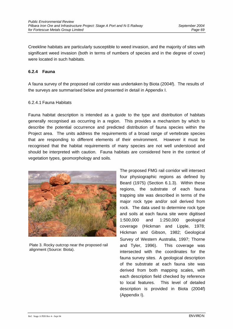
Public Environmental Review Pilbara Iron Ore and Infrastructure Project: Stage A Port and N-S Railway September 2004 for Fortescue Metals Group Limited Page 69
Ref: Stage A PER Rev 4 - Sept 04 ENVIRON
Creekline habitats are particularly susceptible to weed invasion, and the majority of sites with significant weed invasion (both in terms of numbers of species and in the degree of cover) were located in such habitats. 6.2.4 Fauna A fauna survey of the proposed rail corridor was undertaken by Biota (2004f). The results of the surveys are summarised below and presented in detail in Appendix I. 6.2.4.1 Fauna Habitats Fauna habitat description is intended as a guide to the type and distribution of habitats generally recognised as occurring in a region. This provides a mechanism by which to describe the potential occurrence and predicted distribution of fauna species within the Project area. The units address the requirements of a broad range of vertebrate species that are responding to different elements of their environment. However it must be recognised that the habitat requirements of many species are not well understood and should be interpreted with caution. Fauna habitats are considered here in the context of vegetation types, geomorphology and soils.
The proposed FMG rail corridor will intersect four physiographic regions as defined by Beard (1975) (Section 6.1.3). Within these regions, the substrate of each fauna trapping site was described in terms of the major rock type and/or soil derived from rock. The data used to determine rock type and soils at each fauna site were digitised 1:500,000 and 1:250,000 geological coverage (Hickman and Lipple, 1978; Hickman and Gibson, 1982; Geological Survey of Western Australia, 1997; Thorne and Tyler, 1996). This coverage was intersected with the coordinates for the fauna survey sites. A geological description of the substrate at each fauna site was derived from both mapping scales, with each description field checked by reference to local features. This level of detailed description is provided in Biota (2004f) (Appendix I).
Plate 3. Rocky outcrop near the proposed rail alignment (Source: Biota).
Public Environmental Review September 2004 Pilbara Iron Ore and Infrastructure Project: Stage A Port and N-S Railway Page 70 for Fortescue Metals Group Limited
ENVIRON Ref: Stage A PER Rev 4 - Sept 04
Significant Fauna Habitats None of the habitat types along the FMG rail corridor appear to be unique or significant at the bioregion scale (cf. Halpern Glick Maunsell 2000; Biota, 2002a, 2004b and d), except the Fortescue Marshes, which is a regionally significant wetland. The FMG rail corridor however only intersects the western margin of this extensive area. Several habitat types are significant on a local scale and support either apparently restricted suites of species or individual species which are or may be of regional significance. These include:
• Fortescue Marshes (diverse clay based vegetation units supporting most records of Ctenotus affin. uber johnstonei);
• linear sand dune habitats adjacent to the Weeli Wolli Creek delta (isolated linear
sand dunes (Biota and Trudgen, 2002) which may support fauna species atypical of the Pilbara, e.g. Ningaui ridei and Ctenotus ariadnae);
• cracking clay habitat units associated with the Chichester Range and foothills to the
immediate north (given the apparently restricted nature of several species occurring in these habitats; e.g. Planigale sp. nov., Leggadina lakedownensis, Diplodactylus mitchelli (Pilbara type), Ctenotus affin. robustus);
• granite rockpiles scattered on the Abydos plain portion of the FMG rail corridor
(patchy habitat units supporting species uncommon elsewhere in the corridor; e.g. Dasyurus hallucatus, Macroderma gigas, Petrogale rothschildi);
• major drainage systems (species rich and supporting a range of species typically not
recorded from other habitats in the study corridor; e.g. Lichenostomus penicillatus); and
• mangroves at the port site (given the dependence of some bird and bat species on
this habitat, including migratory species; e.g. Mormopterus loriae coburgiana and Nyctophilus arnhemensis).
6.2.4.2 Fauna Recorded from the Rail Corridor Freshwater Fish Sampling of freshwater fish was not undertaken at any creeks or river systems within the rail corridor proposed by Fortescue Metals Group, since recent surveys of the area provide a comprehensive inventory (Biota, 2004f). A list of freshwater fish that occur in the Pilbara, as well as many marine/estuarine species that inhabit Pilbara freshwaters, is given in Appendix I (does not include the two stygobionts restricted to the Cape Range Peninsula and Barrow Island).
Public Environmental Review Pilbara Iron Ore and Infrastructure Project: Stage A Port and N-S Railway September 2004 for Fortescue Metals Group Limited Page 71
Ref: Stage A PER Rev 4 - Sept 04 ENVIRON
Herpetofauna Sixty-four species of herpetofauna (six frogs and 58 reptiles) were recorded from the proposed rail corridor during the fauna survey. The frogs were represented by six species across two families; the Hylidae (tree frogs) and Myobatrachidae (ground frogs). The reptiles comprised one freshwater tortoise, nine geckos, five pygopodids, five agamids, five varanids, 21 skinks, three pythons, seven elapid snakes and two blind snakes. A comprehensive annotated list, including details of voucher specimens lodged with the WA Museum, is provided in Appendix I. Ground Mammals The survey of the FMG rail corridor recorded 22 species of non-volant (ground-dwelling) mammals, comprising the Echidna, eight Dasyuridae (carnivorous marsupials), two macropods, six native and one introduced murid rodents, one canid and three additional introduced mammals. No previously unrecorded ground mammal species or taxa were recorded during this survey (compared to the ground mammal data sets of How et al., 1991; Biota, 2002a, 2004b and d). The Dasyuridae (carnivorous marsupials) was the most species rich of the mammalian families with eight species (35% of the total species richness) and the second most numerically abundant (35 records or 24% of the total mammal records). One Dasyurid of conservation significance, the Mulgara Dasycercus cristicauda (Schedule 1; vulnerable) was recorded during the survey (see Section 6.2.4.3). No individuals were trapped, but the species presence was confirmed from characteristic diggings, scats and tracks. The species has previously been recorded from the FMG rail corridor in the Abydos plain section (the area of the current record) (Biota, 2002a and b). The introduced mammals recorded were: House Mouse Mus musculus; Camel Camelus dromedarius; Cat Felis catus; Donkey Equus asinus and Cattle Bos taurus. Bats Eighteen species of bats occur in the Pilbara region and a summary of these species and their ecology is provided in Biota (2004f) (Appendix I) (compiled from the mammal database of the WA Museum; Churchill, 1998; McKenzie and Rolfe, 1996; Biota, 2002a). The bat species recorded during the fauna survey of the FMG rail corridor were all recorded during earlier survey work along the Hope Downs rail (Biota, 2002a) and during other regional studies (e.g. McKenzie and Rolfe, 1996). Several bat species that occur in the Pilbara have still not been documented from the FMG rail corridor despite repeated fauna surveys.
Public Environmental Review September 2004 Pilbara Iron Ore and Infrastructure Project: Stage A Port and N-S Railway Page 72 for Fortescue Metals Group Limited
ENVIRON Ref: Stage A PER Rev 4 - Sept 04
There are three bat species of conservation significance present in the Pilbara: Ghost Bat Macroderma gigas (Priority 4), the Little Northwestern Freetail-Bat Mormopterus loriae (CALM Priority 1; sometimes designated as subspecies cobourgiana) and the Orange Leaf-nosed Bat Rhinonicteris aurantius (Schedule 1) (Section 6.2.4.3). The first two have previously been recorded in surveys near the FMG rail corridor, but no suitable habitat for R. aurantius was observed during the survey of the FMG rail corridor or those conducted previously for the proposed Hope Downs railway (Biota, 2002a). Avifauna Eighty-four bird species were recorded during the survey of the FMG rail corridor (Biota 2004f), comprising 39 passerines and 45 non-passerines (1,937 individuals in total). The most species rich families were the Accipitridae (eagles; 11 species), Meliphagidae (honeyeaters; seven species), Falconidae (falcons; five species) and Psittacidae (parrots; five species). These four families accounted for 33.7% of the species recorded. The most abundant species were the Zebra Finch, Fork-tailed Swift, Budgerigar, Brown Honeyeater, Crimson Chat, Diamond Dove, and the White-winged Fairy-wren. These seven species accounted for 58% of the individuals recorded. The survey of the FMG rail corridor found very similar results to earlier surveys completed for the Hope Downs project and noted as in previous surveys that drainage line habitats (both mulga and eucalypt dominated) yielded the greatest species richness on a per site basis. A total of 116 species has been recorded during the combined FMG and Hope Downs surveys (HDMS, 2002), comprising 67 species of non-passerines and 49 species of passerines. Twenty-two of the 48 families recorded from the FMG rail corridor have been represented by only a single species. The Peregrine Falcon Falco peregrinus macropus (Schedule 4) and the Grey Falcon Falco hypoleucos (Priority 4) were the only avifauna of conservation significance recorded from Project area (see Section 6.2.4.3). Stygofauna Stygofauna is a general term used to describe the subterranean fauna occurring in the groundwater of a given area (Humphreys, 2000). The term is commonly used in reference to stygobites: obligate groundwater-dwelling, aquatic fauna. This fauna tend to be highly specialised inhabitants of subterranean groundwater habitats and may be restricted spatially in distribution (Watts and Humphreys, 1999; Biota, 2001d). Stygofauna are known to be present in a variety of rock types, primarily karst (limestones, calcretes) and other porous stratigraphies (e.g. alluvium and gravels) (Marmonier et al., 1993) An overview of the broad geology types traversed by the FMG rail corridor is provided in Section 6.1.4. Hydrogeology within the vicinity of the FMG railway corridor is discussed in Section 6.2.2. A review of potential stygofauna habitats was completed as part of the parallel Hope Downs rail corridor (HDMS, 2002), which indicated that no major calcretised areas are crossed by the proposed rail corridor. In past assessments, many of the diversity
Public Environmental Review Pilbara Iron Ore and Infrastructure Project: Stage A Port and N-S Railway September 2004 for Fortescue Metals Group Limited Page 73
Ref: Stage A PER Rev 4 - Sept 04 ENVIRON
centres for stygofauna in the inland Pilbara appear to be associated with such calcretised formations in fluvial environments (Humphreys, 2000; Biota, 2001d). It is possible that stygofauna occur in association with the major drainages crossed by the FMG rail corridor and the alluvial aquifers associated with these. These are, however, unlikely to be affected by the FMG railway if present. 6.2.4.3 Threatened Fauna Native fauna species which are rare, threatened with extinction or have high conservation value are specially protected by law under the Western Australian Wildlife Conservation Act 1950-1979. In addition, many of these species are listed under the Environment Protection and Biodiversity Conservation Act 1999 (EPBC Act 1999). Extant species listed under the EPBC Act 1999 may be classified as ‘critically endangered’, ‘endangered’, ‘vulnerable’ or ‘conservation dependent’. Migratory wader species are also protected under the EPBC Act 1999. This consists of those species identified under the following International Conventions:
• Japan-Australia Migratory Bird Agreement (JAMBA); • China-Australia Migratory Bird Agreement (CAMBA); and • Convention on the Conservation of Migratory Species of Wild Animals - (Bonn
Convention). Classification of rare and endangered fauna under the Wildlife Conservation (Specially Protected Fauna) Notice 1998 recognises four distinct schedules of taxa:
• Schedule 1 - taxa are fauna which are rare or likely to become extinct and are declared to be fauna in need of special protection;
• Schedule 2 - taxa are fauna which are presumed to be extinct; • Schedule 3 - taxa are birds which are subject to an agreement between the
governments of Australia and Japan relating to the protection of migratory birds and birds in danger of extinction which are declared to be fauna in need of special protection; and
• Schedule 4 - taxa are fauna that are in need of special protection, otherwise than for the reasons mentioned above.
In addition to the above classification, fauna are also recognised by CALM under four Priority levels:
• Priority One - Taxa with few, poorly known populations on threatened lands. Taxa which are known from few specimens or sight records from one or a few localities on lands not managed for conservation. The taxon needs urgent survey and evaluation of conservation status before consideration can be given to declaration as threatened fauna.
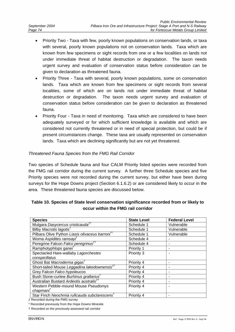
Public Environmental Review September 2004 Pilbara Iron Ore and Infrastructure Project: Stage A Port and N-S Railway Page 74 for Fortescue Metals Group Limited
ENVIRON Ref: Stage A PER Rev 4 - Sept 04
• Priority Two - Taxa with few, poorly known populations on conservation lands, or taxa with several, poorly known populations not on conservation lands. Taxa which are known from few specimens or sight records from one or a few localities on lands not under immediate threat of habitat destruction or degradation. The taxon needs urgent survey and evaluation of conservation status before consideration can be given to declaration as threatened fauna.
• Priority Three - Taxa with several, poorly known populations, some on conservation lands. Taxa which are known from few specimens or sight records from several localities, some of which are on lands not under immediate threat of habitat destruction or degradation. The taxon needs urgent survey and evaluation of conservation status before consideration can be given to declaration as threatened fauna.
• Priority Four - Taxa in need of monitoring. Taxa which are considered to have been adequately surveyed or for which sufficient knowledge is available and which are considered not currently threatened or in need of special protection, but could be if present circumstances change. These taxa are usually represented on conservation lands. Taxa which are declining significantly but are not yet threatened.
Threatened Fauna Species from the FMG Rail Corridor Two species of Schedule fauna and four CALM Priority listed species were recorded from the FMG rail corridor during the current survey. A further three Schedule species and five Priority species were not recorded during the current survey, but either have been during surveys for the Hope Downs project (Section 6.1.6.2) or are considered likely to occur in the area. These threatened fauna species are discussed below.
Table 10. Species of State level conservation significance recorded from or likely to occur within the FMG rail corridor
Species State Level Federal Level Mulgara Dasycercus cristicaudaƒ† Schedule 1 Vulnerable Bilby Macrotis lagotis† Schedule 1 Vulnerable Pilbara Olive Python Liasis olivaceus barroni*† Schedule 1 Vulnerable Woma Aspidites ramsayi† Schedule 4 - Peregrine Falcon Falco peregrinusƒ† Schedule 4 - Ramphotyphlops ganei† Priority 1 - Spectacled Hare-wallaby Lagorchestes conspicillatus
Priority 3 -
Ghost Bat Macroderma gigas† Priority 4 - Short-tailed Mouse Leggadina lakedownensisƒ† Priority 4 - Grey Falcon Falco hypoleucos Priority 4 - Bush Stone-curlew Burhinus grallarius† Priority 4 - Australian Bustard Ardeotis australisƒ† Priority 4 - Western Pebble-mound Mouse Pseudomys chapmani†
Priority 4 -
Star Finch Neochmia ruficauda subclarescens† Priority 4 - ƒ Recorded during the FMG survey * Recorded previously from the Hope Downs Minesite † Recorded on the previously assessed rail corridor
Public Environmental Review Pilbara Iron Ore and Infrastructure Project: Stage A Port and N-S Railway September 2004 for Fortescue Metals Group Limited Page 75
Ref: Stage A PER Rev 4 - Sept 04 ENVIRON
Mulgara Dasycercus cristicauda (Schedule 1, ‘Vulnerable’) Distribution: The Mulgara is a medium sized (60-120 g) carnivorous marsupial occurring in suitable habitat across the arid zone of Western Australia. Ecology: It is listed as vulnerable under the EPBC Act 1999 (a referral has been lodged under this legislation), and as Schedule 1 under the Wildlife Conservation Notice 2003. The species apparently prefers mature spinifex associations on sandy substrates. Populations are thought to contract to core habitat areas during harsh years and have also been documented as undergoing rapid expansions in response to good conditions (Woolley, 1995). Likelihood of occurrence: Evidence (burrows, diggings, scats and tracks) of Mulgaras was recorded from the Abydos Plain section of the FMG rail corridor. Similar signs were also recorded from two locations along the Hope Downs rail corridor and three animals were captured during this survey (Biota, 2002a; HDMS, 2002). All records are from sandy substrates vegetated with Triodia spp. (spinifex) with a sparse overstorey of low shrubs. Further regional surveys were also undertaken for this species and the Bilby Macrotis lagotis (Biota, 2002b). The survey area also encompassed the proposed FMG rail corridor between the Chichester Range and Port Hedland, and surrounding areas in the region to the Great Northern Highway in the west and Marble Bar Rd to the east (Biota, 2002b). Over 40 sites were searched for evidence of the target species with evidence of Mulgaras recorded from 29 of these sites, including three locations within the proposed FMG corridor (see Figure 10). Over 1,000 individual signs of Mulgara activity were recorded from an area of over 145 km in a north-south direction and 75 km in an east-west direction (Biota, 2002b). Some of the populations were extensive, with activity stretching for several kilometres in a number of directions. A similar distribution of Mulgara populations was observed in the area surrounding the existing BHPBIO railway, one of which was located approximately 150 m from the railway, which has been operational for over 30 years (Biota, 2002b). Although a listed Threatened species, the Mulgara appears to be moderately common across the Abydos Plain area traversed by the proposed FMG rail corridor. Potential impacts on this species are discussed in Section 7.2.4.2. Bilby Macrotis lagotis (Schedule 1) Distribution: The former range of the Bilby included most of the semi-arid areas of mainland Australia, however, it is now confined to Triodia hummock grassland and Acacia scrub across parts of northern Australia. Ecology: The Bilby Macrotis lagotis is a medium sized ground mammal, ranging in weight from 1.0 - 2.5 kg. The species is apparently strictly nocturnal and constructs a substantial
Public Environmental Review September 2004 Pilbara Iron Ore and Infrastructure Project: Stage A Port and N-S Railway Page 76 for Fortescue Metals Group Limited
ENVIRON Ref: Stage A PER Rev 4 - Sept 04
burrow system, which may be up to 3 m in length (Flannery, 1990). Similar to the Mulgara, the species has been documented as showing temporary home ranges and relatively rapid changes in distribution in response to variation in habitat resources (Johnson, 1995). Whilst fox and cat predation and the effect of rabbits and stock are thought to be the principal factors in the decline of this species, fire has also been suggested as an important factor in maintaining habitat diversity for this species (Johnson, 1995). Likelihood of occurrence: Three burrows of this species were recorded from the Abydos plain portion of the Hope Downs rail corridor, from amongst vegetation comprising a mixed Triodia angusta / T. basedowii steppe (Biota, 2002a). No animals were sighted or trapped however, and none of the burrows were apparently active. No sites yielding Bilby evidence were recorded from the surrounding region during the additional regional surveys for the Mulgara (Biota, 2002b). The species was, however, documented as occurring in four separate locations within the Abydos-Woodstock area by How et al. (1991). All of these sites were active burrow systems in the vicinity of drainage tributaries of the Yule and Turner Rivers. There were no Bilby records recorded during the current FMG rail corridor survey, but the species is still considered a possibility for the area. A recent record has come from Mulga Downs Station (Dr. Peter Kendrick pers. com.). Pilbara Olive Python Liasis olivaceus barroni (Schedule 1, ‘Vulnerable’) Distribution: Regarded as a Pilbara endemic this subspecies has a known distribution that coincides roughly with the Pilbara bioregion (Environment Australia, 2000). Ecology: Shows a preference for rocky habitats near water, particularly rock pools. May shelter in deep rock crevices, with a diet that includes birds, reptiles and mammals as large as rock wallabies. Likelihood of occurrence: Not recorded from the FMG corridor. Sloughed skin recovered from a cave above a pool of water near HDD05 in the Chichester Range during the Hope Downs surveys and could occur in similar habitat elsewhere along the proposed rail corridor. Peregrine Falcon Falco peregrinus (Schedule 4) Distribution: The Peregrine Falcon has an almost cosmopolitan distribution. The only subspecies in Australia (macropus) is widespread throughout Australia and Tasmania (Marchant and Higgins, 1993). The Australian population has been estimated at 3,000 to 5,000 pairs (Cade, 1982). Ecology: This species inhabits a wide range of habitats including forest, woodlands, wetlands and open country. Apparently the availability of prey is more important than habitat in determining its distribution. Home ranges are probably defended year round and are variable in size, though not typically less than 480 ha (Marchant and Higgins, 1993).
Public Environmental Review Pilbara Iron Ore and Infrastructure Project: Stage A Port and N-S Railway September 2004 for Fortescue Metals Group Limited Page 77
Ref: Stage A PER Rev 4 - Sept 04 ENVIRON
This species typically nests on cliffs (81% of nests Australia-wide) but also on stick nests (11%) and tree hollows (8%). Breeding typically occurs from August to November Food is almost exclusively birds, such as pigeons, parrots and passerines, which are captured in flight (Johnstone and Storr, 1998). Mammals such as possums and rabbits have been recorded as rare prey items (Marchant and Higgins, 1993). Likelihood of occurrence: The species appears to be scarce along the FMG rail corridor and only one individual was sighted actually within the corridor with additional individuals being seen in the Chichester Ranges and near Weeli Wolli Springs during the Hope Downs surveys. The species is likely to be resident in the area as suitable prey species, such as parrots, are common. Woma Aspidites ramsayi (Schedule 4) Distribution: Occurs as four potentially disjunct populations in Western Australia (Storr et al, 2002). The arid northwestern population occurs between Eighty Mile Beach in the east and Mundabullangana Station in the west. Ecology: The northwestern populations apparently prefer the coastal sands. Likelihood of occurrence: One recorded along the BHPIO rail access track 35 km south of Port Hedland and the second also along the access track approximately 10 km south of Port Hedland. Both records from May 2001. Ramphotyphlops ganei (Priority 1) Distribution: This blind snake is poorly collected, being represented by just seven specimens in the WA Museum’s collection. These records have been made in the area surrounding Pannawonnica, with the record from the current survey from north of Newman. Ecology: This species is poorly known, but as for most blind snakes, individuals are likely to mostly inhabit the topsoil, termitaria and ant nests. Blind snake diet typically consists of the eggs, larvae and pupae of ants (Storr et al., 2002). Likelihood of occurrence: The species was recorded from a single specimen from a pitfall trap in Triodia epactia hummock grassland on a scree at site HDD06. Spectacled Hare-wallaby Lagorchestes conspicillatus (Priority 3) Distribution: Scattered records of this species from the Kimberley and Pilbara regions of Western Australia. Ecology: Apparently prefers large spinifex (Triodia spp) clumps in which to shelter during the day.
Public Environmental Review September 2004 Pilbara Iron Ore and Infrastructure Project: Stage A Port and N-S Railway Page 78 for Fortescue Metals Group Limited
ENVIRON Ref: Stage A PER Rev 4 - Sept 04
Likelihood of occurrence: Not recorded during either the FMG or the Hope Downs surveys. However, several records are known from adjacent to the proposed alignment in the vicinity of Chinnamon Creek (Dr. Peter Kendrick pers. com.) Ghost Bat Macroderma gigas (Priority 4) Distribution: The distribution of Ghost Bats is fragmented, with each population showing some genetic differentiation (Dr. K. Armstrong pers. com., 2004). Ecology: Ghost Bats are efficient predators of small birds, mammals and reptiles, and large insects, and they have highly developed echolocation, visual and hearing systems. Vocalisations audible to humans are used in their complex social interactions. Scat material from M. gigas is quite distinctive and can be used to identify temporary roosts or feeding sites. Fairy Martin (Hirundo ariel) nests within culverts provide a roosting substrate for M. gigas and the culverts may function either as a night or feeding roost or (probably less commonly) as a temporary day roost. This is an example of where man-made habitat has benefited bats (Biota, 2002a). Likelihood of occurrence: The Ghost Bat was recorded from several granite rockpiles along the Hope Downs study corridor. Two individuals were observed in a rockpile adjacent to fauna site HAE6. Scat material and feeding remains (most obviously large skinks) were observed at another site, and scat material was also observed elsewhere. No individuals were recorded at these two latter sites. Three culverts beneath the BHPBIO rail line also contained scat material (E1e, E4s and F3n) (Biota, 2002a). Several records exist from the granite terrain in this general area, most notably on Woodstock Station (reviewed in Armstrong and Anstee, 2000). Several of these records are from granite rockpiles. It appears that M. gigas utilises this type of habitat at least on a temporary basis, and rockpiles may form an important habitat for the species in the general area since there is very little other cavernous relief in the locality (Biota, 2002a). Grey Falcon Falco hypoleucos (Priority 4) Distribution: The Grey Falcon is endemic to Australia where it is widespread but rare throughout the arid zone. Its population has been estimated at 1,000 pairs with about 5,000 individuals present post-breeding (Marchant and Higgins, 1993). Ecology: This species inhabits a wide range of habitats in the arid zone but appears to be least rare in lightly wooded coastal and riverine plains (Johnstone & Storr, 1998). In the Pilbara, the Grey Falcon is mostly recorded from the coastal plain between the de Grey and Ashburton Rivers (Storr, 1984). Little is known of the ecology of the species but it appears to feed primarily on birds with mammals and insects forming variably important parts of the diet depending on season and location (Marchant and Higgins, 1993). The species may be either
Public Environmental Review Pilbara Iron Ore and Infrastructure Project: Stage A Port and N-S Railway September 2004 for Fortescue Metals Group Limited Page 79
Ref: Stage A PER Rev 4 - Sept 04 ENVIRON
resident or nomadic but its movements are poorly understood. The species breeds in trees, typically in the abandoned nests of crows and butcherbirds (Marchant and Higgins, 1993). Eggs have been recorded in July and August but its breeding season is not certain. Likelihood of occurrence: The species was recorded during the FMG survey when three individuals were sighted in the Chichester Range. The species is likely to be a rare resident along the rail corridor. Australian Bustard Ardeotis australis (Priority 4) Distribution: The Australian Bustard occurs over much of Western Australia, with the exception of the more heavily wooded southern portions of the state (Johnstone and Storr, 1998). Its wider distribution includes eastern Australia and New Guinea. Ecology: This species prefers open or lightly wooded grassland including Triodia sandplains (Johnstone and Storr, 1998) and is considered scarce to common depending on season and habitat. It has an omnivorous diet and occurs in a relatively broad range of habitats but it appears to have some preference for grasshoppers and is often attracted to recently burnt areas (Marchant and Higgins, 1993). This species breeds from March to September and the eggs are laid on bare, preferably stony, ground (Johnstone and Storr, 1998). Likelihood of occurrence: This species was frequently recorded in the FMG rail corridor with a total of 12 individuals being sighted during the FMG survey and a further 11 individuals sighted during the Hope Downs surveys. This species is probably nomadic in the study area but is likely to be present most of the time. Bush Stonecurlew Burhinus grallarius (Priority 4) Distribution: This species is widespread in Australia and southern New Guinea. It remains common in tropical Australia but has declined alarmingly in temperate Australia and has disappeared from many regions (Marchant and Higgins, 1993). Populations are apparently secure in the Pilbara (Ron Johnstone pers. comm., 2003). The Australian population has been estimated at c. 15 000 individuals. In south-west Western Australia, this species was found throughout most of the south-west but has disappeared from many areas. Ecology: Bush Stone-curlews inhabit sparsely grassed, lightly timbered forest or woodland. In southern Australia, they persist most often where there is a well-structured litter layer and fallen timber debris. Individuals have an estimated home range of about 250 ha (Johnson and Baker-Gabb, 1993). This species breeds from July to January. The eggs are either laid directly on the ground or in a small scrape (Johnstone and Storr, 1998). This species is a terrestrial feeder and is quite wide-ranging in its diet. It feeds primarily on invertebrates, particularly beetles, but also eats small lizards, frogs, snakes, vegetation and seeds (Marchant and Higgins, 1993). Foxes are usually considered to be the primary cause for
Public Environmental Review September 2004 Pilbara Iron Ore and Infrastructure Project: Stage A Port and N-S Railway Page 80 for Fortescue Metals Group Limited
ENVIRON Ref: Stage A PER Rev 4 - Sept 04
their decline, hence their relative abundance in the tropics, but habitat clearance has also been identified as a threatening processes (Garnett and Crowley, 2000). Likelihood of occurrence: This species was scarce in the study but an adult with a chick was recorded during the FMG survey and an additional individual was seen during the Hope Downs surveys. This suggests, that the species is an uncommon resident along the FMG rail corridor. Star Finch Neochmia ruficauda subclarescens (Priority 4) Distribution: This species is endemic to Australia where the species is found from the Pilbara to south-eastern Australia. It remains most common in the tropics. Its population has not been estimated but the species is typically patchy and highly variable in abundance. Ecology: This species is typically confined to reedbeds, and adjacent vegetation communities, along permanent waterways in the Pilbara. It is considered to be resident in most of its range but, as with all finches, the species can wander widely. Its ecology in the Pilbara is not well known but it has been observed feeding on the seed of sedges (Cyperus spp.) and Buffel Grass (Cenchrus ciliaris) (Dr. Mike Craig pers. obs.). In other parts of its ranges it feeds mainly on seeds but insects are a common part of the diet during the breeding season. It typically nests in March and April, as seeds are maturing after summer cyclones, and its domed nest is usually built in reeds up to several metres from the ground. The clutch is between three and six and the young usually fledge after about 16 days. In captivity, Star Finches may produce as many as three broods per year. The main threat to the species is considered to be overgrazing by stock along waterways which destroys the riparian vegetation on which they depend (Garnett & Crowley, 2000). Likelihood of occurrence: Not recorded during the current assessment, but there were numerous records of this species from reedbeds along Coonarrie Creek in sites immediately adjacent to the study area and the species undoubtedly occurs within the FMG rail corridor. Short-tailed Mouse Leggadina lakedownensis (Priority 4) Distribution: Since 1997, the number of records of this species has increased substantially such that it has now been recorded from over 20 locations (Armstrong et al, in prep). A recent taxonomic revision of Leggadina (Cooper et al, 2003) found that despite morphological variation, L. lakedownensis are genetically similar across their range and the variation is insufficient to warrant subspecific status for any regional populations. In Western Australia the distribution includes the Pilbara and Kimberley regions. Ecology: Regional records suggest that the primary mainland habitat comprises areas of cracking clay and adjacent habitats (although also recorded from hill tops, Dr. Peter Kendrick pers. comm., 2003). At Cape Preston this species was recorded from Acacia xiphophylla open shrubland over a mosaic of Triodia wiseana and Eragrostis xerophila mixed hummock
Public Environmental Review Pilbara Iron Ore and Infrastructure Project: Stage A Port and N-S Railway September 2004 for Fortescue Metals Group Limited Page 81
Ref: Stage A PER Rev 4 - Sept 04 ENVIRON
and tussock grassland. Along the proposed Hope downs rail alignment the species was recorded from Astrebla pectinata tussock grassland. Likelihood of occurrence: During the current survey this species was recorded from the Astrebla pectinata, Aristida latifolia tussock grassland on the self mulching clays within the Chichester Range at FMG20. Western Pebble-mound Mouse Pseudomys chapmani (Priority 4) Distribution: This species is common to very common in suitable habitat within the Hamersley and Chichester sub-bioregions. Ecology: Well known for its behaviour of constructing extensive mounds of small stones covering areas from 0.5 to 9.0 square metres (Strahan, 1995). This mound formation is most common on spurs and gentle slopes with suitable size class stones. Likelihood of occurrence: Not recorded during the FMG survey, however, an active mound was recorded adjacent to HDD07 on the weathered granites. This species was also recorded from the lower stony slopes of the Hamersley Range and on the stony plains within the Abydos Plain. A single individual was captured from HAC3 located on the interface between the stony lower slopes and plains associated with the Hamersley’s in the vicinity of the Fortescue Marshes (Biota, 2002a). Other Species of Conservation Significance Three species recorded during the survey are considered to be significant at the scale of the Pilbara bioregion (see Table 11).
Table 11. Species of conservation significance at the Pilbara bioregional level.
Species Significance Diplodactylus mitchelli (Pilbara form) (a gecko)
Pilbara endemic. A poorly collected species known from few specimens and apparently restricted to clay substrates.
Ctenotus affin. robustus (a skink)
Possible Pilbara endemic. Although widely distributed this taxon is relatively poorly collected and apparently restricted to cracking clay habitats.
Ctenotus affin. uber johnstonei (a skink)
Possible Pilbara endemic. Recently collected from the vicinity of the Fortescue Marsh. Shows some similarity to C. uber johnstonei from Balgo Hills - a Priority 1 species.
Diplodactylus mitchelli (Pilbara form) Distribution: D. mitchelli is known to comprise two distinct taxa, one known only from Cape Range and a second represented by 12 specimens (in the collection at the Western Australian Museum) from a few scattered locations in the Pilbara bioregion.
Public Environmental Review September 2004 Pilbara Iron Ore and Infrastructure Project: Stage A Port and N-S Railway Page 82 for Fortescue Metals Group Limited
ENVIRON Ref: Stage A PER Rev 4 - Sept 04
Ecology: Eight individuals were collected from the Astrebla pectinata, Aristida latifolia tussock grassland on cracking clay in the Chichester Range along the proposed Hope Downs rail alignment (Biota Vertebrate Fauna Database). Individuals have also been collected from broadly comparable habitat in the Chichesters north of Auski Roadhouse along the Great Northern Highway (Brad Maryan pers. comm., 2003, Roy Teale and Zoe Hamilton pers. obs.). Likelihood of occurrence: This species was recorded in the Astrebla pectinata tussock grassland on self mulching clays during the Hope Downs surveys (at HDD02 and HAD6). Would be expected to occur anywhere where the proposed FMG alignment intersects self mulching clays or gilgais associated with the Chichester Range. Ctenotus affin. robustus Distribution: Ctenotus affin. robustus appears to be a Pilbara endemic with a restricted, patchy distribution that coincides with cracking clays over an area from Cape Preston on the coast to the Chichester Ranges near Redmont Camp in the east. This species is known from 15 records across nine sites in the Biota vertebrate fauna database. No records have been reported for areas within any conservation estate and the conservation status of this undescribed species is unclear. Genetic studies are required to determine if the Pilbara form represents a distinct taxon. Ecology: Initially collected from cracking clays at Silvergrass near Mt. Brockman (Hamersley Iron, 1999), then later from cracking clays at Cape Preston (Halpern Glick Maunsell and Biota, 2000). During the Hope Downs Rail Corridor vertebrate fauna survey (Biota, 2002a) it was recorded from the Astrebla pectinata, Aristida latifolia tussock grassland on cracking clay in the Chichester Range. Likelihood of occurrence: Individuals recorded from Astrebla pectinata tussock grassland on self mulching clays during the Hope Downs surveys (at HDD02 and HAD6) and stony gilgai plains supporting Streptoglossa bubakii open to very open herbland and Triodia hummock grassland (HAE1). Would be expected to occur anywhere where the proposed FMG alignment intersects self mulching clays or gilgais associated with the Chichester Range. Ctenotus affin. uber johnstonei Distribution: First recorded during the Hope Downs Rail surveys this species was also recorded during the current FMG survey. This taxon is only currently known from a few localities on the western plains surrounding the Fortescue Marshes. Ecology: Little is known of this species. An individual was pit-trapped from Triodia growing on dolerite hillslopes (FMG21) on 26 March 2004 and another individual was seen in Snakewood Acacia xiphophylla over chenopods south of the Fortescue Marshes (FMG13)
Public Environmental Review Pilbara Iron Ore and Infrastructure Project: Stage A Port and N-S Railway September 2004 for Fortescue Metals Group Limited Page 83
Ref: Stage A PER Rev 4 - Sept 04 ENVIRON
on 30th March. Previously recorded from Acacia xiphophylla scattered tall shrubs to high open shrubland over Sclerolaena cuneata herbland at HAC9 during the FMG survey. Likelihood of occurrence: Has been recorded from two sites along the FMG corridor and would be likely in comparable habitats elsewhere along the alignment. Other species of interest recorded within the FMG rail corridor survey include four undescribed fauna taxa or anomalies. Refer to Appendix I for a discussion on these species. 6.3 THE PORT 6.3.1 Topography and Surface Hydrology The topography and surface hydrology of the proposed port site is described in Aquaterra (2004b) and summarised below. The existing Port Hedland port area topography varies from the open harbour to tidal creeks, intertidal mudflats, bare coastal mudflats and sandy lowlands. The proposed FMG port development area is located in the southwest sector of Port Hedland harbour between the existing BHPBIO Port Hedland-Shay Gap Railway and Anderson Point, as shown in Figure 2. Two main surface water drainage pathways flow through this sector, namely the South West Creek and the South Creek. Both these creeks flow northwards and cross under the Port Hedland-Shay Gap Railway to enter the harbour area. The drainage pathway for South West Creek passes through the proposed FMG development area and discharges on the western side of Anderson Point. The drainage pathway for South Creek, which discharges on the eastern side of Anderson Point, passes outside the proposed FMG development area. Natural drainage within the proposed port development area flows via the bare mudflats to the intertidal creeks. Under cyclonic conditions these areas are also susceptible to storm surge (Section 6.3.3.6). 6.3.1.1 South West Creek Upstream from the proposed FMG development area, the South West Creek main flow channel and floodplains are crossed by the existing Port Hedland-Shay Gap Railway embankment. Drainage culverts have been installed through this embankment. In 2000, a detailed flood study was undertaken on the Port Hedland creek systems including South West Creek and South Creek. This study report, the “Greater Port Hedland Storm-Surge Study” (GEMS, 2000), describes the South West Creek as having a relatively flat catchment with poorly defined stream systems, making catchment boundaries and flowpaths in the lower reaches difficult to define. Typical of the smaller catchments in the area, the main flow channels have discontinuities linked by overland flowpaths. These overland
Public Environmental Review September 2004 Pilbara Iron Ore and Infrastructure Project: Stage A Port and N-S Railway Page 84 for Fortescue Metals Group Limited
ENVIRON Ref: Stage A PER Rev 4 - Sept 04
flowpath areas experience relatively shallow slow moving sheet flow and act as water storages in the catchment slowing the catchment response time to rainfall. South West Creek has an estimated main stream length of 53 km and an estimated catchment area of 395 km2, upstream from the BHPBIO Port Hedland-Shay Gap Railway. Design 50 year and 100 year ARI peak discharge estimates at the railway are 1,233 m3/s and 1,902 m3/s respectively (GEMS, 2000). At low flows, floodwaters from South West Creek pass under the BHPBIO railway embankment in to the Port Hedland harbour area via 12 steel pipe culverts, each with an approximate diameter of 600 mm. During large flood events, these culverts have insufficient hydraulic capacity for the peak catchment discharges and surface water ponds on the upstream side of the railway embankment. Based on flood maps (GEMS, 2000), this ponded water discharges westwards along the upstream side of the Port Hedland-Shay Gap Railway to alternative natural drainage pathways. A large capacity drainage channel has been excavated along the upstream side of the BHPBIO railway embankment to discharge excess flood flows from South West Creek to the west. It is possible that this bypass route has a limited capacity and during peak flood events floodwater would also discharge over the railway formation. In March 1988, floodwaters are reported to have overtopped the railway in the region of South West Creek and South Creek causing considerable disruption (Chapple Research, 1995). During the modelling undertaken for the “Greater Port Hedland Storm-Surge Study” (GEMS, 2000), the South West Creek catchment response times were assessed for major rainfall events. For the peak 50 year and 100 year ARI design floods, the times to flood peak generally varied between 8 to 12 hours, depending upon the rainfall pattern being modelled. This demonstrates that the river flood peak discharge generally occurs well after any ocean storm surge peak such that the direct combination of the two peak events is unrealistic. 6.3.1.2 South Creek As with the South West Creek, the existing Port Hedland-Shay Gap Railway embankment also crosses the South Creek main flow channel and floodplains around 4 km southeast from the proposed FMG stockyard area. Drainage culverts have been installed through this railway embankment. The Wedgefield town site is located adjacent to South Creek downstream from the railway formation. South Hedland town site is also located adjacent to South Creek, but 2 km to 4 km upstream from the railway formation. During peak flood events in South Creek, both town sites are potentially subjected to inundation. The “Greater Port Hedland Storm-Surge Study” (GEMS, 2000) included a detailed flood assessment for South Creek. Upstream from the Port Hedland-Shay Gap Railway, South Creek has an estimated main stream length of 8.5 km and an estimated catchment area of 23 km2 (GEMS, 2000). This is significantly smaller than the adjacent 395 km2 South West Creek catchment. The study report describes South Creek catchment as being complex with the upper reaches lacking a defined stream system and its mid-section draining
Public Environmental Review Pilbara Iron Ore and Infrastructure Project: Stage A Port and N-S Railway September 2004 for Fortescue Metals Group Limited Page 85
Ref: Stage A PER Rev 4 - Sept 04 ENVIRON
developed land in the western portion of South Hedland. During major flood events on the neighbouring South West Creek, overflow into the South Creek upper catchment occurs in the White Hill area around 6 km upstream from the Port Hedland-Shay Gap Railway (GEMS, 2000). Design 50 year and 100 year ARI peak discharge estimates for South Creek at the existing railway are 234 m3/s and 383 m3/s respectively, however these discharges could possibly be under-estimated due to the overflows from South West Creek not being reliably defined (GEMS, 2000). At low flows, floodwaters from South Creek pass under the railway formation via steel pipe culverts into the Port Hedland harbour area. As at South West Creek, during large flood events these culverts would have insufficient hydraulic capacity for the peak catchment discharges and surface water would pond on the upstream side of the railway formation. At peak times, floodwater would discharge over the railway formation, as indicated in the GEMS (2000) study. 6.3.1.3 Existing Flooding Issues The “Greater Port Hedland Storm-Surge Study” (GEMS, 2000) concludes that portions of Wedgefield town site are subject to ocean storm surge and river flood inundation risk from South Creek, with the lower lying parts of town within the estimated 50 year ARI flood zone. Additionally, the southwestern fringe of South Hedland town site is subject to river flood inundation risk from South Creek and falls within the estimated 50 year ARI flood zone. The 100 year ARI flood zone encompasses a marginally larger area in both town sites. The town sites of Wedgefield and South Hedland have a history of flooding from river flood events on the South and South West Creek systems and from cyclone induced ocean storm surge events. River flood levels at South Hedland are compounded by the blocking effect of the Port Hedland-Shay Gap Railway formation. However this railway formation also gives the benefit of blocking the inland penetration of ocean flooding during storm surge events (GEMS, 2000). Recent developments in the Boodarie Resource Processing Estate on the South West Creek floodplain will locally alter flooding behaviour and flood levels in South West Creek. The impacts of these changes were assessed in the report “Boodarie Resource Processing Estate: Drainage and Flood management Study” (Jim Davies and Associates, 1995). This report concluded that flood levels on South West Creek local to the development would be raised, but this increase would not extend to impact on the adjacent South Creek, or effect flooding in South Hedland town site. 6.3.2 Hydrogeology Based on observations during Coffey Geosciences’ geotechnical investigation (Appendix N), groundwater levels at the port site are largely influenced by tidal variation and at spring tides
Public Environmental Review September 2004 Pilbara Iron Ore and Infrastructure Project: Stage A Port and N-S Railway Page 86 for Fortescue Metals Group Limited
ENVIRON Ref: Stage A PER Rev 4 - Sept 04
the majority of the area is underwater, except the south-west corner of the Project area which remains dry. The construction of the dredge spoil reclamation area has the potential to locally affect groundwater regimes as discussed in Section 7.3.4 and 7.3.2.2. Water supply for the port will be provided by the Water Corporation through expansion of their existing scheme water system (Section 7.3.2.1) and the impacts of this will be assessed separately by the Water Corporation as part of the required approval process. 6.3.3 Coastal Processes The coastal environment is described in DALSE (2004) (Appendix J) and summarised below. 6.3.3.1 Bathymetry Port Hedland Harbour has been considerably altered since 1965 with the commencement of dredging of the harbour. Modifications have included:
• dredging an approach channel to the harbour; • dredging of a turning basin and berthing pockets within the harbour; • reclamation of East Creek to enable development of Nelson Point; • construction of general cargo, iron ore and salt loading wharves; and • construction of the Finucane Island causeway which has closed West Creek
(Figure 11). As a result of these modifications the bathymetry of the harbour has been significantly altered affecting patterns of sedimentation, water velocities and mixing, and harbour flushing times. The shipping channel in the inner harbour has an average depth of 14.6 m and is 14.1 m at the shallowest point. The channel is deeper offshore, reaching a depth of 16.2 m at Beacon 2. The average depth of the turning basin is 9.1 m. 6.3.3.2 Hydrodynamics and Tides Water movement within the harbour is dominated by tidal flows through the harbour entrance. The tides at Port Hedland are predominantly semi-diurnal and range in movement from 1.5 m during neaps to 5.8 m at springs, with the highest astronomical tide being 7.9 m (PHPA, 2003a). The peak tidal currents are approximately one knot and currents of three knots can occur at some locations. These tidal currents impact on ship handling during berthing and departure manoeuvres (Halpern Glick Maunsell, 1997).
Public Environmental Review Pilbara Iron Ore and Infrastructure Project: Stage A Port and N-S Railway September 2004 for Fortescue Metals Group Limited Page 87
Ref: Stage A PER Rev 4 - Sept 04 ENVIRON
Spring tides circulate in a counter-clockwise pattern in the turning basin which results in the deepest part of the basin not being as effectively flushed as the rest of the harbour. During neap tides the harbour is generally well flushed although stratification is evident as lower water velocities decrease mixing efficiency and increase the residence time of water, particularly in the northeast region of the main basin (Halpern Glick Maunsell, 1997). 6.3.3.3 Sedimentation Sediments within the harbour are mostly fine mud washed down from the creeks, although some parts are sandy such as Anderson Point, or sand and shell grit such as on the south side of Stingray Creek. Natural erosion and deposition processes have been significantly altered since dredging of the port commenced. Harbour sedimentation has been examined in detail by Halpern Glick Maunsell (1999) and MJ Paul & Associates (2001) for PHPA. The key findings were:
• The harbour is continually undergoing sedimentation and maintenance dredging is required at 3 to 4 year intervals in some areas;
• The five tidal creeks are a significant source of sediment loading to the harbour; • Sedimentation tends to occur in the deeper and calmer areas of the harbour, i.e. on
the inside of each bend within the shipping channel, in the southeast corner of the turning basin inside the inner harbour, near the tug boat harbour and small boat ramp;
• Sediment also enters the harbour from the outer channel; and • Cyclonic activity causes some sedimentation in the channel bottom.
6.3.3.4 Water / Sediment Quality Water and sediment quality in the harbour was investigated by DALSE (2004) (Appendix J) and is summarised below. The main source of contaminants to Port Hedland Harbour is from shipping and dust from iron ore loading activities. In addition, the harbour catchment is urbanised to the east and may contribute some contaminants following rainfall events. Water Quality Port Hedland harbour waters are marine with occasional small freshwater inflows via the creeks and drains from Nelson Point. The fringing mangroves, constant movement of ships, highly modified bathymetry (Section 6.3.3.1), large tidal range and presence of large volumes of silt and mud (Section 6.3.3.3) mean that the waters are very turbid. Irregular sampling for phytoplankton and zooplankton has found that there is low species diversity, which is likely to be a result of the highly turbid waters (DALSE, 2004).
Public Environmental Review September 2004 Pilbara Iron Ore and Infrastructure Project: Stage A Port and N-S Railway Page 88 for Fortescue Metals Group Limited
ENVIRON Ref: Stage A PER Rev 4 - Sept 04
There are no known anthropogenic nutrient sources to affect water quality, the main anthropogenic effects are:
• Deposition of dust from ore loading operations; • Leaching of anti-foulants from hulls; • Creation of turbidity from ship movements; and • Leaching of corrosion protection products from infrastructure (e.g. zinc anodes).
These activities may be responsible for elevated iron, copper, lead and zinc levels in the water column near the berths being recorded for several surveys (HDMS, 2002; PHPA 2003a). Dissolved copper and zinc levels are close to or above the ANZECC/ARMCANZ (2000) Low protection trigger values (HDMS, 2002). Sediment Quality Sediment characteristics in the harbour were first described in 1964 as “a thin layer of sand covering a weakly cemented crust of shelly conglomerate with sand, shells and silt underneath” (PHPA, 2003a). Since then, there has been an increase in finer sediments, with layers of mud at least 30 cm thick measured in 1984 (PHPA, 2003a). PHPA (2003a) reported on the results of recent sediment surveys in Port Hedland Harbour, which are summarised as follows:
• 1990: Surveyed levels of copper, chromium and zinc in the harbour sediments. All of these metals were recorded at elevated levels.
• 1991: A follow-up to the 1990 study found copper levels in the range 3 – 67 mg/kg dry weight (dwt), chromium levels 26 – 283 mg/kg dwt and zinc levels 8 – 86 mg/kg dwt. The lower levels were found in samples from sites in the channel and a side branch of South East Creek, whereas the higher levels occurred close to the wharves and in Stingray Creek (PHPA, 2003a). The trigger levels (ANZECC/ARMCANZ, 2000) for copper (65 mg/kg) and chromium (80 mg/kg) were exceeded at some sites.
• 1993: Cadmium and arsenic levels at some sites within the harbour exceeded the trigger values (cadmium 1 .5 mg/kg, arsenic 20 mg/kg).
• 1994: A study undertaken specifically to examine copper contamination and found that copper levels from 1991 had not reduced. These were above ANZECC/ARMCANZ (2000) guidelines.
• 1998: High levels of tributyltin (TBT) were recorded at the base of the tug slip way (up to 70,000 ng Sn/g dwt). Samples taken from sites further away from the tug slip way and at Nelson Point contained much lower, but still significant concentrations of TBT which exceed the ANZECC/ARMCANZ (2000) guidelines.
• 2002: In preparation for the Berth 1 extension a further survey verified significant concentrations of chromium, copper, lead and nickel at the berth. Nutrient levels were also higher at the berth than in adjacent areas. TBT levels at the berth exceeded the ANZECC/ARMCANZ (2000) guidelines.
Public Environmental Review Pilbara Iron Ore and Infrastructure Project: Stage A Port and N-S Railway September 2004 for Fortescue Metals Group Limited Page 89
Ref: Stage A PER Rev 4 - Sept 04 ENVIRON
• Work undertaken as part of the ongoing maintenance dredging programme has shown that nickel levels at all sites are generally above the ANZECC/ARMCANZ (2000) screening level. It has been postulated that this may simply be a result of the mineralogy of the region and further work is anticipated to establish natural background concentrations.
All the sediment sampling work to date suggests that the areas in the harbour frequented by ships and tugs are contaminated to some extent with metals and TBT. Further, Stingray Creek, which collects run-off from urban and industrial areas, may also contain contaminated sediments. In 2003 PHPA commissioned sampling and analysis for 14 metals (total concentration), TBT and total petroleum hydrocarbons (TPH) for marine sediments at a number of sites throughout the harbour including in the vicinity of Anderson Point (Figure 12) and away from shipping and industrial activity (Figure 12, PHPA 58;61-63). As found in other surveys, levels of iron, manganese, zinc and nickel are elevated and this is likely to be a combination of high background levels in the region and the effect of dust from loading operations. TBT levels at site PHPA58, which is within FMG’s proposed dredge area, reflect existing shipping impacts. In addition, FMG commissioned analysis for a suite of ten metals (silver, arsenic, cadmium, cobalt, chromium, copper, nickel, lead, selenium and zinc) in 12 samples collected from the intertidal area of Anderson Point in March 2004 (Sites 1–12 in Figure 12) and in samples collected from the seabed north-east of Anderson Point in May 2004 (Sites PH63–PH67; Figure 12). Sites PH63–PH67 were also tested for TBT compounds, with no TBT contamination found (Table 12). Whilst none of the metal concentrations exceeded the National Ocean Disposal Guidelines (Cmwlth of Australia, 2002), further tests undertaken in accordance with these guidelines will be required to confirm that the sediments in this area are essentially uncontaminated and would be suitable for onshore or offshore disposal (subject to Commonwealth environmental requirements) (Section 7.3.3.3).
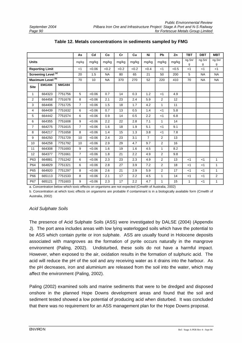
Public Environmental Review September 2004 Pilbara Iron Ore and Infrastructure Project: Stage A Port and N-S Railway Page 90 for Fortescue Metals Group Limited
ENVIRON Ref: Stage A PER Rev 4 - Sept 04
Table 12. Metals concentrations in sediments sampled by FMG As Cd Co Cr Cu Ni Pb Zn TBT DBT MBT
Units mg/kg mg/kg mg/kg mg/kg mg/kg mg/kg mg/kg mg/kg ng.Sn/g
ng.Sn/g
ng.Sn/g
Reporting Limit <1 <0.06 <0.2 <0.2 <0.2 <0.4 <1 <0.5 <1 <1 <1
Screening Level (a) 20 1.5 NA 80 65 21 50 200 5 NA NA
Maximum Level (b) 70 10 NA 370 270 52 220 410 70 NA NA
Site EMGA94 NMGA94
1 664323 7751756 5 <0.06 0.7 14 0.3 1.2 <1 4.9
2 664458 7751678 8 <0.06 2.1 23 2.4 5.9 2 12
3 664406 7751725 7 <0.06 1.5 18 1.7 4.2 1 11
4 664439 7751632 6 <0.06 0.7 13 0.5 1.4 <1 5.8
5 664442 7751574 6 <0.06 0.9 14 0.5 2.2 <1 6.8
6 664355 7751608 9 <0.06 2.2 22 2.8 7.1 1 14
7 664275 7751615 7 <0.06 1.6 18 1.9 5.1 <1 9.1
8 664217 7751658 8 <0.06 1.4 15 1.3 3.8 <1 7.8
9 664250 7751729 10 <0.06 2.4 23 3.1 7 2 13
10 664258 7751792 10 <0.06 2.9 29 4.7 9.7 2 16
11 664308 7751693 9 <0.06 1.6 19 1.6 4.5 1 8.2
12 664377 7751661 7 <0.06 1.8 21 2.2 4.9 2 9.8
P63 664881 7751242 6 <0.06 2.3 23 2.3 4.9 2 13 <1 <1 1
P64 664829 7751321 6 <0.06 2.8 27 3.9 7.2 2 18 <1 <1 1
P65 664920 7751297 8 <0.06 2.6 21 2.9 5.9 2 17 <1 <1 1
P66 665113 7751533 8 <0.06 2.1 17 2.2 4.5 1 14 <1 <1 2
P67 665121 7751603 9 <0.06 2.3 17 2.2 4.7 1 15 1 <1 1 a. Concentration below which toxic effects on organisms are not expected (Cmwlth of Australia, 2002) b. Concentration at which toxic effects on organisms are probable if contaminant is in a biologically available form (Cmwlth of Australia, 2002)
Acid Sulphate Soils The presence of Acid Sulphate Soils (ASS) were investigated by DALSE (2004) (Appendix J). The port area includes areas with low lying waterlogged soils which have the potential to be ASS which contain pyrite or iron sulphate. ASS are usually found in Holocene deposits associated with mangroves as the formation of pyrite occurs naturally in the mangrove environment (Paling, 2002). Undisturbed, these soils do not have a harmful impact. However, when exposed to the air, oxidation results in the formation of sulphuric acid. The acid will reduce the pH of the soil and any receiving water as it drains into the harbour. As the pH decreases, iron and aluminium are released from the soil into the water, which may affect the environment (Paling, 2002). Paling (2002) examined soils and marine sediments that were to be dredged and disposed onshore in the planned Hope Downs development areas and found that the soil and sediment tested showed a low potential of producing acid when disturbed. It was concluded that there was no requirement for an ASS management plan for the Hope Downs proposal.
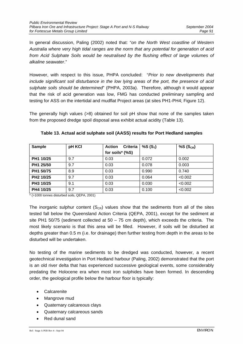
Public Environmental Review Pilbara Iron Ore and Infrastructure Project: Stage A Port and N-S Railway September 2004 for Fortescue Metals Group Limited Page 91
Ref: Stage A PER Rev 4 - Sept 04 ENVIRON
In general discussion, Paling (2002) noted that: “on the North West coastline of Western Australia where very high tidal ranges are the norm that any potential for generation of acid from Acid Sulphate Soils would be neutralised by the flushing effect of large volumes of alkaline seawater.” However, with respect to this issue, PHPA concluded: “Prior to new developments that include significant soil disturbance in the low lying areas of the port, the presence of acid sulphate soils should be determined” (PHPA, 2003a). Therefore, although it would appear that the risk of acid generation was low, FMG has conducted preliminary sampling and testing for ASS on the intertidal and mudflat Project areas (at sites PH1-PH4; Figure 12). The generally high values (>8) obtained for soil pH show that none of the samples taken from the proposed dredge spoil disposal area exhibit actual acidity (Table 13).
Table 13. Actual acid sulphate soil (AASS) results for Port Hedland samples Sample pH KCl Action Criteria
for soils* (%S) %S (ST) %S (SCR)
PH1 10/25 9.7 0.03 0.072 0.002 PH1 25/50 9.7 0.03 0.078 0.003 PH1 50/75 8.9 0.03 0.990 0.740 PH2 10/25 9.7 0.03 0.064 <0.002 PH3 10/25 9.1 0.03 0.030 <0.002 PH4 10/25 9.7 0.03 0.100 <0.002
* (>1000 tonnes disturbed soils, QEPA, 2001)
The inorganic sulphur content (SCR) values show that the sediments from all of the sites tested fall below the Queensland Action Criteria (QEPA, 2001), except for the sediment at site PH1 50/75 (sediment collected at 50 – 75 cm depth), which exceeds the criteria. The most likely scenario is that this area will be filled. However, if soils will be disturbed at depths greater than 0.5 m (i.e. for drainage) then further testing from depth in the areas to be disturbed will be undertaken. No testing of the marine sediments to be dredged was conducted, however, a recent geotechnical investigation in Port Hedland harbour (Paling, 2002) demonstrated that the port is an old river delta that has experienced successive geological events, some considerably predating the Holocene era when most iron sulphides have been formed. In descending order, the geological profile below the harbour floor is typically:
• Calcarenite • Mangrove mud • Quaternary calcareous clays • Quaternary calcareous sands • Red dunal sand
Public Environmental Review September 2004 Pilbara Iron Ore and Infrastructure Project: Stage A Port and N-S Railway Page 92 for Fortescue Metals Group Limited
ENVIRON Ref: Stage A PER Rev 4 - Sept 04
• Sedimentary rocks • Archaean bedrock
Of these, only the mangrove muds and some alluvial sediments are of recent (Holocene) origin and much of the material is expected to be alkaline in nature. Therefore, the dredging and reclamation component of the Project is considered to have a low risk of generating acid drainage harmful to the environment, due to a combination of the low risk of potential acid sulphate soils being encountered, and the positive benefit of tidal flushing in reducing any acidity produced. However, further investigation of dredge sediments will be undertaken, and an ASS management plan developed and implemented should ASS be present (Section 7.3.7). 6.3.3.5 Current Dredging Activities Current dredging activities are described in DALSE (2004) (Appendix J). Previously, spoil from capital and maintenance dredging in the harbour has either been used for reclamation or disposed of to the large spoil bank immediately outside the harbour north of the township. Maintenance dredging is a regular activity and is carried out approximately every four years to maintain the depth of the approach channel and the turning basin (PHPA, 2003a). PHPA currently has approval from the Federal Department of Environment and Heritage to dispose of dredge material at an offshore spoil ground (C. Wilson PHPA, pers. comm.). No sedimentation controls are implemented during dredging due to the already turbid nature of the harbour (PHPA, 2003a). Dredging works for FMG will be undertaken in four separate areas, as shown on Figure 7, as follows (Coffey Geosciences, 2004; Appendix N):
1. Zone A: This area, located immediately north of the proposed berths, has been previously dredged to nominally 9.1 m Chart Datum (CD), and will require further dredging to nominally 14.6 m CD. While this dredged material is expected to be very hard and well cemented, a thin layer of weaker muddy material may have formed on the seabed, due to sediment flowing into the dredged basin from the main creeks including South West and South Creeks.
2. Zone B: This area is located immediately east of the proposed berths and will
require dredging from its existing level, at nominally 0.5 m above CD to 9.1 m CD. Weaker silty/sandy material is expected to be present to depths varying from 0.5 m to 1.0 m CD.
3. Zone C: This area is located within the proposed berthing pocket and will require
dredging from its current level, which varies from nominally between 0.0 m CD and 2.5 m above CD, to 19.5 m below CD. Weaker silty/sandy material is expected to be present to depths varying from 0.5 m to 2.5 m CD.
Public Environmental Review Pilbara Iron Ore and Infrastructure Project: Stage A Port and N-S Railway September 2004 for Fortescue Metals Group Limited Page 93
Ref: Stage A PER Rev 4 - Sept 04 ENVIRON
4. Zone D: This area is located immediately south of the berthing pocket and will
require battered dredging from its current level to tie in with Zone C at 19.5 m CD. 6.3.3.6 Storm Surge Storm surge in the Port Hedland area is described in Aquaterra (2004b) (Appendix L) and summarised below. During cyclonic activity, storm surge occurs as a result of a drop in atmospheric pressure, extreme winds and wave pumping, raising sea levels above normal tide fluctuations. At Port Hedland, winds of over 200 kph and waves of up to 20 m, combined with floodwaters from the rivers flowing into the harbour can result in extensive inundation and scouring of low-lying coastal areas. The sediment load in the harbour may be significantly increased during storm surges. Design 50 year and 100 year Average Recurrence Interval (ARI) peak flood levels in the Port Hedland area have been assessed in the “Greater Port Hedland Storm-Surge Study”. This study employed a probabilistic approach to define return period levels for the coincidence of storm surge and rainfall generated flooding due to cyclones. The effects of varying tides and wave set-up were included in the modelling process (GEMS, 2000). The design peak flood levels developed by the modelling vary through the harbour area and are shown to be highest over the mudflats and sandy lowlands areas where the higher ground elevation tends to lift the storm surge water level. In the proposed FMG port development area, the design 100 year ARI storm surge levels vary from RL 5.0 m AHD at Anderson Point to around RL 6.0 m AHD at the Port Hedland-Shay Gap Railway. A design 100 year ARI average storm surge level of RL 5.5 m AHD has been adopted by FMG for the port development area. The storm surge study reports that the Port Hedland-Shay Gap Railway acts as a barrier to the inland penetration of ocean flooding during storm surge events (GEMS, 2000). 6.3.4 Mangrove Communities Mangrove communities within the vicinity of the Project area were studied by Biota Environmental Sciences and Dr. Eric Paling (see Appendices H and I). Key findings are presented below. 6.3.4.1 Mangrove Species Seven species of mangroves are known to occur in coastal environments in the Pilbara region (Semeniuk et al., 1978; Kenneally, 1982), and six of these are documented as occurring in Port Hedland Harbour (Paling et al., 2001). The species recorded from the vicinity of the proposed FMG port facilities were:
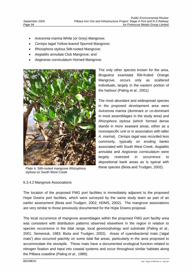
Public Environmental Review September 2004 Pilbara Iron Ore and Infrastructure Project: Stage A Port and N-S Railway Page 94 for Fortescue Metals Group Limited
ENVIRON Ref: Stage A PER Rev 4 - Sept 04
• Avicennia marina White (or Grey) Mangrove; • Ceriops tagal Yellow-leaved Spurred Mangrove; • Rhizophora stylosa Stilt-rooted Mangrove; • Aegialitis annulata Club Mangrove; and • Aegiceras corniculatum Horned Mangrove.
The only other species known for the area, Bruguiera exaristata Rib-fruited Orange Mangrove, occurs only as scattered individuals, largely in the eastern portion of the harbour (Paling et al., 2001). The most abundant and widespread species in the proposed development area were Avicennia marina (dominant or co-dominant in most assemblages in the study area) and Rhizophora stylosa (which formed dense stands in more seaward areas, either as a monospecific unit or in association with taller A. marina). Ceriops tagal was recorded less commonly, typically on eroding banks associated with South West Creek. Aegialitis annulata and Aegiceras corniculatum were largely restricted in occurrence to depositional bank areas as is typical with these species (Biota and Trudgen, 2002).
6.3.4.2 Mangrove Associations The location of the proposed FMG port facilities is immediately adjacent to the proposed Hope Downs port facilities, which were surveyed by the same study team as part of an earlier assessment (Biota and Trudgen, 2002; HDMS, 2002). The mangrove associations are very similar to those previously documented for the Hope Downs proposal. The local occurrence of mangrove assemblages within the proposed FMG port facility area was consistent with distribution patterns observed elsewhere in the region in relation to species occurrence in the tidal range, local geomorphology and substrate (Paling et al., 2001; Semeniuk, 1983; Biota and Trudgen, 2002). Areas of cyanobacterial mats (‘algal mats’) also occurred patchily on some tidal flat areas, particularly in the area proposed to accommodate the stockpile. These mats have a documented ecological function related to nitrogen fixation and input into coastal systems and occur throughout similar habitats along the Pilbara coastline (Paling et al., 1989).
Plate 4. Stilt-rooted mangrove Rhizophora stylosa on South West Creek
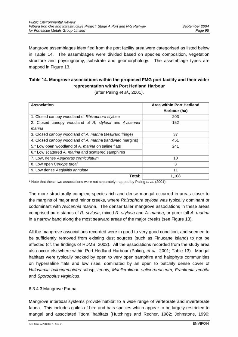
Public Environmental Review Pilbara Iron Ore and Infrastructure Project: Stage A Port and N-S Railway September 2004 for Fortescue Metals Group Limited Page 95
Ref: Stage A PER Rev 4 - Sept 04 ENVIRON
Mangrove assemblages identified from the port facility area were categorised as listed below in Table 14. The assemblages were divided based on species composition, vegetation structure and physiognomy, substrate and geomorphology. The assemblage types are mapped in Figure 13. Table 14. Mangrove associations within the proposed FMG port facility and their wider
representation within Port Hedland Harbour (after Paling et al., 2001).
Association Area within Port Hedland
Harbour (ha) 1. Closed canopy woodland of Rhizophora stylosa 203 2. Closed canopy woodland of R. stylosa and Avicennia marina
152
3. Closed canopy woodland of A. marina (seaward fringe) 37 4. Closed canopy woodland of A. marina (landward margins) 451 5.* Low open woodland of A. marina on saline flats 6.* Low scattered A. marina and scattered samphires
241
7. Low, dense Aegiceras corniculatum 10 8. Low open Ceriops tagal 3 9. Low dense Aegialitis annulata 11
Total: 1,108 * Note that these two associations were not separately mapped by Paling et al. (2001). The more structurally complex, species rich and dense mangal occurred in areas closer to the margins of major and minor creeks, where Rhizophora stylosa was typically dominant or codominant with Avicennia marina. The denser taller mangrove associations in these areas comprised pure stands of R. stylosa, mixed R. stylosa and A. marina, or purer tall A. marina in a narrow band along the most seaward areas of the major creeks (see Figure 13). All the mangrove associations recorded were in good to very good condition, and seemed to be sufficiently removed from existing dust sources (such as Finucane Island) to not be affected (cf. the findings of HDMS, 2002). All the associations recorded from the study area also occur elsewhere within Port Hedland Harbour (Paling, et al., 2001; Table 13). Mangal habitats were typically backed by open to very open samphire and halophyte communities on hypersaline flats and low rises, dominated by an open to patchily dense cover of Halosarcia halocnemoides subsp. tenuis, Muellerolimon salicorneaceum, Frankenia ambita and Sporobolus virginicus. 6.3.4.3 Mangrove Fauna Mangrove intertidal systems provide habitat to a wide range of vertebrate and invertebrate fauna. This includes guilds of bird and bats species which appear to be largely restricted to mangal and associated littoral habitats (Hutchings and Recher, 1982; Johnstone, 1990;
Public Environmental Review September 2004 Pilbara Iron Ore and Infrastructure Project: Stage A Port and N-S Railway Page 96 for Fortescue Metals Group Limited
ENVIRON Ref: Stage A PER Rev 4 - Sept 04
Churchill, 1998) and a wide range of marine invertebrate fauna. The latter falls into two main components:
• invertebrates more strongly associated with the mangal itself (including mud whelks Terebralia spp., the fiddler crab Uca coactarta flammula and a variety of insects and spiders); and
• mangrove sediment infauna (burrowing or more strongly marine invertebrates including polychaete worms, annelid worms, flatworms, and a range of mollusks) (Hutchings and Recher, 1982).
Halpern Glick Maunsell (1997) identified a total of 183 infauna species, of these approximately 55% were polychaete worms, 24% molluscs and 18% crustaceans. The vertebrate fauna of mangrove habitats in the area was assessed both during the current survey for the FMG Project and previously for the proposed Hope Downs port site (Biota, 2001b). A substantial bird fauna utilised the mangroves in this area, including 12 species which are regarded as effectively restricted to mangrove and associated littoral habitats (Johnstone, 1990). These included the Mangrove Golden Whistler, Mangrove Gerygone, Mangrove Robin, Bar-shoulder Dove and the Mangrove Fantail (Biota, 2001b; 2004f). A number of wader species were also recorded from the mudflat habitats associated with West Creek, including the Whimbrel, Eastern Curlew (Priority 4; Section 6.2.4.3), Common Sandpiper and the Grey-tailed Tattler (Biota, 2001b, 2004f). Mangal habitat was also surveyed for bat fauna as part of the Hope Downs port assessment (Biota, 2001b). Two mangrove specialist species were identified as occurring in the mangrove habitats of the port area. Two specimens of the Arnhem Land Long-eared Bat Nyctophilus arnhemensis were captured in mist nets and the Little Northern Freetail-bat Mormopterus loriae coburgiana (Priority 4) was identified from analysis of echolocation calls (see Section 6.2.4.3; Biota, 2001b). The identification of M. l. cobourgiana was not confirmed by a capture but the species is listed as ‘data deficient’ (Duncan et al., 1999), and taxonomic revision of this group is still being completed (How, et al., 2001). Its status in the Pilbara is therefore still not clear, but it is apparently largely confined to mangal habitats. In addition to these species, Flatback Turtles Natator depressus are also known to utilise habitats within the tidal creeks of Port Hedland harbour. Although not recorded during the current site survey, this species has previously been sighted by Biota in West Creek. No potential breeding habitats for this species are likely to be affected by the proposed port infrastructure, but certain frequencies of light can affect hatchling and juvenile animal activity (Section 7.3.5.1).
Public Environmental Review Pilbara Iron Ore and Infrastructure Project: Stage A Port and N-S Railway September 2004 for Fortescue Metals Group Limited Page 97
Ref: Stage A PER Rev 4 - Sept 04 ENVIRON
6.3.5 Marine Biota The subtidal zone is characterised by fine mud or shell grit supporting occasional benthic flora and scattered invertebrates. This zone supports filamentous green algae, but little epifauna due to the disturbance of regular dredging and naturally high turbidity. Sargassum beds are present in Stingray Creek on the eastern side of the harbour, however, these do not occur in the proposed Project area. Green algal mats occur in the Project area as described in Section 6.3.4.2). The Dugong Dugong dugong is the only representative of the mammal order Sirenia that occurs in Australia waters. Dugongs occur in areas where their principal food source, seagrasses belonging to the family Potamogetonaceae, form meadows (Bryden et al., 1998). The marine habitats of Port Hedland harbour do not contain any seagrass beds, being comprised of Sargassum and green algae on rocky and soft substrates (PHPA, 2003a). Regional aerial surveys completed by CALM (Prince, 2001), also failed to record any evidence of Dugong activity in the vicinity of Port Hedland. The harbour therefore appears to have little or no significance as habitat for this species. The same regional survey also recorded data on dolphin distribution (Tursiops sp. and Sousa sp.) (Baker, 1999; Prince, 2001). Some dolphin activity has been recorded in the harbour, but a comprehensive review completed by PHPA (2003a) does highlight dolphin utilisation of the harbour as a major concern. The portion of the harbour affected by the proposed FMG port is likely to be of minimal importance to dolphins at a regional scale. Any potential risks to the occasional dolphin that may enter the harbour would not be substantially altered from that associated with the existing level of shipping activity at Port Hedland. Phytoplankton and zooplankton are characterised by tropical and subtropical species in the water column, with mostly chain forming planktonic diatoms and calanoid copepods the dominant groups. Planktonic species diversity is low, probably due to turbid harbour waters. Over 100 species of fish have been recorded in the harbour, and as mentioned in Section 6.3.4.3, occasional turtles (although no turtle nesting sites) (HDMS, 2002). The size and number of the vessels visiting Port Hedland means that Port Hedland is subject to relatively high volumes of ballast water discharge. In 1998, the Centre for Research on Introduced Marine Pests conducted a survey of the harbour and the two off-shore dredge spoil grounds for introduced species and did not detect any of the Australian Ballast Water Management Advisory Council (ABWMAC) targeted pest species. Other introduced or ‘cryptogenic’ (those species which cannot definitely or demonstrably be categorised as introduced or native) species identified to date include the hydroids Obelia longissima and Antennella secundaria (status still unclear whether native or introduced), the bryozoans Amathia distans, Bugula neritina, the barnacle Balanus amphitrite. None of these species are considered pests in Australia and their potential impact on the environment is regarded as low (CSIRO, 1999).
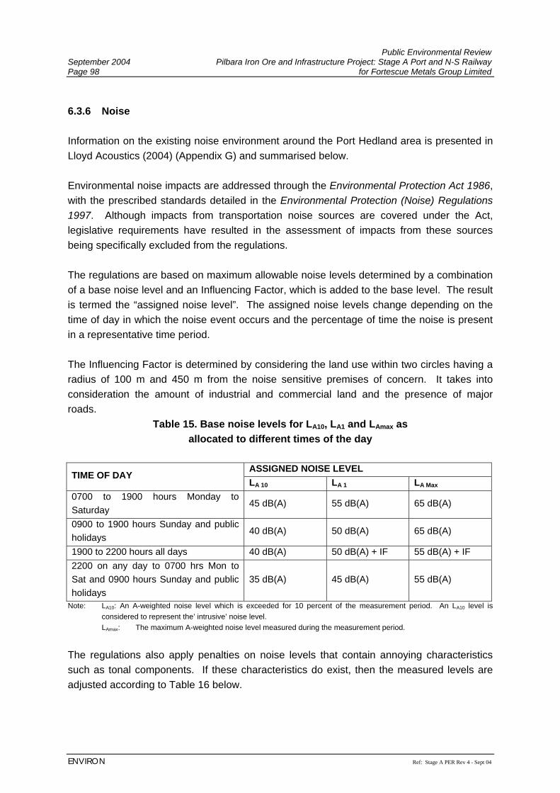
Public Environmental Review September 2004 Pilbara Iron Ore and Infrastructure Project: Stage A Port and N-S Railway Page 98 for Fortescue Metals Group Limited
ENVIRON Ref: Stage A PER Rev 4 - Sept 04
6.3.6 Noise Information on the existing noise environment around the Port Hedland area is presented in Lloyd Acoustics (2004) (Appendix G) and summarised below. Environmental noise impacts are addressed through the Environmental Protection Act 1986, with the prescribed standards detailed in the Environmental Protection (Noise) Regulations 1997. Although impacts from transportation noise sources are covered under the Act, legislative requirements have resulted in the assessment of impacts from these sources being specifically excluded from the regulations. The regulations are based on maximum allowable noise levels determined by a combination of a base noise level and an Influencing Factor, which is added to the base level. The result is termed the “assigned noise level”. The assigned noise levels change depending on the time of day in which the noise event occurs and the percentage of time the noise is present in a representative time period. The Influencing Factor is determined by considering the land use within two circles having a radius of 100 m and 450 m from the noise sensitive premises of concern. It takes into consideration the amount of industrial and commercial land and the presence of major roads.
Table 15. Base noise levels for LA10, LA1 and LAmax as allocated to different times of the day
ASSIGNED NOISE LEVEL
TIME OF DAY LA 10 LA 1 LA Max
0700 to 1900 hours Monday to Saturday
45 dB(A) 55 dB(A) 65 dB(A)
0900 to 1900 hours Sunday and public holidays
40 dB(A) 50 dB(A) 65 dB(A)
1900 to 2200 hours all days 40 dB(A) 50 dB(A) + IF 55 dB(A) + IF 2200 on any day to 0700 hrs Mon to Sat and 0900 hours Sunday and public holidays
35 dB(A) 45 dB(A) 55 dB(A)
Note: LA10: An A-weighted noise level which is exceeded for 10 percent of the measurement period. An LA10 level is considered to represent the’ intrusive’ noise level. LAmax: The maximum A-weighted noise level measured during the measurement period.
The regulations also apply penalties on noise levels that contain annoying characteristics such as tonal components. If these characteristics do exist, then the measured levels are adjusted according to Table 16 below.
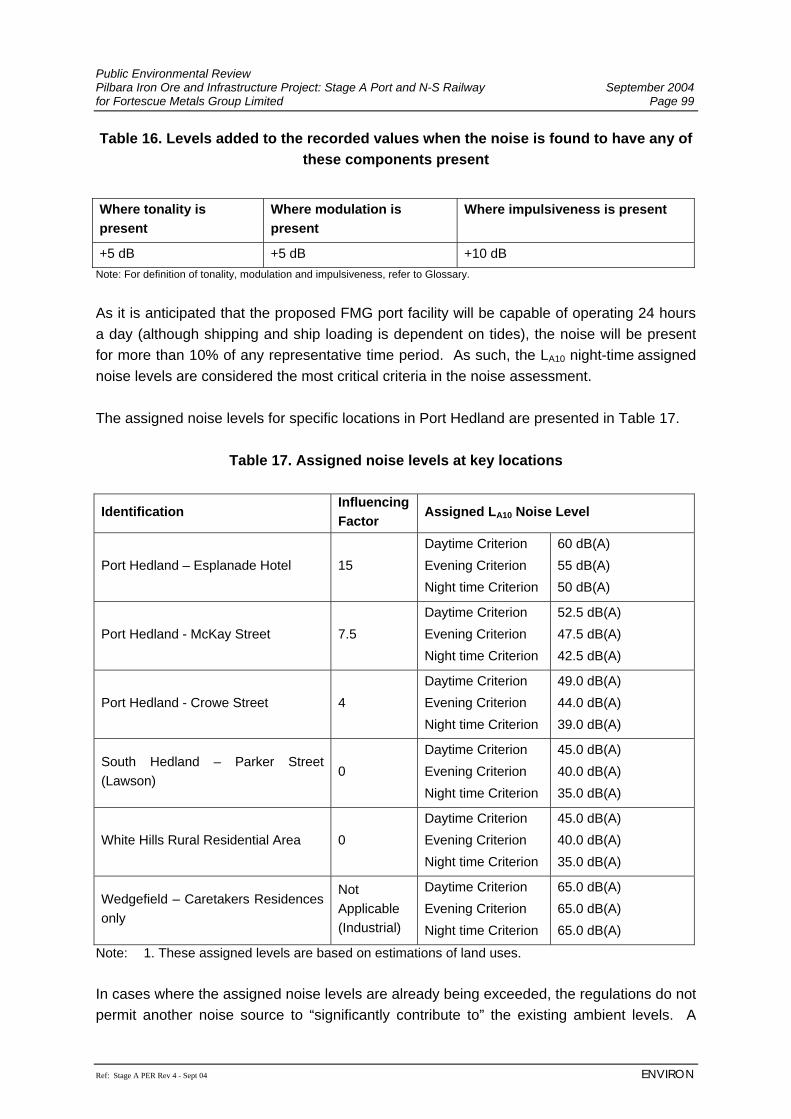
Public Environmental Review Pilbara Iron Ore and Infrastructure Project: Stage A Port and N-S Railway September 2004 for Fortescue Metals Group Limited Page 99
Ref: Stage A PER Rev 4 - Sept 04 ENVIRON
Table 16. Levels added to the recorded values when the noise is found to have any of these components present
Where tonality is present
Where modulation is present
Where impulsiveness is present
+5 dB +5 dB +10 dB Note: For definition of tonality, modulation and impulsiveness, refer to Glossary.
As it is anticipated that the proposed FMG port facility will be capable of operating 24 hours a day (although shipping and ship loading is dependent on tides), the noise will be present for more than 10% of any representative time period. As such, the LA10 night-time assigned noise levels are considered the most critical criteria in the noise assessment. The assigned noise levels for specific locations in Port Hedland are presented in Table 17.
Table 17. Assigned noise levels at key locations
Identification Influencing Factor
Assigned LA10 Noise Level
Port Hedland – Esplanade Hotel 15 Daytime Criterion Evening Criterion Night time Criterion
60 dB(A) 55 dB(A) 50 dB(A)
Port Hedland - McKay Street 7.5 Daytime Criterion Evening Criterion Night time Criterion
52.5 dB(A) 47.5 dB(A) 42.5 dB(A)
Port Hedland - Crowe Street 4 Daytime Criterion Evening Criterion Night time Criterion
49.0 dB(A) 44.0 dB(A) 39.0 dB(A)
South Hedland – Parker Street (Lawson)
0 Daytime Criterion Evening Criterion Night time Criterion
45.0 dB(A) 40.0 dB(A) 35.0 dB(A)
White Hills Rural Residential Area 0 Daytime Criterion Evening Criterion Night time Criterion
45.0 dB(A) 40.0 dB(A) 35.0 dB(A)
Wedgefield – Caretakers Residences only
Not Applicable (Industrial)
Daytime Criterion Evening Criterion Night time Criterion
65.0 dB(A) 65.0 dB(A) 65.0 dB(A)
Note: 1. These assigned levels are based on estimations of land uses. In cases where the assigned noise levels are already being exceeded, the regulations do not permit another noise source to “significantly contribute to” the existing ambient levels. A
Public Environmental Review September 2004 Pilbara Iron Ore and Infrastructure Project: Stage A Port and N-S Railway Page 100 for Fortescue Metals Group Limited
ENVIRON Ref: Stage A PER Rev 4 - Sept 04
noise event is taken to “significantly contribute to” a level of noise if the new noise emission exceeds a value 5 dB(A) below the assigned level at the point of reception. The noise environment in Port Hedland is dominated by the BHPBIO operations at Nelson Point and Finucane Island. Short-term measurements conducted between Edgar Street and Crowe Street, Port Hedland, during reclaiming and ship loading operations, resulted in a background night-time noise level of approximately LA90 56 dB(A). In addition to this, the intrusive noise level from these activities was recorded at LA10 58 dB(A) which exceeds the night-time assigned noise levels for Port Hedland by between 15 dB(A) and 19 dB(A). Based on observations at the time of the measurements, it is considered that the major noise contributors are the ship loaders, reclaimers/stackers and the crushing plant on Finucane Island. Longer term noise measurements were also conducted at Kingsmill Street (between Withnell and Hardie Street) and the corner of Simpson Street and Moore Street between the 12th and 24th July 2004. The noise environment in South Hedland is typical for a regional country centre with short-term measured noise levels of approximately LA90 34 dB(A). However, when a BHPBIO train passes to the east of the townsite, it is clearly audible with noise levels of approximately 50 dB(A) during an easterly wind. As Wedgefield is zoned Industrial the assigned noise levels are not dependent upon time of day in which noise events occur. However, night-time noise levels were measured and were approximately 40 dB(A), dominated by insect noise. The noise environment at the White Hills rural residential area, situated approximately three kilometres south of South Hedland was not measured. As this is a rural area, one would expect typical night-time noise levels to be between 30 dB(A) and 35 dB(A). Although the majority of the FMG rail corridor passes through relatively remote areas that have low ambient noise levels, it does run close to the existing BHPBIO rail corridor, so these areas would currently be subjected to rail noise. 6.3.7 Dust Dust has historically been an issue in the Port Hedland area, and one which impacts on the residents of the town, particularly in the vicinity of ore stockpiles and ship loading facilities at the port. Within the context of defining the extent of the existing dust impacts in the Port Hedland area, there are a number of ambient dust standards that are considered to be applicable. The National Environment Protection Council (NEPC) has produced a National Environment Protection Measure (NEPM) for ambient air quality that contains national ambient air quality standards for the protection of human health for criteria pollutants, including PM10 (particles with a diameter of 10 µm or less). The NEPC has also established an advisory standard under
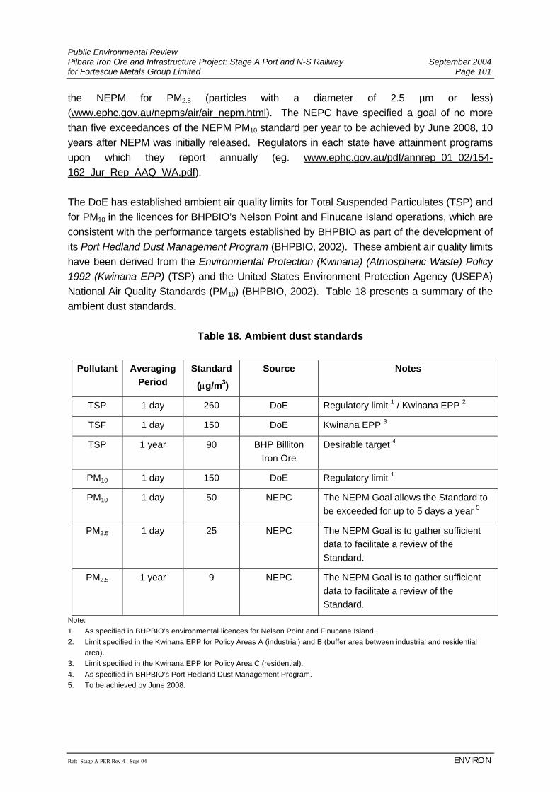
Public Environmental Review Pilbara Iron Ore and Infrastructure Project: Stage A Port and N-S Railway September 2004 for Fortescue Metals Group Limited Page 101
Ref: Stage A PER Rev 4 - Sept 04 ENVIRON
the NEPM for PM2.5 (particles with a diameter of 2.5 µm or less) (www.ephc.gov.au/nepms/air/air_nepm.html). The NEPC have specified a goal of no more than five exceedances of the NEPM PM10 standard per year to be achieved by June 2008, 10 years after NEPM was initially released. Regulators in each state have attainment programs upon which they report annually (eg. www.ephc.gov.au/pdf/annrep_01_02/154-162_Jur_Rep_AAQ_WA.pdf). The DoE has established ambient air quality limits for Total Suspended Particulates (TSP) and for PM10 in the licences for BHPBIO’s Nelson Point and Finucane Island operations, which are consistent with the performance targets established by BHPBIO as part of the development of its Port Hedland Dust Management Program (BHPBIO, 2002). These ambient air quality limits have been derived from the Environmental Protection (Kwinana) (Atmospheric Waste) Policy 1992 (Kwinana EPP) (TSP) and the United States Environment Protection Agency (USEPA) National Air Quality Standards (PM10) (BHPBIO, 2002). Table 18 presents a summary of the ambient dust standards.
Table 18. Ambient dust standards
Pollutant Averaging Period
Standard
(µg/m3)
Source Notes
TSP 1 day 260 DoE Regulatory limit 1 / Kwinana EPP 2
TSF 1 day 150 DoE Kwinana EPP 3
TSP 1 year 90 BHP Billiton Iron Ore
Desirable target 4
PM10 1 day 150 DoE Regulatory limit 1
PM10 1 day 50 NEPC The NEPM Goal allows the Standard to be exceeded for up to 5 days a year 5
PM2.5 1 day 25 NEPC The NEPM Goal is to gather sufficient data to facilitate a review of the Standard.
PM2.5 1 year 9 NEPC The NEPM Goal is to gather sufficient data to facilitate a review of the Standard.
Note: 1. As specified in BHPBIO’s environmental licences for Nelson Point and Finucane Island. 2. Limit specified in the Kwinana EPP for Policy Areas A (industrial) and B (buffer area between industrial and residential
area). 3. Limit specified in the Kwinana EPP for Policy Area C (residential). 4. As specified in BHPBIO’s Port Hedland Dust Management Program. 5. To be achieved by June 2008.
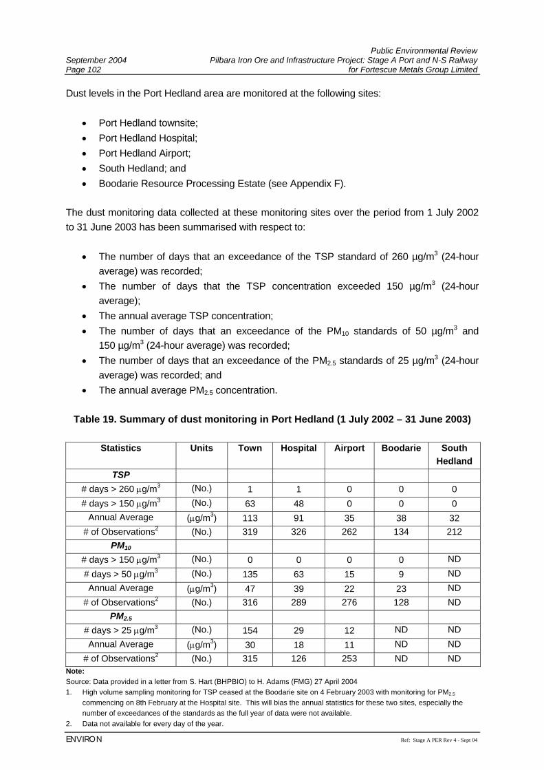
Public Environmental Review September 2004 Pilbara Iron Ore and Infrastructure Project: Stage A Port and N-S Railway Page 102 for Fortescue Metals Group Limited
ENVIRON Ref: Stage A PER Rev 4 - Sept 04
Dust levels in the Port Hedland area are monitored at the following sites:
• Port Hedland townsite; • Port Hedland Hospital; • Port Hedland Airport; • South Hedland; and • Boodarie Resource Processing Estate (see Appendix F).
The dust monitoring data collected at these monitoring sites over the period from 1 July 2002 to 31 June 2003 has been summarised with respect to:
• The number of days that an exceedance of the TSP standard of 260 µg/m3 (24-hour average) was recorded;
• The number of days that the TSP concentration exceeded 150 µg/m3 (24-hour average);
• The annual average TSP concentration; • The number of days that an exceedance of the PM10 standards of 50 µg/m3 and
150 µg/m3 (24-hour average) was recorded; • The number of days that an exceedance of the PM2.5 standards of 25 µg/m3 (24-hour
average) was recorded; and • The annual average PM2.5 concentration.
Table 19. Summary of dust monitoring in Port Hedland (1 July 2002 – 31 June 2003)
Statistics Units Town Hospital Airport Boodarie South
Hedland TSP
# days > 260 µg/m3 (No.) 1 1 0 0 0 # days > 150 µg/m3 (No.) 63 48 0 0 0
Annual Average (µg/m3) 113 91 35 38 32 # of Observations2 (No.) 319 326 262 134 212
PM10 # days > 150 µg/m3 (No.) 0 0 0 0 ND # days > 50 µg/m3 (No.) 135 63 15 9 ND Annual Average (µg/m3) 47 39 22 23 ND
# of Observations2 (No.) 316 289 276 128 ND PM2.5
# days > 25 µg/m3 (No.) 154 29 12 ND ND Annual Average (µg/m3) 30 18 11 ND ND
# of Observations2 (No.) 315 126 253 ND ND Note: Source: Data provided in a letter from S. Hart (BHPBIO) to H. Adams (FMG) 27 April 2004 1. High volume sampling monitoring for TSP ceased at the Boodarie site on 4 February 2003 with monitoring for PM2.5
commencing on 8th February at the Hospital site. This will bias the annual statistics for these two sites, especially the number of exceedances of the standards as the full year of data were not available.
2. Data not available for every day of the year.
Public Environmental Review Pilbara Iron Ore and Infrastructure Project: Stage A Port and N-S Railway September 2004 for Fortescue Metals Group Limited Page 103
Ref: Stage A PER Rev 4 - Sept 04 ENVIRON
ND – No Data
In reviewing the dust monitoring data available for Port Hedland it should be recognised that a portion of the dust that impacts upon the Port Hedland area arises from background dust levels attributable to the arid and naturally dusty environment of the Pilbara region of Australia. Notwithstanding this fact, dust impacts at the Port Hedland and Hospital monitoring sites are significantly higher than at those monitored at the Boodarie Resource Processing Estate monitoring site (which itself is influenced by the DRI operations) due to their proximity to the existing iron ore operations at Nelson Point and Finucane Island. The data presented in Table 19 indicates that whilst the Port Hedland townsite and Hospital monitoring sites complied with the ambient PM10 limit specified in BHPBIO’s environmental licences over the period of data analysed, these sites did not comply with the 24-hour or annual average TSP licence limits, nor did these sites comply with the PM10 or PM2.5 Standards specified by the NEPC. The existing environment in Port Hedland can therefore be characterised as exhibiting naturally high background dust levels, and further elevated dust levels in the Port Hedland townsite which are primarily associated with dust emissions from the existing iron ore operations.

Public Environmental Review September 2004 Pilbara Iron Ore and Infrastructure Project: Stage A Port and N-S Railway Page 104 for Fortescue Metals Group Limited
ENVIRON Ref: Stage A PER Rev 4 - Sept 04
(This page has been left blank intentionally)
Public Environmental Review Pilbara Iron Ore and Infrastructure Project: Stage A Port and N-S Railway September 2004 for Fortescue Metals Group Limited Page 105
Ref: Stage A PER Rev 4 - Sept 04 ENVIRON
7. ENVIRONMENTAL IMPACTS AND MANAGEMENT This section describes the potential impacts of the Project and how these issues will be managed in the context of ‘sustainable development’. 7.1 OVERALL IMPACT OF PROJECT 7.1.1 Principles Of Sustainability The definition for sustainability that has been widely adopted is outlined in the World Commission on Environment and Development’s Brundtland Report (World Commission on Environment and Development, 1987) as:
“Development which meets the needs of the present without compromising the ability of future generations to meet their own needs.”
There are at least three aspects to sustainability which are interrelated: social sustainability, economic sustainability and environmental sustainability. It has been said that a sustainable society depends upon a sustainable, stable economy which in turn depends on the global ecosystem, whose health is vital to all (World Commission on Environment and Development, 1987). The EPA’s objective for FMG’s Project is to:
• ensure as far as practicable, that the proposal meets, or is consistent with, the sustainability principles in the National Strategy for Ecologically Sustainable Development (Ecologically Sustainable Development Steering Committee, 1992).
Australia's National Strategy for Ecologically Sustainable Development (NSESD) defines ecologically sustainable development (ESD) as
“using, conserving and enhancing the community's resources so that ecological processes, on which life depends, are maintained, and the total quality of life, now and in the future, can be increased.”
The Core Objectives of the NSESD are:
• to enhance individual and community well-being and welfare by following a path of economic development that safeguards the welfare of future generations;
• to provide for equity within and between generations; and • to protect biological diversity and maintain essential ecological processes and life-
support systems.
Public Environmental Review September 2004 Pilbara Iron Ore and Infrastructure Project: Stage A Port and N-S Railway Page 106 for Fortescue Metals Group Limited
ENVIRON Ref: Stage A PER Rev 4 - Sept 04
The Guiding Principles of the NSESD are:
1. Decision making processes should effectively integrate both long and short-term economic, environmental, social and equity considerations.
2. Where there are threats of serious or irreversible environmental damage, lack of full scientific certainty should not be used as a reason for postponing measures to prevent environmental degradation.
3. The global dimension of environmental impacts of actions and policies should be recognised and considered.
4. The need to develop a strong, growing and diversified economy which can enhance the capacity for environmental protection should be recognised.
5. The need to maintain and enhance international competitiveness in an environmentally sound manner should be recognised.
6. Cost effective and flexible policy instruments should be adopted, such as improved valuation, pricing and incentive mechanisms.
7. Decisions and actions should provide for broad community involvement on issues which affect them.
In 2003, the Western Australian Government also released a State Sustainability Strategy “Hope for the Future” which outlines six broad goals for sustainability that envisage how sustainability can be applied across the whole of government. These goals include:
• Ensure that the way we govern is driving the transition to a sustainable future. • Play our part in solving the global challenges of sustainability. • Value and protect our environment and ensure the sustainable management and use
of natural resources. • Plan and provide settlements that reduce the ecological footprint and enhance our
quality of life. • Support communities to fully participate in achieving a sustainable future. • Assist business to benefit from and contribute to sustainability.
In addition the strategy sets out a vision for the State’s mining industry which includes some key future actions:
• Work towards assessment of projects using sustainability criteria. • Foster local community involvement (particularly Aboriginal communities, pastoralists
and local shires). • Establish a transparent process to enable community awareness of the day-to-day
regulatory system for the resources industry. • Implement strategies that support the use of local employment in mining ventures,
particularly using regional centres as employment hubs and encourage mining companies to maximise their purchasing of goods and services within regions.
Public Environmental Review Pilbara Iron Ore and Infrastructure Project: Stage A Port and N-S Railway September 2004 for Fortescue Metals Group Limited Page 107
Ref: Stage A PER Rev 4 - Sept 04 ENVIRON
FMG understands that it needs a balanced approach to the way it operates. FMG’s planning takes into account all of the above objectives and principles to pursue the goal of sustainable development, such that no objective or principle should predominate over the others. Whilst FMG’s Pilbara Iron Ore and Infrastructure Project involves mining of a finite resource, and use of fuel resources that will one day be depleted, the way in which the Project is constructed, operated and decommissioned can be undertaken in a manner which meets the Guiding Principles of the NSESD and State Sustainability Strategy. In order to implement the principles of sustainability, FMG will develop a Sustainability Strategy which addresses contribution to global impacts such as greenhouse gas emissions and focuses on managing impacts across the triple bottom line of Social Capital, Economic Wealth and Environmental Assets. This Strategy will include such things as:
• establishing sustainability principles in purchasing and contracting; • ensuring efficient energy and water use; • minimising waste and encouraging recycling; and • providing for industry and community partnerships.
The following sections outline how FMG proposes to manage the potential impacts of the Project, in the light of the NSESD Guiding Principles. Community consultation (Principle 7 NSESD) is addressed in Section 5 of this PER. In recognition of the above sustainability frameworks, FMG has commissioned a Socio-economic review as part of its Environmental Impact Assessment. This review identifies the key socio-economic issues that require further consideration in the Project planning process and will be used to undertake informed consultation with stakeholders, and as a planning tool during project development (see Section 7.1.6). In recognition of the risks and opportunities identified in this review, FMG has developed a range of policy goals and commitments (as outlined in Section 7.1.6) which are well aligned with the State Sustainability Strategy. 7.1.2 Environmental Management System FMG is in the process of developing and implementing an Environmental Management System (EMS) that will assist the company to be proactive in managing environmental issues and promoting environmental excellence. The EMS will be developed to be consistent with the ISO 14001 standard and will be integrated with Quality, Health & Safety, and other business management systems. An Environmental Management Plan (EMP) is a key element in the successful implementation of the EMS. It includes Plans for the management of specific environmental aspects of the Project. A Draft EMP for construction of the Project has been developed and
Public Environmental Review September 2004 Pilbara Iron Ore and Infrastructure Project: Stage A Port and N-S Railway Page 108 for Fortescue Metals Group Limited
ENVIRON Ref: Stage A PER Rev 4 - Sept 04
is presented in Appendix E. Specific procedures for this EMP will be developed prior to construction, for the management of site-specific environmental issues. 7.1.3 Greenhouse Gases The greenhouse effect is a natural phenomenon that warms the earth and enables it to support life. However, since the industrial revolution, the amount of greenhouse gases in the atmosphere has increased dramatically, with the result of increased global warming. The six greenhouse gases specifically covered by the Kyoto Protocol are carbon dioxide (CO2), methane (CH4), perfluorocarbons (CFx), hydrofluorocarbons (HFCs), sulphur hexafluoride (SF6) and nitrous oxide (N2O) (Commonwealth of Australia, 1998). To compare warming potential of the different gases, their impact is usually expressed in terms of CO2 equivalents, where the potential of each to lead to heating in the atmosphere is expressed as a multiple of the heating potential of CO2 (i.e. t CO2e). Australia, with 0.3% of the world’s population contributed 1.4% of global anthropogenic greenhouse gases in 1995 (Government of Western Australia, 1997; Department of Foreign Affairs and Trade, 1997; Government of Western Australia, 1998). Western Australia contributed around 11% of national emissions in 1990 and approximately 12% in 1995 (National Greenhouse Gas Inventory Committee, 1998). The EPA has developed a guidance statement to minimise greenhouse gas emissions (EPA Guidance Statement No. 12, October 2002) which requires proponents of new projects to consider the potential impacts of their project, and compare this impact with that of similar projects. Potential Impacts In the construction and operation of the Project, greenhouse gases will be released to the atmosphere by:
• decomposition of cleared vegetation and release of carbon from the soil; • combustion of diesel fuel for mobile equipment at the railway and port; • combustion of diesel fuel for the locomotives; and • combustion of natural gas or diesel for power supply to the Project.
An estimate of the annual greenhouse gas emissions were based on the methodology outlined in:
• Australian Methodology for the Estimation of Greenhouse Gas Emissions and Sinks 2002: Energy (Stationary Sources), Australian Government, Australian Greenhouse Office (2002a);
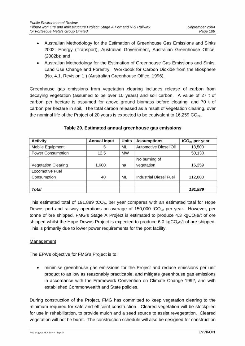
Public Environmental Review Pilbara Iron Ore and Infrastructure Project: Stage A Port and N-S Railway September 2004 for Fortescue Metals Group Limited Page 109
Ref: Stage A PER Rev 4 - Sept 04 ENVIRON
• Australian Methodology for the Estimation of Greenhouse Gas Emissions and Sinks 2002: Energy (Transport), Australian Government, Australian Greenhouse Office, (2002b); and
• Australian Methodology for the Estimation of Greenhouse Gas Emissions and Sinks: Land Use Change and Forestry. Workbook for Carbon Dioxide from the Biosphere (No. 4.1, Revision 1,) (Australian Greenhouse Office, 1996).
Greenhouse gas emissions from vegetation clearing includes release of carbon from decaying vegetation (assumed to be over 10 years) and soil carbon. A value of 27 t of carbon per hectare is assumed for above ground biomass before clearing, and 70 t of carbon per hectare in soil. The total carbon released as a result of vegetation clearing, over the nominal life of the Project of 20 years is expected to be equivalent to 16,259 CO2e.
Table 20. Estimated annual greenhouse gas emissions Activity Annual Input Units Assumptions tCO2e per year Mobile Equipment 5 ML Automotive Diesel Oil 13,500 Power Consumption 12.5 MW 50,130
Vegetation Clearing 1,600 ha No burning of vegetation 16,259
Locomotive Fuel Consumption 40 ML Industrial Diesel Fuel 112,000 Total 191,889
This estimated total of 191,889 tCO2e per year compares with an estimated total for Hope Downs port and railway operations on average of 150,000 tCO2e per year. However, per tonne of ore shipped, FMG’s Stage A Project is estimated to produce 4.3 kgCO2e/t of ore shipped whilst the Hope Downs Project is expected to produce 6.0 kgCO2e/t of ore shipped. This is primarily due to lower power requirements for the port facility. Management The EPA’s objective for FMG’s Project is to:
• minimise greenhouse gas emissions for the Project and reduce emissions per unit product to as low as reasonably practicable, and mitigate greenhouse gas emissions in accordance with the Framework Convention on Climate Change 1992, and with established Commonwealth and State policies.
During construction of the Project, FMG has committed to keep vegetation clearing to the minimum required for safe and efficient construction. Cleared vegetation will be stockpiled for use in rehabilitation, to provide mulch and a seed source to assist revegetation. Cleared vegetation will not be burnt. The construction schedule will also be designed for construction
Public Environmental Review September 2004 Pilbara Iron Ore and Infrastructure Project: Stage A Port and N-S Railway Page 110 for Fortescue Metals Group Limited
ENVIRON Ref: Stage A PER Rev 4 - Sept 04
work to be undertaken in the most efficient manner, to minimise vehicle movements, and duplication of activities and use of natural resources. In designing the Project, FMG has selected the most appropriate technology for the required use, which in some cases also includes the most energy efficient technology available. FMG has also selected a rail route to minimise the impacts of grade, curves and other constraints, which in turn reduces locomotive fuel consumption. Once operational FMG will monitor greenhouse gas emissions and continue to look for ways to improve energy efficiency and reduce greenhouse gas emissions, as part of continual improvement. Renewable energy sources will be used where appropriate (e.g. solar panels for power in remote areas). 7.1.4 Aboriginal Heritage FMG has established regular meetings with the affected Native Title Working Groups established by the five Native Title claimant groups that are impacted by the proposed port, railway corridor and mines. These meetings are facilitated by the PNTS as the legal representative body of these claimant groups and are held in a co-operative manner enabling FMG to present information on a range of matters associated with the proposed development of the port and railway alignment. The matters discussed at these meetings include the timing and conduct of Aboriginal heritage surveys, negotiation of Native Title agreements as well as employment and contracting opportunities. The EPA objectives for FMG’s Project with regard to Aboriginal heritage are to:
• ensure that the proposal complies with the requirements of the Aboriginal Heritage Act 1972; and
• ensure that changes to the biological and physical environment resulting from the Project do not adversely affect cultural associations with the area.
7.1.4.1 Protection of Aboriginal Sites As detailed in the Section 6.1.8, the Abydos Plain, the Chichester Range, the Fortescue Plain and the Hamersley Ranges are known to contain a rich diversity of Aboriginal sites. FMG has undertaken preliminary surveys (commissioned with the PNTS) with the participation of the Aboriginal Traditional Owners. FMG is committed to ensuring that Aboriginal sites are located, recorded and protected. The Aboriginal heritage surveys commissioned by FMG to date have revealed that there are both ethnographic and archaeological sites of significance to the Aboriginal Traditional Owners within the land covered by the proposed port, railway corridor and the mines6. FMG is
6 Mining aspects of the Pilbara Iron Ore and Infrastructure Project are not covered in this PER and will be addressed in the Stage B assessment.
Public Environmental Review Pilbara Iron Ore and Infrastructure Project: Stage A Port and N-S Railway September 2004 for Fortescue Metals Group Limited Page 111
Ref: Stage A PER Rev 4 - Sept 04 ENVIRON
committed to avoid disturbing Aboriginal sites in the final design of the Project however it is acknowledged that it may not be possible to avoid impacting all known sites. The results of the Aboriginal heritage surveys will be used to identify the location, nature and significance of any Aboriginal sites. The alignment of the proposed railway will be refined within its current 2 km wide corridor to avoid where practicable Aboriginal sites along with other environmental and engineering constraints. The long term management of Aboriginal sites within the Project area will necessitate the involvement of the Aboriginal Traditional Owners and the PNTS in the development and application of an appropriate Cultural Heritage Management Plan. The Cultural Heritage Management Plan will be in place prior to construction and will apply during the operation and subsequent decommissioning and rehabilitation of all aspects of the Project by FMG and its contractors. Agreed management measures will be implemented by FMG in consultation with and the participation of the Aboriginal Traditional Owners. The proposed Cultural Heritage Management Plan will ensure that Aboriginal Monitors are employed by FMG and/or the construction contractors to oversee the construction of the Project infrastructure to ensure that no known Aboriginal sites are inadvertently impacted and to ensure that changes to the physical environment do not affect Aboriginal heritage and culture. Additionally, the Cultural Heritage Management Plan will contain procedures for the protection and mitigation of any Aboriginal sites that may be uncovered during construction (e.g. human burials, stratified deposits) as well as procedures for the physical management of Aboriginal sites in close proximity to the construction (e.g. fencing and signposting engravings) as necessary. Should FMG need to disturb an Aboriginal site or disturb the physical environment in a way which affects Aboriginal heritage and culture, then consultation with the Aboriginal Traditional Owners will occur. This is to ensure that disturbance is kept to a minimum and any mitigation of the site is undertaken under the supervision of, and with the participation of, the Aboriginal Traditional Owners, with the resultant salvaged material (e.g. stone artefacts) being stored in a culturally appropriate Keeping Place. FMG will apply under Section 16 and Section 18 of the Aboriginal Heritage Act 1972 only after it has exhausted options to avoid the Aboriginal site in question and after consultation with the affected Native Title claimant group has occurred. 7.1.4.2 Use of Land by the Aboriginal Traditional Owners The Aboriginal Traditional Owners have continually used and occupied the land covered by the Project prior to the European settlement of the Pilbara region. This continued use and occupation of the land is evidenced by the existence of Aboriginal communities such as Mugarinya on the Yandeeyarra pastoral lease, Woodstock on the Woodstock/Abydos pastoral leases, Wirrilimara and Youngaleena on the Mulga Downs pastoral lease as well as
Public Environmental Review September 2004 Pilbara Iron Ore and Infrastructure Project: Stage A Port and N-S Railway Page 112 for Fortescue Metals Group Limited
ENVIRON Ref: Stage A PER Rev 4 - Sept 04
Jigalong and various communities in and around the towns of Port Hedland, Marble Bar, Nullagine, Newman and Tom Price. Evidence of the long term occupation and use of the region by the Aboriginal Traditional Owners is reflected in the richness and variety of the Aboriginal sites that are found in abundance throughout the region today. The Aboriginal Traditional Owners of the land covering the Project area have registered five Native Title claims to ensure that their stated Native Title rights and interests within their traditional country are recognised at law. These rights and interests include the continued use and occupation of the land for traditional purposes such as ceremonies, hunting, fishing and procuring ochre and bush foods. FMG acknowledges that there are specific areas of land that the Aboriginal Traditional Owners wish to protect to ensure that they are available for their ongoing traditional use and enjoyment. These places will be identified during consultation with the Aboriginal Traditional Owners to ensure that any potential impacts during the construction and development of the Project are kept to a minimum. One example is the desire of the Kariyarra Aboriginal Traditional Owners to be able to continue to fish the tidal creeks within the land and waters associated with the proposed port. FMG will ensure that the proposed Cultural Heritage Management Plan will take into consideration the need for the Aboriginal Traditional Owners to continue to have access to traditional fishing grounds within imposed health and safety requirements. Where the presence of the Project is likely to have an adverse impact on access to food, medicinal and other natural resources by the Aboriginal Traditional Owners, FMG will discuss management measures with them, and will ensure that these measures are also enshrined within the proposed Cultural Heritage Management Plan. Management measures may include providing alternative access to resources, using native plant species traditionally used for food in the rehabilitation of disturbed areas, or assistance to the Aboriginal Traditional Owners in other ways. FMG will implement the proposed management measures outlined in Sections 7.2 and 7.3 to minimise the impacts on the environment. Mitigation of socio-economic impacts in general on both the local Aboriginal and non-indigenous community are discussed in Section 7.1.6. 7.1.5 European Heritage Potential Impacts There are no anticipated impacts on European Heritage, as there are no recognised heritage sites in the vicinity of the Project area.
Public Environmental Review Pilbara Iron Ore and Infrastructure Project: Stage A Port and N-S Railway September 2004 for Fortescue Metals Group Limited Page 113
Ref: Stage A PER Rev 4 - Sept 04 ENVIRON
Management The EPA objectives for FMG’s Project with regard to European heritage are to:
• comply with statutory requirements in relation to areas of cultural or historical significance.
FMG will ensure that it complies with statutory requirements in relation to areas of European heritage or historical significance, during the construction and operation of the Project. 7.1.6 Socio-Economic Impacts and Management Potential Impacts The social and economic context of the Project presents a number of opportunities and risks which FMG will consider in planning for the Project. A summary of the key risks and opportunities are presented in ERM (2004) (Appendix O) and outlined below. Key risks identified to date include:
• additional demands on unfunded local community service provision; • social impacts on families if FIFO employment is offered (such as alcoholism,
depression and stress); • wage inflation and local price inflation (including housing) due to increased demand
for housing and employment attraction schemes; • supplier organisation and community dependency on FMG operations for
sustainability; • increase in the relative poverty of the indigenous community due to wage inflation of
industry employees and contractors; • added pressure on social and medical services; • increase in anti-social behaviour and illegal activities; and • port traffic safety due to increased port usage.
These risks are associated with a range of activities throughout the pre-construction, construction, operation and decommissioning phases of the Project as described below. Pre-Construction The Project activities that have the potential to give rise to socio-economic impacts at the planning and pre-construction stage include:
• project approvals and negotiations (including Native Title negotiations); • public communications about the Project;
Public Environmental Review September 2004 Pilbara Iron Ore and Infrastructure Project: Stage A Port and N-S Railway Page 114 for Fortescue Metals Group Limited
ENVIRON Ref: Stage A PER Rev 4 - Sept 04
• procurement; and • changes to land tenure.
The potential impacts that may occur in this phase will be generated by community awareness of the Project and the interactions with stakeholders in relation to project approvals and negotiations over land tenure and Native Title Rights. In particular, the Project may generate investment confidence in the region and locally. This has the potential to be both a positive and a negative impact. Positive impacts will result from the development of additional local business through expansion or new start-ups in addition to multiplier effects. Negative impacts may occur where poor investment decisions are made, potentially on the basis of false expectations about project benefits. Construction Project activities that have the potential to give rise to impacts at the construction stage include:
• procurement; • mobilisation of construction workforce; • construction of temporary work camps; • earthworks and blasting activities; • general construction activities; and • creation of an area around construction activities that excludes the public.
The potential impacts for this phase of the Project will relate to the mobilisation of the workforce and procurement of goods and services. These activities have the potential to have significant positive impacts in terms of employment, economic activity and business development. The temporary increase associated with the construction population in Port Hedland has the potential to create issues associated with social cohesion, increased demand for housing and social infrastructure. Given that mining is a significant economic activity for Port Hedland the presence of additional construction workers is not likely to create a significant social impact. The 14% housing vacancy rate in Port Hedland indicates there is some capacity for this workforce to be absorbed in the local community. In addition, it is also likely that some of the workers will be drawn from the Port Hedland and Newman communities. Given the restricted capacity of the local construction industry, it may be that relatively few construction workers will be residents of Port Hedland or East Pilbara. If this is the case, the positive impacts of wages spending will be small. The ability of local people to acquire the skills required by FMG during the construction phase, will determine to a large extent, the benefits felt by the existing community during this phase.
Public Environmental Review Pilbara Iron Ore and Infrastructure Project: Stage A Port and N-S Railway September 2004 for Fortescue Metals Group Limited Page 115
Ref: Stage A PER Rev 4 - Sept 04 ENVIRON
Construction activities will create nuisance factors such as noise (Sections 7.2.5 and 7.3.8) and dust (Sections 7.2.6 and 7.3.9). In areas where pastoral activities occur or where indigenous people use the lands, construction activities may restrict or modify these activities. Operation Project activities that may result in socio-economic impacts at the operational stage include:
• payment of royalties and taxes; • procurement; • mobilisation of the operational workforce; • training; • operation at the port; • operation of the railway; • mining operations; • power use; and • water use.
The impacts of the Project will result from the payment of royalties and taxes which will have impacts at both the State and Commonwealth level. The benefits of these royalties and taxes will be felt broadly through Government expenditure/reduced borrowing. Procurement and employment related to port and rail operations will predominantly be felt at the State and the local (Port Hedland and Newman) levels. State level impacts will be largely economic benefits associated with the export of iron ore. Local level impacts will largely be a function of employment, local procurement and training. The Project is expected to result in about 225 jobs for port and rail operations, mostly based in Port Hedland. These employees have the potential to contribute to social activities in these locations and to contribute to the local economy. Vacancy rates in Port Hedland are currently high, and the operations workforce could feasibly reduce these vacancy rates. Training activities associated with the Project have the potential to create benefits for local communities. Decommissioning Demobilisation of the operations workforce will cause potential socio-economic impacts during this phase of the Project. This will potentially result in a decline in the population of Port Hedland.
Public Environmental Review September 2004 Pilbara Iron Ore and Infrastructure Project: Stage A Port and N-S Railway Page 116 for Fortescue Metals Group Limited
ENVIRON Ref: Stage A PER Rev 4 - Sept 04
Management The EPA objectives for FMG’s Project are to:
• ensure a net benefit to the local community potentially affected by the Project. The key opportunities relate to economic development and infrastructure provision in the Pilbara including:
• contribution to economic development of the Pilbara Region through local procurement and multiplier effects of income;
• creation of opportunities for sustainable indigenous employment; • additional investment in services infrastructure; and • contribution to increased standards of living in indigenous communities.
FMG has developed a range of policy goals and commitments to address some of the risks and realise opportunities as follows. FMG will:
• facilitate community involvement in company planning processes and decision making;
• use a predominantly non-FIFO workforce; • develop a housing plan to ensure quality and equitable housing for employees whilst
minimising negative impacts on existing communities; • develop a Vocational Training and Education Centre (VTEC) to provide meaningful
training opportunities for indigenous people who would like to work for FMG with guaranteed employment on completion;
• small business opportunities for local indigenous and non-indigenous community members;
• maintain a focus on regional capacity building through: − offering local employment opportunities; − implementing education and training programs for a local workforce; − using local suppliers and establishing partnerships with local businesses where
commercially practicable; and − offering a competitive open access regime for the use of its port and rail
infrastructure to contribute to the long term economic development and sustainability of the Pilbara region.
Ongoing stakeholder liaison will enable FMG to further assess potential risks and opportunities and mitigation measures.
Public Environmental Review Pilbara Iron Ore and Infrastructure Project: Stage A Port and N-S Railway September 2004 for Fortescue Metals Group Limited Page 117
Ref: Stage A PER Rev 4 - Sept 04 ENVIRON
7.1.7 Amenity 7.1.7.1 Visual Impact Potential Impacts The port development will be visible from Wedgefield and possibly from South Hedland, if no screening is provided. Sections of the railway may be visible along the Great Northern Highway and Port Hedland to Wittenoom road. Management The EPA’s objective is to:
• ensure visual amenity of the area is not unduly affected by the proposal. FMG has attempted to minimise the visual impact of the Project, through design and location of facilities. Where visual impacts are unavoidable, vegetative screens will be planted, if practicable to minimise the visual impact. No special management is likely to be required for the railway, with the exception of near the port, as the rail represents a reasonably small impact considering the remoteness of much of FMG’s rail corridor. 7.1.7.2 Access, Recreational Use and Public Safety Potential Impacts Access to the port and rail areas will be restricted during construction, and some areas will remain closed to the public during operations for safety reasons. The potential risk to public safety during construction of the rail and port facilities will be low unless members of the public gain unauthorised entry to construction areas. Construction of the majority of the railway will be in remote areas and therefore unauthorised or accidental access to construction areas is unlikely. Local land holders will be advised on a regular basis of what activities are being conducted at certain locations and areas to avoid. Land holders will also be advised of any blasting activities that may be required, and blasting will be undertaken in accordance with the Explosives and Dangerous Goods Act 1961.
Public Environmental Review September 2004 Pilbara Iron Ore and Infrastructure Project: Stage A Port and N-S Railway Page 118 for Fortescue Metals Group Limited
ENVIRON Ref: Stage A PER Rev 4 - Sept 04
Management The EPA objectives for FMG’s Project with regard to recreational activity are to:
• ensure that the environmental value of recreational activities is maintained. Restriction of access to the port area will be discussed with the local community and other stakeholders to determine the extent of recreational use, and possible mitigation measures. However, the primary use of the port area is for industrial and associated shipping activities and safety requirements will need to be taken into account. Management of the potential impacts of the proposed rail corridor on pastoral infrastructure will be developed in consultation with the land holders, to minimise disruption to existing pastoral activities. Occupational health risk to workers and the public from day to day exposure to hazards such as noise, dust, electricity, moving machinery and hazardous substances is anticipated to be low. The occupational health and the safety of all workers and the public are of paramount importance to FMG. The development will be designed to eliminate or sufficiently reduce exposure or risk of potential harm. FMG will ensure all required legislation, standards and codes of practices are met through design, employee training programs and management systems. All workers and visitors will be required to undertake site specific inductions and/or be accompanied by qualified site personnel. Public access will be restricted where safety hazards exist and areas where access cannot be prevented (e.g. along the rail corridor), signs shall be erected to warn of the possible hazards. 7.2 THE RAILWAY ALIGNMENT 7.2.1 Surface Hydrology Potential Impacts The potential impacts of the proposed FMG railway on the surface hydrology of the Project area was investigated by Aquaterra (2004b) (Appendix L). Construction of the railway formation could potentially interrupt surface water drainage features that naturally occur along the rail corridor. These natural drainage features include major rivers and their tributaries, creeks, floodplains, sheet flow areas, marshes and springs. Inappropriate management of these features could potentially alter existing natural drainage patterns including flooding characteristics; scour, erosion and siltation of the drainage channels; inundation of upstream areas and water starvation to downstream areas.
Public Environmental Review Pilbara Iron Ore and Infrastructure Project: Stage A Port and N-S Railway September 2004 for Fortescue Metals Group Limited Page 119
Ref: Stage A PER Rev 4 - Sept 04 ENVIRON
The FMG rail corridor essentially runs parallel to the existing BHPBIO rail line. As the existing BHPBIO railway formation already causes some interruption to the surface water environment, where feasible the FMG rail corridor has generally been located adjacent to the existing BHPBIO railway to reduce the potential for additional surface water impacts. However, in some areas, due to topography and other constraints, it has been necessary to deviate the FMG corridor from the BHPBIO route. In some cases it has also been necessary to deviate from the BHPBIO route to reduce impacts on natural drainage systems (see Section 2.3.1). Bridges will be installed over the major river channels and culverts installed at all other drainage crossings. Specific design parameters are described below. Port Hedland Area In the Port Hedland Area Catchment (Figure 9), the FMG rail corridor is typically aligned parallel to, and on the western side of the natural surface drainages in South West Creek. This route has been selected to avoid the main flow channels, except where it crosses over the main South West Creek flow channel near to the MRD North West Coastal Highway road bridge. The existing MRD road bridge waterway has been designed to pass the 20 year ARI flood event (Main Roads Department, 1975) and floodwaters from floods in excess of this level discharge over the highway embankment. As the proposed FMG railway formation will be constructed to similar levels as the highway formation, floodwaters from these rare floods will also discharge over the railway. Upstream from the MRD road crossing, in the White Hill area, the South West Creek overspills into South Creek during major flood events. The existing flood flow distribution patterns through this area are complex and the FMG railway formation has been located to avoid passing through this overspill zone and disturbing the existing flood flow patterns. Major River Systems The rail corridor crosses several major rivers and their floodplains in the Turner River, Yule River and Upper Fortescue River Catchments (Figure 9). In the Turner River Catchment bridges will be required over the river channels at Turner River East, Chinnamon Pool, Gillam Creek and Turner River, whereas in the Yule River Catchment bridges will be constructed at Coorong Creek, Yule River and several branches of Coonarrie Creek. Bridges will also be constructed over three main channel crossings of the Weeli Wolli Creek, located in the Upper Fortescue River Catchment. To reduce disturbance to the surface water flow patterns and flow directions, where possible the rail corridor has been aligned such that the bridges cross perpendicular to the main drainage channels and floodplains. Bridges with their approach embankments present a constriction to flood flow. The approach embankments divert upstream flow from the river floodplains into the main channel zone to pass the constriction, then downstream from the bridge, flows spread back into the floodplains. At bridge sites, confining the river flow results in channel flow velocities being locally increased with the potential for scour on the bridge abutments and channel beds.
Public Environmental Review September 2004 Pilbara Iron Ore and Infrastructure Project: Stage A Port and N-S Railway Page 120 for Fortescue Metals Group Limited
ENVIRON Ref: Stage A PER Rev 4 - Sept 04
Smaller Flow Channels The railway formation also crosses numerous smaller flow channels where culverts will be installed to allow drainage to pass. As with bridges, the culverts constrict flood flows. During a flood event, upstream water levels become elevated and pressurise the flow through the culverts generating a higher velocity discharge stream. Downstream from the culverts, the discharging water slows and reverts to natural flow conditions and water levels are not affected. In proximity to the culverts, localised higher flow velocities occur with the potential for scouring and appropriate erosion protection works are required. Where the railway formation is located such that topography would cause intercepted drainage pathways to flow along the upstream side of the formation for long distances, there is potential that large and erosive drainage discharges could develop. In these areas, culverts need to be installed under the railway formation at regular intervals together with small interceptor embankments to direct runoff into the culverts. Sheetflow Areas and Dependant Vegetation Runoff from rainfall initially drains down gradient as overland flow before concentrating in a defined flow channel. In this process surface detention, vegetation, seepage and other mechanisms absorb water from the runoff stream. In steep areas, the runoff processes are rather rapid with relatively low losses and defined drainage channels are typically in close proximity. Whereas in the lower slope areas, the runoff processes are rather slow with relatively higher losses and a greater distance between defined drainage channels. In some of these lower slope areas, vegetation communities have developed which have become dependent on seepage water provided by the overland flow process. In the lower slope areas the overland flow process has been termed sheetflow. Along the FMG rail corridor, sheetflow areas with dependent downstream vegetation (e.g. mulga woodlands) occur in places along the flanks of the Fortescue Valley. If inappropriately managed, these areas of vegetation could be adversely affected by interruption to sheetflow, by the railway formation. Fortescue Marshes The FMG rail corridor crosses through the Fortescue Marshes area upstream from the Goodiadarrie Hills adjacent to the existing BHPBIO railway. At this location, slightly elevated terrain locally reduces the width of the marshes from a typical width around 10 km to less than 500 m. The marsh bed at this crossing location is also higher than the adjacent upstream and downstream bed areas. Being an extensive intermittent wetland, the marshes act as a flood storage area receiving runoff from the surrounding catchments. Installation of the FMG railway formation will not
Public Environmental Review Pilbara Iron Ore and Infrastructure Project: Stage A Port and N-S Railway September 2004 for Fortescue Metals Group Limited Page 121
Ref: Stage A PER Rev 4 - Sept 04 ENVIRON
reduce the volume of storage available in the marshes and will not effect the existing surface water drainage patterns. As such the railway crossing of the marshes will have a negligible effect on the surface water drainage system. Other Impacts Pollution of surface waters can arise from spills, or inappropriate disposal of waste or contaminated surface water. The risk of pollution is likely to be greater around areas such as refuelling stations, maintenance workshops, loading and off-loading areas, and vehicle and locomotive yards. Management The EPA objectives for the Project in regards to surface hydrology are:
• maintain the integrity, functions and environmental values of watercourses and sheet flow; and
• maintain or improve the quality of surface water to ensure that existing and potential uses, including ecosystem maintenance are protected, consistent with the Australian and New Zealand Water Quality Guidelines (ANZECC/ARMCANZ, 2000).
Appropriate surface water management strategies will be adopted to reduce the potential environmental impacts of the proposed North-South railway. FMG has located the railway formation adjacent to the existing BHPBIO Port Hedland to Newman railway where practicable, to reduce the potential for additional surface water interruptions above that already being caused by the BHPBIO railway formation. Detailed drainage design will be according to appropriate Australian Standards. Port Hedland Area In the Port Hedland area, FMG realigned their proposed railway to cross the South West Creek and continue up the western side of the Great Northern Highway, before the existing MRD road bridge, due to concerns that the original alignment further east, may increase the risk of flooding in South Hedland (see Figure 4). At the Project detailed design stage, FMG will assess the flood flow patterns through this area, in conjunction with an assessment for the proposed South West Creek bridge/culvert crossing. The results from this study will be used to finalise the preferred layout for the works such that any potential adverse impacts to existing flood flow patterns will be managed to acceptable levels. Guide banks and erosion protection works will be provided, as appropriate, to reduce potential local impacts to the creek system.
Public Environmental Review September 2004 Pilbara Iron Ore and Infrastructure Project: Stage A Port and N-S Railway Page 122 for Fortescue Metals Group Limited
ENVIRON Ref: Stage A PER Rev 4 - Sept 04
Major River Systems and Smaller Flow Channels FMG will install bridges over the major river channels and culverts at all other drainage crossings which will be located and designed so as not to adversely impact the surface water environment or existing infrastructure. Where necessary due to topography, FMG has deviated the railway formation away from the BHPBIO route, to reduce impacts on the existing BHPBIO railway drainage structures or on the natural drainage systems (e.g. at the Turner River and Turner River East crossings). The FMG rail corridor has been aligned to reduce the disturbance to the existing surface water flow patterns and directions. A typical cross-section of a railway creek crossing is presented in Figure 6. Bridges will be designed to not be overtopped by a 50 year ARI flood event and the culverts designed to withstand a 20 year ARI flood event. FMG will adopt best practice engineering solutions to neutralise adverse water flow impacts from bridge and culvert constructions, such as the provision of guide banks, hydraulically streamlining flow areas, and installing riprap or similar scour protection blankets. Culverts and small interceptor embankments will be installed, where appropriate, to prevent long drainage pathways developing adjacent to the railway formation. Sheetflow Areas and Dependent Vegetation Sheetflow areas with dependent downstream vegetation have been identified along the FMG rail corridor (see Sections 6.2.3 and 7.2.3). Design of surface water management structures in these areas will take into account whether the BHPBIO railway has already affected these areas. If FMG’s proposed railway will significantly impact sheetflow drainage in an area, then drainage culverts at regular intervals will be constructed together with earthworks to redistribute the sheetflow on the downstream side. Other Impacts During construction and operations, FMG will ensure that hydrocarbons and other potentially polluting substances are correctly stored according to Australian Standards, and have procedures for correct handling, spill prevention and clean up. Potentially contaminated surface water runoff from around Project areas, including runoff containing sediment, will be collected and treated via sedimentation traps, oil/water separators or other means prior to reuse by the Project or release to the environment in a controlled manner.
Public Environmental Review Pilbara Iron Ore and Infrastructure Project: Stage A Port and N-S Railway September 2004 for Fortescue Metals Group Limited Page 123
Ref: Stage A PER Rev 4 - Sept 04 ENVIRON
7.2.2 Hydrogeology 7.2.2.1 Water Supply Potential Impacts Groundwater supplies for the proposed railway, and the potential impact of short-term abstraction during construction, was investigated by Aquaterra (2004a) (Appendix M) and is summarised below. Water supplies of approximately 1 ML per day will be required along the railway alignment for conditioning of fill material and dust suppression during construction of the North-South railway. This will be supplied from new bores constructed by FMG and/or existing bores (subject to agreement by the owners) (see Section 6.2.2.1). Potential railway supply bore-sites are listed in Appendix M. These do not include water supply for the Port Hedland end of the railway, which will be supplied by the existing scheme water system (see Section 7.3.2.1), or the Mindy Mindy end of the railway, which will be supplied by dewatering test bores prior to the development of the Mindy Mindy mine (Stage B of the Pilbara Iron Ore and Infrastructure Project). Potential impacts from the supply of process water relate to reduction in groundwater levels in response to pumping. These could potentially impact upon:
• subterranean fauna, eg stygofauna (see Section 6.2.4.2); • phreatophytic (groundwater dependant) vegetation; and • other groundwater users.
It is unlikely that such effects will eventuate given the short-term nature of the abstraction for railway construction. Operating experience elsewhere in the Pilbara has shown that groundwater dependent ecosystems are tolerant of significant short-term fluctuations in groundwater levels, resulting both from climatic variability and pumping, without adverse environmental consequences (Aquaterra, 2004a; Appendix M). Existing bores and their associated aquifers have been targeted for supply of water during railway construction, and therefore it is likely that abstraction of construction water will impact upon nearby groundwater users. FMG will consult with any affected parties to reach mutually acceptable outcomes, prior to any groundwater abstraction. The majority of the bores presented in Appendix M were constructed to supply water for construction and ongoing maintenance of BHPBIO’s main railway between Newman and Port Hedland. Three bores included in the table were installed by the Main Roads Western Australia for construction and maintenance purposes. These bores have historically been
Public Environmental Review September 2004 Pilbara Iron Ore and Infrastructure Project: Stage A Port and N-S Railway Page 124 for Fortescue Metals Group Limited
ENVIRON Ref: Stage A PER Rev 4 - Sept 04
operated for short duration pumping at bore duty rates up to a maximum of around 1 ML per day, with short-term groundwater drawdown, and rapid recovery of groundwater levels. It is therefore expected that similar impacts will be observed during FMG’s planned extraction during railway construction. Because of the short duration of pumping during the construction of the railway, it is unlikely that there will be any long-term impacts upon groundwater levels. Most of the bore sites identified during this investigation have been installed for supply of water during either railway or road construction previously and, therefore, have historically been operated for short periods without apparent adverse impacts upon the groundwater environment. The main environmentally sensitive areas are the Fortescue Marshes and fractured/vuggy rocks that may support subterranean fauna. The Fortescue Marshes is associated with alluvial deposits/aquifers. Analyses of likely responses during pumping indicate that drawdowns are unlikely to extend more than 250 m from the production sites. Groundwater levels are expected to recover within 4 to 5 weeks after the cessation of pumping. Effects upon fractured rock aquifers during groundwater production are likely to be limited to the permeable fracture zones, which because of their depth and limited extent are unlikely to significantly affect local vegetation. Anecdotal evidence from studies elsewhere in the Pilbara has shown that stygofauna populations can tolerate significant short-medium term fluctuations in groundwater levels. As such, the short-term nature of the abstractions associated with the railway construction are unlikely to result in a long-term significant impact. Management The EPA’s objective for the Project with regards to groundwater abstraction is to:
• maintain (sufficient) quantity of groundwater so that existing and potential uses, including ecosystem maintenance, are protected.
To assist in managing groundwater extraction, the following will be undertaken:
• Groundwater levels and pumping rates will be monitored during operation of any production bore to measure bore performance, and so that pumping activities can be modified if required to prevent localised dewatering of fractured rock or calcrete aquifers.
• Measurements of groundwater TDS and pH will be taken before and after each production bore had been used, to ensure there have been no adverse impacts on the groundwater quality as a result of bore use.
• FMG will avoid where practicable, existing bores known to be vulnerable to short-term impacts from groundwater abstraction. FMG will develop alternative bores, or
Public Environmental Review Pilbara Iron Ore and Infrastructure Project: Stage A Port and N-S Railway September 2004 for Fortescue Metals Group Limited Page 125
Ref: Stage A PER Rev 4 - Sept 04 ENVIRON
provide contingency bores to augment these existing supplies, should they be required.
• FMG will utilise contingency supplies from alternative bores should any groundwater production site show unacceptable impacts to pumping.
7.2.2.2 Other Groundwater Impacts Potential Impacts Pollution of the groundwater can arise from spills to ground or surface waters, or inappropriate disposal of waste or contaminated surface water. The risk of pollution is likely to be greater around areas such as refuelling stations, maintenance workshops, loading and off-loading areas, and vehicle and locomotive yards. Management The EPA’s objective for FMG’s Project with regards to groundwater protection is:
• to maintain or improve the quality of groundwater to ensure that existing and potential uses, including ecosystem maintenance are protected, consistent with the Australian and New Zealand Water Quality Guidelines (ANZECC/ARMCANZ, 2000).
During construction and operations, FMG will ensure that hydrocarbons and other potentially polluting substances are correctly stored according to Australian Standards, and have procedures for correct handling, spill prevention and clean up. FMG will implement a waste management programme to minimise the risk of contamination from inappropriate waste disposal. 7.2.3 Vegetation and Flora Potential Impacts Given the similarities between the FMG rail corridor and the previously assessed Hope Downs rail corridor, and the FMG and Hope Downs port sites, the impacts associated with the current proposal are essentially the same in nature as those presented by the earlier proposal (Biota, 2002a; Biota and Trudgen, 2002; HDMS, 2002). FMG believes that only one additional railway will ultimately be constructed along this corridor (see Section 2.3). This section therefore only considers the construction of the proposed FMG railway adjacent to the existing BHPBIO rail line and not the cumulative impact of these two lines in addition to the proposed Hope Downs railway (HDMS, 2002). The significance of an ecological impact is dependent on the status of conservation and reservation of the vegetation types and individual flora species potentially affected. It is also dependent on the intensity, nature and duration of the impact. The significant terrestrial
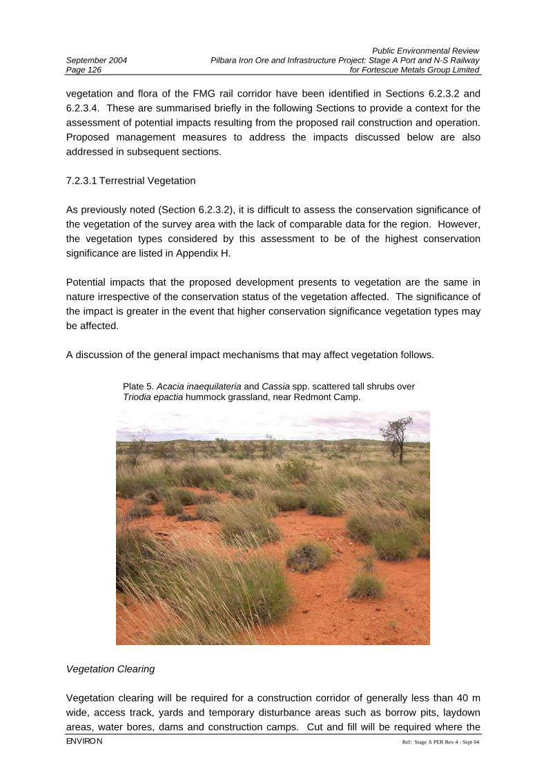
Public Environmental Review September 2004 Pilbara Iron Ore and Infrastructure Project: Stage A Port and N-S Railway Page 126 for Fortescue Metals Group Limited
ENVIRON Ref: Stage A PER Rev 4 - Sept 04
vegetation and flora of the FMG rail corridor have been identified in Sections 6.2.3.2 and 6.2.3.4. These are summarised briefly in the following Sections to provide a context for the assessment of potential impacts resulting from the proposed rail construction and operation. Proposed management measures to address the impacts discussed below are also addressed in subsequent sections. 7.2.3.1 Terrestrial Vegetation As previously noted (Section 6.2.3.2), it is difficult to assess the conservation significance of the vegetation of the survey area with the lack of comparable data for the region. However, the vegetation types considered by this assessment to be of the highest conservation significance are listed in Appendix H. Potential impacts that the proposed development presents to vegetation are the same in nature irrespective of the conservation status of the vegetation affected. The significance of the impact is greater in the event that higher conservation significance vegetation types may be affected. A discussion of the general impact mechanisms that may affect vegetation follows.
Vegetation Clearing Vegetation clearing will be required for a construction corridor of generally less than 40 m wide, access track, yards and temporary disturbance areas such as borrow pits, laydown areas, water bores, dams and construction camps. Cut and fill will be required where the
Plate 5. Acacia inaequilateria and Cassia spp. scattered tall shrubs over Triodia epactia hummock grassland, near Redmont Camp.
Public Environmental Review Pilbara Iron Ore and Infrastructure Project: Stage A Port and N-S Railway September 2004 for Fortescue Metals Group Limited Page 127
Ref: Stage A PER Rev 4 - Sept 04 ENVIRON
proposed rail corridor traverses ridges and valleys, which would extend the limit of clearing beyond the immediate vicinity of the rail line. Where practicable existing borrow pits will be used and areas of temporary disturbance will be located in already disturbed areas. However, this may not be practicable in all cases and therefore the total estimated area of disturbance (3,100 ha) includes a contingency factor, although it is expected that the actual area of disturbance will be less. To estimate the representative impact of the clearing on a local scale, the nominal centre line of the rail corridor was buffered by 25 m on either side, within the 2 km buffered rail corridor mapped during the field survey. An indicative breakdown of the area of each vegetation type affected by the proposed railway is provided in Appendix H. Additional impacts on vegetation may result from other project-related activities including off-road driving and fire (see below). Spinifex (Triodia spp.) is particularly susceptible to physical damage from vehicle movements and may take extended periods to recover. Introduction and/or Spread of Weed Species Eleven introduced flora species were recorded from the FMG rail corridor, at least one of which is a serious environmental weed (Buffel grass *Cenchrus ciliaris; Section 6.2.3.5). Earthworks, disturbance to vegetation, vehicle movement and other factors have the potential to introduce additional weeds to the area and to spread existing populations of introduced flora along the length of the FMG rail corridor. The field survey suggests that this has been the case for some species of exotic flora along the existing rail line. The Hamersley Ranges sand dunes and mesic environments such as major creeklines and floodplains are particularly susceptible to weed invasion. Disruption to Surface Hydrology The FMG rail corridor crosses several large river systems including the Yule, Turner and Fortescue Rivers, and Chinnamon and Coonarrie Creeks. Numerous minor tributaries and floodplains also intersect the FMG rail corridor. Disturbance to surface drainage flow has the potential to negatively impact downstream vegetation. Large areas of Mulga are also present towards the southern end of the corridor (south of the Chichester Range, particularly in association with the Fortescue River basin). These are reliant on surface sheet flow, and interruption to such flow has the potential to cause substantial degradation and mulga mortality by either restriction of water input downstream of the rail formation or ponding upstream. See Section 7.2.1 for hydrological impact management. Erosion Clearing of vegetation has the potential to lead to increased rates of erosion. Susceptible vegetation types within the Project area include the cracking clays and the heavier soils underlying the Mulga communities, particularly in the vicinity of the Fortescue Marshes. The
Public Environmental Review September 2004 Pilbara Iron Ore and Infrastructure Project: Stage A Port and N-S Railway Page 128 for Fortescue Metals Group Limited
ENVIRON Ref: Stage A PER Rev 4 - Sept 04
sand dune communities in the Hamersley Ranges section would also be susceptible to any increases in erosional processes. Fire The level of impact on vegetation associated with this potential increased fire frequency is dependent on the structure of the affected vegetation. The hummock grassland associations which dominate the northern half of the rail corridor are typically very flammable, but are also adapted to fire and recover relatively quickly. Increased frequency of fires can, however, lead to changes in floristic composition and a prevalence of early seral stages of the vegetation (the climax vegetation is prevented from developing; Biota and Trudgen, 2002). Mulga communities may be killed by hot fires, and the Mulga woodlands and tall shrublands along the southern section of the FMG rail corridor are susceptible to damage from fires, particularly if there is also strong grazing pressure or other stresses presented by modification to the existing hydrological regime. Dust Dust generated during the construction, operation and maintenance of the proposed railway has the potential to negatively affect surrounding vegetation, but this is considered to be a minor impact provided standard dust suppression measures are implemented (see Section 7.2.6). 7.2.3.2 Terrestrial Flora The survey area supports a rich and diverse terrestrial flora (see Section 6.2.3.3). Flora of conservation significance occurring along the FMG rail corridor include:
• three Priority 1 species (Eremophila spongiocarpa, Goodenia omearana, Josephinia ?sp. Marandoo (ME Trudgen 1554)).
• seven Priority 2 species (Euphorbia clementii, Gonocarpus ephemerus, Indigofera ixocarpa ms., Ischaemum albovillosum, Olearia fluvialis, Paspalidium retiglume Stylidium weeliwolli);
• ten Priority 3 species (Abutilon trudgenii ms., Bulbostylis burbidgeae, Eriachne tenuiculmis, Goodenia nuda, Gymnanthera cunninghamii, Hibiscus brachysiphonius, Phyllanthus aridus, Polymeria sp. Hamersley (ME Trudgen 11353), Sida sp. Wittenoom (WR Barker 1962), Themeda sp. Hamersley Station (ME Trudgen 11,431));
• one Priority 4 species (Goodenia stellata); and • several other poorly known or collected species (Section 6.2.3.4).
Potential impacts to significant flora arising from the FMG rail corridor include:
Public Environmental Review Pilbara Iron Ore and Infrastructure Project: Stage A Port and N-S Railway September 2004 for Fortescue Metals Group Limited Page 129
Ref: Stage A PER Rev 4 - Sept 04 ENVIRON
Physical Disturbance Clearing works to construct the railway may result in disturbance to populations or individuals of significant flora species. Locations of significant flora populations (shown in Appendix H) will be taken into consideration during finalisation of the rail alignment within the assessed corridor and avoided wherever possible. Introduction and/or Spread of Weed Species Some of the weed species recorded have the potential to exclude native species through competition (see Section 6.2.3.5). A number of significant flora are largely restricted to creekline habitats, which are highly susceptible to weed invasion, particularly by the aggressive Buffel Grass *Cenchrus ciliaris. Introduction or spread of weeds during construction or operation of the railway (see Section 7.2.3.1) could impact on populations of significant flora. Disturbance of Surface Hydrology Disturbance to surface hydrology may have indirect impacts on flora populations through ponding or restrictions to surface water flow. This issue is of particular significance given that three of the Priority flora recorded from the survey area were restricted to or occurred principally in creekline habitats. Large areas of Mulga are present towards the southern end of the corridor (south of the Chichester Range, particularly in association with the Fortescue River basin). These are reliant on surface sheet flow, and interruption to such flow has the potential to cause substantial degradation and mulga mortality by either restriction of water input downstream of the rail or ponding upstream. Fire and Dust The effect of fire on specific flora species depends on the recovery strategy of the species (seeder vs. resprouter). Dust is only likely to be a factor where such populations are located immediately adjacent to areas of high construction disturbance. Refer to Section 7.2.6 for proposed dust suppression measures. Fire management is largely related to line maintenance activities (see Section 4.2.12). Management The EPA’s objective with regards to flora and vegetation are to:
• avoid adverse impacts on biological diversity comprising the different plants and animals and the ecosystems they form, at the levels of genetic, species and ecosystem diversity;
• maintain the abundance, species diversity, geographic distribution and productivity of vegetation communities;
Public Environmental Review September 2004 Pilbara Iron Ore and Infrastructure Project: Stage A Port and N-S Railway Page 130 for Fortescue Metals Group Limited
ENVIRON Ref: Stage A PER Rev 4 - Sept 04
• protect Declared Rare and Priority Flora, consistent with the provisions of the Wildlife Conservation Act 1950; and
• protect other flora species of conservation significance. A variety of management measures will be implemented as part of the design, construction and operation of the proposed railway to reduce the potential impacts to terrestrial vegetation and flora. These include:
1 Refinement of the design of the rail alignment taking account of the locations of significant vegetation types and populations of Priority flora (Sections 6.2.3.2 and 6.2.3.4; Appendix H), with the objective of avoiding these through final design where practicable.
2 The drainage design for the railway will take into account local hydrological patterns that may have ecological significance. This will include adequate provision for drainage line habitats to ensure that back-water or flow restriction is reduced as far as practicable. This will be based on mirroring the drainage design of the existing railway when located adjacent to it, and following best practice drainage design in other areas. A hydrological study has been completed for the FMG rail corridor as part of this management (see Sections 6.2.1 and 7.2.1; Appendix L);
3 Maintenance of sheet flow to ensure that sensitive vegetation both upstream and downstream (primarily mulga) is not adversely affected. The proposed FMG railway has been aligned adjacent to the BHPBIO line where possible, to minimise the cumulative effects on the surface hydrology within the vicinity of the rail corridor. This will be a consideration south of the Chichester Range, particularly where the rail passes through mulga vegetation in the Fortescue basin. This aspect of the drainage design will be finalised to the satisfaction of the CALM and the DoE (see Section 7.2.1);
4 Vegetation clearing will be kept to the minimum necessary for safe construction and operation of the railway, particularly in areas adjacent to vegetation of higher conservation significance (see Section 7.2.3.1). Clearing limits will be marked on all design drawings and pegged in the field prior to any clearing works commencing. This will constitute a hold-point for the site supervisor to review and provide written approval prior to clearing works commencing;
5 Off-road driving will be strictly prohibited, with all staff to be informed of this, and other general environmental issues, as part of an on-site induction programme;
6 Weed control measures will be implemented to ensure that weed species identified from the FMG rail corridor are not spread as part of the construction and operation of the railway. This may include targeted control of more aggressive weed species where these are intersected by the final rail alignment. A Weed Hygiene and Management Plan will be prepared to the satisfaction of CALM prior to construction commencing;
7 Fire management will be addressed as part of the EMP prepared for construction (see Appendix E) operation and maintenance of the railway. FMG will develop and implement a Fire Management Plan that will include work procedures for all welding
Public Environmental Review Pilbara Iron Ore and Infrastructure Project: Stage A Port and N-S Railway September 2004 for Fortescue Metals Group Limited Page 131
Ref: Stage A PER Rev 4 - Sept 04 ENVIRON
and grinding work, personnel fire hazard procedures, fire response vehicles on site and bushfire contingency plans. The objective of these management measures will be to reduce the risk of unplanned fires and provide contingency measures to minimise any impacts in the event that a fire is started. This will include measures to address normal construction activities including the use of heavy plant and equipment in dry vegetated areas, welding, grinding and other activities with the potential to start fires. Management of track maintenance and the fire risk associated with track grinding activities will be an important component of this. The compulsory use of spark shields will be specified into rail maintenance contracts, with vehicles equipped with fire fighting equipment to follow the track grinder in order to quickly stop any spot fires that may have started. FMG will ensure locomotive engines are well maintained to reduce the risk of sparks from the engine exhaust.
8 A Topsoil Management and Rehabilitation Plan (see Section 7.2.7.2) will be prepared for all non-permanent cleared areas to the satisfaction of CALM, DoE and DoIR prior to the commencement of construction activities. This plan will include use of provenance collected native seed, characterisation and management of topsoil, and the respreading of cleared vegetative material. Recovery monitoring will also be carried out, with any rehabilitation failure subject to additional treatment to a suitable standard;
9 Standard dust suppression measures will be implemented across the Project area during construction to minimise effects on surrounding vegetation (Section 7.2.6).
10 The location of borrow pits and other materials sourcing sites are not known in detail at this stage of the Project. Given that all biological surveys are based on representative sampling only, there will always be parts of the Project area which have not been adequately ground-truthed. It is therefore possible that borrow pits may ultimately be located in areas that have not been specifically surveyed. If this is the case, the location of these sites will be subject to targeted survey for any threatened flora species or vegetation types of conservation significance once identified, prior to clearing commencing. The location of materials sourcing sites will be revised as appropriate based on the findings of this work in liaison with the CALM regional office.
11 Off-sets will be considered in consultation with the CALM regional office. These could include contribution of funds to relevant taxonomic research (eg. research into Acacia “aneura” in the Pilbara, or some of the other poorly known taxa such as the Malvaceae and Tiliaceae).
7.2.4 Terrestrial Fauna Potential Impacts Many of the impact mechanisms that may affect native vegetation and flora (Section 7.2.3) will also have impacts on native fauna. These may act at both the habitat level, affecting a suite of species, or affect individual species at the population level. Many of the impacts and
Public Environmental Review September 2004 Pilbara Iron Ore and Infrastructure Project: Stage A Port and N-S Railway Page 132 for Fortescue Metals Group Limited
ENVIRON Ref: Stage A PER Rev 4 - Sept 04
management measure of FMG’s proposed railway will be similar to those for the Hope Downs railway as outlined below (HDMS, 2002). 7.2.4.1 Fauna Habitats Potential impacts on terrestrial fauna arising from the construction and operation of the proposed railway are essentially similar to potential impacts on vegetation (Section 7.2.3.1). From the perspective of fauna habitats, these comprise: Direct Fauna Habitat Disturbance and Modification One of the primary potential impacts associated with the proposed development arises from the clearing of fauna habitat necessary to establish the railway including the rail formation, adjacent access track and associated disturbance areas. A nominal breakdown of representative habitats expected to be disturbed by the proposed railway is provided in Appendix I. Areas of mangrove will also be cleared for the port facility (7.3.4). Several fauna habitats within the Project area have been identified as either spatially restricted or supporting populations of significant species or fauna communities (Section 6.2.4.1). In summary these comprise: • linear sand dune habitats adjacent to the Weeli Wolli Creek delta; • clay-based habitats in association with the Fortescue Marshes; • cracking clay habitat units associated with the Chichester Range; • granite rockpiles on the Abydos plain portion of the rail corridor; • major drainage systems; and • mangroves. As with vegetation, all fauna habitats within the Project area may be affected by clearing activities for the development. The significance of the impact will be greater, however, if the above units are disturbed. The final design of the rail alignment and any related ground disturbing activities will therefore aim to minimise or avoid any impacts on these habitats where practicable. This particularly applies to the more discrete and isolated habitat units such as cracking clay formations and granite boulder piles on the plains north of the Chichester Range. Additional disturbance to vegetation may result from other project-related activities including off-road driving. Spinifex dominated habitat units are particularly susceptible to this type of physical damage and can take extended periods to recover. Given the reliance of several fauna species of conservation significance in these habitats (including the Schedule 1 species the Mulgara Dasycercus cristicauda), strict on-site management will be implemented to ensure that such activities are controlled.
Public Environmental Review Pilbara Iron Ore and Infrastructure Project: Stage A Port and N-S Railway September 2004 for Fortescue Metals Group Limited Page 133
Ref: Stage A PER Rev 4 - Sept 04 ENVIRON
Indirect Fauna Habitat Disturbance and Modification Indirect modifications may also affect fauna habitat adjacent to the railway as a result of the construction and operation of the railway. These are generally processes that would be initiated by the construction of the railway that have the potential to then continue to operate for the life of the railway. Mechanisms in this category include changes to surface hydrology (Section 7.2.1), increased erosion, weed introduction/spread and changes to fire regimes (see Section 7.2.3.1; the latter is discussed further from the fauna perspective below). Any changes to existing surface hydrology regimes could have effects on both upstream and downstream vegetation, with flow on effects on fauna habitat and riverine and floodplain habitat dependent fauna species. The potential loss of mulga woodland due to sheet flow modification is an example of this, whereby many avifauna in the region are dependent on this habitat type. Changes to surface flows could also result in increased scour and erosion, with similar consequences for fluvial fauna habitats (Section 7.2.1). The spread or introduction of weeds is a potential risk associated with the construction of any linear infrastructure corridor and this can also have implications for fauna species. Changes to the floristic and structural nature of vegetation and fauna habitat can result in the habitat resource value of areas being diminished for native fauna. The replacement of spinifex hummock grasslands by Buffel grass that has occurred across large areas of the Pilbara is an example of such a shift. Mesic environments such as major creeklines are particularly susceptible to weed invasion and any consequent changes to fauna habitat. Increased Fire Frequency Construction works, track grinding and other maintenance activities for the proposed FMG railway have the potential to increase fire frequency in adjacent areas. The consequences of this potential for increased fire frequency would depend on the affected fauna habitats and the fauna species present. Open vegetation types such as samphire and Snakewood shrublands tend not to carry fires of any significant spatial scale. However, spinifex hummock grassland habitats tend to dominate much of the proposed corridor and these are highly flammable (Section 7.2.3.1). A number of significant fauna species identified from the corridor require mature spinifex as a component of their habitat and their persistence in the immediate locality could be affected if high fire frequencies continue to apply or are increased (Biota, 2002a; 2004f). Fire is a natural part of vegetation, habitat and fauna ecological cycles in the Pilbara, with many bushfires started naturally by lightning strikes (Biota and Trudgen, 2002; Biota, 2002a). At a regional level, fire is a normal and to some extent necessary part of the Pilbara ecological landscape, particularly in relation to senescent vegetation and habitat units which may experience reduced fire frequencies compared to historical patterns. A number of
Public Environmental Review September 2004 Pilbara Iron Ore and Infrastructure Project: Stage A Port and N-S Railway Page 134 for Fortescue Metals Group Limited
ENVIRON Ref: Stage A PER Rev 4 - Sept 04
management initiatives will be employed as part of the proposed rail to address the issues of fire regimes in the corridor (see Section 7.2.3). 7.2.4.2 Fauna Species Direct Loss of Individual Fauna There will inevitably be some localised loss of individual fauna due to direct mortality arising from construction of the new railway, including that which may occur during the clearing of habitat (Section 7.2.4.1). Ongoing impacts may also arise from more frequent vehicle movements, train movements and machinery operation down the corridor once the rail and associated access tracks are constructed. It is unlikely, however, that the loss of individuals associated with these direct mortality events would be significant enough to affect the conservation status of any of the species recorded from the corridor. Restriction of Fauna Movement The construction of the railway formation will result in a barrier to the movement of some fauna species and potential subdivision of populations situated along the rail alignment. The extent to which this would affect the various fauna occurring along the corridor is dependent on the ordinary range, dispersal and effective population size of the various species involved. Ground mammals are perhaps most likely to be potentially affected, given their greater dispersal and generally larger home ranges compared to most herpetofauna present along the corridor (Biota 2002a; 2004f). Populations of species associated with riverine habitats are perhaps less likely to be potentially affected by this, given the bridging and culverting to be constructed at all significant drainage system crossings. In these areas culverting may provide pathways for fauna dispersal during dry periods. The proposed railway would not present any significant barrier to gene flow amongst most avifauna and bats. There also will be some level of habitat isolation between the proposed FMG railway and the existing BHPBIO line. The significance of this isolation of a strip of habitat will depend on the distance between the two lines and the population size and dispersal of fauna species utilising the isolated habitat. Some fauna with small home ranges (such as many of the smaller skinks) may not be affected by this isolation of habitat. Management The EPA objectives with regards to fauna management are to:
• maintain the abundance, species diversity and geographical distribution of terrestrial fauna; and
Public Environmental Review Pilbara Iron Ore and Infrastructure Project: Stage A Port and N-S Railway September 2004 for Fortescue Metals Group Limited Page 135
Ref: Stage A PER Rev 4 - Sept 04 ENVIRON
• protect Specially Protected (Threatened) Fauna, consistent with the provisions of the Wildlife Conservation Act 1950.
The management of impacts on terrestrial fauna has a large degree of overlap with the initiatives to be put in place to protect native vegetation and flora (Section 7.2.3). These comprise: 1 The detailed design of the final rail alignment and associated disturbance areas will
treat the location of restricted and potentially significant fauna habitats, including granite rockpiles and cracking clay units, as design constraints with the objective of minimising impacts on these areas or avoiding them entirely as far as practicable.
2 The detailed design of the railway will take into account local hydrological patterns that may have ecological significance.
3 Fauna habitat clearing will be kept to the minimum necessary for safe construction works and operations, particularly in the vicinity of significant fauna habitats, such as creek lines, mulga groves and the Fortescue Basin. Works areas clearing limits will be identified on design documentation and pegged in the field prior to the commencement of any clearing activities.
4 Site-specific surveys access tracks and associated railway infrastructure will be carried out to identify any significant fauna species which may be present, with modification as necessary in liaison with CALM regional office.
5 A rehabilitation plan will be developed for all non-permanent disturbed areas. This will also serve to restore some area of habitat lost or modified during construction activities and fauna habitat reconstruction measures will be included as part of this plan.
6 Off-road driving, with associated impacts on spinifex habitats in particular, will be prohibited.
7 FMG will prepare and implement during construction and operations, a Fire Management Plan to reduce the risk of increased fire frequency, with consequent reduction in effects on fauna in sensitive receiving habitats. The Fire Management Plan will include the reduction of risk of increased fire frequency, work procedures for all welding and grinding work, personnel fire hazard procedures, fire response vehicles on site and bushfire contingency plans.
8 As part of the environmental induction, staff will be made aware that all native fauna are protected and that there are substantial penalties associated with disturbance to fauna. Firearms, traps and domestic pets will be prohibited on-site.
9 Off-sets will be considered in consultation with CALM. These could include funding towards taxonomic issues, or other relevant research such as CALM’s research programme on Mulgara (Dasycercus cristicauda).
Public Environmental Review September 2004 Pilbara Iron Ore and Infrastructure Project: Stage A Port and N-S Railway Page 136 for Fortescue Metals Group Limited
ENVIRON Ref: Stage A PER Rev 4 - Sept 04
7.2.5 Noise Potential Impacts The Noise Study by Lloyd Acoustics (2004) (Appendix G) investigated two scenarios for FMG’s proposed railway being:
• Scenario 4: Impact from the proposed FMG railway alone; • Scenario 5: Impact from the proposed future railway operations (FMG and BHPBIO
railways). Due to the majority of the railway passing through remote areas, noise is not expected to be a significant issue along the majority of its length. However, where the railway passes close to homesteads and settlements, the significance and level of management in these areas will increase. Predicted noise impacts have taken into account the realignment of the rail corridor west of White Hills, due to surface hydrology issues (Section 7.2.1, Figure 4). Railway noise levels have been predicted using a modified version of the Nordic Rail Prediction Method (Kilde Rep. 130) algorithm. This algorithm was used as it provides both LAeq and LAmax noise level predictions. The algorithm was modified to align with measured noise levels of locomotives and wagons. In addition, to accurately predict the effect of noise barriers, the noise source height of the locomotive was raised from the standard 0.5 metres above the railhead to 4.0 metres. Within the acceptable tolerances allowed for predictive modelling, it is expected that the results would have an accuracy of +/-3 dB(A). The rail noise assessment is based on measured noise levels of BHPBIO trains and assumes the following input data.
• Locomotive maximum noise level at 30m: 89 dB(A) • Wagons maximum noise level at 30m: 78 dB(A) • Train Speed: 40 km/h • Height of Locomotive: 4 m above rail head • Train Length: 3,200 m • Number of Train Movements/8 hours: 3.33
Modelling results are presented in Table 21.
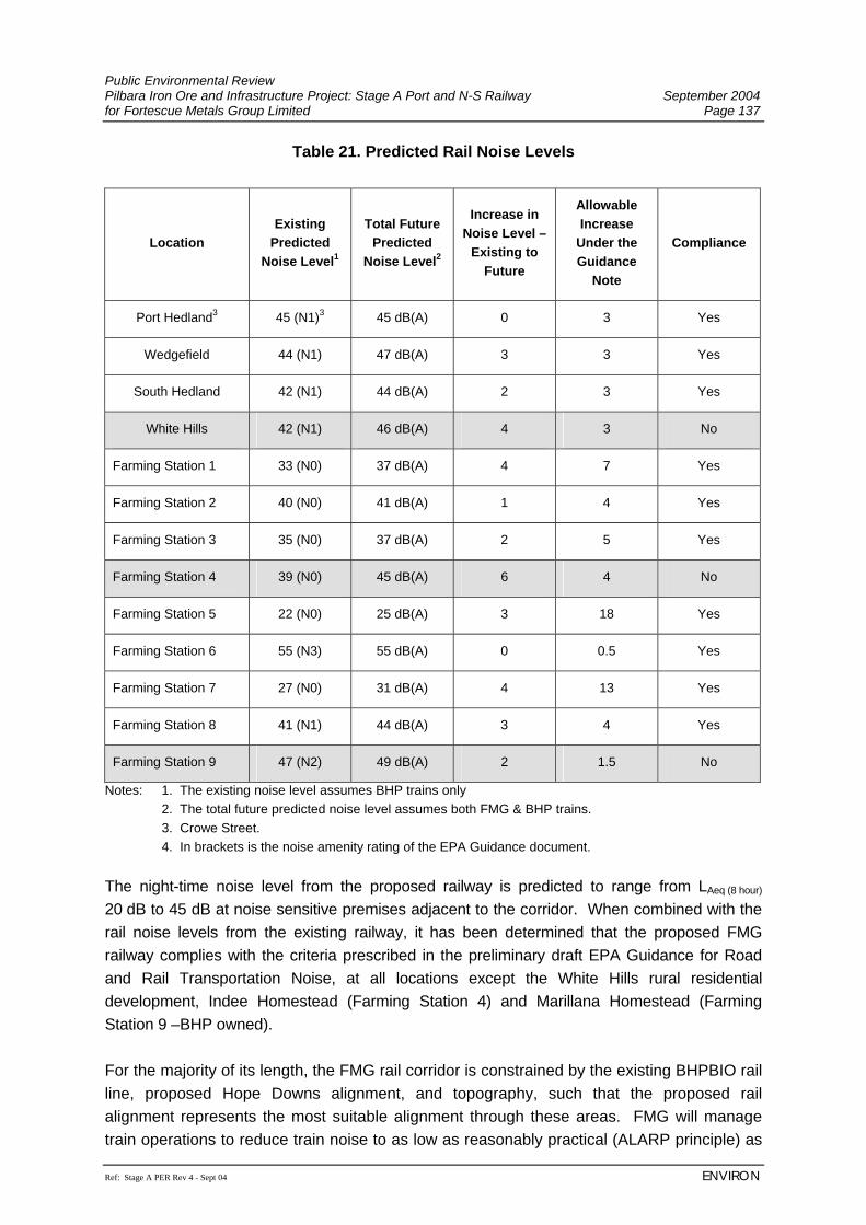
Public Environmental Review Pilbara Iron Ore and Infrastructure Project: Stage A Port and N-S Railway September 2004 for Fortescue Metals Group Limited Page 137
Ref: Stage A PER Rev 4 - Sept 04 ENVIRON
Table 21. Predicted Rail Noise Levels
Location Existing
Predicted Noise Level1
Total Future Predicted
Noise Level2
Increase in Noise Level –
Existing to Future
Allowable Increase
Under the Guidance
Note
Compliance
Port Hedland3 45 (N1)3 45 dB(A) 0 3 Yes
Wedgefield 44 (N1) 47 dB(A) 3 3 Yes
South Hedland 42 (N1) 44 dB(A) 2 3 Yes
White Hills 42 (N1) 46 dB(A) 4 3 No
Farming Station 1 33 (N0) 37 dB(A) 4 7 Yes
Farming Station 2 40 (N0) 41 dB(A) 1 4 Yes
Farming Station 3 35 (N0) 37 dB(A) 2 5 Yes
Farming Station 4 39 (N0) 45 dB(A) 6 4 No
Farming Station 5 22 (N0) 25 dB(A) 3 18 Yes
Farming Station 6 55 (N3) 55 dB(A) 0 0.5 Yes
Farming Station 7 27 (N0) 31 dB(A) 4 13 Yes
Farming Station 8 41 (N1) 44 dB(A) 3 4 Yes
Farming Station 9 47 (N2) 49 dB(A) 2 1.5 No
Notes: 1. The existing noise level assumes BHP trains only 2. The total future predicted noise level assumes both FMG & BHP trains. 3. Crowe Street. 4. In brackets is the noise amenity rating of the EPA Guidance document.
The night-time noise level from the proposed railway is predicted to range from LAeq (8 hour) 20 dB to 45 dB at noise sensitive premises adjacent to the corridor. When combined with the rail noise levels from the existing railway, it has been determined that the proposed FMG railway complies with the criteria prescribed in the preliminary draft EPA Guidance for Road and Rail Transportation Noise, at all locations except the White Hills rural residential development, Indee Homestead (Farming Station 4) and Marillana Homestead (Farming Station 9 –BHP owned). For the majority of its length, the FMG rail corridor is constrained by the existing BHPBIO rail line, proposed Hope Downs alignment, and topography, such that the proposed rail alignment represents the most suitable alignment through these areas. FMG will manage train operations to reduce train noise to as low as reasonably practical (ALARP principle) as
Public Environmental Review September 2004 Pilbara Iron Ore and Infrastructure Project: Stage A Port and N-S Railway Page 138 for Fortescue Metals Group Limited
ENVIRON Ref: Stage A PER Rev 4 - Sept 04
outlined below. It should however, be noted that these predicted noise levels are below LAeq
(8hour) 55 dB, which has been used as a maximum criterion (where the ALARP management principle has been applied), for assessment of similar projects in Western Australia, including the proposed Hope Downs project. Management The EPA objectives with regards to noise management are:
• ensure noise impacts emanating from proposed railway construction comply with statutory requirements and acceptable (and appropriate) standards.
• minimise the impact to noise sensitive premises from increased train movements. FMG will develop a noise management strategy specific for its rail operations, to minimise disturbance to residences. Specific noise management measures that will be investigated to reduce noise emissions from train operations include:
• rail design (e.g. turning circles) to minimise wheel noise; • use of low-noise equipment where practicable; • management of train operations, such as reduction of notch speed to reduce
locomotive noise near sensitive areas; • cuttings and/or noise barriers; and • as a last resort, acoustic treatment of affected buildings.
At the Port Hedland end of the rail corridor, the unloading station will be installed in a loop and there will not be the requirement to shunt the wagons into position for unloading. In addition, the track within the loop will be designed to minimise the effect of consists compressing and expanding, which cause the ‘clanging effect’ (also associated with shunting). This is achieved by sloping the track into and out of the unloading station for the maximum consist size. 7.2.6 Dust Potential Impacts Dust emissions and the impacts on residential communities during construction and operation of the railway are not expected to be significant, due to the remoteness of the corridor. However, vegetation can be adversely affected by repeated heavy coatings of dust, which may be generated during construction activities.
Public Environmental Review Pilbara Iron Ore and Infrastructure Project: Stage A Port and N-S Railway September 2004 for Fortescue Metals Group Limited Page 139
Ref: Stage A PER Rev 4 - Sept 04 ENVIRON
Management The EPA objectives with regards to dust management are to:
• protect the surrounding land users such that dust and particulate emissions will not adversely impact upon their welfare and amenity, or cause health problems in accordance with EPA Guidance Statement No. 18 Prevention of Air Quality Impacts from Land Development Sites; and
• ensure that particulate/dust emissions both individually and cumulatively, meet appropriate criteria and do not cause an environmental or human health problem.
FMG intends to keep dust emissions to a minimum during construction of the Project, particularly in the vicinity of Port Hedland, to ensure that dust does not create a hazard or nuisance to the human or natural environment. The Dust Management Plan will be prepared prior to the commencement of construction, outlining monitoring and management measures for the construction and operation of the railway as well as for the port. The Dust Management Plan will identify specific management measures to minimise dust generation during construction, including;
• water carts used on high traffic areas (access roads, railway construction, temporary camps and laydown areas);
• progressively rehabilitate disturbed areas to minimise potential for dust generation;
• minimise vegetation clearing;
• optimise vehicle movements; and
• undertake daily visual inspections of construction areas to ensure dust control management measures are implemented and effective.
Due to high moisture content of the ore, as a result of the beneficiation process, it is not anticipated that loaded trains will generate significant dust during their daily operations. However, in the unlikely event that dust from the trains becomes an issue engineering design solutions such as applying water sprays following loading will be investigated and applied.
Public Environmental Review September 2004 Pilbara Iron Ore and Infrastructure Project: Stage A Port and N-S Railway Page 140 for Fortescue Metals Group Limited
ENVIRON Ref: Stage A PER Rev 4 - Sept 04
7.2.7 Decommissioning and Rehabilitation 7.2.7.1 Decommissioning The Project has an indefinite operating life depending on continued exploration and development of the iron ore industry and use by other third party operators. Abandonment of the railway is not an option. In the event that all or part of this infrastructure is no longer required, by FMG or another party, the facilities no longer required will be decommissioned. Decommissioning will comprise the safe dismantling and removal of infrastructure, the appropriate disposal of waste materials and site rehabilitation to return the environment as close to its original state. Where the removal of non visible infrastructure, or features that have been incorporated into the natural landscape, may cause more environmental damage than if left in situ then their retention will be discussed with the relevant authorities at that time. The railway is expected to have a design life in excess of 20 years. However, with continuing exploration throughout the Pilbara, industry diversification and through proper maintenance the railway could have an indefinite operating life. With the low level of existing regional infrastructure the railway, provided it is actively maintained, should be considered an asset to the State. Decommissioning procedures, closure plans, and completion criteria will be established in accordance with the applicable legislation and standards at the time. 7.2.7.2 Rehabilitation A corridor of generally less than 40 m will be disturbed during construction of FMG’s railway, which is similar to the area proposed for disturbance by the Hope Downs railway (HDMS, 2002). The FMG railway corridor will be progressively rehabilitated as construction of sections of the rail is completed. Cleared areas not required for operation of the railway will be rehabilitated to re-establish a stable landform and promote regeneration of a self-sustaining ecosystem. Areas prone to erosion will be stabilised, and where practicable, similar substrate and hydrodynamic features to that which was present prior to construction, will be re-established. Rehabilitation activities will include:
• ripping of compacted areas; • re-establishment of a stable landform with erosion protection where necessary for long-
term stability; • reinstatement of surface drainage patterns similar to that which was present pre-
construction; • replacement of topsoil; and
Public Environmental Review Pilbara Iron Ore and Infrastructure Project: Stage A Port and N-S Railway September 2004 for Fortescue Metals Group Limited Page 141
Ref: Stage A PER Rev 4 - Sept 04 ENVIRON
• spreading of vegetation debris to return organic matter to the area, and provide an additional seed source.
Areas of temporary disturbance will be rehabilitated in a manner similar to the railway corridor, once these are no longer required for construction, to re-establish a stable landform and promote the regeneration of a self-sustaining ecosystem. Ballast material for construction rail and operations will be from existing or new quarries. Rehabilitation of these quarries will be required by the owners of the quarries according to legal requirements. Compacted areas of borrow pits will be ripped on the contour. The slopes of borrow pits will be battered down and contoured to reduce the risk of excessive erosion and left as free-draining structures. Topsoil and vegetation debris will be spread over the surface of the pits to promote regeneration of a stable community. Rehabilitation undertaken after construction will require monitoring to assess the effectiveness of the rehabilitation and remedial works will be undertaken as required. This may include repair of eroded areas, weed control, and seeding or planting of areas where vegetation has not established from natural seed sources in the topsoil and mulch applied to rehabilitated areas. The rehabilitation programme will include development of rehabilitation completion criteria to determine when a rehabilitated area can be considered self-sustaining, or indicate a continuous positive trend towards a stable community. 7.3 THE PORT 7.3.1 Surface Hydrology Potential Impacts The potential impacts of the proposed port development on the surface hydrology of the site were investigated by Aquaterra (2004a) (Appendix L). Potential impacts include:
• altering natural drainage pathways (e.g. by filling minor mudflat channels in the dredge disposal areas, directing surface water flow through man-made drainage structures, changes to natural erosion/accretion processes);
• local flooding/backwater in surrounding areas; • flooding of stockyard by storm surge, and resultant pollution risk from sedimentation
and contamination of surface water run-off; and • increases in marine turbidity or contamination through uncontrolled surface water
run-off. Whilst the dredge spoil reclamation will block some minor mudflat channels (Figure 2) these channels are not considered significant and the flow areas available for surface water
Public Environmental Review September 2004 Pilbara Iron Ore and Infrastructure Project: Stage A Port and N-S Railway Page 142 for Fortescue Metals Group Limited
ENVIRON Ref: Stage A PER Rev 4 - Sept 04
drainage in South West Creek and South Creek will essentially remain unaltered. That is, the majority of water flow in flood events escapes to the harbour through South Creek and adjacent low lying mudflat areas (to the east of the dredge spoil area) as well as to the west of the Port Hedland-Shay Gap railway (through the bypass channel excavated by BHPBIO and adjacent sheetflow areas). As such, the existing surface water flood levels in these creeks will not be impacted by construction of the dredge spoil areas. In the South West Creek main flow channel, culverts are proposed to be installed through the FMG railway embankment, immediately downstream from the existing BHPBIO railway embankment culverts. The capacity of these FMG culverts will be determined during the detailed design stage. However, it is anticipated that these culverts would be equal to or larger than the capacity of the existing BHPBIO culverts, and would not adversely affect the existing upstream flood levels. At the downstream rail loop crossing of South West Creek, large capacity culverts will be installed in the main flow channel and in the main tributary channel located around 700 m to the east (Figure 2). As a minimum, these culverts will be designed to have the same discharge capacity as the upstream FMG culvert crossing that controls river flood discharges entering the railway loop. These culverts have also been designed for discharges derived by hydrodynamic modelling of tidal movements such that adequate tidal flushing occurs through the mangrove areas (see Section 7.3.4). A proposed access causeway supporting the loadout conveyor and a roadway will be constructed from the stockyard area to the Anderson Point shiploading facilities. Culverts will be provided through the embankment to enable tidal flushing of the mangrove areas and local drainage. The construction of this causeway will not have an impact on the existing flood levels in South West Creek or South Creek and will not impact on drainage from the port development area, as the majority of surface water escapes to the harbour over the low lying mudflat areas to the east of the dredge spoil area, and within/adjacent to South Creek. The portion of the causeway into the harbour itself will be constructed on trestles which will not impede surface water flows. The proposed rail car dumper facility located on the rail embankment at the western side of the railway loop will not impact on surface water drainage in the area. Conveyors linking the car dumper to the primary screen house in the stockyard area will be installed on trestles to allow unimpeded movement of water in the area. Other Surface Hydrology Issues As the Port area will be well drained, there is expected to be no increase in potential habitats for mosquito breeding. Pollution of surface waters can arise from spills, or inappropriate disposal of waste or contaminated surface water. The risk of pollution is likely to be greater around areas such
Public Environmental Review Pilbara Iron Ore and Infrastructure Project: Stage A Port and N-S Railway September 2004 for Fortescue Metals Group Limited Page 143
Ref: Stage A PER Rev 4 - Sept 04 ENVIRON
as refuelling stations, workshops, loading and off-loading areas, and vehicle and locomotive yards. Spills to the marine environment in particular can have serious consequences for coastal and marine environments. Management The EPA objectives for the Project in regards to surface hydrology are:
• maintain the integrity, functions and environmental values of watercourses and sheet flow; and
• maintain or improve the quality of surface water to ensure that existing and potential uses, including ecosystem maintenance are protected, consistent with the Australian and New Zealand Water Quality Guidelines (ANZECC/ARMCANZ, 2000).
To reduce disturbance to surface water movement, intertidal creeks and associated mangrove communities, the facilities will be predominantly located over the bare mudflat areas away from the main intertidal zones and appropriate drainage management will be provided as described below. The FMG Project will be designed to withstand a 1:100 year flood event without overtopping the facility or uncontrolled release of potentially polluted stormwater runoff. FMG will ensure that drainage design is current best practice to minimise any potential pollution impact from a greater than 1:100 flood event. Drainage design will take into account the proximity of the existing BHPBIO Port Hedland to Shay Gap railway. Dredge Spoil Deposition Areas The final boundaries of the spoil deposition areas will be shaped to minimise clearing and hydraulic impact in the mangrove communities. During spoil deposition, spoil will be managed to settle the solids and decant the free water for discharge back into the harbour under favourable tidal conditions. The free water will be processed via sediment interception basins prior to disposal as described in Section 7.3.3.3. Railway Loop During the detailed design stage, an assessment of the South West Creek upstream bypass channel hydraulics will be undertaken, in consultation with BHPBIO, to determine the required peak design flow to be discharged via the railway culverts or alternative options to manage the risk of embankment overtopping in peak flood events. The FMG railway culverts will then be selected for the required design discharge. During the detailed design process, design flood levels through the railway loop area will be assessed and culverts designed such that the hydraulic capacity of the upstream culverts
Public Environmental Review September 2004 Pilbara Iron Ore and Infrastructure Project: Stage A Port and N-S Railway Page 144 for Fortescue Metals Group Limited
ENVIRON Ref: Stage A PER Rev 4 - Sept 04
will not be impacted. Erosion protection works will be installed on the culvert inlet and outlet zones, to manage potential adverse scouring effects. Loadout Causeway The loadout causeway will be constructed to a minimum level of 0.5 m above the 100 year ARI average storm surge level. As previously described in Section 7.3.4 culverts have been designed such that adequate tidal flushing occurs through the mangrove communities. Stockyard Area The stockyard area will be protected from ocean storm surge flood events by the slightly raised perimeter road constructed around the dredge spoil deposition area. This road will be constructed to a minimum level of 0.5 m above the adopted design 100 year ARI average storm surge level. The road will also contain local stormwater runoff within the spoil deposition area. Other Surface Hydrology Issues During construction and operations, FMG will ensure that potentially polluting substances are correctly stored and disposed of, and procedures are in place for correct handling, spill prevention and clean up. Potentially contaminated surface water runoff from around Project areas, including runoff containing sediment, will be collected and treated via an oil separator and a sediment interceptor basin prior to reuse or release to the harbour under favourable tidal conditions. Local stormwater runoff from within the spoil deposition area will be harvested and used for dust control, with any excess runoff treated as above. The potential impacts and management of hydrocarbons in the marine environment are discussed in Section 7.3.6. 7.3.2 Hydrogeology 7.3.2.1 Water Supply Potential Impacts Water supply for FMG’s proposed port development (approximately 2 GLpa) will be provided by the Water Corporation (see correspondence with the Water Corporation in Appendix D) from expansion of the existing water scheme in the Port Hedland area. The environmental impacts and environmental approval associated with expansion of the water scheme will be completed by the Water Corporation.
Public Environmental Review Pilbara Iron Ore and Infrastructure Project: Stage A Port and N-S Railway September 2004 for Fortescue Metals Group Limited Page 145
Ref: Stage A PER Rev 4 - Sept 04 ENVIRON
Management The Water Corporation will be responsible for the management of the water supply for the Port area. FMG will implement water conservation measures, such as minimising water use for dust suppression (by enclosing/covering equipment where possible, sealing roads and high traffic areas, management of stockpiles and planting shelter belts) (Section 7.3.9) and harvesting of surface water runoff at the port site to supplement scheme supplies. FMG in collaboration with the Water Corporation will investigate non-potable water sources for dust suppressions such as grey water, brackish water and waste water. 7.3.2.2 Other Groundwater Impacts Potential Impacts Pollution of the groundwater can arise from spills to ground or surface waters, or inappropriate disposal of waste or contaminated surface water. The risk of pollution is likely to be greater around areas such as workshops, loading and off-loading areas, and vehicle yards. The proposed port developments may also present some potential changes to local groundwater regimes. These primarily relate to the potential for hypersaline groundwater seepage, water-logging or acidic drainage associated with the construction of the dredge spoil basin and bund walls. There is a relatively small percentage of the bund wall which abuts mangrove habitat. In a study of similar phenomena associated with saltfield bund walls, Gordon et al. (1995) found that water-logging and other groundwater related changes were typically limited to mangroves less than 50 m from the bunds. In the case of the FMG port, the mangrove areas near the dredge spoil bunds are generally in an area where they would receive regular tidal flushing. There will be dewatering of the port site during construction of the rail dumper. Some dewatering may also be required during maintenance operations. The extent of dewatering required will be determined during the geotechnical investigations required for detailed design of the Project. Management The EPA’s objective for FMG’s Project with regards to groundwater protection is:
• to maintain or improve the quality of groundwater to ensure that existing and potential uses, including ecosystem maintenance are protected, consistent with the Australian and New Zealand Water Quality Guidelines (ANZECC/ARMCANZ, 2000).
Public Environmental Review September 2004 Pilbara Iron Ore and Infrastructure Project: Stage A Port and N-S Railway Page 146 for Fortescue Metals Group Limited
ENVIRON Ref: Stage A PER Rev 4 - Sept 04
Correct management of waste, dredge spoil disposal (Section 7.3.7.1), surface water runoff (Section 7.3.1) and hydrocarbons (Section 7.3.6) will minimise the risk of groundwater pollution. To address the issue of hydrostatic head, FMG will assess the engineering requirements around the perimeter of the dredge spoil reclamation area using a combination of providing an adequate buffer between the levy wall and the mangals; and ensuring any hypersaline seepage is adequately flushed by the tidal regime. 7.3.3 Coastal Processes 7.3.3.1 Marine Sediments Potential Impacts The dredging of the harbour to create the berths will result in the disturbance of approximately 36.8 ha, including 17.8 ha of mudflats and 19.0 ha of seabed (within the existing Port Hedland turning basin) to a depth of between 14.6 m and 19.5 m (Figure 7). Sediments at berth pockets elsewhere in the harbour already show significant existing impacts from shipping with elevated Tributyltin (TBT), copper, chromium and lead levels (PHPA, 2003a). Given that the berths will be continuously used by Cape and Panamax class bulk carriers, there will be ongoing contamination of this region from leaching and flaking from hulls as well as overspill from iron ore loading. It is estimated that the operation of the FMG port will result in an additional 180 to 200 ship visits each year, in excess of the current 735 ship visits (2003 calendar year). FMG will not have jurisdiction with regard to hull-coatings on visiting vessels as this is subject to international marine protocols and therefore FMG will not be able to control contamination from this vector. For example, the International Maritime Organisation has called for a global prohibition on the application of organotin compounds by 1 January 2003 and a complete prohibition 1 January 2008. In addition, given the history of siltation in Port Hedland, maintenance dredging of the berth areas will probably be required at approximately four-yearly intervals. This will act to prevent the build-up of toxicants and dredged sediments will need to be disposed of in an approved manner. Dredging impacts and impacts on marine sedimentation are discussed in Section 7.3.3.3.
Public Environmental Review Pilbara Iron Ore and Infrastructure Project: Stage A Port and N-S Railway September 2004 for Fortescue Metals Group Limited Page 147
Ref: Stage A PER Rev 4 - Sept 04 ENVIRON
Management The EPA’s objective for this Project is to:
• maintain or improve marine sediment quality to protect Environmental Values (EVs) and Environmental Quality Objectives (EQO’s) defined in Perth Coastal Waters Environmental Values and Objectives (EPA, 2000) and the sediment quality guidelines documented in Australian and New Zealand Water Quality Guidelines (ANZECC/ARMCANZ, 2000).
FMG commit to undertaking a sediment quality survey in accordance with guidance provided in the National Ocean Disposal Guidelines (Cmwlth of Australia, 2002) and an assessment of return water quality (from dredge disposal areas), to be provided to the EPA for consideration during its assessment of the proposal. This survey and results will be provided as an addendum to the PER and provided within the Proponent’s response to submissions. FMG will prepare a Water and Sediment Quality Management Plan to the approval of the EPA and PHPA prior to operations, to ensure current best practice management with respect to management of wharf-side and loading operations. The following sediment quality issues will be addressed:
• control of contamination from berth maintenance activities; • enforcement of bans on hull cleaning in port; • control of ship loading to minimise dust and spillage; • routine sediment quality monitoring and reporting; • contingency management for contamination events within FMG’s management
responsibility; and • clean up and disposal procedures.
7.3.3.2 Marine Water Quality Potential Impacts During construction, dredging and reclamation will occur for up to 12 months and will result in elevated turbidity levels at the southern portion of the harbour for this time. Port Hedland harbour is a naturally turbid environment; much of the region in question has previously been dredged by PHPA for the swinging basin and will continue to be dredged for maintenance purposes. There are no significant marine habitats in the harbour that would be sensitive to increased turbidity from dredging activities, which are not expected to result in any adverse long-term ecological impacts (Section 7.3.5.1).
Public Environmental Review September 2004 Pilbara Iron Ore and Infrastructure Project: Stage A Port and N-S Railway Page 148 for Fortescue Metals Group Limited
ENVIRON Ref: Stage A PER Rev 4 - Sept 04
The operation of the FMG port has the potential to compromise water quality via increases in the scale or frequency of occurrence of the following mechanisms (which are already present in Port Hedland):
• shiploading operations (via dust or product spillage); • offsite discharges from the stockyard and berth areas; and • hydrocarbon spills.
Management The EPA’s objective for FMG’s Project is to:
• maintain or improve marine water quality to protect Environmental Values (EVs) and Environmental Quality Objectives (EQO’s) defined in Perth Coastal Waters Environmental Values and Objectives (EPA, 2000) and the water quality guidelines documented in Australian and New Zealand Water Quality Guidelines (ANZECC/ARMCANZ, 2000).
FMG will implement the following strategies to minimise impacts on water quality such as:
• installation of dust suppression equipment (Section 7.3.9) on loading facilities and belt break detection equipment on conveyors to minimise the amount of iron ore that may spill into the harbour;
• stormwater discharges from the majority of the site will be harvested in catchment ponds/settling basins for use within the port (e.g. as dust suppression spray water). Any excess will overflow from these ponds into the port;
• stormwater from potentially contaminated areas (e.g. fuel storage, maintenance, parking areas) will be treated via oil/water separators and catchment ponds/settling basins for reuse, or controlled discharge to the port; and
• implement other surface water quality protection measures outlined in Section 7.3.1 to maintain or improve surface water quality, such as correct storage, handling and disposal of potentially polluting substances, spill prevention and clean-up measures, and treatment and controlled release of decant water from dredge spoil disposal areas.
FMG will prepare and implement a Water and Sediment Quality Management Plan (Section 7.3.3.1) in consultation with DoE and PHPA. The activities of FMG will pose a relatively low risk of oil spills. As the FMG port is within PHPA waters, the FMG oil spill and contingency response plans (as part of the Hydrocarbon Management Plan) will be developed in close collaboration with PHPA and other operators in Port Hedland, and linked to the PHPA Emergency Response Plan (Section 7.3.6).
Public Environmental Review Pilbara Iron Ore and Infrastructure Project: Stage A Port and N-S Railway September 2004 for Fortescue Metals Group Limited Page 149
Ref: Stage A PER Rev 4 - Sept 04 ENVIRON
7.3.3.3 Dredging Potential Impacts Dredging will be required at the proposed port berth location, to provide a sufficient depth for access to, and operation of the loadout facilities. Approximately 3.3 Mm3 of dredge material will be placed in the two land reclamation areas shown in Figure 2; the area at the end of Anderson Point behind the mangroves; and the area inland where the iron ore stockpiles will be located. The dredging of the harbour will disturb approximately 36.8 ha, including 17.8 ha of mudflats and 19.0 ha of seabed within the existing Port Hedland turning basin (Figure 7). The turning basin has already been dredged to 9.3 m navigable depth, and will be deepened to between 14.6 m and 19.5 m. The preliminary Coffey Geosciences geotechnical investigation for the Project (Appendix N) found that it is likely that all of the material to be dredged will be suitable for structural fill. However, further detailed geotechnical work is required to confirm this. If some of the material is not suitable for structural fill it will be disposed of to a land reclamation area where it will not be used as structural fill, or it will be disposed off-shore. FMG will undertake the necessary investigations to support the sea dumping permit application in the unlikely event it is required. Dredging and reclamation will occur for up to 12 months and will result in elevated turbidity levels at the southern portion of the harbour for this time. Port Hedland harbour is a naturally turbid environment and much of the region in question has previously been dredged by PHPA for the swinging basin. There are no significant light sensitive marine habitats in the harbour and therefore increased turbidity as a result of dredging activities is not expected have any adverse long-term ecological impacts (Section 6.3.5). Dredging could result in adverse impacts if acid sulphate soils (ASS) are present, at either the dredge spoil disposal site or in the material to be dredged. Impacts at the dredge spoil disposal site would result if acid sulphate soils are disturbed. Acid sulphate soil impacts could also result from the excavation and exposure of such soils during the dredging process. Excavated soils could generate acid runoff from the dredge spoil piles, and acid could also be generated if ASS are exposed to the marine environment by dredging. Paling (2002) has found that few such impacts have been recorded in the marine environment, where tidal exchange is an important component in reducing the impacts of acid drainage because:
• tidal pressure maintains the watertable above acid sulphate soils; • the tide both dilutes and flushes acid from waterways; and • the carbonate buffering of seawater helps neutralise acid.
Given the history of siltation in Port Hedland, maintenance dredging of the berth areas will probably be required at approximately four-yearly intervals. This will act to prevent the build-
Public Environmental Review September 2004 Pilbara Iron Ore and Infrastructure Project: Stage A Port and N-S Railway Page 150 for Fortescue Metals Group Limited
ENVIRON Ref: Stage A PER Rev 4 - Sept 04
up of toxicants and dredged sediments will need to be disposed of in an approved manner. This ongoing dredging will be conducted by PHPA. Potential impacts resulting from the proposed dredging and land reclamation using dredge spoil include:
• increases in marine turbidity caused by the dredging process; • increases in marine turbidity from drainage and runoff from the dredge spoil
reclamation areas; • pollution of surface water runoff (with potentially acidic runoff or saline runoff), with
consequential impacts on creek water quality, flora and fauna; and • pollution of groundwater from seepage from the bunded dredge spoil area.
Management The EPA’s objective, in addition to protection of the marine ecosystem’s health, is to ensure the development does not significantly impact on existing coastal processes.
• Contaminated material (which may include dredge spoil, due to its elevated salt content and potentially acid forming sediments [Section 6.3.3.4]) must be treated and/or disposed of in a manner that minimises the risk of long-term contamination to the environment.
The Project has not yet assessed sediments from the areas to be dredged and although it is unlikely that they will have elevated levels of contaminants or significant organic content (Section 6.3.3.4), FMG will fully characterise the quality of sediments from all areas proposed to be dredged in accordance with the National Ocean Disposal Guidelines four-phase approach (Cmwlth of Australia, 2002). An assessment of potential acid sulphate soils (PASS) in the dredge will also be undertaken (Section 7.3.7.1). An assessment of return water quality from dredge spoil disposal areas will also be provided to the EPA for consideration during its assessment of the proposal. This survey and results will be provided as an addendum to the PER and provided within the Proponent’s response to submissions. FMG will prepare a Dredging and Reclamation Environmental Management Plan prior to construction which will detail the dredging and reclamation work, the procedures to be put in place to manage the impacts of dredging and reclamation and contingencies in the event of unacceptable levels of impact. The following measures will form part of the Dredging and Reclamation Environmental Management Plan:
• Prevention of disturbance of acid forming material where possible; • If required, development of an acid sulphate soils management plan, to address the
likely volumes involved, the likely fate and consequences of any acid drainage, and options for neutralising acid soils if there is a risk of acid runoff;
Public Environmental Review Pilbara Iron Ore and Infrastructure Project: Stage A Port and N-S Railway September 2004 for Fortescue Metals Group Limited Page 151
Ref: Stage A PER Rev 4 - Sept 04 ENVIRON
• Disposal of any potentially acid-forming spoil in a manner which prevents oxidation of these materials;
• The return water from the reclamation area will be drained to settling basin(s) before release to the harbour, and discharged so as not to cause erosion of creeks or damage to mangroves (with monitoring to ensure that there is no damage to the mangrove systems through erosion).
• Dredging will be undertaken by a cutter suction dredge with spoil pumped directly to reclamation areas;
• The likely extent of turbidity in the harbour (and outside) will be modelled and the predicted extent of any potential plume checked against known areas of sensitive marine habitats, and the results presented to the DoE; and
• Management strategies for any known sensitive marine habitats (e.g. coral reefs outside the harbour) as agreed with the DoE (as outlined in Section 7.3.5.1)
Prior to commencement of dredging, a perimeter embankment will be constructed around the proposed spoil deposition areas which will contain the dredged spoil. These embankments will initially be constructed using borrow from beneath the reclamation area or imported fill. However, later they will likely be raised with selected reclaimed spoil material. The finished level of the perimeter embankment will be at a minimum level of RL 6.0 m AHD, being 0.5 m above the design 100 year ARI average storm surge level. Within the reclamation areas, dredge material will be retained to settle the solids and decant the free water back into the port (via sediment interception basins). This water will be discharged to the port at locations and in a manner established in the Dredging and Reclamation Environmental Management Plan such that the potential for impact to the mangrove populations is minimised. Upon completion of the dredging, the spoil deposition areas will be drained and levelled. The finished surface will be covered with previously stockpiled topsoil and may be seeded to minimise the potential for surface erosion from rainfall and dust generation. To ensure the suitability of the dredge spoil for use as structural fill, further detailed geotechnical investigations will be required to confirm the:
• range of materials to be dredged and their engineering properties; • batter slopes to be formed during the dredging operations; • foundation conditions along the alignment of the starter embankments for
reclamation works; and • design foundation profiles for the starter embankments.
Public Environmental Review September 2004 Pilbara Iron Ore and Infrastructure Project: Stage A Port and N-S Railway Page 152 for Fortescue Metals Group Limited
ENVIRON Ref: Stage A PER Rev 4 - Sept 04
7.3.3.4 Hydrodynamics Potential Impacts The Port Hedland harbour has been substantially modified by dredging since 1965. The FMG Project is not expected to significantly alter the flushing and exchange of Port Hedland Harbour and nor will it affect circulation of currents and sedimentation within the harbour beyond the immediate area of development. This conclusion is based on the results of a numerical modelling study completed by Worley, (Appendix K) for FMG that addressed:
• the effect of the port development on currents and circulation in the harbour; and • the effect of the port development tidal flows in adjacent mangrove areas.
The work included the proposed Hope Downs development so that the cumulative impacts on these factors could be fully assessed. Worley refined the Environmental Fluid Dynamics Code (EFDC) three-dimension numerical model for the harbour used for the PHPA planning study (Worley, 2003) and applied it to FMG’s requirements. A comparative analysis was conducted using a simulation of the existing configuration of the Port as the baseline and comparing this to simulations of the proposed Hope Downs development and the combined FMG and Hope Downs developments. Overall the comparative modelling predicts that the impacts of the proposed FMG and Hope Downs developments will be localised to the berth dredged pockets and the dredged harbour basin, with minimal impact in the broader creek and mangrove regions (Worley, 2004). Specifically:
• impacts on tidal currents will be localised to the berth pockets; • changes in the tidal range in the berth areas are predicted to be approximately 2 cm,
a relatively small change, with little effect on berth operability; and • based on the small magnitude of the predicted changes in water levels (~1 cm) in the
mangrove areas, the inundation of mangroves will not change significantly. Management The EPA’s objective for the Project is to:
• ensure the development does not significantly impact on existing coastal processes. The following design parameters have been adopted to minimise hydrodynamic impacts:
• the rail loop formation will be built on a solid causeway with culverts designed to allow adequate tidal flow in creek areas;
Public Environmental Review Pilbara Iron Ore and Infrastructure Project: Stage A Port and N-S Railway September 2004 for Fortescue Metals Group Limited Page 153
Ref: Stage A PER Rev 4 - Sept 04 ENVIRON
• the conveyor from the car dumper to the screen house will be built on elevated trusses, presenting minimal tidal impediment;
• the loadout conveyor will be built on a causeway with culverts to allow adequate creek tidal flows; and
• the loadout conveyor into the harbour itself will be trestled forming a jetty. Preliminary culvert designs have been developed for all tidal creek crossings and have been included in the hydrodynamic modelling along with the other design parameters above, to demonstrate minimal predicted impacts to tidal flushing. The port and associated facilities will be designed and constructed to minimise local hydrodynamic changes and to ensure that adequate flushing of the mangroves and intertidal areas is maintained. 7.3.4 Mangrove Ecosystems Potential Impacts Specific mechanisms that may impact on mangrove ecosystems in the Project area include:
• Reduction in tidal flushing in creeks and reduction in extent of mudflat inundation under high water of springs. This typically results in loss of mangroves in marginal fringing environments which have high salinities under natural conditions.
• Changes in erosion or accretion which may result in the undermining of fringing mangroves, the reduction of tidal flushing to mangroves or burial of pneumatophores by altered sedimentation patterns.
• Impoundment of water at higher than natural levels, which can result in mangrove decline and death due to sustained inundation of pneumatophores and a decline in water quality.
• Direct construction impacts and physical removal of mangroves. • Longer term indirect impacts which may reduce mangrove condition, such as
alteration of freshwater surface drainage hydrology and dust deposition on mangrove communities.
The development of the proposed FMG port facilities presents a range of potential impacts to mangrove communities as discussed below. Approximately 300 ha will be required for construction of the port facility (including less than 100 ha of land that will be used for operations purposes) (Table 1). Whilst it is expected that substantially less than 300 ha will actually be disturbed by construction activities, this total area has been included as a contingency due to the following. Whilst FMG will minimise disturbance during construction of the port facility by using existing off-site borrow pits, locating temporary facilities in areas that are already disturbed, and
Public Environmental Review September 2004 Pilbara Iron Ore and Infrastructure Project: Stage A Port and N-S Railway Page 154 for Fortescue Metals Group Limited
ENVIRON Ref: Stage A PER Rev 4 - Sept 04
constructing facilities on reclaimed land where practicable, has been made allowance for additional areas that may be required for wharf construction laydown, stockyard machine erection area, conveyor laydown and assembly area, construction offices and ablutions, construction access roads, planting of a shelter belt to the east of the stockpiles and service access corridors. In addition, due to the expected hardness of the dredge material, pumping rates for spoil disposal are expected to be high, requiring large settling areas to minimise sediment return to the harbour. The final design of the settling areas will utilise the testwork data generated as part of the dredge sediment characterisation testwork programme and will allow the proponent to consider alternative solids separation options with the view to minimising the proposed dredge spoil area. Alternatives considered for dredge spoil disposal included disposal at sea. However, construction of the port facility will require substantial foundations, and rather than disturb additional land areas for structural fill, FMG propose to use dredge spoil as foundations for the port facility. Off-shore disposal will only be pursued if dredge spoil is unsuitable as foundation material, or can not be appropriately disposed of onland, and would only be undertaken with the correct Commonwealth approvals. Operational areas will include the stockpile area, conveyors and car dumper and are expected to cover less than 100 ha (Table 1). Areas not required for operations will be progressively rehabilitated as soon as practicable during construction to a condition similar to pre-construction. In the case of the dredge spoil reclamation areas and settling ponds, which would be above the original area of tidal influence, these areas would be rehabilitated to a condition similar to adjacent supra-tidal areas that were present before construction of the port facility. In addition FMG has encouraged Hope Downs to work collaboratively with FMG’s to minimise overall cumulative disturbance should both projects proceed (see Appendix D). Clearing of Mangroves During Construction The proposed development would result in the clearing of approximately 22 ha of core mangal closed canopy associations (approximately 2% of the current core mangal habitat within Port Hedland Harbour; Paling et al., 2003), in addition to a further 87 ha of open mudflat with scattered samphires and occasional low Avicennia marina (the more open form of this single association of Paling et al., 2003). The total clearing would amount to approximately 10% of the harbour’s current mangrove assemblage cover; a similar impact to that presented by the proposed Hope Downs port site (HDMS, 2002). Most of this clearing (80%), however, impacts on a very low mangrove cover unit at the top end of the tidal range.
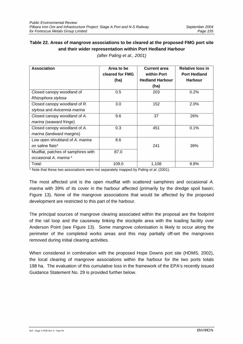
Public Environmental Review Pilbara Iron Ore and Infrastructure Project: Stage A Port and N-S Railway September 2004 for Fortescue Metals Group Limited Page 155
Ref: Stage A PER Rev 4 - Sept 04 ENVIRON
Table 22. Areas of mangrove associations to be cleared at the proposed FMG port site and their wider representation within Port Hedland Harbour
(after Paling et al., 2001) Association Area to be
cleared for FMG (ha)
Current area within Port
Hedland Harbour (ha)
Relative loss in Port Hedland
Harbour
Closed canopy woodland of Rhizophora stylosa
0.5 203 0.2%
Closed canopy woodland of R. stylosa and Avicennia marina
3.0 152 2.0%
Closed canopy woodland of A. marina (seaward fringe)
9.6 37 26%
Closed canopy woodland of A. marina (landward margins)
0.3 451 0.1%
Low open shrubland of A. marina on saline flats*
8.6
Mudflat, patches of samphires with occasional A. marina *
87.0
241
39%
Total: 109.0 1,108 9.8% * Note that these two associations were not separately mapped by Paling et al. (2001). The most affected unit is the open mudflat with scattered samphires and occasional A. marina with 39% of its cover in the harbour affected (primarily by the dredge spoil basin; Figure 13). None of the mangrove associations that would be affected by the proposed development are restricted to this part of the harbour. The principal sources of mangrove clearing associated within the proposal are the footprint of the rail loop and the causeway linking the stockpile area with the loading facility over Anderson Point (see Figure 13). Some mangrove colonisation is likely to occur along the perimeter of the completed works areas and this may partially off-set the mangroves removed during initial clearing activities. When considered in combination with the proposed Hope Downs port site (HDMS, 2002), the local clearing of mangrove associations within the harbour for the two ports totals 198 ha. The evaluation of this cumulative loss in the framework of the EPA’s recently issued Guidance Statement No. 29 is provided further below.
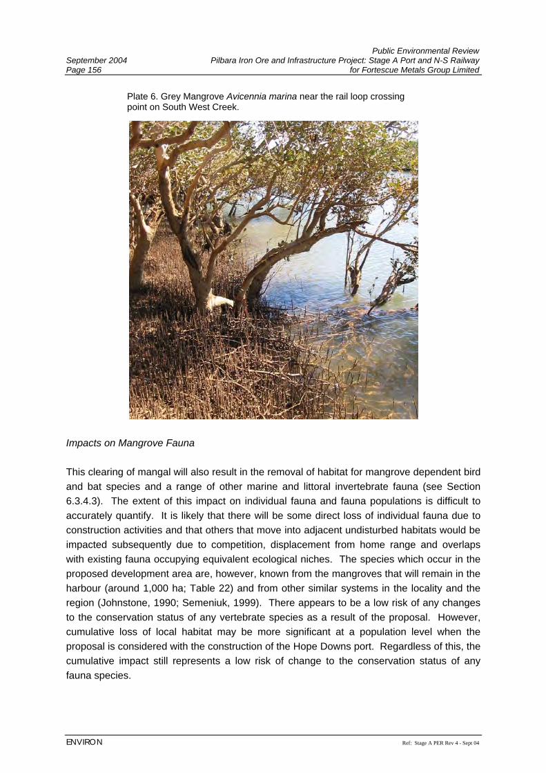
Public Environmental Review September 2004 Pilbara Iron Ore and Infrastructure Project: Stage A Port and N-S Railway Page 156 for Fortescue Metals Group Limited
ENVIRON Ref: Stage A PER Rev 4 - Sept 04
Impacts on Mangrove Fauna This clearing of mangal will also result in the removal of habitat for mangrove dependent bird and bat species and a range of other marine and littoral invertebrate fauna (see Section 6.3.4.3). The extent of this impact on individual fauna and fauna populations is difficult to accurately quantify. It is likely that there will be some direct loss of individual fauna due to construction activities and that others that move into adjacent undisturbed habitats would be impacted subsequently due to competition, displacement from home range and overlaps with existing fauna occupying equivalent ecological niches. The species which occur in the proposed development area are, however, known from the mangroves that will remain in the harbour (around 1,000 ha; Table 22) and from other similar systems in the locality and the region (Johnstone, 1990; Semeniuk, 1999). There appears to be a low risk of any changes to the conservation status of any vertebrate species as a result of the proposal. However, cumulative loss of local habitat may be more significant at a population level when the proposal is considered with the construction of the Hope Downs port. Regardless of this, the cumulative impact still represents a low risk of change to the conservation status of any fauna species.
Plate 6. Grey Mangrove Avicennia marina near the rail loop crossing point on South West Creek.
Public Environmental Review Pilbara Iron Ore and Infrastructure Project: Stage A Port and N-S Railway September 2004 for Fortescue Metals Group Limited Page 157
Ref: Stage A PER Rev 4 - Sept 04 ENVIRON
Changes to Tidal Exchange and Hydrodynamics The construction of the proposed port facilities has the potential to alter local tidal hydrodynamics. Mangroves rely on regular tidal flushing to ensure that soil salinities are maintained within their tolerance limits (Galloway, 1982; Gordon, 1987). Several key locations were identified early in the Project design where proposed infrastructure would potentially alter tidal flushing and therefore impact on mangrove communities. The locations where tidal exchange could be significantly affected in the area are primarily associated with the rail loop (which crosses South West Creek at two major tidal channel openings) and a smaller creek system on Anderson Point which would be traversed by the proposed load-out access causeway (see Figure 13). The extent of this impact is largely dependent on the nature and alignment of the constructed rail and causeway embankments and the extent to which they obstruct or modify tidal flow and wetting and drying regimes. To better assess this issue and refine the project design, hydrodynamic modelling of the harbour was completed by Worley (2004) (see Section 7.3.3.4). This model provided for quantification of wetting and drying regimes under existing conditions in the Project area and then superimposed the proposed port design. The hydrodynamic modelling was completed in a staged fashion. Given the grid size of the model (see Section 7.3.3.4), the initial scenarios including the presence of the FMG port facilities assumed totally transmissive cells at key exchange points on South West Creek and other tidal channels (Worley, 2004). Running this model suggested that there would be no significant change to wetting and drying regimes, provided this level of exchange could be achieved (Figure 15; Worley, 2004). Culvert design specifications were then developed by Worley to ensure that this would be achieved and these will be included in project design. Dust deposition The presence of iron ore stockpiles, materials handling, vehicle movement and other Project activities all have the potential to generate dust within the port area. Mangroves in the locality are currently in good condition and generally unaffected by the dust that coats mangroves in other parts of the harbour (Paling et al., 2000; Section 6.3.4). Studies have demonstrated that iron ore dust in particular does not appear to cause any significant structural damage to mangrove leaf structures (Paling, et al., 2001). Dust deposition may still cause other loss of condition in mangroves through effects relating to increased heat or reductions in gas exchange (research is continuing in this area; Dr. E. Paling, pers. comm.). Given the proposed dust suppression measures to be implemented at the port (Section 7.3.9), the risk of significant dust impacts occurring to mangroves as a result of this proposal is considered low.
Public Environmental Review September 2004 Pilbara Iron Ore and Infrastructure Project: Stage A Port and N-S Railway Page 158 for Fortescue Metals Group Limited
ENVIRON Ref: Stage A PER Rev 4 - Sept 04
Effluent discharge and changes in surface hydrology Discharge of runoff water from stockpiles, drainage water and other effluents has the potential to degrade mangroves in areas adjacent to the proposed facility. The release of effluent from the dredge spoil storage basin also has the potential to affect water quality or increase sediment loads in mangrove creeks. Given the management measures to be applied for dredge spoil handling, testing and release of pond effluent (Section 7.3.3.3) no significant impact is expected to arise from this as a result of the proposed port development. Alterations to Groundwater Regime The proposed port developments may also present some potential changes to local groundwater regimes. These primarily relate to the potential for hypersaline groundwater seepage, water-logging or acidic drainage associated with the construction of the dredge spoil basin and bund walls. There is a relatively small percentage of the bund wall which abuts mangrove habitat. In a study of similar phenomena associated with saltfield bund walls, Gordon et al. (1995) found that water-logging and other groundwater related changes were typically limited to mangroves less than 50 m from the bunds. In the case of the FMG port facility, the mangrove areas near the dredge spoil bunds are generally in an area where they would receive regular tidal flushing. Management The EPA’s objectives for this Project which relate to mangroves are to:
• avoid adverse impacts on biological diversity, comprising the different plants and animals and the ecosystem they form, at the levels of genetic, species and ecosystem diversity;
• maintain the ecological function, abundance, species diversity and geographic distribution of marine biota and habitat in order to protect ecosystem health, in accordance with the principles identified in Perth Coastal Waters Environmental Values and Objectives (EPA, 2000);
Management Policy Framework Two EPA Guidance Statements are relevant to the assessment of impacts on mangroves in Port Hedland Harbour: 1. Guidance Statement for the protection of tropical arid zone mangroves along the Pilbara
coastline (EPA Guidance Statement No. 1, May 2001). 2. Benthic Primary Producer Habitat Protection for Western Australia’s Marine Environment
(EPA Guidance Statement No. 29, June 2004).
Public Environmental Review Pilbara Iron Ore and Infrastructure Project: Stage A Port and N-S Railway September 2004 for Fortescue Metals Group Limited Page 159
Ref: Stage A PER Rev 4 - Sept 04 ENVIRON
• Guidance Statement for the protection of tropical arid zone mangroves along the Pilbara
coastline (EPA Guidance Statement No. 1, May 2001). Port Hedland harbour is not specifically identified as a conservation area in the EPA’s “Guidance Statement for the protection of tropical arid zone mangroves along the Pilbara coastline” (EPA, 2001). Figure 7 presented in the Guidance Statement defines an area of coastline approximating the port limits as “Industrial area – Port Hedland”. The mangrove systems to the west of this industrial unit are designated as being “regionally significant” and of high conservation value. Guideline 1 applies to these areas (numbers 19-21) thereby effectively quarantining them from future development. The design approach therefore treated the mangrove systems present within Port Hedland Harbour in accordance with Guideline 4 of EPA (2001), ‘All other mangrove areas within designated industrial and associated port areas’. The proposed development has sought to apply the principals of this guidance statement in the design of the facilities and planned construction and post-construction management measures. Project Design and Management Measures Guidance Statement No. 1 requires that the impact of development on mangroves and their ecological function is reduced to the minimum practicable level (EPA, 2001). A range of Project design and management measures have been included in the current proposal to this end, including: 1 Situation and alignment of the stockpile area such that as much of the footprint as
possible occupies supratidal land and to ensure that direct clearing impacts on more structurally complex mangroves in seaward areas will be minimised;
2 All structures that cross tidal channels will be designed in accordance with the
outcomes of the modelling work completed for the Project to ensure adequate hydrodynamic exchange such that tidal flushing of upstream mangrove systems is not inhibited (particularly in the mangrove habitats of South West Creek within the rail loop);
3 Modification of the dredge spoil bund walls to minimise direct impacts on mangroves.
Initial concept designs were square in nature but these have now been modified to follow the boundary of the mangrove zone to reduce clearing requirements.
4 Detailed design of the port facilities will aim to minimise impacts on mangrove areas
wherever possible. All final design drawings will show clearing limits and these will be pegged in the field prior to clearing commencing;
Public Environmental Review September 2004 Pilbara Iron Ore and Infrastructure Project: Stage A Port and N-S Railway Page 160 for Fortescue Metals Group Limited
ENVIRON Ref: Stage A PER Rev 4 - Sept 04
5 Detailed design of the port facility will include best practice management of all surface drainages including run-off from stockpile facilities and surface stabilisation of the dredge spoil bund walls (Section 7.3.3.3).
6 Best practice dust suppression technology will be installed on stockpile facilities and
associated areas to ensure that dust deposition on mangroves is minimised (Section 7.3.9);
FMG believes the above measures meet the intent of Guideline 4 of the EPA’s “Guidance Statement for the protection of tropical arid zone mangroves along the Pilbara coastline”. This is consistent with project design and management measures to protect mangrove systems in the designated port site of Port Hedland. • Benthic Primary Producer Habitat Protection for Western Australia’s Marine Environment
(EPA Guidance Statement No. 29) This recently issued EPA Guidance Statement sets out a framework for the assessment of proposals that may impact on Benthic Primary Producer Habitats (BPPH). The Guidance considers that BPPs are ‘predominantly marine plants (e.g. seagrasses, mangroves, seaweeds and turf algae) but include invertebrates such as scleractinian corals…’ (EPA, 2004). The Guidance also applies to habitat areas that can or do support such communities (BPPH). For the purposes of the proposed FMG port, it is mangrove communities that require consideration as part of compliance with Guidance Statement No. 29. The EPA Guidance sets out a hierarchy of general principles of assessment in relation to the protection of BPPH (EPA, 2004). The initial three principles require evaluation prior to proceeding the impact assessment and risk based assessment framework set out in the Guidance Statement. Principle 1: Demonstrate consideration of options to avoid damage/loss of BPPH FMG has evaluated several different options for the location and configuration of the port facility (see Section 2.3.2). The minimisation of impacts on mangrove BPPH was a key consideration in this process, consistent with Principle 1 of Guidance Statement No. 29 (EPA, 2004). As discussed above in regards to Guidance Statement No. 1, the current proposed port option avoids loss of mangrove BPPH as far as possible within the engineering design, land use and other constraints applying to the port facility (see Section 2.3.2). Principle 2: Design to minimise loss of BPPH and justify unavoidable loss of BPPH Principle 3: Best practicable design/construction/management to minimise BPPH loss Principles 2 and 3 of the Guidance Statement relate to the design and operation of the port facility to ensure that ‘unavoidable loss of BPPH is minimised’ and ‘best practicable design,
Public Environmental Review Pilbara Iron Ore and Infrastructure Project: Stage A Port and N-S Railway September 2004 for Fortescue Metals Group Limited Page 161
Ref: Stage A PER Rev 4 - Sept 04 ENVIRON
construction and environmental management measures’ are implemented to minimise indirect impacts on BPPH (EPA, 2004). These latter two principals are similar in nature to the scope and intent of the requirements of Guidance Statement No. 1 in respect of mangrove systems as outlined above. The development of the design of the port included specific measures to reduce unavoidable loss of mangrove BPPH. This included specific tailoring of the design of the dredge spoil basin to follow the mangrove zone rather than intruding into it as earlier designs did (see Section 2.3.2) and other design and management measures implemented to further minimise direct and indirect impacts on mangroves as outlined above. Evaluation of the proposed Port in accordance with Guidance Statement No. 29
• Definition of BPPH Management Unit The Guidance Statement’s risk based approach to assessing any implications for BPPH ecosystem integrity sets out several steps. The first is the definition of a ‘Management Unit’ for the purposes of applying the EPA Guidance. The Guidance suggests the identification of an integrated area of marine habitat in the order of 50 km2 in size (EPA, 2004). Prior to defining the management unit for this Project, it is useful to place the mangroves of Port Hedland harbour into regional context. The mangrove systems of Western Australia have been described and categorised by Semeniuk (1993). Whilst mangroves occur in abundance in the vicinity of Carnarvon, they occur almost continuously along the north coast of Western Australia between Exmouth Gulf and the NT / WA border. Semeniuk categorised the mangrove systems along the coast - on the basis of geomorphology, climate, coastal processes and hydrology – into seven coastal units extending from Carnarvon to Cambridge Gulf. The unit to which Port Hedland belongs is identified as the Pilbara Coastal Unit. This unit is characterised by mangrove habitats which occur on wave dominated river deltas (eg. De Grey River), in tidal inlets behind barrier islands (eg Port Hedland coastline) and in ria-archipelago systems (eg Dampier Archipelago and offshore island). The Pilbara coastal unit extends from Exmouth Gulf to the De Grey River east of Port Hedland, a distance of approximately 600 km. Along this coastline, the following subregions support mangrove systems similar to those at Port Hedland:
• East coast of Exmouth Gulf from Giralia Bay to Locker Point (90 km); • Ashburton delta to Cape Preston (170 km); • Cossack to Cape Cossigny (90 km); and • Cape Thouin to Ridley Creek (80 km).
Port Hedland harbour is located approximately in the middle of the Cape Thouin to Ridley Creek subregion, and is the largest protected tidal embayment within that unit.
Public Environmental Review September 2004 Pilbara Iron Ore and Infrastructure Project: Stage A Port and N-S Railway Page 162 for Fortescue Metals Group Limited
ENVIRON Ref: Stage A PER Rev 4 - Sept 04
Barrier islands occur throughout this sub region, but predominate from just west of Weerdie Island-Oyster Inlet through to Ridley Creek. To the west of Weerdie Island, mangrove systems occur on the deltas of the Turner and Yule Rivers (see Areas 19 and 20, Figure 7 of EPA Guidance Statement No. 1). Hence Port Hedland harbour sits within a readily identifiable coastal unit characterised by tidal inlets protected by barrier islands which extends from just west of Weerdie Island through to Ridley Creek (some 5.5 km approximately). Prior to European development of the coast, this unit would have been interconnected and shared similar geomorphological, hydrological and ecological processes. European development of the region has resulted in segmentation of this unit. Construction of the main road and railway into Port Hedland, plus development of salt crystallisers at Six Mile and Paradise Creeks has effectively truncated the harbour inlet to the east, and construction of the Finucane Island causeway has truncated the inlet to the west. Development in the region to date has occurred east of the Finucane Island causeway through to Ridley Creek. The original tidal inlet has been modified by dredging and land reclamation to provide land for the iron ore shiploading facilities and berths and a deep navigation access channel. To the east of Port Hedland harbour, approximately 6,000 ha of solar salt ponds have been constructed predominantly on the upper tidal salt flats landward of the mangrove fringe from east of Six Mile Creek through to Ridley Creek. Hence, a number of management units exist in the area. These can be described as:
1. the man-made and now hydrologically distinct unit of the harbour itself (referred to below as “Port Hedland harbour”);
2. the post development planning unit represented by the port limits adopted by the EPA in Guidance Statement 1 (referred to below as “Hedland Port limits”); and
3. the pre-development geomorphic and ecologic unit of barrier island–tidal inlet complex between Weerdie Island and Ridley Creek (referred to below as “Geomorphic unit”)
The extent of these management units is summarised in Table 23 and shown in Figure 14.
Table 23. Management units for the consideration of mangrove BPPH loss in accordance with EPA Guidance Statement No. 29
Unit Area (km2) Description 1. Port Hedland harbour 56 The inner Port Hedland harbour 2. Hedland port limits 288 From 6 km west of Oyster Inlet (W) to 6 km
east of Six Mile Creek (E) 3. Geomorphic unit 453 From 6 km west of Oyster Inlet (W) to Ridley
Creek (E) The management unit for which the most detail exists regarding mangrove habitat distribution is the harbour (Unit 1 above). This unit is also approximately 50 km2 in area and detailed mapping of mangrove communities by aerial photography and extensive ground-
Public Environmental Review Pilbara Iron Ore and Infrastructure Project: Stage A Port and N-S Railway September 2004 for Fortescue Metals Group Limited Page 163
Ref: Stage A PER Rev 4 - Sept 04 ENVIRON
truthing has been undertaken in this area by Paling et al. (2003). Hence a detailed and reliable assessment of cumulative mangrove losses in this unit is possible and is presented below. However, the same level of detail is not readily available for the other larger units (2 and 3 above) and estimates of mangrove loss can at present only be based on available topographic mapping. Nevertheless estimates have been provided in an effort to place the proposed project – and future development proposed by the Port Authority (see Figure 5) – into regional context. Port Hedland Harbour management unit (Unit 1)
EPA Guidance Statement No 29 defines six categories of management unit marine ecosystem protection (A to F; EPA 2004). As a designated port and industrial development area, Port Hedland harbour belongs to either Category E (Development areas) or F (Areas where cumulative loss thresholds have been significantly exceeded). In order to confirm which category applies, it is necessary to make an estimate of the cumulative loss of mangrove BPPH that has occurred historically in the harbour. Mangroves in the Port Hedland harbour management unit have been affected by historical developments in the harbour. The reduction in mangrove area likely to arise from the proposed FMG port site needs to be expressed in terms of percentage cumulative impact relative to the original extent of this BPPH prior to European habitation. Detailed assessment of mangrove cover change in Port Hedland harbour was completed by Paling et al. (2003) by utilising aerial photography dating back to 1960. This indicated that whilst some units had declined due to human disturbance (primarily infilling and development around East Creek), others had increased naturally since 1960. The net estimated area of lost mangrove BPPH (155 ha) was added to the current extent of mangrove cover in the harbour (1,108 ha; Paling et al., 2003), to arrive at an estimated 1,263 ha of original cover for this management unit scale. This suggests that approximately 12% of the mangrove BPPH has been lost historically from the management unit (i.e. 87% of the original extent remains). The EPA also requires consideration of losses associated with any other approved but as yet unimplemented proposals in the determination of cumulative impact. The only relevant project in this case is the existing approval for Hope Downs Management Services (2002) to construct a port adjacent to the site proposed by FMG. This will result in the clearance of a further 89 ha of BPPH, bringing the total estimated cumulative loss to date to 244 ha (19%). The loss of denser mangrove units associated with the proposed FMG port has been estimated at 22 ha (see Table 22). This analysis made provision for construction corridors and other peripheral impact areas beyond the core footprint and therefore is considered to represent a ‘most probable’ case for the impact on mangrove BPPH. This additional loss of core mangal would bring the total cumulative loss within the harbour to 21% (266 ha of the original 1,263 ha). This smallest management unit (Port Hedland harbour) is also the only
Public Environmental Review September 2004 Pilbara Iron Ore and Infrastructure Project: Stage A Port and N-S Railway Page 164 for Fortescue Metals Group Limited
ENVIRON Ref: Stage A PER Rev 4 - Sept 04
scale where mapping resolutaion is available to evaluate the cumulative loss of both the dense mangal and the scattered, open mangrove BPPH. The 87 ha of this latter unit that would be lost, combined with the 22 ha of denser mangroves, would represent an additional 8% loss of the original estimated extent of the total harbour mangrove BPPH. This will bring the total cumulative loss of mangrove BPPH in the harbour to approximately 28% (353 ha of the original 1,263 ha), with 910 ha remaining in the management unit. This smallest management unit scale and widest consideration of mangrove BPPH units provides a worst case evaluation of the impacts of the proposed FMG port. Guidance Statement No. 29 also requires an assessment of the proposals effect on overall BPPH ecosystem integrity if management units are treated as Category F (EPA, 2004). This is a difficult area to provide quantification and certainty of assessment, given the level of detailed knowledge available in relation to detailed ecosystem processes in these systems. However, some assessment can be completed in regard to key biophysical and ecosystem process which are well documented for mangrove systems. Perhaps the single most important factor in maintaining ecosystem function in mangrove systems is tidal flushing. Whilst essentially a physical process, regular tidal exchange along mangrove creek systems is a key requirement for sustaining mangrove health and therefore the persistence of other associated biota (Hutchings and Recher, 1982; Gordon, 1987). This is primarily in relation to the reduction in soil salinities that the incoming tide brings, along with nutrients, propagule dispersal and interaction with marine fauna. The proposed development will not result in any changes to tidal flushing on the 910 ha of mangal remaining within the Port Hedland harbour management unit, indicating that current ecosystem function in these areas should continue provided this key ecosystem process will be maintained. There is also support for this in the data collected by Paling et al. (2003), which specifically examined the condition and community ecology of mangrove systems in the harbour area to assess the impacts of port development. The study found that in areas outside those directly affected by historical developments showed no significant change in recruitment, mortality and survivorship from control sites outside of the harbour (Paling et al., 2003). The spatial extent and diversity of the mangal area remaining also bears consideration in terms of maintenance of ecosystem integrity within the Port Hedland harbour management unit. Allowing for other approved developments, there will be 908 ha of mangrove remaining in the area, including all structural and floristic variants documented by Paling et al. (2003). This is still a relatively extensive area of mangal for the Pilbara tropical arid zone coast, with other smaller areas of mangal persisting in other parts of this coast (as small as 20 ha in an isolated stand; Paling and Pedretti, 2001). It therefore appears reasonable to assume that the smallest management unit remnant of 910 ha extent would remain a viable unit. Based on previous EPA decisions (principally EPA, 2000), a ‘Moderate’ level of change to ecosystem integrity could be acceptable, given that the management unit in this case is a
Public Environmental Review Pilbara Iron Ore and Infrastructure Project: Stage A Port and N-S Railway September 2004 for Fortescue Metals Group Limited Page 165
Ref: Stage A PER Rev 4 - Sept 04 ENVIRON
designated inner harbour. The criteria applied in Perth Coastal Waters in this respect are for acceptable changes to comprise:
• Small changes in rates, but not types of ecosystem process (no significant changes predicted in mangrove ecosystem process outside of the project development area);
• Biodiversity at local and regional scales to remain unchanged (no reduction in mangrove species richness or number of associations within the management unit);
• Small changes in abundance of marine life (some local reduction in mangrove dependent fauna due to loss of habitat in the port site); and
• Moderate change in water and sediment quality but not beyond specified limits (the Project will again comply; Section 7.3.1).
Based on this review, it appears that the proposed port site can remain within acceptable levels of change to overall mangrove ecosystem integrity within the Port Hedland harbour management unit. As it is not possible for FMG to further reduce the loss of mangrove BPPH through design (see Section 2.3.2) or management measures (detailed in relation to Guidance Statement No. 1 below). However other management and monitoring efforts related to mangrove BPPH will be implemented as part of this project, including:
1. A mangrove and littoral vegetation rehabilitation plan to be prepared as part of the port development. This will result in the replacement of some mangal area once the port development is complete, partially off-setting the loss of mangrove BPPH associated with this proposal. Approximately 3 m either side of the rail loop and load-out conveyor in the mangrove and littoral areas will be rehabilitated on completion of construction.
2. Funding for further research into the impacts of dust deposition on mangrove
condition, extending studies already completed in the harbour (Paling et al., 2001). FMG will commit to a study of at least three years, which builds on the current knowledge base available on the impacts of dust deposition on mangrove condition.
3. The development of a mangrove monitoring programme to assess mangrove
condition in areas reliant on the hydrological design of the Project for tidal flushing, during development and implementation of the Project. This will primarily be in the rail loop area and in parts of Anderson Point mangal upstream from infrastructure crossing points. Dependent on findings, these data will be published in a refereed journal to further regional knowledge on the management of impacts on mangrove BPPH.
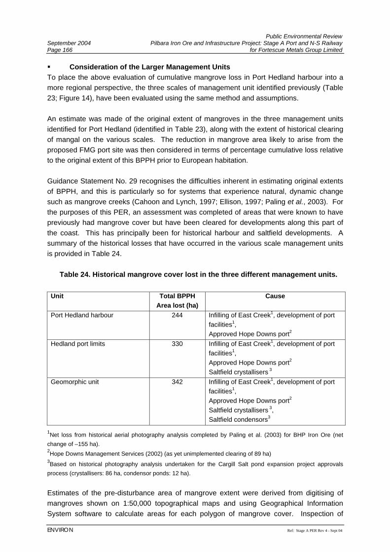
Public Environmental Review September 2004 Pilbara Iron Ore and Infrastructure Project: Stage A Port and N-S Railway Page 166 for Fortescue Metals Group Limited
ENVIRON Ref: Stage A PER Rev 4 - Sept 04
Consideration of the Larger Management Units To place the above evaluation of cumulative mangrove loss in Port Hedland harbour into a more regional perspective, the three scales of management unit identified previously (Table 23; Figure 14), have been evaluated using the same method and assumptions. An estimate was made of the original extent of mangroves in the three management units identified for Port Hedland (identified in Table 23), along with the extent of historical clearing of mangal on the various scales. The reduction in mangrove area likely to arise from the proposed FMG port site was then considered in terms of percentage cumulative loss relative to the original extent of this BPPH prior to European habitation. Guidance Statement No. 29 recognises the difficulties inherent in estimating original extents of BPPH, and this is particularly so for systems that experience natural, dynamic change such as mangrove creeks (Cahoon and Lynch, 1997; Ellison, 1997; Paling et al., 2003). For the purposes of this PER, an assessment was completed of areas that were known to have previously had mangrove cover but have been cleared for developments along this part of the coast. This has principally been for historical harbour and saltfield developments. A summary of the historical losses that have occurred in the various scale management units is provided in Table 24.
Table 24. Historical mangrove cover lost in the three different management units. Unit Total BPPH
Area lost (ha) Cause
Port Hedland harbour 244 Infilling of East Creek1, development of port facilities1,
Approved Hope Downs port2 Hedland port limits 330 Infilling of East Creek1, development of port
facilities1,
Approved Hope Downs port2 Saltfield crystallisers 3
Geomorphic unit 342 Infilling of East Creek1, development of port facilities1,
Approved Hope Downs port2 Saltfield crystallisers 3, Saltfield condensors3
1Net loss from historical aerial photography analysis completed by Paling et al. (2003) for BHP Iron Ore (net change of –155 ha). 2Hope Downs Management Services (2002) (as yet unimplemented clearing of 89 ha) 3Based on historical photography analysis undertaken for the Cargill Salt pond expansion project approvals process (crystallisers: 86 ha, condensor ponds: 12 ha). Estimates of the pre-disturbance area of mangrove extent were derived from digitising of mangroves shown on 1:50,000 topographical maps and using Geographical Information System software to calculate areas for each polygon of mangrove cover. Inspection of
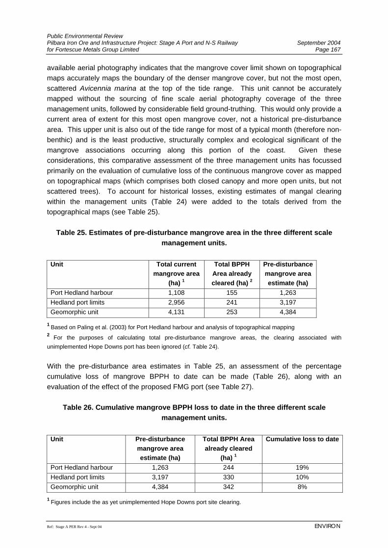
Public Environmental Review Pilbara Iron Ore and Infrastructure Project: Stage A Port and N-S Railway September 2004 for Fortescue Metals Group Limited Page 167
Ref: Stage A PER Rev 4 - Sept 04 ENVIRON
available aerial photography indicates that the mangrove cover limit shown on topographical maps accurately maps the boundary of the denser mangrove cover, but not the most open, scattered Avicennia marina at the top of the tide range. This unit cannot be accurately mapped without the sourcing of fine scale aerial photography coverage of the three management units, followed by considerable field ground-truthing. This would only provide a current area of extent for this most open mangrove cover, not a historical pre-disturbance area. This upper unit is also out of the tide range for most of a typical month (therefore non-benthic) and is the least productive, structurally complex and ecological significant of the mangrove associations occurring along this portion of the coast. Given these considerations, this comparative assessment of the three management units has focussed primarily on the evaluation of cumulative loss of the continuous mangrove cover as mapped on topographical maps (which comprises both closed canopy and more open units, but not scattered trees). To account for historical losses, existing estimates of mangal clearing within the management units (Table 24) were added to the totals derived from the topographical maps (see Table 25).
Table 25. Estimates of pre-disturbance mangrove area in the three different scale management units.
Unit Total current
mangrove area (ha) 1
Total BPPH Area already cleared (ha) 2
Pre-disturbance mangrove area estimate (ha)
Port Hedland harbour 1,108 155 1,263 Hedland port limits 2,956 241 3,197 Geomorphic unit 4,131 253 4,384
1 Based on Paling et al. (2003) for Port Hedland harbour and analysis of topographical mapping 2 For the purposes of calculating total pre-disturbance mangrove areas, the clearing associated with unimplemented Hope Downs port has been ignored (cf. Table 24). With the pre-disturbance area estimates in Table 25, an assessment of the percentage cumulative loss of mangrove BPPH to date can be made (Table 26), along with an evaluation of the effect of the proposed FMG port (see Table 27).
Table 26. Cumulative mangrove BPPH loss to date in the three different scale management units.
Unit Pre-disturbance
mangrove area estimate (ha)
Total BPPH Area already cleared
(ha) 1
Cumulative loss to date
Port Hedland harbour 1,263 244 19% Hedland port limits 3,197 330 10% Geomorphic unit 4,384 342 8%
1 Figures include the as yet unimplemented Hope Downs port site clearing.
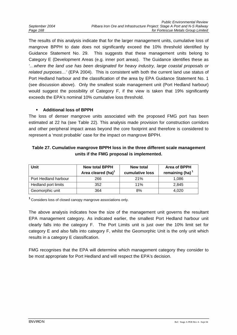
Public Environmental Review September 2004 Pilbara Iron Ore and Infrastructure Project: Stage A Port and N-S Railway Page 168 for Fortescue Metals Group Limited
ENVIRON Ref: Stage A PER Rev 4 - Sept 04
The results of this analysis indicate that for the larger management units, cumulative loss of mangrove BPPH to date does not significantly exceed the 10% threshold identified by Guidance Statement No. 29. This suggests that these management units belong to Category E (Development Areas (e.g. inner port areas). The Guidance identifies these as ‘…where the land use has been designated for heavy industry, large coastal proposals or related purposes…’ (EPA 2004). This is consistent with both the current land use status of Port Hedland harbour and the classification of the area by EPA Guidance Statement No. 1 (see discussion above). Only the smallest scale management unit (Port Hedland harbour) would suggest the possibility of Category F, if the view is taken that 19% significantly exceeds the EPA’s nominal 10% cumulative loss threshold.
Additional loss of BPPH The loss of denser mangrove units associated with the proposed FMG port has been estimated at 22 ha (see Table 22). This analysis made provision for construction corridors and other peripheral impact areas beyond the core footprint and therefore is considered to represent a ‘most probable’ case for the impact on mangrove BPPH.
Table 27. Cumulative mangrove BPPH loss in the three different scale management units if the FMG proposal is implemented.
Unit New total BPPH
Area cleared (ha)1 New total
cumulative loss Area of BPPH
remaining (ha) 1 Port Hedland harbour 266 21% 1,086 Hedland port limits 352 11% 2,845 Geomorphic unit 364 8% 4,020
1 Considers loss of closed canopy mangrove associations only.
The above analysis indicates how the size of the management unit governs the resultant EPA management category. As indicated earlier, the smallest Port Hedland harbour unit clearly falls into the category F. The Port Limits unit is just over the 10% limit set for category E and also falls into category F, whilst the Geomorphic Unit is the only unit which results in a category E classification. FMG recognises that the EPA will determine which management category they consider to be most appropriate for Port Hedland and will respect the EPA’s decision.
Public Environmental Review Pilbara Iron Ore and Infrastructure Project: Stage A Port and N-S Railway September 2004 for Fortescue Metals Group Limited Page 169
Ref: Stage A PER Rev 4 - Sept 04 ENVIRON
7.3.5 Marine Biota 7.3.5.1 Marine Flora and Fauna Potential Impacts The impacts of the Project on the marine environment were investigated by DALSE (2004) (Appendix J) and Biota (Appendices H and I). The intertidal zone at Port Hedland is characterised by mudflats between high and low tide zones. The Project will disturb approximately 109 ha of the intertidal zone (including proposed dredge areas), including approximately 22 ha of mangroves and 87 ha of open mudflats with scattered samphires and occasional low Avicennia marina. This zone supports a range of benthic invertebrates mostly from the Polychaeta, Mollusca and Crustacea families (Section 6.3.5). These fauna are widely distributed throughout the harbour and therefore the impacts on these fauna are not considered significant. Disturbance of intertidal mudflats is likely to remove 49 ha of algal mat from the area south of Anderson Point (Biota and Trudgen, 2002). Given the mat’s role in nitrogen fixing (Paling and McComb, 1994), this is likely to result in some reduction of nutrient input to intertidal systems in the harbour. The most significant component of the intertidal zone within the Project Area is the mangrove ecosystem which is discussed in more detail in Section 7.3.4. The majority of the subtidal area within the harbour, offshore from the mudflats has already been dredged to 9.3 m navigable depth by PHPA for use as a swinging basin, and is subject to regular maintenance dredging. The marine habitat has therefore been extensively modified in the harbour and comprises bare sandy silty sediments. The FMG proposal will result in the deepening of a further 19.0 ha of this subtidal area to 14.6 m to 19.5 m navigable depth (Figure 7; Section 7.3.3.3). Port Hedland harbour is a macro-tidal creek system that is naturally turbid. Subtidal communities that exist in the harbour are tolerant of turbid conditions and no light sensitive communities (e.g. seagrass beds or coral reefs) are present within the harbour. However, coral reef communities occur outside of the harbour and there is a risk that a 12 month dredging campaign may result in higher turbidity water leaving the harbour. If this occurs for a sufficiently extended period of time, then this may result in impacts on the coral reef communities outside of the harbour. Flatback Turtles (Natator depressus) are known to utilise the habitats within the tidal creeks of Port Hedland harbour (Section 6.3.5). No potential breeding habitats are likely to be affected by the proposed port infrastructure, although certain frequencies of light from the port development may affect hatching and juvenile animal activity in the locality.
Public Environmental Review September 2004 Pilbara Iron Ore and Infrastructure Project: Stage A Port and N-S Railway Page 170 for Fortescue Metals Group Limited
ENVIRON Ref: Stage A PER Rev 4 - Sept 04
Dugongs (Dugong dugong) are not expected to occur within the Port Hedland harbour due to the lack of seagrass beds, and therefore are not expected to be affected by FMG’s proposed port development (Section 6.3.5). Over 100 species of fish have been recorded in the harbour. FMG’s proposed port development is not expected to have a significant impact on the fish populations in the harbour. Given the heavy industrial use of the harbour and the extensive history of modification, operation of the proposed FMG port is not considered to present a significant impact on the marine biota (DALSE, 2004). The EPA has largely confirmed this finding with regard to its deliberations on the Hope Downs Iron Ore Project (EPA, 2002), which had a similar level of impact on the marine environment. The EPA found that although the loss of marine biota and habitat was a relevant factor, the issue required to be addressed in detail was impacts on mangroves and not marine communities. Management The EPA’s objective for FMG’s Project is to:
• maintain the ecological function, abundance, species diversity and geographic distribution of marine biota and habitat in order to protect ecosystem health, in accordance with the principles identified in Perth Coastal Waters Environmental Values and Objectives (EPA, 2000).
Considering the highly modified environment of the harbour and the ‘Heavy Industrial Use’ zoning, management of the Project would need to meet the ‘Moderate’ (E3) level of protection outlined in the Perth Coastal Waters study (EPA, 2000). The limits for acceptable change according to this study are:
1. Small changes in rates, but not types of ecosystem processes. 2. Biodiversity as measured on both local and regional scales remains at natural levels
(no detectable change). 3. Small changes in abundance and/or biomass of marine life. 4. Moderate changes in water quality, sediment quality and biota beyond the limits of
natural variation, but not to exceed specified criteria. FMG believe that the proposed port development will not result in changes to the marine biota beyond these limits provided the following management measures are implemented:
• The loss of mudflats for the Project will be kept to a minimum by only disturbing mudflats required for permanent port facility construction. All other disturbances will be confined to the terrestrial environment where possible.
Public Environmental Review Pilbara Iron Ore and Infrastructure Project: Stage A Port and N-S Railway September 2004 for Fortescue Metals Group Limited Page 171
Ref: Stage A PER Rev 4 - Sept 04 ENVIRON
• The likely extent of turbidity from the harbour during dredging (above natural levels) will be modelled following detailed geotechnical investigation of dredge sediments, and the predicted extent of any potential plume checked against known areas of sensitive habitats. If there is a risk that habitats sensitive to turbidity (e.g. coral reefs outside of the harbour) will be adversely affected by the dredging programme, a monitoring programme with suitable ‘trigger’ criteria for action, will be developed in consultation with the DoE. Further management measures for minimising the impacts from dredging are outlined in Section 7.3.3.3.
• FMG will install frequency controlled lighting to avoid affecting hatchling and juvenile turtle orientation. Light overspill from the port facility will also be minimised by ensuring light is directed to where it is required at the port facility, and providing shielding (of lights) if necessary to minimise light impacts.
7.3.5.2 Protection Against Introduction of Exotic Organisms Potential Impacts As with all ports accepting international vessels, there is concern over the introduction of non-indigenous marine organisms into Australian waters through release of ballast water. If these organisms become established, they have the potential to compete with, or damage local marine ecosystems. The FMG Project will increase the risk of translocation of species into Port Hedland harbour due to the increase in shipping movements. Management The EPA’s objective for FMG’s Project is to:
• minimise the risk of introduction of unwanted marine organisms consistent with the Australian Quarantine Inspection Services (AQIS) guidelines for ballast water management and ANZECC Code of Practice for Anti-fouling and In-Water Hull Cleaning and Maintenance.
Shipping activities will be required to comply with the AQIS requirements in relation to ballast water control (AQIS, 2001). FMG will work with PHPA on this issue to ensure that protocols are consistent between operators in Port Hedland. As controller of the berth, FMG will:
• prevent hull cleaning and scraping at the FMG berths; • implement an Introduced Marine Pests Monitoring Program; and • will not accept vessels found to be in contravention of AQIS requirements.
The Dredging and Reclamation Environmental Management Plan will also include quarantine measures for dredge vessels.
Public Environmental Review September 2004 Pilbara Iron Ore and Infrastructure Project: Stage A Port and N-S Railway Page 172 for Fortescue Metals Group Limited
ENVIRON Ref: Stage A PER Rev 4 - Sept 04
7.3.6 Hydrocarbon Management Potential Impacts Terrestrial Impacts Incorrect storage and handling of hydrocarbons, and failure to contain and clean up spills adequately, can result in contamination of soils, groundwater, surface water runoff and have consequential impacts on flora and fauna. Marine Impacts Construction of a port facility, which will increase the amount of marine vessel traffic in the port of Port Hedland will also increase the risk of hydrocarbon spills in the harbour. Hydrocarbon spills in the marine coastal environment can have a significant ecological, social and economic impact (DALSE, 2004; Appendix J). Potential impacts include:
• contamination of coastal waters making them unfit for recreational and tourism activities, and fishing and aquaculture industries;
• contamination of industrial water supply; • smothering and physical contamination of organisms; • toxic affects on organisms (e.g. impair ability of organisms to reproduce, grow, feed
or perform other functions) and tainting; • physical disturbance to habitats during clean-up operations; and • persistence of residues and water/oil emulsions.
In coastal areas marine mammals and reptiles may be particularly vulnerable to adverse effects from oil contamination because of their need to surface to breathe or to leave the water to breed. Adult fish living in nearshore waters and juveniles in shallow water nursery grounds may be at greater risk to exposure from dispersed or dissolved hydrocarbons. Coastal dwelling birds that dive through the water to catch fish are also at high risk from hydrocarbon spills. Mangroves are susceptible if hydrocarbons smother the aerial roots, restricting air exchange, or interfering with the trees’ salt balance causing leaves to drop and trees to die. Protection of mangroves from spills is therefore high priority, as removal of hydrocarbons is extremely difficult. Management FMG will develop a Hydrocarbon Management Plan, which will include spill prevention and clean up procedures, for construction and operation. The Plan which will require hydrocarbons to be stored and handled in accordance with appropriate standards (e.g. AS1940: 1993 The storage and handling of Flammable and Combustible Liquids). This includes adequate bunding (e.g. to hold 110% capacity of the vessel’s contents), and
Public Environmental Review Pilbara Iron Ore and Infrastructure Project: Stage A Port and N-S Railway September 2004 for Fortescue Metals Group Limited Page 173
Ref: Stage A PER Rev 4 - Sept 04 ENVIRON
treatment of surface runoff from areas where hydrocarbons may be present (e.g. through an oil/water separator). Used or spilt hydrocarbons will be collected for recycling by a licenced contractor. Spill kits will be provided where hydrocarbons are used or stored, and employees will be trained in the use of these kits. With regards to impacts of hydrocarbons on the marine environment, the EPA’s objective is to:
• minimise the impacts of fuel or oil spillage during ship movements and refuelling (if applicable).
An Oil Spill Contingency Plan will also be developed to deal with spills to the marine environment and will be linked to the requirements of the PHPA Emergency Response Plan. The Oil Spill Contingency Plan will be prepared in consultation with PHPA and the Department of Planning and Infrastructure. Dredging contactors will be required to comply with the Hydrocarbon Management Plan / Oil Spill Contingency Plan. FMG will also have emergency response procedures which will cover:
• fire or explosion in a ship alongside berth; • fire or explosion in a ship in transit or at anchor; • vessel collision, sinking, stranding or emergency situation in Port Hedland harbour; • hydrocarbon spill; • spill of hazardous substances; • spill of bulk cargo; • cyclone; and • sabotage or act of terrorism.
FMG will liaise with PHPA to ensure that these procedures are consistent with the Emergency Response Plan put in place by PHPA (PHPA, 2003a) which covers the responses to hydrocarbon spills and other identified events. FMG will have responsibility for the clean up of hydrocarbon spills to the marine environment caused by FMG’s port operations or ships berthed at FMG’s port facility. FMG will educate and train its staff to ensure that they are able to implement these procedures and work with PHPA as required.
Public Environmental Review September 2004 Pilbara Iron Ore and Infrastructure Project: Stage A Port and N-S Railway Page 174 for Fortescue Metals Group Limited
ENVIRON Ref: Stage A PER Rev 4 - Sept 04
7.3.7 Acid Sulphate Soils 7.3.7.1 Dredge Spoil Disposal Potential Impacts Preliminary investigations show that although there is some potential for Acid Sulphate Soils (ASS) to be present in dredge spoil, it was considered low from the surficial samples taken (Section 6.3.3.4). Further detailed geotechnical investigation is required, particularly of deeper sediments, to accurately determine the acid-forming potential of dredge sediments (DALSE, 2004; Appendix J). Management The EPA’s objectives for the Project with regards to dredge spoil disposal are as follows:
• contaminated dredge material should be treated and/or disposed of in a manner that minimises the risk of long-term contamination to the environment; and
• minimise the risk to the environment resulting from ASS. FMG will seek expert advice with regards to ASS and commit to undertaking comprehensive sampling for acid sulphate soils in the port area based on this advice, prior to the EPA completing its assessment of the Project (results to be presented within the Proponent’s Response to Submissions). Investigations will be undertaken in accordance with the DoE guidelines for ‘Identification and investigation of acid sulphate soils and groundwater’ (DEP & WRC, 2003) and National Strategy for the Management of Coastal Acid Sulfate Soils (ARMCANZ, 2000). The State guideline provides guidance on soil sampling effort and methodology, laboratory analysis and interpretation of results to assist in the development of appropriate management measures. Although this guideline is developed predominantly for the management of ASS in the terrestrial environment of the southwest of Western Australia, the principles are considered applicable to FMG’s Project area. The Dredging and Reclamation Management Plan will address the volumes of dredge spoil involved, the predicted fate and consequences of any acid drainage, and proposed management measures to prevent acidic conditions forming or acidic drainage being released to the environment. Management of ASS will be determined on the outcome of detailed geotechnical investigations and an ASS management plan developed and implemented, should ASS be present.
Public Environmental Review Pilbara Iron Ore and Infrastructure Project: Stage A Port and N-S Railway September 2004 for Fortescue Metals Group Limited Page 175
Ref: Stage A PER Rev 4 - Sept 04 ENVIRON
7.3.7.2 Stockpiled Ore Potential Impacts Preliminary investigations indicate that the ore from FMG’s proposed mining areas have a low potential for acid generation. However, further work is being undertaken, particularly in regards to the crushed product. Management The EPA’s objectives for the Project with regards to acid generation from stockpiled ore are as follows:
• to minimise the risk to the environment resulting from ASS. Even though the potential for acid generation from stockpiled ore is considered low, FMG will implement the following management measures to ensure acid runoff from the stockyard, does not occur:
• Stormwater runoff from the stockyard will be contained and used in dust suppression. Any excess will be contained and treated before release to the harbour under favourable tidal conditions, where possible. Regular monitoring of the quality of water discharged to the harbour, will be undertaken.
• Groundwater and surface water monitoring in the vicinity of the stockpiles will also be
undertaken to ensure that stockpiled ores are not having an adverse impact on groundwater or surface water quality.
7.3.8 Noise Potential Impacts An assessment of the noise impacts of the proposed FMG port development on the town of Port Hedland was completed by Lloyd Acoustics (2004) (Appendix G) and is summarised below. Noise level predictions to noise sensitive premises have been undertaken for the following three scenarios are:
• Scenario 1 Existing Situation; • Scenario 2 Proposed FMG Port Facility; • Scenario 3 Combined Noise Sources (BHPBIO, Hope Downs and FMG Port Facility).
Public Environmental Review September 2004 Pilbara Iron Ore and Infrastructure Project: Stage A Port and N-S Railway Page 176 for Fortescue Metals Group Limited
ENVIRON Ref: Stage A PER Rev 4 - Sept 04
The noise predictions incorporate the worst-case meteorological conditions (i.e. wind blowing from the plant to the receiver) for impacts on noise sensitive receivers in Port Hedland, South Hedland, Wedgefield and the White Hills rural residential area, situated south of South Hedland. Modelled meteorological conditions were:
• Wind Speed: 3 m/s • Temperature: 15°C • Relative Humidity: 50% • Atmospheric Pressure: 1013 HPa • Pasquil Stability Category: F
The data used in this assessment were obtained from the following sources:
• on-site measurements between 31 July and 2 August 2001 for Hope Downs Management Services;
• on-site measurements undertaken between 11 and 12 June 2004; • long term noise measurements in Port Hedland between 12 and 23 June 2004; • manufacturer’s data where available; and • in-house data obtained from measurements of similar plant proposed for this project:
Existing and future noise levels have been predicted using the computer program SoundPLAN 6.1. This is an internationally used noise modelling program. For plant noise, the predictions are based on the CONCAWE methodology which explicitly deals with the influence of wind and the stability of the atmosphere. The following noise sources have been considered in this assessment. They represent the most dominant noise sources likely to result in impacts to noise sensitive premises from the existing operations, the proposed FMG port facility and the expected future scenario that includes the proposed Hope Downs port facility.
Table 28. Existing Noise Sources Considered
Description Number of Items Comments
Stackers/Reclaimers 8 From measured data of individual plant
Ship Loaders 3 From measured data of individual plant
Crushing Plant 1 Overall noise from measured data
Screens Port Hedland 8 From measured data of individual plant
Screens (Finucane Island) 4 From measured data of individual plant
Public Environmental Review Pilbara Iron Ore and Infrastructure Project: Stage A Port and N-S Railway September 2004 for Fortescue Metals Group Limited Page 177
Ref: Stage A PER Rev 4 - Sept 04 ENVIRON
Description Number of Items Comments
Conveyor Drives 6 Assumed noise levels form similar plant
HBI Plant 1 Overall noise from measured data
Power Station 1 Overall noise from measured data
Table 29. Proposed FMG Noise Sources
Description Number of Items Comments
Stackers/Reclaimers 3 Stockpile Area
Ship Loaders 1 Port
Screens 8 6 Banana Screens in Screen House
Conveyor Drives 6 Stockpile, car dumper, loadout and Shiploaders
Car Dumper 1 Point Source from measured data
Table 30. Expected Future Noise Sources
Description Number of Items Comments
BHP Plant as Above
As Above
FMG Plant as above
As Above
Hope Downs Plant as follows 8 6 Banana Screens in Screen House
Stackers/Reclaimers 3 HDMS Stockpile
Ship Loaders 2 HDMS Plant
Screens 1 5 Banana Screens – HDMS Stockpile
Conveyor Drives 3 HDMS Stockpile, car dumper and loadout
Car Dumper 1 HDMS
Train Shunt 1 Assessed a max level only
Public Environmental Review September 2004 Pilbara Iron Ore and Infrastructure Project: Stage A Port and N-S Railway Page 178 for Fortescue Metals Group Limited
ENVIRON Ref: Stage A PER Rev 4 - Sept 04
The results of the noise modelling are presented in Figures 16a, 16b and 16c for Scenarios 1, 2 and 3 respectively and tabled in Appendix G. The noise level at the most constraining noise sensitive location in Port Hedland (Crowe Street), resulting from the proposed FMG port facility (Scenario 2), is predicted to be 39 dB(A) LA10 under worst-case meteorological conditions. However, where other industries exist and the combined noise levels at noise sensitive premises result in an exceedance (refer Scenario 1; Figure 16a), it is a requirement that all industries not “significantly contribute” to the noise levels. To be considered as “not significantly contributing”, each industry must be at least 5 dB(A) below the assigned noise levels. Thus, the proposed FMG facility is expected to exceed the noise regulations by 4 dB(A) at night-time under worst case meteorological conditions. For the remaining areas of Wedgefield, South Hedland and White Hills rural residential area, the predicted noise levels from FMG’s proposed port facilities (Scenario 2) are sufficiently below the assigned noise levels and are therefore in compliance with the noise regulations. In summary, the predicted noise levels from the proposed FMG port facility, under worst-case meteorological conditions, are predicted to:
• comply with the noise regulations during the daytime; • comply with the noise regulations during the evenings and Sundays/public holidays
between 0900 and 1900 hours; and • exceed the regulations by 4 dB(A) during the night-time period at the most noise
sensitive location. To address the night-time exceedance, FMG will investigate the practicability of partial enclosure of the loadout and shiploader conveyors, which are the major items influencing the noise levels in Port Hedland. A reduction of 7 dB(A) would be required from these items of plant to comply with the noise regulations. It is considered that the 7 dB(A) reduction could be achieved using partial enclosures. To illustrate this, the predicted noise levels at the most constraining noise sensitive location in Port Hedland, assuming noise control is practicable, is provided in Table 31.
Public Environmental Review Pilbara Iron Ore and Infrastructure Project: Stage A Port and N-S Railway September 2004 for Fortescue Metals Group Limited Page 179
Ref: Stage A PER Rev 4 - Sept 04 ENVIRON
Table 31. Predicted noise levels with noise control on conveyors Plant Ranking Predicted Noise Level FMG Ship Loader 29.3 dB(A) Load out Conveyor 26.7 dB(A) Ship loader Conveyor 26.6 dB(A) Loader Conveyor Drive 23.3 dB(A) Load out Conveyor Drive 22.8 dB(A) Stacker Conveyor 21.7 dB(A) Overall Level 34 dB(A) Assigned Noise Level at this location 39 dB(A) LA10
Allowable level 34 dB(A) LA10 due to contributing noise sources Should noise control to the conveyors prove to be impracticable, it has been acknowledged by the EPA that Port Hedland may require special consideration in terms of acceptable noise levels. In the EPA Bulletin 1066 (Hope Downs Iron Ore Project – Rail and Port Facility), the EPA states that Port Hedland “relies on industry for its long term sustainability. With this in mind, the EPA considers that it may be appropriate for allowable noise levels to be slightly higher in Port Hedland than is normally the case in other areas of the State”. For the Hope Downs proposal, the EPA suggested the following conditions relating to noise.
Table 32. Noise conditions set by EPA in Bulletin 1066 Noise Sensitive Premises LA10 dB(A)
West of Crowe Street 50 Noise Sensitive Premises in Port Hedland East of Crowe Street 44 From the results shown in Figures 16b and 16c the predicted noise levels resulting from the FMG port facility would be below these conditions set for the Hope Downs Project. The predicted increase in noise level from the existing scenario (Scenario 1) to the cumulative impact of noise from BHPBIO, Hope Downs and FMG’s future operations (Scenario 3) is:
• 0 dB(A) at Esplanade Hotel Port Hedland • 0 dB(A) at Mckay Street Port Hedland • 0 dB(A) at Crowe Street, Port Hedland • 3 dB(A) at Wedgefield • 10 dB(A) at South Hedland (but not attributable to FMG, which is unlikely to impact
existing noise levels at South Hedland) • 0 dB(A) at Whitehills rural residential area.
Therefore, it is considered that noise attributable to the FMG port facility in most cases, is unlikely to impact on the existing noise levels experienced in Port Hedland.
Public Environmental Review September 2004 Pilbara Iron Ore and Infrastructure Project: Stage A Port and N-S Railway Page 180 for Fortescue Metals Group Limited
ENVIRON Ref: Stage A PER Rev 4 - Sept 04
Management The EPA objectives for the Project with regards to noise management are:
• ensure noise impacts emanating from proposed port construction, dredging, reclamation and other construction activities comply with statutory requirements and acceptable (and appropriate) standards; and
• ensure noise impacts emanating from any increase in port operations comply with statutory requirements and acceptable (and appropriate) standards.
FMG has committed to undertaking crushing of ore at the mine, rather than the proposed port facility to minimise noise impacts. As described previously, FMG will investigate noise mitigation measures and in particular engineering measures such as partial enclosure of the loadout and shiploader conveyors. However, if it were found that even with noise mitigation measures in place, compliance with the noise regulations is not possible, an exemption under regulation 17 would need to be sought. FMG will develop a noise management strategy specific for its port operations at Port Hedland. Specific noise management measures will be adopted during operations and may include shielding of noise sources, use of low-noise equipment where practicable, maintenance of idlers and management of train operations. Prior to construction of the Project, noisy activities (e.g. piling, blasting) will be identified and where practicable the quietest available equipment will be sourced. FMG will minimise ‘after hours’ works around Port Hedland where practicable. Details of the proposed equipment, the expected hours of operation, the expected impacts to noise sensitive premises resulting from out of hours work and the proposed approach to managing any noise impacts will be detailed in the final Construction Noise Management Plan (refer to Appendix E for the Draft Environmental Management Plan). The Construction Noise Management Plan would be developed in accordance with the requirement under regulation 13. Compliance Monitoring Following completion of the Project, noise emissions resulting form the port operations will be monitored to ensure compliance with the noise regulations. As the noise emissions are predicted to be well below the current ambient noise levels in Port Hedland, it is proposed to measure the noise levels in close proximity to the FMG port facility and interpolate the results to Port Hedland. Should it be determined that the noise emissions from the FMG facility exceed the regulations, the noise sources would be identified and practicable noise control measures implemented.
Public Environmental Review Pilbara Iron Ore and Infrastructure Project: Stage A Port and N-S Railway September 2004 for Fortescue Metals Group Limited Page 181
Ref: Stage A PER Rev 4 - Sept 04 ENVIRON
7.3.9 Dust Potential Impacts Construction of the Project has the potential to generate dust from earthworks, unsealed areas, and increased traffic, which may create a nuisance, particularly near the town of Port Hedland. During operations, the greatest potential dust generation is likely to be from:
• rail car dumpers during unloading activities associated with the Port; • ore conveyors, including windblown emissions from conveyor belts and conveyor
transfer points; • stockpiled ore; • stockpile stacking and reclaiming activities; • ship loading; and • other fugitive emissions such as generation by vehicular traffic.
Crushing of ore will be undertaken at the mine and will therefore not be required at the port. Port Hedland already has high levels of dust from existing port operations (mainly the export of iron ore). Further, HDMS Pty Ltd (Hope Downs) has been granted environmental approval for a 25 Mtpa iron ore port facility to be located in Port Hedland, and BHPBIO Iron Ore has recently been granted environmental approval to upgrade its port facilities to handle 90 Mtpa of iron ore. The potential impacts of FMG’s Project on the air quality of Port Hedland have been investigated by ENVIRON (2004) (Appendix F) using predictive air dispersion modelling techniques and the results of ambient dust monitoring available for the Port Hedland area. The investigation included consideration of the impacts of FMG’s Project in isolation, as well as the cumulative impacts arising from FMG’s Project, established industry in Port Hedland, and the Projects proposed to be located in Port Hedland that have been granted environmental approval. The modelling of fugitive dust emissions is associated with a high level of uncertainty due to the difficulty in obtaining the information necessary to reliably quantify such emissions, including:
• ore type being handled; • ore moisture content; • frequency and timing of various dust generating operations occurring; • quantity of ore being moved; • size of stockpiles and level of activity;
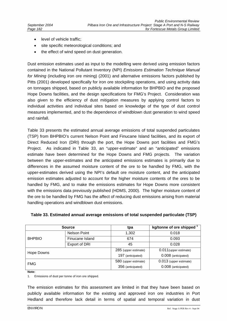
Public Environmental Review September 2004 Pilbara Iron Ore and Infrastructure Project: Stage A Port and N-S Railway Page 182 for Fortescue Metals Group Limited
ENVIRON Ref: Stage A PER Rev 4 - Sept 04
• level of vehicle traffic; • site specific meteorological conditions; and • the effect of wind speed on dust generation.
Dust emission estimates used as input to the modelling were derived using emission factors contained in the National Pollutant Inventory (NPI) Emissions Estimation Technique Manual for Mining (including iron ore mining) (2001) and alternative emissions factors published by Pitts (2001) developed specifically for iron ore stockpiling operations, and using activity data on tonnages shipped, based on publicly available information for BHPBIO and the proposed Hope Downs facilities, and the design specifications for FMG’s Project. Consideration was also given to the efficiency of dust mitigation measures by applying control factors to individual activities and individual sites based on knowledge of the type of dust control measures implemented, and to the dependence of windblown dust generation to wind speed and rainfall. Table 33 presents the estimated annual average emissions of total suspended particulates (TSP) from BHPBIO’s current Nelson Point and Finucane Island facilities, and its export of Direct Reduced Iron (DRI) through the port, the Hope Downs port facilities and FMG’s Project. As indicated in Table 33, an “upper-estimate” and an “anticipated” emissions estimate have been determined for the Hope Downs and FMG projects. The variation between the upper-estimates and the anticipated emissions estimates is primarily due to differences in the assumed moisture content of the ore to be handled by FMG, with the upper-estimates derived using the NPI’s default ore moisture content, and the anticipated emission estimates adjusted to account for the higher moisture contents of the ores to be handled by FMG, and to make the emissions estimates for Hope Downs more consistent with the emissions data previously published (HDMS, 2000). The higher moisture content of the ore to be handled by FMG has the affect of reducing dust emissions arising from material handling operations and windblown dust emissions.
Table 33. Estimated annual average emissions of total suspended particulate (TSP)
Source tpa kg/tonne of ore shipped 1 Nelson Point 1,302 0.018 Finucane Island 674 0.093 BHPBIO Export of DRI 45 0.028
Hope Downs 285 (upper estimate)
197 (anticipated) 0.011(upper estimate)
0.008 (anticipated)
FMG 580 (upper estimate)
356 (anticipated) 0.013 (upper estimate)
0.008 (anticipated) Note: 1. Emissions of dust per tonne of iron ore shipped.
The emission estimates for this assessment are limited in that they have been based on publicly available information for the existing and approved iron ore industries in Port Hedland and therefore lack detail in terms of spatial and temporal variation in dust
Public Environmental Review Pilbara Iron Ore and Infrastructure Project: Stage A Port and N-S Railway September 2004 for Fortescue Metals Group Limited Page 183
Ref: Stage A PER Rev 4 - Sept 04 ENVIRON
emissions, however to account for this the emission estimates initially derived for BHPBIO’s existing port activities were adjusted so that the model predictions aligned more closely with the actual dust concentrations measured in the Port Hedland area. Due to the inclusion of modern dust control within the Project’s design, the emissions estimates presented in Table 33 indicate that the FMG Project will achieve a lower dust emission rate (per tonne of iron ore shipped) compared to BHPBIO’s established operations, and a similar dust emission rate to that estimated for Hope Downs, providing some confidence that the emissions estimated for this assessment are suitable for use as input to the modelling. The DoIR is currently undertaking an assessment of the cumulative impacts associated with the continued growth at the Port Hedland Port including those associated with dust. It is envisaged that the DoIR study will have full access to the best available emissions estimates and that the modelling results will be made available to the EPA prior to it preparing its Bulletin for FMG’s Project. Upon completion of the DoIR study, FMG will compare modelling assumptions and results with those used in the DoIR study to confirm that the modelling presented in the PER is representative of the more detailed modelling. In order to confirm that the dust impacts predicted from the modelling are representative of the actual dust impacts experienced in Port Hedland, a comparison of measured and modelled dust concentrations was undertaken as part of the air quality assessment for this Project. Such a comparison revealed that the modelling predictions of TSP concentrations agreed well with measured dust concentrations, whilst the modelling tended to over-predict PM10 concentrations and under-predict PM2.5 concentrations when compared to the available measurement data. As such, the modelling predictions for PM10 and PM2.5 should be viewed more in a relative sense showing areas where highest concentrations occur and the changes that will occur as a result of FMG’s Project. Port Hedland The results of the modelling indicate that generally there will be a small increase in the maximum 24-hour average concentrations of particulates in the Port Hedland townsite associated with FMG’s Project, as follows:
• less than 1% increase in the maximum 24-hour average concentration of TSP; • approximately 6% increase in the maximum 24-hour average concentrations of PM10
and PM2.5; and • approximately 10% increase in the annual average concentration of PM2.5
based on predictions at the dust monitoring sites located to the west of the Port Hedland townsite and at the hospital, and applying the upper-estimate of emissions for FMG and Hope Downs. The relatively small increase in the maximum 24-hour average concentrations of particulates in the Port Hedland townsite associated with FMG’s Project can be seen from Figure 17 which shows that there is very little difference in the concentration contours predicted for the
Public Environmental Review September 2004 Pilbara Iron Ore and Infrastructure Project: Stage A Port and N-S Railway Page 184 for Fortescue Metals Group Limited
ENVIRON Ref: Stage A PER Rev 4 - Sept 04
proposed scenario (i.e. established industry, Hope Downs and FMG) compared to the existing scenario (i.e. established industry only). The small increase associated with FMG’s operations in the Port Hedland townsite is because the wind conditions that lead to the existing high concentrations (westerlies) do not result in FMG’s dust emissions being transported over this area. The modelling results also show that the annual average concentrations of TSP associated with FMG’s Project is predicted to contribute approximately 3.9 µg/m3 at the Port Hedland townsite. Taking into consideration the predicted impacts associated with emissions from the established iron ore industry operations (including BHPBIO’s proposed expansion) and the proposed Hope Downs project, it is estimated that FMG will contribute less than 5% to the annual average TSP concentrations, and as such represents a relatively minor contributor to annual average TSP concentrations predicted at the Port Hedland townsite. Wedgefield Due to the prevailing westerly winds typically experienced during the summer months in Port Hedland, FMG’s Project is predicted to contribute to dust levels experienced in Wedgefield, as follows:
• between 3.9% and 8.8% increase in the maximum 24-hour average concentrations of TSP, PM10 and PM2.5; and
• approximately 10% increase in the annual average concentration of PM2.5 as predicted at the northwest edge of Wedgefield, and applying the upper-estimate of emissions for FMG and Hope Downs. Applying the anticipated emission estimates for FMG and Hope Downs, FMG’s Project is predicted to contribute less to the dust levels experienced in Wedgefield, as follows:
• between 2.3% and 4.9% increase in the maximum 24-hour average concentrations of TSP, PM10 and PM2.5; and
• approximately 5.8% increase in the annual average concentration of PM2.5 as predicted at the northwest edge of Wedgefield. Overall Model Area Comparison of the model results with the relevant ambient dust standards (refer to Section 6.3.7) indicates that the maximum predicted 24-hour average and annual average concentrations of TSP, PM10 and PM2.5 associated with FMG’s Project, if considered in isolation, comfortably comply with the standards. The cumulative impacts arising from the established operations, Hope Downs and FMG are predicted to result in an increase in the annual number of predicted exceedances of nominated dust concentrations. Table 34 presents the number of predicted exceedances of
Public Environmental Review Pilbara Iron Ore and Infrastructure Project: Stage A Port and N-S Railway September 2004 for Fortescue Metals Group Limited Page 185
Ref: Stage A PER Rev 4 - Sept 04 ENVIRON
a nominated TSP 24-hour average concentration, and the relevant PM10 and PM2.5 ambient dust standards (refer to Section 6.3.7) at the Port Hedland Townsite and Hospital monitoring sites, and at a site to the northwest of Wedgefield for the modelled period (1 July 2002 to 30 June 2003).
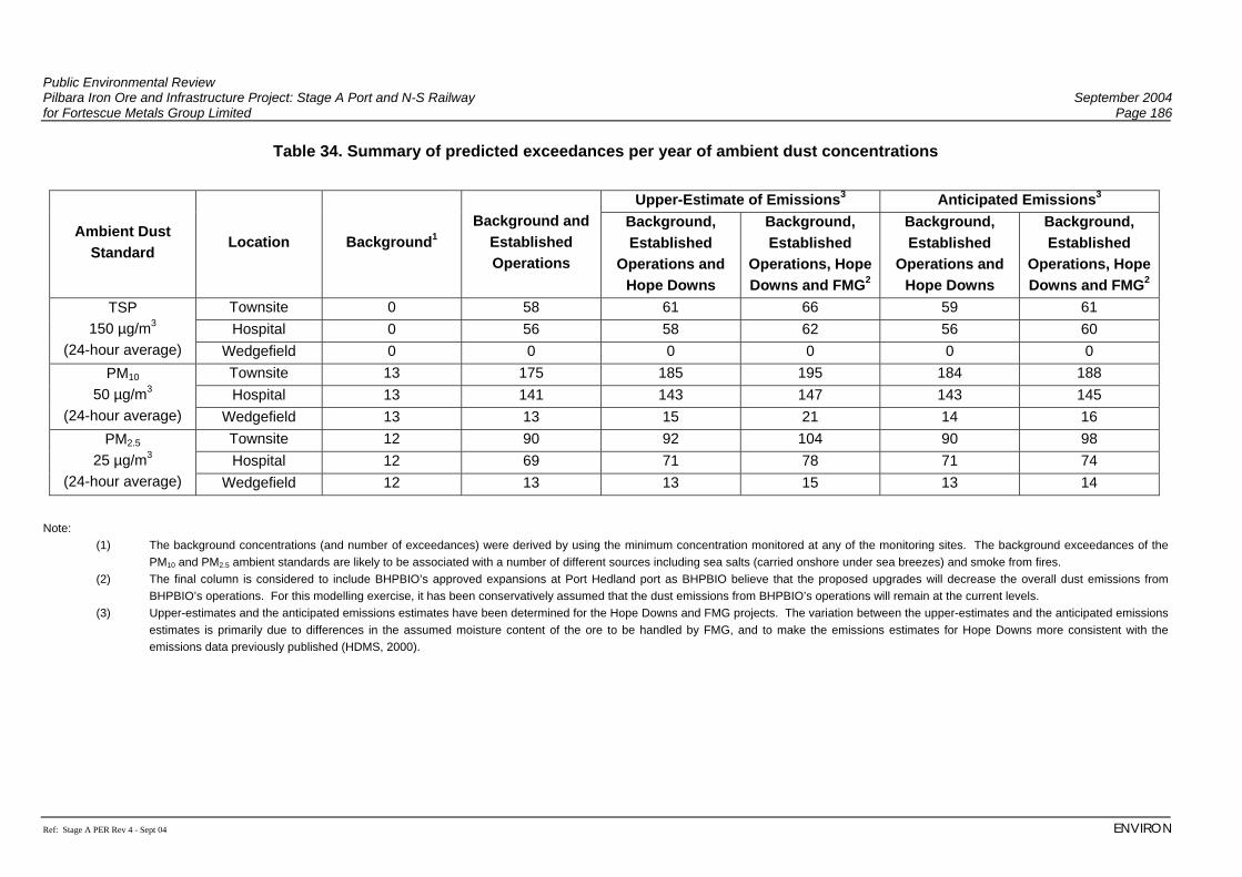
Public Environmental Review Pilbara Iron Ore and Infrastructure Project: Stage A Port and N-S Railway September 2004 for Fortescue Metals Group Limited Page 186
Ref: Stage A PER Rev 4 - Sept 04 ENVIRON
Table 34. Summary of predicted exceedances per year of ambient dust concentrations
Upper-Estimate of Emissions3 Anticipated Emissions3
Ambient Dust Standard
Location Background1 Background and
Established Operations
Background, Established
Operations and Hope Downs
Background, Established
Operations, Hope Downs and FMG2
Background, Established
Operations and Hope Downs
Background, Established
Operations, Hope Downs and FMG2
Townsite 0 58 61 66 59 61 Hospital 0 56 58 62 56 60
TSP 150 µg/m3
(24-hour average) Wedgefield 0 0 0 0 0 0 Townsite 13 175 185 195 184 188 Hospital 13 141 143 147 143 145
PM10 50 µg/m3
(24-hour average) Wedgefield 13 13 15 21 14 16 Townsite 12 90 92 104 90 98 Hospital 12 69 71 78 71 74
PM2.5 25 µg/m3
(24-hour average) Wedgefield 12 13 13 15 13 14
Note:
(1) The background concentrations (and number of exceedances) were derived by using the minimum concentration monitored at any of the monitoring sites. The background exceedances of the PM10 and PM2.5 ambient standards are likely to be associated with a number of different sources including sea salts (carried onshore under sea breezes) and smoke from fires.
(2) The final column is considered to include BHPBIO’s approved expansions at Port Hedland port as BHPBIO believe that the proposed upgrades will decrease the overall dust emissions from BHPBIO’s operations. For this modelling exercise, it has been conservatively assumed that the dust emissions from BHPBIO’s operations will remain at the current levels.
(3) Upper-estimates and the anticipated emissions estimates have been determined for the Hope Downs and FMG projects. The variation between the upper-estimates and the anticipated emissions estimates is primarily due to differences in the assumed moisture content of the ore to be handled by FMG, and to make the emissions estimates for Hope Downs more consistent with the emissions data previously published (HDMS, 2000).
Public Environmental Review Pilbara Iron Ore and Infrastructure Project: Stage A Port and N-S Railway September 2004 for Fortescue Metals Group Limited Page 187
Ref: Stage A PER Rev 4 - Sept 04 ENVIRON
No exceedances of the BHPBIO 24-hour average TSP concentration licence condition (260 µg/m3) were predicted for any of the operational scenarios considered. Although the number of exceedances predicted by the modelling is only indicative, the results presented in Table 34 indicate that FMG’s Project will result in:
• an additional two to five exceedances of the 24-hour average TSP concentration of 150 µg/m3 at the Townsite monitoring location for the anticipated and upper-estimate emission scenarios respectively. No exceedances of this concentration are predicted to occur at Wedgefield.
• an increase in the number of exceedances of the 24-hour average PM10 standards of between two and six events (Wedgefield) and four to 10 events (Townsite) for the anticipated and upper-estimate emission scenarios respectively; and
• an increase in the number of exceedances of the 24-hour average PM2.5 standard of between one and two events (Wedgefield) and eight to 12 events (Townsite) for the anticipated and upper-estimate emission scenarios respectively.
The air dispersion modelling was undertaken using a number of conservative assumptions regarding the quantification of the dust emissions and model parameters. Therefore, it is expected that the actual impacts arising from FMG’s operations will be less than those predicted. Nevertheless, the modelling indicates that whilst FMG’s contribution to the existing dust levels in Port Hedland are predicted to be relatively small, dust emissions from FMG’s proposed operations have the potential to increase the frequency of exceedances of air quality objectives if FMG does not apply effective design and management measures to ensure effective dust control. It is expected that asbestos will not be present in the ore, as the geological processes under which the ore was formed, were not conducive to the formation of asbestos minerals. However, asbestos minerals are not uncommon in the Pilbara and other iron ore projects in the region have encountered asbestos. FMG will test for the presence of asbestos in their ore as a matter of course during the feasibility studies for Stage B of the Project. FMG will not mine ore contaminated with asbestos minerals, and if it is encountered accidentally (e.g. during drilling), it has strict Occupational Health and Safety procedures that must be followed. Management The EPA objectives for this Project with regards to dust management are to:
• protect the surrounding land users such that dust and particulate emissions will not adversely impact upon their welfare and amenity or cause health problems; and
• ensure that particulate/dust emissions, both individually and cumulatively, meet appropriate criteria and do not cause environmental or human health problems.
Public Environmental Review September 2004 Pilbara Iron Ore and Infrastructure Project: Stage A Port and N-S Railway Page 188 for Fortescue Metals Group Limited
Ref: Stage A PER Rev 4 - Sept 04
One of the most critical elements in minimising dust emissions from the FMG Project is the maintenance of the moisture content of the ore above an optimum threshold. The optimum threshold will be determined based on the results of “ore dusting” tests for the various ore bodies, ore sizes, and other such characteristics, but is expected to be between 4% and 6% moisture. The beneficiation of the ore at the mine sites is expected to result in an ore moisture content that is much greater than 6% and as such dust generation is expected to be much lower than that assumed in the modelling. The ore moisture content will be checked upon delivery to the port and maintained via an integrated ore moisture monitoring and management system for the ore from the time it leaves the mine site until it is shipped from port. In addition, the equipment proposed to be installed for the FMG Project will be designed and operated to meet (and in many cases exceed) the current dust mitigation measures employed by the Western Australian iron ore industry. For example:
• A dust extraction system for the car dumping facility will be installed, which will include an induced draught at the dumping point and wet scrubbing;
• Conveyor transfer points will be totally enclosed, with water sprays jets at each loading point to wet the surface of the ore;
• Allowance has been made if necessary for future installation of insertable dry, reverse pulse gas filters at the transfer points in the unlikely event that the use of water sprays proves to be inadequate for dust control;
• Dust emitted from the belt conveyors will be controlled through proper maintenance of belt scrapers to dislodge material sticking to the belt;
• The conveyors from the car dumper to the screening building and out to the shiploader will be covered;
• Stackers will be automated to minimise the drop heights to stockpiles and the stacker booms will be fitted with spray heads to minimise the emissions of dust;
• The fines stockpiles will be protected from prevailing winds by the coarse stockpiles where practicable and the stockpile area will be fitted out with a fixed water cannon based spray system to reduce the likelihood of dust from wind erosion; and
• The feasibility of planting a vegetation shelter belt along the western side of the stockpiles will be investigated. Such a shelter belt, if feasible, would reduce the wind speed and therefore reduce wind erosion from the stockpiles and surrounding area.
FMG is confident that its design, ore characteristics and operational practices will ensure that the dust emissions and resultant impacts are well below those predicted. FMG’s proposed operational practices will be document in its Dust Management Plan.
The Dust Management Plan will be prepared prior to commencement of construction. The Plan will be developed in consultation with the relevant government agencies and key stakeholders in the Port Hedland area. The plan will detail the dust mitigation management measures, including:
Public Environmental Review Pilbara Iron Ore and Infrastructure Project: Stage A Port and N-S Railway September 2004 for Fortescue Metals Group Limited Page 189
Ref: Stage A PER Rev 4 - Sept 04 ENVIRON
• Integrated ore moisture monitoring and management system maintaining ore moisture through the use of sprays and water cannons. It is proposed that the Bureau of Meteorology weather forecasts for Port Hedland will be obtained on a regular basis (at least daily) to help optimise the effectiveness of water sprays by applying these before forecast strong winds occur;
• Regularly checking on the operation of the dust control equipment and ensuring that the required maintenance and repairs are conducted in a timely manner;
• Use of water carts on high traffic areas (roads, dredge deposition areas and laydown areas) during construction;
• Use of a real time continuous dust monitoring network to provide real time feedback on the effectiveness of the dust control measures;
• Sealing of Port operational areas, where practicable; • Optimise vehicle movements; • Minimise vegetation clearing; • Progressively rehabilitate disturbed areas to minimise potential for dust generation;
and • Undertake visual inspections of port construction areas to ensure dust control
management measures are implemented and remain effective. A real time continuous dust monitoring network will be installed to assist with dust management and to accurately define the impacts at the nearest receptors such as Wedgefield. The network will be designed to include a background site and a site at the area to be evaluated such that on an hourly basis with use of the wind direction the dust contribution from the operations can be monitored. The monitoring results will be used:
• in an operational sense, to manage activities found to be generating dust through near real-time feedback to plant operators on dust impacts associated with their activities;
• to regularly review the effectiveness of dust mitigation measures and to track FMG’s performance with respect to dust management, and
• for the analysis and reporting of FMG’s performance with respect to dust management, including reporting to the local community and the DoE.
FMG believes that the implementation of its Dust Management Plan and real time dust monitoring network will ensure that the predicted dust impacts are well below those predicted by the modelling and will only result in a very small incremental increase in the ambient particulate concentrations in the region. It is anticipated that this small incremental increase in concentrations will be easily off-set by BHPBIO proposed reductions in its dust emissions and resultant impacts.
Public Environmental Review September 2004 Pilbara Iron Ore and Infrastructure Project: Stage A Port and N-S Railway Page 190 for Fortescue Metals Group Limited
Ref: Stage A PER Rev 4 - Sept 04
7.3.10 Decommissioning and Rehabilitation 7.3.10.1 Decommissioning The Project has an expected indefinite operating life depending on continued exploration and development of the iron ore industry and use by other third party operators. However, in the unlikely event that all or part of this infrastructure is no longer required, by FMG or another party, the facilities no longer required will be decommissioned. Decommissioning will comprise the safe dismantling and removal of infrastructure, the appropriate disposal of waste materials and site rehabilitation to re-establish a self-sustaining ecosystem. Where the removal of non visible infrastructure, or features that have been incorporated into the natural landscape, may cause more environmental damage than if left in situ then their retention will be discussed with the relevant authorities at that time. Decommissioning procedures, closure plans, and completion criteria will be established in accordance with the applicable legislation and standards just prior to closure. 7.3.10.2 Rehabilitation Cleared areas not required for operation of the port will be rehabilitated to re-establish a stable landform and promote regeneration of a self-sustaining ecosystem. Areas prone to erosion will be stabilised, and where practicable, similar substrate and hydrodynamic features to that which was present prior to construction, will be re-established in the supratidal, intertidal and mangrove areas. Mangrove and supratidal vegetation debris cleared prior to construction will be spread over the rehabilitated area to provide organic matter and a seed source, where this will not adversely affect the local hydrodynamics. Rehabilitation activities will take into account tidal activity to determine the most appropriate method and timing for mangrove and supratidal rehabilitation. Rehabilitation activities will include:
• ripping of compacted areas; • re-establishment of a stable landform with erosion protection where necessary for long-
term stability; • reinstatement of surface drainage patterns similar to that which was present pre-
construction; • replacement of topsoil; and • spreading of vegetation debris to return organic matter to the area, and provide an
additional seed source. Rehabilitation undertaken after construction will require monitoring to assess the effectiveness of the rehabilitation and remedial works will be undertaken as required. This may include repair of eroded areas, weed control, and seeding or planting of areas where vegetation has
Public Environmental Review Pilbara Iron Ore and Infrastructure Project: Stage A Port and N-S Railway September 2004 for Fortescue Metals Group Limited Page 191
Ref: Stage A PER Rev 4 - Sept 04 ENVIRON
not established from natural seed sources in the topsoil, and mulch applied to rehabilitated areas. The rehabilitation programme will include development of rehabilitation completion criteria to determine when a rehabilitated area can be considered self-sustaining, or indicate a continuous positive trend towards a stable community.

Public Environmental Review September 2004 Pilbara Iron Ore and Infrastructure Project: Stage A Port and N-S Railway Page 192 for Fortescue Metals Group Limited
Ref: Stage A PER Rev 4 - Sept 04
(This page has been left blank intentionally)
Public Environmental Review Pilbara Iron Ore and Infrastructure Project: Stage A Port and N-S Railway September 2004 for Fortescue Metals Group Limited Page 193
Ref: Stage A PER Rev 4 - Sept 04 ENVIRON
8. ENVIRONMENTAL MANAGEMENT COMMITMENTS FMG intend to design, construct and operate the Port and North-South Railway for the Pilbara Iron Ore and Infrastructure Project in the a manner which encompasses the principles of Sustainability (Section 7.1.1). The following environmental management commitments have been developed for the more significant environmental issues for FMG’s Project. These will represent key components within FMG’s EMS (Section 7.1.2).

Public Environmental Review September 2004 Pilbara Iron Ore and Infrastructure Project: Stage A Port and N-S Railway Page 194 for Fortescue Metals Group Limited
Ref: Stage A PER Rev 4 - Sept 04
(This page has been left blank intentionally)
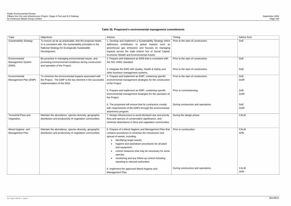
Public Environmental Review Pilbara Iron Ore and Infrastructure Project: Stage A Port and N-S Railway September 2004 for Fortescue Metals Group Limited Page 195
Ref: Stage A PER Rev 4 - Sept 04 ENVIRON
Table 35. Proponent’s environmental management commitments
Topic Objectives Actions Timing Advice from Sustainability Strategy To ensure as far as practicable, that the proposal meets,
or is consistent with, the sustainability principles in the National Strategy for Ecologically Sustainable Development.
1. Develop and implement a Sustainability Strategy which addresses contribution to global impacts such as greenhouse gas emissions and focuses on managing impacts across the triple bottom line of Social Capital, Economic Wealth and Environmental Assets.
Prior to the start of construction. DoE
Environmental Management System (EMS)
Be proactive in managing environmental issues, and promoting environmental excellence during construction and operation of the Project.
2. Prepare and implement an EMS that is consistent with the ISO 14001 standard. 3. Integrate the EMS with Quality, Health & Safety and other business management systems.
Prior to the start of construction. Prior to the start of construction.
DoE DoE
Environmental Management Plan (EMP)
To minimise the environmental impacts associated with the Project. The EMP is the key element in the successful implementation of the EMS.
4. Prepare and implement an EMP, containing specific environmental management strategies for the construction of the Project. 5. Prepare and implement an EMP, containing specific environmental management strategies for the operation of the Project. 6. The proponent will ensure that its contractors comply with requirements of the EMPs through the environmental awareness program.
Prior to the start of construction. Prior to commissioning. During construction and operations.
DoE DoIR DoE DoIR DoE DoIR
Terrestrial Flora and Vegetation,
Maintain the abundance, species diversity, geographic distribution and productivity of vegetation communities.
7. Design infrastructure to avoid declared rare and priority flora and species of conservation significance, and minimise disturbance to flora and vegetation communities.
During the design phase.
CALM
Weed Hygiene and Management Plan
Maintain the abundance, species diversity, geographic distribution and productivity of vegetation communities.
8. Prepare of a Weed Hygiene and Management Plan that contains procedures to minimise the introduction and spread of weeds, including:
• identifying target weeds; • hygiene and washdown procedures for all plant
and equipment; • control measures that may be necessary for some
species; • monitoring and any follow-up control including
reporting to relevant authorities. 9. Implement the approved Weed Hygiene and Management Plan.
Prior to construction. During construction and operations.
CALM APB CALM APB
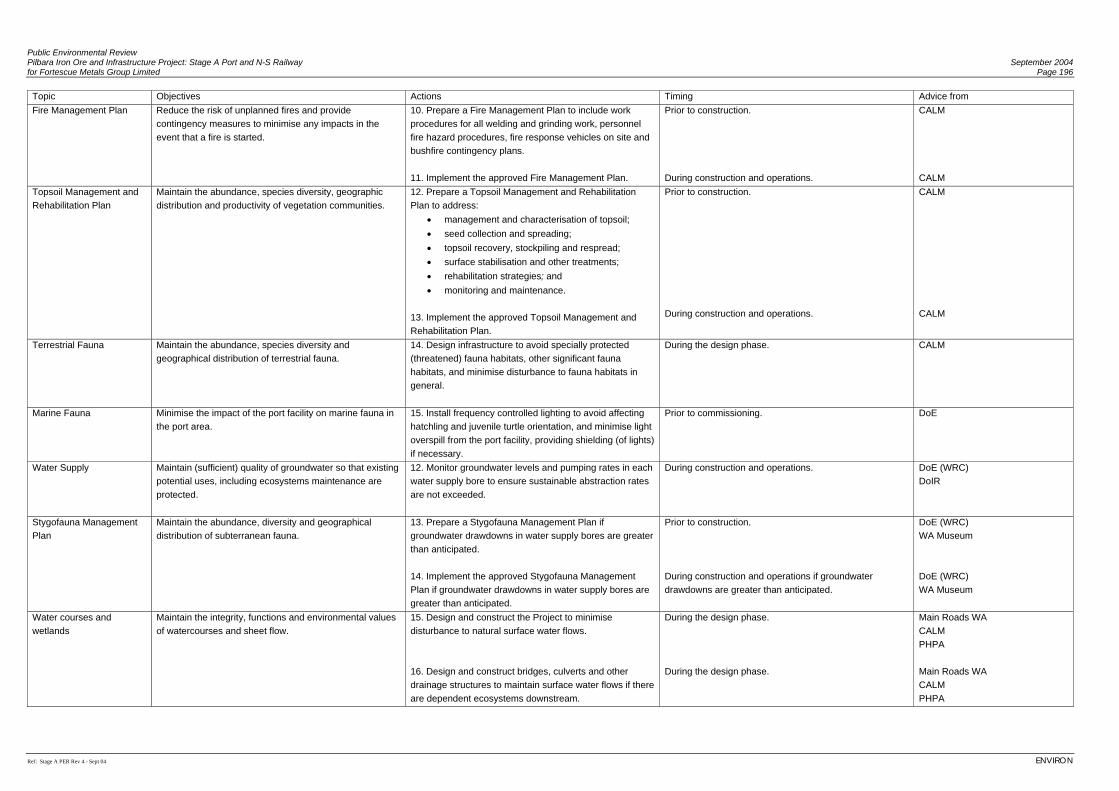
Public Environmental Review Pilbara Iron Ore and Infrastructure Project: Stage A Port and N-S Railway September 2004 for Fortescue Metals Group Limited Page 196
Ref: Stage A PER Rev 4 - Sept 04 ENVIRON
Topic Objectives Actions Timing Advice from Fire Management Plan Reduce the risk of unplanned fires and provide
contingency measures to minimise any impacts in the event that a fire is started.
10. Prepare a Fire Management Plan to include work procedures for all welding and grinding work, personnel fire hazard procedures, fire response vehicles on site and bushfire contingency plans. 11. Implement the approved Fire Management Plan.
Prior to construction. During construction and operations.
CALM CALM
Topsoil Management and Rehabilitation Plan
Maintain the abundance, species diversity, geographic distribution and productivity of vegetation communities.
12. Prepare a Topsoil Management and Rehabilitation Plan to address:
• management and characterisation of topsoil; • seed collection and spreading; • topsoil recovery, stockpiling and respread; • surface stabilisation and other treatments; • rehabilitation strategies; and • monitoring and maintenance.
13. Implement the approved Topsoil Management and Rehabilitation Plan.
Prior to construction. During construction and operations.
CALM CALM
Terrestrial Fauna Maintain the abundance, species diversity and geographical distribution of terrestrial fauna.
14. Design infrastructure to avoid specially protected (threatened) fauna habitats, other significant fauna habitats, and minimise disturbance to fauna habitats in general.
During the design phase. CALM
Marine Fauna Minimise the impact of the port facility on marine fauna in the port area.
15. Install frequency controlled lighting to avoid affecting hatchling and juvenile turtle orientation, and minimise light overspill from the port facility, providing shielding (of lights) if necessary.
Prior to commissioning. DoE
Water Supply Maintain (sufficient) quality of groundwater so that existing potential uses, including ecosystems maintenance are protected.
12. Monitor groundwater levels and pumping rates in each water supply bore to ensure sustainable abstraction rates are not exceeded.
During construction and operations.
DoE (WRC) DoIR
Stygofauna Management Plan
Maintain the abundance, diversity and geographical distribution of subterranean fauna.
13. Prepare a Stygofauna Management Plan if groundwater drawdowns in water supply bores are greater than anticipated. 14. Implement the approved Stygofauna Management Plan if groundwater drawdowns in water supply bores are greater than anticipated.
Prior to construction. During construction and operations if groundwater drawdowns are greater than anticipated.
DoE (WRC) WA Museum DoE (WRC) WA Museum
Water courses and wetlands
Maintain the integrity, functions and environmental values of watercourses and sheet flow.
15. Design and construct the Project to minimise disturbance to natural surface water flows. 16. Design and construct bridges, culverts and other drainage structures to maintain surface water flows if there are dependent ecosystems downstream.
During the design phase. During the design phase.
Main Roads WA CALM PHPA Main Roads WA CALM PHPA
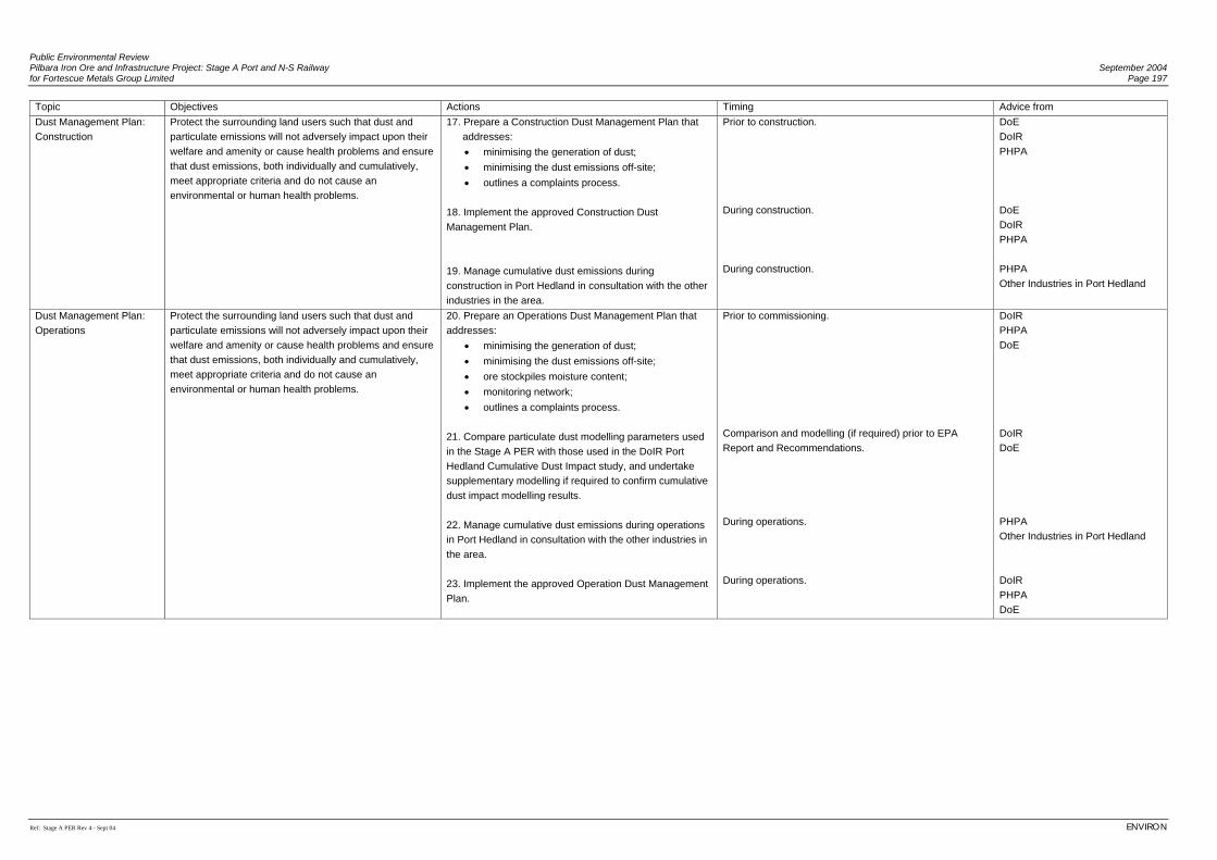
Public Environmental Review Pilbara Iron Ore and Infrastructure Project: Stage A Port and N-S Railway September 2004 for Fortescue Metals Group Limited Page 197
Ref: Stage A PER Rev 4 - Sept 04 ENVIRON
Topic Objectives Actions Timing Advice from Dust Management Plan: Construction
Protect the surrounding land users such that dust and particulate emissions will not adversely impact upon their welfare and amenity or cause health problems and ensure that dust emissions, both individually and cumulatively, meet appropriate criteria and do not cause an environmental or human health problems.
17. Prepare a Construction Dust Management Plan that addresses:
• minimising the generation of dust; • minimising the dust emissions off-site; • outlines a complaints process.
18. Implement the approved Construction Dust Management Plan. 19. Manage cumulative dust emissions during construction in Port Hedland in consultation with the other industries in the area.
Prior to construction. During construction. During construction.
DoE DoIR PHPA DoE DoIR PHPA PHPA Other Industries in Port Hedland
Dust Management Plan: Operations
Protect the surrounding land users such that dust and particulate emissions will not adversely impact upon their welfare and amenity or cause health problems and ensure that dust emissions, both individually and cumulatively, meet appropriate criteria and do not cause an environmental or human health problems.
20. Prepare an Operations Dust Management Plan that addresses:
• minimising the generation of dust; • minimising the dust emissions off-site; • ore stockpiles moisture content; • monitoring network; • outlines a complaints process.
21. Compare particulate dust modelling parameters used in the Stage A PER with those used in the DoIR Port Hedland Cumulative Dust Impact study, and undertake supplementary modelling if required to confirm cumulative dust impact modelling results. 22. Manage cumulative dust emissions during operations in Port Hedland in consultation with the other industries in the area. 23. Implement the approved Operation Dust Management Plan.
Prior to commissioning. Comparison and modelling (if required) prior to EPA Report and Recommendations. During operations. During operations.
DoIR PHPA DoE DoIR DoE PHPA Other Industries in Port Hedland DoIR PHPA DoE
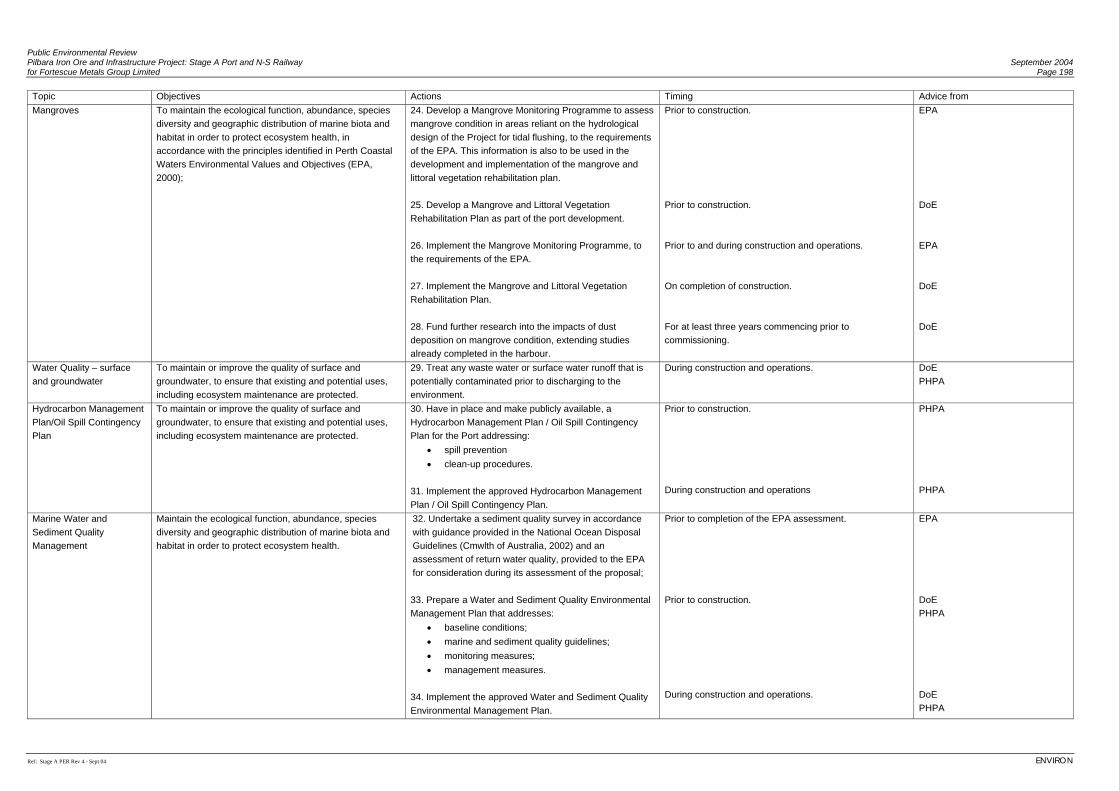
Public Environmental Review Pilbara Iron Ore and Infrastructure Project: Stage A Port and N-S Railway September 2004 for Fortescue Metals Group Limited Page 198
Ref: Stage A PER Rev 4 - Sept 04 ENVIRON
Topic Objectives Actions Timing Advice from Mangroves To maintain the ecological function, abundance, species
diversity and geographic distribution of marine biota and habitat in order to protect ecosystem health, in accordance with the principles identified in Perth Coastal Waters Environmental Values and Objectives (EPA, 2000);
24. Develop a Mangrove Monitoring Programme to assess mangrove condition in areas reliant on the hydrological design of the Project for tidal flushing, to the requirements of the EPA. This information is also to be used in the development and implementation of the mangrove and littoral vegetation rehabilitation plan. 25. Develop a Mangrove and Littoral Vegetation Rehabilitation Plan as part of the port development. 26. Implement the Mangrove Monitoring Programme, to the requirements of the EPA. 27. Implement the Mangrove and Littoral Vegetation Rehabilitation Plan. 28. Fund further research into the impacts of dust deposition on mangrove condition, extending studies already completed in the harbour.
Prior to construction. Prior to construction. Prior to and during construction and operations. On completion of construction. For at least three years commencing prior to commissioning.
EPA DoE EPA DoE DoE
Water Quality – surface and groundwater
To maintain or improve the quality of surface and groundwater, to ensure that existing and potential uses, including ecosystem maintenance are protected.
29. Treat any waste water or surface water runoff that is potentially contaminated prior to discharging to the environment.
During construction and operations.
DoE PHPA
Hydrocarbon Management Plan/Oil Spill Contingency Plan
To maintain or improve the quality of surface and groundwater, to ensure that existing and potential uses, including ecosystem maintenance are protected.
30. Have in place and make publicly available, a Hydrocarbon Management Plan / Oil Spill Contingency Plan for the Port addressing:
• spill prevention • clean-up procedures.
31. Implement the approved Hydrocarbon Management Plan / Oil Spill Contingency Plan.
Prior to construction. During construction and operations
PHPA PHPA
Marine Water and Sediment Quality Management
Maintain the ecological function, abundance, species diversity and geographic distribution of marine biota and habitat in order to protect ecosystem health.
32. Undertake a sediment quality survey in accordance with guidance provided in the National Ocean Disposal Guidelines (Cmwlth of Australia, 2002) and an assessment of return water quality, provided to the EPA for consideration during its assessment of the proposal; 33. Prepare a Water and Sediment Quality Environmental Management Plan that addresses:
• baseline conditions; • marine and sediment quality guidelines; • monitoring measures; • management measures.
34. Implement the approved Water and Sediment Quality Environmental Management Plan.
Prior to completion of the EPA assessment. Prior to construction. During construction and operations.
EPA DoE PHPA DoE PHPA
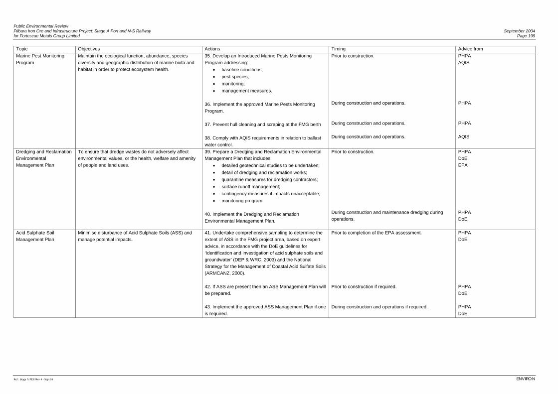
Public Environmental Review Pilbara Iron Ore and Infrastructure Project: Stage A Port and N-S Railway September 2004 for Fortescue Metals Group Limited Page 199
Ref: Stage A PER Rev 4 - Sept 04 ENVIRON
Topic Objectives Actions Timing Advice from Marine Pest Monitoring Program
Maintain the ecological function, abundance, species diversity and geographic distribution of marine biota and habitat in order to protect ecosystem health.
35. Develop an Introduced Marine Pests Monitoring Program addressing:
• baseline conditions; • pest species; • monitoring; • management measures.
36. Implement the approved Marine Pests Monitoring Program. 37. Prevent hull cleaning and scraping at the FMG berth 38. Comply with AQIS requirements in relation to ballast water control.
Prior to construction. During construction and operations. During construction and operations. During construction and operations.
PHPA AQIS PHPA PHPA AQIS
Dredging and Reclamation Environmental Management Plan
To ensure that dredge wastes do not adversely affect environmental values, or the health, welfare and amenity of people and land uses.
39. Prepare a Dredging and Reclamation Environmental Management Plan that includes:
• detailed geotechnical studies to be undertaken; • detail of dredging and reclamation works; • quarantine measures for dredging contractors; • surface runoff management; • contingency measures if impacts unacceptable; • monitoring program.
40. Implement the Dredging and Reclamation Environmental Management Plan.
Prior to construction. During construction and maintenance dredging during operations.
PHPA DoE EPA PHPA DoE
Acid Sulphate Soil Management Plan
Minimise disturbance of Acid Sulphate Soils (ASS) and manage potential impacts.
41. Undertake comprehensive sampling to determine the extent of ASS in the FMG project area, based on expert advice, in accordance with the DoE guidelines for ‘Identification and investigation of acid sulphate soils and groundwater’ (DEP & WRC, 2003) and the National Strategy for the Management of Coastal Acid Sulfate Soils (ARMCANZ, 2000). 42. If ASS are present then an ASS Management Plan will be prepared. 43. Implement the approved ASS Management Plan if one is required.
Prior to completion of the EPA assessment. Prior to construction if required. During construction and operations if required.
PHPA DoE PHPA DoE PHPA DoE
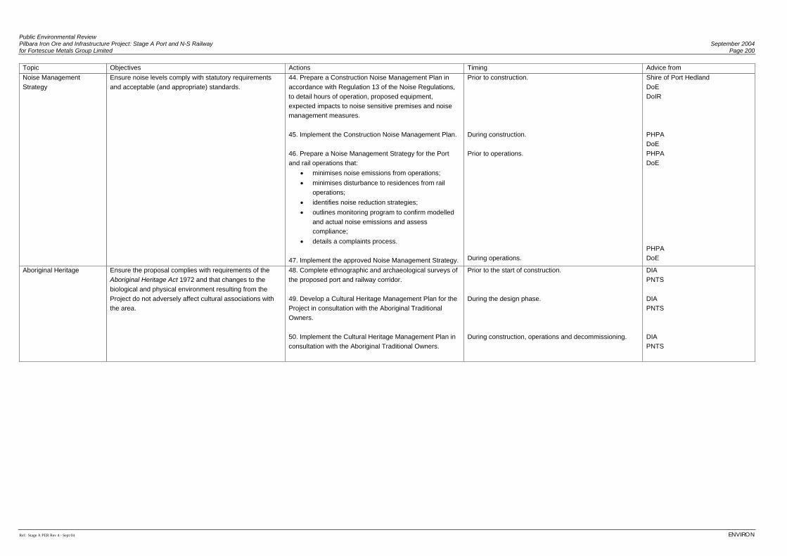
Public Environmental Review Pilbara Iron Ore and Infrastructure Project: Stage A Port and N-S Railway September 2004 for Fortescue Metals Group Limited Page 200
Ref: Stage A PER Rev 4 - Sept 04 ENVIRON
Topic Objectives Actions Timing Advice from Noise Management Strategy
Ensure noise levels comply with statutory requirements and acceptable (and appropriate) standards.
44. Prepare a Construction Noise Management Plan in accordance with Regulation 13 of the Noise Regulations, to detail hours of operation, proposed equipment, expected impacts to noise sensitive premises and noise management measures. 45. Implement the Construction Noise Management Plan. 46. Prepare a Noise Management Strategy for the Port and rail operations that:
• minimises noise emissions from operations; • minimises disturbance to residences from rail
operations; • identifies noise reduction strategies; • outlines monitoring program to confirm modelled
and actual noise emissions and assess compliance;
• details a complaints process. 47. Implement the approved Noise Management Strategy.
Prior to construction. During construction. Prior to operations. During operations.
Shire of Port Hedland DoE DoIR PHPA DoE PHPA DoE PHPA DoE
Aboriginal Heritage Ensure the proposal complies with requirements of the Aboriginal Heritage Act 1972 and that changes to the biological and physical environment resulting from the Project do not adversely affect cultural associations with the area.
48. Complete ethnographic and archaeological surveys of the proposed port and railway corridor. 49. Develop a Cultural Heritage Management Plan for the Project in consultation with the Aboriginal Traditional Owners. 50. Implement the Cultural Heritage Management Plan in consultation with the Aboriginal Traditional Owners.
Prior to the start of construction. During the design phase. During construction, operations and decommissioning.
DIA PNTS DIA PNTS DIA PNTS
Public Environmental Review Pilbara Iron Ore and Infrastructure Project: Stage A Port and N-S Railway September 2004 for Fortescue Metals Group Limited Page 201
Ref: Stage A PER Rev 4 - Sept 04 ENVIRON
9. CONCLUSIONS
The Pilbara Iron Ore and Infrastructure Project will be undertaken in line with the guiding sustainability principles outlined in the National Strategy for Ecologically Sustainable Development (Commonwealth, 1992). FMG also recognises the Western Australian Government State Sustainability Strategy, which sets out a vision for the State’s mining industry. FMG has made a number of formal commitments with respect to Stage A – the Port and North-South railway to show its commitment to constructing and operating in an environmentally responsible manner. The formal commitments will be implemented to the satisfaction of the Environmental Protection Authority. The key environmental issues associated with the development of the port and North-South railway have been identified as noise, dust, surface drainage, mangroves, vegetation and significant flora species. FMG is committed to minimising environmental impacts where practicable and will ensure all impacts are managed using the port and North-South railway Construction and Operations Environmental Management Plans. FMG will work closely with the relevant authorities to achieve improved environmental standards wherever practicable. The development of the Port and North-South railway to FMG’s iron ore resources will provide a number of significant benefits including:
• rail and port facilities to be available for other operations in the area; • creation of significant direct and indirect employment opportunities; • expenditure of approximately A$1.85 billion during the construction of the port, rail
and mining facilities, which represents a significant contribution to the State’s economy;
• employment of individuals from the towns of Port Hedland and Newman and the Pilbara region as a priority;
• housing of FMG’s operational workforce in the regional townships of Port Hedland; and
• improved regional community support through local employment opportunities, including meaningful vocational training and employment for local indigenous people.
FMG believes that construction and operation of Stage A of the Pilbara Iron Ore and Infrastructure Project will result in net economic and social benefits to the local and regional community and the State as a whole.

Public Environmental Review September 2004 Pilbara Iron Ore and Infrastructure Project: Stage A Port and N-S Railway Page 202 for Fortescue Metals Group Limited
ENVIRON Ref: Stage A PER Rev 4 - Sept 04
(This page has been left blank intentionally)
Public Environmental Review Pilbara Iron Ore and Infrastructure Project: Stage A Port and N-S Railway September 2004 for Fortescue Metals Group Limited Page 203
Ref: Stage A PER Rev 4 - Sept 04 ENVIRON
10. REFERENCES
Agriculture and Resource Management Council of Australia and New Zealand (ARMCANZ)
(2000). National Strategy for the Management of Coastal Acid Sulfate Soils. Agwest (2002). Land Systems Mapping of the Pilbara region, WA. Draft mapping by
Agriculture WA. Anthropos Australis (2004). Aboriginal Heritage Information for Pilbara Native Title Services. Aquaterra Consulting (2004a). Assessment of Water Supply Development for the Stage A
Port and North-South Railway. Report prepared for Fortescue Metals Group Limited. Aquaterra Consulting (2004b). Stage A Port and North South Railway Surface Hydrology.
Report prepared for Fortescue Metals Group Limited. Armstrong, K.N. and Anstee, S.D. (2000). The ghost bat in the Pilbara: 100 years on.
Australian Mammalogy 22: 93-101. Atkins, K.J. (2003). Declared Rare and Priority Flora List for Western Australia. Prepared
by the Department of Conservation and Land Management, 16 April 2003. Australia and New Zealand Environment and Conservation Council (ANZECC) (2000). Code
of Practice for Antifouling and In-water Hull Cleaning and Maintenance. Australia and New Zealand Environment and Conservation Council/Agriculture and
Resource Management Council of Australia and New Zealand (ANZECC/ARMCANZ) (2000). National Water Quality Management Strategy: Australian and New Zealand Guidelines for Fresh and Marine Water Quality.
Australian Bureau of Statistics (2001). Basic Community Profiles, 2001 Australian Greenhouse Office (1996). Australian Methodology for the Estimation of
Greenhouse Gas Emissions and Sinks: Land Use Change and Forestry. Workbook for Carbon Dioxide from the Biosphere (No. 4.1, Revision 1, 1996).
Australian Greenhouse Office (2002a). Australian Methodology for the Estimation of
Greenhouse Gas Emissions and Sinks 2002: Energy (Stationary Sources), Australian Government, May 2004.
Australian Greenhouse Office (2002b). Australian Methodology for the Estimation of
Greenhouse Gas Emissions and Sinks 2002: Energy (Transport), Australian Government, May 2004.
Public Environmental Review September 2004 Pilbara Iron Ore and Infrastructure Project: Stage A Port and N-S Railway Page 204 for Fortescue Metals Group Limited
ENVIRON Ref: Stage A PER Rev 4 - Sept 04
Australian Quarantine and Inspection Service (AQIS) (2001). Australian Ballast Water
Management Requirements. Baker, A. (1999). Whales and Dolphins of Australia and New Zealand. Allen and Unwin,
Sydney. Beard, J. S. (1975). Pilbara. Explanatory Notes and Map Sheet 5, 1:1 000 000 series
Vegetation Survey of Western Australia. University of Western Australia Press: Nedlands.
BHPB Iron Ore and Halpern Glick Maunsell Pty Ltd, (2002). Port Hedland Dust
Management Programme. July 2002. Biota Environmental Sciences (2001a). Baseline Biological and Soil Surveys and Mapping
for ML244SA West of the Fortescue River. Unpublished report for BHPIO. Biota Environmental Sciences (2001b). Hope Downs to Port Hedland Rail Vertebrate Fauna
Survey. Unpublished report for Hope Downs Management Services, Perth. Biota Environmental Sciences (2001c). An Assessment of the Distribution of the Mulgara
Dasycercus cristicauda and Bilby Macrotis lagotis along and Adjacent to the Proposed Hope Downs to Port Hedland Rail Corridor. Unpublished report for Hope Downs Management Services, Perth.
Biota Environmental Sciences (2001d). Resources Development and Subterranean Biota in
the Pilbara Region – Management and Approval Processes. EPA Submission prepared for BHP Iron Ore Pty Ltd, Perth.
Biota Environmental Sciences (2002a). Proposed Hope Downs Rail Corridor from Weeli
Wolli Siding to Port Hedland – Vertebrate Fauna Survey. Unpublished report for Hope Downs Management Services, Perth.
Biota Environmental Sciences (2002b). Hope Downs Rail Corridor Mulgara Dasycercus
cristicauda and Bilby Macrotis lagotis Surveys. Unpublished report for Hope Downs Management Services Pty. Ltd.
Biota Environmental Sciences (2003a). Hope Downs Rail Corridor Extension – Hamersley
Ranges: Flora and Vegetation Survey. Unpublished report for Hope Downs Management Services, Perth.
Biota Environmental Sciences (2003b). Hope Downs Additional Rail Corridor – Chichester
Range: Vertebrate Fauna Survey. Unpublished report for Hope Downs Management Services, Perth.
Public Environmental Review Pilbara Iron Ore and Infrastructure Project: Stage A Port and N-S Railway September 2004 for Fortescue Metals Group Limited Page 205
Ref: Stage A PER Rev 4 - Sept 04 ENVIRON
Biota Environmental Sciences (2003c). Hope Downs Additional Rail Corridor – Chichester Range: Flora and Vegetation Survey. Unpublished report for Hope Downs Management Services, Perth.
Biota Environmental Sciences (2003d). Hope Downs Rail Corridor Extension – Hamersley Ranges: Vertebrate Fauna Survey. Unpublished report for Hope Downs Management Services, Perth.
Biota Environmental Sciences (2004a). Hope Downs Rail Corridor, Hamersley Ranges
Extension – Vegetation and Flora Survey. Unpublished report prepared for Hope Downs Management Services, Perth.
Biota Environmental Sciences (2004b). Hope Downs Rail Corridor, Hamersley Ranges
Extension – Vertebrate Fauna Survey. Unpublished report prepared for Hope Downs Management Services, Perth.
Biota Environmental Sciences (2004c). Hope Downs Rail Corridor, Chichester Range
Additional Corridor – Flora and Vegetation Survey. Unpublished report prepared for Hope Downs Management Services, Perth.
Biota Environmental Sciences (2004d). Hope Downs Rail Corridor, Chichester Range
Additional Corridor – Vertebrate Fauna Survey. Unpublished report prepared for Hope Downs Management Services, Perth.
Biota Environmental Sciences (2004e). Fortescue Metals Group Rail Corridor: Flora and
Vegetation Survey. Unpublished report prepared for Fortescue Metals Group. Biota Environmental Sciences (2004f). Fortescue Metals Group Rail Corridor and Mindy
Mindy Mine: Vertebrate Fauna Survey. Unpublished report prepared for Fortescue Metals Group.
Biota Environmental Sciences and M.E. Trudgen (2002). Hope Downs Rail Corridor, Port
Hedland to Weeli Wolli Creek – Vegetation and Flora Survey. Unpublished report for Hope Downs Management Services, Perth.
Bryden, M., H. Marsh and Shaugnessy, P. (1998). Dugongs, Whales, Dolphins and Seals: A
Guide to the Sea Mammals of Australasia. Allen and Unwin, Sydney. Cade T.J. (1982). The Falcons of the World. Collins, London. Cahoon, D.R. and Lynch, J. C. (1997). Vertical accretion and shallow subsidence in a
mangrove forest of southwestern Florida, USA. Mangroves and Salt Marshes 1: 173-186.
Public Environmental Review September 2004 Pilbara Iron Ore and Infrastructure Project: Stage A Port and N-S Railway Page 206 for Fortescue Metals Group Limited
ENVIRON Ref: Stage A PER Rev 4 - Sept 04
Chapple Research (1995). Review of the BHP Direct Reduced Iron Pty Ltd - Hot Briquetted Iron Project - Consultative Environmental Review, Prepared on behalf of the Town of Port Hedland.
Churchill, S.K. (1998). Australian Bats. Reed New Holland: Frenchs Forest, NSW. Coffey Geosciences (2004). Pilbara Iron Ore and Infrastructure Project: Desktop Study and
Site Visit. Report prepared for Fortescue Metals Group Limited. Commonwealth of Australia (1992). National Strategy for Ecologically Sustainable
Development. Commonwealth of Australia (1998). National Greenhouse Strategy. Commonwealth of Australia (2002). National Ocean Disposal Guidelines for Dredged
Material. Commonwealth of Australia, Canberra, 2002. Cooper N.K, Adams, M., Anthony, C. and Schmitt, L.H. (2003). Morphological and genetic
variation in Leggadina (Thomas, 1910) with special reference to Western Australian populations. Records of the Western Australian Museum 21: 333-351
CSIRO Centre for Research on Introduced Marine Pests (1999). Introduced Species
Survey, Port Hedland Western Australia. Prepared for AAPMA and ABWMAC. DAL Science and Engineering (DALSE) (2004). Marine Environmental Impacts and Their
Management. Report prepared for Fortescue Metals Group Limited. Department of Environment (2003). Interim Industry Guide to Community Involvement,
December 2003 Department of Environment and Water and Rivers Commission (2003). Acid Sulfate Soils
Guidelines: Identification and Investigation of Acid Sulfate Soils and Groundwater. Department of Foreign Affairs and Trade (1997). Australia and Climate Change Negotiations
- Issues Paper September 1997. Duncan, A., Baker, G.B., and Montgomery, N. (1999). The Action Plan for Australian bats.
Biodiversity Group, Environment Australia: Canberra. Ecologically Sustainable Development Steering Committee (1992) National Strategy for
Ecologically Sustainable Development, Australia. Endorsed by the Council of Australian Governments, December 1992.
Public Environmental Review Pilbara Iron Ore and Infrastructure Project: Stage A Port and N-S Railway September 2004 for Fortescue Metals Group Limited Page 207
Ref: Stage A PER Rev 4 - Sept 04 ENVIRON
Ellison, J. C. (1997). Impact of sediment burial on mangroves. Marine Pollution Bulletin, Vol 37, 8-12: 420-426.
ENVIRON (2004). Port Hedland Dust Modelling Assessment. Report prepared for Fortescue
Metals Group Limited. Environment Australia (2000). Revision of the Interim Biogeographic Regionalisation for
Australia (IBRA) and Development of Version 5.1, Summary Report. Environment Australia, November 2000.
Environment Australia (2001). A Directory of Important Wetlands in Australia Third Edition. Environmental Protection Authority (2000). Perth Coastal Waters Environmental Values and
Objectives. Environmental Protection Authority (2001). Guidance Statement No. 1: Protection of Tropical
Arid Zone Mangroves along the Pilbara Coastline. April 2001. Environmental Protection Authority (2002). Hope Downs Iron Ore Project – Rail and Port
Facility, Pilbara. Environmental Protection Authority (2004). Guidance for the Assessment of Environmental
Factors (in accordance with the Environmental Protection Act 1986) No. 29. Benthic Primary Producer Habitat Protection for Western Australia's Marine Environment. June 2004
Environmental Resources Management (2004). Socio-Economic Assessment Scoping of
Proposed Port, Rail and Mine Investments in the Pilbara. Report prepared for Fortescue Metals Group Limited.
Flannery, T. (1990). The Bilby Macrotis lagotis In: Australia’s Vanishing Mammals:
Endangered and Extinct Native Species. WWF Press. Galloway, R.W. (1982). Distribution and physiographic patterns of Australian Mangroves. In:
Clough, B.F. (ed.) (1982). Mangrove Ecosystems in Australia: Structure, function and management. Australian Institute of Marine Science, Canberra.
Garnett S.T. and Crowley, G.M. (2000). The Action Plan for Australian Birds 2000.
Environment Australia, Canberra. GEMS (2000). Greater Port Hedland Storm-Surge Study: Final Report to WA Ministry for
Town Planning and Port Hedland Council.
Public Environmental Review September 2004 Pilbara Iron Ore and Infrastructure Project: Stage A Port and N-S Railway Page 208 for Fortescue Metals Group Limited
ENVIRON Ref: Stage A PER Rev 4 - Sept 04
Geological Survey of Western Australia (1997). Bulletin 144 Plate 1B Geology of the Fortescue Group – East, Pilbara Craton (1:500 000). Geological Survey of Western Australia, Perth, Western Australia.
Gordon, D., Bougher, A. and Le Provost, I. (1995). Impacts of a solar saltfield on mangroves
associated with groundwater salinity. Unpublished report for Cargill Salt. Gordon, D.M. (1987). Disturbance to mangroves in tropical-arid Western Australia:
Hypersalinity and restricted tidal exchange as factors leading to mortality. Journal of Arid Environments, 15:117-145.
Government of Western Australia (1997). Environment Western Australia 1997 Draft State of
the Environment Report for Western Australia. Government of Western Australia (1998). Environment Western Australia 1998. State of the
Environment Report for Western Australia. Government of Western Australia (2003). Hope for the future: The Western Australian State
Sustainability Strategy Halpern Glick Maunsell (1997). Port Hedland Port Developments—Environmental Study.
Report to PHPA. Halpern Glick Maunsell (1999). Port Hedland Harbour Model Study. Report to PHPA. Halpern Glick Maunsell (2000). Hope Downs Rail Corridors Biological Surveys. Report no.
ES9779C. Unpublished report for Hope Downs Management Services, August 2000. Halpern Glick Maunsell and Biota (2000). Austeel Biological Survey, Cape Preston.
Unpublished report prepared for Austeel, Perth. Hamersley Iron Pty Ltd. (1999). Nammuldi / Silvergrass Exploration Project Biological
Survey Report, November 1998 – May 1999. Unpublished internal report. Hickman, A.H. and Gibson, D.L. (1982). ‘Port Hedland – Bedout Island Western Australia.
Sheet SF 50-4 and Part Sheet SE 50-16 International Index. 1:250 000 Geological Series’. Bureau of Mineral Resources, Geology and Geophysics. Geological Survey of Western Australia.
Hickman, A.H. and Lipple, S.L. (1978). ‘Marble Bar Western Australia. Sheet SF 50-8
International Index. 1:250 000 Geological Series’. 1st edition. Bureau of Mineral Resources, Geology and Geophysics. Geological Survey of Western Australia.
Public Environmental Review Pilbara Iron Ore and Infrastructure Project: Stage A Port and N-S Railway September 2004 for Fortescue Metals Group Limited Page 209
Ref: Stage A PER Rev 4 - Sept 04 ENVIRON
Hope Downs Management Services (HDMS) (2000). Hope Downs Iron Ore Mine. Public Environmental Review. Prepared by Halpern Glick Maunsell.
Hope Downs Management Services (HDMS) (2002). Hope Downs Iron Ore Project: Rail
and Port. Public Environmental Review. Prepared by Halpern Glick Maunsell. How, R.A., Dell, J. and Cooper, N.K. (1991). Vertebrate Fauna In: Ecological Survey of
Abydos-Woodstock Reserve, Western Australia, Records of the Western Australia Museum Supplement No. 37: pp 78 – 123.
Humphreys, W. F. (2000). The Pilbara stygofauna: a synopsis. Unpublished report to the
Waters and Rivers Commission. Hutchings, P.A and Recher, H.F. (1982). The fauna of Australian mangroves. Proceedings
of the Linnean Society of New South Wales, 1982: 83-121. Jim Davies and Associates (1995). Boodarie Resource Processing Estate - Drainage and
Flood Management Study: prepared for Department of Resources Development and LandCorp.
Johnson (1995). The Bilby Macrotis lagotis. In: Strahan, R. (ed). (1995). The Mammals of
Western Australia. Australian Museum/Reed Books. Johnson G. and Baker-Gabb, D.J. (1993). Bush Thick-knee in Northern Victoria (Part 1):
Conservation and Management. Arthur Rylah Institute of Environmental Research Technical Report 129(A).
Johnstone, R. E. (1990). Mangroves and Mangroves Birds of Western Australia. Records of
the Western Australia Museum Supplement No. 63: pp 75 – 90. Johnstone, R.E. and Storr, G.M. (1998). Handbook of Western Australian Birds. Volume 1 -
Non-passerines (Emu to Dollarbird). Western Australian Museum, Perth WA. Kenneally, K. F. (1982). Mangroves of Western Australia. P80-94. In: Clough, B.F. (ed.)
(1982). Mangrove Ecosystems in Australia: Structure, function and management. Australian Institute of Marine Science, Canberra.
Lloyd Acoustics (2004). Environmental Noise Assessment: Pilbara Iron Ore and
Infrastructure Project Stage A Port and North-South Railway, Report prepared for Fortescue Metals Group Limited.
Main Roads Department (1975): South Hedland Flood Study Technical Report No. 4.
Public Environmental Review September 2004 Pilbara Iron Ore and Infrastructure Project: Stage A Port and N-S Railway Page 210 for Fortescue Metals Group Limited
ENVIRON Ref: Stage A PER Rev 4 - Sept 04
Marchant, S. and Higgins, P.J. (1993). Handbook of Australian, New Zealand & Antarctic Birds Volume 2: Raptors to Lapwings. Oxford University Press, South Melbourne.
Marmonier, P., Vervier, P., Gibert, J. and Dole-Olivier, M.J. (1993). Biodiversity in
groundwaters. TREE 8(11): 392-395. McKenzie, N.L. and Rolfe, J.K. (1996). Structure of bat guilds in the Kimberley mangroves,
Australia. Journal of Animal Ecology 55: 401-420. MJ Paul & Associates (2001). Review of silting rates and calculations of dredged volumes in
the Port Hedland Harbour channel, turning basin and berths. Report to PHPA. National Environmental Protection Measure (NEPM) (1998). Ambient Air Quality National
Environmental Protection Measure. National Greenhouse Gas Inventory Committee (1996). Workbook for Carbon Dioxide from
the Biosphere. Commonwealth of Australia. National Greenhouse Gas Inventory Committee. (1998). State and Territory Greenhouse
Gas Inventory 1990 and 1995: Western Australia. Commonwealth of Australia. Paling, E.I. (2002). Assessment of issues relating to acid sulphate soils at Port Hedland,
August 2002. Paling, E. I., McComb, A. J. and Pate, J.S. (1989). Nitrogen Fixation (acetylene reduction) in
non-heterocystous cyanobacterial mats from the Dampier Archipelago, Western Australia. Australian Journal of Marine and Freshwater Research, 40: 147-153.
Paling, E.I., and McComb, A. J. (1994). Cyanobacterial Mats: a possible nitrogen source to
arid coastal mangroves. International Journal of Ecology and Environmental Science, 20: 47-54.
Paling, E.I., Humphreys, G., McCardle, I. and Thomson, G. (2001). The effects of iron ore
dust on mangroves in Western Australia: Lack of evidence for stomatal damage. Wetlands Ecology and Management, 9: 363-370.
Paling, E.I., Humphreys, G. and McCardle, I. (2003). The effect of a harbour development
on mangroves in northwestern Australia. Wetlands Ecology and Management 54: 281-290.
Paling, E.I and Pedretti, Y. (2001). The WA Mangrove Assessment project.
http://dseweb.murdoch.edu.au/wamangrove/frameset.html
Public Environmental Review Pilbara Iron Ore and Infrastructure Project: Stage A Port and N-S Railway September 2004 for Fortescue Metals Group Limited Page 211
Ref: Stage A PER Rev 4 - Sept 04 ENVIRON
Pitts, O. (2001). Fugitive PM10 Emission Factors: 15th International Clean Air and Environmental Conference, Sydney 27-30 November 2003, p. 303-306.
Port Hedland Port Authority (2003a). Port Hedland Harbour Environmental Management
Plan. Port Hedland Port Authority, Port Hedland. Port Hedland Port Authority (2003b). Port Hedland Area Planning Study. Western Australian
Planning Commission. Prince, R.I.T (2001). Aerial Survey of the Distribution and Abundance of Dugongs and
Associated Macrovertebrate Fauna – Pilbara Coastal and Offshore Region, WA. Unpublished report for Environment Australia, Department of Conservation and Land Management, Woodvale.
Queensland Environmental Protection Authority (QEPA) (2001). Instructions for the
Treatment and Management of Acid Sulphate Soils. Semeniuk, V. (1983). Mangrove distribution in northwestern Australia in relationship to
regional and local groundwater seepage. Vegetatio, 53: 11-31. Semeniuk V (1993) The Mangrove systems of Western Australia: 1993 Presidential Address.
Jnl of the Royal society of WA,76:99-122. Semeniuk ,V. (1999). Selection of mangrove stands for conservation in the Pilbara Region
of Western Australia – A discussion. Unpublished report prepared for the Environmental Protection Authority.
Semeniuk, V., Kenneally, J.F. and Wilson, P. G. (1978). Mangroves Western Australia.
Handbook No. 12, Western Australian Naturalists Club, Perth. Storr G.M., L.A. Smith and Johnstone, R.E. (2002). Snakes of Western Australia. Western
Australian Museum, Perth, Western Australia. Storr, G.M. (1984). Birds of the Pilbara Region, Western Australia. Records of the Western
Australian Museum, Supplement No. 16. Strahan R. (1995). The Mammals of Australia. Reed Books, Chatswood. Thackway, R. and Cresswell, I.D. (1995). An Interim Biogeographic Regionalisation for
Australia: a framework for setting priorities in the national reserves system cooperative program. Australian Nature Conservation Agency, Canberra.
Public Environmental Review September 2004 Pilbara Iron Ore and Infrastructure Project: Stage A Port and N-S Railway Page 212 for Fortescue Metals Group Limited
ENVIRON Ref: Stage A PER Rev 4 - Sept 04
Thorne, A.M. and Trendall, A.F. (2001). Geology of the Fortescue Group, Pilbara Craton, Western Australia. Geological Survey of Western Australia Bulletin 144, Department of Minerals and Energy.
Thorne, A.M. and Tyler, I.M. (1996). ‘Roy Hill 1:250 000 Sheet Western Australia. Sheet SF
50-12 International Index. 1:250 000 Geological Series’. 2nd edition. Bureau of Mineral Resources, Geology and Geophysics. Geological Survey of Western Australia.
Tinley, K.L. (1991). Vegetation, habitats and biogeographic context. In: Ecological Survey of
Abydos-Woodstock Reserve, Western Australia. Records of the Western Australian Museum, Supplement No. 37. pp 30-77.
United Nations, (1997). Kyoto Protocol to the United Nations Framework Convention on
Climate Change, Kyoto, Japan. URS (2003). Port Hedland Port Authority Sampling and Analysis Plan for Maintenance
Dredging. Unpublished Report. van Leeuwen, S. and Bromilow, B. (2002). Botanical Survey of Hamersley Ranges Uplands.
National Reserve System Project N709. Final Report – May 2002. Unpublished report prepared by the Department of Conservation and Land Management.
Water and Rivers Commission (2000). Environmental Water Provisions Policy for Western
Australia: Statewide Policy No. 5 Watts, C.H.S. and Humphreys, W.F. (1999). Three new genera and five species of
Dytiscidae (Coleoptera) from underground waters in Australia. Records of the South Australian Museum 32: 121-142.
Woolley, P. (1995). The Mulgara Dasycercus cristicauda In: in Strahan, R. (ed). (1995). The
Mammals of Australia. Australian Museum / Reed Books. World Commission on Environment and Development (WCED) (1987). Our Common
Future. Brundtland, G. (ed.) Oxford University Press. Worley (2003). Port Planning Study: Phase 2 Report. Worley (2004). Port Hedland Harbour: Hydrodynamic Modelling of FMG Conceptual
Layouts. Unpublished report prepared for Fortescue Metals Group Limited.
Public Environmental Review Pilbara Iron Ore and Infrastructure Project: Stage A Port and N-S Railway September 2004 for Fortescue Metals Group Limited Page 213
Ref: Stage A PER Rev 4 - Sept 04 ENVIRON
11. GLOSSARY Abbreviations ABWMAC Australian Ballast Water Management Advisory Council ANZECC Australia New Zealand Environment and Conservation Council APB Agricultural Protection Board AQIS Australian Quarantine Inspection Services ARI Average Recurrence Interval: How many times an event could be expected to occur over a period of time, for example a 1 in 100 year storm event). ARMCANZ Agricultural and Resource Management Council of Australia and New Zealand ASS Acid Sulphate Soils BHPBIO BHP Billiton Iron Ore BP Before present day CALM Department of Conservation and Land Management CFx Perfluorocarbons CH4 Methane CO2 Carbon dioxide d(B)A Decibels (A-weighted) DoE Department of Environment DoIR Department of Industry and Resources DRF Declared Rare Flora EFDC Environmental Fluid Dynamics Code EP Act Environmental Protection Act EPA Environmental Protection Authority EQO Environmental Quality Objective ESD Ecologically sustainable development EV Environmental Value GEMS Global Environmental Modelling Systems HFCs Hydrofluorocarbons KCl Potassium Chloride MRD Main Roads Department N2O Nitrous oxide NEPC National Environment Protection Council NPI National Pollutant Inventory NSESD National Strategy for Ecologically Sustainable Development PASS Potential Acid Sulphate Soils PER Public Environmental Review PHPA Port Hedland Port Authority PNTS Pilbara Native Title Service PQL Practical Quantitation Limit RL Reduced Level SF6 Sulphur hexafluoride
Public Environmental Review September 2004 Pilbara Iron Ore and Infrastructure Project: Stage A Port and N-S Railway Page 214 for Fortescue Metals Group Limited
ENVIRON Ref: Stage A PER Rev 4 - Sept 04
TBT Tributyltin TDS Total Dissolved Solids TPH Total petroleum hydrocarbons TSP Total Suspended Particulates WAM Western Australian Museum WRC Water and Rivers Commission Definitions Alluvium: Young sediment, eroded rock particles that are carried downslope by streams. Archaeological: Containing traces of past human activity, including artefact scatters, quarries, art sites, stone arrangements, rockshelters etc. Archipelago: A large group of islands. Banded iron: Ironstone deposited in a banded structure. Basalt: A hard, dense, dark volcanic rock composed chiefly of plagioclase, pyroxene, and olivine, and often having a glassy appearance. Biodiversity: The variability among living organisms on the earth, including the variability within and between species and within and between ecosystems. Bioregion: A region constituting a natural ecological community with characteristic flora, fauna, and environmental conditions and bounded by natural rather than artificial borders. Chert: A variety of silica that contains microcrystalline quartz. Dolomite: A magnesia-rich sedimentary rock resembling limestone. Ethnographic: Pertaining to the study of human cultures in their natural settings. Gilgai: Soil type with uneven microrelief, often as a result of expansion and contraction of soils. Nutrients may accumulate in the depression areas or salts/carbonates may accumulate on mounds. Herpetofauna: Cold-blooded terrestrial vertebrates and amphibians. Holocene: Of, or belonging to, the geological time, rock series, or sedimentary deposits of the more recent of the two epochs of the Quaternary Period, beginning at the end of the last Ice Age about 11,000 years ago.
Public Environmental Review Pilbara Iron Ore and Infrastructure Project: Stage A Port and N-S Railway September 2004 for Fortescue Metals Group Limited Page 215
Ref: Stage A PER Rev 4 - Sept 04 ENVIRON
Impulsiveness (noise): A noise characteristic that can generally be described as a clearly audible banging or thumping. Invertebrate: Lacking a backbone or spinal column. LA1: An A-weighted noise level which is exceeded for one percent of the measurement period. An LA1 level is considered to represent the “intrusive” noise level. LA10: An A-weighted noise level which is exceeded for 10 percent of the measurement period. An LA10 level is considered to represent the ’intrusive’ noise level. LAmax: The maximum A-weighted noise level measured during the measurement period. Linear sound pressure level: A sound pressure level that has not been filtered. It is described in the linear scale and noted by the symbol dB(L). Mafic: Term to describe ferro-magnesian minerals Manganiferous: Containing manganese Mesic: A moderately moist habitat Modulation: Increase and decrease of sound in a regular, cyclic, audible manner (e.g. siren). Pelite: Sedimentary rock composed of fine fragments, as of clay or mud. PM10: Particles with a diameter of 10 µm or less. PM2.5: Particles with a diameter of 2.5 µm or less. Pneumatophore: A specialised respiratory root structure in certain aquatic plants, characteristic of mangrove vegetation. Physiographic Unit: Distinct landscape grouping based on geomorphology, climate and biological features. Quaternary: Of, or belonging to, the geological time, system of rocks, or sedimentary deposits of the second period of the Cenozoic Era, from the end of the Tertiary Period through the present.

Public Environmental Review September 2004 Pilbara Iron Ore and Infrastructure Project: Stage A Port and N-S Railway Page 216 for Fortescue Metals Group Limited
ENVIRON Ref: Stage A PER Rev 4 - Sept 04
Shale: A fissile rock composed of layers of claylike, fine-grained sediments. Tonality: Characteristic of a noise emission with one or more frequencies (e.g. whining or droning). Vertebrate: Having a backbone or spinal column.
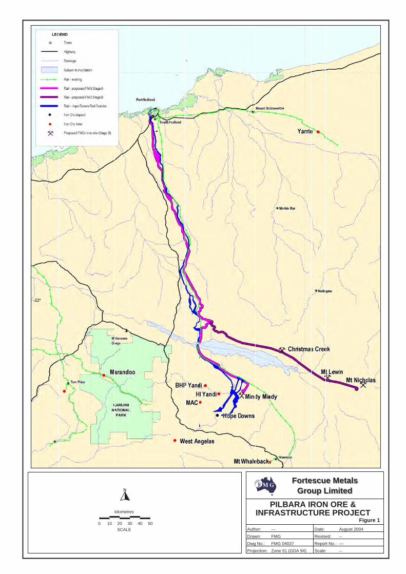
N
Fortescue MetalsGroup Limited
Fortescue MetalsGroup Limited
Author:
Drawn:
Dwg No.:
Projection:
Date:
Revised:
Report No.:
Scale:
PILBARA IRON ORE &INFRASTRUCTURE PROJECT
FMG 04037
Zone 51 (GDA 94)
Figure 10 10 20 30 40 50
kilometres
SCALE
--
--
FMG
---
---
August 2004
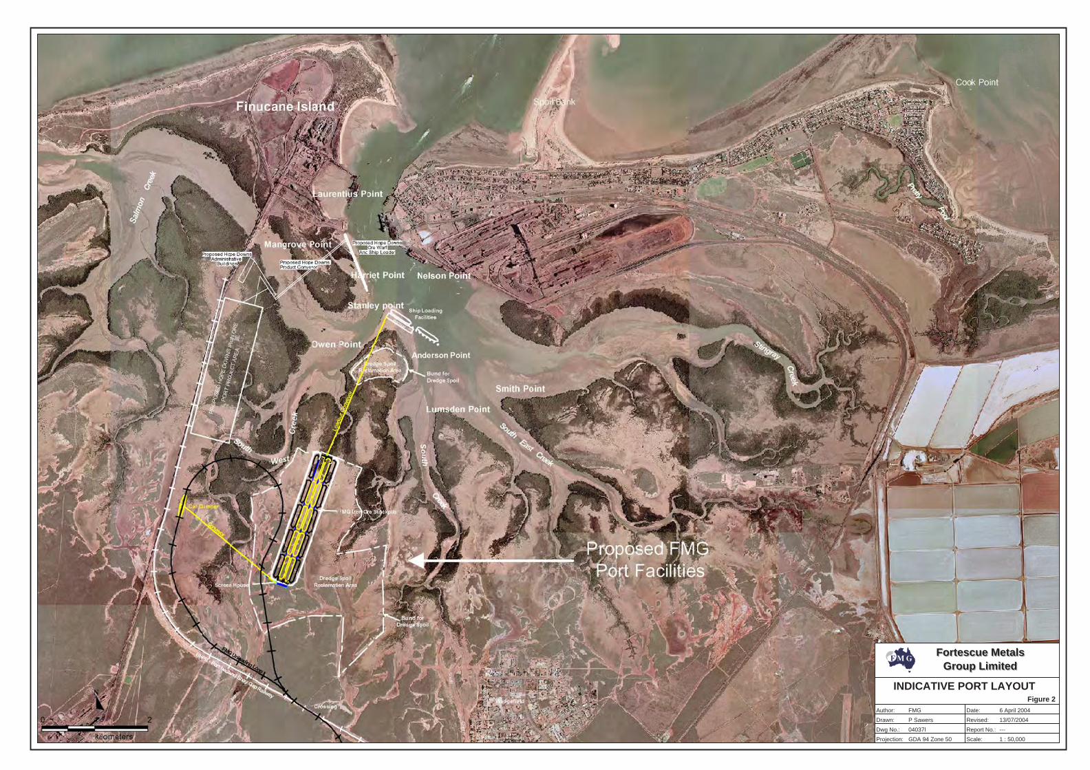
Fortescue MetalsGroup Limited
Fortescue MetalsGroup Limited
Author:
Drawn:
Dwg No.:
Projection:
Date:
Revised:
Report No.:
Scale:
FMG
---
INDICATIVE PORT LAYOUTFigure 2
1 : 50,000
P Sawers
GDA 94 Zone 50
6 April 2004
13/07/2004
04037l
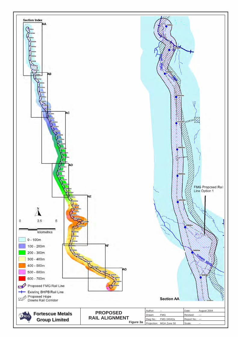
Fortescue MetalsGroup Limited
Fortescue MetalsGroup Limited
Author:
Drawn:
Dwg No.:
Projection:
Date:
Revised:
Report No.:
Scale:
---
---
MGA Zone 50
PROPOSEDRAIL ALIGNMENT
Figure 3aFMG 04042a
--
--
FMG
August 2004
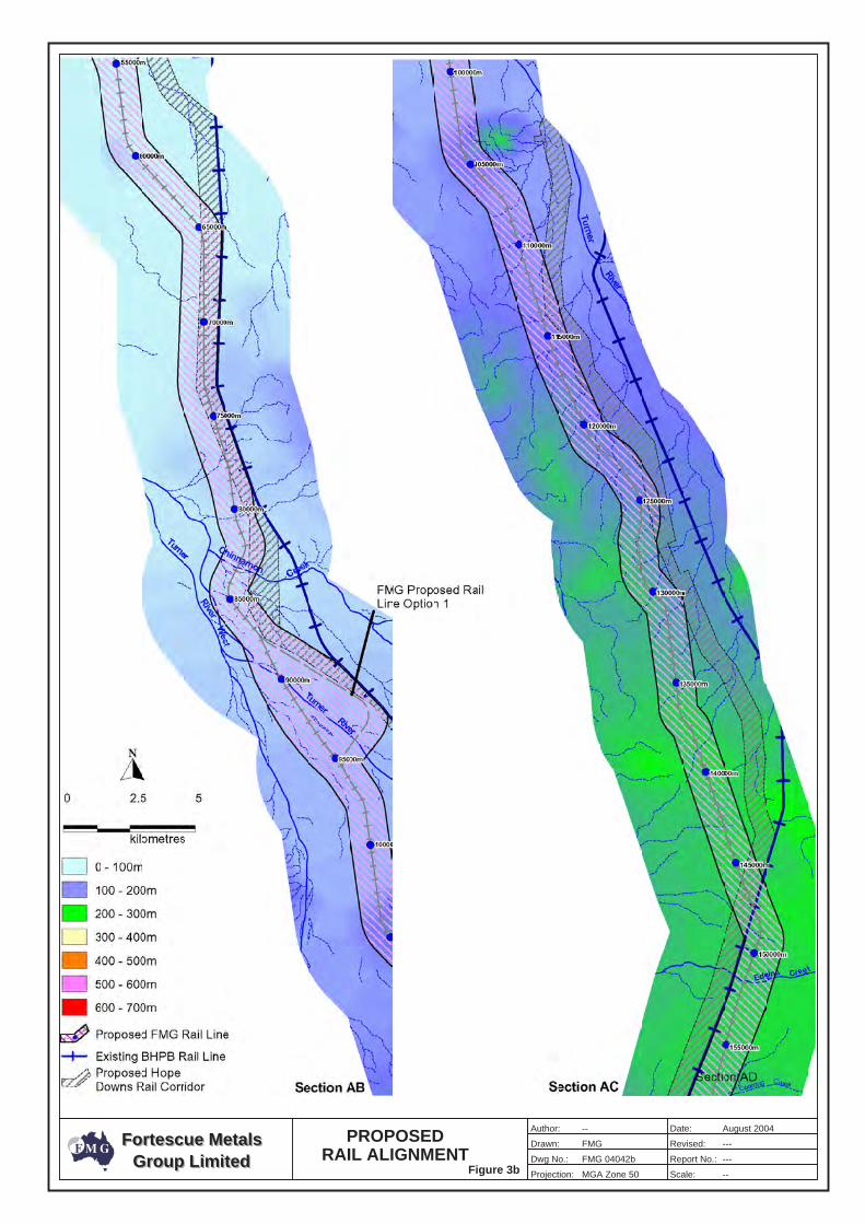
Fortescue MetalsGroup Limited
Fortescue MetalsGroup Limited
Author:
Drawn:
Dwg No.:
Projection:
Date:
Revised:
Report No.:
Scale:
---
---
MGA Zone 50
PROPOSEDRAIL ALIGNMENT
Figure 3bFMG 04042b
--
--
FMG
August 2004
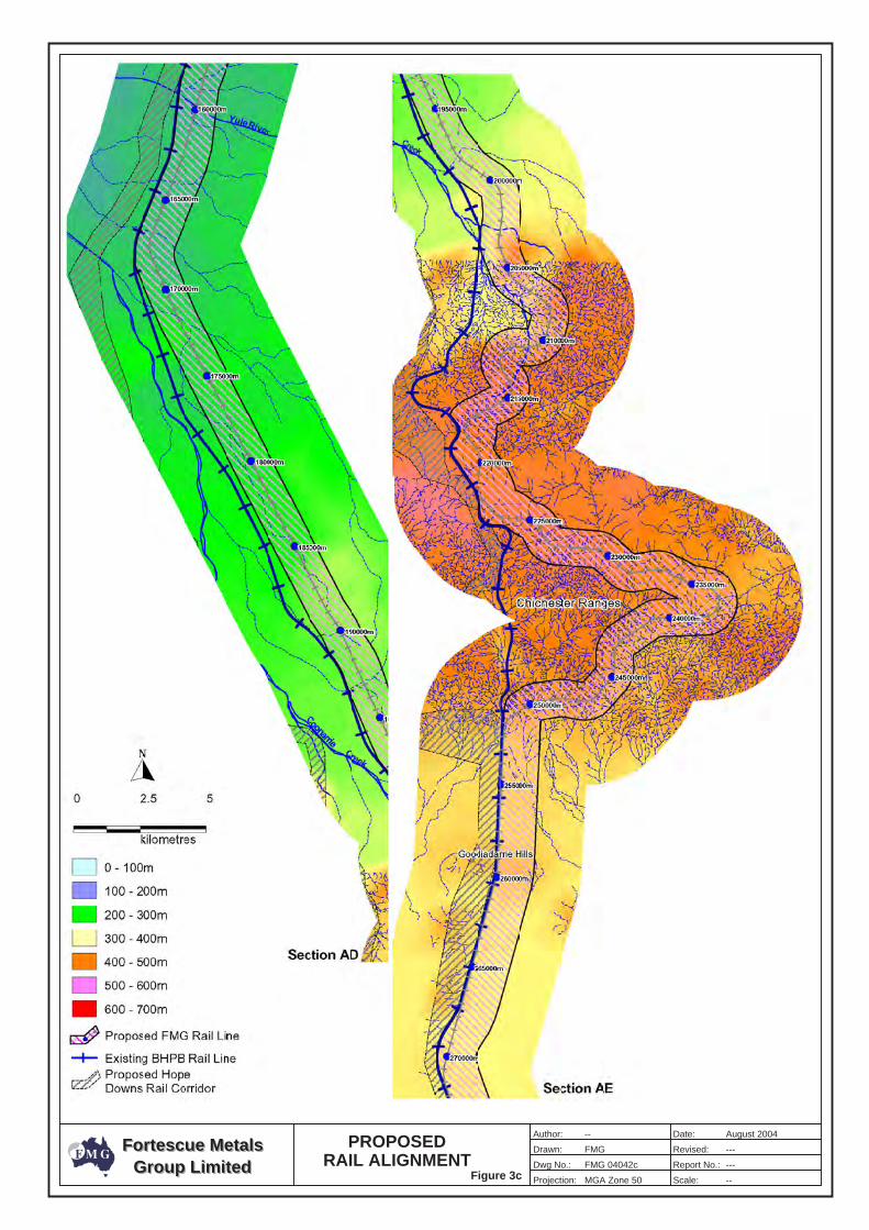
Fortescue MetalsGroup Limited
Fortescue MetalsGroup Limited
Author:
Drawn:
Dwg No.:
Projection:
Date:
Revised:
Report No.:
Scale:
---
---
MGA Zone 50
PROPOSEDRAIL ALIGNMENT
Figure 3cFMG 04042c
--
--
FMG
August 2004
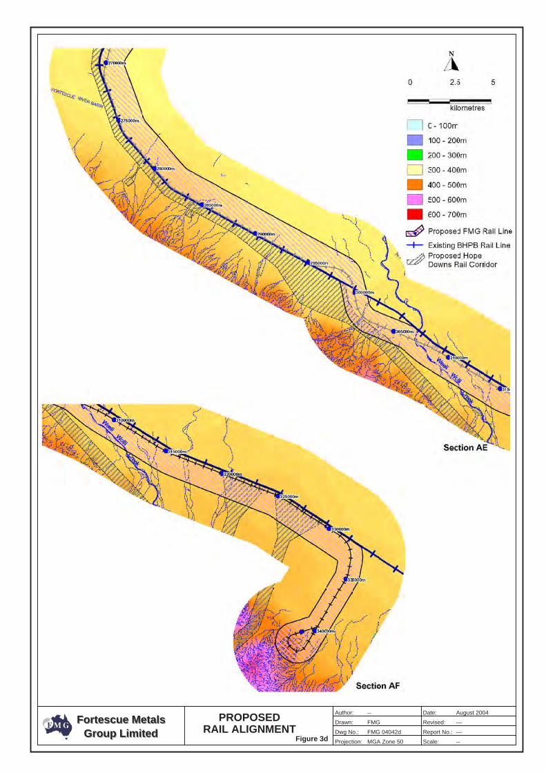
Fortescue MetalsGroup Limited
Fortescue MetalsGroup Limited
Author:
Drawn:
Dwg No.:
Projection:
Date:
Revised:
Report No.:
Scale:
---
---
MGA Zone 50
PROPOSEDRAIL ALIGNMENT
Figure 3dFMG 04042d
--
--
FMG
August 2004
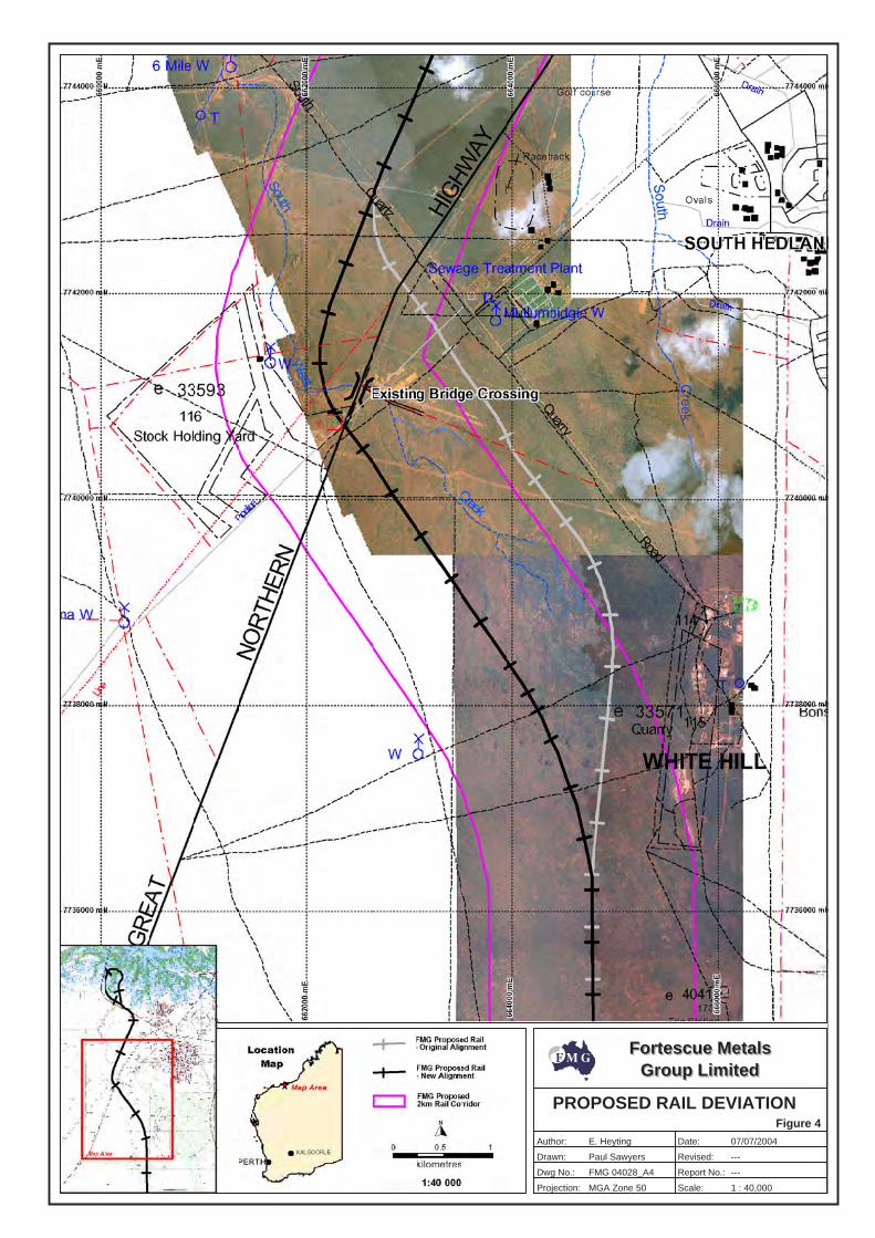
Fortescue MetalsGroup Limited
Fortescue MetalsGroup Limited
Author:
Drawn:
Dwg No.:
Projection:
Date:
Revised:
Report No.:
Scale:
---
---
Figure 4
E. Heyting
Paul Sawyers
FMG 04028_A4
MGA Zone 50
07/07/2004
1 : 40,000
PROPOSED RAIL DEVIATION
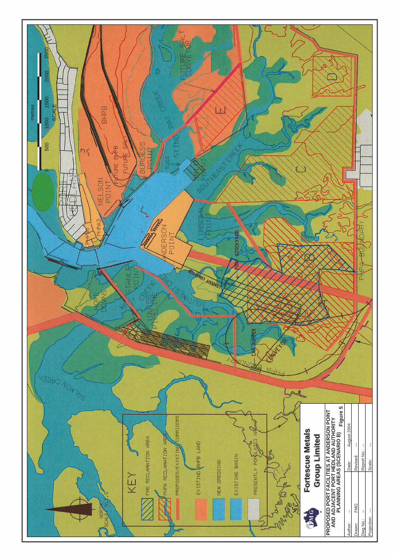
Fig
ure
5
Fo
rtes
cue
Met
als
Gro
up
Lim
ited
Fo
rtes
cue
Met
als
Gro
up
Lim
ited
Aut
hor:
Dra
wn:
Dw
g N
o.:
Pro
ject
ion:
Dat
e:
Rev
ised
:
Rep
ort N
o.:
Sca
le:
---
---
---
-- ----
PR
OP
OS
ED
PO
RT
FAC
ILIT
IES
AT
AN
DE
RS
ON
PO
INT
AN
D A
DJA
CE
NT
PO
RT
HE
DLA
ND
AU
THO
RIT
YP
LAN
NIN
G A
RE
AS
(SC
EN
AR
IO B
)
FM
G
Aug
ust 2
004
0
met
res
SC
ALE
500
1000
1500
2000
2500
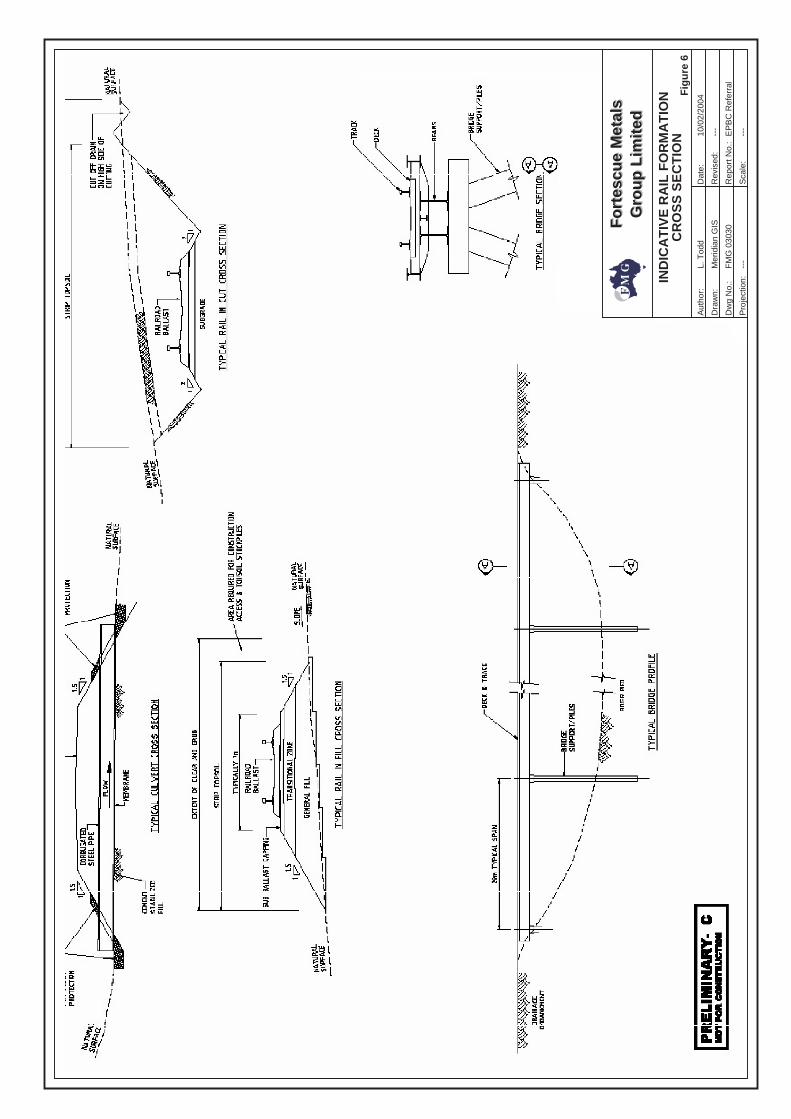
Fo
rtes
cue
Met
als
Gro
up
Lim
ited
Fo
rtes
cue
Met
als
Gro
up
Lim
ited
Aut
hor:
Dra
wn:
Dw
g N
o.:
Pro
ject
ion:
Dat
e:
Rev
ised
:
Rep
ort N
o.:
Sca
le:
---
---
---
Fig
ure
6
IND
ICA
TIV
E R
AIL
FO
RM
AT
ION
CR
OS
S S
EC
TIO
N
Mer
idia
n G
IS
FM
G 0
3030
10/0
2/20
04
EP
BC
Ref
erra
l
L. T
odd
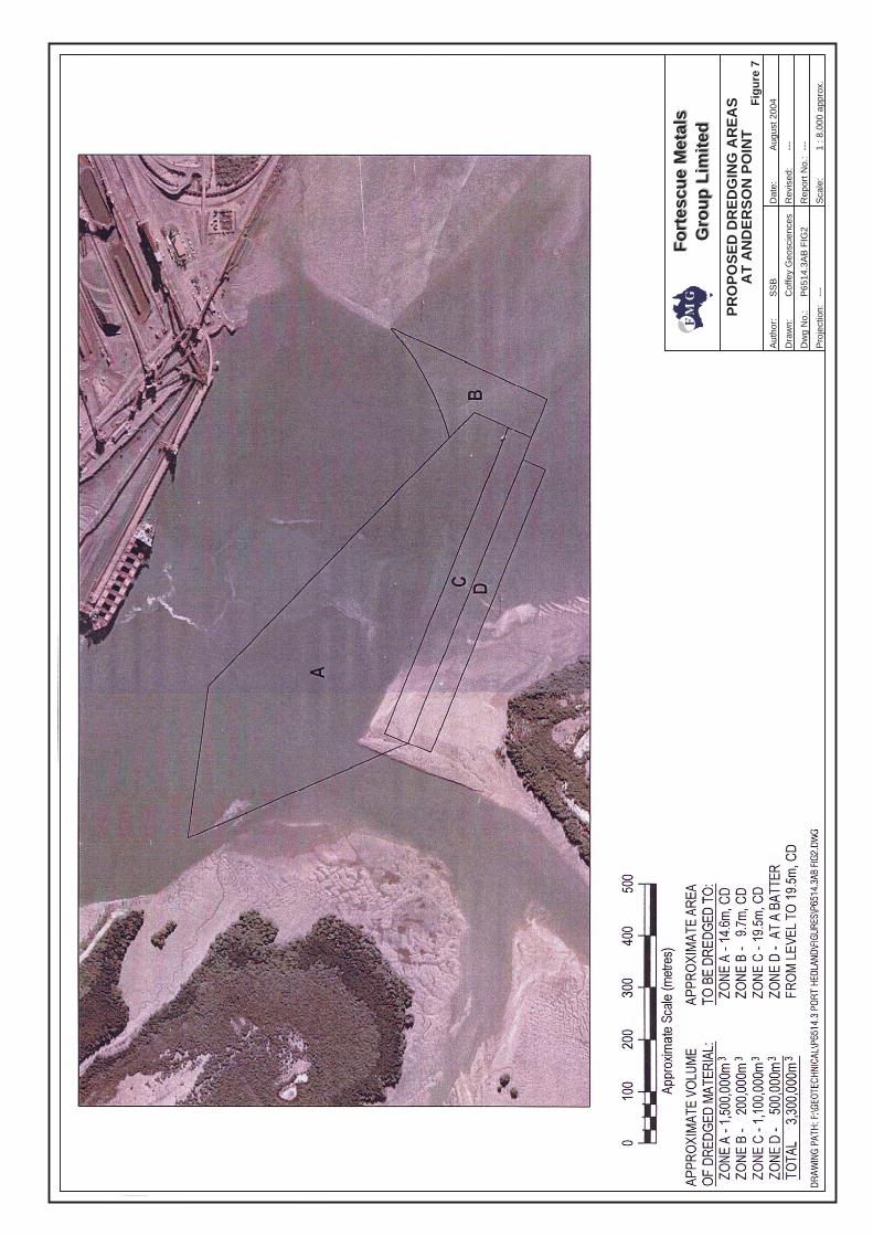
Fo
rtes
cue
Met
als
Gro
up
Lim
ited
Fo
rtes
cue
Met
als
Gro
up
Lim
ited
Aut
hor:
Dra
wn:
Dw
g N
o.:
Pro
ject
ion:
Dat
e:
Rev
ised
:
Rep
ort N
o.:
Sca
le:
SS
B
---
---
---
1 : 8
,000
app
rox.
Cof
fey
Geo
scie
nces
P65
14.3
AB
FIG
2
Fig
ure
7
PR
OP
OS
ED
DR
ED
GIN
G A
RE
AS
AT
AN
DE
RS
ON
PO
INT
Aug
ust 2
004
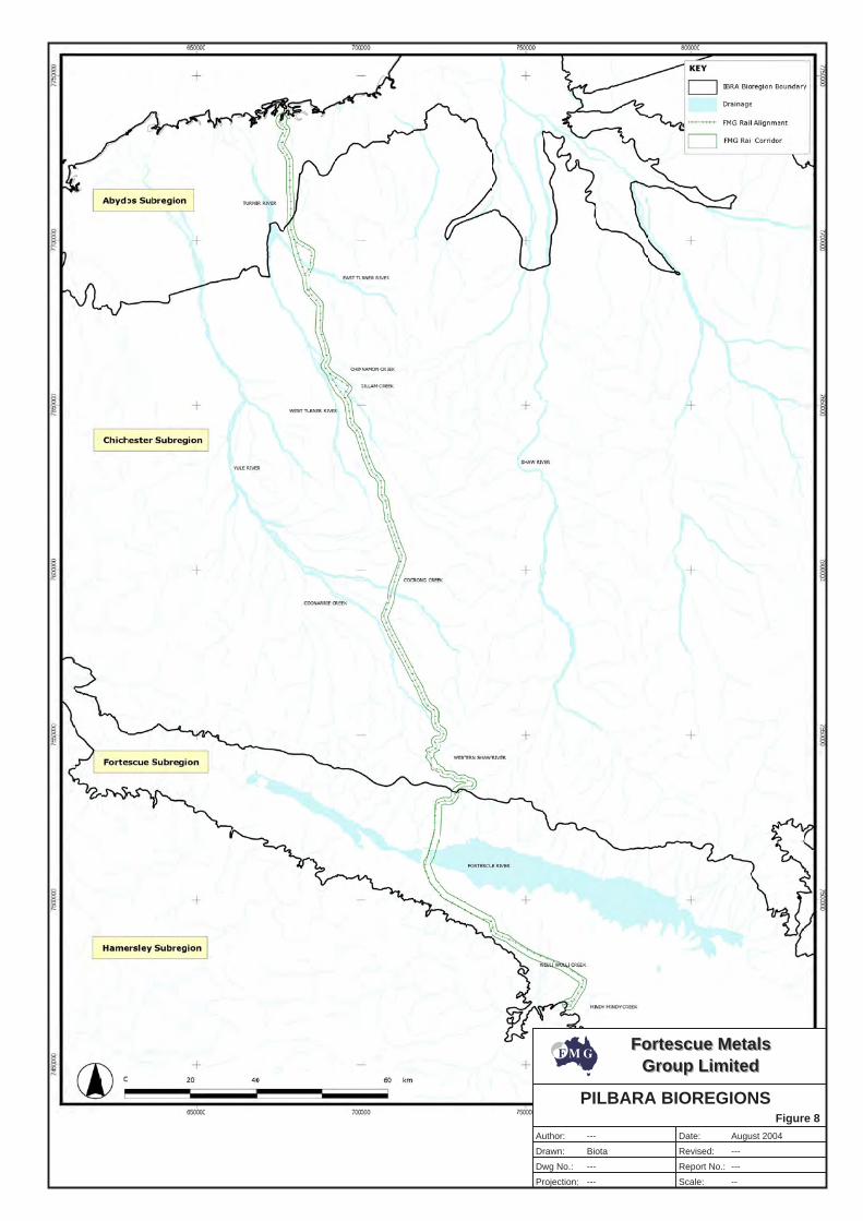
Fortescue MetalsGroup Limited
Fortescue MetalsGroup Limited
Author:
Drawn:
Dwg No.:
Projection:
Date:
Revised:
Report No.:
Scale:
---
---
---
---
---
Biota
Figure 8
--
PILBARA BIOREGIONS
August 2004
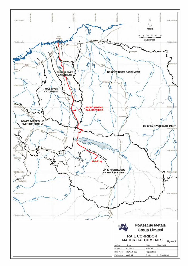
Fortescue MetalsGroup Limited
Fortescue MetalsGroup Limited
Author:
Drawn:
Dwg No.:
Projection:
Date:
Revised:
Report No.:
Scale:
---
---
Figure 9
I. Rea
Aquaterra
495AA3_002
MGA 94
May 2004
1 : 2,000,000
RAIL CORRIDORMAJOR CATCHMENTS
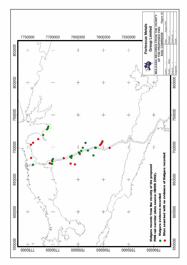
Fo
rtes
cue
Met
als
Gro
up
Lim
ited
Fo
rtes
cue
Met
als
Gro
up
Lim
ited
Aut
hor:
Dra
wn:
Dw
g N
o.:
Pro
ject
ion:
Dat
e:
Rev
ised
:
Rep
ort N
o.:
Sca
le:
---
---
---
---
---
Bio
ta
--
MU
LG
AR
A R
EC
OR
DS
FR
OM
TH
E V
ICIN
ITY
OF
TH
E P
RO
PO
SE
D F
MG
RA
IL C
OR
RID
OR
Fig
ure
10
Aug
ust 2
004
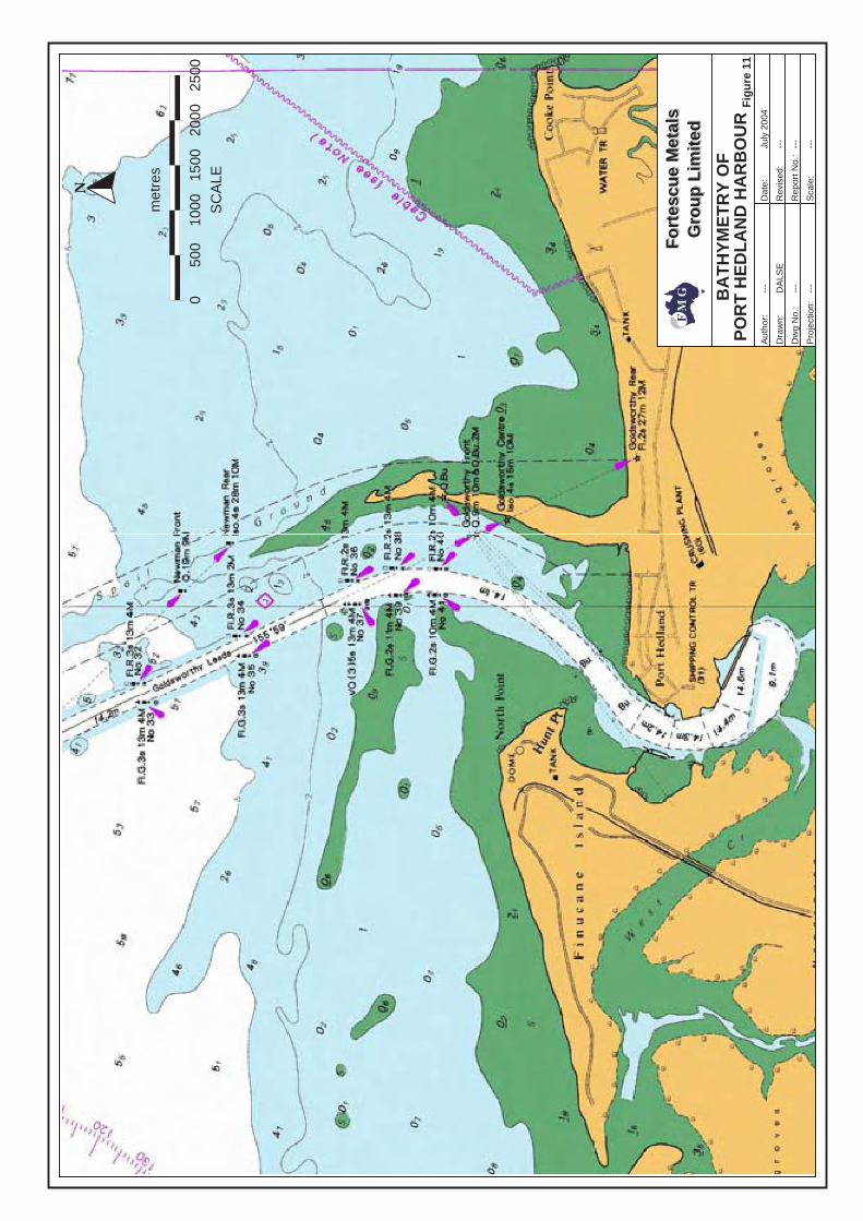
Fo
rtes
cue
Met
als
Gro
up
Lim
ited
Fo
rtes
cue
Met
als
Gro
up
Lim
ited
Aut
hor:
Dra
wn:
Dw
g N
o.:
Pro
ject
ion:
Dat
e:
Rev
ised
:
Rep
ort N
o.:
Sca
le:
---
---
---
---
---
---
BA
TH
YM
ET
RY
OF
PO
RT
HE
DL
AN
D H
AR
BO
UR
Fig
ure
11
DA
LSE
July
200
4
N
0S
CA
LE50
010
0015
0020
0025
00
met
res
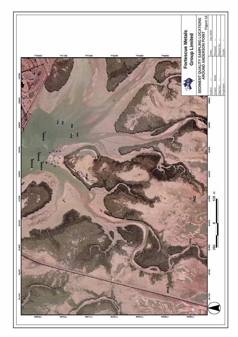
Fo
rtes
cue
Met
als
Gro
up
Lim
ited
Fo
rtes
cue
Met
als
Gro
up
Lim
ited
Aut
hor:
Dra
wn:
Dw
g N
o.:
Pro
ject
ion:
Dat
e:
Rev
ised
:
Rep
ort N
o.:
Sca
le:
---
---
---
---
---
Bio
ta
--
Fig
ure
12
SE
DIM
EN
T Q
UA
LITY
SA
MP
LIN
G L
OC
ATI
ON
SA
RO
UN
D A
ND
ER
SO
N P
OIN
T
July
200
4
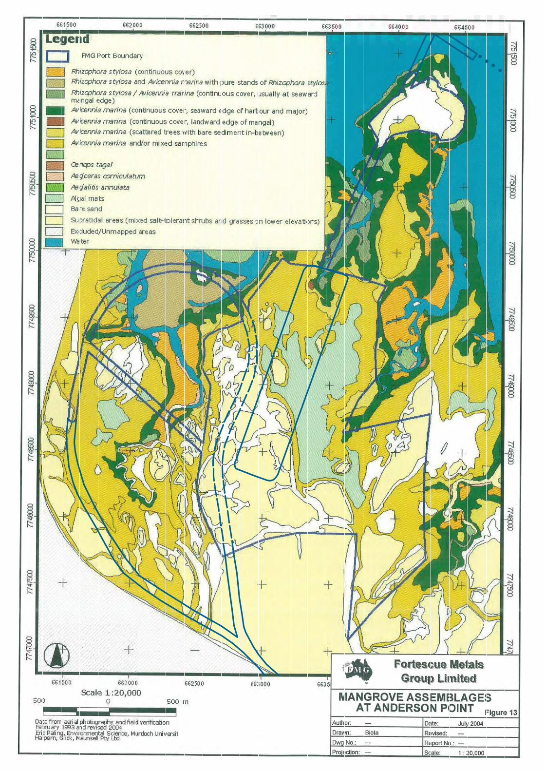
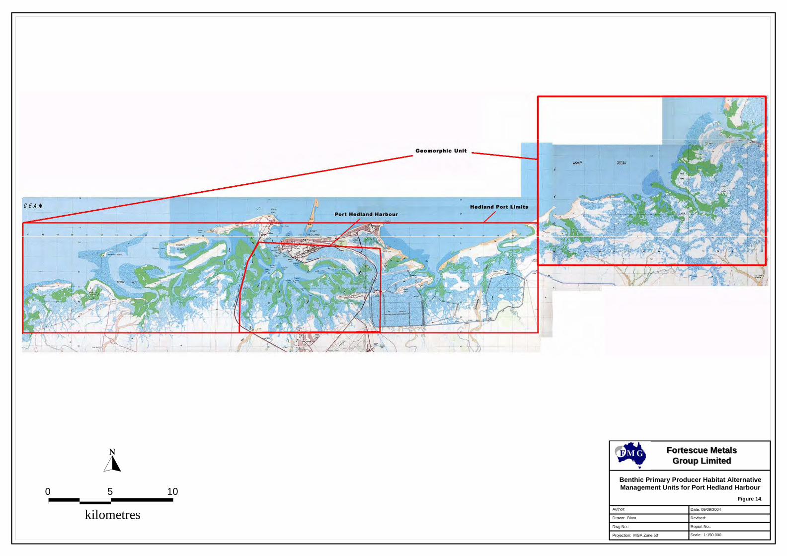
Benthic Primary Producer Habitat AlternativeManagement Units for Port Hedland Harbour
Author:
Report No.:
Projection: MGA Zone 50
Revised:
Dwg No.:
Drawn: Biota
Scale: 1:150 000
Date: 09/09/2004
Fortescue MetalsFortescue MetalsGroup LimitedGroup Limited
Figure 14.
kilometres
100 5
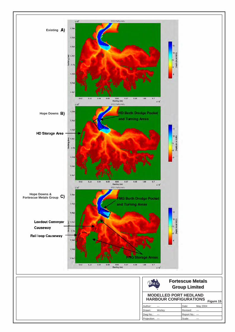
Fortescue MetalsGroup Limited
Fortescue MetalsGroup Limited
Author:
Drawn:
Dwg No.:
Projection:
Date:
Revised:
Report No.:
Scale:
---
---
---
---
---
---
MODELLED PORT HEDLANDHARBOUR CONFIGURATIONS Figure 15
Existing
Hope Downs
Hope Downs &Fortescue Metals Group
Worley
May 2004
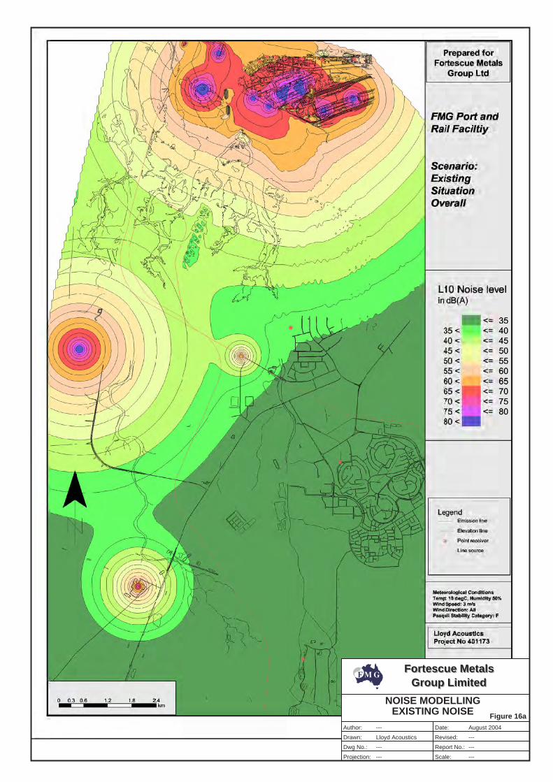
Fortescue MetalsGroup Limited
Fortescue MetalsGroup Limited
Author:
Drawn:
Dwg No.:
Projection:
Date:
Revised:
Report No.:
Scale:
---
---
---
---
---
---
Figure 16a
NOISE MODELLINGEXISTING NOISE
Lloyd Acoustics
August 2004
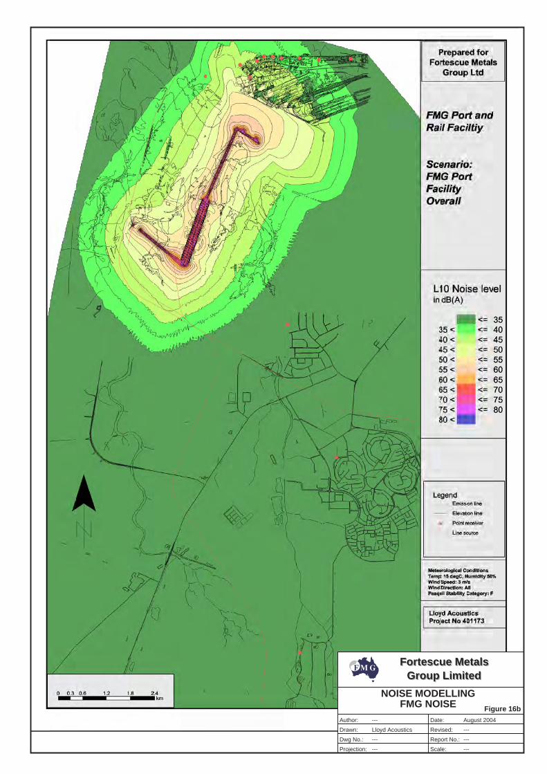
Fortescue MetalsGroup Limited
Fortescue MetalsGroup Limited
Author:
Drawn:
Dwg No.:
Projection:
Date:
Revised:
Report No.:
Scale:
---
---
---
---
---
---
Figure 16b
Lloyd Acoustics
NOISE MODELLINGFMG NOISE
August 2004
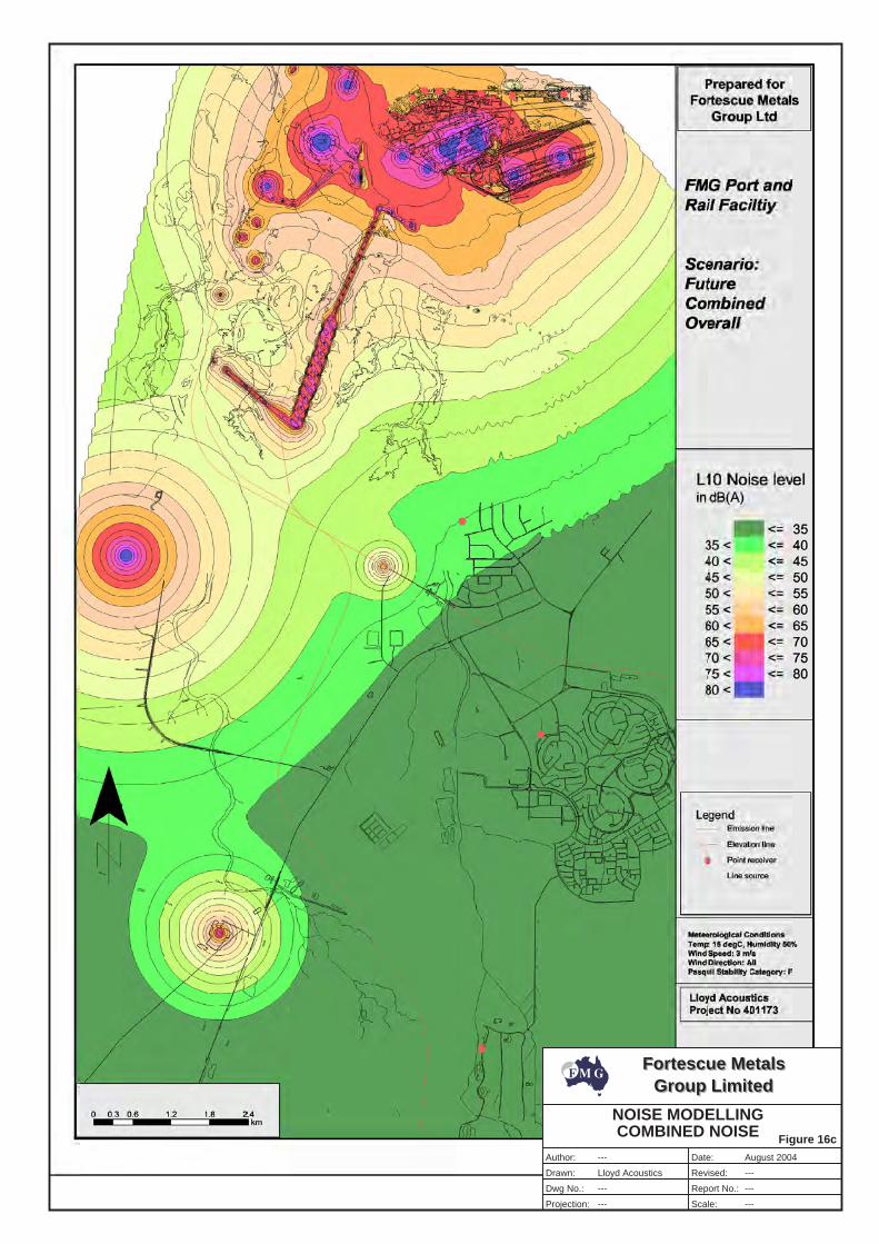
Fortescue MetalsGroup Limited
Fortescue MetalsGroup Limited
Author:
Drawn:
Dwg No.:
Projection:
Date:
Revised:
Report No.:
Scale:
---
---
---
---
---
---
Figure 16c
NOISE MODELLINGCOMBINED NOISE
Lloyd Acoustics
August 2004
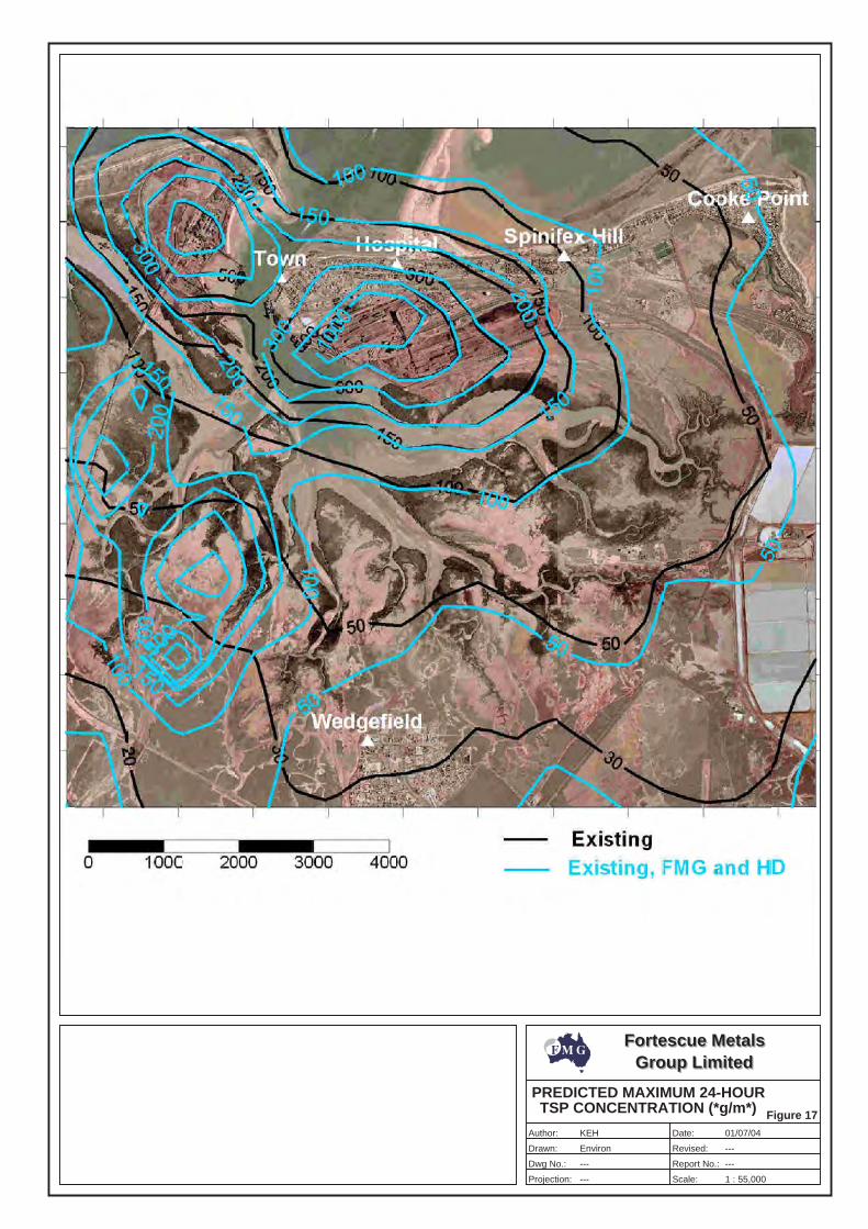
Fortescue MetalsGroup Limited
Fortescue MetalsGroup Limited
Author:
Drawn:
Dwg No.:
Projection:
Date:
Revised:
Report No.:
Scale:
KEH
---
---
---
---
Figure 17
PREDICTED MAXIMUM 24-HOURTSP CONCENTRATION (*g/m*)
Environ
01/07/04
1 : 55,000
Appendix A
Pilbara Iron Ore and Infrastructure Project: Stage A Port and North-South Rail Scoping Document
(Refer to CD with Technical Appendices)

(This page has been left blank intentionally)
Appendix B
Correspondence from Federal Department of Environment and Heritage

(This page has been left blank intentionally)
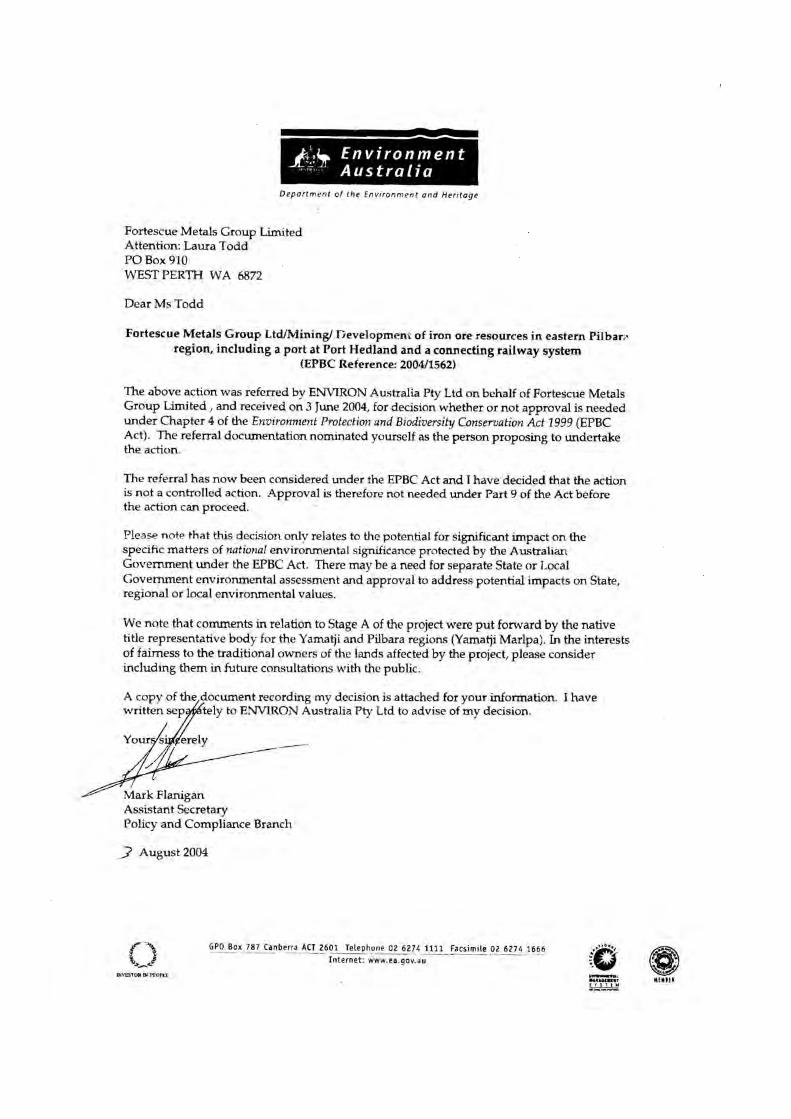
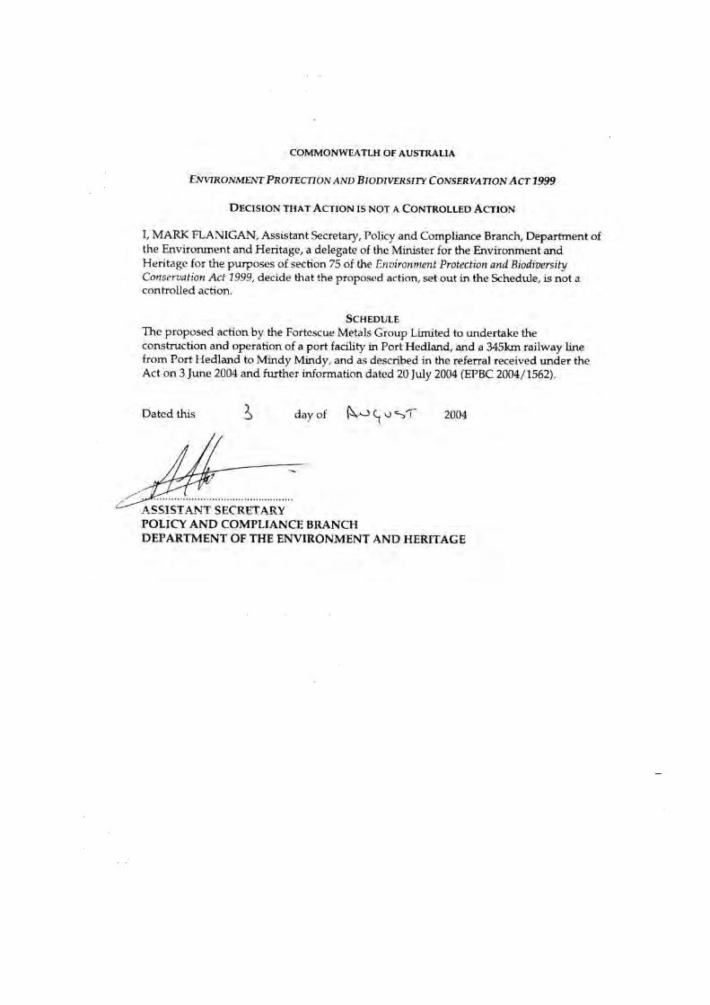
Appendix C
Stakeholder Consultation undertaken for the Pilbara Iron Ore and Infrastructure Project

(This page has been left blank intentionally)
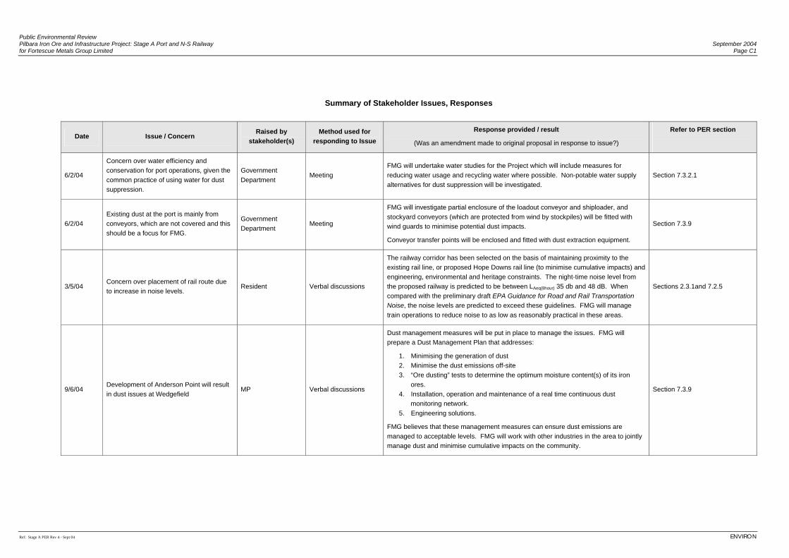
Public Environmental Review Pilbara Iron Ore and Infrastructure Project: Stage A Port and N-S Railway September 2004 for Fortescue Metals Group Limited Page C1
Ref: Stage A PER Rev 4 - Sept 04 ENVIRON
Summary of Stakeholder Issues, Responses
Date Issue / Concern Raised by
stakeholder(s) Method used for
responding to Issue
Response provided / result
(Was an amendment made to original proposal in response to issue?)
Refer to PER section
6/2/04
Concern over water efficiency and conservation for port operations, given the common practice of using water for dust suppression.
Government Department
Meeting FMG will undertake water studies for the Project which will include measures for reducing water usage and recycling water where possible. Non-potable water supply alternatives for dust suppression will be investigated.
Section 7.3.2.1
6/2/04 Existing dust at the port is mainly from conveyors, which are not covered and this should be a focus for FMG.
Government Department
Meeting
FMG will investigate partial enclosure of the loadout conveyor and shiploader, and stockyard conveyors (which are protected from wind by stockpiles) will be fitted with wind guards to minimise potential dust impacts.
Conveyor transfer points will be enclosed and fitted with dust extraction equipment.
Section 7.3.9
3/5/04 Concern over placement of rail route due to increase in noise levels.
Resident Verbal discussions
The railway corridor has been selected on the basis of maintaining proximity to the existing rail line, or proposed Hope Downs rail line (to minimise cumulative impacts) and engineering, environmental and heritage constraints. The night-time noise level from the proposed railway is predicted to be between LAeq(8hour) 35 db and 48 dB. When compared with the preliminary draft EPA Guidance for Road and Rail Transportation Noise, the noise levels are predicted to exceed these guidelines. FMG will manage train operations to reduce noise to as low as reasonably practical in these areas.
Sections 2.3.1and 7.2.5
9/6/04 Development of Anderson Point will result in dust issues at Wedgefield
MP Verbal discussions
Dust management measures will be put in place to manage the issues. FMG will prepare a Dust Management Plan that addresses:
1. Minimising the generation of dust 2. Minimise the dust emissions off-site 3. “Ore dusting” tests to determine the optimum moisture content(s) of its iron
ores. 4. Installation, operation and maintenance of a real time continuous dust
monitoring network. 5. Engineering solutions.
FMG believes that these management measures can ensure dust emissions are managed to acceptable levels. FMG will work with other industries in the area to jointly manage dust and minimise cumulative impacts on the community.
Section 7.3.9
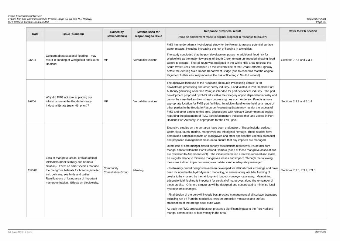
Public Environmental Review Pilbara Iron Ore and Infrastructure Project: Stage A Port and N-S Railway September 2004 for Fortescue Metals Group Limited Page C2
Ref: Stage A PER Rev 4 - Sept 04 ENVIRON
Date Issue / Concern Raised by
stakeholder(s) Method used for
responding to Issue
Response provided / result
(Was an amendment made to original proposal in response to issue?)
Refer to PER section
9/6/04 Concern about seasonal flooding – may result in flooding of Wedgefield and South Hedland
MP Verbal discussions
FMG has undertaken a hydrological study for the Project to assess potential surface water impacts, including increasing the risk of flooding in townships.
The study concluded that the port development poses no additional flood risk for Wedgefield as the major flow areas of South Creek remain un-impeded allowing flood waters to escape. The rail route was realigned in the White Hills area, to cross the South West Creek and continue up the western side of the Great Northern Highway before the existing Main Roads Department Bridge (due to concerns that the original alignment further east may increase the risk of flooding in South Hedland).
Sections 7.2.1 and 7.3.1
9/6/04 Why did FMG not look at placing our infrastructure at the Boodarie Heavy Industrial Estate (near HBI plant)?
MP Verbal discussions
The approved land use of the “Boodarie Resource Processing Estate” is for downstream processing and other heavy industry. Land vested in Port Hedland Port Authority (including Anderson Point) is intended for port dependent industry. The port development proposed by FMG falls within the category of port dependent industry and cannot be classified as downstream processing. As such Anderson Point is a more appropriate location for FMG port facilities. In addition land tenure held by a range of other parties in the Boodarie Resource Processing Estate may restrict the access of FMG and other parties to this area. Discussions with relevant Government agencies regarding the placement of FMG port infrastructure indicated that land vested in Port Hedland Port Authority is appropriate for the FMG port.
Sections 2.3.2 and 3.1.4
15/6/04
Loss of mangrove areas, erosion of tidal inlets/flats (bank stability and harbour siltation). Effect on other species that use the mangrove habitats for breeding/shelter, incl. pelicans, sea birds and turtles. Ramifications of losing area of important mangrove habitat. Effects on biodiversity.
Community Consultation Group
Meeting
Extensive studies on the port area have been undertaken. These include: surface water, flora, fauna, marine, mangroves and Aboriginal heritage. These studies have determined potential impacts on mangroves and other species that use this as habitat and proposed management measure to ensure that any impacts are managed.
Direct loss of core mangal closed canopy associations represents 2% of total core mangal habitat within the Port Hedland Harbour (none of these mangrove associations are restricted to Anderson Point). The initial reclamation area was reduced and made an irregular shape to minimise mangroves losses and impact. Through the following measures indirect impact on mangrove habitat can be adequately managed:
- Preliminary culvert designs have been developed for all tidal creek crossings and have been included in the hydrodynamic modelling, to ensure adequate tidal flushing of creeks to be crossed by the rail loop and loadout conveyor causeway. Maintaining adequate tidal flushing is important for survival of mangroves along the remainder of these creeks. - Offshore structures will be designed and constructed to minimise local hydrodynamic changes.
- Final design of the port will include best practice management of all surface drainages including run-off from the stockpiles, erosion protection measures and surface stabilisation of the dredge spoil bund walls.
As such the FMG proposal does not present a significant impact to the Port Hedland mangal communities or biodiversity in the area.
Sections 7.3.3, 7.3.4, 7.3.5
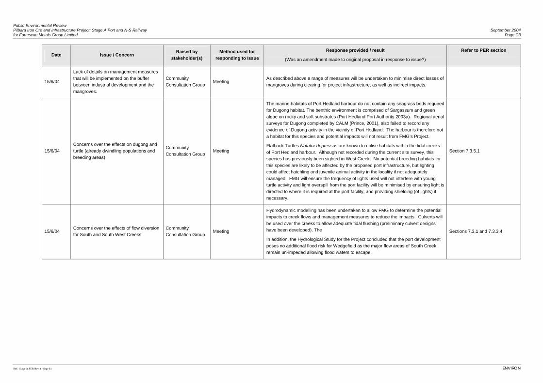
Public Environmental Review Pilbara Iron Ore and Infrastructure Project: Stage A Port and N-S Railway September 2004 for Fortescue Metals Group Limited Page C3
Ref: Stage A PER Rev 4 - Sept 04 ENVIRON
Date Issue / Concern Raised by
stakeholder(s) Method used for
responding to Issue Response provided / result
(Was an amendment made to original proposal in response to issue?)
Refer to PER section
15/6/04
Lack of details on management measures that will be implemented on the buffer between industrial development and the mangroves.
Community Consultation Group
Meeting As described above a range of measures will be undertaken to minimise direct losses of mangroves during clearing for project infrastructure, as well as indirect impacts.
15/6/04 Concerns over the effects on dugong and turtle (already dwindling populations and breeding areas)
Community Consultation Group
Meeting
The marine habitats of Port Hedland harbour do not contain any seagrass beds required for Dugong habitat. The benthic environment is comprised of Sargassum and green algae on rocky and soft substrates (Port Hedland Port Authority 2003a). Regional aerial surveys for Dugong completed by CALM (Prince, 2001), also failed to record any evidence of Dugong activity in the vicinity of Port Hedland. The harbour is therefore not a habitat for this species and potential impacts will not result from FMG’s Project.
Flatback Turtles Natator depressus are known to utilise habitats within the tidal creeks of Port Hedland harbour. Although not recorded during the current site survey, this species has previously been sighted in West Creek. No potential breeding habitats for this species are likely to be affected by the proposed port infrastructure, but lighting could affect hatchling and juvenile animal activity in the locality if not adequately managed. FMG will ensure the frequency of lights used will not interfere with young turtle activity and light overspill from the port facility will be minimised by ensuring light is directed to where it is required at the port facility, and providing shielding (of lights) if necessary.
Section 7.3.5.1
15/6/04 Concerns over the effects of flow diversion for South and South West Creeks.
Community Consultation Group
Meeting
Hydrodynamic modelling has been undertaken to allow FMG to determine the potential impacts to creek flows and management measures to reduce the impacts. Culverts will be used over the creeks to allow adequate tidal flushing (preliminary culvert designs have been developed). The
In addition, the Hydrological Study for the Project concluded that the port development poses no additional flood risk for Wedgefield as the major flow areas of South Creek remain un-impeded allowing flood waters to escape.
Sections 7.3.1 and 7.3.3.4
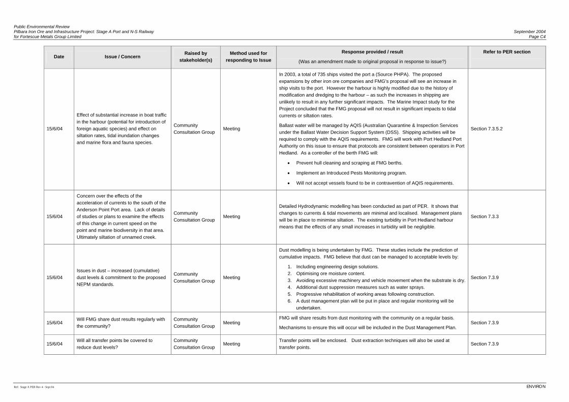
Public Environmental Review Pilbara Iron Ore and Infrastructure Project: Stage A Port and N-S Railway September 2004 for Fortescue Metals Group Limited Page C4
Ref: Stage A PER Rev 4 - Sept 04 ENVIRON
Date Issue / Concern Raised by
stakeholder(s) Method used for
responding to Issue
Response provided / result
(Was an amendment made to original proposal in response to issue?)
Refer to PER section
15/6/04
Effect of substantial increase in boat traffic in the harbour (potential for introduction of foreign aquatic species) and effect on siltation rates, tidal inundation changes and marine flora and fauna species.
Community Consultation Group
Meeting
In 2003, a total of 735 ships visited the port a (Source PHPA). The proposed expansions by other iron ore companies and FMG’s proposal will see an increase in ship visits to the port. However the harbour is highly modified due to the history of modification and dredging to the harbour – as such the increases in shipping are unlikely to result in any further significant impacts. The Marine Impact study for the Project concluded that the FMG proposal will not result in significant impacts to tidal currents or siltation rates.
Ballast water will be managed by AQIS (Australian Quarantine & Inspection Services under the Ballast Water Decision Support System (DSS). Shipping activities will be required to comply with the AQIS requirements. FMG will work with Port Hedland Port Authority on this issue to ensure that protocols are consistent between operators in Port Hedland. As a controller of the berth FMG will:
• Prevent hull cleaning and scraping at FMG berths.
• Implement an Introduced Pests Monitoring program.
• Will not accept vessels found to be in contravention of AQIS requirements.
Section 7.3.5.2
15/6/04
Concern over the effects of the acceleration of currents to the south of the Anderson Point Port area. Lack of details of studies or plans to examine the effects of this change in current speed on the point and marine biodiversity in that area. Ultimately siltation of unnamed creek.
Community Consultation Group
Meeting
Detailed Hydrodynamic modelling has been conducted as part of PER. It shows that changes to currents & tidal movements are minimal and localised. Management plans will be in place to minimise siltation. The existing turbidity in Port Hedland harbour means that the effects of any small increases in turbidity will be negligible.
Section 7.3.3
15/6/04 Issues in dust – increased (cumulative) dust levels & commitment to the proposed NEPM standards.
Community Consultation Group
Meeting
Dust modelling is being undertaken by FMG. These studies include the prediction of cumulative impacts. FMG believe that dust can be managed to acceptable levels by:
1. Including engineering design solutions. 2. Optimising ore moisture content. 3. Avoiding excessive machinery and vehicle movement when the substrate is dry. 4. Additional dust suppression measures such as water sprays. 5. Progressive rehabilitation of working areas following construction. 6. A dust management plan will be put in place and regular monitoring will be
undertaken.
Section 7.3.9
15/6/04 Will FMG share dust results regularly with the community?
Community Consultation Group
Meeting FMG will share results from dust monitoring with the community on a regular basis.
Mechanisms to ensure this will occur will be included in the Dust Management Plan. Section 7.3.9
15/6/04 Will all transfer points be covered to reduce dust levels?
Community Consultation Group
Meeting Transfer points will be enclosed. Dust extraction techniques will also be used at transfer points.
Section 7.3.9
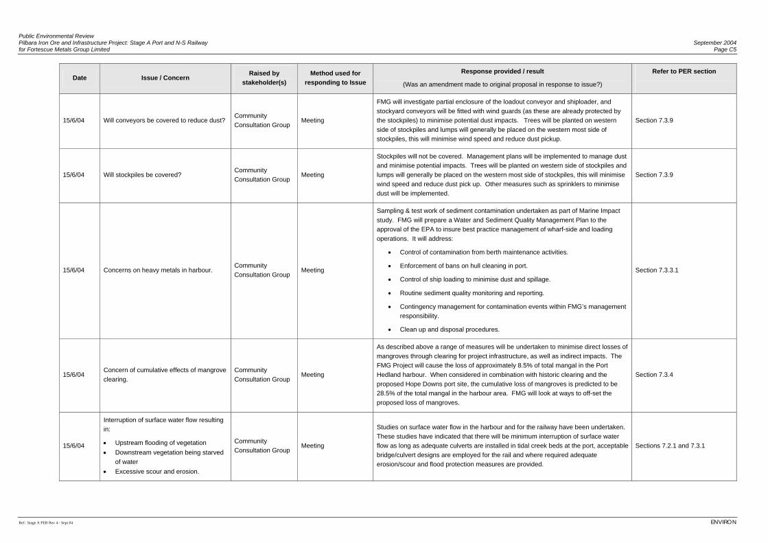
Public Environmental Review Pilbara Iron Ore and Infrastructure Project: Stage A Port and N-S Railway September 2004 for Fortescue Metals Group Limited Page C5
Ref: Stage A PER Rev 4 - Sept 04 ENVIRON
Date Issue / Concern Raised by
stakeholder(s) Method used for
responding to Issue Response provided / result
(Was an amendment made to original proposal in response to issue?)
Refer to PER section
15/6/04 Will conveyors be covered to reduce dust? Community Consultation Group
Meeting
FMG will investigate partial enclosure of the loadout conveyor and shiploader, and stockyard conveyors will be fitted with wind guards (as these are already protected by the stockpiles) to minimise potential dust impacts. Trees will be planted on western side of stockpiles and lumps will generally be placed on the western most side of stockpiles, this will minimise wind speed and reduce dust pickup.
Section 7.3.9
15/6/04 Will stockpiles be covered? Community Consultation Group
Meeting
Stockpiles will not be covered. Management plans will be implemented to manage dust and minimise potential impacts. Trees will be planted on western side of stockpiles and lumps will generally be placed on the western most side of stockpiles, this will minimise wind speed and reduce dust pick up. Other measures such as sprinklers to minimise dust will be implemented.
Section 7.3.9
15/6/04 Concerns on heavy metals in harbour. Community Consultation Group
Meeting
Sampling & test work of sediment contamination undertaken as part of Marine Impact study. FMG will prepare a Water and Sediment Quality Management Plan to the approval of the EPA to insure best practice management of wharf-side and loading operations. It will address:
• Control of contamination from berth maintenance activities.
• Enforcement of bans on hull cleaning in port.
• Control of ship loading to minimise dust and spillage.
• Routine sediment quality monitoring and reporting.
• Contingency management for contamination events within FMG’s management responsibility.
• Clean up and disposal procedures.
Section 7.3.3.1
15/6/04 Concern of cumulative effects of mangrove clearing.
Community Consultation Group
Meeting
As described above a range of measures will be undertaken to minimise direct losses of mangroves through clearing for project infrastructure, as well as indirect impacts. The FMG Project will cause the loss of approximately 8.5% of total mangal in the Port Hedland harbour. When considered in combination with historic clearing and the proposed Hope Downs port site, the cumulative loss of mangroves is predicted to be 28.5% of the total mangal in the harbour area. FMG will look at ways to off-set the proposed loss of mangroves.
Section 7.3.4
15/6/04
Interruption of surface water flow resulting in:
• Upstream flooding of vegetation • Downstream vegetation being starved
of water • Excessive scour and erosion.
Community Consultation Group
Meeting
Studies on surface water flow in the harbour and for the railway have been undertaken. These studies have indicated that there will be minimum interruption of surface water flow as long as adequate culverts are installed in tidal creek beds at the port, acceptable bridge/culvert designs are employed for the rail and where required adequate erosion/scour and flood protection measures are provided.
Sections 7.2.1 and 7.3.1
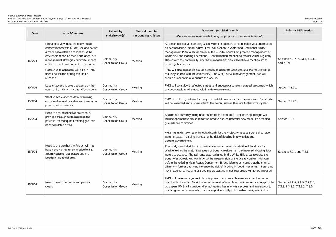
Public Environmental Review Pilbara Iron Ore and Infrastructure Project: Stage A Port and N-S Railway September 2004 for Fortescue Metals Group Limited Page C6
Ref: Stage A PER Rev 4 - Sept 04 ENVIRON
Date Issue / Concern Raised by
stakeholder(s) Method used for
responding to Issue
Response provided / result
(Was an amendment made to original proposal in response to issue?)
Refer to PER section
15/6/04
Request to view data on heavy metal concentrations within Port Hedland so that a more accountable description of the environment can be made and adequate management strategies minimise impact on the clerical environment of the harbour.
Reference to asbestos, will it be in FMG fines and will the drilling results be released.
Community Consultation Group
Meeting
As described above, sampling & test work of sediment contamination was undertaken as part of Marine Impact study. FMG will prepare a Water and Sediment Quality Management Plan to the approval of the EPA to insure best practice management of wharf-side and loading operations. Contamination monitoring results will be regularly shared with the community, and the management plan will outline a mechanism for ensuring this occurs.
FMG will also assess its ore for potential to generate asbestos and the results will be regularly shared with the community. The Air Quality/Dust Management Plan will outline a mechanism to ensure this occurs.
Sections 5.2.2, 7.3.3.1, 7.3.3.2 and 7.3.9
15/6/04 Loss of access to creek systems by the community – South & South West creeks.
Community Consultation Group
Meeting FMG will consult with affected parties and endeavour to reach agreed outcomes which are acceptable to all parties within safety constraints.
Section 7.1.7.2
15/6/04 Want to see evidence/data examining opportunities and possibilities of using non potable water sources.
Community Consultation Group
Meeting FMG is exploring options for using non potable water for dust suppression. Possibilities will be reviewed and discussed with the community as they are further investigated.
Section 7.3.2.1
15/6/04
Need to ensure effective drainage is provided throughout to minimise the potential for mosquito breeding grounds near populated areas.
Community Consultation Group
Meeting Studies are currently being undertaken for the port area. Engineering designs will include appropriate drainage for the area to ensure potential new mosquito breeding grounds are minimised.
Section 7.3.1
15/6/04
Need to ensure that the Project will not have flooding impact on Wedgefield & South Hedland rural estate and the Boodarie Industrial area.
Community Consultation Group
Meeting
FMG has undertaken a hydrological study for the Project to assess potential surface water impacts, including increasing the risk of flooding in townships and Boodarie/Wedgefield.
The study concluded that the port development poses no additional flood risk for Wedgefield as the major flow areas of South Creek remain un-impeded allowing flood waters to escape. The rail route was realigned in the White Hills area, to cross the South West Creek and continue up the western side of the Great Northern Highway before the existing Main Roads Department Bridge (due to concerns that the original alignment further east may increase the risk of flooding in South Hedland). There is no risk of additional flooding of Boodarie as existing major flow areas will not be impeded.
Sections 7.2.1 and 7.3.1
15/6/04 Need to keep the port area open and clean.
Community Consultation Group
Meeting
FMG will have management plans in place to ensure a clean environment as far as practicable, including Dust, Hydrocarbon and Waste plans. With regards to keeping the port open, FMG will consider affected parties that may wish access and endeavour to reach agreed outcomes which are acceptable to all parties within safety constraints.
Sections 4.2.8, 4.2.9, 7.1.7.2, 7.3.1, 7.3.2.2, 7.3.3.2, 7.3.6
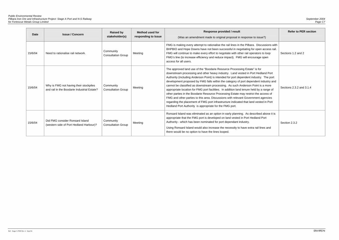
Public Environmental Review Pilbara Iron Ore and Infrastructure Project: Stage A Port and N-S Railway September 2004 for Fortescue Metals Group Limited Page C7
Ref: Stage A PER Rev 4 - Sept 04 ENVIRON
Date Issue / Concern Raised by
stakeholder(s) Method used for
responding to Issue Response provided / result
(Was an amendment made to original proposal in response to issue?)
Refer to PER section
15/6/04 Need to rationalise rail network. Community Consultation Group
Meeting
FMG is making every attempt to rationalise the rail lines in the Pilbara. Discussions with BHPBIO and Hope Downs have not been successful in negotiating for open access rail. FMG will continue to make every effort to negotiate with other rail operators to loop FMG’s line (to increase efficiency and reduce impact). FMG will encourage open access for all users.
Sections 1.2 and 2
15/6/04 Why is FMG not having their stockpiles and rail in the Boodarie Industrial Estate?
Community Consultation Group
Meeting
The approved land use of the “Boodarie Resource Processing Estate” is for downstream processing and other heavy industry. Land vested in Port Hedland Port Authority (including Anderson Point) is intended for port dependent industry. The port development proposed by FMG falls within the category of port dependent industry and cannot be classified as downstream processing. As such Anderson Point is a more appropriate location for FMG port facilities. In addition land tenure held by a range of other parties in the Boodarie Resource Processing Estate may restrict the access of FMG and other parties to this area. Discussions with relevant Government agencies regarding the placement of FMG port infrastructure indicated that land vested in Port Hedland Port Authority is appropriate for the FMG port.
Sections 2.3.2 and 3.1.4
15/6/04 Did FMG consider Ronsard Island (western side of Port Hedland Harbour)?
Community Consultation Group
Meeting
Ronsard Island was eliminated as an option in early planning. As described above it is appropriate that the FMG port is developed on land vested in Port Hedland Port Authority - which has been nominated for port dependant industry.
Using Ronsard Island would also increase the necessity to have extra rail lines and there would be no option to have the lines looped.
Section 2.3.2

Public Environmental Review Pilbara Iron Ore and Infrastructure Project: Stage A Port and N-S Railway September 2004 for Fortescue Metals Group Limited Page C8
Ref: Stage A PER Rev 4 - Sept 04 ENVIRON
Date Issue / Concern Raised by
stakeholder(s) Method used for
responding to Issue
Response provided / result
(Was an amendment made to original proposal in response to issue?)
Refer to PER section
15/6/04
Will FMG provide a dredging and reclamation Management Plan, especially managing turbidity given likelihood of limestone material and turtles and dolphins in the harbour?
Community Consultation Group
Meeting
FMG will provide a dredging and reclamation management plan for the port area which will include:
• Management of any Acid Sulphate Material (although the potential is low risk)
• Return water will be drained to settling basins and discharged appropriately (with ongoing monitoring).
• The likely extent of turbidity in the harbour (and outside) will be modelled and any potential sensitive habitats monitored.
• Photographs and records of visual impacts will be taken at regular intervals.
Regional aerial surveys by CALM (Prince 2001) recorded data on dolphin distribution. Some dolphin activity has been recorded in the harbour and a comprehensive review completed by Port Hedland Port Authority (2003a) did not recognise this as an issue. The portion of the harbour affected by the proposed FMG port is likely to be of minimal importance to dolphins at a regional scale. Any potential risks to the occasional dolphin that may enter the harbour would not be substantially altered from that associated with the existing level of shipping activity at Port Hedland.
Flatback Turtles Natator depressus are known to utilise habitats within the tidal creeks of Port Hedland harbour. Although not recorded during the current site survey, this species has previously been sighted in West Creek. No potential breeding habitats for this species are likely to be affected by the proposed port infrastructure, but lighting could affect hatchling and juvenile animal activity in the locality if not adequately managed. FMG will ensure Light overspill from the port facility will be minimised by ensuring light is directed to where it is required at the port facility, and providing shielding (of lights) if necessary, to avoid disturbance to turtle populations.
Sections 4.3.4, 7.3.1, 7.3.3, 7.3.5.1, 7.3.7.1
15/6/04 Employment of locals, apprenticeships and employment and training.
Community Consultation Group
Meeting
FMG will employ locally wherever possible. All employees will be assessed according to their skills and will need to address selection criteria and safety standards.
FMG has a corporate policy of being based in the region (eg. No-fly-in-fly-out) and will encourage development of employment skills in the community.
Section 7.1.6
15/6/04 Future planning of downstream secondary industry with and in conjunction with other exporters etc.
Community Consultation Group
Meeting FMG has no current plans to enter into downstream industry; however FMG plans to be a responsible member of the local community and will consult if there are any future plans.
n/a
15/6/04 The distance between the two rail crossings in succession on NW Highway is a safety concern.
Government Department
Correspondence & meeting
All rail crossings will be reviewed for safety requirements and will meet Australian Standards.
n/a

Public Environmental Review Pilbara Iron Ore and Infrastructure Project: Stage A Port and N-S Railway September 2004 for Fortescue Metals Group Limited Page C9
Ref: Stage A PER Rev 4 - Sept 04 ENVIRON
Date Issue / Concern Raised by
stakeholder(s) Method used for
responding to Issue Response provided / result
(Was an amendment made to original proposal in response to issue?)
Refer to PER section
15/6/04
What has been planned for the crossing where the Kulkinbar Creek and Fortescue River join and also the crossing of the rail at the Fortescue Marsh? (Crossing & drainage).
Government Department
Correspondence & meeting
All crossings will be reviewed and will meet Australian Standards. Designs will ensure that the impact on normal drainage patterns is minimised and this has been investigated as part of the Hydrology Study for the Project.
Section 7.2.1
15/6/04
Concern about the rail crossing on the Marble Bar Road as it is an unsealed road and will be a safety concern due to dust issues. It will need to be sealed at least 500 m on either side and will also need to be raised (~2% grade).
Government Department
Correspondence & meeting
All rail crossings will be reviewed for safety requirements and will meet Australian Standards.
n/a
15/6/04 Are FMG aware of new standards for rail crossings?
Government Department
Correspondence & meeting
FMG are aware of the new standards for rail crossings and will ensure all crossings meet these new Australian Standards.
n/a
15/6/04 Concern regarding camp locations, parking on road reserves and heavy vehicle movement.
Government Department
Correspondence & meeting
Details regarding our proposed camps, parking on road reserves and heavy vehicle movements during construction will be discussed and provided to the relevant government departments. A construction management plan has been prepared to manage impacts of construction and this will be supplemented with procedures, work instructions, training and audit/inspection protocols.
See Appendix E
15/6/04
Use of maintenance tracks:
Use of existing tracks? Do not want to see new access tracks beside an existing track.
Government Department
Correspondence & meeting
FMG will use existing tracks where possible to do so, subject to ensuring safety concerns are addressed and engineering/economic constraints.
n/a
15/6/04
Weeds are a concern:
• FMG should contact local Ag Dept
• declared weeds require an EMP
Government Department
Correspondence & meeting
An Environmental Information package sent to local Agricultural Department for reference and a meeting was held with representatives of this department.
FMG has assessed Introduced Flora (weeds) as part of the detailed Flora/Vegetation surveys undertaken for the Project. A Weed Management Plan will be prepared to manage declared weeds.
Sections 6.2.3.5 and 7.2.3
15/6/04 Concerns raised about acid sulphate soils. Government Department
Correspondence & meeting
The risk of Acid Sulphate Soils (ASS) is thought to be low, due to a previous study undertaken for Hope Downs. FMG also conducted a study which indicated low risk except at depth in the Mangrove Areas. It is unlikely that these area will be disturbed, however engineering detailed design requires disturbance (eg for drainage) further assessment will be undertaken.
The risk of ASS occurring in the sea-bed to be dredged is also thought to be low, however further assessment will be undertaken to confirm this prior to dredging.
If ASS potential is identified an ASS Management Plan will be prepared.
Sections 6.3.3.4 and 7.3.7
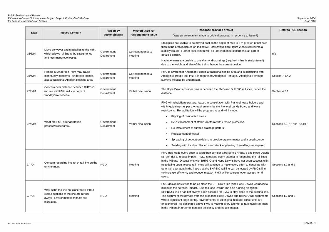
Public Environmental Review Pilbara Iron Ore and Infrastructure Project: Stage A Port and N-S Railway September 2004 for Fortescue Metals Group Limited Page C10
Ref: Stage A PER Rev 4 - Sept 04 ENVIRON
Date Issue / Concern Raised by
stakeholder(s) Method used for
responding to Issue
Response provided / result
(Was an amendment made to original proposal in response to issue?)
Refer to PER section
15/6/04 Move conveyor and stockpiles to the right, which allows rail line to be straightened and less mangrove losses.
Government Department
Correspondence & meeting
Stockpiles are unable to be moved east as the depth of mud is 3 m greater in that area than in the area indicated on Indicative Port Layout plan Figure 2 (this represents a stability issue). Further assessment will be undertaken to confirm this as part of detailed design.
Haulage trains are unable to use diamond crossings (required if line is straightened) due to the weight and size of the trains, hence the current design.
n/a
15/6/04 Fishing at Anderson Point may cause community concerns. Anderson point is also a traditional Aboriginal fishing area.
Government Department
Correspondence & meeting
FMG is aware that Anderson Point is a traditional fishing area and is consulting with Aboriginal groups and PNTS in regards to Aboriginal Heritage. Aboriginal Heritage surveys will also be undertaken.
Section 7.1.4.2
22/6/04 Concern over distance between BHPBIO rail line and FMG rail line north of Yandeyarra Reserve.
Government Department
Verbal discussion The Hope Downs corridor runs in between the FMG and BHPBIO rail lines, hence the distance.
Section 4.2.1
22/6/04 What are FMG’s rehabilitation process/procedures?
Government Department
Verbal discussion
FMG will rehabilitate pastoral leases in consultation with Pastoral lease holders and within guidelines as per the requirements by the Pastoral Lands Board and lease restrictions. Rehabilitation will be progressive and will include:
• Ripping of compacted areas.
• Re-establishment of stable landform with erosion protection.
• Re-instatement of surface drainage patters.
• Replacement of topsoil.
• Spreading of vegetation debris to provide organic matter and a seed source.
• Seeding with locally collected seed stock or planting of seedlings as required.
Sections 7.2.7.2 and 7.3.10.2
3/7/04 Concern regarding impact of rail line on the environment.
NGO Meeting
FMG has made every effort to align their corridor parallel to BHPBIO’s and Hope Downs rail corridor to reduce impact. FMG is making every attempt to rationalise the rail lines in the Pilbara. Discussions with BHPBIO and Hope Downs have not been successful in negotiating open access rail. FMG will continue to make every effort to negotiate with other rail operators in the hope that the BHPBIO rail line can be looped by FMG’s line (to increase efficiency and reduce impact). FMG will encourage open access for all users.
Sections 1.2 and 2
3/7/04
Why is the rail line not closer to BHPBIO (some sections of the line are further away). Environmental impacts are increased.
NGO Meeting
FMG design basis was to be as close the BHPBIO’s line (and Hope Downs Corridor) to minimise the potential impact. Due to Hope Downs line also running alongside BHPBIO’s line it has not always been possible for FMG to stay close to the existing line. The alignment will deviate from the proposed Hope Downs and BHPBIO rail alignments where significant engineering, environmental or Aboriginal heritage constraints are encountered. As described above FMG is making every attempt to rationalise rail lines in the Pilbara in order to increase efficiency and reduce impact.
Sections 1.2 and 2
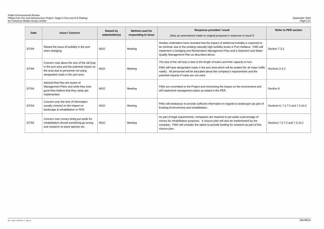
Public Environmental Review Pilbara Iron Ore and Infrastructure Project: Stage A Port and N-S Railway September 2004 for Fortescue Metals Group Limited Page C11
Ref: Stage A PER Rev 4 - Sept 04 ENVIRON
Date Issue / Concern Raised by
stakeholder(s) Method used for
responding to Issue Response provided / result
(Was an amendment made to original proposal in response to issue?)
Refer to PER section
3/7/04 Raised the issue of turbidity in the port when dredging.
NGO Meeting
Studies undertaken have revealed that the impact of additional turbidity is expected to be minimal, due to the existing naturally high turbidity levels in Port Hedland. FMG will implement a Dredging and Reclamation Management Plan and a Sediment and Water Quality Management Plan as described above.
Section 7.3.3
3/7/04
Concern rose about the size of the rail loop in the port area and the potential impact on the area due to personnel not using designated roads in the port area.
NGO Meeting
The size of the rail loop is due to the length of trains and their capacity to turn.
FMG will have designated roads in the port area which will be sealed (for all major traffic roads). All personnel will be educated about the company’s requirements and the potential impacts if roads are not used.
Sections 2.3.2
3/7/04
Advised that they are aware of Management Plans and while they look good they believe that they rarely get implemented.
NGO Meeting FMG are committed to the Project and minimising the impact on the environment and will implement management plans as stated in the PER.
Section 8
3/7/04 Concern over the lack of information usually covered on the impact on landscape & rehabilitation in PER.
NGO Meeting FMG will endeavour to provide sufficient information in regards to landscape (as part of Existing Environment) and rehabilitation.
Sections 6, 7.2.7.2 and 7.3.10.2
3/7/04 Concern over money being put aside for rehabilitation should something go wrong and research on plant species etc.
NGO Meeting
As part of legal requirements, companies are required to put aside a percentage of money for rehabilitation purposes. A closure plan will also be implemented by the company. FMG will consider the option to provide funding for research as part of this closure plan.
Sections 7.2.7.2 and 7.3.10.2

Public Environmental Review Pilbara Iron Ore and Infrastructure Project: Stage A Port and N-S Railway September 2004 for Fortescue Metals Group Limited Page C12
Ref: Stage A PER Rev 4 - Sept 04 ENVIRON
(This page has been left blank intentionally)
Appendix D
Correspondence with Stakeholders
(Water Corporation regarding Project water supply)
(Hope Downs Management Services regarding use of land within port rail loop)

(This page has been left blank intentionally)
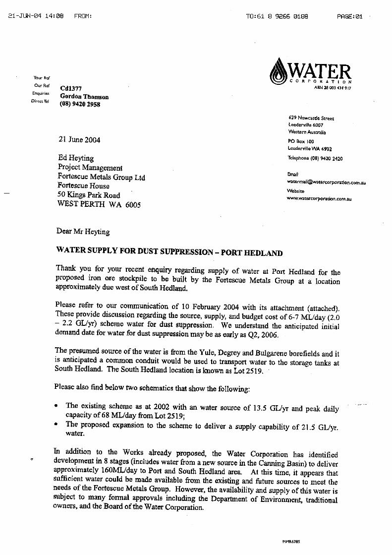
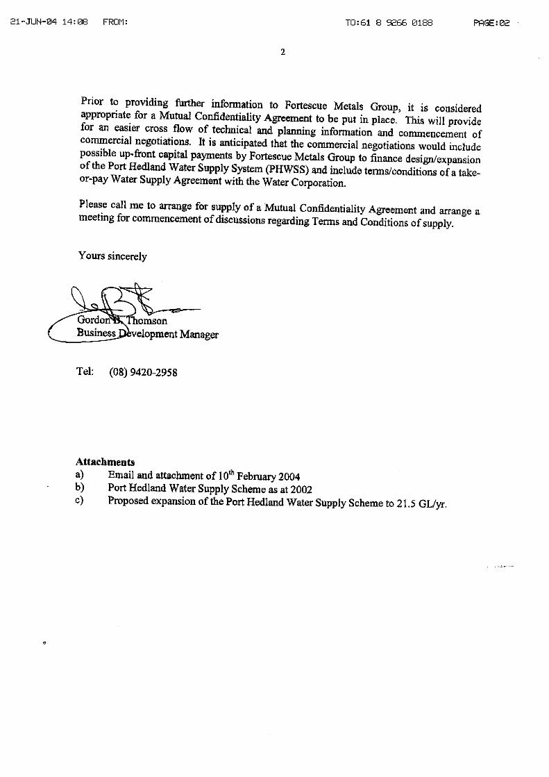

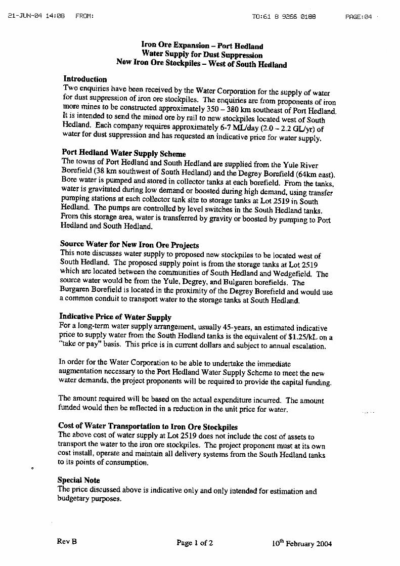
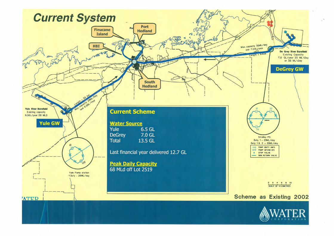
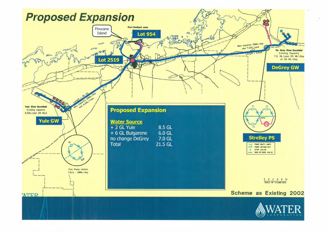
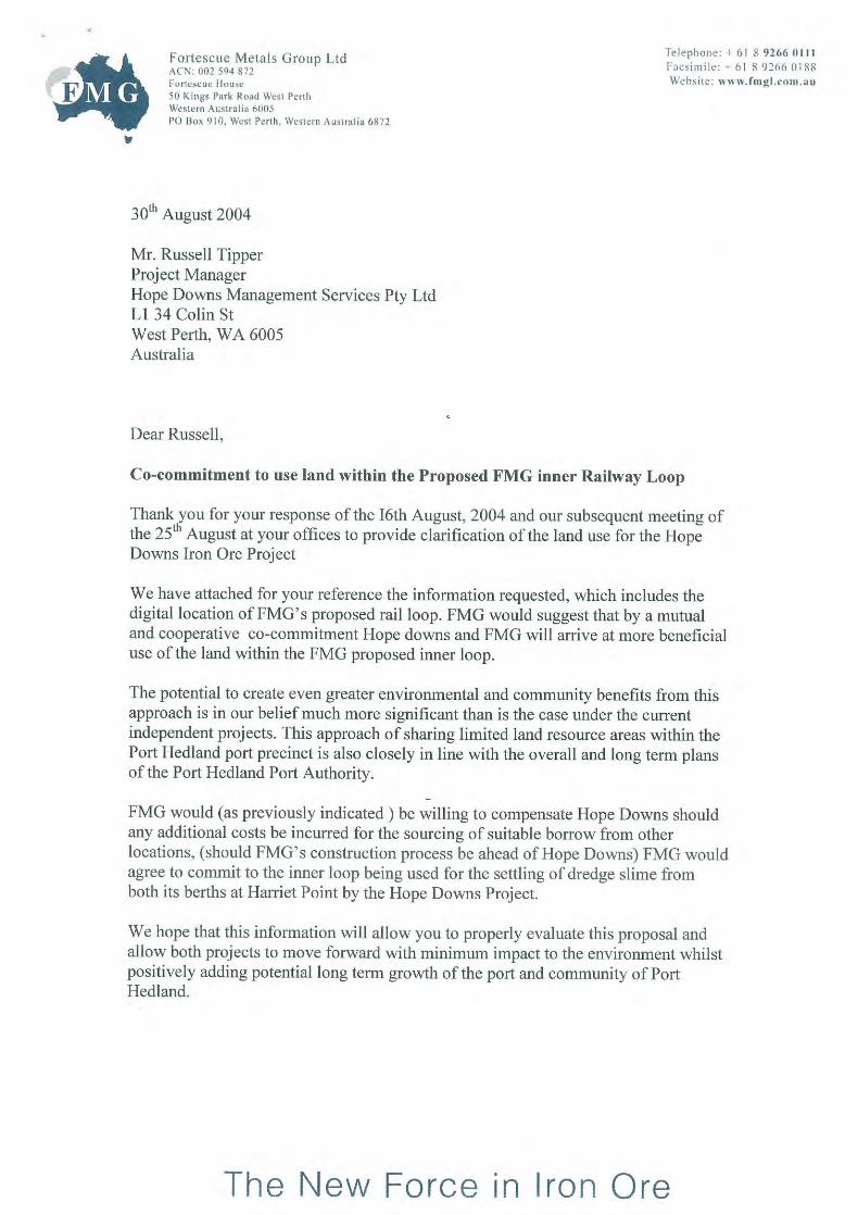
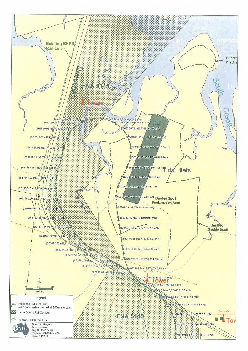

Appendix E
Draft Construction Environmental Management Plan

(This page has been left blank intentionally)
Public Environmental Review Pilbara Iron Ore and Infrastructure Project: Stage A Port and N-S Railway September 2004 for Fortescue Metals Group Limited
Ref: Stage A PER Rev 4 - Sept 04 ENVIRON
Fortescue Metals Group Ltd Pilbara Iron Ore and Infrastructure Project:
Stage A Port and North-South Railway
Environmental Management Plan (EMP) Construction Stage A
1 Introduction............................................................................................................1
1.1 Project Background.........................................................................................1 1.2 Purpose of the EMP........................................................................................1 1.3 Scope of the EMP ...........................................................................................2 1.4 Regulatory Framework....................................................................................2 1.5 Environmental Accountabilities .......................................................................4 1.6 Reporting ........................................................................................................4 1.7 Environmental Management Plan...................................................................4

Public Environmental Review September 2004 Pilbara Iron Ore and Infrastructure Project: Stage A Port and N-S Railway for Fortescue Metals Group Limited
ENVIRON Ref: Stage A PER Rev 4 - Sept 04
(This page has been left blank intentionally)
Public Environmental Review Pilbara Iron Ore and Infrastructure Project: Stage A Port and N-S Railway September 2004 for Fortescue Metals Group Limited Page E1
Ref: Stage A PER Rev 4 - Sept 04 ENVIRON
1. Introduction 1.1 Project Background Fortescue Metals Group Limited (FMG) is planning to construct a port facility at Port Hedland and a connecting railway to its proposed iron ore mining operations approximately 345 km to the southeast. The majority of the proposed railway will run parallel and in close proximity to the existing BHP Billiton Iron Ore Newman to Port Hedland railway and the proposed Hope Downs corridor. The FMG Port facility will be constructed on the western side of the Port Hedland Harbour at Anderson Point, which will be serviced by a conveyor system that will transfer iron ore from the railway via a stockyard to a new wharf and shiploader. The railway and port will be open to other users who also have undeveloped deposits in the Pilbara. The Project has been broken down into two stages for separate assessment by the State Environmental Protection Authority (EPA):
Stage A - the proposed port and rail infrastructure that is the subject of this Environmental Management Plan (EMP); and
Stage B - the development of the mining operations and connecting rail spur. The EPA has set the level of assessment as a Public Environmental Review (PER). This EMP has been developed as part of the PER process for the construction phase of Stage A. 1.2 Purpose of the EMP The EMP is a management tool that outlines environmental management strategies to ensure the Project’s environmental commitments and objectives are met. The EMP will be used over the proposed 20 month construction period. The EMP will outline:
• key environmental issues associated with construction; • management measures to minimise construction impacts; • monitoring to be undertaken during construction; • environmental accountabilities; and • legislative requirements which must be met by the Company.
Public Environmental Review September 2004 Pilbara Iron Ore and Infrastructure Project: Stage A Port and N-S Railway Page E2 for Fortescue Metals Group Limited
ENVIRON Ref: Stage A PER Rev 4 - Sept 04
1.3 Scope of the EMP This EMP addresses the environmental management for the construction of all components of the port and rail infrastructure. The main components are as follows:
• rail line; • rail line access road; • bridges and culverts along the railway alignment; • borrow pits and quarries; • temporary facilities such as construction camps; • stockyard; • car dumper; • conveyors and transfer points; • rescreening plant; • stackers; • reclaimer; • piled wharf; • offices, control room, amenities; • substations; • sidings; • administration offices and warehouses; • trip servicing facilities; • service workshops; • maintenance track and facilities; and • turnaround facilities.
1.4 Regulatory Framework The Project will be subject to regulatory control under a range of State and Commonwealth Acts. Applicable legislation includes:
• Environmental Protection Act 1986; • Environmental Protection and Biodiversity Conservation Act 1999; • Conservation and Land Management Act 1984; • Aboriginal Heritage Act 1972; • Australian Heritage Commission Act 1975; • Agriculture and Related Resources Protection Act 1976; • Bush Fires Act 1954;
Public Environmental Review Pilbara Iron Ore and Infrastructure Project: Stage A Port and N-S Railway September 2004 for Fortescue Metals Group Limited Page E3
Ref: Stage A PER Rev 4 - Sept 04 ENVIRON
• Wildlife Conservation Act 1950; • Rights in Water and Irrigation Act 1914; • Soil and Land Conservation Act 1945; • Mining Act 1978; • Health Act 1911; • Occupational Safety and Health Act 1984; • Mines Safety and Inspection Act 1994; • Explosives and Dangerous Goods Act 1961; • Dangerous Goods (Transport) Act 1998; • Land Administration (Amendments) Act 1997; • Local Government Act 1995; • Private Railways (Level Crossings) Act 1966; • Rail Safety Act 1998; • Rail Freight System Act 2000; • Town Planning & Development Act 1928; and • Western Australian Marine (Sea Dumping) Act 1981.
Commonwealth legislation likely to be relevant to the Project includes the following:
• Environmental Protection and Biodiversity Conservation Act 1999; • National Native Title Act 1993; and • Environmental Protection (Sea Dumping) Act 1981.
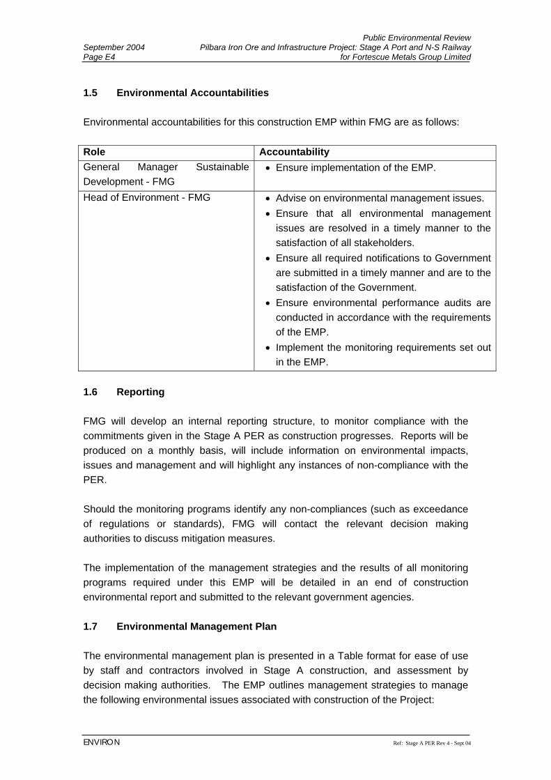
Public Environmental Review September 2004 Pilbara Iron Ore and Infrastructure Project: Stage A Port and N-S Railway Page E4 for Fortescue Metals Group Limited
ENVIRON Ref: Stage A PER Rev 4 - Sept 04
1.5 Environmental Accountabilities Environmental accountabilities for this construction EMP within FMG are as follows: Role Accountability General Manager Sustainable Development - FMG
• Ensure implementation of the EMP.
Head of Environment - FMG • Advise on environmental management issues. • Ensure that all environmental management
issues are resolved in a timely manner to the satisfaction of all stakeholders.
• Ensure all required notifications to Government are submitted in a timely manner and are to the satisfaction of the Government.
• Ensure environmental performance audits are conducted in accordance with the requirements of the EMP.
• Implement the monitoring requirements set out in the EMP.
1.6 Reporting FMG will develop an internal reporting structure, to monitor compliance with the commitments given in the Stage A PER as construction progresses. Reports will be produced on a monthly basis, will include information on environmental impacts, issues and management and will highlight any instances of non-compliance with the PER. Should the monitoring programs identify any non-compliances (such as exceedance of regulations or standards), FMG will contact the relevant decision making authorities to discuss mitigation measures. The implementation of the management strategies and the results of all monitoring programs required under this EMP will be detailed in an end of construction environmental report and submitted to the relevant government agencies. 1.7 Environmental Management Plan The environmental management plan is presented in a Table format for ease of use by staff and contractors involved in Stage A construction, and assessment by decision making authorities. The EMP outlines management strategies to manage the following environmental issues associated with construction of the Project:

Public Environmental Review Pilbara Iron Ore and Infrastructure Project: Stage A Port and N-S Railway September 2004 for Fortescue Metals Group Limited Page E5
Ref: Stage A PER Rev 4 - Sept 04 ENVIRON
• Terrestrial Flora and Vegetation Communities • Terrestrial Fauna • Water Courses and Surface Flows • Marine Biota and Water quality • Mangroves • Groundwater • Dust • Acid Sulphate Soils • Contamination • Noise emissions • Aboriginal Heritage • General Waste Management • Hazardous Waste Management • Rehabilitation of Disturbed Areas • Stygofauna • Land Clearing • Bushfires • Sewage Management • Stakeholder Liaison • Incident reporting
The EMP is broken into four key components:
• Key Issues – this identifies the key issues associated with the construction of
Stage A that require specific management strategies.
• Objectives – outlines the standard of environmental management that FMG will achieve in undertaking construction of Stage A.
• Management strategies – FMG will achieve its environmental objectives for
Stage A construction through the identified management strategies. These strategies provide clear direction to staff and contractors on how construction activities will be undertaken to avoid environmental disturbance where possible, and to manage and mitigate where avoidance is not possible.
• Monitoring – Construction of Stage A will have impacts on the environment and
FMG will monitor these impacts to ensure they are minimised and managed in accordance with both the Commitments given in the PER, and relevant legislation.
Public Environmental Review September 2004 Pilbara Iron Ore and Infrastructure Project: Stage A Port and N-S Railway Page E6 for Fortescue Metals Group Limited
ENVIRON Ref: Stage A PER Rev 4 - Sept 04
The EMP will be supplemented with the following specific documentation prior to construction:
• More detailed issue specific management plans; • Procedures and work instructions where required; • Training and awareness documentation; • Monitoring, audit and inspection protocols.
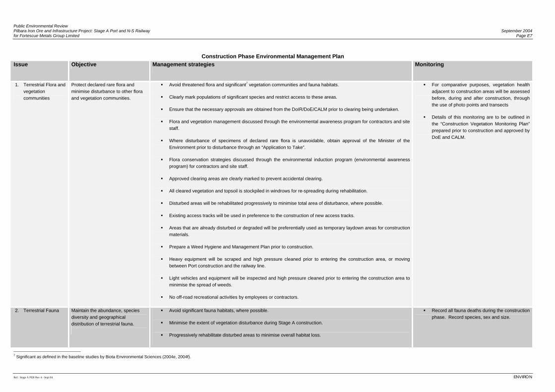
Public Environmental Review Pilbara Iron Ore and Infrastructure Project: Stage A Port and N-S Railway September 2004 for Fortescue Metals Group Limited Page E7
Ref: Stage A PER Rev 4 - Sept 04 ENVIRON
Construction Phase Environmental Management Plan
Issue Objective Management strategies Monitoring
1. Terrestrial Flora and vegetation communities
Protect declared rare flora and minimise disturbance to other flora and vegetation communities.
Avoid threatened flora and significant7 vegetation communities and fauna habitats.
Clearly mark populations of significant species and restrict access to these areas.
Ensure that the necessary approvals are obtained from the DoIR/DoE/CALM prior to clearing being undertaken.
Flora and vegetation management discussed through the environmental awareness program for contractors and site staff.
Where disturbance of specimens of declared rare flora is unavoidable, obtain approval of the Minister of the Environment prior to disturbance through an “Application to Take”.
Flora conservation strategies discussed through the environmental induction program (environmental awareness program) for contractors and site staff.
Approved clearing areas are clearly marked to prevent accidental clearing.
All cleared vegetation and topsoil is stockpiled in windrows for re-spreading during rehabilitation.
Disturbed areas will be rehabilitated progressively to minimise total area of disturbance, where possible.
Existing access tracks will be used in preference to the construction of new access tracks.
Areas that are already disturbed or degraded will be preferentially used as temporary laydown areas for construction materials.
Prepare a Weed Hygiene and Management Plan prior to construction.
Heavy equipment will be scraped and high pressure cleaned prior to entering the construction area, or moving between Port construction and the railway line.
Light vehicles and equipment will be inspected and high pressure cleaned prior to entering the construction area to minimise the spread of weeds.
No off-road recreational activities by employees or contractors.
For comparative purposes, vegetation health adjacent to construction areas will be assessed before, during and after construction, through the use of photo points and transects
Details of this monitoring are to be outlined in the “Construction Vegetation Monitoring Plan” prepared prior to construction and approved by DoE and CALM.
2. Terrestrial Fauna Maintain the abundance, species diversity and geographical distribution of terrestrial fauna.
Avoid significant fauna habitats, where possible.
Minimise the extent of vegetation disturbance during Stage A construction.
Progressively rehabilitate disturbed areas to minimise overall habitat loss.
Record all fauna deaths during the construction phase. Record species, sex and size.
7 Significant as defined in the baseline studies by Biota Environmental Sciences (2004e, 2004f).
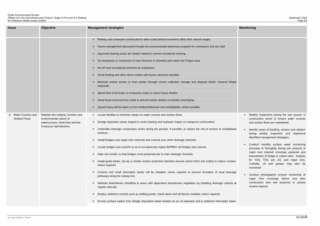
Public Environmental Review Pilbara Iron Ore and Infrastructure Project: Stage A Port and N-S Railway September 2004 for Fortescue Metals Group Limited Page E8
Ref: Stage A PER Rev 4 - Sept 04 ENVIRON 8
Issue Objective Management strategies Monitoring
Railway and conveyors constructed to allow small animal movement within their natural ranges.
Fauna management discussed through the environmental awareness program for contractors and site staff.
Approved clearing areas are clearly marked to prevent accidental clearing.
No employees or contractors to have firearms or domestic pets within the Project area.
No off-road recreational activities by employees.
Avoid feeding and other direct contact with fauna, wherever possible.
Minimise animal access to food wastes through correct collection, storage and disposal (Refer: General Waste Disposal).
Speed limit of 60 kmph on temporary roads to reduce fauna deaths.
Dead fauna removed from roads to prevent further deaths of animals scavenging.
Injured fauna will be taken to Port Hedland/Newman and rehabilitated, where possible.
3. Water Courses and Surface Flows
Maintain the integrity, function and environmental values of watercourses, sheet flow and the Fortescue Salt Marshes.
Locate facilities to minimise impact on water courses and surface flows.
Dredge deposition areas shaped to avoid clearing and hydraulic impact on mangrove communities.
Undertake drainage construction works during dry periods, if possible, to reduce the risk of erosion of unstabilised surfaces.
Install bridges over major river channels and culverts over other drainage channels.
Locate bridges and culverts so as to not adversely impact BHPBIO rail bridges and culverts.
Align rail corridor so that bridges cross perpendicular to main drainage channels.
Install guide banks, rip-rap or similar erosion protection blankets around culvert inlets and outlets to reduce erosion, where required.
Culverts and small interceptor banks will be installed, where required to prevent formation of local drainage pathways along the railway line.
Maintain downstream sheetflow to areas with dependent downstream vegetation by installing drainage culverts at regular intervals.
Employ sediment controls such as settling ponds, check dams and silt fences installed, where required.
Excess surface waters from dredge deposition areas treated via an oil separator and a sediment interceptor basin,
Weekly inspections during the wet season of construction works to ensure water courses and surface flows are maintained.
Identify areas of flooding, erosion and siltation during weekly inspection and implement identified management strategies.
Conduct monthly surface water monitoring (increase to fortnightly during wet season) of major river channel crossings upstream and downstream of bridge or culvert sites. Analyse for TDS, TSS, pH, EC and major ions. Turbidity, oil and grease may also be monitored
Conduct photographic erosion monitoring of major river crossings before and after construction (two wet seasons) to assess erosion impacts.
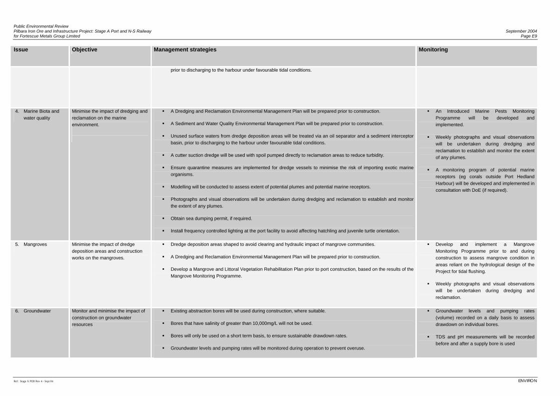
Public Environmental Review Pilbara Iron Ore and Infrastructure Project: Stage A Port and N-S Railway September 2004 for Fortescue Metals Group Limited Page E9
Ref: Stage A PER Rev 4 - Sept 04 ENVIRON
Issue Objective Management strategies Monitoring
prior to discharging to the harbour under favourable tidal conditions.
4. Marine Biota and water quality
Minimise the impact of dredging and reclamation on the marine environment.
A Dredging and Reclamation Environmental Management Plan will be prepared prior to construction.
A Sediment and Water Quality Environmental Management Plan will be prepared prior to construction.
Unused surface waters from dredge deposition areas will be treated via an oil separator and a sediment interceptor basin, prior to discharging to the harbour under favourable tidal conditions.
A cutter suction dredge will be used with spoil pumped directly to reclamation areas to reduce turbidity.
Ensure quarantine measures are implemented for dredge vessels to minimise the risk of importing exotic marine organisms.
Modelling will be conducted to assess extent of potential plumes and potential marine receptors.
Photographs and visual observations will be undertaken during dredging and reclamation to establish and monitor the extent of any plumes.
Obtain sea dumping permit, if required.
Install frequency controlled lighting at the port facility to avoid affecting hatchling and juvenile turtle orientation.
An Introduced Marine Pests Monitoring Programme will be developed and implemented.
Weekly photographs and visual observations will be undertaken during dredging and reclamation to establish and monitor the extent of any plumes.
A monitoring program of potential marine receptors (eg corals outside Port Hedland Harbour) will be developed and implemented in consultation with DoE (if required).
5. Mangroves
Minimise the impact of dredge deposition areas and construction works on the mangroves.
Dredge deposition areas shaped to avoid clearing and hydraulic impact of mangrove communities.
A Dredging and Reclamation Environmental Management Plan will be prepared prior to construction.
Develop a Mangrove and Littoral Vegetation Rehabilitation Plan prior to port construction, based on the results of the Mangrove Monitoring Programme.
Develop and implement a Mangrove Monitoring Programme prior to and during construction to assess mangrove condition in areas reliant on the hydrological design of the Project for tidal flushing.
Weekly photographs and visual observations will be undertaken during dredging and reclamation.
6. Groundwater Monitor and minimise the impact of construction on groundwater resources
Existing abstraction bores will be used during construction, where suitable.
Bores that have salinity of greater than 10,000mg/L will not be used.
Bores will only be used on a short term basis, to ensure sustainable drawdown rates.
Groundwater levels and pumping rates will be monitored during operation to prevent overuse.
Groundwater levels and pumping rates (volume) recorded on a daily basis to assess drawdown on individual bores.
TDS and pH measurements will be recorded before and after a supply bore is used
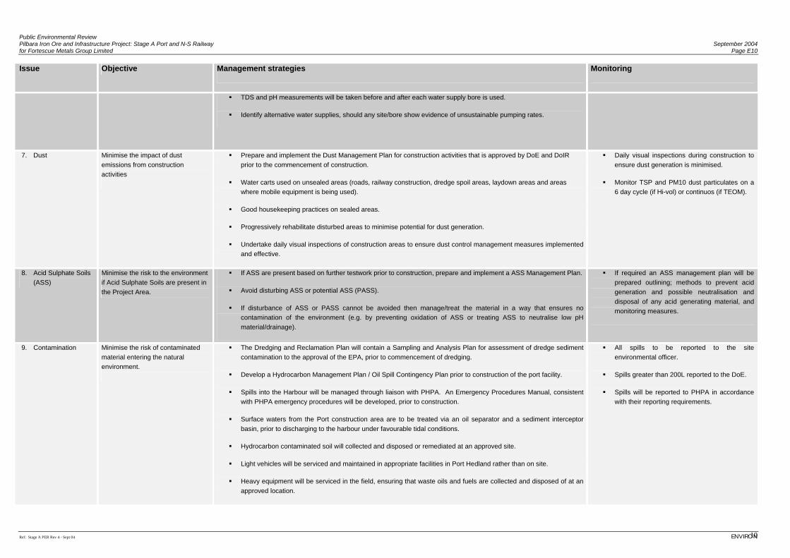
Public Environmental Review Pilbara Iron Ore and Infrastructure Project: Stage A Port and N-S Railway September 2004 for Fortescue Metals Group Limited Page E10
Ref: Stage A PER Rev 4 - Sept 04 ENVIRON 10
Issue Objective Management strategies Monitoring
TDS and pH measurements will be taken before and after each water supply bore is used.
Identify alternative water supplies, should any site/bore show evidence of unsustainable pumping rates.
7. Dust Minimise the impact of dust emissions from construction activities
Prepare and implement the Dust Management Plan for construction activities that is approved by DoE and DoIR prior to the commencement of construction.
Water carts used on unsealed areas (roads, railway construction, dredge spoil areas, laydown areas and areas where mobile equipment is being used).
Good housekeeping practices on sealed areas.
Progressively rehabilitate disturbed areas to minimise potential for dust generation.
Undertake daily visual inspections of construction areas to ensure dust control management measures implemented and effective.
Daily visual inspections during construction to ensure dust generation is minimised.
Monitor TSP and PM10 dust particulates on a 6 day cycle (if Hi-vol) or continuos (if TEOM).
8. Acid Sulphate Soils (ASS)
Minimise the risk to the environment if Acid Sulphate Soils are present in the Project Area.
If ASS are present based on further testwork prior to construction, prepare and implement a ASS Management Plan.
Avoid disturbing ASS or potential ASS (PASS).
If disturbance of ASS or PASS cannot be avoided then manage/treat the material in a way that ensures no contamination of the environment (e.g. by preventing oxidation of ASS or treating ASS to neutralise low pH material/drainage).
If required an ASS management plan will be prepared outlining; methods to prevent acid generation and possible neutralisation and disposal of any acid generating material, and monitoring measures.
9. Contamination Minimise the risk of contaminated material entering the natural environment.
The Dredging and Reclamation Plan will contain a Sampling and Analysis Plan for assessment of dredge sediment contamination to the approval of the EPA, prior to commencement of dredging.
Develop a Hydrocarbon Management Plan / Oil Spill Contingency Plan prior to construction of the port facility.
Spills into the Harbour will be managed through liaison with PHPA. An Emergency Procedures Manual, consistent with PHPA emergency procedures will be developed, prior to construction.
Surface waters from the Port construction area are to be treated via an oil separator and a sediment interceptor basin, prior to discharging to the harbour under favourable tidal conditions.
Hydrocarbon contaminated soil will collected and disposed or remediated at an approved site.
Light vehicles will be serviced and maintained in appropriate facilities in Port Hedland rather than on site.
Heavy equipment will be serviced in the field, ensuring that waste oils and fuels are collected and disposed of at an approved location.
All spills to be reported to the site environmental officer.
Spills greater than 200L reported to the DoE.
Spills will be reported to PHPA in accordance with their reporting requirements.
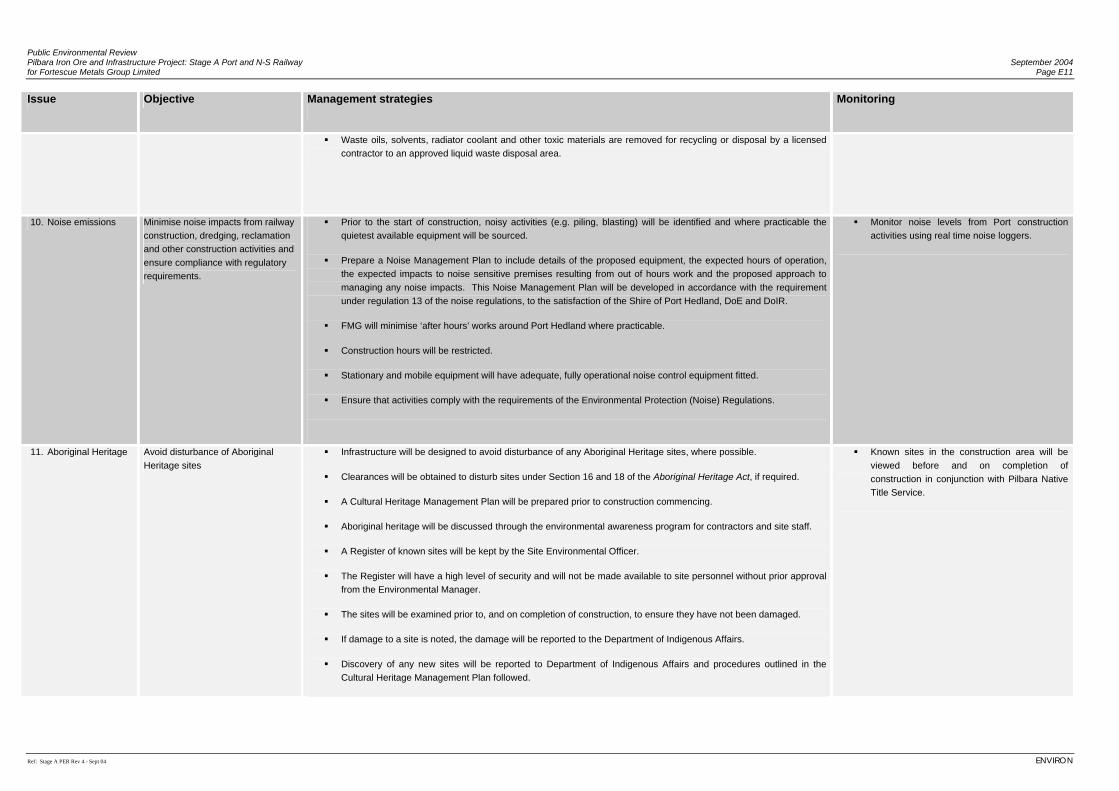
Public Environmental Review Pilbara Iron Ore and Infrastructure Project: Stage A Port and N-S Railway September 2004 for Fortescue Metals Group Limited Page E11
Ref: Stage A PER Rev 4 - Sept 04 ENVIRON
Issue Objective Management strategies Monitoring
Waste oils, solvents, radiator coolant and other toxic materials are removed for recycling or disposal by a licensed contractor to an approved liquid waste disposal area.
10. Noise emissions Minimise noise impacts from railway construction, dredging, reclamation and other construction activities and ensure compliance with regulatory requirements.
Prior to the start of construction, noisy activities (e.g. piling, blasting) will be identified and where practicable the quietest available equipment will be sourced.
Prepare a Noise Management Plan to include details of the proposed equipment, the expected hours of operation, the expected impacts to noise sensitive premises resulting from out of hours work and the proposed approach to managing any noise impacts. This Noise Management Plan will be developed in accordance with the requirement under regulation 13 of the noise regulations, to the satisfaction of the Shire of Port Hedland, DoE and DoIR.
FMG will minimise ‘after hours’ works around Port Hedland where practicable.
Construction hours will be restricted.
Stationary and mobile equipment will have adequate, fully operational noise control equipment fitted.
Ensure that activities comply with the requirements of the Environmental Protection (Noise) Regulations.
Monitor noise levels from Port construction activities using real time noise loggers.
11. Aboriginal Heritage Avoid disturbance of Aboriginal Heritage sites
Infrastructure will be designed to avoid disturbance of any Aboriginal Heritage sites, where possible.
Clearances will be obtained to disturb sites under Section 16 and 18 of the Aboriginal Heritage Act, if required.
A Cultural Heritage Management Plan will be prepared prior to construction commencing.
Aboriginal heritage will be discussed through the environmental awareness program for contractors and site staff.
A Register of known sites will be kept by the Site Environmental Officer.
The Register will have a high level of security and will not be made available to site personnel without prior approval from the Environmental Manager.
The sites will be examined prior to, and on completion of construction, to ensure they have not been damaged.
If damage to a site is noted, the damage will be reported to the Department of Indigenous Affairs.
Discovery of any new sites will be reported to Department of Indigenous Affairs and procedures outlined in the Cultural Heritage Management Plan followed.
Known sites in the construction area will be viewed before and on completion of construction in conjunction with Pilbara Native Title Service.
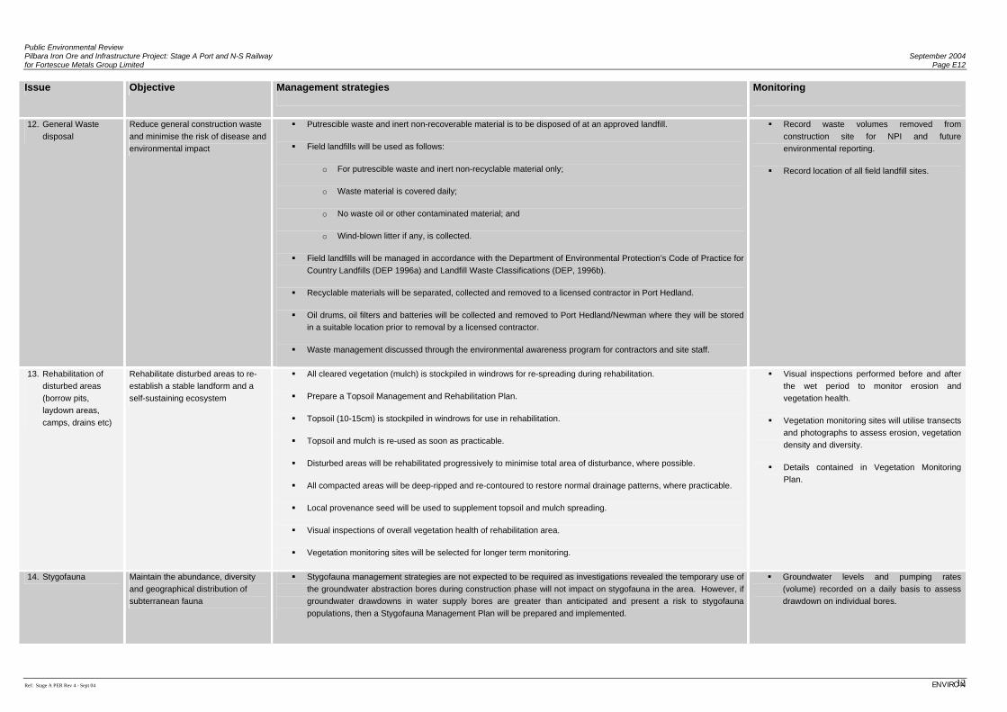
Public Environmental Review Pilbara Iron Ore and Infrastructure Project: Stage A Port and N-S Railway September 2004 for Fortescue Metals Group Limited Page E12
Ref: Stage A PER Rev 4 - Sept 04 ENVIRON 12
Issue Objective Management strategies Monitoring
12. General Waste disposal
Reduce general construction waste and minimise the risk of disease and environmental impact
Putrescible waste and inert non-recoverable material is to be disposed of at an approved landfill.
Field landfills will be used as follows:
o For putrescible waste and inert non-recyclable material only;
o Waste material is covered daily;
o No waste oil or other contaminated material; and
o Wind-blown litter if any, is collected.
Field landfills will be managed in accordance with the Department of Environmental Protection’s Code of Practice for Country Landfills (DEP 1996a) and Landfill Waste Classifications (DEP, 1996b).
Recyclable materials will be separated, collected and removed to a licensed contractor in Port Hedland.
Oil drums, oil filters and batteries will be collected and removed to Port Hedland/Newman where they will be stored in a suitable location prior to removal by a licensed contractor.
Waste management discussed through the environmental awareness program for contractors and site staff.
Record waste volumes removed from construction site for NPI and future environmental reporting.
Record location of all field landfill sites.
13. Rehabilitation of disturbed areas (borrow pits, laydown areas, camps, drains etc)
Rehabilitate disturbed areas to re-establish a stable landform and a self-sustaining ecosystem
All cleared vegetation (mulch) is stockpiled in windrows for re-spreading during rehabilitation.
Prepare a Topsoil Management and Rehabilitation Plan.
Topsoil (10-15cm) is stockpiled in windrows for use in rehabilitation.
Topsoil and mulch is re-used as soon as practicable.
Disturbed areas will be rehabilitated progressively to minimise total area of disturbance, where possible.
All compacted areas will be deep-ripped and re-contoured to restore normal drainage patterns, where practicable.
Local provenance seed will be used to supplement topsoil and mulch spreading.
Visual inspections of overall vegetation health of rehabilitation area.
Vegetation monitoring sites will be selected for longer term monitoring.
Visual inspections performed before and after the wet period to monitor erosion and vegetation health.
Vegetation monitoring sites will utilise transects and photographs to assess erosion, vegetation density and diversity.
Details contained in Vegetation Monitoring Plan.
14. Stygofauna Maintain the abundance, diversity and geographical distribution of subterranean fauna
Stygofauna management strategies are not expected to be required as investigations revealed the temporary use of the groundwater abstraction bores during construction phase will not impact on stygofauna in the area. However, if groundwater drawdowns in water supply bores are greater than anticipated and present a risk to stygofauna populations, then a Stygofauna Management Plan will be prepared and implemented.
Groundwater levels and pumping rates (volume) recorded on a daily basis to assess drawdown on individual bores.
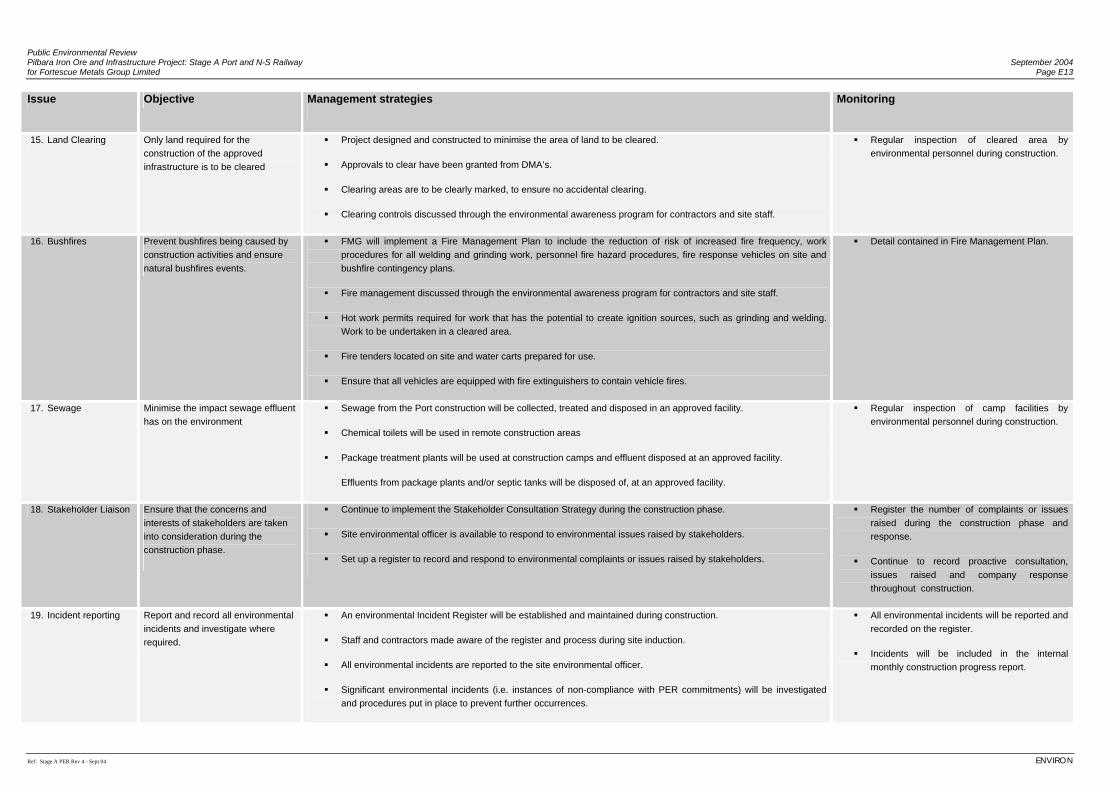
Public Environmental Review Pilbara Iron Ore and Infrastructure Project: Stage A Port and N-S Railway September 2004 for Fortescue Metals Group Limited Page E13
Ref: Stage A PER Rev 4 - Sept 04 ENVIRON
Issue Objective Management strategies Monitoring
15. Land Clearing Only land required for the construction of the approved infrastructure is to be cleared
Project designed and constructed to minimise the area of land to be cleared.
Approvals to clear have been granted from DMA’s.
Clearing areas are to be clearly marked, to ensure no accidental clearing.
Clearing controls discussed through the environmental awareness program for contractors and site staff.
Regular inspection of cleared area by environmental personnel during construction.
16. Bushfires Prevent bushfires being caused by construction activities and ensure natural bushfires events.
FMG will implement a Fire Management Plan to include the reduction of risk of increased fire frequency, work procedures for all welding and grinding work, personnel fire hazard procedures, fire response vehicles on site and bushfire contingency plans.
Fire management discussed through the environmental awareness program for contractors and site staff.
Hot work permits required for work that has the potential to create ignition sources, such as grinding and welding. Work to be undertaken in a cleared area.
Fire tenders located on site and water carts prepared for use.
Ensure that all vehicles are equipped with fire extinguishers to contain vehicle fires.
Detail contained in Fire Management Plan.
17. Sewage Minimise the impact sewage effluent has on the environment
Sewage from the Port construction will be collected, treated and disposed in an approved facility.
Chemical toilets will be used in remote construction areas
Package treatment plants will be used at construction camps and effluent disposed at an approved facility.
Effluents from package plants and/or septic tanks will be disposed of, at an approved facility.
Regular inspection of camp facilities by environmental personnel during construction.
18. Stakeholder Liaison Ensure that the concerns and interests of stakeholders are taken into consideration during the construction phase.
Continue to implement the Stakeholder Consultation Strategy during the construction phase.
Site environmental officer is available to respond to environmental issues raised by stakeholders.
Set up a register to record and respond to environmental complaints or issues raised by stakeholders.
Register the number of complaints or issues raised during the construction phase and response.
Continue to record proactive consultation, issues raised and company response throughout construction.
19. Incident reporting Report and record all environmental incidents and investigate where required.
An environmental Incident Register will be established and maintained during construction.
Staff and contractors made aware of the register and process during site induction.
All environmental incidents are reported to the site environmental officer.
Significant environmental incidents (i.e. instances of non-compliance with PER commitments) will be investigated and procedures put in place to prevent further occurrences.
All environmental incidents will be reported and recorded on the register.
Incidents will be included in the internal monthly construction progress report.
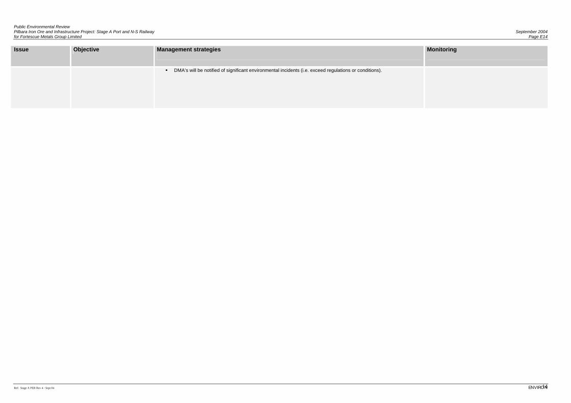
Public Environmental Review Pilbara Iron Ore and Infrastructure Project: Stage A Port and N-S Railway September 2004 for Fortescue Metals Group Limited Page E14
Ref: Stage A PER Rev 4 - Sept 04 ENVIRON 14
Issue Objective Management strategies Monitoring
DMA’s will be notified of significant environmental incidents (i.e. exceed regulations or conditions).
Appendix F
Assessment of Dust Impacts: ENVIRON Australia Pty Ltd
Peer Review by Holmes Air Sciences
(Refer to CD with Technical Appendices)

(This page has been left blank intentionally)
Appendix G
Assessment of Environmental Noise Impacts from the Proposed FMG Port and Railway Facility at Port Hedland: Lloyd
Acoustics Pty Ltd.
Peer Review by Herring Storer Acoustics
(Refer to CD with Technical Appendices)

(This page has been left blank intentionally)
Appendix H
Flora and Vegetation Surveys for the Proposed FMG Port and Rail Corridor: Biota Environmental Sciences.
(Refer to CD with Technical Appendices)

(This page has been left blank intentionally)
Appendix I
Fauna Surveys for the Proposed FMG Port and Rail Corridor: Biota Environmental Sciences
(Refer to CD with Technical Appendices)

(This page has been left blank intentionally)
Appendix J
Pilbara Iron Ore and Infrastructure Project: Port and Railway Marine Environmental Impacts and their Management:
DAL Science & Engineering Pty Ltd.
Peer Review by URS (Le Provost Dames & Moore)
(Refer to CD with Technical Appendices)

(This page has been left blank intentionally)
Appendix K
Port Hedland Harbour Hydrodynamic Modelling of FMG Conceptual Layouts: Worley Pty Ltd.
(Refer to CD with Technical Appendices)

(This page has been left blank intentionally)
Appendix L
Pilbara Iron Ore and Infrastructure Project Stage A Port And North South Rail Corridor
Surface Hydrology: Aquaterra Consulting Pty Ltd.
(Refer to CD with Technical Appendices)

(This page has been left blank intentionally)
Appendix M
Pilbara Iron Ore and Infrastructure Project Assessment of Water Supply Development
for the Stage A Railway: Aquaterra Consulting Pty Ltd.
(Refer to CD with Technical Appendices)

(This page has been left blank intentionally)
Appendix N
Pilbara Iron Ore and Infrastructure Project, Geotechnical Desktop Study and Site Visit: Coffey Geosciences Pty Ltd.
(Refer to CD with Technical Appendices)

(This page has been left blank intentionally)
Appendix O
Socio-Economic Assessment Scoping of Proposed Port, Rail and Mine Investments in the Pilbara:
Environmental Resources Management Australia.
(Refer to CD with Technical Appendices)

(This page has been left blank intentionally)
Appendix P
Aboriginal Heritage Information for the Pilbara Iron Ore and Infrastructure Project:
Anthropos Australis (on behalf of Yamatji Marlpa Barna Baba Maaja Aboriginal Corporation Inc.).
(Refer to CD with Technical Appendices)

(This page has been left blank intentionally)