Embed Size (px)
Citation preview
PIKE COUNTY PLANNING COMMISSION 2010 ANNUAL REPORT
Prepared for:
Pike County Board of Commissioners
Richard A. Caridi, Chairman
Harry Forbes, Commissioner (2010)
Karl A. Wagner, Jr. Commissioner
Kathleen Hummel, Commissioner (2011)

This page intentionally left blank.
2010 Planning Commission Members SPECIAL RECOGNITION Michael Billig, Milford Borough George Jerus, Matamoras Borough COMMISSION MEMBERS Georgene Snyder, Chairman Blooming Grove Township Dennis Brink, Vice-Chair Dingman Township Robert Cocchi Lackawaxen Township Mary Ann Conza Lehman Township Richard Gross Matamoras Borough Samuel Jackson Greene Township Keith Raser Shohola Township James Trunzo Palmyra Township Steve Vitale Delaware Township
Sally J. Corrigan, Planning Director Joined Planning Staff in 2004 Michael Mrozinski, Assistant Planning Director Joined Planning staff in 1991 Jessica Y. Grohmann, Preservation Planner Joined Planning Staff in 2006 Scot Boyce, Community & Natural Resource Planner Joined Planning Staff in 2009 Linda Masie, Planning Assistant Joined Planning Staff in 2007
2010 Planning Staff
Planning Office 837 Route 6, Unit 4 Shohola, PA 18458
570.296.3500 phone 570.296.3501 fax
Pike County Planning Commission
Pike County Office of Community Planning
We’re on the web!
www.pikepa.org/planning
Dennis Brink is a local Dingman Township businessman and a long-time resident of the County. Dennis currently serves as a Dingman Township Supervisor, a position he has held for over 30 years. Appointed to the Pike County Planning Commission in January 2007, Dennis has served as the Vice-Chairman of the Commission since 2008.
Robert Cocchi was appointed by the Pike County Commissioners to the Planning Commission in January 2009. He was elected as Township Supervisor of Lackawaxen Township in November 2009 and took office in January 2010. Bob has served on the Board of Directors of the Lackawaxen-Honesdale Shippers Association since 2007. (The Shippers Assoc. runs the railroad from Honesdale to Lackawaxen.) Bob served as treasurer and president of the Lackawaxen Township Volunteer Fire Department. Presently he serves on the board of the Lackawaxen Township Fire Commission. Bob was appointed in 2010 to the Pike County Agricultural Land Preservation Board as their municipal representative. He is a retired NYPD Detective and lives in Lackawaxen with his wife Valerie.
MaryAnn Conza was first appointed to the Pike County Planning Commission in January 2007. She resides in Pocono Mountain Lake Estates with her husband Walter. She serves as a Board of Director and Treasurer for that Community as well as Secretary/Treasurer for the Lehman Township Water & Sewer Authority. Mrs. Conza is employed as Assistant Secretary for Lehman Township Board of Supervisors. She is an active member of the Reformed Church of Bushkill and currently serves as Treasurer for the Deacons.
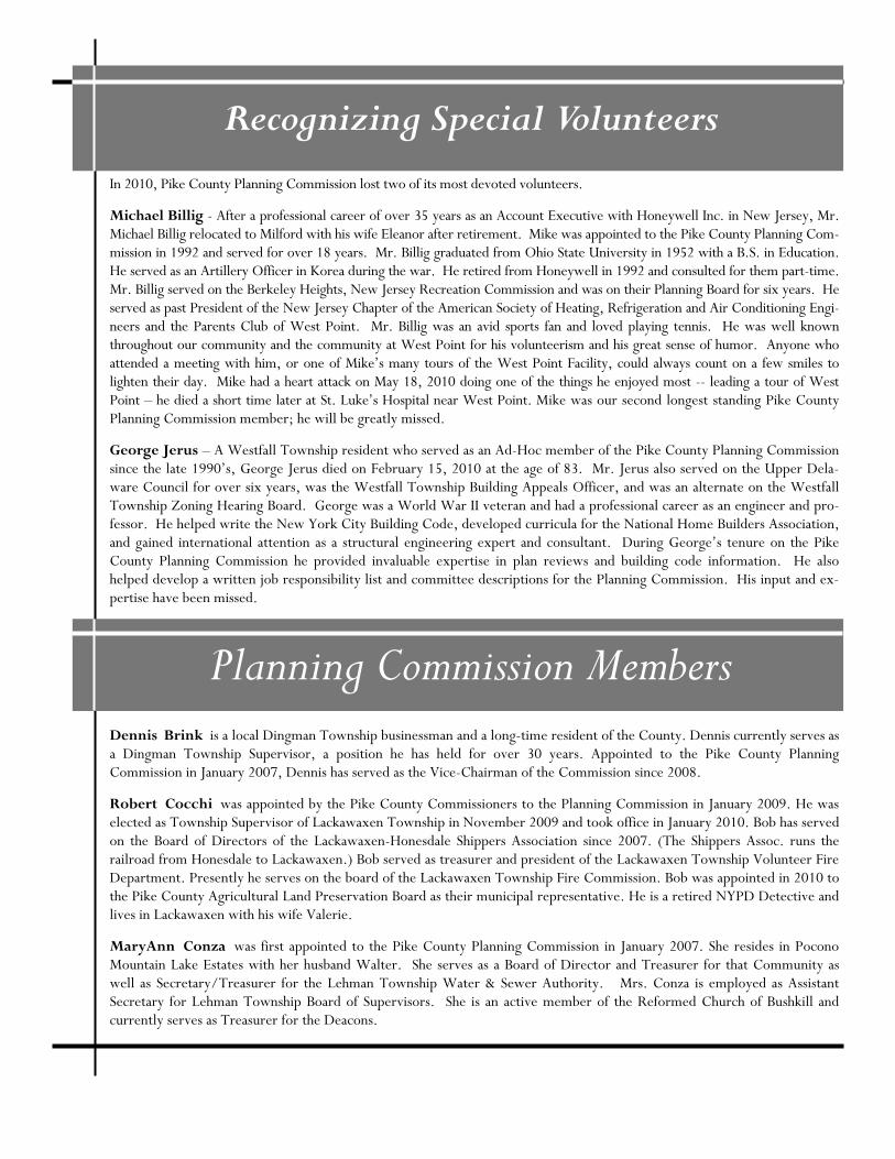
Recognizing Special Volunteers
In 2010, Pike County Planning Commission lost two of its most devoted volunteers.
Michael Billig - After a professional career of over 35 years as an Account Executive with Honeywell Inc. in New Jersey, Mr. Michael Billig relocated to Milford with his wife Eleanor after retirement. Mike was appointed to the Pike County Planning Com-mission in 1992 and served for over 18 years. Mr. Billig graduated from Ohio State University in 1952 with a B.S. in Education. He served as an Artillery Officer in Korea during the war. He retired from Honeywell in 1992 and consulted for them part-time. Mr. Billig served on the Berkeley Heights, New Jersey Recreation Commission and was on their Planning Board for six years. He served as past President of the New Jersey Chapter of the American Society of Heating, Refrigeration and Air Conditioning Engi-neers and the Parents Club of West Point. Mr. Billig was an avid sports fan and loved playing tennis. He was well known throughout our community and the community at West Point for his volunteerism and his great sense of humor. Anyone who attended a meeting with him, or one of Mike’s many tours of the West Point Facility, could always count on a few smiles to lighten their day. Mike had a heart attack on May 18, 2010 doing one of the things he enjoyed most -- leading a tour of West Point – he died a short time later at St. Luke’s Hospital near West Point. Mike was our second longest standing Pike County Planning Commission member; he will be greatly missed.
George Jerus – A Westfall Township resident who served as an Ad-Hoc member of the Pike County Planning Commission since the late 1990’s, George Jerus died on February 15, 2010 at the age of 83. Mr. Jerus also served on the Upper Dela-ware Council for over six years, was the Westfall Township Building Appeals Officer, and was an alternate on the Westfall Township Zoning Hearing Board. George was a World War II veteran and had a professional career as an engineer and pro-fessor. He helped write the New York City Building Code, developed curricula for the National Home Builders Association, and gained international attention as a structural engineering expert and consultant. During George’s tenure on the Pike County Planning Commission he provided invaluable expertise in plan reviews and building code information. He also helped develop a written job responsibility list and committee descriptions for the Planning Commission. His input and ex-pertise have been missed.
Planning Commission Members
Planning Commission Members
Dick Gross was appointed to the Planning Commission in 2003. Dick brings with him a full history of public service. With degrees from Oregon State and Rutgers Universities, Dick has spent much of his career heading up land and wildlife man-agement agencies in Oregon, New Jersey, North Carolina and for the US Department of Interior in the Mid-Atlantic Re-gion. His research and management projects and career experience regularly placed him in positions of policy development for conservation throughout the US. He served on Lady Bird Johnson’s Committee, Alaska National Lands Bill Task Force, and worked on such projects as Land and Water Conservation Fund, St. Johns, Virgin Islands Underwater Study, Cornell University New York State SeaGrant Program. He is a World War II Marine Corps veteran. Since retirement in 1987, he has remained active in wildlife and land management conservation policy development and educational efforts. He serves actively in the Pike County Federation of Sportsmen, Pike County Youth Conservation School, Ducks Unlimited, and American Legion. He also serves on the Pike County Scenic Rural Character Preservation Program Board and served previ-ously on the Conservation District Board for Pike County.
Sam Jackson joined the PCPC in 2005. He lives in Greene Township where he also serves on its Planning Commission. For the last nine years he has been editing the quarterly local history publication of the Greene-Dreher Historical Society, The Greene Hills of Home. His wife and he work as Friends of the Newfoundland Area Public Library, raising money to support the library. Sam is a past chair of the Lacawac Sanctuary Board, Wayne County and a continuing volunteer for the sanctuary. Sam ended his volunteer service with the Planning Commission at the end of 2010.
Keith Raser, a Pike County native, was appointed to the Pike County Planning Commission in 2010. A resident of Sho-hola Township he also serves as a member of the Shohola Zoning Hearing Board. He is a graduate of Kutztown University and also attended East Stroudsburg University. He is a member of the Pike County Republican Committee, ten-year Presi-dent of the Matamoras Rod and Gun Club, and a Life Member of the National Rifle Association (NRA). Interested in local history, Keith is a Trustee and past Vice-President of the Shohola Railroad and Historical Society. In 2008, Keith retired from the US Postal Service, and currently is a Substitute Teacher in the Delaware Valley and Port Jervis Schools. His inter-est in proper planning, the environment, and preserving the beauty of Pike County is foremost in his mind.
Georgene Snyder was appointed to the Planning Commission by the Pike County Commissioners in January 2007. She was elected Vice-Chair in 2009 and served as Chairperson in 2010. She served as a member of the Hemlock Farms Commu-nity Association Board of Directors from 2000 to 2010 serving as Corporate Secretary for two years and as President for six years. Prior to her service on the Board she chaired the Finance Committee for five years. Although no longer on the Board she remains active in the community. Georgene was co-founder of a New York City sign company where she worked for thirty five years. She is currently an independent financial planner and insurance broker.
James Trunzo was Appointed to the Planning Commission in 1985 and is the longest standing member of the Pike County Planning Commission. James is also a member of the Palmyra Township Planning Commission where he serves as Chairman.
Steven Vitale, Ph.D, P.E. is an expert on Gas technologies related to Natural Gas distribution infrastructure and Liquid Natural Gas (LNG) plants. As Vice President and Chief Engineer of KeySpan Energy, he was responsible for KeySpan’s R&D program, and all gas engineering and production facilities across four states, including 14 LNG facilities and 14 pro-pane-air facilities. In 2004, he retired as Vice President and Chief Engineer from KeySpan Energy and formed Vitale Tech-nical Services Inc. Dr. Vitale consults internationally on Gas Industry issues with particular emphasis on natural gas piping networks and LNG infrastructure. He has been licensed as a Professional Engineer in five states and holds a Ph.D. in me-chanical engineering. He has authored the book LNG and Gas, An Operators Guide to Thermodynamics and teaches on this and other topics internationally. Dr. Vitale has served his community in numerous ways including tutoring programs for at-risk Junior High School students, mentoring programs for High School students, being a judge for the national technical FIRST program and similar programs. Appointed to the Pike Planning Commission in June 2005, Dr. Vitale continues to serve as a member of the Pike County Planning Commission. He also serves as a board member of the NYU-Polytechnic Mechanical Engineering Board.
Planning Commission
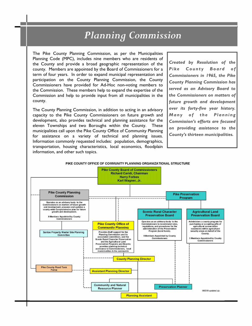
The Pike County Planning Commission, as per the Municipalities Planning Code (MPC), includes nine members who are residents of the County and provide a broad geographic representation of the county. Members are appointed by the Board of Commissioners for a term of four years. In order to expand municipal representation and participation on the County Planning Commission, the County Commissioners have provided for Ad-Hoc non-voting members to the Commission. These members help to expand the expertise of the Commission and help to provide input from all municipalities in the county. The County Planning Commission, in addition to acting in an advisory capacity to the Pike County Commissioners on future growth and development, also provides technical and planning assistance for the eleven Townships and two Boroughs within the County. These municipalities call upon the Pike County Office of Community Planning for assistance on a variety of technical and planning issues. Information commonly requested includes: population, demographics, transportation, housing characteristics, local economics, floodplain information, and other such topics.
Created by Resolution of the P i k e C ou n t y B oa r d o f Commissioners in 1965, the Pike County Planning Commission has served as an Advisory Board to the Commissioners on matters of future growth and development over its forty-five year history. Many o f t he P l ann i ng Commission’s efforts are focused on providing assistance to the County’s thirteen municipalities.

Planning
The Pike County Office of Community Planning has five professional planning staff who provide support for the Pike County Board of Commissioners, the Pike County Planning Commission and its associated Committees, the Pike County Road Task Force, the Pike County Scenic Rural Character Preservation Board, and the Pike County Agricultural Land Preservation Board. Additionally, the Office takes the lead role in the development and implementation of important County Planning initiatives, helps facilitate multi-municipal planning efforts, provides technical professional planning support for municipalities, assists with grant searches and applications for municipal governments and county agencies, and conducts other studies, surveys and plans to address the needs of our growing County and its communities.
PENNSYLVANIA MUNICIPALITIES PLANNING CODE
AND PIKE COUNTY’S MUNICIPALITIES The Pennsylvania Municipalities Planning Code (MPC), Act 247 of 1968, establishes the basic framework for a municipality in Pennsylvania to plan for community development through the preparation of a comprehen-sive plan. Moreover, the MPC permits a municipality to further govern development locally through the en-actment of zoning ordinances, subdivision and land development ordinances, and several other land use tools. All of Pike County’s thirteen municipalities have adopted subdivision and land development ordinances and twelve of the thirteen have zoning ordinances in effect. Each of Pike’s municipalities have formed plan-ning commissions which serve in an advisory capacity to the governing board of the municipality; the County Planning Commission works with the local municipal commissions to assist wherever possible in providing land use and planning technical assistance. The County Office of Community Planning also assists municipalities by providing review and comment on proposed ordinances and amendments to existing ordi-nances, comprehensive plans and other special studies.

This page intentionally left blank.
Our Planning Commission and our Pike County Planning staff efforts have been focused on the provision of municipal assistance – both technical and financial. We work directly with our municipalities to assist with planning initiatives such as the development of comprehensive plans, open space plans, and ordinance updates helping to facilitate projects and provide technical input on changes and updates. Our office also works with municipal governing boards to submit grant funding applications for these planning projects. As part of our normal Planning Office operation, our Planning staff provides review of all subdivision and land development plans for all of our thirteen municipalities. Municipal ordinance amendments and land use ordinance updates are also reviewed by County Planning staff, and comments are provided to the municipal planning commissions. During 2010, County Planning Staff attended numerous municipal planning commission and/or governing board meetings to discuss issues of concern to the municipality and areas where County Planning Professional staff could provide important technical and/or financial assistance. These meetings were also used to provide updates on county planning initiatives. The County Planning office served as a technical resource for our municipalities assisting wherever possible. Following are several municipal planning initiatives where we provided assistance.
Municipal Technical Assistance
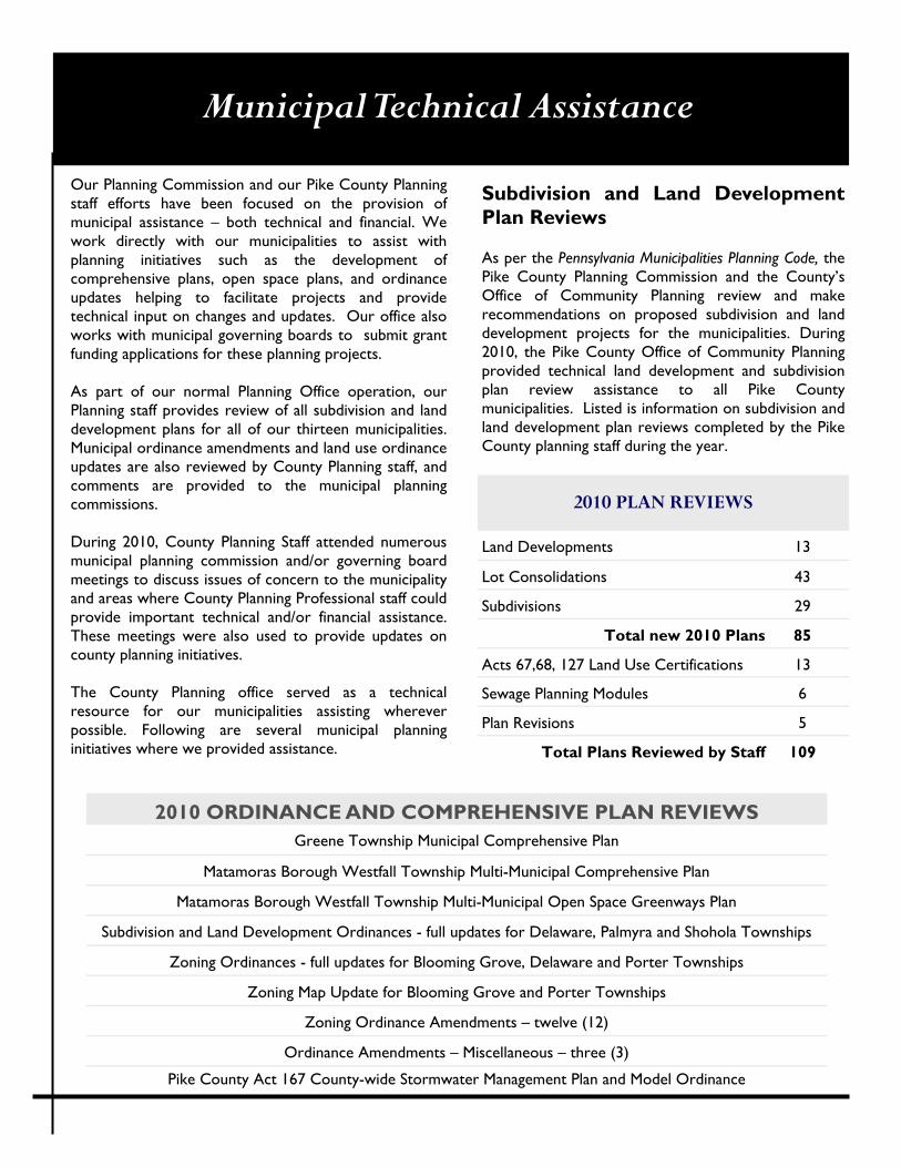
Subdivision and Land Development Plan Reviews As per the Pennsylvania Municipalities Planning Code, the Pike County Planning Commission and the County’s Office of Community Planning review and make recommendations on proposed subdivision and land development projects for the municipalities. During 2010, the Pike County Office of Community Planning provided technical land development and subdivision plan review assistance to all Pike County municipalities. Listed is information on subdivision and land development plan reviews completed by the Pike County planning staff during the year.
2010 PLAN REVIEWS
Land Developments 13
Lot Consolidations 43
Subdivisions 29
Total new 2010 Plans 85
Acts 67,68, 127 Land Use Certifications 13
Sewage Planning Modules 6
Plan Revisions 5
Total Plans Reviewed by Staff 109
2010 ORDINANCE AND COMPREHENSIVE PLAN REVIEWS
Greene Township Municipal Comprehensive Plan
Matamoras Borough Westfall Township Multi-Municipal Comprehensive Plan
Matamoras Borough Westfall Township Multi-Municipal Open Space Greenways Plan
Subdivision and Land Development Ordinances - full updates for Delaware, Palmyra and Shohola Townships
Zoning Ordinances - full updates for Blooming Grove, Delaware and Porter Townships
Zoning Map Update for Blooming Grove and Porter Townships
Zoning Ordinance Amendments – twelve (12)
Ordinance Amendments – Miscellaneous – three (3)
Pike County Act 167 County-wide Stormwater Management Plan and Model Ordinance
Municipal Planning Assistance
Matamoras Borough Westfall Township Multi-Municipal Comprehensive Plan and Open Space, Greenways Plan
The Pike County Planning Staff continued to provide technical planning and grant administration support to Matamoras Borough and Westfall Township in the development of their Multi-Municipal Comprehensive Plan and Open Space, Greenways and Recreation Plan. Throughout 2010, Pike Planning Staff helped facilitate the meetings of the Joint Planning Committee and worked with the Committee and their identified planning consultants to finalize the draft Plans. In October 2010, the drafts were circulated to the school district, adjacent municipalities, the county and the public for the required 45-day public review period. The Planning Office hosted the draft plans on the county website. Public meetings were held late in 2010. Additional public hearings will be held and municipal adoption is anticipated early in 2011. This project was funded through a combination of funding sources which allowed the project to be completed with no direct outlay of municipal funds. The County and Planning office applied for, received and administered funds from several sources on behalf of the two municipalities. Pike County Scenic Rural Character Preservation Program Municipal Planning funds were used to leverage state funding through the PA DCED Land Use Planning and Technical Assistance Program (LUPTAP) and the PA DCNR Community Conservation Partnership Program (C2P2). Additionally a grant was received through the Upper Delaware Council to assist in funding this project.
Delaware Township Subdivision and Land Development and Zoning Ordinances The County Planning office continued to participate in the Task Force appointed by the Delaware Township Board of Supervisors to redraft a new zoning and subdivision ordinance for the Township. The final draft of both ordinances were received early in 2010; our review was completed and comments were provided to the Supervisors for their scheduled March 2 public hearing. The Township made revisions based on the public hearing. Our office worked closely with the Township and their consultants to provide comments on the revisions. We participated in another public hearing held on May 24 and the Delaware Twp. Planning Commission public hearing on the ordinances held on October 19. Delaware Township Planning Commission voted to recommend approval of the new SALDO and the Definitions. At the end of 2010, the draft Zoning Ordinance was still under consideration.
Municipal Grant Assistance
Grants Assistance to Municipalities In addition to the municipal planning grants provided through the Pike County Scenic Rural Character Preservation Program (SRCP) administered through the Pike County Office of Community Planning, our Planning Office again took an active role in assisting our municipalities with obtaining grant funding. Staff worked with municipal governments to develop and write grant applications. In many cases, the County served as the applicant and administrator for several state planning grants in order to lessen the administrative load on municipal staff while at the same time increasing funding opportunities for our local governments. During 2010, our office continued to administer grant funds for our municipalities for projects funded under the PA Department of Community and Economic Development (DCED), the PA Department of Conservation and Natural Resources (DCNR), Upper Delaware Council (UDC), and the PA Department of Environmental Protection (DEP). Funding available through these state agencies and other organizations under programs such as the PA DCED Land Use Planning and Technical Assistance Program (LUPTAP) and the PA DCNR Community Conservation Partnerships Program (C2P2) were used by local municipalities for planning projects. The required local match funds were provided through the County’s Scenic Rural Character Preservation Program Municipal Planning Grant Program. During 2010, the Planning office continued to administer state planning grants on behalf of Delaware, Greene, Lackawaxen, Palmyra, Shohola and Westfall Townships and Matamoras Borough. Planning staff also assisted with the development of numerous other municipal grant requests during the year. Staff actively monitor grant funding opportunities and inform municipal staff and governing boards of appropriate opportunities.
Conservation Works!
The Pike County Office of Community Planning was successful in obtaining grant funding to support energy saving improvements in Matamoras Borough and Shohola Township. Funds totaling $302,500 were received through PA Department of Environmental Protection, Conservation Works Grants (via the federal stimulus dollars); they will be used for numerous improvements to municipal structures including:
Shohola Township Building 85 T8 lighting fixtures R-38 Insulation improvements 3 Door replacements
Matamoras Borough Building and Public Works Building 77 T8 lighting fixtures (49 Borough & 28 FD/Public Wks) 3 HVAC Heat pumps (Borough Building) R-38 Insulation improvements (Borough Building) 13 Window replacements (Borough Building) 9 Door replacements (4 Borough (3 door and 1 garage) & 5 FD/Public Wks (3 door and 2 garage)) Heating System Zoning Modification (Borough Building) 25kw Solar panel array (FD/Public Wks)
The County Planning office is administering this 100% grant funded program. The specifications were created and advertised in 2010 and the project was recently awarded to two local contractors and given a notice to proceed. The improvements are anticipated to be completed by May 31, 2011.
Shohola Township Building
Special Projects: Santos Master Planning
Pike County Santos Parcel Master Planning Site planning for recreational and conservation development of the Santos Parcel, acquired by the County in 2009, was begun in early 2010 with the appointment by the Pike County Commissioners of a citizen volunteer Committee. The Pike County Planning office facilitated the planning process by assisting the Committee with coordination of public meetings, key person interviews and research and information. Over twenty key person interviews were conducted by Committee members. A news media effort was used to spur citizen input on the site planning process, and two public meetings were held in summer 2010. Building on the planning efforts of the County’s Open Space Plan and the several municipal comprehensive planning initiatives recently conducted, the Committee assembled information on the important recreational needs of the community. Committee members also conducted research -- visiting the site, assembling pertinent natural resource mapping information as well as historic and cultural background. Additionally, public input received through the outreach opportunities was collated and assembled for inclusion in the text of the Master Site Plan document. Each of the Committee members drafted portions of the text, and an initial draft of the background including existing site conditions and sensitive natural features and public participation elements of the Master Plan document was assembled by years end. The Committee continues to have discussions on the final recommendations for the conservation and recreational development of the site. They will submit these to the Pike County Board of Commissioners in 2011. The Committee will also work with a hired consultant to develop Site Concept Drawings which can be used to seek funding for site development. The 88.56 acre parcel fronts on the Delaware River and is immediately adjacent to the northern boundary of the US Department of Interior National Park Service Delaware Water Gap National Recreation Area. The parcel provides the County with just over 4,000 feet of Delaware River frontage. It is in close proximity to the Milford Township building. Some of the suggested site development facilities that are being researched further by the Committee and will be included in the recommendations to the Commissioners include: a River Trail, community gardens, wildlife enhancement areas for viewing, open field areas for recreation. Over the long-term, a car-top boat access and possible trail connections to Milford Borough are also being considered. The parcel provides excellent opportunities for greenway connections to existing public lands and to the business district of the Borough. The Master Site Planning will continue with a report submitted to the Commissioners in 2011.
County-owned Santos River Fields
Special Projects: Natural Heritage Inventory Pike County Natural Heritage Inventory The Pike County Natural Heritage Inventory Update continued in 2010 with the ecologist team from Western PA Conservancy spending most of 2010 in the field. The team completed the second field season, identifying rare or threatened flora and fauna throughout the county. While the first field season in 2009 focused on the huge network of public lands in Pike County, 2010 targeted inventory research on environmentally sensitive areas on private land. The team, with outreach assistance from the Planning Office, was able to gain access to enough private parcels to fill out the whole field season. With the field survey phase of the project ending in October 2010, the focus turned towards generating the updated NHI report. The team spent the last months of 2010 identifying collected samples and writing the draft of the report. The newest versions of NHI update reports offer color maps, more details on species identified, impacts on the surveyed areas, and recommendations to protect the environmentally sensitive habitats throughout the county. The first draft of the report is due in early 2011, with the final report due by June 2011. The Planning Office will also be receiving new GIS files showing updated NHI areas to use as a planning tool.
As work on the eagerly anticipated report continues, the next step will be to provide education and outreach on the Pike County Natural Heritage Inventory. A public meeting to discuss the findings of the scientists and the report will be held in 2011. When the report is complete, it will be available for viewing on the County’s Community Planning website. The update of the Pike County Natural Heritage Inventory was made possible through funding sources such as PA DCNR, the Pike County Conservation District, and the Pike County Scenic Rural Character Preservation Program in addition to a generous In-Kind staff match from the W e s t e r n P A Conservancy.
The landowners of Pike County deserve a special “Thank You” for graciously allowing the team of scientists to conduct biological surveys on their private lands.
Cotton Grass (Photo:S.Boyce)
WPC Ecologist Rocky Gleason wades through Pike County wetlands
Halloween Pennant Dragonfly (Photo:S.Boyce)
Special Projects: Subdivision Mapping
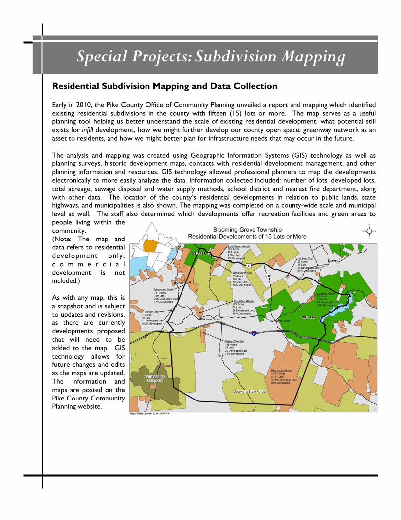
Residential Subdivision Mapping and Data Collection Early in 2010, the Pike County Office of Community Planning unveiled a report and mapping which identified existing residential subdivisions in the county with fifteen (15) lots or more. The map serves as a useful planning tool helping us better understand the scale of existing residential development, what potential still exists for infill development, how we might further develop our county open space, greenway network as an asset to residents, and how we might better plan for infrastructure needs that may occur in the future. The analysis and mapping was created using Geographic Information Systems (GIS) technology as well as planning surveys, historic development maps, contacts with residential development management, and other planning information and resources. GIS technology allowed professional planners to map the developments electronically to more easily analyze the data. Information collected included: number of lots, developed lots, total acreage, sewage disposal and water supply methods, school district and nearest fire department, along with other data. The location of the county’s residential developments in relation to public lands, state highways, and municipalities is also shown. The mapping was completed on a county-wide scale and municipal level as well. The staff also determined which developments offer recreation facilities and green areas to people living within the community. (Note: The map and data refers to residential deve lopment only ; c o m m e r c i a l development is not included.) As with any map, this is a snapshot and is subject to updates and revisions, as there are currently developments proposed that will need to be added to the map. GIS technology allows for future changes and edits as the maps are updated. The information and maps are posted on the Pike County Community Planning website.
Subdivision Mapping
Residential Subdivision Study Data from the study showed: ⇒ 192 Residential Developments of 15 lots or more
currently exist in Pike County ⇒ These 192 developments cover a total of 53,248 acres in
the County and include 49,381 lots; of which, 25,928 lots or 53% are developed. This statistic shows the tremendous number of housing lots that are still available in developments throughout the county.
⇒ 146 of the 192 Developments mapped are already over 50% developed.
⇒ 70% of the developments use Individual On-Lot water supplies (single family well);
⇒ 94% of the developments utilize Individual On-Lot Sewage Disposal (sand mound, drip irrigation, etc.)
⇒ Seven developments contain 2,000 lots or more – the largest being Hemlock Farms (3,717 lots), Saw Creek (2,833 lots), and Birchwood lakes (2,600 lots).
⇒ 33 developments contain 200 lots or more.
⇒ Palmyra Township mapped 47 developments of 15 lots or more while Porter Township mapped the fewest with 5 developments.
Useful Planning Tool This Pike County residential development analysis has served as a useful planning tool for the county. In September 2010, Planning Staff were requested to provide public testimony for the Joint State Government Commission and PA State Representative John J. Siptroth. The testimony from Pike Planning Staff outlined how the data was collected and what the data showed in regards to the Private Residential Developments in Pike County. Pike County was one of only a handful of counties across the state
to submit this requested information to the Joint State Government Commiss ion. Representative Siptroth had introduced legislation to collect this type of information to deal with infrastructure needs within P r i v a t e R e s i d e n t i a l Developments. Also in 2010, DEP (as required by a Environmental Hearing Board decision) announced it w o u l d s t a r t r e q u i r i n g
hydrogeologic studies with any new land development in Exceptional Value or High Quality watersheds, which includes all of Pike County. DEP looked at the Pike County Planning Residential Development mapping as a tool they could use in this process. The Planning Office and DEP utilizing GIS were able to determine the number of water supplies and on-lot sewage disposal systems per each sub-watershed in the Toms Creek and Dwarfskill Creek Watersheds. DEP used the data in combination with their own water testing data to show the impact in these highly developed residential areas. These watersheds are overlain by some of the largest residential developments in Pike County. The Residential Development mapping and study are available for a fee in printed form at the Pike County Office of Community Planning.
192 Residential Developments of 15
lots or more currently exist in Pike County. These developments contain 49,381 total
building lots, of which 53% are developed.
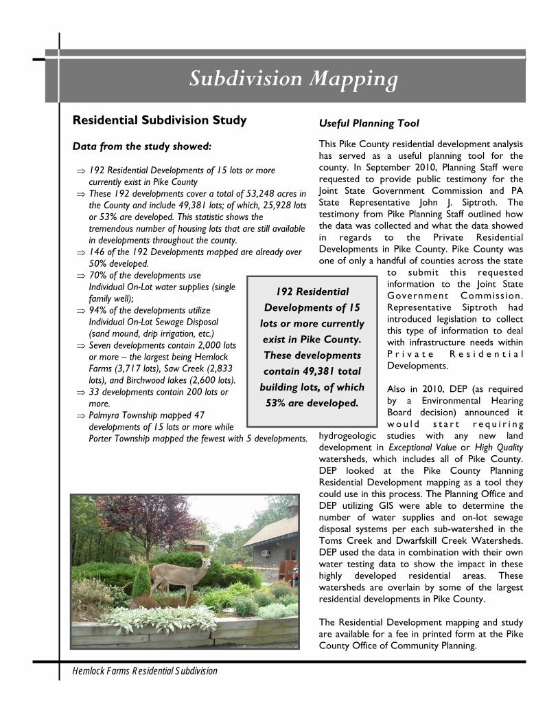
Hemlock Farms Residential Subdivision
Special Projects: Pike Outdoors
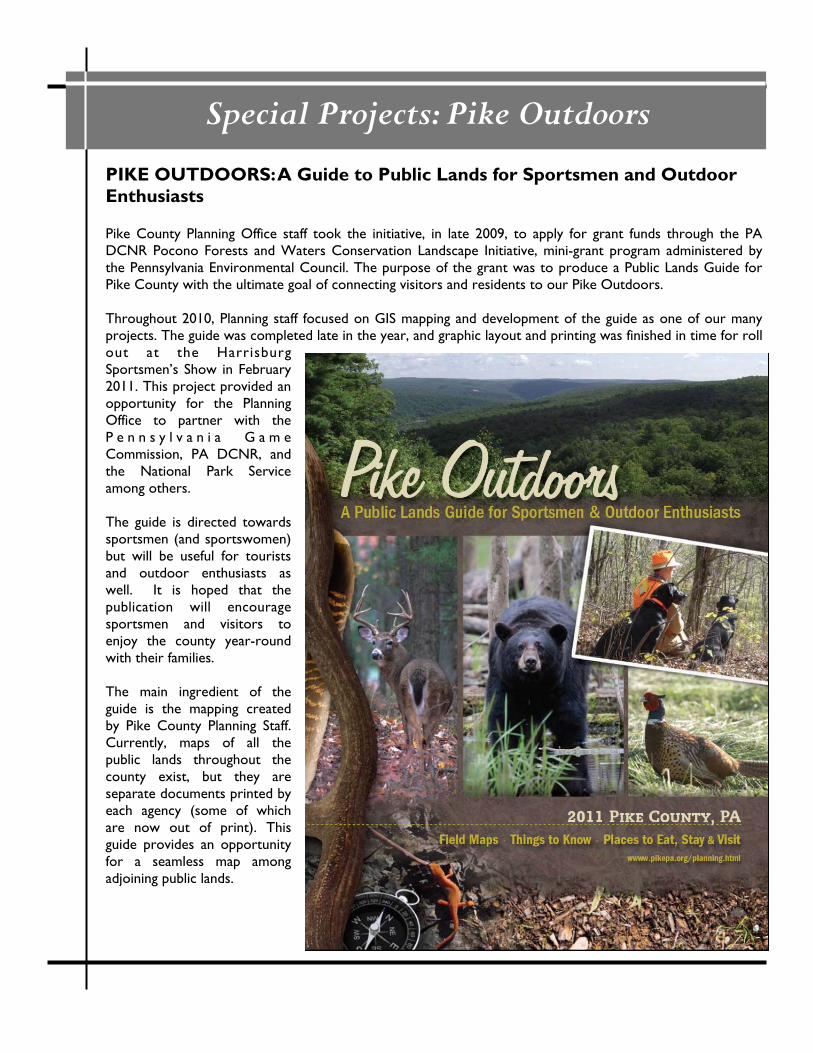
PIKE OUTDOORS: A Guide to Public Lands for Sportsmen and Outdoor Enthusiasts Pike County Planning Office staff took the initiative, in late 2009, to apply for grant funds through the PA DCNR Pocono Forests and Waters Conservation Landscape Initiative, mini-grant program administered by the Pennsylvania Environmental Council. The purpose of the grant was to produce a Public Lands Guide for Pike County with the ultimate goal of connecting visitors and residents to our Pike Outdoors. Throughout 2010, Planning staff focused on GIS mapping and development of the guide as one of our many projects. The guide was completed late in the year, and graphic layout and printing was finished in time for roll out at the Harrisburg Sportsmen’s Show in February 2011. This project provided an opportunity for the Planning Office to partner with the P e n n s y l v a n i a G a m e Commission, PA DCNR, and the National Park Service among others. The guide is directed towards sportsmen (and sportswomen) but will be useful for tourists and outdoor enthusiasts as well. It is hoped that the publication will encourage sportsmen and visitors to enjoy the county year-round with their families. The main ingredient of the guide is the mapping created by Pike County Planning Staff. Currently, maps of all the public lands throughout the county exist, but they are separate documents printed by each agency (some of which are now out of print). This guide provides an opportunity for a seamless map among adjoining public lands.
Pike Outdoors Guide to Public Lands
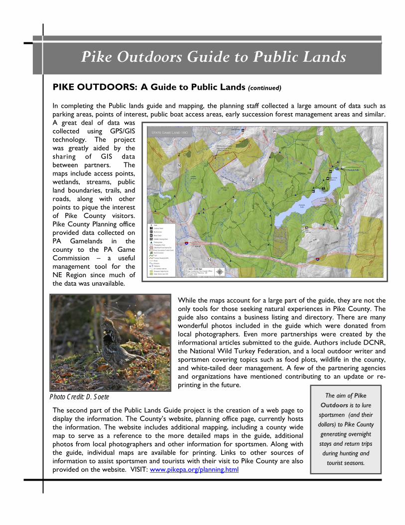
PIKE OUTDOORS: A Guide to Public Lands (continued) In completing the Public lands guide and mapping, the planning staff collected a large amount of data such as parking areas, points of interest, public boat access areas, early succession forest management areas and similar. A great deal of data was collected using GPS/GIS technology. The project was greatly aided by the sharing of GIS data between partners. The maps include access points, wetlands, streams, public land boundaries, trails, and roads, along with other points to pique the interest of Pike County visitors. Pike County Planning office provided data collected on PA Gamelands in the county to the PA Game Commission – a useful management tool for the NE Region since much of the data was unavailable.
While the maps account for a large part of the guide, they are not the only tools for those seeking natural experiences in Pike County. The guide also contains a business listing and directory. There are many wonderful photos included in the guide which were donated from local photographers. Even more partnerships were created by the informational articles submitted to the guide. Authors include DCNR, the National Wild Turkey Federation, and a local outdoor writer and sportsmen covering topics such as food plots, wildlife in the county, and white-tailed deer management. A few of the partnering agencies and organizations have mentioned contributing to an update or re-printing in the future.
The second part of the Public Lands Guide project is the creation of a web page to display the information. The County’s website, planning office page, currently hosts the information. The website includes additional mapping, including a county wide map to serve as a reference to the more detailed maps in the guide, additional photos from local photographers and other information for sportsmen. Along with the guide, individual maps are available for printing. Links to other sources of information to assist sportsmen and tourists with their visit to Pike County are also provided on the website. VISIT: www.pikepa.org/planning.html
The aim of Pike Outdoors is to lure sportsmen (and their dollars) to Pike County generating overnight stays and return trips during hunting and
tourist seasons.
Photo Credit: D. Soete
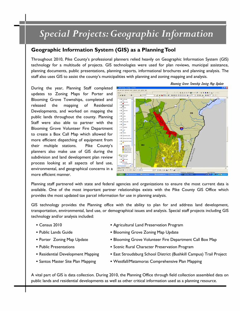
Special Projects: Geographic Information Geographic Information System (GIS) as a Planning Tool
Throughout 2010, Pike County’s professional planners relied heavily on Geographic Information System (GIS) technology for a multitude of projects. GIS technologies were used for plan reviews, municipal assistance, planning documents, public presentations, planning reports, informational brochures and planning analysis. The staff also uses GIS to assist the county’s municipalities with planning and zoning mapping and analysis. During the year, Planning Staff completed updates to Zoning Maps for Porter and Blooming Grove Townships, completed and released the mapping of Residential Developments, and worked on mapping the public lands throughout the county. Planning Staff were also able to partner with the Blooming Grove Volunteer Fire Department to create a Box Call Map which allowed for more efficient dispatching of equipment from their multiple stations. Pike County’s planners also make use of GIS during the subdivision and land development plan review process looking at all aspects of land use, environmental, and geographical concerns in a more efficient manner.
Planning staff partnered with state and federal agencies and organizations to ensure the most current data is available. One of the most important partner relationships exists with the Pike County GIS Office which provides the most updated tax parcel information for use in planning analysis.
GIS technology provides the Planning office with the ability to plan for and address land development, transportation, environmental, land use, or demographical issues and analysis. Special staff projects including GIS technology and/or analysis included:
A vital part of GIS is data collection. During 2010, the Planning Office through field collection assembled data on public lands and residential developments as well as other critical information used as a planning resource.
Blooming Grove Township Zoning Map Update
Census 2010 Agricultural Land Preservation Program
Public Lands Guide Blooming Grove Zoning Map Update
Porter Zoning Map Update Blooming Grove Volunteer Fire Department Call Box Map
Public Presentations Scenic Rural Character Preservation Program
Residential Development Mapping East Stroudsburg School District (Bushkill Campus) Trail Project
Santos Master Site Plan Mapping Westfall/Matamoras Comprehensive Plan Mapping
Special Projects: ESSD Trail
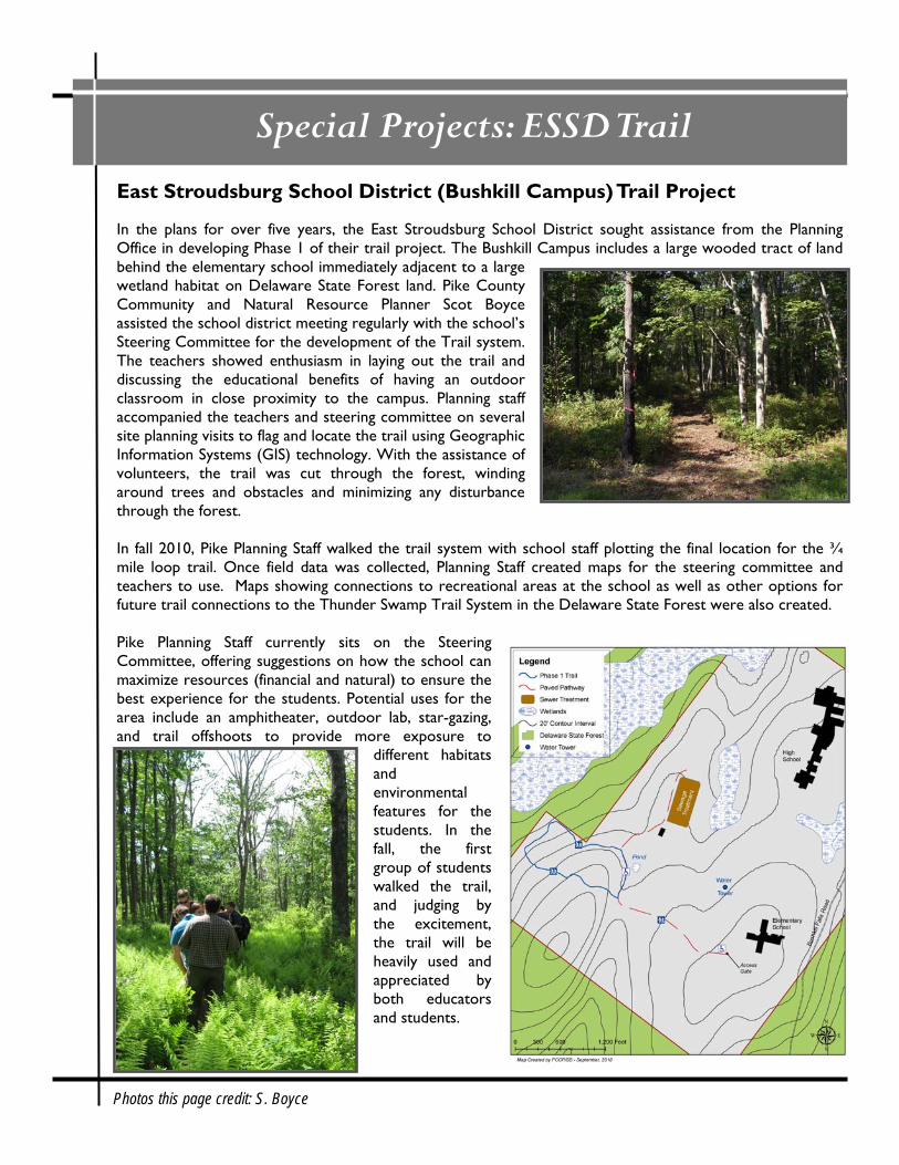
East Stroudsburg School District (Bushkill Campus) Trail Project In the plans for over five years, the East Stroudsburg School District sought assistance from the Planning Office in developing Phase 1 of their trail project. The Bushkill Campus includes a large wooded tract of land behind the elementary school immediately adjacent to a large wetland habitat on Delaware State Forest land. Pike County Community and Natural Resource Planner Scot Boyce assisted the school district meeting regularly with the school’s Steering Committee for the development of the Trail system. The teachers showed enthusiasm in laying out the trail and discussing the educational benefits of having an outdoor classroom in close proximity to the campus. Planning staff accompanied the teachers and steering committee on several site planning visits to flag and locate the trail using Geographic Information Systems (GIS) technology. With the assistance of volunteers, the trail was cut through the forest, winding around trees and obstacles and minimizing any disturbance through the forest. In fall 2010, Pike Planning Staff walked the trail system with school staff plotting the final location for the ¾ mile loop trail. Once field data was collected, Planning Staff created maps for the steering committee and teachers to use. Maps showing connections to recreational areas at the school as well as other options for future trail connections to the Thunder Swamp Trail System in the Delaware State Forest were also created. Pike Planning Staff currently sits on the Steering Committee, offering suggestions on how the school can maximize resources (financial and natural) to ensure the best experience for the students. Potential uses for the area include an amphitheater, outdoor lab, star-gazing, and trail offshoots to provide more exposure to
different habitats and environmental features for the students. In the fall, the first group of students walked the trail, and judging by the excitement, the trail will be heavily used and appreciated by both educators and students.
Photos this page credit: S. Boyce
County Planning: Population
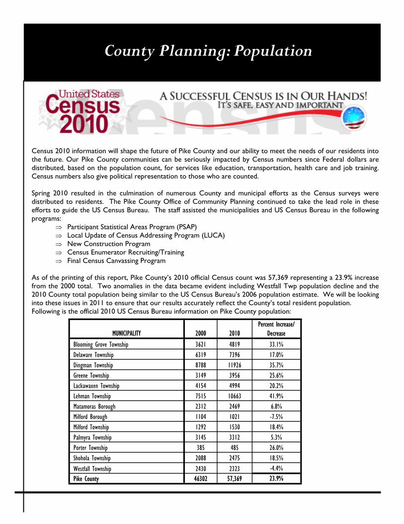
Census 2010 information will shape the future of Pike County and our ability to meet the needs of our residents into the future. Our Pike County communities can be seriously impacted by Census numbers since Federal dollars are distributed, based on the population count, for services like education, transportation, health care and job training. Census numbers also give political representation to those who are counted. Spring 2010 resulted in the culmination of numerous County and municipal efforts as the Census surveys were distributed to residents. The Pike County Office of Community Planning continued to take the lead role in these efforts to guide the US Census Bureau. The staff assisted the municipalities and US Census Bureau in the following programs:
⇒ Participant Statistical Areas Program (PSAP) ⇒ Local Update of Census Addressing Program (LUCA) ⇒ New Construction Program ⇒ Census Enumerator Recruiting/Training ⇒ Final Census Canvassing Program
As of the printing of this report, Pike County’s 2010 official Census count was 57,369 representing a 23.9% increase from the 2000 total. Two anomalies in the data became evident including Westfall Twp population decline and the 2010 County total population being similar to the US Census Bureau’s 2006 population estimate. We will be looking into these issues in 2011 to ensure that our results accurately reflect the County’s total resident population. Following is the official 2010 US Census Bureau information on Pike County population:
MUNICIPALITY 2000 2010 Percent Increase/
Decrease
Blooming Grove Township 3621 4819 33.1%
Delaware Township 6319 7396 17.0%
Dingman Township 8788 11926 35.7%
Greene Township 3149 3956 25.6%
Lackawaxen Township 4154 4994 20.2%
Lehman Township 7515 10663 41.9%
Matamoras Borough 2312 2469 6.8%
Milford Borough 1104 1021 -7.5%
Milford Township 1292 1530 18.4%
Palmyra Township 3145 3312 5.3%
Porter Township 385 485 26.0%
Shohola Township 2088 2475 18.5%
Westfall Township 2430 2323 -4.4%
Pike County 46302 57,369 23.9%
County Planning: Stormwater & Mitigation
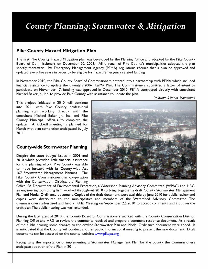
Pike County Hazard Mitigation Plan The first Pike County Hazard Mitigation plan was developed by the Planning Office and adopted by the Pike County Board of Commissioners on December 20, 2006. All thirteen of Pike County’s municipalities adopted the plan shortly thereafter. PA Emergency Management Agency (PEMA) regulations require that a plan be approved and updated every five years in order to be eligible for hazard/emergency related funding. In November 2010, the Pike County Board of Commissioners entered into a partnership with PEMA which included financial assistance to update the County’s 2006 HazMit Plan. The Commissioners submitted a letter of intent to participate on November 17; funding was approved in December 2010. PEMA contracted directly with consultant Michael Baker Jr., Inc. to provide Pike County with assistance to update the plan. This project, initiated in 2010, will continue into 2011 with Pike County professional planning staff working directly with the consultant Michael Baker Jr., Inc. and Pike County Municipal officials to complete the update. A kick-off meeting is planned for March with plan completion anticipated by July 2011.
County-wide Stormwater Planning Despite the state budget issues in 2009 and 2010 which provided little financial assistance for this planning effort, Pike County was able to move forward with its County-wide Act 167 Stormwater Management Planning. The Pike County Commissioners, in cooperation with the Conservation District, the Planning Office, PA Department of Environmental Protection, a Watershed Planning Advisory Committee (WPAC) and HRG, an engineering consulting firm, worked throughout 2010 to bring together a draft County Stormwater Management Plan and Model Ordinance document. Copies of the draft document were available by June 2010 for public review and copies were distributed to the municipalities and members of the Watershed Advisory Committee. The Commissioners advertised and held a Public Meeting on September 22, 2010 to accept comments and input on the draft plan. The public hearing was well attended. During the later part of 2010, the County Board of Commissioners worked with the County Conservation District, Planning Office and HRG to review the comments received and prepare a comment response document. As a result of the public hearing, some changes to the drafted Stormwater Plan and Model Ordinance document were added. It is anticipated that the County will conduct another public informational meeting to present the new document. Draft documents can be accessed on the county website: www.pikepa.org Recognizing the importance of implementing a Stormwater Management Plan for the county, the Commissioners anticipate adoption of the Plan in 2011.
Delaware River at Matamoras
County Planning: Transportation
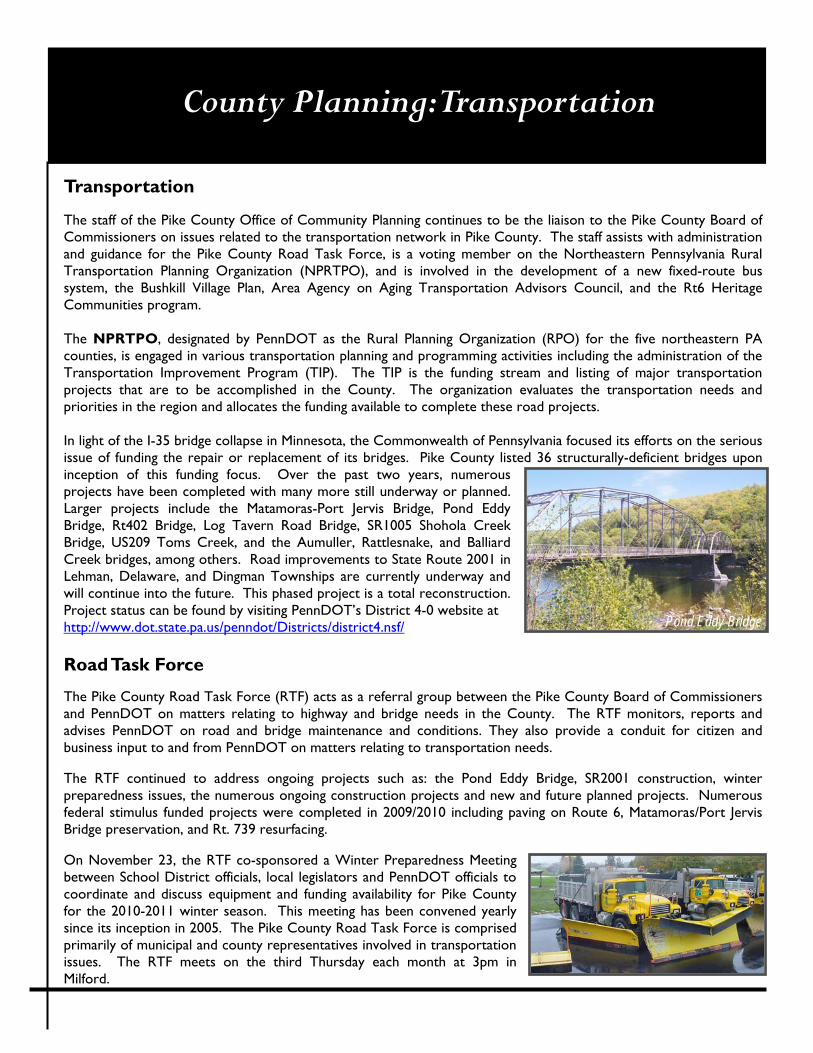
Transportation The staff of the Pike County Office of Community Planning continues to be the liaison to the Pike County Board of Commissioners on issues related to the transportation network in Pike County. The staff assists with administration and guidance for the Pike County Road Task Force, is a voting member on the Northeastern Pennsylvania Rural Transportation Planning Organization (NPRTPO), and is involved in the development of a new fixed-route bus system, the Bushkill Village Plan, Area Agency on Aging Transportation Advisors Council, and the Rt6 Heritage Communities program. The NPRTPO, designated by PennDOT as the Rural Planning Organization (RPO) for the five northeastern PA counties, is engaged in various transportation planning and programming activities including the administration of the Transportation Improvement Program (TIP). The TIP is the funding stream and listing of major transportation projects that are to be accomplished in the County. The organization evaluates the transportation needs and priorities in the region and allocates the funding available to complete these road projects. In light of the I-35 bridge collapse in Minnesota, the Commonwealth of Pennsylvania focused its efforts on the serious issue of funding the repair or replacement of its bridges. Pike County listed 36 structurally-deficient bridges upon inception of this funding focus. Over the past two years, numerous projects have been completed with many more still underway or planned. Larger projects include the Matamoras-Port Jervis Bridge, Pond Eddy Bridge, Rt402 Bridge, Log Tavern Road Bridge, SR1005 Shohola Creek Bridge, US209 Toms Creek, and the Aumuller, Rattlesnake, and Balliard Creek bridges, among others. Road improvements to State Route 2001 in Lehman, Delaware, and Dingman Townships are currently underway and will continue into the future. This phased project is a total reconstruction. Project status can be found by visiting PennDOT’s District 4-0 website at http://www.dot.state.pa.us/penndot/Districts/district4.nsf/ Road Task Force The Pike County Road Task Force (RTF) acts as a referral group between the Pike County Board of Commissioners and PennDOT on matters relating to highway and bridge needs in the County. The RTF monitors, reports and advises PennDOT on road and bridge maintenance and conditions. They also provide a conduit for citizen and business input to and from PennDOT on matters relating to transportation needs. The RTF continued to address ongoing projects such as: the Pond Eddy Bridge, SR2001 construction, winter preparedness issues, the numerous ongoing construction projects and new and future planned projects. Numerous federal stimulus funded projects were completed in 2009/2010 including paving on Route 6, Matamoras/Port Jervis Bridge preservation, and Rt. 739 resurfacing. On November 23, the RTF co-sponsored a Winter Preparedness Meeting between School District officials, local legislators and PennDOT officials to coordinate and discuss equipment and funding availability for Pike County for the 2010-2011 winter season. This meeting has been convened yearly since its inception in 2005. The Pike County Road Task Force is comprised primarily of municipal and county representatives involved in transportation issues. The RTF meets on the third Thursday each month at 3pm in Milford.
Pond Eddy Bridge
County Planning
Pike County Training Facility The Pike County Training Center is currently under construction in Blooming Grove Township. This approx. $10 million project is an investment in the future of emergency services in Pike County. The Center will include a new facility for Pike County’s e911 Communications Center and Emergency Operations Center (EOC) as well as training area for law enforcement agencies, fire departments and other emergency services personnel. The center is located on an 8± acre parcel within the existing county-owned property in Lords Valley. The Lords Valley County Complex currently houses several other Pike County facilities. The new training center will include: a three-story building housing the 911 communication and emergency operation centers and several training classrooms; a fire training building with live burn rooms for simulating hands-on emergency scenarios; training areas for law enforcement simulation; an observation tower that will house a control room used to operate training throughout the structure. The Pike County Office of Community Planning assisted the Pike County Board of Commissioners in obtaining grants for the project including the following: ⇒ DCED Local Share Account (Casino Grant Funds) - $500,000 was awarded to support the construction of the
Pike County 911/EOC Training Facility. ⇒ DCED ACE Grant – $72,000 loan was awarded through DCED’s Alternative and Clean Energy Grant program.
The loan is to be used towards the Geothermal System at the facility. ⇒ DCED Community Revitalization (CR) Grant – $500,000 was awarded to support construction. ⇒ Appalachian Regional Commission (ARC) Grant – $64,310 in grant funds were awarded and utilized to purchase
support apparatus for the center. Apparatus includes: SCBA - HazMat Confined Space Maze System; Fixed Position Class “A” Flashover Simulator; O-100 Hose Line Fire Trainer Burn Pan and Pilot Box; 500 Gallon Pressure Vessel Prop; Industrial Pipe (Christmas Tree) Fire Prop.
The Facility is currently under construction and substantial completion is anticipated in late Summer/early Fall 2011.
Pike County Marcellus Shale Task Force The Pike County Board of Commissioners, seeing the need to be proactive on outreach, education, planning and action in regard to Marcellus Shale activities in Pike County, established a Marcellus Shale Task Force late in 2010. The Commissioners felt the county needed to play a key leadership role providing fact-based information to Pike County residents and county agencies and facilitating communication, cooperation, planning and education related to Marcellus activities in the County. The Planning office worked with the Commissioners over
several months assembling pertinent information on Task Forces from other counties in northeastern Pennsylvania, the Northern Tier of Pennsylvania, and the Southern Tier of New York. The Task Force structure should provide a functional organization which can move forward to build capacity for addressing the various potential impacts and opportunities that this new industry might provide for the County. The Task Force includes several Committees including Economic Development, Education, Environment, Planning/Government, Public Safety and Roads. A critical component of the overall Task Force will be input from our municipal government officials, so a Planning/Government Committee has been included in the overall Task Force structure. This Committee includes representation from each municipal government. The Task Force will meet quarterly starting in early 2011. VISIT: http://www.pikepa.org/marcellus.html

PIKE COUNTY OFFICE OF COMMUNITY PLANNING
MARCH 2011
AG R I C U LT U R A L L A N D P R E S E RVAT I O N
S C E N I C RU R A L C H A R AC T E R P R E S E RVAT I O N
PIKE COUNTY PRESERVATION PROGRAMS
2010 Annual Repor t

A g r i c u l t u r a l L a n d P r e s e r v a t i o n
Pike County Board of Commissioners
Richard A. Caridi Harry Forbes (2010) Karl A. Wagner, Jr.
Kathleen Hummel (2011)
The purpose of the Pike County Agricultural Land Preservation Program is to protect and promote the continued agricultural use of valuable agricultural lands by acquiring agricultural conservation easements on actively farmed lands within Agricultural Security Areas (ASA’s). The purchase of these easements from willing and interested landowners will provide these landowners with a more viable option for retaining the small farm operations and our local communities’ rural character.
The Commissioners, in March 2006, created the Pike County Agricultural Land Preservation Program and named a five (5) member Board, in accordance with the provisions contained within the Agricultural Area Security Law (3 P.S. §§ 901-915), as amended by Act 149 in 1988. The Board's primary goals are the implementation of the Agricultural Land Preservation program including:
Promoting efforts to support the agricultural community in Pike County and maximize Pike County’s agricultural lands’ contribution to the county’s agricultural and tourism economy.
Encouraging the use of additional farmland preservation techniques through public and private organizations in Pike County.
Encouraging the formation of Agricultural Security Areas (ASA’s) within the County by working with landowners and municipal officials.
Administering the program for purchasing and/or accepting gifts of agricultural conservation easements within Agricultural Security Areas (ASA) on behalf of the County and in accordance with Act 149.
While Pike County’s farming community may not play a significant role in the state’s agricultural economy, Pike County farming does remain a productive resource which contributes to the local economy and plays a significant role in the scenic rural character of our local communities. The Pike County Agricultural Land Preservation Program Manual was approved by the State Ag Board on February 15, 2007 allowing Pike County to start accepting applications in 2008. The most recent revision to the program manual was approved by the state board on December 10, 2009, with approvals by the Pike County Board of Commissioners on January 13, 2010.
2010 Board Members
Glenn Strys
Chairman
Bill Obert Vice-Chair
Bob Cocchi
Shirley Coutts
Matt Martin
837 Route 6, Unit 4
Shohola, PA 18458
P: 570-296-3500
F: 570-296-3501
www.pikepa.org/alp.html
Special points of interest:
• Greene Township creates ASA
• 1st Agricultural Conservation Easement
• Educational Outreach
Another ASA, and together that makes Four
In early 2010, Pike County was notified that Greene Township had approved a proposal for the creation of a Greene Township Agricultural Security Area (ASA). While only a few landowners made the pioneer journey to enroll their lands in the ASA, over 350 acres were included on that first proposal.
Not long after that first proposal was accepted by the Greene Township Supervisors, another 100 acres was submitted for consideration and inclusion in the Greene Township ASA.
Lackawaxen Township, the first ASA in Pike County, continued to add lands to their 4-year old Agricultural Security Area. Another 820 acres was added in March 2010, and a year end proposal for additional acreage was received by the Township for consideration in early 2011.
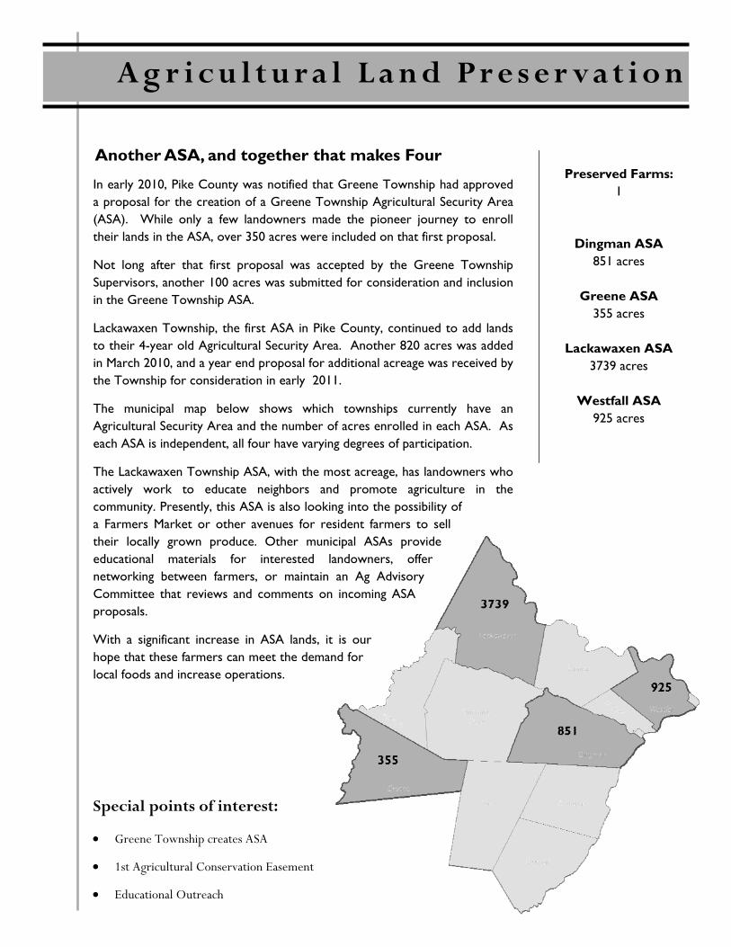
The municipal map below shows which townships currently have an Agricultural Security Area and the number of acres enrolled in each ASA. As each ASA is independent, all four have varying degrees of participation.
The Lackawaxen Township ASA, with the most acreage, has landowners who actively work to educate neighbors and promote agriculture in the community. Presently, this ASA is also looking into the possibility of a Farmers Market or other avenues for resident farmers to sell their locally grown produce. Other municipal ASAs provide educational materials for interested landowners, offer networking between farmers, or maintain an Ag Advisory Committee that reviews and comments on incoming ASA proposals.
With a significant increase in ASA lands, it is our hope that these farmers can meet the demand for local foods and increase operations.
Preserved Farms: 1
Dingman ASA 851 acres
Greene ASA
355 acres
Lackawaxen ASA 3739 acres
Westfall ASA
925 acres
A g r i c u l t u r a l L a n d P r e s e r v a t i o n
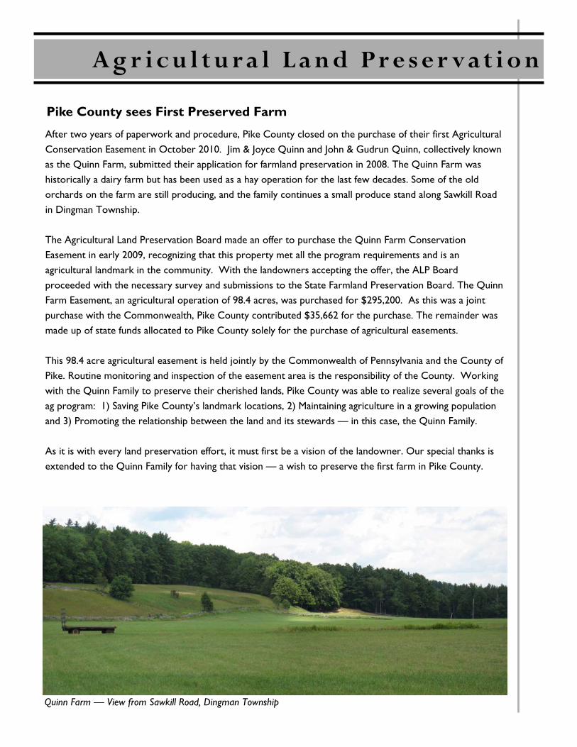
After two years of paperwork and procedure, Pike County closed on the purchase of their first Agricultural Conservation Easement in October 2010. Jim & Joyce Quinn and John & Gudrun Quinn, collectively known as the Quinn Farm, submitted their application for farmland preservation in 2008. The Quinn Farm was historically a dairy farm but has been used as a hay operation for the last few decades. Some of the old orchards on the farm are still producing, and the family continues a small produce stand along Sawkill Road in Dingman Township. The Agricultural Land Preservation Board made an offer to purchase the Quinn Farm Conservation Easement in early 2009, recognizing that this property met all the program requirements and is an agricultural landmark in the community. With the landowners accepting the offer, the ALP Board proceeded with the necessary survey and submissions to the State Farmland Preservation Board. The Quinn Farm Easement, an agricultural operation of 98.4 acres, was purchased for $295,200. As this was a joint purchase with the Commonwealth, Pike County contributed $35,662 for the purchase. The remainder was made up of state funds allocated to Pike County solely for the purchase of agricultural easements. This 98.4 acre agricultural easement is held jointly by the Commonwealth of Pennsylvania and the County of Pike. Routine monitoring and inspection of the easement area is the responsibility of the County. Working with the Quinn Family to preserve their cherished lands, Pike County was able to realize several goals of the ag program: 1) Saving Pike County’s landmark locations, 2) Maintaining agriculture in a growing population and 3) Promoting the relationship between the land and its stewards — in this case, the Quinn Family. As it is with every land preservation effort, it must first be a vision of the landowner. Our special thanks is extended to the Quinn Family for having that vision — a wish to preserve the first farm in Pike County.
Pike County sees First Preserved Farm
Quinn Farm — View from Sawkill Road, Dingman Township
A g r i c u l t u r a l L a n d P r e s e r v a t i o n
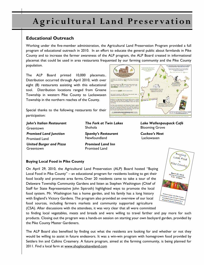
Working under the five-member administration, the Agricultural Land Preservation Program provided a full program of educational outreach in 2010. In an effort to educate the general public about farmlands in Pike County and to increase the farmer awareness of the ALP program, the ALP Board created in informational placemat that could be used in area restaurants frequented by our farming community and the Pike County population. The ALP Board printed 10,000 placemats.. Distribution occurred through April 2010, with over eight (8) restaurants assisting with this educational tool. Distribution locations ranged from Greene Township in western Pike County to Lackawaxen Township in the northern reaches of the County. Special thanks to the following restaurants for their participation:
Buying Local Food in Pike County
On April 29, 2010, the Agricultural Land Preservation (ALP) Board hosted “Buying Local Food in Pike County” – an educational program for residents looking to get their food locally and promote area farms. Over 20 residents came to take a tour of the Delaware Township Community Gardens and listen as Stephen Washington (Chief of Staff for State Representative John Siptroth) highlighted ways to promote the local food system. Mr. Washington has a home garden, and his family has a long history with England’s Victory Gardens. The program also provided an overview of our local food sources, including farmers markets and community supported agriculture (CSA). After discussions with the attendees, it was very clear that all were committed to finding local vegetables, meats and breads and were willing to travel farther and pay more for such products. Closing out the program was a hands-on session on starting your own backyard garden, provided by the Pike County Master Gardeners.
The ALP Board also benefited by finding out what the residents are looking for and whether or not they would be willing to assist in future endeavors. It was a win-win program with homegrown food provided by Settlers Inn and Calkins Creamery. A future program, aimed at the farming community, is being planned for 2011. Find a local farm at www.shoplocalsaveland.com
Educational Outreach
John’s Italian Restaurant Greentown
The Fork at Twin Lakes Shohola
Lake Wallenpaupack Café Blooming Grove
Promised Land Junction Promised Land
Spanky’s Restaurant Newfoundland
Cuckoo’s Nest Lackawaxen
United Burger and Pizza Greentown
Promised Land Inn Promised Land
A g r i c u l t u r a l L a n d P r e s e r v a t i o n
Scenic Rural Character Preservation
2010 Board Members
Ed Nikles Chairman
Lisa Napoletano Vice-Chair
Carol Comando
John Dublanica
Richard Gross
Pete Helms
Roger Spotts
Tony Waldron
Nelia Wall
837 Route 6, Unit 4
Shohola, PA 18458
P: 570-296-3500
F: 570-296-3501
www.pikepa.org/srcp.html
In 2005, a Pike County citizen group, the Alliance to Keep Pike Green, worked with the Pike County Commissioners to place a bond referendum on the November electoral ballot. The bond referendum asked the citizens in Pike County to aid in protecting our scenic rural character and quality of life by authorizing the expenditure of up to $10 million over 10 years for increased planning at the county and municipal levels and for the purchase of land and land protection agreements from willing sellers in the County. In many cases, the funds under this Pike County Scenic Rural Character Preservation Program could be used as matching funds by the County and municipalities to leverage millions of dollars in state, federal, or other matching funds for planning and land preservation. The bond referendum passed with an overwhelming 68% Yes vote and thus, the Pike County Scenic Rural Character Preservation Program was established in April 2006. The mission of the Scenic Rural Character Preservation Program is to provide for the protection of drinking water; wildlife habitat; preservation of scenic ridges and critical open space; protection of water quality of rivers, lakes and streams; parks and recreational areas; improved county and municipal planning; and related acquisitions of real property or interests therein from willing sellers on a voluntary basis and to provide education, outreach and the provision of funds for such purposes. Early funding was used for Municipal Planning Initiatives, and grants were awarded in accordance with the Program Manual approved by the Commissioners in October 2006. The following year, the SRCP Board updated the manual to include funding guidelines for the acquisitions and easements portion of the program. The SRCP Board actively began working with municipalities and willing landowners to acquire conservation easements or properties that satisfied program criteria. In May 2009, the Commissioners announced the development of the Donated Conservation Easements Manual. This landmark program offers financial assistance for landowners who want to donate a conservation easement. The Preservation Board also conducts educational outreach to assist municipalities and private landowners in conservation and stewardship planning to retain Pike County’s scenic rural character and natural resources.
Pike County Board of Commissioners
Richard A. Caridi Harry Forbes (2010) Karl A. Wagner, Jr.
Kathleen Hummel (2011)
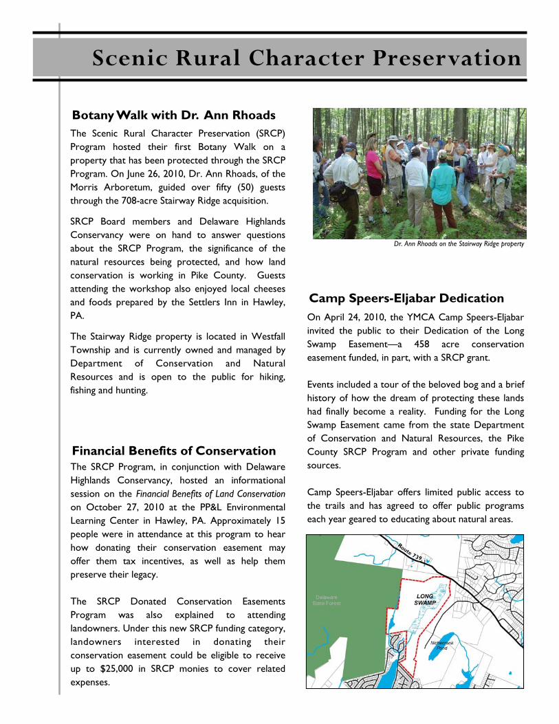
The Scenic Rural Character Preservation (SRCP) Program hosted their first Botany Walk on a property that has been protected through the SRCP Program. On June 26, 2010, Dr. Ann Rhoads, of the Morris Arboretum, guided over fifty (50) guests through the 708-acre Stairway Ridge acquisition.
SRCP Board members and Delaware Highlands Conservancy were on hand to answer questions about the SRCP Program, the significance of the natural resources being protected, and how land conservation is working in Pike County. Guests attending the workshop also enjoyed local cheeses and foods prepared by the Settlers Inn in Hawley, PA.
The Stairway Ridge property is located in Westfall Township and is currently owned and managed by Department of Conservation and Natural Resources and is open to the public for hiking, fishing and hunting.
Botany Walk with Dr. Ann Rhoads
Dr. Ann Rhoads on the Stairway Ridge property
Scenic Rural Character Preservation
On April 24, 2010, the YMCA Camp Speers-Eljabar invited the public to their Dedication of the Long Swamp Easement—a 458 acre conservation easement funded, in part, with a SRCP grant. Events included a tour of the beloved bog and a brief history of how the dream of protecting these lands had finally become a reality. Funding for the Long Swamp Easement came from the state Department of Conservation and Natural Resources, the Pike County SRCP Program and other private funding sources. Camp Speers-Eljabar offers limited public access to the trails and has agreed to offer public programs each year geared to educating about natural areas.
Camp Speers-Eljabar Dedication
Financial Benefits of Conservation The SRCP Program, in conjunction with Delaware Highlands Conservancy, hosted an informational session on the Financial Benefits of Land Conservation on October 27, 2010 at the PP&L Environmental Learning Center in Hawley, PA. Approximately 15 people were in attendance at this program to hear how donating their conservation easement may offer them tax incentives, as well as help them preserve their legacy. The SRCP Donated Conservation Easements Program was also explained to attending landowners. Under this new SRCP funding category, landowners interested in donating their conservation easement could be eligible to receive up to $25,000 in SRCP monies to cover related expenses.
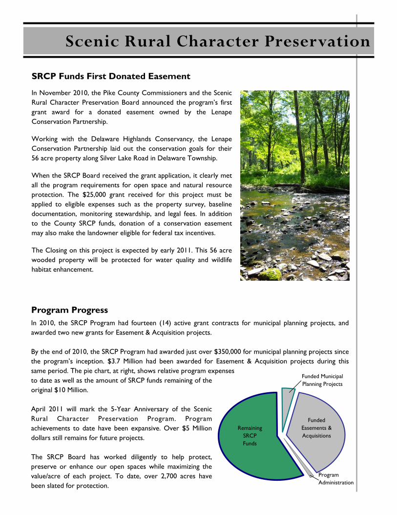
In November 2010, the Pike County Commissioners and the Scenic Rural Character Preservation Board announced the program’s first grant award for a donated easement owned by the Lenape Conservation Partnership.
Working with the Delaware Highlands Conservancy, the Lenape Conservation Partnership laid out the conservation goals for their 56 acre property along Silver Lake Road in Delaware Township.
When the SRCP Board received the grant application, it clearly met all the program requirements for open space and natural resource protection. The $25,000 grant received for this project must be applied to eligible expenses such as the property survey, baseline documentation, monitoring stewardship, and legal fees. In addition to the County SRCP funds, donation of a conservation easement may also make the landowner eligible for federal tax incentives.
The Closing on this project is expected by early 2011. This 56 acre wooded property will be protected for water quality and wildlife habitat enhancement.
SRCP Funds First Donated Easement
Scenic Rural Character Preservation
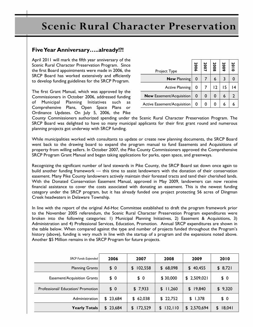
In 2010, the SRCP Program had fourteen (14) active grant contracts for municipal planning projects, and awarded two new grants for Easement & Acquisition projects. By the end of 2010, the SRCP Program had awarded just over $350,000 for municipal planning projects since the program’s inception. $3.7 Million had been awarded for Easement & Acquisition projects during this same period. The pie chart, at right, shows relative program expenses to date as well as the amount of SRCP funds remaining of the original $10 Million. April 2011 will mark the 5-Year Anniversary of the Scenic Rural Character Preservation Program. Program achievements to date have been expansive. Over $5 Million dollars still remains for future projects. The SRCP Board has worked diligently to help protect, preserve or enhance our open spaces while maximizing the value/acre of each project. To date, over 2,700 acres have been slated for protection.
Program Progress
Remaining SRCP Funds
Funded Easements & Acquisitions
Funded Municipal Planning Projects
Program Administration
April 2011 will mark the fifth year anniversary of the Scenic Rural Character Preservation Program. Since the first Board appointments were made in 2006, the SRCP Board has worked extensively and efficiently to develop funding guidelines for the SRCP Program. The first Grant Manual, which was approved by the Commissioners in October 2006, addressed funding of Municipal Planning Initiatives such as Comprehensive Plans, Open Space Plans or Ordinance Updates. On July 5, 2006, the Pike County Commissioners authorized spending under the Scenic Rural Character Preservation Program. The SRCP Board was delighted to have so many municipal applicants for their first grant round and numerous planning projects got underway with SRCP funding. While municipalities worked with consultants to update or create new planning documents, the SRCP Board went back to the drawing board to expand the program manual to fund Easements and Acquisitions of property from willing sellers. In October 2007, the Pike County Commissioners approved the Comprehensive SRCP Program Grant Manual and began taking applications for parks, open space, and greenways. Recognizing the significant number of land stewards in Pike County, the SRCP Board sat down once again to build another funding framework — this time to assist landowners with the donation of their conservation easement. Many Pike County landowners actively maintain their forested tracts and tend their cherished lands. With the Donated Conservation Easement Manual, approved in May 2009, landowners can now receive financial assistance to cover the costs associated with donating an easement. This is the newest funding category under the SRCP program, but it has already funded one project protecting 56 acres of Dingman Creek headwaters in Delaware Township. In line with the report of the original Ad-Hoc Committee established to draft the program framework prior to the November 2005 referendum, the Scenic Rural Character Preservation Program expenditures were broken into the following categories: 1) Municipal Planning Initiatives, 2) Easement & Acquisitions, 3) Administration and 4) Professional Services, Education, Promotion. Annual SRCP expenditures are shown in the table below. When compared against the type and number of projects funded throughout the Program’s history (above), funding is very much in line with the startup of a program and the expansions noted above. Another $5 Million remains in the SRCP Program for future projects.
Five Year Anniversary…..already!?!
Scenic Rural Character Preservation
SRCP Funds Expended 2006 2007 2008 2009 2010
Planning Grants $ 0 $ 102,558 $ 68,098 $ 40,455 $ 8,721
Easement/Acquisition Grants $ 0 $ 0 $ 30,000 $ 2,509,021 $ 0
Professional/ Education/ Promotion $ 0 $ 7,933 $ 11,260 $ 19,840 $ 9,320
Administration $ 23,684 $ 62,038 $ 22,752 $ 1,378 $ 0
Yearly Totals $ 23,684 $ 172,529 $ 132,110 $ 2,570,694 $ 18,041
Project Type
2006
2007
2008
2009
2010
New Planning 0 7 6 3 0
Active Planning 0 7 12 15 14
New Easement/Acquisition 0 0 0 6 2
Active Easement/Acquisition 0 0 0 6 6
PIKE COUNTY OFFICE OF COMMUNITY PLANNING
MARCH 2011