Embed Size (px)
Citation preview

PIGWAD and Mapping Tools Update
Planetary Mappers Meeting 2002
Topics
bullPIGWAD Update
bullDownloads
bullTools
bullFree Shapefile Viewers
bullShapefile Creators
bull3D
bullProfiles
bullAnaglyphs
PIGWAD Update
bullUpgraded to new version ArcIMS 40
bullNew spatial server for faster displays ndash not online yet
bullChange to standardized template
bullMore datasets (explained next) and downloads added
bullFeature Extraction
bullTesting new image server which will allow you to mix RGB channels do transparency on multiple layers and save out GIS ready jpeg
Mars datasetsbullMSSS Mars MOC Mosaic (231 meters per pixel)
bullMars Digital Image Mosaic 2 (231 meters per pixel) no albedo
bullMars Digital Image Mosaic 1 (6000 and 1500 meters per pixel) albedo
bullMOLA Shaded Relief (MOLA contour)
bullGeology
bullMOC footprints
bullMOLA tracks
bull115M Global Geologic Map
bullStereo Expected Precision Map
bullImage Resolution Map
bullPhotoclinometry Figure of Merit Map
bullLow-res TES mineral maps
bullGraticule
Venus datasetsbullImage Base (1 and 30 kmpixel bases)
bullCrater Catalog
bullVolcano Catalog
bullCoronae Features (Type 1 and Type 2)
bullNomenclature
bullRadar Properties
bullTopography (GTDR) Image (contours 1 and 2 km interval)
bullReflectivity (GREDR) Image (contours 01 and 02 unit interval)
bullEmissivity (GEDR) Image (contours 01 unit interval)
bullRMS Slope (GSDR) Image (contours)
bullGraticules (5x5 deg 30x30 deg)
bullClementine 750nm image base (303 and 16 pixel degree)
bullNomenclature
bullGeologic Maps
bullGeologic Map Index
bullTopography images (contours - 1 and 2 km intervals)
bullFree-air Gravity images (contours - 1 and 2 km intervals)
bullGraticules
Moon datasets
Free Shapefile ViewersbullArcExplorer
httpwwwesricomWindows Sun Linux Mac OSX
Venus hillshade with color layer set to 60 transparent elevation contours
Free Shapefile ViewersbullArcExplorer
httpwwwesricomWindows Sun Linux Mac OSX
Supports multiple image typesbullJpegbullGeotiffbullYou need a ldquoGISrdquo PDS imagebullldquoGISrdquo ISIS cubbullImage transparency
This means a PDS or ISIS image with detached header info and georef info Note PIGWAD has tutorials and tools to help generate these
Supports shapefilesbullColor legendsbullScale dependanciesbullSmart queriesbullMap tipsbullBufferingbullSaving projects
Free Shapefile ViewersbullArcExplorer
Supports PIGWAD online maps and layers and thousands of Earth online maps
This means you can show your own shapefiles on top of PIGWAD layers without downloading anything
Free Shapefile ViewersbullArcExplorer
Set backsbullplanetary spheroids not supported Distances are wrong if using decimal degrees User should use files in metersbullCannot create or edit shapefilesbullNew version will be available for download at the end of JunebullCanrsquot query image pixels or display DEMs
Free Shapefile ViewersbullPCI Geomatic FreeView
httpwwwpcigeomaticscomWindows only
Shapefile Query tools
Free Shapefile ViewersbullPCI Geomatic FreeView
bullView any number of images at any depth (8 16 and 32 bit) at any size and in any resolution with NO conversion
ECW Mr Sid Tif Jpeg GeoTif RAW (PDSISIS) hellip
bullVector support
bullMore than 100 formats
Note We may start having users download ECW or MrSid formats as you can get 100 to 1 compression We will also look into Jpeg2000 This will be for GIS files like Mdim 21 Clementine Venus SAR which can be multiple Gigs in size This make the files easier to download an handle and serve in full mosaics not just pieces
Free Shapefile ViewersbullPCI Geomatic FreeView
Image pixel query on images or DEMs
bullNo profile toolbullNo planetary projections
Free Shapefile ViewersbullGeo Mapper
Problem Note how the profile is plotted over a sphere It will not let you accurately set a planetary sphere
Using ldquoGISrdquo ISIS DEM (MOLA 230 mp) The programbullColored itbullShaded itbullContouredbullProfiled
bullQuery Pixels and vectors
httpwwwglobalmappercomWindows only
FormatsbullVector Data (ie DLGs Shapefiles etc)
bullAutoCAD DXF format bullESRI Shapefile format bullMapInfo MIFMID format bullXYZ ASCII format bullUSGS DLG-O format bullSVG (Scalable Vector Graphic) format
bullRaster Data (ie DRGs DOQs etc)bullGeoTIFF format
bullElevation Data (ie DEMs etc) bullUSGS DEM formatbullGeoTIFF DEM format bullSurfer Grid (ASCII and binary) formats bullXYZ ASCII Grid format bullArc Grid and ASCII Grid format bull3D DXF Mesh formatbullRockWorks Grid format
bullContour GenerationbullProfiles (sort-of)bullHillshading
Free Shapefile ViewersbullGeo Mapper
Free Shapefile ViewersbullGeo Mapper
Set backsbullplanets spheroids not supported
bullFree mode is limitingbullOnly supports 4 layers at a timebullCannot convert image to different image formatbullCannot convert vectorsbullCannot export contours to shapefiles hellipbullTo enable these features the product cost $130
Free Shapefile ViewersbullThere are many more
httpsoftwaregeocommcom for articleldquoGIS Viewing Tools You Shouldnt Be Withoutrdquo
Last but not LeastWe are looking into a free viewer createdin cooperation with GLIMS (Global Land Ice
Measurements from Space) They are generating a image viewer and and shapefile attribution Hopefully this would have a shapefile digitizer alsoThis would be available for Linux SunWindows and even Mac OSX
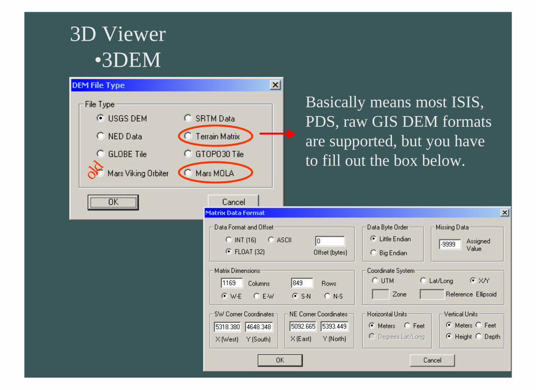
3D Viewerbull3DEM
httpwwwvisualizationsoftwarecomWindows only
bullProfilesbull3D ViewsbullAnaglyphs
bullExtremely useful
bull3D movies
Limitationsbull$35 (try for free)
bullWindowsbullStatic 3D views
3D Viewerbull3DEM
oldBasically means most ISIS PDS raw GIS DEM formats are supported but you have to fill out the box below
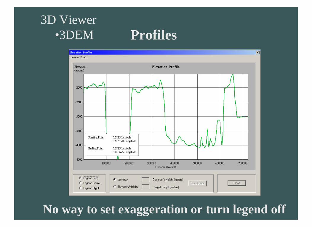
3D Viewerbull3DEM Profiles
No way to set exaggeration or turn legend off
3D Viewerbull3DEM 3D Views
And you can drape registered image textures
3D Viewerbull3DEM Anaglyphs
RedBlue and Flicker glasses
Shapefile Creators
We are currently going to support a free stand alone ASCII to shapefile converter The input format is known as a generate format and supports points lines polygons (possibly circles rectangles)
Please visit PIGWAD for tutorials on how to format the generate file and for the latest downloads We will try to support Windows Linux Sun and Mac OSX
httpintevationde~jangen2shpgen2shphtml

Topics
bullPIGWAD Update
bullDownloads
bullTools
bullFree Shapefile Viewers
bullShapefile Creators
bull3D
bullProfiles
bullAnaglyphs
PIGWAD Update
bullUpgraded to new version ArcIMS 40
bullNew spatial server for faster displays ndash not online yet
bullChange to standardized template
bullMore datasets (explained next) and downloads added
bullFeature Extraction
bullTesting new image server which will allow you to mix RGB channels do transparency on multiple layers and save out GIS ready jpeg
Mars datasetsbullMSSS Mars MOC Mosaic (231 meters per pixel)
bullMars Digital Image Mosaic 2 (231 meters per pixel) no albedo
bullMars Digital Image Mosaic 1 (6000 and 1500 meters per pixel) albedo
bullMOLA Shaded Relief (MOLA contour)
bullGeology
bullMOC footprints
bullMOLA tracks
bull115M Global Geologic Map
bullStereo Expected Precision Map
bullImage Resolution Map
bullPhotoclinometry Figure of Merit Map
bullLow-res TES mineral maps
bullGraticule
Venus datasetsbullImage Base (1 and 30 kmpixel bases)
bullCrater Catalog
bullVolcano Catalog
bullCoronae Features (Type 1 and Type 2)
bullNomenclature
bullRadar Properties
bullTopography (GTDR) Image (contours 1 and 2 km interval)
bullReflectivity (GREDR) Image (contours 01 and 02 unit interval)
bullEmissivity (GEDR) Image (contours 01 unit interval)
bullRMS Slope (GSDR) Image (contours)
bullGraticules (5x5 deg 30x30 deg)
bullClementine 750nm image base (303 and 16 pixel degree)
bullNomenclature
bullGeologic Maps
bullGeologic Map Index
bullTopography images (contours - 1 and 2 km intervals)
bullFree-air Gravity images (contours - 1 and 2 km intervals)
bullGraticules
Moon datasets
Free Shapefile ViewersbullArcExplorer
httpwwwesricomWindows Sun Linux Mac OSX
Venus hillshade with color layer set to 60 transparent elevation contours
Free Shapefile ViewersbullArcExplorer
httpwwwesricomWindows Sun Linux Mac OSX
Supports multiple image typesbullJpegbullGeotiffbullYou need a ldquoGISrdquo PDS imagebullldquoGISrdquo ISIS cubbullImage transparency
This means a PDS or ISIS image with detached header info and georef info Note PIGWAD has tutorials and tools to help generate these
Supports shapefilesbullColor legendsbullScale dependanciesbullSmart queriesbullMap tipsbullBufferingbullSaving projects
Free Shapefile ViewersbullArcExplorer
Supports PIGWAD online maps and layers and thousands of Earth online maps
This means you can show your own shapefiles on top of PIGWAD layers without downloading anything
Free Shapefile ViewersbullArcExplorer
Set backsbullplanetary spheroids not supported Distances are wrong if using decimal degrees User should use files in metersbullCannot create or edit shapefilesbullNew version will be available for download at the end of JunebullCanrsquot query image pixels or display DEMs
Free Shapefile ViewersbullPCI Geomatic FreeView
httpwwwpcigeomaticscomWindows only
Shapefile Query tools
Free Shapefile ViewersbullPCI Geomatic FreeView
bullView any number of images at any depth (8 16 and 32 bit) at any size and in any resolution with NO conversion
ECW Mr Sid Tif Jpeg GeoTif RAW (PDSISIS) hellip
bullVector support
bullMore than 100 formats
Note We may start having users download ECW or MrSid formats as you can get 100 to 1 compression We will also look into Jpeg2000 This will be for GIS files like Mdim 21 Clementine Venus SAR which can be multiple Gigs in size This make the files easier to download an handle and serve in full mosaics not just pieces
Free Shapefile ViewersbullPCI Geomatic FreeView
Image pixel query on images or DEMs
bullNo profile toolbullNo planetary projections
Free Shapefile ViewersbullGeo Mapper
Problem Note how the profile is plotted over a sphere It will not let you accurately set a planetary sphere
Using ldquoGISrdquo ISIS DEM (MOLA 230 mp) The programbullColored itbullShaded itbullContouredbullProfiled
bullQuery Pixels and vectors
httpwwwglobalmappercomWindows only
FormatsbullVector Data (ie DLGs Shapefiles etc)
bullAutoCAD DXF format bullESRI Shapefile format bullMapInfo MIFMID format bullXYZ ASCII format bullUSGS DLG-O format bullSVG (Scalable Vector Graphic) format
bullRaster Data (ie DRGs DOQs etc)bullGeoTIFF format
bullElevation Data (ie DEMs etc) bullUSGS DEM formatbullGeoTIFF DEM format bullSurfer Grid (ASCII and binary) formats bullXYZ ASCII Grid format bullArc Grid and ASCII Grid format bull3D DXF Mesh formatbullRockWorks Grid format
bullContour GenerationbullProfiles (sort-of)bullHillshading
Free Shapefile ViewersbullGeo Mapper
Free Shapefile ViewersbullGeo Mapper
Set backsbullplanets spheroids not supported
bullFree mode is limitingbullOnly supports 4 layers at a timebullCannot convert image to different image formatbullCannot convert vectorsbullCannot export contours to shapefiles hellipbullTo enable these features the product cost $130
Free Shapefile ViewersbullThere are many more
httpsoftwaregeocommcom for articleldquoGIS Viewing Tools You Shouldnt Be Withoutrdquo
Last but not LeastWe are looking into a free viewer createdin cooperation with GLIMS (Global Land Ice
Measurements from Space) They are generating a image viewer and and shapefile attribution Hopefully this would have a shapefile digitizer alsoThis would be available for Linux SunWindows and even Mac OSX
3D Viewerbull3DEM
httpwwwvisualizationsoftwarecomWindows only
bullProfilesbull3D ViewsbullAnaglyphs
bullExtremely useful
bull3D movies
Limitationsbull$35 (try for free)
bullWindowsbullStatic 3D views
3D Viewerbull3DEM
oldBasically means most ISIS PDS raw GIS DEM formats are supported but you have to fill out the box below
3D Viewerbull3DEM Profiles
No way to set exaggeration or turn legend off
3D Viewerbull3DEM 3D Views
And you can drape registered image textures
3D Viewerbull3DEM Anaglyphs
RedBlue and Flicker glasses
Shapefile Creators
We are currently going to support a free stand alone ASCII to shapefile converter The input format is known as a generate format and supports points lines polygons (possibly circles rectangles)
Please visit PIGWAD for tutorials on how to format the generate file and for the latest downloads We will try to support Windows Linux Sun and Mac OSX
httpintevationde~jangen2shpgen2shphtml

Free Shapefile ViewersbullArcExplorer
httpwwwesricomWindows Sun Linux Mac OSX
Supports multiple image typesbullJpegbullGeotiffbullYou need a ldquoGISrdquo PDS imagebullldquoGISrdquo ISIS cubbullImage transparency
This means a PDS or ISIS image with detached header info and georef info Note PIGWAD has tutorials and tools to help generate these
Supports shapefilesbullColor legendsbullScale dependanciesbullSmart queriesbullMap tipsbullBufferingbullSaving projects
Free Shapefile ViewersbullArcExplorer
Supports PIGWAD online maps and layers and thousands of Earth online maps
This means you can show your own shapefiles on top of PIGWAD layers without downloading anything
Free Shapefile ViewersbullArcExplorer
Set backsbullplanetary spheroids not supported Distances are wrong if using decimal degrees User should use files in metersbullCannot create or edit shapefilesbullNew version will be available for download at the end of JunebullCanrsquot query image pixels or display DEMs
Free Shapefile ViewersbullPCI Geomatic FreeView
httpwwwpcigeomaticscomWindows only
Shapefile Query tools
Free Shapefile ViewersbullPCI Geomatic FreeView
bullView any number of images at any depth (8 16 and 32 bit) at any size and in any resolution with NO conversion
ECW Mr Sid Tif Jpeg GeoTif RAW (PDSISIS) hellip
bullVector support
bullMore than 100 formats
Note We may start having users download ECW or MrSid formats as you can get 100 to 1 compression We will also look into Jpeg2000 This will be for GIS files like Mdim 21 Clementine Venus SAR which can be multiple Gigs in size This make the files easier to download an handle and serve in full mosaics not just pieces
Free Shapefile ViewersbullPCI Geomatic FreeView
Image pixel query on images or DEMs
bullNo profile toolbullNo planetary projections
Free Shapefile ViewersbullGeo Mapper
Problem Note how the profile is plotted over a sphere It will not let you accurately set a planetary sphere
Using ldquoGISrdquo ISIS DEM (MOLA 230 mp) The programbullColored itbullShaded itbullContouredbullProfiled
bullQuery Pixels and vectors
httpwwwglobalmappercomWindows only
FormatsbullVector Data (ie DLGs Shapefiles etc)
bullAutoCAD DXF format bullESRI Shapefile format bullMapInfo MIFMID format bullXYZ ASCII format bullUSGS DLG-O format bullSVG (Scalable Vector Graphic) format
bullRaster Data (ie DRGs DOQs etc)bullGeoTIFF format
bullElevation Data (ie DEMs etc) bullUSGS DEM formatbullGeoTIFF DEM format bullSurfer Grid (ASCII and binary) formats bullXYZ ASCII Grid format bullArc Grid and ASCII Grid format bull3D DXF Mesh formatbullRockWorks Grid format
bullContour GenerationbullProfiles (sort-of)bullHillshading
Free Shapefile ViewersbullGeo Mapper
Free Shapefile ViewersbullGeo Mapper
Set backsbullplanets spheroids not supported
bullFree mode is limitingbullOnly supports 4 layers at a timebullCannot convert image to different image formatbullCannot convert vectorsbullCannot export contours to shapefiles hellipbullTo enable these features the product cost $130
Free Shapefile ViewersbullThere are many more
httpsoftwaregeocommcom for articleldquoGIS Viewing Tools You Shouldnt Be Withoutrdquo
Last but not LeastWe are looking into a free viewer createdin cooperation with GLIMS (Global Land Ice
Measurements from Space) They are generating a image viewer and and shapefile attribution Hopefully this would have a shapefile digitizer alsoThis would be available for Linux SunWindows and even Mac OSX
3D Viewerbull3DEM
httpwwwvisualizationsoftwarecomWindows only
bullProfilesbull3D ViewsbullAnaglyphs
bullExtremely useful
bull3D movies
Limitationsbull$35 (try for free)
bullWindowsbullStatic 3D views
3D Viewerbull3DEM
oldBasically means most ISIS PDS raw GIS DEM formats are supported but you have to fill out the box below
3D Viewerbull3DEM Profiles
No way to set exaggeration or turn legend off
3D Viewerbull3DEM 3D Views
And you can drape registered image textures
3D Viewerbull3DEM Anaglyphs
RedBlue and Flicker glasses
Shapefile Creators
We are currently going to support a free stand alone ASCII to shapefile converter The input format is known as a generate format and supports points lines polygons (possibly circles rectangles)
Please visit PIGWAD for tutorials on how to format the generate file and for the latest downloads We will try to support Windows Linux Sun and Mac OSX
httpintevationde~jangen2shpgen2shphtml

Free Shapefile ViewersbullArcExplorer
Set backsbullplanetary spheroids not supported Distances are wrong if using decimal degrees User should use files in metersbullCannot create or edit shapefilesbullNew version will be available for download at the end of JunebullCanrsquot query image pixels or display DEMs
Free Shapefile ViewersbullPCI Geomatic FreeView
httpwwwpcigeomaticscomWindows only
Shapefile Query tools
Free Shapefile ViewersbullPCI Geomatic FreeView
bullView any number of images at any depth (8 16 and 32 bit) at any size and in any resolution with NO conversion
ECW Mr Sid Tif Jpeg GeoTif RAW (PDSISIS) hellip
bullVector support
bullMore than 100 formats
Note We may start having users download ECW or MrSid formats as you can get 100 to 1 compression We will also look into Jpeg2000 This will be for GIS files like Mdim 21 Clementine Venus SAR which can be multiple Gigs in size This make the files easier to download an handle and serve in full mosaics not just pieces
Free Shapefile ViewersbullPCI Geomatic FreeView
Image pixel query on images or DEMs
bullNo profile toolbullNo planetary projections
Free Shapefile ViewersbullGeo Mapper
Problem Note how the profile is plotted over a sphere It will not let you accurately set a planetary sphere
Using ldquoGISrdquo ISIS DEM (MOLA 230 mp) The programbullColored itbullShaded itbullContouredbullProfiled
bullQuery Pixels and vectors
httpwwwglobalmappercomWindows only
FormatsbullVector Data (ie DLGs Shapefiles etc)
bullAutoCAD DXF format bullESRI Shapefile format bullMapInfo MIFMID format bullXYZ ASCII format bullUSGS DLG-O format bullSVG (Scalable Vector Graphic) format
bullRaster Data (ie DRGs DOQs etc)bullGeoTIFF format
bullElevation Data (ie DEMs etc) bullUSGS DEM formatbullGeoTIFF DEM format bullSurfer Grid (ASCII and binary) formats bullXYZ ASCII Grid format bullArc Grid and ASCII Grid format bull3D DXF Mesh formatbullRockWorks Grid format
bullContour GenerationbullProfiles (sort-of)bullHillshading
Free Shapefile ViewersbullGeo Mapper
Free Shapefile ViewersbullGeo Mapper
Set backsbullplanets spheroids not supported
bullFree mode is limitingbullOnly supports 4 layers at a timebullCannot convert image to different image formatbullCannot convert vectorsbullCannot export contours to shapefiles hellipbullTo enable these features the product cost $130
Free Shapefile ViewersbullThere are many more
httpsoftwaregeocommcom for articleldquoGIS Viewing Tools You Shouldnt Be Withoutrdquo
Last but not LeastWe are looking into a free viewer createdin cooperation with GLIMS (Global Land Ice
Measurements from Space) They are generating a image viewer and and shapefile attribution Hopefully this would have a shapefile digitizer alsoThis would be available for Linux SunWindows and even Mac OSX
3D Viewerbull3DEM
httpwwwvisualizationsoftwarecomWindows only
bullProfilesbull3D ViewsbullAnaglyphs
bullExtremely useful
bull3D movies
Limitationsbull$35 (try for free)
bullWindowsbullStatic 3D views
3D Viewerbull3DEM
oldBasically means most ISIS PDS raw GIS DEM formats are supported but you have to fill out the box below
3D Viewerbull3DEM Profiles
No way to set exaggeration or turn legend off
3D Viewerbull3DEM 3D Views
And you can drape registered image textures
3D Viewerbull3DEM Anaglyphs
RedBlue and Flicker glasses
Shapefile Creators
We are currently going to support a free stand alone ASCII to shapefile converter The input format is known as a generate format and supports points lines polygons (possibly circles rectangles)
Please visit PIGWAD for tutorials on how to format the generate file and for the latest downloads We will try to support Windows Linux Sun and Mac OSX
httpintevationde~jangen2shpgen2shphtml

Free Shapefile ViewersbullPCI Geomatic FreeView
Image pixel query on images or DEMs
bullNo profile toolbullNo planetary projections
Free Shapefile ViewersbullGeo Mapper
Problem Note how the profile is plotted over a sphere It will not let you accurately set a planetary sphere
Using ldquoGISrdquo ISIS DEM (MOLA 230 mp) The programbullColored itbullShaded itbullContouredbullProfiled
bullQuery Pixels and vectors
httpwwwglobalmappercomWindows only
FormatsbullVector Data (ie DLGs Shapefiles etc)
bullAutoCAD DXF format bullESRI Shapefile format bullMapInfo MIFMID format bullXYZ ASCII format bullUSGS DLG-O format bullSVG (Scalable Vector Graphic) format
bullRaster Data (ie DRGs DOQs etc)bullGeoTIFF format
bullElevation Data (ie DEMs etc) bullUSGS DEM formatbullGeoTIFF DEM format bullSurfer Grid (ASCII and binary) formats bullXYZ ASCII Grid format bullArc Grid and ASCII Grid format bull3D DXF Mesh formatbullRockWorks Grid format
bullContour GenerationbullProfiles (sort-of)bullHillshading
Free Shapefile ViewersbullGeo Mapper
Free Shapefile ViewersbullGeo Mapper
Set backsbullplanets spheroids not supported
bullFree mode is limitingbullOnly supports 4 layers at a timebullCannot convert image to different image formatbullCannot convert vectorsbullCannot export contours to shapefiles hellipbullTo enable these features the product cost $130
Free Shapefile ViewersbullThere are many more
httpsoftwaregeocommcom for articleldquoGIS Viewing Tools You Shouldnt Be Withoutrdquo
Last but not LeastWe are looking into a free viewer createdin cooperation with GLIMS (Global Land Ice
Measurements from Space) They are generating a image viewer and and shapefile attribution Hopefully this would have a shapefile digitizer alsoThis would be available for Linux SunWindows and even Mac OSX
3D Viewerbull3DEM
httpwwwvisualizationsoftwarecomWindows only
bullProfilesbull3D ViewsbullAnaglyphs
bullExtremely useful
bull3D movies
Limitationsbull$35 (try for free)
bullWindowsbullStatic 3D views
3D Viewerbull3DEM
oldBasically means most ISIS PDS raw GIS DEM formats are supported but you have to fill out the box below
3D Viewerbull3DEM Profiles
No way to set exaggeration or turn legend off
3D Viewerbull3DEM 3D Views
And you can drape registered image textures
3D Viewerbull3DEM Anaglyphs
RedBlue and Flicker glasses
Shapefile Creators
We are currently going to support a free stand alone ASCII to shapefile converter The input format is known as a generate format and supports points lines polygons (possibly circles rectangles)
Please visit PIGWAD for tutorials on how to format the generate file and for the latest downloads We will try to support Windows Linux Sun and Mac OSX
httpintevationde~jangen2shpgen2shphtml

Free Shapefile ViewersbullGeo Mapper
Problem Note how the profile is plotted over a sphere It will not let you accurately set a planetary sphere
Using ldquoGISrdquo ISIS DEM (MOLA 230 mp) The programbullColored itbullShaded itbullContouredbullProfiled
bullQuery Pixels and vectors
httpwwwglobalmappercomWindows only
FormatsbullVector Data (ie DLGs Shapefiles etc)
bullAutoCAD DXF format bullESRI Shapefile format bullMapInfo MIFMID format bullXYZ ASCII format bullUSGS DLG-O format bullSVG (Scalable Vector Graphic) format
bullRaster Data (ie DRGs DOQs etc)bullGeoTIFF format
bullElevation Data (ie DEMs etc) bullUSGS DEM formatbullGeoTIFF DEM format bullSurfer Grid (ASCII and binary) formats bullXYZ ASCII Grid format bullArc Grid and ASCII Grid format bull3D DXF Mesh formatbullRockWorks Grid format
bullContour GenerationbullProfiles (sort-of)bullHillshading
Free Shapefile ViewersbullGeo Mapper
Free Shapefile ViewersbullGeo Mapper
Set backsbullplanets spheroids not supported
bullFree mode is limitingbullOnly supports 4 layers at a timebullCannot convert image to different image formatbullCannot convert vectorsbullCannot export contours to shapefiles hellipbullTo enable these features the product cost $130
Free Shapefile ViewersbullThere are many more
httpsoftwaregeocommcom for articleldquoGIS Viewing Tools You Shouldnt Be Withoutrdquo
Last but not LeastWe are looking into a free viewer createdin cooperation with GLIMS (Global Land Ice
Measurements from Space) They are generating a image viewer and and shapefile attribution Hopefully this would have a shapefile digitizer alsoThis would be available for Linux SunWindows and even Mac OSX
3D Viewerbull3DEM
httpwwwvisualizationsoftwarecomWindows only
bullProfilesbull3D ViewsbullAnaglyphs
bullExtremely useful
bull3D movies
Limitationsbull$35 (try for free)
bullWindowsbullStatic 3D views
3D Viewerbull3DEM
oldBasically means most ISIS PDS raw GIS DEM formats are supported but you have to fill out the box below
3D Viewerbull3DEM Profiles
No way to set exaggeration or turn legend off
3D Viewerbull3DEM 3D Views
And you can drape registered image textures
3D Viewerbull3DEM Anaglyphs
RedBlue and Flicker glasses
Shapefile Creators
We are currently going to support a free stand alone ASCII to shapefile converter The input format is known as a generate format and supports points lines polygons (possibly circles rectangles)
Please visit PIGWAD for tutorials on how to format the generate file and for the latest downloads We will try to support Windows Linux Sun and Mac OSX
httpintevationde~jangen2shpgen2shphtml

3D Viewerbull3DEM
httpwwwvisualizationsoftwarecomWindows only
bullProfilesbull3D ViewsbullAnaglyphs
bullExtremely useful
bull3D movies
Limitationsbull$35 (try for free)
bullWindowsbullStatic 3D views
3D Viewerbull3DEM
oldBasically means most ISIS PDS raw GIS DEM formats are supported but you have to fill out the box below
3D Viewerbull3DEM Profiles
No way to set exaggeration or turn legend off
3D Viewerbull3DEM 3D Views
And you can drape registered image textures
3D Viewerbull3DEM Anaglyphs
RedBlue and Flicker glasses
Shapefile Creators
We are currently going to support a free stand alone ASCII to shapefile converter The input format is known as a generate format and supports points lines polygons (possibly circles rectangles)
Please visit PIGWAD for tutorials on how to format the generate file and for the latest downloads We will try to support Windows Linux Sun and Mac OSX
httpintevationde~jangen2shpgen2shphtml