Embed Size (px)
Citation preview

pierre c. labrequeinge*nieur geologue - geological engineer
245, rue des Chrysanthemes, La Prairie, P. Quebec, Canada J5R 4G4 T6I. (514) 659-1889
42C13SE*863 2 .8794 WABIKOBA LAKE 010
KILEMBE RESOURCES INC.
HEMLO PRO3ECT
CASSEX OPTION
RECEIVIOJAN 1 3
LAHOS SECTION
DECEMBER 2, 1985
4aC13SE0063 2.6794 WABIKOBA LAKE 010C
CONTENTS
Introduction...................................................................................................!
Property........................................................................................................!
Location, Access and Infrastructure................................................................?
Geology.........................................................................................................?
Geochemistry................................................................................................3
Geophysics....................................................................................................^
Conclusions and recommendations..................................................................6
Exploration programme..................................................................................?
Certificate....................................................................................................8
Maps: VLF-EM survey
Geochemistry
Magnetometer survey
1.
~1KILEMBE RESOURCES INC.
HEMLO PROJECT
Cassex Option
Introduction
In August, September and November 1985, exploration work was done
on the property in order to: 1) verify the previous surveys, 2) extend further
west the geophysical survey (VLF-EM), and 3) find suitable targets for stripping,
trenching and drilling.
Property
The claims covered are the following:
606733 658750
S" \ 675066 /701957 \
675063 ( 701957
675059 701955
675065 701948
675068 70954l
686212 701905
674043
674042
686218
686219
674037
675067

2.
Location, Access and Infrastructure
The property is situated north of Lake Superior some i 100 km
northwest of Toronto, 1200 km west of Ottawa and about 30 km km southeast
of Manitouwadge. The Theresa Lake property is about 15 km from the main gold
deposits of Hemlo and about 10 km north of the Trans-Canada Highway.
Theresa Lake covers the eastern and southeastern parts of the
property. Dotted Lake touches the northwestern corner of the claim block.
The property can be reached from the Trans-Canada highway
by highway 614, and then, by taking gravel roads leading to Theresa Lake
and Dead Otter Lake.
Geology
a) Regional
The property is located in the Archean Abitibi-Wawa-Shebandowan
subprovince of the Superior Province of the Canadian Precambrian Shield. That
subprovince forms the southernmost lithological group that hosts the gold deposits
of Timmins, Val d'Or and Kirkland Lake and has several volcanic belts.
The Heron Bay meta-volcanic belt is one out of several greenstone
belts that occurs in the Shield and that comprises the gold occurences and mines
of Hemlo district. The Heron belt is thought to be a syncline whose dimensions
are 8 to 20 km in a N-S direction and striking east-west for 40 km. This belt
is chiefly made up of steeply dipping volcanic-sedimentary series. That synclinal
structure is flanked on all sides by granitoid plutons with some gneisses.
The Heron Bay metavolcanic belt has been metamorphosed and
most rocks have reached the upper amphibolite facies.

3.
In the Hemlo area, the gold ore zone is hosted within mafic and
felsic volcanic sequences that are overlain by felsic volcaniclastites and calcareous
sediments.
Within the Hemlo synclinal structure, two phases of felsic plutonism
are known. The first and the earliest is represented by concordant porphyry
sills intruding the felsic volcanic rocks. The second phase is constituted by
late tectonic granitic stock intruding the core of the syncline.
b) Local
The property is situated on the northern limb of the syncline and
is mostly underlain by metavolcanics and meta-sedimentaries which are metamorpho
sed to the upper amphibolite facies. The northern half of the property is underlain
by the Dotted Lake granodiorite complex. Ultramafics (peridotite) are also present
and form a lens-like body 2000' by 700' and is located near the western shore
of Theresa Lake and appears to be responsible for the magnetic anomaly shown
on the airborne magnetic survey.
Geochemistry
During August and September '85, 95 soil samples have been taken
and assayed for gold. Most of them have been taken in the A horizon and mainly
consisted of semi-organic material.
The analyses showed no real gold anomaly in the area where we
carried out the sampling. Because of the small number of samples taken, this
geochemical survey that covers only a small part of the property is considered
inconclusive.

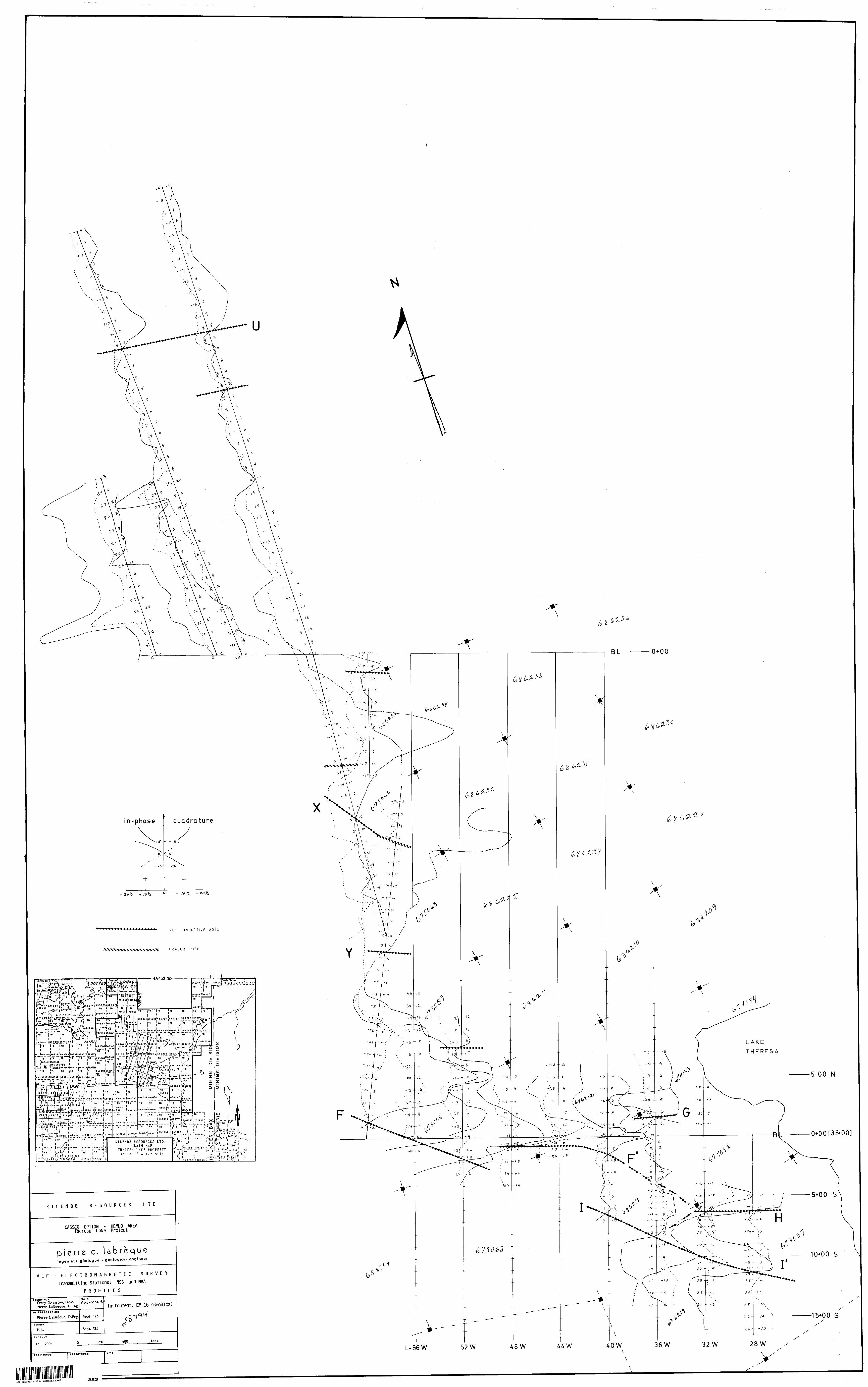
Geophysics
During August, September and November '85, several verifications
have been done on the already reported VLF anomalies. New VLF readings have
been taken on the main VLF conductors and confirmed their existence.
Conductor F-F 1 is the most conspicuous conductor occuring in
the South Central part of the property. At one place, between lines 52W and
48W south of the base line, the conductor is disrupted and appears to have been
displaced by a cross-fault with a general N-S direction. This conductor is also
the closest to the knownsulphide mineralization (L-36W at 0+75S) occuringon the
property.
Conductors H and I-} 1 are moderately strong and persistent enough
to deserve more attention while continuing the exploration of the property.
Conductors F-F 1 , H and I-P are all located within the mafic
volcanics of the Hemlo synform and are situated about 500 to 1000 feet of
the granodiorite batholith.
A number of other VLF conductors are present but are not considered
to be of prime importance for the time being.
A VLF conductor arises from the presence of conductive massive
sulphides, graphite, fractures like faults and shears, geological contacts and
other conductive substances. Metallic objects are also detectable by VLF-EM
and may cause a conductive effect.
While working on the property, I noticed several electrical wires
lying on the ground that once have been used for electricity/communications. In
some instances, these wires may cause a conductive effect and give rise to
a VLF conductor. Before conducting any drilling, proper care should be given
to look around for these wires in order not to make a hole for nothing.........!

The NAA (Cutler, Me, U.S.A.) transmitting station was used for
most of the survey.
The NSS (Annapolis) transmitting station was used for all the lines
north and west of line 60 W.
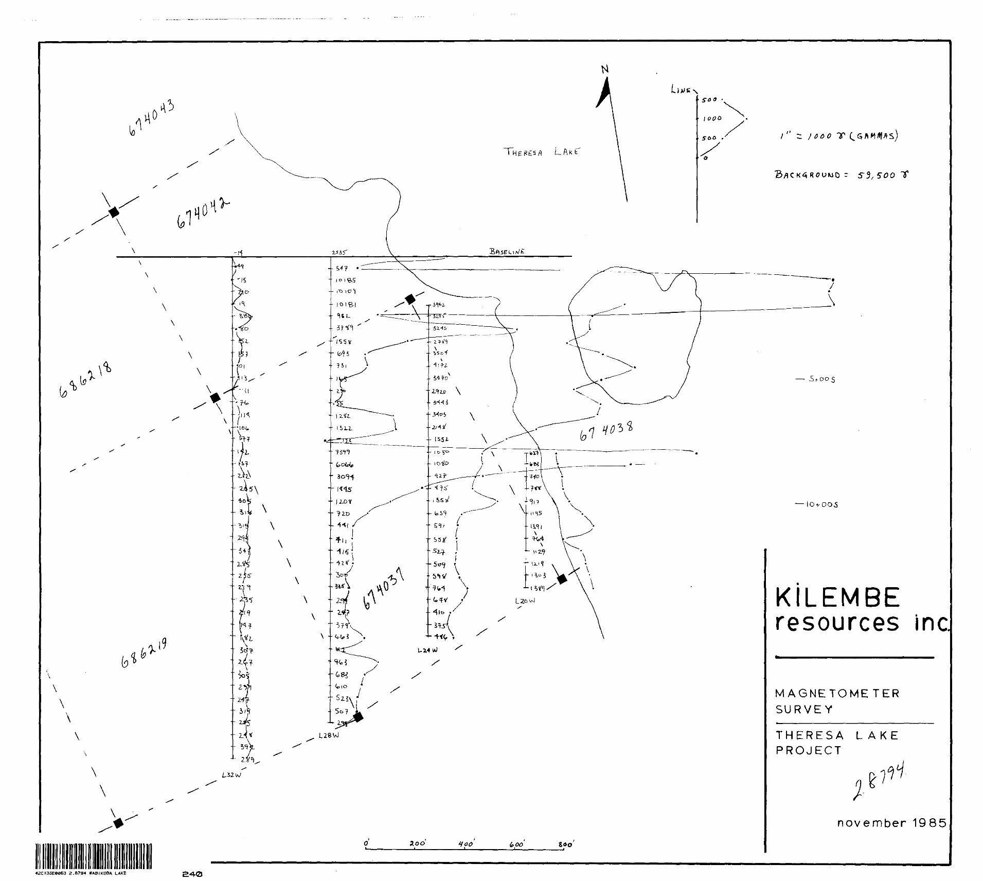
A very small magnetometer survey has been carried out on a few
lines. The high magnetic readings in some places reflect the presence of ultramafic
rocks along with magnetite. The magnetometer survey should definitely be extended
to cover the South Central part of the property which of interest to us at this
moment.

6.
Conclusions and recommendations
In 1983 and 1984, several field surveys and other studies have been done on the property. The geological mapping along with the VLF electro magnetic surveys yielded useful results concerning the geology of the property and its exploration potential.
In 1985, additional field studies have been carried out in order to verify the results previously obtained. The main VLF conductors have been surveyed again and a small geochemical survey has been completed. The VLF-EM check up proved the existence of conductive axes as previously reported, but the geochemical sampling yielded no positive mineralized trend and is thus considered as inconclusive.
Following the examination of the work done on the property up to this time, it stands out that a few surveys and related work should have been carried out on the field before this time but have not been. So, it is recommended to Kilembe to complete the line cutting on the property west of the actual grid of cut lines. For this reason, the line cutters will have to cut the tie lines around your property and will further define its boundaries. The VLF-EM survey already done on most of the property should be extended to cover the western portion of it.
It is also highly recommended to run a magnetometer survey over the south-central and western parts of the property in order to detect any magnetic mineral association with the mineralization and to decipher the local tectonics. Conventional prospecting by stripping and trenching involving some geological mapping should also be undertaken as it constitutes an excellent means for visualizing the rock formations and taking fresh rock samples.
If the mineralization consists of disseminated sulphides, induced polarization will have to be used to locate appropriate targets for drilling. Additional geochemistry, in places, could be a useful tool to show the presence of gold mineralization.
Diamond drilling should be used to test the best targets defined by previous surveys. If good results are obtained, further drilling will be recommended.

EXPLORATION PROGRAMME
Phase la - General Exploration and Outlining the Targets
7.
Linecutting S Geophysics: Magnetometer survey
VLF electromagnetic survey 5,000 Conventional Prospecting: stripping, trenching some geological mapping, road building, etc... 15,000 Consulting and Supervision S,000 Accommodations 6c Transportation/associated expenses 10,000
Contingency
Phase Ib - if necessary only
Induced polarization Geochemistry
$46,000 5,000
$30,000 10,000
551,000
^40,000
Phase II - Diamond drilling
600 - 1000 metres Contingency
$60,000 - 100,000 10,000
^70,000 - 110,000
Respectfully submitted,
December 2, 1985
Fpierre c. labrequeIngenieur geologue - geological engineer
CERTIFICATE
I, Pierre C. LaBreoue, hereby declare that I reside at 245, rue
des Chrysanthemes, La Prairie, P.Que.. J5R 4G4, and that:
1- I am a graduate in Geological Engineering from Ecole Polytechnioue,
University of Montreal, 1971:
2- I am a member in good standing of the Order of Engineers Of Quebec:
3- I have been practicing my profession since 1971:
b- l have no direct or indirect interest in the said property of Kilembe
Resources Inc. (Cassex option^; nor do l expect to receive any such
consideration:
5- The foregoing report is based on work carried out on the property
under my supervision during August/September 1985 , and after
in November 1985.
DATED, SIGNED AND SEALED,
December 2, 1985,
La Prairie, Province of Quebec.
Pierre C. LaBregue* P.Eng.
Ministry of Natural
..sources
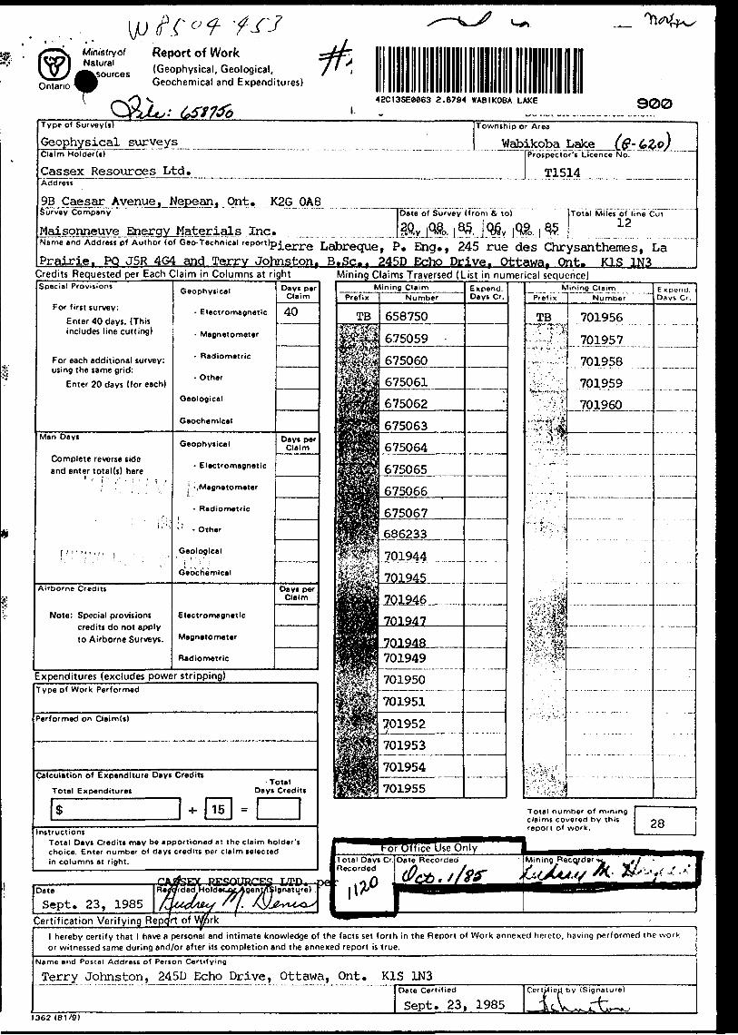
Report of Work(Geophysical, Geological, Geochemical and Expenditures)
42CI3SEe0S3 a .8794 WABIKOBA LAKE 900Type of Survey(s)
Geophysical surveysClaim Holder(s)
Gas sex Resources Ltd.Address
9B Caesar Avenuej Nepean, OntSurvey Company
Maisonneuve Energy Materials
Township
Wat3' A rea
)ikoba Lake t(?~6,Zo)l Prospector's Licence No.
1 T1514
. K2G OA8^Date of Survey (from tV to) Total Miles of line Cut
ei,*. 12Name and Address of Author (of Geo-Technic.lrepor,)pierre Labreque, P. Qjg. f 245 1TU6 des ChT y S 311 theme S, La
Prairie, PQ J5R 4G4 and Terrv Johnston, B.Sc. f 245D Echo Drive, Ottawa. Ont. K1S 1N3Credits Requested per Each Claim in Columns at rightSpecial Provisions
For first survey:
Enter 40 days. (This includes line cutting)
For each additional survey: using the same grid:
Enter 20 days (for each)
Man Days
Complete reverse side and enter total (s) herer " ["f 'r ' V
i i. i;
f.':;- 1 ;,":" j ; - - , -
Airborne Credits
Note: Special provisions credits do not apply to Airborne Surveys.
Geophysical
- Electromagnetic
- Magnetometer
- Radiometric
- Other
Geological
Geochemical
Geophysical
- Electromagnetic
j -, Magnetometer
- Radiometric
^' - Other
Geological' '; f i: i
Geochemical
Electromagnetic
Magnetometer
Radiometric
Dayi perClaim
40
Dayt per Claim
Days per Claim
Mining Claims Traversed (List in numerical sequence)
Expenditures (excludes power stripping)
Mining ClaimPrefix Number
TB 701956
.701957..
701958
701959
701960
E xpend. Days Cr.
Type of Work Performed
Performed on Claim(t)
Calculation of Expenditure Days Credits
Total ExpendituresTotal
Days Credits
Total number of mining claims covered by this report of work.Instructions
Total Days Credits may be apportioned at the claim holder's choice. Enter number of days credits per claim selected in columns at right.
E*V ut*ortTTpfC'Date Sept. 2 3, 1985
Certification Verifying Rel hereby certify that l have a personal and intimate knowledge of the facts set forth in the Report of Work annexed hereto, having performed the work or witnessed same during and/or after its completion and the annexed report is true.
Name and Postal Address of Penon Certifying
Terry Johnston, 245D Echo Drive, Ottawa, Ont. K1S 1N3
1362 (81/9)
Date Certified
Sept. 23, 1985

Ministry of Natural
ourcesOntario
Report of Work(Geophysical, Geological, Geochemical and Expenditures)
Mining Act
r- ~~ j^^ w Instructions: Pleas? type or print.
- If number of mining claims traversed exceeds space on this form, attach a lisi.
Note: Only days credits calculated in the "Expenditures" section may be entered in the "Expend. Days O." columns.
Do not use shaded areas below.Type of Survey!?
Geological surveys ^Claim Holder(t)
Cassex Resources Ltd,
Township or Area Wabikoba Lake (north p
Addreit
Prospector's Licence No.
T1514
9B Caesar Avenue, Nepean, Ont. K2G OA8Survey Company "~|Date"of Survey (from Si to)
Maisonneuve Energy Materials Inc. J D.v j MO. j v^ i o^ j MO. i w5Total Miles of line Cut
Name and Address of Author (of Geo-TechrTicalTeport)Pierre Labreque, 245 rue des Chrysahthenies f La Prairie^ POT J5R 4G4 and Terry Johnston, 245 D Echo Drive, Ottawa, Ont. K1S 1N3
Credits Requested per Each Claim in Columns at rightSpecial Provision!
For first survey:
Enter 40 days. (This includes line cutting)
For each additional survey: using the same grid:
Enter 20 days (for each)
Man Da y t
Complete reverse side and enter total (s) here
r1 i
i
l -. , ; ' . i t ' * ' !
Airborne Credits
Note: Special provisions
credits do not apply
to Airborne Surveys.
Geophysical
- Electromagnetic
- Magnetometer
- Radiometric
- Other
Geological
Geochemical
Geophysical
- Electromagnetic
- Magnetometer
- RadiometricM . M r
1 - Other
Geological
Geochemical
Electromagnetic
Magnetometer
Radiometric
Days perClaim
22
Days per Claim
Days per Claim
Expenditures (excludes power stripping)
Mining Claims Traversed (List in numerical sequence)
Type of Work Performed
Performed on Claim(s)
Calculation of Expenditure Days Credits
Total ExpendituresTotal
Days Credits
15
InstructionsTotal Days Credits may be apportioned at the claim holder's choice. Enter number of days credits per claim selected in columns at right.
Fry
Certification Verifying Re
Date l Regarded Holder or^Agant^Signatm
Sept. 23, 1985
Total number of mining claims covered by this report of work.
Total Days Cr. Date Recorded Recorded
l hereby certify that l have a personal and intimate knowledge of the facts set forth in the Report of Work annexed hereto, having performed the work or witnessed same during and/or after its completion and the annexed report is true.
Name and Postal Address of Person Certifying
Terry Johnston, 245D Echo Drive, Ottawa, Ont. K1S 1N3
1362 (81/9)
Date Certified
Sept. 23, 1985Cor/fied by (Signature)

MiniStryol Natural
ources
WReport Of Work,- . . . - , . , {Geophysical, Geological,Geochemical and Expend tures)
0
Mining Act
Instructions: Please typtf of p rint-.- If number of mining claims traversed
exceeds space on this form, attach a list. Note: Only days credits calculated in the
"Expenditures" section may be entered in the "Expend. Days Cr." jcolumns.
- Do not use shaded areas below.!Type of Survey(s Township or Area Wabikoba Lake and Geochemical surveys _____ ^ J^L Lake (north part) 6-
Claim Holder(s) ~* "[Prospector's Licence No.
Cassex Resources Ltd.Address
j T1514 ^
9B Caesar Avenue, Nepean, Ont. K2G OA8Survey Company
rials Inc.[Date of Survey (froi
20 08 85- . -.-...J.D'vJ.Mo.J^Yr...
n fit to)
06 09Day | Mo. j
85Vr.
Total Miles of line Ci
Name and Address pf Author (of Geo-Technical report)
Sudesh Kc Sinqh, Ph.D., 42 Oval Drive. Aylmer, Que. J9H 1V2Credits Requested per Each Claim in Columns at rightSpecial Provisions
For first survey:
Enter 40 days. (This includes line cutting)
For each additional survey: using the same grid:
Enter 20 days (for each)
Man Days
Complete reverse side and enter total(s) Here
Airborne Credits
Note: Special provisions credits do not apply to Airborne Surveys.
Geophysical
- Electromagnetic
- Magnetometer
- Radiometric
- Other
Geological
Geochemical
Geophysical
- Electromagnetic
- Magnetometer
K Radiometric
- Other
Geological
Geochemical
Electromagnetic
Magnetometer
Radiometric
Days per Claim
40Days per
Claim
Days per Claim
Mining Claims Traversed (List in numerical sequence)
Expenditures (excludes power stripping)Type of Work Performed
Performed on Claimd)
Calculation of Expenditure Days Credits- . - ;-
Totel Expenditures " Oayt Credits
*Instructions
Total Days Credits may be apportioned at the claim holder's choice. Enter number of days credits per claim selected in columns Rt right.
Certification Verifying Repprt of Vfark1 hereby certify that 1 have a personal and intimate knowledge of the facts set forth in the Report of Work annexed hereto, having performed the work or witnessed same during and/or after its completion and the annexed report is true.
Name and Postal Address of Person CertifyingSudesh K. Singh, 42 Oval Drive, Aylmer, Que. J9H 1V2
Date CertifiedSept. 23, 1985
Ceridjed by (Sig
k.1363 (81/9)

Ministry of Natural
{sourcesOntario!
Report of Work(Geophysical, Geological, Geochemical and Expenditures)
Type of Survey(s)
Geochemical surveys
Mining Act
Instructions: - Please type Or print. If number of mining claims traversed
exceeds space on this form, attach a list. Note: - Only days credits calculated in the
"Expenditures" section may be entered in the "Expend. Days Cr." columns.
Do not use shaded areas below.
Claim Holder(s)
Cassex Resources Ltd.
ownsnipor Area Wabikoba Lake White Lake (north__
fProsipectoPrUicence~NoT
T1514Address
9B Caesar Avenue, Nepean, Ont. K2G OA8Survey Company [Date of Survey (from A to)
Maisonneuve Energy Materials Inc. JJ3?vJ 3?. l ^ | 9a6v j ft?, j 8?Name and Address of Author (of Geo-Technicel report)
Sudesh K. Singh, Ph.D., 42 Oval Drive, Aylmer, Quei J9H 1V2
Total Miles of line Cut
Credits Requested per Each Claim in Columns at rightSpecial Proviiions
For first survey:
Enter 40 days. (This includes line cutting)
For each additional survey: using the same grid:
Enter 20 days (for each)
Man Days
Complete reverse sideand enter total(s) here
\' . \ . :t -\ ~ ^
\''V.V;'- l
Airborne Credits
Note: Special provisions credits do not apply to Airborne Surveys.
Geophysical
- Electromagnetic
- Magnetometer
- Radiometric
- Other
Geological
Geochemical
Geophysical
-, -- f E lectromagnetic
- Magnetometer
: -IRadlometric
- Other , , .
Geological
Geochemical
Electromagnetic
Magnetometer
Radiometric
Days per Claim
40
Days per Claim
Days per Claim
Expenditures (excludes power stripping)
Mining Claims Traversed (List in numerical sequence)
Type of Work Performed
Performed on Claim(s)
Calculation of Expenditure Days Credits
Total ExpendituresTotal
* Days Credits
SInstructions
Total Days Credits may be apportioned at the claim holder's Choice. Enter number of days credits per claim selected in columns at right.
Mining Claim Prefix Number
TB 701949
701950
701951
701952
J01953^
701954
701955
j 701956
701957
701958
701959
701960
Expend. Days Cr.
Total number of mining claims covered by this report of work.
35
Dat*Sept. 23, 1985
Certification Verifying Repqrt of W/rk fhereby certify that 1 have a personal and intimate knowledge of the facts set forth in the Report of Work annoxed hereto, having performed the work
or witnessed same during and/or after its completion and the annexed report is true.
Name and Postal Address of Person Certifying
jSyde sh K.^Singh, 42 Oval Drivei,^Aylraer^^ Que. J9H 1V2Date Certified
Sept. 23, 1985Certified by (Signature,
^1362 (81/9)

Mlnlatry ofNorthern Development
l MinesOntario
and K
Technical Assessment Work Credits
Ditt
IQRfi 0? IR
Flit
2.8794Mining Rtcordtr'i Rtport of Workfco. 4 53
Recorded Holder CASSEX RESOURCES LTD
Township or AreaAREA OF WABIKOBA LAKE
Type of survey and number of Assessment days credit per claim
Geophysical i o
Magnetometer Hays
Section 77 (19) See "Mining Claims Assessed" column
fifiolnginal rtays
Gfioohfiminal riays
Man days | | Airborne l l
Special provision [x| Ground [xj
0 Credits have been reduced because of partial coverage of claims.
Q Credits have been reduced because of corrections to work dates and figures of applicant.
Mining Claims Assessed
TB 658750 675059 675063 675065 686233 701948 701955
to 67 incl
to 57 incl
Special credits under section 77 (16) for the following mining claims
Mo credits have been allowed for the following mining claims
[jj] not sufficiently covered by the survey Q insufficient technical data filed
TB 675060 to 62 incl 675064 701944 to 47 incl 701949 to 54 incl 701958 to 60 incl
The Mining Recorder may reduce the above credits if necessary in order that the total number of approved assessment days recorded on each claim does not exceed the maximum allowed as follows: Geophysical - 80; Geologocal - 40; Geochemical - 40; Section 77(19) - 60.

Ministry ofNorthern Development
id MinesOntario
Technical Assessment Work Credits
Date
1986 02 18
File
2.87Mining Recorder's Work No. . r .
454
94Report of
Recorded Holder
CASSEX RESOURCES LTDTownship or Area
AREA OF WABIKOBA LAKE AND WHITE LAKE (NORTH PART)
Type of survey and number of Assessment days credit per claim
Geophysical
Section 77 (19) See "Mining Claims Assessed" column
fipftlngir.al 0 days
Gftonhemical days
Man days fi Airborne j |
Special provision Q Ground Q
| | Credits have been reduced because of partial coverage of claims.
l | Credits have been reduced because of corrections to work dates and figures of applicant.
Mining Claims Assessed
TB 658749-50 675059 to 686215-16 686226 686233 701922 701944 to
68 incl
60 incl
Special credits under section 77 (16) for the following mining claims
Mo credits have been allowed for the following mining claims
| | not sufficiently covered by the survey Q insufficient technical data filed
- No geological assessment credit as report submitted .
s and maps not
The Mining Recorder may reduce the above credits if necessary in order that the total number of approved assessment days recorded on each claim does not exceed the maximum allowed as follows: Geophysical - 80; Geologocal - 40; Geochemical - 40; Section 77(19) - 60.
828 (8SJ12)
Ministry ofNorthern Development
id Mines
Technical Assessment Work Credits
Ontario Date
1986 02 18
File
2.8794Mining Recorder'1 Report of Work No. . - c . . ,
455, 456
Recorded Holder
CASSEX RESOURCES LTDTownship or Area
WABIKOBA LAKE AND WHITE LAKE (NORTH PART)
Type of survey and number of Assessment days credit per claim
Geophysical
Magnetometer rlays
Inriiirsrl polarization riays
Othfir riays
Section 77 (19) See "Mining Claims Assessed" column
Geological days
i 2 Georhfimir.al * ^ riays
Man days [~| Airborne l l
Special provision j~^ Ground fj;
Pi Credits have been reduced because of partial coverage of claims.
l | Credits have been reduced because of corrections to work dates and figures of applicant.
Mining Claims Assessed
IB 674037 674042-43 675065 675068 686212 686218-19
Special credits under section 77 (16) for the following mining claims
No credits have been allowed for the following mining claims
[xj not sufficiently covered by the survey
TB 658749674017674938674044675059
-50
to 41to 46to 64
inclinclincl
675066-67
| | insufficient technical data
686208686213686220686222686256701922701944
toto
to
to
11
4
17
7
60
filed
inclincl
incl
incl
The Mining Recorder may reduce the above credits if necessary in order that the total number of approved assessment days recorded on each claim does not exceed the maximum allowed as follows: Geophysical - 80; Geologocal - 40; Geochemical - 40; Section 77(19)-60.

^Mini]) Natif Resources
Order of the Minister
Ontario
AMENDED
The Mining Act
Room 6643, Whitney Block Queen's Park Toronto, Ontario M7A 1W3 416/9654888
In the matter of mining claims: TB 658750, et al, in the Area of Wabikoba Lake as listed on Report of Work 453 to 456 inclusive.
Cassex Resources LtdOn consideration of an application from the recorded holder,.————-—— under Section 77 Subsection 22 of The Mjning Act, l hereby order that the time for filing reports and plans in support of
Geophysical (Electromagnetic)_______assessment work recorded ™ October l f 10 85— be extended until and including__January 10, 1Q 86. ,
Copies:
Date
LtdCassex Resources 9B Caesar Avenue Nepean, Ontario K2G OA8
Mining Recorder Thunder Bay, Ontario
Signature of Director, Land Management Branch
Pierre Labreque, P.Eng., 245 rue des Chryanthemes La Prairie, Quebec J5R 4G4

Ontario
'Ministry of Natural R^^rces
Order of the Minister
ci \0
The Mining Act
. Room 6643, Whitney Block Queen't Park Toronto, Ontario M7A1W3 416/965-4888
In the matter of mining claims: TB 658750, et al,
in the Area of Wabikoba Lake
as listed on Report of Work
#453.
Cassex Resources LtdOn consideration of an application from the recorded holder, -—— under Section 77 Subsection 22 of The Mining Act, l hereby order that the time for filing reports and plans in sup
Geophysical (Electromagnetic)__________assessment work recorded nn October l, 1 Q be extended until and including January 10, 19 86 .
of
flos, K .copies:
Date
LtdCassex Resources 9B Caesar Avenue Nepean, Ontario K2G OA8
Mining Recorder Thunder Bay, Ontario
Signature of Director, Land Management Branch
Pierre Labreque, P.Eng., 245 rue des Chrysanthemes La Prairie, Quebec J5R 4G4
1333 (85/02)

lMining Lands Section
Control Sheet
File No .̂87 f Y
TYPE OP SURVEY
MINING LANDS COMMENTS:
GEOPHYSICAL
GEOLOGICAL
GEOCHEMICAL
EXPENDITURE
L-Signature of Assessor
Date(J

March 12, 19B6 Your File: Our File:
453 A 4542.8794
Mining RecorderMinistry of Northern Development and Nines435 James Street SouthP.O. Box 5000Thunder Bay, OntarioP7C 5G6
Dear Madam:
RE: Notice of Intent dated February 18, 1986 Geophysical (Electromagnetic) and Geological Surveys on Mining Claims TB 658749, et al, 1n the Area of Wabikoba Lake and White Lake (North Part)
The assessment work credits, as listed with the above-mentioned Notice of Intent, have been approved as of the above date.
Please Inform the recorded holder of these mining claims and so Indicate on your records.
Yours sincerely,
J.C. Smith, Supervisor Mining Lands Section
Whitney Block, 6th Floor Queen's Park Toronto, Ontario M7A 1W3
Telephone: (416) 965-4888
DK/mccc: Cassex Resources Ltd
9B Caesar AvenueNepean, OntarioK2G OA8
Mr. 6.H. FergusonMining A Lands CoonlsslonerToronto, Ontario
Encj Resident Geologist Thunder Bay, Ontario
Plerre Labreque, P.Eng., 245 rue des Cnrytnthemts La Prairie, Quebec J4R 464
K. SethuramanSuite 400111 Richmond Street WestToronto* OntarioN5H 264
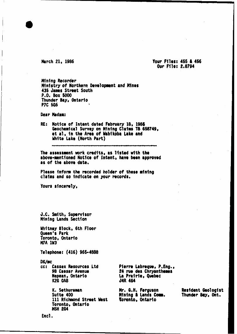
March 21, 1986 Your Files: 45S I 4S6 Our Flits 2.8794
Mining RecorderMinistry of Northern Development and Mints43S Janes Street SouthP.O. Box 5000Thunder Bay* OntarioP7C 5G6
Dear Madam:
RE: Notice of Intent dated February 18. 1986Geochemical Survey on Mining CI ellis TB 668749* et al, In the Area of Wabikoba Lake and Unite Lake (North Part)
The assessment work credits, as listed with the above-mentioned Notice of Inttnt, have been approved as of the above date.
Please Inform the recorded holder of these mining claims and so Indicate on your records.
Yours sincerely*
O,C. Smith* Supervisor Mining Lands Section
Whitney Block* 6th Floor Queen's Park Toronto, Ontario M7A 1H3
Telephone: (416) 966*4888
DK/mccc: Cassex Resources Ltd
9B Caesar AvenueNepean, OntarioK26 OA8
K. SethuramanSuite 400111 Richmond Street WestToronto* OntarioM5H 264
End.
Plerre Labreque* P.Eng.* 24 rue des Chryanthemes La Prairie, Quebec J4R 464
Mr. 6.H. Ferguson Mining i Lands COM. toronto, Ontario
Resident Geologist Thunder toy* Ont.

November 20, 1985 Reports of Wbrk
REGISTERED
Cassex Resources Ltdt 9B Caesar Avenue Nepean, Ontario K2G OA8
Dear Sirss
RE t Mining Claims IB 658749 et al in the Areas of Wabikoba Lake and White Lake North.
I have not received the reports and maps (in duplicate) for the Geochemical, Geological and Blectromagnetic Surveys on the above-mentioned claims.
As the assessment "Report of Work" was recorded by the Mining Recorder on October l, 1985 the 60 day period allowed by Section 77 of the Mining Act for the submission of the technical reports and maps to this office will expire onNovember 30, 1985.
If the material is not submitted to this office by November 30, 1985 I will have no alternative but to instruct tho Mining Recorder to delete the work credits from the claim record sheets.
For further informtion, please contact Mr. A. Barr at 416/965-4888.
Yours sincerely
S.E. YundtDirectorLand Management Branch
Whitney Block, Room 6643 Queen's Park, Toronto M7A 1W3 Telephones 416/965-4888
AB i se
cct Mining RecorderThunder Bay, Ontario

Ill, Richmond S t. West Suite 400 Toronto, Ontario. K5H 2G4
1.1s. S. Yundt January 10, 1986., ^ .-, , Lane i'lfenagernent Branch
Ontario Ministry of Natural KesourcesQuc en ' s Park , Toronto, Ontario.
Re; I-linirig claims fi'.d 658749 et.al., Thunder Bay Division. Reports of work 453,454,455,456.
l have been authorized by Gassex Resources of Ottawa and -tvile-nbe Kesources of Vancouver to act as their geological consultant effective January 10, 1936.
Based on a review of files made available to me by Cassex, I understand that as per telephone conversation between Audry L. Denis of Cassex and A. Barr of your Branch on November 25, 1935, Gassex was granted extension to submit tlie report by January 10, 1986. Accodingly,! am forwarding a recent report dated December 2, 1985 prepared by Pierre C. Labreque.
Last year, Gassex signed an agreement with Kilembe Resources whereby Kilembe is committed to doing further exploration on the above property subject to further financing. Kilembe adviccd me that the financing has been completed today and the Company intends to initiate en exploration program as soon as possible subject to snow conditions on the property.
I hope the documents are in order. If you need further information, please do not hesitate to contact me.
y,ES LTD.
J/l j&'&WWue/ W- Ph.D.,
AST/y
l

CASSE^ RESOURCES LTD.9B CAESAR AVENUE, NEPEAN.ONT. K 2GOA8 613 226 7598 l 7 699
November 26, 1985
Ms. S. YundtDirectorLand Management BranchOnt. Ministry of Natural ResourcesWhitney Block, Room 6643Queen 1 s ParkToronto, Ont. M7A 1W3
Dear Ms. Yundt:
Re: Mining claims TB 658749 et al in the Areas of Wabikoba Lake and White Lake North; Reports of work 453, 454, 455, 456
We acknowledge and appreciate receiving your letter of November 20/85 reminding us of our obligation to submit the reports and maps for the geo chemical, geological, and electromagnetic surveys on the above-mentioned claims by Nov. 30/85.
I would like to inform you of my telephone discussion of Nov. 25/85 with Mr. A Barr of the Land Management Branch. As I told Mr. Barr, the three geologists responsible for writing these reports went out to the property to do additional work and Dr. S. Singh, President of Cassex Resources, went missing on Nov. 16th. The other two geologists were assisting the O.P.P. in their search for Dr. Singh for eight days* Obviously, no work was done on t the reports during this period and I expressed the need for additional time in which to complete the report preparation. Mr. Barr agreed to such an ex tension until Jan. 10/86.
I hope that this information brings you up to date and will be included in your files.
Yours sincerely,
CASSEX RESOURCES LTD.
Auorey M Denis Secretary-Treasurer
cc: Mining Recorder . Thunder Bay, Ont.
.^RECEIVED
DEC O ?. 1985
MINING LANDS SECTION
Ontario
Ministry ofNorthern Developmentand Mines
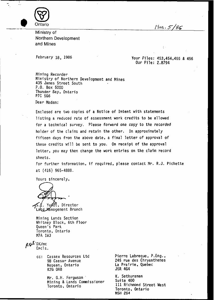
February IB, 1986 Your Files: 453,454,455 4 456 Our File: 2.8794
Mining RecorderMinistry of Northern Development and Mines435 James Street SouthP.O. Box 5000Thunder Bay, OntarioP7C 5G6
Dear Madam:
Enclosed are two copies of a Notice of Intent with statements listing a reduced rate of assessment work credits to be allowed for a technical survey. Please forward one copy to the recorded holder of the claims and retain the other. In approximately fifteen days from the above date, a final letter of approval of these credits will be sent to you. On receipt of the approval letter, you may then change the work entries on the claim record
sheets.For further information, if required, please contact Mr. R.J. Pichette
at (416) 965-4888.
Yours sincerely,
Director nagement Branch
Mining Lands Section Whitney Block, 6th Floor Queen's Park Toronto, Ontario M7A 1W3
Ends.
cc: Cassex Resources Ltd 9B Caesar Avenue Nepean, Ontario K2G OA8
Mr. G.H. FergusonMining b Lands CommissionerToronto, Ontario
Pierre Labreque, P.Eng., 245 rue des Chryanthemes La Prairie, Quebec J5R 4G4
K. SethuramanSuite 400111 Richmond Street WestToronto, OntarioM5H 2G4

Ontario
Ministry ofNorthern Developmentand Mines
Notice of Intent for Technical Reports
February 18, 1986
2.8794/453,454,455 k 456
An examination of your survey report indicates that the requirements of The Ontario Mining Act have not been fully met to warrant maximum assessment work credits. This notice is merely a warning that you will not be allowed the number of assessment work days credits that you expected and also that in approximately 15 days from the above date, the mining recorder will be authorized to change the entries on the record sheets to agree with the enclosed statement. Please note that until such time as the recorder actually changes the entry on the record sheet, the status of the claim remains unchanged.
If you are of the opinion that these changes by the mining recorder will jeopardize your claims, you may during the next fifteen days apply to the Mining and Lands Commissioner for an extension of time. Abstracts should be sent with your application.
If the reduced rate of credits does not jeopardize the s.tatus of the claims then you need not seek relief from the Mining and Lands Commissioner and this Notice of Intent may be disregarded.
If your survey was submitted and assessed under the "Special Provision-Performance and Coverage" method and you are of the opinion that a re-appraisal under the "Man-days" method would result in the approval of a greater number of days credit per claim, you may, within the said fifteen day period, submit assessment work breakdowns listing the employees names, addresses and the dates and hours they worked. The new work breakdowns should be submitted directly to the Land Management Branch, Toronto. The report will be re-assessed and a new statement of credits based on actual days worked will be issued.

Jl
fe- fc -S wV *w Q
Z O
COc3)
Om
O -W C)C 53 W> o n z m r
Ox
S33
O
l
S22 O
33 ~
nj o o^* 5 S t f*
-c.O)
ROUS LAKE G-611LORNA LAKE G-598
i", l -' ' i - w iJ*i l; -x M *, l ^C --L.— —-- -r-i
WHITE LAKE (S. PT.)
G-623
WHITE LAKE (N. PT.) G-622
eocCO H
C) l l
CDno o
;N ™ z } (U (l)\- w f±A O ^N^ C (B*A o ~~
(D
00 25 5S 2 3- (fl
^
z zz H zs m SB
o s o s >m w m - o ^o ^ ^o " m o m
CO-i 33
00
oz
oO
in
' f-
LW(D O
"- i tt fi •* . O Ul -J H (J'1 tnbm S o 33 m
c rn o2 W Qm o
O T*
n
O11
m
2 OZ
goIzCOv r
f -8
ft! "2m O m vOB l
w n 30z oB9 O
m
m o
O3) nSo
mw : "i
W m .9 c 2
O 33 ftl mt— XX•Do 2 a* i
O (/i 2 O
ox -tC/}
OI H WOz
-4mzH
00c
o mD"i2Z C X5x
J" eg ^ ,
-Si OeOS^cdBOb
CO•o oCO
x mZ Oz cm ZH
02r- i/iI Omr
f-
w c ra
OZ
o x83
-n Z C X
C l"
O O oz o I? 5
m5 gSc ^ C* r- Z ^ O OD mS5i"5 s z D w g T m **
2p5
r^ —* O O-* s y l5S
w -
ifm r
m O
C ffi n i* r ffi1 w ^ f"
9* "
- m T) W > '
SH*' i~\ •m P
O
\

OLGA LAKE- ' - . - :- -- '
39 38'
G-604REF'ER E N C
AREAS WITHDRAWN FROM DISPOSITION
M.R.-MINING RIGHTS••S.R fc.** SURFACE RIGHTS•i.- ' - . ~
Dat* DiipoMiion Fita
TB TTB FB
68623416862351686236 .686237 |686Z38 |686Z — — — '— — t~~ — — — L/— — 4— —
l586232(686231.6862301686,2/29 [686228 !
686225 .686224j ^
TB ITB TTB
6S62II 6862IO6a6ZO9 ^6 620 fiII 6862IO|6a6ZO9 6 6
TB ITB , TB
674041 !67404oNSeS24V
686219 6T4037| — — —l— — —
ATIKAMEG-^ — ^^-.- ._^ —.— TB i TB l TB.
l 655070 fi6Sp07l i644 f O L 1644103
TS : TB |"rs"
644.00 644,02l 6S44 ?6 W*4**-!^. .- ———,———.^. -
• l ' \
Z5J.L(IPS? 9 T L -T-I TB |TB ~
Zf iTOCTft
^700759.700756 . f—146939 9V
.J.—U-..J
^1 J609077I —Ta l^TB J VH
"T ,*"
. -*. r . 'v "-i.
. //fv ro /oac'-f^^^ *-. ™ PBW*-^.P^.....^^P^^^^^.^ '̂ ^^^^'^ j •••V-.-fJ^pp-Spp-BB
-.-•l- AW--J-^... ^l*———j-.-l^tM.V- -P ^/———————.———.,———
•^•^1 ~ ̂ ^ " ^T-y l VV ph/T^T^j ___ J___ ____ - --
t^pQU . B*0U AHa* ' - 1^^.. rf*^!-^.^
SSM flOODiUGOAnLCISSM
l —_^.^.5TB Fri TB ^~ aia jj. j?'-. IMJ660665 J 6606**J
~ ~~ |6"
ITBPfei^"*!" ,l *; .-' j ' - ; - -SW^-x-^f ^ ---- ^S-V^*-.*^.'.^-". ^.w --. '^ -rsfe* iR-ir* ., V' v, , ^ -.- - ^
^ EC E l VE DL' -
. ' (71OI41 J710J44 (710^49 j - ''
3T4SalsB74*3! " jSHWSfc^fifi'Ji'StJfiffll'JLj-.-l-——L-..L: J v . rss-- IBS-- jssi- F'Jijaff^L !ss" ^ SM I-"" (l 1 1- ____l**7***^ !1!1LSV7M*1 J*94STI,*Basro,B9S8S9|r^;;;T^^Mgv7j4tt' : j^i^ij™^^!^!:* * "^ W?, ^ x ^ ci -''-^r v r^ - J^1
to—Tsir^jag^jf-^-^H t v 'j ?'; -pT j v ^ ; ;^ ? ; ^Kijnn ' !V~!H^^?TSS IwssftsieBssez'sasBSs.1. ,, :;l , '-ijf's----^ - f'~ - ^* ". ' i - '"!^T!*ws*]*v73V , ^^-j--* ^ 'i' . --J :-^~- ;-p-:i3^.--^...'.* -.^-/' : ^ : L\^S^jyj^i^io*!^f-g", i.^ "!^; l '••'^l;sti'-^':? :-V^-v; : :-j- 1 ^ s ^ ^{ m l •QfJ * C-ttH " B; BjftM "i"* . a "•'-"l.**"".' f , - , - fc.'~ ' "
.triSh tfii\afti***te*tJinttt ' - . . J i - . - l -. ttl -' * V", ' ' '. - , --i-"' -'.' \* - "-'.", V- - 1 -
•4\67 657468 1657469
SSM ISSM , ,S8M
"4*' - -' ' 1*9**
• l ^_ ,,, _ _ — ——* TB ' TB IfTB
^TB " ""TS r B TB
;.r..' ;" V-.'-:.f^-'VV - V -^-v- /' ' W"'- V "^T. - ^ \."-.'-' - - '^- .•-l ,-;-'-' " -'-' " •••- . *- ;" *
v*': ,--:^ f-'-, - •k^.; - w.- , "* - /*r^i8^ f"-T*— --^789694i6B66fi3|68aiB2l CC |6r89SS1if896
, e'S T 5 Z l ,6Brtta'6S73IJ .637882,637941,697942, ' ' 667S46 665347.663346
, p-. , L ^j - i." . ( ': . . &J'/' 1'.,-
WHITE
R E F E: R E N C E S t t **f l .!*
- T'O POGRAPHY ^ ;
LAKES. RIVERS. ETC.. FROM FOREST RESOURCES INVENTORY SHEET No.4*7MS
-' - .- 'J " -. - - - - -.'
J' -. . 'rV:^r'
Of ISSUE
uS^W
LEGENDHIGHWAY AND ROUTE No. ^ OTHER ROADS ^ ?^" TRAILS -; SURVEYED LINES: ^
TOWNSHIPS. BASE LINES, ETC.LOTS. MINING CLAIMS, PARCELS, ETC,
UNSURVEYED LINES: ;LOT LINES ' ~PARCEL BOUNDARYMINING CLAIMS ETC
RAILWAY AND RIGHTOF WAV UTILITY LINES O NON-PERENNIAL STREAM ; F LOOPING OR FLOODING RIGHTS . SUBDIVISION OR COMPOSITE PLAN . RESERVATIONS -; ORIGINAL SHORELINE /J MARSH OR MUSKEG "' *" MINES ', M - - : Y - ~-4't: " '- .^ . : : s':'
TRAVERSE MONUMENTS -••' ? '""
ZZ&^ t-'*P.,f-^,*
DISPOSmON OF CROWIl LANDS
TYPE OF DOCUMENT ;^ ;\ ^ '/t-" SYMBOLPATENT,SURFACE * MIMING aKajTy -'^.-'-/.-/; ^ * .
;^^;^.^SURFACE ;;- ^r- .MINING RIGHTSONLV LEASE. SURFACE A MINING
;:-^ .SURFACE RIGHTS ONLY-f ^ ."MINING R IGHTS ONtY-!
LICENCE OF OCCUPATION ^1.'ftim6R4M.mimiL:v--V--^ ne
-. RESERVATION ':' : y.v ;\-'.'.'.: ''4-:-f;: :vj^^^j^;," j" CAffCELLElT ^1^1 -———.-. ----^
SAND 8. GRAVEL ——
e- ' ~-;;M ;yV.v " T-,-.-..J'--' ..-A^ ;V-V.'
__j..-"7^. ......^ i —*5\ ^ ; - ~ -. .
MOTli MWIMa flllOHTB Ml FAMCEUS. .' . 1613. ycSTCO "* O UtOW* AU f A TV NT f C SJY TM* *tf*MC. ; LAND* ACT. H MjQ. 1ST*. CHAP. SS*..*CC. W. KUS.SCC t.
SCALE; 11NCH -^40 CHAINS
O 1OOO IOOO'
O 2OO 1000
'AREA' -* " - '-''- -""
WHITE LAKE(horlli part)
M.W.R. AD.MIIIISTRAT1VE DlSTfllCT ,
TERRACE"•* ' ~ - l t r "., l ' '-' - ;--. , Jo "t -j-. ii ^V '^.k. rtr*'~MINING DIVJSIO^:-^:';-C-'-^^-^:"^^^^^ ̂.' - * ' ; 'v,.f-T.- '-".''i"^'•' v; 'U'^*^ 'p 1 . VY*' T'*''^' '^'*rcci .i1
-,-*ft :-'•~-' *H
THUNDER BAY/SAULT STE.MAR1ELAND TITLES/ REGIStflY
Nafuf^|:f -J Resouicesv
isf;'-'p^ A*JffJS?^*"**^•jf**.^--*;^ --i1'-'.fe'-r^jrfflni::*--:
'Np-rt^.l^.lVl? *-tfcr* IST- - -, 1* ^
Ontario..---'si
i--*^-,"^"'!
'^'^^f i&^i1'*
f
---K?-"
V'S'--.':^•f :
i* r -- -• •- 1*,*?*. -;^.^;,'-
.- ^'-;^-"•^ -
• t .^.'-•^t^- j
S&A.'ii*^-m-^
/sfe'^fc^^
sa^-^A*1^
'fasmaiaiiiis^
quadraturem-phase
VLF CONDUCTIVE AXIS
686257 l 6 *^"" ^'"^686.^1
Xi" t
J86251 (686231,68 6 Z 3 O 16862/2 9 [686228- -™- -4: -.z -^MI-^Z -~ - ^'01944 1701443 —— — -4- — f-
LAKE
THERESAT| ' leijiofileesjii
li It*3338^*33*3 663?84*663Ml
6 74 044,*^ 043jA.740-46" ' rail TB
5 00 N
M,.,,' -^ l T*
6~44o*ii 64-1049 l (44030
4(11 l l ft W l"L J0*00 [38*00]
KILEMBE RESOURCES LTD.CLAIM MAP
TllKRKSA LAKE PROPERTY scale l" * 1/2 mile
y 17^0^5^^00757 ^~" tf -
5*00 SRESOURCESKILEMBE
CASSEX OPTION - HEMLO AREA Theresa Lake Project
pierre c. lab re qu eingenieur g6ologue - g eological e ngi
10*00 S
VLF - ELECTROMAGNETIC SURVEY
Transmitting Stations: NSS and NAAPROFILES
ECUTlun i -"--
Terry Johnston, B.Sc. Aug.-Sept. s—. n * .r* r;—— l Instrument: EM-16 (Geonics)Pierre LaBreque, P-Bng.
15*00 SPierre LaBreque, P.Engj Sept. '85
L-56 W
42C135E8B63 2.8794 WABIKOBA LAKE 220

VLF CONDUCTIVE AXIS
K I L E M B E RESOURCES LTD
I CASSEX OPTION - HEMLO AREA Theresa Lake Project
pierre c, l a b re q u eingenieur geologue - geological engineer
SOIL GEOCHEMISTRY
GOLD(expressed in parts per billion-ppb)
EXECUTION
Pierre LaBreque, P.Eng. Terry Johnston, B.Sc.INTERPRETATION
Pierre LaBreque, P.Eng.
DESSIN
P.L.
DATE
Sept. '85
Oct. '85
ECHELLE
1" = 200- 400'—i—
600' 800'
LATITUDES LONGITUDES NTS
F
\
L 52 W
0*00 (38 + OOS)
5* 00 S
10*005
24W
s
x
\2.8/94 WABIKOBA LAKE 230
" z looo T
\
\\
\
\\
\
(eOO 800
KILEMBE resources inc
MAGNETOME TER SURVEY
THERESA LAKE PROJECT
november 1985
42C135E8063 2.8794 WABIKOBA LAKE

![RPT ON PLACER HOLDINGS - geologyontario.mndmf.gov.on.ca · craAio c* o pt] of hole is oatinuteti at 60 foe t for a total of lQt 2QO ^i'nc c* Rt of this', drilling: will be approximately](https://img.pdfslide.us/doc/110x75/5e0791b01ec8b747aa1f63c9/rpt-on-placer-holdings-craaio-c-o-pt-of-hole-is-oatinuteti-at-60-foe-t-for-a.jpg)