Embed Size (px)
Citation preview
PHYS216 Practical Astrophysics
Lecture 2 – Coordinate Systems 1
Module Leader:Dr Matt Darnley
Course Lecturer:Dr Chris Davis
2
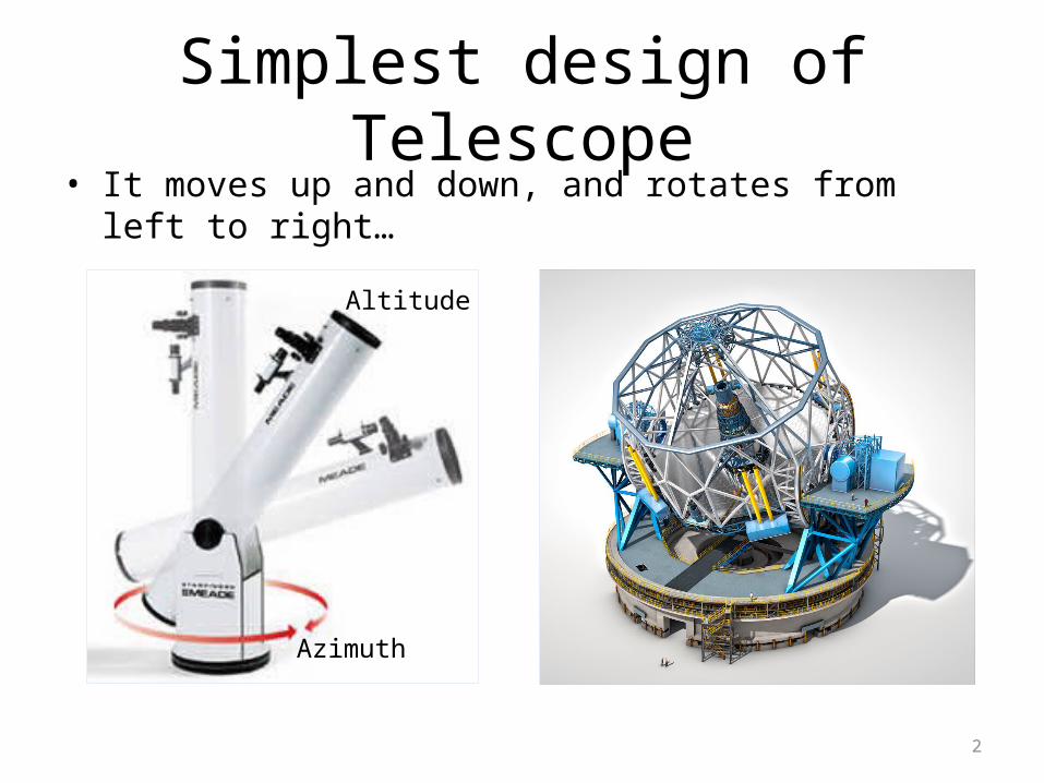
Simplest design of Telescope• It moves up and down, and rotates from left to right…
Azimuth
Altitude
3
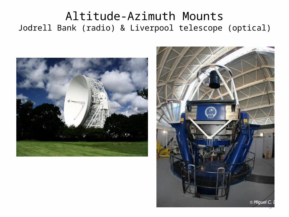
Altitude-Azimuth MountsJodrell Bank (radio) & Liverpool telescope (optical)
4
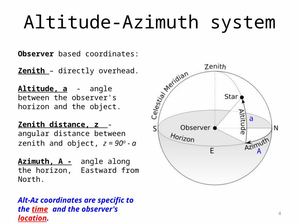
Altitude-Azimuth system
Observer based coordinates:
Zenith – directly overhead.
Altitude, a - angle between the observer's horizon and the object.
Zenith distance, z - angular distance between zenith and object, z = 90o - a
Azimuth, A - angle along the horizon, Eastward from North.
Alt-Az coordinates are specific to the time and the observer's location.
A
a
E
S

5
The Celestial SphereNeed a fixed coordinate system so we can catalogue the positions of the stars...
From last time…
• Celestial Equator - Projection of the Earth's equator onto the Celestial Sphere.
• Celestial Poles – North and South pole!
• Hour Angle - angle between star's current position and the meridian (measured W, in hrs)
• Declination - angular distance above (+ve) or below (-ve) the Celestial Equator.
6
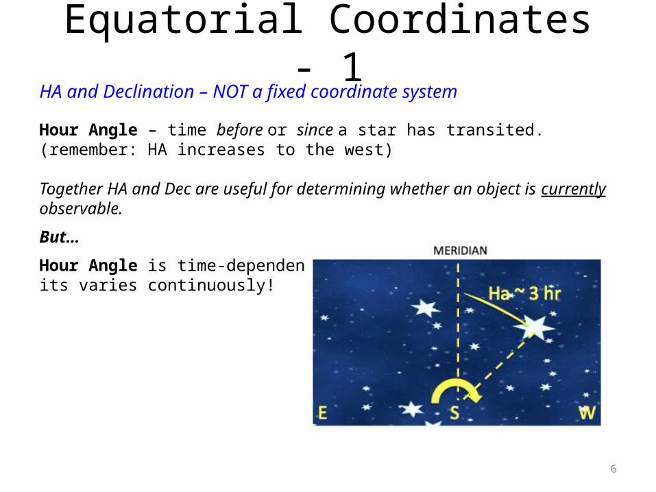
Equatorial Coordinates - 1HA and Declination – NOT a fixed coordinate system
Hour Angle – time before or since a star has transited. (remember: HA increases to the west)
Together HA and Dec are useful for determining whether an object is currently observable.
But…
Hour Angle is time-dependent – its varies continuously!

7
Equatorial Coordinates - 2HA and Right Ascension (RA) IS a fixed coordinate system
Declination – as before, angular distance above/below celestial equator.
Right Ascension - is measured like HA (in hrs mins secs), but… - is referenced to a fixed point on the celestial sphere - the First Point of Aries (g) - is analogous to longitude on Earth; lines of R.A. are great circles through the poles
Lines of equal RA
Eclipticg
Equatorial
8
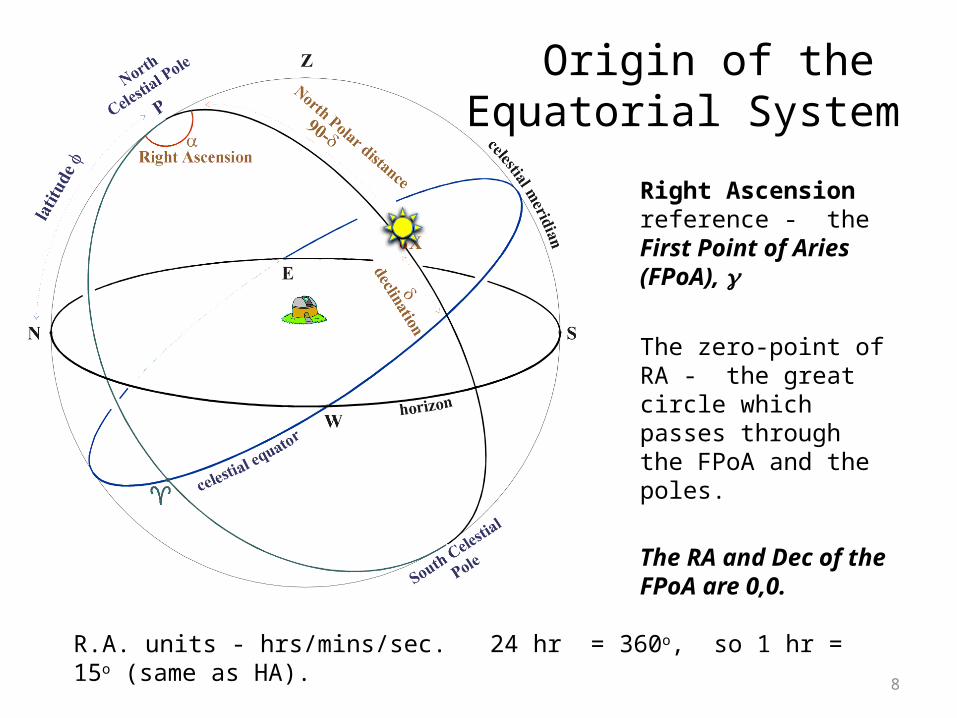
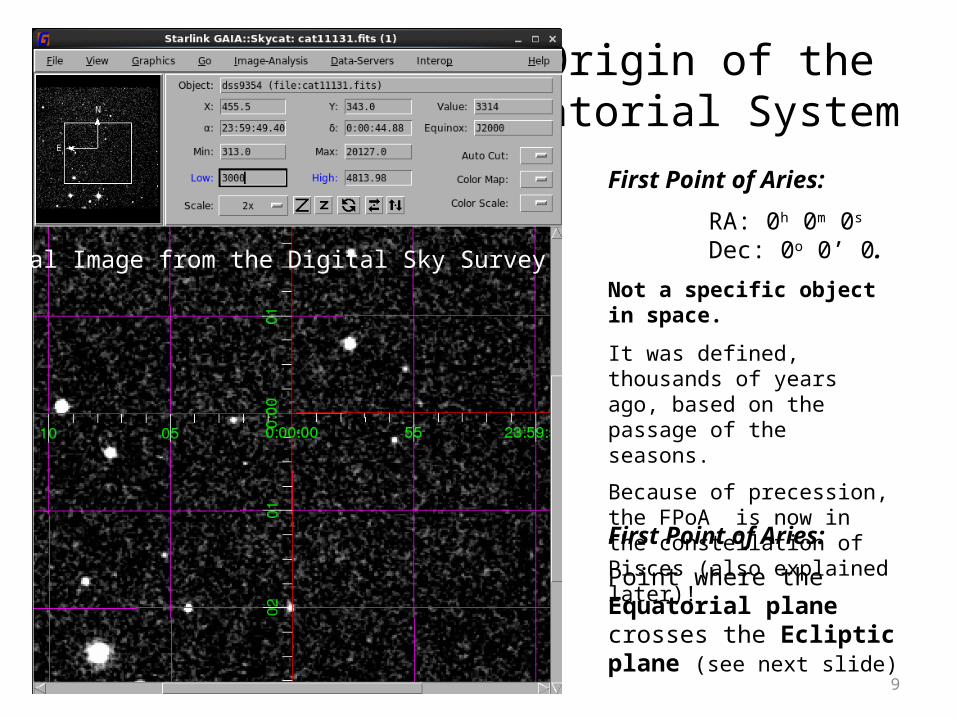
Origin of the Equatorial System
R.A. units - hrs/mins/sec. 24 hr = 360o, so 1 hr = 15o (same as HA).
Right Ascension reference - the First Point of Aries (FPoA), g
The zero-point of RA - the great circle which passes through the FPoA and the poles.
The RA and Dec of the FPoA are 0,0.
9
Origin of the Equatorial System
First Point of Aries:
Point where the Equatorial plane crosses the Ecliptic plane (see next slide)
First Point of Aries:
RA: 0h 0m 0s Dec: 0o 0’ 0.
Not a specific object in space.
It was defined, thousands of years ago, based on the passage of the seasons.
Because of precession, the FPoA is now in the constellation of Pisces (also explained later)!
Optical Image from the Digital Sky Survey
10
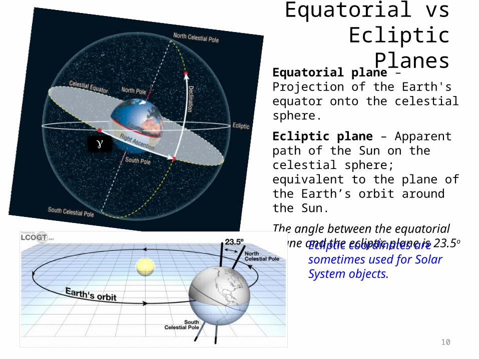
Equatorial plane – Projection of the Earth's equator onto the celestial sphere.
Ecliptic plane – Apparent path of the Sun on the celestial sphere; equivalent to the plane of the Earth’s orbit around the Sun.
The angle between the equatorial plane and the ecliptic plane is 23.5o
Equatorial vs EclipticPlanes
Ecliptic coordinates are sometimes used for Solar System objects.
g

11
First Point of Aries and the Vernal Equinox
• FPoA: one of the two points on the Celestial Sphere where the Ecliptic Plane and the Equatorial Plane cross one another. • FPoA: point in space beyond the sun on the Vernal Equinox, March 21st / 22nd each year. Note that Ver is Latin for Spring!

12
Vernal (or Spring) Equinox & Autumnal Equinox – When the sun crosses the equator.
The Vernal Equinox – when the Sun, Earth and First Point of Aries (FPoA) are in line –corresponds to when the Sun moves above the equator as it moves around the ecliptic.
First Point of Aries and the Vernal Equinox

13
On the EQUATOR, the sun is directly overhead twice a year, at noon on the two equinoxes (March and September)….
14
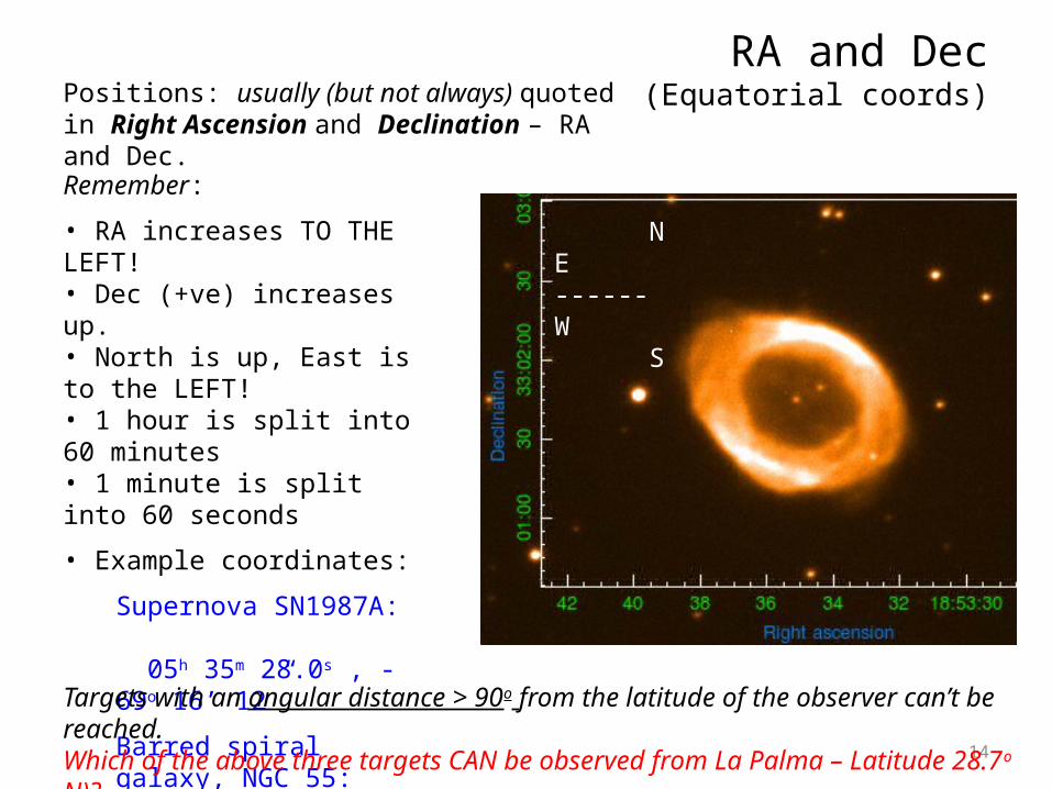
RA and Dec(Equatorial coords)
Remember:
• RA increases TO THE LEFT! • Dec (+ve) increases up.• North is up, East is to the LEFT!• 1 hour is split into 60 minutes • 1 minute is split into 60 seconds
• Example coordinates:
Supernova SN1987A: 05h 35m 28.0s , -69o 16’ 12”
Barred spiral galaxy, NGC 55: 00h 14m 53.6s , -39o 11’ 48”
Ring Nebula, M57: 18h 53m 35.1s , +33o 01’ 45”
Targets with an angular distance > 90o from the latitude of the observer can’t be reached.Which of the above three targets CAN be observed from La Palma – Latitude 28.7o N)?
Positions: usually (but not always) quoted in Right Ascension and Declination – RA and Dec.
NE ------ W S
15
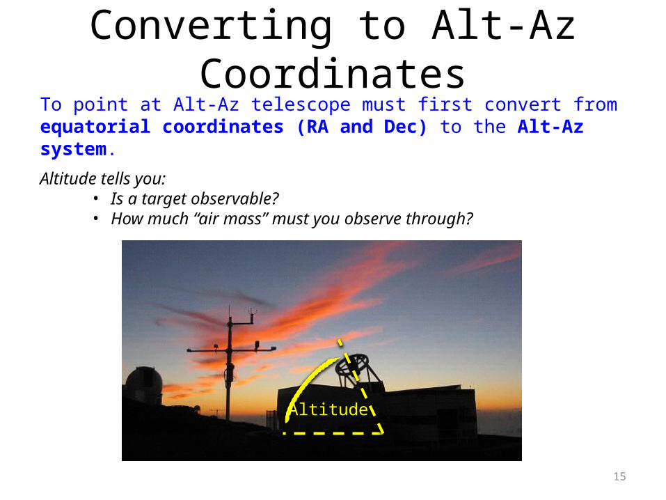
Converting to Alt-Az CoordinatesTo point at Alt-Az telescope must first convert from equatorial coordinates (RA and Dec) to the Alt-Az system.
Altitude tells you:• Is a target observable?• How much “air mass” must you observe through?
Altitude

16
Converting to Alt-Az CoordinatesConvert Equatorial coordinates (HA and Dec) to Horizon coordinates (Alt-Az)
Use a spherical triangle XPZ, where Z is Zenith, P is North Celestial Pole, X is position of the star.
Note: f is the latitude of the observer
The sides of the triangle: PZ is the observer's co-latitude = 90°-φ. ZX is the zenith distance of X = 90°-a. PX is the North Polar Distance of X = 90°-δ.
The angles of the triangle: The angle at P is HA, the local Hour Angle of star X. The angle at Z is 360°-A, where A is the azimuth of star X. The angle at X is q, the parallactic angle.
Tip: if you don’t get this, try
looking down on Z from above!
N
meridianHA

17
Converting to Alt-Az CoordinatesGiven: the latitude of the observer, , f the hour angle, HA and declination, δ we can calculate azimuth A and altitude a.
By the cosine rule:
cos(90°-a) = cos(90°-δ) cos(90°-φ) + sin(90°-δ) sin(90°-φ) cos(HA)
which simplifies to:
sin(a) = sin(δ) sin(φ) + cos(δ) cos(φ) cos(HA)
… This gives us the altitude a.
By the sine rule:
sin(360°-A)/sin(90°-δ) = sin(HA)/sin(90°-a)
which simplifies to:- sin(A)/cos(δ) = sin(HA)/cos(a)then:
sin(A) = - sin(HA) cos(δ) / cos(a)
… This gives us the azimuth A (IF d > 0).
HA

18
Converting to Alt-Az CoordinatesGiven: the latitude of the observer, , f the hour angle, HA and Declination, δ we can calculate azimuth A and altitude a.
By the cosine rule:
cos(90°-a) = cos(90°-δ) cos(90°-φ) + sin(90°-δ) sin(90°-φ) cos(HA)
which simplifies to:
sin(a) = sin(δ) sin(φ) + cos(δ) cos(φ) cos(HA)
… This gives us the altitude a.
Alternatively, by the cosine rule again:
cos(90°-δ) = cos(90°-φ) cos(90°-a) + sin(90°-φ) sin(90°-a) cos(360°-A)
which simplifies to sin(δ) = sin(φ) sin(a) + cos(φ) cos(a) cos(360°-A)
Rearrange to find A:
cos(360°-A) = cos(A) = [ sin(δ) - sin(φ) sin(a) ] / cos(φ) cos(a)
… This again gives us the azimuth A (for +ve and –ve declination)

19
Converting to Alt-Az Coordinates
Strictly speaking:
• Altitude, a (the angular height above the horizon)
sin(a) = sin(δ) sin(φ) + cos(δ) cos(φ) cos(HA)
• Azimuth, A (angular rotation clockwise, i.e. from North towards East):
cos(360°-A) = [ sin(δ) - sin(φ) sin(a) ] / cos(φ) cos(a) (0 hrs < HA < 12 hrs
target is setting)
cos(A) = [ sin(δ) - sin(φ) sin(a) ] / cos(φ) cos(a) (12 hrs < HA < 24 hrs
target is rising)

20
Converting to Alt-Az Coordinates(an example…)
Planetary Nebula, M76, equatorial coordinates:Convert to degrees.
d = 51o 19’ 30” 51o 19.5’ 51.325o
We will observe at 3am when the target has transitted: Hour angle, HA = 2.20 hrsTo convert hour angle to degrees - multiply by 15 (nb. 24 hrs is equivalent to 360o).
Therefore: HA = 33.00o
Altitude, a:
sin(a) = sin(δ) sin(φ) + cos(δ) cos(φ) cos(HA)a = 56.624o
= 56o 37’ 29”
Azimuth, A (0 < HA < 12 hrs): cos(360°-A) = [ sin(δ) - sin(φ) sin(a) ] / cos(φ) cos(a) A = 321.781o or -38.219o
= 321o 46’ 50”
Observatory in La Palma, latitude f = 28.7624
(NB: a –ve angle, or very large +ve angle, means target is West of North)
21
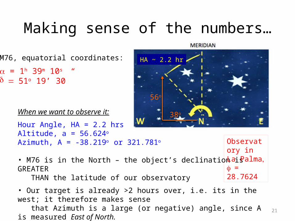
Making sense of the numbers…
When we want to observe it:
Hour Angle, HA = 2.2 hrs Altitude, a = 56.624o Azimuth, A = -38.219o or 321.781o
• M76 is in the North – the object’s declination is GREATER THAN the latitude of our observatory
• Our target is already >2 hours over, i.e. its in the west; it therefore makes sense that Azimuth is a large (or negative) angle, since A is measured East of North.
Observatory in La Palma, f = 28.7624
M76, equatorial coordinates:
a = 1h 39m 10s
d = 51o 19’ 30”
38o
56o
HA ~ 2.2 hr
22
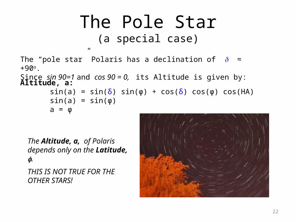
The Pole Star(a special case)
The “pole star” Polaris has a declination of d ≈ +90o. Since sin 90=1 and cos 90 = 0, its Altitude is given by:
The Altitude, a, of Polaris depends only on the Latitude, f.
THIS IS NOT TRUE FOR THE OTHER STARS!
Altitude, a: sin(a) = sin(δ) sin(φ) + cos(δ) cos(φ) cos(HA)sin(a) = sin(φ) a = φ

23
Polaris – not one star, but two, err, three…And not quite at the north ecliptic pole, either… Declination: 89o 15’
24
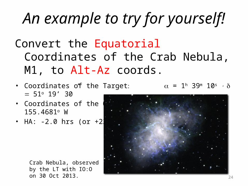
An example to try for yourself!
Convert the Equatorial Coordinates of the Crab Nebula, M1, to Alt-Az coords.
• Coordinates of the Target: a = 1h 39m 10s , = d 51o 19’ 30” • Coordinates of the Observatory: 19.8207o N, 155.4681o W• HA: -2.0 hrs (or +22.0 hrs)
Crab Nebula, observed by the LT with IO:O on 30 Oct 2013.

25

26
PrecessionThe Earth's rotation axis precesses slowly, with a period of 25,600 years.
The Earth is not quite spherical, but is oblate and tilted. Therefore, the direction of the Sun's gravity does not pass directly through the Earth's centre of rotation.
The position of the Vernal Equinox moves at approx 50” per year.
Because of precession, we must define an appropriate equinox for the RA and Dec catalogue positions, e.g. 1950, 2000 etc.
27
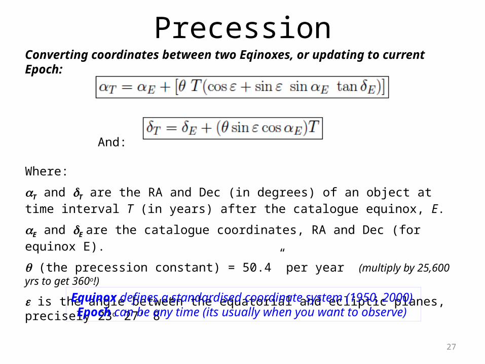
PrecessionConverting coordinates between two Eqinoxes, or updating to current Epoch:
And:
Where:
aT and dT are the RA and Dec (in degrees) of an object at time interval T (in years) after the catalogue equinox, E.
aE and dE are the catalogue coordinates, RA and Dec (for equinox E).
q (the precession constant) = 50.4” per year (multiply by 25,600 yrs to get 360o!)
e is the angle between the equatorial and ecliptic planes, precisely 23o 27’ 8”
Equinox defines a standardised coordinate system (1950, 2000) Epoch can be any time (its usually when you want to observe)
28
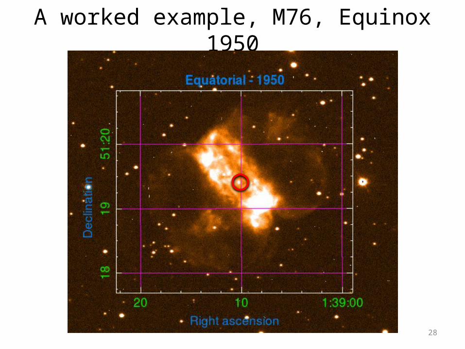
A worked example, M76, Equinox 1950

29
Converting between Equinox 1950 and Equinox 2000
Convert Equinox 1950 coords to degrees:a1950 = 1h 39m 10s 1h 39.17m 1.653h (÷24 and ×360) 24.795o
d1950 = 51o 19’ 30” 51o 19.5’ 51.325o
Precess 1950 degrees to 2000 degrees and convert back to RA and Dec
a2000 = 24.795o + [0.014o . 50yrs . (cos.23.5o + sin23.5o.sin24.795o.tan51.325o)] = 25.583o
= 1.7055h ≈ 1h 42m 20s
d2000 = 51.325o + [0.014o . 50yrs . (sin23.5o.cos24.795o)
= 51.578 ≈ 51o 34’ 40”
Remember:Precession constant is 50.4” = 0.014o / year.Angle between ecliptic and equatorial planesIs 23.5o)

30
A worked example, M76, Equinox 2000
31
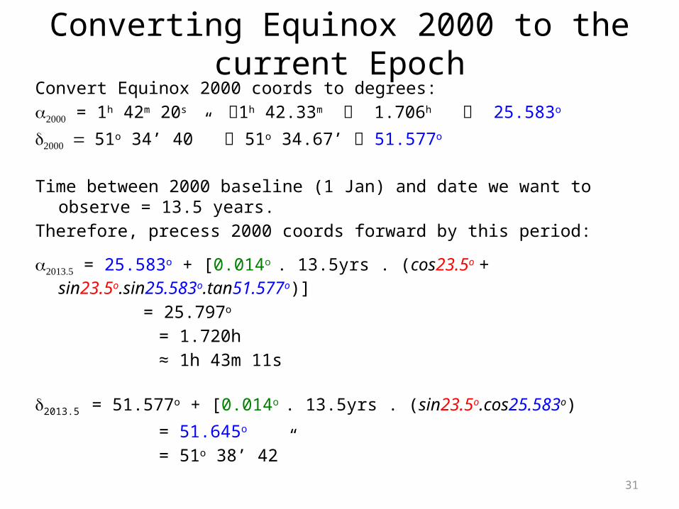
Converting Equinox 2000 to the current Epoch
Convert Equinox 2000 coords to degrees:a2000 = 1h 42m 20s 1h 42.33m 1.706h 25.583o
d2000 = 51o 34’ 40” 51o 34.67’ 51.577o
Time between 2000 baseline (1 Jan) and date we want to observe = 13.5 years.Therefore, precess 2000 coords forward by this period:
a2013.5 = 25.583o + [0.014o . 13.5yrs . (cos23.5o + sin23.5o.sin25.583o.tan51.577o)] = 25.797o = 1.720h ≈ 1h 43m 11s
d2013.5 = 51.577o + [0.014o . 13.5yrs . (sin23.5o.cos25.583o)
= 51.645o = 51o 38’ 42”
32
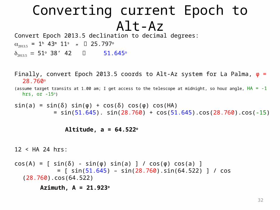
Converting current Epoch to Alt-AzConvert Epoch 2013.5 declination to decimal degrees:a2013.5 = 1h 43m 11s 25.797o
d2013.5 = 51o 38’ 42” 51.645o
Finally, convert Epoch 2013.5 coords to Alt-Az system for La Palma, φ = 28.760o (assume target transits at 1.00 am; I get access to the telescope at midnight, so hour angle, HA = -1 hrs, or -15o)
sin(a) = sin(δ) sin(φ) + cos(δ) cos(φ) cos(HA) = sin(51.645). sin(28.760) + cos(51.645).cos(28.760).cos(-15)
Altitude, a = 64.522o
12 < HA 24 hrs:
cos(A) = [ sin(δ) - sin(φ) sin(a) ] / cos(φ) cos(a) ] = [ sin(51.645) – sin(28.760).sin(64.522) ] / cos (28.760).cos(64.522)
Azimuth, A = 21.923o
33
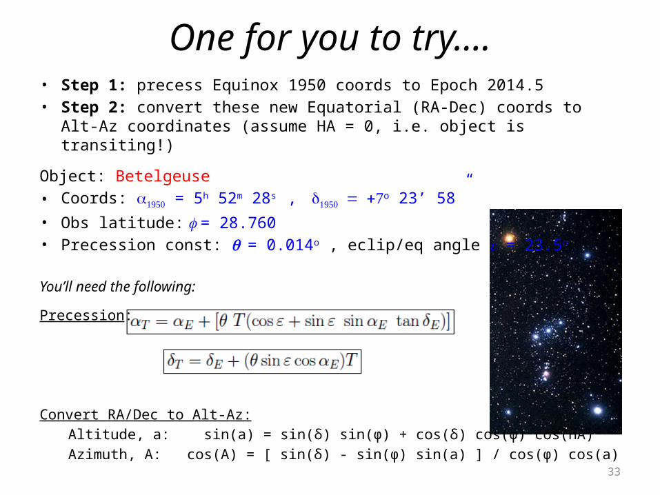
One for you to try….• Step 1: precess Equinox 1950 coords to Epoch 2014.5• Step 2: convert these new Equatorial (RA-Dec) coords to Alt-Az coordinates
(assume HA = 0, i.e. object is transiting!)
Object: Betelgeuse• Coords: a1950 = 5h 52m 28s , d1950 = +7o 23’ 58”• Obs latitude: f = 28.760• Precession const: q = 0.014o , eclip/eq angle e = 23.5o
You’ll need the following:
Precession:
Convert RA/Dec to Alt-Az:Altitude, a: sin(a) = sin(δ) sin(φ) + cos(δ) cos(φ) cos(HA)Azimuth, A: cos(A) = [ sin(δ) - sin(φ) sin(a) ] / cos(φ) cos(a)
34
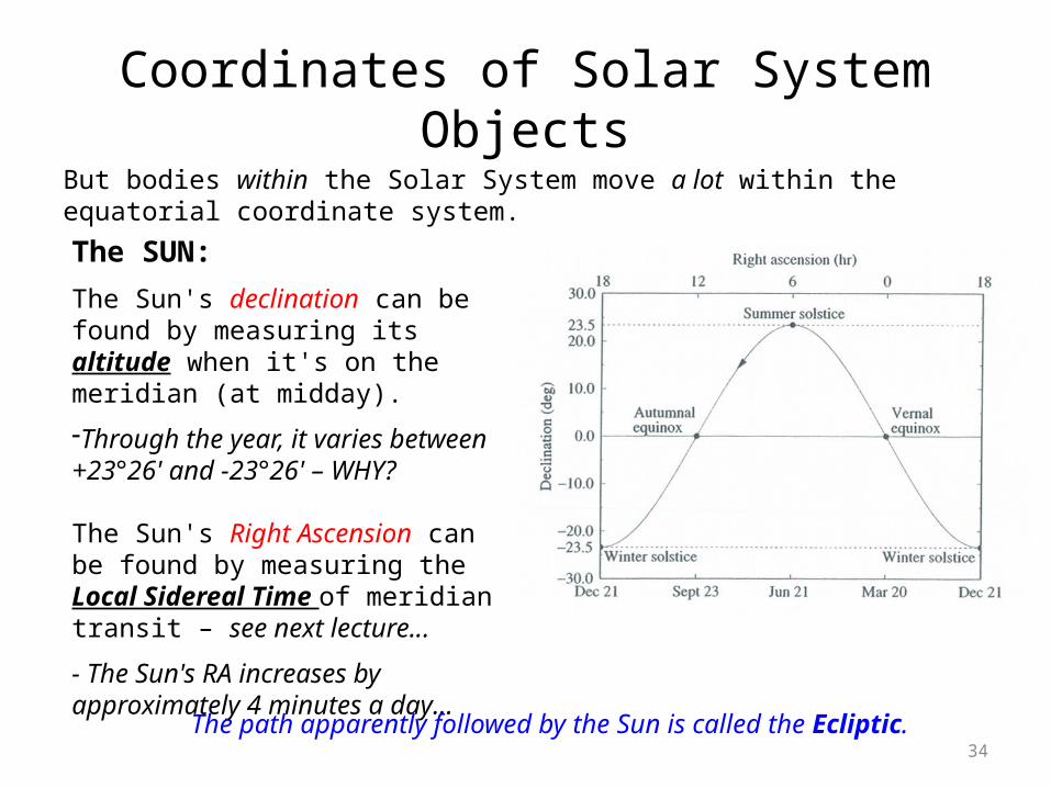
Coordinates of Solar System ObjectsBut bodies within the Solar System move a lot within the equatorial coordinate system.
The SUN:
The Sun's declination can be found by measuring its altitude when it's on the meridian (at midday).
-Through the year, it varies between +23°26' and -23°26' – WHY?
The Sun's Right Ascension can be found by measuring the Local Sidereal Time of meridian transit – see next lecture...
- The Sun's RA increases by approximately 4 minutes a day…
The path apparently followed by the Sun is called the Ecliptic.

35
Parallax• We can use the motion of the earth
around the sun as a tool for measuring distances to nearby stars.
• Foreground stars appear to move against the background of distant stars and galaxies
• Annual parallax – the maximum displacement of a star from its mean position
• A star with an annual parallax of 1 arcsec is at a distance of 1 parsec
Distance, D = 1/q
E.g.Proxima Centauri,Annual parallax = 0.772
arcsec,D = 1/0.772 = 1.30 pc
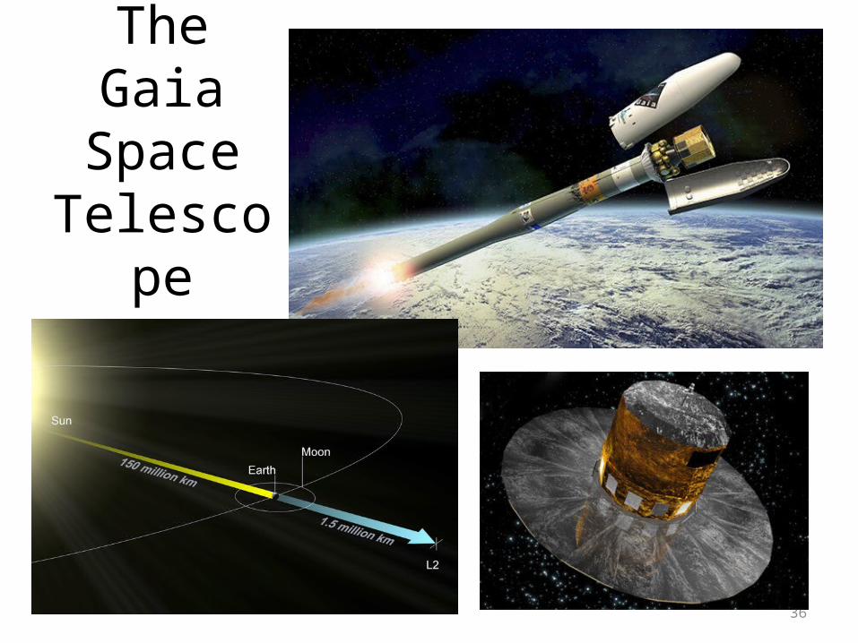
36
The Gaia Space
Telescope