Embed Size (px)
Citation preview
Clockwise from below: Eastern grey kangaroos; superb lyrebird putting on a show; yellow-tufted honeyeater; duck orchid.
At GirraweenAt SundownBoth parks
Bald Rock Creek camping areaCastle Rock camping areaThe Broadwater camping areaBurrows Waterhole camping areaReedy Waterhole bushcampNundubbermere Falls bushcampRemote walkers’ camps
Tent and camper trailer sites tucked away in the bush plus more social ones in an open, semi-grassed area. Some sites are sunny. Short walk to Bald Rock Creek.
Sites for caravans, motorhomes, camper trailers, buses and tents in a large open, semi-shaded area with views of granite outcrops. Amenities block has wheelchair access.
Individual sites on the river bank for tents, camper trailers, small motorhomes and caravans less than 4m long. Has large open area for groups of 15–30 people. Use donkey heater to boil hot water for showers. Pit toilets.
Attractive riverside area with shady spots at end of the 4WD road. Pit toilets.
Large open grassy area near the Severn River. Access by 4WD or on foot. No facilities.
Small, semi-shaded grassy area for tents only. Caution: steep drop to river below. No formed walking track. No facilities.
Sundown’s walkers’ camps (max 8 people each) are not defined and fuel stoves are recommended. Girraween has seven walker’s camps ranging in size to accommodate 4–8 people. Open fires are prohibited. Visit queenslandnationalparks.com.au for GPS references and other details. No facilities.
©State of Queensland 2016. Queensland Parks and Wildlife Service, Department of National Parks, Sport and Racing. BP2145 May 2016 Printed on eco-friendly paper to save energy and resources.
Beat around the bushSavour a bush picnic then hit the trails. Use the free electric barbecues to cook up a storm at popular
Bald Rock Creek day-use area in the heart of Girraween, or eat a packed lunch under towering trees at smaller, secluded picnic spots.
Don your hiking boots and get closer to nature on short or long walks. Feel the freedom pedalling through the forest along the Creek or Peak shared trails in Girraween’s back country, but remember cyclists
must give way to walkers.
Adventurous mountain bikers experienced in remote terrain can also cycle the rough 4WD access road in Sundown—keep watch for vehicles.
Camp restfully Create camping memories of a lifetime—share the day’s adventures over a barbecue, spot possums and wake with the birds at Girraween’s well-equipped camping areas. Or enjoy ‘roughing it’ in the unspoilt seclusion of Sundown’s wild and rugged terrain with few, or no facilities.
Book your camp sites well in advance at qld.gov.au/camping especially for during the school holidays. Check where fires are permitted before booking, and remember to bring your own clean-milled firewood or fuel stove.
If you need a powered site, or camping isn’t your thing, visit southernqueenslandcountry.com.au for other places to stay.
Challenge RuggedlyChallenge yourself on a strenuous off-track overnight hike carrying all your gear on your back. Raise a sweat
and breathe in the isolation of difficult-to-get-to destinations in rough, rocky country with mind-blowing scenery.
To hike off-track you MUST be fit, experienced and suitably prepared! Ensure you have the relevant topographic maps, guide books, a compass or GPS, a personal locating beacon (PLB), and all necessary equipment, food, water and a hiking companion. Be careful and don’t take risks.
Limited remote, walk-in camp sites without facilities are available for experienced bushwalkers. For further details and bookings visit queenslandnationalparks.com.au
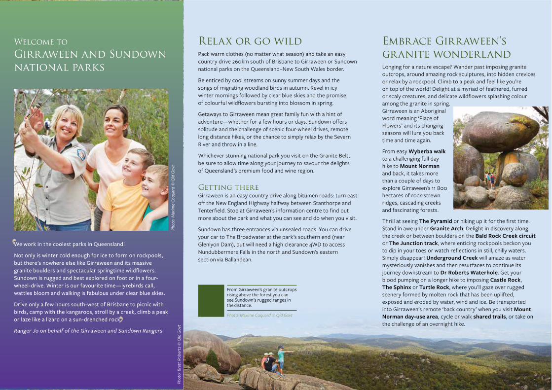
We work in the coolest parks in Queensland!
Not only is winter cold enough for ice to form on rockpools, but there’s nowhere else like Girraween and its massive granite boulders and spectacular springtime wildflowers. Sundown is rugged and best explored on foot or in a four-wheel-drive. Winter is our favourite time—lyrebirds call, wattles bloom and walking is fabulous under clear blue skies.
Drive only a few hours south-west of Brisbane to picnic with birds, camp with the kangaroos, stroll by a creek, climb a peak or laze like a lizard on a sun-drenched rock.
Ranger Jo on behalf of the Girraween and Sundown Rangers
From Girraween’s granite outcrops rising above the forest you can see Sundown’s rugged ranges in the distance.
Relax or go wildPack warm clothes (no matter what season) and take an easy country drive 260km south of Brisbane to Girraween or Sundown national parks on the Queensland–New South Wales border.
Be enticed by cool streams on sunny summer days and the songs of migrating woodland birds in autumn. Revel in icy winter mornings followed by clear blue skies and the promise of colourful wildflowers bursting into blossom in spring.
Getaways to Girraween mean great family fun with a hint of adventure—whether for a few hours or days. Sundown offers solitude and the challenge of scenic four-wheel drives, remote long distance hikes, or the chance to simply relax by the Severn River and throw in a line.
Whichever stunning national park you visit on the Granite Belt, be sure to allow time along your journey to savour the delights of Queensland’s premium food and wine region.
Getting thereGirraween is an easy country drive along bitumen roads: turn east off the New England Highway halfway between Stanthorpe and Tenterfield. Stop at Girraween’s information centre to find out more about the park and what you can see and do when you visit.
Sundown has three entrances via unsealed roads. You can drive your car to The Broadwater at the park’s southern end (near Glenlyon Dam), but will need a high clearance 4WD to access Nundubbermere Falls in the north and Sundown’s eastern section via Ballandean.
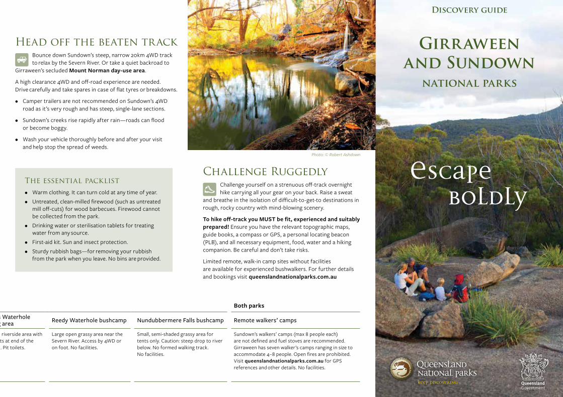
Embrace Girraween’s granite wonderlandLonging for a nature escape? Wander past imposing granite outcrops, around amazing rock sculptures, into hidden crevices or relax by a rockpool. Climb to a peak and feel like you’re on top of the world! Delight at a myriad of feathered, furred or scaly creatures, and delicate wildflowers splashing colour among the granite in spring. Girraween is an Aboriginal word meaning ‘Place of Flowers’ and its changing seasons will lure you back time and time again.
From easy Wyberba walk to a challenging full day hike to Mount Norman and back, it takes more than a couple of days to explore Girraween’s 11 800 hectares of rock-strewn ridges, cascading creeks and fascinating forests.
Thrill at seeing The Pyramid or hiking up it for the first time. Stand in awe under Granite Arch. Delight in discovery along the creek or between boulders on the Bald Rock Creek circuit or The Junction track, where enticing rockpools beckon you to dip in your toes or watch reflections in still, chilly waters. Simply disappear! Underground Creek will amaze as water mysteriously vanishes and then resurfaces to continue its journey downstream to Dr Roberts Waterhole. Get your blood pumping on a longer hike to imposing Castle Rock, The Sphinx or Turtle Rock, where you’ll gaze over rugged scenery formed by molten rock that has been uplifted, exposed and eroded by water, wind and ice. Be transported into Girraween’s remote ‘back country’ when you visit Mount Norman day-use area, cycle or walk shared trails, or take on the challenge of an overnight hike.
Photo: © Robert Ashdown
Photo: © Robert Ashdown
Photo: Maxim
e Coquard © Q
ld Govt
Front cover photo: Maxime Coquard © Tourism and Events Queensland Back cover photo: Robert Ashdown © Qld Govt
Girraween’s walks are perfect for the whole family. Kids love climbing rocks and exploring along the creek.
Photo: Maxime Coquard © Qld Govt
Get lost in natureRelease your inner nature lover! This snap-frozen landscape more akin to southern States has plants and animals that don’t occur elsewhere in Queensland.
Sunlit outcrops are the preferred habitat of reptiles that dart under rocks and into crevices. Come face-to-face with a Cunningham’s skink or spot an eastern water dragon by the creek. Thrill at discovering frogs where it’s moist and snakes among leaf litter.
Wake early and greet the birds. Wrens, robins, thornbills and firetails flit through the understorey and honeyeaters, warblers, parrots, treecreepers and flycatchers forage to the tops of eucalypt trees. Be mystified by the master of mimicry. The elusive superb lyrebird—more often heard than seen—is one of the 170 bird species at Girraween and 150 at Sundown.
By day, admire red-necked wallabies and eastern grey kangaroos grazing lazily in open grassy areas. At night, shine a light on nocturnal residents. Catch sight of a crook! Common brushtail possums are bold thieves stealing food from unwary campers! Glimpse tiny sugar and feathertail gliders in trees or bush rats, antechinus and echidnas rummaging across the ground for food.
Find seclusion at SundownJourney back roads to experience the wild isolation and solitude of rugged ranges and deeply eroded ‘traprock country’ along the Severn River.
Camp on a river flat at Sundown’s southern end and throw in a line to see if you can catch a yellow-belly or eel-tailed catfish. Wander to Permanent Waterhole to watch wildlife or swim; or take the Western circuit for extensive views and woodland birds.
See red at Red Rock Gorge, gazing across lichen-stained granite cliffs above which peregrine falcons fly. Then continue the slow and steady four-wheel drive down to the river along the rough, narrow track past abandoned Beecroft Mine where tin, copper and arsenic were mined periodically from the 1870s.
Keep watch for brush-tailed rock-wallabies hiding among rocks near Nundubbermere Falls and wallaroos grazing steep slopes. Spot red-capped robins, spiny-cheeked and striped honeyeaters, red-winged parrots and turquoise parrots in dry southern areas, and tiny azure kingfishers along the river.
Challenge your fitness and bushwalking skills with a hike into remote, rugged ranges (not for the inexperienced). For a half day adventure, make your own way following the creek downstream from Burrows Waterhole to Rats Castle (in the eastern section) or into Ooline Creek or McAllisters Creek (from The Broadwater at the southern end). Reaching other remote features can take several days.
Immerse yourself in the wildflower spectacle setting Girraween’s forests, woodlands and heathlands ablaze with colour from late winter to summer. Starting with golden wattle and pea-flowers, displays of more than 700 species of blossoms reach a climax in September and October with delicate white heath bells, grass trigger plants, native bluebells, banksias, native sarsaparilla and daisies; then finish with summer-time flannel flowers, bottlebrushes, paperbarks and eucalypts.
Welcome to Girraween and Sundown national parks
Girraween’s Granite Arch (left); Sundown’s Red Rock Gorge (above).
Photo (left): Maxime Coquard © Qld Govt Photo (above): Brett Roberts © Qld Govt
Phot
o: M
axim
e Co
quar
d ©
Qld
Gov
t Ph
oto:
Bre
tt R
ober
ts ©
Qld
Gov
t
Photo (top): © Qld Govt Photos (clockwise from below): Maxime Coquard © Qld Govt; Jolene McLellan © Qld Govt; © Ted Colles; © Bill Goebel
Head off the beaten trackBounce down Sundown’s steep, narrow 20km 4WD track to relax by the Severn River. Or take a quiet backroad to
Girraween’s secluded Mount Norman day-use area.
A high clearance 4WD and off-road experience are needed. Drive carefully and take spares in case of flat tyres or breakdowns.
• Camper trailers are not recommended on Sundown’s 4WD road as it’s very rough and has steep, single-lane sections.
• Sundown’s creeks rise rapidly after rain—roads can flood or become boggy.
• Wash your vehicle thoroughly before and after your visit and help stop the spread of weeds.
Camping at a glance
Photo: Maxime Coquard © Qld Govt
Connect with Queensland National Parks
queenslandnationalparks.com.au
book at qld.gov.au/camping
check npsr.qld.gov.au/park-alerts for park access, closures and conditions.
facebook.com/qldnationalparks
@QldParks; #QldParks
For help to plan your holiday, visit queensland.com or southernqueenslandcountry.com.au
Nothing beats cooking over a wood-fired barbecue. But fighting a wildfire raging through the bush is not cool! So keep your fire small, make sure it is out when you leave and remember to bring firewood rather than raid it from the bush.Ranger Peter
The essential packlist• Warm clothing. It can turn cold at any time of year.• Untreated, clean-milled firewood (such as untreated
mill off-cuts) for wood barbecues. Firewood cannot be collected from the park.
• Drinking water or sterilisation tablets for treating water from any source.
• First-aid kit. Sun and insect protection.• Sturdy rubbish bags—for removing your rubbish
from the park when you leave. No bins are provided.
Warwick
Allora
Stanthorpe
SundownNational ParkGirraween
National ParkTexas
Wallangarra
Ballandean
Mingoola
Queensland
Tenterfield
New SouthWales
New
England Highway
Cunningham Highway
Bruxner Highway
To ToowoombaTo Brisbane
Killarney
1020kmScale0
Girraween and Sundown
national parks
Discovery guide
Escape boldly

Clockwise from below: Eastern grey kangaroos; superb lyrebird putting on a show; yellow-tufted honeyeater; duck orchid.
At GirraweenAt SundownBoth parks
Bald Rock Creek camping areaCastle Rock camping areaThe Broadwater camping areaBurrows Waterhole camping areaReedy Waterhole bushcampNundubbermere Falls bushcampRemote walkers’ camps
Tent and camper trailer sites tucked away in the bush plus more social ones in an open, semi-grassed area. Some sites are sunny. Short walk to Bald Rock Creek.
Sites for caravans, motorhomes, camper trailers, buses and tents in a large open, semi-shaded area with views of granite outcrops. Amenities block has wheelchair access.
Individual sites on the river bank for tents, camper trailers, small motorhomes and caravans less than 4m long. Has large open area for groups of 15–30 people. Use donkey heater to boil hot water for showers. Pit toilets.
Attractive riverside area with shady spots at end of the 4WD road. Pit toilets.
Large open grassy area near the Severn River. Access by 4WD or on foot. No facilities.
Small, semi-shaded grassy area for tents only. Caution: steep drop to river below. No formed walking track. No facilities.
Sundown’s walkers’ camps (max 8 people each) are not defined and fuel stoves are recommended. Girraween has seven walker’s camps ranging in size to accommodate 4–8 people. Open fires are prohibited. Visit queenslandnationalparks.com.au for GPS references and other details. No facilities.
©State of Queensland 2016. Queensland Parks and Wildlife Service, Department of National Parks, Sport and Racing. BP2145 May 2016 Printed on eco-friendly paper to save energy and resources.
Beat around the bushSavour a bush picnic then hit the trails. Use the free electric barbecues to cook up a storm at popular
Bald Rock Creek day-use area in the heart of Girraween, or eat a packed lunch under towering trees at smaller, secluded picnic spots.
Don your hiking boots and get closer to nature on short or long walks. Feel the freedom pedalling through the forest along the Creek or Peak shared trails in Girraween’s back country, but remember cyclists
must give way to walkers.
Adventurous mountain bikers experienced in remote terrain can also cycle the rough 4WD access road in Sundown—keep watch for vehicles.
Camp restfully Create camping memories of a lifetime—share the day’s adventures over a barbecue, spot possums and wake with the birds at Girraween’s well-equipped camping areas. Or enjoy ‘roughing it’ in the unspoilt seclusion of Sundown’s wild and rugged terrain with few, or no facilities.
Book your camp sites well in advance at qld.gov.au/camping especially for during the school holidays. Check where fires are permitted before booking, and remember to bring your own clean-milled firewood or fuel stove.
If you need a powered site, or camping isn’t your thing, visit southernqueenslandcountry.com.au for other places to stay.
Challenge RuggedlyChallenge yourself on a strenuous off-track overnight hike carrying all your gear on your back. Raise a sweat
and breathe in the isolation of difficult-to-get-to destinations in rough, rocky country with mind-blowing scenery.
To hike off-track you MUST be fit, experienced and suitably prepared! Ensure you have the relevant topographic maps, guide books, a compass or GPS, a personal locating beacon (PLB), and all necessary equipment, food, water and a hiking companion. Be careful and don’t take risks.
Limited remote, walk-in camp sites without facilities are available for experienced bushwalkers. For further details and bookings visit queenslandnationalparks.com.au
We work in the coolest parks in Queensland!
Not only is winter cold enough for ice to form on rockpools, but there’s nowhere else like Girraween and its massive granite boulders and spectacular springtime wildflowers. Sundown is rugged and best explored on foot or in a four-wheel-drive. Winter is our favourite time—lyrebirds call, wattles bloom and walking is fabulous under clear blue skies.
Drive only a few hours south-west of Brisbane to picnic with birds, camp with the kangaroos, stroll by a creek, climb a peak or laze like a lizard on a sun-drenched rock.
Ranger Jo on behalf of the Girraween and Sundown Rangers
From Girraween’s granite outcrops rising above the forest you can see Sundown’s rugged ranges in the distance.
Relax or go wildPack warm clothes (no matter what season) and take an easy country drive 260km south of Brisbane to Girraween or Sundown national parks on the Queensland–New South Wales border.
Be enticed by cool streams on sunny summer days and the songs of migrating woodland birds in autumn. Revel in icy winter mornings followed by clear blue skies and the promise of colourful wildflowers bursting into blossom in spring.
Getaways to Girraween mean great family fun with a hint of adventure—whether for a few hours or days. Sundown offers solitude and the challenge of scenic four-wheel drives, remote long distance hikes, or the chance to simply relax by the Severn River and throw in a line.
Whichever stunning national park you visit on the Granite Belt, be sure to allow time along your journey to savour the delights of Queensland’s premium food and wine region.
Getting thereGirraween is an easy country drive along bitumen roads: turn east off the New England Highway halfway between Stanthorpe and Tenterfield. Stop at Girraween’s information centre to find out more about the park and what you can see and do when you visit.
Sundown has three entrances via unsealed roads. You can drive your car to The Broadwater at the park’s southern end (near Glenlyon Dam), but will need a high clearance 4WD to access Nundubbermere Falls in the north and Sundown’s eastern section via Ballandean.
Embrace Girraween’s granite wonderlandLonging for a nature escape? Wander past imposing granite outcrops, around amazing rock sculptures, into hidden crevices or relax by a rockpool. Climb to a peak and feel like you’re on top of the world! Delight at a myriad of feathered, furred or scaly creatures, and delicate wildflowers splashing colour among the granite in spring. Girraween is an Aboriginal word meaning ‘Place of Flowers’ and its changing seasons will lure you back time and time again.
From easy Wyberba walk to a challenging full day hike to Mount Norman and back, it takes more than a couple of days to explore Girraween’s 11 800 hectares of rock-strewn ridges, cascading creeks and fascinating forests.
Thrill at seeing The Pyramid or hiking up it for the first time. Stand in awe under Granite Arch. Delight in discovery along the creek or between boulders on the Bald Rock Creek circuit or The Junction track, where enticing rockpools beckon you to dip in your toes or watch reflections in still, chilly waters. Simply disappear! Underground Creek will amaze as water mysteriously vanishes and then resurfaces to continue its journey downstream to Dr Roberts Waterhole. Get your blood pumping on a longer hike to imposing Castle Rock, The Sphinx or Turtle Rock, where you’ll gaze over rugged scenery formed by molten rock that has been uplifted, exposed and eroded by water, wind and ice. Be transported into Girraween’s remote ‘back country’ when you visit Mount Norman day-use area, cycle or walk shared trails, or take on the challenge of an overnight hike.
Photo: © Robert Ashdown
Photo: © Robert AshdownPhoto: M
axime Coquard ©
Qld G
ovt
Front cover photo: Maxime Coquard © Tourism and Events Queensland Back cover photo: Robert Ashdown © Qld Govt
Girraween’s walks are perfect for the whole family. Kids love climbing rocks and exploring along the creek.
Photo: Maxime Coquard © Qld Govt
Get lost in natureRelease your inner nature lover! This snap-frozen landscape more akin to southern States has plants and animals that don’t occur elsewhere in Queensland.
Sunlit outcrops are the preferred habitat of reptiles that dart under rocks and into crevices. Come face-to-face with a Cunningham’s skink or spot an eastern water dragon by the creek. Thrill at discovering frogs where it’s moist and snakes among leaf litter.
Wake early and greet the birds. Wrens, robins, thornbills and firetails flit through the understorey and honeyeaters, warblers, parrots, treecreepers and flycatchers forage to the tops of eucalypt trees. Be mystified by the master of mimicry. The elusive superb lyrebird—more often heard than seen—is one of the 170 bird species at Girraween and 150 at Sundown.
By day, admire red-necked wallabies and eastern grey kangaroos grazing lazily in open grassy areas. At night, shine a light on nocturnal residents. Catch sight of a crook! Common brushtail possums are bold thieves stealing food from unwary campers! Glimpse tiny sugar and feathertail gliders in trees or bush rats, antechinus and echidnas rummaging across the ground for food.
Find seclusion at SundownJourney back roads to experience the wild isolation and solitude of rugged ranges and deeply eroded ‘traprock country’ along the Severn River.
Camp on a river flat at Sundown’s southern end and throw in a line to see if you can catch a yellow-belly or eel-tailed catfish. Wander to Permanent Waterhole to watch wildlife or swim; or take the Western circuit for extensive views and woodland birds.
See red at Red Rock Gorge, gazing across lichen-stained granite cliffs above which peregrine falcons fly. Then continue the slow and steady four-wheel drive down to the river along the rough, narrow track past abandoned Beecroft Mine where tin, copper and arsenic were mined periodically from the 1870s.
Keep watch for brush-tailed rock-wallabies hiding among rocks near Nundubbermere Falls and wallaroos grazing steep slopes. Spot red-capped robins, spiny-cheeked and striped honeyeaters, red-winged parrots and turquoise parrots in dry southern areas, and tiny azure kingfishers along the river.
Challenge your fitness and bushwalking skills with a hike into remote, rugged ranges (not for the inexperienced). For a half day adventure, make your own way following the creek downstream from Burrows Waterhole to Rats Castle (in the eastern section) or into Ooline Creek or McAllisters Creek (from The Broadwater at the southern end). Reaching other remote features can take several days.
Immerse yourself in the wildflower spectacle setting Girraween’s forests, woodlands and heathlands ablaze with colour from late winter to summer. Starting with golden wattle and pea-flowers, displays of more than 700 species of blossoms reach a climax in September and October with delicate white heath bells, grass trigger plants, native bluebells, banksias, native sarsaparilla and daisies; then finish with summer-time flannel flowers, bottlebrushes, paperbarks and eucalypts.
Welcome to Girraween and Sundown national parks
Girraween’s Granite Arch (left); Sundown’s Red Rock Gorge (above).
Photo (left): Maxime Coquard © Qld Govt Photo (above): Brett Roberts © Qld Govt
Phot
o: M
axim
e Co
quar
d ©
Qld
Gov
t Ph
oto:
Bre
tt R
ober
ts ©
Qld
Gov
t
Photo (top): © Qld Govt Photos (clockwise from below): Maxime Coquard © Qld Govt; Jolene McLellan © Qld Govt; © Ted Colles; © Bill Goebel
Head off the beaten trackBounce down Sundown’s steep, narrow 20km 4WD track to relax by the Severn River. Or take a quiet backroad to
Girraween’s secluded Mount Norman day-use area.
A high clearance 4WD and off-road experience are needed. Drive carefully and take spares in case of flat tyres or breakdowns.
• Camper trailers are not recommended on Sundown’s 4WD road as it’s very rough and has steep, single-lane sections.
• Sundown’s creeks rise rapidly after rain—roads can flood or become boggy.
• Wash your vehicle thoroughly before and after your visit and help stop the spread of weeds.
Camping at a glance
Photo: Maxime Coquard © Qld Govt
Connect with Queensland National Parks
queenslandnationalparks.com.au
book at qld.gov.au/camping
check npsr.qld.gov.au/park-alerts for park access, closures and conditions.
facebook.com/qldnationalparks
@QldParks; #QldParks
For help to plan your holiday, visit queensland.com or southernqueenslandcountry.com.au
Nothing beats cooking over a wood-fired barbecue. But fighting a wildfire raging through the bush is not cool! So keep your fire small, make sure it is out when you leave and remember to bring firewood rather than raid it from the bush.Ranger Peter
The essential packlist• Warm clothing. It can turn cold at any time of year.• Untreated, clean-milled firewood (such as untreated
mill off-cuts) for wood barbecues. Firewood cannot be collected from the park.
• Drinking water or sterilisation tablets for treating water from any source.
• First-aid kit. Sun and insect protection.• Sturdy rubbish bags—for removing your rubbish
from the park when you leave. No bins are provided.
Warwick
Allora
Stanthorpe
SundownNational ParkGirraween
National ParkTexas
Wallangarra
Ballandean
Mingoola
Queensland
Tenterfield
New SouthWales
New
England Highway
Cunningham Highway
Bruxner Highway
To ToowoombaTo Brisbane
Killarney
1020kmScale0
Girraween and Sundown
national parks
Discovery guide
Escape boldly

Clockwise from below: Eastern grey kangaroos; superb lyrebird putting on a show; yellow-tufted honeyeater; duck orchid.
At Girraween At Sundown Both parks
Bald Rock Creek camping area Castle Rock camping area The Broadwater camping area Burrows Waterhole camping area Reedy Waterhole bushcamp Nundubbermere Falls bushcamp Remote walkers’ camps
Tent and camper trailer sites tucked away in the bush plus more social ones in an open, semi-grassed area. Some sites are sunny. Short walk to Bald Rock Creek.
Sites for caravans, motorhomes, camper trailers, buses and tents in a large open, semi-shaded area with views of granite outcrops. Amenities block has wheelchair access.
Individual sites on the river bank for tents, camper trailers, small motorhomes and caravans less than 4m long. Has large open area for groups of 15–30 people. Use donkey heater to boil hot water for showers. Pit toilets.
Attractive riverside area with shady spots at end of the 4WD road. Pit toilets.
Large open grassy area near the Severn River. Access by 4WD or on foot. No facilities.
Small, semi-shaded grassy area for tents only. Caution: steep drop to river below. No formed walking track. No facilities.
Sundown’s walkers’ camps (max 8 people each) are not defined and fuel stoves are recommended. Girraween has seven walker’s camps ranging in size to accommodate 4–8 people. Open fires are prohibited. Visit queenslandnationalparks.com.au for GPS references and other details. No facilities.
©State of Queensland 2016. Queensland Parks and Wildlife Service, Department of National Parks, Sport and Racing. BP2145 May 2016 Printed on eco-friendly paper to save energy and resources.
Beat around the bushSavour a bush picnic then hit the trails. Use the free electric barbecues to cook up a storm at popular
Bald Rock Creek day-use area in the heart of Girraween, or eat a packed lunch under towering trees at smaller, secluded picnic spots.
Don your hiking boots and get closer to nature on short or long walks. Feel the freedom pedalling through the forest along the Creek or Peak shared trails in Girraween’s back country, but remember cyclists
must give way to walkers.
Adventurous mountain bikers experienced in remote terrain can also cycle the rough 4WD access road in Sundown—keep watch for vehicles.
Camp restfully Create camping memories of a lifetime—share the day’s adventures over a barbecue, spot possums and wake with the birds at Girraween’s well-equipped camping areas. Or enjoy ‘roughing it’ in the unspoilt seclusion of Sundown’s wild and rugged terrain with few, or no facilities.
Book your camp sites well in advance at qld.gov.au/camping especially for during the school holidays. Check where fires are permitted before booking, and remember to bring your own clean-milled firewood or fuel stove.
If you need a powered site, or camping isn’t your thing, visit southernqueenslandcountry.com.au for other places to stay.
Challenge RuggedlyChallenge yourself on a strenuous off-track overnight hike carrying all your gear on your back. Raise a sweat
and breathe in the isolation of difficult-to-get-to destinations in rough, rocky country with mind-blowing scenery.
To hike off-track you MUST be fit, experienced and suitably prepared! Ensure you have the relevant topographic maps, guide books, a compass or GPS, a personal locating beacon (PLB), and all necessary equipment, food, water and a hiking companion. Be careful and don’t take risks.
Limited remote, walk-in camp sites without facilities are available for experienced bushwalkers. For further details and bookings visit queenslandnationalparks.com.au
We work in the coolest parks in Queensland!
Not only is winter cold enough for ice to form on rockpools, but there’s nowhere else like Girraween and its massive granite boulders and spectacular springtime wildflowers. Sundown is rugged and best explored on foot or in a four-wheel-drive. Winter is our favourite time—lyrebirds call, wattles bloom and walking is fabulous under clear blue skies.
Drive only a few hours south-west of Brisbane to picnic with birds, camp with the kangaroos, stroll by a creek, climb a peak or laze like a lizard on a sun-drenched rock.
Ranger Jo on behalf of the Girraween and Sundown Rangers
From Girraween’s granite outcrops rising above the forest you can see Sundown’s rugged ranges in the distance.
Relax or go wildPack warm clothes (no matter what season) and take an easy country drive 260km south of Brisbane to Girraween or Sundown national parks on the Queensland–New South Wales border.
Be enticed by cool streams on sunny summer days and the songs of migrating woodland birds in autumn. Revel in icy winter mornings followed by clear blue skies and the promise of colourful wildflowers bursting into blossom in spring.
Getaways to Girraween mean great family fun with a hint of adventure—whether for a few hours or days. Sundown offers solitude and the challenge of scenic four-wheel drives, remote long distance hikes, or the chance to simply relax by the Severn River and throw in a line.
Whichever stunning national park you visit on the Granite Belt, be sure to allow time along your journey to savour the delights of Queensland’s premium food and wine region.
Getting thereGirraween is an easy country drive along bitumen roads: turn east off the New England Highway halfway between Stanthorpe and Tenterfield. Stop at Girraween’s information centre to find out more about the park and what you can see and do when you visit.
Sundown has three entrances via unsealed roads. You can drive your car to The Broadwater at the park’s southern end (near Glenlyon Dam), but will need a high clearance 4WD to access Nundubbermere Falls in the north and Sundown’s eastern section via Ballandean.
Embrace Girraween’s granite wonderlandLonging for a nature escape? Wander past imposing granite outcrops, around amazing rock sculptures, into hidden crevices or relax by a rockpool. Climb to a peak and feel like you’re on top of the world! Delight at a myriad of feathered, furred or scaly creatures, and delicate wildflowers splashing colour among the granite in spring. Girraween is an Aboriginal word meaning ‘Place of Flowers’ and its changing seasons will lure you back time and time again.
From easy Wyberba walk to a challenging full day hike to Mount Norman and back, it takes more than a couple of days to explore Girraween’s 11 800 hectares of rock-strewn ridges, cascading creeks and fascinating forests.
Thrill at seeing The Pyramid or hiking up it for the first time. Stand in awe under Granite Arch. Delight in discovery along the creek or between boulders on the Bald Rock Creek circuit or The Junction track, where enticing rockpools beckon you to dip in your toes or watch reflections in still, chilly waters. Simply disappear! Underground Creek will amaze as water mysteriously vanishes and then resurfaces to continue its journey downstream to Dr Roberts Waterhole. Get your blood pumping on a longer hike to imposing Castle Rock, The Sphinx or Turtle Rock, where you’ll gaze over rugged scenery formed by molten rock that has been uplifted, exposed and eroded by water, wind and ice. Be transported into Girraween’s remote ‘back country’ when you visit Mount Norman day-use area, cycle or walk shared trails, or take on the challenge of an overnight hike.
Photo: © Robert Ashdown
Photo: © Robert Ashdown
Phot
o: M
axim
e Co
quar
d ©
Qld
Gov
t
Front cover photo: Maxime Coquard © Tourism and Events Queensland Back cover photo: Robert Ashdown © Qld Govt
Girraween’s walks are perfect for the whole family. Kids love climbing rocks and exploring along the creek.
Photo: Maxime Coquard © Qld Govt
Get lost in natureRelease your inner nature lover! This snap-frozen landscape more akin to southern States has plants and animals that don’t occur elsewhere in Queensland.
Sunlit outcrops are the preferred habitat of reptiles that dart under rocks and into crevices. Come face-to-face with a Cunningham’s skink or spot an eastern water dragon by the creek. Thrill at discovering frogs where it’s moist and snakes among leaf litter.
Wake early and greet the birds. Wrens, robins, thornbills and firetails flit through the understorey and honeyeaters, warblers, parrots, treecreepers and flycatchers forage to the tops of eucalypt trees. Be mystified by the master of mimicry. The elusive superb lyrebird—more often heard than seen—is one of the 170 bird species at Girraween and 150 at Sundown.
By day, admire red-necked wallabies and eastern grey kangaroos grazing lazily in open grassy areas. At night, shine a light on nocturnal residents. Catch sight of a crook! Common brushtail possums are bold thieves stealing food from unwary campers! Glimpse tiny sugar and feathertail gliders in trees or bush rats, antechinus and echidnas rummaging across the ground for food.
Find seclusion at SundownJourney back roads to experience the wild isolation and solitude of rugged ranges and deeply eroded ‘traprock country’ along the Severn River.
Camp on a river flat at Sundown’s southern end and throw in a line to see if you can catch a yellow-belly or eel-tailed catfish. Wander to Permanent Waterhole to watch wildlife or swim; or take the Western circuit for extensive views and woodland birds.
See red at Red Rock Gorge, gazing across lichen-stained granite cliffs above which peregrine falcons fly. Then continue the slow and steady four-wheel drive down to the river along the rough, narrow track past abandoned Beecroft Mine where tin, copper and arsenic were mined periodically from the 1870s.
Keep watch for brush-tailed rock-wallabies hiding among rocks near Nundubbermere Falls and wallaroos grazing steep slopes. Spot red-capped robins, spiny-cheeked and striped honeyeaters, red-winged parrots and turquoise parrots in dry southern areas, and tiny azure kingfishers along the river.
Challenge your fitness and bushwalking skills with a hike into remote, rugged ranges (not for the inexperienced). For a half day adventure, make your own way following the creek downstream from Burrows Waterhole to Rats Castle (in the eastern section) or into Ooline Creek or McAllisters Creek (from The Broadwater at the southern end). Reaching other remote features can take several days.
Immerse yourself in the wildflower spectacle setting Girraween’s forests, woodlands and heathlands ablaze with colour from late winter to summer. Starting with golden wattle and pea-flowers, displays of more than 700 species of blossoms reach a climax in September and October with delicate white heath bells, grass trigger plants, native bluebells, banksias, native sarsaparilla and daisies; then finish with summer-time flannel flowers, bottlebrushes, paperbarks and eucalypts.
Welcome to Girraween and Sundown national parks
Girraween’s Granite Arch (left); Sundown’s Red Rock Gorge (above).
Photo (left): Maxime Coquard © Qld Govt Photo (above): Brett Roberts © Qld Govt
Photo: Maxim
e Coquard © Q
ld Govt
Photo: Brett Roberts © Q
ld Govt
Photo (top): © Qld Govt Photos (clockwise from below): Maxime Coquard © Qld Govt; Jolene McLellan © Qld Govt; © Ted Colles; © Bill Goebel
Head off the beaten trackBounce down Sundown’s steep, narrow 20km 4WD track to relax by the Severn River. Or take a quiet backroad to
Girraween’s secluded Mount Norman day-use area.
A high clearance 4WD and off-road experience are needed. Drive carefully and take spares in case of flat tyres or breakdowns.
• Camper trailers are not recommended on Sundown’s 4WD road as it’s very rough and has steep, single-lane sections.
• Sundown’s creeks rise rapidly after rain—roads can flood or become boggy.
• Wash your vehicle thoroughly before and after your visit and help stop the spread of weeds.
Camping at a glance
Photo: Maxime Coquard © Qld Govt
Connect with Queensland National Parks
queenslandnationalparks.com.au
book at qld.gov.au/camping
check npsr.qld.gov.au/park-alerts for park access, closures and conditions.
facebook.com/qldnationalparks
@QldParks; #QldParks
For help to plan your holiday, visit queensland.com or southernqueenslandcountry.com.au
Nothing beats cooking over a wood-fired barbecue. But fighting a wildfire raging through the bush is not cool! So keep your fire small, make sure it is out when you leave and remember to bring firewood rather than raid it from the bush.Ranger Peter
The essential packlist• Warm clothing. It can turn cold at any time of year.• Untreated, clean-milled firewood (such as untreated
mill off-cuts) for wood barbecues. Firewood cannot be collected from the park.
• Drinking water or sterilisation tablets for treating water from any source.
• First-aid kit. Sun and insect protection.• Sturdy rubbish bags—for removing your rubbish
from the park when you leave. No bins are provided.
Warwick
Allora
Stanthorpe
SundownNational Park Girraween
National ParkTexas
Wallangarra
Ballandean
Mingoola
Queensland
Tenterfield
New SouthWales
New
Eng
land
Hig
hway
Cunningham High
way
Bruxner Highway
To Toowoomba To Brisbane
Killarney
10 20kmScale0
Girraween and Sundown
national parks
Discovery guide
Escape boldly

7
815
9
11
10
12
13
16
14
Ballandean
To Stanthorpe 20km
To Stanthorpe 23kmvia Storm King Dam
To Stanthorpe viaStorm King Dam
To Stanthorpe–Texas RoadNundubbermere Falls
Jibbinbar Mountain
TheHellHole
RatsCastle
DonovansWaterhole
Red RockWaterhole
PumpWaterhole
ReedyWaterhole
Red Rock Gorge
Red Rock day-use area
Mt Lofty
SundownMine
Beecroft Mine
QUEENSLAND
NEW SOUTH WALES
BurrowsWaterhole
Sundown National Park
3
Back C
reek
Severn River
Sundown Cree
k
Blue Gorge Creek
Stony Creek
McAllisters Creek
Mt Donaldson Creek
OolineCreek
Mt E
mily
Cre
ek
Severn River
Red Rock Creek
Geor
ge C
reek
The Broadwater
(pit)
(pit)
(boil yourown hotwater)
Mt Donaldson
To Mingoola
1
2
Girraween National Park
Wallangarra
New England Highway
The Junction
Granite Arch
Mt N
or man
Roa
d
Pyramids Road
Start of Northern walking tracks
Start of Eastern walking tracks
Start of Southern walking tracks
To Tenterfield18km
Dr Roberts Waterhole
The Pyramid
UndergroundCreek
Turtle Rock
The Sphinx
Mt Norman
Mt Normanday-use area
Castle Rock
See inset
Eukey Road
Bald Rock Creek
Permanent Waterhole
(pit)
(pit)
1 2kmScale0
Legend
National park
Highway
Sealed road
Unsealed road
4WD road
Waterways
State border
Information
Parking
Toilets
Picnic table
4WD access
Car camping
4WD camping
Caravan
Camper trailer
Motorhome
Barbecue—wood
Barbecue—electric
Showers
Structured platform lookout with handrailsLookout with no built structure or handrailsRanger base
Telephone
Mines Water (not suitable for drinking)
Track and trail legendClass 2Class 3Class 4
Shared trail—walkers and mountain-bikers
EasyIntermediate
Adventure safelyMake your visit memorable for all of the right reasons.
• Watch your step. Granite rocks become very slippery when wet. Decomposed granite on tracks can also be slippery.
• Stay well back from edges of rock faces or cliffs. Supervise children. Take extra care in rainy or windy conditions.
• Be careful near water. Never dive or jump into rivers, creeks or pools as water may be shallow or hide submerged debris, rocks or objects.
• Choose walks that match the capabilities of your entire group and the time you have available.
• Take plenty of drinking water. Boil or treat water from all sources before drinking. Never drink water from creeks in the vicinity of Sundown’s old mines.
• Keep water supplies clean. Never wash near watercourses. Where there are no toilets, bury human waste and toilet paper 15cm deep and at least 100m away from waterways.
• Check for park closure alerts online at npsr.qld.gov.au/park-alerts, and obtain weather forecasts and water and river height information before heading out as conditions can change rapidly (especially in Sundown).
• Let somebody know where you are going, when you plan to return and what to do if you are late or lost.
Emergency!Call Triple Zero (000). Mobile coverage is limited and unreliable.
There is no road through Sundown between Burrows Waterhole and The Broadwater.
Warning: The Pyramid, Castle Rock and Mount Norman have steep slopes and cliffs and
potentially slippery surfaces. Avoid climbing when wet. Keep to the track and supervise children closely.
Information centre
Granite Arch
Bald Rock Creek day-use area
Bald Rock Creek circuit
Granite Arch circuit
Castle Rock camping area
Bald Rock Creek camping area
Inset
67
11
12
5
10
13
Wyberba walk4
6
1 Western circuit4.5km (return) 1.5hrsRamble above river flats for extensive views and spot woodland birds including golden whistlers and spiny-cheeked, yellow-faced or fuscous honeyeaters. Keep watch for turquoise parrots near the camping area.
2 Permanent Waterhole2km (return) 1hrDelve into secret depths. Even in the driest of times Permanent Waterhole is ideal for a swim. Be mesmerised by tiny azure kingfishers near the mouth of Ooline Creek and wildlife coming to drink at dawn or dusk.
3 Red Rock Gorge lookout500m (return) 15minsVenture down a short track for stunning views across Sundown’s rugged wilderness. In winter, mimicking lyrebirds call from moisture-loving vine scrubs in the gorge below.
Class Symbol Suits Track description
2 Families with young children.
Easy level tracks, suitable for all fitness levels—no bushwalking experience needed. May be gentle hill sections or occasional steps.
3 Most ages and fitness levels.
Well-defined tracks may have short steep hill sections, a rough surface and steps. Caution needed on decomposed granite and at exposed natural lookouts. Ankle-supporting footwear required.
4 Bushwalkers with moderate levels of experience and fitness.
Tracks may be rough with steep, exposed rock inclines and many steps. Caution needed on decomposed granite and at exposed natural lookouts. Ankle-supporting footwear required.
Easy Beginner riders with basic mountain-bike skills and off-road bikes.
Wide trail with gentle gradient and smooth surface. Some obstacles such as roots, logs and rocks.
Intermediate Skilled mountain-bikers with basic off-road riding skills.
Trail with moderate gradients, variable surface and obstacles. May have steep sections.
4 Wyberba walk280m (one way) 15minsStroll along the creek glimpsing wrens and bowerbirds, admiring wildflowers and delighting in vistas of The Pyramid. Catch reflections in peaceful waters and take a quick peek at a Bell’s turtle.
Track and trail classification
Girraween’s Shared trails15 Creek trail
3.5km (circuit) Take your family on a leisurely cycle or walk along a reasonably flat and forested trail discovering spring-time wildflowers and views of Bald Rock Creek.
16 Peak trail10.6km (return) Be stunned by spectacular vistas of Mount Norman from a more difficult trail where cyclists employ their off-road skills.
Combine the two shared trails for an outstanding 17km (return along Mount Norman Road) journey in nature.
Sundown’s short/easy walks Girraween’s short/easy walks5 Granite Arch
1.6km (return) 30minsA favourite for families and the young at heart—cross Bald Rock Creek and wind through the forest to gaze in wonder at Girraween’s natural stone archway. Perfect if time is short.
6 Bald Rock Creek circuit2.2km (return) 1hrPause to fill your soul with the sounds and smells of the cascading creek. Catch sight of feathered, furred or scaly residents. Discover butterflies on bottlebrush and mesmerising patterns in water-sculpted rocks.
7 The Junction5.2km (return from day-use area) 2hrsEnergise your body and mind following Bald Rock Creek downstream to its junction with Ramsay Creek. A must for wildflower lovers in spring! In dry seasons these creeks may not flow.
8 Dr Roberts Waterhole 1.2km (return) 30minsContemplate nature reflected in still deep waters after an easy walk past sometimes-swampy country sprouting ground orchids, conesticks, geebungs, and banksias.
9 Underground Creek2.8km (return) 1–1.5hrsBe mesmerised by burnished-gold, water-sculpted rocks and Bald Rock Creek disappearing mysteriously underground. Delight in the varied birdlife and colourful wildflowers on the way.
Girraween’s longer/challenging walks 11 Castle Rock
5.2km (return) 1.5–2hrsRise above the tree-line for spectacular 360 degree views. Shade, good birdwatching and moderate grades make for great walking, but it’s a steep climb over exposed granite rocks to the summit.
10 The Pyramid3.6km (return) 1.5–2hrsTake an unforgettable and at times breathless journey for awesome views of Balancing Rock, Second Pyramid and across the park. You’ll need a good level of fitness and shoes with grip to climb the exposed rock face. Take time to rest and soak up the views.
13 Mount Norman11km (return) 4–5hrs Leave Castle Rock behind and trek to the rocky slabs below the imposing Mount Norman monolith. The final approach to the summit is steep and rock climbing experience is needed to reach the absolute top. Never rock climb alone.
12 The Sphinx and Turtle Rock7.4km (return) 3–4hrsSee for yourself a large granite monolith resembling a turtle’s back and The Sphinx—a granite pinnacle bearing a large balancing tor. You’ll enjoy this easy walk branching off the Castle Rock track.
14 Mount Norman from Mount Norman day-use area4km (return) 1.5–2hrsWander through rock gardens and stands of graceful Wallangarra white gums on Mount Norman’s southern face. Reaching the summit requires rock climbing experience. Never rock climb alone.
Photos (clockwise from left): © Robert Ashdown; Maxime Coquard © Qld Govt;
© Loren Jarvis Photography; Jolene McLellan © Qld Govt; © Robert Ashdown
Class Distance (return) Walking time Access point
SundownWestern circuit 3 4.5km 1.5hr The Broadwater
Permanent Waterhole 3 2km 1hr The Broadwater
Red Rock Gorge lookout 3 500m 15mins Red Rock day-use area
GirraweenWyberba walk 2 280m (one way) 15mins
Granite Arch 3 1.6km 30mins
Bald Rock Creek circuit 3 2.2km 1hr
The Junction 3 5.2km 2hrs
Dr Roberts Waterhole 2 1.2km 30mins
Underground Creek 3 2.8km 1–1.5hr
The Pyramid 3/4 3.6km 1.5–2hrs
Castle Rock 3/4 5.2km 1.5–2hr
The Sphinx and Turtle Rock 3/4 7.4km 3–4hrs
Mount Norman3/43/4
11km4km
4–5hrs1.5–2hrs Mt Norman
day-use area
Northern tracks combined 3/4 8.3km 4hrs
Southern tracks combined 3/4 15.4km 6–7hrs
1
2
3
4
5
6
11
7
8
9
10
12
13
14
Walks at a glance
Ranger favourites
Sundown and Girraween national parks
If the climb doesn’t take your breath away, the view from on top of The Pyramid will. You
can see across most of Girraween and over to Sundown from there, and everyone loves
taking photos beside Balancing Rock. Ranger Justin
Fishing in the Severn River at Sundown is one of the
simple pleasures of life. The Broadwater is the best
spot, but remember you must not bring live bait into
the park. If you don’t like to fish you can simply relax
and watch the birds.Ranger Ian
Girraween is like a giant’s rock garden, with massive granite boulders perched precariously on others. But it’s the little things in nature that bring it to life. I love sundews. After rain especially, they are scattered alongside Girraween’s waterways and swampy areas. Spare a thought for insects that have been lured in and then trapped by their sticky petals.Ranger Greg
Relaxing by Bald Rock Creek in Girraween is a perfect way to end a good walk. I like to dangle my feet in a cool rockpool or
watch the swirling eddies of a tumbling cascade. You might even be lucky enough to spot a short-necked Bell’s turtle.
Ranger Neal
7
815
9
11
10
12
13
16
14
Ballandean
To Stanthorpe 20km
To Stanthorpe 23kmvia Storm King Dam
To Stanthorpe viaStorm King Dam
To Stanthorpe–Texas RoadNundubbermere Falls
Jibbinbar Mountain
TheHellHole
RatsCastle
DonovansWaterhole
Red RockWaterhole
PumpWaterhole
ReedyWaterhole
Red Rock Gorge
Red Rock day-use area
Mt Lofty
SundownMine
Beecroft Mine
QUEENSLAND
NEW SOUTH WALES
BurrowsWaterhole
Sundown National Park
3
Back C
reek
Severn River
Sundown Cree
k
Blue Gorge Creek
Stony Creek
McAllisters Creek
Mt Donaldson Creek
OolineCreek
Mt E
mily
Cre
ek
Severn River
Red Rock Creek
Geor
ge C
reek
The Broadwater
(pit)
(pit)
(boil yourown hotwater)
Mt Donaldson
To Mingoola
1
2
Girraween National Park
Wallangarra
New England Highway
The Junction
Granite Arch
Mt N
or man
Roa
d
Pyramids Road
Start of Northern walking tracks
Start of Eastern walking tracks
Start of Southern walking tracks
To Tenterfield18km
Dr Roberts Waterhole
The Pyramid
UndergroundCreek
Turtle Rock
The Sphinx
Mt Norman
Mt Normanday-use area
Castle Rock
See inset
Eukey Road
Bald Rock Creek
Permanent Waterhole
(pit)
(pit)
1 2kmScale0
Legend
National park
Highway
Sealed road
Unsealed road
4WD road
Waterways
State border
Information
Parking
Toilets
Picnic table
4WD access
Car camping
4WD camping
Caravan
Camper trailer
Motorhome
Barbecue—wood
Barbecue—electric
Showers
Structured platform lookout with handrailsLookout with no built structure or handrailsRanger base
Telephone
Mines Water (not suitable for drinking)
Track and trail legendClass 2Class 3Class 4
Shared trail—walkers and mountain-bikers
EasyIntermediate
Adventure safelyMake your visit memorable for all of the right reasons.
• Watch your step. Granite rocks become very slippery when wet. Decomposed granite on tracks can also be slippery.
• Stay well back from edges of rock faces or cliffs. Supervise children. Take extra care in rainy or windy conditions.
• Be careful near water. Never dive or jump into rivers, creeks or pools as water may be shallow or hide submerged debris, rocks or objects.
• Choose walks that match the capabilities of your entire group and the time you have available.
• Take plenty of drinking water. Boil or treat water from all sources before drinking. Never drink water from creeks in the vicinity of Sundown’s old mines.
• Keep water supplies clean. Never wash near watercourses. Where there are no toilets, bury human waste and toilet paper 15cm deep and at least 100m away from waterways.
• Check for park closure alerts online at npsr.qld.gov.au/park-alerts, and obtain weather forecasts and water and river height information before heading out as conditions can change rapidly (especially in Sundown).
• Let somebody know where you are going, when you plan to return and what to do if you are late or lost.
Emergency!Call Triple Zero (000). Mobile coverage is limited and unreliable.
There is no road through Sundown between Burrows Waterhole and The Broadwater.
Warning: The Pyramid, Castle Rock and Mount Norman have steep slopes and cliffs and
potentially slippery surfaces. Avoid climbing when wet. Keep to the track and supervise children closely.
Information centre
Granite Arch
Bald Rock Creek day-use area
Bald Rock Creek circuit
Granite Arch circuit
Castle Rock camping area
Bald Rock Creek camping area
Inset
67
11
12
5
10
13
Wyberba walk4
6
1 Western circuit4.5km (return) 1.5hrsRamble above river flats for extensive views and spot woodland birds including golden whistlers and spiny-cheeked, yellow-faced or fuscous honeyeaters. Keep watch for turquoise parrots near the camping area.
2 Permanent Waterhole2km (return) 1hrDelve into secret depths. Even in the driest of times Permanent Waterhole is ideal for a swim. Be mesmerised by tiny azure kingfishers near the mouth of Ooline Creek and wildlife coming to drink at dawn or dusk.
3 Red Rock Gorge lookout500m (return) 15minsVenture down a short track for stunning views across Sundown’s rugged wilderness. In winter, mimicking lyrebirds call from moisture-loving vine scrubs in the gorge below.
Class Symbol Suits Track description
2 Families with young children.
Easy level tracks, suitable for all fitness levels—no bushwalking experience needed. May be gentle hill sections or occasional steps.
3 Most ages and fitness levels.
Well-defined tracks may have short steep hill sections, a rough surface and steps. Caution needed on decomposed granite and at exposed natural lookouts. Ankle-supporting footwear required.
4 Bushwalkers with moderate levels of experience and fitness.
Tracks may be rough with steep, exposed rock inclines and many steps. Caution needed on decomposed granite and at exposed natural lookouts. Ankle-supporting footwear required.
Easy Beginner riders with basic mountain-bike skills and off-road bikes.
Wide trail with gentle gradient and smooth surface. Some obstacles such as roots, logs and rocks.
Intermediate Skilled mountain-bikers with basic off-road riding skills.
Trail with moderate gradients, variable surface and obstacles. May have steep sections.
4 Wyberba walk280m (one way) 15minsStroll along the creek glimpsing wrens and bowerbirds, admiring wildflowers and delighting in vistas of The Pyramid. Catch reflections in peaceful waters and take a quick peek at a Bell’s turtle.
Track and trail classification
Girraween’s Shared trails15 Creek trail
3.5km (circuit) Take your family on a leisurely cycle or walk along a reasonably flat and forested trail discovering spring-time wildflowers and views of Bald Rock Creek.
16 Peak trail10.6km (return) Be stunned by spectacular vistas of Mount Norman from a more difficult trail where cyclists employ their off-road skills.
Combine the two shared trails for an outstanding 17km (return along Mount Norman Road) journey in nature.
Sundown’s short/easy walks Girraween’s short/easy walks5 Granite Arch
1.6km (return) 30minsA favourite for families and the young at heart—cross Bald Rock Creek and wind through the forest to gaze in wonder at Girraween’s natural stone archway. Perfect if time is short.
6 Bald Rock Creek circuit2.2km (return) 1hrPause to fill your soul with the sounds and smells of the cascading creek. Catch sight of feathered, furred or scaly residents. Discover butterflies on bottlebrush and mesmerising patterns in water-sculpted rocks.
7 The Junction5.2km (return from day-use area) 2hrsEnergise your body and mind following Bald Rock Creek downstream to its junction with Ramsay Creek. A must for wildflower lovers in spring! In dry seasons these creeks may not flow.
8 Dr Roberts Waterhole 1.2km (return) 30minsContemplate nature reflected in still deep waters after an easy walk past sometimes-swampy country sprouting ground orchids, conesticks, geebungs, and banksias.
9 Underground Creek2.8km (return) 1–1.5hrsBe mesmerised by burnished-gold, water-sculpted rocks and Bald Rock Creek disappearing mysteriously underground. Delight in the varied birdlife and colourful wildflowers on the way.
Girraween’s longer/challenging walks 11 Castle Rock
5.2km (return) 1.5–2hrsRise above the tree-line for spectacular 360 degree views. Shade, good birdwatching and moderate grades make for great walking, but it’s a steep climb over exposed granite rocks to the summit.
10 The Pyramid3.6km (return) 1.5–2hrsTake an unforgettable and at times breathless journey for awesome views of Balancing Rock, Second Pyramid and across the park. You’ll need a good level of fitness and shoes with grip to climb the exposed rock face. Take time to rest and soak up the views.
13 Mount Norman11km (return) 4–5hrs Leave Castle Rock behind and trek to the rocky slabs below the imposing Mount Norman monolith. The final approach to the summit is steep and rock climbing experience is needed to reach the absolute top. Never rock climb alone.
12 The Sphinx and Turtle Rock7.4km (return) 3–4hrsSee for yourself a large granite monolith resembling a turtle’s back and The Sphinx—a granite pinnacle bearing a large balancing tor. You’ll enjoy this easy walk branching off the Castle Rock track.
14 Mount Norman from Mount Norman day-use area4km (return) 1.5–2hrsWander through rock gardens and stands of graceful Wallangarra white gums on Mount Norman’s southern face. Reaching the summit requires rock climbing experience. Never rock climb alone.
Photos (clockwise from left): © Robert Ashdown; Maxime Coquard © Qld Govt;
© Loren Jarvis Photography; Jolene McLellan © Qld Govt; © Robert Ashdown
Class Distance (return) Walking time Access point
SundownWestern circuit 3 4.5km 1.5hr The Broadwater
Permanent Waterhole 3 2km 1hr The Broadwater
Red Rock Gorge lookout 3 500m 15mins Red Rock day-use area
GirraweenWyberba walk 2 280m (one way) 15mins
Granite Arch 3 1.6km 30mins
Bald Rock Creek circuit 3 2.2km 1hr
The Junction 3 5.2km 2hrs
Dr Roberts Waterhole 2 1.2km 30mins
Underground Creek 3 2.8km 1–1.5hr
The Pyramid 3/4 3.6km 1.5–2hrs
Castle Rock 3/4 5.2km 1.5–2hr
The Sphinx and Turtle Rock 3/4 7.4km 3–4hrs
Mount Norman3/43/4
11km4km
4–5hrs1.5–2hrs Mt Norman
day-use area
Northern tracks combined 3/4 8.3km 4hrs
Southern tracks combined 3/4 15.4km 6–7hrs
1
2
3
4
5
6
11
7
8
9
10
12
13
14
Walks at a glance
Ranger favourites
Sundown and Girraween national parks
If the climb doesn’t take your breath away, the view from on top of The Pyramid will. You
can see across most of Girraween and over to Sundown from there, and everyone loves
taking photos beside Balancing Rock. Ranger Justin
Fishing in the Severn River at Sundown is one of the
simple pleasures of life. The Broadwater is the best
spot, but remember you must not bring live bait into
the park. If you don’t like to fish you can simply relax
and watch the birds.Ranger Ian
Girraween is like a giant’s rock garden, with massive granite boulders perched precariously on others. But it’s the little things in nature that bring it to life. I love sundews. After rain especially, they are scattered alongside Girraween’s waterways and swampy areas. Spare a thought for insects that have been lured in and then trapped by their sticky petals.Ranger Greg
Relaxing by Bald Rock Creek in Girraween is a perfect way to end a good walk. I like to dangle my feet in a cool rockpool or
watch the swirling eddies of a tumbling cascade. You might even be lucky enough to spot a short-necked Bell’s turtle.
Ranger Neal

7
815
9
11
10
12
13
16
14
Ballandean
To Stanthorpe 20km
To Stanthorpe 23kmvia Storm King Dam
To Stanthorpe viaStorm King Dam
To Stanthorpe–Texas RoadNundubbermere Falls
Jibbinbar Mountain
TheHellHole
RatsCastle
DonovansWaterhole
Red RockWaterhole
PumpWaterhole
ReedyWaterhole
Red Rock Gorge
Red Rock day-use area
Mt Lofty
SundownMine
Beecroft Mine
QUEENSLAND
NEW SOUTH WALES
BurrowsWaterhole
Sundown National Park
3
Back C
reek
Severn River
Sundown Cree
k
Blue Gorge Creek
Stony Creek
McAllisters Creek
Mt Donaldson Creek
OolineCreek
Mt E
mily
Cre
ek
Severn River
Red Rock Creek
Geor
ge C
reek
The Broadwater
(pit)
(pit)
(boil yourown hotwater)
Mt Donaldson
To Mingoola
1
2
Girraween National Park
Wallangarra
New England Highway
The Junction
Granite Arch
Mt N
or man
Roa
d
Pyramids Road
Start of Northern walking tracks
Start of Eastern walking tracks
Start of Southern walking tracks
To Tenterfield18km
Dr Roberts Waterhole
The Pyramid
UndergroundCreek
Turtle Rock
The Sphinx
Mt Norman
Mt Normanday-use area
Castle Rock
See inset
Eukey Road
Bald Rock Creek
Permanent Waterhole
(pit)
(pit)
1 2kmScale0
Legend
National park
Highway
Sealed road
Unsealed road
4WD road
Waterways
State border
Information
Parking
Toilets
Picnic table
4WD access
Car camping
4WD camping
Caravan
Camper trailer
Motorhome
Barbecue—wood
Barbecue—electric
Showers
Structured platform lookout with handrailsLookout with no built structure or handrailsRanger base
Telephone
Mines Water (not suitable for drinking)
Track and trail legendClass 2Class 3Class 4
Shared trail—walkers and mountain-bikers
EasyIntermediate
Adventure safelyMake your visit memorable for all of the right reasons.
• Watch your step. Granite rocks become very slippery when wet. Decomposed granite on tracks can also be slippery.
• Stay well back from edges of rock faces or cliffs. Supervise children. Take extra care in rainy or windy conditions.
• Be careful near water. Never dive or jump into rivers, creeks or pools as water may be shallow or hide submerged debris, rocks or objects.
• Choose walks that match the capabilities of your entire group and the time you have available.
• Take plenty of drinking water. Boil or treat water from all sources before drinking. Never drink water from creeks in the vicinity of Sundown’s old mines.
• Keep water supplies clean. Never wash near watercourses. Where there are no toilets, bury human waste and toilet paper 15cm deep and at least 100m away from waterways.
• Check for park closure alerts online at npsr.qld.gov.au/park-alerts, and obtain weather forecasts and water and river height information before heading out as conditions can change rapidly (especially in Sundown).
• Let somebody know where you are going, when you plan to return and what to do if you are late or lost.
Emergency!Call Triple Zero (000). Mobile coverage is limited and unreliable.
There is no road through Sundown between Burrows Waterhole and The Broadwater.
Warning: The Pyramid, Castle Rock and Mount Norman have steep slopes and cliffs and
potentially slippery surfaces. Avoid climbing when wet. Keep to the track and supervise children closely.
Information centre
Granite Arch
Bald Rock Creek day-use area
Bald Rock Creek circuit
Granite Arch circuit
Castle Rock camping area
Bald Rock Creek camping area
Inset
67
11
12
5
10
13
Wyberba walk4
6
1 Western circuit4.5km (return) 1.5hrsRamble above river flats for extensive views and spot woodland birds including golden whistlers and spiny-cheeked, yellow-faced or fuscous honeyeaters. Keep watch for turquoise parrots near the camping area.
2 Permanent Waterhole2km (return) 1hrDelve into secret depths. Even in the driest of times Permanent Waterhole is ideal for a swim. Be mesmerised by tiny azure kingfishers near the mouth of Ooline Creek and wildlife coming to drink at dawn or dusk.
3 Red Rock Gorge lookout500m (return) 15minsVenture down a short track for stunning views across Sundown’s rugged wilderness. In winter, mimicking lyrebirds call from moisture-loving vine scrubs in the gorge below.
Class Symbol Suits Track description
2 Families with young children.
Easy level tracks, suitable for all fitness levels—no bushwalking experience needed. May be gentle hill sections or occasional steps.
3 Most ages and fitness levels.
Well-defined tracks may have short steep hill sections, a rough surface and steps. Caution needed on decomposed granite and at exposed natural lookouts. Ankle-supporting footwear required.
4 Bushwalkers with moderate levels of experience and fitness.
Tracks may be rough with steep, exposed rock inclines and many steps. Caution needed on decomposed granite and at exposed natural lookouts. Ankle-supporting footwear required.
Easy Beginner riders with basic mountain-bike skills and off-road bikes.
Wide trail with gentle gradient and smooth surface. Some obstacles such as roots, logs and rocks.
Intermediate Skilled mountain-bikers with basic off-road riding skills.
Trail with moderate gradients, variable surface and obstacles. May have steep sections.
4 Wyberba walk280m (one way) 15minsStroll along the creek glimpsing wrens and bowerbirds, admiring wildflowers and delighting in vistas of The Pyramid. Catch reflections in peaceful waters and take a quick peek at a Bell’s turtle.
Track and trail classification
Girraween’s Shared trails15 Creek trail
3.5km (circuit) Take your family on a leisurely cycle or walk along a reasonably flat and forested trail discovering spring-time wildflowers and views of Bald Rock Creek.
16 Peak trail10.6km (return) Be stunned by spectacular vistas of Mount Norman from a more difficult trail where cyclists employ their off-road skills.
Combine the two shared trails for an outstanding 17km (return along Mount Norman Road) journey in nature.
Sundown’s short/easy walks Girraween’s short/easy walks5 Granite Arch
1.6km (return) 30minsA favourite for families and the young at heart—cross Bald Rock Creek and wind through the forest to gaze in wonder at Girraween’s natural stone archway. Perfect if time is short.
6 Bald Rock Creek circuit2.2km (return) 1hrPause to fill your soul with the sounds and smells of the cascading creek. Catch sight of feathered, furred or scaly residents. Discover butterflies on bottlebrush and mesmerising patterns in water-sculpted rocks.
7 The Junction5.2km (return from day-use area) 2hrsEnergise your body and mind following Bald Rock Creek downstream to its junction with Ramsay Creek. A must for wildflower lovers in spring! In dry seasons these creeks may not flow.
8 Dr Roberts Waterhole 1.2km (return) 30minsContemplate nature reflected in still deep waters after an easy walk past sometimes-swampy country sprouting ground orchids, conesticks, geebungs, and banksias.
9 Underground Creek2.8km (return) 1–1.5hrsBe mesmerised by burnished-gold, water-sculpted rocks and Bald Rock Creek disappearing mysteriously underground. Delight in the varied birdlife and colourful wildflowers on the way.
Girraween’s longer/challenging walks 11 Castle Rock
5.2km (return) 1.5–2hrsRise above the tree-line for spectacular 360 degree views. Shade, good birdwatching and moderate grades make for great walking, but it’s a steep climb over exposed granite rocks to the summit.
10 The Pyramid3.6km (return) 1.5–2hrsTake an unforgettable and at times breathless journey for awesome views of Balancing Rock, Second Pyramid and across the park. You’ll need a good level of fitness and shoes with grip to climb the exposed rock face. Take time to rest and soak up the views.
13 Mount Norman11km (return) 4–5hrs Leave Castle Rock behind and trek to the rocky slabs below the imposing Mount Norman monolith. The final approach to the summit is steep and rock climbing experience is needed to reach the absolute top. Never rock climb alone.
12 The Sphinx and Turtle Rock7.4km (return) 3–4hrsSee for yourself a large granite monolith resembling a turtle’s back and The Sphinx—a granite pinnacle bearing a large balancing tor. You’ll enjoy this easy walk branching off the Castle Rock track.
14 Mount Norman from Mount Norman day-use area4km (return) 1.5–2hrsWander through rock gardens and stands of graceful Wallangarra white gums on Mount Norman’s southern face. Reaching the summit requires rock climbing experience. Never rock climb alone.
Photos (clockwise from left): © Robert Ashdown; Maxime Coquard © Qld Govt;
© Loren Jarvis Photography; Jolene McLellan © Qld Govt; © Robert Ashdown
Class Distance (return) Walking time Access point
SundownWestern circuit 3 4.5km 1.5hr The Broadwater
Permanent Waterhole 3 2km 1hr The Broadwater
Red Rock Gorge lookout 3 500m 15mins Red Rock day-use area
GirraweenWyberba walk 2 280m (one way) 15mins
Granite Arch 3 1.6km 30mins
Bald Rock Creek circuit 3 2.2km 1hr
The Junction 3 5.2km 2hrs
Dr Roberts Waterhole 2 1.2km 30mins
Underground Creek 3 2.8km 1–1.5hr
The Pyramid 3/4 3.6km 1.5–2hrs
Castle Rock 3/4 5.2km 1.5–2hr
The Sphinx and Turtle Rock 3/4 7.4km 3–4hrs
Mount Norman3/43/4
11km4km
4–5hrs1.5–2hrs Mt Norman
day-use area
Northern tracks combined 3/4 8.3km 4hrs
Southern tracks combined 3/4 15.4km 6–7hrs
1
2
3
4
5
6
11
7
8
9
10
12
13
14
Walks at a glance
Ranger favourites
Sundown and Girraween national parks
If the climb doesn’t take your breath away, the view from on top of The Pyramid will. You
can see across most of Girraween and over to Sundown from there, and everyone loves
taking photos beside Balancing Rock. Ranger Justin
Fishing in the Severn River at Sundown is one of the
simple pleasures of life. The Broadwater is the best
spot, but remember you must not bring live bait into
the park. If you don’t like to fish you can simply relax
and watch the birds.Ranger Ian
Girraween is like a giant’s rock garden, with massive granite boulders perched precariously on others. But it’s the little things in nature that bring it to life. I love sundews. After rain especially, they are scattered alongside Girraween’s waterways and swampy areas. Spare a thought for insects that have been lured in and then trapped by their sticky petals.Ranger Greg
Relaxing by Bald Rock Creek in Girraween is a perfect way to end a good walk. I like to dangle my feet in a cool rockpool or
watch the swirling eddies of a tumbling cascade. You might even be lucky enough to spot a short-necked Bell’s turtle.
Ranger Neal


![RepoRt - Olijf_netwerk_vrouwen...Improving the treatment of rare gynaecological cancers Isabelle Ray Coquard (Centre Léon Bérard, Centre de Lutte Contre le Cancer [CLCC], France)](https://img.pdfslide.us/doc/110x75/5f59781d80fc07785b232284/report-olijf-netwerkvrouwen-improving-the-treatment-of-rare-gynaecological.jpg)
![Manufactured Homes (Residential Parks) Act 2003Residential... · Queensland Manufactured Homes (Residential Parks) Act 2003 Current as at [Not applicable] Indicative reprint note](https://img.pdfslide.us/doc/110x75/5e7f19dabd7e2e4cbc53b9de/manufactured-homes-residential-parks-act-2003-residential-queensland-manufactured.jpg)