Embed Size (px)
Citation preview

JOAN CRUZ SALCEDOPhilippine Institute of Volcanology and Seismology
PHIVOLCS-DOST
Training on Disaster Risk Reduction: The Role of DOST Regional OfficesPHIVOLCS Auditorium, Quezon City
11 December 2013
PHIVOLCSInformation Products

understand the various PHIVOLCSinformation products
classify the kinds of existinginformation materials
identify the key messages of eachinformation

1. Volcano Information- Bulletin- Update- Advisory
2. Earthquake Information- Bulletin
3. Tsunami Information- Advisory- Warning
4. Catalogue- Volcano Information- Earthquake Data
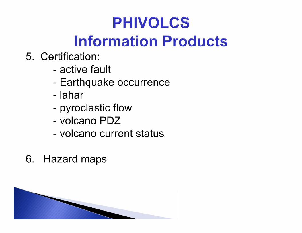
5. Certification:- active fault- Earthquake occurrence- lahar- pyroclastic flow- volcano PDZ- volcano current status
6. Hazard maps

7. Educational Package8. Information Package9. Library Services10. Resource person11. Replies to technical inquiries and requests forassistance

1. Volcano Information: Bulletin, Update, AdvisoryVolcano Bulletin – written report issued when there are unusual
volcanic activities that may lead to an eruption- ash explosion- remarkable seismic activity- ground deformation
also issued when raising or lowering a volcanoalert status
describing an on-going eruption- concise interpretation of the volcanoobservations, which is the basis for publicwarning issued

Volcano Advisory – written report issued when the volcano exhibits an
increasing volcanic activity, or any other suddenchanges in activity, but that the observations arenot sufficient to warrant upgrading of the volcano’salert status.
If volcanic activity continues to increase,the advisory may be upgraded to a bulletin.
An advisory is also issued during typhoons orperiod of continuous heavy rainfall capable ofgenerating lahars. It advises people to avoid areasprone to lahar inundation.
1. Volcano Information: Bulletin, Update, Advisory

ALERT CRITERIA INTERPRETATION/
0(NORMAL)
All monitored parameters are withinbackground/ baseline levels. No eruption is foreseen.
1(ABNORMAL)
Slight increase in volcanic earthquakes,steam/gas activity, slight inflation.
The source of activity is shallow or near crater. Entryinto PDZ is forbidden.
2Elevated Level ofVolcanic Unrest
Elevated levels of any of the following: volcanicearthquakes, steam/gas activity, grounddeformation, other parameters..
Probable ascent and intrusion of magma which maylead to eruption within weeks or months. Entry into PDZis forbidden.
3High Level of
Volcanic Unrest
Relatively high and increasing unrest due tofurther intensified in volcanic earthquake, gas,ground deformation parameters
Magmatic processes underway and may lead toeruption within days to weeks. Evacuation of hazardzones.
4HazardousEruptionImminent
Intense unrest characterized by earthquakeswarms and tremors, many perceptible, highgas output, intense ground deformation.Activity may involve lava extrusion and domegrowth.
Low-level eruption in progress and may lead tohazardous highly explosive eruption. Hazard zones maybe extended for a few kilometers or more.
5Life-Threatening
ERUPTION
Highly explosive eruption in progress withbillowing tall ash-laden eruption columns, inexcess of tens of kilometers, widespreaddispersal of volcanic hazards..
Hazardous eruption in progress. Flowing or fallingmaterials encroach into settlements. Additional dangerareas may be recommended as eruption progresses.
Volcano Alert Level Scheme

Date and time
Location of volcano Number of volcanic
earthquakes Steaming activity Crater glow Volcanic gas
measurements Ground deformation
surveys
Alert level Interpretation Recommendations

Earthquake Information – written report of significant - usually perceptible or felt
earthquake events
This contains information about the earthquakeoccurrence
This is immediately relayed to concerned authoritiesand local government units, disaster agencies andthe media
2. Earthquake Information: Bulletin

PHIVOLCSEarthquakeInformation/Bulletin
Earthquake parameters: Origin date/time Location Depth Possible source Magnitude Reported Intensities

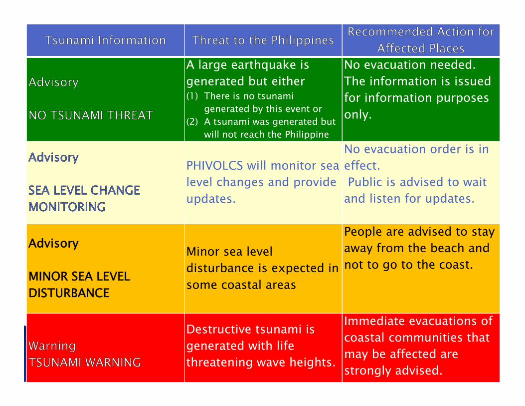
3. Tsunami Information- Advisory- Warning
Philippine Tsunami InformationAdvisory : NO TSUNAMI THREAT
Advisory: SEA LEVEL CHANGE MONITORING
Advisory: MINOR SEA LEVEL DISTURBANCE
TSUNAMI WARNING
13
Tsunami Information Threat to the Philippines Recommended Action forAffected Places
Advisory
NO TSUNAMI THREAT
A large earthquake isgenerated but either(1) There is no tsunami
generated by this event or(2) A tsunami was generated but
will not reach the Philippine
No evacuation needed.The information is issuedfor information purposesonly.
Advisory
SEA LEVEL CHANGEMONITORING
PHIVOLCS will monitor sealevel changes and provideupdates.
No evacuation order is ineffect.Public is advised to wait
and listen for updates.
Advisory
MINOR SEA LEVELDISTURBANCE
Minor sea leveldisturbance is expected insome coastal areas
People are advised to stayaway from the beach andnot to go to the coast.
WarningTSUNAMI WARNING
Destructive tsunami isgenerated with lifethreatening wave heights.
Immediate evacuations ofcoastal communities thatmay be affected arestrongly advised.

Information number Date and time
Type of TsunamiInformation
Earthquakeinformation
Interpretation andrecommendations

Information number Date and time Type of Tsunami
Information Earthquake
information
Interpretation andrecommendations
Areas covered bywarning
TSUNAMI WARNING
This can trigger a tsunami of at least 1 meter.

4.1 Earthquake Data Waveform Data Earthquake Catalogue
list or tabulation of earthquake data
4. Catalogue


4.2 Volcano Information description of the volcano
- physical features- location and accessibility- classification- geological features- studies or field investigations undertaken atthe volcano- monitoring methods and techniques- historical eruptions (usually extracted from
the volcano catalogue).
4. Catalogue

PHIVOLCS Certification states whether a volcano orearthquake hazard is present or absent inan area.
It is required by certain government agencies as asupporting document in relation to a customer’sapplication for loan, permit for land development andother government transaction.
PHIVOLCS Certification by itself is NOT an approval,endorsement or authorization for further governmentprocedure.
5. Certification

5.1 active faults5.2 lahar5.3 pyroclastic flow5.4 lava flow5.5 volcano Permanent Danger Zone
5.6 Earthquake occurrence
5.7 volcano current status
5. Certification

Ground Shaking Hazard Map - probability of occurrenceof ground shaking over a given time period of seismichazard and related uncertainties
Seismicity Map - shows the plots of epicenters ofearthquakes, indicating magnitude anddepth, that occurred in a particular area and period
6. Hazard MapsPHIVOLCS produces maps showing areas prone toearthquake or volcanic hazards. These are madeavailable to users either as printed output or digital data.
Earthquake

Seismicity Maps

other earthquake hazards Active Faults and Trenches Map – show the distribution of
earthquake generators in the Philippines
Earthquake-induced Landslide Hazard Map – indicativeregional map showing areas at high-, moderate-, or low-risk to slope failure
Liquefaction Hazard Map - indicative regional mapshowing areas prone to ground failure
Tsunami Hazard Map – show the computed worst-casetsunami wave height and inundation coming from thelargest credible earthquake from an off-shore earthquakegenerator
6. Hazard Maps


VolcanoLahar Hazard Map – shows the areas prone to rain-induced flow of volcanic deposits on slopes of activevolcanoes;
6. Hazard Maps
available for selectedactive and potentiallyactive volcanoes ofthe Philippines –Pinatubo, Mayon,Bulusan, Hibok-hibok, Kanlaon, Iriga,Parker, Cabalian,Banahaw.

Volcano Lava Flow Hazard Map – shows the areas prone to
stream-like flows of hot incandescent molten materialsfrom an erupting volcano; available for selected activevolcanoes of the Philippines.
Pyroclastic Flow Hazard Map - shows the areas proneto turbulent flows of hot gases, ash and rocks from anerupting volcano; available for selected active volcanoesof the Philippines.
6. Hazard Maps

Group tours (e.g schools, GOs, NGOs), a venue forlecture, film showing, and guided exhibit viewing.
Smaller groups of students (15 or less) are also allowed toview the Data Receiving Center (DRC). Technicalpersonnel are tapped to give them lectures.
Film showing may be any of the following: volcanoes andvolcanic hazards, earthquake or tsunami. Technicalpersonnel are available to answer questions after videoviewing or during exhibit viewing.
7. Educational Package

Information packages are in the form of flyers,pamphlets, leaflets, posters, comics, brochures, andscientific papers or proceedings which are available ineither printed or digital format.
These materials contain general information onPhilippine volcanoes, volcanic activities, volcanichazards, earthquakes, tsunami and related geotectonicprocesses, their threats and how the effects from thesehazards can be reduced or avoided.
8. Information Package

Duplication of Audio-Visual materials and Digital Images
sets of slide and digital photograph collectionvolcanic eruption events and impactspanoramic view of the Philippines’ six most active
volcanoesimpacts of earthquake events.
8. Information Package

VIDEOEARTHQUAKE:• The Killer Quake: 1990 Luzon Earthquake• Sta. Elena High School Earthquake Drill• Tsunami (DOST-GIA Project)• Tsunami Eyewitness Accounts: 1976 Moro Gulf and 1994
Mindoro Earthquake• 15 November 1994 Mindoro Earthquake
VOLCANO:• Ang Pagputok ng Bulkang Mayon, 1993• Pinatubo Lahars• Volcanic Hazards

Specific materials for EARTHQUAKE


SCHOOL-BASEDPREPAREDNESS

Specific materials for TSUNAMI

Local Language VersionsIlocano, Bicolano, Maguindanaoan,Cebuano, Ilonggo (2006-2007)

Comics/Manga
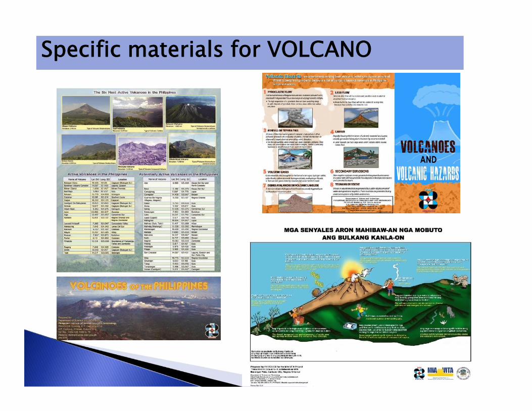
Specific materials for VOLCANO

GOOD PRACTICES ..BRGY. PULA andBRGY. BIAKNABATO, CANLAONVOLCANOType: BrochurePurpose: Guide in planning resilient communityin volcanic hazards prone areasTarget users: LGU(Planner, DRRM Council,Managers), Brgy. Officials, Media, NGO,Consultants, Professionals, Teachers, andStudentsLanguage: English

Type: FlyerPurpose:Information aboutthe projectTarget users:LGUs covered bythe project, Media,and projectpartnersLanguage: English
Project Profile

Exhibit on-loanExhibit –
- collection of framed posters or mounteddiagrams for public viewing.- These are displayed at the PHIVOLCSMain and field stations.- mostly composed of 3-dimensionalmodels of ‘The Planet Earth, PlateTectonics, and Relief Map of thePhilippines showing the volcanoes andearthquake generators’ and framed andlaminated posters
PHIVOLCS provides technical assistance in the designof exhibit and may lend framed and laminated mobiledisplays.
8. Information Package

Exhibit at PHIVOLCS General Santos City Seismic Station

PHIVOLCS library has a collection of books, journals,news clippings related to volcanoes, volcanic activity,volcanic hazards, earthquakes and earthquake hazardsand tsunamis.
9. Library Services
PHIVOLCS S & T LibraryGround Floor, PHIVOLCS Building

PHIVOLCS provides resource person(s) either as lecturer,facilitator, observer to requesting organizations.
Standard lecture packages are basic information onvolcano and volcano hazards, earthquake and earthquakehazards, and tsunami and tsunami hazards.
10. Resource Person
Vigan City Pagadian City

Rapid Earthquake DamageAssessment System
- tools for computing hazards(ground shaking, liquefaction,landslides, tsunami); preparingscenarios
- static maps of various hazards canbe integrated
- Contains database of elements atrisk which can be updated by localgovernment
Mainstreaming DRR into the localdevelopment planning process throughthe provision and training on the use of
•being shared with localgovernments

PHIVOLCS will answer queries and requests forassistance regarding earthquake, volcanoesand other matters that fall within its mandates andexpertise.
11. Replies to technical inquiries and assistance forother specific needs

www.phivolcs.dost.gov.ph

@phivolcs_dost

/PHIVOLCS

Cut-off in posting tweets and facebook:Magnitude – 4.0 up (Inland), 5.0 (offshore)Intensity – based on the report
Facebook Contents:• Disclaimer of PHIVOLCS• Awareness and preparedness materials• Bulletins of earthquake, tsunami and volcano (feed
from twitter)• Comments or queries to be answered by senior
PHIVOLCS staff (more knowledgeable andexperienced in terms of PHIVOLCS activities) ---optional
• News item --- at least one paragraphex. Update on REDAS schedule and otherPHIVOLCS activity.

EarthquakeEQ Bull#_Date_Time_Magnitude_Depth_Location_Epicenter
Sample: EQ Bull#1 31Aug2012 8:47PM M7.6 Depth10KmOffshore 112Km SE Guiuan (Eastern Samar) Int VIIBorongan (link)
Tsunami
TSUNAMI Bull#_Date_Time_INFORMATION_ACTION_AREA
Sample: TSUNAMI Bull#1 31Aug2012 9:01PM TSUNAMIWARNING IMMEDIATE EVACUATION for Pacific Coast ofNSamar/ESamar/Leyte/SLeyte/SurigaoNorte & Sur

Earthquake & Tsunami(24/7):
Tel. Numbers +632 929-9254 +632 426-1468 loc 124 /
125Fax number +632 927-1087
Volcano (24/7):Tel. Numbers +632 426-1468 loc 127Telefax number +632 927-1095
IEC materials: +632 426-1468 loc 128 +632 927-4524
http://www.phivolcs.dost.gov.ph
@phivolcs_dost
/PHIVOLCS
Contact Us: