Embed Size (px)
Citation preview
27
A preliminary vertebrate palaeontological cave survey of the Comoros Islands.
*JULIAN HUME1 AND GREG MIDDLETON21Bird Group, Department of Zoology, The Natural History Museum
Akeman St, Tring, Herts HP23 6AP, U.K.2Sydney Speleological Society
PO Box 269, Sandy Bay, Tas. 7006 AUSTRALIA
Abtract.— The results of a reconnaissance palaeontological cave survey are described, with an island by island review of potential fossil localities within the Comoros Archipelago. Lava cave localities were examined and details recorded. The first lava caves on Anjouan were recorded, including new native bat roosts. In general the cave localities were too eroded, lacked any substantial sediment deposits or were geochemically unsuitable for the long-term preservation of fossil material; hence the lack of success in finding a single preserved fossil or subfossil bone.
Keywords — Anjouan, Moheli, Grande Comore, Mayotte, cave, fossil, bat, terrestrial snail
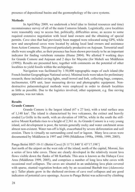
Introduction The Comoros Archipelago (Fig.1) comprises four main volcanic islands situated between Mozambique and Madagascar at the north end of the Mozambique Channel. Estimated ages for the islands, based on the Somali Plate Motion and Mount Karthala active volcano, are 7.7-10 MYA for Mayotte, 5.0 MYA for Mohéli, 3.9 MYA for Anjouan, and 0.5 MYA for Grande Comore (Emerick & Duncan 1982; Harris & Rocha 2009). Running from east to west, the most easterly and oldest is Mayotte (local name, Maore), followed by the smallest Mohéli (Mwali), then Anjouan (Ndzuani), while the largest, youngest and most westerly island is Grande Comore (Ngazidja). The islands are entirely volcanic in origin, and have never been connected to any continental landmass or to each other. Grande Comore has an active volcano, Mt Kathala, which is considered to have one of the largest craters in the world (Pavlovsky & Saint-Ours 1953). Surrounding coral reefs only occur on Mayotte, but are not extensive and virtually no lagoonal systems exist. The islands have a complex social history. The initial colonisation was first by Africans, then Austronesians (proto Malagasy) settlers in the 6th century, followed by Arabians c. 8-10th centuries until the 15th century (Newitt 1983; Allibert 1984; Dick-Read 2006), and since then a mixture of African, Arabic and French. Despite the Portuguese having been aware of the islands since 1505 (Toussaint 1966), little early literature has survived. The first faunal accounts did not appear until the late 16th century (Alibert 1984; Liskowski 2000; Cheke 2010), by which time the islands’ resources had already been heavily exploited. The islands of the Comoros Archipelago lack an existing fossil record and appeared to be ideal candidates for a palaeontological survey; thus the main aim of this reconnaissance was to determine whether fossil material was preserved. Cave surveys were considered the best option to achieve this aim, as marsh and sand dune sites are virtually absent. Each island was surveyed dependant on age, the steepness of the terrain,
Phelsuma 19 (2011); 26-40
28
presence of depositional basins and the geomorphology of the cave systems.
Methods In April/May 2009, we undertook a brief (due to limited resources and time) reconnaissance survey of all of the main Comoros Islands. Logistically, cave localities were reasonably easy to access but, politically, difficulties arose, as access to some required extensive negotiation with local land owners and the obtaining of special permits. Cave sites that had previously been mapped were relocated using GPS, while new and unexplored caves were located by asking local land owners and assistance from Action Comores. This proved particularly productive on Anjouan. Terrestrial snail shells were sought after, as their presence has been shown previously to be an important indicator for finding vertebrate remains (Hume 2004). We allotted 9 working days for Grande Comore and Anjouan and 2 days for Mayotte (for Moheli see Middleton (1999)). Results are presented here, together with comments on the potential of other localities to yield fossils within the archipelago. Navigation was facilitated by 1:50,000 topographic maps of each island (the French Institut Geographique National series). Minimal tools were taken for preliminary research; these included caving lights, small trowel and fork, collecting bags, compass, inclinometer, GPS unit, laser measuring device and photographic equipment. Non-destructive palaeontological methods were employed in order to disturb localities as little as possible. Due to the logistics involved, other equipment, e.g. fine sieving apparatus, was not taken.
ResultsGrande Comore Grande Comore is the largest island (67 x 27 km), with a total surface area of 1,148 km2. The island is characterised by two volcanoes, the extinct and heavily eroded La Grille in the north, with an elevation of 1087m, while in the south the still-active Mount Karthala rises to a height of 2,361 m. As Grande Comore is a very young island, soil development is poor, the terrain generally rocky and water catchment areas almost non-existent. Water run-off is high, exacerbated by severe deforestation and soil erosion. There is virtually no surrounding coral reef or lagoon. Many lava caves were documented by Middleton in 1997 and 1998 (Middleton 1998a, 1998b, 1999, 2005).
Panga Betini HH7-10-11 (Betini Cave) [S 11°31.840’ E 43°17.198’]Just north of the airport on the west side of the island, north of the capital, Moroni, lies a series of lava tube caves. These are clearly developed in the relatively recent lava flows visible down the flanks of Mt Karthala. This area is known as the Hahaya Cave Area (Middleton 1999, 2005), and comprises a number of long lava tube caves with occasional roof collapses. The caves are situated in an undulating lava plain covered with sparse, stunted vegetation broken only by an occasional Baobab tree (Adansonia sp.). Taller plants grow in the sheltered environs of cave roof collapses and are good indicators of potential cave openings. Access to Panga Betini was achieved by climbing
29Figure 1. Map of the Comoros Archipelago.
30
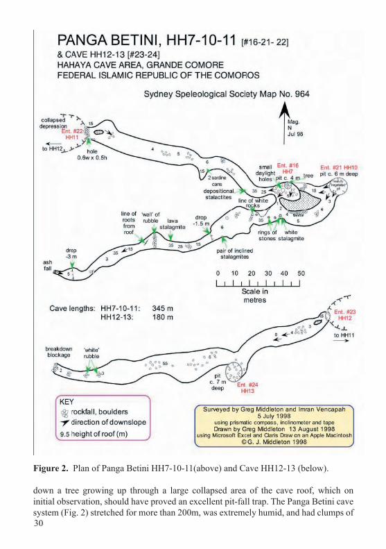
Figure 2. Plan of Panga Betini HH7-10-11(above) and Cave HH12-13 (below).
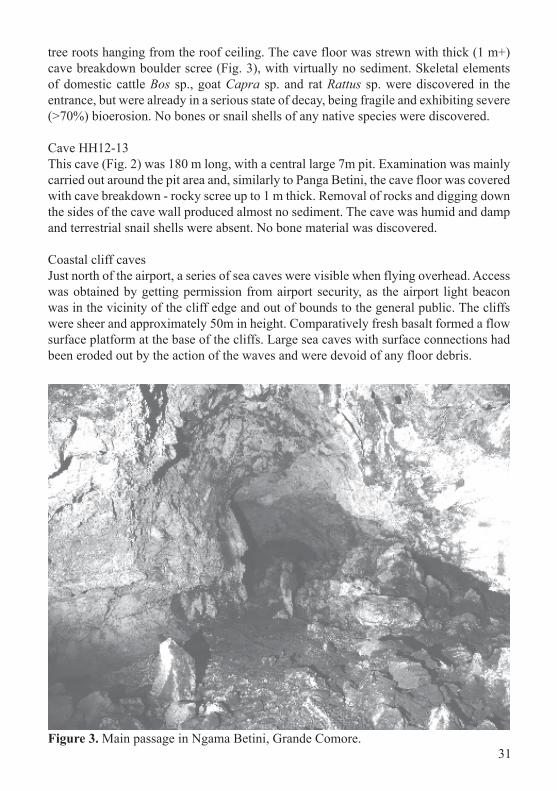
down a tree growing up through a large collapsed area of the cave roof, which on initial observation, should have proved an excellent pit-fall trap. The Panga Betini cave system (Fig. 2) stretched for more than 200m, was extremely humid, and had clumps of
31
tree roots hanging from the roof ceiling. The cave floor was strewn with thick (1 m+) cave breakdown boulder scree (Fig. 3), with virtually no sediment. Skeletal elements of domestic cattle Bos sp., goat Capra sp. and rat Rattus sp. were discovered in the entrance, but were already in a serious state of decay, being fragile and exhibiting severe (>70%) bioerosion. No bones or snail shells of any native species were discovered.
Cave HH12-13This cave (Fig. 2) was 180 m long, with a central large 7m pit. Examination was mainly carried out around the pit area and, similarly to Panga Betini, the cave floor was covered with cave breakdown - rocky scree up to 1 m thick. Removal of rocks and digging down the sides of the cave wall produced almost no sediment. The cave was humid and damp and terrestrial snail shells were absent. No bone material was discovered.
Coastal cliff cavesJust north of the airport, a series of sea caves were visible when flying overhead. Access was obtained by getting permission from airport security, as the airport light beacon was in the vicinity of the cliff edge and out of bounds to the general public. The cliffs were sheer and approximately 50m in height. Comparatively fresh basalt formed a flow surface platform at the base of the cliffs. Large sea caves with surface connections had been eroded out by the action of the waves and were devoid of any floor debris.
Figure 3. Main passage in Ngama Betini, Grande Comore.
32
Figure 4. Map of Anjouan, detailing major roads and localities mentioned in the text.
Fossil potential of Grande Comore caves: Low to Moderate. Grande Comore caves proved unproductive. This is almost certainly due to the young age of the island and the lack of sediment in the cave systems. Due to the size of Grande Comore and the large numbers of lava flows, many more cave systems must exist, but they are likely to be taphonomically similar to those investigated. The absence of preserved snail shells indicates also that long-term preservation of fossil material is unlikely. Marshes are almost non-existent, but an area stated as being a potentially interesting marsh locality in the south of Grande Comore, but without road access, should be investigated by a future team with more time available.
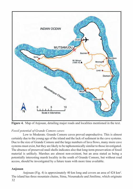
Anjouan Anjouan (Fig. 4) is approximately 40 km long and covers an area of 424 km². The island has three mountain chains, Sima, Nioumakele and Jimilime, which originate
33
from the central peak, Mtingui, at 1,595 meters. This gives Anjouan its distinctive triangular shape. The island is steep and dissected by numerous river systems that produce waterfalls in the wet season. Being one of the older islands, soil cover is deep, but severe deforestation and over-cultivation has caused serious erosion. A coral reef is situated close to the shore, but is in serious decline due to soil run-off.
Chaoueni Sea Cave *[S 12° 21.683’ E 44° 29.678’]This cave is situated on the coast below the village of Chaoueni, and from a distance looked like a classic sea cave. Unfortunately, we were prevented by a local official from actually accessing it, so the true nature of this site remains unknown.*These coordinates are for the nearest point to the cave that we could reach.
Moya Sea Cave [S 12° 18.564’ E 44° 26.094’]The coastal village of Moya has a rubbish-strewn pebble beach below a run-down hotel. To access the cave required walking from the sandy public beach across a lava rock-platform. It is a sea cave about 20 m wide, but shallow (~6 m) with no sediment and devoid of any faunal remains.
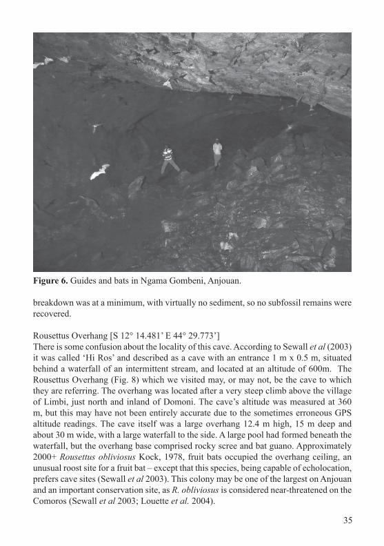
Ngama Gombeni [S 12° 10.827’ E 44° 26.801’] Behind the village of Bazimini is the large lava tube cave called Ngama Gombeni (Fig. 5), which proved to be the first true lava cave we were able to discover on Anjouan (We used the term ‘ngama’ or ‘pit’ because, we believe, this applies to a cave that goes down, rather than in horizontally). The entrance is approximately 3 m x 4 m and is situated on the side of a steep gorge. The cave floor is 2 m below the entrance, blocked by sediment in the direction of the gorge, but with a sharp descent for approximately 60 m in the opposite direction. The passage below the entrance was strewn with ceremonial objects including pottery. The descent to the bottom of the cave was difficult due to large amounts of bat guano, exacerbated by a wet surface from the constant dripping of water from the cave ceiling (Fig. 6). The microchiropteran bats were clearly visible and at least 3 species were present, Taphozous mauritianus Geoffroy, 1818, Myotis anjouanensis Dorst, 1960, and a third unidentified species. At its lowest point the lava tube appears to be sealed and the floor is completely covered in a large, slimy pool of guano. Humidity was high, so the chances of finding any fossil remains appeared bleak. Some test pits were dug, but the sediment comprised saturated silts and clays, high in organic material and crawling with cave crickets Ceuthophilus sp? and unidentified cockroaches. Unsurprisingly, no fossil remains were discovered.
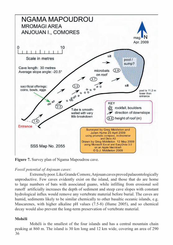
Ngama Mapoudrou [S 12° 12.377’ E 44° 30.049’] Heading inland from Bambao, is Mromaji or Mromagi village. Upslope from the village, after a long uphill hike, is Ngama Mapoudrou (Fig. 7), a classic lava tube cave with a terminal clear pool or sump at the base situated approximately 30 m inside. The tube slopes steeply down and has comparatively smooth walls; the floor is partly covered with guano, and it hosts the usual entourage of crickets and cockroaches. Unlike Ngama Gombeni, Taphozous mauritianus dominates the microchiropteran fauna. Cave
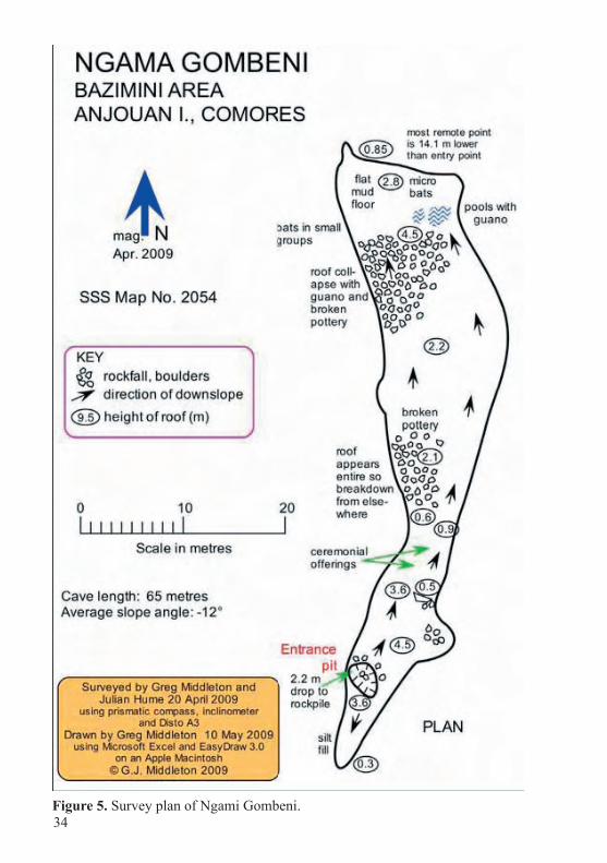
34Figure 5. Survey plan of Ngami Gombeni.
35
Figure 6. Guides and bats in Ngama Gombeni, Anjouan.
breakdown was at a minimum, with virtually no sediment, so no subfossil remains were recovered.
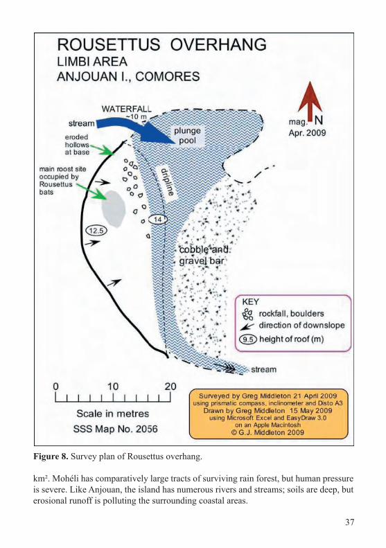
Rousettus Overhang [S 12° 14.481’ E 44° 29.773’]There is some confusion about the locality of this cave. According to Sewall et al (2003) it was called ‘Hi Ros’ and described as a cave with an entrance 1 m x 0.5 m, situated behind a waterfall of an intermittent stream, and located at an altitude of 600m. The Rousettus Overhang (Fig. 8) which we visited may, or may not, be the cave to which they are referring. The overhang was located after a very steep climb above the village of Limbi, just north and inland of Domoni. The cave’s altitude was measured at 360 m, but this may have not been entirely accurate due to the sometimes erroneous GPS altitude readings. The cave itself was a large overhang 12.4 m high, 15 m deep and about 30 m wide, with a large waterfall to the side. A large pool had formed beneath the waterfall, but the overhang base comprised rocky scree and bat guano. Approximately 2000+ Rousettus obliviosus Kock, 1978, fruit bats occupied the overhang ceiling, an unusual roost site for a fruit bat – except that this species, being capable of echolocation, prefers cave sites (Sewall et al 2003). This colony may be one of the largest on Anjouan and an important conservation site, as R. obliviosus is considered near-threatened on the Comoros (Sewall et al 2003; Louette et al. 2004).
36
Figure 7. Survey plan of Ngama Mapoudrou cave.
Fossil potential of Anjouan caves: Extremely poor. Like Grande Comore, Anjouan caves proved palaeontologically unproductive. Few caves evidently exist on the island, and those that do are home to large numbers of bats with associated guano, while infilling from erosional soil runoff artificially increases the depth of sediment and steep cave slopes with constant hydrological influx would remove any vertebrate material before burial. The caves are humid, sediments likely to be similar chemically to other basaltic oceanic islands, e.g. Mascarenes, with higher alkaline pH values (7.5-8) (Hume 2005), and so chemical decay would also prevent the long-term preservation of vertebrate material.
Mohéli Mohéli is the smallest of the four islands and has a central mountain chain peaking at 860 m. The island is 30 km long and 12 km wide, covering an area of 290
37
Figure 8. Survey plan of Rousettus overhang.
km². Mohéli has comparatively large tracts of surviving rain forest, but human pressure is severe. Like Anjouan, the island has numerous rivers and streams; soils are deep, but erosional runoff is polluting the surrounding coastal areas.
38
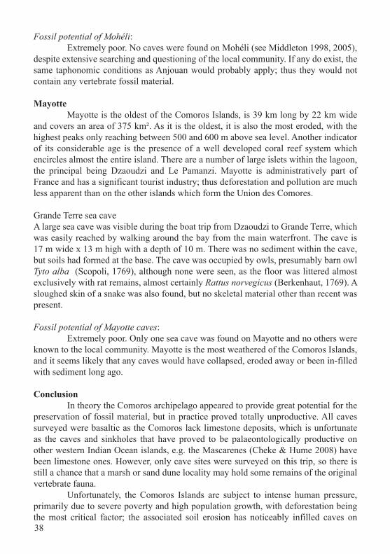
Fossil potential of Mohéli: Extremely poor. No caves were found on Mohéli (see Middleton 1998, 2005), despite extensive searching and questioning of the local community. If any do exist, the same taphonomic conditions as Anjouan would probably apply; thus they would not contain any vertebrate fossil material.
Mayotte Mayotte is the oldest of the Comoros Islands, is 39 km long by 22 km wide and covers an area of 375 km². As it is the oldest, it is also the most eroded, with the highest peaks only reaching between 500 and 600 m above sea level. Another indicator of its considerable age is the presence of a well developed coral reef system which encircles almost the entire island. There are a number of large islets within the lagoon, the principal being Dzaoudzi and Le Pamanzi. Mayotte is administratively part of France and has a significant tourist industry; thus deforestation and pollution are much less apparent than on the other islands which form the Union des Comores.
Grande Terre sea caveA large sea cave was visible during the boat trip from Dzaoudzi to Grande Terre, which was easily reached by walking around the bay from the main waterfront. The cave is 17 m wide x 13 m high with a depth of 10 m. There was no sediment within the cave, but soils had formed at the base. The cave was occupied by owls, presumably barn owl Tyto alba (Scopoli, 1769), although none were seen, as the floor was littered almost exclusively with rat remains, almost certainly Rattus norvegicus (Berkenhaut, 1769). A sloughed skin of a snake was also found, but no skeletal material other than recent was present. Fossil potential of Mayotte caves: Extremely poor. Only one sea cave was found on Mayotte and no others were known to the local community. Mayotte is the most weathered of the Comoros Islands, and it seems likely that any caves would have collapsed, eroded away or been in-filled with sediment long ago.
Conclusion In theory the Comoros archipelago appeared to provide great potential for the preservation of fossil material, but in practice proved totally unproductive. All caves surveyed were basaltic as the Comoros lack limestone deposits, which is unfortunate as the caves and sinkholes that have proved to be palaeontologically productive on other western Indian Ocean islands, e.g. the Mascarenes (Cheke & Hume 2008) have been limestone ones. However, only cave sites were surveyed on this trip, so there is still a chance that a marsh or sand dune locality may hold some remains of the original vertebrate fauna. Unfortunately, the Comoros Islands are subject to intense human pressure, primarily due to severe poverty and high population growth, with deforestation being the most critical factor; the associated soil erosion has noticeably infilled caves on
39
Anjouan. It is hoped that further longer term investigation can take place, but the present politically unstable nature of the islands lowers the likelihood of this in the foreseeable future.
Acknowledgements We thank Action Comores and, in particular, Hugh Doulton for assistance in the field on Anjouan. JPH is deeply indebted to the Trustees of the Special Funds, Natural History Museum, London, for making his travel to the Comoros possible, and for their patience while he was overcoming the delays and uncertainties of safe travel to the islands.
ReferencesALLIBERT, C. 1984. Mayotte: plaque tournant et microcosme de l’Océan Indien
occidental. Son histoire avant 1841. Paris: Editions Anthropos, 352pp.CHEKE, A.[S.]. 2010. The timing of arrival of humans and their commensal animals on
Western Indian Ocean oceanic islands. Phelsuma 18: 38-69.CHEKE, A.[S.] & HUME J.[P.] 2008. Lost land of the Dodo: an ecological history
of Mauritius, Réunion and Rodrigues. London: A&C Black & New Haven, Connecticut: Yale University Press. 464pp.
DICK-READ, R. 2006. Indonesia and Africa: questioning the origins of some of Africa’s most famous icons. J. Transdisciplinary Res. S. Africa 2: 23-45.
EMERICK, C.M., & DUNCAN, R.A. 1982. Age progressive volcanism in the Comoro Archipelago, western Indian Ocean and implications for Somali Plate Tectonics. Earth Planet. Sci. Lett. 60, 415 – 428.
HARRIS, D.J., & ROCHA, S. 2009. Comoros. In: R.G. GILLESPIE., & CLAGUE, D.A(Eds.) Encyclopedia of Islands. Berkeley and Los Angeles, California: University of California Press, pp. 177 – 180.
HUME, J.P. 2004. A preliminary vertebrate palaeontological survey of the granitic Seychelles islands. Phelsuma 12: 24-34.
HUME, J.P. 2005. Contrasting taphofacies in ocean island settings: the fossil record of Mascarene vertebrates. Monografies de la Societat d’Història Natural de les Balears 12: 129-144.
LISZKOWSKI, D. 2000. Documents anciens sur Mayotte (relations de voyages et cartes). Bull. Nat. Hist. Geog. Mayotte 3: 208.
LOUETTE, M., MEIRTE, D. & JOCQUÉ, R. (eds.) 2004. La faune terrestre de l’Archipel des Comores. Studies in Afrotropical Zoolgy 293. Tervuren, Belgium: Musée Royale de l’Afrique Centrale, 456pp.
MIDDLETON, G. (1998a). Speleological survey of the lava caves of Grande Comore September 1997. J. Syd. Speleol. Soc., 42: 201-213.
MIDDLETON, G. (1998b). Lava caves of Grande Comore, Indian Ocean: An initial reconnaissance, September 1997. Int. J. Speleol., 27B(1/4): 77-86.
MIDDLETON, G. (1999). Further investigations of the lava caves of the Comoros Islands – July 1998. J. Syd. Speleol. Soc., 43: 285-309.
MIDDLETON, G. (2005). Lava caves of Grande Comore, Indian Ocean: Further
40
investigations, July 1998. Proc. 9th Int. Symposium on Vulcanospeleology, Catania 1999. pp. EN92-107. Centro Speleologico Etneo, Catania, Italy.
NEWITT, M. 1983. The Comoro Islands in Indian Ocean Trade before the 19th Century. Cahiers d’Études Africaines, 23 (89/90): 139-165.
PAVLOVSKY, R., & SAINT-OURS, J DE. 1953. Etude Géologique de l’Archipelago des Comores. Service Géologique, Tananarive, Madagascar, 55pp.
SEWALL, B.J., GRANEK, E.F. & TREWHELLA, W.J. 2003. The endemic Comoros Islands fruit bat Rousettus obliviosus: ecology, conservation and Red List status. Oryx 37(3): 344-352.
TOUSSAINT, A. 1966. History of the Indian Ocean. London: University of Chicago Press, 292 p.