Embed Size (px)
Citation preview
Phase I Cultural Resources Survey for the 10” Lincoln-Traverse City Loop
Pipeline, Grand Traverse Counties, Michigan
DTE Gas Company
Project No. 115495
8/12/2019
Case No.: U-20640 Exhibit: A-1, Appendix C Witness: C. M. Paquette
Page: 1 of 54

Phase I Cultural Resources Survey for the 10” Lincoln-Traverse City Loop Pipeline, Grand Traverse
Counties, Michigan
prepared for
DTE Gas Company
Project No. 115495
August 2019
Author Mark A. Latham
Burns & McDonnell Michigan, Inc. Kansas City, Missouri
COPYRIGHT © 2019 BURNS & McDONNELL Michigan, INC.
Case No.: U-20640 Exhibit: A-1, Appendix C Witness: C. M. Paquette
Page: 2 of 54

ABSTRACT
Burns & McDonnell Michigan, Inc. (Burns & McDonnell) was retained by DTE Gas Company (DTE) to
conduct a cultural resources survey for the proposed nine mile, 10-inch diameter natural gas pipeline, the
10” Lincoln-Traverse City Loop Pipeline (Project), in Paradise Township, East Bay Township, Blair
Township, and Garfield Township Grand Traverse County, Michigan. The pipeline will commence near
the DTE Gas’ crossing of the DTE Energy’s Gas Storage & Pipeline’s 24” gathering header and end at
the existing DTE Gas Traverse City Gate Station. This Project also includes an expansion of the existing
DTE Frankfort Junction Station and upgrades to the existing DTE Traverse City Gate Station. This report
describes the results of a Phase I cultural resources survey for the proposed Project.
The survey also included a 19-acre pipe yard. The total area surveyed was 222 acres. Two previously
unrecorded archaeological sites were identified during the investigation; one prehistoric and the other
historic age. Both sites are recommended as not eligible for inclusion in the National Register of Historic
Places (NRHP). All work was conducted to professional standards and guidelines in accordance with the
Michigan State Historic Preservation Office and the Secretary of the Interior’s Standards and Guidelines
for Archaeology and Historic Preservation, (48 FR 44716-44742) and in accordance with the Secretary’s
Standard for Identification (48 FR 44720-44723).
Case No.: U-20640 Exhibit: A-1, Appendix C Witness: C. M. Paquette
Page: 3 of 54

10” Lincoln-Traverse City Loop Pipeline Project Table of Contents
DTE Energy TOC-1 Burns & McDonnell
TABLE OF CONTENTS
ABSTRACT Page No.
1.0 INTRODUCTION ............................................................................................... 1-1
1.1 Description of Project Area ................................................................................. 1-1
1.2 Objectives of the Investigation ............................................................................ 1-1
1.3 Schedule and Personnel ....................................................................................... 1-4
1.4 Report Format ...................................................................................................... 1-4
2.0 ENVIRONMENTAL SETTING ........................................................................... 2-1
2.1 Physiography........................................................................................................ 2-1
2.2 Geology ................................................................................................................ 2-1
2.3 Soils...................................................................................................................... 2-1
2.4 Drainage ............................................................................................................... 2-3
2.5 Flora and Fauna.................................................................................................... 2-3
3.0 CULTURAL HISTORY ...................................................................................... 3-1
3.1 Paleoindian (9,000-8,000 B.C.) ........................................................................... 3-1
3.2 Archaic Period (8,000-500 B.C.) ......................................................................... 3-1
3.3 Woodland Period (500 B.C – A.D. 1650) ............................................................ 3-2
3.4 Protohistoric (A.D. 600-1650) ............................................................................. 3-3
3.5 Historic Period ..................................................................................................... 3-3
4.0 RESEARCH DESIGN AND METHODS ............................................................ 4-5
4.1 Archival Research ................................................................................................ 4-5
4.2 Field Methods ...................................................................................................... 4-6
4.2.1 Intensive Visual Inspection and Shovel Testing ................................... 4-6
4.2.2 Site Mapping ......................................................................................... 4-6
4.3 Laboratory Methods ............................................................................................. 4-6
4.3.1 Prehistoric Artifact Analysis ................................................................. 4-7
4.3.2 Historic Artifact Analysis ..................................................................... 4-7
4.4 Objectives ............................................................................................................ 4-7
5.0 PREVIOUS INVESTIGATIONS AND ARCHAEOGOICAL POTENTIAL OF THE STUDY AREA ........................................................................................... 5-1
5.1 Previously Recorded Archaeological Sites Near the Survey Area ...................... 5-1
5.2 Historic Map Review ........................................................................................... 5-1
5.3 Archaeological Site Potential ............................................................................... 5-2
6.0 RESULTS OF INVESTIGATION ....................................................................... 6-1
6.1 Archaeological Sites ............................................................................................ 6-2
6.1.1 Site 20GT161 ........................................................................................ 6-2
Case No.: U-20640 Exhibit: A-1, Appendix C Witness: C. M. Paquette
Page: 4 of 54
10” Lincoln-Traverse City Loop Pipeline Project Table of Contents
DTE Energy TOC-2 Burns & McDonnell
6.1.2 Site 20GT162 ........................................................................................ 6-5
7.0 CONCLUSIONS AND RECOMMENDATIONS ................................................. 7-9
7.1 Summary Evaluations of Sites ............................................................................. 7-9
7.2 Stipulations .......................................................................................................... 7-9
8.0 REFERENCES CITED ...................................................................................... 8-1
APPENDIX A - PROJECT MAPS
APPENDIX B - PROJECT AREA AND SITE PHOTOGRAPHS
APPENDIX C - SITE MAPS
Case No.: U-20640 Exhibit: A-1, Appendix C Witness: C. M. Paquette
Page: 5 of 54
10” Lincoln-Traverse City Loop Pipeline Project Table of Contents
DTE Energy TOC-3 Burns & McDonnell
LIST OF TABLES
Page No.
Table 2-1: Soil Associations in the Traverse City-Lincoln Survey Area ................................ 2-2
Table 5-1: Previously Recorded Archaeological Sites within One Mile of Survey
Area ........................................................................................................................ 5-1
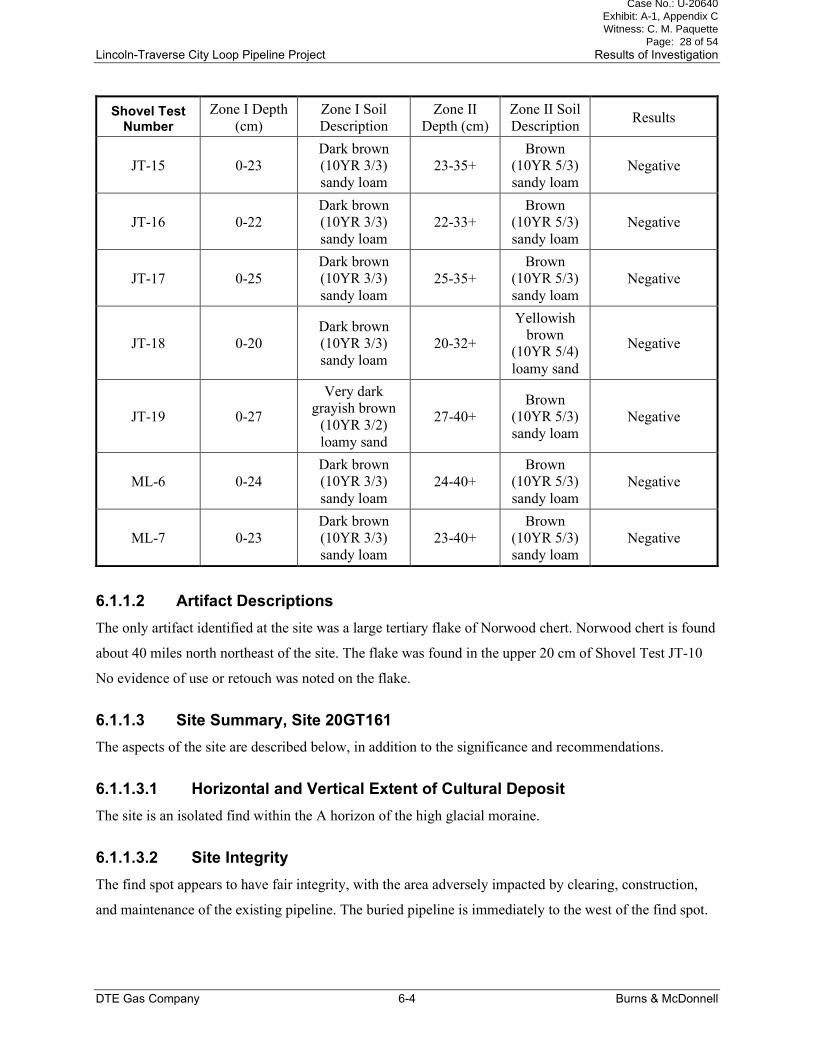
Table 6-1: Shovel Tests Results, Site 20GT161 ...................................................................... 6-3
Table 6-2: Shovel Tests Results, Site 20GT162 ...................................................................... 6-7
Table 7-1: Recommendations for Sites Within the Survey Area ............................................. 7-9
Case No.: U-20640 Exhibit: A-1, Appendix C Witness: C. M. Paquette
Page: 6 of 54

10” Lincoln-Traverse City Loop Pipeline Project Table of Contents
DTE Energy TOC-4 Burns & McDonnell
LIST OF FIGURES
Page No.
Figure 1-1 General Location ...................................................... Error! Bookmark not defined.
Case No.: U-20640 Exhibit: A-1, Appendix C Witness: C. M. Paquette
Page: 7 of 54

Lincoln-Traverse City Loop Pipeline Project List of Abbreviations
DTE Gas Company i Burns & McDonnell
LIST OF ABBREVIATIONS
Abbreviation Term/Phrase/Name
AMSL above mean sea level
Burns & McDonnell Burns & McDonnell Michigan, Inc.
DTE DTE Gas Company
GIS Geographic Information System
GLO General Land Office
GPS Global Positioning System
GSV ground surface visibility
MSHPO Michigan State Historic Preservation Office
NHPA National Historic Preservation Act
NRHP National Register of Historic Places
Project 10” Lincoln-Traverse City Loop Pipeline
Study Area within one mile of the Survey Area
Survey Area Project layout plus a buffer area
TCARP Traverse City-Alpena Reinforcement Project
USGS U.S. Geological Survey
Case No.: U-20640 Exhibit: A-1, Appendix C Witness: C. M. Paquette
Page: 8 of 54

Lincoln-Traverse City Loop Pipeline Project Introduction
DTE Gas Company 1-1 Burns & McDonnell
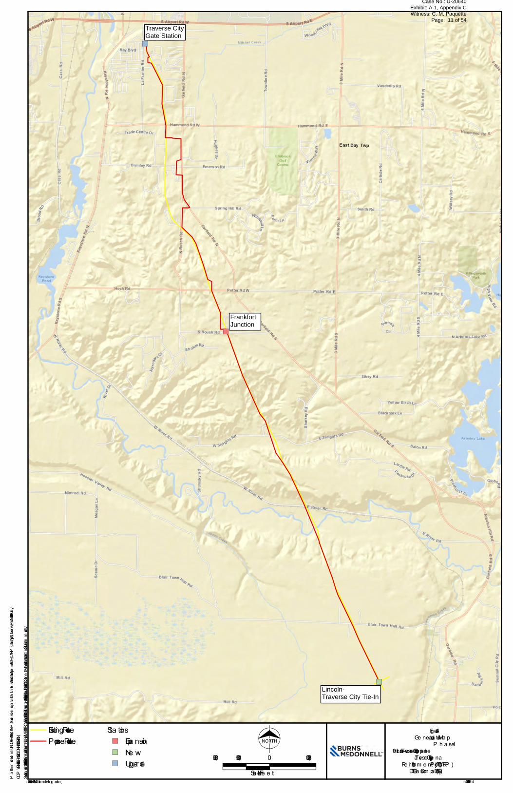
1.0 INTRODUCTION
Burns & McDonnell Michigan, Inc. (Burns & McDonnell) was retained by DTE Gas Company (DTE) to
conduct a cultural resources Phase I survey for the proposed DTE’s Traverse City-Alpena Reinforcement
Project (TCARP) 10” Lincoln-Traverse City Loop Pipeline (Project) in Grand Traverse County, Michigan
(Figure 1-1). The Project involves installing approximately 9 miles of the Lincoln-Traverse pipeline (10-
inch diameter) which will commence near the DTE Gas’ crossing of the DTE Energy’s Gas Storage &
Pipeline’s 24” gathering header and end at the existing DTE Gas Traverse City Gate Station. This Project
also includes an expansion of the existing DTE Frankfort Junction Station and upgrades to the existing
DTE Traverse City Gate Station.
This pipeline will help create a loop to add a second natural gas supply source to the area to minimize
customer disruptions during routine and emergency situations. The Project has the potential to impact
wetlands or other waterbodies that may be under the jurisdiction of the Clean Water Act and therefore this
cultural resources survey was conducted in anticipation of compliance with Section 106 of the National
Historic Preservation Act (NHPA).
1.1 Description of Project Area
The looping pipeline travels from the Lincoln-Traverse City Tie-In in the south, travelling north to the
Frankfort Junction and continuing north to the Traverse City Gate Station (Figures A-1 and A-2). The
cultural resource survey was completed based on the proposed Project layout plus a buffer area to allow
for small Project design modifications (Survey Area). The Survey Area ranged in width but was typically
150-feet wide. In some areas additional potential corridors or reroutes were included and a pipe laydown
yard was also surveyed. The survey totaled approximately 222 acres, of which 15 acres or 7 percent were
wetlands.
The Survey Area has several types of land use, including maintained pipeline and other utility corridors,
wooded areas, pine plantations, wetlands, grasslands, waterways, manicured lawns, livestock pastures,
cherry orchards, agricultural fields, public road rights-of-way, and industrial areas.
1.2 Objectives of the Investigation
The primary objective of the archaeological investigation was to identify cultural resources through a
systematic survey of the proposed construction corridor, laydown yards and other activity areas associated
with the Project (Appendix A). All work was conducted to professional standards and guidelines in
accordance with consultation with the Michigan State Historic Preservation Office (MSHPO), as well as
Case No.: U-20640 Exhibit: A-1, Appendix C Witness: C. M. Paquette
Page: 9 of 54

Lincoln-Traverse City Loop Pipeline Project Introduction
DTE Gas Company 1-2 Burns & McDonnell
the Secretary of the Interior’s Standards and Guidelines for Archaeology and Historic Preservation, (48
FR 44716-44742) and the Secretary’s Standard for Identification (48 FR 44720-44723).
Case No.: U-20640 Exhibit: A-1, Appendix C Witness: C. M. Paquette
Page: 10 of 54
Service Layer Credits: Sources: Esri, HERE, Garmin, USGS, Intermap, INCREMENT P, NRCan, Esri Japan, METI, Esri China (Hong Kong), Esri Korea, Esri (Thailand), NGCC, (c) OpenStreetMap contributors, and the GIS User Community
")
")
")
Traverse CityGate Station
Blair toLincoln-Traverse
Interconnect
FrankfortCheck MeterStation
COPYRIGHT © 2019 BURNS & McDONNELL MICHIGAN, INC.
Source : Esri, a nd Burns & McDonne ll Mich ig a n, Inc. Issue d: 9/20/2019Path: \\bmcd\dfs\Clients\TND\DTEEnr\115495_TCARP\Studies\Geospatial\DataFiles\ArcDocs\Cultural\AppendixA\DTE_TCARP_Cultural_AppA_Overview_P1.mxd snekolny 9/20/2019
Fig ure 1-1Ge ne ra l Loca tion Map
P h a se I10” Lincoln-Trave rse City Loop P ipe line
Trave rse City-Alpe na Re inforce m e nt P roje ct (TCARP )DTE Ga s Com pa ny (DTE)
Existing RouteP ropose d Route
Sta tions") Expa nsion") Ne w") Upg rade
NORTH
3,000 0 3,0001,500
Sca le in Fe e t
Traverse CityGate Station
FrankfortJunction
Lincoln-Traverse City Tie-In
Case No.: U-20640 Exhibit: A-1, Appendix C Witness: C. M. Paquette
Page: 11 of 54
Lincoln-Traverse City Loop Pipeline Project Introduction
DTE Gas Company 1-4 Burns & McDonnell
1.3 Schedule and Personnel
The archival research for the Project included a review of the site files and survey records maintained by
MSHPO, at the Michigan State Housing Development Authority on April 9, 2019. Mark A. Latham acted
as Principal Investigator for the archaeological investigations, which were conducted May 28 to June 4,
and July 16 to 18 2019. Survey participants included John Topi and Mr. Latham. Mr. Latham also
conducted archival research, artifact analysis, and authored the report. Kyle Boatright and Kim House
produced the report figures and Mr. Boatright also coordinated the Global Information System (GIS) data.
1.4 Report Format
This report is presented in a format following the guidelines set forth by the MSHPO, client request, and
the format used by Burns & McDonnell on similar projects. The second and third chapters include
Environmental Setting and Cultural History sections to set the context for the investigation and assist in
the interpretation and preliminary assessment of the cultural resources identified. Chapter 4.0 is the
Research Design and Methods chapter which presents a summary of the guidelines followed and
approaches used to conduct the investigation. Previous Investigations in the vicinity of the Project are
presented in Chapter 5.0. Chapter 6.0 contains the Results of Investigation including a detailed discussion
of the archaeological resources recorded during the current investigation. is Chapter 7.0, Conclusions and
Recommendations, summarizes the results of the investigation, a review of the significance of the
findings, and recommendations concerning the proposed Project. A References Cited section is also
included in the report as Chapter 8.0. Three appendixes are included in the report. Appendix A includes
topographic maps and aerial images showing the Project layout, areas surveyed, and sites recorded.
Project area and site photographs are found in Appendix B, and site maps in Appendix C.
Case No.: U-20640 Exhibit: A-1, Appendix C Witness: C. M. Paquette
Page: 12 of 54

Lincoln-Traverse City Loop Pipeline Project Environmental Setting
DTE Gas Company 2-1 Burns & McDonnell
2.0 ENVIRONMENTAL SETTING
The Project is within the Northern Lower Peninsula High Hills region and encompasses a variety of
landscapes and environments with diverse resources. This chapter gives a brief overview of the
environmental setting, including discussion of some of the critical resources used by the prehistoric and
historic populations of the area.
2.1 Physiography
The Lincoln-Traverse City Project is divided between two units within the Northern Lower Peninsula
High Hills region. The portion of the Project south of the Boardman River is within the Mancelona-
Thompsonville Outwash Plain, while to the north it is within the Northern Lower Peninsula Tunneled
Uplands. Both physiographic units are characterized by hills and plains that were formed by glacial
deposition and meltwater erosion (Michigan Geological Survey 2019). The Project crosses the Port Huron
Moraine just north of the Boardman River.
2.2 Geology
The underlying bedrock of the Project is shale. The southern portion is Coldwater Shale and the northern
is Ellsworth Shale (Michigan Department of Natural Resources 1999). No bedrock outcroppings were
noted in the Survey Area.
2.3 Soils
Soils occur in recognizable patterns across landscapes. This patterning is greatly influenced by parent
material and landscape position. Soil science commonly defines parent material as the mineral or organic
material in which soil has formed, and it includes the kinds of rock from which the regolith is derived
(Soil Survey Staff 1993; Wysocki et al. 2005). Soils can form in an extensive array of surficial geologic
deposits, including unconsolidated sediments (alluvial, glacial, marine, and eolian), saprolite, and bedrock
(weathered and unweathered) (Wysocki et al. 2005). Most of the soils in the area were formed from
glacial deposits (Table 2-1). The soil types not formed from glacial include muck (Carlisle and Edwards)
and Calcareous silty lacustrine and/or eolian deposits of the Sanilac-Richter loam found in a small area of
the Boardman River floodplain.
Case No.: U-20640 Exhibit: A-1, Appendix C Witness: C. M. Paquette
Page: 13 of 54

Lincoln-Traverse City Loop Pipeline Project Environmental Setting
DTE Gas Company 2-2 Burns & McDonnell
Table 2-1: Soil Associations in the Traverse City-Lincoln Survey Area
Soil Type Slope Setting, Parent Material
Rubicon sand 0 to 6% Sandy glaciofluvial deposits
Kalkaska loamy sand 0 to 25% Sandy glaciofluvial deposits
Carlisle muck 0 to 2% Woody organic material
Tonkey mucky sandy loam 0 to 1% Stratified loam and sand glaciofluvial
deposits
Emmet sandy loam
6 to 45%,
moderately
eroded
Thick layer (24-50 inches) of loamy
material over calcareous loamy till
Guelph-Nester loams
2 to 35%,
moderately
eroded
Loamy glacial till
Nessen-Kaleva sands 0 to 6%
Thick layer (40-55 inches) of sand over
calcareous sand and gravelly glaciofluvial
deposits
Losco-Ogemaw loamy sand 0 to 2% Thick layer (20-40 inches) of glaciofluvial
deposits over loamy till
Richter, Tonkey, and Piconning
loams 0 to 2%
Thick layer (25-40 inches) of sand and
loam over calcareous sandy and silty
glaciofluvial deposits
Leelanau-Kalkaska loamy sand 0 to 45%
Thick layer (20-52 inches) of sand and
loam over calcareous sandy glaciofluvial
deposits
Richter loams 0 to 2%
Outwash. Thick layer (25-40 inches) of
sand and loam over calcareous sandy and
silty glaciofluvial deposits
Mancelona gravelly sandy loam 6 to 12%
Thick layer (18-40 inches) of sand and
gravel over calcareous sandy and gravelly
glaciofluvial deposits
Ubly-Nester complex 12 to 25% Thick layer (30-50 inches) of loam over
calcareous loamy till
Kalkaska sand 0 to 2% Sandy glaciofluvial deposits
Wind eroded land Strongly
sloping (Not described)
Croswell loamy sand 0 to 2%,
Overwash Sandy glaciofluvial deposits
Tawas-Roscommon complex (none given) Thick layer (16-51 inches) of organic
material over sandy glaciofluvial deposits
Kalkaska loamy sand 0 to 25% Sandy glaciofluvial deposits
Roscommon mucky loamy sand (none given) Sandy glaciofluvial deposits
Source: Soil Survey Staff 2015
Case No.: U-20640 Exhibit: A-1, Appendix C Witness: C. M. Paquette
Page: 14 of 54
Lincoln-Traverse City Loop Pipeline Project Environmental Setting
DTE Gas Company 2-3 Burns & McDonnell
Nineteen soil types have been mapped for the Survey Area, ranging from 0 to 45 percent slopes. Over 90
percent of the Survey Area soils are sand. The other soil types are a variety of muck found along
drainages, a gravelly moraine slope, and small areas of sandy loam found near the middle of the Survey
Area.
2.4 Drainage
The Project area is within the Boardman River drainage, crossing it near the southern end the proposed
pipeline corridor. The Boardman River is just over 28 miles long, beginning near Kalkaska and flowing
into the west arm of Grand Traverse Bay. During the logging period of the nineteenth century it was used
by lumber companies to transport logs to sawmills at Traverse City. Prior to the logging activities in the
area, the river was reportedly over 200 feet wide (Rennie 1982). Currently the river channel is only about
50 feet wide.
2.5 Flora and Fauna
The Project area was glaciated until sometime between 12,500 to 11,800 years ago when most of the
region was tundra. By 9,900 years ago, the area was dominated by spruce and pine forest. During the dry
and warm period from 4,500 to 3,500 years ago, the area appears to have been dominated by northern
hardwood forest, which continues to the present (Kapp 1999). The project area is considered to be within
the transitional zone, which is described as having integrated floral and faunal elements of two provinces.
The northern community is the Canadian Biotic Province and the southern one is the Carolinian Biotic
Province. The northern flora includes beech-maple and conifer forests, while the southern flora are
species associated with oak-hickory forests (Douglas et al. 1998).
Case No.: U-20640 Exhibit: A-1, Appendix C Witness: C. M. Paquette
Page: 15 of 54
Lincoln-Traverse City Loop Pipeline Project Cultural History
DTE Gas Company 3-1 Burns & McDonnell
3.0 CULTURAL HISTORY
This chapter presents an overview of the prehistory and history of the general area of the Project.
Archaeologists generally divide the prehistoric cultural sequence of the Great Lakes into two preceramic
periods and two ceramic periods. The historic period follows these periods and the transitional
protohistoric period. The site densities of the various prehistoric periods vary considerably, as do the
climate and lake levels, The highest site density appears to be along the shores of the Great Lakes, and
considering the fluctuations of the shorelines throughout prehistory, the occupied shorelines could
currently be either underwater or some distance inland.
3.1 Paleoindian (9,000-8,000 B.C.)
Based on the current data, most archaeologists identify the Paleoindian period as the earliest stage of
human occupation in the Midwest and Great Lakes. Sites assigned to this period are best known by the
presence of unique projectile point styles, with the fluted varieties being the most recognized. By the end
of the Paleoindian period, the environment had changed dramatically. The withdrawal of the Wisconsin
ice sheet caused a gradual shift in the distribution of floral communities across the landscape. At the
beginning of the Paleoindian period, the climate in northwestern portions of the Michigan lower peninsula
was sub-arctic, with vegetation dominated by grasslands with some small woodlands. By the end of the
period the climate was warmer, and the landscape was dominated by mixed boreal-deciduous forests.
Little evidence of Paleoindian occupation has been recorded in the northwestern portions of the Michigan
lower peninsula (Monaghan and Lovis 2005; Shott and Wright 1999), but possible evidence has been
identified at a site (20GT89) along the shores of Green Lake in Interlochen (Douglas et al. 1998).
3.2 Archaic Period (8,000-500 B.C.)
The Archaic period in the Midwest has been divided into three subdivisions: Early Archaic (8,000 to
6,000 B.C.), Middle Archaic (6,000 to 3,000 B.C.), and Late Archaic (3,000 to 500 B.C.). The Early
Archaic is generally viewed as a continuation of the lifestyle traditions established during the late
Paleoindian period. As the climate continued to shift, a broader range of ecological niches was exploited.
Even though temporally diagnostic artifacts of the Early Archaic are not uncommon in Michigan, very
few such sites have been recorded or investigated. At least one Early Archaic site, the Samels Field site
(20GT90), has been reported in Grand Traverse County (Shott 1999). The Samels Field site was an Agate
Basin base camp near Traverse City (Cleland and Ruggles 1996). Many other sites from the period are
now likely submerged by the waters of the Great Lakes. Lake levels were much lower during the Early
Archaic than during the present, and it is postulated that most of the sites dating to this period were
Case No.: U-20640 Exhibit: A-1, Appendix C Witness: C. M. Paquette
Page: 16 of 54
Lincoln-Traverse City Loop Pipeline Project Cultural History
DTE Gas Company 3-2 Burns & McDonnell
located along ancient lake shores and are now submerged deep below modern lake levels (Monaghan and
Lovis 2005).
The environment continued to shift throughout the Middle Archaic, resulting in continued changes in
vegetation and lake levels. The Middle Archaic is poorly understood in Michigan, as only a few sites have
been excavated and few large systematic surveys of localities have been undertaken. The recorded site
density is low, and much of the current understanding of the period is inferred from more intensely
studied sites and localities in neighboring regions. Even though the number of known sites in Michigan is
low it may not reflect the true site density, as lake levels were much lower at this time and it is postulated
that many Middle Archaic sites were likely along the contemporary shoreline and therefore are currently
underwater or deeply buried and not identifiable by typical survey methods (Lovis 1999; Monaghan and
Lovis 2005). The Middle Archaic is the only period not identified in the Green Lake site assemblage
(Douglas et al. 1998).
By the beginning of the Late Archaic period, the vegetation communities were similar to the composition
of historic period to modern species composition. Late Archaic occupations are marked by further
expansion of the toolkits. Groundstone tools that became common during this period include three-quarter
grooved axes, bannerstones, plummets, hammerstones, pestles, and manos. The increased number of
pestles and manos is thought to reflect the increased exploitation of wild seeds and nuts. During the
terminal Late Archaic period, ceramic technology began to develop (Robertson et al. 1999). Architectural
evidence is rare for the Late Archaic, with only the Rock Hearth site (20BE306) known to contain the
remains of a structure: a small, rectangular house (Clark 1994).
3.3 Woodland Period (500 B.C – A.D. 1650)
In the Midwest, the Woodland period has also been divided into three subdivisions: Early Woodland (500
B.C to A.D. 1), Middle Woodland (A.D. 1-600), and Late Woodland (A.D. 600-1650). The Woodland
period is characterized by a trend toward increased sedentism, production of pottery, intensified
horticultural activity, and other changes in subsistence patterns. Additionally, researchers have
documented evidence of regional exchange networks and the elaboration of ceremonial activities and
mortuary practices (Brashler et al. 1999; Garland and Beld 1999; Griffin 1967; Kingsley et al. 1999;
Stothers and Abel 1993). The origin of these trends can be traced to the Late Archaic, but the elaboration
of cultural elements became the hallmark of the Woodland period. These developmental trends form the
basis for distinguishing the Early, Middle, and Late Woodland substages. Regional variations in the
timing and extent to which these traditions were expressed, however, make this three-part subdivision
difficult to apply in certain areas. The invention of pottery is generally associated with the beginning of
Case No.: U-20640 Exhibit: A-1, Appendix C Witness: C. M. Paquette
Page: 17 of 54

Lincoln-Traverse City Loop Pipeline Project Cultural History
DTE Gas Company 3-3 Burns & McDonnell
the Early Woodland, though the timing of its appearance seems to vary spatially across the landscape
(Garland and Beld 1999; Stothers and Abel 1993).
The Middle Woodland period is characterized by the refinement of ceramic technology, by mound
building, and by the appearance of semi-permanent villages (Kingsley et al. 1999). This period is also
associated with the Hopewellian Interaction Sphere, which is marked by specific design motifs on pottery
vessels, “elite” burial mounds, and the exchange of exotic materials (Caldwell and Hall 1964). The
Hopewellian Interaction Sphere connected distant Middle Woodland groups through a highly developed
socio-religious organization (Struever 1964). Large regional centers, which exhibit conical-shaped burial
mounds, were the focal points for Hopewellian activities.
The beginning of the Late Woodland period was marked by a reduction in interregional trade, a decrease
in the complexity of ceremonial/mortuary practices, and a reduction in the elaborateness of ceramic
decoration (Brashler et al. 1999; Stothers 1999). Otherwise, the period did not differ much from earlier
Woodland times in terms of subsistence practices and settlement systems. The introduction of the bow
and arrow was an important technological development.
3.4 Protohistoric (A.D. 600-1650)
The protohistoric is described as the period during which European derived trade items appear in the
assemblage of native groups and prior to actual contact between the two groups (Parker 1907; Stothers
2000; Trigger 1985). In the Great Lakes area, the protohistoric period has been dated to A.D. 1534 when
French explorer Jacques Cartier met several groups of Iroquoian-speakers in what is now Canada. Around
A.D. 1600, European trade goods were steadily flowing into the region as the fur trade intensified and
several Native American confederacies were formed, including the Huron, Iroquois, Erie, and Neutral
(Kuhn and Spempowski 2001). Europeans increased their presence in the area during the late seventeenth
century, following the Iroquois Wars of the mid-seventeenth century.
3.5 Historic Period
The first European settlers in the Grand Traverse area were Jesuits, who had followed certain bands of the
Hurons after they were defeated by the Iroquois in the Georgian Bay area of Lake Huron. These Huron
bands joined the Ottawa in what is now northwest Michigan and northeast Wisconsin. Early histories and
maps of Grand Traverse county characterize the Project area as being mature forest, with a mixture of
pines and hardwoods. In 1847, Captain Horace Boardman purchased some of the land around what would
become Grand Traverse County. The Boardman River, which was formerly called the Ottawa River, was
renamed after the captain (Leach 1883; Rennie 1982; Sprague and Smith 1903).
Case No.: U-20640 Exhibit: A-1, Appendix C Witness: C. M. Paquette
Page: 18 of 54
Lincoln-Traverse City Loop Pipeline Project Cultural History
DTE Gas Company 3-4 Burns & McDonnell
Grand Traverse County was organized in 1851 and by 1854 the county was dominated by one logging
company; the Hannah & Lay Company (Benson 1989; Rennie 1982). Logs were transported down the
Boardman river to the mill in Traverse City for several years until the area had been clear-cut. The
introduction of the railroad changed how lumber was transported (Benson 1989; Rennie 1982). By the
late 1860s, Euroamerican settlers began establishing farms throughout the valley (Rennie 1982).
Case No.: U-20640 Exhibit: A-1, Appendix C Witness: C. M. Paquette
Page: 19 of 54
Lincoln-Traverse City Loop Pipeline Project Cultural History
DTE Gas Company 4-5 Burns & McDonnell
4.0 RESEARCH DESIGN AND METHODS
The investigations were guided through consultation with the MSHPO and by contract requirements and
objectives as outlined in the scope of work, topographic and vegetation conditions in the Survey Area,
and the level of the proposed effort. Using National Register of Historic Places (NRHP) criteria of
significance, the investigation focused on locating and assessing all cultural resources found within the
Survey Area. The level of effort used in this Project is typically referred to as a Phase I cultural resources
survey, with preliminary NRHP site and historic-age resource evaluation.
4.1 Archival Research
Prior to the beginning of the field investigation, a review of archaeological and historical literature
relevant to the Survey Area was conducted. This review included examination of site inventory records on
file at the MSHPO. These records document the identified cultural resources in and around the Survey
Area. The review also garnered information regarding cultural history and environmental setting, as these
pertain to site distribution and the evaluation of cultural resources. In addition, the archival research effort
included an examination of previous archaeological investigations conducted in the vicinity. In
conjunction with NRHP significance criteria, this information established a context within which all
cultural resources could be evaluated.
In addition to the archaeological site records and previous project reports, other archival sources that were
consulted are listed below.
• General Land Office (GLO) survey notes and plat maps
(http://www.glorecords.blm.gov/SurveySearch/Default.asp?)
• NRHP list (http://nrhp.focus.nps.gov/natreghome.do?searchtype=natreghome)
• U.S. Geological Survey (USGS) National Map (http://nationalmap.gov/)
• County historical plat maps
A review of available historic-era maps was undertaken to determine land use history and the potential for
historic-era resources in or near the Survey Area. The maps selected for review were those depicting the
locations of houses, other types of buildings, and cultural features that would illustrate the land use
history of the Survey Area. Reviewed maps include GLO maps (GLO 1840), county and township plat
maps (Hayes 1881; Pond 1895; Ogle 1910); and topographic quadrangles (USGS 1958a, 1958b, 1965a,
1965b, 1983a, 1983b).
Case No.: U-20640 Exhibit: A-1, Appendix C Witness: C. M. Paquette
Page: 20 of 54
Lincoln-Traverse City Loop Pipeline Project Cultural History
DTE Gas Company 4-6 Burns & McDonnell
4.2 Field Methods
The field methods used during the investigation were designed to identify cultural resources and obtain
data needed to identify age, function, and other characteristics of each cultural resource discovered within
the Survey Area. The approach gleaned information on land use, landform integrity, site probability, site
location, and artifact density throughout the Survey Area.
4.2.1 Intensive Visual Inspection and Shovel Testing
Field survey was undertaken by means of visual examination of the ground surface as trained professional
archaeologists walked parallel transects spaced at 15-meter intervals. Where cultural materials were
observed, the ground surface was examined visually using parallel 5-meter transects to determine the
areal extent of any artifact scatter and to determine the presence of any cultural features that might be
exposed on the ground surface. Visual inspection also included examination of obvious surface features,
stream cut banks, tree falls, animal burrows, trails, road cuts, eroded ridge slopes, two-track roads, push
piles, and borrow pits. This approach not only helped identify and define cultural resources, it also
allowed the investigator insight into depositional settings, environmental characteristics, and landform
integrity within the Survey Area.
The Survey Area primarily included sandy soils with ground surface visibility (GSV) exceeding 30
percent. In portions of the Survey Area that had less than 25 percent GSV, shovel testing was conducted.
Shovel tests were approximately 30 centimeters in diameter (about 1 foot) and were excavated to the
depth of the Holocene-aged deposits, which in most cases was 20 to 30 centimeters below the current
ground surface. Excavated soils were screened through ¼-inch mesh. Where needed, survey shovel tests
were excavated at 5- to 15-meter (16- to 50-foot) intervals.
4.2.2 Site Mapping
Artifact locations at each site or isolated find spot were mapped using Global Positioning System (GPS)
units with sub-meter accuracy. Maps were generated based on GPS mapping, field notes, and sketch maps
prepared during field work to thoroughly document cultural, environmental, and topographic features.
Measurements of historic features were recorded in Standard English units (feet and inches) to match the
system of measurement used by the occupants of nineteenth and twentieth century sites. The GPS data
was processed by Burns & McDonnell in a GIS mapping program to produce map figures for the report.
4.3 Laboratory Methods
The artifacts were analyzed using appropriate methods discussed below, before being returned to the
landowners or the site. No artifacts were identified on state-owned lands.
Case No.: U-20640 Exhibit: A-1, Appendix C Witness: C. M. Paquette
Page: 21 of 54

Lincoln-Traverse City Loop Pipeline Project Cultural History
DTE Gas Company 4-7 Burns & McDonnell
4.3.1 Prehistoric Artifact Analysis
Considering there was only one prehistoric artifact recovered during the current investigation, the artifact
analysis was not intensive. The artifact was tabulated according functional category, material class, and
provenience.
4.3.2 Historic Artifact Analysis
All historic artifacts were identified and tabulated according to functional categories, material classes, and
provenience. They were analyzed and described as required by state and Federal guidelines. Diagnostic
material was identified and dated using applicable references (listed in the bibliography).
4.4 Objectives
The main objectives of this survey were to find and record cultural resources within the Survey Area.
After archaeological resources were identified and sufficient data was gathered, each site was evaluated
for historical significance based on the eligibility criteria set forth in the NHPA:
Criteria for evaluation: The quality of significance in American history, architecture, archaeology,
engineering, and culture is present in districts, sites, buildings, structures, and objects that possess
integrity of location, design, setting, materials, workmanship, feeling, associations, and
A. that are associated with the events that have made a significant contribution to the
broad patterns of our history; or
B. that are associated with the lives of persons significant in our past; or
C. that embody the distinctive characteristics of a type, period, or method of
construction, or that represent the work of a master, or that possess high artistic
value, or that represent a significant and distinguishable entity whose components
may lack individual distinction; or
D. that yielded, or may be likely to yield, information important in prehistory or
history.
Criteria considerations: Ordinarily cemeteries, birthplaces, or graves of historical figures;
properties owned by religious institutions or used for religious purposes; structures that have been
moved from their original locations, reconstructed historic buildings; properties primarily
commemorative in nature; and properties that have achieved their significance within the past
50 years shall not be considered eligible for the National Register (36 CFR § 60.4).
Typically, the most applicable criterion for evaluating archaeological properties is Criterion D. In general,
prehistoric and historic sites containing subsurface deposits in the form of features or middens that are
potentially eligible for NRHP listing are significant under Criterion D. Sites that are viewed as likely to
contain intact subsurface deposits are determined by occupation intensity, function or type of site, and the
degree of disturbance. Site integrity and condition are key factors in evaluating NRHP significance.
Case No.: U-20640 Exhibit: A-1, Appendix C Witness: C. M. Paquette
Page: 22 of 54
Lincoln-Traverse City Loop Pipeline Project Previous Investigations of the Study Area
DTE Gas Company 5-1 Burns & McDonnell
5.0 PREVIOUS INVESTIGATIONS AND ARCHAEOGOICAL POTENTIAL OF THE
STUDY AREA
The pre-fieldwork research was conducted to identify previously recorded archaeological site and surveys
within one mile of the Survey Area (Study Area). The results were utilized to help develop a context for
human occupation during the prehistoric and historic period and develop a better understanding of
landform types and settings that are more likely to include archaeological sites. This section gives a brief
overview of the previously documented sites, archaeological investigations, and historic era residential
density within the Study Area.
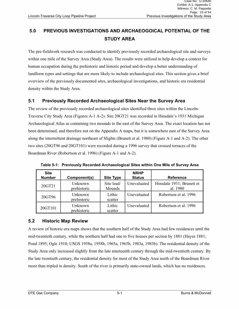
5.1 Previously Recorded Archaeological Sites Near the Survey Area
The review of the previously recorded archaeological sites identified three sites within the Lincoln-
Traverse City Study Area (Figures A-1 A-2). Site 20GT21 was recorded in Hinsdale’s 1931 Michigan
Archaeological Atlas as containing two mounds to the east of the Survey Area. The exact location has not
been determined, and therefore not on the Appendix A maps, but it is somewhere east of the Survey Area
along the intermittent drainage northeast of Slights (Brunett et al. 1980) (Figure A-1 and A-2). The other
two sites (20GT96 and 20GT101) were recorded during a 1996 survey that crossed terraces of the
Boardman River (Robertson et al. 1996) (Figure A-1 and A-2).
Table 5-1: Previously Recorded Archaeological Sites within One Mile of Survey Area
Site Number Component(s) Site Type
NRHP Status Reference
20GT21 Unknown
prehistoric
Site lead/
Mounds
Unevaluated Hinsdale 1931; Brunett et
al. 1980
20GT96 Unknown
prehistoric
Lithic
scatter
Unevaluated Robertson et al. 1996
20GT101 Unknown
prehistoric
Lithic
scatter
Unevaluated Robertson et al. 1996
5.2 Historic Map Review
A review of historic-era maps shows that the southern half of the Study Area had few residences until the
mid-twentieth century, while the northern half had one to five houses per section by 1881 (Hayes 1881;
Pond 1895; Ogle 1910; USGS 1958a, 1958b, 1965a, 1965b, 1983a, 1983b). The residential density of the
Study Area only increased slightly from the late nineteenth century through the mid-twentieth century. By
the late twentieth century, the residential density for most of the Study Area north of the Boardman River
more than tripled in density. South of the river is primarily state-owned lands, which has no residences.
Case No.: U-20640 Exhibit: A-1, Appendix C Witness: C. M. Paquette
Page: 23 of 54
Lincoln-Traverse City Loop Pipeline Project Previous Investigations of the Study Area
DTE Gas Company 5-2 Burns & McDonnell
The few residential occupations in this segment are small, privately-owned tracts flanking the state-owned
parcels.
5.3 Archaeological Site Potential
Based on a review of the previously recorded archaeological sites and their distribution, previous cultural
resource survey results, previous land use, and historic-era maps, the archaeological site density of the
area is low. Based on this review, it appears the archaeological site potential is also low through the
majority of the Survey Area. The review of the Hinsdale’s 1930 Michigan Archaeological Atlas indicated
that two burial mounds were recorded to the east of the Survey Area. Most of the mounds documented by
Hinsdale in the region have been destroyed by cultivation. Nearly all the Survey Area has been previously
disturbed by cultivation, timber activities, utility and pipeline construction, or subjected to twentieth and
twenty-first century development.
Based on the previous surveys and sites recorded, the areas with the highest potential for containing
prehistoric sites are on terraces or elevated landscapes overlooking streams. The Survey Area crosses the
Boardman River; however, this segment of the river has no terraces or elevated landforms within the
floodplain. No evidence of prehistoric occupation was identified in this location during the survey.
The locations of the mapped houses and overall residential density suggest that the potential for historic
era sites within the Survey Area is low. The most likely sites types present would be dumpsites or
possibly logging camps. According to the 1881 plat map, logging companies owned several large tracts of
land, which reduced the areas open to homesteading and rural schools, churches, and industries (Hayes
1881).
Case No.: U-20640 Exhibit: A-1, Appendix C Witness: C. M. Paquette
Page: 24 of 54
Lincoln-Traverse City Loop Pipeline Project Results of Investigation
DTE Gas Company 6-1 Burns & McDonnell
6.0 RESULTS OF INVESTIGATION
This chapter details the archaeological investigation undertaken for the Project, including a summary of
the field investigations followed by a discussion of resources identified. All of the sites identified were in
Grand Traverse County, Michigan. The field surveys were limited to the Survey Area, which includes
construction corridors, buffers, and laydown yard footprint areas of the proposed Project. During the
current investigation, historic period maps were consulted to assist in the survey procedures and site
interpretation and assessments.
The Project area was primarily level to rolling uplands that included have been predominately forest until
cleared in the mid- to late nineteenth century. Some areas are presently wooded, which are periodically
harvested or clear-cut for lumber. Other areas include agricultural fields, orchards, pastures, manicured
lawns, and modern development areas (both industrial and residential). The GSV ranged from 0 in most
of the heavily wooded areas to 100 percent in the existing maintenance road corridors. Many of the shovel
tests in the wooded areas revealed the repeated logging in the sandy soils has severely disturbed the A
horizon.
The maps, photographs, and artifact tables referenced in the following site discussions are presented in a
series of appendixes. Appendix A includes the topographic and aerial maps that depict the Survey Area
and the locations of the sites recorded. Appendix B includes the photographs of the Survey Area,
archaeological site overviews, and cultural features documented within the sites. Appendix C includes the
site maps.
The segment between the Lincoln-Traverse City Tie-In and the Frankfort Junction parallels an existing
pipeline, which is within the Survey Area. This segment also includes the crossing of the Boardman
River. South of the river, the existing pipeline and a heavily traveled maintenance road along the eastern
half of the Survey Area are on a sandy level plain (Photograph B-1). The Survey Area south of the
Boardman River passes through some privately-owned and four state-owned land parcels. A Permit to
Perform Archaeological Exploration on State-Owned Land (Permit Number 2019-03) was required before
surveying the state-owned parcels. The Survey Area within the four state-owned parcels totaled 32 acres
and was approximately half wooded and half cleared existing pipeline maintenance corridor. The state-
owned wooded areas had evidence of past logging activities, borrow areas, and other buried pipelines and
utilities. The private property included tracts of wooded areas (also with evidence of previous logging
activities), portions of manicured lawns, and grassy meadows. The sandy soil, combined with the
extensive disturbances and sparse vegetation cover within much of the Survey Area afforded excellent
Case No.: U-20640 Exhibit: A-1, Appendix C Witness: C. M. Paquette
Page: 25 of 54
Lincoln-Traverse City Loop Pipeline Project Results of Investigation
DTE Gas Company 6-2 Burns & McDonnell
GSV in the existing pipeline maintenance corridors, borrow areas, yards, and grassy meadows during the
survey.
The Survey Area crossing of the Boardman River was in a segment of the valley floor that was all low-
lying floodplain on both sides of the river with no terraces or elevated landforms (Photograph B-2). Burns
& McDonnell’s 2019 wetland survey determined both sides of the river were wetlands (Figures A-1 and
A-2).
The northern edge of the Broadman River floodplain is marked by the steep slope of the in the Port Huron
Moraine (Photograph B-3). From this moraine to the Frankfort Junction, the Survey Area includes
existing pipeline. The moraine is wooded, with the exception of the existing pipeline maintenance
corridor and some open meadows on the crest of the landform. The rolling hills to the north of the highest
elevations of the moraine and south of the Frankfort Junction were agricultural fields, cherry orchards,
grasslands, and woodlands. During the survey, these areas had 20 to 80 percent GSV.
The segment between the Frankfort Junction and the Traverse City Gate Station was a mixture of
agricultural fields, wooded areas, housing developments, and industrial areas (Figures A-2 and A-4;
Photograph B-4). Adjacent to this segment is the proposed pipe yard, for which 19 acres of an alfalfa field
was surveyed (Figures A-1 and A-2; Photograph B-5). Much of this segment also parallels an existing
pipeline, which is included in the Survey Area. North of the laydown yard, the Survey Area is primarily
in highly disturbed areas adjacent to and within housing developments and industrial areas (Photographs
B-6 through B-8).
6.1 Archaeological Sites
Two archaeological sites were recorded during the current investigation of the Survey Area. One was
prehistoric of unknown cultural affiliation and the other was mid- to late twentieth century Euroamerican.
Each archaeological site is discussed in detail below.
6.1.1 Site 20GT161
Summary Data
Site Type: Isolated find
Component: Unknown prehistoric
Site Area: 8 square meters (46 square meters; 0.01 acres)
Topography: Glacial moraine
Elevation: 276 meters above mean sea level (AMSL)
Soil Type: Kalkaska loamy sand, 0 to 2 percent slopes
Nearest Water: Marsh 117 meters to the south
Field Method: Visual inspection and shovel testing
Case No.: U-20640 Exhibit: A-1, Appendix C Witness: C. M. Paquette
Page: 26 of 54
Lincoln-Traverse City Loop Pipeline Project Results of Investigation
DTE Gas Company 6-3 Burns & McDonnell
Site Condition: Fair
NRHP Status: Recommended not eligible
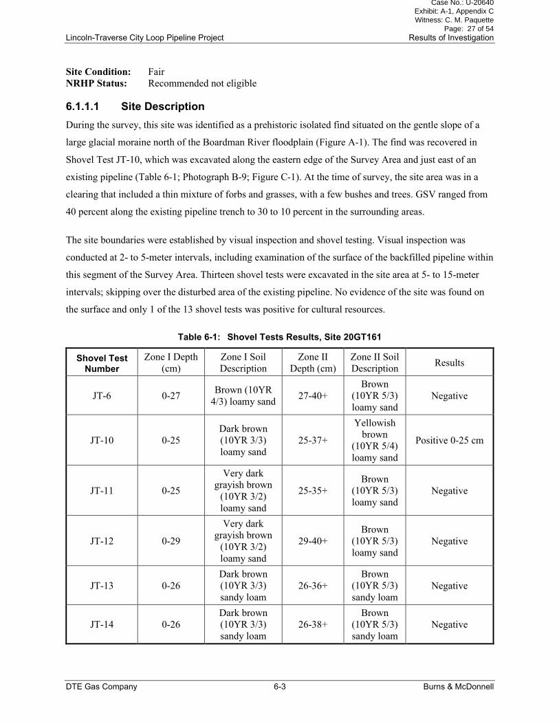
6.1.1.1 Site Description
During the survey, this site was identified as a prehistoric isolated find situated on the gentle slope of a
large glacial moraine north of the Boardman River floodplain (Figure A-1). The find was recovered in
Shovel Test JT-10, which was excavated along the eastern edge of the Survey Area and just east of an
existing pipeline (Table 6-1; Photograph B-9; Figure C-1). At the time of survey, the site area was in a
clearing that included a thin mixture of forbs and grasses, with a few bushes and trees. GSV ranged from
40 percent along the existing pipeline trench to 30 to 10 percent in the surrounding areas.
The site boundaries were established by visual inspection and shovel testing. Visual inspection was
conducted at 2- to 5-meter intervals, including examination of the surface of the backfilled pipeline within
this segment of the Survey Area. Thirteen shovel tests were excavated in the site area at 5- to 15-meter
intervals; skipping over the disturbed area of the existing pipeline. No evidence of the site was found on
the surface and only 1 of the 13 shovel tests was positive for cultural resources.
Table 6-1: Shovel Tests Results, Site 20GT161
Shovel Test Number
Zone I Depth
(cm)
Zone I Soil
Description
Zone II
Depth (cm)
Zone II Soil
Description Results
JT-6 0-27 Brown (10YR
4/3) loamy sand 27-40+
Brown
(10YR 5/3)
loamy sand
Negative
JT-10 0-25
Dark brown
(10YR 3/3)
loamy sand
25-37+
Yellowish
brown
(10YR 5/4)
loamy sand
Positive 0-25 cm
JT-11 0-25
Very dark
grayish brown
(10YR 3/2)
loamy sand
25-35+
Brown
(10YR 5/3)
loamy sand
Negative
JT-12 0-29
Very dark
grayish brown
(10YR 3/2)
loamy sand
29-40+
Brown
(10YR 5/3)
loamy sand
Negative
JT-13 0-26
Dark brown
(10YR 3/3)
sandy loam
26-36+
Brown
(10YR 5/3)
sandy loam
Negative
JT-14 0-26
Dark brown
(10YR 3/3)
sandy loam
26-38+
Brown
(10YR 5/3)
sandy loam
Negative
Case No.: U-20640 Exhibit: A-1, Appendix C Witness: C. M. Paquette
Page: 27 of 54
Lincoln-Traverse City Loop Pipeline Project Results of Investigation
DTE Gas Company 6-4 Burns & McDonnell
Shovel Test Number
Zone I Depth
(cm)
Zone I Soil
Description
Zone II
Depth (cm)
Zone II Soil
Description Results
JT-15 0-23
Dark brown
(10YR 3/3)
sandy loam
23-35+
Brown
(10YR 5/3)
sandy loam
Negative
JT-16 0-22
Dark brown
(10YR 3/3)
sandy loam
22-33+
Brown
(10YR 5/3)
sandy loam
Negative
JT-17 0-25
Dark brown
(10YR 3/3)
sandy loam
25-35+
Brown
(10YR 5/3)
sandy loam
Negative
JT-18 0-20
Dark brown
(10YR 3/3)
sandy loam
20-32+
Yellowish
brown
(10YR 5/4)
loamy sand
Negative
JT-19 0-27
Very dark
grayish brown
(10YR 3/2)
loamy sand
27-40+
Brown
(10YR 5/3)
sandy loam
Negative
ML-6 0-24
Dark brown
(10YR 3/3)
sandy loam
24-40+
Brown
(10YR 5/3)
sandy loam
Negative
ML-7 0-23
Dark brown
(10YR 3/3)
sandy loam
23-40+
Brown
(10YR 5/3)
sandy loam
Negative
6.1.1.2 Artifact Descriptions
The only artifact identified at the site was a large tertiary flake of Norwood chert. Norwood chert is found
about 40 miles north northeast of the site. The flake was found in the upper 20 cm of Shovel Test JT-10
No evidence of use or retouch was noted on the flake.
6.1.1.3 Site Summary, Site 20GT161
The aspects of the site are described below, in addition to the significance and recommendations.
6.1.1.3.1 Horizontal and Vertical Extent of Cultural Deposit
The site is an isolated find within the A horizon of the high glacial moraine.
6.1.1.3.2 Site Integrity
The find spot appears to have fair integrity, with the area adversely impacted by clearing, construction,
and maintenance of the existing pipeline. The buried pipeline is immediately to the west of the find spot.
Case No.: U-20640 Exhibit: A-1, Appendix C Witness: C. M. Paquette
Page: 28 of 54
Lincoln-Traverse City Loop Pipeline Project Results of Investigation
DTE Gas Company 6-5 Burns & McDonnell
The construction and maintenance of this pipeline may have destroyed elements of this low artifact
density site.
6.1.1.3.3 Site Function
The site was identified as an isolated find that was likely associated with a short-term activity area on the
crest of a glacial moraine.
6.1.1.3.4 Cultural Affiliation
Based on the artifact present, the cultural affiliation was identified as prehistoric of unknown cultural
affiliation.
6.1.1.3.5 Stratigraphic Placement of Components
The site is limited to the A horizon.
6.1.1.3.6 Presence of Subsurface Features
No evidence of subsurface features was identified during the current investigation of the site.
6.1.1.3.7 Site Significance
The isolated find lacks research potential due to its low artifact density, and diversity. It is the opinion of
the investigator that the current investigation has exhausted the research potential of the site within the
Survey Area.
6.1.1.3.8 Impact
It is the opinion of the investigator that the proposed Project would not impact significant cultural
resources at this site within the Survey Area.
6.1.1.3.9 Recommendations
No further archaeological investigations are recommended for this site within the Survey Area.
6.1.2 Site 20GT162
Summary Data
Site Type: Foundation
Component: Mid- to late twentieth century
Site Area: 17 meters (north-south) by 28 meters (east-west); 472 square meters (0.12 acres)
Topography: Rolling plain
Elevation: 276 meters AMSL
Soil Type: Kalkaska loamy sand, 12 to 18 percent slopes
Nearest Water: Well about 50 meters to the west southwest
Case No.: U-20640 Exhibit: A-1, Appendix C Witness: C. M. Paquette
Page: 29 of 54
Lincoln-Traverse City Loop Pipeline Project Results of Investigation
DTE Gas Company 6-6 Burns & McDonnell
Field Method: Visual inspection and shovel testing
Site Condition: Good
NRHP Status: Recommended not eligible
6.1.2.1 Site Description
During the survey, this site was identified as a concrete foundation remnant along the western edge of the
Survey Area just south of Rusch Road and the Frankfort Junction (: Figures A-1 and A-2). The
foundation is currently associated with an extant residence that is located several hundred feet to the west
of the feature outside the Survey Area (Photograph B-10; Figure C-2). The foundation feature is under an
extant outbuilding, which sets outside the Survey Area, and extends to the east of it. The cinder block
building appears to be a later construction that only incorporated a portion of the historic-era foundation,
outside the Survey Area, that appears to be of later construction than the foundation (Photograph B-11).
The foundation feature east of the cinder block outbuilding measured 24 feet north to south and 22 feet
east to west. It was at least one foot thick and 16 inches wide.
The site boundaries were defined by the feature limits, visual inspection, shovel testing (Table 6-2), and
the Survey Area. Shovel test JT-20 was placed just to the east of the foundation. A buried portion of a
concrete slab was found at a depth of 22 cm. This large piece of concrete was resting at an angle; sloping
from 22 cm on one side of the shovel test to 33 cm on the other. The foundation is in a level area created
by mechanical removal or cutting of the fine sandy landform (Photograph B-12). An access road passes
along the southern edge of the foundation, and a planted grove of pine trees to the south. The excellent
ground surface in this area is a result of the mechanical removal of portions of the original landform. To
the north of the feature is the steep wall of the cut landform and ditch along Rusch Road. To the east of
the foundation is a continuation of the mechanically created a level area or building pad.
A review of the available historic maps found that the associated farmstead was not present until the mid-
to late twentieth century. No buildings were depicted in the site area on any of the early plat or
topographic maps (Hayes 1881; Pond 1895; Ogle 1910; USGS 1958b, 1965b). The first map to depict the
house to the west of the site was the 1983 topographic map (USGS 1983b).
Even though the adjacent residence is not old enough to be considered historic period, the foundation
appears to be of an earlier date. The building was likely constructed after 1954, as it does not appear on
the 1954 aerial image, but prior to 1983 when the residence was first depicted. No temporarily diagnostic
artifacts, other than concrete, were identified at the site, but based on the concrete the foundation appears
to predate the cinder block building that now sits on its western half.
Case No.: U-20640 Exhibit: A-1, Appendix C Witness: C. M. Paquette
Page: 30 of 54
Lincoln-Traverse City Loop Pipeline Project Results of Investigation
DTE Gas Company 6-7 Burns & McDonnell
Most of the sandy area in and around the site had 40 to 100 percent GSV, which included the excavated
southern hill side and the eroded slope to the east. The network of graded access roads and two-tracks to
the south allowed for excellent GSV as well as profile walls or cuts along incised sections of these roads.
Immediately south of the site the terrain slopes into the floor of level basin.
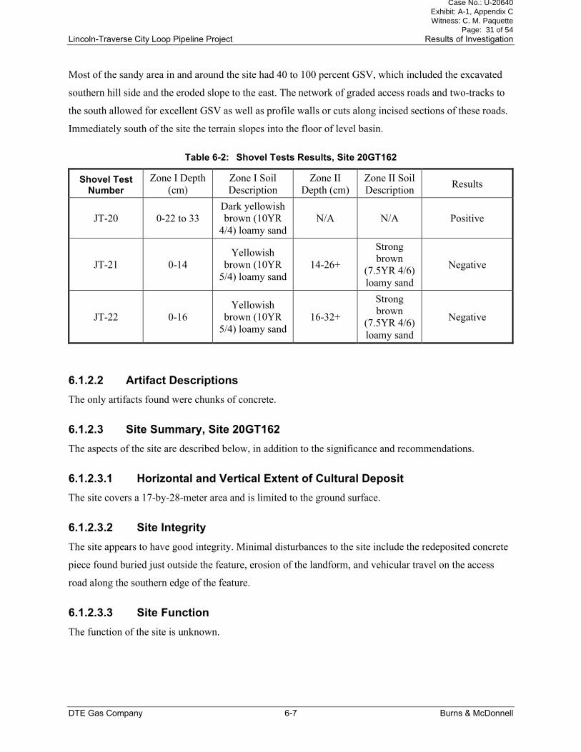
Table 6-2: Shovel Tests Results, Site 20GT162
Shovel Test Number
Zone I Depth
(cm)
Zone I Soil
Description
Zone II
Depth (cm)
Zone II Soil
Description Results
JT-20 0-22 to 33
Dark yellowish
brown (10YR
4/4) loamy sand
N/A N/A Positive
JT-21 0-14
Yellowish
brown (10YR
5/4) loamy sand
14-26+
Strong
brown
(7.5YR 4/6)
loamy sand
Negative
JT-22 0-16
Yellowish
brown (10YR
5/4) loamy sand
16-32+
Strong
brown
(7.5YR 4/6)
loamy sand
Negative
6.1.2.2 Artifact Descriptions
The only artifacts found were chunks of concrete.
6.1.2.3 Site Summary, Site 20GT162
The aspects of the site are described below, in addition to the significance and recommendations.
6.1.2.3.1 Horizontal and Vertical Extent of Cultural Deposit
The site covers a 17-by-28-meter area and is limited to the ground surface.
6.1.2.3.2 Site Integrity
The site appears to have good integrity. Minimal disturbances to the site include the redeposited concrete
piece found buried just outside the feature, erosion of the landform, and vehicular travel on the access
road along the southern edge of the feature.
6.1.2.3.3 Site Function
The function of the site is unknown.
Case No.: U-20640 Exhibit: A-1, Appendix C Witness: C. M. Paquette
Page: 31 of 54
Lincoln-Traverse City Loop Pipeline Project Results of Investigation
DTE Gas Company 6-8 Burns & McDonnell
6.1.2.3.4 Cultural Affiliation
Based on the historic map review and feature type, the site was occupied during the mid- to late twentieth
century.
6.1.2.3.5 Stratigraphic Placement of Components
The site is limited to the historic-age excavated and leveled surface.
6.1.2.3.6 Presence of Subsurface Features
No evidence of intact subsurface features was identified during the current investigation of the site.
6.1.2.3.7 Site Significance
The surface site lacks research potential due to its period of occupation and lack of association with
individuals of local significance. It is the opinion of the investigator that the current investigation has
exhausted the research potential of the site.
6.1.2.3.8 Impact
It is the opinion of the investigator that the proposed Project would not impact significant cultural
resources at this site.
6.1.2.3.9 Recommendations
No further archaeological investigations are recommended for this site.
Case No.: U-20640 Exhibit: A-1, Appendix C Witness: C. M. Paquette
Page: 32 of 54
Lincoln-Traverse City Loop Pipeline Project Conclusions and Recommendations
DTE Gas Company 7-9 Burns & McDonnell
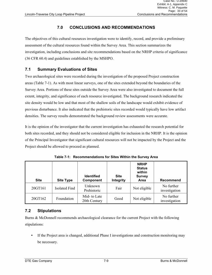
7.0 CONCLUSIONS AND RECOMMENDATIONS
The objectives of this cultural resources investigation were to identify, record, and provide a preliminary
assessment of the cultural resources found within the Survey Area. This section summarizes the
investigation, including conclusions and site recommendations based on the NRHP criteria of significance
(36 CFR 60.4) and guidelines established by the MSHPO.
7.1 Summary Evaluations of Sites
Two archaeological sites were recorded during the investigation of the proposed Project construction
areas (Table 7-1). As with most linear surveys, one of the sites extended beyond the boundaries of the
Survey Area. Portions of these sites outside the Survey Area were also investigated to document the full
extent, integrity, and significance of each resource investigated. The background research indicated the
site density would be low and that most of the shallow soils of the landscape would exhibit evidence of
previous disturbance. It also indicated that the prehistoric sites recorded would typically have low artifact
densities. The survey results demonstrated the background review assessments were accurate.
It is the opinion of the investigator that the current investigation has exhausted the research potential for
both sites recorded, and they should not be considered eligible for inclusion in the NRHP. It is the opinion
of the Principal Investigator that significant cultural resources will not be impacted by the Project and the
Project should be allowed to proceed as planned.
Table 7-1: Recommendations for Sites Within the Survey Area
Site Site Type Identified
Component Site
Integrity
NRHP Status within Survey Area Recommend
20GT161 Isolated Find Unknown
Prehistoric Fair Not eligible
No further
investigation
20GT162 Foundation Mid- to Late
20th Century Good Not eligible
No further
investigation
7.2 Stipulations
Burns & McDonnell recommends archaeological clearance for the current Project with the following
stipulations:
• If the Project area is changed, additional Phase I investigations and construction monitoring may
be necessary.
Case No.: U-20640 Exhibit: A-1, Appendix C Witness: C. M. Paquette
Page: 33 of 54

Lincoln-Traverse City Loop Pipeline Project Conclusions and Recommendations
DTE Gas Company 7-10 Burns & McDonnell
• If human burials or buried archaeological deposits are encountered during Project construction,
land-disturbing activities in the immediate area will be halted, and the Principal Investigator, the
MSHPO, and the appropriate agency archaeologist will be notified. Then the exposed cultural
resources will be evaluated for their significance in accordance with the state and federal
guidelines.
Case No.: U-20640 Exhibit: A-1, Appendix C Witness: C. M. Paquette
Page: 34 of 54
Lincoln-Traverse City Loop Pipeline Project References Cited
DTE Gas Company 8-1 Burns & McDonnell
8.0 REFERENCES CITED
Benson, Barbara E.
1989 Logs and Lumber: The Development of the Limber Industry in Michigan’s Lower
Peninsula, 1837-1870. Clarke Historical Library, Central Michigan University, Mount
Pleasant, Michigan.
Brashler, Janet G., John R. Halsey, Margaret B. Holman, James J. Krakker, Susan R. Martin, David M.
Stothers, and Richard L. Zurel
1999 Late Woodland: Prehistory’s Finale, History’s Prelude. In Retrieving Michigan’s Buried
Past, edited by John R Halsey, pp. 125-146. Cranbook Institute of Sciences, Bloomfield
Hills, Michigan.
Brunett, Fel., M.K. Scott, and M.K. Speas
1980 An Historical-Archaeological Survey of the Traverse Bay Regional Planning Commission
Area: Phase I. Traverse Bay Regional Planning Commission, Traverse City.
Caldwell, Joseph and Robert L. Hall
1964 Hopewellian Studies. Illinois State Museum Scientific Papers Volume 12. Illinois State
Museum, Springfield.
Clark, Caven P.
1994 Berrien County’s 4,000-Year-Old House. Michigan History Magazine 78(5):51-53.
Cleland, Charles E., and David L. Ruggles
1996 The Samels Field Site: An Early Archaic Base Camp in Grand Traverse County, Michigan.
In Investigating the Archaeological Record of the Great Lakes State: Essays in the Honor
of Elizabeth Baldwin Garland, edited by Margret B. Holman, Janet G. Brashler, and
Kathryn E. Parker., pp. 55-79. New Issues Press, Western Michigan University,
Kalamazoo.
Douglas, John F., Margret B. Holman, and James H. Stephenson
1998 Paleoindian, Archaic, and Woodland Artifacts from a Site at Green Lake, Grand Traverse
County, Michigan. The Michigan Archaeologist, 44(3): 151-192.
Garland, Elizabeth B., and Scott G. Beld
1999 The Early Woodlands: Ceramics, Domesticated Plants, and Burial Mounds Foretell the
Shape of the Future. In Retrieving Michigan’s Buried Past, edited by John R Halsey, pp.
125-146. Cranbook Institute of Sciences, Bloomfield Hills, Michigan.
General Land Office (GLO)
1840 Survey maps and notes on file with the Bureau of Land Management.
Griffin, James B.
1967 Eastern North American Archaeology: A Summary. Science 156:175-91.
Hayes, E. L.
1881 Atlas of Grand Traverse County, Michigan. C.O. Titus, Philadelphia.
Hinsdale, Wilbert B.
Case No.: U-20640 Exhibit: A-1, Appendix C Witness: C. M. Paquette
Page: 35 of 54
Lincoln-Traverse City Loop Pipeline Project References Cited
DTE Gas Company 8-2 Burns & McDonnell
1930 The Archaeological Atlas of Michigan. Michigan Handbook Series no. 4, University of
Michigan, Ann Arbor.
Kapp, Ronald O.
1999 Michigan Late Pleistocene, Holocene, and Presettlement Vegetation and Climate. In In
Retrieving Michigan’s Buried Past, edited by John R Halsey, pp. 31-58. Cranbook Institute of
Sciences, Bloomfield Hills, Michigan.
Kingsley, Robert G., David S. Brose, and Michael J. Hambacher
1999 The Woodlands: A Golden Age of Mound Builders and Fishermen. In Retrieving
Michigan’s Buried Past, edited by John R Halsey, pp. 147-192. Cranbook Institute of
Sciences, Bloomfield Hills, Michigan.
Kuhn, R.D., and M.L. Spempowski
2001 A New Approach to Dating the League of Iroquois. American Antiquity 66(2): 301-314.
Leach, M.L.
1883 A History of Grand Traverse Region. Grand Traverse Herald, Traverse City, Michigan.
Lovis, William A.
1999 The Middle Archaic: Learning to Live in the Woods. In Retrieving Michigan’s Buried Past,
edited by John R Halsey, pp. 83-94. Cranbook Institute of Sciences, Bloomfield Hills,
Michigan.
Michigan Department of Natural Resources
1999 1987 Bedrock Geology of Michigan. Land and Mineral Services Division. Lansing.
Michigan Geological Survey
2019 Physiographic Map of Michigan.
http://mgs.geology.wmich.edu/webmgs/physiography/physio.html.
Accessed May 21, 2019.
Monaghan, G. William and William A. Lovis
2005 Modeling Archaeological Site Burial in Southern Michigan: A Geoarchaeological
Synthesis. Michigan State University Press, East Lansing.
Ogle, George A.
1910 Standard Atlas of Grand Traverse County, Michigan. Geo, A. Ogle and Company,
Chicago.
Parker, A.C.
1907 Excavation in an Erie Indian Village and Burial Site at Ripley, Chautauqua County, New
York. New York State Museum Bulletin 117, Albany.
Pond, Seymour E.
1895 New Atlas and Directory of Grand Traverse County, Michigan. Seymour E. Pond and
Company, Traverse City, Michigan.
Rennie, Alec M.
1982 The Boardman River. In Currents of the Boardman, pp. 17-25. Compiled by the Boardman
River Historical Committee, Grand Traverse Historical Society, Traverse City.
Case No.: U-20640 Exhibit: A-1, Appendix C Witness: C. M. Paquette
Page: 36 of 54
Lincoln-Traverse City Loop Pipeline Project References Cited
DTE Gas Company 8-3 Burns & McDonnell
Robertson, James A., R. Neumann, E. Robinson, K.C. Taylor, and D.G. Landis
1996 Phase I Archaeological Survey and Reconnaissance Level Survey of Above Ground
Resources, Cass Road Bridge Reconstruction Project, Garfield Township, Grand Traverse
County, Michigan. Commonwealth Cultural Resources Group, Inc., Jackson, Michigan.
Robertson, James A., William A. Lovis, and John R. Halsey
1999 The Late Archaic Hunter-Gatherers in an Uncertain Environment. In Retrieving
Michigan’s Buried Past, edited by John R Halsey, pp. 95-124. Cranbook Institute of
Sciences, Bloomfield Hills, Michigan.
Shott, Michael J
1999 The Early Archaic: Life After the Glaciers. In Retrieving Michigan’s Buried Past, edited
by John R Halsey, pp. 71-70. Cranbook Institute of Sciences, Bloomfield Hills, Michigan.
Shott, Michael J. and Henry T. Wright
1999 The Paleo-Indians: Michigan’s First People. In Retrieving Michigan’s Buried Past, edited
by John R Halsey, pp. 59-70. Cranbook Institute of Sciences, Bloomfield Hills, Michigan.
Soil Survey Staff
1993 Soil Survey Manual. Soil Conservation Service. U.S. Department of Agriculture
Handbook 18. U.S. Government Printing Office, Washington, D.C.
2015 Web Soil Survey. Electronic document,
http://soils.usda.gov/technical/classification/osd/index.html, accessed March 2017
Sprague, Elvin L., and Mrs. George A. Smith
1903 Sprague’s History of Traverse and Leelanaw Counties, Michigan. B.F. Bowen.
Stothers, David M.
1999 Late Woodland Models for Cultural Development in Southern Michigan. In Retrieving
Michigan’s Buried Past, Prehistoric and Historic Archaeology of the Great Lakes State,
edited by J. Halsey, pp. 194-211. Cranbook Institute of Sciences, Bloomfield Hills,
Michigan.
2000 The Protohistoric Time Period in the Southwestern Lake Erie Region: European-Derived
Trade Material, Population Movement and Cultural Realignment. In Cultures Before
Contact: The Late Prehistory of Ohio and Surrounding Regions, ed. By Robert
Genheimer, pp. 52-94. Ohio Archaeological Council, Columbus, OH.
Stothers, David M., and Timothy J. Abel
1993 Archaeological Reflections of the Late Archaic and Early Woodland Time Periods in the
Western Lake Erie Region. Archaeology of Eastern North America 21:25-109.
Struever, S.
1964 The Hopewellian Interaction Sphere in Riverine-Western Great Lakes Culture History. In
Hopewellian Studies, edited by J. R. Caldwell and R. L. Hall, pp. 87-106. Scientific Papers
No. 12. Illinois State Museum, Springfield.
Trigger, Bruce G.
1985 Natives and Newcomers: Canada’s “Heroic Age” Revisited. McGill-Queens University
Press, Montreal.
Case No.: U-20640 Exhibit: A-1, Appendix C Witness: C. M. Paquette
Page: 37 of 54
Lincoln-Traverse City Loop Pipeline Project References Cited
DTE Gas Company 8-4 Burns & McDonnell
U.S. Geological Survey (USGS)
1958a Kingsley, 1:25,000 topographic map. U.S. Geological Survey, Washington, D.C.
1958b Mayfield, 1:25,000 topographic map. U.S. Geological Survey, Washington, D.C.
1965a Kingsley, 1:25,000 topographic map. U.S. Geological Survey, Washington, D.C.
1965b Mayfield, 1:25,000 topographic map. U.S. Geological Survey, Washington, D.C.
1983a Kingsley, 1:25,000 topographic map. U.S. Geological Survey, Washington, D.C.
1983b Mayfield, 1:25,000 topographic map. U.S. Geological Survey, Washington, D.C.
Wysocki, D. A., P. J. Schoeneberger, and H. E. LaGarry
2005 Soil Surveys: A Window to the Subsurface, Geoderma, 126: 167–180.
Case No.: U-20640 Exhibit: A-1, Appendix C Witness: C. M. Paquette
Page: 38 of 54
APPENDIX A - PROJECT MAPS
Case No.: U-20640 Exhibit: A-1, Appendix C Witness: C. M. Paquette
Page: 39 of 54
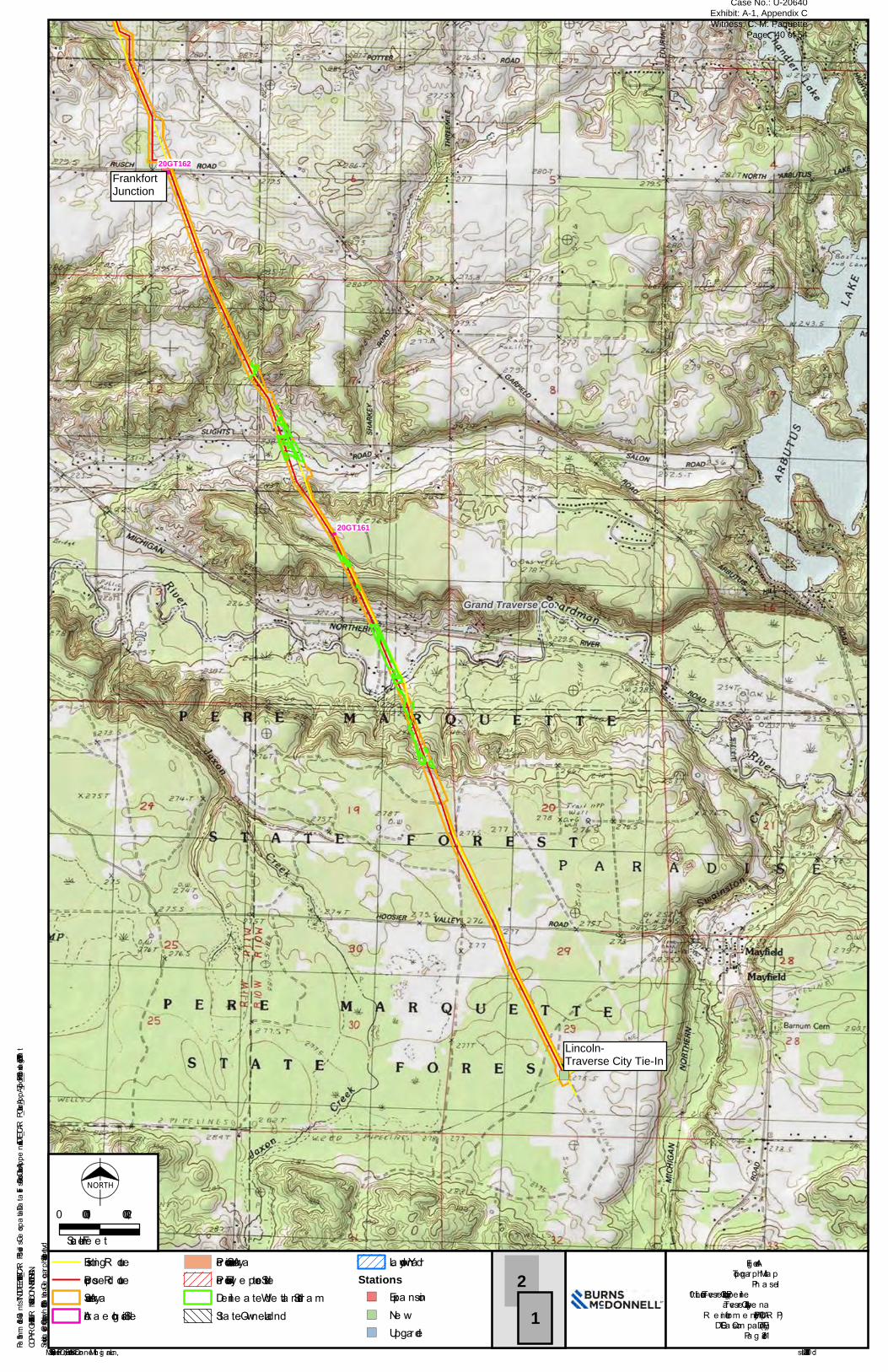
Service Layer Credits: Copyright:© 2013 National Geographic Society, i-cubed
")
")
Grand Traverse Co.
20GT162
20GT161
Lincoln-TraverseCity Tie-In
FrankfortJunction
COPYRIGHT © 2019 BURNS & McDONNELL MICHIGAN, INC.
Source : Esri, MSHPO, a nd Burns & McDonne ll Mich ig a n, Inc. Issue d: 10/17/2019Path: \\bmcd\dfs\Clients\TND\DTEEnr\115495_TCARP\Studies\Geospatial\DataFiles\ArcDocs\Cultural\AppendixA\DTE_TCARP_Cultural_AppA_Topo_P1_3.mxd kdboatright 10/17/2019
Fig ure A-1Topog ra ph ic Ma p
Ph a se I10” Lincoln-Trave rse City Loop Pipe line
Trave rse City-Alpe na R e inforce m e nt Proje ct (TCAR P)DTE Ga s Com pa ny (DTE)
Pa g e 1 of 2
21
Existing R outePropose d R outeSurve y Are aArch a e olog ica l Site
Pre vious Surve y Are aPre viously R e porte d SiteDe line a te d We tla nd/Stre a mSta te -Owne d La nd
Laydown YardStations") Expa nsion") Ne w") Upg rade
NORTH
0 2,0001,000Sca le in Fe e t
FrankfortJunction
Lincoln-Traverse City Tie-In
Case No.: U-20640 Exhibit: A-1, Appendix C Witness: C. M. Paquette
Page: 40 of 54
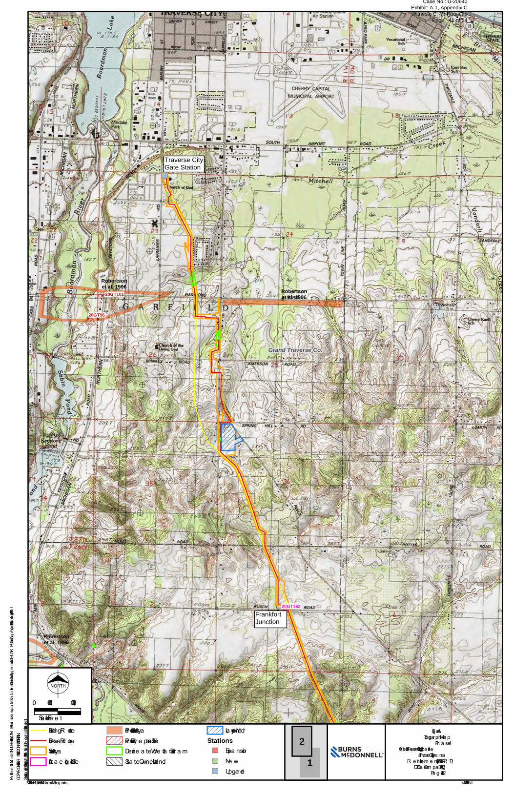
Service Layer Credits: Copyright:© 2013 National Geographic Society, i-cubed
")
")
20GT101
20GT96
Grand Traverse Co.
20GT162
Robertsonet al. 1996
Robertsonet al. 1996
Robertsonet al. 1996
Traverse CityGate Station
FrankfortJunction
COPYRIGHT © 2019 BURNS & McDONNELL MICHIGAN, INC.
Source : Esri, MSHPO, a nd Burns & McDonne ll Mich ig a n, Inc. Issue d: 10/17/2019Path: \\bmcd\dfs\Clients\TND\DTEEnr\115495_TCARP\Studies\Geospatial\DataFiles\ArcDocs\Cultural\AppendixA\DTE_TCARP_Cultural_AppA_Topo_P1_3.mxd kdboatright 10/17/2019
Fig ure A-1Topog ra ph ic Ma p
Ph a se I10” Lincoln-Trave rse City Loop Pipe line
Trave rse City-Alpe na R e inforce m e nt Proje ct (TCAR P)DTE Ga s Com pa ny (DTE)
Pa g e 2 of 2
21
Existing R outePropose d R outeSurve y Are aArch a e olog ica l Site
Pre vious Surve y Are aPre viously R e porte d SiteDe line a te d We tla nd/Stre a mSta te -Owne d La nd
Laydown YardStations") Expa nsion") Ne w") Upg rade
NORTH
0 2,0001,000Sca le in Fe e t
FrankfortJunction
Traverse CityGate Station
Case No.: U-20640 Exhibit: A-1, Appendix C Witness: C. M. Paquette
Page: 41 of 54
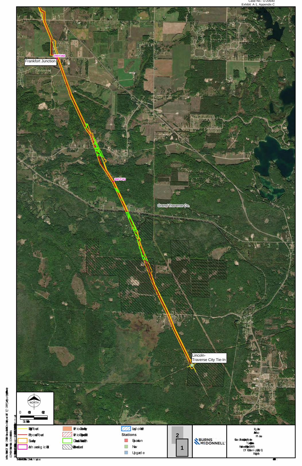
Service Layer Credits: Source: Esri, DigitalGlobe, GeoEye, Earthstar Geographics, CNES/Airbus DS, USDA, USGS, AeroGRID, IGN, and the GIS User Community
")
")
Grand Traverse Co.
20GT162
20GT161
Blair toLincoln-TraverseInterconnect
Frankfort CheckMeter Station
COPYRIGHT © 2019 BURNS & McDONNELL MICHIGAN, INC.
Source: Esri, MSHPO, and Burns & McDonnell Mic h ig an, Inc. Issued : 9/20/2019Path: \\bmcd\dfs\Clients\TND\DTEEnr\115495_TCARP\Studies\Geospatial\DataFiles\ArcDocs\Cultural\AppendixA\DTE_TCARP_Cultural_AppA_Aerial_P1.mxd snekolny 9/20/2019
Fig ure A-2Aerial MapPh ase I
10” Lincoln-T rav erse City Loop PipelineT rav erse City-Alpena
Reinforcem ent Project (T CARP)DT E Gas Com pany (DT E)
Pag e 1 of 2
21
Existing RouteProposed RouteSurvey AreaArc h aeolog ic al Site
Prev ious Survey AreaPrev iously Reported SiteDelineated Wetland/StreamState-Owned Land
Layd own YardStations") Expansion") New") Upg rade
NORTH
0 2,0001,000
Scale in Feet
Lincoln-Traverse City Tie-In
Frankfort Junction
Case No.: U-20640 Exhibit: A-1, Appendix C Witness: C. M. Paquette
Page: 42 of 54
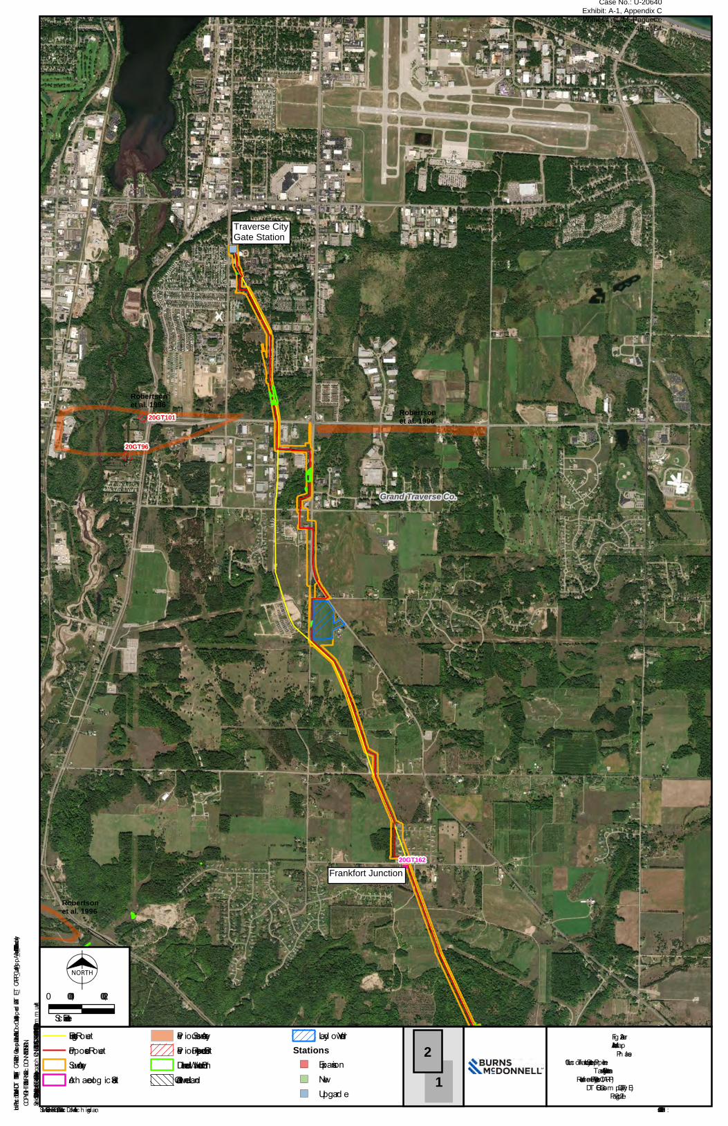
Service Layer Credits: Source: Esri, DigitalGlobe, GeoEye, Earthstar Geographics, CNES/Airbus DS, USDA, USGS, AeroGRID, IGN, and the GIS User Community
")
")
20GT101
20GT96
Grand Traverse Co.
20GT162
Robertsonet al. 1996
Robertsonet al. 1996
Robertsonet al. 1996
Traverse CityGate Station
Frankfort CheckMeter Station
COPYRIGHT © 2019 BURNS & McDONNELL MICHIGAN, INC.
Source: Esri, MSHPO, and Burns & McDonnell Mic h ig an, Inc. Issued : 9/20/2019Path: \\bmcd\dfs\Clients\TND\DTEEnr\115495_TCARP\Studies\Geospatial\DataFiles\ArcDocs\Cultural\AppendixA\DTE_TCARP_Cultural_AppA_Aerial_P1.mxd snekolny 9/20/2019
Fig ure A-2Aerial MapPh ase I
10” Lincoln-T rav erse City Loop PipelineT rav erse City-Alpena
Reinforcem ent Project (T CARP)DT E Gas Com pany (DT E)
Pag e 2 of 2
21
Existing RouteProposed RouteSurvey AreaArc h aeolog ic al Site
Prev ious Survey AreaPrev iously Reported SiteDelineated Wetland/StreamState-Owned Land
Layd own YardStations") Expansion") New") Upg rade
NORTH
0 2,0001,000
Scale in Feet
Frankfort Junction
Traverse CityGate Station
Case No.: U-20640 Exhibit: A-1, Appendix C Witness: C. M. Paquette
Page: 43 of 54

APPENDIX B - PROJECT AREA AND SITE PHOTOGRAPHS
Case No.: U-20640 Exhibit: A-1, Appendix C Witness: C. M. Paquette
Page: 44 of 54

DTE 10” Lincoln-Traverse City Loop
Pipeline Project
Project Area and Site Photographs May 24 to June 4 and July 16 to 17,
2019 Grand Traverse County, Michigan
Photograph B-1: South end of Project, Lincoln Traverse Blair Interconnect, view to north.
Photograph B-2: Boardman River crossing, view to southeast.
Case No.: U-20640 Exhibit: A-1, Appendix C Witness: C. M. Paquette
Page: 45 of 54
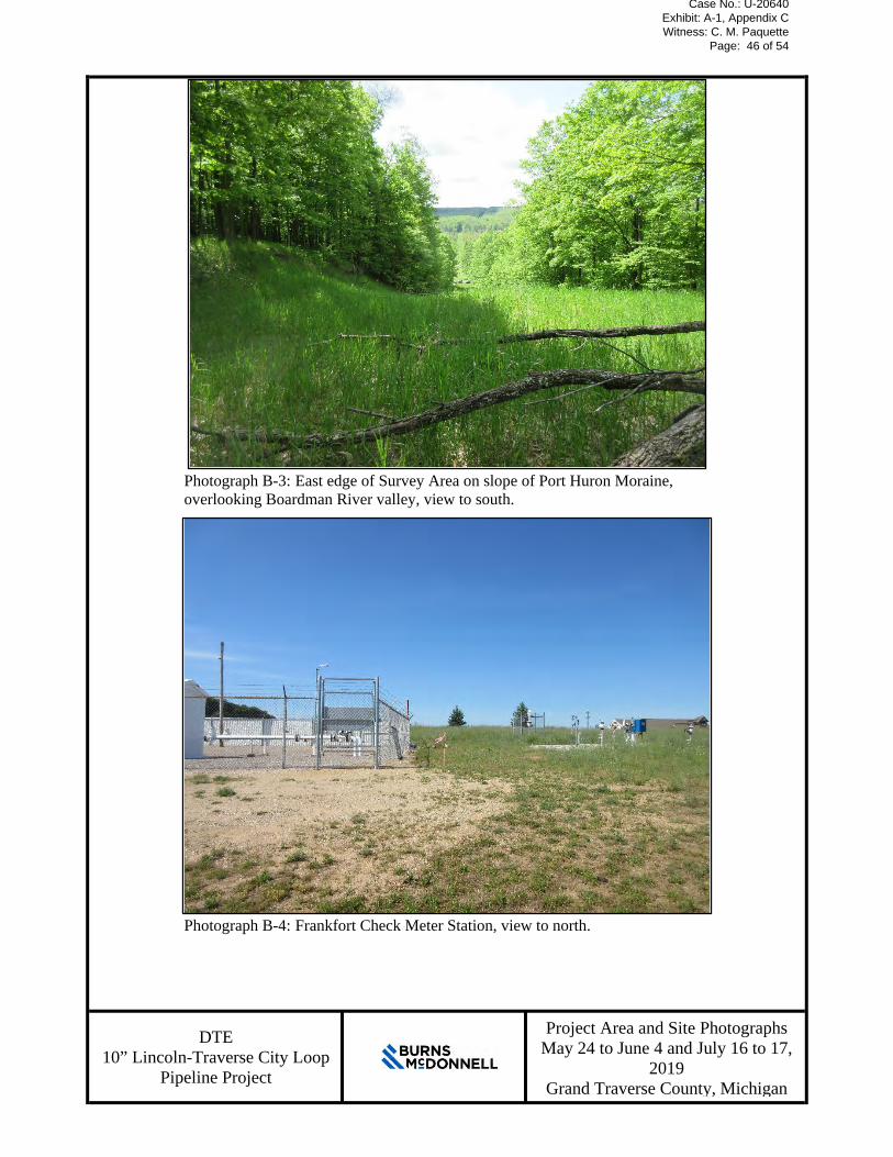
DTE 10” Lincoln-Traverse City Loop
Pipeline Project
Project Area and Site Photographs May 24 to June 4 and July 16 to 17,
2019 Grand Traverse County, Michigan
Photograph B-3: East edge of Survey Area on slope of Port Huron Moraine, overlooking Boardman River valley, view to south.
Photograph B-4: Frankfort Check Meter Station, view to north.
Case No.: U-20640 Exhibit: A-1, Appendix C Witness: C. M. Paquette
Page: 46 of 54

DTE 10” Lincoln-Traverse City Loop
Pipeline Project
Project Area and Site Photographs May 24 to June 4 and July 16 to 17,
2019 Grand Traverse County, Michigan
Photograph B-5: Proposed pipe laydown yard along Project between the Traverse City Gate Station and Frankfort Check Meter Station, view to south.
Photograph B-6: Frankfort Check Meter Station, view to north.
Case No.: U-20640 Exhibit: A-1, Appendix C Witness: C. M. Paquette
Page: 47 of 54
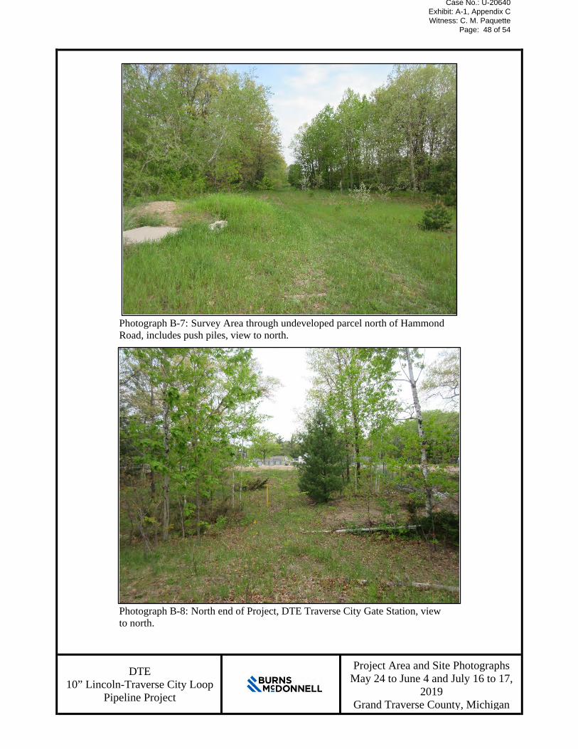
DTE 10” Lincoln-Traverse City Loop
Pipeline Project
Project Area and Site Photographs May 24 to June 4 and July 16 to 17,
2019 Grand Traverse County, Michigan
Photograph B-7: Survey Area through undeveloped parcel north of Hammond Road, includes push piles, view to north.
Photograph B-8: North end of Project, DTE Traverse City Gate Station, view to north.
Case No.: U-20640 Exhibit: A-1, Appendix C Witness: C. M. Paquette
Page: 48 of 54
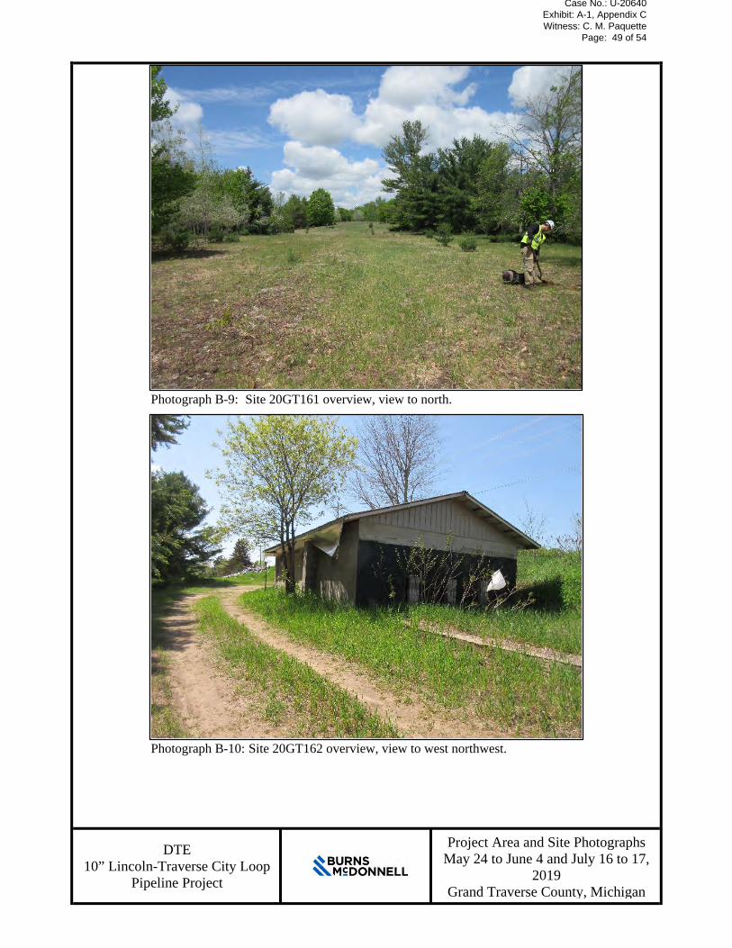
DTE 10” Lincoln-Traverse City Loop
Pipeline Project
Project Area and Site Photographs May 24 to June 4 and July 16 to 17,
2019 Grand Traverse County, Michigan
Photograph B-9: Site 20GT161 overview, view to north.
Photograph B-10: Site 20GT162 overview, view to west northwest.
Case No.: U-20640 Exhibit: A-1, Appendix C Witness: C. M. Paquette
Page: 49 of 54

DTE 10” Lincoln-Traverse City Loop
Pipeline Project
Project Area and Site Photographs May 24 to June 4 and July 16 to 17,
2019 Grand Traverse County, Michigan
Photograph B-11: Site DTE-2 foundation, view to north.
Photograph B-12: Site DTE-2, showing original landform to the north (right) of the foundation, view to west.
Case No.: U-20640 Exhibit: A-1, Appendix C Witness: C. M. Paquette
Page: 50 of 54

APPENDIX C - SITE MAPS
Case No.: U-20640 Exhibit: A-1, Appendix C Witness: C. M. Paquette
Page: 51 of 54
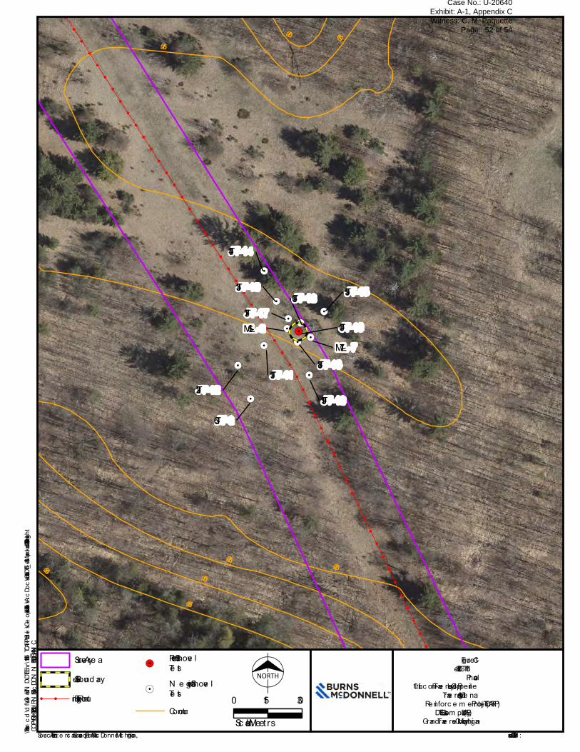
Issue d: 9/20/2019
Figure C-1Site 20GT161Phase I
10” Linc oln-Trave rse City Loop Pipe lineTrave rse City-Alpe na
Re inforc e m e nt Proje c t (TCARP)DTE Gas Com pany (DTE)
Grand Trave rse County, Mic higan
!!
!!
!!
!!
!!
!!
!!
!!
!!
!!
!!
!!
!!
!!
!!
!!
!!
!!
!!
!!
!!
!!
!!
!!
!!
!!
!!
!!
!!
!!
!!
!!
!!
!!
!!
!!
!!
!!
!!
!!
!!
!!
!!
!!
!!
!!
!!
!!
!!
!!
!!
!!
!.
!.
!.
!.
!.
!.
!.!. !.
!.
!.
!.!.
ML-7ML-6
JT-6JT-19
JT-18
JT-16JT-17
JT-15
JT-14
JT-12
JT-13
JT-11
JT-10
276 m273 m
270 m
267 m
264 m
273 m
276 m270 m
NORTH
0 3015Scale in Me te rs
Surve y Are aSite Boundary
!! !! Existing Route
!.Positive Shove lTe st
!.N e gative Shove lTe stContour
COPYRIGHT © 2019 BURNS & McDONNELL MICHIGAN, INC.
Sourc e : Esri, Am e ric an Surve y, and Burns & McDonne ll Mic higan, Inc.Path: \\bmcd\dfs\Clients\TND\DTEEnr\115495_TCARP\Studies\Geospatial\DataFiles\ArcDocs\Cultural\DTE-1_Site Map.mxd kdboatright 9/20/2019
Case No.: U-20640 Exhibit: A-1, Appendix C Witness: C. M. Paquette
Page: 52 of 54

COPYRIGHT © 2019 BURNS & McDONNELL MICHIGAN, INC.
Source : Es ri, Am e rica n Surve y, a nd Burns & McDonne ll Michig a n, Inc. Is s ue d : 9/20/2019Path: \\bmcd\dfs\Clients\TND\DTEEnr\115495_TCARP\Studies\Geospatial\DataFiles\ArcDocs\Cultural\DTE-2_Site Map.mxd kdboatright 9/20/2019
Fig ure C-2Site 20GT162Pha s e I
10” Lincoln-Tra ve rs e City Loop Pipe lineTra ve rs e City-Alpe na
Re inforce m e nt Proje ct (TCARP)DTE Ga s Com pa ny (DTE)
Gra nd Tra ve rs e County, Michig a n
!!
!!
!!
!!
!!
!!
!!
!!
!!
!!
!!
!!
!!
!!
!!
!!
!!
!!
!!
!!
!!
!!
!!
!!
!!
!!
!!
!!
!!
!!
!!
!!
!!
!!
!!
!!
!!
!!
!!
!!
!!
!!
!!
!!
!!
!!
!!
!!
!!
!.!.!.
JT-22
JT-21
JT-20
S Rusch Rd
From
holz
Rd
279 m
276 m
273 m
279 m
273 m
NORTHSurve y Are aSite Bound a ry
!! !! Exis ting RouteFound a tion
!.Pos itive Shove lTe s t
!.Ne g a tive Shove lTe s tRoa dContour
0 3015Sca le in Mete rs
Case No.: U-20640 Exhibit: A-1, Appendix C Witness: C. M. Paquette
Page: 53 of 54

Burns & McDonnell World Headquarters 9400 Ward Parkway
Kansas City, MO 64114 O 816-333-9400 F 816-333-3690
www.burnsmcd.com
Case No.: U-20640 Exhibit: A-1, Appendix C Witness: C. M. Paquette
Page: 54 of 54


![Understanding Quantum Phase Transitions - CRC Press · Understanding quantum phase transitions / [edited by] Lincoln Carr. p. cm. -- (Condensed matter physics) Summary: “Exploring](https://img.pdfslide.us/doc/110x75/5ec6bb57f6cb0b602e3cab3e/understanding-quantum-phase-transitions-crc-press-understanding-quantum-phase.jpg)


![Understanding Quantum Phase Transitions - …...Understanding quantum phase transitions / [edited by] Lincoln Carr. p. cm. -- (Condensed matter physics) Summary: “Exploring a steadily](https://img.pdfslide.us/doc/110x75/5f0c13fb7e708231d433a263/understanding-quantum-phase-transitions-understanding-quantum-phase-transitions.jpg)