Embed Size (px)
Citation preview
i
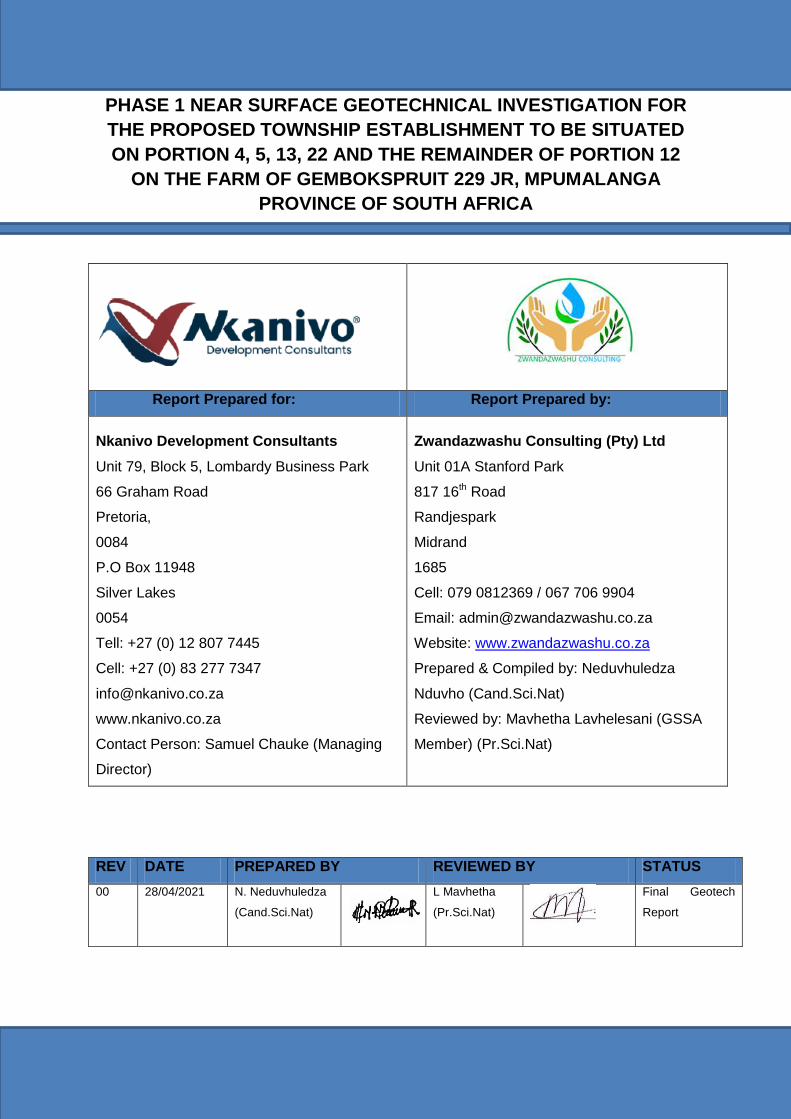
PHASE 1 NEAR SURFACE GEOTECHNICAL INVESTIGATION FOR
THE PROPOSED TOWNSHIP ESTABLISHMENT TO BE SITUATED
ON PORTION 4, 5, 13, 22 AND THE REMAINDER OF PORTION 12
ON THE FARM OF GEMBOKSPRUIT 229 JR, MPUMALANGA
PROVINCE OF SOUTH AFRICA
Report Prepared for: Report Prepared by:
Nkanivo Development Consultants
Unit 79, Block 5, Lombardy Business Park
66 Graham Road
Pretoria,
0084
P.O Box 11948
Silver Lakes
0054
Tell: +27 (0) 12 807 7445
Cell: +27 (0) 83 277 7347
www.nkanivo.co.za
Contact Person: Samuel Chauke (Managing
Director)
Zwandazwashu Consulting (Pty) Ltd
Unit 01A Stanford Park
817 16th Road
Randjespark
Midrand
1685
Cell: 079 0812369 / 067 706 9904
Email: [email protected]
Website: www.zwandazwashu.co.za
Prepared & Compiled by: Neduvhuledza
Nduvho (Cand.Sci.Nat)
Reviewed by: Mavhetha Lavhelesani (GSSA
Member) (Pr.Sci.Nat)
REV DATE PREPARED BY REVIEWED BY STATUS
00 28/04/2021 N. Neduvhuledza
(Cand.Sci.Nat)
L Mavhetha
(Pr.Sci.Nat)
Final Geotech
Report
Phase 1 near surface geotechnical investigation for the proposed township establishment on portion 4, 5, 13, 22 and the remainder of portion 12 of the farm Gemsbokspruit 229 JR, Mpumalanga province of South Africa
ii | P a g e
TABLE OF CONTENTS
LIST OF FIGURES ............................................................................................................... iii
LIST OF TABLES .................................................................................................................. iii
ACRONYMS AND ABBREVIATIONS ................................................................................... iv
EXECUTIVE SUMMARY ...................................................................................................... v
1. INTRODUCTION ........................................................................................................... 1
2. SCOPE OF THE REPORT ............................................................................................ 1
3. INFORMATION USED IN THIS STUDY ........................................................................ 2
4. SITE DESCRIPTION ..................................................................................................... 3
4.1. Site Location ........................................................................................................... 3
4.2. Climate ................................................................................................................... 4
4.3. Land use ................................................................................................................. 5
4.4. Topography............................................................................................................. 5
5. GEOLOGY ..................................................................................................................... 5
6. SOIL PROFILE .............................................................................................................. 6
7. METHOD OF INVESTIGATION ..................................................................................... 8
7.1. Desktop Study ........................................................................................................ 8
7.2. Field Mapping ......................................................................................................... 8
7.3. Inspection of Test Pits ............................................................................................. 8
8. LABORATORY RESULTS ........................................................................................... 10
9. HYDROGEOLOGY ...................................................................................................... 14
9.1. Drainage patterns ................................................................................................. 14
10. GEOHAZARDS ........................................................................................................ 14
10.1. Seismic activities ............................................................................................... 14
10.2. Ground subsidence ........................................................................................... 16
10.3. Sinkhole formation ............................................................................................. 16
10.4. Landslides and mudslides ................................................................................. 17
11. GEOTECHNICAL EVALUATION .............................................................................. 17
11.1. Expansive soils.................................................................................................. 19
11.2. Collapsible soils ................................................................................................. 19
11.3. Compressible soils ............................................................................................ 19
11.4. Soil site classification......................................................................................... 20
11.5. Excavation Classification ................................................................................... 20
Phase 1 near surface geotechnical investigation for the proposed township establishment on portion 4, 5, 13, 22 and the remainder of portion 12 of the farm Gemsbokspruit 229 JR, Mpumalanga province of South Africa
iii | P a g e
11.6. Stability of excavations sidewalls ....................................................................... 20
11.7. Construction material suitability ......................................................................... 21
11.8. Construction Monitoring ..................................................................................... 21
12. CONCLUSION AND RECOMMENDATIONS ........................................................... 21
12.1. Foundations ...................................................................................................... 21
12.1.1. Foundations on residual soils ......................................................................... 21
12.2.2. Foundations on a slightly weathered Granite .................................................... 22
13. REPORT PROVISIONS ........................................................................................... 22
14. REFFERENCE ......................................................................................................... 24
15. APPENDIX A: THE SITE PHOTOS .......................................................................... 25
16. APPENDIX B: LABORATORY RESULTS ................................................................ 37
17. APPENDIX C: SOIL PROFILES ............................................................................... 38
LIST OF FIGURES
Figure 1: Locality map of the site .......................................................................................... 3
Figure 2: Layout Plan of the proposed development ............................................................. 4
Figure 3: Geological setting of the site .................................................................................. 6
Figure 4: Test pit positions .................................................................................................... 9
Figure 5: Seismic hazard map of South Africa .................................................................... 15
Figure 6: Siesmic Hazard Zones of South Africa (SANS 10160-4, 2011) ............................ 16
LIST OF TABLES
Table 1: Summary of the test pit profiles ............................................................................... 7
Table 2: Summary of the foundation indicator test results ................................................... 11
Table 3: Summary of the CBR test results .......................................................................... 13
Table 4: Residential site class designations ........................................................................ 17
Table 5: Geotechnical Classification for Urban Development (GFSH-2 Document) ............. 18

Phase 1 near surface geotechnical investigation for the proposed township establishment on portion 4, 5, 13, 22 and the remainder of portion 12 of the farm Gemsbokspruit 229 JR, Mpumalanga province of South Africa
iv | P a g e
ACRONYMS AND ABBREVIATIONS
AASHTO : American Association of State Highway and Transportation Officials
ARS : Acceleration Response Spectra
DCP : Dynamic Cone Penetrometer
DSI : Dolomite Stability Investigation
CBR : Californian Bearing Ratio
M : Meter
MDD : Maximum Dry Density
MBGL : Meters Below Ground Level
NHBRC : The National Home Builders Registration Council
OMC : Optimum Moisture Content
CL : Clay
TP : Trial Pit
TLB : Tractor Loader Backhoe
SANS : South African National Standards
SANAS : South African National Accreditation System
SACNASP : South African Council Natural Scientific Professions
USC : Unified Soil Classification
Phase 1 near surface geotechnical investigation for the proposed township establishment on portion 4, 5, 13, 22 and the remainder of portion 12 of the farm Gemsbokspruit 229 JR, Mpumalanga province of South Africa
v | P a g e
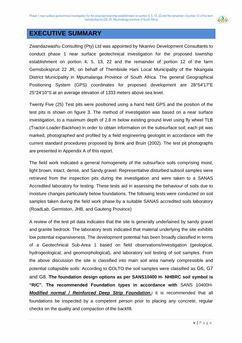
EXECUTIVE SUMMARY
Zwandazwashu Consulting (Pty) Ltd was appointed by Nkanivo Development Consultants to
conduct phase 1 near surface geotechnical investigation for the proposed township
establishment on portion 4, 5, 13, 22 and the remainder of portion 12 of the farm
Gemsbokspruit 22 JR, on behalf of Thembisile Hani Local Municipality of the Nkangala
District Municipality in Mpumalanga Province of South Africa. The general Geographical
Positioning System (GPS) coordinates for proposed development are 28°54'17"E
25°24'10"S at an average elevation of 1333 meters above sea level.
Twenty Five (25) Test pits were positioned using a hand held GPS and the position of the
test pits is shown on figure 3. The method of investigation was based on a near surface
investigation, to a maximum depth of 2.8 m below existing ground level using fly wheel TLB
(Tractor-Loader-Backhoe) in order to obtain information on the subsurface soil; each pit was
marked, photographed and profiled by a field engineering geologist in accordance with the
current standard procedures proposed by Brink and Bruin (2002). The test pit photographs
are presented in Appendix A of this report.
The field work indicated a general homogeneity of the subsurface soils comprising moist,
light brown, intact, dense, and Sandy gravel. Representative disturbed subsoil samples were
retrieved from the inspection pits during the investigation and were taken to a SANAS
Accredited laboratory for testing. These tests aid in assessing the behaviour of soils due to
moisture changes particularly below foundations. The following tests were conducted on soil
samples taken during the field work phase by a suitable SANAS accredited soils laboratory
(RoadLab, Germiston, JHB, and Gauteng Province)
A review of the test pit data indicates that the site is generally underlained by sandy gravel
and granite bedrock. The laboratory tests indicated that material underlying the site exhibits
low potential expansiveness. The development potential has been broadly classified in terms
of a Geotechnical Sub-Area 1 based on field observations/investigation (geological,
hydrogeological, and geomorphological), and laboratory soil testing of soil samples. From
the above discussion the site is classified into main soil area namely compressible and
potential collapsible soils: According to COLTO the soil samples were classified as G6, G7
and G8. The foundation design options as per SANS10400 H- NHBRC soil symbol is
“R/C”. The recommended Foundation types in accordance with SANS 10400H-
Modified normal / Reinforced Deep Strip Foundation.I it is recommended that all
foundations be inspected by a competent person prior to placing any concrete, regular
checks on the quality and compaction of the backfill.
1
1. INTRODUCTION
Zwandazwashu Consulting (Pty) Ltd was appointed by Nkanivo Development Consultants to
conduct phase 1 near surface geotechnical investigation for the proposed township
establishment on portion 4, 5, 13, 22 and the remainder of portion 12 of the farm
Gemsbokspruit 22 JR, on behalf of Thembisile Hani Local Municipality of the Nkangala
District Municipality in Mpumalanga Province of South Africa.
2. SCOPE OF THE REPORT
This report evaluates the geotechnical characteristics associated with the underlying geology
and any geotechnical constraints that might affect structural integrity of the subject property.
However, it is also essential to Identify engineering properties’ potential influence on the
design, construction and operation of the intended infrastructures. It must be noted that there
were no infrastructures erected on site during the course of the investigation, thus, the site is
a Greenfield.
The main objective of the investigation was aimed at defining the founding materials and
establishing broader geotechnical conditions and their suitability to the establishment of
township.
The following are some of the objectives of the conducted geotechnical investigation:
To provide an overview of the geology of the site
To establish in broad terms, the nature and relevant engineering properties of the
upper soil and rock strata underlying the site.
To ascertain the soil chemistry including pH determination and electrical conductivity
tests.
Assess the groundwater level encountered below the site.
To comment on suitable excavation procedures for the installation of services.
To present general foundation recommendations for the proposed development.
To comment on any other geotechnical aspects as these may affect the
development.
Potential geotechnical limiting factors by determining the behavior and suitability of
soil/rocks and their effects on the intended development;
Assess excavation conditions

Phase 1 near surface geotechnical investigation for the proposed township establishment on portion 4, 5, 13, 22 and the remainder of portion 12 of the farm Gemsbokspruit 229 JR, Mpumalanga province of South Africa
2 | P a g e
Determine the presence or occurrence of groundwater from the surface to a
maximum depth of 3 meters.
Classification of the site material according to the TRH14 classification system
The geotechnical investigation was carried out in accordance with SAIEG and GFSH-2
guidelines and all NHBRC Home Building Manuals. This report presents findings on the
geotechnical properties and characteristics of the surficial soils underlying the site, the
investigation methodology and discusses recommendations for earthworks, drainage, ease
of excavation and foundations.
3. INFORMATION USED IN THIS STUDY
The geotechnical investigation commenced with a desktop study using the existing
geotechnical databases and Maps
The following information was reviewed and consulted during the site investigation:
Geological Map of the GSO: Scale 1: 100 000 Sheet – Geological series 2528BD
Expansive Roadbed Treatment for Southern Africa: D J Weston (1980) 4th Int. Conf.
on Expansive Soils, Vol. 1, Denver pp 339-360;
National Home Builders Registration Council: Home Builders Manual 2015;
Technical Recommendations for Highways – TRH14 Guidelines for Road
Construction Materials by the National Institute for Transport and road research of
the Council for Scientific and Industrial Research, (1985);
SAICE’s Guidelines for Urban Engineering Geological Investigations;
Schwartz, K. (1985). Collapsible soils. The Civil Engineer in South Africa, July, p379-
393 and;
New, M., Lister, D., Hulme, M. and Makin, I., 2002: A high-resolution data set of
surface climate over global land areas. Climate Research 21:1-25
Site plans provided by the client
South African Weather Service
Phase 1 near surface geotechnical investigation for the proposed township establishment on portion 4, 5, 13, 22 and the remainder of portion 12 of the farm Gemsbokspruit 229 JR, Mpumalanga province of South Africa
3 | P a g e
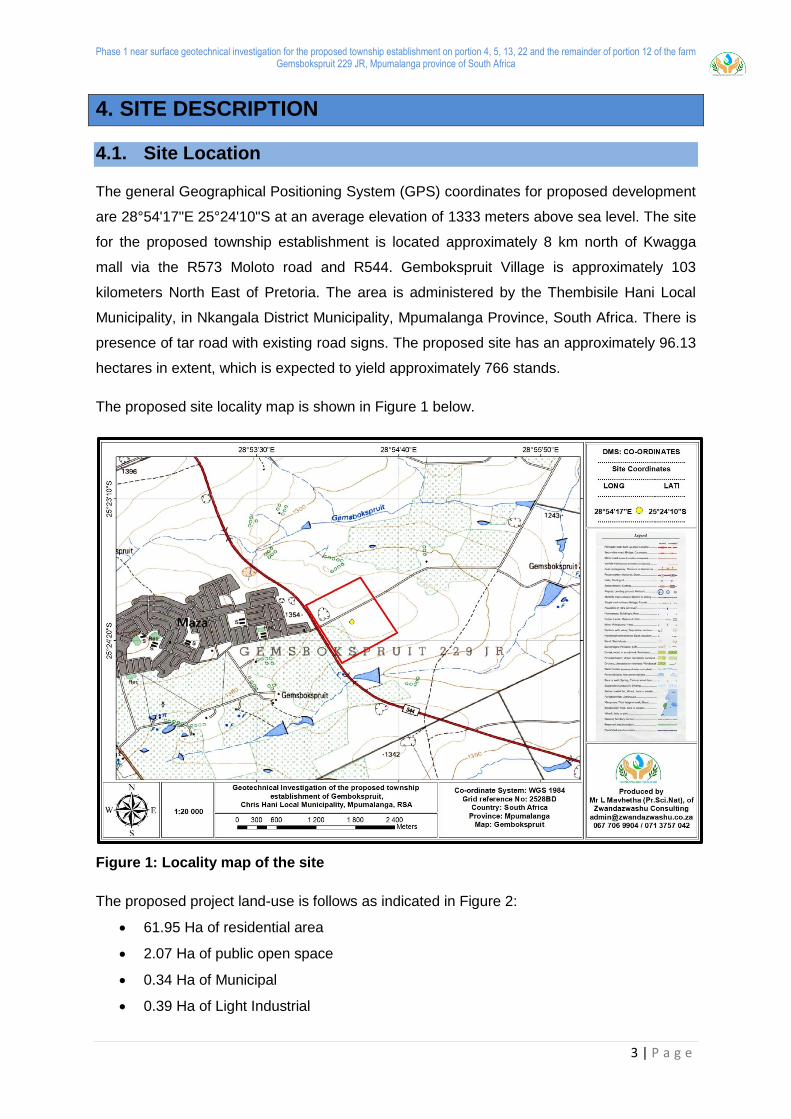
4. SITE DESCRIPTION
4.1. Site Location
The general Geographical Positioning System (GPS) coordinates for proposed development
are 28°54'17"E 25°24'10"S at an average elevation of 1333 meters above sea level. The site
for the proposed township establishment is located approximately 8 km north of Kwagga
mall via the R573 Moloto road and R544. Gembokspruit Village is approximately 103
kilometers North East of Pretoria. The area is administered by the Thembisile Hani Local
Municipality, in Nkangala District Municipality, Mpumalanga Province, South Africa. There is
presence of tar road with existing road signs. The proposed site has an approximately 96.13
hectares in extent, which is expected to yield approximately 766 stands.
The proposed site locality map is shown in Figure 1 below.
Figure 1: Locality map of the site
The proposed project land-use is follows as indicated in Figure 2:
61.95 Ha of residential area
2.07 Ha of public open space
0.34 Ha of Municipal
0.39 Ha of Light Industrial
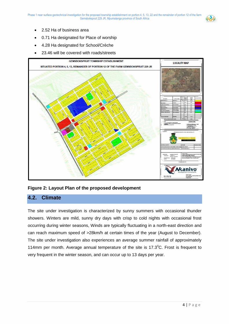
Phase 1 near surface geotechnical investigation for the proposed township establishment on portion 4, 5, 13, 22 and the remainder of portion 12 of the farm Gemsbokspruit 229 JR, Mpumalanga province of South Africa
4 | P a g e
2.52 Ha of business area
0.71 Ha designated for Place of worship
4.28 Ha designated for School/Crèche
23.46 will be covered with roads/streets
Figure 2: Layout Plan of the proposed development
4.2. Climate
The site under investigation is characterized by sunny summers with occasional thunder
showers. Winters are mild, sunny dry days with crisp to cold nights with occasional frost
occurring during winter seasons, Winds are typically fluctuating in a north-east direction and
can reach maximum speed of >28km/h at certain times of the year (August to December).
The site under investigation also experiences an average summer rainfall of approximately
114mm per month. Average annual temperature of the site is 17.30C. Frost is frequent to
very frequent in the winter season, and can occur up to 13 days per year.
Phase 1 near surface geotechnical investigation for the proposed township establishment on portion 4, 5, 13, 22 and the remainder of portion 12 of the farm Gemsbokspruit 229 JR, Mpumalanga province of South Africa
5 | P a g e
4.3. Land use
The area of interest for geotechnical investigation is used for grazing of domestic animals.
Site is suited 30km south of Kwaggafontein, a township with a well-established residential
area, schools, medical facilities and a shopping mall.
4.4. Topography
It was noted during site observation survey and actual geotechnical fieldwork procedures
that the site topography is slightly steep from north to south direction. This was expected
since the engineering geologist conducted geological and topographic analysis using
ArcGISpro software prior site visit. It must also be noted that the layout plan of the proposed
development as indicated in Figure 2 showed that the site is slightly steep. During the
investigation the proposed site was accessible by a four-wheeled drive vehicle.
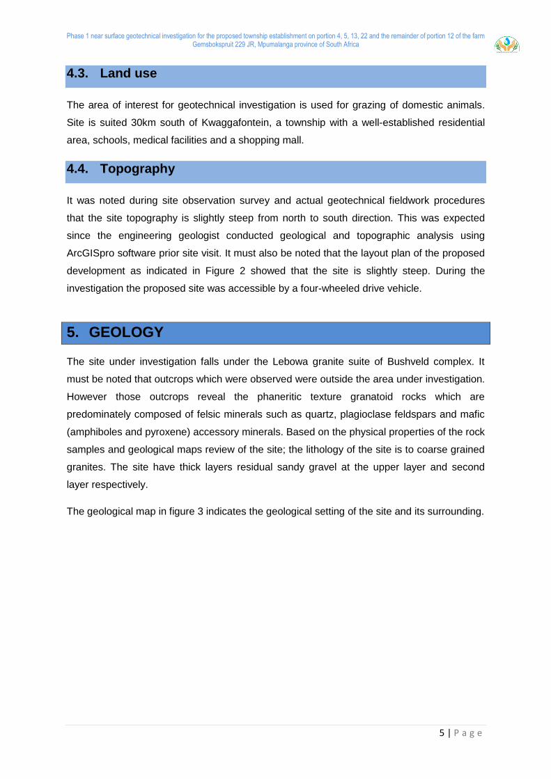
5. GEOLOGY
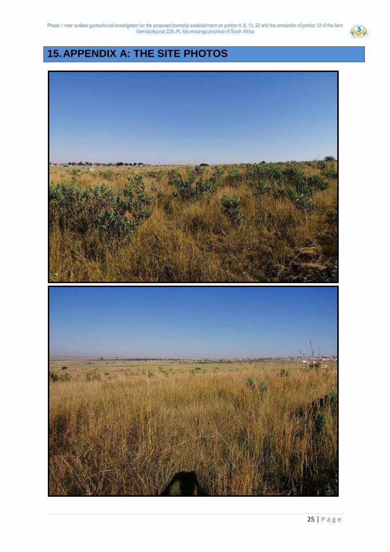
The site under investigation falls under the Lebowa granite suite of Bushveld complex. It
must be noted that outcrops which were observed were outside the area under investigation.
However those outcrops reveal the phaneritic texture granatoid rocks which are
predominately composed of felsic minerals such as quartz, plagioclase feldspars and mafic
(amphiboles and pyroxene) accessory minerals. Based on the physical properties of the rock
samples and geological maps review of the site; the lithology of the site is to coarse grained
granites. The site have thick layers residual sandy gravel at the upper layer and second
layer respectively.
The geological map in figure 3 indicates the geological setting of the site and its surrounding.
Phase 1 near surface geotechnical investigation for the proposed township establishment on portion 4, 5, 13, 22 and the remainder of portion 12 of the farm Gemsbokspruit 229 JR, Mpumalanga province of South Africa
6 | P a g e
Figure 3: Geological setting of the site
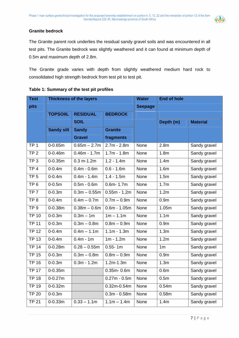
6. SOIL PROFILE
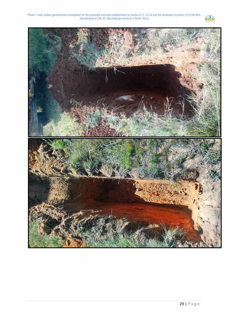
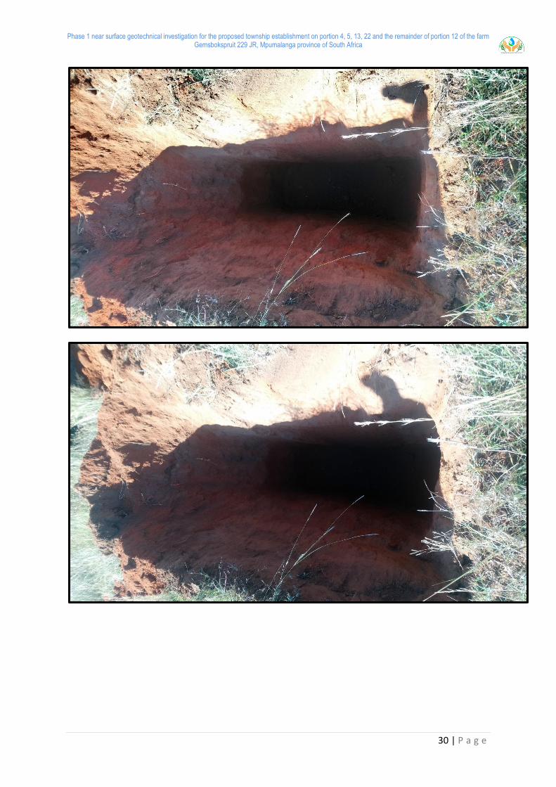
Several soil strata that were encountered in the test pits during the field investigations are
given below. Moreover, the summary of the test pit profiles is shown in Table 1.
Top soils
The topsoil is characterised by an upper stratum of sandy silt which have an average
thickness of 0.37m in the range 0 to 0.65m below ground level. It is characterised by soils
which can typically be described as “Slightly moist, greyish, intact,_Loose to Medium dense,
~Sandy Silt.”
Residual soils
Residual soil was encountered in all test pits except TP17, TP18, TP19, and TP20 with an
average thickness of 0.93m in the range 0.25 to 2.7m below ground level.
These soils originate from the in-situ weathering of the Granite parent rock which is
underlined which underlines the site. This stratum is typically described as “Moist, light
brown, intact, _Dense, boulders, and ~ Sandy gravel”
Phase 1 near surface geotechnical investigation for the proposed township establishment on portion 4, 5, 13, 22 and the remainder of portion 12 of the farm Gemsbokspruit 229 JR, Mpumalanga province of South Africa
7 | P a g e
Granite bedrock
The Granite parent rock underlies the residual sandy gravel soils and was encountered in all
test pits. The Granite bedrock was slightly weathered and it can found at minimum depth of
0.5m and maximum depth of 2.8m.
The Granite grade varies with depth from slightly weathered medium hard rock to
consolidated high strength bedrock from test pit to test pit.
Table 1: Summary of the test pit profiles
Test
pits
Thickness of the layers Water
Seepage
End of hole
TOPSOIIL RESIDUAL
SOIL
BEDROCK
Depth (m) Material
Sandy silt Sandy
Gravel
Granite
fragments
TP 1 0-0.65m 0.65m – 2.7m 2.7m - 2.8m None 2.8m Sandy gravel
TP 2 0-0.46m 0.46m - 1.7m 1.7m - 1.8m None 1.8m Sandy gravel
TP 3 0-0.35m 0.3 m-1.2m 1.2 - 1.4m None 1.4m Sandy gravel
TP 4 0-0.4m 0.4m - 0.6m 0.6 - 1.6m None 1.6m Sandy gravel
TP 5 0-0.4m 0.4m - 1.4m 1.4 - 1.5m None 1.5m Sandy gravel
TP 6 0-0.5m 0.5m - 0.6m 0.6m- 1.7m None 1.7m Sandy gravel
TP 7 0-0.3m 0.3m – 0.55m 0.55m - 1.2m None 1.2m Sandy gravel
TP 8 0-0.4m 0.4m – 0.7m 0.7m – 0.9m None 0.9m Sandy gravel
TP 9 0-0.38m 0.38m – 0.6m 0.6m - 1.05m None 1.05m Sandy gravel
TP 10 0-0.3m 0.3m – 1m 1m – 1.1m None 1.1m Sandy gravel
TP 11 0-0.3m 0.3m – 0.8m 0.8m – 0.9m None 0.9m Sandy gravel
TP 12 0-0.4m 0.4m – 1.1m 1.1m - 1.3m None 1.3m Sandy gravel
TP 13 0-0.4m 0.4m - 1m 1m - 1.2m None 1.2m Sandy gravel
TP 14 0-0.28m 0.28 – 0.55m 0.55- 1m None 1m Sandy gravel
TP 15 0-0.3m 0.3m – 0.8m 0.8m – 0.9m None 0.9m Sandy gravel
TP 16 0-0.3m 0.3m - 1.2m 1.2m-1.3m None 1.3m Sandy gravel
TP 17 0-0.35m 0.35m- 0.6m None 0.6m Sandy gravel
TP 18 0-0.27m 0.27m - 0.5m None 0.5m Sandy gravel
TP 19 0-0.32m 0.32m-0.54m None 0.54m Sandy gravel
TP 20 0-0.3m 0.3m - 0.58m None 0.58m Sandy gravel
TP 21 0-0.33m 0.33 – 1.1m 1.1m – 1.4m None 1.4m Sandy gravel

Phase 1 near surface geotechnical investigation for the proposed township establishment on portion 4, 5, 13, 22 and the remainder of portion 12 of the farm Gemsbokspruit 229 JR, Mpumalanga province of South Africa
8 | P a g e
TP 22 0-0.48m 0.48m – 0.7m 0.7m - 1.48m None 1.48m Sandy gravel
TP 23 0-0.48m 0.48m – 0.7m 0.7m - 1.48m None 1.48m Sandy gravel
TP 24 0-0.4m 0.4m – 0.7m 0.7m - 1.4m None 1.4m Sandy gravel
TP 25 0-0.25m 0.25m – 0.9m 0.9m - 1.1m None 1.1m Sandy gravel
7. METHOD OF INVESTIGATION
The fieldwork was undertaken on the 04 April 2021 and comprised of the following:
Desktop study
Walk over survey and pit excavation
Test Pits
Soil Sampling for laboratory tests purposes
7.1. Desktop Study
The desk study comprises the review of existing regional, site and surface information.
Sources of information include:
Topographic maps, geological data such as lithology of nearby rock outcrops,
landforms and erosion patterns;
Existing geotechnical reports prepared for areas in close proximity to the site;
Data on seismic aspects, such as ground motion and liquefaction potential.
7.2. Field Mapping
A walk-over survey was carried out on the proposed site to obtain as much information as
possible of the subsurface conditions from existing soil. A granite rock outcrops were
identified during this investigation other field testing discussed below.
7.3. Inspection of Test Pits
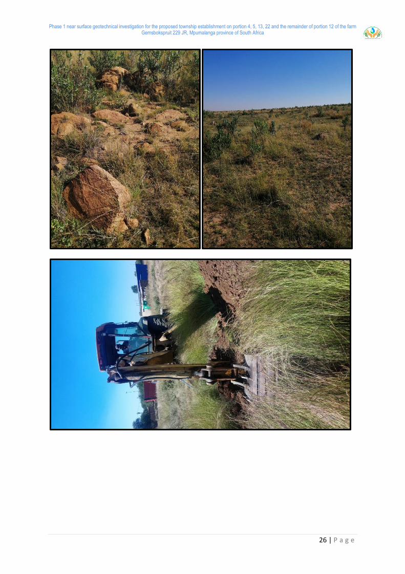
The field investigation was conducted on the 09 April 2021. Based on the “Site Investigation
Code of Practice” (SAICE Geotechnical Division, 2010), which provides standards for
“acceptable engineering practice”, a total of 25 (Twenty Five) test pits were planned for the
proposed development.
This chapter of the report describes the field work and activities that were conducted in order
to assess the geotechnical conditions at the proposed site. Twenty Five (25) Test pits were
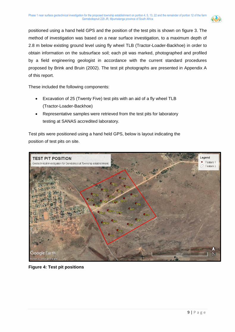
Phase 1 near surface geotechnical investigation for the proposed township establishment on portion 4, 5, 13, 22 and the remainder of portion 12 of the farm Gemsbokspruit 229 JR, Mpumalanga province of South Africa
9 | P a g e
positioned using a hand held GPS and the position of the test pits is shown on figure 3. The
method of investigation was based on a near surface investigation, to a maximum depth of
2.8 m below existing ground level using fly wheel TLB (Tractor-Loader-Backhoe) in order to
obtain information on the subsurface soil; each pit was marked, photographed and profiled
by a field engineering geologist in accordance with the current standard procedures
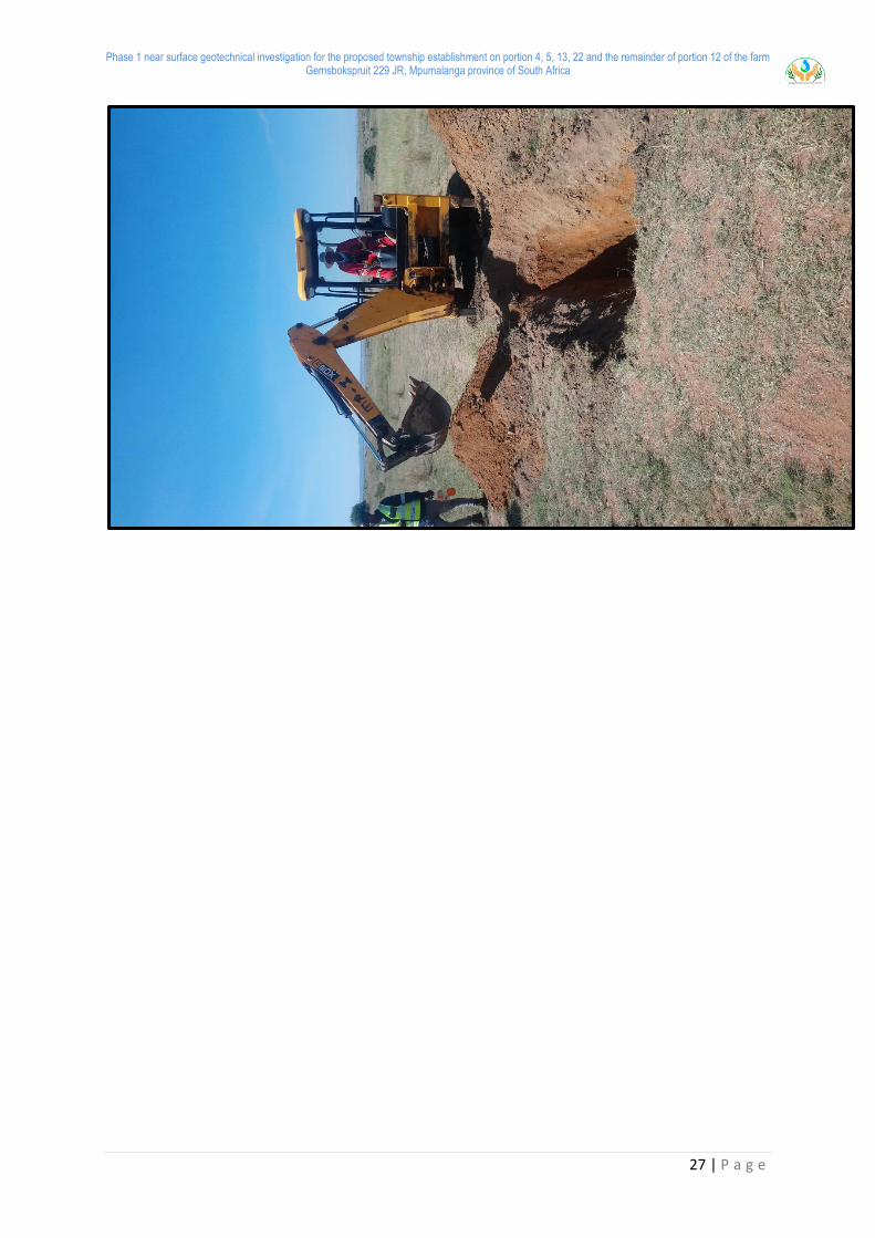
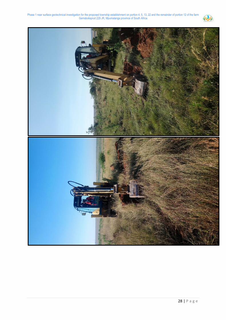
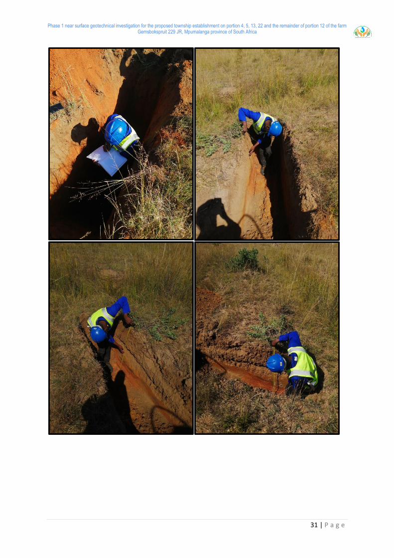
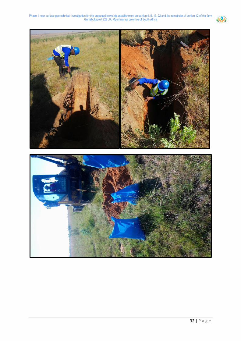
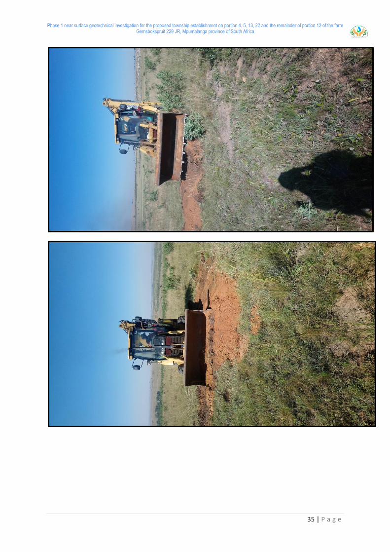
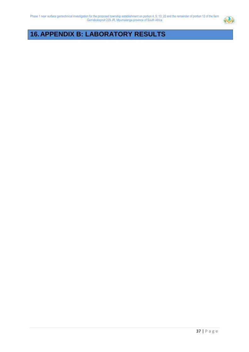
proposed by Brink and Bruin (2002). The test pit photographs are presented in Appendix A
of this report.
These included the following components:
Excavation of 25 (Twenty Five) test pits with an aid of a fly wheel TLB
(Tractor-Loader-Backhoe)
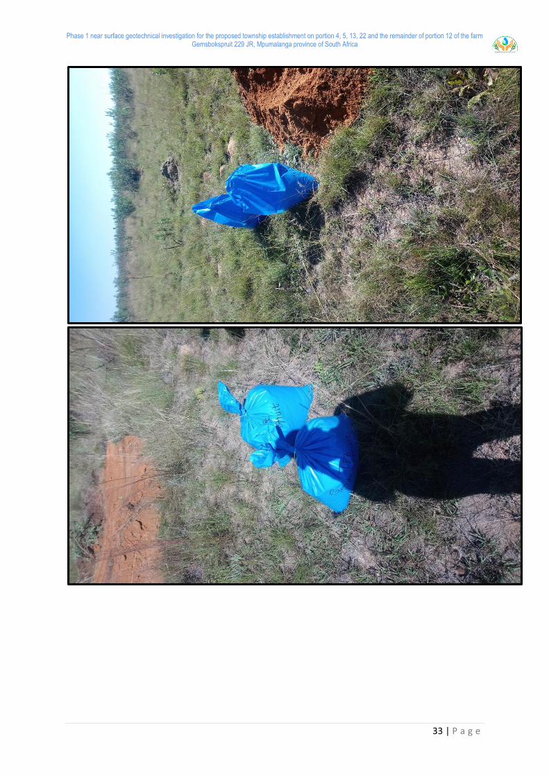
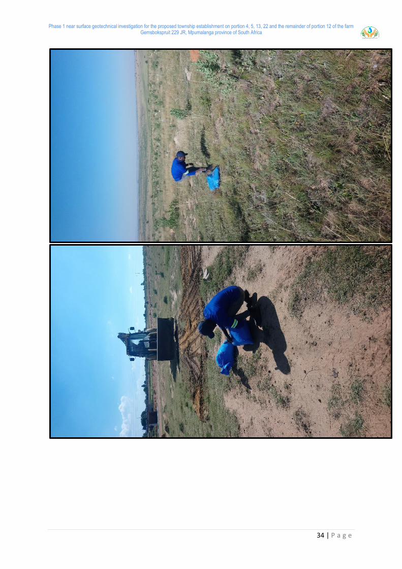
Representative samples were retrieved from the test pits for laboratory
testing at SANAS accredited laboratory.
Test pits were positioned using a hand held GPS, below is layout indicating the
position of test pits on site.
Figure 4: Test pit positions
Phase 1 near surface geotechnical investigation for the proposed township establishment on portion 4, 5, 13, 22 and the remainder of portion 12 of the farm Gemsbokspruit 229 JR, Mpumalanga province of South Africa
10 | P a g e
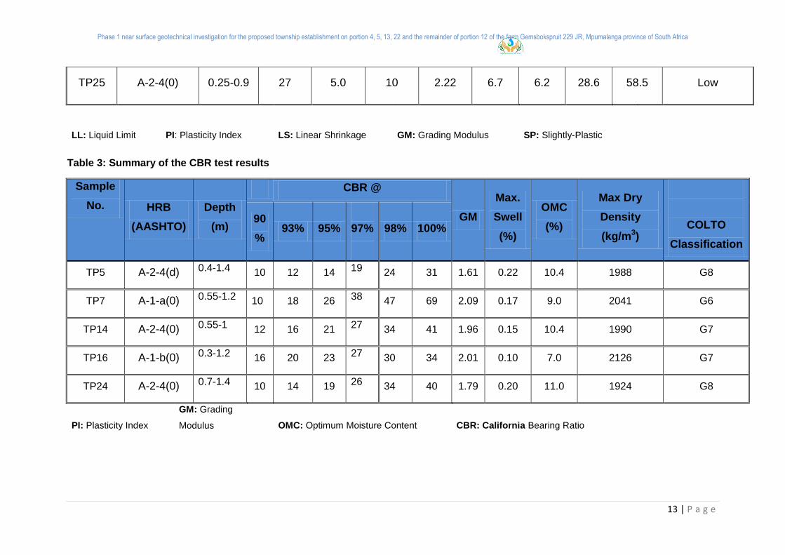
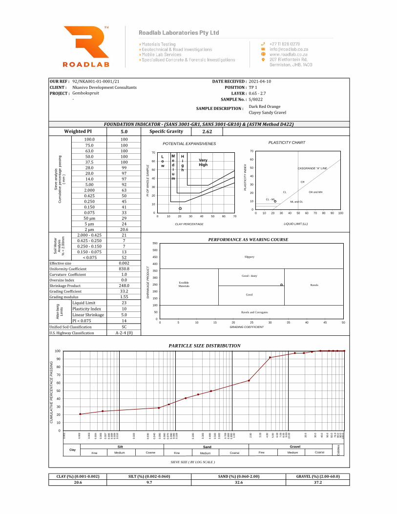
8. LABORATORY RESULTS
The field work indicated a general homogeneity of the subsurface soils comprising moist,
light brown, intact, dense, and Sandy gravel. Representative disturbed subsoil samples were
retrieved from the inspection pits during the investigation and were taken to a SANAS
Accredited laboratory for testing. These tests aid in assessing the behaviour of soils due to
moisture changes particularly below foundations.
The following tests were conducted on soil samples taken during the field work phase by a
suitable SANAS accredited soils laboratory (RoadLab, Germiston, JHB, and Gauteng
Province)
Standard foundation indicator and CBR tests were conducted on disturbed soil samples in
order to determine its composition, to evaluate the heave and compressibility potential of
these soils, and to calculate the maximum heave and/or differential settlement that can be
expected. The following tests were conducted for all four sites:
The following tests were conducted:
21 Atterberg Limits (plastic limit, liquid limit and plasticity index);
21 Grading analysis and;
5 MOD and 5 CBR,
3 pH and 3 Conductivity
The laboratory tests were conducted in order to assist with the classification, description,
and delineation of homogenous zones. The results of the foundation indicator, MOD, CBR,
pH and Conductivity tests are presented in Appendix B and are summarized in Table 2 and
Table 3 respectively.

11
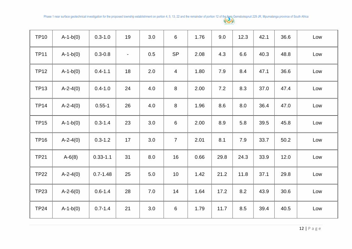
Table 2: Summary of the foundation indicator test results
Sample
No.
HRB
(AASHTO)
Depth
(m)
Atterberg Limit GM
Grading analysis (%) Potential
expansiveness LL % LS % PI % Clay Silt Sand Gravel
TP01 A-2-4(0) 0.65-2.7 23 5.0 10 1.55 20.6 9.7 32.6 37.2 Low
TP02 A-2-4(0) 0.46-1.7 27 4.0 8 1.53 12.0 13.5 44.1 30.4 Low
TP03 A-2-4(0) 0.35-1.2 24 5.0 10 1.88 11.1 7.8 41.9 39.1 Low
TP04 A-2-4(0) 0.6-1.6 22 4.0 8 1.66 11.1 10.9 48.8 29.2 Low
TP05 A-2-4(0) 0.4-1.4 23 4.0 8 1.62 14.0 11.4 41.2 33.2 Low
TP06 A-1-b(0) 0.5-1.6 18 2.0 4 1.71 9.0 8.1 56.6 26.3 Low
TP07 A-1-b(0) 0.55-1.2 17 2.0 4 2.09 4.9 6.8 39.4 48.9 Low
TP08 A-1-b(0) 0.4-0.7 16 1.0 2 2.10 5.6 5.8 40.8 47.8 Low
TP09 A-1-b(0) 0.6-1.05 22 3.0 6 1.89 8.7 10.0 37.6 43.8 Low
Phase 1 near surface geotechnical investigation for the proposed township establishment on portion 4, 5, 13, 22 and the remainder of portion 12 of the farm Gemsbokspruit 229 JR, Mpumalanga province of South Africa
12 | P a g e
TP10 A-1-b(0) 0.3-1.0 19 3.0 6 1.76 9.0 12.3 42.1 36.6 Low
TP11 A-1-b(0) 0.3-0.8 - 0.5 SP 2.08 4.3 6.6 40.3 48.8 Low
TP12 A-1-b(0) 0.4-1.1 18 2.0 4 1.80 7.9 8.4 47.1 36.6 Low
TP13 A-2-4(0) 0.4-1.0 24 4.0 8 2.00 7.2 8.3 37.0 47.4 Low
TP14 A-2-4(0) 0.55-1 26 4.0 8 1.96 8.6 8.0 36.4 47.0 Low
TP15 A-1-b(0) 0.3-1.4 23 3.0 6 2.00 8.9 5.8 39.5 45.8 Low
TP16 A-2-4(0) 0.3-1.2 17 3.0 7 2.01 8.1 7.9 33.7 50.2 Low
TP21 A-6(8) 0.33-1.1 31 8.0 16 0.66 29.8 24.3 33.9 12.0 Low
TP22 A-2-4(0) 0.7-1.48 25 5.0 10 1.42 21.2 11.8 37.1 29.8 Low
TP23 A-2-6(0) 0.6-1.4 28 7.0 14 1.64 17.2 8.2 43.9 30.6 Low
TP24 A-1-b(0) 0.7-1.4 21 3.0 6 1.79 11.7 8.5 39.4 40.5 Low
Phase 1 near surface geotechnical investigation for the proposed township establishment on portion 4, 5, 13, 22 and the remainder of portion 12 of the farm Gemsbokspruit 229 JR, Mpumalanga province of South Africa
13 | P a g e
TP25 A-2-4(0) 0.25-0.9 27 5.0 10 2.22 6.7 6.2 28.6 58.5 Low
LL: Liquid Limit PI: Plasticity Index LS: Linear Shrinkage GM: Grading Modulus SP: Slightly-Plastic
Table 3: Summary of the CBR test results
Sample
No. HRB
(AASHTO)
Depth
(m)
CBR @
GM
Max.
Swell
(%)
OMC
(%)
Max Dry
Density
(kg/m3)
COLTO
Classification
90
% 93% 95%
97%
98% 100%
TP5 A-2-4(d) 0.4-1.4 10 12 14 19 24 31 1.61 0.22 10.4 1988 G8
TP7 A-1-a(0) 0.55-1.2 10 18 26 38 47 69 2.09 0.17 9.0 2041 G6
TP14 A-2-4(0) 0.55-1 12 16 21 27 34 41 1.96 0.15 10.4 1990 G7
TP16 A-1-b(0) 0.3-1.2 16 20 23 27 30 34 2.01 0.10 7.0 2126 G7
TP24 A-2-4(0) 0.7-1.4 10 14 19 26 34 40 1.79 0.20 11.0 1924 G8
PI: Plasticity Index
GM: Grading
Modulus
OMC: Optimum Moisture Content CBR: California Bearing Ratio
Phase 1 near surface geotechnical investigation for the proposed township establishment on portion 4, 5, 13, 22 and the remainder of portion 12 of the farm Gemsbokspruit 229 JR, Mpumalanga province of South Africa
14 | P a g e
9. HYDROGEOLOGY
9.1. Drainage patterns
Natural ground water seepage was not encountered in any of the test pits and there is no
indication of temporary perched water tables in the soil profile, not even at the contact
between soil and bedrock. It is therefore expected that if temporary perched water was to at
the site, it would occur at bedrock level and only after unusually prolonged and substantial
rain. Groundwater seepage is not expected to be problematic at shallow depths on this site.
10. GEOHAZARDS
10.1. Seismic activities
Seismic-hazard can be described as being the physical effects of an earthquake or earth
tremor. Examples of such phenomenon include surface faulting, ground shaking and
liquefaction (Kijko A et al, 2004). According to the published (Council for Geosciences)
Seismic Hazard Identification Maps of South Africa, Site falls under an area with a 10 %
probabilistic of >0.12g (peak ground acceleration) being exceeded in a 50 year period. The
peak ground acceleration is the maximum acceleration of the ground shaking during an
earthquake.
For masonry and concrete structures, a 4 to 5 Hz Spectral Acceleration is assumed. This
natural frequency of the structure can give an indication of the spectral part of the
earthquake motion time history that has the capacity to introduce energy into the structure.
Spectral Acceleration (ARS – acceleration-response spectra) is the movement experienced
by the structure during an earthquake / seismic event.
This phenomenon is known as resonance. Resonance is where the frequency of the applied
harmonic force is consistent with the natural frequency of a vibrating body. At resonance, the
vibrating body will exhibit the maximum amplitude of response displacement leading to
extremely high structural distress similar to popular example of the Tacoma Narrows Bridge
that was situated in Washington State, near Puget Sound. Therefore, frequencies far away -
either lower or higher - from the natural frequency of the structure have little capability of
damaging the structure.
Phase 1 near surface geotechnical investigation for the proposed township establishment on portion 4, 5, 13, 22 and the remainder of portion 12 of the farm Gemsbokspruit 229 JR, Mpumalanga province of South Africa
15 | P a g e
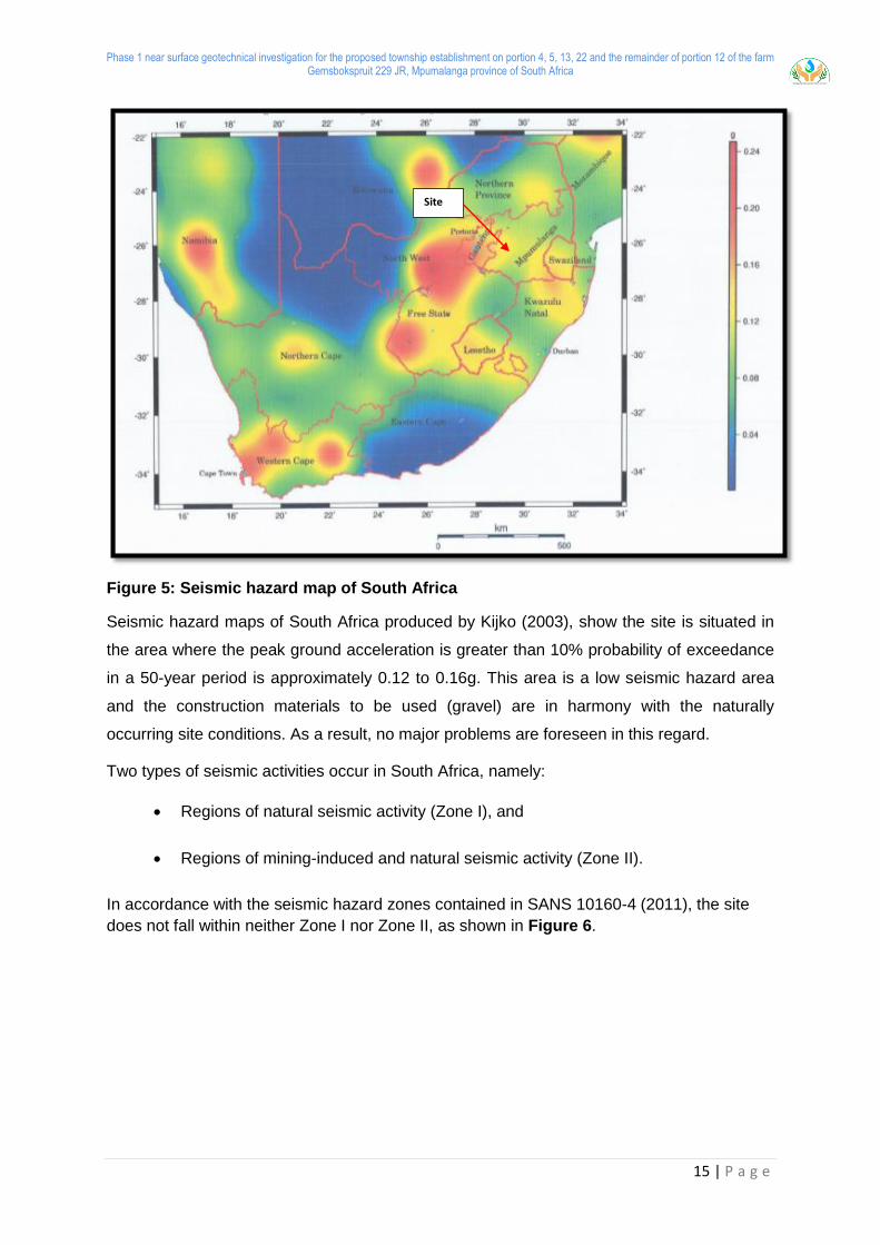
Figure 5: Seismic hazard map of South Africa
Seismic hazard maps of South Africa produced by Kijko (2003), show the site is situated in
the area where the peak ground acceleration is greater than 10% probability of exceedance
in a 50-year period is approximately 0.12 to 0.16g. This area is a low seismic hazard area
and the construction materials to be used (gravel) are in harmony with the naturally
occurring site conditions. As a result, no major problems are foreseen in this regard.
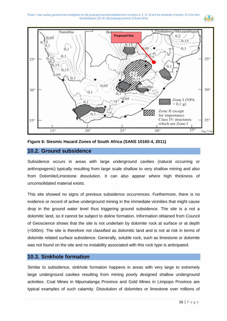
Two types of seismic activities occur in South Africa, namely:
Regions of natural seismic activity (Zone I), and
Regions of mining-induced and natural seismic activity (Zone II).
In accordance with the seismic hazard zones contained in SANS 10160-4 (2011), the site
does not fall within neither Zone I nor Zone II, as shown in Figure 6.
Site
Phase 1 near surface geotechnical investigation for the proposed township establishment on portion 4, 5, 13, 22 and the remainder of portion 12 of the farm Gemsbokspruit 229 JR, Mpumalanga province of South Africa
16 | P a g e
Figure 6: Siesmic Hazard Zones of South Africa (SANS 10160-4, 2011)
10.2. Ground subsidence
Subsidence occurs in areas with large underground cavities (natural occurring or
anthropogenic) typically resulting from large scale shallow to very shallow mining and also
from Dolomite/Limestone dissolution. It can also appear where high thickness of
unconsolidated material exists.
This site showed no signs of previous subsidence occurrences. Furthermore, there is no
evidence or record of active underground mining in the immediate vicinities that might cause
drop in the ground water level thus triggering ground subsidence. The site is a not a
dolomitic land, so it cannot be subject to doline formation. Information obtained from Council
of Geoscience shows that the site is not underlain by dolomite rock at surface or at depth
(<500m). The site is therefore not classified as dolomitic land and is not at risk in terms of
dolomite related surface subsidence. Generally, soluble rock, such as limestone or dolomite
was not found on the site and no instability associated with this rock type is anticipated.
10.3. Sinkhole formation
Similar to subsidence, sinkhole formation happens in areas with very large to extremely
large underground cavities resulting from mining poorly designed shallow underground
activities. Coal Mines in Mpumalanga Province and Gold Mines in Limpopo Province are
typical examples of such calamity. Dissolution of dolomites or limestone over millions of
Proposed Site

Phase 1 near surface geotechnical investigation for the proposed township establishment on portion 4, 5, 13, 22 and the remainder of portion 12 of the farm Gemsbokspruit 229 JR, Mpumalanga province of South Africa
17 | P a g e
years also lead to cavity formations that might later manifest into sinkhole formation as
evidenced very much so in Limpopo and Gauteng Provinces.
According to the research done, there are no records of wide shallow underground mining
activities directly below this site. There is no dolomite or limestone underlying the site so the
chances of dolomite related sinkhole formation are unlikely.
10.4. Landslides and mudslides
The probability of landslides and mudslides occurring at this area are rare. This is primarily
due to the climatic conditions and composition of residual soil in this particular area. Also,
this is primarily due to the low relief and slightly steep gradient of the area.
10.5. Volcanic activities
South Africa has seen its last volcanic activity approximately 65 million years ago during the
massive historical eruption of the Drakensberg Lava forming the Basaltic Drakensberg
Mountain Ranges that we see today. Recent studies showed no signs for the possibility of
volcanic eruption in the foreseeable future
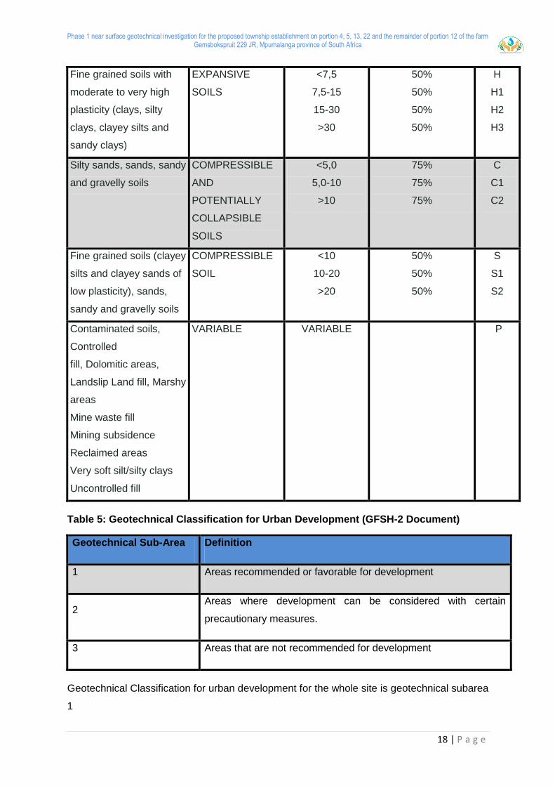
11. GEOTECHNICAL EVALUATION
This report focuses on the geotechnical site investigation aimed at determining various
geotechnical properties of the near surface soil horizons in accordance with SAICE Code of
Practice, SANS guidelines and NHBRC guidelines and the GFSH-2 document. Table 6 gives
the basis of the soil site classification that was applied during the investigation and Table 7
gives the geotechnical classification for urban development
Table 4: Residential site class designations
TYPICAL FOUNDING
MATERIAL
CHARACTER OF
FOUNDING
MATERIAL
EXPECTED
RANGE OF
TOTAL SOIL
MOVEMENTS
(mm)
ASSUMED
DIFFERENTIAL
MOVEMENT (%OF
TOTAL)
SITE
CLASS
Rock (excluding mud
rocks which may exhibit
swelling to some depth)
STABLE NEGLIGIBLE - R
Phase 1 near surface geotechnical investigation for the proposed township establishment on portion 4, 5, 13, 22 and the remainder of portion 12 of the farm Gemsbokspruit 229 JR, Mpumalanga province of South Africa
18 | P a g e
Fine grained soils with
moderate to very high
plasticity (clays, silty
clays, clayey silts and
sandy clays)
EXPANSIVE
SOILS
<7,5
7,5-15
15-30
>30
50%
50%
50%
50%
H
H1
H2
H3
Silty sands, sands, sandy
and gravelly soils
COMPRESSIBLE
AND
POTENTIALLY
COLLAPSIBLE
SOILS
<5,0
5,0-10
>10
75%
75%
75%
C
C1
C2
Fine grained soils (clayey
silts and clayey sands of
low plasticity), sands,
sandy and gravelly soils
COMPRESSIBLE
SOIL
<10
10-20
>20
50%
50%
50%
S
S1
S2
Contaminated soils,
Controlled
fill, Dolomitic areas,
Landslip Land fill, Marshy
areas
Mine waste fill
Mining subsidence
Reclaimed areas
Very soft silt/silty clays
Uncontrolled fill
VARIABLE VARIABLE P
Table 5: Geotechnical Classification for Urban Development (GFSH-2 Document)
Geotechnical Sub-Area Definition
1 Areas recommended or favorable for development
2 Areas where development can be considered with certain
precautionary measures.
3 Areas that are not recommended for development
Geotechnical Classification for urban development for the whole site is geotechnical subarea
1
Phase 1 near surface geotechnical investigation for the proposed township establishment on portion 4, 5, 13, 22 and the remainder of portion 12 of the farm Gemsbokspruit 229 JR, Mpumalanga province of South Africa
19 | P a g e
Other related engineering geological characteristics such as collapse settlement,
compressibility, slope stability groundwater etc. were evaluated. The geotechnical properties
relevant to the development are discussed below.
11.1. Expansive soils
Active/expansive soils are defined as fine grained soils (generally with high clay content) that
change in volume in response to the change in moisture content. These soils may increase
in volume (heave/swell) upon wetting and decrease in volume (shrink) upon drying out.
These soils are classified as (H) according to the SAICE site classes. Depending on the
severity of the predicted movement, expansive soils can be classified as H, H1, H2 or H3
(Table 4).
The site is predominately underlain by sandy gravel> sandy silt >with low content of clay.
The laboratory results of all the samples analyzed exhibit a low potential expansiveness.
NB: The site cannot be classified with the soil site class H. the H class is not applicable for
this site
11.2. Collapsible soils
Collapsible soils are defined as soils that have a potential for collapse and are commonly
open textured with a high void ratio (Brink, 1985). These soils are typically silty sands,
sands, sandy and gravelly soils commonly found in colluvial and aeolian sands. Soils which
exhibit potentially collapsible characteristics are classified with the soil site class ‘C’
according to the SAICE site classification system (Table 4).
The soils encountered on the site typically comprise of sandy gravel with no visual open-
textured structures such as voids and pinholes which indicate collapse potential. Due to the
crumbly nature of the soils on site, undisturbed soil samples could not be retrieved for
collapse potential testing. From the site observations it is anticipated that the site will exhibit
low collapse potential. Therefore, the site is classified as site class C according to the
GFSH-2 classification.
11.3. Compressible soils
Compressible soils are soils in which the bulk volume of the soil may gradually decrease
with time when subjected to an applied load. These soils typically comprise fine grained soils
such as clay, clayey sand and clayey silt with low plasticity, gravelly and sandy soil.
Phase 1 near surface geotechnical investigation for the proposed township establishment on portion 4, 5, 13, 22 and the remainder of portion 12 of the farm Gemsbokspruit 229 JR, Mpumalanga province of South Africa
20 | P a g e
According to the SAICE soil site class these soils are denoted as class ‘S’ and may very (S,
S1, S2) depending on the severity of the bulk volume change (Table 4).
The site is generally underlain by non-cohesive soils with low plasticity index. The laboratory
results indicate that the samples have a low clay content and high gravel content.
The site cannot be classified with the soil site class S according to the SAICE site
classification system.
11.4. Soil site classification
A review of the test pit data indicates that the site is generally underlained by sandy gravel
and granite bedrock. The laboratory tests indicated that material underlying the site exhibits
low potential expansiveness. The development potential has been broadly classified in terms
of a Geotechnical Sub-Area 1 based on field observations/investigation (geological,
hydrogeological, and geomorphological), and laboratory soil testing of soil samples. From
the above discussion the site is classified into main soil area namely compressible and
potential collapsible soils: According to COLTO the soil samples were classified as G6, G7
and G8. The foundation design options as per SANS10400 H- NHBRC soil symbol is
“R/C”. The recommended Foundation types in accordance with SANS 10400H-
Modified normal / Reinforced Deep Strip Foundation
11.5. Excavation Classification
The in-situ soils and slightly weathered granite bedrock were excavated to minimum depth of
0.5m and maximum depth of 2.8 m
Based on the test pits excavations, it is anticipated that site should classify as “soft
excavation” until the start of granite bedrock (range of 0.5m to 2.8m), in accordance with
SANS 1200 DA classification using similar plant as employed during this investigation. This
means it can easily be removed by a tractor loader backhoe (TLB) of flywheel power >0.10
kW per mm of tined bucket width.
Allowance should be made for “intermediate to hard excavation” where deeper excavations
are required from a depth 2.8m where there’s a unweathered granite bedrock.
11.6. Stability of excavations sidewalls
It was noted during trail pit excavations that the sidewalls retain its initial condition without
crumbling. This is a good indication for the behaviour of the materials; excavated ground
must retain its stature vertically without unsupported.
Phase 1 near surface geotechnical investigation for the proposed township establishment on portion 4, 5, 13, 22 and the remainder of portion 12 of the farm Gemsbokspruit 229 JR, Mpumalanga province of South Africa
21 | P a g e
For safety reasons, sidewalls of excavations deeper than 1.5 m should be battered back to
1:1 in dry conditions. Should oblique jointing or any seepage be noted, then the sidewalls
may need to be battered at a much flatter gradient. This is only acceptable for excavation
depths restricted to less than 3.0 m. All safety precautions should be adhered to. Should
battering be deemed unpractical due to some site conditions, sidewalls should be supported
by suitably designed shoring technique.
11.7. Construction material suitability
The aim of this geotechnical site investigation report was to determine the different
engineering geological properties of the surface and subsurface soils in accordance with the
GFSH–2 guidelines, NHBRC. The intention is to be able to recommend for the founding
levels for the foundation design for the proposed township establishment. The soil was
mainly composed of sandy gravel and granite bedrock; hence it was found to be of low
plastic behaviour. This soil was classified as G6, G7 and G8 according to COLTO
Classification. Furthermore, the materials are ideal for construction.
11.8. Construction Monitoring
It is recommended that all foundations be inspected by a competent person prior to placing
any concrete, regular checks on the quality and compaction of the backfill to the terraces
should be made.
12. CONCLUSION AND RECOMMENDATIONS
12.1. Foundations
It is important to note that foundation recommendations are based on the inspection of test
pits, soil profiling, laboratory test result and the geotechnical evaluation described in this
report. The following foundation types are provisionally recommended.
12.1.1. Foundations on residual soils
Residual soils were encountered at various, uneven depths with an average of 0.93m below
the ground level.
Therefore, the recommended foundation type is a reinforced strip foundation.
Reinforcement should be designed by a competent person. The following construction
procedures apply.
All topsoil to be stripped to spoil;
Phase 1 near surface geotechnical investigation for the proposed township establishment on portion 4, 5, 13, 22 and the remainder of portion 12 of the farm Gemsbokspruit 229 JR, Mpumalanga province of South Africa
22 | P a g e
Foundation trenches for 500mm wide strip footing to be over-excavated to 1.0m wide
by 1.3m deep below existing ground level;
Excavation to be backfill with G6 quality material to a depth of 0.6m existing ground
level; (material on site can be utilised as backfill material)
G6 material to be compacted in 150mm thick layers to 93% Mod AASHTO density at
–1% to +2% OMC;
Strip footings 500mm wide and adequately reinforced should be constructed at a
depth of 0.6m;
The allowable bearing capacity should be limited to 150kPa on the engineered soil
mattress;
Articulation joints at some internal doors and all external doors;
Light reinforcement in masonry;
12.2.2. Foundations on a slightly weathered Granite
The medium hard rock granite is encountered at a depth of 0.5m below existing ground
level. The recommended foundation type is a normal strip foundation onto the medium
hard rock granite. The following construction procedures apply:
All topsoil to be stripped to spoil;
Foundation excavation to the slightly weathered, medium hard rock at an average
depth of 0.8m below existing ground level;
The excavation onto the weathered Granite to be hand cleaned and all loose
material to be removed;
A concrete blinding to be cast to onto cleaned rock surface prior to casting
foundations;
The allowable bearing capacity should be limited to 300kPa on the weathered
Granite bedrock.
13. REPORT PROVISIONS
This investigation is aimed at providing the engineers with an indication of the prevailing
geological and geotechnical conditions in the study area, with reference to the proposed
township establishment.
Phase 1 near surface geotechnical investigation for the proposed township establishment on portion 4, 5, 13, 22 and the remainder of portion 12 of the farm Gemsbokspruit 229 JR, Mpumalanga province of South Africa
23 | P a g e
While every effort has been made during the fieldwork investigation to identify the various
soil horizons, their problems and distribution, it is impossible to guarantee that isolated
zones of varying material have not been missed. The investigation was, however, thorough
and conditions are not expected to vary a great deal from that described in this report.
The engineers are, nevertheless, strongly urged to inspect all excavations to assure
themselves that conditions are not at variance with those described in this report.
Please note:
Test pits were backfilled after the field investigation but were not re-compacted.
Some test pits positions occur within the footprints of proposed structures.
The recommendations provided in this report are a final interpretive geotechnical
report.

Phase 1 near surface geotechnical investigation for the proposed township establishment on portion 4, 5, 13, 22 and the remainder of portion 12 of the farm Gemsbokspruit 229 JR, Mpumalanga province of South Africa
24 | P a g e
14. REFFERENCE
Brink, A.B.A and Bruin R.M.H, (2002). Guidelines for soil and rock logging in South
Africa, Second Impression, Proceedings of the Geoterminology Workshop.
Brink A.B.A. Engineering Geology of Southern Africa. Volume 3. The Karoo Sequence.
Building publications Pretoria. ISBN 0908423152
Committee of Land Transport Officials (COLTO), Draft TRH4:1996 Structural Design of
Flexible Pavements for Interurban and Rural Roads.
Jennings J.E., Brink A.B.A. and Williams A.A.B. (1973) Revised Guide to Soil Profiling for
Civil Engineering Purposes in South Africa. The Civil Engineer in South Africa, January
1973.
IH Braatveld, JP Everett, G Byrne, K Schwartz, EA Friedlaender, N Mackintosh and C
Wetter. A guide to practical Geotechnical Engineering in Southern Africa by FRANKI
Partridge, T C, Wood, C K, and Brink, A B A, “Geotechnical Constraints for Urban
Development”. 1993
South African Institution of Civil Engineering (SAICE) – Geotechnical Division. Site
investigation code of practice. 1st Ed, 2009.
The South African Bureau of Standard, Standardised Specification of Civil Engineering
Construction, SABS 1200 D_1988
Phase 1 near surface geotechnical investigation for the proposed township establishment on portion 4, 5, 13, 22 and the remainder of portion 12 of the farm Gemsbokspruit 229 JR, Mpumalanga province of South Africa
25 | P a g e
15. APPENDIX A: THE SITE PHOTOS
Phase 1 near surface geotechnical investigation for the proposed township establishment on portion 4, 5, 13, 22 and the remainder of portion 12 of the farm Gemsbokspruit 229 JR, Mpumalanga province of South Africa
26 | P a g e
Phase 1 near surface geotechnical investigation for the proposed township establishment on portion 4, 5, 13, 22 and the remainder of portion 12 of the farm Gemsbokspruit 229 JR, Mpumalanga province of South Africa
27 | P a g e
Phase 1 near surface geotechnical investigation for the proposed township establishment on portion 4, 5, 13, 22 and the remainder of portion 12 of the farm Gemsbokspruit 229 JR, Mpumalanga province of South Africa
28 | P a g e
Phase 1 near surface geotechnical investigation for the proposed township establishment on portion 4, 5, 13, 22 and the remainder of portion 12 of the farm Gemsbokspruit 229 JR, Mpumalanga province of South Africa
29 | P a g e
Phase 1 near surface geotechnical investigation for the proposed township establishment on portion 4, 5, 13, 22 and the remainder of portion 12 of the farm Gemsbokspruit 229 JR, Mpumalanga province of South Africa
30 | P a g e
Phase 1 near surface geotechnical investigation for the proposed township establishment on portion 4, 5, 13, 22 and the remainder of portion 12 of the farm Gemsbokspruit 229 JR, Mpumalanga province of South Africa
31 | P a g e
Phase 1 near surface geotechnical investigation for the proposed township establishment on portion 4, 5, 13, 22 and the remainder of portion 12 of the farm Gemsbokspruit 229 JR, Mpumalanga province of South Africa
32 | P a g e
Phase 1 near surface geotechnical investigation for the proposed township establishment on portion 4, 5, 13, 22 and the remainder of portion 12 of the farm Gemsbokspruit 229 JR, Mpumalanga province of South Africa
33 | P a g e
Phase 1 near surface geotechnical investigation for the proposed township establishment on portion 4, 5, 13, 22 and the remainder of portion 12 of the farm Gemsbokspruit 229 JR, Mpumalanga province of South Africa
34 | P a g e
Phase 1 near surface geotechnical investigation for the proposed township establishment on portion 4, 5, 13, 22 and the remainder of portion 12 of the farm Gemsbokspruit 229 JR, Mpumalanga province of South Africa
35 | P a g e

Phase 1 near surface geotechnical investigation for the proposed township establishment on portion 4, 5, 13, 22 and the remainder of portion 12 of the farm Gemsbokspruit 229 JR, Mpumalanga province of South Africa
36 | P a g e
Phase 1 near surface geotechnical investigation for the proposed township establishment on portion 4, 5, 13, 22 and the remainder of portion 12 of the farm Gemsbokspruit 229 JR, Mpumalanga province of South Africa
37 | P a g e
16. APPENDIX B: LABORATORY RESULTS
Page 1of1 RLG.s.032.01
Ref- 92/NKA001-01-0001/21 Date - 2021-04-10
Nkanivo Development Consultants
P.O 11948
Silver Lakes
Pretoria
Attention: Mr. L Mavhetha
Re: Gembokspruit – Foundation Indicator Test Results
Herewith please find attached the test results for the above-mentioned project as tested by Roadlab
Laboratories.
Thank you
Kind Regards
Mr N Herbst / Mr R Potgieter
Technical Signatory / Manager
OUR REF : 92/NKA001-01-0001/21 DATE RECEIVED : 2021-04-10
CLIENT : Nkanivo Development Consultants POSITION : TP 1
PROJECT : LAYER : 0.65 - 2.7
SAMPLE No. : S/8022
Dark Red Orange
Clayey Sandy Gravel
5.0 2.62
100.0 100
75.0 100
63.0 100
50.0 100
37.5 100
28.0 99
20.0 97
14.0 97
5.00 92
2.000 63
0.425 50
0.250 45
0.150 41
0.075 33
50 µm 29
5 µm 24
2 µm 20.6
2.000 - 0.425 21
0.425 - 0.250 7
0.250 - 0.150 7
0.150 - 0.075 13
< 0.075 52
Effective size 0.002 Page 1/3
Uniformity Coefficient 830.8
Curvature Coefficient 1.0
Oversize Index 0.0
Shrinkage Product 248.0
Grading Coefficient 33.2
Grading modulus 1.55
Liquid Limit 23
Plasticity Index 10
Linear Shrinkage 5.0
PI < 0.075 14
Unified Soil Classification SC
U.S. Highway Classification A-2-4 (0)
9.7 32.6 37.220.6
Weighted PI
CLAY (%) (0.001-0.002) SILT (%) (0.002-0.060)
Gembokspruit
Specifc Gravity
SAND (%) (0.060-2.00) GRAVEL (%) (2.00-60.0)
FOUNDATION INDICATOR - (SANS 3001-GR1, SANS 3001-GR10) & (ASTM Method D422)
SAMPLE DESCRIPTION :
-
GEOTECHNICAL & SOILS ENGINEERING
Sie
ve a
naly
sis
C
um
ula
tive p
erc
enta
ge p
assin
g
( m
m )
Soil
Mort
ar
Analy
sis
% <
2.0
0m
m
Atter-
berg
Lim
its
0
50
100
150
200
250
300
350
400
450
500
550
0 5 10 15 20 25 30 35 40 45 50
Slippery
Erodible
Materials
Good - dusty
Ravels
Good
Ravels and Corrugates
GRADING COEFFICIENT
SH
RIN
KA
GE
PR
OD
UC
T
PERFORMANCE AS WEARING COURSE
0
10
20
30
40
50
60
70
80
90
100
SIEVE SIZE ( BY LOG SCALE )
PARTICLE SIZE DISTRIBUTION
Sand Gravel
Cob
ble
s
Fine FineMedium MediumCoarse Coarse
Silt Clay
CoarseMediumFine
0
10
20
30
40
50
60
70
0 10 20 30 40 50 60 70 80 90 100
PL
AS
TIC
ITY
IN
DE
X
LIQUID LIMIT (LL)
PLASTICITY CHART
CL - ML
CL
CH
ML and OL
OH and MH
CASGRANDE "A" LINE
CU
MU
LA
TIV
E P
ER
CE
NT
AC
E P
AS
SIN
G
0.0
01
0.0
03
0.0
04
0.0
02
0.0
05
0.0
07
0.0
08
0.0
09
0.0
10
0.0
20
0.0
30
0.0
06
0.8
00
0.4
00
0.1
00
0.0
70
0.0
50
0.7
00
0.5
00
0.3
00
0.0
90
0.0
80
0.0
40
0.9
00
1.0
0
0.6
00
0.2
00
0.0
60
90.0
2.0
0
80.0
70.0
50.0
40.0
20.0
3.0
0
4.0
0
5.0
0
6.0
0
7.0
0
8.0
09.0
0
60.0
30.0
10.0
0
100.0
0
10
20
30
40
50
60
70
0 10 20 30 40 50 60 70
PI
OF
WH
OL
E S
AM
PL
E
CLAY PERCENTAGE
POTENTIAL EXPANSIVENES
Low
Medium
High
Very High

OUR REF : 92/NKA001-01-0001/21 DATE RECEIVED : 2021-04-10
CLIENT : Nkanivo Development Consultants POSITION : TP 2
PROJECT : LAYER : 0.46 - 1.7
SAMPLE No. : S/8023
Light Red Orange
Clayey Silty Gravelly Sand
3.8 2.59
100.0 100
75.0 100
63.0 100
50.0 100
37.5 100
28.0 99
20.0 97
14.0 97
5.00 90
2.000 70
0.425 47
0.250 40
0.150 34
0.075 30
50 µm 23
5 µm 18
2 µm 12.0
2.000 - 0.425 32
0.425 - 0.250 11
0.250 - 0.150 9
0.150 - 0.075 6
< 0.075 43
Effective size 0.002 Page 1/3
Uniformity Coefficient 659.3
Curvature Coefficient 2.4
Oversize Index 0.0
Shrinkage Product 189.9
Grading Coefficient 26.6
Grading modulus 1.53
Liquid Limit 27
Plasticity Index 8
Linear Shrinkage 4.0
PI < 0.075 12
Unified Soil Classification SC
U.S. Highway Classification A-2-4 (0)
Gembokspruit
Specifc Gravity
SAND (%) (0.060-2.00) GRAVEL (%) (2.00-60.0)
FOUNDATION INDICATOR - (SANS 3001-GR1, SANS 3001-GR10) & (ASTM Method D422)
SAMPLE DESCRIPTION :
-
13.5 44.1 30.412.0
Weighted PI
CLAY (%) (0.001-0.002) SILT (%) (0.002-0.060)
GEOTECHNICAL & SOILS ENGINEERING
Sie
ve a
naly
sis
C
um
ula
tive p
erc
enta
ge p
assin
g
( m
m )
Soil
Mort
ar
Analy
sis
% <
2.0
0m
m
Atter-
berg
Lim
its
0
50
100
150
200
250
300
350
400
450
500
550
0 5 10 15 20 25 30 35 40 45 50
Slippery
Erodible
Materials
Good - dusty
Ravels
Good
Ravels and Corrugates
GRADING COEFFICIENT
SH
RIN
KA
GE
PR
OD
UC
T
PERFORMANCE AS WEARING COURSE
0
10
20
30
40
50
60
70
80
90
100
SIEVE SIZE ( BY LOG SCALE )
PARTICLE SIZE DISTRIBUTION
Sand Gravel
Cob
ble
s
Fine FineMedium MediumCoarse Coarse
Silt Clay
CoarseMediumFine
0
10
20
30
40
50
60
70
0 10 20 30 40 50 60 70 80 90 100
PL
AS
TIC
ITY
IN
DE
X
LIQUID LIMIT (LL)
PLASTICITY CHART
CL - ML
CL
CH
ML and OL
OH and MH
CASGRANDE "A" LINE
CU
MU
LA
TIV
E P
ER
CE
NT
AC
E P
AS
SIN
G
0.0
01
0.0
03
0.0
04
0.0
02
0.0
05
0.0
07
0.0
08
0.0
09
0.0
10
0.0
20
0.0
30
0.0
06
0.8
00
0.4
00
0.1
00
0.0
70
0.0
50
0.7
00
0.5
00
0.3
00
0.0
90
0.0
80
0.0
40
0.9
00
1.0
0
0.6
00
0.2
00
0.0
60
90.0
2.0
0
80.0
70.0
50.0
40.0
20.0
3.0
0
4.0
0
5.0
0
6.0
0
7.0
0
8.0
09.0
0
60.0
30.0
10.0
0
100.0
0
10
20
30
40
50
60
70
0 10 20 30 40 50 60 70
PI
OF
WH
OL
E S
AM
PL
E
CLAY PERCENTAGE
POTENTIAL EXPANSIVENES
Low
Medium
High
Very High

OUR REF : 92/NKA001-01-0001/21 DATE RECEIVED : 2021-04-10
CLIENT : Nkanivo Development Consultants POSITION : TP 3
PROJECT : LAYER : 0.35 - 1.2
SAMPLE No. : S/8024
Light Red Brown
Clayey Gravelly Sand
3.2 2.57
100.0 100
75.0 100
63.0 100
50.0 99
37.5 94
28.0 91
20.0 85
14.0 85
5.00 80
2.000 61
0.425 32
0.250 26
0.150 22
0.075 19
50 µm 19
5 µm 15
2 µm 11.1
2.000 - 0.425 47
0.425 - 0.250 10
0.250 - 0.150 6
0.150 - 0.075 5
< 0.075 31
Effective size 0.002 Page 1/3
Uniformity Coefficient 976.3
Curvature Coefficient 34.7
Oversize Index 6.4
Shrinkage Product 159.8
Grading Coefficient 24.1
Grading modulus 1.88
Liquid Limit 24
Plasticity Index 10
Linear Shrinkage 5.0
PI < 0.075 16
Unified Soil Classification SC
U.S. Highway Classification A-2-4 (0)
7.8 41.9 39.111.1
Weighted PI
CLAY (%) (0.001-0.002) SILT (%) (0.002-0.060)
Gembokspruit
Specifc Gravity
SAND (%) (0.060-2.00) GRAVEL (%) (2.00-60.0)
FOUNDATION INDICATOR - (SANS 3001-GR1, SANS 3001-GR10) & (ASTM Method D422)
SAMPLE DESCRIPTION :
-
GEOTECHNICAL & SOILS ENGINEERING
Sie
ve a
naly
sis
C
um
ula
tive p
erc
enta
ge p
assin
g
( m
m )
Soil
Mort
ar
Analy
sis
% <
2.0
0m
m
Atter-
berg
Lim
its
0
50
100
150
200
250
300
350
400
450
500
550
0 5 10 15 20 25 30 35 40 45 50
Slippery
Erodible
Materials
Good - dusty
Ravels
Good
Ravels and Corrugates
GRADING COEFFICIENT
SH
RIN
KA
GE
PR
OD
UC
T
PERFORMANCE AS WEARING COURSE
0
10
20
30
40
50
60
70
80
90
100
SIEVE SIZE ( BY LOG SCALE )
PARTICLE SIZE DISTRIBUTION
Sand Gravel
Cob
ble
s
Fine FineMedium MediumCoarse Coarse
Silt Clay
CoarseMediumFine
0
10
20
30
40
50
60
70
0 10 20 30 40 50 60 70 80 90 100
PL
AS
TIC
ITY
IN
DE
X
LIQUID LIMIT (LL)
PLASTICITY CHART
CL - ML
CL
CH
ML and OL
OH and MH
CASGRANDE "A" LINE
CU
MU
LA
TIV
E P
ER
CE
NT
AC
E P
AS
SIN
G
0.0
01
0.0
03
0.0
04
0.0
02
0.0
05
0.0
07
0.0
08
0.0
09
0.0
10
0.0
20
0.0
30
0.0
06
0.8
00
0.4
00
0.1
00
0.0
70
0.0
50
0.7
00
0.5
00
0.3
00
0.0
90
0.0
80
0.0
40
0.9
00
1.0
0
0.6
00
0.2
00
0.0
60
90.0
2.0
0
80.0
70.0
50.0
40.0
20.0
3.0
0
4.0
0
5.0
0
6.0
0
7.0
0
8.0
09.0
0
60.0
30.0
10.0
0
100.0
0
10
20
30
40
50
60
70
0 10 20 30 40 50 60 70
PI
OF
WH
OL
E S
AM
PL
E
CLAY PERCENTAGE
POTENTIAL EXPANSIVENES
Low
Medium
High
Very High

OUR REF : 92/NKA001-01-0001/21 DATE RECEIVED : 2021-04-10
CLIENT : Nkanivo Development Consultants POSITION : TP 4
PROJECT : LAYER : 0.6 - 1.6
SAMPLE No. : S/8025
Light Red Orange
Silty Clayey Gravelly Sand
3.2 2.59
100.0 100
75.0 100
63.0 100
50.0 100
37.5 96
28.0 89
20.0 81
14.0 81
5.00 80
2.000 71
0.425 40
0.250 34
0.150 29
0.075 24
50 µm 21
5 µm 15
2 µm 11.1
2.000 - 0.425 44
0.425 - 0.250 8
0.250 - 0.150 7
0.150 - 0.075 8
< 0.075 34
Effective size 0.002 Page 1/3
Uniformity Coefficient 728.4
Curvature Coefficient 9.5
Oversize Index 4.0
Shrinkage Product 158.0
Grading Coefficient 14.3
Grading modulus 1.66
Liquid Limit 22
Plasticity Index 8
Linear Shrinkage 4.0
PI < 0.075 12
Unified Soil Classification SC
U.S. Highway Classification A-2-4 (0)
Gembokspruit
Specifc Gravity
SAND (%) (0.060-2.00) GRAVEL (%) (2.00-60.0)
FOUNDATION INDICATOR - (SANS 3001-GR1, SANS 3001-GR10) & (ASTM Method D422)
SAMPLE DESCRIPTION :
-
10.9 48.8 29.211.1
Weighted PI
CLAY (%) (0.001-0.002) SILT (%) (0.002-0.060)
GEOTECHNICAL & SOILS ENGINEERING
Sie
ve a
naly
sis
C
um
ula
tive p
erc
enta
ge p
assin
g
( m
m )
Soil
Mort
ar
Analy
sis
% <
2.0
0m
m
Atter-
berg
Lim
its
0
50
100
150
200
250
300
350
400
450
500
550
0 5 10 15 20 25 30 35 40 45 50
Slippery
Erodible
Materials
Good - dusty
Ravels
Good
Ravels and Corrugates
GRADING COEFFICIENT
SH
RIN
KA
GE
PR
OD
UC
T
PERFORMANCE AS WEARING COURSE
0
10
20
30
40
50
60
70
80
90
100
SIEVE SIZE ( BY LOG SCALE )
PARTICLE SIZE DISTRIBUTION
Sand Gravel
Cob
ble
s
Fine FineMedium MediumCoarse Coarse
Silt Clay
CoarseMediumFine
0
10
20
30
40
50
60
70
0 10 20 30 40 50 60 70 80 90 100
PL
AS
TIC
ITY
IN
DE
X
LIQUID LIMIT (LL)
PLASTICITY CHART
CL - ML
CL
CH
ML and OL
OH and MH
CASGRANDE "A" LINE
CU
MU
LA
TIV
E P
ER
CE
NT
AC
E P
AS
SIN
G
0.0
01
0.0
03
0.0
04
0.0
02
0.0
05
0.0
07
0.0
08
0.0
09
0.0
10
0.0
20
0.0
30
0.0
06
0.8
00
0.4
00
0.1
00
0.0
70
0.0
50
0.7
00
0.5
00
0.3
00
0.0
90
0.0
80
0.0
40
0.9
00
1.0
0
0.6
00
0.2
00
0.0
60
90.0
2.0
0
80.0
70.0
50.0
40.0
20.0
3.0
0
4.0
0
5.0
0
6.0
0
7.0
0
8.0
09.0
0
60.0
30.0
10.0
0
100.0
0
10
20
30
40
50
60
70
0 10 20 30 40 50 60 70
PI
OF
WH
OL
E S
AM
PL
E
CLAY PERCENTAGE
POTENTIAL EXPANSIVENES
Low
Medium
High
Very High

OUR REF : 92/NKA001-01-0001/21 DATE RECEIVED : 2021-04-10
CLIENT : Nkanivo Development Consultants POSITION : TP 5
PROJECT : LAYER : 0.4 - 1.4
SAMPLE No. : S/8026
Light Red Orange
Silty Clayey Gravelly Sand
3.6 2.57
100.0 100
75.0 100
63.0 100
50.0 100
37.5 100
28.0 100
20.0 100
14.0 100
5.00 98
2.000 67
0.425 45
0.250 38
0.150 33
0.075 27
50 µm 25
5 µm 19
2 µm 14.0
2.000 - 0.425 33
0.425 - 0.250 10
0.250 - 0.150 7
0.150 - 0.075 9
< 0.075 40
Effective size 0.002 Page 1/3
Uniformity Coefficient 763.2
Curvature Coefficient 4.2
Oversize Index 0.0
Shrinkage Product 178.7
Grading Coefficient 32.6
Grading modulus 1.62
Liquid Limit 23
Plasticity Index 8
Linear Shrinkage 4.0
PI < 0.075 12
Unified Soil Classification SC
U.S. Highway Classification A-2-4 (0)
11.4 41.2 33.414.0
Weighted PI
CLAY (%) (0.001-0.002) SILT (%) (0.002-0.060)
Gembokspruit
Specifc Gravity
SAND (%) (0.060-2.00) GRAVEL (%) (2.00-60.0)
FOUNDATION INDICATOR - (SANS 3001-GR1, SANS 3001-GR10) & (ASTM Method D422)
SAMPLE DESCRIPTION :
-
GEOTECHNICAL & SOILS ENGINEERING
Sie
ve a
naly
sis
C
um
ula
tive p
erc
enta
ge p
assin
g
( m
m )
Soil
Mort
ar
Analy
sis
% <
2.0
0m
m
Atter-
berg
Lim
its
0
50
100
150
200
250
300
350
400
450
500
550
0 5 10 15 20 25 30 35 40 45 50
Slippery
Erodible
Materials
Good - dusty
Ravels
Good
Ravels and Corrugates
GRADING COEFFICIENT
SH
RIN
KA
GE
PR
OD
UC
T
PERFORMANCE AS WEARING COURSE
0
10
20
30
40
50
60
70
80
90
100
SIEVE SIZE ( BY LOG SCALE )
PARTICLE SIZE DISTRIBUTION
Sand Gravel
Cob
ble
s
Fine FineMedium MediumCoarse Coarse
Silt Clay
CoarseMediumFine
0
10
20
30
40
50
60
70
0 10 20 30 40 50 60 70 80 90 100
PL
AS
TIC
ITY
IN
DE
X
LIQUID LIMIT (LL)
PLASTICITY CHART
CL - ML
CL
CH
ML and OL
OH and MH
CASGRANDE "A" LINE
CU
MU
LA
TIV
E P
ER
CE
NT
AC
E P
AS
SIN
G
0.0
01
0.0
03
0.0
04
0.0
02
0.0
05
0.0
07
0.0
08
0.0
09
0.0
10
0.0
20
0.0
30
0.0
06
0.8
00
0.4
00
0.1
00
0.0
70
0.0
50
0.7
00
0.5
00
0.3
00
0.0
90
0.0
80
0.0
40
0.9
00
1.0
0
0.6
00
0.2
00
0.0
60
90.0
2.0
0
80.0
70.0
50.0
40.0
20.0
3.0
0
4.0
0
5.0
0
6.0
0
7.0
0
8.0
09.0
0
60.0
30.0
10.0
0
100.0
0
10
20
30
40
50
60
70
0 10 20 30 40 50 60 70
PI
OF
WH
OL
E S
AM
PL
E
CLAY PERCENTAGE
POTENTIAL EXPANSIVENES
Low
Medium
High
Very High

OUR REF : 92/NKA001-01-0001/21 DATE RECEIVED : 2021-04-10
CLIENT : Nkanivo Development Consultants POSITION : TP 6
PROJECT : LAYER : 0.5 - 1.6m
SAMPLE No. : S/8027
Light Red Brown
Gravelly Sand
1.5 2.57
100.0 100
75.0 100
63.0 100
50.0 100
37.5 99
28.0 98
20.0 96
14.0 96
5.00 92
2.000 74
0.425 38
0.250 30
0.150 24
0.075 18
50 µm 16
5 µm 13
2 µm 9.0
2.000 - 0.425 49
0.425 - 0.250 10
0.250 - 0.150 8
0.150 - 0.075 9
< 0.075 24
Effective size 0.003 Page 1/3
Uniformity Coefficient 499.2
Curvature Coefficient 14.9
Oversize Index 1.0
Shrinkage Product 75.0
Grading Coefficient 22.0
Grading modulus 1.71
Liquid Limit 18
Plasticity Index 4
Linear Shrinkage 2.0
PI < 0.075 8
Unified Soil Classification SM & SC
U.S. Highway Classification A-1-b (0)
Gembokspruit
Specifc Gravity
SAND (%) (0.060-2.00) GRAVEL (%) (2.00-60.0)
FOUNDATION INDICATOR - (SANS 3001-GR1, SANS 3001-GR10) & (ASTM Method D422)
SAMPLE DESCRIPTION :
-
8.1 56.6 26.39.0
Weighted PI
CLAY (%) (0.001-0.002) SILT (%) (0.002-0.060)
GEOTECHNICAL & SOILS ENGINEERING
Sie
ve a
naly
sis
C
um
ula
tive p
erc
enta
ge p
assin
g
( m
m )
Soil
Mort
ar
Analy
sis
% <
2.0
0m
m
Atter-
berg
Lim
its
0
50
100
150
200
250
300
350
400
450
500
550
0 5 10 15 20 25 30 35 40 45 50
Slippery
Erodible
Materials
Good - dusty
Ravels
Good
Ravels and Corrugates
GRADING COEFFICIENT
SH
RIN
KA
GE
PR
OD
UC
T
PERFORMANCE AS WEARING COURSE
0
10
20
30
40
50
60
70
80
90
100
SIEVE SIZE ( BY LOG SCALE )
PARTICLE SIZE DISTRIBUTION
Sand Gravel
Cob
ble
s
Fine FineMedium MediumCoarse Coarse
Silt Clay
CoarseMediumFine
0
10
20
30
40
50
60
70
0 10 20 30 40 50 60 70 80 90 100
PL
AS
TIC
ITY
IN
DE
X
LIQUID LIMIT (LL)
PLASTICITY CHART
CL - ML
CL
CH
ML and OL
OH and MH
CASGRANDE "A" LINE
CU
MU
LA
TIV
E P
ER
CE
NT
AC
E P
AS
SIN
G
0.0
01
0.0
03
0.0
04
0.0
02
0.0
05
0.0
07
0.0
08
0.0
09
0.0
10
0.0
20
0.0
30
0.0
06
0.8
00
0.4
00
0.1
00
0.0
70
0.0
50
0.7
00
0.5
00
0.3
00
0.0
90
0.0
80
0.0
40
0.9
00
1.0
0
0.6
00
0.2
00
0.0
60
90.0
2.0
0
80.0
70.0
50.0
40.0
20.0
3.0
0
4.0
0
5.0
0
6.0
0
7.0
0
8.0
09.0
0
60.0
30.0
10.0
0
100.0
0
10
20
30
40
50
60
70
0 10 20 30 40 50 60 70
PI
OF
WH
OL
E S
AM
PL
E
CLAY PERCENTAGE
POTENTIAL EXPANSIVENES
Low
Medium
High
Very High

OUR REF : 92/NKA001-01-0001/21 DATE RECEIVED : 2021-04-10
CLIENT : Nkanivo Development Consultants POSITION : TP 7
PROJECT : LAYER : 0.55 - 1.2
SAMPLE No. : S/8028
Light Yellow Orange
Sandy Gravel
1.0 2.57
100.0 100
75.0 95
63.0 92
50.0 92
37.5 89
28.0 84
20.0 77
14.0 76
5.00 68
2.000 51
0.425 26
0.250 22
0.150 18
0.075 14
50 µm 11
5 µm 7
2 µm 4.9
2.000 - 0.425 49
0.425 - 0.250 8
0.250 - 0.150 8
0.150 - 0.075 8
< 0.075 27
Effective size 0.042 Page 1/3
Uniformity Coefficient 85.9
Curvature Coefficient 3.0
Oversize Index 10.9
Shrinkage Product 52.4
Grading Coefficient 22.4
Grading modulus 2.09
Liquid Limit 17
Plasticity Index 4
Linear Shrinkage 2.0
PI < 0.075 10
Unified Soil Classification SM & SC
U.S. Highway Classification A-1-b (0)
6.8 39.4 48.94.9
Weighted PI
CLAY (%) (0.001-0.002) SILT (%) (0.002-0.060)
Gembokspruit
Specifc Gravity
SAND (%) (0.060-2.00) GRAVEL (%) (2.00-60.0)
FOUNDATION INDICATOR - (SANS 3001-GR1, SANS 3001-GR10) & (ASTM Method D422)
SAMPLE DESCRIPTION :
-
GEOTECHNICAL & SOILS ENGINEERING
Sie
ve a
naly
sis
C
um
ula
tive p
erc
enta
ge p
assin
g
( m
m )
Soil
Mort
ar
Analy
sis
% <
2.0
0m
m
Atter-
berg
Lim
its
0
50
100
150
200
250
300
350
400
450
500
550
0 5 10 15 20 25 30 35 40 45 50
Slippery
Erodible
Materials
Good - dusty
Ravels
Good
Ravels and Corrugates
GRADING COEFFICIENT
SH
RIN
KA
GE
PR
OD
UC
T
PERFORMANCE AS WEARING COURSE
0
10
20
30
40
50
60
70
80
90
100
SIEVE SIZE ( BY LOG SCALE )
PARTICLE SIZE DISTRIBUTION
Sand Gravel
Cob
ble
s
Fine FineMedium MediumCoarse Coarse
Silt Clay
CoarseMediumFine
0
10
20
30
40
50
60
70
0 10 20 30 40 50 60 70 80 90 100
PL
AS
TIC
ITY
IN
DE
X
LIQUID LIMIT (LL)
PLASTICITY CHART
CL - ML
CL
CH
ML and OL
OH and MH
CASGRANDE "A" LINE
CU
MU
LA
TIV
E P
ER
CE
NT
AC
E P
AS
SIN
G
0.0
01
0.0
03
0.0
04
0.0
02
0.0
05
0.0
07
0.0
08
0.0
09
0.0
10
0.0
20
0.0
30
0.0
06
0.8
00
0.4
00
0.1
00
0.0
70
0.0
50
0.7
00
0.5
00
0.3
00
0.0
90
0.0
80
0.0
40
0.9
00
1.0
0
0.6
00
0.2
00
0.0
60
90.0
2.0
0
80.0
70.0
50.0
40.0
20.0
3.0
0
4.0
0
5.0
0
6.0
0
7.0
0
8.0
09.0
0
60.0
30.0
10.0
0
100.0
0
10
20
30
40
50
60
70
0 10 20 30 40 50 60 70
PI
OF
WH
OL
E S
AM
PL
E
CLAY PERCENTAGE
POTENTIAL EXPANSIVENES
Low
Medium
High
Very High

OUR REF : 92/NKA001-01-0001/21 DATE RECEIVED : 2021-04-10
CLIENT : Nkanivo Development Consultants POSITION : TP 8
PROJECT : LAYER : 0.4 - 0.7
SAMPLE No. : S/8029
Light Red Brown
Sandy Gravel
0.5 2.58
100.0 100
75.0 100
63.0 100
50.0 100
37.5 96
28.0 92
20.0 87
14.0 87
5.00 80
2.000 52
0.425 26
0.250 19
0.150 13
0.075 12
50 µm 9
5 µm 8
2 µm 5.6
2.000 - 0.425 51
0.425 - 0.250 13
0.250 - 0.150 11
0.150 - 0.075 9
< 0.075 17
Effective size 0.097 Page 1/3
Uniformity Coefficient 29.6
Curvature Coefficient 1.7
Oversize Index 4.1
Shrinkage Product 25.5
Grading Coefficient 31.3
Grading modulus 2.10
Liquid Limit 16
Plasticity Index 2
Linear Shrinkage 1.0
PI < 0.075 6
Unified Soil Classification SM
U.S. Highway Classification A-1-b (0)
5.8 40.8 47.85.6
Weighted PI
CLAY (%) (0.001-0.002) SILT (%) (0.002-0.060)
Gembokspruit
Specifc Gravity
SAND (%) (0.060-2.00) GRAVEL (%) (2.00-60.0)
FOUNDATION INDICATOR - (SANS 3001-GR1, SANS 3001-GR10) & (ASTM Method D422)
SAMPLE DESCRIPTION :
-
GEOTECHNICAL & SOILS ENGINEERING
Sie
ve a
naly
sis
C
um
ula
tive p
erc
enta
ge p
assin
g
( m
m )
Soil
Mort
ar
Analy
sis
% <
2.0
0m
m
Atter-
berg
Lim
its
0
50
100
150
200
250
300
350
400
450
500
550
0 5 10 15 20 25 30 35 40 45 50
Slippery
Erodible
Materials
Good - dusty
Ravels
Good
Ravels and Corrugates
GRADING COEFFICIENT
SH
RIN
KA
GE
PR
OD
UC
T
PERFORMANCE AS WEARING COURSE
0
10
20
30
40
50
60
70
80
90
100
SIEVE SIZE ( BY LOG SCALE )
PARTICLE SIZE DISTRIBUTION
Sand Gravel
Cob
ble
s
Fine FineMedium MediumCoarse Coarse
Silt Clay
CoarseMediumFine
0
10
20
30
40
50
60
70
0 10 20 30 40 50 60 70 80 90 100
PL
AS
TIC
ITY
IN
DE
X
LIQUID LIMIT (LL)
PLASTICITY CHART
CL - ML
CL
CH
ML and OL
OH and MH
CASGRANDE "A" LINE
CU
MU
LA
TIV
E P
ER
CE
NT
AC
E P
AS
SIN
G
0.0
01
0.0
03
0.0
04
0.0
02
0.0
05
0.0
07
0.0
08
0.0
09
0.0
10
0.0
20
0.0
30
0.0
06
0.8
00
0.4
00
0.1
00
0.0
70
0.0
50
0.7
00
0.5
00
0.3
00
0.0
90
0.0
80
0.0
40
0.9
00
1.0
0
0.6
00
0.2
00
0.0
60
90.0
2.0
0
80.0
70.0
50.0
40.0
20.0
3.0
0
4.0
0
5.0
0
6.0
0
7.0
0
8.0
09.0
0
60.0
30.0
10.0
0
100.0
0
10
20
30
40
50
60
70
0 10 20 30 40 50 60 70
PI
OF
WH
OL
E S
AM
PL
E
CLAY PERCENTAGE
POTENTIAL EXPANSIVENES
Low
Medium
High
Very High
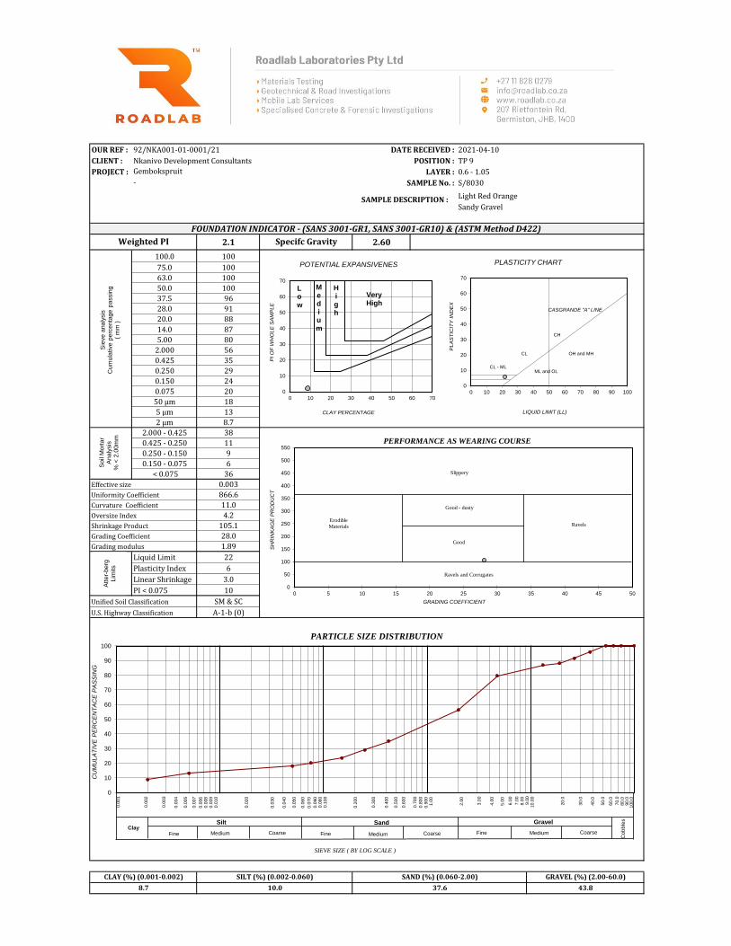
OUR REF : 92/NKA001-01-0001/21 DATE RECEIVED : 2021-04-10
CLIENT : Nkanivo Development Consultants POSITION : TP 9
PROJECT : LAYER : 0.6 - 1.05
SAMPLE No. : S/8030
Light Red Orange
Sandy Gravel
2.1 2.60
100.0 100
75.0 100
63.0 100
50.0 100
37.5 96
28.0 91
20.0 88
14.0 87
5.00 80
2.000 56
0.425 35
0.250 29
0.150 24
0.075 20
50 µm 18
5 µm 13
2 µm 8.7
2.000 - 0.425 38
0.425 - 0.250 11
0.250 - 0.150 9
0.150 - 0.075 6
< 0.075 36
Effective size 0.003 Page 1/3
Uniformity Coefficient 866.6
Curvature Coefficient 11.0
Oversize Index 4.2
Shrinkage Product 105.1
Grading Coefficient 28.0
Grading modulus 1.89
Liquid Limit 22
Plasticity Index 6
Linear Shrinkage 3.0
PI < 0.075 10
Unified Soil Classification SM & SC
U.S. Highway Classification A-1-b (0)
10.0 37.6 43.88.7
Weighted PI
CLAY (%) (0.001-0.002) SILT (%) (0.002-0.060)
Gembokspruit
Specifc Gravity
SAND (%) (0.060-2.00) GRAVEL (%) (2.00-60.0)
FOUNDATION INDICATOR - (SANS 3001-GR1, SANS 3001-GR10) & (ASTM Method D422)
SAMPLE DESCRIPTION :
-
GEOTECHNICAL & SOILS ENGINEERING
Sie
ve a
naly
sis
C
um
ula
tive p
erc
enta
ge p
assin
g
( m
m )
Soil
Mort
ar
Analy
sis
% <
2.0
0m
m
Atter-
berg
Lim
its
0
50
100
150
200
250
300
350
400
450
500
550
0 5 10 15 20 25 30 35 40 45 50
Slippery
Erodible
Materials
Good - dusty
Ravels
Good
Ravels and Corrugates
GRADING COEFFICIENT
SH
RIN
KA
GE
PR
OD
UC
T
PERFORMANCE AS WEARING COURSE
0
10
20
30
40
50
60
70
80
90
100
SIEVE SIZE ( BY LOG SCALE )
PARTICLE SIZE DISTRIBUTION
Sand Gravel
Cob
ble
s
Fine FineMedium MediumCoarse Coarse
Silt Clay
CoarseMediumFine
0
10
20
30
40
50
60
70
0 10 20 30 40 50 60 70 80 90 100
PL
AS
TIC
ITY
IN
DE
X
LIQUID LIMIT (LL)
PLASTICITY CHART
CL - ML
CL
CH
ML and OL
OH and MH
CASGRANDE "A" LINE
CU
MU
LA
TIV
E P
ER
CE
NT
AC
E P
AS
SIN
G
0.0
01
0.0
03
0.0
04
0.0
02
0.0
05
0.0
07
0.0
08
0.0
09
0.0
10
0.0
20
0.0
30
0.0
06
0.8
00
0.4
00
0.1
00
0.0
70
0.0
50
0.7
00
0.5
00
0.3
00
0.0
90
0.0
80
0.0
40
0.9
00
1.0
0
0.6
00
0.2
00
0.0
60
90.0
2.0
0
80.0
70.0
50.0
40.0
20.0
3.0
0
4.0
0
5.0
0
6.0
0
7.0
0
8.0
09.0
0
60.0
30.0
10.0
0
100.0
0
10
20
30
40
50
60
70
0 10 20 30 40 50 60 70
PI
OF
WH
OL
E S
AM
PL
E
CLAY PERCENTAGE
POTENTIAL EXPANSIVENES
Low
Medium
High
Very High

OUR REF : 92/NKA001-01-0001/21 DATE RECEIVED : 2021-04-10
CLIENT : Nkanivo Development Consultants POSITION : TP 10
PROJECT : LAYER : 0.3 - 1.0
SAMPLE No. : S/8031
Light Red Orange
Silty Gravelly Sand
2.3 2.63
100.0 100
75.0 100
63.0 97
50.0 90
37.5 87
28.0 84
20.0 77
14.0 76
5.00 71
2.000 63
0.425 38
0.250 32
0.150 26
0.075 22
50 µm 21
5 µm 14
2 µm 9.0
2.000 - 0.425 40
0.425 - 0.250 10
0.250 - 0.150 9
0.150 - 0.075 6
< 0.075 35
Effective size 0.003 Page 1/3
Uniformity Coefficient 687.8
Curvature Coefficient 10.7
Oversize Index 12.7
Shrinkage Product 114.7
Grading Coefficient 14.3
Grading modulus 1.76
Liquid Limit 19
Plasticity Index 6
Linear Shrinkage 3.0
PI < 0.075 10
Unified Soil Classification SM & SC
U.S. Highway Classification A-1-b (0)
Gembokspruit
Specifc Gravity
SAND (%) (0.060-2.00) GRAVEL (%) (2.00-60.0)
FOUNDATION INDICATOR - (SANS 3001-GR1, SANS 3001-GR10) & (ASTM Method D422)
SAMPLE DESCRIPTION :
-
12.3 42.1 36.69.0
Weighted PI
CLAY (%) (0.001-0.002) SILT (%) (0.002-0.060)
GEOTECHNICAL & SOILS ENGINEERING
Sie
ve a
naly
sis
C
um
ula
tive p
erc
enta
ge p
assin
g
( m
m )
Soil
Mort
ar
Analy
sis
% <
2.0
0m
m
Atter-
berg
Lim
its
0
50
100
150
200
250
300
350
400
450
500
550
0 5 10 15 20 25 30 35 40 45 50
Slippery
Erodible
Materials
Good - dusty
Ravels
Good
Ravels and Corrugates
GRADING COEFFICIENT
SH
RIN
KA
GE
PR
OD
UC
T
PERFORMANCE AS WEARING COURSE
0
10
20
30
40
50
60
70
80
90
100
SIEVE SIZE ( BY LOG SCALE )
PARTICLE SIZE DISTRIBUTION
Sand Gravel
Cob
ble
s
Fine FineMedium MediumCoarse Coarse
Silt Clay
CoarseMediumFine
0
10
20
30
40
50
60
70
0 10 20 30 40 50 60 70 80 90 100
PL
AS
TIC
ITY
IN
DE
X
LIQUID LIMIT (LL)
PLASTICITY CHART
CL - ML
CL
CH
ML and OL
OH and MH
CASGRANDE "A" LINE
CU
MU
LA
TIV
E P
ER
CE
NT
AC
E P
AS
SIN
G
0.0
01
0.0
03
0.0
04
0.0
02
0.0
05
0.0
07
0.0
08
0.0
09
0.0
10
0.0
20
0.0
30
0.0
06
0.8
00
0.4
00
0.1
00
0.0
70
0.0
50
0.7
00
0.5
00
0.3
00
0.0
90
0.0
80
0.0
40
0.9
00
1.0
0
0.6
00
0.2
00
0.0
60
90.0
2.0
0
80.0
70.0
50.0
40.0
20.0
3.0
0
4.0
0
5.0
0
6.0
0
7.0
0
8.0
09.0
0
60.0
30.0
10.0
0
100.0
0
10
20
30
40
50
60
70
0 10 20 30 40 50 60 70
PI
OF
WH
OL
E S
AM
PL
E
CLAY PERCENTAGE
POTENTIAL EXPANSIVENES
Low
Medium
High
Very High

OUR REF : 92/NKA001-01-0001/21 DATE RECEIVED : 2021-04-10
CLIENT : Nkanivo Development Consultants POSITION : TP 11
PROJECT : LAYER : 0.3 - 0.8
SAMPLE No. : S/8032
Light Red Brown
Sandy Gravel
- 2.57
100.0 100
75.0 100
63.0 100
50.0 96
37.5 88
28.0 85
20.0 83
14.0 82
5.00 76
2.000 51
0.425 29
0.250 21
0.150 18
0.075 12
50 µm 10
5 µm 7
2 µm 4.3
2.000 - 0.425 44
0.425 - 0.250 15
0.250 - 0.150 7
0.150 - 0.075 11
< 0.075 23
Effective size 0.050 Page 1/3
Uniformity Coefficient 61.3
Curvature Coefficient 1.6
Oversize Index 12.0
Shrinkage Product 14.5
Grading Coefficient 25.8
Grading modulus 2.08
Liquid Limit -
Plasticity Index SP
Linear Shrinkage 0.5
PI < 0.075 6
Unified Soil Classification SM
U.S. Highway Classification A-1-b (0)
6.6 40.3 48.84.3
Weighted PI
CLAY (%) (0.001-0.002) SILT (%) (0.002-0.060)
Gembokspruit
Specifc Gravity
SAND (%) (0.060-2.00) GRAVEL (%) (2.00-60.0)
FOUNDATION INDICATOR - (SANS 3001-GR1, SANS 3001-GR10) & (ASTM Method D422)
SAMPLE DESCRIPTION :
-
GEOTECHNICAL & SOILS ENGINEERING
Sie
ve a
naly
sis
C
um
ula
tive p
erc
enta
ge p
assin
g
( m
m )
Soil
Mort
ar
Analy
sis
% <
2.0
0m
m
Atter-
berg
Lim
its
0
50
100
150
200
250
300
350
400
450
500
550
0 5 10 15 20 25 30 35 40 45 50
Slippery
Erodible
Materials
Good - dusty
Ravels
Good
Ravels and Corrugates
GRADING COEFFICIENT
SH
RIN
KA
GE
PR
OD
UC
T
PERFORMANCE AS WEARING COURSE
0
10
20
30
40
50
60
70
80
90
100
SIEVE SIZE ( BY LOG SCALE )
PARTICLE SIZE DISTRIBUTION
Sand Gravel
Cob
ble
s
Fine FineMedium MediumCoarse Coarse
Silt Clay
CoarseMediumFine
0
10
20
30
40
50
60
70
0 10 20 30 40 50 60 70 80 90 100
PL
AS
TIC
ITY
IN
DE
X
LIQUID LIMIT (LL)
PLASTICITY CHART
CL - ML
CL
CH
ML and OL
OH and MH
CASGRANDE "A" LINE
CU
MU
LA
TIV
E P
ER
CE
NT
AC
E P
AS
SIN
G
0.0
01
0.0
03
0.0
04
0.0
02
0.0
05
0.0
07
0.0
08
0.0
09
0.0
10
0.0
20
0.0
30
0.0
06
0.8
00
0.4
00
0.1
00
0.0
70
0.0
50
0.7
00
0.5
00
0.3
00
0.0
90
0.0
80
0.0
40
0.9
00
1.0
0
0.6
00
0.2
00
0.0
60
90.0
2.0
0
80.0
70.0
50.0
40.0
20.0
3.0
0
4.0
0
5.0
0
6.0
0
7.0
0
8.0
09.0
0
60.0
30.0
10.0
0
100.0
0
10
20
30
40
50
60
70
0 10 20 30 40 50 60 70
PI
OF
WH
OL
E S
AM
PL
E
CLAY PERCENTAGE
POTENTIAL EXPANSIVENES
Low
Medium
High
Very High
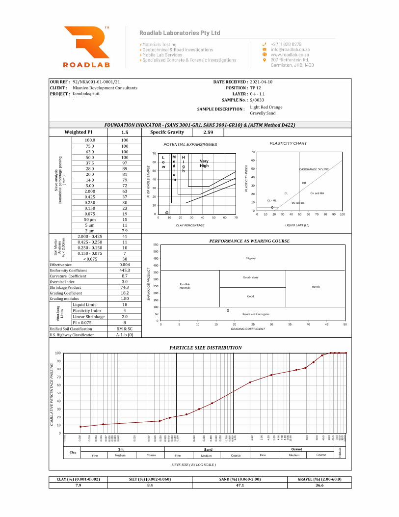
OUR REF : 92/NKA001-01-0001/21 DATE RECEIVED : 2021-04-10
CLIENT : Nkanivo Development Consultants POSITION : TP 12
PROJECT : LAYER : 0.4 - 1.1
SAMPLE No. : S/8033
Light Red Orange
Gravelly Sand
1.5 2.59
100.0 100
75.0 100
63.0 100
50.0 100
37.5 97
28.0 89
20.0 81
14.0 79
5.00 72
2.000 63
0.425 37
0.250 30
0.150 23
0.075 19
50 µm 15
5 µm 11
2 µm 7.9
2.000 - 0.425 41
0.425 - 0.250 11
0.250 - 0.150 10
0.150 - 0.075 7
< 0.075 30
Effective size 0.004 Page 1/3
Uniformity Coefficient 445.3
Curvature Coefficient 8.7
Oversize Index 3.0
Shrinkage Product 74.3
Grading Coefficient 18.2
Grading modulus 1.80
Liquid Limit 18
Plasticity Index 4
Linear Shrinkage 2.0
PI < 0.075 8
Unified Soil Classification SM & SC
U.S. Highway Classification A-1-b (0)
Gembokspruit
Specifc Gravity
SAND (%) (0.060-2.00) GRAVEL (%) (2.00-60.0)
FOUNDATION INDICATOR - (SANS 3001-GR1, SANS 3001-GR10) & (ASTM Method D422)
SAMPLE DESCRIPTION :
-
8.4 47.1 36.67.9
Weighted PI
CLAY (%) (0.001-0.002) SILT (%) (0.002-0.060)
GEOTECHNICAL & SOILS ENGINEERING
Sie
ve a
naly
sis
C
um
ula
tive p
erc
enta
ge p
assin
g
( m
m )
Soil
Mort
ar
Analy
sis
% <
2.0
0m
m
Atter-
berg
Lim
its
0
50
100
150
200
250
300
350
400
450
500
550
0 5 10 15 20 25 30 35 40 45 50
Slippery
Erodible
Materials
Good - dusty
Ravels
Good
Ravels and Corrugates
GRADING COEFFICIENT
SH
RIN
KA
GE
PR
OD
UC
T
PERFORMANCE AS WEARING COURSE
0
10
20
30
40
50
60
70
80
90
100
SIEVE SIZE ( BY LOG SCALE )
PARTICLE SIZE DISTRIBUTION
Sand Gravel
Cob
ble
s
Fine FineMedium MediumCoarse Coarse
Silt Clay
CoarseMediumFine
0
10
20
30
40
50
60
70
0 10 20 30 40 50 60 70 80 90 100
PL
AS
TIC
ITY
IN
DE
X
LIQUID LIMIT (LL)
PLASTICITY CHART
CL - ML
CL
CH
ML and OL
OH and MH
CASGRANDE "A" LINE
CU
MU
LA
TIV
E P
ER
CE
NT
AC
E P
AS
SIN
G
0.0
01
0.0
03
0.0
04
0.0
02
0.0
05
0.0
07
0.0
08
0.0
09
0.0
10
0.0
20
0.0
30
0.0
06
0.8
00
0.4
00
0.1
00
0.0
70
0.0
50
0.7
00
0.5
00
0.3
00
0.0
90
0.0
80
0.0
40
0.9
00
1.0
0
0.6
00
0.2
00
0.0
60
90.0
2.0
0
80.0
70.0
50.0
40.0
20.0
3.0
0
4.0
0
5.0
0
6.0
0
7.0
0
8.0
09.0
0
60.0
30.0
10.0
0
100.0
0
10
20
30
40
50
60
70
0 10 20 30 40 50 60 70
PI
OF
WH
OL
E S
AM
PL
E
CLAY PERCENTAGE
POTENTIAL EXPANSIVENES
Low
Medium
High
Very High

OUR REF : 92/NKA001-01-0001/21 DATE RECEIVED : 2021-04-10
CLIENT : Nkanivo Development Consultants POSITION : TP 13
PROJECT : LAYER : 0.4 - 1.0
SAMPLE No. : S/8034
Light Red Orange
Sandy Gravel
2.3 2.58
100.0 100
75.0 100
63.0 100
50.0 98
37.5 95
28.0 91
20.0 88
14.0 86
5.00 76
2.000 53
0.425 29
0.250 25
0.150 22
0.075 18
50 µm 14
5 µm 11
2 µm 7.2
2.000 - 0.425 45
0.425 - 0.250 7
0.250 - 0.150 6
0.150 - 0.075 8
< 0.075 33
Effective size 0.004 Page 1/3
Uniformity Coefficient 685.7
Curvature Coefficient 19.0
Oversize Index 4.8
Shrinkage Product 115.8
Grading Coefficient 29.3
Grading modulus 2.00
Liquid Limit 24
Plasticity Index 8
Linear Shrinkage 4.0
PI < 0.075 10
Unified Soil Classification SC
U.S. Highway Classification A-2-4 (0)
8.3 37.0 47.47.2
Weighted PI
CLAY (%) (0.001-0.002) SILT (%) (0.002-0.060)
Gembokspruit
Specifc Gravity
SAND (%) (0.060-2.00) GRAVEL (%) (2.00-60.0)
FOUNDATION INDICATOR - (SANS 3001-GR1, SANS 3001-GR10) & (ASTM Method D422)
SAMPLE DESCRIPTION :
-
GEOTECHNICAL & SOILS ENGINEERING
Sie
ve a
naly
sis
C
um
ula
tive p
erc
enta
ge p
assin
g
( m
m )
Soil
Mort
ar
Analy
sis
% <
2.0
0m
m
Atter-
berg
Lim
its
0
50
100
150
200
250
300
350
400
450
500
550
0 5 10 15 20 25 30 35 40 45 50
Slippery
Erodible
Materials
Good - dusty
Ravels
Good
Ravels and Corrugates
GRADING COEFFICIENT
SH
RIN
KA
GE
PR
OD
UC
T
PERFORMANCE AS WEARING COURSE
0
10
20
30
40
50
60
70
80
90
100
SIEVE SIZE ( BY LOG SCALE )
PARTICLE SIZE DISTRIBUTION
Sand Gravel
Cob
ble
s
Fine FineMedium MediumCoarse Coarse
Silt Clay
CoarseMediumFine
0
10
20
30
40
50
60
70
0 10 20 30 40 50 60 70 80 90 100
PL
AS
TIC
ITY
IN
DE
X
LIQUID LIMIT (LL)
PLASTICITY CHART
CL - ML
CL
CH
ML and OL
OH and MH
CASGRANDE "A" LINE
CU
MU
LA
TIV
E P
ER
CE
NT
AC
E P
AS
SIN
G
0.0
01
0.0
03
0.0
04
0.0
02
0.0
05
0.0
07
0.0
08
0.0
09
0.0
10
0.0
20
0.0
30
0.0
06
0.8
00
0.4
00
0.1
00
0.0
70
0.0
50
0.7
00
0.5
00
0.3
00
0.0
90
0.0
80
0.0
40
0.9
00
1.0
0
0.6
00
0.2
00
0.0
60
90.0
2.0
0
80.0
70.0
50.0
40.0
20.0
3.0
0
4.0
0
5.0
0
6.0
0
7.0
0
8.0
09.0
0
60.0
30.0
10.0
0
100.0
0
10
20
30
40
50
60
70
0 10 20 30 40 50 60 70
PI
OF
WH
OL
E S
AM
PL
E
CLAY PERCENTAGE
POTENTIAL EXPANSIVENES
Low
Medium
High
Very High

OUR REF : 92/NKA001-01-0001/21 DATE RECEIVED : 2021-04-10
CLIENT : Nkanivo Development Consultants POSITION : TP 14
PROJECT : LAYER : 0.55 - 1
SAMPLE No. : S/8035
Light Red Orange
Sandy Gravel
2.5 2.59
100.0 100
75.0 100
63.0 100
50.0 100
37.5 100
28.0 95
20.0 83
14.0 77
5.00 69
2.000 53
0.425 32
0.250 27
0.150 24
0.075 19
50 µm 15
5 µm 12
2 µm 8.6
2.000 - 0.425 40
0.425 - 0.250 8
0.250 - 0.150 7
0.150 - 0.075 8
< 0.075 37
Effective size 0.003 Page 1/3
Uniformity Coefficient 1016.8
Curvature Coefficient 11.8
Oversize Index 0.0
Shrinkage Product 126.7
Grading Coefficient 28.7
Grading modulus 1.96
Liquid Limit 26
Plasticity Index 8
Linear Shrinkage 4.0
PI < 0.075 16
Unified Soil Classification SC
U.S. Highway Classification A-2-4 (0)
Gembokspruit
Specifc Gravity
SAND (%) (0.060-2.00) GRAVEL (%) (2.00-60.0)
FOUNDATION INDICATOR - (SANS 3001-GR1, SANS 3001-GR10) & (ASTM Method D422)
SAMPLE DESCRIPTION :
-
8.0 36.4 47.08.6
Weighted PI
CLAY (%) (0.001-0.002) SILT (%) (0.002-0.060)
GEOTECHNICAL & SOILS ENGINEERING
Sie
ve a
naly
sis
C
um
ula
tive p
erc
enta
ge p
assin
g
( m
m )
Soil
Mort
ar
Analy
sis
% <
2.0
0m
m
Atter-
berg
Lim
its
0
50
100
150
200
250
300
350
400
450
500
550
0 5 10 15 20 25 30 35 40 45 50
Slippery
Erodible
Materials
Good - dusty
Ravels
Good
Ravels and Corrugates
GRADING COEFFICIENT
SH
RIN
KA
GE
PR
OD
UC
T
PERFORMANCE AS WEARING COURSE
0
10
20
30
40
50
60
70
80
90
100
SIEVE SIZE ( BY LOG SCALE )
PARTICLE SIZE DISTRIBUTION
Sand Gravel
Cob
ble
s
Fine FineMedium MediumCoarse Coarse
Silt Clay
CoarseMediumFine
0
10
20
30
40
50
60
70
0 10 20 30 40 50 60 70 80 90 100
PL
AS
TIC
ITY
IN
DE
X
LIQUID LIMIT (LL)
PLASTICITY CHART
CL - ML
CL
CH
ML and OL
OH and MH
CASGRANDE "A" LINE
CU
MU
LA
TIV
E P
ER
CE
NT
AC
E P
AS
SIN
G
0.0
01
0.0
03
0.0
04
0.0
02
0.0
05
0.0
07
0.0
08
0.0
09
0.0
10
0.0
20
0.0
30
0.0
06
0.8
00
0.4
00
0.1
00
0.0
70
0.0
50
0.7
00
0.5
00
0.3
00
0.0
90
0.0
80
0.0
40
0.9
00
1.0
0
0.6
00
0.2
00
0.0
60
90.0
2.0
0
80.0
70.0
50.0
40.0
20.0
3.0
0
4.0
0
5.0
0
6.0
0
7.0
0
8.0
09.0
0
60.0
30.0
10.0
0
100.0
0
10
20
30
40
50
60
70
0 10 20 30 40 50 60 70
PI
OF
WH
OL
E S
AM
PL
E
CLAY PERCENTAGE
POTENTIAL EXPANSIVENES
Low
Medium
High
Very High
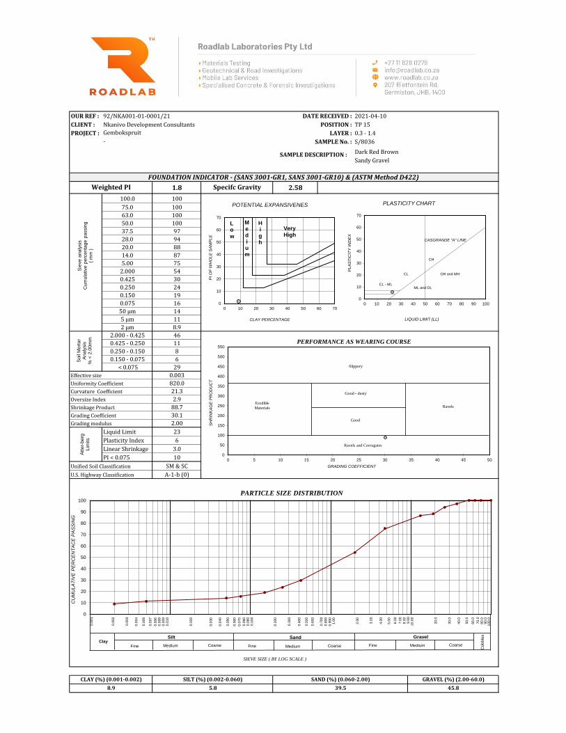
OUR REF : 92/NKA001-01-0001/21 DATE RECEIVED : 2021-04-10
CLIENT : Nkanivo Development Consultants POSITION : TP 15
PROJECT : LAYER : 0.3 - 1.4
SAMPLE No. : S/8036
Dark Red Brown
Sandy Gravel
1.8 2.58
100.0 100
75.0 100
63.0 100
50.0 100
37.5 97
28.0 94
20.0 88
14.0 87
5.00 75
2.000 54
0.425 30
0.250 24
0.150 19
0.075 16
50 µm 14
5 µm 11
2 µm 8.9
2.000 - 0.425 46
0.425 - 0.250 11
0.250 - 0.150 8
0.150 - 0.075 6
< 0.075 29
Effective size 0.003 Page 1/3
Uniformity Coefficient 820.0
Curvature Coefficient 21.3
Oversize Index 2.9
Shrinkage Product 88.7
Grading Coefficient 30.1
Grading modulus 2.00
Liquid Limit 23
Plasticity Index 6
Linear Shrinkage 3.0
PI < 0.075 10
Unified Soil Classification SM & SC
U.S. Highway Classification A-1-b (0)
5.8 39.5 45.88.9
Weighted PI
CLAY (%) (0.001-0.002) SILT (%) (0.002-0.060)
Gembokspruit
Specifc Gravity
SAND (%) (0.060-2.00) GRAVEL (%) (2.00-60.0)
FOUNDATION INDICATOR - (SANS 3001-GR1, SANS 3001-GR10) & (ASTM Method D422)
SAMPLE DESCRIPTION :
-
GEOTECHNICAL & SOILS ENGINEERING
Sie
ve a
naly
sis
C
um
ula
tive p
erc
enta
ge p
assin
g
( m
m )
Soil
Mort
ar
Analy
sis
% <
2.0
0m
m
Atter-
berg
Lim
its
0
50
100
150
200
250
300
350
400
450
500
550
0 5 10 15 20 25 30 35 40 45 50
Slippery
Erodible
Materials
Good - dusty
Ravels
Good
Ravels and Corrugates
GRADING COEFFICIENT
SH
RIN
KA
GE
PR
OD
UC
T
PERFORMANCE AS WEARING COURSE
0
10
20
30
40
50
60
70
80
90
100
SIEVE SIZE ( BY LOG SCALE )
PARTICLE SIZE DISTRIBUTION
Sand Gravel
Cob
ble
s
Fine FineMedium MediumCoarse Coarse
Silt Clay
CoarseMediumFine
0
10
20
30
40
50
60
70
0 10 20 30 40 50 60 70 80 90 100
PL
AS
TIC
ITY
IN
DE
X
LIQUID LIMIT (LL)
PLASTICITY CHART
CL - ML
CL
CH
ML and OL
OH and MH
CASGRANDE "A" LINE
CU
MU
LA
TIV
E P
ER
CE
NT
AC
E P
AS
SIN
G
0.0
01
0.0
03
0.0
04
0.0
02
0.0
05
0.0
07
0.0
08
0.0
09
0.0
10
0.0
20
0.0
30
0.0
06
0.8
00
0.4
00
0.1
00
0.0
70
0.0
50
0.7
00
0.5
00
0.3
00
0.0
90
0.0
80
0.0
40
0.9
00
1.0
0
0.6
00
0.2
00
0.0
60
90.0
2.0
0
80.0
70.0
50.0
40.0
20.0
3.0
0
4.0
0
5.0
0
6.0
0
7.0
0
8.0
09.0
0
60.0
30.0
10.0
0
100.0
0
10
20
30
40
50
60
70
0 10 20 30 40 50 60 70
PI
OF
WH
OL
E S
AM
PL
E
CLAY PERCENTAGE
POTENTIAL EXPANSIVENES
Low
Medium
High
Very High

OUR REF : 92/NKA001-01-0001/21 DATE RECEIVED : 2021-04-10
CLIENT : Nkanivo Development Consultants POSITION : TP 16
PROJECT : LAYER : 0.3 - 1.2
SAMPLE No. : S/8037
Light Yellow Orange
Sandy Gravel
2.1 2.62
100.0 100
75.0 100
63.0 100
50.0 97
37.5 94
28.0 89
20.0 81
14.0 78
5.00 70
2.000 50
0.425 32
0.250 27
0.150 23
0.075 17
50 µm 15
5 µm 11
2 µm 8.1
2.000 - 0.425 35
0.425 - 0.250 10
0.250 - 0.150 9
0.150 - 0.075 11
< 0.075 35
Effective size 0.004 Page 1/3
Uniformity Coefficient 931.2
Curvature Coefficient 8.8
Oversize Index 6.3
Shrinkage Product 97.3
Grading Coefficient 27.2
Grading modulus 2.01
Liquid Limit 17
Plasticity Index 7
Linear Shrinkage 3.0
PI < 0.075 12
Unified Soil Classification SM & SC
U.S. Highway Classification A-2-4 (0)
Gembokspruit
Specifc Gravity
SAND (%) (0.060-2.00) GRAVEL (%) (2.00-60.0)
FOUNDATION INDICATOR - (SANS 3001-GR1, SANS 3001-GR10) & (ASTM Method D422)
SAMPLE DESCRIPTION :
-
7.9 33.7 50.28.1
Weighted PI
CLAY (%) (0.001-0.002) SILT (%) (0.002-0.060)
GEOTECHNICAL & SOILS ENGINEERING
Sie
ve a
naly
sis
C
um
ula
tive p
erc
enta
ge p
assin
g
( m
m )
Soil
Mort
ar
Analy
sis
% <
2.0
0m
m
Atter-
berg
Lim
its
0
50
100
150
200
250
300
350
400
450
500
550
0 5 10 15 20 25 30 35 40 45 50
Slippery
Erodible
Materials
Good - dusty
Ravels
Good
Ravels and Corrugates
GRADING COEFFICIENT
SH
RIN
KA
GE
PR
OD
UC
T
PERFORMANCE AS WEARING COURSE
0
10
20
30
40
50
60
70
80
90
100
SIEVE SIZE ( BY LOG SCALE )
PARTICLE SIZE DISTRIBUTION
Sand Gravel
Cob
ble
s
Fine FineMedium MediumCoarse Coarse
Silt Clay
CoarseMediumFine
0
10
20
30
40
50
60
70
0 10 20 30 40 50 60 70 80 90 100
PL
AS
TIC
ITY
IN
DE
X
LIQUID LIMIT (LL)
PLASTICITY CHART
CL - ML
CL
CH
ML and OL
OH and MH
CASGRANDE "A" LINE
CU
MU
LA
TIV
E P
ER
CE
NT
AC
E P
AS
SIN
G
0.0
01
0.0
03
0.0
04
0.0
02
0.0
05
0.0
07
0.0
08
0.0
09
0.0
10
0.0
20
0.0
30
0.0
06
0.8
00
0.4
00
0.1
00
0.0
70
0.0
50
0.7
00
0.5
00
0.3
00
0.0
90
0.0
80
0.0
40
0.9
00
1.0
0
0.6
00
0.2
00
0.0
60
90.0
2.0
0
80.0
70.0
50.0
40.0
20.0
3.0
0
4.0
0
5.0
0
6.0
0
7.0
0
8.0
09.0
0
60.0
30.0
10.0
0
100.0
0
10
20
30
40
50
60
70
0 10 20 30 40 50 60 70
PI
OF
WH
OL
E S
AM
PL
E
CLAY PERCENTAGE
POTENTIAL EXPANSIVENES
Low
Medium
High
Very High
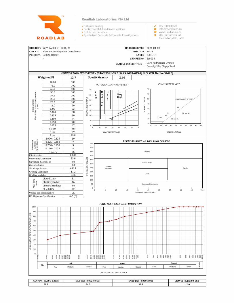
OUR REF : 92/NKA001-01-0001/21 DATE RECEIVED : 2021-04-10
CLIENT : Nkanivo Development Consultants POSITION : TP 21
PROJECT : LAYER : 0.33 - 1.1
SAMPLE No. : S/8038
Dark Red Orange Orange
Gravelly Silty Clayey Sand
12.7 2.60
100.0 100
75.0 100
63.0 100
50.0 100
37.5 100
28.0 100
20.0 100
14.0 99
5.00 93
2.000 88
0.425 80
0.250 74
0.150 70
0.075 67
50 µm 48
5 µm 39
2 µm 29.8
2.000 - 0.425 10
0.425 - 0.250 7
0.250 - 0.150 5
0.150 - 0.075 4
< 0.075 76
Effective size 0.002 Page 1/3
Uniformity Coefficient 33.0
Curvature Coefficient 0.0
Oversize Index 0.0
Shrinkage Product 636.1
Grading Coefficient 11.2
Grading modulus 0.66
Liquid Limit 31
Plasticity Index 16
Linear Shrinkage 8.0
PI < 0.075 22
Unified Soil Classification CL
U.S. Highway Classification A-6 (8)
24.3 33.9 12.029.8
Weighted PI
CLAY (%) (0.001-0.002) SILT (%) (0.002-0.060)
Gembokspruit
Specifc Gravity
SAND (%) (0.060-2.00) GRAVEL (%) (2.00-60.0)
FOUNDATION INDICATOR - (SANS 3001-GR1, SANS 3001-GR10) & (ASTM Method D422)
SAMPLE DESCRIPTION :
-
GEOTECHNICAL & SOILS ENGINEERING
Sie
ve a
naly
sis
C
um
ula
tive p
erc
enta
ge p
assin
g
( m
m )
Soil
Mort
ar
Analy
sis
% <
2.0
0m
m
Atter-
berg
Lim
its
0
50
100
150
200
250
300
350
400
450
500
550
0 5 10 15 20 25 30 35 40 45 50
Slippery
Erodible
Materials
Good - dusty
Ravels
Good
Ravels and Corrugates
GRADING COEFFICIENT
SH
RIN
KA
GE
PR
OD
UC
T
PERFORMANCE AS WEARING COURSE
0
10
20
30
40
50
60
70
80
90
100
SIEVE SIZE ( BY LOG SCALE )
PARTICLE SIZE DISTRIBUTION
Sand Gravel
Cob
ble
s
Fine FineMedium MediumCoarse Coarse
Silt Clay
CoarseMediumFine
0
10
20
30
40
50
60
70
0 10 20 30 40 50 60 70 80 90 100
PL
AS
TIC
ITY
IN
DE
X
LIQUID LIMIT (LL)
PLASTICITY CHART
CL - ML
CL
CH
ML and OL
OH and MH
CASGRANDE "A" LINE
CU
MU
LA
TIV
E P
ER
CE
NT
AC
E P
AS
SIN
G
0.0
01
0.0
03
0.0
04
0.0
02
0.0
05
0.0
07
0.0
08
0.0
09
0.0
10
0.0
20
0.0
30
0.0
06
0.8
00
0.4
00
0.1
00
0.0
70
0.0
50
0.7
00
0.5
00
0.3
00
0.0
90
0.0
80
0.0
40
0.9
00
1.0
0
0.6
00
0.2
00
0.0
60
90.0
2.0
0
80.0
70.0
50.0
40.0
20.0
3.0
0
4.0
0
5.0
0
6.0
0
7.0
0
8.0
09.0
0
60.0
30.0
10.0
0
100.0
0
10
20
30
40
50
60
70
0 10 20 30 40 50 60 70
PI
OF
WH
OL
E S
AM
PL
E
CLAY PERCENTAGE
POTENTIAL EXPANSIVENES
Low
Medium
High
Very High

OUR REF : 92/NKA001-01-0001/21 DATE RECEIVED : 2021-04-10
CLIENT : Nkanivo Development Consultants POSITION : TP 22
PROJECT : LAYER : 0.7 - 1.48
SAMPLE No. : S/8039
Dark Red Orange
Silty Clayey Gravelly Sand
5.3 2.64
100.0 100
75.0 100
63.0 100
50.0 100
37.5 100
28.0 100
20.0 95
14.0 93
5.00 78
2.000 70
0.425 53
0.250 46
0.150 41
0.075 35
50 µm 32
5 µm 27
2 µm 21.2
2.000 - 0.425 25
0.425 - 0.250 10
0.250 - 0.150 7
0.150 - 0.075 9
< 0.075 49
Effective size 0.002 Page 1/3
Uniformity Coefficient 539.8
Curvature Coefficient 0.5
Oversize Index 0.0
Shrinkage Product 263.8
Grading Coefficient 23.3
Grading modulus 1.42
Liquid Limit 25
Plasticity Index 10
Linear Shrinkage 5.0
PI < 0.075 14
Unified Soil Classification SC
U.S. Highway Classification A-2-4 (0)
Gembokspruit
Specifc Gravity
SAND (%) (0.060-2.00) GRAVEL (%) (2.00-60.0)
FOUNDATION INDICATOR - (SANS 3001-GR1, SANS 3001-GR10) & (ASTM Method D422)
SAMPLE DESCRIPTION :
-
11.8 37.1 29.821.2
Weighted PI
CLAY (%) (0.001-0.002) SILT (%) (0.002-0.060)
GEOTECHNICAL & SOILS ENGINEERING
Sie
ve a
naly
sis
C
um
ula
tive p
erc
enta
ge p
assin
g
( m
m )
Soil
Mort
ar
Analy
sis
% <
2.0
0m
m
Atter-
berg
Lim
its
0
50
100
150
200
250
300
350
400
450
500
550
0 5 10 15 20 25 30 35 40 45 50
Slippery
Erodible
Materials
Good - dusty
Ravels
Good
Ravels and Corrugates
GRADING COEFFICIENT
SH
RIN
KA
GE
PR
OD
UC
T
PERFORMANCE AS WEARING COURSE
0
10
20
30
40
50
60
70
80
90
100
SIEVE SIZE ( BY LOG SCALE )
PARTICLE SIZE DISTRIBUTION
Sand Gravel
Cob
ble
s
Fine FineMedium MediumCoarse Coarse
Silt Clay
CoarseMediumFine
0
10
20
30
40
50
60
70
0 10 20 30 40 50 60 70 80 90 100
PL
AS
TIC
ITY
IN
DE
X
LIQUID LIMIT (LL)
PLASTICITY CHART
CL - ML
CL
CH
ML and OL
OH and MH
CASGRANDE "A" LINE
CU
MU
LA
TIV
E P
ER
CE
NT
AC
E P
AS
SIN
G
0.0
01
0.0
03
0.0
04
0.0
02
0.0
05
0.0
07
0.0
08
0.0
09
0.0
10
0.0
20
0.0
30
0.0
06
0.8
00
0.4
00
0.1
00
0.0
70
0.0
50
0.7
00
0.5
00
0.3
00
0.0
90
0.0
80
0.0
40
0.9
00
1.0
0
0.6
00
0.2
00
0.0
60
90.0
2.0
0
80.0
70.0
50.0
40.0
20.0
3.0
0
4.0
0
5.0
0
6.0
0
7.0
0
8.0
09.0
0
60.0
30.0
10.0
0
100.0
0
10
20
30
40
50
60
70
0 10 20 30 40 50 60 70
PI
OF
WH
OL
E S
AM
PL
E
CLAY PERCENTAGE
POTENTIAL EXPANSIVENES
Low
Medium
High
Very High

OUR REF : 92/NKA001-01-0001/21 DATE RECEIVED : 2021-04-10
CLIENT : Nkanivo Development Consultants POSITION : TP 23
PROJECT : LAYER : 0.6 - 1.4
SAMPLE No. : S/8040
Light Red Orange
Clayey Gravelly Sand
5.6 2.58
100.0 100
75.0 100
63.0 100
50.0 98
37.5 94
28.0 89
20.0 86
14.0 86
5.00 84
2.000 69
0.425 40
0.250 37
0.150 32
0.075 26
50 µm 25
5 µm 22
2 µm 17.2
2.000 - 0.425 42
0.425 - 0.250 5
0.250 - 0.150 6
0.150 - 0.075 9
< 0.075 38
Effective size 0.002 Page 1/3
Uniformity Coefficient 746.0
Curvature Coefficient 4.9
Oversize Index 6.0
Shrinkage Product 282.2
Grading Coefficient 16.8
Grading modulus 1.64
Liquid Limit 28
Plasticity Index 14
Linear Shrinkage 7.0
PI < 0.075 18
Unified Soil Classification SC
U.S. Highway Classification A-2-6 (0)
Gembokspruit
Specifc Gravity
SAND (%) (0.060-2.00) GRAVEL (%) (2.00-60.0)
FOUNDATION INDICATOR - (SANS 3001-GR1, SANS 3001-GR10) & (ASTM Method D422)
SAMPLE DESCRIPTION :
-
8.2 43.9 30.617.2
Weighted PI
CLAY (%) (0.001-0.002) SILT (%) (0.002-0.060)
GEOTECHNICAL & SOILS ENGINEERING
Sie
ve a
naly
sis
C
um
ula
tive p
erc
enta
ge p
assin
g
( m
m )
Soil
Mort
ar
Analy
sis
% <
2.0
0m
m
Atter-
berg
Lim
its
0
50
100
150
200
250
300
350
400
450
500
550
0 5 10 15 20 25 30 35 40 45 50
Slippery
Erodible
Materials
Good - dusty
Ravels
Good
Ravels and Corrugates
GRADING COEFFICIENT
SH
RIN
KA
GE
PR
OD
UC
T
PERFORMANCE AS WEARING COURSE
0
10
20
30
40
50
60
70
80
90
100
SIEVE SIZE ( BY LOG SCALE )
PARTICLE SIZE DISTRIBUTION
Sand Gravel
Cob
ble
s
Fine FineMedium MediumCoarse Coarse
Silt Clay
CoarseMediumFine
0
10
20
30
40
50
60
70
0 10 20 30 40 50 60 70 80 90 100
PL
AS
TIC
ITY
IN
DE
X
LIQUID LIMIT (LL)
PLASTICITY CHART
CL - ML
CL
CH
ML and OL
OH and MH
CASGRANDE "A" LINE
CU
MU
LA
TIV
E P
ER
CE
NT
AC
E P
AS
SIN
G
0.0
01
0.0
03
0.0
04
0.0
02
0.0
05
0.0
07
0.0
08
0.0
09
0.0
10
0.0
20
0.0
30
0.0
06
0.8
00
0.4
00
0.1
00
0.0
70
0.0
50
0.7
00
0.5
00
0.3
00
0.0
90
0.0
80
0.0
40
0.9
00
1.0
0
0.6
00
0.2
00
0.0
60
90.0
2.0
0
80.0
70.0
50.0
40.0
20.0
3.0
0
4.0
0
5.0
0
6.0
0
7.0
0
8.0
09.0
0
60.0
30.0
10.0
0
100.0
0
10
20
30
40
50
60
70
0 10 20 30 40 50 60 70
PI
OF
WH
OL
E S
AM
PL
E
CLAY PERCENTAGE
POTENTIAL EXPANSIVENES
Low
Medium
High
Very High

OUR REF : 92/NKA001-01-0001/21 DATE RECEIVED : 2021-04-10
CLIENT : Nkanivo Development Consultants POSITION : TP 24
PROJECT : LAYER : 0.7 - 1.4
SAMPLE No. : S/8041
Light Red Orange
Clayey Sandy Gravel
2.3 2.58
100.0 100
75.0 100
63.0 92
50.0 87
37.5 85
28.0 81
20.0 78
14.0 77
5.00 71
2.000 60
0.425 39
0.250 34
0.150 29
0.075 23
50 µm 19
5 µm 15
2 µm 11.7
2.000 - 0.425 35
0.425 - 0.250 8
0.250 - 0.150 8
0.150 - 0.075 10
< 0.075 39
Effective size 0.002 Page 1/3
Uniformity Coefficient 1060.4
Curvature Coefficient 6.2
Oversize Index 15.0
Shrinkage Product 116.2
Grading Coefficient 15.4
Grading modulus 1.79
Liquid Limit 21
Plasticity Index 6
Linear Shrinkage 3.0
PI < 0.075 10
Unified Soil Classification SM & SC
U.S. Highway Classification A-1-b (0)
Gembokspruit
Specifc Gravity
SAND (%) (0.060-2.00) GRAVEL (%) (2.00-60.0)
FOUNDATION INDICATOR - (SANS 3001-GR1, SANS 3001-GR10) & (ASTM Method D422)
SAMPLE DESCRIPTION :
-
8.5 39.4 40.511.7
Weighted PI
CLAY (%) (0.001-0.002) SILT (%) (0.002-0.060)
GEOTECHNICAL & SOILS ENGINEERING
Sie
ve a
naly
sis
C
um
ula
tive p
erc
enta
ge p
assin
g
( m
m )
Soil
Mort
ar
Analy
sis
% <
2.0
0m
m
Atter-
berg
Lim
its
0
50
100
150
200
250
300
350
400
450
500
550
0 5 10 15 20 25 30 35 40 45 50
Slippery
Erodible
Materials
Good - dusty
Ravels
Good
Ravels and Corrugates
GRADING COEFFICIENT
SH
RIN
KA
GE
PR
OD
UC
T
PERFORMANCE AS WEARING COURSE
0
10
20
30
40
50
60
70
80
90
100
SIEVE SIZE ( BY LOG SCALE )
PARTICLE SIZE DISTRIBUTION
Sand Gravel
Cob
ble
s
Fine FineMedium MediumCoarse Coarse
Silt Clay
CoarseMediumFine
0
10
20
30
40
50
60
70
0 10 20 30 40 50 60 70 80 90 100
PL
AS
TIC
ITY
IN
DE
X
LIQUID LIMIT (LL)
PLASTICITY CHART
CL - ML
CL
CH
ML and OL
OH and MH
CASGRANDE "A" LINE
CU
MU
LA
TIV
E P
ER
CE
NT
AC
E P
AS
SIN
G
0.0
01
0.0
03
0.0
04
0.0
02
0.0
05
0.0
07
0.0
08
0.0
09
0.0
10
0.0
20
0.0
30
0.0
06
0.8
00
0.4
00
0.1
00
0.0
70
0.0
50
0.7
00
0.5
00
0.3
00
0.0
90
0.0
80
0.0
40
0.9
00
1.0
0
0.6
00
0.2
00
0.0
60
90.0
2.0
0
80.0
70.0
50.0
40.0
20.0
3.0
0
4.0
0
5.0
0
6.0
0
7.0
0
8.0
09.0
0
60.0
30.0
10.0
0
100.0
0
10
20
30
40
50
60
70
0 10 20 30 40 50 60 70
PI
OF
WH
OL
E S
AM
PL
E
CLAY PERCENTAGE
POTENTIAL EXPANSIVENES
Low
Medium
High
Very High

OUR REF : 92/NKA001-01-0001/21 DATE RECEIVED : 2021-04-10
CLIENT : Nkanivo Development Consultants POSITION : TP 25
PROJECT : LAYER : 0.25 - 0.9
SAMPLE No. : S/8042
Light Red Orange
Sandy Gravel
2.2 2.50
100.0 100
75.0 100
63.0 97
50.0 97
37.5 93
28.0 89
20.0 86
14.0 81
5.00 59
2.000 42
0.425 22
0.250 19
0.150 16
0.075 14
50 µm 12
5 µm 9
2 µm 6.7
2.000 - 0.425 46
0.425 - 0.250 8
0.250 - 0.150 7
0.150 - 0.075 6
< 0.075 34
Effective size 0.014 Page 1/3
Uniformity Coefficient 395.7
Curvature Coefficient 14.1
Oversize Index 6.5
Shrinkage Product 112.4
Grading Coefficient 28.1
Grading modulus 2.22
Liquid Limit 27
Plasticity Index 10
Linear Shrinkage 5.0
PI < 0.075 14
Unified Soil Classification SC
U.S. Highway Classification A-2-4 (0)
6.2 28.6 58.56.7
Weighted PI
CLAY (%) (0.001-0.002) SILT (%) (0.002-0.060)
Gembokspruit
Specifc Gravity
SAND (%) (0.060-2.00) GRAVEL (%) (2.00-60.0)
FOUNDATION INDICATOR - (SANS 3001-GR1, SANS 3001-GR10) & (ASTM Method D422)
SAMPLE DESCRIPTION :
-
GEOTECHNICAL & SOILS ENGINEERING
Sie
ve a
naly
sis
C
um
ula
tive p
erc
enta
ge p
assin
g
( m
m )
Soil
Mort
ar
Analy
sis
% <
2.0
0m
m
Atter-
berg
Lim
its
0
50
100
150
200
250
300
350
400
450
500
550
0 5 10 15 20 25 30 35 40 45 50
Slippery
Erodible
Materials
Good - dusty
Ravels
Good
Ravels and Corrugates
GRADING COEFFICIENT
SH
RIN
KA
GE
PR
OD
UC
T
PERFORMANCE AS WEARING COURSE
0
10
20
30
40
50
60
70
80
90
100
SIEVE SIZE ( BY LOG SCALE )
PARTICLE SIZE DISTRIBUTION
Sand Gravel
Cob
ble
s
Fine FineMedium MediumCoarse Coarse
Silt Clay
CoarseMediumFine
0
10
20
30
40
50
60
70
0 10 20 30 40 50 60 70 80 90 100
PL
AS
TIC
ITY
IN
DE
X
LIQUID LIMIT (LL)
PLASTICITY CHART
CL - ML
CL
CH
ML and OL
OH and MH
CASGRANDE "A" LINE
CU
MU
LA
TIV
E P
ER
CE
NT
AC
E P
AS
SIN
G
0.0
01
0.0
03
0.0
04
0.0
02
0.0
05
0.0
07
0.0
08
0.0
09
0.0
10
0.0
20
0.0
30
0.0
06
0.8
00
0.4
00
0.1
00
0.0
70
0.0
50
0.7
00
0.5
00
0.3
00
0.0
90
0.0
80
0.0
40
0.9
00
1.0
0
0.6
00
0.2
00
0.0
60
90.0
2.0
0
80.0
70.0
50.0
40.0
20.0
3.0
0
4.0
0
5.0
0
6.0
0
7.0
0
8.0
09.0
0
60.0
30.0
10.0
0
100.0
0
10
20
30
40
50
60
70
0 10 20 30 40 50 60 70
PI
OF
WH
OL
E S
AM
PL
E
CLAY PERCENTAGE
POTENTIAL EXPANSIVENES
Low
Medium
High
Very High
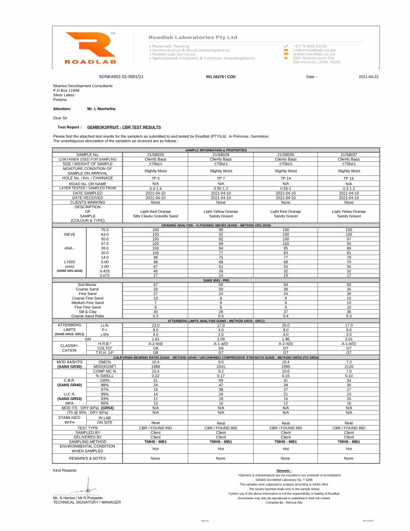
RG 16376 / COD Date - 2021-04-22
Nkanivo Development Consultants
P.O Box 11948
Silver Lakes
Pretoria
Attention: Mr. L Mavhetha
Dear Sir
Please find the attached test results for the sample/s as submitted to and tested by Roadlab (PTY)Ltd. In Primrose, Germiston.
The unambiguous description of the sample/s as received are as follows :
SAMPLE INFORMATION & PROPERTIES
21/S8026 21/S8028 21/S8035 21/S8037
Clients Bags Clients Bags Clients Bags Clients Bags
±70kg's ±70kg's ±70kg's ±70kg's
Slightly Moist Slightly Moist Slightly Moist Slightly Moist
TP 5 TP 7 TP 14 TP 16
N/A N/A N/A N/A
0.4-1.4 0.55-1.2 0.55-1 0.3-1.2
2021-04-10 2021-04-10 2021-04-10 2021-04-10
2021-04-10 2021-04-10 2021-04-10 2021-04-10
None None None None
Light Red Orange Light Yellow Orange Light Red Orange Light Yelow Orange
Silty Clayey Gravelly Sand Sandy Gravel Sandy Gravel Sandy Gravel
GRADING ANALYSIS - % PASSING SIEVES (SANS : METHOD GR1:2010)
75.0 100 95 100 100
63.0 100 92 100 100
50.0 100 92 100 97
37.5 100 89 100 94
28.0 100 84 95 89
20.0 100 77 83 81
14.0 98 75 77 78
5.00 98 68 69 70
2.00 67 51 53 50
0.425 45 26 32 320.075 27 14 19 17
SANS 3001 - PR5
67 50 54 5033 50 39 3427 24 24 3010 8 9 107 8 6 109 8 9 1040 26 37 360.3 0.5 0.4 0.3
ATTERBERG LIMITS ANALYSIS (SANS : METHOD GR10 ; GR11)
LL% 23.0 17.0 26.0 17.0
P.I. 8.0 4.0 8.0 6.6
LS% 4.0 2.0 4.0 3.0
GM 1.61 2.09 1.96 2.01
H.R.B.* A-2-4(d) A-1-a(0) A-2-4(0) A-1-b(0)
G8 G6 G7 G7T.R.H. 14* G8 G7 G7 G7
CALIFORNIA BEARING RATIO (SANS : METHOD GR40) / UNCONFINED COMPRESSIVE STRENGTH (SANS : METHOD GR53) (ITS GR54)
10.4 9.0 10.4 7.0
1988 2041 1990 2126
10.4 9.2 10.6 7.0
0.22 0.17 0.15 0.10
31 69 41 34
24 47 34 30
19 38 27 27
14 26 21 23
12 18 16 20
10 10 12 16
N/A N/A N/A N/A
N/A N/A N/A N/A
Neat Neat Neat Neat
CBR / FOUND IND CBR / FOUND IND CBR / FOUND IND CBR / FOUND IND
Client Client Client Client
Client Client Client Client
TMH5 - MB1 TMH5 - MB1 TMH5 - MB1 TMH5 - MB1
Hot Hot Hot Hot
Kind Regards
TECHNICAL SIGNATORY / MANAGER
MPA
IN LAB
MOD ITS : DRY (kPa) (GR54)
(SANS GR1:2010)
COMP MC %
LIMITS
98%
DATE RECEIVED
ROAD No. OR NAME
SAMPLE
MDD(KG/M3)
100%
(SANS GR30)
90%
92/NKA001-01-0001/21
Test Report : GEMBOKSPRUIT - CBR TEST RESULTS
CONTAINER USED FOR SAMPLING
SIZE / WEIGHT OF SAMPLE
MOISTURE CONDITION OF
SAMPLE ON ARRIVAL
SAMPLE No.
HOLE No. / Km. / CHAINAGE
MOD AASHTO
ATTERBERG
CLIENTS MARKING
LAYER TESTED / SAMPLED FROM
DESCRIPTION
OF
DATE SAMPLED
(SANS GR10; GR11)
% SWELL
95%
(COLOUR & TYPE)
(mm)
CLASSIFI -
CATIONCOLTO*
OMC%
SIEVE
ANA -
LYSIS
Compiled By : Rehmat Ally
None None None None
Mr. N Herbst / Mr R Potgieter
*Opinions & Interpretations are not included in our schedule of Accreditation
TEST TYPE
SANAS Accredited Laboratory No. T 0296
The samples were subjected to analysis according to SANS 3001
C.B.R.
The results reported relate only to the sample tested
Further use of the above information is not the responsibility or liability of Roadlab
STABILISED
WITH ON SITE
ITS @ 95% : DRY (kPa)
97%
(SANS GR40)
Documents may only be reproduced or published in their full context
REMARKS & NOTES
SAMPLED BY
ENVIRONMENTAL CONDITION
WHEN SAMPLED
SAMPLING METHOD
U.C.S.
(SANS GR53) 93%
Remarks :
DELIVERED BY
Silt & ClayCoarse Sand Ratio
Soil Mortar Coarse Sand
Fine SandCoarse Fine SandMedium Fine Sand
Fine Fine Sand
Page 1of1 RLG.s.029.01
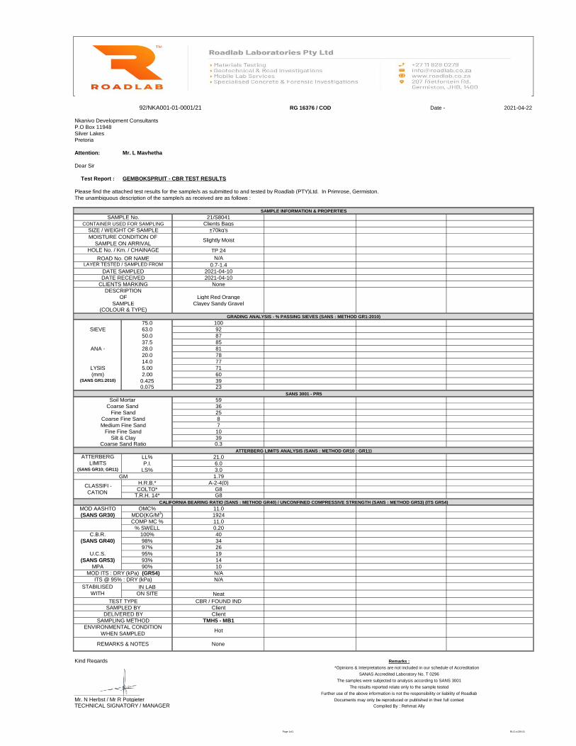
RG 16376 / COD Date - 2021-04-22
Nkanivo Development Consultants
P.O Box 11948
Silver Lakes
Pretoria
Attention: Mr. L Mavhetha
Dear Sir
Please find the attached test results for the sample/s as submitted to and tested by Roadlab (PTY)Ltd. In Primrose, Germiston.
The unambiguous description of the sample/s as received are as follows :
SAMPLE INFORMATION & PROPERTIES
21/S8041
Clients Bags
±70kg's
Slightly Moist
TP 24
N/A
0.7-1.4
2021-04-10
2021-04-10
None
Light Red Orange
Clayey Sandy Gravel
GRADING ANALYSIS - % PASSING SIEVES (SANS : METHOD GR1:2010)
75.0 100
63.0 92
50.0 87
37.5 85
28.0 81
20.0 78
14.0 77
5.00 71
2.00 60
0.425 390.075 23
SANS 3001 - PR5
5936258710390.3
ATTERBERG LIMITS ANALYSIS (SANS : METHOD GR10 ; GR11)
LL% 21.0
P.I. 6.0
LS% 3.0
GM 1.79
H.R.B.* A-2-4(0)
G8T.R.H. 14* G8
CALIFORNIA BEARING RATIO (SANS : METHOD GR40) / UNCONFINED COMPRESSIVE STRENGTH (SANS : METHOD GR53) (ITS GR54)
11.0
1924
11.0
0.20
40
34
26
19
14
10
N/A
N/A
Neat
CBR / FOUND IND
Client
Client
TMH5 - MB1
Hot
Kind Regards
TECHNICAL SIGNATORY / MANAGER Compiled By : Rehmat Ally
SANAS Accredited Laboratory No. T 0296
The samples were subjected to analysis according to SANS 3001
The results reported relate only to the sample tested
Further use of the above information is not the responsibility or liability of Roadlab
Mr. N Herbst / Mr R Potgieter Documents may only be reproduced or published in their full context
None
Remarks :
*Opinions & Interpretations are not included in our schedule of Accreditation
TEST TYPE
SAMPLED BY
DELIVERED BY
SAMPLING METHOD
ENVIRONMENTAL CONDITION
WHEN SAMPLED
REMARKS & NOTES
MOD ITS : DRY (kPa) (GR54)
ITS @ 95% : DRY (kPa)
STABILISED
WITHIN LAB
ON SITE
U.C.S. 95%
(SANS GR53) 93%
MPA 90%
C.B.R. 100%
(SANS GR40) 98%
97%
MOD AASHTO OMC%
(SANS GR30) MDD(KG/M3)
COMP MC %
% SWELL
Silt & ClayCoarse Sand Ratio
ATTERBERG
LIMITS(SANS GR10; GR11)
CLASSIFI -
CATIONCOLTO*
Soil Mortar Coarse Sand
Fine SandCoarse Fine SandMedium Fine Sand
Fine Fine Sand
SIEVE
ANA -
LYSIS
(mm)(SANS GR1:2010)
DATE RECEIVED
CLIENTS MARKING
DESCRIPTION
OF
SAMPLE(COLOUR & TYPE)
SIZE / WEIGHT OF SAMPLE
MOISTURE CONDITION OF
SAMPLE ON ARRIVAL
HOLE No. / Km. / CHAINAGE
ROAD No. OR NAMELAYER TESTED / SAMPLED FROM
DATE SAMPLED
92/NKA001-01-0001/21
Test Report : GEMBOKSPRUIT - CBR TEST RESULTS
SAMPLE No.
CONTAINER USED FOR SAMPLING
Page 1of1 RLG.s.029.01
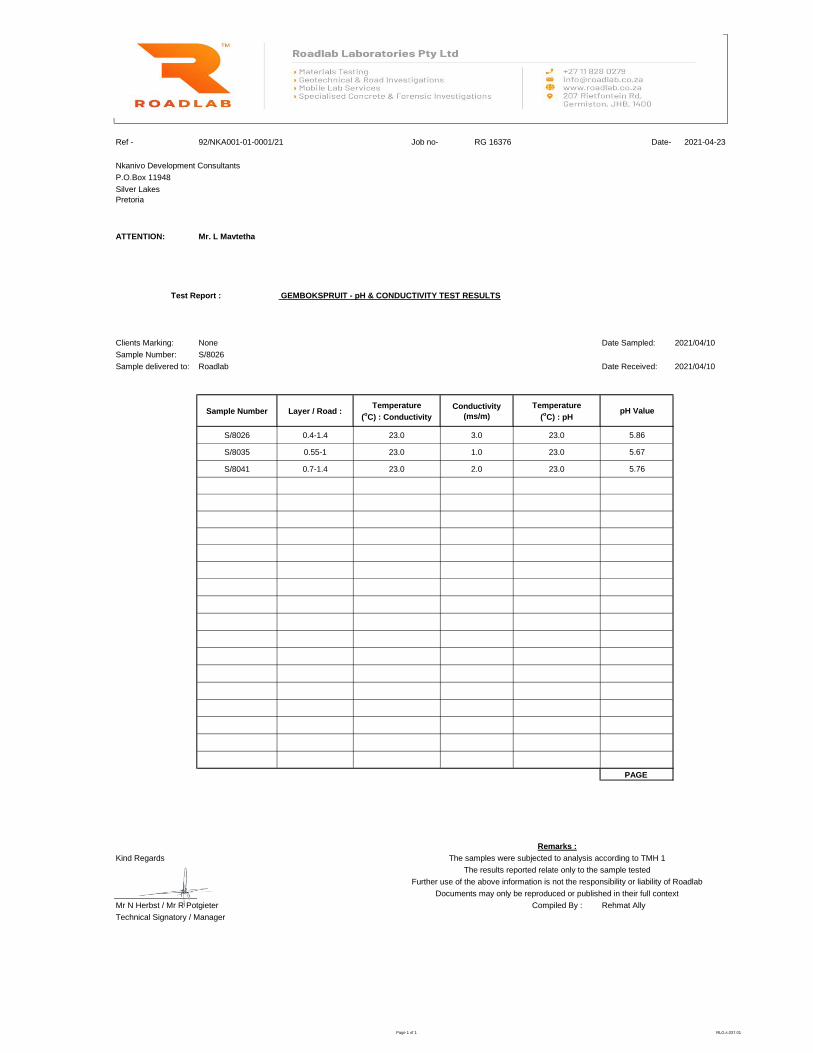
Ref - Job no- RG 16376 Date- 2021-04-23
Nkanivo Development Consultants
P.O.Box 11948
Silver Lakes
Pretoria
ATTENTION: Mr. L Mavtetha
GEMBOKSPRUIT - pH & CONDUCTIVITY TEST RESULTS
Clients Marking: None Date Sampled: 2021/04/10
Sample Number: S/8026
Sample delivered to: Roadlab Date Received: 2021/04/10
Sample Number Layer / Road :Temperature
(oC) : Conductivity
Conductivity
(ms/m)
Temperature
(oC) : pH
pH Value
S/8026 0.4-1.4 23.0 3.0 23.0 5.86
S/8035 0.55-1 23.0 1.0 23.0 5.67
S/8041 0.7-1.4 23.0 2.0 23.0 5.76
PAGE
Remarks :
Kind Regards The samples were subjected to analysis according to TMH 1
The results reported relate only to the sample tested
Further use of the above information is not the responsibility or liability of Roadlab
Documents may only be reproduced or published in their full context
Mr N Herbst / Mr R Potgieter Compiled By : Rehmat Ally
92/NKA001-01-0001/21
Test Report :
Technical Signatory / Manager
Facilities to print on provided letterheads
Page 1 of 1 RLG.s.037.01

Phase 1 near surface geotechnical investigation for the proposed township establishment on portion 4, 5, 13, 22 and the remainder of portion 12 of the farm Gemsbokspruit 229 JR, Mpumalanga province of South Africa
38 | P a g e
17. APPENDIX C: SOIL PROFILES
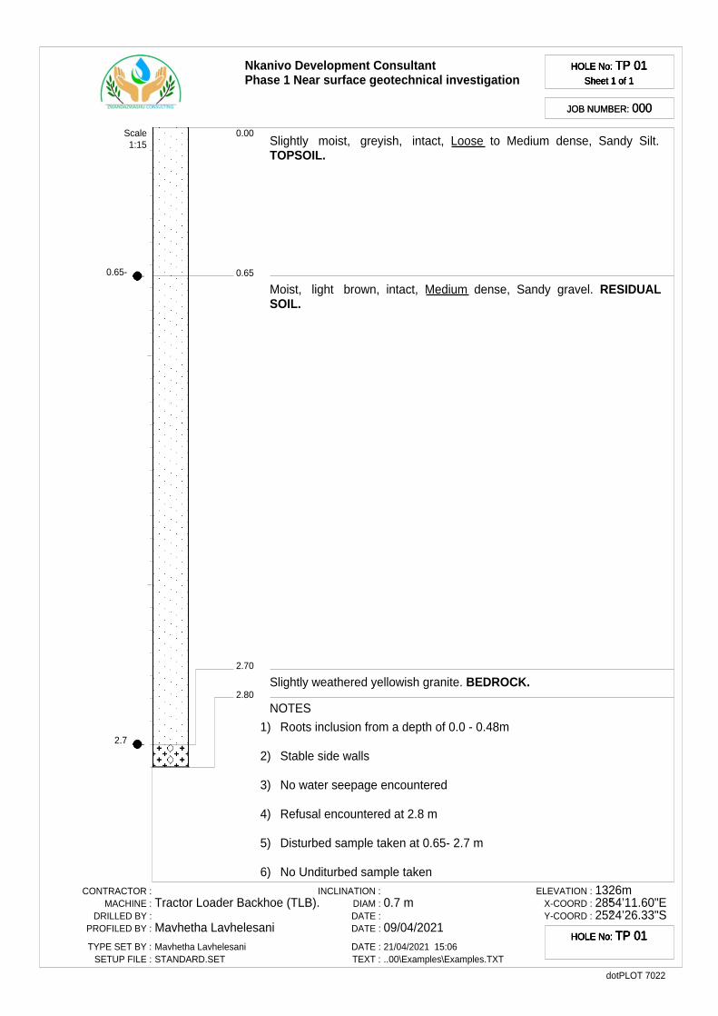
0.65-
2.7
Nkanivo Development ConsultantPhase 1 Near surface geotechnical investigation
HOLE No: TP 01Sheet 1 of 1
HOLE No: TP 01Sheet 1 of 1
HOLE No: TP 01Sheet 1 of 1
HOLE No: TP 01Sheet 1 of 1
JOB NUMBER: 000JOB NUMBER: 000
0.65
0.00
2.70
2.80
Slightly moist, greyish, intact, Loose to Medium dense, Sandy Silt.TOPSOIL.
Moist, light brown, intact, Medium dense, Sandy gravel. RESIDUALSOIL.
Slightly weathered yellowish granite. BEDROCK.
Scale1:15
NOTES
1) Roots inclusion from a depth of 0.0 - 0.48m
2) Stable side walls
3) No water seepage encountered
4) Refusal encountered at 2.8 m
5) Disturbed sample taken at 0.65- 2.7 m
6) No Unditurbed sample takenCONTRACTOR :
MACHINE :DRILLED BY :
PROFILED BY :
TYPE SET BY :SETUP FILE :
Tractor Loader Backhoe (TLB).
Mavhetha LavhelesaniMavhetha LavhelesaniSTANDARD.SET
INCLINATION :DIAM :DATE :DATE :
DATE :TEXT :
0.7 m
09/04/202121/04/2021 15:06..00\Examples\Examples.TXT
ELEVATION :X-COORD :Y-COORD :
1326m28°54’11.60"E25°24’26.33"S
dotPLOT 7022
HOLE No: TP 01HOLE No: TP 01HOLE No: TP 01HOLE No: TP 01
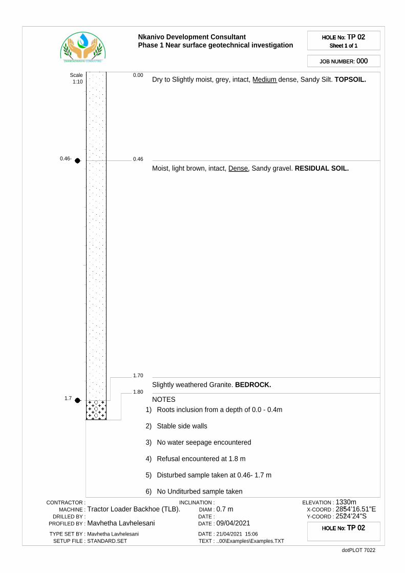
0.46-
1.7
Nkanivo Development ConsultantPhase 1 Near surface geotechnical investigation
HOLE No: TP 02Sheet 1 of 1
HOLE No: TP 02Sheet 1 of 1
HOLE No: TP 02Sheet 1 of 1
HOLE No: TP 02Sheet 1 of 1
JOB NUMBER: 000JOB NUMBER: 000
0.46
0.00
1.70
1.80
Dry to Slightly moist, grey, intact, Medium dense, Sandy Silt. TOPSOIL.
Moist, light brown, intact, Dense, Sandy gravel. RESIDUAL SOIL.
Slightly weathered Granite. BEDROCK.
Scale1:10
NOTES1) Roots inclusion from a depth of 0.0 - 0.4m
2) Stable side walls
3) No water seepage encountered
4) Refusal encountered at 1.8 m
5) Disturbed sample taken at 0.46- 1.7 m
6) No Unditurbed sample taken
CONTRACTOR :MACHINE :
DRILLED BY :PROFILED BY :
TYPE SET BY :SETUP FILE :
Tractor Loader Backhoe (TLB).
Mavhetha LavhelesaniMavhetha LavhelesaniSTANDARD.SET
INCLINATION :DIAM :DATE :DATE :
DATE :TEXT :
0.7 m
09/04/202121/04/2021 15:06..00\Examples\Examples.TXT
ELEVATION :X-COORD :Y-COORD :
1330m28°54’16.51"E25°24’24"S
dotPLOT 7022
HOLE No: TP 02HOLE No: TP 02HOLE No: TP 02HOLE No: TP 02
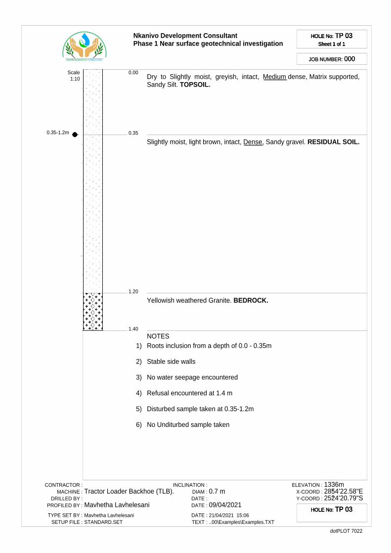
0.35-1.2m
Nkanivo Development ConsultantPhase 1 Near surface geotechnical investigation
HOLE No: TP 03Sheet 1 of 1
HOLE No: TP 03Sheet 1 of 1
HOLE No: TP 03Sheet 1 of 1
HOLE No: TP 03Sheet 1 of 1
JOB NUMBER: 000JOB NUMBER: 000
0.35
0.00
1.20
1.40
Dry to Slightly moist, greyish, intact, Medium dense, Matrix supported,Sandy Silt. TOPSOIL.
Slightly moist, light brown, intact, Dense, Sandy gravel. RESIDUAL SOIL.
Yellowish weathered Granite. BEDROCK.
Scale1:10
NOTES1) Roots inclusion from a depth of 0.0 - 0.35m
2) Stable side walls
3) No water seepage encountered
4) Refusal encountered at 1.4 m
5) Disturbed sample taken at 0.35-1.2m
6) No Unditurbed sample taken
CONTRACTOR :MACHINE :
DRILLED BY :PROFILED BY :
TYPE SET BY :SETUP FILE :
Tractor Loader Backhoe (TLB).
Mavhetha LavhelesaniMavhetha LavhelesaniSTANDARD.SET
INCLINATION :DIAM :DATE :DATE :
DATE :TEXT :
0.7 m
09/04/202121/04/2021 15:06..00\Examples\Examples.TXT
ELEVATION :X-COORD :Y-COORD :
1336m28°54’22.58"E25°24’20.79"S
dotPLOT 7022
HOLE No: TP 03HOLE No: TP 03HOLE No: TP 03HOLE No: TP 03
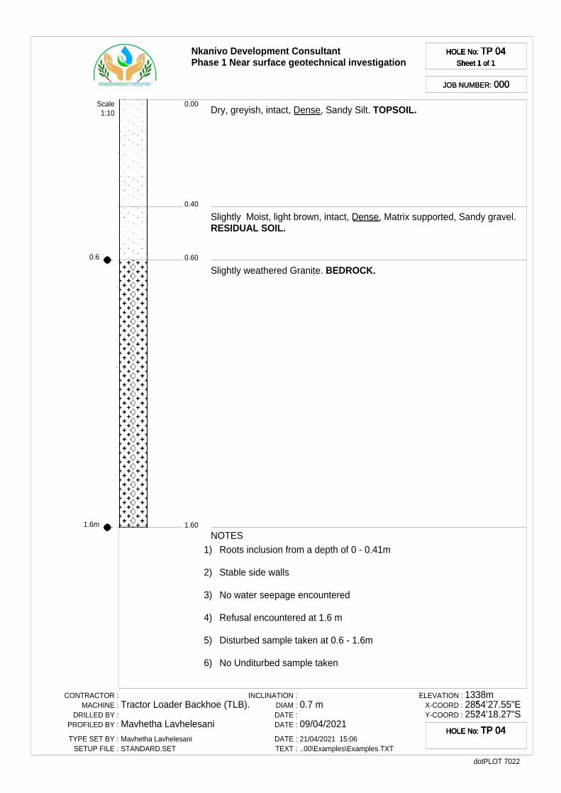
0.6
1.6m
Nkanivo Development ConsultantPhase 1 Near surface geotechnical investigation
HOLE No: TP 04Sheet 1 of 1
HOLE No: TP 04Sheet 1 of 1
HOLE No: TP 04Sheet 1 of 1
HOLE No: TP 04Sheet 1 of 1
JOB NUMBER: 000JOB NUMBER: 000
0.40
0.00
0.60
1.60
Dry, greyish, intact, Dense, Sandy Silt. TOPSOIL.
Slightly Moist, light brown, intact, Dense, Matrix supported, Sandy gravel.RESIDUAL SOIL.
Slightly weathered Granite. BEDROCK.
Scale1:10
NOTES1) Roots inclusion from a depth of 0 - 0.41m
2) Stable side walls
3) No water seepage encountered
4) Refusal encountered at 1.6 m
5) Disturbed sample taken at 0.6 - 1.6m
6) No Unditurbed sample taken
CONTRACTOR :MACHINE :
DRILLED BY :PROFILED BY :
TYPE SET BY :SETUP FILE :
Tractor Loader Backhoe (TLB).
Mavhetha LavhelesaniMavhetha LavhelesaniSTANDARD.SET
INCLINATION :DIAM :DATE :DATE :
DATE :TEXT :
0.7 m
09/04/202121/04/2021 15:06..00\Examples\Examples.TXT
ELEVATION :X-COORD :Y-COORD :
1338m28°54’27.55"E25°24’18.27"S
dotPLOT 7022
HOLE No: TP 04HOLE No: TP 04HOLE No: TP 04HOLE No: TP 04
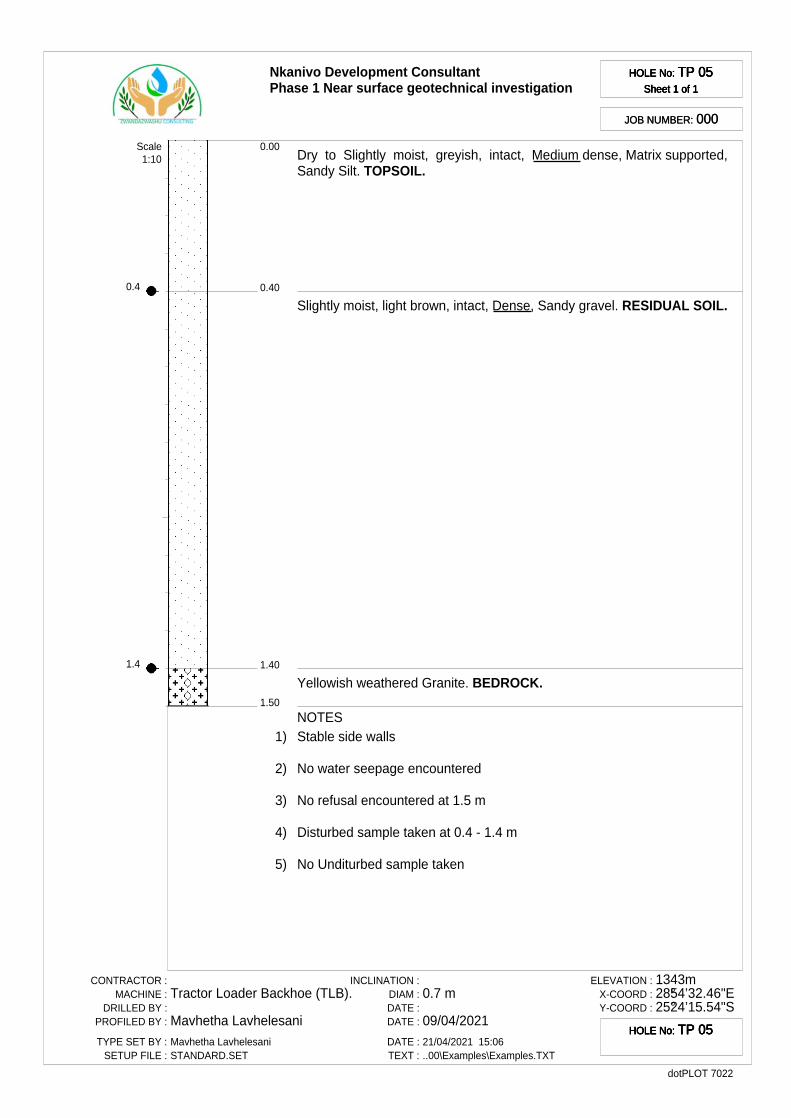
0.4
1.4
Nkanivo Development ConsultantPhase 1 Near surface geotechnical investigation
HOLE No: TP 05Sheet 1 of 1
HOLE No: TP 05Sheet 1 of 1
HOLE No: TP 05Sheet 1 of 1
HOLE No: TP 05Sheet 1 of 1
JOB NUMBER: 000JOB NUMBER: 000
0.40
0.00
1.40
1.50
Dry to Slightly moist, greyish, intact, Medium dense, Matrix supported,Sandy Silt. TOPSOIL.
Slightly moist, light brown, intact, Dense, Sandy gravel. RESIDUAL SOIL.
Yellowish weathered Granite. BEDROCK.
Scale1:10
NOTES1) Stable side walls
2) No water seepage encountered
3) No refusal encountered at 1.5 m
4) Disturbed sample taken at 0.4 - 1.4 m
5) No Unditurbed sample taken
CONTRACTOR :MACHINE :
DRILLED BY :PROFILED BY :
TYPE SET BY :SETUP FILE :
Tractor Loader Backhoe (TLB).
Mavhetha LavhelesaniMavhetha LavhelesaniSTANDARD.SET
INCLINATION :DIAM :DATE :DATE :
DATE :TEXT :
0.7 m
09/04/202121/04/2021 15:06..00\Examples\Examples.TXT
ELEVATION :X-COORD :Y-COORD :
1343m28°54’32.46"E25°24’15.54"S
dotPLOT 7022
HOLE No: TP 05HOLE No: TP 05HOLE No: TP 05HOLE No: TP 05

0.5
1.6m
Nkanivo Development ConsultantPhase 1 Near surface geotechnical investigation
HOLE No: TP 06Sheet 1 of 1
HOLE No: TP 06Sheet 1 of 1
HOLE No: TP 06Sheet 1 of 1
HOLE No: TP 06Sheet 1 of 1
JOB NUMBER: 000JOB NUMBER: 000
0.50
0.00
1.60
1.70
Dry to Slightly moist, grey, intact, Medium dense, Sandy Silt. TOPSOIL.
Moist, light brown, intact, Dense, Sandy gravel. RESIDUAL SOIL.
Slightly weathered Granite. BEDROCK.
Scale1:10
NOTES
1) Roots inclusion from a depth of 0 - 0.45m
2) Stable side walls
3) No water seepage encountered
4) Refusal encountered at 1.7 m
5) Disturbed sample taken at 0.5 - 1.6m
6) No Unditurbed sample takenCONTRACTOR :
MACHINE :DRILLED BY :
PROFILED BY :
TYPE SET BY :SETUP FILE :
Tractor Loader Backhoe (TLB).
Mavhetha LavhelesaniMavhetha LavhelesaniSTANDARD.SET
INCLINATION :DIAM :DATE :DATE :
DATE :TEXT :
0.7 m
09/04/202121/04/2021 15:06..00\Examples\Examples.TXT
ELEVATION :X-COORD :Y-COORD :
1349m28°54’27.41"E25°24’9.51"S
dotPLOT 7022
HOLE No: TP 06HOLE No: TP 06HOLE No: TP 06HOLE No: TP 06
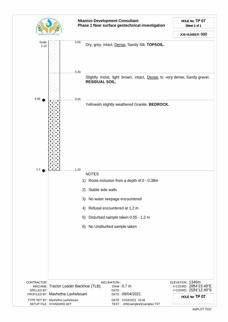
0.55
1.2
Nkanivo Development ConsultantPhase 1 Near surface geotechnical investigation
HOLE No: TP 07Sheet 1 of 1
HOLE No: TP 07Sheet 1 of 1
HOLE No: TP 07Sheet 1 of 1
HOLE No: TP 07Sheet 1 of 1
JOB NUMBER: 000JOB NUMBER: 000
0.30
0.00
0.55
1.20
Dry, grey, intact, Dense, Sandy Silt. TOPSOIL.
Slightly moist, light brown, intact, Dense to very dense, Sandy gravel.RESIDUAL SOIL.
Yellowish slightly weathered Granite. BEDROCK.
Scale1:10
NOTES
1) Roots inclusion from a depth of 0 - 0.38m
2) Stable side walls
3) No water seepage encountered
4) Refusal encountered at 1.2 m
5) Disturbed sample taken 0.55 - 1.2 m
6) No Unditurbed sample taken
CONTRACTOR :MACHINE :
DRILLED BY :PROFILED BY :
TYPE SET BY :SETUP FILE :
Tractor Loader Backhoe (TLB).
Mavhetha LavhelesaniMavhetha LavhelesaniSTANDARD.SET
INCLINATION :DIAM :DATE :DATE :
DATE :TEXT :
0.7 m
09/04/202121/04/2021 15:06..00\Examples\Examples.TXT
ELEVATION :X-COORD :Y-COORD :
1346m28°54’23.49"E25°24’12.40"S
dotPLOT 7022
HOLE No: TP 07HOLE No: TP 07HOLE No: TP 07HOLE No: TP 07
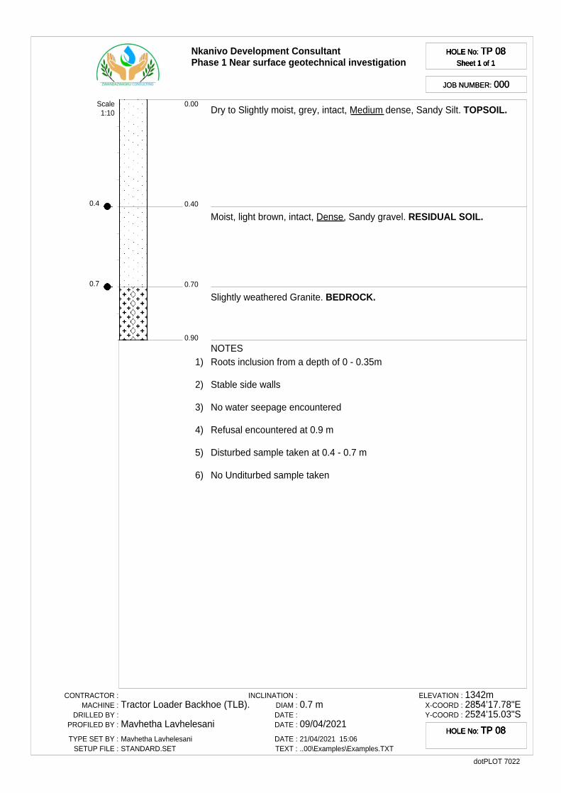
0.4
0.7
Nkanivo Development ConsultantPhase 1 Near surface geotechnical investigation
HOLE No: TP 08Sheet 1 of 1
HOLE No: TP 08Sheet 1 of 1
HOLE No: TP 08Sheet 1 of 1
HOLE No: TP 08Sheet 1 of 1
JOB NUMBER: 000JOB NUMBER: 000
0.40
0.00
0.70
0.90
Dry to Slightly moist, grey, intact, Medium dense, Sandy Silt. TOPSOIL.
Moist, light brown, intact, Dense, Sandy gravel. RESIDUAL SOIL.
Slightly weathered Granite. BEDROCK.
Scale1:10
NOTES1) Roots inclusion from a depth of 0 - 0.35m
2) Stable side walls
3) No water seepage encountered
4) Refusal encountered at 0.9 m
5) Disturbed sample taken at 0.4 - 0.7 m
6) No Unditurbed sample taken
CONTRACTOR :MACHINE :
DRILLED BY :PROFILED BY :
TYPE SET BY :SETUP FILE :
Tractor Loader Backhoe (TLB).
Mavhetha LavhelesaniMavhetha LavhelesaniSTANDARD.SET
INCLINATION :DIAM :DATE :DATE :
DATE :TEXT :
0.7 m
09/04/202121/04/2021 15:06..00\Examples\Examples.TXT
ELEVATION :X-COORD :Y-COORD :
1342m28°54’17.78"E25°24’15.03"S
dotPLOT 7022
HOLE No: TP 08HOLE No: TP 08HOLE No: TP 08HOLE No: TP 08
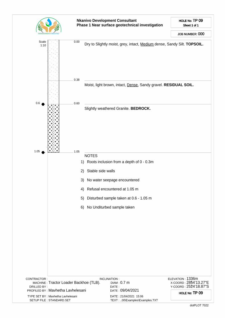
0.6
1.05
Nkanivo Development ConsultantPhase 1 Near surface geotechnical investigation
HOLE No: TP 09Sheet 1 of 1
HOLE No: TP 09Sheet 1 of 1
HOLE No: TP 09Sheet 1 of 1
HOLE No: TP 09Sheet 1 of 1
JOB NUMBER: 000JOB NUMBER: 000
0.38
0.00
0.60
1.05
Dry to Slightly moist, grey, intact, Medium dense, Sandy Silt. TOPSOIL.
Moist, light brown, intact, Dense, Sandy gravel. RESIDUAL SOIL.
Slightly weathered Granite. BEDROCK.
Scale1:10
NOTES
1) Roots inclusion from a depth of 0 - 0.3m
2) Stable side walls
3) No water seepage encountered
4) Refusal encountered at 1.05 m
5) Disturbed sample taken at 0.6 - 1.05 m
6) No Unditurbed sample taken
CONTRACTOR :MACHINE :
DRILLED BY :PROFILED BY :
TYPE SET BY :SETUP FILE :
Tractor Loader Backhoe (TLB).
Mavhetha LavhelesaniMavhetha LavhelesaniSTANDARD.SET
INCLINATION :DIAM :DATE :DATE :
DATE :TEXT :
0.7 m
09/04/202121/04/2021 15:06..00\Examples\Examples.TXT
ELEVATION :X-COORD :Y-COORD :
1336m28°54’13.27"E25°24’18.87"S
dotPLOT 7022
HOLE No: TP 09HOLE No: TP 09HOLE No: TP 09HOLE No: TP 09
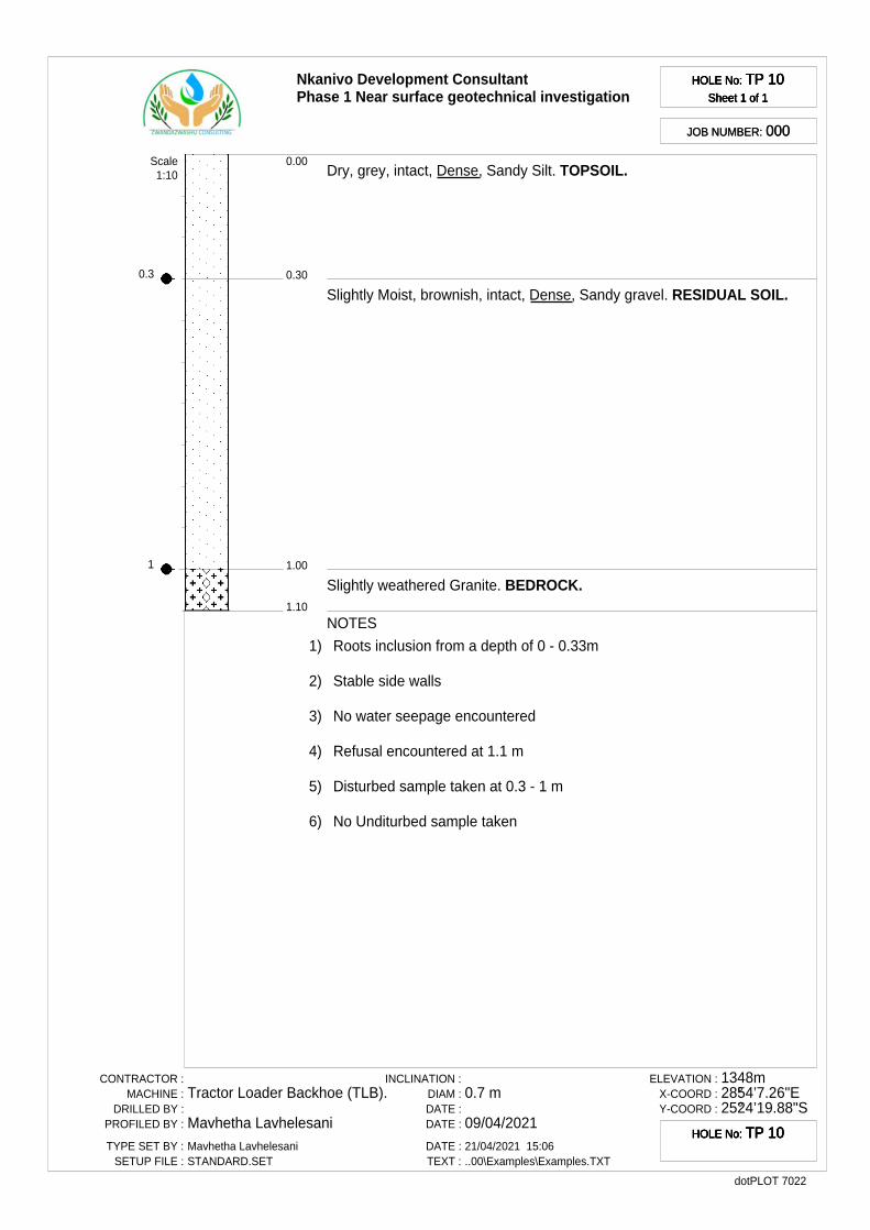
0.3
1
Nkanivo Development ConsultantPhase 1 Near surface geotechnical investigation
HOLE No: TP 10Sheet 1 of 1
HOLE No: TP 10Sheet 1 of 1
HOLE No: TP 10Sheet 1 of 1
HOLE No: TP 10Sheet 1 of 1
JOB NUMBER: 000JOB NUMBER: 000
0.30
0.00
1.00
1.10
Dry, grey, intact, Dense, Sandy Silt. TOPSOIL.
Slightly Moist, brownish, intact, Dense, Sandy gravel. RESIDUAL SOIL.
Slightly weathered Granite. BEDROCK.
Scale1:10
NOTES
1) Roots inclusion from a depth of 0 - 0.33m
2) Stable side walls
3) No water seepage encountered
4) Refusal encountered at 1.1 m
5) Disturbed sample taken at 0.3 - 1 m
6) No Unditurbed sample taken
CONTRACTOR :MACHINE :
DRILLED BY :PROFILED BY :
TYPE SET BY :SETUP FILE :
Tractor Loader Backhoe (TLB).
Mavhetha LavhelesaniMavhetha LavhelesaniSTANDARD.SET
INCLINATION :DIAM :DATE :DATE :
DATE :TEXT :
0.7 m
09/04/202121/04/2021 15:06..00\Examples\Examples.TXT
ELEVATION :X-COORD :Y-COORD :
1348m28°54’7.26"E25°24’19.88"S
dotPLOT 7022
HOLE No: TP 10HOLE No: TP 10HOLE No: TP 10HOLE No: TP 10
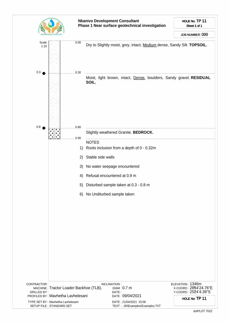
0.3
0.8
Nkanivo Development ConsultantPhase 1 Near surface geotechnical investigation
HOLE No: TP 11Sheet 1 of 1
HOLE No: TP 11Sheet 1 of 1
HOLE No: TP 11Sheet 1 of 1
HOLE No: TP 11Sheet 1 of 1
JOB NUMBER: 000JOB NUMBER: 000
0.30
0.00
0.80
0.90
Dry to Slightly moist, grey, intact, Medium dense, Sandy Silt. TOPSOIL.
Moist, light brown, intact, Dense, boulders, Sandy gravel. RESIDUALSOIL.
Slightly weathered Granite. BEDROCK.
Scale1:10
NOTES1) Roots inclusion from a depth of 0 - 0.32m
2) Stable side walls
3) No water seepage encountered
4) Refusal encountered at 0.9 m
5) Disturbed sample taken at 0.3 - 0.8 m
6) No Unditurbed sample taken
CONTRACTOR :MACHINE :
DRILLED BY :PROFILED BY :
TYPE SET BY :SETUP FILE :
Tractor Loader Backhoe (TLB).
Mavhetha LavhelesaniMavhetha LavhelesaniSTANDARD.SET
INCLINATION :DIAM :DATE :DATE :
DATE :TEXT :
0.7 m
09/04/202121/04/2021 15:06..00\Examples\Examples.TXT
ELEVATION :X-COORD :Y-COORD :
1346m28°54’24.76"E25°24’4.39"S
dotPLOT 7022
HOLE No: TP 11HOLE No: TP 11HOLE No: TP 11HOLE No: TP 11
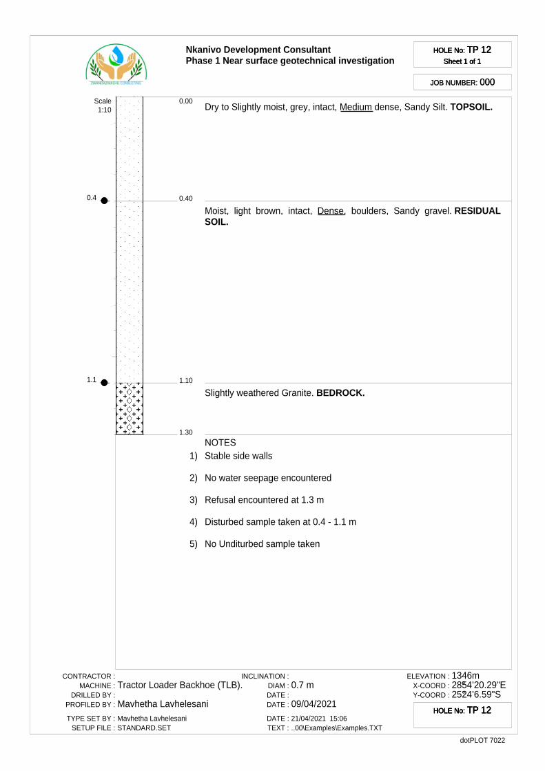
0.4
1.1
Nkanivo Development ConsultantPhase 1 Near surface geotechnical investigation
HOLE No: TP 12Sheet 1 of 1
HOLE No: TP 12Sheet 1 of 1
HOLE No: TP 12Sheet 1 of 1
HOLE No: TP 12Sheet 1 of 1
JOB NUMBER: 000JOB NUMBER: 000
0.40
0.00
1.10
1.30
Dry to Slightly moist, grey, intact, Medium dense, Sandy Silt. TOPSOIL.
Moist, light brown, intact, Dense, boulders, Sandy gravel. RESIDUALSOIL.
Slightly weathered Granite. BEDROCK.
Scale1:10
NOTES1) Stable side walls
2) No water seepage encountered
3) Refusal encountered at 1.3 m
4) Disturbed sample taken at 0.4 - 1.1 m
5) No Unditurbed sample taken
CONTRACTOR :MACHINE :
DRILLED BY :PROFILED BY :
TYPE SET BY :SETUP FILE :
Tractor Loader Backhoe (TLB).
Mavhetha LavhelesaniMavhetha LavhelesaniSTANDARD.SET
INCLINATION :DIAM :DATE :DATE :
DATE :TEXT :
0.7 m
09/04/202121/04/2021 15:06..00\Examples\Examples.TXT
ELEVATION :X-COORD :Y-COORD :
1346m28°54’20.29"E25°24’6.59"S
dotPLOT 7022
HOLE No: TP 12HOLE No: TP 12HOLE No: TP 12HOLE No: TP 12
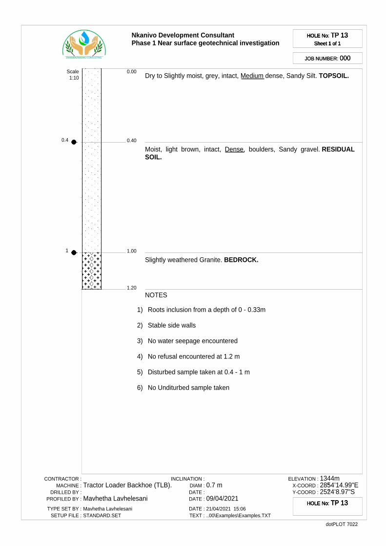
0.4
1
Nkanivo Development ConsultantPhase 1 Near surface geotechnical investigation
HOLE No: TP 13Sheet 1 of 1
HOLE No: TP 13Sheet 1 of 1
HOLE No: TP 13Sheet 1 of 1
HOLE No: TP 13Sheet 1 of 1
JOB NUMBER: 000JOB NUMBER: 000
0.40
0.00
1.00
1.20
Dry to Slightly moist, grey, intact, Medium dense, Sandy Silt. TOPSOIL.
Moist, light brown, intact, Dense, boulders, Sandy gravel. RESIDUALSOIL.
Slightly weathered Granite. BEDROCK.
Scale1:10
NOTES
1) Roots inclusion from a depth of 0 - 0.33m
2) Stable side walls
3) No water seepage encountered
4) No refusal encountered at 1.2 m
5) Disturbed sample taken at 0.4 - 1 m
6) No Unditurbed sample taken
CONTRACTOR :MACHINE :
DRILLED BY :PROFILED BY :
TYPE SET BY :SETUP FILE :
Tractor Loader Backhoe (TLB).
Mavhetha LavhelesaniMavhetha LavhelesaniSTANDARD.SET
INCLINATION :DIAM :DATE :DATE :
DATE :TEXT :
0.7 m
09/04/202121/04/2021 15:06..00\Examples\Examples.TXT
ELEVATION :X-COORD :Y-COORD :
1344m28°54’14.99"E25°24’8.97"S
dotPLOT 7022
HOLE No: TP 13HOLE No: TP 13HOLE No: TP 13HOLE No: TP 13

0.55
1m
Nkanivo Development ConsultantPhase 1 Near surface geotechnical investigation
HOLE No: TP 14Sheet 1 of 1
HOLE No: TP 14Sheet 1 of 1
HOLE No: TP 14Sheet 1 of 1
HOLE No: TP 14Sheet 1 of 1
JOB NUMBER: 000JOB NUMBER: 000
0.28
0.00
0.55
1.00
Slightly moist, greyish, intact, Medium dense, Matrix supported, SandySilt. TOPSOIL.
Slightly moist to Moist, light brown, intact, Dense to very dense, Sandygravel. RESIDUAL SOIL.
Yellowish slightly weathered Granite. BEDROCK.
Scale1:10
NOTES1) Stable side walls
2) No water seepage encountered
3) Refusal encountered at 1 m
4) Disturbed sample taken at 0.55 - 1m
5) No Unditurbed sample taken
CONTRACTOR :MACHINE :
DRILLED BY :PROFILED BY :
TYPE SET BY :SETUP FILE :
Tractor Loader Backhoe (TLB).
Mavhetha LavhelesaniMavhetha LavhelesaniSTANDARD.SET
INCLINATION :DIAM :DATE :DATE :
DATE :TEXT :
0.7 m
09/04/202121/04/2021 15:06..00\Examples\Examples.TXT
ELEVATION :X-COORD :Y-COORD :
1340m28°54’10.62"E25°24’13.30"S
dotPLOT 7022
HOLE No: TP 14HOLE No: TP 14HOLE No: TP 14HOLE No: TP 14
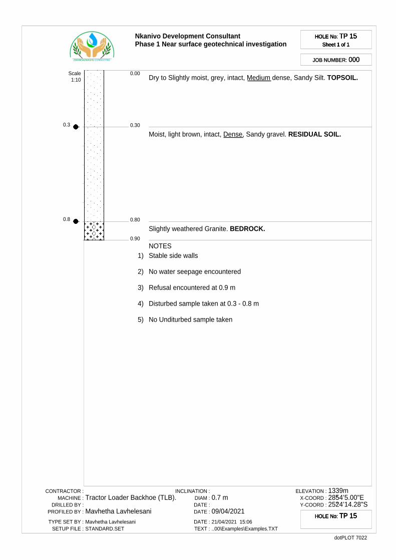
0.3
0.8
Nkanivo Development ConsultantPhase 1 Near surface geotechnical investigation
HOLE No: TP 15Sheet 1 of 1
HOLE No: TP 15Sheet 1 of 1
HOLE No: TP 15Sheet 1 of 1
HOLE No: TP 15Sheet 1 of 1
JOB NUMBER: 000JOB NUMBER: 000
0.30
0.00
0.80
0.90
Dry to Slightly moist, grey, intact, Medium dense, Sandy Silt. TOPSOIL.
Moist, light brown, intact, Dense, Sandy gravel. RESIDUAL SOIL.
Slightly weathered Granite. BEDROCK.
Scale1:10
NOTES1) Stable side walls
2) No water seepage encountered
3) Refusal encountered at 0.9 m
4) Disturbed sample taken at 0.3 - 0.8 m
5) No Unditurbed sample taken
CONTRACTOR :MACHINE :
DRILLED BY :PROFILED BY :
TYPE SET BY :SETUP FILE :
Tractor Loader Backhoe (TLB).
Mavhetha LavhelesaniMavhetha LavhelesaniSTANDARD.SET
INCLINATION :DIAM :DATE :DATE :
DATE :TEXT :
0.7 m
09/04/202121/04/2021 15:06..00\Examples\Examples.TXT
ELEVATION :X-COORD :Y-COORD :
1339m28°54’5.00"E25°24’14.28"S
dotPLOT 7022
HOLE No: TP 15HOLE No: TP 15HOLE No: TP 15HOLE No: TP 15
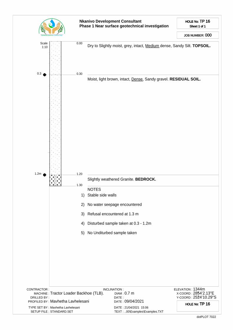
0.3
1.2m
Nkanivo Development ConsultantPhase 1 Near surface geotechnical investigation
HOLE No: TP 16Sheet 1 of 1
HOLE No: TP 16Sheet 1 of 1
HOLE No: TP 16Sheet 1 of 1
HOLE No: TP 16Sheet 1 of 1
JOB NUMBER: 000JOB NUMBER: 000
0.30
0.00
1.20
1.30
Dry to Slightly moist, grey, intact, Medium dense, Sandy Silt. TOPSOIL.
Moist, light brown, intact, Dense, Sandy gravel. RESIDUAL SOIL.
Slightly weathered Granite. BEDROCK.
Scale1:10
NOTES1) Stable side walls
2) No water seepage encountered
3) Refusal encountered at 1.3 m
4) Disturbed sample taken at 0.3 - 1.2m
5) No Unditurbed sample taken
CONTRACTOR :MACHINE :
DRILLED BY :PROFILED BY :
TYPE SET BY :SETUP FILE :
Tractor Loader Backhoe (TLB).
Mavhetha LavhelesaniMavhetha LavhelesaniSTANDARD.SET
INCLINATION :DIAM :DATE :DATE :
DATE :TEXT :
0.7 m
09/04/202121/04/2021 15:06..00\Examples\Examples.TXT
ELEVATION :X-COORD :Y-COORD :
1344m28°54’2.13"E25°24’10.29"S
dotPLOT 7022
HOLE No: TP 16HOLE No: TP 16HOLE No: TP 16HOLE No: TP 16
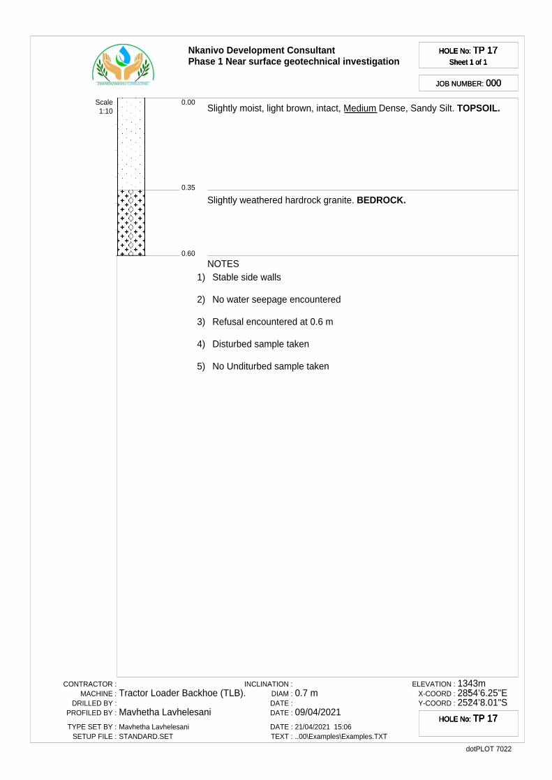
Nkanivo Development ConsultantPhase 1 Near surface geotechnical investigation
HOLE No: TP 17Sheet 1 of 1
HOLE No: TP 17Sheet 1 of 1
HOLE No: TP 17Sheet 1 of 1
HOLE No: TP 17Sheet 1 of 1
JOB NUMBER: 000JOB NUMBER: 000
0.35
0.00
0.60
Slightly moist, light brown, intact, Medium Dense, Sandy Silt. TOPSOIL.
Slightly weathered hardrock granite. BEDROCK.
Scale1:10
NOTES1) Stable side walls
2) No water seepage encountered
3) Refusal encountered at 0.6 m
4) Disturbed sample taken
5) No Unditurbed sample taken
CONTRACTOR :MACHINE :
DRILLED BY :PROFILED BY :
TYPE SET BY :SETUP FILE :
Tractor Loader Backhoe (TLB).
Mavhetha LavhelesaniMavhetha LavhelesaniSTANDARD.SET
INCLINATION :DIAM :DATE :DATE :
DATE :TEXT :
0.7 m
09/04/202121/04/2021 15:06..00\Examples\Examples.TXT
ELEVATION :X-COORD :Y-COORD :
1343m28°54’6.25"E25°24’8.01"S
dotPLOT 7022
HOLE No: TP 17HOLE No: TP 17HOLE No: TP 17HOLE No: TP 17
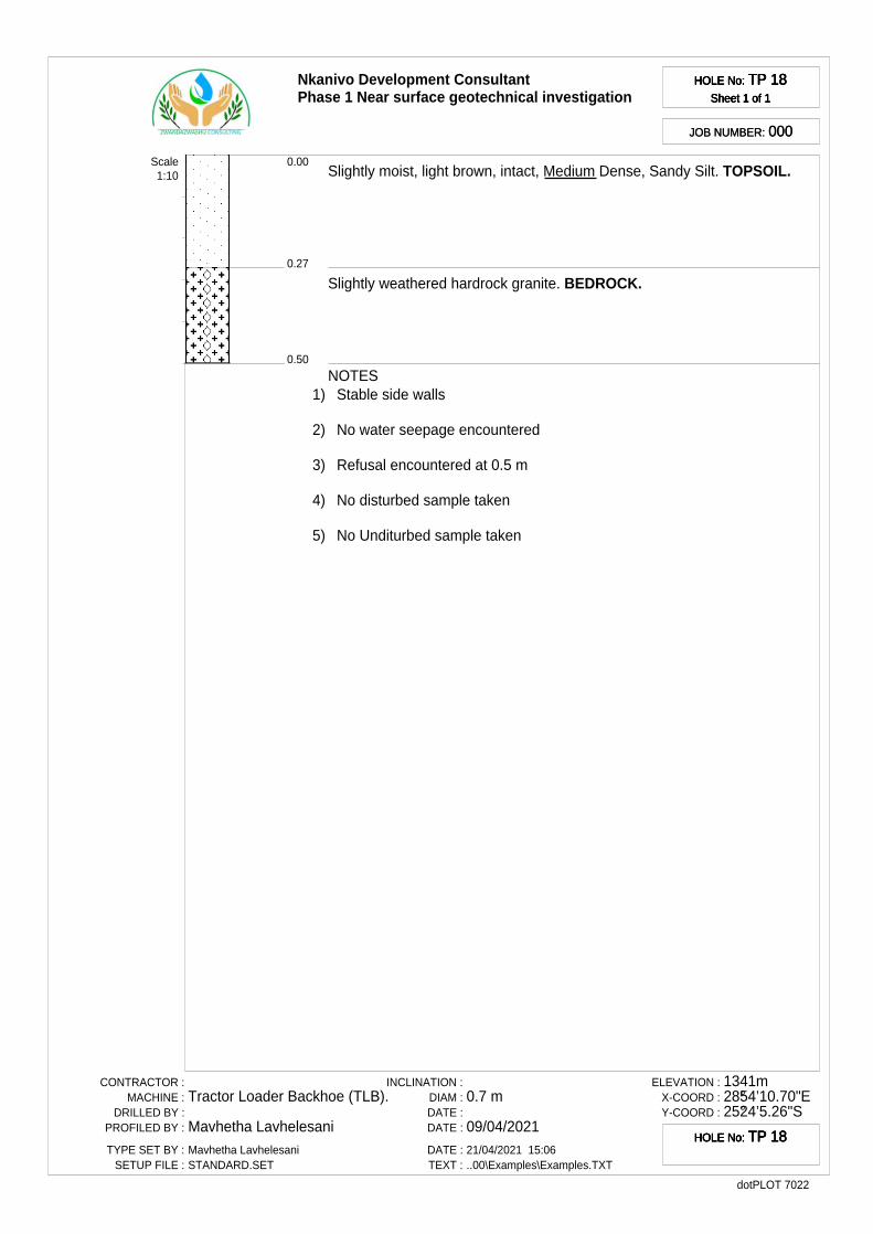
Nkanivo Development ConsultantPhase 1 Near surface geotechnical investigation
HOLE No: TP 18Sheet 1 of 1
HOLE No: TP 18Sheet 1 of 1
HOLE No: TP 18Sheet 1 of 1
HOLE No: TP 18Sheet 1 of 1
JOB NUMBER: 000JOB NUMBER: 000
0.27
0.00
0.50
Slightly moist, light brown, intact, Medium Dense, Sandy Silt. TOPSOIL.
Slightly weathered hardrock granite. BEDROCK.
Scale1:10
NOTES1) Stable side walls
2) No water seepage encountered
3) Refusal encountered at 0.5 m
4) No disturbed sample taken
5) No Unditurbed sample taken
CONTRACTOR :MACHINE :
DRILLED BY :PROFILED BY :
TYPE SET BY :SETUP FILE :
Tractor Loader Backhoe (TLB).
Mavhetha LavhelesaniMavhetha LavhelesaniSTANDARD.SET
INCLINATION :DIAM :DATE :DATE :
DATE :TEXT :
0.7 m
09/04/202121/04/2021 15:06..00\Examples\Examples.TXT
ELEVATION :X-COORD :Y-COORD :
1341m28°54’10.70"E25°24’5.26"S
dotPLOT 7022
HOLE No: TP 18HOLE No: TP 18HOLE No: TP 18HOLE No: TP 18
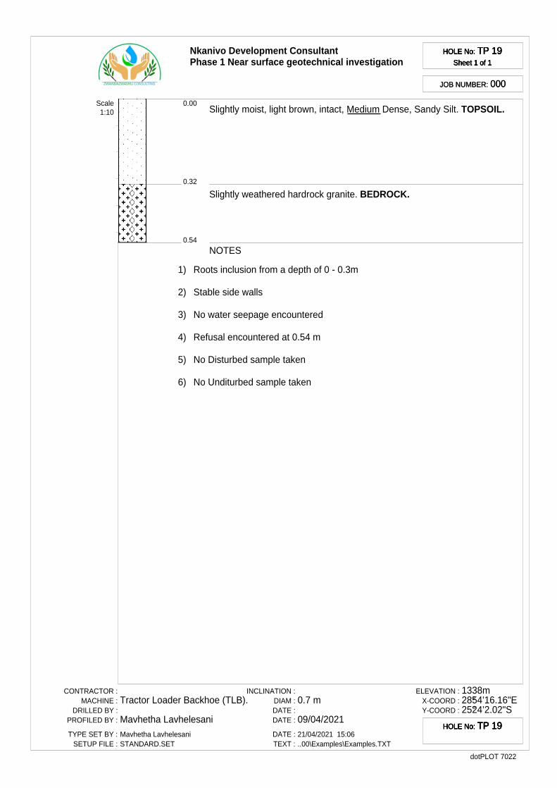
Nkanivo Development ConsultantPhase 1 Near surface geotechnical investigation
HOLE No: TP 19Sheet 1 of 1
HOLE No: TP 19Sheet 1 of 1
HOLE No: TP 19Sheet 1 of 1
HOLE No: TP 19Sheet 1 of 1
JOB NUMBER: 000JOB NUMBER: 000
0.32
0.00
0.54
Slightly moist, light brown, intact, Medium Dense, Sandy Silt. TOPSOIL.
Slightly weathered hardrock granite. BEDROCK.
Scale1:10
NOTES
1) Roots inclusion from a depth of 0 - 0.3m
2) Stable side walls
3) No water seepage encountered
4) Refusal encountered at 0.54 m
5) No Disturbed sample taken
6) No Unditurbed sample taken
CONTRACTOR :MACHINE :
DRILLED BY :PROFILED BY :
TYPE SET BY :SETUP FILE :
Tractor Loader Backhoe (TLB).
Mavhetha LavhelesaniMavhetha LavhelesaniSTANDARD.SET
INCLINATION :DIAM :DATE :DATE :
DATE :TEXT :
0.7 m
09/04/202121/04/2021 15:06..00\Examples\Examples.TXT
ELEVATION :X-COORD :Y-COORD :
1338m28°54’16.16"E25°24’2.02"S
dotPLOT 7022
HOLE No: TP 19HOLE No: TP 19HOLE No: TP 19HOLE No: TP 19
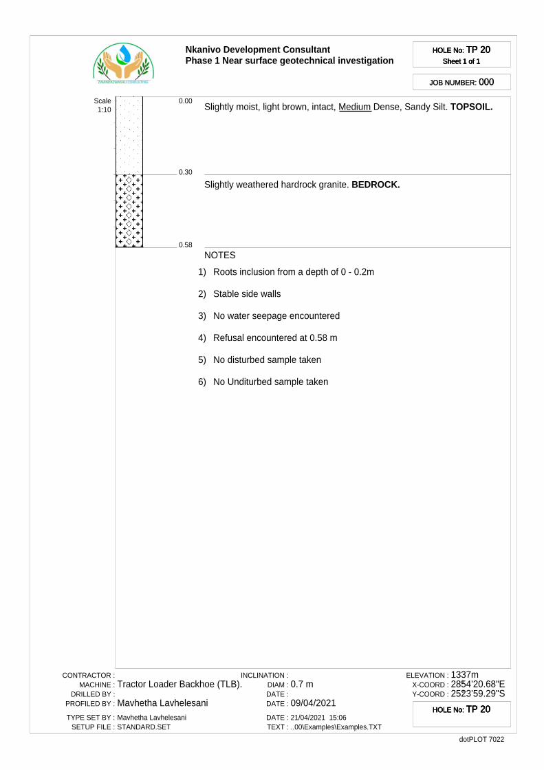
Nkanivo Development ConsultantPhase 1 Near surface geotechnical investigation
HOLE No: TP 20Sheet 1 of 1
HOLE No: TP 20Sheet 1 of 1
HOLE No: TP 20Sheet 1 of 1
HOLE No: TP 20Sheet 1 of 1
JOB NUMBER: 000JOB NUMBER: 000
0.30
0.00
0.58
Slightly moist, light brown, intact, Medium Dense, Sandy Silt. TOPSOIL.
Slightly weathered hardrock granite. BEDROCK.
Scale1:10
NOTES
1) Roots inclusion from a depth of 0 - 0.2m
2) Stable side walls
3) No water seepage encountered
4) Refusal encountered at 0.58 m
5) No disturbed sample taken
6) No Unditurbed sample taken
CONTRACTOR :MACHINE :
DRILLED BY :PROFILED BY :
TYPE SET BY :SETUP FILE :
Tractor Loader Backhoe (TLB).
Mavhetha LavhelesaniMavhetha LavhelesaniSTANDARD.SET
INCLINATION :DIAM :DATE :DATE :
DATE :TEXT :
0.7 m
09/04/202121/04/2021 15:06..00\Examples\Examples.TXT
ELEVATION :X-COORD :Y-COORD :
1337m28°54’20.68"E25°23’59.29"S
dotPLOT 7022
HOLE No: TP 20HOLE No: TP 20HOLE No: TP 20HOLE No: TP 20
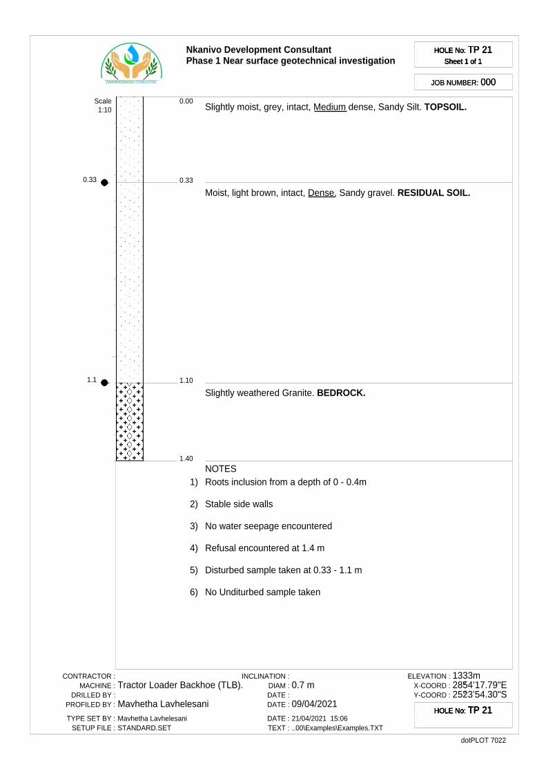
0.33
1.1
Nkanivo Development ConsultantPhase 1 Near surface geotechnical investigation
HOLE No: TP 21Sheet 1 of 1
HOLE No: TP 21Sheet 1 of 1
HOLE No: TP 21Sheet 1 of 1
HOLE No: TP 21Sheet 1 of 1
JOB NUMBER: 000JOB NUMBER: 000
0.33
0.00
1.10
1.40
Slightly moist, grey, intact, Medium dense, Sandy Silt. TOPSOIL.
Moist, light brown, intact, Dense, Sandy gravel. RESIDUAL SOIL.
Slightly weathered Granite. BEDROCK.
Scale1:10
NOTES1) Roots inclusion from a depth of 0 - 0.4m
2) Stable side walls
3) No water seepage encountered
4) Refusal encountered at 1.4 m
5) Disturbed sample taken at 0.33 - 1.1 m
6) No Unditurbed sample taken
CONTRACTOR :MACHINE :
DRILLED BY :PROFILED BY :
TYPE SET BY :SETUP FILE :
Tractor Loader Backhoe (TLB).
Mavhetha LavhelesaniMavhetha LavhelesaniSTANDARD.SET
INCLINATION :DIAM :DATE :DATE :
DATE :TEXT :
0.7 m
09/04/202121/04/2021 15:06..00\Examples\Examples.TXT
ELEVATION :X-COORD :Y-COORD :
1333m28°54’17.79"E25°23’54.30"S
dotPLOT 7022
HOLE No: TP 21HOLE No: TP 21HOLE No: TP 21HOLE No: TP 21
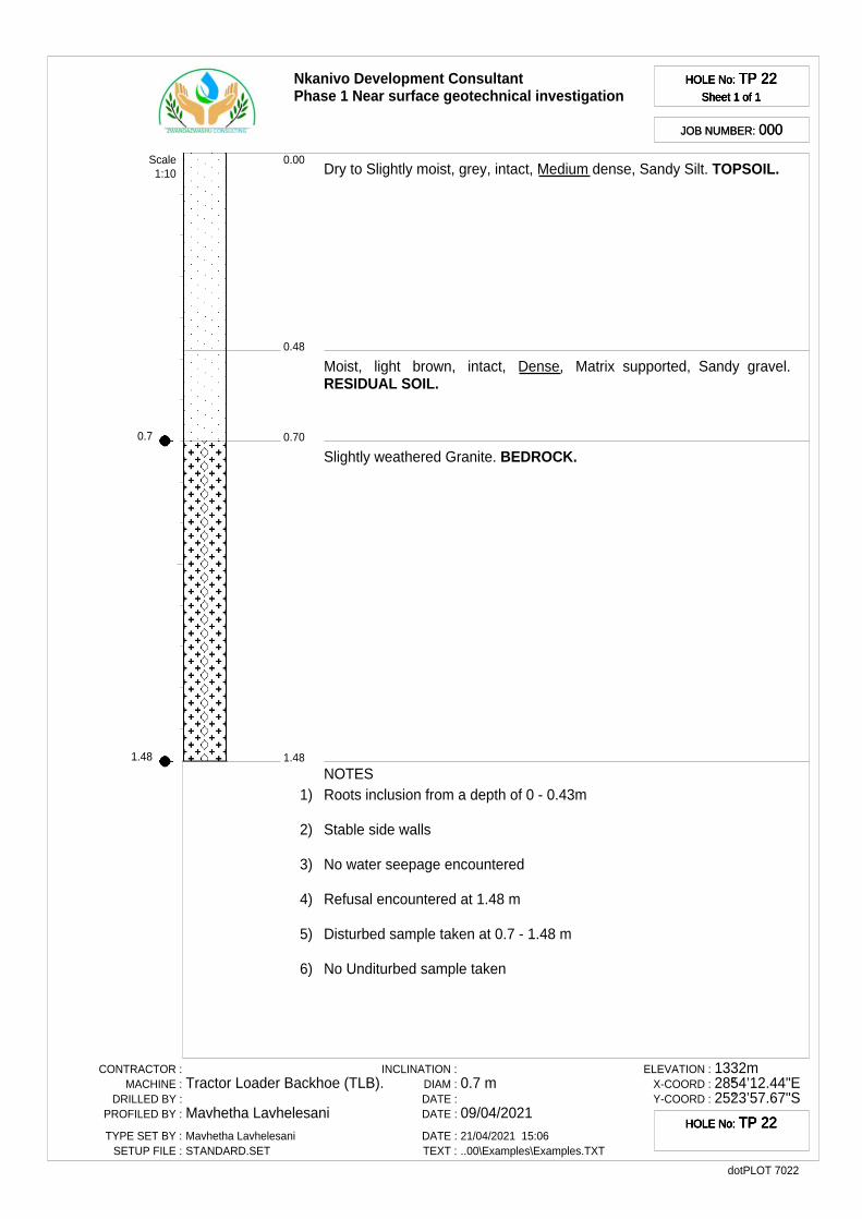
0.7
1.48
Nkanivo Development ConsultantPhase 1 Near surface geotechnical investigation
HOLE No: TP 22Sheet 1 of 1
HOLE No: TP 22Sheet 1 of 1
HOLE No: TP 22Sheet 1 of 1
HOLE No: TP 22Sheet 1 of 1
JOB NUMBER: 000JOB NUMBER: 000
0.48
0.00
0.70
1.48
Dry to Slightly moist, grey, intact, Medium dense, Sandy Silt. TOPSOIL.
Moist, light brown, intact, Dense, Matrix supported, Sandy gravel.RESIDUAL SOIL.
Slightly weathered Granite. BEDROCK.
Scale1:10
NOTES1) Roots inclusion from a depth of 0 - 0.43m
2) Stable side walls
3) No water seepage encountered
4) Refusal encountered at 1.48 m
5) Disturbed sample taken at 0.7 - 1.48 m
6) No Unditurbed sample taken
CONTRACTOR :MACHINE :
DRILLED BY :PROFILED BY :
TYPE SET BY :SETUP FILE :
Tractor Loader Backhoe (TLB).
Mavhetha LavhelesaniMavhetha LavhelesaniSTANDARD.SET
INCLINATION :DIAM :DATE :DATE :
DATE :TEXT :
0.7 m
09/04/202121/04/2021 15:06..00\Examples\Examples.TXT
ELEVATION :X-COORD :Y-COORD :
1332m28°54’12.44"E25°23’57.67"S
dotPLOT 7022
HOLE No: TP 22HOLE No: TP 22HOLE No: TP 22HOLE No: TP 22
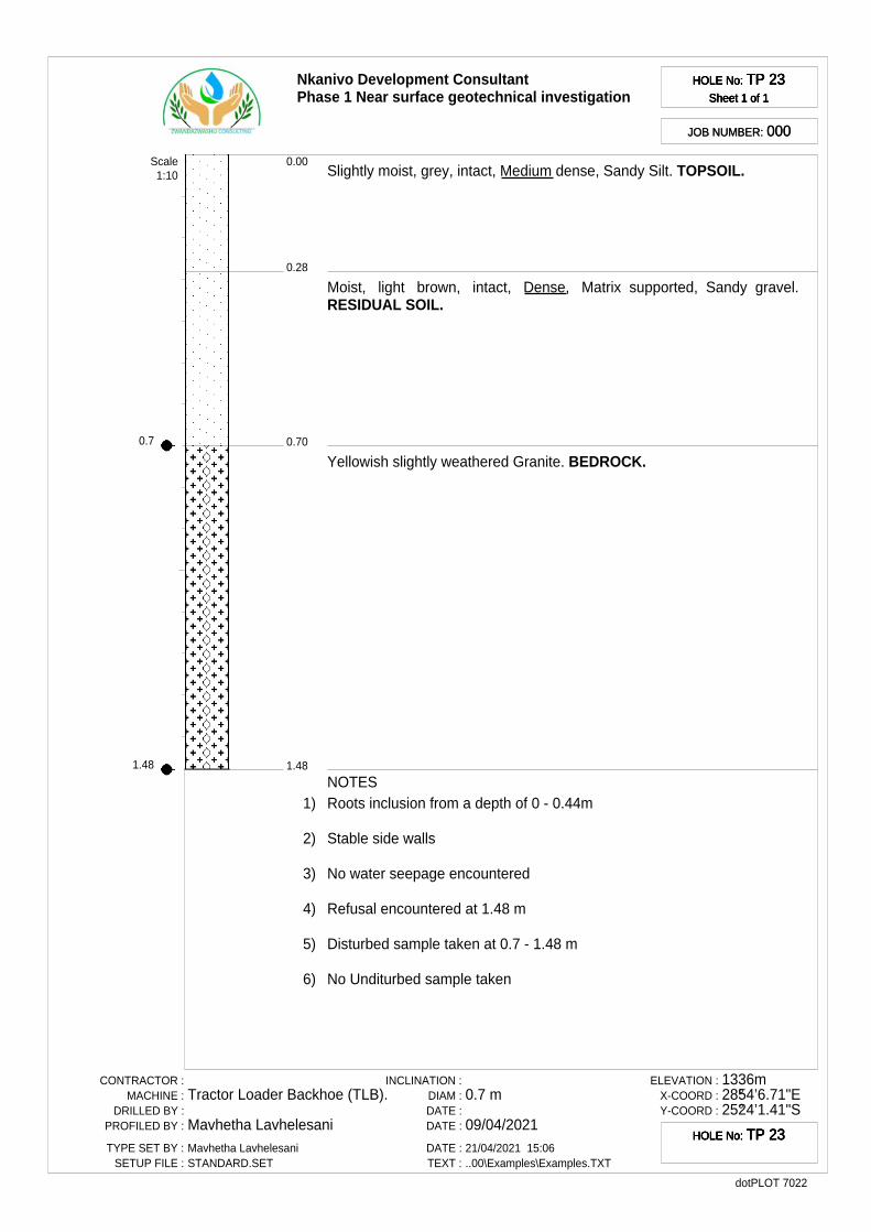
0.7
1.48
Nkanivo Development ConsultantPhase 1 Near surface geotechnical investigation
HOLE No: TP 23Sheet 1 of 1
HOLE No: TP 23Sheet 1 of 1
HOLE No: TP 23Sheet 1 of 1
HOLE No: TP 23Sheet 1 of 1
JOB NUMBER: 000JOB NUMBER: 000
0.28
0.00
0.70
1.48
Slightly moist, grey, intact, Medium dense, Sandy Silt. TOPSOIL.
Moist, light brown, intact, Dense, Matrix supported, Sandy gravel.RESIDUAL SOIL.
Yellowish slightly weathered Granite. BEDROCK.
Scale1:10
NOTES1) Roots inclusion from a depth of 0 - 0.44m
2) Stable side walls
3) No water seepage encountered
4) Refusal encountered at 1.48 m
5) Disturbed sample taken at 0.7 - 1.48 m
6) No Unditurbed sample taken
CONTRACTOR :MACHINE :
DRILLED BY :PROFILED BY :
TYPE SET BY :SETUP FILE :
Tractor Loader Backhoe (TLB).
Mavhetha LavhelesaniMavhetha LavhelesaniSTANDARD.SET
INCLINATION :DIAM :DATE :DATE :
DATE :TEXT :
0.7 m
09/04/202121/04/2021 15:06..00\Examples\Examples.TXT
ELEVATION :X-COORD :Y-COORD :
1336m28°54’6.71"E25°24’1.41"S
dotPLOT 7022
HOLE No: TP 23HOLE No: TP 23HOLE No: TP 23HOLE No: TP 23

0.7
1.4
Nkanivo Development ConsultantPhase 1 Near surface geotechnical investigation
HOLE No: TP 24Sheet 1 of 1
HOLE No: TP 24Sheet 1 of 1
HOLE No: TP 24Sheet 1 of 1
HOLE No: TP 24Sheet 1 of 1
JOB NUMBER: 000JOB NUMBER: 000
0.40
0.00
0.70
1.40
Dry to Slightly moist, grey, intact, Medium dense, Sandy Silt. TOPSOIL.
Moist, light brown, intact, Dense, Matrix supported, Sandy gravel.RESIDUAL SOIL.
Slightly weathered Granite. BEDROCK.
Scale1:10
NOTES1) Roots inclusion from a depth of 0 - 0.4m
2) Stable side walls
3) No water seepage encountered
4) Refusal encountered at 1.4 m
5) Disturbed sample taken at 0.7 - 1.4 m
6) No Unditurbed sample taken
CONTRACTOR :MACHINE :
DRILLED BY :PROFILED BY :
TYPE SET BY :SETUP FILE :
Tractor Loader Backhoe (TLB).
Mavhetha LavhelesaniMavhetha LavhelesaniSTANDARD.SET
INCLINATION :DIAM :DATE :DATE :
DATE :TEXT :
0.7 m
09/04/202121/04/2021 15:06..00\Examples\Examples.TXT
ELEVATION :X-COORD :Y-COORD :
1348m28°54’0.47"E25°24’4.07"S
dotPLOT 7022
HOLE No: TP 24HOLE No: TP 24HOLE No: TP 24HOLE No: TP 24
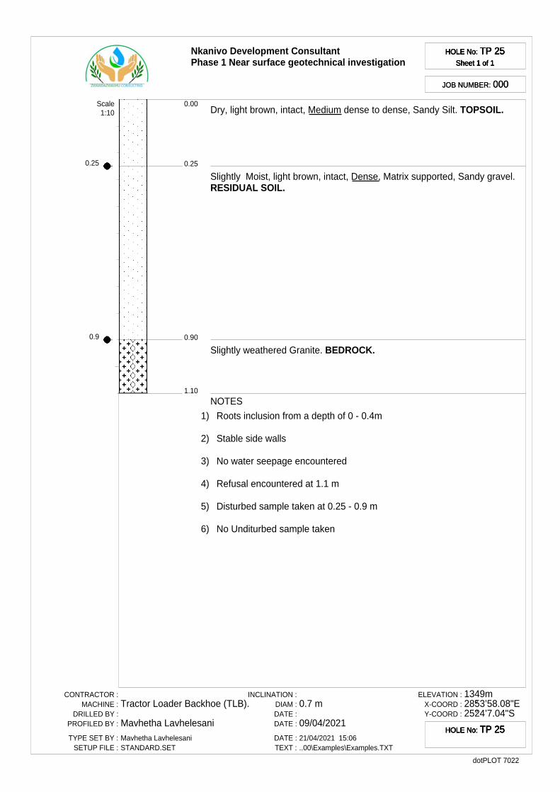
0.25
0.9
Nkanivo Development ConsultantPhase 1 Near surface geotechnical investigation
HOLE No: TP 25Sheet 1 of 1
HOLE No: TP 25Sheet 1 of 1
HOLE No: TP 25Sheet 1 of 1
HOLE No: TP 25Sheet 1 of 1
JOB NUMBER: 000JOB NUMBER: 000
0.25
0.00
0.90
1.10
Dry, light brown, intact, Medium dense to dense, Sandy Silt. TOPSOIL.
Slightly Moist, light brown, intact, Dense, Matrix supported, Sandy gravel.RESIDUAL SOIL.
Slightly weathered Granite. BEDROCK.
Scale1:10
NOTES
1) Roots inclusion from a depth of 0 - 0.4m
2) Stable side walls
3) No water seepage encountered
4) Refusal encountered at 1.1 m
5) Disturbed sample taken at 0.25 - 0.9 m
6) No Unditurbed sample taken
CONTRACTOR :MACHINE :
DRILLED BY :PROFILED BY :
TYPE SET BY :SETUP FILE :
Tractor Loader Backhoe (TLB).
Mavhetha LavhelesaniMavhetha LavhelesaniSTANDARD.SET
INCLINATION :DIAM :DATE :DATE :
DATE :TEXT :
0.7 m
09/04/202121/04/2021 15:06..00\Examples\Examples.TXT
ELEVATION :X-COORD :Y-COORD :
1349m28°53’58.08"E25°24’7.04"S
dotPLOT 7022
HOLE No: TP 25HOLE No: TP 25HOLE No: TP 25HOLE No: TP 25
Name
Nkanivo Development ConsultantPhase 1 Near surface geotechnical investigation
LEGENDSheet 1 of 1
LEGENDSheet 1 of 1
LEGENDSheet 1 of 1
LEGENDSheet 1 of 1
JOB NUMBER: 000JOB NUMBER: 000
SANDY {SA05}
GRANITE {SA17}{SA44}
DISTURBED SAMPLE {SA38}
CONTRACTOR :MACHINE :
DRILLED BY :PROFILED BY :
TYPE SET BY :SETUP FILE :
Mavhetha LavhelesaniSTANDARD.SET
INCLINATION :DIAM :DATE :DATE :
DATE :TEXT :
21/04/2021 15:06..00\Examples\Examples.TXT
ELEVATION :X-COORD :Y-COORD :
dotPLOT 7022
LEGENDSUMMARY OF SYMBOLS
LEGENDSUMMARY OF SYMBOLS
LEGENDSUMMARY OF SYMBOLS
LEGENDSUMMARY OF SYMBOLS