Embed Size (px)
Citation preview

Petroleum Systems of the LevantNeil Hodgson

Eastern Mediterranean: What’s with the Perception?
SecurityIssues
Security Issues
Only Deep Expensive Gas left
Poor Well Results
Commercial Issues

Game Changer in the Levant
Zohr Discovery

South Levantine Basin: Gas Basin?
Dalit2009 Gas DiscoveryLower Miocene SandsReserves: Mean 0.5 TCF
Dolphin2011 Gas discovery ‘Tamar’ sands Reserves: Mean ca 0.5 TCF
Aphrodite2011 Gas Discovery310ft net pay Miocene sandsReserves: Mean 7 TCF
Leviathan 2010 Gas Discovery220ft net payLower Miocene sandsReserves: Mean 17 TCF. *Reported deeper thermogenicgas zone at 21,000ft
Tanin2011 Gas Discovery,130ft net pay Lower Miocene ‘Tamar’ sands. Reserves: Mean 1.1 TCF
Shimsom 2012 Gas DiscoveryReserves: Mean 1 TCF.
MC 3D
Tamar2009 Gas Discovery 2012 onstream460ft net Mid‐ Lower Miocene sands Reserves Mean 9 TCF

So what do we know about the Levant Basin?
1. Biogenic Gas Play in deepwater2. Locally derived reservoir of poor quality3. Complex, strike-slip structures.
All suggesting difficult reservoirs, gas, hard to develop and long lead time to production.
I don’t think any of the above is true

Early Miocene Reservoir thickening to the northLine length 220 km

Levant Ramp
1. RESERVOIR:

After Robertson 1998
Paleo ‐ Reconstruction
Cretaceous: Tethys open to east
Nile River Drains into “Niger” Delta
Eocene Restricted Late Miocene Closed
Nile Delta Establishing
Open Sea way
Open Sea way

Sand Provenance
After Peace, Petex Nov
2012
Reservoir

Nile: ProgradingDeltaic Packages
Eastern Levant: Pinch out onto Basin margin
Northern Levant:Basin Floor Depocenter
Southern Levant:Deep Marine Clastic Transport systems
LevantRamp
290 km 2D lineTamar
Block 550Km
Block 6
260Km
Geometry of Basin System E. Miocene
SW NE

Early Miocene sand input from Arabian Plate?
Afiq canyon insising into Early MioceneIe post-dating Early Miocene sand influxTherefore not the source for Early Miocene sandsThat fill the northern Levant basin

Zohr Seismic / GeoseismicE MIOC NILE ISN’T FLOWING NORTH…

Orange= top Early MioceneYellow = base Early Miocene
Isochore (TWT interval) Map of the Early Miocene
Tannin
Top Early Miocene Sands
W E
W
E

Sand falls into the N Levant Basin…

Does Any Sand NOT fall into the N Levant Basin…

Amathusa-1Very thin interval block 9:
Thick sand in Block 5 lebanon
Top SandE Mioc
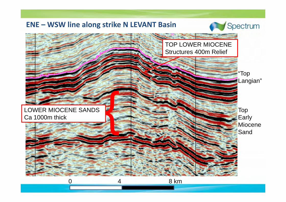
ENE – WSW line along strike N LEVANT Basin
0 4 8 km
“TopLangian”
TopEarly Miocene Sand
TOP LOWER MIOCENEStructures 400m Relief
LOWER MIOCENE SANDSCa 1000m thick

Deepening Basin into Lebanon: More chance of Oil
Charge
Oligocene source: biogenic gas offshore Israel, Zohr, Yet, N Levant more deeply buired.
Line length 220 km

3D Basin Modelling: South to North Levant2: Charge
Source Rocks
1. Miocene2. Oligocene3. Eocene4. Campanian5. Cenomanian6. Early Cretaceous7. Jurassic8. Triassic

Independent basin modelling & seeps
High Potential for Oil, Biogenic and Thermogenic Gas ? Southern Levant Basin, 15C/km
Levant Basin, 25oC/km
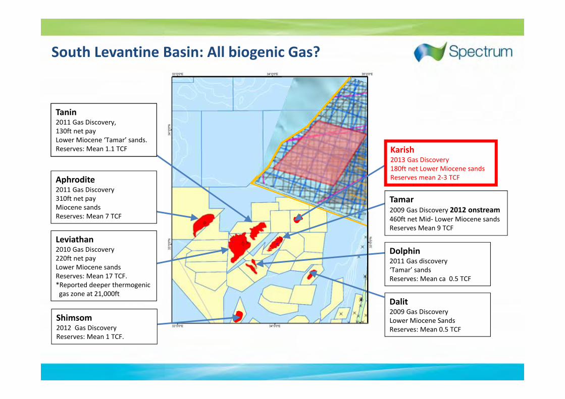
South Levantine Basin: All biogenic Gas?
Dalit2009 Gas DiscoveryLower Miocene SandsReserves: Mean 0.5 TCF
Dolphin2011 Gas discovery ‘Tamar’ sands Reserves: Mean ca 0.5 TCF
Aphrodite2011 Gas Discovery310ft net pay Miocene sandsReserves: Mean 7 TCF
Leviathan 2010 Gas Discovery220ft net payLower Miocene sandsReserves: Mean 17 TCF. *Reported deeper thermogenicgas zone at 21,000ft
Tanin2011 Gas Discovery,130ft net pay Lower Miocene ‘Tamar’ sands. Reserves: Mean 1.1 TCF
Shimsom 2012 Gas DiscoveryReserves: Mean 1 TCF.
MC 3D
Tamar2009 Gas Discovery 2012 onstream460ft net Mid‐ Lower Miocene sands Reserves Mean 9 TCF
Karish2013 Gas Discovery180ft net Lower Miocene sands Reserves mean 2‐3 TCF

EM 0046West-east
EM 007South-North
Early Miocene strongly pinching out onto in Margin
KarishKarish
Karish Well
Early Miocene pinch out: this is a stratigraphic play!
NoE MioSands
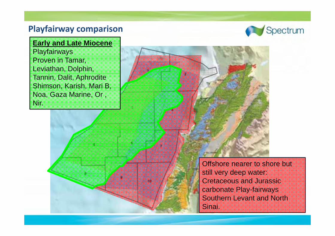
Playfairway comparison
Offshore nearer to shore but still very deep water:Cretaceous and Jurassic carbonate Play-fairways Southern Levant and North Sinai.
Early and Late MiocenePlayfairwaysProven in Tamar, Leviathan, Dolphin,Tannin, Dalit, AphroditeShimson, Karish, Mari B, Noa, Gaza Marine, Or , Nir.

IEOC’s line published a few years ago over zohr
Zohr ?Biogenic Gas

Line on edge of Zohr discovery
WSW ENE
Zohr Discovery
Egypt
CyprusIsrael
Lagoonal Facies?
Oligo-Miocene
CretaceousReefs
Messinian Evaporites
10kms
(100kms2 )30TCF

SSE NNW
Zohr Look Alike ?
20kms
(+500 km2)
North of Zohr

Eratosthenes Sea Mount W E
Northern Levant BasinHerodotus Basin Early Miocene

NW SE
Crustal Model
Oceanic Attenuated Crust

ESE
NE of Zohr
WSW
Total block 11Total block 10
2011 PSTM
Zohr Look‐alikes Ringing the Seamount

Structures In South Lebanon3: Structure
Extensional structures SW Lebanon far less complex than compressional structures S Levant
Line length 220 km
2D regional Line

15kmRef: Noble Website
Both Images are at identical scales
W-E Hyperion
10km
Structures North and South Levant Basin
Phoebe
Leviathan
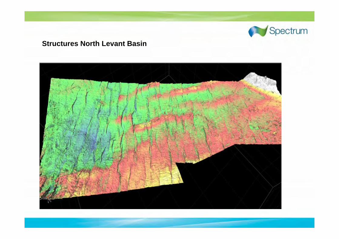
Structures North Levant Basin

After Kosi, Tari, Nader, Skiple, Trudgill and Lazar, 2012

Eos
Oceanus
Hyperion
PhoebeTethys
Croes
Leto
Theia
Prometheus
Helios
Atlas
Themis
Mnemosyne
Cronus
Selene
Epimetheus
AstraeusCalypso
Rhea
Crius
Iapetus
Aster
Perses
Southern half‐ block 5

Phoebe Structure, Mapped at Top Langian
Crest 5180m, Spill 5460m, 280m relief, 40 sqkm Area
2 to 7 TCF potential
PHOEBE; Resource Estimate
7.5 km
TWT Depth

N Levant Concluding Q & A
Q. More than a biogenic gas play to chase in N. Levant Basin?
A. Yes! North Levant is an Oil and Gas Basin.
Q. Levant’s thickest Reservoirs offshore Israel?
A. No! E. Miocene N. Levant 3‐5 times thicker.
Q. Are the best structures in South Lebanon?
A. Yes! N Levant has bigger and less complex structure than Offshore Israel

Eastern Mediterranean: Keeps on Giving
50TCF50TCF
>100TCF50TCF