Embed Size (px)
Citation preview
Status Report
Petroleum Exploration in India - A perspective and EndeavoursAJAY KUMAR DWIVEDI*Director (Exploration), Oil and Natural Gas Corporation Ltd, Jeevan Bharathi Building, New Delhi,India
(Received on 15 May 2016; Accepted on 25 June 2016)
Indian oil industry has come a long way since the first oil discovery at Digboi in 1889 through concerted exploratory efforts.Production of oil from a 5 barrels per day level from a single field in Assam has grown to more than 750000 barrels per dayfrom over 50 major oil and gas in seven sedimentary Basins and is projected to attain 1 million barrels per day mark in nearfuture. After Independence, oil and gas exploration was accorded high priority and was taken up by National, Private andInternational oil companies across the 26 sedimentary Basins covering an area of about 3.14 million sq. kms. Of the 26sedimentary Basins, 7 Basins are producing oil and gas today. Sedimentary Basins of India are categorised into fourcategories based on their degree of hydrocarbon prospectivity as presently known. At present India’s estimated hydrocarbonresource is of the order of 28 billion tonnes of oil equivalent (BTOE) and an Initial In-place volume of about 11.18 billiontonnes of oil equivalent (BTOE). A project for re-assessment of the resource potential of Indian Sedimentary Basins hasbeen initiated by Government of India with active participation of ONGC, OIL and DGH in view of extensive availabilityof new data from all the Sedimentary Basins.
Currentefforts are to enhance the production from category–I Basins with a focus on upgrading the Category-II Basins toCategory-I Basins. Present paper outlines the endeavours during last few years through opening up of new areas, especiallyfrontier areas of Proterozoic Basins of Vindhyan and Satpura, Deep offshore Basins of Bay of Bengal and Arabian Seawithin Indian exclusive economic zone, Andaman fore-arc and back-arc Basins, unconventional sources of hydrocarbonssuch as Basement exploration, CBM (Coal Bed Methane), shale oil and gas, gas hydrates and leveraging the technologyadvances in Petroleum exploration.
Keywords: Petroleum; Resources; Reserves; Category; Basins; NELP; Frontiers; Unconventional
*Author for Correspondence: E-mail: [email protected]
Proc Indian Natn Sci Acad 82 No. 3 July Spl Issue 2016 pp. 881-903 Printed in India. DOI: 10.16943/ptinsa/2016/48491
Introduction
Quest for Petroleum in India spans over 162 yearssince the first lease given in Assam by Britishgovernment during 1854. A new chapter andchallenging journey of Indian upstream Petroleumindustry began with discovery of oil from the historicfirst well Digboi No:1 in 1889 barely 30 years afterthe first Drake Oil well was drilled by Col. E L Drakein Northwest Pennsylvania, USA. Indian upstreamindustry since then has travelled a long way throughvarious socio-political changes and surged ahead withthe economic growth of the country. Growth of Indianeconomy and the development of the upstreamindustry have always moved hand in hand. Sustainedefforts by the Indian upstream industry have resulted
in discovery of more than 830 oil and gas fieldsincluding 50 major fields with an increase in productionfrom an insignificant 5 bopd from a single field inAssam to present production of 750000 bopd acrossthe country. Independent India witnessed an enhancedexploratory activity in its sedimentary Basins by thethen newly created National Oil Companies leadingto opening up of new Petroliferous Basins of Cambay,Rajasthan, Assam & Assam-Arakan fold Belt, theprolific Western Offshore, Krishna-Godavri andCauvery Basins. The spectacular achievements bythese NOC’s have brought India into the World OilMap. Sustained exploratory efforts by National Oilcompanies coupled with the initiatives by GOI in termsof New Exploration License Policy (NELP) hasopened up the industry for exploration by International
882 Ajay Kumar Dwivedi
Oil and gas companies, as well as Private oilcompanies. As on date the Indian E&P industry isoperated by over 117 companies consisting of 11PSU’s, 58 Indian Private Companies and 48International/Foreign Oil and Gas Companies targetedto explore the 26 sedimentary Basins covering an areaof 3.14 million square kilometres, including the deepwater areas beyond 400m bathymetry.
Exploratory efforts by these companies resultedin accreting about 11187 MMTOE of in placehydrocarbon volume by 2015, an increase of 32% ascompared to base year of 2006.
India’s demand for fossil fuel by 2040 isestimated to grow by CAAGR (Compounded AnnualAverage Growth Rate) of 3.6% for oil and 4.6% fornatural gas to keep pace with the projected economicgrowth. The oil import dependency of the India ispredicted to rise to 90% from the current 70%. Tomeet the increasing energy demand Government ofIndia has adopted several policies such as openingup of upstream exploration through competitive biddingunder NELP during 1997-98, marginal field policyduring 2015 and is now moving towards OpenAcreage Policy model for future acreages underHydrocarbon Exploration Licence Policy (HELP).
An overview of the status of exploration in thepetroliferousBasins of India, their future perspectiveand the endeavours carried out by Indian E&Pcompanies, especially Indian NOC’s leveraging theadvances in the technology for establishing produciblehydrocarbons has been presented in the followingparagraphs.
Sedimentary Basins of India
Exploratory efforts since 1850’s by foreign private oilcompanies (Assam Railways and Trading CompanyLimited (AR&T), Assam Oil Company (AOC) andBurma Oil Company (BOC) and later by NOC’s fromlate 50’s and subsequently by private/foreigncompanies (1980) has resulted in expanding thegeological knowledge of the Indian sedimentary Basinsand about 88% Basinal areas are at various stagesof exploration (DGH, 2011). These efforts have alsoaided in working out a scheme of tectonicclassification of the Basins (Biswas et al., 1993,Biswas, 1998, Ravi Bastia et al., 2007) that wasrequired for the detail Basin analysis. Multifold
increase in 3D seismic data acquisition led to manydiscoveries in challenging environments. Drilling ofthe deeper exploratory wells resulted in refining thegeological models of the existing Basins and betterunderstanding of their tectonic styles, sedimentationpattern and evolution.
Biswas et al. (1993) for the first time publisheda comprehensive classification of Indian sedimentaryBasins using the Dickinson (1976) scheme of Basinclassification based on the structural style, geometryand size, nature of stratigraphic fill and thermal historyinto 38 sedimentary Basins and grouped them in threemain settings: (i) intracratonic, (ii) rifted, (iii) orogenicsettings (Table 1) and regrouped into 26 sedimentaryBasins based on the hydrocarbon proclivity.
Most of the Indian Sedimentary Basins arepericratonic, bordering the Indian plate radially. Thenorthern Basins are bordered by orogenic belts ofHimalaya and Assam–Arakan and are the peripheralforeland Basins sub ducting under the orogenic belt.The coastal pericratonic Basins, especially in the southare extending from onshore to offshore and are riftedBasins, separated by horsts. The Intracratonic Basinsare rift Basins such as Gondwana Basins/grabens orstructural depressions such as Vindhyan, Cuddapah,Kaladgi and Bhîma Basins.
Petroleum occurs mainly in the marginal andpericratonic rift Basins. Occurrence of commercialpetroleum from the northern foreland Basin is yet tobe established excepting in the Upper Assam inter-orogenic foreland Basin – Assam Shelf situated oncratonicwedge between Himalayan and Assam–Arakan mountains. Tectonic setting and collision ofthe Indian plate created favourable habitat forgeneration and preservation of thehydrocarbons.Hydrocarbon discoveries from the Interior and Intra-cratonic rift Basins are so far elusive barring few gasindications; however, recent exploratory efforts areindicating encouraging results such as gas discoveryfrom Proterozoic VindyanBasin.
The estimated prognosticated resource base ofthe Indian Basins is 28 BMTOE including the 7BMTOE from deep water sector. As on 2015,exploratory efforts have resulted in estimation of InitialHydrocarbon In-Place (IHIP) of about 11.18 BMTOEwhich is about 40% of the present prognosticatedresources. Reassessment of the hydrocarbon

Petroleum Exploration in India - A perspective and Endeavours 883
resources of all the Indian sedimentary Basinsincluding the deep water areas has been taken upand is in progress.
Exploratory activities for hydrocarbons in the26 sedimentary Basins were initiated as early as mid-50’s and are continuing with varying degree of success.
Table 1: Classification of Indian Sedimentary Basins (After Biswas et al., 1993)
Category Type Basins Status
I. Interior Basins Intra-Cratonic Sags 1. Vindhyan Basin Gas Indications
2. Chattisgarh-Bastar Basin
3. Cuddapah Basin
4. Kaladgi Basin
II. Rifted Setting IIA Marginal Aulacogen 1.Cambay Basin Oil and Gas producing Basin
IIB Pericratonic Rift 1.Kutch Basin Oil and Gas – Emerging Basin
2.Saurashtra Shelf Oil and Gas Indications
3.Surat Basin
4.Bombay-Ratnagiri Basin Oil and Gas producing Basin
5. Konkan Basin
6. Kerala Basin
7. Western Bengal Basin
8. Mahanadi Basin Gas discoveries – Emerging Basin
9. Krishna-Godavari Basin Oil and Gas producing Basin
10. Palar Basin
11. Cauvery Basin Oil and Gas producing Basin
12. Mannar Basin
IIC Intra-Cratonic RM 1. Pranhita-Godavari Basin
2. Mahanadi Graben
3. Purnea Graben
IID Intra cratonicTranstensional 1.Satpura Basin
Basins 2. Son Basin
3. South Rewa Basin
4. Damodar Basin
5. Narmada Basin
IIEMiogeoclinal Prism 1. Deep Water Basins of West coast
2. Deep water Basins of East coastOil and Gas Producing Basins
III. Orogenic Settings III A Superposed Basins 1. Karewa Basin
III B Peripheral Foreland Basin 1. Rajasthan Basin Oil and Gas Producing Basin
2. Punjab Basin
3. Ganga Basin
4. Lower Assam Basin Oil and Gas Producing Basin
III C Inter-orogenic foreland Basin 1. Upper Assam Basin Oil and gas Producing Basin
III DForearc Basins 1. Kohima forearc Basin
2. Tripura-Mizoram Forearc Basin Gas producing Basin
3. Andaman Basin Gas Indications
III E Remnant Ocean Basin 1. East Bengal Basin
884 Ajay Kumar Dwivedi
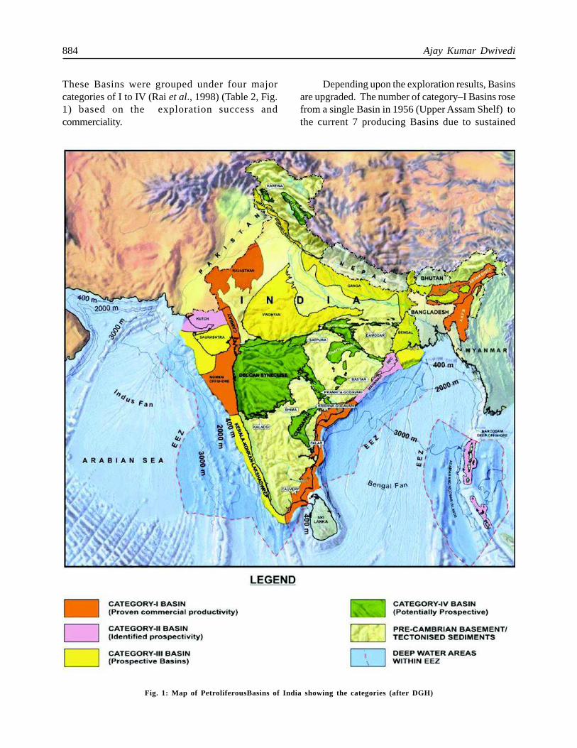
These Basins were grouped under four majorcategories of I to IV (Rai et al., 1998) (Table 2, Fig.1) based on the exploration success andcommerciality.
Depending upon the exploration results, Basinsare upgraded. The number of category–I Basins rosefrom a single Basin in 1956 (Upper Assam Shelf) tothe current 7 producing Basins due to sustained
Fig. 1: Map of PetroliferousBasins of India showing the categories (after DGH)
Petroleum Exploration in India - A perspective and Endeavours 885
exploratory efforts aided with the right technologyimplementation.
The present paper deals with brief geologicalset-up, plays established and recent endeavours toenhance success ratio.
Assam Shelf, Assam-Arakan Basin (Category-IBasin)
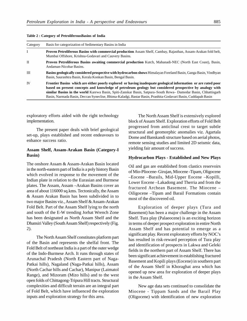
The onshore Assam & Assam-Arakan Basin locatedin the north-eastern part of India is a poly history Basinwhich evolved in response to the movement of theIndian plate in relation to the Eurasian and Burmeseplates. The Assam, Assam –Arakan Basins cover anarea of about 116000 sq.kms. Tectonically, the Assam& Assam Arakan Basin has been subdivided in totwo major Basins viz., Assam Shelf & Assam-ArakanFold Belt. Part of the Assam Shelf lying to the northand south of the E-W trending Jorhat Wrench Zonehas been designated as North Assam Shelf and theDhansiri Valley (South Assam Shelf) respectively (Fig.2).
The North Assam Shelf constitutes platform partof the Basin and represents the shelfal front. TheFold Belt of northeast India is a part of the outer wedgeof the Indo-Burmese Arch. It runs through states ofArunachal Pradesh (North Eastern part of Naga-Patkai hills), Nagaland (Naga-Patkai hills), Assam(North Cachar hills and Cachar), Manipur (LaimatolRange), and Mizoram (Mizo hills) and to the westopen folds of Chittagong-Tripura Hill tracts. Structuralcomplexities and difficult terrain are an integral partof Fold Belt, which have influenced the explorationinputs and exploration strategy for this area.
The North Assam Shelf is extensively exploredblock of Assam Shelf. Exploration efforts of Fold Beltprogressed from anticlinal crest to target subtlestructural and geomorphic anomalies viz. AgartalaDome and Banskandi structure based on aerial photos,remote sensing studies and limited 2D seismic data,yielding fair amount of success.
Hydrocarbon Plays - Established and New Plays
Oil and gas are established from clastics reservoirsof Mio-Pliocene- Girujan, Miocene -Tipam, Oligocene–Eocene –Barails, Mid-Upper Eocene –Kopilli,Lower Eocene –Lakadong and Therria and from thefractured Archean Basement. The Miocene –Oiligocene –Tipam and Barail Formations containmost of the discovered oil.
Exploration of deeper plays (Tura andBasement) has been a major challenge in the AssamShelf. Tura play (Palaeocene) is an exciting horizonin terms of deeper prospect exploration in entire NorthAssam Shelf and has potential to emerge as asignificant play. Recent exploratory efforts by NOC’shas resulted in risk-reward perception of Tura playand identification of prospects in Lakwa and Gelekifields in the northern part of Assam Shelf. There hasbeen significant achievement in establishing fracturedBasement and Kopili plays (Eocene) in southern partof the Assam Shelf in Khoraghat area which hasopened up new area for exploration of deeper playsin the Assam Shelf.
New age data sets continued to consolidate theMiocene - Tippam Sands and the Barail Play(Oligocene) with identification of new exploration
Table 2 :Category of PetroliferousBasins of India
Category Basis for categorization of Sedimentary Basins in India
I Proven Petroliferous Basins with commercial production Assam Shelf, Cambay, Rajasthan, Assam-Arakan fold belt,Mumbai Offshore, Krishna-Godavari and Cauvery Basins.
II Proven Petroliferous Basins awaiting commercial production Kutch, Mahanadi-NEC (North East Coast), Basin,Andaman-Nicobar Basins.
III Basins geologically considered prospective with hydrocarbon shows Himalayan Foreland Basin, Ganga Basin, VindhyanBasin, Saurashtra Basin, Kerala Konkan Basin, Bengal Basin.
IV Frontier Basins which are either poorly explored or having inadequate geological information or are rated poorbased on present concepts and knowledge of petroleum geology but considered prospective by analogy withsimilar Basins in the world Karewa Basin, Spiti-Zanskar Basin, Satpura–South Rewa– Damodar Basin, ChhattisgarhBasin, Narmada Basin, Deccan Syneclise, Bhima-Kaladgi, Bastar Basin, Pranhita-Godavari Basin, Cuddapah Basin
886 Ajay Kumar Dwivedi
prospects. In the southern part of Assam Shelf Sylhetand Kopili plays are well established in Borholla-Champang fields and remain elusive in the rest ofDhansiri Valley.Taking these leads into considerationthe focus of exploration is for establishing for Sylhetand Barail plays in the Assam-Arakan Basin. Bokabilplay continue to be an attractive stratigraphicexploration play in southern part of Assam Shelf. InFold Belt, elusive “Badarpur Oil Play” remains to beelusive for oil though few gas discoveries arereported. Naga up thrust Tipam Section has emergedas one of the attractive play in the north Assam shelf.Similarly the basement exploration in Khoraghat areahas been rejuvenated with use of new technologyDFN modelling (Discreet Fracture Network) anddrilling of horizontal wells.
Cambay Basin (Category: I Basin)
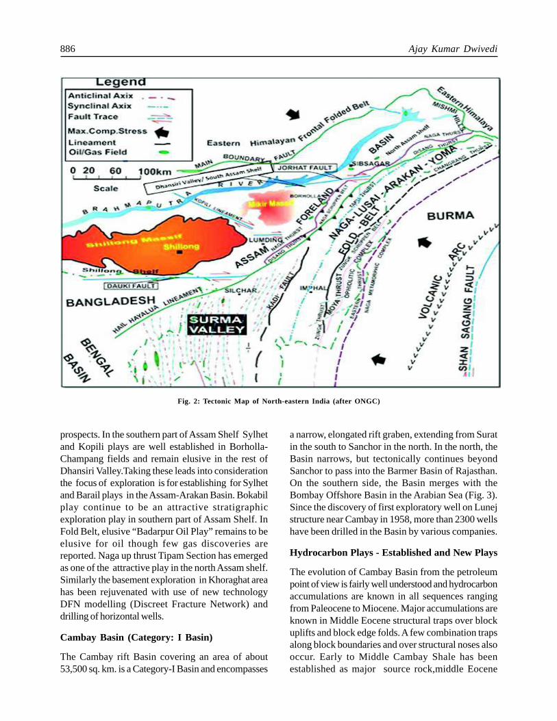
The Cambay rift Basin covering an area of about53,500 sq. km. is a Category-I Basin and encompasses
a narrow, elongated rift graben, extending from Suratin the south to Sanchor in the north. In the north, theBasin narrows, but tectonically continues beyondSanchor to pass into the Barmer Basin of Rajasthan.On the southern side, the Basin merges with theBombay Offshore Basin in the Arabian Sea (Fig. 3).Since the discovery of first exploratory well on Lunejstructure near Cambay in 1958, more than 2300 wellshave been drilled in the Basin by various companies.
Hydrocarbon Plays - Established and New Plays
The evolution of Cambay Basin from the petroleumpoint of view is fairly well understood and hydrocarbonaccumulations are known in all sequences rangingfrom Paleocene to Miocene. Major accumulations areknown in Middle Eocene structural traps over blockuplifts and block edge folds. A few combination trapsalong block boundaries and over structural noses alsooccur. Early to Middle Cambay Shale has beenestablished as major source rock,middle Eocene
Fig. 2: Tectonic Map of North-eastern India (after ONGC)
Petroleum Exploration in India - A perspective and Endeavours 887
Fig. 3: Tectonic map of Cambay Basin (after ONGC)
888 Ajay Kumar Dwivedi
deltaic sands are major reservoirs and Late Eocene-Oligocene and Miocene Shales are regional cap rockin this Basin. The Broach depression in Broach blockis the largest kitchen area for maturation of sourcerocks and the generation of hydrocarbons. Transversehighs played an important role in controlling the palaeo-drainage and distribution of sands. Most of the troughsare local generation centres for accumulation in theadjacent highs. There are several petroleum systemsin the Basin and the most important one is theCambay-Hazad Petroleum System(!) which is relatedto several large oil and gas fields.
The Cambay-Hazad(!) petroleum system inSouth Cambay Basin, has original in-place oil and gasreserves of 395 million tonnes. The system covers9320 km² encompassing 20 different oil and gasaccumulations. Carbon isotopic and biological markerdata indicate that the low sulphur, high API gravity oiloriginated from the lower-middle Eocene CambayShale source rock. Burial and thermal historyreconstructions indicate that oil generation andmigration occurred from Miocene (21 Ma) to Recent.The overburden rocks are over 3 km thick and rangein age from middle Eocene to Recent. The principalreservoir rocks are sandstone units of the Hazad andArdol Members of the Ankleshvar Formation.
The essential elements of the petroleum system,consisting of the source, reservoir, seal and overburdenrocks were deposited from early Eocene to Recenttime and the critical processes of generation, migration,trap formation, and accumulation occurred fromMiocene to Recent.
Although it is usually the new discoveries thatcapture the attention of the oil industry, 70% of thehydrocarbon liquids produced in the world todayactually come from fields that have been in operationfor more than twenty years: the majority of petroleumassets consist of “old” fields. With most of the world’spotential oil provinces having already been exploredand major new discoveries becoming increasingly rare,mature fields are slated to play an ever moreprominent role in energy supply.
Currently exploration of the Cambay rift Basinis in matured stage and bears a good chance ofmaximizing the probabilities of discovering small fieldsin subtle traps. As most of the large accumulationshave been located, the Basin is now being rated as
low risk/moderate reward category. Growth in oil andgas production expected from a combination of newfield discoveries and effective management of existingacreage.
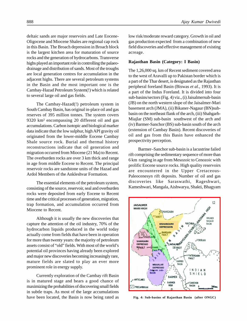
Rajasthan Basin (Category: I Basin)
The 1,26,000 sq. km of Recent sediment covered areato the west of Aravalli up to Pakistan border which isa part of the Thar desert, is designated as the Rajasthanperipheral foreland Basin (Biswas et al., 1993). It isa part of the Indus Foreland. It is divided into foursub-basins/sectors (Fig. 4) viz., (i) Jaisalmersub-basin(JB) on the north western slope of the Jaisalmer-Maribasement arch (JMA), (ii) Bikaner-Nagaur (BN)sub-basin on the northeast flank of the arch, (iii) Shahgarh-Miajlar (SM) sub-basin southwest of the arch and(iv) Barmer-Sanchor (BS) sub-basin south of the arch(extension of Cambay Basin). Recent discoveries ofoil and gas from this Basin have enhanced theprospectivity perception.
Barmer–Sanchor sub-basin is a lacustrine failedrift comprising the sedimentary sequence of more than6 km ranging in age from Mesozoic to Cenozoic withprolific Eocene source rocks. High quality reservoirsare encountered in the Upper Cretaceous-Paleocenesyn rift deposits. Number of oil and gasdiscoveries like Saraswathi, Rageshwari,Kameshwari, Mangala, Aishwarya, Shakti, Bhagyam
Fig. 4: Sub-basins of Rajasthan Basin (after ONGC)
Petroleum Exploration in India - A perspective and Endeavours 889
are some of the significant fields in Barmer-Sanchorsub-basin.
Hydrocarbon Plays - Established and New Plays
The Jaisalmer sub-basin is a Late Palaeozoic-MesozoicBasin with Permian rocks resting unconformably overthe Proterozoic Basement with gas discoveries ofManhera Tibba, Ghotaru Extn-I, South Kharatar,ChinnewalaTibba and BakhriTibba fields. TheBikaner-Nagaur sub-basin to the north has widelydiffering geological histories during Palaeozoic andMesozoic times. This Basin has well developed Infra-Cambrian sequence. The Shahgarh-Miajar sub-basinis mainly Mesozoic Basin with thin cap of Palaeocene-Eocene rocks (300m) and a thin (200m) base ofPermian rocks resting over the basement.
The Rajasthan Basin is mostly covered by desertsands excepting on the Jaisalmer-Mari basement arch(JMA) which is the only outcropping region besides afew scattered ones. Sequence from Middle Jurassicto Early Eocene is exposed in Jaisalmer sub-basin.
Apart from Barmer sub-basin, there is noTertiary prospect in other sub-basins of Rajasthan.Excepting small satellite pools in the Paleocene section,the chance of another large discovery appears to below. However, the Barmer discoveries indicate thatthe prospect of sizeable accumulation in Sanchor sub-basin cannot be ruled out. In Shahgarh-Miajar sub-basin, the Mesozoic are the main prospective targets,particularly the Cretaceous Pariwar, Goru, and ParhFormations. Deeper Cretaceous and Jurassic targetsshould be the primary focus in Shahgarh-Miajar sub-basin. In Jaisalmer sub-basin focus should be oncombination and subtle traps in Jurassic and LowerCretaceous plays, while more extensive explorationfor heavy oil should be planned for the Bikaner-Nagaursub-basins.
In Jaisalmer sub-basin, deeper Mesozoic playslike Baishakhi Badesir, Jaisalmer and Lathi of Jurassicage will form frontier plays. The finer clastics alongwith thin irregular sand bodies within Basisakhi BadesirFormation deposited in sub tidal to inner shelfenvironment may form stratigraphic/strati-structuralprospects which are targets for future exploration.Similarly, the thick Jaisalmer limestone with occasionaloolitic development may be another suitable promisingexploration objective.
Western Pericratonic Rift Basins
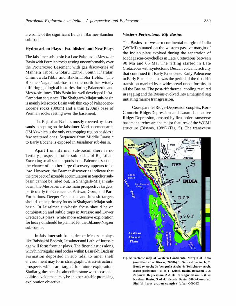
The Basins of western continental margin of India(WCMI) situated on the western passive margin ofthe Indian plate evolved during the separation ofMadagascar-Seychelles in Late Cretaceous between90 Ma and 65 Ma. The rifting started in LateCretaceous with syntectonic Deccan volcanic activitythat continued till Early Paleocene. Early Paleoceneto Early Eocene hiatus was the period of the rift-drifttransition marked by a widespread unconformity inall the Basins. The post-rift thermal cooling resultedin sagging and the Basins evolved into a marginal saginitiating marine transgression.
Coast parallel Ridge-Depression couplets, Kori-Comorin Ridge/Depression and Laxmi-LaccadiveRidge/ Depression, crossed by first order transversebasement arches are the major features of the WCMIstructure (Biswas, 1989) (Fig. 5). The transverse
Fig. 5: Tectonic map of Western Continental Margin of India(modified after Biswas, 2008b) 1: Saurashtra Ar ch; 2:Bombay Ar ch; 3: Vengurla Ar ch; 4: Tellicherr y Ar ch.Basin positions: - N of 1- Kutch Basin, Between 1 &2: Surat Depression, 2 & 3: RatnagiriBasin, 3 & 4:Kankan Basin, S of 4: Kerala Basin. SHG-Complex:Shelfal horst graben complex (after ONGC)
890 Ajay Kumar Dwivedi
arches, from north to south are, Saurashtra, Bombay,Vengurla and Tellicheri arches which divide the shelfinto five offshore sub-basins - Kutch, Surat, Ratnagiri(Bombay offshore Basin), Konkan and Kerala Basins(Biswas and Singh, 1988). Kori-Comorin coupletmarks the edge of the present continental shelf, whichis rifted developing a “shelfal horst-graben” complex.Each sub-basin extends offshore across the shelf,depressions and ridges. Thus, a shallow shelfal horst-graben complex, a shelf margin depression and ridge,a deep slope-parallel depression and an outer ridge(Laxmi) separating the Basin and abyssal plain arethe characteristic structural domains of each sub-basin. Kerala, Konkan and Ratnagiri Basins areconfined to offshore. The West Coast Fault terminatesthese Basins along the coastline.
Of the five sub-basins, Surat and Ratnagiri(Bombay) offshore Basins qualify as a Category-IBasins with its vast reserve of hydrocarboncontributing almost 70% of India’s total oil/gasproduction. Kutch Basin is Category-II Basin waitingto be upgraded in view of commercial discovery.
The Kerala-Konkan Basin though well exploredno commercial accumulation could be located till date.Awaiting discovery, this Basin is listed in Category-III Basins.
Mumbai Offshore Basin (Category-IBasin)
The Mumbai Offshore Basin is the most prolific of allthe hydrocarbon bearing provinces in India.
Bounded by Diu and Narmada Faults andDeccan Trap outcrops to its north and east, thepericratonic Mumbai Offshore Basin extends towardswest parallel to the western continental margin of Indiaup to the Western Margin Basement Arch. NE-SWtrending Vengurla Arch separates the Basin from theKerala-Konkan Basin to its south.
On the basis of structural elements and thenature of sediment fill which influenced characteristichydrocarbon generation and entrapment patterns indifferent sectors, the Basin is subdivided in to a numberof blocks, viz. Tapti-Daman block, Diu block, Heera-Panna-Bassein block, Mumbai High-Deep ContinentalShelf block, Shelf Margin block and the Ratnagiriblock.
Based on tectonic-sedimentary history and
alignment of structural elements, the Basin issubdivided in to six major units, three of which arecharacterised by paleo-platform set up, viz. theMumbai High-DCS platform, the Heera-Panna-Bassein Platform and the Ratnagiri platform whichwere dominantly filled up by carbonate sediments.Three of the other units, viz. Murud low, Saurashtrarise- Diu depression and Surat depression are mostlycharacterised by clastic sedimentation acting as thedominant hydrocarbon generation centers for theBasin. The Tapti-Daman block is a clastic Basindeveloped in the northern part of Bombay OffshoreBasin in front of a narrow Cambay Gulf havingsedimentation history from Paleocene time onwards.Middle Eocene-Oligocene deltaic sediments of proto-Narmada in Cambay Basin and Late Oligocene-Miocene sediments in Tapti-Daman sector depositedas a result of progradation of the delta through thenarrow Cambay Gulf.
Continued and sustained exploratory anddevelopment efforts in Mumbai Offshore Basin sincelast four decades have shown remarkable results andled to conversion of nearly 50% of the prognosticatedresource of 9190 MMToE in to In-place volume ofhydrocarbons.
Hydrocarbon Plays - Established and New Plays
The major hydrocarbon fields of the Basin includeBombay High, Bassein, Panna, Mukta, Neelam,Heera, South Heera, Ratna, D-1 fields, Tapti (north,mid and south), C22/24 structures.
Hydrocarbon accumulations in BH-DCS-HPB(Bombay High–Deep Continental Shelf–Heera-Panna-Bassein) sector are structurally controlled, ingeneral occur, in carbonate reservoirs ranging in agefrom Middle Eocene to Middle Miocene with a fewexceptions of stratigraphic/combination plays in clasticreservoirs. While major pay zones occur in MiddleEocene and Early Miocene plays, hydrocarbon zoneshave also been identified in Paleocene to Oligoceneplays where as in Tapti-Daman sector Daman (LateOligocene) and Mahuva (Early Oligocene) plays arewell established.
Targeting new objectives in established areasand looking for extension of known plays besidesexploring deeper plays has always been the essenceof exploratory activities in Mumbai Offshore Basin.
Petroleum Exploration in India - A perspective and Endeavours 891
Recent successes in Basement and Basal clasticsection from a number of wells on west and southernperiphery of Mumbai High have seen renewed focusand exploration initiatives being adopted for explorationof this play. With integrated interpretation of seismicand well data including special analysis of coresand image logs along with application of state- of-the-art technologies for fracture imaging, a significantimprovement has come in identification and mappingof probable fracture zones in basement. Simultaneousexploration for extension of other known plays in L-III to L-VI limestones of Early Miocene to LateOligocene age beyond the known confines aroundMumbai High is also expected to discover morehydrocarbons.
Exploring for Eocene – PaleocenePannaclasticsin recent times in areas away from knownaccumulations has shown very positive results aroundsouth and south east of Mumbai and Heera-Panna-Bassein platforms.
Renewed efforts of targeting deeper as well asestablished plays and success achieved in new areashave helped in more resource conversion.
The established plays in Early Oligocene to Mid/Late Eocene Carbonate reservoirs of Mukta andBassein Formation along with fluvio-marine clasticdeposits of early Eocene/late PaleocenePannaFormation continue to attract exploration.
A recent discovery of gas in the very fine grainedPliocene reservoir towards west of the Neogene Shelfmargin of Mumbai Offshore block from shelf edgeroll over structure opened up a new play in the frontierarea.
Discovery of deeper oil, below the known oilwater contacts, especially in Bombay High sectoropened up new vistas of exploration.
Exploring the Mahuva Play in B-12/C-24 andC-26 areas remained as challenge due to HP-HTconditions besides the establishment of the deeperplays (Belapur, Panna and Basement) though provedprospective in few wells.
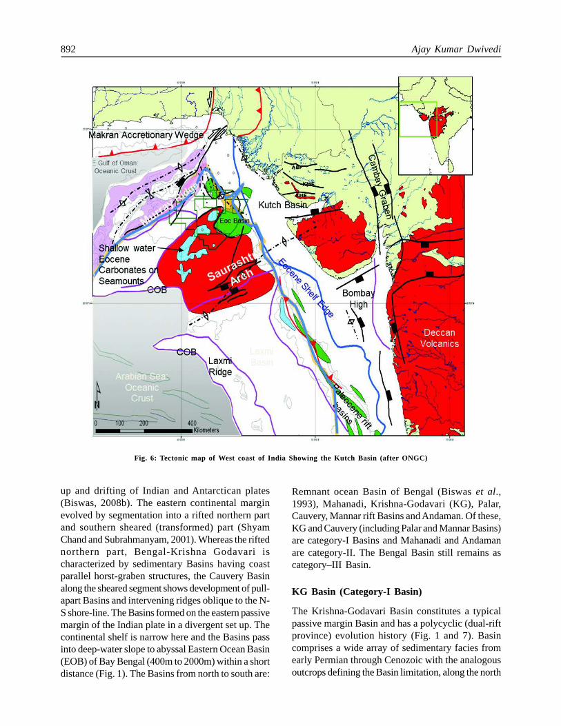
Kutch Basin (Category-II Basin)
The Kutch Basin located on the western continentalmargin covers an area over 80,000 Sq. Km both on-
land and off-shore. The Basin is a poly–history riftand passive margin Basin which has evolved throughmultiple rift phases after the separation of the Indianand African plate. Exploration commenced waybackin 1972 and decade later oil was discovered in theoffshore KD structure from Eocene Limestone.
The onland part of the Kutch Basin appears tobe an arm of a failed rift system and is restricted bythe Allabandh fault towards the north and extends upto the North Kathiawar fault towards south. Thestructural trend on the onland part of Kutch Basinessentially trends in an east-west direction where asin the offshore part of the Basin the dominantstructural trend appears in a NW-SE direction. Thisindicates that probably the separation of the Indianand African plates has a more significant imprint inthe offshore area. Based on the study of recent gravitymagnetic data it appears that the continental oceanicboundary took an easterly swing around Kutch Basin,distinctly indicating possible presence of Mesozoicsediments below the Deccan traps even in the Deepwater areas (Fig. 6).
The most important plays in the Kutch Basinare sub-trappean Mesozoic’s and Early TertiarySediments.
Hydrocarbon Plays - Established and New Plays
The early discoveries in Kutch Basin include oil inEocene limestone and calcareous sandstone from KDarea, gas discovery in Early Cretaceous sandstone inGK-22 area, gas in late Cretaceous marl from GK-39 and from Palaeocene sands in GK-29 area.Discoveries made in Tertiary sections have usheredin a paradigm shift in the thought process forexploration in the area. Recent discoveries fromMesozoic sediments south of Kutch Basin on thenorthern flank of Saurashtra Arch has established thepresence of active petroleum system south of theNorth Kathiawar fault and corroborates with theenvisaged prospectivity till Saurashtra arch in thesouth. Discovery of gas from GK-28 structure fromDeccan basalts opened up a new play.
Eastern Pericratonic Rift Basins
The Eastern Pericratonic Basins (Fig. 1) define thepresent coastal and offshore structural frameworkthat evolved since Late Jurassic related to the break
892 Ajay Kumar Dwivedi
up and drifting of Indian and Antarctican plates(Biswas, 2008b). The eastern continental marginevolved by segmentation into a rifted northern partand southern sheared (transformed) part (ShyamChand and Subrahmanyam, 2001). Whereas the riftednorthern part, Bengal-Krishna Godavari ischaracterized by sedimentary Basins having coastparallel horst-graben structures, the Cauvery Basinalong the sheared segment shows development of pull-apart Basins and intervening ridges oblique to the N-S shore-line. The Basins formed on the eastern passivemargin of the Indian plate in a divergent set up. Thecontinental shelf is narrow here and the Basins passinto deep-water slope to abyssal Eastern Ocean Basin(EOB) of Bay Bengal (400m to 2000m) within a shortdistance (Fig. 1). The Basins from north to south are:
Remnant ocean Basin of Bengal (Biswas et al.,1993), Mahanadi, Krishna-Godavari (KG), Palar,Cauvery, Mannar rift Basins and Andaman. Of these,KG and Cauvery (including Palar and Mannar Basins)are category-I Basins and Mahanadi and Andamanare category-II. The Bengal Basin still remains ascategory–III Basin.
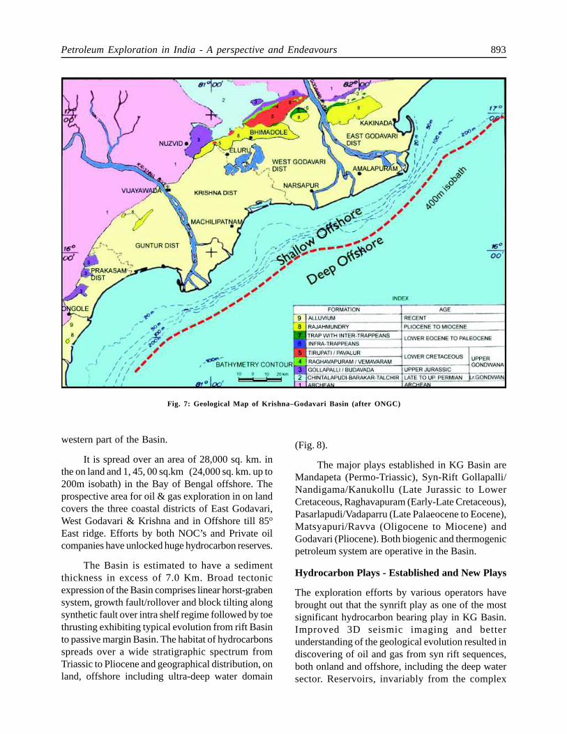
KG Basin (Category-I Basin)
The Krishna-Godavari Basin constitutes a typicalpassive margin Basin and has a polycyclic (dual-riftprovince) evolution history (Fig. 1 and 7). Basincomprises a wide array of sedimentary facies fromearly Permian through Cenozoic with the analogousoutcrops defining the Basin limitation, along the north
Fig. 6: Tectonic map of West coast of India Showing the Kutch Basin (after ONGC)
Petroleum Exploration in India - A perspective and Endeavours 893
western part of the Basin.
It is spread over an area of 28,000 sq. km. inthe on land and 1, 45, 00 sq.km (24,000 sq. km. up to200m isobath) in the Bay of Bengal offshore. Theprospective area for oil & gas exploration in on landcovers the three coastal districts of East Godavari,West Godavari & Krishna and in Offshore till 85o
East ridge. Efforts by both NOC’s and Private oilcompanies have unlocked huge hydrocarbon reserves.
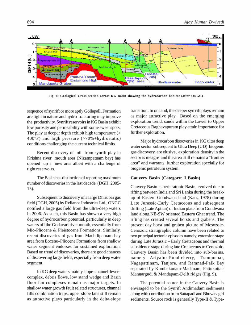
The Basin is estimated to have a sedimentthickness in excess of 7.0 Km. Broad tectonicexpression of the Basin comprises linear horst-grabensystem, growth fault/rollover and block tilting alongsynthetic fault over intra shelf regime followed by toethrusting exhibiting typical evolution from rift Basinto passive margin Basin. The habitat of hydrocarbonsspreads over a wide stratigraphic spectrum fromTriassic to Pliocene and geographical distribution, onland, offshore including ultra-deep water domain
(Fig. 8).
The major plays established in KG Basin areMandapeta (Permo-Triassic), Syn-Rift Gollapalli/Nandigama/Kanukollu (Late Jurassic to LowerCretaceous, Raghavapuram (Early-Late Cretaceous),Pasarlapudi/Vadaparru (Late Palaeocene to Eocene),Matsyapuri/Ravva (Oligocene to Miocene) andGodavari (Pliocene). Both biogenic and thermogenicpetroleum system are operative in the Basin.
Hydrocarbon Plays - Established and New Plays
The exploration efforts by various operators havebrought out that the synrift play as one of the mostsignificant hydrocarbon bearing play in KG Basin.Improved 3D seismic imaging and betterunderstanding of the geological evolution resulted indiscovering of oil and gas from syn rift sequences,both onland and offshore, including the deep watersector. Reservoirs, invariably from the complex
Fig. 7: Geological Map of Krishna–Godavari Basin (after ONGC)
894 Ajay Kumar Dwivedi
sequence of synrift or more aptly Gollapalli Formationare tight in nature and hydro-fracturing may improvethe productivity. Synrift reservoirs in KG Basin exhibitlow porosity and permeability with some sweet spots.The play at deeper depth exhibit high temperature (>400oF) and high pressure (>70%+hydrostatic)conditions challenging the current technical limits.
Recent discovery of oil from synrift play inKrishna river mouth area (Nizampatnam bay) hasopened up a new area albeit with a challenge oftight reservoirs.
The Basin has distinction of reporting maximumnumber of discoveries in the last decade. (DGH: 2005-15).
Subsequent to discovery of a large Dhirubai gasfield (DGH, 2005) by Reliance Industries Ltd., ONGCnotified a large gas field from the ultra-deep watersin 2006. As such, this Basin has shown a very highdegree of hydrocarbon potential, particularly in deepwaters off the Godavari river mouth, essentially fromMio-Pliocene & Pleistocene Formations. Similarly,recent discoveries of gas from Machilipatnam bayarea from Eocene–Pliocene Formations from shallowwater segment endorses for sustained exploration.Based on trend of discoveries, there are good chancesof discovering large fields, especially from deep watersegment.
In KG deep waters mainly slope-channel-levee-complex, debris flows, low stand wedge and Basinfloor fan complexes remain as major targets. Inshallow water growth fault related structures, channelfills combination traps, upper slope fans still remainas attractive plays particularly in the delta-slope
transition. In on land, the deeper syn rift plays remainas major attractive play. Based on the emergingexploration trend, sands within the Lower to UpperCretaceous Raghavapuram play attain importance forfurther exploration.
Major hydrocarbon disocveries in KG ultra deepwater sector subsequent to Ultra Deep (UD) biogenicgas discovery are elusive, exploration density in thesector is meagre and the area still remains a “frontierarea” and warrants further exploration specially forbiogenic petroleum system.
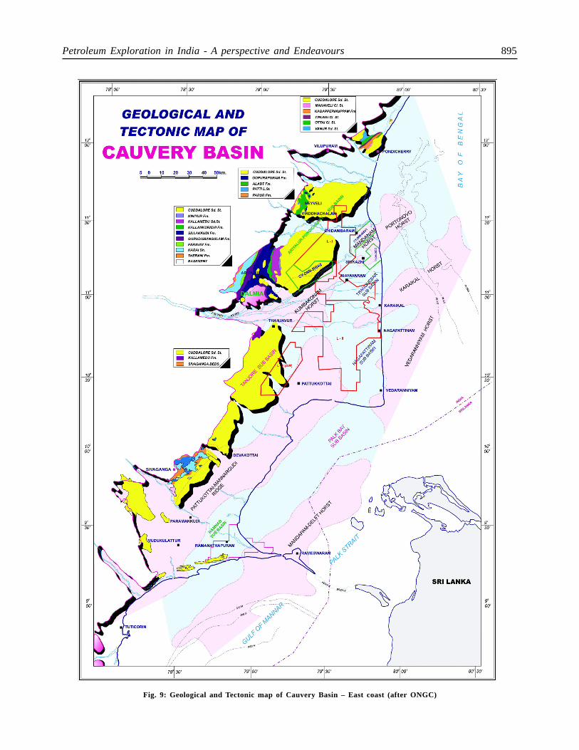
Cauvery Basin (Category: I Basin)
Cauvery Basin is pericratonic Basin, evolved due torifting between India and Sri Lanka during the break-up of Eastern Gondwana land (Katz, 1978) duringLate Jurassic-Early Cretaceous and subsequentdrifting (Late Aptian) of Indian plate from Gondwanaland along NE-SW oriented Eastern Ghat trend. Therifting has created several horsts and grabens. Thepresent day horst and graben picture of Mesozoic-Cenozoic stratigraphic column have been related totwo principal tectonic episodes namely, extension stageduring Late Jurassic – Early Cretaceous and thermalsubsidence stage during late Cretaceous to Cenozoic.Cauvery Basin has been divided into sub-basins,namely Ariyalur-Pondicherry, Tranquebar,Nagapattinam, Tanjore, and Ramnad-Palk Bayseparated by Kumbakonam-Madanam, Pattukottai-Mannargudi & Mandapam-Delft ridges (Fig. 9).
The potential source in the Cauvery Basin isenvisaged to be the Synrift Andimadam sedimentsalong with contribution from Sattapadi and Bhuvanagirisediments. Source rock is generally Type-II & Type-
Fig. 8: Geological Cross section across KG Basin showing the hydrocarbon habitat (after ONGC)
Petroleum Exploration in India - A perspective and Endeavours 895
Fig. 9: Geological and Tectonic map of Cauvery Basin – East coast (after ONGC)
896 Ajay Kumar Dwivedi
III capable of generating both liquid & gaseoushydrocarbon. Two sets of faults, one trending NE-SW and associated with the Synrift phase and theother NW-SE fault system dissecting the older systemare envisaged to have played major role in thedepositional setting, hydrocarbon migration andaccumulation.
Concerted efforts to explore the Basement playresulted in major success with discovery ofhydrocarbons from Madanam, Pandanallur andChidambaram areas.
Hydrocarbon Plays - Established and New Plays
Basement Play: Exploratory drilling in Madanam andPandanallur areas established the commercialhydrocarbons from basement play in Cauvery on landarea.
The other important operative plays in Cauveryonland are - Andimadam Play : (prolific producer in
Kuthalam-Kali, Pallivaramangalam–Vijayapuram,Periyakudi fields and is characterised by poorporosities and low permeabilities). Bhuvanagiri Play:(Well established in Pallivaramangalam –Vijayapuram, Pundi, Kanjirangudi and Periyapattinamfields tight reservoirs), Nannilam Play (in most of thewells drilled in Ariyaluru-Pondichery sub basin,wellestablished in Nannilam, Tiruvarur, Kanjirangudi,Periyapattinam, Perungulam and PBS fields)Kamalapuram Play (The Paleocene play is wellestablished in Adaiyakkamangalam, Kamalapuram,Nannilam, Kuthanallur & few fields in Ramnad sub-basin).
Recent discovery of Periyakudi field from synriftsequence gave a major impetus to synrift play andchance of discovering large fields in the Basin.However, as in the case of Krishna-Godavari, thisplay is also known for HP-HT conditions.
In Cauvery Offshore, there is no much
Fig. 10: Geological and Tectonic Element map of Mahanadi Basin (after ONGC)
Petroleum Exploration in India - A perspective and Endeavours 897
breakthrough except in the established PY and PHfields. Recent discoveries reported by Hardy Oil inCauvery shallow water, by Reliance Industries Ltd(RIL) in Cauvery deep waters (discovery of thickcolumn of gas & condensate from synrift sequencefrom the CY-PR deep water area) and Cairn EnergyIndia Ltd (CEIL) from Srilanka/Gulf of Mannar Basinshas rekindled the exploration interest in the CauveryOffshore.
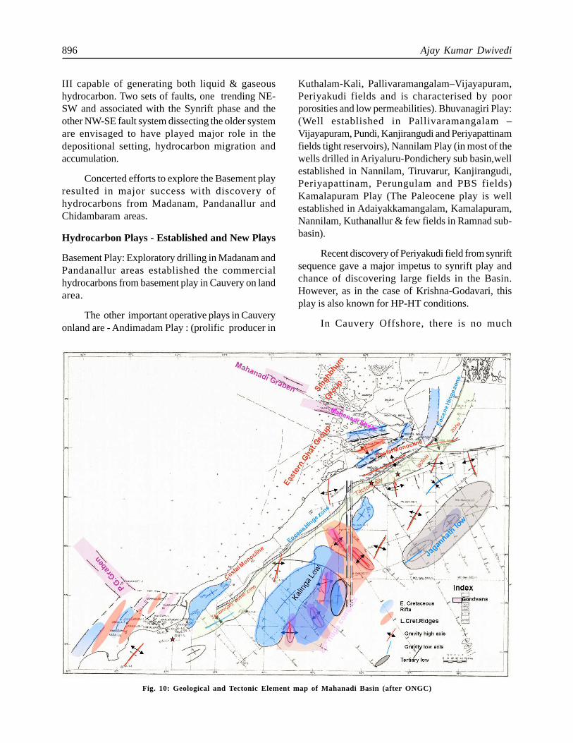
Mahanadi Basin (Category-II Basin)
Mahanadi Basin is a category-II sedimentary Basinlocated in the Eastern Passive Continental Margin ofIndian sub continent. Geographically, it is flanked bythe Bengal Basin in the NE and Krishna-GodavariBasin in the SW. The on-land part of the Basinencompasses the deltaic plains of Mahanadi river andits distributaries lying between Jagannathpur in thenortheast and Chilka Lake in the southwest whichextends in to offshore Bay of Bengal covering a totalarea of about 2,60,000 sq.kms.
Tectonically, Mahanadi Basin is a poly-historyBasin - starting as a NW-SE trending Permo-TriassicGondwana rift characterised by a failed armsuperposed by Late Jurassic-Early Cretaceous NE-SW trending east coast rifting and finally leading topassive margin Basin set-up during Late Cretaceous- Recent period.Various sub-basins/depressions withNE-SW trend are present which include Cuttack-Chandbali depression, Paradip depression, Puridepression, Northern and Southern offshoredepression with sediment thickness varying from5000m in on land to more than 10,000m in the offshoreBasin(Fig:10).Exploration process started in MahanadiBasin way back during 1960 – 70 by OIL and ONGC.Fifteen exploratory wells have been drilled with nomajor hydrocarbon interest reported.
With the advent of New Exploration LicensingPolicy (NELP), the exploration efforts wererejuvenated and additional inputs in terms of seismicAPI and drilling was carried out by NOC and PrivateE&P companies and number of gas discoveries weremade in the offshore part of the Basin.
Hydrocarbon Plays - Established and New Plays
Most of the gas discoveries in Mahanadi offshoreBasin are Non-Associated Natural Gas (NANG) and
biogenic in origin from Mio-Pliocene channel plays.In Oligocene-Eocene level only two wells encounteredgaseous hydrocarbon of mixed origin. In all the casesthe hydrocarbon bearing clastics reservoir facies areof limited areal extent. New plays- deeper fanprospects of Cretaceous and Paleocene age couldnot be probed due to severe down-hole complicationsrelated to high-pressure. The delta- prodelta sequenceat the shelf edge is prospective for potential petroleumsystem in this Basin. In the offshore area Mio-Pliocene shales and channel sands in channel-leveecomplex on paleo-continental slope suggestprospective source-reservoir combination which isproved by the discoveries.
Exploratory efforts till date are restricted up tothe Neogene level. Hence, the Low stand deep-watercanyon fill deposits and the associated relict structuresof Eocene age and the slope fans of Palaeocene andEocene age remain as prospective candidates forfuture exploration targets in this area.
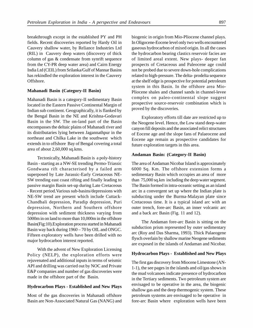
Andaman Basin: (Category-II Basin)
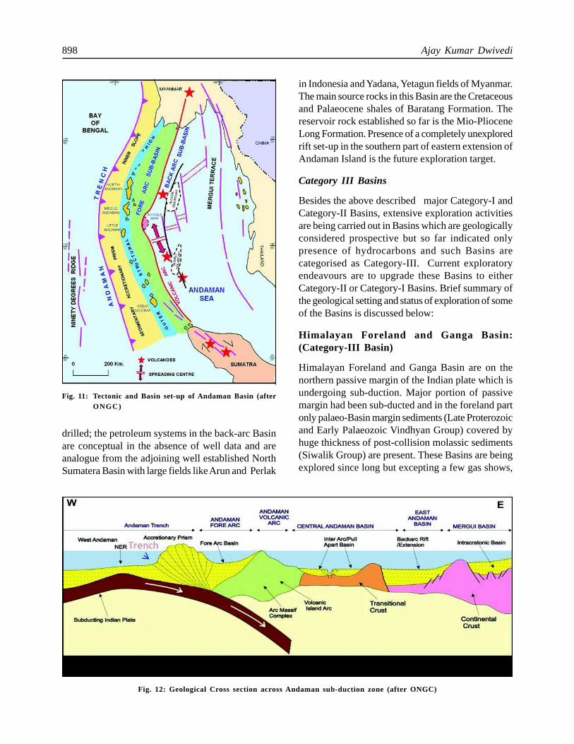
The area of Andaman Nicobar Island is approximately6000 Sq. Km. The offshore extension forms asedimentary Basin which occupies an area of morethan 75,000 sq.km including the deep water segment.The Basin formed in intra-oceanic setting as an islandarc in a convergent set up where the Indian plate issubducting under the Burma-Malayan plate sinceCretaceous time. It is a typical island arc with anouter trench, fore-arc Basin, an inner volcanic arcand a back arc Basin (Fig. 11 and 12).
The Andaman fore-arc Basin is sitting on thesubduction prism represented by outer sedimentaryarc (Roy and Das Sharma, 1993). Thick Palaeogeneflysch overlain by shallow marine Neogene sedimentsare exposed in the islands of Andaman and Nicobar.
Hydrocarbon Plays - Established and New Plays
The first gas discovery from Miocene Limestone (AN-1-1), the see pages in the islands and oil/gas shows inthe mud volcanoes indicate presence of hydrocarbonin the Tertiary sediments. Two petroleum system areenvisaged to be operative in the area, the biogenicshallow gas and the deep thermogenic system. Thesepetroleum systems are envisaged to be operative infore-arc Basin where exploration wells have been
898 Ajay Kumar Dwivedi
in Indonesia and Yadana, Yetagun fields of Myanmar.The main source rocks in this Basin are the Cretaceousand Palaeocene shales of Baratang Formation. Thereservoir rock established so far is the Mio-PlioceneLong Formation. Presence of a completely unexploredrift set-up in the southern part of eastern extension ofAndaman Island is the future exploration target.
Category III Basins
Besides the above described major Category-I andCategory-II Basins, extensive exploration activitiesare being carried out in Basins which are geologicallyconsidered prospective but so far indicated onlypresence of hydrocarbons and such Basins arecategorised as Category-III. Current exploratoryendeavours are to upgrade these Basins to eitherCategory-II or Category-I Basins. Brief summary ofthe geological setting and status of exploration of someof the Basins is discussed below:
Himalayan Foreland and Ganga Basin:(Category-III Basin)
Himalayan Foreland and Ganga Basin are on thenorthern passive margin of the Indian plate which isundergoing sub-duction. Major portion of passivemargin had been sub-ducted and in the foreland partonly palaeo-Basin margin sediments (Late Proterozoicand Early Palaeozoic Vindhyan Group) covered byhuge thickness of post-collision molassic sediments(Siwalik Group) are present. These Basins are beingexplored since long but excepting a few gas shows,
Fig. 11: Tectonic and Basin set-up of Andaman Basin (afterONGC)
Fig. 12: Geological Cross section across Andaman sub-duction zone (after ONGC)
drilled; the petroleum systems in the back-arc Basinare conceptual in the absence of well data and areanalogue from the adjoining well established NorthSumatera Basin with large fields like Arun and Perlak
Petroleum Exploration in India - A perspective and Endeavours 899
no other encouraging result was found. The maintarget here is the palaeo-passive margin Eocenewedge-out which are expected to be matured in thedeeper part of the sub-duction zone. Eocene wedgeswere encountered in drilled wells in Arunachal andPunjab respectively on the eastern and westernextremities of this peripheral foreland area with localshows.
The Himalaya in northwest India is divided intodifferent litho-tectonic blocks by a number of E-Wregional boundary thrusts. Exploration in theHimalayan Foreland Basin commenced in the 50’sand ONGC drilled about 31 wells. The variousstructural plays envisaged in a fold thrust belt havebeen targeted and explored within the hanging wallblocks of Jawalamukhi Thrust and the triangle zonestructures with limited success which proved existenceof thermogenic gas in the area, albeit in non-commercial quantities.
Hydrocarbon Plays : Established and New Plays
Majority of the wells drilled in the Himalayan Forelandexplored the triangle zone structures and theJawalamukhi play, where live gas seepages are wellknown. Gas analysis of Jwalamukhi pool indicates tobe secondary with deep gas migrating upward. Basedon the exploration efforts so far, inner part of the innertectonic belt and sub thrust prospects of Palampurthrust in Lesser Himalayas are envisaged as futureexploration targets.
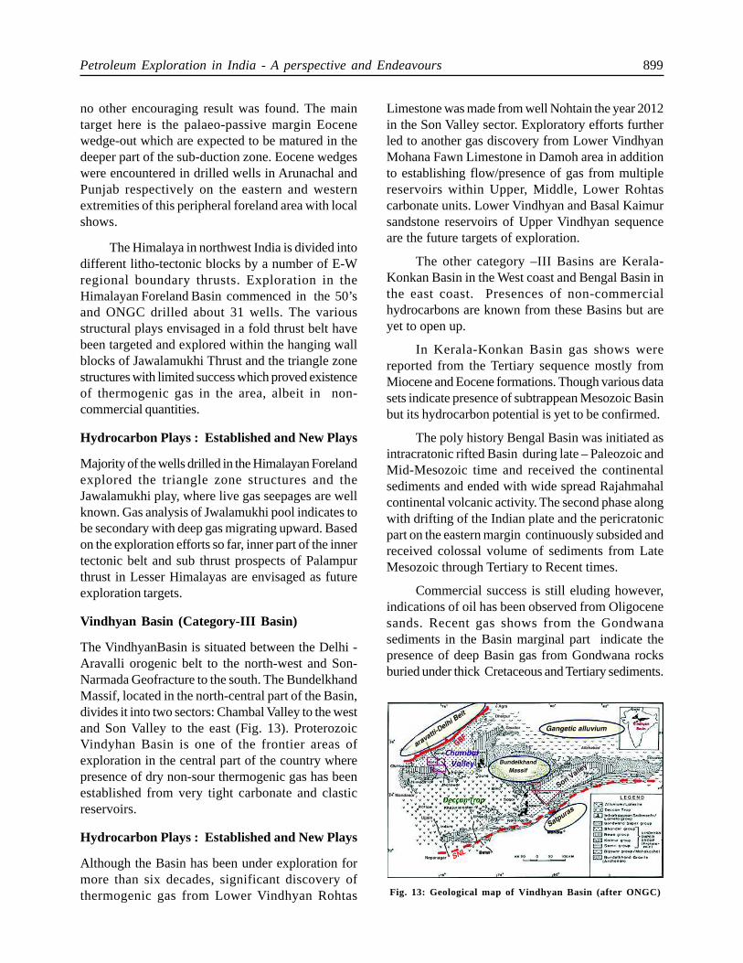
Vindhyan Basin (Category-III Basin)
The VindhyanBasin is situated between the Delhi -Aravalli orogenic belt to the north-west and Son-Narmada Geofracture to the south. The BundelkhandMassif, located in the north-central part of the Basin,divides it into two sectors: Chambal Valley to the westand Son Valley to the east (Fig. 13). ProterozoicVindyhan Basin is one of the frontier areas ofexploration in the central part of the country wherepresence of dry non-sour thermogenic gas has beenestablished from very tight carbonate and clasticreservoirs.
Hydrocarbon Plays : Established and New Plays
Although the Basin has been under exploration formore than six decades, significant discovery ofthermogenic gas from Lower Vindhyan Rohtas
Limestone was made from well Nohtain the year 2012in the Son Valley sector. Exploratory efforts furtherled to another gas discovery from Lower VindhyanMohana Fawn Limestone in Damoh area in additionto establishing flow/presence of gas from multiplereservoirs within Upper, Middle, Lower Rohtascarbonate units. Lower Vindhyan and Basal Kaimursandstone reservoirs of Upper Vindhyan sequenceare the future targets of exploration.
The other category –III Basins are Kerala-Konkan Basin in the West coast and Bengal Basin inthe east coast. Presences of non-commercialhydrocarbons are known from these Basins but areyet to open up.
In Kerala-Konkan Basin gas shows werereported from the Tertiary sequence mostly fromMiocene and Eocene formations. Though various datasets indicate presence of subtrappean Mesozoic Basinbut its hydrocarbon potential is yet to be confirmed.
The poly history Bengal Basin was initiated asintracratonic rifted Basin during late – Paleozoic andMid-Mesozoic time and received the continentalsediments and ended with wide spread Rajahmahalcontinental volcanic activity. The second phase alongwith drifting of the Indian plate and the pericratonicpart on the eastern margin continuously subsided andreceived colossal volume of sediments from LateMesozoic through Tertiary to Recent times.
Commercial success is still eluding however,indications of oil has been observed from Oligocenesands. Recent gas shows from the Gondwanasediments in the Basin marginal part indicate thepresence of deep Basin gas from Gondwana rocksburied under thick Cretaceous and Tertiary sediments.
Fig. 13: Geological map of Vindhyan Basin (after ONGC)
900 Ajay Kumar Dwivedi
Category–IV Basins
Most of these Basins are less explored in comparisonto the category I and II Basins and are located inlogistically difficult terrains/environments with inherentgeological complexities. Exploration ventures in theseBasins are capital intensive with uncertain return.However, considering the huge potential ofhydrocarbon resources, more aggressive explorationis required, which can make a significant impact onthe national hydrocarbon portfolio in the long run.
Exploration was carried out since 1956 in diversegeographical and geological regions of Frontier Basinslike Spiti-Zanskar and Karewa Basin, DeccanSyneclise, Pranhita–Godavari, Narmada, and Satpura-S. Rewa-DamodarBasins; however, the success sohas been was elusive.
Unconventional Hydrocarbons
Apart from conventional hydrocarbon occurrencesdiscussed above, there are other types of hydrocarbonresources. These are, Coal Bed Methane (CBM),Shale Gas, and Gas Hydrates (GH). India, keepingthe increasing demand for hydrocarbons is formulatingthe policies for exploration and exploitation of theseunconventional resources. Of these, CBM explorationinitiated towards the end of the last century is inadvanced stage and exploitation has started in someareas. Special focus is on gas hydrates (GH) sincepreliminary investigation indicated good resourcepotential. India has already established the physicalpresence of GH in offshore deep water part ofKrishna-Godavari, Mahanadi and Andaman areas.Exploration for shale oil shale &gas are in initial stages.
Coal Bed Methane
The adsorbed methane in coal bed which was knownto be the potential hazard in coal mining is noweconomically exploited through bore holes at depthrages of 500m to 1000m. India has the fifth largestproven coal reserves in the world and thus holdssignificant prospects for exploration and exploitationof CBM. The prognosticated CBM resources in thecountry are about 92 TCF (2600 BCM) in 12 statesof India, especially the eastern coal fields ofDamodar-Koel valley and Son valley.
As an initiative to harness the CBM potential,GOI has awarded 33 CBM blocks and commercial
production commenced from July, 2007.
Gas Hydrates
Methane gas hydrate in the seabed shallow sedimentsis a prolific source of gas containing both biogenicand thermogenic gas. In India, presence of gas hydratehas been established in deep offshore of KG, Mahanadiand Andaman areas (DGH, 2010). National GasHydrate Program of Government of India conductedthe first expedition in 2006 and the second expeditionof Gas Hydrates commenced in 2015. Intensive R&Dstudies are being carried out to evolve technologiesto produce gas from frozen sea-bed sediments andIndia is ranked third in this endeavour after USA andJapan.
Shale Gas
Shale gas and oil constitute an importantunconventional source of hydrocarbons stored inorganic rich, matured fine grained sedimentary rocks.Hydro fracturing is an essential operational activityto explore the unconventional hydrocarbons from theshale which is impervious in nature with permeabilityin nano scale. Meso-Neo Proterozoic source faciesof Vindhyan Basin and Permian source facies ofGondwana Basins besides the conventional deepersource shales are the potential shale gas/oil resources.Six Indian sedimentary Basins viz., Cambay, KG,Cauvery, Assam-Arakan, Ganga Valley and DamodarBasin were identified for shale oil/gas exploration.
India embarked on an ambitious Shale oil andgas programme and exploration programme in 55blocks has been initiated by NOC’s.
Technology Induction to Enhance ExplorationEfforts
Technology induction being an integral part ofhydrocarbon exploration, following new technologiesare implemented in Indian Sedimentary Basins
l Long Offset 2D seismic surveys for deeperimaging
l 3D-3C/4D Seismic Surveys
l Wide Azimuth surveys
l Onshore carpet 3D surveys
l Node based Wide angle refraction cumreflection profiling.
Petroleum Exploration in India - A perspective and Endeavours 901
l Broadband Surveys
l CSEM surveys and Microgravity data fordelineation
l Bean PSDM processing
l Common Reflection Angle Migration processing
l Discreet Fracture Net work Analysis
l Permeability structure analysis and fluidreplacement studies
Summary
Exploratory efforts by E&P companies havediscovered 7 producing Basins and converted about11.18 BTOE out of the prognosticated resource of 28
BTOE. A growth of about 32% compared to baseyear of 2006 in Initial In-Place volume.
Exploratory efforts have brought down theunexplored sedimentary Basinal area to a mere 12%compared 50% as in 1995.
Continued exploratory efforts leveraging the newtechnologies are resulting in new discoveries fromCategory –I Basins and more commercial discoveriesfrom Category–II Basins like Mahanadi and Kutch.
Challenges in term of exploring and exploitingthe HP-HT and Ultra HP-HT reservoirs exists andIndia is gearing up to meet the challenges throughinduction of new technologies.
Abbreviations Used
2D/3D/4D :Two-dimensional/three dimensional/fourdimensional (time-lapsed)
3D-3C : Three dimension – Three component
BCM : Billion Cubic meters
BOPD : Barrels of oil per day
BTOE: Billion Tonnes Oil equivalent
CAAGR: Compounded Average Annual growthrate
CBM : Coalbed Methane
CRAM: Common Reflection Angle Migration
CSEM: Controlled Source Electro Magnetic
DFN : Discreet Fracture Net work.
DGH : Directorate General of Hydrocarbons
E&P : Exploration and Production
EOB: Eastern OceanBasin
FRM : Fluid Replacement Model
GH : Gas Hydrates
GOI: Government of India
GSI: Geological Survey of India
HELP: Hydrocarbon Exploration LicensingPolicy
HOEC: Hindustan Oil Exploration Company
HPB: Heera-Panna-Bassein
HPHT: High Pressure-High Temperature
KG : Krishna-Godavari
LWD: Logging While drilling
MBPD: Million Barrels per day
MPD : Managed Pressure Drilling
MMSCD/ MMSCMD: Million Metric Standard CubicMeters Per Day
NANG: Non associated Natural Gas
NEC: Northern East Coast
NELP : New Exploration Licensing Policy
NOC : National oil Companies
OIL : Oil India Ltd.
ONGC : Oil and Natural Gas corporation Ltd
PSU : Public Sector Undertaking
PST: Passive Seismic tomography
RIL: Reliance Industries Limited
RSS: Rotary Steerable System
SBL : Sea bed logging
WAZ: Wide Angle Azimuth
WARRP: Wide angle Refraction cum Reflectionprofiling.
902 Ajay Kumar Dwivedi
References
Anirbid Sircar (2004) Hydrocarbon production from fractured
basement formations Current Science 87 147-151
Bastia R (2007) Geologic setting and petroleum systems of India’s
east coast offshore Basins-concepts & applications
Technology Publications, Dehradun, p 1-124
Biswas S K (2009) The Upper Assam Inter-Orogenic Peripheral
Foreland Basin - a Special type of Peripheral Foreland
Basin in Northeast India - an Overview on Tectono-
Sedimentary Evolution. Nat. Semi. On geodynamics
Mizoram Univ & Geol Soc Ind Souvenir 77-89
Biswas S K (2008a) PetroliferousBasins of India - Fifty years’
history and perspective Mem Geol Soc India 66 159-202
Biswas S K (2008b) Geodynamics of Indian plate and evolution
of Mesozoic-CenozoicBasins Mem Geol Soc India 74 247-
260
Biswas S K (2012) Status of Petroleum Exploration in India Proc
Indian natn Sci Acad 78 September 2012 475-494
Biswas S K (1989) Hydrocarbon exploration in western offshore
Basins of India Geol Surv India Spl Pub 24 184-194
Biswas S K (1982) Rift Basins in western margin of India with
special reference to hydrocarbon prospect Bull Amer Assoc
Petro Geol 66 1497-1513
Biswas S K (1987) Regional tectonic framework, structure and
evolution of the western margin Basins of India
Tectonophysics 135 307-327
Biswas S K (1995) Prospect of coal bed methane in India Indian
Jour Petro Geol 4 1-23
Biswas S K (1998) Overview of sedimentary Basins of India and
their hydrocarbon potential In: R N Tiwari (ed) Recent
researches in sedimentary Basins - implications in the
exploration of natural resources. Indian Petroleum Pub.,
Dehradun, p 1-25
Biswas S K (2002) Structure and tectonics of the Kutch Basin,
Western India, with special reference to Earthquakes. 8th.
IGC Foundation Lecture, Indian Geological Congress,
Roorkee, p 1-21
Biswas S K (2003) Regional tectonic framework of Pranhita-
Godavari Basin India Jour Asian Earth Sci 21 543-552
Biswas S K (2005) A review of structure and tectonics of Kutch
Basin, Western India, with special reference to earthquakes
Curr Sci 88 1592-1600
Biswas S K and Singh N K (1988) Western continental margin of
India and hydrocarbon prospects of deep sea Basin Proc
7th Offshore SE-Asia Conf Singapore OTSC 88119, p 170-
181
Biswas S K, Bhasin A L and Ram J (1993) Classification of
Indian sedimentary Basins in the framework of plate
tectonics Proc Second Seminar on PetroliferousBasins of
India Indian Petroleum Pub Dehradun 1 1-46
Biswas S K, Rangaraju M K, Thomas J and Bhattacharya S K
(1994) Cambay-Hazad (!) petroleum system in south
Cambay Basin, India In Magoon L B and W G Dow (eds),
The Petroleum System - from source to trap Mem Amer
Assoc Petro Geol 60 615-624
Biswas S K (2012) Status of Petroleum Exploration in India Proc
Indian Natn Sci Acad 78 September 2015, pp 475-494
Chandrasekhar N, Mane P H, Rajappan P (2015) Basement
Hydrocarbon Exploration-Overview of Petroleum system,
Multi-component seismic analysis, identification of
fractures and status of Indian Basin Exploration,
Geohorizons, July 2015, 36-44
Das Gupta A B and Biswas A K (2000) Geology of Assam Geol
Soc India Pub 169p
Das Gupta U and Bulgauda S S (1994) An overview of the geology
and hydrocarbon occurrences in the western part of
Bikaner-Nagaur Basin Ind Jour Petrol Geol 1-17
DGH (2015) Hydrocarbon exploration and production activities,
India, 2014-15. p. 14-17, 100-108,112-118, 152-153
DGH (2007) Petroleum exploration and production activities,
India, 2006-07 p 82-83
DGH (2010) Petroleum exploration and production activities,
India, 2009-10 73 107-113
Dhar P C and Bhattacharya S K (1993) Status of exploration in
the Cambay Basin Proc. Second Seminar on
PetroliferousBasins of India Indian Petroleum Publishers,
Dehradun 2 1-32
Dolson John, Burley, Stuart D, Sunder V R, Kothari V, Naidu,
Bodapati, Nicholas P, Paul Farrimond, Whitely, Taylor
Andrew, Direen Nicholas and Anathakrishnan B (2015)
The discovery of the Barmer Basin, Rajasthan,India, and
its petroleum geology Amer Assoc Petro Geol 99 433-465
Fuloria R C (1993) Geology and hydrocarbon prospects of
Mahanadi Basin, India Proc Second Seminar on
PetroliferousBasins of India, Indian Petroleum Pub.,
Dehradun 1 355-370
Ganguly, Susnato (1993) Stratigraphy, sedimentation and
hydrocarbon prospects of the Tertiary succession of
Tripura and Cachar (Assam) Ind Jour Geol 65 145-180
Katz M B (1978) Sri Lanka in Gondwanaland and the evolution
of the Indian Ocean Geol Mag 115 237-316
Indian Energy Outlook (2015) In World energy outlook Special
Publication by International energy Agency
Powell C, Me A, Roots S R and Veevers J J (1988) Pre-break up
Petroleum Exploration in India - A perspective and Endeavours 903
continental extension in East Gondwanaland and the early
opening of the eastern Indian Ocean Tectonophysics 155
261-283
Venkatarengan R and Ray D (1993) Geology and petroleum
systems, Krishna-Godavari Basin.Proc.Second Seminar on
Petroliferous Basins of India, Indian Petroleum Pub
Dehradun 1 331-354
Wani M R and Kundu J (1995) Tectonostratigraphic Analysis in
Cambay rift Basin, India: Leads for future exploration
Proc PETROTECH conf Technology Trends in Petroleum
Industry, New Delhi, 147-164
Kundu J and Wani M R (1992) Structural styles and tectono-
strigraphic framework of Cambay rift Basin, Western India
Ind Jour Petro Geol 1 181-202
Kundu J, Wani M R and Thakur R K (1993) Structural style in
south Cambay rift and its control on post rift deltaic
sedimentation Proc Second Seminar on Petroliferous
Basins of India, Indian Petroleum Pub., Dehradun 2 79-96
Max M D and Lowrie A (1996) Oceanic methane hydrates: a
“frontier” gas resource Jour Petro Geol 19 41-56
Mitra P, Mukherjee M K, Mathur B K, Bhandari S K, Qureshi S
M and Bahukhandi G C (1993) Exploration and
hydrocarbon prospect in Jaisalmer Basin, Rajasthan Proc
Second Seminar on Petroliferous Basins of India, Indian
Petroleum Pub., Dehradun 2 235-284
Murty K N (1983) Geology and hydrocarbon prospects of Assam
shelf - recent advance and present status.Petroliferous
Basins of India, pt. I, Petroleum Asia Jour VI 1-14
Rai A, Chandrasekharam P and Misra V N (1998) Indian
sedimentary Basins and their hydrocarbon potential In R
N Tiwari (ed) Recent researches in sedimentary Basins -
implications in the exploration of natural resources. Indian
Petroleum Pub., Dehradun, p 91-103
Rao G N (2001) Sedimentation, stratigraphy, and petroleum
potential of Krishna-Godavari Basin, east coast of India
Bull Amer Assoc Petro Geol 85 1623-1643
Raju D S N et al. (2008) Stratigraphy of India ONGC Bulletin 43
10-39
Rangaraju M K, Agarwal A and Prabhakar K N (1993) Tectono-
stratigraphy, structural styles, evolutionary model and
hydrocarbon habitat, Cauvery and Palar Basins Proc Second
Seminar on Petroliferous Basins of India Indian Petroleum
Pub., Dehradun 1 371-388
Roy Sandip K and Das Sharma S (1993) Evolution of Andaman
fore arc Basin and its hydrocarbon potential Proc Second
Seminar on Petroliferous Basins of India Indian Petroleum
Publishers, Dehradun 1 407-435
Shyam Chand and Subrhmanyam C (2001) Subsidence and
isostasy along a sheared margin - Cauvery Basin, eastern
continental margin Geoph Res Lett 28 2273-2276
Sinha A K, Yadav R K and Qureshi S M (1993) Status of
exploration in south Shahgarh sub-basin of Jaisalmer Basin,
Rajasthan Proc Second Seminar on Petroliferous Basins
of India, Indian Petroleum Pub., Dehradun 2 285-334
Sudhakar R (1990) Scope of integrated exploration research in
Krishna-Godavari, Cauvery and Andaman Basins Proc
Conference on Integrated Exploration Research
Achievements and Perspectives, Unpublished reports of
ONGC and inputs from various formations.

![[Chap6102]CHAPTER 61:02 PETROLEUM … · PETROLEUM (EXPLORATION AND PRODUCTION) ARRANGEMENT OF ... Notice of intention to commence exploration or ... Commissioner for Petroleum Exploration](https://img.pdfslide.us/doc/110x75/5b7bb8197f8b9adb4c8d3af1/chap6102chapter-6102-petroleum-petroleum-exploration-and-production-arrangement.jpg)


![Petroleum Exploration Production Act regulations 1984 · · 2016-06-16LAWS OF MALAWI Petroleum (Exploration and Production) Cap. 61 Petroleum (Applications) Regulations 41 [Subsidiary]](https://img.pdfslide.us/doc/110x75/5ac9a3347f8b9a5d718da164/petroleum-exploration-production-act-regulations-1984-of-malawi-petroleum-exploration.jpg)