Embed Size (px)
Citation preview
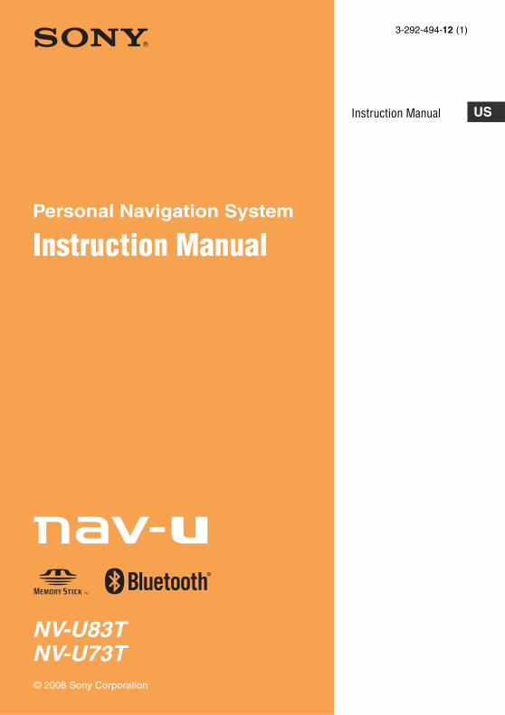
NV-U83TNV-U73T
Personal Navigation System
Instruction Manual
© 2008 Sony Corporation
3-292-494-12 (1)
Instruction Manual US

2
Using the manualsThe following manuals are included with the unit.Before installing or operating the unit, read these manuals thoroughly and retain them for future reference.
• Read This FirstContains instructions on how to install the unit in your car, the location of controls, and the featured navigation operations.
• Before You UseContains important notices to be read prior to use, including warnings, specifications, and troubleshooting instructions.
• Quick Guide for Bluetooth Hands-free Calling (NV-U83T only)Contains instructions on Bluetooth function basic operations.
• Instruction Manual (PDF) (this manual)Contains descriptions of all functions.
Notes on this manual• This manual contains instructions for the NV-
U83T and U73T.– NV-U83T is the model used for illustration
and screenshot purposes.– Available functions such as POSITION plus
or Bluetooth differ depending on the model. Check your model name and refer to the different indications in each section of this manual.
• Illustrations and screenshots in this manual may differ from the actual device.

3

4
Table of Contents
Basic Operations 6
Menu operations. . . . . . . . . . . . . . . . . . . . . . . . .6
Gesture Command operations . . . . . . . . . . . . . .6
Keyboard operations . . . . . . . . . . . . . . . . . . . . .7
Navigation 8
Checking the GPS status . . . . . . . . . . . . . . . . . .8
Route searching . . . . . . . . . . . . . . . . . . . . . . . . .8Address search. . . . . . . . . . . . . . . . . . . . . . . .8Home search . . . . . . . . . . . . . . . . . . . . . . . . .9POI search . . . . . . . . . . . . . . . . . . . . . . . . . .10Intersection search . . . . . . . . . . . . . . . . . . . .11City center search . . . . . . . . . . . . . . . . . . . .11Recent destinations search. . . . . . . . . . . . . .11Address book search . . . . . . . . . . . . . . . . . .11Favorites search . . . . . . . . . . . . . . . . . . . . . .12Option menu in the address/POI confirmation display . . . . . . . . . . . . . . . . . .12
Map operations. . . . . . . . . . . . . . . . . . . . . . . . .12Indications on the map. . . . . . . . . . . . . . . . .12Map scrolling mode . . . . . . . . . . . . . . . . . . .13Using the map tool. . . . . . . . . . . . . . . . . . . .14
Route planning . . . . . . . . . . . . . . . . . . . . . . . . .14Creating a new itinerary . . . . . . . . . . . . . . .14Option menu for route planning . . . . . . . . .15Adding an interim destination to the current route. . . . . . . . . . . . . . . . . . . . . . . . .16Skipping the current destination . . . . . . . . .16
Route confirmation. . . . . . . . . . . . . . . . . . . . . .16Viewing the turn-by-turn list . . . . . . . . . . . .16Viewing the entire route . . . . . . . . . . . . . . .16
TMC information . . . . . . . . . . . . . . . . . . . . . . .17Checking traffic information . . . . . . . . . . . .17Selecting the traffic information type . . . . .18
Destination management . . . . . . . . . . . . . . . . .18Recent destinations . . . . . . . . . . . . . . . . . . .18Address book . . . . . . . . . . . . . . . . . . . . . . . .18Favorites . . . . . . . . . . . . . . . . . . . . . . . . . . .19
Bluetooth Function (NV-U83T only) 19
Activating the Bluetooth signal . . . . . . . . . . . . 20
Pairing with a cellphone . . . . . . . . . . . . . . . . . 20Searching from this unit . . . . . . . . . . . . . . . 20Searching from a cellphone . . . . . . . . . . . . 20
Connecting to a cellphone . . . . . . . . . . . . . . . . 20
Making calls . . . . . . . . . . . . . . . . . . . . . . . . . . 21Dialing a phone number . . . . . . . . . . . . . . . 21Using the list of recent calls . . . . . . . . . . . . 21Using the phone book . . . . . . . . . . . . . . . . . 21Using preset numbers . . . . . . . . . . . . . . . . . 22Other ways to make calls . . . . . . . . . . . . . . 22
Receiving calls. . . . . . . . . . . . . . . . . . . . . . . . . 22
Operations during a call. . . . . . . . . . . . . . . . . . 22Showing the map . . . . . . . . . . . . . . . . . . . . 23Transferring the current call to a cellphone. . . . . . . . . . . . . . . . . . . . . . . . . . . 23Entering numbers . . . . . . . . . . . . . . . . . . . . 23Ending a call . . . . . . . . . . . . . . . . . . . . . . . . 23
Call data management . . . . . . . . . . . . . . . . . . . 23Recent calls . . . . . . . . . . . . . . . . . . . . . . . . . 23Phone book . . . . . . . . . . . . . . . . . . . . . . . . . 23
Settings 24
Address book settings . . . . . . . . . . . . . . . . . . . 24
General settings . . . . . . . . . . . . . . . . . . . . . . . . 24
Map settings. . . . . . . . . . . . . . . . . . . . . . . . . . . 26
Route profile settings. . . . . . . . . . . . . . . . . . . . 26
Guidance settings. . . . . . . . . . . . . . . . . . . . . . . 26
Traffic Information settings. . . . . . . . . . . . . . . 27
Phone settings (NV-U83T only) . . . . . . . . . . . 27

5
Using the Supplied Software 28
System requirements . . . . . . . . . . . . . . . . . . . . 28
Installing the software . . . . . . . . . . . . . . . . . . . 28
Connecting the unit to your computer . . . . . . . 28
Starting the software . . . . . . . . . . . . . . . . . . . . 29
Guidance voice data management . . . . . . . . . . 29
Map data management. . . . . . . . . . . . . . . . . . . 30
Address book data management . . . . . . . . . . . 30Editing the address book data on your computer . . . . . . . . . . . . . . . . . . . . . . . . . . . 30Editing the address book data on the unit . . . . . . . . . . . . . . . . . . . . . . . . . . . . 30Transferring address book data from your computer to the unit . . . . . . . . . . . . . . 31Transferring address book data from the unit to your computer . . . . . . . . . . . . . . 31
Firmware upgrade . . . . . . . . . . . . . . . . . . . . . . 31
6
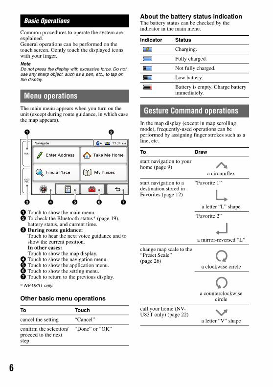
Basic Operations
Common procedures to operate the system are explained.General operations can be performed on the touch screen. Gently touch the displayed icons with your finger.
NoteDo not press the display with excessive force. Do not use any sharp object, such as a pen, etc., to tap on the display.
Menu operationsThe main menu appears when you turn on the unit (except during route guidance, in which case the map appears).
1 Touch to show the main menu.2 To check the Bluetooth status* (page 19),
battery status, and current time.3 During route guidance:
Touch to hear the next voice guidance and to show the current position.In other cases:Touch to show the map display.
4 Touch to show the navigation menu.5 Touch to show the application menu.6 Touch to show the setting menu.7 Touch to return to the previous display.
* NV-U83T only.
Other basic menu operations
About the battery status indicationThe battery status can be checked by the indicator in the main menu.
Gesture Command operationsIn the map display (except in map scrolling mode), frequently-used operations can be performed by assigning finger strokes such as a line, etc.
To Touch
cancel the setting “Cancel”
confirm the selection/proceed to the next step
“Done” or “OK”
MENU
VOICE/POS.
4
1
3 5 6 7
2
Indicator Status
Charging.
Fully charged.
Not fully charged.
Low battery.
Battery is empty. Charge battery immediately.
To Draw
start navigation to your home (page 9)
a circumflex
start navigation to a destination stored in Favorites (page 12)
“Favorite 1”
a letter “L” shape
“Favorite 2”
a mirror-reversed “L”
change map scale to the “Preset Scale” (page 26)
a clockwise circle
a counterclockwise circle
call your home (NV-U83T only) (page 22)
a letter “V” shape
7
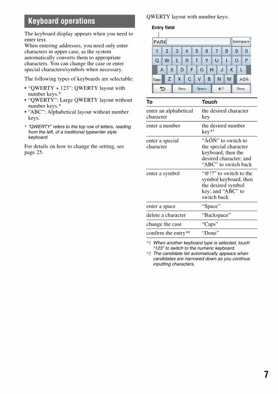
Keyboard operationsThe keyboard display appears when you need to enter text.When entering addresses, you need only enter characters in upper case, as the system automatically converts them to appropriate characters. You can change the case or enter special characters/symbols when necessary.
The following types of keyboards are selectable:
• “QWERTY + 123”: QWERTY layout with number keys.*
• “QWERTY”: Large QWERTY layout without number keys.*
• “ABC”: Alphabetical layout without number keys.
* “QWERTY” refers to the top row of letters, reading from the left, of a traditional typewriter style keyboard.
For details on how to change the setting, see page 25.
QWERTY layout with number keys:
*1 When another keyboard type is selected, touch “123” to switch to the numeric keyboard.
*2 The candidate list automatically appears when candidates are narrowed down as you continue inputting characters.
To Touch
enter an alphabetical character
the desired character key
enter a number the desired number key*1
enter a special character
“ÀŐŇ” to switch to the special character keyboard, then the desired character; and “ABC” to switch back
enter a symbol “@!?” to switch to the symbol keyboard, then the desired symbol key; and “ABC” to switch back
enter a space “Space”
delete a character “Backspace”
change the case “Caps”
confirm the entry*2 “Done”
Entry field

8
Navigation
Checking the GPS status
About the GPS status indicationThe GPS status can be checked by the color of the current position icon.If the current position is not displayed, touch VOICE/POS. to show the icon.
* Available only for NV-U83T.
NoteAcquisition of GPS signal may take up to 10 minutes, especially for the first time. Make sure that you are in an open space for faster acquisition.
Viewing detailed GPS status informationDetailed GPS status information, such as the latitude, longitude, etc., can be viewed to check if the current position is properly calculated.
1 In the menu display, touch , “General,” then “GPS Status.”
Route searchingYou can search for a route in various ways.
The following route search methods are available.• “Address search” (page 8)• “Home search” (page 9)• “POI search” (page 10)• “Intersection search” (page 11)• “City center search” (page 11)• “Recent destinations search” (page 11)• “Address book search” (page 11)• “Favorites search” (page 12)
Address searchAddress search allows you to set the destination by entering the address information such as house number, street name, etc.
Note on the state selectionThe system recognizes the state you usually drive in and sets it as default, so that you do not need to enter the same state name at each address search.When GPS detects that the current position is not in the default state, the state selection display automatically appears, allowing you to set the desired state.
Indication Status
Signals are insufficient for navigation (less than 3 GPS satellites are received).
Reception temporarily interrupted (e.g., in a tunnel). The built-in sensor (POSITION plus)* calculates the current position instead.
Signals are sufficient for navigation.
Current position icon
9
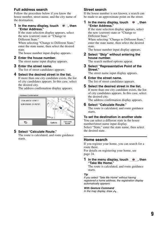
Full address searchFollow the procedure below if you know the house number, street name, and the city name of the destination.
1 In the menu display, touch , then “Enter Address.”If the state selection display appears, select the new (current) state or “Change to Different State.”When selecting “Change to Different State,” enter the state name, then select the desired state.The house number input display appears.
2 Enter the house number.The street name input display appears.
3 Enter the street name.The list of street candidates appears.
4 Select the desired street in the list.If more than one city candidate exists, the list of city candidates appears. In this case, select the desired city.The address confirmation display appears.
5 Select “Calculate Route.”The route is calculated, and route guidance starts.
Street searchIf the house number is not known, a search can be made to an approximate point on the street.
1 In the menu display, touch , then “Enter Address.”If the state selection display appears, select the new (current) state or “Change to Different State.”When selecting “Change to Different State,” enter the state name, then select the desired state.The house number input display appears.
2 Select “Skip” without entering the house number.The search method options appear.
3 Select “Representative Point of the Street.”The street name input display appears.
4 Enter the street name.The list of street candidates appears.
5 Select the desired street in the list.If more than one city candidate exists, the list of city candidates appears. In this case, select the desired city.The address confirmation display appears.
6 Select “Calculate Route.”The route is calculated, and route guidance starts.
To set the destination in another stateYou can select a different state in the house number/street name input display.Select “State,” enter the state name, then select the desired state.
Home searchIf you register your home, you can search for a route there.For details on registering your home, see page 24.
1 In the menu display, touch , then “Take Me Home.”The route is calculated, and route guidance starts.
TipIf you select “Take Me Home” without having registered a home address, the registration display automatically appears.
With Gesture CommandIn the map display, draw .

10
POI searchPOI (Points Of Interest) search allows you to set facilities such as restaurants, hotels, gas stations, etc., as the destination.The system searches for POIs near the current position.
To search for the POIs in another cityYou can specify the city before selecting the POI search method.In this case, the system searches for POIs in the city center.
1 In the menu display, touch , then “Find a Place.”The search method selection display appears.
2 Select “Points of Interest.”
3 Select “Change City.”
4 Enter the city name.
5 Select the desired city in the list.
To switch back to the nearby search, select “Nearby.”
By POI nameYou can search for a route to a POI by directly entering its name.
1 In the menu display, touch , then “Find a Place.”The search method selection display appears.
2 Select “Points of Interest.”
3 Select “By Name.”The POI name input display appears.
4 Enter the POI name.The list of POI candidates appears in order of distance from the current position.
5 Select the desired POI.The POI confirmation display appears.
6 Select “Calculate Route.”The route is calculated, and route guidance starts.
TipIf there are too many POI candidates in the list after step 4 above, you can narrow down by selecting category(ies). Select “Category” to show the category list, then select the desired category(ies).
By POI categoryYou can search for a route to a POI by selecting its category(ies).
1 In the menu display, touch , then “Find a Place.”The search method selection display appears.
2 Select “Points of Interest.”
3 Select “Category.”The list of category candidates appears.
4 Select the desired category.Select sub category when necessary until the POI candidates are narrowed down.The list of candidates appears in order of distance from the current position.
5 Select the desired POI.The POI confirmation display appears.
6 Select “Calculate Route.”The route is calculated, and route guidance starts.
TipIf there are too many POI candidates in the list after step 4 above, you can narrow down by entering the POI name. Select “Name” to show the POI name input display, then enter the POI name.
1
1Intersection searchThe intersection can be set as a destination, if available for the selected street.
1 In the menu display, touch , then “Find a Place.”The search method selection display appears.
2 Select “Find Intersection.”The street name input display appears.
3 Enter the street name.The list of street candidates appears.
4 Select the desired street in the list.If more than one city candidate exists, the list of city candidates appears. In this case, select the desired city.The street name input display appears.
5 Enter the other street name.The list of street candidates appears.
6 Select the street.The address confirmation display appears.
7 Select “Calculate Route.”The route is calculated, and route guidance starts.
TipThe intersection search can also be made by selecting “Enter Address” in step 1 above and skipping the house number input. For details, see “Street search” on page 9.
City center searchThe city center can be set as a destination.
1 In the menu display, touch , then “Find a Place.”The search method selection display appears.
2 Select “Find City.”The city name input display appears.
3 Enter the city name.The list of city candidates appears.
4 Select the desired city in the list.The address confirmation display appears.
5 Select “Calculate Route.”The route is calculated, and route guidance starts.
TipThe city center search can also be made by selecting “Enter Address” in step 1 above and skipping the house number input. For details, see “Street search” on page 9.
Recent destinations searchThe system stores previous destinations, allowing you to select one quickly from the list.For details on how to delete the history, see page 18.
1 In the menu display, touch , then “My Places.”The search method selection display appears.
2 Select “Recent Destinations.”The list of searched destinations appears in reverse chronological order.
3 Select the desired item in the list.The address/POI confirmation display appears.
4 Select “Calculate Route.”The route is calculated, and route guidance starts.
Address book searchYou can select the destination saved in the address book.For details on how to manage the address book, see page 18.
1 In the menu display, touch , then “My Places.”The search method selection display appears.
2 Select “Address Book.”The list of groups appears.
3 Select the desired group.The list of data in the selected group appears in alphabetical order.
4 Select the desired entry in the list.The address/POI confirmation display appears.
5 Select “Calculate Route.”The route is calculated, and route guidance starts.

12
Favorites searchYou can select a destination that is saved in the Favorites.For details on how to manage Favorites, see page 19.
1 In the menu display, touch , then “My Places.”The search method selection display appears.
2 Select “Favorite 1,” “Favorite 2,” “Favorite 3,” or “Favorite 4.”The route is calculated, and route guidance starts.
With Gesture CommandIn the map display, draw one of the command strokes:– Favorite 1: – Favorite 2:
Option menu in the address/POI confirmation displayThe option menu in the address/POI confirmation display provides various useful operations.When the confirmation display appears after setting a destination, select “Options” before selecting “Calculate Route,” then one of the following items.
*1 Appears depending on your selection. “Edit Item” appears when you select “My Places” c “Address Book.” In other cases, “Save to Address Book” appears.
*2 Available only during route guidance.
Map operations
Indications on the map
When no route guidance is in progress:
During route guidance:Straight-ahead driving
Approaching an intersection
Save to Address Book*1 (page 18)Saves the selected point to the address book.
Edit Item*1 (page 24)Edits the selected address book entry.
Interim Destination*2 (page 16)Adds the point as an interim destination in the current route. The system navigates you to this point before the current destination.
BA C
D
E F
G
H

3
1Approaching an intersection (closer)
Approaching an intersection (even closer)
A Current direction/current speedB Current position/GPS status indication
(page 8)C North indicator/current timeD Current street nameE ETA (Estimated Time of Arrival)/distance to
destinationF Distance to next turnG Next instructionH Next turn instructionI Magnified view of an intersectionJ Bar indication of the distance to next turnK Current position
TipYou can set to hide the magnified view of an intersection (page 27).
Map scrolling modeYou can switch to map scrolling mode by touching the map, whether during route guidance or not.By placing the desired point into the crosshair, you can view the information on the point or open the map option menu.
Operations in map scrolling mode
JI
K
To Operation
scroll a map drag the screen
move the desired point to the center of the screen
touch the point
pan the map left/right
touch and hold a point and drag it left/right
14
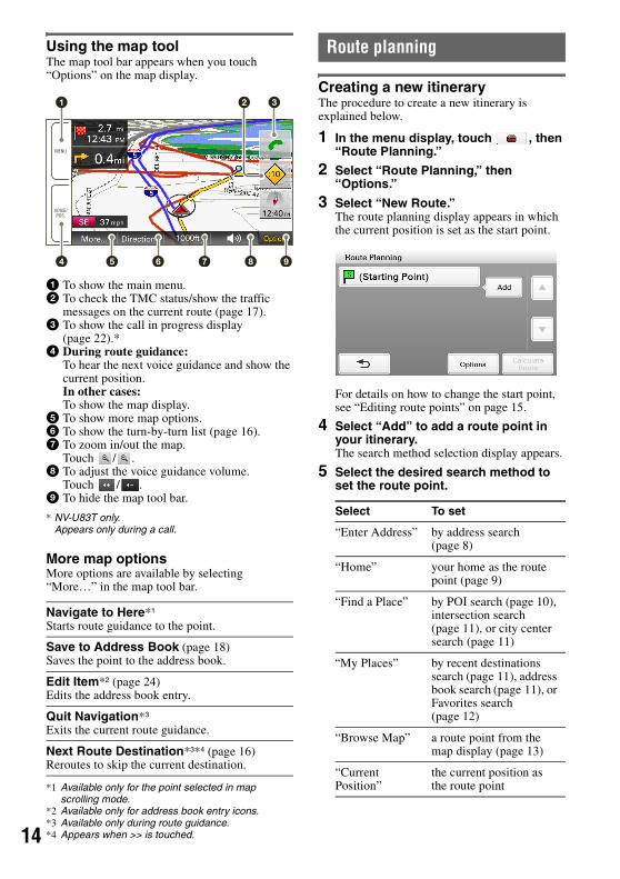
Using the map toolThe map tool bar appears when you touch “Options” on the map display.
1 To show the main menu.2 To check the TMC status/show the traffic
messages on the current route (page 17).3 To show the call in progress display
(page 22).*4 During route guidance:
To hear the next voice guidance and show the current position.In other cases:To show the map display.
5 To show more map options.6 To show the turn-by-turn list (page 16).7 To zoom in/out the map.
Touch / .8 To adjust the voice guidance volume.
Touch / .9 To hide the map tool bar.
* NV-U83T only.Appears only during a call.
More map optionsMore options are available by selecting “More…” in the map tool bar.
*1 Available only for the point selected in map scrolling mode.
*2 Available only for address book entry icons.*3 Available only during route guidance.*4 Appears when >> is touched.
Route planning
Creating a new itineraryThe procedure to create a new itinerary is explained below.
1 In the menu display, touch , then “Route Planning.”
2 Select “Route Planning,” then “Options.”
3 Select “New Route.”The route planning display appears in which the current position is set as the start point.
For details on how to change the start point, see “Editing route points” on page 15.
4 Select “Add” to add a route point in your itinerary.The search method selection display appears.
5 Select the desired search method to set the route point.
Navigate to Here*1
Starts route guidance to the point.
Save to Address Book (page 18)Saves the point to the address book.
Edit Item*2 (page 24)Edits the address book entry.
Quit Navigation*3
Exits the current route guidance.
Next Route Destination*3*4 (page 16)Reroutes to skip the current destination.
MENU
VOICE/POS.
5
1
4 6 7 8 9
2 3
Select To set
“Enter Address” by address search (page 8)
“Home” your home as the route point (page 9)
“Find a Place” by POI search (page 10), intersection search (page 11), or city center search (page 11)
“My Places” by recent destinations search (page 11), address book search (page 11), or Favorites search (page 12)
“Browse Map” a route point from the map display (page 13)
“Current Position”
the current position as the route point

5
16 After setting the route point, select “Done.”The route planning display reappears with the selected point added in the list.
The last setting is listed as the final destination.Repeat step 4 to 6 to continue adding route points. Up to 10 route points can be set.
7 Select “Calculate Route.”The route calculation starts.After the calculation is complete, the route confirmation display appears.
8 Select one of the following items.
Editing route pointsYou can edit the selected route points while creating an itinerary.Select the desired route point in the route planning display, then one of the following items.
TipYou can open the route planning display and modify your itinerary, even after starting route guidance.
Option menu for route planningThe option menu in the route planning/route confirmation display provides various useful operations.When the route planning/route confirmation display appears, select “Options,” then one of the following items.
* Appears only in the option menu of the route planning display while setting the route point(s).
Start NavigationTo start the route guidance.
Change ConditionTo set the route calculation conditions.– “Standard”: Sets a recommended route.– “Avoid Toll Roads”: Avoids the use of toll
roads.– “Avoid Toll Roads (Shortest)”: Sets a
distance-optimized route without toll roads.
Change LocationShows the search method selection display to set the route point again.
DeleteDeletes the selected point from the itinerary.
Change OrderChanges the order of route points.
Select the point to move c “Up”/“Down” c “Done.”
Save RouteSaves the current route.
Saved Routes*Edits the route/starts the route guidance.
Select the route, then one of the following options.– “Edit”: Shows the route planning display to
edit the route point.– “Rename”: Changes the name of the selected
route.– “Delete”: Deletes the selected route.– “Start Navigation”: Starts the route guidance.
Route Profile (page 26)Shows/changes the current route profile settings.
New Route*Shows the route planning display to create a new itinerary.
Calculation Condition*To set the route calculation conditions.For details on options, see page 15.

16
Adding an interim destination to the current routeDuring route guidance, you can add an interim destination.
1 In the menu display, touch , then select the desired search method to set the interim destination.For details on search methods, see “Route searching” on page 8.You can select the desired search method, except for home search and Favorites search.
2 After setting the interim destination, select “Options” in the address/POI confirmation display.
3 Select “Interim Destination.”The route guidance to the interim destination starts.
Skipping the current destinationIf more than one destination point exists during route guidance, you can choose to reroute and skip the current destination.
1 In the map display, select “Options,” “More...,” then >>.
2 Select “Next Route Destination.”The current destination is skipped, and recalculation starts.
Route confirmation
Viewing the turn-by-turn list
1 In the map display, select “Options,” then “Directions.”The turn-by-turn list appears.
2 Select the desired item to show the detailed information.
Viewing the entire routeDuring route guidance, you can view the entire route to the destination.
1 In the map display, select “Options,” then “Directions.”
2 Select “Route Confirmation.”The entire route appears.
To change the route calculation conditions
1 Select “Change Condition,” then the desired option.For details on options, see page 15.
2 Select “Calculate Route.”Recalculation starts.

7
1TMC informationThe built-in TMC (Traffic Message Channel) receiver* allows you to receive traffic information. You can check the traffic messages.
* For NV-U83T, the receiver is located in the cradle.For NV-U73T, the receiver is located in the unit.
Checking traffic information
About the TMC status indicationThe TMC status can be checked by the traffic icon in the map display.
Viewing traffic messages
1 In the menu display, touch , then “Traffic Information.”The list of traffic messages appears.If the traffic information type set to display is previously selected, the relevant messages appear (page 18).
ATraffic event typeBDistance from the current positionCStateDRoad nameETraffic message
2 Select the desired message to view detailed information.
To view the previous/next message, touch / .
TipYou can jump to the traffic information setting display (page 27) by selecting “Settings” in the traffic message list.
From the map displayIf any traffic message exists on the current route, you can open the message list also from the map display by touching .In this case, the messages on the current route appear, regardless of the selected type (page 18).
Indication Status
No icon Out of service. In case of NV-U83T, the TMC cradle may not be attached.
Tuning. No TMC signal is currently receivable.
Traffic information available. Pending messages not regarding on the current route exist.
Traffic congestion on route. Pending messages regarding traffic congestion on the current route exist.
Traffic Icon
A CB D E
18
Selecting the traffic information typeYou can select the traffic information type to display.
1 Open the list of traffic messages.For details, see “Viewing traffic messages” on page 17.
2 Select “Change Message.”The type selection display appears.
3 Select the desired type.
4 Touch .The message list of selected information type appears.
Destination managementDestinations on “Recent Destinations,” “Address Book,” and “Favorites” can be managed.
Recent destinationsYou can delete the history of “Recent Destinations.”
1 In the menu display, touch , “My Places,” then “Recent Destinations.”
2 Select “Delete.”
3 Select the item to delete.To select all items, select “All.”To unselect all items, select “Clear.”
4 Select “Done.”The selected item(s) is deleted.
Address bookYou can register the destinations or points on the map to the address book.
From the navigation menu
1 In the menu display, touch , then select the desired search method.For details on search methods, see “Route searching” on page 8.You can select the desired search method, except for home search, address book search, and Favorites search.
2 After setting the destination, select “Options” in the address/POI confirmation display.
3 Select “Save to Address Book.”The registration display appears.
4 Set the following items.
5 Select “Done.”The destination is added to the address book and indicated by the selected icon on the map.
Select To show
“On Route” all traffic messages on the current route
“Not on Route”
all traffic messages not on the current route
“Name”: Enter the name.
“Group”: Select the group to categorize.To create a new group, select “New Group,” then enter the group name.
“Phone”: Enter the phone number.
Icon: Select the icon to show on the map.To select from the facility icon list, select “Facilities Icons” c category c sub category c icon.
“Sound”: Configure the sound setting.– “Sound Function”: Set to “ON” to have
notification sound upon approach.– “Sound Source”: Select the sound source.– “Distance of Starting to Play Back”: Select
the distance at which the sound will be output.

9
1From the map option menu
1 In the map display, touch the map to switch to the map scrolling mode, then select the desired point.
2 Select “Options,” then “More...”Follow the procedure from step 3 above to add the selected point to the address book.
TipFurther management of address book is available from the setting menu (page 24).
FavoritesYou can register destinations to “Favorite 1,” “Favorite 2,” “Favorite 3,” and “Favorite 4” separately.
1 In the menu display, touch , then “General.”
2 Select “Favorites.”
3 Select “Favorite 1,” “Favorite 2,” “Favorite 3,” or “Favorite 4.”
4 Select the desired search method.For details on search methods, see “Route searching” on page 8.You can select the desired search method, except for home search and Favorites search.
5 After setting the destination, select “Done” in the address/POI confirmation display.The destination is stored in the selected Favorite.
To change the registration in FavoritesFollow the procedure above and overwrite a registered Favorite.
Bluetooth Function (NV-U83T only)
The following is the basic procedure required for using the Bluetooth function.
1 Bluetooth signal activationActivating the Bluetooth signal is required to connect this unit to a Bluetooth compatible cellphone.
2 PairingWhen connecting a cellphone for the first time, mutual registration is required. This is called “pairing.” This registration (pairing) is required only for the first time, as this unit and the cellphone will recognize each other automatically from the next time.
3 ConnectionConnect this unit and the cellphone for hands-free calling.
4 Hands-free callingYou can make/receive a hands-free call.
About the Bluetooth status indicationThe Bluetooth status can be checked by the indicator in the main menu.
Indicator Status
Signal is off. You need to activate the signal for connection.
Signal is on, with no cellphone connected. The unit is ready for a connection.
Signal is on, with a cellphone connected. The unit is ready for hands-free calling.
Bluetooth indicator

20
Activating the Bluetooth signal1 In the menu display, touch , then
“Phone.”
2 Select “Bluetooth Signal,” then “ON.”The signal is activated.The Bluetooth indicator in the bottom right of the unit lights up in blue.
Pairing with a cellphonePairing is required only the first time you connect to a cellphone.
To pair this unit to a cellphone, you need to enter the same passkey* on this unit and on the cellphone. The passkey can be either your own selected number or the number determined by the cellphone.For details, see the manual of the cellphone.
* Passkey may be called “passcode,” “PIN code,” “PIN number,” “password,” etc., depending on the cellphone.
Searching from this unitThe procedure to search for a cellphone from this unit is explained below.Check that the cellphone is set to allow for searching beforehand.
1 In the menu display, touch , then “Phone.”
2 Select “Add Devices.”A message asking you to set the cellphone to detectable appears.
3 Select “Search for Phone.”After cellphone search is complete, the list of connectable cellphones appears.To list cellphones by address, select “Address.”To list by name, select “Name.”** The address appears instead of the name if
unavailable.
4 Select the cellphone to register.Pairing starts.
5 Enter the passkey.Perform the required operation also on the cellphone.A message appears stating that the pairing is complete.
To connect to the cellphone, select “Connect.”
Searching from a cellphoneThe procedure to search for this unit from a cellphone is explained below.In this case, the name of the unit is registered as “nav-u,” which can be changed in the phone setting (page 27).
1 Start searching for this unit from the cellphone.For details, see the manual of the cellphone.After you perform the required operation on the cellphone, the passkey input display appears on this unit.
2 Enter the passkey.A message appears stating that the pairing is complete.
Connecting to a cellphoneOnce the Bluetooth signal is activated, the unit searches for the last connected cellphone, and connection is made automatically if possible.
In this chapter, instructions on how to connect manually to paired cellphones are introduced.
Before starting, be sure to activate the Bluetooth signal both on this unit and the cellphone.
1 In the menu display, touch , “Phone,” then “My Devices.”The list of paired cellphones appears.
2 Select the cellphone to connect.The confirmation display appears.
3 Select “OK.”The unit is connected to the selected cellphone.The currently connected cellphone is indicated by in the paired cellphone list.
To disconnectIn step 2 above, select the cellphone to disconnect (one that is currently connected) c “OK.”

1
2Making callsYou can make hands-free calls in various ways.
The following calling methods are available.• “Dialing a phone number” (page 21)• “Using the list of recent calls” (page 21)• “Using the phone book” (page 21)• “Using preset numbers” (page 22)• “Other ways to make calls” (page 22)
Dialing a phone number
1 In the menu display, touch , then “Phone.”The calling method selection display appears.
2 Select “Make a Call,” then “Numeric Input.”
3 Enter the phone number, then select “Call.”The call is made.The calling display appears until the other party answers.
For details on operations during a call, see page 22.
To cancel calling, touch .To adjust the volume of the hands-free function, touch –/+.
Using the list of recent callsThe system stores the last 40 calls, allowing you to select one quickly from the list.For details on how to delete the history, see page 23.
1 In the menu display, touch , then “Phone.”The calling method selection display appears.
2 Select “Make a Call,” then “Recent Calls.”The list of recent calls appears.
3 Select the desired item in the list.The call is made.The calling display appears until the other party answers.For details on operations during a call, see page 22.
To cancel calling, touch .To adjust the volume of the hands-free function, touch –/+.
Using the phone bookYou can make a call using the phone book.For details on how to manage the phone book, see page 23.
1 In the menu display, touch , then “Phone.”The calling method selection display appears.
2 Select “Phone Book.”The list of data in the phone book appears in alphabetical order.
3 Select the desired entry in the list.The call is made.The calling display appears until the other party answers.For details on operations during a call, see page 22.
To cancel calling, touch .To adjust the volume of the hands-free function, touch –/+.

22
Using preset numbersYou can make a call quickly using preset phone numbers.For details on how to preset phone numbers, see page 27.
1 In the menu display, touch , then “Phone.”The calling method selection display appears.
2 Select “D1,” “D2,” “D3,” or “Home.”The call is made.The calling display appears until the other party answers.For details on operations during a call, see page 22.
To cancel calling, touch .To adjust the volume of the hands-free function, touch –/+.
With Gesture CommandIn the map display, draw to call your home.
Other ways to make callsYou can make calls also by the following methods.In the menu display, touch c “Phone” c “Make a Call” c the desired item below.
* Available only if the phone number is registered.
Receiving callsWith the unit connected to the cellphone, you can receive a call in any status.The following display indicates an incoming call, along with the ring tone.
* Appears only when stored in the phone book.
1 Touch .Hands-free talking starts.For details on operations during a call, see page 22.
To reject the call, touch .To adjust the volume of the hands-free function, touch –/+.
Operations during a callVarious operations are available from the following call in progress display, which appears during a call.
* Appears only when stored in the phone book.
To adjust the volume of the hands-free functionTouch –/+.
POI Search*Makes a call to the searched POI.For details on POI search, see page 10.
Search for POI, then select “Call” in the POI confirmation display.
Voice DialMakes a call using the voice dial function of your cellphone (if available).For details, see the manual of the cellphone.
Name* and phone number of other party
Volume indicator
Name* and phone number of other party
Volume indicator
Call duration
3
2Showing the map
1 Touch VOICE/POS.The map and the route guidance (if in progress) appear with displayed on the right side.
To return to the call in progress display, touch .
To show the menu display, touch MENU.
Transferring the current call to a cellphoneYou can transfer the current call to a cellphone if, for example, you want to leave your car without ending the call.
1 Select “Use Cellphone” in the call in progress display.The call is transferred to the cellphone, and the map and the route guidance (if in progress) appear with displayed on the right side.
To transfer back to the hands-free call, touch , “Use Hands-free,” then “OK.”To show the menu display, touch MENU.
Entering numbersYou may need to enter numbers during a call (e.g., to forward the call).
1 Select “Numeric Input” in the call in progress display.The number input display appears.
2 Enter the required number.
Ending a call
1 Touch in the call in progress display.
Call data managementCall data on “Recent Calls” and “Phone Book” can be managed.
Recent callsYou can delete the history of “Recent Calls.”
1 In the menu display, touch , then “Phone.”
2 Select “Make a Call,” then “Recent Calls.”
3 Select “Delete.”
4 Select the item to delete.To select all items, select “All.”To unselect all items, select “Clear.”
5 Select “Done.”The selected item(s) is deleted.
Phone bookYou can import phone book data from the cellphone or delete unnecessary data.
Importing phone book data from the cellphoneUp to 500 entries from the phone book of the cellphone can be imported to this unit.
Before starting, check that the unit is connected to a cellphone.
1 In the menu display, touch , then “Phone.”
2 Select “Receive Phone Book.”The confirmation display appears.
3 Select “OK.”Perform the required operation on the cellphone.For details, see the manual of the cellphone.
4 Select “Done” to complete.The phone book is imported to the unit.
To continue importing the phone book data, select “Continue” instead of “Done” in step 4 above.
Deleting dataYou can delete unnecessary data in the phone book of this unit.
1 In the menu display, touch , then “Phone.”
2 Select “Phone Book,” then “Delete.”
3 Select the entry to delete.To select all entries, select “All.”To unselect all entries, select “Clear.”
4 Select “Done.”The selected entry(ies) is deleted.
TipDeleting phone book data on this unit does not delete data on the cellphone, even if you connect the unit to the cellphone (the data will not be synchronized).

24
Settings
The setting menu includes the following categories.• “Route Planning” (page 14)• “Address Book” (page 24)• “General” (page 24)• “Map” (page 26)• “Route Profile” (page 26)• “Guide” (page 26)• “Traffic Information” (page 27)• “Phone” (NV-U83T only) (page 27)
Address book settingsThe following address book settings are configurable.
In the menu display, touch c “Address Book” c the desired item c the desired option.
General settingsThe following settings related to the system are configurable.
In the menu display, touch c select “General” c the desired item c the desired option.
Edit ItemTo edit the address book entry.
Select the group, then one of the following items.– Entry in the list: Opens the display where you
can delete an entry, or change the name/group/phone/icon/sound setting.
– “Move”: Categorizes entry(ies) to another group. Select the entry(ies) to move c “Done” c the new group c “OK.”
– “Delete”: Deletes an entry(ies). Select an entry(ies) to delete c “Done” c “OK.”
Edit GroupsTo edit the group setting.– “New Group”: Creates a new group.– “Rearrange Group Order”: Changes the order
of groups. Select the group c “Up”/“Down.”– “Edit Group Name”: Changes the group name.– “Delete Group”: Deletes the group and all its
entries.
Make BackupTo back up the address book data on a “Memory Stick Duo.”
Restore Address BookTo restore the address book data from a “Memory Stick Duo.”
Import ItemsTo import the address book entry(ies) from a “Memory Stick Duo.”
Select the file in the “Memory Stick Duo” c all entries or individual entry c “OK” c “OK.”
Export ItemsTo export the address book entry(ies) to a “Memory Stick Duo.”
Select the group c entry(ies) c “Done” c “Done” c “Done,” select/create a file, then select c “OK” c “OK.”
Volume (Operation Sound)To preset the volume level for touch screen operation sound: “Level 3,” “Level 2,” “Level 1,” “OFF.”
UnitsTo select the distance unit: “Kilometers,” “Miles.”
Time FormatTo select the clock indication: “12hr (AM / PM),” “24hr.”
Time ZoneTo set the time zone automatically or manually.
Select LanguageTo select the language for on-screen display.
DisplayTo adjust the display settings.– “Brightness”: Switches the display brightness
automatically or sets the brightness for day time/night time use: “Automatic,” “Day,” “Night.” The brightness level for day time and night time use can be adjusted manually.
– “Touchscreen Calibration”: Performs the touch screen calibration when the touch function is off the mark. Touch the targets in sequence.
Input Home AddressTo register your home address.– “Enter Address”: Sets from the navigation
menu. For details on how to set the address, see “Address search” on page 8.
– “Map”: Selects on the map. For details on how to select the point on the map, see “Map scrolling mode” on page 13.
Start the Configuration WizardTo configure the basic settings by following the wizard (i.e., to perform the Startup Configuration Wizard again).

5
2Daylight Saving TimeTo set daylight saving time automatically by GPS or manually.– “Automatic”: Updates automatically by GPS.– “Manual (+1h)”/“Manual (+30min)”: Sets
manually.– “OFF”: Standard time.
GUI Day / Night ModeTo select the color theme of menu displays.– “Automatic”: Switches the day time (“Day”)/
night time (“Night”) options automatically depending on the time of day.
– “Day”: Suitable for day time use.– “Night”: Suitable for night time use.
Power Saving (Display OFF)To turn off the display automatically after several minutes of inactivity: “ON,” “OFF.”
Keyboard Style (page 7)To select the keyboard type: “QWERTY + 123,” “QWERTY,” “ABC.”
Password LockTo lock the unit by setting a 4-digit numerical password to prevent unauthorized access: “ON,” “OFF.” Once activated, you will need to enter the password when you turn on the unit.
To activate, select “ON” c “OK,” enter the password, then reenter the password to confirm.To deactivate, select “OFF” c “OK,” enter the password, then select “OK.”
Change PasswordTo change the password for locking the unit.
Enter the new password, then reenter the password to confirm.
Reset Factory DefaultTo reset settings to default.
Product InformationTo view the ID number and status (cradle connection, etc.) of the unit.
GPS Status (page 8)To view the detailed GPS status information.
Firmware VersionTo view the firmware version.
Memory Stick InformationTo view the information of the currently inserted “Memory Stick Duo,” such as used/free space; format the “Memory Stick Duo.”
To format, select “Format” c “OK” repeatedly.
Demonstration Mode– “Automatic Demonstration”: Sets to start the
demonstration automatically after several minutes of inactivity: “ON,” “OFF.”
– “Start Demonstration”: Starts the demonstration.
Favorites (page 19)To register destinations in Favorites.
26
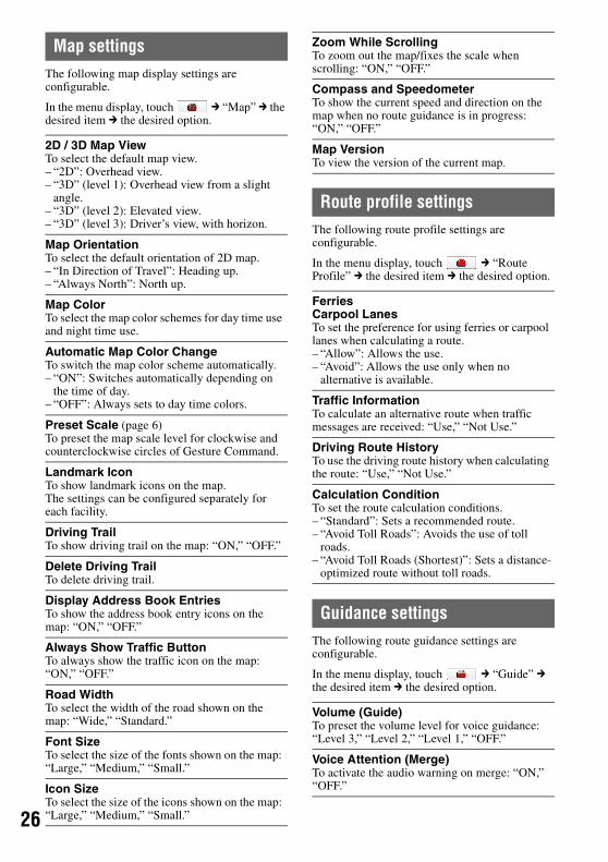
Map settingsThe following map display settings are configurable.
In the menu display, touch c “Map” c the desired item c the desired option.
Route profile settingsThe following route profile settings are configurable.
In the menu display, touch c “Route Profile” c the desired item c the desired option.
Guidance settingsThe following route guidance settings are configurable.
In the menu display, touch c “Guide” c the desired item c the desired option.
2D / 3D Map ViewTo select the default map view.– “2D”: Overhead view.– “3D” (level 1): Overhead view from a slight
angle.– “3D” (level 2): Elevated view.– “3D” (level 3): Driver’s view, with horizon.
Map OrientationTo select the default orientation of 2D map.– “In Direction of Travel”: Heading up.– “Always North”: North up.
Map ColorTo select the map color schemes for day time use and night time use.
Automatic Map Color ChangeTo switch the map color scheme automatically.– “ON”: Switches automatically depending on
the time of day.– “OFF”: Always sets to day time colors.
Preset Scale (page 6)To preset the map scale level for clockwise and counterclockwise circles of Gesture Command.
Landmark IconTo show landmark icons on the map.The settings can be configured separately for each facility.
Driving TrailTo show driving trail on the map: “ON,” “OFF.”
Delete Driving TrailTo delete driving trail.
Display Address Book EntriesTo show the address book entry icons on the map: “ON,” “OFF.”
Always Show Traffic ButtonTo always show the traffic icon on the map: “ON,” “OFF.”
Road WidthTo select the width of the road shown on the map: “Wide,” “Standard.”
Font SizeTo select the size of the fonts shown on the map: “Large,” “Medium,” “Small.”
Icon SizeTo select the size of the icons shown on the map: “Large,” “Medium,” “Small.”
Zoom While ScrollingTo zoom out the map/fixes the scale when scrolling: “ON,” “OFF.”
Compass and SpeedometerTo show the current speed and direction on the map when no route guidance is in progress: “ON,” “OFF.”
Map VersionTo view the version of the current map.
FerriesCarpool LanesTo set the preference for using ferries or carpool lanes when calculating a route.– “Allow”: Allows the use.– “Avoid”: Allows the use only when no
alternative is available.
Traffic InformationTo calculate an alternative route when traffic messages are received: “Use,” “Not Use.”
Driving Route HistoryTo use the driving route history when calculating the route: “Use,” “Not Use.”
Calculation ConditionTo set the route calculation conditions.– “Standard”: Sets a recommended route.– “Avoid Toll Roads”: Avoids the use of toll
roads.– “Avoid Toll Roads (Shortest)”: Sets a distance-
optimized route without toll roads.
Volume (Guide)To preset the volume level for voice guidance: “Level 3,” “Level 2,” “Level 1,” “OFF.”
Voice Attention (Merge)To activate the audio warning on merge: “ON,” “OFF.”

7
2Traffic Information settingsThe following traffic information settings are configurable.
In the menu display, touch c “Traffic Information” c the desired item c the desired option.
* Applicable only when “Traffic Information” is set to “Use” in the route profile setting (page 26).
Phone settings (NV-U83T only)The following phone settings are configurable.
In the menu display, touch c “Phone” c the desired item c the desired option.
*1 The name of “Home” cannot be changed.*2 Available only if data exists in the phone book.
Automatic ZoomTo change the map scale automatically depending on the driving speed. The faster the speed, the larger the map scale: “ON,” “OFF.”
Intersection ZoomTo show the magnified view of an intersection: “ON,” “OFF.”
Select VoiceTo select the guidance voice type.For details on how to import guidance voice data from your computer, see “Guidance voice data management” on page 29.
To show the data on the unit/“Memory Stick Duo,” select “Unit”/“Memory Stick.”To register and activate the imported item, select the item c “Activate.”To select the desired item, select the item c “Done” c “OK.”To delete the item, select the item to delete c “Delete” c “OK.”
Status InformationTo check the name, frequency, and reception level of the current TMC station.
Recalculate Route*To calculate an alternative route automatically to avoid a new traffic event when detected on the current route: “ON,” “OFF.”
Indication in the MapTo show the following indications on the map: “ON,” “OFF.”– “Traffic Control Point”– “Traffic Control Section”
Activate TMC ServiceTo activate the Pay-TMC-Services.
Select “Activate,” then enter the activation code.
My Devices (page 20)To select the cellphone to connect for a hands-free call or phone book import; delete the registration of the cellphone.
To delete the registration, select “Delete” c the cellphone(s) to delete c “Done” c “OK.”
Add Devices (page 20)To pair the unit and the cellphone.
Bluetooth Signal (page 20)To activate the Bluetooth signal: “ON,” “OFF.”
Bluetooth Device InfoTo view the information of this unit, such as the name, address, or compatible profile; edit the device name.
To edit the device name, select “Edit,” then enter the new name.
Receive Phone Book (page 23)To import the phone book data of the cellphone to this unit.
Volume (Ring Tone)To preset the ring tone volume.
Speed DialTo preset/edit phone numbers on “D1”/“D2”/“D3”/“Home.”– “New Input”: Registers the phone number and
the name.*1
– “Edit”: Changes the phone number and/or the name.*1
– “Copy from Phone Book”: Registers the phone number copied from the phone book.*2
– “Clear”: Deletes the registration of the selected preset.
Noise / Echo CancellationTo reduce echo and noise in phone call conversations.
Select “Mode 1” normally.Select “Mode 2” or “OFF” if the sound quality is unsatisfactory.
28
Using the Supplied Software
You can install the software to your computer from the supplied disc. Using the software, you can manage various data to use on the unit.
System requirementsComputer• IBM PC/AT compatible machines• CPU: Pentium III Processor 800 MHz or faster• Hard Disc space: 300 MB or more (500 MB or more recommended)• RAM: 128 MB or more (256 MB or more recommended)• USB port
OS• Microsoft Windows 2000 Professional with Service Pack 4 (or later)• Microsoft Windows XP Home Edition/Professional with Service Pack 2 (or later)• Microsoft Windows XP Media Center Edition/Media Center Edition 2004/Media Center Edition 2005• Microsoft Windows Vista Home Basic/Home Premium/Business/Ultimate
MonitorHigh color (16-bit color) or more, 1024 × 768 dots or more
OtherInternet connection for data download and support
Notes• The following system environments are not supported.
– Non IBM PC type computers, such as NEC PC 98 series, Macintosh, etc.– Homemade computers– OS upgraded computers– Multi-monitor environment– Multi-boot environment
• Depending on the computer condition, operation may not be possible even with the recommended environment.
Installing the software1 Turn on your computer and start Windows.
Log on using an account with administrator privileges.
2 Insert the supplied disc into your computer’s drive.The Install Wizard appears.
3 Follow the on-screen instructions and complete the installation.
Connecting the unit to your computer1 Turn on the unit and your computer.
2 Connect the unit to your computer with the USB cable.The data communication between your computer and the unit starts.
NoteDuring communication, do not:– disconnect the USB cable.– turn off or reset the unit.– shut down the computer, enter computer standby mode, or restart the computer.
DisconnectingAfter the data communication is complete, exit the software, then disconnect the USB cable.

9
2Starting the software1 Start the software.
Click “start,” then select “(All) Programs” c “nav-u tool” c “nav-u tool.”The main menu appears.
1 To manage the map data (page 30).2 To manage the address book data (page 30).3 To select the language for software on-screen displays.4 To upgrade the firmware (page 31).5 To manage guidance voice data (page 29).6 To access to the Sony navigation support site.7 To exit the software.
Guidance voice data managementYou can transfer guidance voice data from your computer to the unit, using the software.Before starting, connect the unit to your computer and start the software.
You can also transfer data to the “Memory Stick Duo” inserted in the unit.
1 In the main menu of the software, select “Guidance Voice Manager.”If the guidance voice data on your computer does not appear, select “Browse,” then specify the data location on your computer.
2 Select the drive corresponding to the unit/“Memory Stick Duo.”
3 In the list, check the box(es) of the guidance voice data to transfer, then select >>.Transfer starts.If free space is insufficient on the unit/“Memory Stick Duo,” a notification appears. Delete unnecessary data by selecting “OK” c “Show” in “Target” c the data to delete c “Delete” c “OK” c “OK.”
4 Select “OK.”The guidance voice data is transferred to the unit/“Memory Stick Duo.”For details on how to select the transferred data on the unit, see page 27.
1
2
3
4
5
6
7
30
Map data managementYou can transfer and replace the map data on the unit, using the software (e.g., to restore map data if necessary).Before starting, connect the unit to your computer and start the software.To transfer the map data on the supplied/optional disc, insert the disc.
1 In the main menu of the software, select “Map Manager.”If the map data does not appear, select “Browse,” then specify the data location.
2 In the list, check the box of the map to transfer, then select >>.Transfer starts.
3 Select “OK.”The map on the unit is replaced.
Address book data managementAddress book data on the unit or your computer can be managed using the software. You can transfer or import the address book data on the unit or your computer.
Editing the address book data on your computerYou can edit the address book data on your computer.
1 In the main menu of the software, select “Address Book Manager.”If the data does not appear in the list, select “Browse,” then specify the data location.
2 Select the group/entry to edit, then the desired edit menu.
3 Select “OK” after editing is complete.The address book data on the computer is updated.
To delete the group/entryIn step 2 above, select the group/entry to delete c “Delete” c “OK” c “OK.”
Editing the address book data on the unitYou can edit the address book data on the unit, using the software.Before starting, connect the unit to your computer and start the software.
1 In the main menu of the software, select “Address Book Manager.”
2 Select “Edit Address Book of the Unit” on the left side of the screen.Follow steps 2 to 3 of “Editing the address book data on your computer” on page 30 to edit the address book data on the unit, then select “Apply to the Unit.”
Select To
“Add” add a new group/entry.
“Edit” edit the selected group/entry.

1
3Transferring address book data from your computer to the unitYou can transfer address book data from your computer to the unit, using the software.Before starting, connect the unit to your computer and start the software.
1 In the main menu of the software, select “Address Book Manager.”
2 Select “Transfer Address Book from PC to the Unit” on the left side of the screen.If the data does not appear in the list, select “Browse,” then specify the data location.
3 Check the box(es) of the group(s)/entry(ies) on your computer.
4 Select “Transfer.”Transfer starts.If free space is insufficient on the unit, a notification appears. Delete unnecessary data from the unit (page 30).
5 Select “OK.”The address book data is transferred to the unit.
Transferring address book data from the unit to your computerYou can transfer address book data from the unit to your computer, using the software.Before starting, connect the unit to your computer and start the software.
1 In the main menu of the software, select “Address Book Manager.”
2 Select “Save Address Book of the Unit” on the left side of the screen.
3 Check the box(es) of the group(s)/entry(ies) on the unit.
4 Select “Save to PC.”Transfer starts.If free space is insufficient on your computer, a notification appears. Delete unnecessary data from your computer.
5 Select “OK.”The address book data is transferred to your computer.
Firmware upgradeYou can download firmware upgrades from the Sony navigation support site to your computer, and upgrade the firmware of the unit using the software.Before starting, connect the unit to your computer and start the software.
1 In the main menu of the software, select “Upgrade System.”
2 In the list, select the latest upgrade data, then “Upgrade.”The confirmation appears.
3 Select “OK.”The firmware upgrade starts. The upgrade progress is displayed on the unit.
![The 1line keyboard: a QWERTY layout in a single line · the QWERTY keyboard along with a second row of modi-fier keys [6]. While their design is similar to ours, we re-duce the keyset](https://img.pdfslide.us/doc/110x75/5f0c43bd7e708231d4348aad/the-1line-keyboard-a-qwerty-layout-in-a-single-line-the-qwerty-keyboard-along-with.jpg)