Embed Size (px)
Citation preview
Project Number: 40156-033 MFF Number: 0049 July 2017
India: Sustainable Coastal Protection and Management Investment Program (Tranche 2) Distribution of this document is restricted until it has been approved by the Management. Following such approval, ADB will disclose the document to the public in accordance with ADB’s Public Communications Policy 2011.
Periodic Financing Request Report
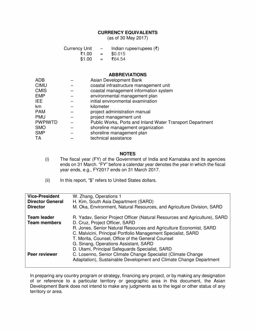
CURRENCY EQUIVALENTS (as of 30 May 2017)
Currency Unit – Indian rupee/rupees (₹)
₹1.00 = $0.015 $1.00 = ₹64.54
ABBREVIATIONS ADB – Asian Development Bank CIMU – coastal infrastructure management unit CMIS – coastal management information system EMP – environmental management plan IEE – initial environmental examination km PAM PMU
– – –
kilometer project administration manual project management unit
PWPIWTD – Public Works, Ports and Inland Water Transport Department SMO SMP
– –
shoreline management organization shoreline management plan
TA – technical assistance
NOTES (i) The fiscal year (FY) of the Government of India and Karnataka and its agencies
ends on 31 March. “FY” before a calendar year denotes the year in which the fiscal year ends, e.g., FY2017 ends on 31 March 2017.
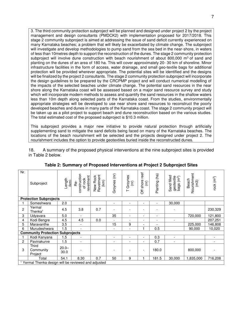
(ii) In this report, “$” refers to United States dollars.
Vice-President W. Zhang, Operations 1 Director General H. Kim, South Asia Department (SARD) Director M. Oka, Environment, Natural Resources, and Agriculture Division, SARD Team leader R. Yadav, Senior Project Officer (Natural Resources and Agriculture), SARD Team members D. Cruz, Project Officer, SARD
R. Jones, Senior Natural Resources and Agriculture Economist, SARD C. Malvicini, Principal Portfolio Management Specialist, SARD T. Morita, Counsel, Office of the General Counsel G. Sinang, Operations Assistant, SARD D. Utami, Principal Safeguards Specialist, SARD
Peer reviewer C. Losenno, Senior Climate Change Specialist (Climate Change Adaptation), Sustainable Development and Climate Change Department
In preparing any country program or strategy, financing any project, or by making any designation of or reference to a particular territory or geographic area in this document, the Asian Development Bank does not intend to make any judgments as to the legal or other status of any territory or area.
CONTENTS
Page TRANCHE AT A GLANCE
I. BACKGROUND 1
II. ASSESSMENT OF IMPLEMENTATION 2
III. PERIODIC FINANCING REQUEST 3
A. Impact and Outcome 3
B. Outputs 4
C. Investment and Financing Plans 4
D. Implementation Arrangements 5
E. Project Readiness 6
IV. DUE DILIGENCE 6
A. Technical 6
B. Economic and Financial 7
C. Governance 7
D. Poverty, Social, and Gender Dimensions 8
E. Safeguards 8
F. Risks and Mitigating Measures 9
G. Risk Categorization 9
V. ASSURANCES 10
VI. RECOMMENDATION 10
APPENDIXES 1. Design and Monitoring Framework for Project 2 2. Loan Agreement 3. Project Agreement 4. Project Administration Manual 5. Updated Contribution to the ADB Results Framework 6. Economic and Financial Assessments for Project 2 7. Updated Summary of Poverty Reduction and Social Strategy 8. Resettlement Framework 9. Indigenous People Planning Framework 10. Environmental Assessment and Review Framework 11. Initial Environmental Examination 12. Risk Assessment and Risk Management Plan SUPPLEMENTARY APPENDIXES A. Climate Change: Project Adaptation Action Report B. Updated Detailed Project Report including Project Planning and Technical Rationale for
Subproject Interventions C. Financial and Economic Assessment D. Climate Risk and Vulnerability Assessment

Project Classification Information Status: Complete
TRANCHE AT A GLANCE
Source: Asian Development Bank 04112016150443091373This document must only be generated in eOps. Generated Date: 07-Jul-2017 17:52:39 PM
1. Basic Data Project Number: 40156-033Project Name Sustainable Coastal Protection and Management
Investment Program - Tranche 2Department/Division
SARD/SAER
Country India Executing Agency Public Works, Ports & Inland Water Transport Dept.Borrower India
.
2. Sector Subsector(s) ADB Financing ($ million)Agriculture, natural resources and rural development
Water-based natural resources management 65.50
Total 65.50
3. Strategic Agenda Subcomponents Climate Change Information Inclusive economic growth (IEG)
Pillar 2: Access to economic opportunities, including jobs, made more inclusive
Environmentally sustainable growth (ESG)
Disaster risk managementEnvironmental policy and legislationGlobal and regional transboundary environmental concernsNatural resources conservation
Adaptation ($ million) 50.00Climate Change impact on the Project
Medium
.
4. Drivers of Change Components Gender Equity and MainstreamingKnowledge solutions (KNS)
Application and use of new knowledge solutions in key operational areas
Private sector development (PSD)
Conducive policy and institutional environment
Some gender elements (SGE)
.
5. Poverty and SDG Targeting Location ImpactGeographic TargetingHousehold TargetingSDG Targeting
NoNoYes
Rural High Urban Medium Nation-wide Low
SDG Goals SDG9.
6. Risk Categorization: Low.
7. Safeguard Categorization Environment: B Involuntary Resettlement: C Indigenous Peoples: C.
8. Financing
Modality and Sources Amount ($ million)
ADB 65.50
Sovereign MFF-Tranche (Regular Loan): Ordinary capital resources 65.50
Cofinancing 0.00
None 0.00
Counterpart 28.04
Government 28.04
Total 93.54
.
TRANCHE AT A GLANCE
Source: Asian Development Bank 04112016150443091373This document must only be generated in eOps. Generated Date: 07-Jul-2017 17:52:39 PM
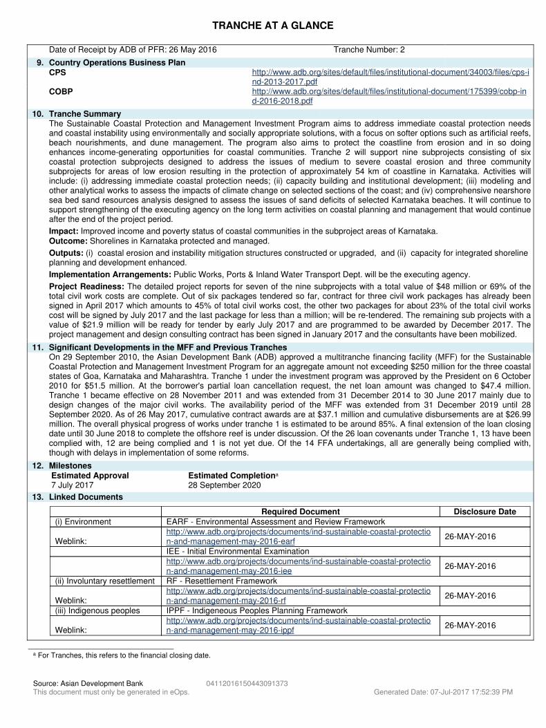
Date of Receipt by ADB of PFR: 26 May 2016 Tranche Number: 2.
9. Country Operations Business PlanCPS http://www.adb.org/sites/default/files/institutional-document/34003/files/cps-i
nd-2013-2017.pdfCOBP http://www.adb.org/sites/default/files/institutional-document/175399/cobp-in
d-2016-2018.pdf.
10. Tranche SummaryThe Sustainable Coastal Protection and Management Investment Program aims to address immediate coastal protection needsand coastal instability using environmentally and socially appropriate solutions, with a focus on softer options such as artificial reefs,beach nourishments, and dune management. The program also aims to protect the coastline from erosion and in so doingenhances income-generating opportunities for coastal communities. Tranche 2 will support nine subprojects consisting of sixcoastal protection subprojects designed to address the issues of medium to severe coastal erosion and three communitysubprojects for areas of low erosion resulting in the protection of approximately 54 km of coastline in Karnataka. Activities willinclude: (i) addressing immediate coastal protection needs; (ii) capacity building and institutional development; (iii) modeling andother analytical works to assess the impacts of climate change on selected sections of the coast; and (iv) comprehensive nearshoresea bed sand resources analysis designed to assess the issues of sand deficits of selected Karnataka beaches. It will continue tosupport strengthening of the executing agency on the long term activities on coastal planning and management that would continueafter the end of the project period..
Impact: Improved income and poverty status of coastal communities in the subproject areas of Karnataka. Outcome: Shorelines in Karnataka protected and managed. .
Outputs: (i) coastal erosion and instability mitigation structures constructed or upgraded, and (ii) capacity for integrated shoreline planning and development enhanced..
Implementation Arrangements: Public Works, Ports & Inland Water Transport Dept. will be the executing agency..
Project Readiness: The detailed project reports for seven of the nine subprojects with a total value of $48 million or 69% of thetotal civil work costs are complete. Out of six packages tendered so far, contract for three civil work packages has already beensigned in April 2017 which amounts to 45% of total civil works cost, the other two packages for about 23% of the total civil workscost will be signed by July 2017 and the last package for less than a million; will be re-tendered. The remaining sub projects with avalue of $21.9 million will be ready for tender by early July 2017 and are programmed to be awarded by December 2017. Theproject management and design consulting contract has been signed in January 2017 and the consultants have been mobilized.
.
11. Significant Developments in the MFF and Previous TranchesOn 29 September 2010, the Asian Development Bank (ADB) approved a multitranche financing facility (MFF) for the SustainableCoastal Protection and Management Investment Program for an aggregate amount not exceeding $250 million for the three coastalstates of Goa, Karnataka and Maharashtra. Tranche 1 under the investment program was approved by the President on 6 October2010 for $51.5 million. At the borrower's partial loan cancellation request, the net loan amount was changed to $47.4 million.Tranche 1 became effective on 28 November 2011 and was extended from 31 December 2014 to 30 June 2017 mainly due todesign changes of the major civil works. The availability period of the MFF was extended from 31 December 2019 until 28September 2020. As of 26 May 2017, cumulative contract awards are at $37.1 million and cumulative disbursements are at $26.99million. The overall physical progress of works under tranche 1 is estimated to be around 85%. A final extension of the loan closingdate until 30 June 2018 to complete the offshore reef is under discussion. Of the 26 loan covenants under Tranche 1, 13 have beencomplied with, 12 are being complied and 1 is not yet due. Of the 14 FFA undertakings, all are generally being complied with,though with delays in implementation of some reforms.
.
12. MilestonesEstimated Approval Estimated Completiona
7 July 2017 28 September 2020
13. Linked Documents-
Required Document Disclosure Date(i) Environment EARF - Environmental Assessment and Review Framework Weblink:
http://www.adb.org/projects/documents/ind-sustainable-coastal-protection-and-management-may-2016-earf
26-MAY-2016
IEE - Initial Environmental Examination
http://www.adb.org/projects/documents/ind-sustainable-coastal-protection-and-management-may-2016-iee
26-MAY-2016
(ii) Involuntary resettlement RF - Resettlement Framework Weblink:
http://www.adb.org/projects/documents/ind-sustainable-coastal-protection-and-management-may-2016-rf
26-MAY-2016
(iii) Indigenous peoples IPPF - Indigeneous Peoples Planning Framework Weblink:
http://www.adb.org/projects/documents/ind-sustainable-coastal-protection-and-management-may-2016-ippf
26-MAY-2016
-
. .
a For Tranches, this refers to the financial closing date.
I. BACKGROUND
1. The Asian Development Bank (ADB) approved a multitranche financing facility of $250.0 million on 29 September 2010 funded by ADB’s ordinary capital resources for the three coastal states of Goa1, Karnataka, and Maharashtra for the Sustainable Coastal Protection and Management Investment Program. Tranche 1 under the investment program was approved by the President on 6 October 2010 for a total amount of $51.5 million, comprising $41.0 million for the state of Karnataka and $10.5 million for the state of Maharashtra. The Public Works, Ports and Inland Water Transport Department (PWPIWTD) is the executing agency for the subprojects in Karnataka, and the Maharashtra Maritime Board for the subprojects in Maharashtra.
2. The investment program addresses immediate coastal protection needs and coastal instability using environmentally and socially appropriate structural solutions, with a focus on softer options such as artificial reefs, beach nourishment, and dune management. It finances the development of shoreline management plans and information systems and institutional capacities to meet the long-term needs of sustainable coastal protection and management and economically viable coastal erosion protection works. Through the introduction of new technologies for coastal protection, the investment program aims to protect the coastline from erosion and in so doing enhances income-generating opportunities for coastal communities.
3. Progressing coastline erosion in the three states is a major threat to the communities and economic development in the coastal zone.2 The rise in sea levels and the likely increase in the frequency and intensity of storms will aggravate the rate of erosion, with serious economic and environmental consequences. The coastal environment is of high importance to India’s major economic sectors, which include fisheries, agriculture, tourism, ports and maritime shipping, other major transport and communication sectors, and their related infrastructures. Effective and sustainable management of the shoreline is thus vital to sustainable economic and social development of the coastal regions.
4. ADB received a periodic financing request for second tranche of the investment program from the Government of India on 26 May 2016. Project 2 will protect a total of 54 kilometers (km) of coastline in the three selected coastal districts for the investment program in Karnataka.3 The country operations business plan, 2016–2018 for India includes tranche 2 in its 2016 program. 5. Coastal erosion in Karnataka, where project 2 is focused, poses a high risk to human well-being, economic development, and ecological integrity through loss of land, infrastructure, and business opportunities. The impact will be much more extensive and widespread in the coming years, with increased sea level rise projections of 0.1 meters over the 25 years from 2015 to 2040.4 As the economy in Karnataka’s coastline grows, conflicts and pressures are likely to develop in the already disturbed natural coastal environments. Similarly, disturbances to beaches and coastal wetlands from climate change impacts can be very significant. Changes in predominant wave directions can also cause instabilities in beaches.
1 The state of Goa requested ADB to be excluded during loan negotiation of Tranche 1. 2 The Space Application Centre, in association with the Central Water Commission, has prepared a shoreline change
atlas of the Indian coast using satellite data for 1989–1991 and 2004–2006 on a 1:25,000 scale. The results show that 3,829 km (45.5%) of the coast is under erosion and 3,004 km (35.7%) of the coast is accreting, while 1,581 km (18.8%) of the coast is stable in nature.
3 Dakshina Kannada, Udupi, and Uttara Kannada. 4 Intergovernmental Panel on Climate Change. 2014. Climate Change 2014: Synthesis Report. Contribution of
Working Groups I, II and III to the Fifth Assessment Report of the Intergovernmental Panel on Climate Change. Geneva, Switzerland.
2
6. Coastal infrastructure in India has traditionally been designed based on historic sea levels and wave regimes, with a design life of 50–100 years, without adequate consideration of recent changes in erosion and sedimentation patterns. Limited external assistance in coastal protection and management has also constrained exposure to new approaches and practices. As a result, new and existing infrastructure projects are increasingly vulnerable to damage unless measures against changing the coastal environment, including those for climate resilience, are incorporated. Projects 1 and 2 under the investment program in Karnataka aim to address these fundamental gaps through the selection and adoption of infrastructure design to counter the negative impacts of coastal erosion. This will include the incorporation of climate change resilience parameters in the selected subprojects of the investment program. The main benefits are increased coastal protection and institutional management capacities to meet the long-term needs of sustainable coastal protection and management, and economically viable coastal erosion protection works.
II. ASSESSMENT OF IMPLEMENTATION
7. Tranche 15 became effective on 28 November 2011. The original loan closing date of 31 December 2014 was extended to 30 June 2017 because of implementation delays during project start-up, mainly attributable to design changes of the reef and berm. Project 1 covers one subproject in Dakshin Kannada district in Karnataka and one subproject in Ratnagiri district in Maharashtra. The physical works envisaged under the Karnataka component of project 1 relate to the reconstruction of breakwaters, offshore reefs, and inshore berms in the Ullal subproject. As of 26 May 2017, cumulative contract awards are $37.1 million and cumulative disbursements were $26.99 million. The overall physical progress of works is estimated to be about 85%, consisting of breakwaters (99%), offshore reefs (80%), and inshore berms (90%). Coastal protection intervention under project 1 benefited a total of about 10 km of coastline. Based on executing agencies request through the Department of Economic Affairs, loan closing date of project 1 was extended from 30 June 2017 to 30 June 2018. The availability period of the MFF was earlier extended from 31 December 2019 until 28 September 2020. 8. Shoreline management plans (SMPs) that go across several coastal districts were prepared under project 1, taking into account the Coastal Regulation Zones in the state, in close cooperation with the local government6 and with the participation of stakeholders. The SMP includes a technical assessment of the shoreline erosion, management plan, and required budget.
9. Project 1 has prepared SMPs for three coastal districts in Karnataka—Dakshina Kannada, Uttar Kannada and Udupi. The State Government has approved SMPs for two districts and for Uttar Kannada district, the SMP has been endorsed by district level committee and is awaiting the approval of the State Government. Shoreline management organizations (SMOs) were formed and registered at (i) Bengre policy unit on 22 March 2016, and (ii) Ullal policy unit on 7 April 2016 and are functional. 10. The investment program maintains linkages with the World Bank-supported Integrated Coastal Zone Management Project being implemented by the Ministry of Environment, Forest and Climate Change. ADB is implementing a technical assistance (TA) for the Climate-Resilient
5 The multitranche financing facility follows a geographic slicing model. ADB approved the first periodic financing
request (PFR1) on 6 October 2010 for a total amount of $51.56 million, which included $41.02 million for Karnataka and $10.54 million for Maharashtra. After cancellation of savings of $4.19 million in March 2016 from Maharashtra state’s share of the loan amount, the net loan amount is $47.37 million.
6 The district authorities, zilla parishads or zilla panchayats (elected bodies at district level), gram panchayats, (elected bodies at village level), municipal councils, and district planning councils.
3
Coastal Protection and Management Project,7 financed by the Global Environment Facility. The TA aims to (i) assess the impacts of climate change on the coast of India; (ii) prepare guidelines for adaptation measures to ensure climate resilience in coastal protection and coastal infrastructure; (iii) provide recommendations for climate change adaptation for shoreline planning and the design of subprojects based on the above guidelines; and (iv) provide training to coastal states, including training of trainers, on the adaptation guidelines. 11. A coastal infrastructure management unit (CIMU) was established in May 2015 under project 1 to support long-term coastal planning and management activities that will continue after the project. The CIMU is planned to be transferred to the Director of Ports and Inland Water Transport at the end of project 1.
12. Under project 1, a coastal management information system (CMIS) is being established.8 Project 1 has prepared SMPs for two coastal districts in Karnataka—Dakshina Kannada and Udupi—and has obtained the approval of the state government. For Uttar Kannada district, the district level committee has endorsed the SMP which is awaiting the approval of the program steering committee. SMOs were formed and registered at (i) Bengre policy unit on 22 March 2016, and (ii) Ullal policy unit on 7 April 2016.
13. Activities in the program road map have made progress, including (i) the development of the states’ coastal protection and management policy, (ii) project planning and design, and (iii) coastal protection and management investments. Key milestones in the road map include agreed state policies for coastal protection, developing the capacity of all stakeholders involved in the planning and design of projects, and stakeholder participation in the management and maintenance of coastal interventions. Project 2 will continue to provide support for the completion of the program road map, and will cover additional subprojects in different locations.
14. Project 1 had 26 loan covenants, of which 13 have been complied with, 12 are being complied with, and one is not yet due. Maharashtra and Karnataka have complied with the 14 undertakings in the framework financing agreement with exception of 1 related to private sector involvement. Both states have taken actions to promote public–private sector participation, but the private sector has shown limited interest in participating in coastal protection and management. This has not affected project performance. Environmental monitoring reports have been regularly prepared and submitted to ADB. Project 1 has had no social safeguards impacts, and no grievances related to the environment or social safeguards have been filed to date. Overall, the capacity of the project management unit (PMU) has been satisfactory.
III. PERIODIC FINANCING REQUEST
A. Impact and Outcome
15. The impact will be improved income and poverty status of coastal communities in the subproject areas of Karnataka, aligned with the National Flood Management Program. The outcome will be protected and managed shorelines in Karnataka.9 7 ADB. 2014. Technical Assistance to India for Climate-Resilient Coastal Protection and Management Project. Manila. 8 The CMIS is a geographic information system that stores all coastal information in Karnataka. It will hold all the data
owned, updated, and used by the CIMU (e.g., shoreline changes, plans for the coastline, water quality, monitoring information, and reporting) and will be accessible to the public.
9 Project 1 covers one subproject each in Karnataka and Maharashtra benefiting 7 km of the coastline. Project 2 will support nine subprojects consisting of six coastal protection subprojects designed to address the issues of medium to severe coastal erosion and three community subprojects for areas of low erosion resulting in the protection of approximately 54 km of coastline in Karnataka.
4
B. Outputs
16. Project 2 will consist of two outputs: (i) coastal erosion and instability mitigation structures constructed or upgraded, and (ii) capacity for integrated shoreline planning and development enhanced. 17. Output 1 will include the construction and evaluation of nine subprojects at erosion sites along the coast, providing protection for 54 km of the shoreline. This will include the reconstruction of 9 km of rock revetment, 50 groynes, nine T-groynes, one offshore reef, 180 hectares of dune planting, 30,000 cubic meters of sand-filled geotextile bag protection, and 1.8 million cubic meters of beach nourishment.
18. Subprojects under project 2 have been identified in accordance with the required structural interventions envisaged under the SMPs to prevent eroding zones in coastal areas. SMOs, to be registered according to government procedures in the subproject areas, will undertake community initiatives. Both projects 1 and 2 will assist local government and SMOs to prepare and implement shoreline management and maintenance activities. 19. Output 2 will support capacity building and institutional development, including (i) updated participatory SMPs and coastal information systems, incorporating the impacts of climate change; (ii) the plans and designs for two subprojects (Yermal Thenka and community subproject 3); (iii) a fully established and strengthened CIMU and SMOs at nine subproject sites; and (iv) capacity strengthening in the executing agency in project management, including finance, construction, and community participation.
C. Investment and Financing Plans
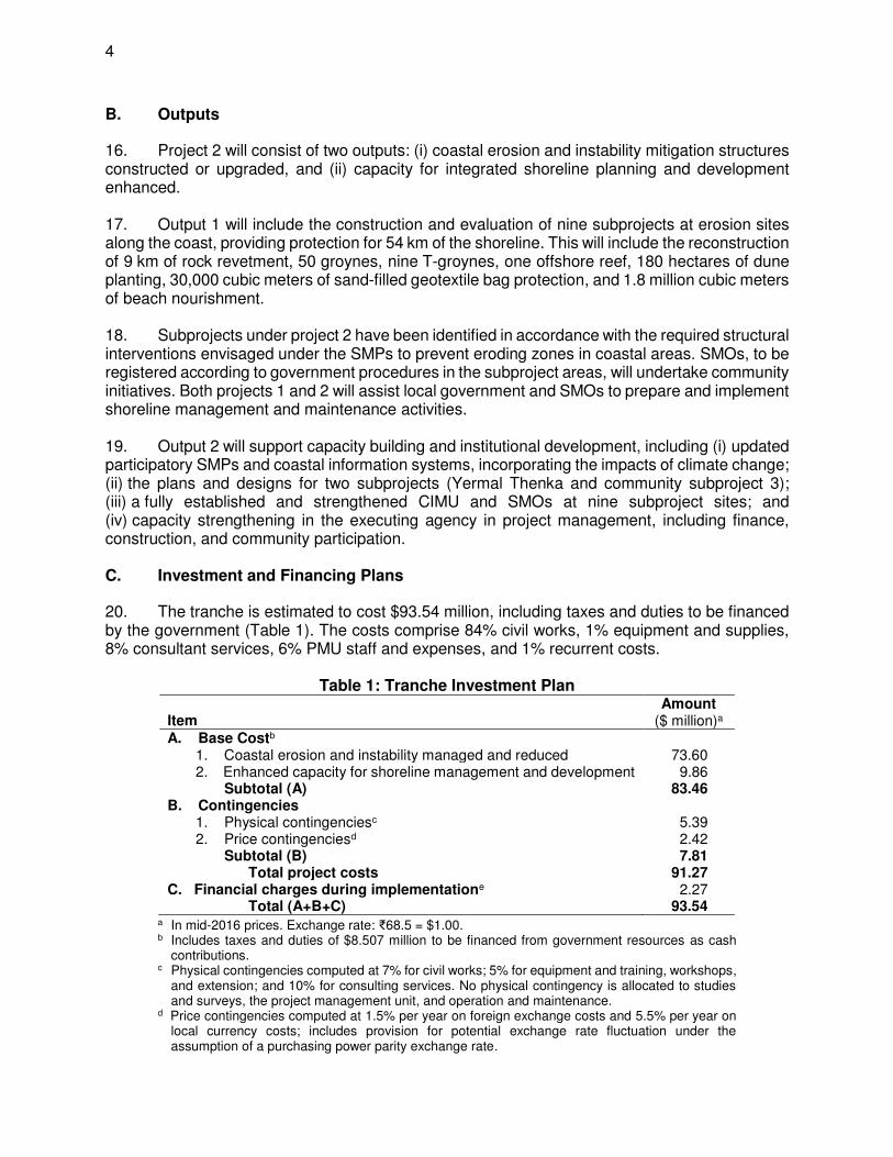
20. The tranche is estimated to cost $93.54 million, including taxes and duties to be financed by the government (Table 1). The costs comprise 84% civil works, 1% equipment and supplies, 8% consultant services, 6% PMU staff and expenses, and 1% recurrent costs.
Table 1: Tranche Investment Plan
Item Amount
($ million)a A. Base Costb 1. Coastal erosion and instability managed and reduced 73.60 2. Enhanced capacity for shoreline management and development 9.86 Subtotal (A) 83.46 B. Contingencies 1. Physical contingenciesc 5.39 2. Price contingenciesd 2.42 Subtotal (B) 7.81 Total project costs 91.27 C. Financial charges during implementatione 2.27 Total (A+B+C) 93.54
a In mid-2016 prices. Exchange rate: ₹68.5 = $1.00. b Includes taxes and duties of $8.507 million to be financed from government resources as cash
contributions. c Physical contingencies computed at 7% for civil works; 5% for equipment and training, workshops,
and extension; and 10% for consulting services. No physical contingency is allocated to studies and surveys, the project management unit, and operation and maintenance.
d Price contingencies computed at 1.5% per year on foreign exchange costs and 5.5% per year on local currency costs; includes provision for potential exchange rate fluctuation under the assumption of a purchasing power parity exchange rate.
5
e Includes interest and commitment charges. Source: Asian Development Bank.
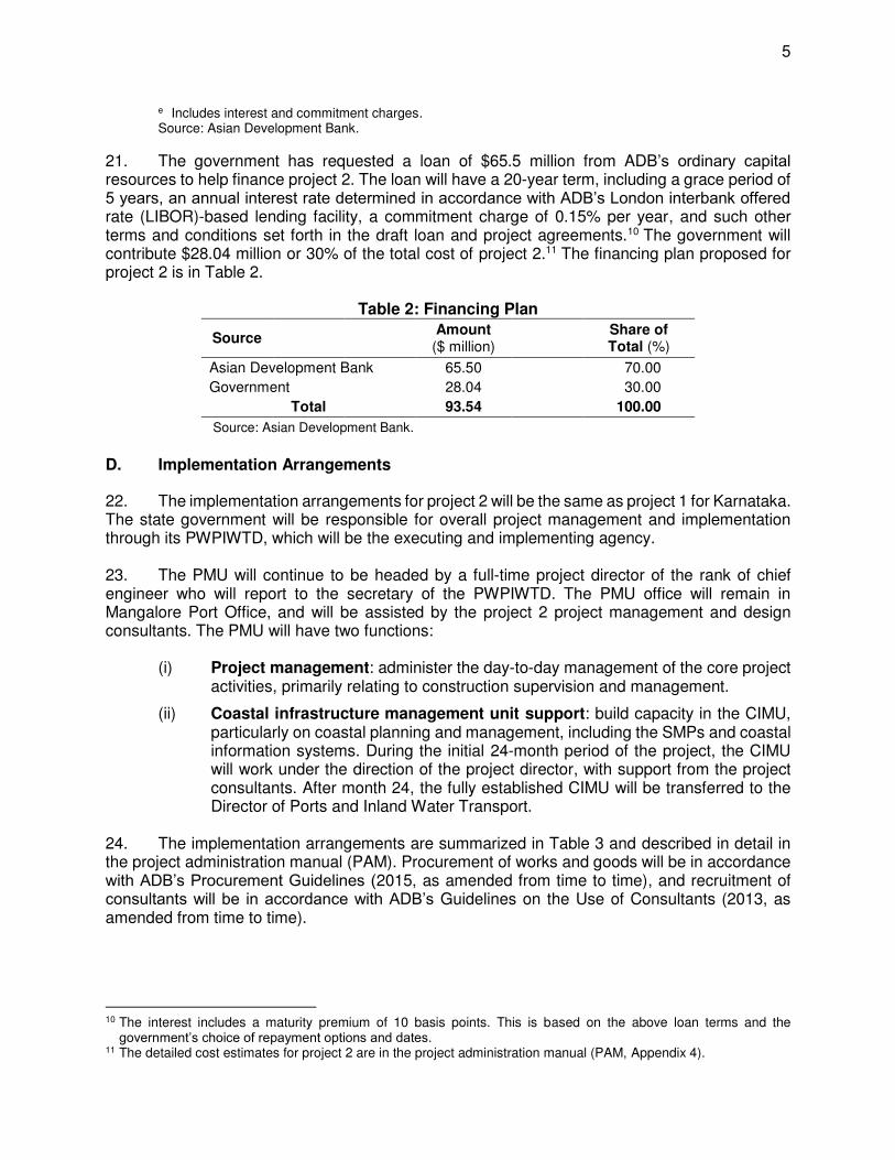
21. The government has requested a loan of $65.5 million from ADB’s ordinary capital resources to help finance project 2. The loan will have a 20-year term, including a grace period of 5 years, an annual interest rate determined in accordance with ADB’s London interbank offered rate (LIBOR)-based lending facility, a commitment charge of 0.15% per year, and such other terms and conditions set forth in the draft loan and project agreements.10 The government will contribute $28.04 million or 30% of the total cost of project 2.11 The financing plan proposed for project 2 is in Table 2.
Table 2: Financing Plan
Source Amount ($ million)
Share of Total (%)
Asian Development Bank 65.50 70.00
Government 28.04 30.00 Total 93.54 100.00
Source: Asian Development Bank.
D. Implementation Arrangements
22. The implementation arrangements for project 2 will be the same as project 1 for Karnataka. The state government will be responsible for overall project management and implementation through its PWPIWTD, which will be the executing and implementing agency.
23. The PMU will continue to be headed by a full-time project director of the rank of chief engineer who will report to the secretary of the PWPIWTD. The PMU office will remain in Mangalore Port Office, and will be assisted by the project 2 project management and design consultants. The PMU will have two functions:
(i) Project management: administer the day-to-day management of the core project activities, primarily relating to construction supervision and management.
(ii) Coastal infrastructure management unit support: build capacity in the CIMU, particularly on coastal planning and management, including the SMPs and coastal information systems. During the initial 24-month period of the project, the CIMU will work under the direction of the project director, with support from the project consultants. After month 24, the fully established CIMU will be transferred to the Director of Ports and Inland Water Transport.
24. The implementation arrangements are summarized in Table 3 and described in detail in the project administration manual (PAM). Procurement of works and goods will be in accordance with ADB’s Procurement Guidelines (2015, as amended from time to time), and recruitment of consultants will be in accordance with ADB’s Guidelines on the Use of Consultants (2013, as amended from time to time).
10 The interest includes a maturity premium of 10 basis points. This is based on the above loan terms and the
government’s choice of repayment options and dates. 11 The detailed cost estimates for project 2 are in the project administration manual (PAM, Appendix 4).
6
Table 3: Implementation Arrangements Aspects Arrangements
Implementation period July 2017–March 2020
Estimated completion date 31 March 2020 (loan closing date is 28 September 2020) Management
(i) Oversight body State Project Steering Committee Principal Secretary of the department, PWPIWTD Secretaries of the departments in charge of finance, water resource development, fisheries, environment, urban development, rural development and tourism, and representatives of the district level administration (members) Project director of the PMU (secretary)
(ii) Executing agency PWPIWTD (iii) Key implementing agencies PWPIWTD (iv) Implementation unit PMU, 66 staff
Procurement
International competitive bidding
3 contracts $32.0 million in total
National competitive bidding 5 contracts $38.0 million in total
Shopping Various $0.5 million in total Consulting services
Quality- and cost-based selection (80:20) - Project Management and Design Consultants
38 person-months international, 160 person-months national
$6.8 million
Retroactive financing and/or advance contracting
Advance contracting and retroactive financing of civil works and consulting services. Retroactive financing will be considered for eligible expenditures not exceeding 20% of the loan amount incurred before loan effectiveness, but not earlier than 12 months before the loan agreement is signed.
Disbursement The loan proceeds will be disbursed in accordance with ADB’s Loan Disbursement Handbook (2015, as amended from time to time) and detailed arrangements agreed upon between the government and ADB.
Source: Asian Development Bank.
E. Project Readiness
25. The Department of Economic Affairs’ project readiness criterion for loan negotiation has been fully met. Six out of 8 civil works packages have been tendered. Three of these have been awarded (totalling $32 million), two packages will be awarded in July 2017 (totalling $15.7 million), and one will be for re-bid ($0.30 million). The remaining two packages (totalling $21.9 million) will be advertised in July 2017 and are expected to be awarded by December 2017. The project management and design contract was signed on 30 January 2017 and the consultants have been mobilized. The PMU has been established and is fully functional.
IV. DUE DILIGENCE
A. Technical
26. Project 2 will use the same principles of project design and implementation as project 1. The subprojects will mostly be shore-based works, which will be easier to construct than the offshore reefs in project 1. In addition, the works will incorporate rock works, for which local capacity for construction exists. Beach nourishment will incorporate sand redistribution, which sources sand in parts of the beach with surplus sand—a new and innovative methodology for the
7
state government. Three community subprojects are proposed to be implemented and these will involve planting and management of the dunes. Dune reconstruction is proposed for one of the three community subprojects, which will dredge and pump sand from sand sources from the near-shore seabed. A survey of the near-shore seabed will be carried out in selected parts of the coast to assess the sand resources. 27. Project 2 is linked closely with the Climate-Resilient Coastal Protection and Management Project TA, and will incorporate the guidelines for coastal climate change adaptation including adjustments to the subproject designs, incorporation of climate change mitigation measures, in the shoreline management plans and climate change data sets into the CMIS, during the initial stages of implementation (2017–2018). B. Economic and Financial
28. The potential benefits of project 2 will mainly arise from the prevention of losses that would occur without the project, as continued coastal erosion would affect the local infrastructure, buildings, and agricultural land. As considerable uncertainties surround the costs and benefits, a Monte Carlo simulation approach was employed where probability distributions are used for the uncertain variables. The economic evaluation of the overall project, including all overhead and support costs, shows a mean economic internal rate of return of 12.1% and a mean economic net present value of $0.4 million. Hence, the project is considered viable under the baseline assumptions. 29. Project 2 is also expected to generate additional benefits that are intangible or unquantifiable. These include (i) increased security for artisanal fishing and rural fishing families, leading to increased productivity and improved quality of life; (ii) improved security for households, farms, and infrastructure at risk adjacent to the shoreline, providing better conditions for future investments and an incentive for increased economic activity; (iii) indirect favorable impacts on employment and economic activities in general, especially tourism; and (iv) long-term benefits that may accrue from institutional strengthening and knowledge and skill upgrading in the public and private sectors, which is relevant to other coastal protection measures in the country. Similarly, project 2 will have a potential impact on government expenditures by reducing future requirements for infrastructure replacement. It is estimated that the subprojects will require 5% of their individual capital cost every 5 years for ongoing operation and maintenance to ensure the sustainability of the capital investment. This amounts to an average of about $0.63 million per year for a total shoreline length of 54 km. This can be accommodated within the current PWPIWTD budget. C. Governance
30. An assessment of the capacity of the PWPIWTD has been conducted based on ADB’s disbursement, financial, and project management guidelines, and the overall risk is rated moderate. Risk mitigating measures include the strengthening of the PMU and enhanced computerization of financial information. The PWPIWTD will report on project activities and implementation on its website to foster transparency and timely awarding of contracts. ADB’s Anticorruption Policy (1998, as amended to date) was explained to and discussed with the government and the PWPIWTD. The specific policy requirements and supplementary measures are described in the PAM, based on which the financial management arrangements are considered satisfactory.
8
31. Delays in the approval and implementation of works pose some risks. Experience from project 1 indicates that procurement took a long time and many packages required re-tendering. The subprojects under project 2 are mostly shore-based, so they are less complicated to implement than the underwater works in project 1 subprojects. Lessons learned from the implementation of project 1 are incorporated in the design of project 2, including the application of better tested and documented design approaches and the establishment of mechanisms and procedures to approve designs and tender evaluations. D. Poverty, Social, and Gender Dimensions
32. Coastal erosion has significant impacts on the livelihoods of communities living along the coast, including loss of land and other assets, damage to community infrastructure, and restricted connectivity. The project areas encompass 38 wards, including about 5,070 households, which depend primarily on coastal resources for their livelihoods—from fishing and other service occupations related to beach tourism. People living in the project areas, including women and the poor, will benefit from the coastal erosion protection and beach management. Project 2 will not only relieve and redress their fears of facing erosion threats every year, but will also contribute to them leading more secure lives. 33. The coastal protection measures will have positive impacts: reducing expenditure on property restoration, enhancing livelihood opportunities, and ensuring connectivity. Women will also reap benefits, particularly those who are engaged in fish processing and retail vending, and in small businesses supporting the tourism industry. The establishment of SMOs in the project area is expected to enhance the participation of communities, including women, with at least 30% female representation in the executive body. E. Safeguards
34. Environment. Project 2 is classified category B for environment in accordance with ADB’s Safeguard Policy Statement (2009). An initial environmental examination (IEE) has been prepared for project 2, and the environmental assessment review framework was updated to comply with the government’s Coastal Regulation Zone Notification, (2011).12 Eight subprojects involving physical interventions such as revetment, groynes, and offshore reef breakwaters, will result in positive environmental impacts—addressing coastal erosion, and creating and maintaining beach areas. The IEE prepared for project 2 indicated that the environmental impacts are not significant, they are temporary and localized impacts, and none of them are irreversible in nature. However, given the complexity of coastal processes and the new technologies being employed, an extra level of diligence was deemed necessary. Therefore, an environmental management plan (EMP) was prepared for each of the eight subprojects to address possible impacts during the construction and operation. Environmental guidelines were developed for the beach nourishment components that involve dune management and planting of vegetation for erosion protection. The EMP also includes monitoring parameters associated with construction works for coastal protection measures, and parameters to monitor any changes in bathymetric conditions.
12 Ministry of Environment and Forests. http://www.moef.nic.in/downloads/public-information/CRZ-Notification-
2011.pdf
9
35. As part of project 2, three subprojects aim to address severely affected coastal erosion locations (Someshwara, Yermal Thenka, and Kodi Bengre)13 by providing revetments as coastal protection measures. The IEE indicated that rocks for revetment should not require quarrying from forest and other protected areas, but recommended using extracted rocks produced as overburden from an existing tunnelling project authorized by the Department of Mines and Geology. As described in the EMP, the bid document indicated the source of rocks. 36. Involuntary resettlement. Since the project components will be carried out on the shoreline, no settlements will be affected in these areas, so project 2 will not require any land acquisition or resettlement. Project 2 is classified category C for involuntary resettlement. During the preparation of project 2, the involuntary resettlement framework was updated in compliance with the Safeguard Policy Statement as well as the government’s Land Acquisition, Rehabilitation and Resettlement Act, 2013. 37. Indigenous peoples. There are no indigenous peoples, ethnic minority groups, or communities in the project area that have distinct social, economic, linguistic, or cultural characteristics. Therefore, project 2 is classified category C for indigenous peoples. The indigenous peoples planning framework was updated during the preparation of project 2 to comply with the Safeguard Policy Statement.
F. Risks and Mitigating Measures
38. Major risks and mitigating measures are summarized in Table 4 and described in detail in the updated risk assessment and risk management plan.14
Table 4: Summary of Risks and Mitigating Measures
Risks Mitigation Measures
Climate change impacts on sea level rise exceed projections.
There are no plausible mitigation measures to manage natural disasters that may prevent or delay implementation.
Slow transformation of the PMU into the CIMU.
A high level emphasis will be given to institutional strengthening, and the full establishment and transfer of the CIMU to the PWPIWTD within 24 months of the project start.
State Government’s parallel program to construct emergency protection works, implemented with no coordination with project 2.
By placing the CIMU in the Ports Department, all required information relating to coastal construction works will be coordinated. As part of project 2, the consultants will support capacity building efforts of the CIMU to ensure it is fully operationalized.
Source: Asian Development Bank.
G. Risk Categorization
39. ADB has been working in the natural resources sector in India since 2004 and in coastal management since 2010. Project 2 is categorized low risk on the basis that (i) the loan amount is less than $200 million; (ii) although experience in the sector was initially slow, a higher level of capacity now exists in the sector and responses are observed to be sound; (iii) the PWPIWTD has demonstrated improved capacity to manage the project; and (iv) environmental safeguards are categorized B and social safeguards are categorized C.
13 Someshwara will be constructed on geotextile revetment; Yermal Thenka is currently designed for rock revetment
but the design will be reviewed and adjusted as required under project 2; Kodi Bengre will be constructed from rock revetment.
14 Updated Risk Assessment and Risk Management Plan is in Appendix 12.
10
V. ASSURANCES
40. The Government of India, the State Government of Karnataka, and the PWPIWTD have assured ADB that implementation of the project shall conform to all applicable ADB policies including those concerning anticorruption measures, safeguards, gender, procurement, consulting services, and disbursement as described in detail in the project administration manual and loan documents. 41. The Government of India, the State Government of Karnataka, and the PWPIWTD have agreed with ADB on certain covenants for the project, which are set forth in the loan agreement and project agreement.
VI. RECOMMENDATION
42. On the basis of the approval by ADB’s Board of Directors for the provision of loans under the multitranche financing facility in an aggregate principal amount not exceeding $250,000,000 to India for the Sustainable Coastal Protection and Management Investment Program, it is recommended that the President approve the proposed tranche as described in para. 21 and such other terms and conditions as are substantially in accordance with those set forth in the draft loan and project agreements for the proposed tranche.
Appendix 1
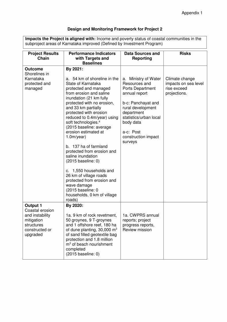
Design and Monitoring Framework for Project 2
Impacts the Project is aligned with: Income and poverty status of coastal communities in the subproject areas of Karnataka improved (Defined by Investment Program)
Project Results Chain
Performance Indicators with Targets and
Baselines
Data Sources and Reporting
Risks
Outcome Shorelines in Karnataka protected and managed
By 2021: a. 54 km of shoreline in the State of Karnataka protected and managed from erosion and saline inundation (21 km fully protected with no erosion, and 33 km partially protected with erosion reduced to 0.4m/year) using soft technologies.a (2015 baseline: average erosion estimated at 1.0m/year) b. 137 ha of farmland protected from erosion and saline inundation (2015 baseline: 0) c. 1,550 households and 26 km of village roads protected from erosion and wave damage (2015 baseline: 0 households, 0 km of village roads)
a. Ministry of Water Resources and Ports Department annual report b-c: Panchayat and rural development department statistics/urban local body data a-c: Post construction impact surveys
Climate change impacts on sea level rise exceed projections.
Output 1 Coastal erosion and instability mitigation structures constructed or upgraded
By 2020: 1a. 9 km of rock revetment, 50 groynes, 9 T-groynes and 1 offshore reef, 180 ha of dune planting, 30,000 m3 of sand filled geotextile bag protection and 1.8 million m3 of beach nourishment completed (2015 baseline: 0)
1a. CWPRS annual reports; project progress reports, Review mission
2
Project Results Chain
Performance Indicators with Targets and
Baselines
Data Sources and Reporting
Risks
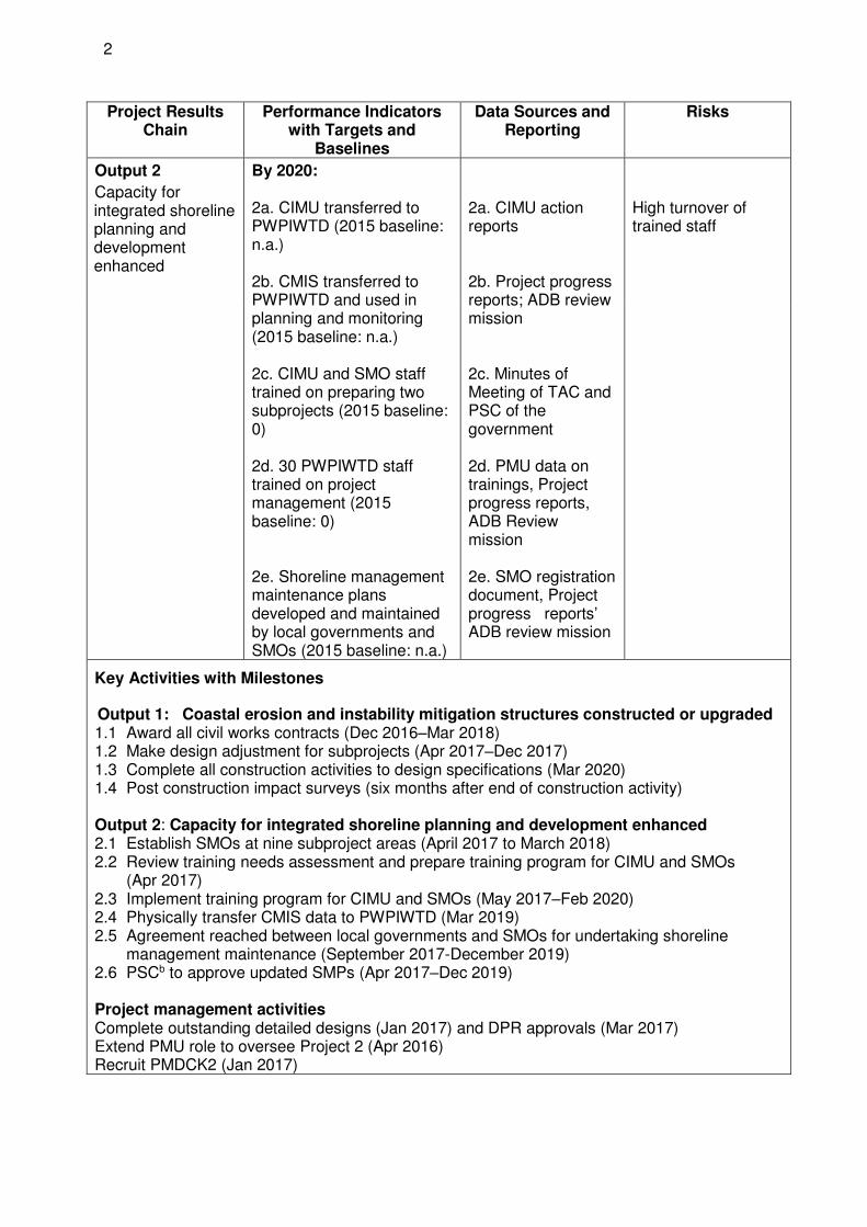
Output 2
Capacity for integrated shoreline planning and development enhanced
By 2020: 2a. CIMU transferred to PWPIWTD (2015 baseline: n.a.) 2b. CMIS transferred to PWPIWTD and used in planning and monitoring (2015 baseline: n.a.) 2c. CIMU and SMO staff trained on preparing two subprojects (2015 baseline: 0) 2d. 30 PWPIWTD staff trained on project management (2015 baseline: 0) 2e. Shoreline management maintenance plans developed and maintained by local governments and SMOs (2015 baseline: n.a.)
2a. CIMU action reports 2b. Project progress reports; ADB review mission 2c. Minutes of Meeting of TAC and PSC of the government 2d. PMU data on trainings, Project progress reports, ADB Review mission 2e. SMO registration document, Project progress reports’ ADB review mission
High turnover of trained staff
Key Activities with Milestones
Output 1: Coastal erosion and instability mitigation structures constructed or upgraded 1.1 Award all civil works contracts (Dec 2016–Mar 2018) 1.2 Make design adjustment for subprojects (Apr 2017–Dec 2017) 1.3 Complete all construction activities to design specifications (Mar 2020) 1.4 Post construction impact surveys (six months after end of construction activity) Output 2: Capacity for integrated shoreline planning and development enhanced 2.1 Establish SMOs at nine subproject areas (April 2017 to March 2018) 2.2 Review training needs assessment and prepare training program for CIMU and SMOs
(Apr 2017) 2.3 Implement training program for CIMU and SMOs (May 2017–Feb 2020) 2.4 Physically transfer CMIS data to PWPIWTD (Mar 2019) 2.5 Agreement reached between local governments and SMOs for undertaking shoreline
management maintenance (September 2017-December 2019) 2.6 PSCb to approve updated SMPs (Apr 2017–Dec 2019) Project management activities Complete outstanding detailed designs (Jan 2017) and DPR approvals (Mar 2017) Extend PMU role to oversee Project 2 (Apr 2016) Recruit PMDCK2 (Jan 2017)

3
Project Results Chain
Performance Indicators with Targets and
Baselines
Data Sources and Reporting
Risks
Inputs ADB: $65.50 million (regular OCR lending) Government: $28.04 million
CIMU = Coastal Information Management Unit, CMIS = coastal management information system, CWPRS = Central Water and Power Research Station, DPR = detailed project report, MOU = memorandum of understanding, NIO = National Institute of Oceanography, NCPP = National Coastal Protection Project, PMU = project management unit, PMDCK2 = project management and design consultants, PSC = program steering committee, PWPIWTD = Public Works, Ports and Inland Water Transport Department, SMO = shoreline management organization, SMP = shoreline management plan, TAC = technical approval committee Note: The DMF was retrofitted to comply with new DMF guidelines. a Soft technologies include, but not limited to, artificial reefs, beach nourishment, dune management. b PSC chaired by PWPIWTD’s Departmental Secretary to approve the updated SMPs.
Appendix 4
Project Number: 40156-033 Loan and/or Grant Number(s): MFF0049, Loan 2679 July 2017
IND: Sustainable Coastal Protection and Management Investment Program - Project 2
Project Administration Manual
ABBREVIATIONS
ADB = Asian Development Bank AFS = audited financial statements APFS = audited project financial statements CIMU = Coastal Infrastructure Management Unit CRCPMP = Climate Resilient Coastal Protection Management Project CWPRS = Central Water and Power Research Station DMF = design and monitoring framework EARF = environmental assessment and review framework EIA = environmental impact assessment EMP = environmental management plan GACAP = governance and anticorruption action plan GP = gram panchayat (village local body) GOK = Government of Karnataka GOI = Government of India ICB = international competitive bidding IEE = initial environmental examination IPP = indigenous people plan IPPF = indigenous people planning framework LAR = land acquisition and resettlement LIBOR = London interbank offered rate NCB = national competitive bidding NGOs = non-government organizations PAM = project administration manual PFR PMDCK2
= =
periodic financing request project management design consultant
PSC = project steering committee QCBS = quality- and cost based selection RRP = report and recommendation of the President to the Board EA SMP
= =
executing agency shoreline management plan
SOE = statement of expenditure SPS = safeguard policy statement TAC = technical approval committee ULB = urban local body (municipal administration at the local level)
CONTENTS
I. PROJECT DESCRIPTION 1
A. Background 1
B. Rationale 1
C. Description of Project 2 2
D. Impact and outcome 9
II. IMPLEMENTATION PLANS 10
A. Project Readiness Activities 10
B. Overall Project Implementation Plan 10
III. PROJECT MANAGEMENT ARRANGEMENTS 12
A. Project Implementation Organizations: Roles and Responsibilities 12
B. Key Persons Involved in Implementation 20
C. Project Organization Structure 21
IV. COSTS AND FINANCING 22
A. Cost Estimates Preparation and Revisions 23
B. Detailed Cost Estimates by Expenditure Category 24
C. Allocation and Withdrawal of Loan Proceeds 25
D. Detailed Cost Estimates by Financier 26
E. Detailed Cost Estimates by Outputs 27
F. Detailed Cost Estimates by Year 28
G. Contract and Disbursement S-Curve 29
H. Fund Flow Diagram 30
V. FINANCIAL MANAGEMENT 30
A. Financial Management Assessment 30
VI. PROCUREMENT AND CONSULTING SERVICES 35
A. Advance Contracting and Retroactive Financing 35
B. Procurement of Goods, Works, and Consulting Services 36
C. Procurement Plan 37
D. Consulting Services 37
VII. SAFEGUARDS 38
VIII. GENDER AND SOCIAL DIMENSIONS 40
IX. PERFORMANCE MONITORING, EVALUATION, REPORTING, AND COMMUNICATION 42
A. Project Design and Monitoring Framework 42
B. Monitoring 44
C. Evaluation 45
D. Reporting 45
E. Stakeholder Communication Strategy 46
X. ANTICORRUPTION POLICY 46
XI. ACCOUNTABILITY MECHANISM 47
XII. RECORD OF CHANGES TO THE PROJECT ADMINISTRATION MANUAL 47
APPENDIX 1: 48
TERMS OF REFERENCE FOR THE PROJECT MANAGEMENT AND DESIGN CONSULTANT (PROJECT 2) 48
A. Output 1: Coastal erosion and instability mitigation structures constructed or upgraded. 51
B. Output 2: Capacity for integrated shoreline planning and development enhanced. 55
APPENDIX2: 103
PROCUREMENT PLAN (PROJECT 2) 103

Project Administration Manual Purpose and Process
1. The project administration manual (PAM) describes the essential administrative and management requirements to implement the project on time, within budget, and in accordance with the policies and procedures of the government and Asian Development Bank (ADB). The PAM should include references to all available templates and instructions either through linkages to relevant URLs or directly incorporated in the PAM.
2. The Government of Karnataka (the state government) acting through the Department of Public Works, Ports and Inland Water Transport Department (PWPIWTD) (the executing agency) is wholly responsible for the implementation of the project, as agreed jointly between India as the borrower and ADB, and in accordance with the policies and procedures of the government and ADB. ADB staff is responsible to support implementation including compliance by PWPIWTD of their obligations and responsibilities for project implementation in accordance with ADB’s policies and procedures.
3. At loan negotiations, the borrower and ADB agreed to the PAM and ensured consistency with the loan agreement. Such agreement is reflected in the minutes of the loan negotiations. In the event of any discrepancy or contradiction between the PAM and the loan agreement, the provisions of the loan agreement shall prevail.
4. After ADB Management approval of the project's project financing request (PFR) report, changes
in implementation arrangements are subject to agreement and approval pursuant to relevant government and ADB administrative procedures (including the Project Administration Instructions) and upon such approval, they will be subsequently incorporated in the PAM.

I. PROJECT DESCRIPTION
A. Background
1. On 29 September 2010, Asian Development Bank (ADB) approved a multitranche financing facility (MFF) of $250 million from the ordinary capital resources (OCR), for the three coastal states of Goa, Karnataka, and Maharashtra for the Sustainable Coastal Protection and Management Investment Program (SCPMIP). The framework financing agreement (FFA) was signed on 1 September 2010. SCPMIP is being implemented in 10 years. The investment program aims to address immediate coastal protection needs and coastal instability using environmentally and socially appropriate structural solutions, with a focus on artificial reefs, inshore berms, dune management and beach nourishment, in the states of Karnataka, and Maharashtra. 2. On the basis of the FFA, the Government of India submitted its periodic financing request (PFR) for the first tranche (Project 1) on 6 October 2010. Project 1 became effective on 28 November 2011 with an original closing date of 31 December 2014. The loan was subsequently extended to 30 June 2017. Project 1 is supporting (i) in Karnataka, the Ullal project which includes two offshore reefs, reconstruction of the two entrance breakwaters with rock and tetrapods, new geotextile inshore berms, and sand nourishment. Project 1 will protect the eroding spit as well as ensure the sustainability of the entrance to the old Mangalore Port; and (ii) in Maharashtra, the Mirya bay project which includes the construction of a geotextile reef as well as sand nourishment to provide erosion protection to the north end of the bay.
3. Project 2 will support (i) construction and upgrading of coastal erosion and instability mitigation structures, and (ii) capacity building for integrated shoreline planning and development in Karnataka. 4. Under the MFF, the allocation to the Government of Karnataka (GOK) was for an amount of $198.064 million. Project 1 is for $48.55 million ($41.02 million from ADB and $7.53 million from GOK). Project 2 is for $93.54 million ($65.50 million from ADB and $28.04 million from GOK).
B. Rationale
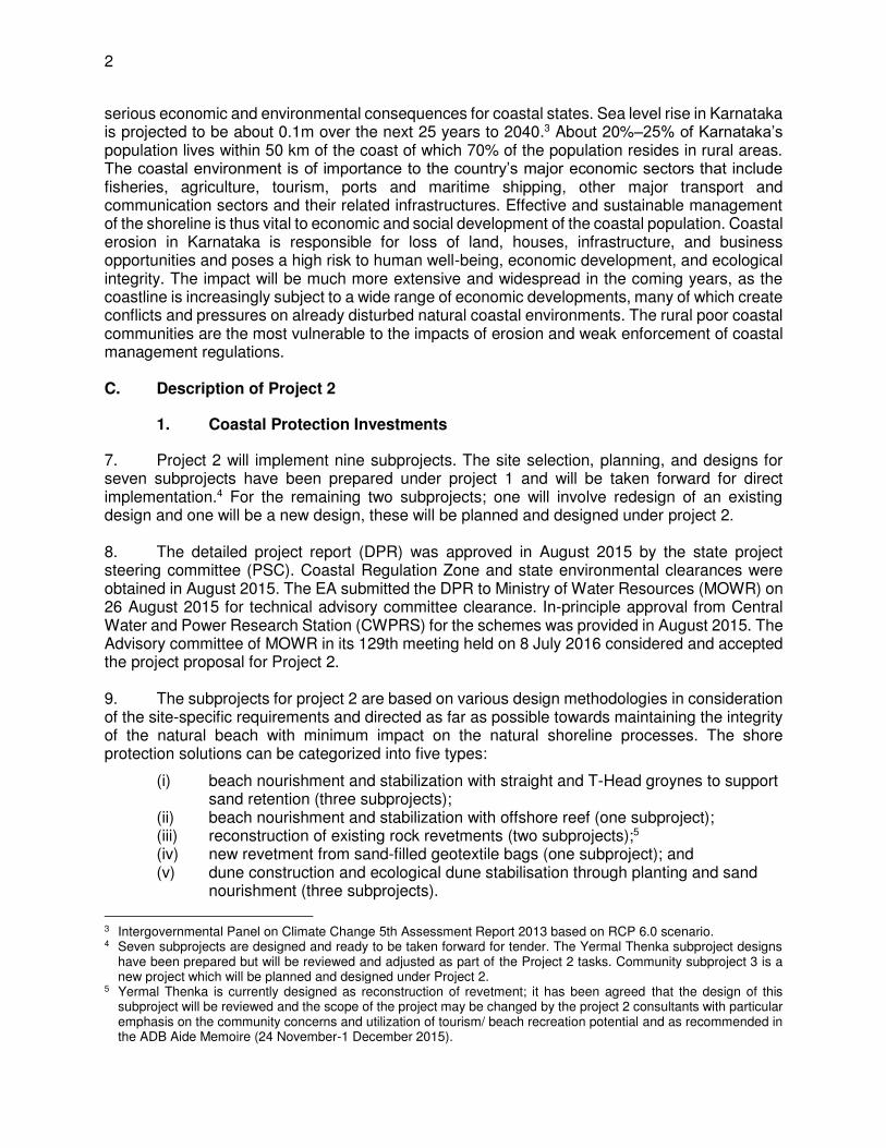
5. The investment program is designed to address immediate coastal protection needs and coastal instability using environmentally and socially appropriate solutions in the states of Karnataka, Maharashtra and Goa.1 It will also develop institutional capacities to meet the long-term needs of sustainable coastal protection and management, and support initiatives to increase the participation of the private sector and communities. The selected subprojects are suffering from the impacts of severe coastal erosion. The introduction of new technologies for coastal protection leads to solutions that not only protect the coastline from erosion, but also have the potential to enhance income-generating opportunities for communities living near the affected areas. 6. Coastline erosion in India has intensified over the years; Karnataka has a coastline of about 300 km, of which almost 250 km (83%)2 is affected by erosion to some degree. The rise in levels and the likely increased frequency and intensity of storms will aggravate the erosion, with
1 These three states were selected after consulting the states and central government, and considering coastal erosion
and instability status in these states. The project agreements have been signed by Maharashtra and Karnataka. 2 National Coastal Protection Project. Ministry of Water Resources (1994-2010)
2
serious economic and environmental consequences for coastal states. Sea level rise in Karnataka is projected to be about 0.1m over the next 25 years to 2040.3 About 20%–25% of Karnataka’s population lives within 50 km of the coast of which 70% of the population resides in rural areas. The coastal environment is of importance to the country’s major economic sectors that include fisheries, agriculture, tourism, ports and maritime shipping, other major transport and communication sectors and their related infrastructures. Effective and sustainable management of the shoreline is thus vital to economic and social development of the coastal population. Coastal erosion in Karnataka is responsible for loss of land, houses, infrastructure, and business opportunities and poses a high risk to human well-being, economic development, and ecological integrity. The impact will be much more extensive and widespread in the coming years, as the coastline is increasingly subject to a wide range of economic developments, many of which create conflicts and pressures on already disturbed natural coastal environments. The rural poor coastal communities are the most vulnerable to the impacts of erosion and weak enforcement of coastal management regulations. C. Description of Project 2
1. Coastal Protection Investments
7. Project 2 will implement nine subprojects. The site selection, planning, and designs for seven subprojects have been prepared under project 1 and will be taken forward for direct implementation.4 For the remaining two subprojects; one will involve redesign of an existing design and one will be a new design, these will be planned and designed under project 2. 8. The detailed project report (DPR) was approved in August 2015 by the state project steering committee (PSC). Coastal Regulation Zone and state environmental clearances were obtained in August 2015. The EA submitted the DPR to Ministry of Water Resources (MOWR) on 26 August 2015 for technical advisory committee clearance. In-principle approval from Central Water and Power Research Station (CWPRS) for the schemes was provided in August 2015. The Advisory committee of MOWR in its 129th meeting held on 8 July 2016 considered and accepted the project proposal for Project 2. 9. The subprojects for project 2 are based on various design methodologies in consideration of the site-specific requirements and directed as far as possible towards maintaining the integrity of the natural beach with minimum impact on the natural shoreline processes. The shore protection solutions can be categorized into five types:
(i) beach nourishment and stabilization with straight and T-Head groynes to support sand retention (three subprojects);
(ii) beach nourishment and stabilization with offshore reef (one subproject); (iii) reconstruction of existing rock revetments (two subprojects);5 (iv) new revetment from sand-filled geotextile bags (one subproject); and (v) dune construction and ecological dune stabilisation through planting and sand
nourishment (three subprojects).
3 Intergovernmental Panel on Climate Change 5th Assessment Report 2013 based on RCP 6.0 scenario. 4 Seven subprojects are designed and ready to be taken forward for tender. The Yermal Thenka subproject designs
have been prepared but will be reviewed and adjusted as part of the Project 2 tasks. Community subproject 3 is a new project which will be planned and designed under Project 2.
5 Yermal Thenka is currently designed as reconstruction of revetment; it has been agreed that the design of this subproject will be reviewed and the scope of the project may be changed by the project 2 consultants with particular emphasis on the community concerns and utilization of tourism/ beach recreation potential and as recommended in the ADB Aide Memoire (24 November-1 December 2015).
3
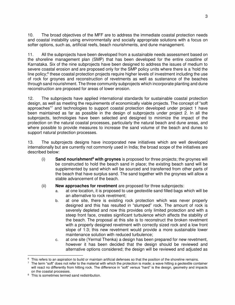
10. The broad objectives of the MFF are to address the immediate coastal protection needs and coastal instability using environmentally and socially appropriate solutions with a focus on softer options, such as, artificial reefs, beach nourishments, and dune management. 11. All the subprojects have been developed from a sustainable needs assessment based on the shoreline management plan (SMP) that has been developed for the entire coastline of Karnataka. Six of the nine subprojects have been designed to address the issues of medium to severe coastal erosion and are proposed only for the SMP policy units where there is a 'hold the line policy;6 these coastal protection projects require higher levels of investment including the use of rock for groynes and reconstruction of revetments as well as sustenance of the beaches through sand nourishment. The three community subprojects which incorporate planting and dune reconstruction are proposed for areas of lower erosion. 12. The subprojects have applied international standards for sustainable coastal protection design, as well as meeting the requirements of economically viable projects. The concept of “soft approaches”7 and technologies to support coastal protection developed under project 1 have been maintained as far as possible in the design of subprojects under project 2. In all the subprojects, technologies have been selected and designed to minimize the impact of the protection on the natural coastal processes, particularly the natural beach and dune areas, and where possible to provide measures to increase the sand volume of the beach and dunes to support natural protection processes. 13. The subprojects designs have incorporated new initiatives which are well developed internationally but are currently not commonly used in India; the broad scope of the initiatives are described below:
(i) Sand nourishment8 with groynes is proposed for three projects; the groynes will be constructed to hold the beach sand in place; the existing beach sand will be supplemented by sand which will be sourced and transferred from other parts of the beach that have surplus sand. The sand together with the groynes will allow a stable advancement of the beach.
(ii) New approaches for revetment are proposed for three subprojects: a. at one location, it is proposed to use geotextile sand filled bags which will be
an alternative to rock revetment; b. at one site, there is existing rock protection which was never properly
designed and this has resulted in “slumped” rock. The amount of rock is severely depleted and now this provides only limited protection and with a steep front face, creates significant turbulence which affects the stability of the beach. The proposal at this site is to reconstruct the broken revetment with a properly designed revetment with correctly sized rock and a low front slope of 1:3; this new revetment would provide a more sustainable lower maintenance solution with reduced turbulence;
c. at one site (Yermal Thenka) a design has been prepared for new revetment, however it has been decided that the design should be reviewed and alternative options considered; the design will be reviewed and adjusted as
6 This refers to an aspiration to build or maintain artificial defenses so that the position of the shoreline remains. 7 The term “soft” does not refer to the material with which the protection is made; a wave hitting a geotextile container
will react no differently from hitting rock. The difference in “soft” versus “hard” is the design, geometry and impacts on the coastal processes.
8 This is sometimes termed sand redistribution.
4
part of the project 2 tasks in 2017.
(iii) A major new innovative initiative being proposed is the community protection projects where the communities work closely with Government to develop long term sustainable protection measures. The community projects are aimed at beaches with low to medium erosion. The initiatives include:
a. Dune Planting: Two community projects have been planned and designed to support areas of low erosion and to help the long-term sustainability of coastal protection through planting of the dunes to help with sand retention.
b. Sand Nourishment and Dune Reconstruction: A third community subproject which will be planned and designed under project 2 is aimed at addressing the issue of sand deficit, a major problem of beaches in India that will very likely be exacerbated by climate change. The planning for the subproject will investigate the availability of sand resources in the sea bed in the near-shore waters of less than 10 meters, to support the reconstruction of the dunes. The dunes will be stabilized by planting, with options to incorporate geotextile sand bags or other measures to provide additional protection if required.
14. Climate Change. All the nine subprojects have incorporated resilience to climate change as part of their design features and include the following aspects: (i) sea level rise (SLR) has been based on the Intergovernmental Panel on Climate Change (IPCC) Fifth Assessment Report (IPCC, 2013) for the future sea level rise rate (S2). Projected global average rate for SLR is considered to range between 3.9mm/year to 9.7mm/year across the six scenarios developed for the 21st century. For this project, the Representative Concentration Pathway 6.0 is taken as the basis, as this provides the medium stabilization scenario. Over the estimated 25- year lifetime of the project a provision of 97 mm is made for future sea level rise; and (ii) storm surge protection - exact statistics of storm surge levels due to cyclonic storms are not available along the Karnataka coast. The frequency of cyclones along the West Coast is one-fourth of that along the East Coast of India and Karnataka gets the least number of cyclones along the West Coast, compared to Gujarat, Maharashtra, Goa and Kerala. Cyclonic storms during the monsoon period are mild and a nominal value of 200mm has been used for the project 2 designs to allow for potential future storm surge occurrence. 15. A technical assistance on Climate-Resilient Coastal Protection and Management Project9 (CRCPMP) started in April 2015 and will continue up to December 2017 to complement the SCPMIP in the two focal states of Maharashtra and Karnataka. The technical assistance (TA) is being implemented through ADB and financed by the Global Environmental Facility (GEF). The TA objectives aim to strengthen the resilience of the Indian coast, coastal infrastructure and communities to the adverse impacts of climate change through agreed strategies, and effective mainstreaming of climate change considerations into coastal protection and management. The CRCPMP will work closely with the SCPMIP in Karnataka and Maharashtra with the specific objectives of: (i) assessing the impacts of climate change on the coast of India; (ii) preparing guidelines for adaptation measures to ensure climate resilience in coastal protection and coastal infrastructure; (iii) providing specific recommendations for climate change adaptation for shoreline planning and design of subprojects for the two focal states of Maharashtra and Karnataka based
9 The Government of India in 2011 requested for technical assistance in (TA) to complement the project. The TA was
endorsed by Karnataka and Maharashtra, MOWR and the Ministry of Environment, Forests and Climate Change (MOEFCC) and approved by the Global Environment Fund (GEF) in May 2014.
5
on the above guidelines; and (iv) providing training to coastal states including "training of trainers" in climate change adaptation guidelines. 16. A more detailed analysis of climate change impacts will be developed as part of project 2 and some adjustments to the designs, where necessary, may be made to provide added resilience for climate change prior to implementation. 17. A description of the nine subprojects is shown in Table 1 below.
Table 1: Description of the Subprojects
A. Coastal Protection Projects (medium to severe erosion) 1. Someshwara: The project site is located in Dakshina Kannada district, south of Mangalore. The proposed coastal protection scheme at the Someshwara site are revetments using geotextile containers filled with sand, for a length of about 2 kms. The proposed scheme provides protection to the communities and infrastructure adjacent to the shoreline. The estimated cost of the proposed scheme in Someshwara is $4.7 million. Geotextile containers are proposed for protection. This is a new innovation in India which can provide protection without the use of rocks.
2. Yermal Thenka: The project site is located in Udupi district; the current design for protection is to reconstruct the existing damaged rock revetment for a length of 3.8 kms and to construct new rock revetments for a length of 0.7 km using international design standards. The existing rock revetment is basically dumped rock at a steep slope which results in high turbulence, the front slope of the new revetment is designed at a low 1:3 slope to allow wave run up and help reduce wave reflection and toe scour. It is estimated that the properly designed revetment would result in reduced turbulence which will help stabilize the beach. The investment will provide protection to the existing fisheries, the road running parallel to the shoreline for a length of 4 kms and will also protect the land from erosion. The total estimated cost of the proposed scheme in Yermal Thenka is $11.6 million. Yermal Thenka is a potentially valuable tourist beach which also provides livelihood to artisanal fisheries. There is a need to allow the continued traditional beach seine fishing and allow facilities for fishing boats to land and be stored in the beach area. Although reconstruction of revetment was selected as the lowest cost option, meeting both the key needs of protection of communities and the road, it was considered that alternative options should be considered that would potentially provide improved sand retention and support for beach enhancement. The design for Yermal Thenka will thus be reviewed by the project 2 consultants and as necessary, a revised design will be prepared. Close consultation with the communities will be continued to further review the options and develop the most appropriate strategy and design for sustainable and environmentally appropriate protection at Yermal Thenka. Yermal Thenka will remain as a subproject for the project 2 investment; the design will be reviewed and revised as necessary, the project tendered in early 2017 and ready for works to start in late 2017. 3. Udyavara: The project site is located in Udupi district. The project site is a long narrow spit, surrounded by sea on the west and a riverine environment on the east. A 9 km stretch of road, which runs along the spit that connects Malpe fishing harbour to the nearby villages, is under constant threat from erosion. The proposed coastal protection scheme at Udyavara includes protecting a shoreline length of 5 km by providing 35 numbers of shore normal rock groynes spaced at an interval of 120 m and nourishing the beach with a total volume 720,000 m3 of sand. The total works contract for this scheme in Udyavara is $14.6 million. Groynes would hold the beach nourishment in place and stabilize the beach. The length of the groynes would be set low so as not to significantly affect the natural processes of littoral drift. 4. Kodi Bengre: The project site is located in Udupi district. The project site is a long narrow spit, surrounded by sea on the west and river on the east. The spit, which is densely populated, is under constant threat from erosion. Wave flooding takes place at the northern end. The proposed coastal
6
protection scheme at Kodi Bengre will replace existing rock revetments of 4.5 kms using current international design standards. The total estimated cost of the proposed scheme in Kodi Bengre is $11.1 million. Revetment was selected as the most appropriate method of protection, as most of the work here is required to replace the damaged existing revetment. A large part of the revetment was built by rock dumping as part of the State Governments "emergency response". This is the lowest cost option to meet the key needs of protection of communities and economic activities. A fraction of the rock required for this purpose will be the reuse of existing rock meeting the design standards. The revised revetment will be properly designed according to international standards with toe below the anticipated scour level during the extreme monsoon waves. Geotextile filter fabric will be placed to prevent escape of sand from the core. The slope of the revetment will be designed at a 1:3 flat slope to allow wave run up and help reduce turbulence. It is estimated that the properly designed revetment would result in reduced turbulence which will help stabilize the beach with and ensure its sustainability. The revetment will be provided with access paths and fishing boat launching ramps. Though the revetment will not directly address the cause of the erosion, its choice here is mainly based on providing protection to the existing infrastructure from wave overtopping. Currently residential facilities and road traffic are all under threat. 5. Maravanthe: The project site is located in Udupi district and is surrounded by the Arabian sea on the west and the Souparnika river on the east, forming a narrow isthmus on which the National Highway 66 (NH-66) connects Mumbai in the north, to Kochi in Kerala towards the south. The proposed scheme involves protecting a shoreline length of 3.5 kms through establishing 15 shore normal groynes on the south and northern ends of the project site and 9 T-groynes at the middle section where the National Highway 66 runs close to the sea and river. Sand redistribution is proposed to enhance the beach width at critical sections. The total works contract amount of the scheme in Maravanthe is $13.5 million. T-Groynes would protect the beach, hold the beach nourishment in place and stabilize the beach. The length of the groynes would be set low so as not to significantly affect the natural littoral drift. 6. Murudeshwara: The project site is located in Uttara Kannada district. Murudeshwara is one of the prime tourist destinations within Karnataka state. The shore protection scheme here is a combination of offshore reef, sand nourishment of 90,000 m3 and dune stabilization by vetiver grass on the northern stretch of 1.5 km. The total estimated cost of the proposed scheme in Murudeshwara is $ 3.9 million. The offshore reef will protect the beach located on the leeside of the reef by reducing the wave energy and helping build up the beach profile by creation of a salient (natural accretion) supplemented by sand nourishment. The beach nourishment would advance the beach baseline by 20 meters. Away from the nourishment area, vetiver grass will be planted for dune stabilization to prevent further exacerbation of the visible beach scarp. B. Community Protection Subprojects (low to medium erosion) 1. Kodi Kanyana: The project site is located in Udupi district. A three-layered vegetation planting scheme along a 1.5 km stretch is proposed in order to reduce wave rush into the cultivable lands located behind the proposed site and also to hold the beach. This scheme is proposed to protect a 1.5 km stretch of the beach. Implementation and maintenance of this scheme will be carried out involving local communities. Planting of the dunes would help stabilize the dunes and provides some income. The total estimated cost of the proposed scheme in Kodi Kanyana is $0.14 million. 2. Pavinakurve: The project site is located in Uttara Kannada district. The project area is divided into three sectors, where a plantation scheme is proposed with a combination of different species of plants. This scheme is proposed to protect a 1.5 km stretch. Implementation and maintenance of this scheme is proposed to be carried out by involving local communities. Planting of the dunes will help stabilize the dunes and provides some income. The total estimated cost of the proposed scheme in Pavinakurve is $0.15 million.
7
3. The third community protection subproject will be planned and designed under project 2 by the project management and design consultants (PMDCK2) with implementation proposed for 2017/2018. This stage 2 community subproject is aimed at addressing the issue of sand deficit currently experienced on many Karnataka beaches; a problem that will likely be exacerbated by climate change. The subproject will investigate and develop methodologies to pump sand from the sea bed in the near-shore, in waters of less than 10metres depth to support the reconstruction of the dunes. The stage 2 community protection subproject will involve dune construction with beach nourishment of about 800,000 m3 of sand and planting on the dunes of an area of 180 ha. This will cover approximately 20- 30 km of shoreline. Minor infrastructure facilities in the form of access, water drainage, and small geo-textile bags for additional protection will be provided wherever appropriate. The potential sites will be identified and the designs will be finalized by the project 2 consultants. The stage 2 community protection subproject will incorporate the design guidelines to be prepared by the CRCPMP project and will conduct numerical modelling of the impacts of the selected beaches under climate change. The potential sand resources in the near shore along the Karnataka coast will be assessed based on a major sand resource survey and study which will incorporate modern methods to assess and quantify the sand resources in the shallow waters less than 10m depth along selected parts of the Karnataka coast. From the studies, environmentally appropriate strategies will be developed to use near shore sand resources to reconstruct the poorly developed beaches and dunes in many parts of the Karnataka coast. The stage 2 community project will be taken up as a pilot project to support beach and dune reconstruction based on the various studies. The total estimated cost of the proposed subproject is $10.3 million. This subproject provides a major new initiative to provide natural protection through artificially supplementing sand to mitigate the sand deficits being faced on many of the Karnataka beaches. The locations of the beach nourishment will be selected and the projects designed under project 2. The nourishment includes the option to provide geotextiles buried inside the reconstructed dunes.
18. A summary of the proposed physical interventions at the nine subproject sites is provided in Table 2 below.
Table 2: Summary of Proposed Interventions at Project 2 Subproject Sites
Nr.
Subproject L
en
gth
(k
m)
Re
-co
nstr
uction
o
f ro
ck
reve
tme
nt
New
Ro
ck
Reve
tme
nt
(km
)
Gro
yn
es (
nr)
T G
royn
es
(nr)
Off
sh
ore
re
ef
(nr)
Pla
ntin
g (
ha
)
Sa
nd
fill
ed
g
eo
textil
e
ba
gs
(m3)
Be
ach
N
ou
rish
men
t (m
3)
rock (
m3)
Protection Subprojects 1 Someshwara 2.0 - - - - 30,000
2 Yermal Thenka1
4.5 3.8 0.7 - - - - - 230,329
3 Udyavara 5.0 - 35 - - - 720,000 121,800 4 Kodi Bengre 4.5 4.5 0.0 - - - - - 207,251 5 Maravanthe 3.5 - 15 9 - - 225,000 146,808 6 Murudeshwara 1.5 - - - 1 0.5 90,000 10,020
Community Protection Subprojects 1 Kodi Kanyana 1.5 - - - - 0.3 - - 2 Pavinakurve 1.5 - - - - 0.7 - -
3 Third Community Project
20.0–30.0
- - - - 180.0 800,000 -
Total 54.1 8.30 0.7 50 9 1 181.5 30,000 1,835,000 716,208 1 Yermal Thenka design will be reviewed and adjusted
8
2. Capacity Building for Coastal Protection and Management
19. Capacity building and institutional development is a key activity of project 2. The key activities will include:
(i) Updating of the shoreline management plans including climate change impacts and expanded stakeholder consultation;
(ii) Updating the coastal management information system (CMIS); (iii) Implementing a comprehensive near-shore sea bed sand resources analysis study
which will assess the issues of sand deficits of selected Karnataka beaches. The outputs of the study will be applied to assess sand resources and availability and scope to restore the deficit of sand on selected beaches through beach nourishment and dune reconstruction. The findings of the study will form a key addition to the shoreline management plans;
(iv) Numerical modeling of a selected section of the coast to assess the impacts based on the climate change impact assessments;
(v) Preparation of plans and detailed designs for one community protection subproject which will incorporate beach nourishment, dune reconstruction and planting. The project planning and design will include a DPR which will be submitted to the GOK who will organize the necessary approvals;
(vi) Design adjustments of the other subprojects designed under project 2 incorporating the actual beach profile at the time of construction;
(vii) Establishing and strengthening the capacities of the coastal infrastructure management unit (CIMU);
(viii) Support to establishing shoreline management organizations (SMOs) at nine subproject sites;
(ix) Strengthening the capacities of stakeholders at different levels in sustainable coastal management and climate change; and
(x) Strengthening of capacities within the EA in project management including finance, construction and community participation.
20. The activities will focus on the strengthening and operationalization of the CIMU which has been established as a structural cell within the Department of Ports. The CIMU will be the hub for long term sustainable planning and management of the coastline. Through the CIMU, project 2 would support long term institutional strengthening and awareness of the key stakeholders including the PWPIWTD staff, district level organizations, district collectors, and district planning committees, Zilla Panchayats, Urban Local Bodies and Gram Panchayats. 21. The CIMU will focus on the long term activities of coastal planning and management that would continue after the end of the project period in mid-2020, these would include: (i) ensuring effective coordination between the various agencies and stakeholders involved in coastal infrastructure; (ii) working with the State Ministry of Environment and the Coastal Zone Regulation Authority to support the development of long term sustainability of the coast and shorelines, with special attention to ensure the natural coastal processes and sand movements are maintained with minimal disruption by coastal infrastructure investments; (iii) manage the CMIS being established under the SCPMIP, the ADB/GEF supported CRCPMP project as well as the national information systems being developed by the MOWR and Ministry of Environment, Forest and Climate Change (MOEFCC); (iv) support the establishment and training of the SMOs to be established at each subproject site; on a long-term time frame, CIMU will stimulate the successful functioning of SMOs and ensure their sustainability; (v) implement the shoreline management tasks as set out in the Shoreline Management Plans; these will be undertaken by involving district
9
administration, local bodies as stakeholders; and (vi) during the SCPMIP project period as well as beyond the project period to support the development and implementation of policies of sustainable coastal protection. 22. The activities will be implemented through the project management and design consultants (PMDCK2) working closely with the project management unit (PMU). Supplementary surveys including the sand resources survey will be contracted to specialist survey companies. CWPRS would support some of the studies including mathematical and physical modeling. 23. Linkage with ADB/GEF Climate Resilient Coastal Protection and Management Project (CRCPMP). Project 2 will work closely with the ADB/GEF Climate Resilient Coastal Protection and Management Project. The key interactions of the two projects will include: (i) CRCPMP will prepare guidelines for Climate Change Adaptation which will provide technical guidance for climate resilient coastal protection adaptation decision-making and implementation, and (ii) CRCPMP will provide training to the EA and other stakeholders in Karnataka in the climate change adaptation guidelines. Project 2 will incorporate the CRCPMP guidelines into: (a) the updated shoreline management plans, and (b) design adjustments of project 2 subproject designs. CRCPMP will directly implement 1-2 community coastal protection projects; lessons learnt from these will be used to complement the community protection projects under project 2. D. Impact and outcome
24. Project 2 in Karnataka will follow the MFF road map which outlines the policy and institutional actions of the investment program, designed to support the move towards integrated and sustainable coastal protection and management. The objective of the road map is to reduce coastal erosion and instability in the state. The road map envisages actions to protect and manage the shorelines whilst meeting the needs of communities and other stakeholders, while maintaining the environmental integrity of the shorelines. 25. The impact will be improved income and poverty status of the coastal communities in the subproject areas of Karnataka, aligned with National Flood Management Program. The expected outcome will be protected and managed shorelines in Karnataka.10 26. The following outputs are planned under Project 2. 27. Output 1 will include the construction and evaluation of nine subprojects at erosion sites along the coast, providing protection for 54 km of the shoreline. This will include the reconstruction of 9 km of rock revetment, 50 groynes, nine T-groynes, one offshore reef, 180 hectares of dune planting, 30,000 cubic meters of sand-filled geotextile bag protection, and 1.8 million cubic meters of beach nourishment. 28. Output 2 will support capacity building and institutional development, including (i) updated participatory SMPs and coastal information systems, incorporating the impacts of climate change; (ii) the plans and designs for two subprojects (Yermal Thenka and community subproject 3); (iii) a fully established and strengthened CIMU and SMOs at nine subproject sites; and (iv) capacity strengthening in the executing agency in project management, including finance, construction, and community participation. 10 Project 1 covers one subproject each in Karnataka and Maharashtra benefiting 7 km of the coastline. Project 2 will
support nine subprojects consisting of six coastal protection subprojects designed to address the issues of medium to severe coastal erosion and three community subprojects for areas of low erosion resulting in the protection of approximately 54 km of coastline in Karnataka.
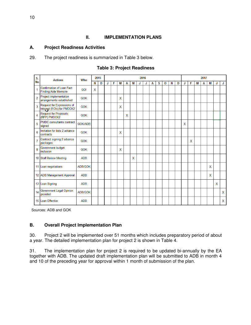
10
II. IMPLEMENTATION PLANS
A. Project Readiness Activities
29. The project readiness is summarized in Table 3 below.
Table 3: Project Readiness
Sources: ADB and GOK
B. Overall Project Implementation Plan
30. Project 2 will be implemented over 51 months which includes preparatory period of about a year. The detailed implementation plan for project 2 is shown in Table 4. 31. The implementation plan for project 2 is required to be updated bi-annually by the EA together with ADB. The updated draft implementation plan will be submitted to ADB in month 4 and 10 of the preceding year for approval within 1 month of submission of the plan.
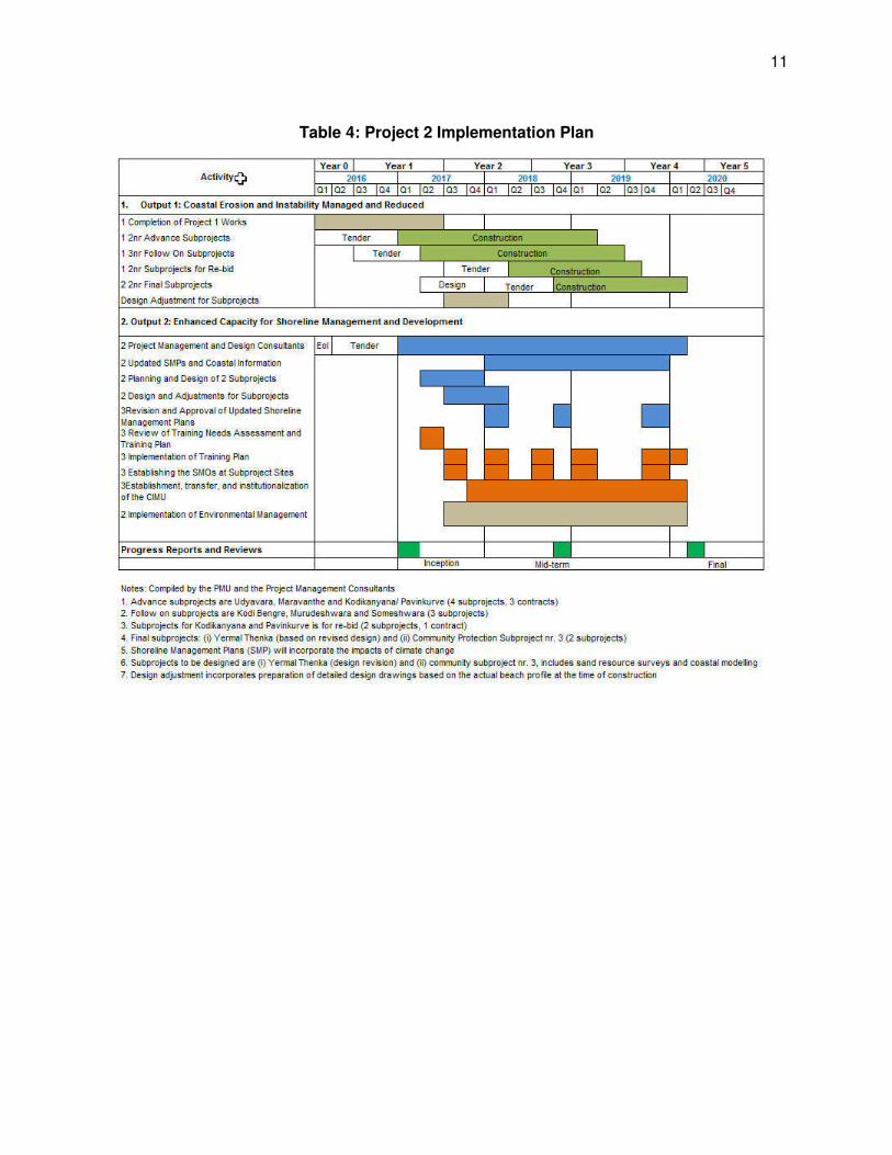
11
Table 4: Project 2 Implementation Plan
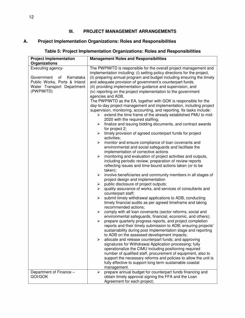
12
III. PROJECT MANAGEMENT ARRANGEMENTS
A. Project Implementation Organizations: Roles and Responsibilities
Table 5: Project Implementation Organizations: Roles and Responsibilities
Project Implementation Organizations
Management Roles and Responsibilities
Executing agency- Government of Karnataka Public Works, Ports & Inland Water Transport Department (PWPIWTD)
The PWPIWTD is responsible for the overall project management and implementation including: (i) setting policy directions for the project, (ii) preparing annual program and budget including ensuring the timely and adequate provision of government’s counterpart funds, (iii) providing implementation guidance and supervision, and (iv) reporting on the project implementation to the government agencies and ADB. The PWPIWTD as the EA, together with GOK is responsible for the day-to-day project management and implementation, including project supervision, monitoring, accounting, and reporting. Its tasks include:
extend the time frame of the already established PMU to mid-2020 with the required staffing;
finalize and issuing bidding documents, and contract awards for project 2;
timely provision of agreed counterpart funds for project activities;
monitor and ensure compliance of loan covenants and environmental and social safeguards and facilitate the implementation of corrective actions
monitoring and evaluation of project activities and outputs, including periodic review, preparation of review reports reflecting issues and time-bound actions taken (or to be taken);
involve beneficiaries and community members in all stages of project design and implementation
public disclosure of project outputs; quality assurance of works, and services of consultants and
counterpart staff; submit timely withdrawal applications to ADB, conducting
timely financial audits as per agreed timeframe and taking recommended actions;
comply with all loan covenants (sector reforms, social and environmental safeguards, financial, economic, and others);
prepare quarterly progress reports, and project completion reports and their timely submission to ADB; ensuring projects' sustainability during post implementation stage and reporting to ADB on the assessed development impacts;
allocate and release counterpart funds; and approving signatures for Withdrawal Application processing; fully operationalize the CIMU including positioning required number of qualified staff, procurement of equipment, also to support the necessary reforms and policies to allow the unit is fully effective to support long term sustainable coastal management.
Department of Finance – GOI/GOK
prepare annual budget for counterpart funds financing and obtain timely approval signing the FFA and the Loan Agreement for each project;

13
monitoring of the investment program implementation and providing respective coordination and facilitation;
ensure availability of counterpart funds process and submit to ADB periodic requests, as required, for
reallocating the loan proceeds. Ministry of Water Resources including CWC and CWPRS (GOI)
coordinate and provide technical guidance to PWPIWTD; support the coordination activities with related central
Government Agencies including MOEFCC; support the training and institutional development activities; provide coordination and liaison with the parallel MOEFCC
Integrated Coastal Management Project; support initiatives to create awareness of the project activities
at central Government as well as in other coastal states. Ministry of Environment Forests and Climate Change (GOI)
provide the key environmental linkages with the projects; provide linkages and liaison with the MOEFCC Integrated
Coastal Management Project; support the processes of environmental clearances of
proposed subprojects. Program steering committee ensure inter-ministerial coordination;
oversee implementation of the project; monitor progress of the project including safeguards and
development objectives; rectify issues hindering progress of the project; guide the EA; meet at least twice a year;(refer para 33 to 36)
District Coordination Committee
support coordination of shoreline planning and management at the district level
support coordination and liaison of the subprojects at district level
Shoreline Management Organizations
support the coordination of subprojects including community and stakeholder engagement.
support the long-term management of the subprojects including maintenance and livelihood activities.
Project Management Unit detailed in para 42 and 43 Project Management and Design Consultants
construction management support for the 9 T2 subprojects; construction management support for the outstanding T1
projects. design adjustments and detailed construction drawing for the
T2 subprojects; support tendering process for works and support
procurement; undertake sand source studies, coastal modelling and
planning and design of the final subproject. provide overall project management support on reporting,
financial management; institutional and training support; provide support to operationalize the CIMU; provide support for the establishment of the SMOs develop and maintain the monitoring and evaluation system
including PPMS ADB periodic review and supervision of the project implementation
(through six monthly loan review missions and midterm and final review missions), financial disbursement and ensuring compliance with loan assurances including institutional arrangements as agreed and stated in the loan agreement
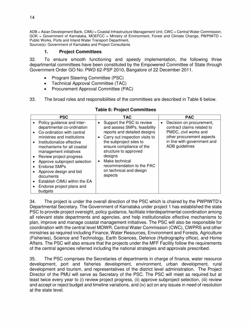
14
ADB = Asian Development Bank, CIMU = Coastal Infrastructure Management Unit, CWC = Central Water Commission, GOK = Government of Karnataka, MOEFCC = Ministry of Environment, Forest and Climate Change, PWPIWTD =
Public Works, Ports and Inland Water Transport Department, Source(s): Government of Karnataka and Project Consultants
1. Project Committees
32. To ensure smooth functioning and speedy implementation, the following three departmental committees have been constituted by the Empowered Committee of State through Government Order GO No: PWD 62-PSP 2010, Bangalore of 22 December 2011.
Program Steering Committee (PSC) Technical Approval Committee (TAC) Procurement Approval Committee (PAC)
33. The broad roles and responsibilities of the committees are described in Table 6 below.
Table 6: Project Committees
PSC TAC PAC
Policy guidance and inter-departmental co-ordination
Co-ordination with central ministries and institutions
Institutionalize effective mechanisms for all coastal management initiatives
Review project progress Approve subproject selection
Endorse SMPs Approve design and bid
documents Establish CIMU within the EA
Endorse project plans and budgets
Support the PSC to review and assess SMPs, feasibility reports and detailed designs
Carry out inspection visits to the subproject sites to ensure compliance of the structure to approved designs
Make technical recommendation to the PAC on technical and design aspects
Decision on procurement, contract claims related to PMDC, civil works and other procurement aspects in line with government and ADB guidelines
34. The project is under the overall direction of the PSC which is chaired by the PWPIWTD’s Departmental Secretary. The Government of Karnataka under project 1 has established the state PSC to provide project oversight, policy guidance, facilitate interdepartmental coordination among all relevant state departments and agencies, and help institutionalize effective mechanisms to plan, improve and manage coastal management initiatives. The PSC will also be responsible for coordination with the central level MOWR, Central Water Commission (CWC), CWPRS and other ministries as required including Finance, Water Resources, Environment and Forests, Agriculture (Fisheries), Science and Technology, Earth Sciences, Defence (Hydrography office), and Home Affairs. The PSC will also ensure that the projects under the MFF Facility follow the requirements of the central agencies referred including the national strategies and approvals prescribed. 35. The PSC comprises the Secretaries of departments in charge of finance, water resource development, port and fisheries development, environment, urban development, rural development and tourism, and representatives of the district level administration. The Project Director of the PMU will serve as Secretary of the PSC. The PSC will meet as required but at least twice every year to (i) review project progress, (ii) approve subproject selection, (iii) review and accept or reject budget and timeline variations, and (iv) act on any issues in need of resolution at the state level.
15
36. The PSC is guided by the TAC; the TAC is chaired by an experienced senior coastal expert from a technical government department with members being Chief Engineers from water resources, irrigation and public works departments and heads of Karnataka relevant technical institutes. The TAC supports and has the mandate for review of shoreline planning, subproject feasibility studies and detail design technical approvals, including the environmental safeguards.
37. The key project decisions will be endorsed by the State Empowered Committee (EC) which is a high-level committee appointed by the cabinet to give the final endorsement of project decisions for any externally funded projects in Karnataka. The EC will meet periodically to guide and endorse project implementation decisions.
2. Executing Agency
38. The executing agency responsible for overall project management and implementation will be the Public Works, Ports & Inland Water Transport Department (PWPIWTD), the responsible department for the management of coastal erosion and development of coastal protection in the State of Karnataka. 39. The state legislative assembly in December 2011 passed the Karnataka Maritime Board Bill, to facilitate setting up the Maritime Board to fast track the development of ports and to maintain ports, harbors, inland waterways and coastal protection activities. The legislation is pending approval. If approved by the Government of India, the board will be an autonomous body and will ensure systematic development of infrastructure in all state ports together with coastal protection works and beach nourishment.
40. At present, the ports wing of PWIPIWTD is headed by a Director, who is a certified marine pilot. The director reports to the Secretary PWPIWTD in Bangalore. The main office of the Director Ports is in Karwar and he also maintains a small office in Bangalore. The Director exercises overall supervision on the technical and managerial functions including coastal protection and enforces various marine enactments.
41. PWIPIWTD has two wings: (i) ports wing and (ii) inland water transport wing. The total sanctioned staff strength of both the wings is 408. Each of the twelve ports is managed either by a Port Officer, Port Engineer or Executive Engineer, depending on the approved posts. The key positions in the port offices include: (i) port officers; (ii) marine engineer; (iii) port engineer; (iv) hydrographic surveyor; (v) regional executive officer; and (vi) ports conservator.
3. Project Management Unit (PMU)
42. The PMU will be headed by a full-time Project Director of the rank of Chief Engineer. The Project Director reports to the PWPIWTD’s Departmental Secretary. The PMU office is located within the premises of the Mangalore Port Office. The PMU will be assisted by the PMDCK2 for a period of 39 months. The PMU will be divided into two parts:
(i) The project management wing will administer the day to day management of the core project activities primarily relating to the construction supervision and management.
(ii) The CIMU which will focus on issues relating the planning and management of the coast including the shoreline management plans and the coastal information systems. During the initial 24-month period of the project the CIMU would work
16
under the direction of the project director with support of the PMDCK2. After month 24 the fully established CIMU would be transferred to the Director of Ports and Inland Water Transport.
43. The project management wing that is currently in place under project 1 will focus on the following core project activities: (i) preparation of an overall implementation plan and annual budget; (ii) overall inter-agency coordination; (iii) recruitment of consultants/NGOs and award of procurement and consulting contracts; (iv) subproject planning and appraisal; (v) subproject safeguards document preparation, state agencies clearance coordination and safeguard plans implementation; (vi) project financial management; (vii) consolidation, review, and submission of regular progress and financial reports to the PSC and ADB; (viii) preparation of the periodic financing request for tranches; (ix) establishment of a coastal management information system (MIS); and (x) monitoring and evaluation of project outputs and results. The key role of the PMU includes:
approval of the site selection of the stage II community protection subprojects; commissioning of the supporting surveys to support the planning and design; executing through contractors the 9 proposed project 2 subprojects; supervision of the project 2 contracts with supervision and management support from
PMDCK2;
completion of the construction of the outstanding project 1 works; approvals of design reviews and adjustments for project 2 works; and ensuring compliance with environmental management plans.
44. The Coastal Infrastructure Management Unit has been established as a structural cell within the Department of Ports. The formation of the CIMU is based on the Government Order of 21st February 2014 and Office Order issued in April 2015. Although formally established, there has been limited progress on the activities of the CIMU. It is proposed that the development of the CIMU will be in two stages.
(i) During the initial 24 months of the project, the CIMU would follow a process of establishment. During this period the CIMU would be headed by a joint director within the auspices of the PMU and under the overall direction of the Project Director. The PMDCK2 would provide advisory guidance and support for the establishment of the CIMU. Selected staff from the EA would be seconded to work within the CIMU.
(ii) After 24 months, the responsibility for the CIMU would be transferred to the Director Ports based in Karwar. The PMDCK2 would continue to provide support to the CIMU until the end of the project in March 2020. It is proposed that the CIMU would form a third wing within the PWPIWTD alongside the existing ports and inland transport wings.
(iii) The CIMU during the initial period will be based in the same office as the PMU in Mangalore; the location of the unit after the transfer to the Director of Ports would be decided.
45. The proposed organizational arrangement for the CIMU after the transfer to the Department of Ports is shown in Figure 1 below.
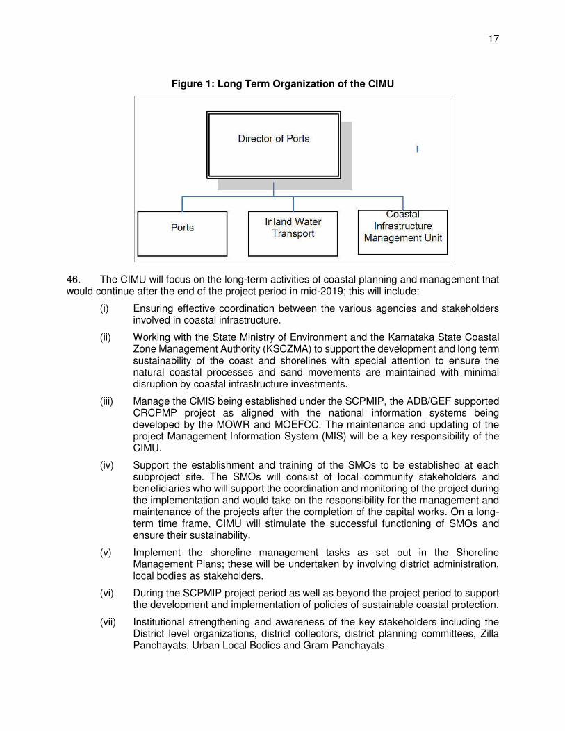
17
Figure 1: Long Term Organization of the CIMU
46. The CIMU will focus on the long-term activities of coastal planning and management that would continue after the end of the project period in mid-2019; this will include:
(i) Ensuring effective coordination between the various agencies and stakeholders involved in coastal infrastructure.
(ii) Working with the State Ministry of Environment and the Karnataka State Coastal Zone Management Authority (KSCZMA) to support the development and long term sustainability of the coast and shorelines with special attention to ensure the natural coastal processes and sand movements are maintained with minimal disruption by coastal infrastructure investments.
(iii) Manage the CMIS being established under the SCPMIP, the ADB/GEF supported CRCPMP project as aligned with the national information systems being developed by the MOWR and MOEFCC. The maintenance and updating of the project Management Information System (MIS) will be a key responsibility of the CIMU.
(iv) Support the establishment and training of the SMOs to be established at each subproject site. The SMOs will consist of local community stakeholders and beneficiaries who will support the coordination and monitoring of the project during the implementation and would take on the responsibility for the management and maintenance of the projects after the completion of the capital works. On a long-term time frame, CIMU will stimulate the successful functioning of SMOs and ensure their sustainability.
(v) Implement the shoreline management tasks as set out in the Shoreline Management Plans; these will be undertaken by involving district administration, local bodies as stakeholders.
(vi) During the SCPMIP project period as well as beyond the project period to support the development and implementation of policies of sustainable coastal protection.
(vii) Institutional strengthening and awareness of the key stakeholders including the District level organizations, district collectors, district planning committees, Zilla Panchayats, Urban Local Bodies and Gram Panchayats.
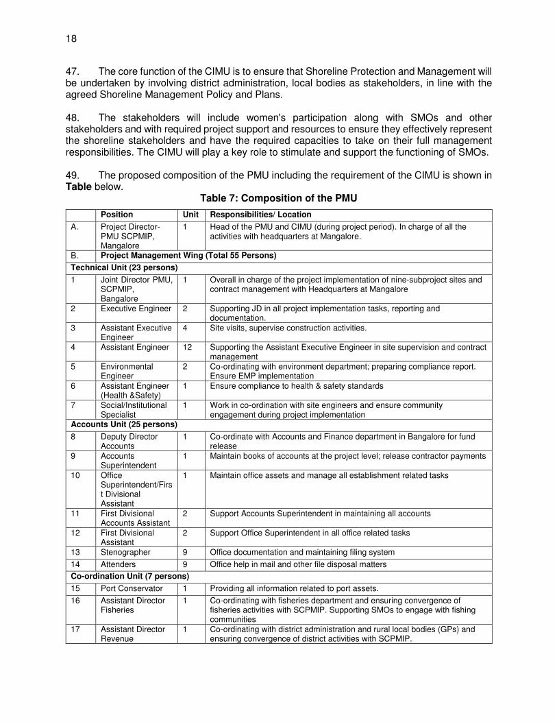
18
47. The core function of the CIMU is to ensure that Shoreline Protection and Management will be undertaken by involving district administration, local bodies as stakeholders, in line with the agreed Shoreline Management Policy and Plans. 48. The stakeholders will include women's participation along with SMOs and other stakeholders and with required project support and resources to ensure they effectively represent the shoreline stakeholders and have the required capacities to take on their full management responsibilities. The CIMU will play a key role to stimulate and support the functioning of SMOs.
49. The proposed composition of the PMU including the requirement of the CIMU is shown in Table below.
Table 7: Composition of the PMU
Position Unit Responsibilities/ Location
A. Project Director- PMU SCPMIP, Mangalore
1 Head of the PMU and CIMU (during project period). In charge of all the activities with headquarters at Mangalore.
B. Project Management Wing (Total 55 Persons)
Technical Unit (23 persons)
1 Joint Director PMU, SCPMIP, Bangalore
1 Overall in charge of the project implementation of nine-subproject sites and contract management with Headquarters at Mangalore
2 Executive Engineer 2 Supporting JD in all project implementation tasks, reporting and documentation.
3 Assistant Executive Engineer
4 Site visits, supervise construction activities.
4 Assistant Engineer 12 Supporting the Assistant Executive Engineer in site supervision and contract management
5 Environmental Engineer
2 Co-ordinating with environment department; preparing compliance report. Ensure EMP implementation
6 Assistant Engineer (Health &Safety)
1 Ensure compliance to health & safety standards
7 Social/Institutional Specialist
1 Work in co-ordination with site engineers and ensure community engagement during project implementation
Accounts Unit (25 persons)
8 Deputy Director Accounts
1 Co-ordinate with Accounts and Finance department in Bangalore for fund release
9 Accounts Superintendent
1 Maintain books of accounts at the project level; release contractor payments
10 Office Superintendent/First Divisional Assistant
1 Maintain office assets and manage all establishment related tasks
11 First Divisional Accounts Assistant
2 Support Accounts Superintendent in maintaining all accounts
12 First Divisional Assistant
2 Support Office Superintendent in all office related tasks
13 Stenographer 9 Office documentation and maintaining filing system
14 Attenders 9 Office help in mail and other file disposal matters
Co-ordination Unit (7 persons)
15 Port Conservator 1 Providing all information related to port assets.
16 Assistant Director Fisheries
1 Co-ordinating with fisheries department and ensuring convergence of fisheries activities with SCPMIP. Supporting SMOs to engage with fishing communities
17 Assistant Director Revenue
1 Co-ordinating with district administration and rural local bodies (GPs) and ensuring convergence of district activities with SCPMIP.
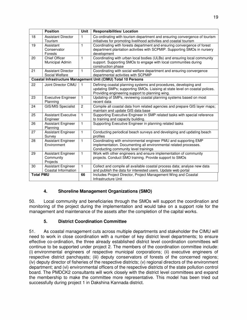
19
Position Unit Responsibilities/ Location
18 Assistant Director Tourism
1 Co-ordinating with tourism department and ensuring convergence of tourism initiatives for promoting livelihood activities and coastal tourism
19 Assistant Conservator Forests
1 Coordinating with forests department and ensuring convergence of forest department plantation activities with SCPMIP. Supporting SMOs in nursery development
20 Chief Officer Municipal Admin
1 Coordinating with urban local bodies (ULBs) and ensuring local community support. Supporting SMOs to engage with local communities during construction phase
21 Assistant Director Social Welfare
1 Coordinating with social welfare department and ensuring convergence departmental activities with SCPMIP
Coastal Infrastructure Management Unit (CIMU) Total 10 Persons
22 Joint Director CIMU 1 Defining coastal planning systems and procedures, developing and updating SMPs; supporting SMOs. Liaising at state level on coastal polices. Providing engineering support to planning wing.
23 Executive Engineer Planning
1 Updating of SMPs, reviewing coastal planning systems based on most recent data
24 GIS/MIS Specialist 2 Compile all coastal data from related agencies and prepare GIS layer maps; maintain and update GIS data base
25 Assistant Executive Engineer
1 Supporting Executive Engineer in SMP related tasks with special reference to training and capacity building.
26 Assistant Engineer Planning
1 Supporting Executive Engineer in planning related tasks
27 Assistant Engineer Survey
1 Conducting periodical beach surveys and developing and updating beach profiles
28 Assistant Engineer Environment
1 Coordinating with environmental engineer PMU and supporting EMP implementation. Documenting all environmental related processes. Conducting community level trainings
29 Assistant Engineer Community Projects
1 Work with other engineers and ensure implementation of community projects. Conduct SMO training. Provide support to SMOs
30 Assistant Engineer Coastal Information
1 Collect and compile all available coastal process data; analyse new data and publish the data for interested users. Update web portal
Total PMU 66 Includes Project Director, Project Management Wing and Coastal Infrastructure Unit
4. Shoreline Management Organizations (SMO)
50. Local community and beneficiaries through the SMOs will support the coordination and monitoring of the project during the implementation and would take on a support role for the management and maintenance of the assets after the completion of the capital works.
5. District Coordination Committee
51. As coastal management cuts across multiple departments and stakeholder the CIMU will need to work in close coordination with a number of key district level departments; to ensure effective co-ordination, the three already established district level coordination committees will continue to be supported under project 2. The members of the coordination committee include: (i) environmental engineers of respective municipal corporations; (ii) executive engineers of respective district panchayats; (iii) deputy conservators of forests of the concerned regions; (iv) deputy director of fisheries of the respective districts; (v) regional directors of the environment department; and (vi) environmental officers of the respective districts of the state pollution control board. The PMDCK2 consultants will work closely with the district level committees and expand the membership to make the committee more representative. This model has been tried out successfully during project 1 in Dakshina Kannada district.
20
B. Key Persons Involved in Implementation
Executing Agency Public Works, Ports and Inland Water Transport
N.S. Ramesh Project Director Government of Karnataka Public Works, Ports & Inland Water Transport Department Old Mangalore Port, Mangalore, Karnataka India Telephone: +91 824- 2441382 Fax: +91 824- 2441382 Email address: [email protected]
Asian Development Bank India Resident Mission
Kenichi Yokoyama Country Director 4 San Martin Marg Chanakyapuri New Delhi 110021, India P.O Box 5331 Chanakyapuri HPO, India Tel: +911124107200Fax: +91 11 26870955
Mission Leader Rajesh Yadav Senior Project Officer (Natural Resources and Agriculture) 4 San Martin Marg Chanakyapuri New Delhi 110021, India P.O Box 5331 Chanakyapuri HPO, India Tel: +911124107200 Fax: +91 11 26870955
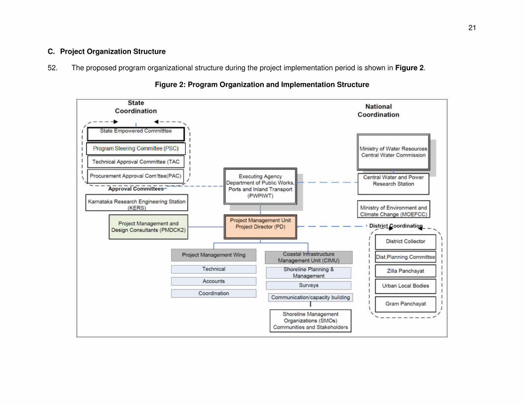
21
C. Project Organization Structure
52. The proposed program organizational structure during the project implementation period is shown in Figure 2.
Figure 2: Program Organization and Implementation Structure
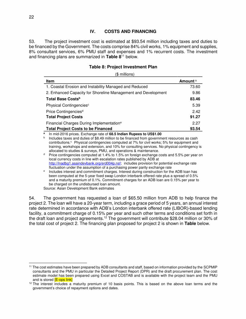
22
IV. COSTS AND FINANCING
53. The project investment cost is estimated at $93.54 million including taxes and duties to be financed by the Government. The costs comprise 84% civil works, 1% equipment and supplies, 8% consultant services, 6% PMU staff and expenses and 1% recurrent costs. The investment and financing plans are summarized in Table 811 below.
Table 8: Project Investment Plan
($ millions)
Item Amount a
1. Coastal Erosion and Instability Managed and Reduced 73.60
2. Enhanced Capacity for Shoreline Management and Development 9.86
Total Base Costsb 83.46
Physical Contingenciesc 5.39
Price Contingenciesd 2.42
Total Project Costs 91.27
Financial Charges During Implementatione 2.27
Total Project Costs to be Financed 93.54 a In mid-2016 prices. Exchange rate of 68.5 Indian Rupees to US$1.00 b Includes taxes and duties of $8.49 million to be financed from government resources as cash
contributions.c Physical contingencies computed at 7% for civil works; 5% for equipment and training, workshops and extension, and 10% for consulting services. No physical contingency is allocated to studies & surveys, PMU, and operations & maintenance.
d Price contingencies computed at 1.4% to 1.5% on foreign exchange costs and 5.5% per year on local currency costs in line with escalation rates published by ADB at http://lnadbg1.asaindevbank.org/erd004p.nsf; includes provision for potential exchange rate fluctuation under the assumption of a purchasing power parity exchange rate
e Includes interest and commitment charges. Interest during construction for the ADB loan has been computed at the 5-year fixed swap London interbank offered rate plus a spread of 0.5% and a maturity premium of 0.1%. Commitment charges for an ADB loan are 0.15% per year to be charged on the undisbursed loan amount.
Source: Asian Development Bank estimates
54. The government has requested a loan of $65.50 million from ADB to help finance the project 2. The loan will have a 20-year term, including a grace period of 5 years, an annual interest rate determined in accordance with ADB’s London interbank offered rate (LIBOR)-based lending facility, a commitment charge of 0.15% per year and such other terms and conditions set forth in the draft loan and project agreements.12 The government will contribute $28.04 million or 30% of the total cost of project 2. The financing plan proposed for project 2 is shown in Table below.
11 The cost estimates have been prepared by ADB consultants and staff, based on information provided by the SCPMIP
consultants and the PMU in particular the Detailed Project Report (DPR) and the draft procurement plan. The cost estimate model has been prepared using Excel and COSTAB and is available with the project team and the PMU and is stored [E-ops link]
12 The interest includes a maturity premium of 10 basis points. This is based on the above loan terms and the government’s choice of repayment options and dates.
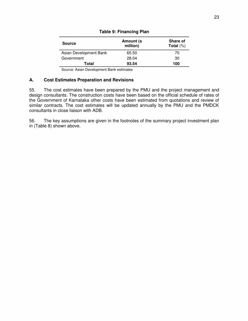
23
Table 9: Financing Plan
Source Amount (s million)
Share of Total (%)
Asian Development Bank 65.50 70
Government 28.04 30 Total 93.54 100
Source: Asian Development Bank estimates
A. Cost Estimates Preparation and Revisions
55. The cost estimates have been prepared by the PMU and the project management and design consultants. The construction costs have been based on the official schedule of rates of the Government of Karnataka other costs have been estimated from quotations and review of similar contracts. The cost estimates will be updated annually by the PMU and the PMDCK consultants in close liaison with ADB. 56. The key assumptions are given in the footnotes of the summary project investment plan in (Table 8) shown above.
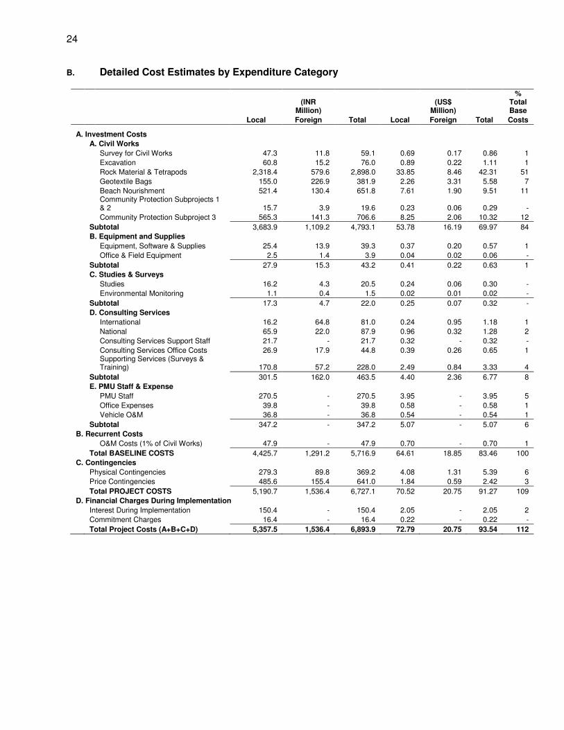
24
B. Detailed Cost Estimates by Expenditure Category
(INR
Million) (US$
Million)
% Total Base
Local Foreign Total Local Foreign Total Costs A. Investment Costs
A. Civil Works
Survey for Civil Works 47.3 11.8 59.1 0.69 0.17 0.86 1
Excavation 60.8 15.2 76.0 0.89 0.22 1.11 1
Rock Material & Tetrapods 2,318.4 579.6 2,898.0 33.85 8.46 42.31 51
Geotextile Bags 155.0 226.9 381.9 2.26 3.31 5.58 7
Beach Nourishment 521.4 130.4 651.8 7.61 1.90 9.51 11
Community Protection Subprojects 1 & 2 15.7 3.9 19.6 0.23 0.06 0.29 -
Community Protection Subproject 3 565.3 141.3 706.6 8.25 2.06 10.32 12
Subtotal 3,683.9 1,109.2 4,793.1 53.78 16.19 69.97 84
B. Equipment and Supplies
Equipment, Software & Supplies 25.4 13.9 39.3 0.37 0.20 0.57 1
Office & Field Equipment 2.5 1.4 3.9 0.04 0.02 0.06 -
Subtotal 27.9 15.3 43.2 0.41 0.22 0.63 1
C. Studies & Surveys
Studies 16.2 4.3 20.5 0.24 0.06 0.30 -
Environmental Monitoring 1.1 0.4 1.5 0.02 0.01 0.02 -
Subtotal 17.3 4.7 22.0 0.25 0.07 0.32 -
D. Consulting Services
International 16.2 64.8 81.0 0.24 0.95 1.18 1
National 65.9 22.0 87.9 0.96 0.32 1.28 2
Consulting Services Support Staff 21.7 - 21.7 0.32 - 0.32 -
Consulting Services Office Costs 26.9 17.9 44.8 0.39 0.26 0.65 1
Supporting Services (Surveys & Training) 170.8 57.2 228.0 2.49 0.84 3.33 4
Subtotal 301.5 162.0 463.5 4.40 2.36 6.77 8
E. PMU Staff & Expense
PMU Staff 270.5 - 270.5 3.95 - 3.95 5
Office Expenses 39.8 - 39.8 0.58 - 0.58 1
Vehicle O&M 36.8 - 36.8 0.54 - 0.54 1
Subtotal 347.2 - 347.2 5.07 - 5.07 6 B. Recurrent Costs
O&M Costs (1% of Civil Works) 47.9 - 47.9 0.70 - 0.70 1
Total BASELINE COSTS 4,425.7 1,291.2 5,716.9 64.61 18.85 83.46 100 C. Contingencies
Physical Contingencies 279.3 89.8 369.2 4.08 1.31 5.39 6
Price Contingencies 485.6 155.4 641.0 1.84 0.59 2.42 3
Total PROJECT COSTS 5,190.7 1,536.4 6,727.1 70.52 20.75 91.27 109 D. Financial Charges During Implementation
Interest During Implementation 150.4 - 150.4 2.05 - 2.05 2
Commitment Charges 16.4 - 16.4 0.22 - 0.22 -
Total Project Costs (A+B+C+D) 5,357.5 1,536.4 6,893.9 72.79 20.75 93.54 112
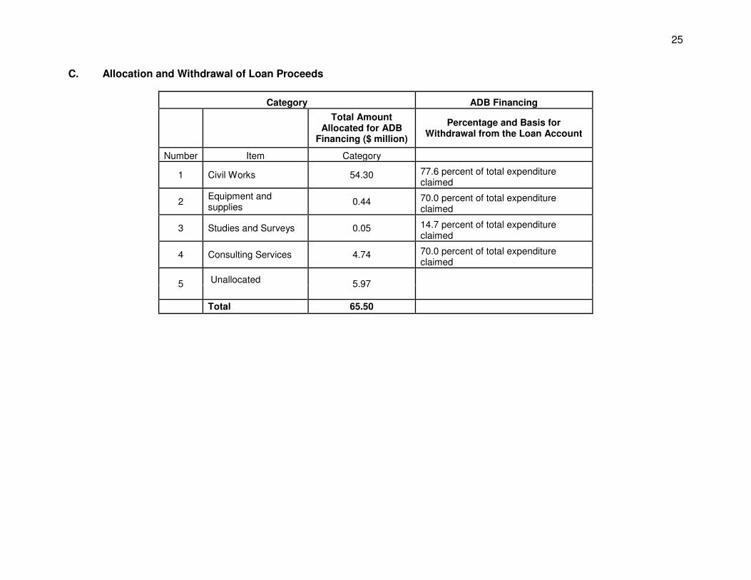
25
C. Allocation and Withdrawal of Loan Proceeds
Category ADB Financing
Total Amount Allocated for ADB
Financing ($ million)
Percentage and Basis for Withdrawal from the Loan Account
Number Item Category
1 Civil Works 54.30 77.6 percent of total expenditure claimed
2 Equipment and supplies
0.44 70.0 percent of total expenditure claimed
3 Studies and Surveys 0.05 14.7 percent of total expenditure claimed
4 Consulting Services 4.74 70.0 percent of total expenditure claimed
5 Unallocated 5.97
Total 65.50
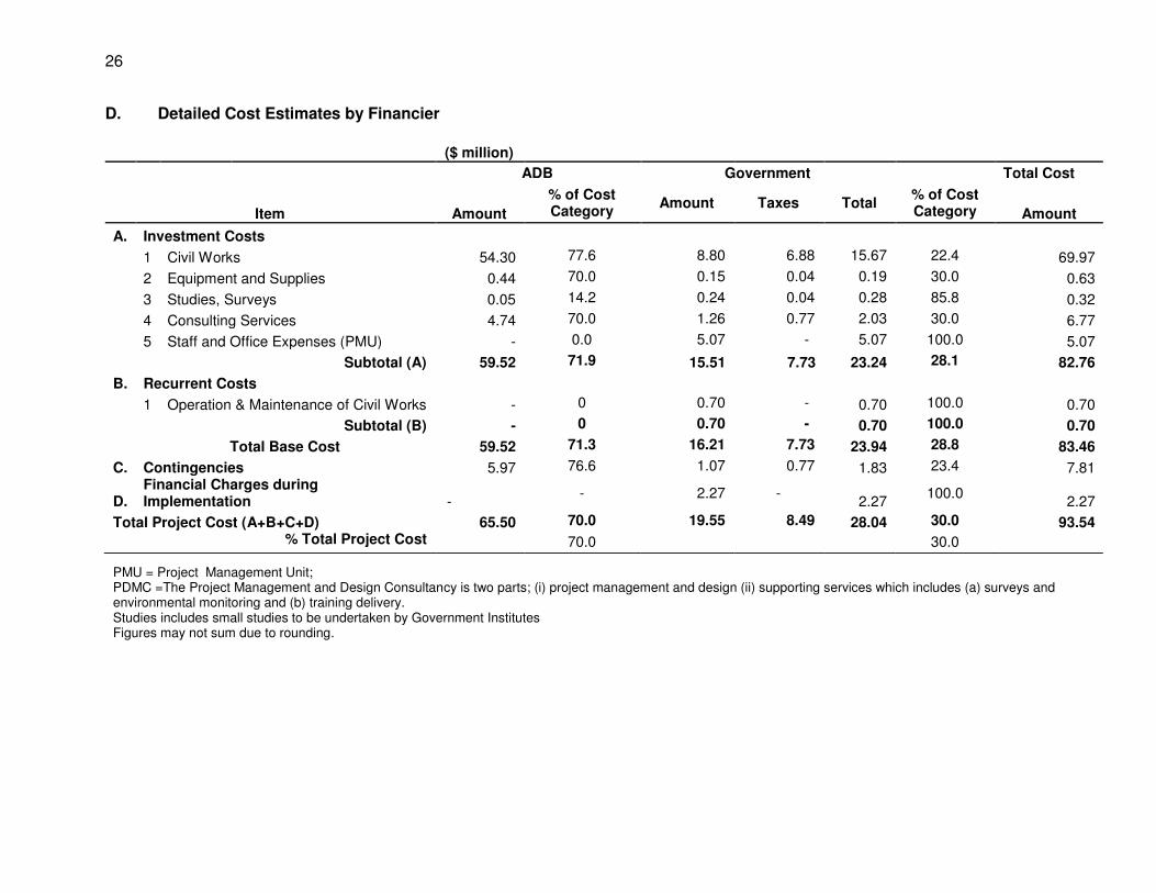
26
D. Detailed Cost Estimates by Financier
($ million)
ADB Government Total Cost
Item Amount
% of Cost Category
Amount Taxes Total % of Cost Category Amount
A. Investment Costs
1 Civil Works 54.30 77.6 8.80 6.88 15.67 22.4 69.97
2 Equipment and Supplies 0.44 70.0 0.15 0.04 0.19 30.0 0.63
3 Studies, Surveys 0.05 14.2 0.24 0.04 0.28 85.8 0.32
4 Consulting Services 4.74 70.0 1.26 0.77 2.03 30.0 6.77
5 Staff and Office Expenses (PMU) - 0.0 5.07 - 5.07 100.0 5.07
Subtotal (A) 59.52 71.9 15.51 7.73 23.24 28.1 82.76
B. Recurrent Costs
1 Operation & Maintenance of Civil Works - 0 0.70 - 0.70 100.0 0.70
Subtotal (B) - 0 0.70 - 0.70 100.0 0.70
Total Base Cost 59.52 71.3 16.21 7.73 23.94 28.8 83.46
C. Contingencies 5.97 76.6 1.07 0.77 1.83 23.4 7.81
D. Financial Charges during Implementation -
- 2.27 - 2.27
100.0 2.27
Total Project Cost (A+B+C+D) 65.50 70.0 19.55 8.49 28.04 30.0 93.54 % Total Project Cost 70.0 30.0
PMU = Project Management Unit; PDMC =The Project Management and Design Consultancy is two parts; (i) project management and design (ii) supporting services which includes (a) surveys and environmental monitoring and (b) training delivery. Studies includes small studies to be undertaken by Government Institutes Figures may not sum due to rounding.
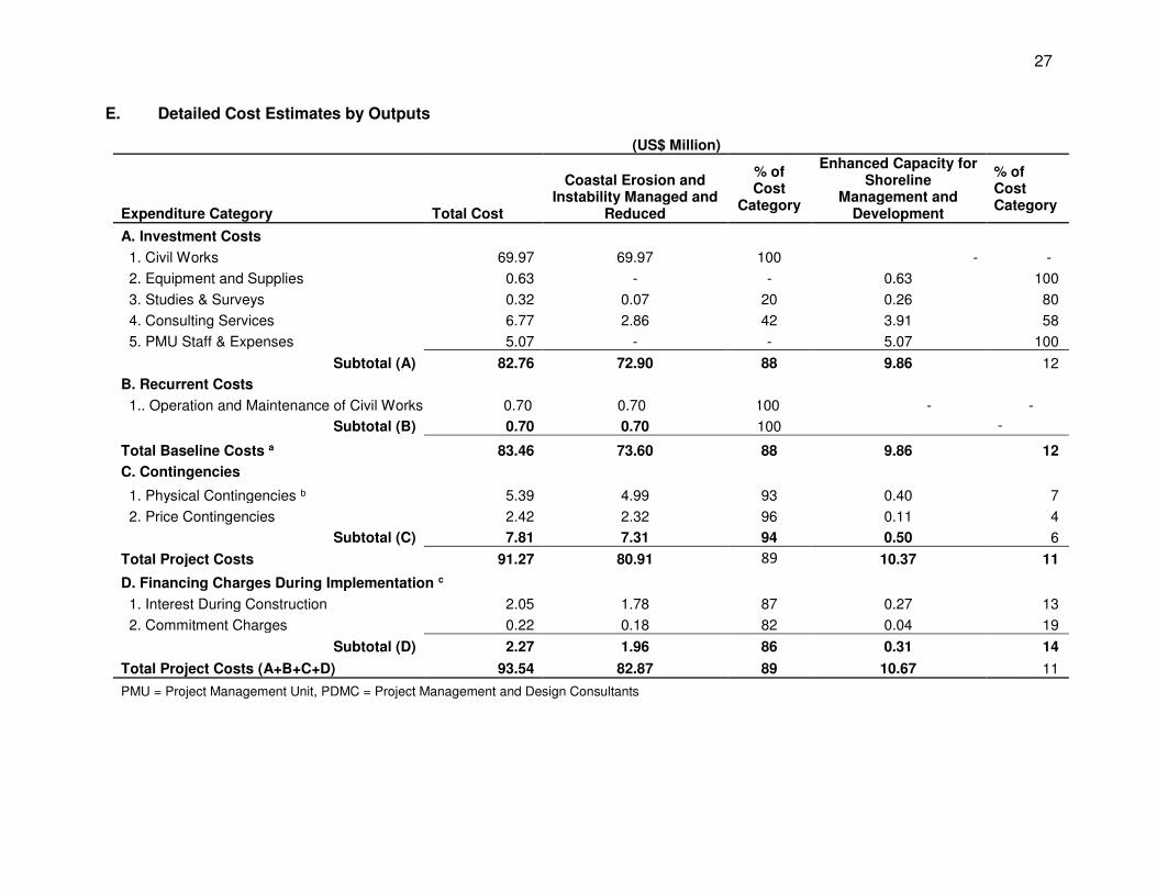
27
E. Detailed Cost Estimates by Outputs
(US$ Million)
Expenditure Category Total Cost
Coastal Erosion and Instability Managed and
Reduced
% of Cost
Category
Enhanced Capacity for Shoreline
Management and Development
% of Cost Category
A. Investment Costs
1. Civil Works 69.97 69.97 100 - -
2. Equipment and Supplies 0.63 - - 0.63 100
3. Studies & Surveys 0.32 0.07 20 0.26 80
4. Consulting Services 6.77 2.86 42 3.91 58
5. PMU Staff & Expenses 5.07 - - 5.07 100
Subtotal (A) 82.76 72.90 88 9.86 12
B. Recurrent Costs
1.. Operation and Maintenance of Civil Works 0.70 0.70 100 - -
Subtotal (B) 0.70 0.70 100 -
Total Baseline Costs a 83.46 73.60 88 9.86 12
C. Contingencies
1. Physical Contingencies b 5.39 4.99 93 0.40 7
2. Price Contingencies 2.42 2.32 96 0.11 4
Subtotal (C) 7.81 7.31 94 0.50 6
Total Project Costs 91.27 80.91 89 10.37 11
D. Financing Charges During Implementation c
1. Interest During Construction 2.05 1.78 87 0.27 13
2. Commitment Charges 0.22 0.18 82 0.04 19
Subtotal (D) 2.27 1.96 86 0.31 14
Total Project Costs (A+B+C+D) 93.54 82.87 89 10.67 11
PMU = Project Management Unit, PDMC = Project Management and Design Consultants
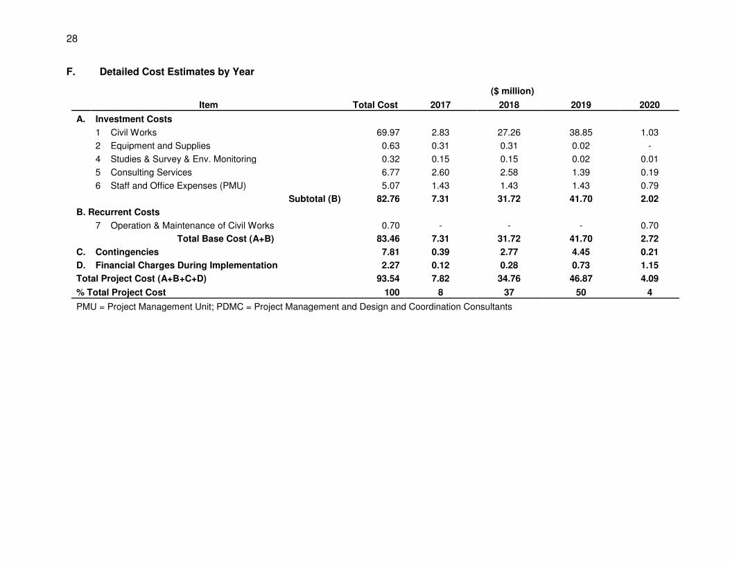
28
F. Detailed Cost Estimates by Year
($ million)
Item Total Cost 2017 2018 2019 2020
A. Investment Costs
1 Civil Works 69.97 2.83 27.26 38.85 1.03
2 Equipment and Supplies 0.63 0.31 0.31 0.02 -
4 Studies & Survey & Env. Monitoring 0.32 0.15 0.15 0.02 0.01
5 Consulting Services 6.77 2.60 2.58 1.39 0.19
6 Staff and Office Expenses (PMU) 5.07 1.43 1.43 1.43 0.79
Subtotal (B) 82.76 7.31 31.72 41.70 2.02
B. Recurrent Costs
7 Operation & Maintenance of Civil Works 0.70 - - - 0.70
Total Base Cost (A+B) 83.46 7.31 31.72 41.70 2.72
C. Contingencies 7.81 0.39 2.77 4.45 0.21
D. Financial Charges During Implementation 2.27 0.12 0.28 0.73 1.15
Total Project Cost (A+B+C+D) 93.54 7.82 34.76 46.87 4.09
% Total Project Cost 100 8 37 50 4
PMU = Project Management Unit; PDMC = Project Management and Design and Coordination Consultants
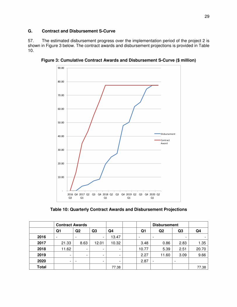
29
G. Contract and Disbursement S-Curve
57. The estimated disbursement progress over the implementation period of the project 2 is shown in Figure 3 below. The contract awards and disbursement projections is provided in Table 10.
Figure 3: Cumulative Contract Awards and Disbursement S-Curve ($ million)
Table 10: Quarterly Contract Awards and Disbursement Projections
Contract Awards Disbursement
Q1 Q2 Q3 Q4 Q1 Q2 Q3 Q4
2016 - - - 13.47 - - - -
2017 21.33 8.63 12.01 10.32 3.48 0.86 2.83 1.35
2018 11.62 - - - 10.77 5.39 2.51 20.70
2019 - - - - 2.27 11.60 3.09 9.66
2020 - - - - 2.87 - -
Total 77.38 77.38
-
10.00
20.00
30.00
40.00
50.00
60.00
70.00
80.00
90.00
2016
Q3
Q4 2017
Q1
Q2 Q3 Q4 2018
Q1
Q2 Q3 Q4 2019
Q1
Q2 Q3 Q4 2020
Q1
Q2
Disbursement
Contract
Award
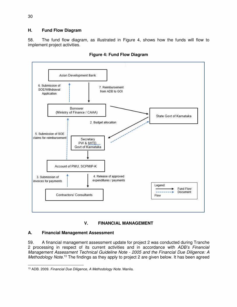
30
H. Fund Flow Diagram
58. The fund flow diagram, as illustrated in Figure 4, shows how the funds will flow to implement project activities.
Figure 4: Fund Flow Diagram
V. FINANCIAL MANAGEMENT
A. Financial Management Assessment
59. A financial management assessment update for project 2 was conducted during Tranche 2 processing in respect of its current activities and in accordance with ADB’s Financial Management Assessment Technical Guideline Note - 2005 and the Financial Due Diligence: A Methodology Note.13 The findings as they apply to project 2 are given below. It has been agreed
13 ADB. 2009. Financial Due Diligence, A Methodology Note. Manila.
31
that the financial management arrangements in place for Project 1 will continue during Project 2. During project 1 there have been improvements in the financial capacities and the current systems are considered satisfactory. The status and recommendations are described below. The overall risk assessment remains moderate.
60. The financial management action plan is provided in Table 11 below.
Table 11: Financial Management Action Plan
Key Risk Risk Mitigating Activity Timeline Responsible Entity
PMU has insufficient finance/accounting staff to manage the transactions.
The Finance and Administration Section within the PMU will be strengthened to include one full time accountant and one full time Deputy Director Finance to conduct the regular accounting according to ADB procedures. Additional training and workshops on ADB disbursement and financial management procedures will be planned.
2016-2018 PMU
Manual record keeping leads to inefficiencies and loss of data integrity
Implement computerized financial reporting system in accordance with the accounting manual. The system will link the PMU and corresponding subprojects into one information network. This will improve efficiency and overall effectiveness of information exchange.
2016 PMU
No internal audit This will be outsourced or a request will be made to the State Finance Department to include Project 2 in their scope of work.
2016 GOK
Expected delay in submission of APFS
Request the AG in advance of Project 2 to ensure inclusion of project audit in their work plan to ensure continued timeliness
Before loan effectiveness
PMU
61. The FMA is based on lessons learned: (i) during the implementation of previous projects and the ongoing project 1, and (ii) from project implementation experience in the sector and India, in general. 62. Summary of the Financial Management Internal Control and Risk Assessment is given below.
Table 12: Control Risk Summary
Risk Type Risk Description Risk Assessment
Agreed Mitigation Measures
1. Executing Entity
PWPIWTD has successfully implemented project 1 of SCPMIP and has capacity to manage project 2.
Low Not applicable
2. Fund Flow
The PWPIWTD has knowledge of and working experience in ADB fund flow
Moderate The state government will provide budget provision for
32
Risk Type Risk Description Risk Assessment
Agreed Mitigation Measures
arrangements. Under project 1 however there have been difficulties due to the delay of fund flows from the Ministry of Finance to the State Government which has been delayed and on occasion y there are insufficient funds available to make timely payments; adding to this there are also difficulties in quick fund transfer from the State Government to the project.
the project which would be later reimbursed by ADB. Prior to loan negotiations it is essential to ensure the availability of counterpart funds from the state government.
3. Staffing The PMU is not adequately staffed with experienced financial specialists.
Moderate The Finance and Administration Section within the PMU requires to be strengthened to conduct the regular accounting according to ADB procedures. A full time accountant with adequate experience on external aided projects will be posted. In addition, a full time DD-finance position is required to support quality control of accounting and project finance management It is proposed to organize additional training and workshops on ADB financial management procedures for the existing and new PMU staff. On-the-job training and support will be provided by the project 2 consultants.
4. Budgeting PMU follows the GOK budget formulation process. PMU’s budget is prepared in accordance with the Government’s schedule and is approved well in advance of the start of the financial year. The budget process starts in November of each year and is concluded by January of the following year. It is approved in line with Government procedures
Low Efforts will be made to support computerization of accounts which speed up and increase the accuracy of processing. The Finance and Administration Section within the PMU will be strengthened and given training on budgeting for external assistance and use of computers. Additional training and workshops on budgeting for external aided projects will be provided by the project 2 consultants for the existing and new PMU staff.
5. Accounting Policies and Procedures
The PWPIWTD’s accounting policies accounts for transactions on a cash basis in accordance with the
Low Not applicable
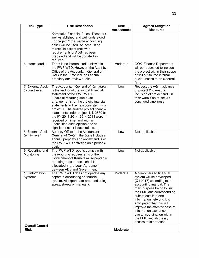
33
Risk Type Risk Description Risk Assessment
Agreed Mitigation Measures
Karnataka Financial Rules. These are well established and well understood. For project 2 the, same accounting policy will be used. An accounting manual in accordance with requirements of ADB has been prepared and will be updated as required.
6.Internal audit There is no internal audit unit within the PWPIWTD. However, the Audit by Office of the Accountant General of CAG in the State includes annual, propriety and review audits.
Moderate GOK, Finance Department will be requested to include the project within their scope or will outsource internal audit function to an external firm.
7. External Audit (project level)
The Accountant General of Karnataka is the auditor of the annual financial statement of the PWPIWTD. Financial reporting and audit arrangements for the project financial statements will remain consistent with project 1. The audited project financial statements under project 1, L-2679 for the FY 2013-2014, 2014-2015 were received on time, and with an unqualified audit opinion and no significant audit issues raised.
Low Request the AG in advance of project 2 to ensure inclusion of project audit in their work plan to ensure continued timeliness
8. External Audit (entity level)
Audit by Office of the Accountant General of CAG in the State includes annual, propriety and review audits of the PWPIWTD activities on a periodic basis
Low Not applicable
9. Reporting and Monitoring
The PWPIWTD reports comply with the reporting requirements of the Government of Karnataka. Acceptable reporting requirements shall be stipulated in the Loan Agreement between ADB and Government.
Low Not applicable
10. Information Systems
The PWPIWTD does not operate any separate accounting or financial system. All reports are prepared using spreadsheets or manually.
Moderate A computerized financial system will be developed (Q1 2017) according to the accounting manual. The main purpose being to link the PMU and corresponding subprojects into one information network. It is anticipated that this will improve the effectiveness of information exchange, overall coordination within the PMU and also easy access to information.
Overall Control Risk
Moderate
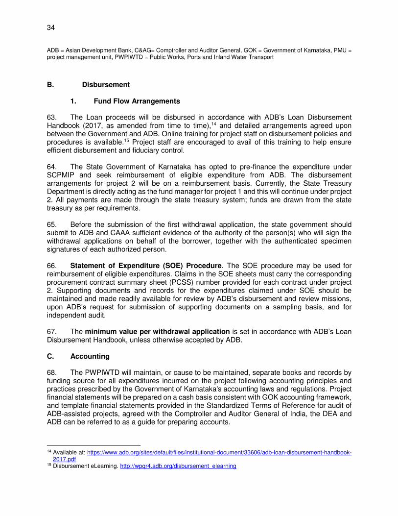
34
ADB = Asian Development Bank, C&AG= Comptroller and Auditor General, GOK = Government of Karnataka, PMU = project management unit, PWPIWTD = Public Works, Ports and Inland Water Transport
B. Disbursement
1. Fund Flow Arrangements
63. The Loan proceeds will be disbursed in accordance with ADB’s Loan Disbursement Handbook (2017, as amended from time to time),14 and detailed arrangements agreed upon between the Government and ADB. Online training for project staff on disbursement policies and procedures is available.15 Project staff are encouraged to avail of this training to help ensure efficient disbursement and fiduciary control. 64. The State Government of Karnataka has opted to pre-finance the expenditure under SCPMIP and seek reimbursement of eligible expenditure from ADB. The disbursement arrangements for project 2 will be on a reimbursement basis. Currently, the State Treasury Department is directly acting as the fund manager for project 1 and this will continue under project 2. All payments are made through the state treasury system; funds are drawn from the state treasury as per requirements. 65. Before the submission of the first withdrawal application, the state government should submit to ADB and CAAA sufficient evidence of the authority of the person(s) who will sign the withdrawal applications on behalf of the borrower, together with the authenticated specimen signatures of each authorized person. 66. Statement of Expenditure (SOE) Procedure. The SOE procedure may be used for reimbursement of eligible expenditures. Claims in the SOE sheets must carry the corresponding procurement contract summary sheet (PCSS) number provided for each contract under project 2. Supporting documents and records for the expenditures claimed under SOE should be maintained and made readily available for review by ADB’s disbursement and review missions, upon ADB’s request for submission of supporting documents on a sampling basis, and for independent audit.
67. The minimum value per withdrawal application is set in accordance with ADB’s Loan Disbursement Handbook, unless otherwise accepted by ADB.
C. Accounting
68. The PWPIWTD will maintain, or cause to be maintained, separate books and records by funding source for all expenditures incurred on the project following accounting principles and practices prescribed by the Government of Karnataka's accounting laws and regulations. Project financial statements will be prepared on a cash basis consistent with GOK accounting framework, and template financial statements provided in the Standardized Terms of Reference for audit of ADB-assisted projects, agreed with the Comptroller and Auditor General of India, the DEA and ADB can be referred to as a guide for preparing accounts.
14 Available at: https://www.adb.org/sites/default/files/institutional-document/33606/adb-loan-disbursement-handbook-
2017.pdf 15 Disbursement eLearning. http://wpqr4.adb.org/disbursement_elearning
35
D. Auditing and Public Disclosure
69. The PWPIWTD will cause the detailed consolidated project financial statements to be audited in accordance with Government's audit regulations, by independent auditors acceptable to ADB. The audited project financial statements together with auditor’s opinion will be presented in the English language to ADB within 6 months of the end of the fiscal year by the EA. 70. The annual audit report for the project financial statements will include audit opinions which cover (i) whether the project financial statements present a true and fair view or are presented fairly, in all material respects, in accordance with the applicable financial reporting framework; (ii) whether loan proceeds were used only for the purposes of the project; (iii) whether the borrower or EA was in compliance with the financial covenants contained in the legal agreements (where applicable). 71. The Government and PWPIWTD have been made aware of ADB’s approach to delayed submission, and the requirements for satisfactory and acceptable quality of the audited project financial statements.16 ADB reserves the right to require a change in the auditor (in a manner consistent with the constitution of the borrower), or for additional support to be provided to the auditor, if the audits required are not conducted in a manner satisfactory to ADB, or if the audits are substantially delayed. ADB reserves the right to verify the project's financial accounts to confirm that the share of ADB’s financing is used in accordance with ADB’s policies and procedures.
72. Public disclosure of the audited project financial statements, including the auditor’s opinion on the project financial statements, will be guided by ADB’s Public Communications Policy 2011. After ADB’s review, ADB will disclose on ADB’s website the audited project financial statements and the opinion of the auditors on the project financial statements no later than 14 days of ADB’s confirmation of their acceptability. The management letter will not be disclosed.
VI. PROCUREMENT AND CONSULTING SERVICES
A. Advance Contracting and Retroactive Financing
73. All advance contracting and retroactive financing will be undertaken in conformity with ADB’s Procurement Guidelines (2015, as amended from time to time)17 and ADB’s Guidelines on the Use of Consultants (2013, as amended from time to time).18 The issuance of invitations to bid under advance contracting and retroactive financing will be subject to ADB’s prior approval. The
16 ADB’s approach and procedures regarding delayed submission of audited project financial statements:
(i) When audited project financial statements are not received by the due date, ADB will write to the EA advising that (a) the audit documents are overdue; and (b) if they are not received within the next 6 months, requests for new contract awards and disbursement such as new replenishment of imprest accounts, processing of new reimbursement, and issuance of new commitment letters will not be processed.
(ii) When audited project financial statements are not received within 6 months after the due date, ADB will withhold processing of requests for new contract awards and disbursement such as new replenishment of imprest accounts, processing of new reimbursement and issuance of new commitment letters. ADB will (a) inform the EA of ADB’s actions; and (b) advise that the loan may be suspended if the audit documents are not received within the next 6 months.
(iii) When audited project financial statements are not received within 12 months after the due date, ADB may suspend the loan.
17 Available at: https://www.adb.org/sites/default/files/institutional-document/31482/procurement-guidelines-april-2015.pdf
18 Available at: https://www.adb.org/sites/default/files/institutional-document/31481/guidelines-use-consultants.pdf
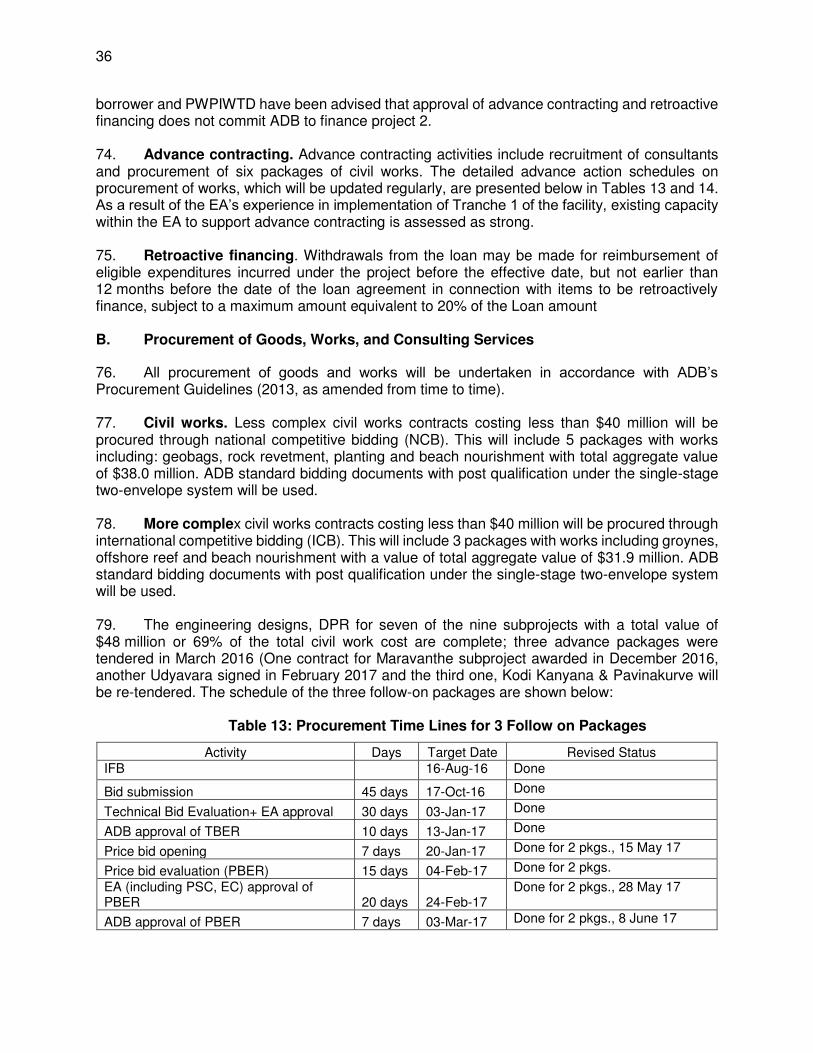
36
borrower and PWPIWTD have been advised that approval of advance contracting and retroactive financing does not commit ADB to finance project 2. 74. Advance contracting. Advance contracting activities include recruitment of consultants and procurement of six packages of civil works. The detailed advance action schedules on procurement of works, which will be updated regularly, are presented below in Tables 13 and 14. As a result of the EA’s experience in implementation of Tranche 1 of the facility, existing capacity within the EA to support advance contracting is assessed as strong.
75. Retroactive financing. Withdrawals from the loan may be made for reimbursement of eligible expenditures incurred under the project before the effective date, but not earlier than 12 months before the date of the loan agreement in connection with items to be retroactively finance, subject to a maximum amount equivalent to 20% of the Loan amount
B. Procurement of Goods, Works, and Consulting Services
76. All procurement of goods and works will be undertaken in accordance with ADB’s Procurement Guidelines (2013, as amended from time to time). 77. Civil works. Less complex civil works contracts costing less than $40 million will be procured through national competitive bidding (NCB). This will include 5 packages with works including: geobags, rock revetment, planting and beach nourishment with total aggregate value of $38.0 million. ADB standard bidding documents with post qualification under the single-stage two-envelope system will be used. 78. More complex civil works contracts costing less than $40 million will be procured through international competitive bidding (ICB). This will include 3 packages with works including groynes, offshore reef and beach nourishment with a value of total aggregate value of $31.9 million. ADB standard bidding documents with post qualification under the single-stage two-envelope system will be used.
79. The engineering designs, DPR for seven of the nine subprojects with a total value of $48 million or 69% of the total civil work cost are complete; three advance packages were tendered in March 2016 (One contract for Maravanthe subproject awarded in December 2016, another Udyavara signed in February 2017 and the third one, Kodi Kanyana & Pavinakurve will be re-tendered. The schedule of the three follow-on packages are shown below:
Table 13: Procurement Time Lines for 3 Follow on Packages
Activity Days Target Date Revised Status IFB
16-Aug-16 Done
Bid submission 45 days 17-Oct-16 Done
Technical Bid Evaluation+ EA approval 30 days 03-Jan-17 Done
ADB approval of TBER 10 days 13-Jan-17 Done
Price bid opening 7 days 20-Jan-17 Done for 2 pkgs., 15 May 17
Price bid evaluation (PBER) 15 days 04-Feb-17 Done for 2 pkgs.
EA (including PSC, EC) approval of PBER 20 days 24-Feb-17
Done for 2 pkgs., 28 May 17
ADB approval of PBER 7 days 03-Mar-17 Done for 2 pkgs., 8 June 17
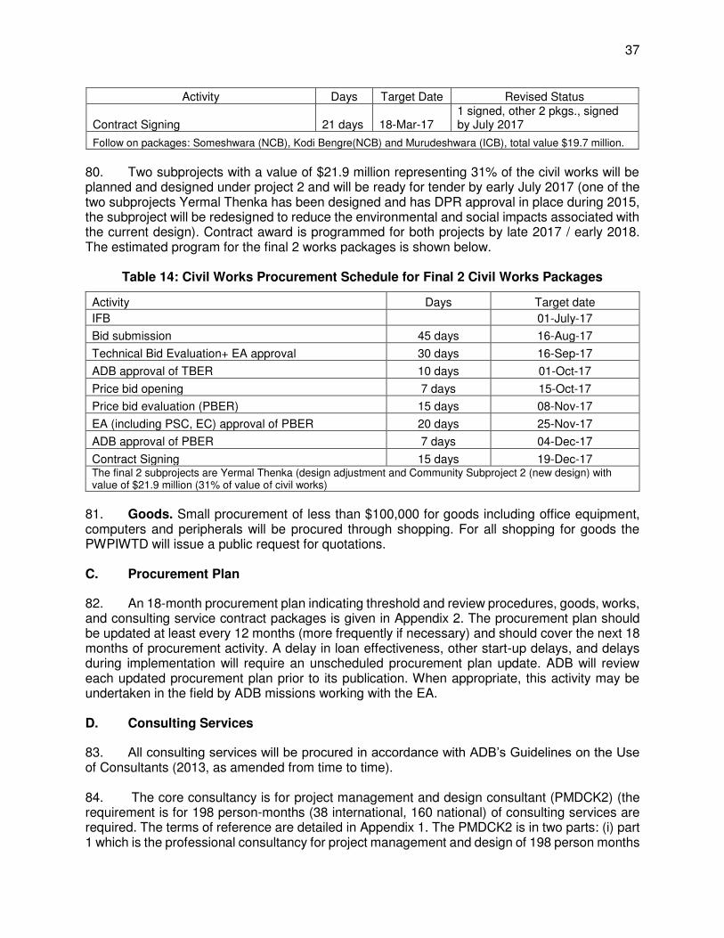
37
Activity Days Target Date Revised Status
Contract Signing 21 days 18-Mar-17 1 signed, other 2 pkgs., signed by July 2017
Follow on packages: Someshwara (NCB), Kodi Bengre(NCB) and Murudeshwara (ICB), total value $19.7 million.
80. Two subprojects with a value of $21.9 million representing 31% of the civil works will be planned and designed under project 2 and will be ready for tender by early July 2017 (one of the two subprojects Yermal Thenka has been designed and has DPR approval in place during 2015, the subproject will be redesigned to reduce the environmental and social impacts associated with the current design). Contract award is programmed for both projects by late 2017 / early 2018. The estimated program for the final 2 works packages is shown below.
Table 14: Civil Works Procurement Schedule for Final 2 Civil Works Packages
Activity Days Target date
IFB 01-July-17
Bid submission 45 days 16-Aug-17
Technical Bid Evaluation+ EA approval 30 days 16-Sep-17
ADB approval of TBER 10 days 01-Oct-17
Price bid opening 7 days 15-Oct-17
Price bid evaluation (PBER) 15 days 08-Nov-17
EA (including PSC, EC) approval of PBER 20 days 25-Nov-17
ADB approval of PBER 7 days 04-Dec-17
Contract Signing 15 days 19-Dec-17 The final 2 subprojects are Yermal Thenka (design adjustment and Community Subproject 2 (new design) with value of $21.9 million (31% of value of civil works)
81. Goods. Small procurement of less than $100,000 for goods including office equipment, computers and peripherals will be procured through shopping. For all shopping for goods the PWPIWTD will issue a public request for quotations. C. Procurement Plan
82. An 18-month procurement plan indicating threshold and review procedures, goods, works, and consulting service contract packages is given in Appendix 2. The procurement plan should be updated at least every 12 months (more frequently if necessary) and should cover the next 18 months of procurement activity. A delay in loan effectiveness, other start-up delays, and delays during implementation will require an unscheduled procurement plan update. ADB will review each updated procurement plan prior to its publication. When appropriate, this activity may be undertaken in the field by ADB missions working with the EA. D. Consulting Services
83. All consulting services will be procured in accordance with ADB’s Guidelines on the Use of Consultants (2013, as amended from time to time). 84. The core consultancy is for project management and design consultant (PMDCK2) (the requirement is for 198 person-months (38 international, 160 national) of consulting services are required. The terms of reference are detailed in Appendix 1. The PMDCK2 is in two parts: (i) part 1 which is the professional consultancy for project management and design of 198 person months
38
and (ii) part 2 which is supporting services which includes (a) surveys and environmental monitoring and (b) delivery of training courses; both parts have been categorized as consulting services. The consultants have been recruited using quality- and cost-based selection method (80:20, full technical proposal) and are expected to be mobilized by February 2017.
VII. SAFEGUARDS
85. The government, through the PWPIWTD, will ensure that all safeguard requirements prescribed for project 2 are implemented. The project 2, in accordance to ADB’s Safeguard Policy Statement (2009), was classified as category B project for environment, category C for involuntary resettlement, and category C for indigenous people. 86. The initial environmental examination (IEE) for project 2 has been prepared and the environmental assessment review framework was updated. The environmental management plan (EMP), including the monitoring plan is included in the IEE report. The government, through the PWPIWTD, is obliged to implement recommendations from the IEE report. 87. With respect to the requirement of the facility to comply with ADB SPS 2009, the government through the PWPIWTD has updated and provided ADB with the following safeguards framework documents:
(i) Environmental Assessment and Review Framework (EARF) was updated to comply with the ADB SPS (2009) and the Government of India Coastal Regulation Zone 2011.
(ii) Resettlement Framework (RF) was updated to comply with the ADB SPS (2009) and the Government of India Act on the Right to Fair Compensation and Transparency in Land Acquisition, Rehabilitation and Resettlement Act (2013).
(iii) Indigenous Peoples Planning Framework (IPPF) was updated to comply with the ADB SPS (2008).
88. The frameworks cover specific guidance and requirements to address and manage environmental and social impacts that trigger activities under the facility which may become a subject of the ADB SPS 2009. The guidance includes: (i) the tools to screen the activities to categorize in accordance with ADB’s SPS 2009; (ii) the approaches and the steps to identify likely impacts of activities under the facility on the environment, involuntary resettlement, and indigenous peoples; (iii) the approach and principles to develop the environmental management plan, resettlement plan and indigenous people development plan; (iv) the procedures and requirement to hold public consultations and information disclosure (including the 120-day disclosure rule, if required), and to establish the grievance redress mechanism; and (iv) the requirement for monitoring and reporting. As part of the Safeguards implementation, project 2 will seek to follow the existing project specific grievance redress mechanism (GRM) established for project 1. The GRM will aim to provide a time bound and transparent mechanism to voice and resolve social and environmental concerns linked with the project. The project specific GRM is not intended to bypass the government’s own redress process, rather it is intended to address project affected people’s concerns and complaints promptly, making it readily accessible to all segments of affected persons and is scaled to the risks and impacts of the project. The GRM will be set at 3 levels: (i) at subproject level, the Assistant Executive Engineer (AEE)/Assistant Engineer (AE) of the respective project sites will be the first recipient of the grievance. At this level, the grievance team will consist of the AEE/AE, other subproject team members, and representatives of affected people. If the grievance is not resolved at this level, it will be addressed by the next level grievance mechanism; (ii) at the PMU level, the grievance
39
committee will be chaired by the Project Director (PD) with members including the District Administrator, AEE/EA respective project site, Environment Engineer (EE), and representative(s) of affected people. If the grievance is not resolved at this level, it will be addressed by the next level - grievance mechanism; and (iii) at the District level, the grievance committee will be chaired by the District Collector, with members consisting of representatives of relevant departments, PD and respective AEE/EA, EE, representatives of affected people, and representatives of the contractor (if required). 89. The following paragraphs describe briefly the activities to be implemented during project implementation and operation. A. Environment Safeguards
90. PWPIWTD will ensure that the design, construction, and operation and maintenance of the facilities under project 2 are carried out in accordance with ADB’s SPS (2009), applicable Government of India laws and regulations, and recommendations from the IEE and its EMP. The EA will ensure that potential adverse environmental impacts arising from the project 2 are minimized by implementing all mitigation and monitoring measures as presented in the EMP as part of the IEE report and will ensure that:
(i) The PMU will engage the environment specialist/engineer as part of its team to implement and record the implementation of the EMPs prepared for the project 2;
(ii) The detailed engineering designs incorporate applicable environmental measures identified in the IEE and its EMP, and if the detailed designed will be changed, the updated IEE and its EMP has to be prepared. In case a new activity will be added in Project these activities will be screened by following the EARF, IPPF and IRF and will carry out the required studies as described in the EARF, IPPF and IRF;
(iii) The Terms of Reference for the supervision consultant/engineer will include a requirement to enable them to assist in implementing the IEE and its EMP;
(iv) All bidding documents for civil works contracts will include all safeguards requirement as described in the IEE and its EMP;
(v) The contractors will be required to prepare a site EMP prior to implementation of civil works. The Site EMP will be reviewed by the supervision consultant/engineer (PMDC) and approved by PMU prior to commencing civil works;
(vi) Six months after the loan effectiveness, the PMU will submit semi-annual environmental reports on monitoring the implementation of the EMP and environmental monitoring report. The semi-annual report on environment will be submitted to ADB and other relevant government agencies regularly until the financial closing of the project 2. The environmental monitoring report will include, among other things, a review of progress made on environmental measures detailed in the IEE and EMP, and problems encountered or un-expected impacts encountered during implementation and remedial measures taken to address those problems. The report will also include any complaint received and actions to resolve the complaint under the grievance redress mechanism;
(vii) The PMU will take responsibility as the secretariat for the grievance redress mechanism for both environmental and social aspects of the project;
40
(viii) The PMU will ensure that the supervision consultant will record all contractor claims to implement EMP, and civil works contractors are supervised and monitored to ensure compliance with the requirements of the IEE and EMP;
(ix) If unexpected or unforeseen environmental impacts occurred, the environment specialist from PMU together with the supervision consultant, and contractor will take prompt corrective measures;
(x) PMU, Supervision consultant, and contractors will fulfil responsibilities to address any environmental impact raised from any activities under project 2; and
(xi) PMU will recruit an independent environmental monitoring entity to carry out environmental audit, and the environmental audit report will be submitted to relevant government agencies as well as to ADB.
B. Social Safeguards
91. The project components will be carried out offshore or on the shoreline. Therefore, no settlements will be affected in these areas, and, as a result, project 2 will not require any land acquisition or resettlement. Project 2 is categorized as C for involuntary resettlement in accordance to the ADB SPS, 2009. Nonetheless, the Involuntary Resettlement Framework was updated in compliance with ADB SPS, 2009. In the project areas, there are no indigenous peoples or ethnic minority groups. There are no indigenous people/community in the project area which have distinct social, economic, linguistic, and cultural characteristics as described in ADB SPS 2009. Therefore, project 2 is categorized as a C for indigenous peoples in accordance to ADB SPS, 2009. Nevertheless, the indigenous peoples planning framework (IPPF) was updated in compliance with ADB SPS, 2009. 92. Although project 2 is categorized as C project for IR and IP, the PMU will take necessary actions to address social impacts raised during project implementation by applying as applicable the social safeguard frameworks (IRF and/or IPPF). 93. Prohibited investment activities. Pursuant to ADB’s Safeguard Policy Statement (2009), ADB funds may not be applied to the activities described on the ADB Prohibited Investment Activities List set forth at Appendix 5 of the Safeguard Policy Statement (2009).
VIII. GENDER AND SOCIAL DIMENSIONS
A. Gender
94. Upon completion of project 2, it is envisaged that there will be some positive benefits to women’s livelihood, particularly those who are engaged in retail fish vending and processing, as well as women engaged in small businesses in tourism. The expanded width of the beach will help women to have adequate space to dry the fish catch and to maintain their small businesses to support tourism activities. In addition, it is anticipated that the psychological trauma of families living with the fear of facing erosion threats every year will be redressed and people would be able to lead a more secure life. Output 1 of the project involves significant construction works in the coastal belt. Concerted efforts will be made to involve women in activities required to meet Output 1. However, setting specific targets for involvement will be difficult in view of the hostile and difficult environmental conditions in the project environs and the relative reluctance voiced during stakeholder consultations by women of being involved in construction related activities.
41
95. Of five defined activities required to achieve Output 2, there are however two activities that could be more specifically targeted to have gender elements incorporated, these include: (i) fully established SMOs at nine subproject sites; and (ii) capacity strengthening within PWPIWTD in project management aspects including finance, construction and community participation. The establishment of SMOs in each subproject area will give an opportunity for women to be involved and participate in decision making in community development activities especially in maintaining the coastal protection facilities. The SMOs are expected to have at least 10 persons as part of the executive body, of which at least 3 will be expected to be women. The training programs on coastal management for local communities will incorporate strengthened knowledge to maintain assets and at least 30% participants should be women. As part of the capacity strengthening program, PWPIWTD will encourage participation of its female staff. Any training held under this component should have female staff representation. The progress in implementing activities that will be targeted to have some gender elements (SGE) as described above will be reported by PMU in its quarterly project progress report. On this basis, project 2 is categorized as an SGE project. B. Labor
96. The PWPIWTD will ensure that contractors, sub-contractors, and supplier civil works contracts under project 2 comply with all applicable labor laws of the Government of Karnataka and the Government of India. The contract document for contractors and its sub-contractors will include provisions to (i) avoid employing children and not use children and forced labor, (ii) to provide an opportunity to employ female labor, (iii) ensure equal pay for equal work for male and female labor, (iv) adopt a good practice as well as follow mandated provisions of health, safety, sanitation, welfare and working conditions, and (v) conduct trainings and awareness programs on HIV/AIDS awareness programs for construction workers and staff and disseminate information at worksites on risks of sexually transmitted diseases and conduct other training as part of health and safety measures for those employed during construction. The PMU will ensure that contracts shall also include clauses for termination in case of any breach of these provisions by contractors and its sub-contractors. The PMU will include in its quarterly project progress report the implementation of contractors’ compliance with applicable labor law at the minimal to cover this requirement.
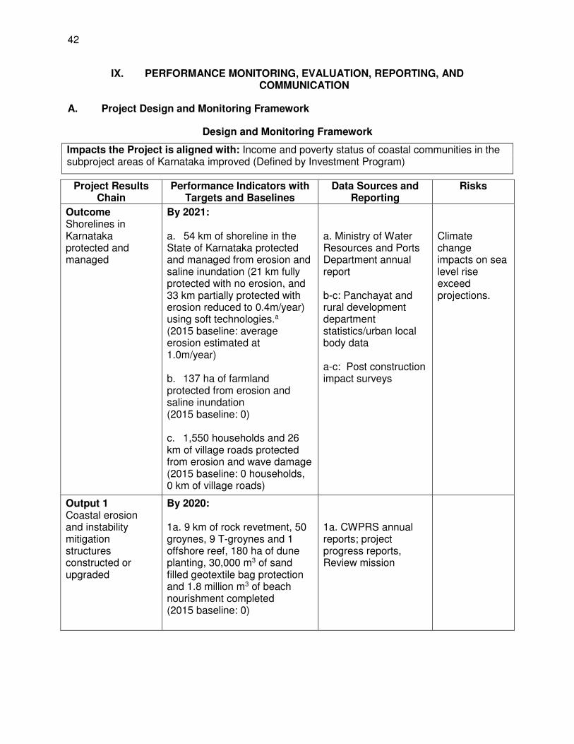
42
IX. PERFORMANCE MONITORING, EVALUATION, REPORTING, AND COMMUNICATION
A. Project Design and Monitoring Framework
Design and Monitoring Framework
Impacts the Project is aligned with: Income and poverty status of coastal communities in the subproject areas of Karnataka improved (Defined by Investment Program)
Project Results Chain
Performance Indicators with Targets and Baselines
Data Sources and Reporting
Risks
Outcome Shorelines in Karnataka protected and managed
By 2021: a. 54 km of shoreline in the State of Karnataka protected and managed from erosion and saline inundation (21 km fully protected with no erosion, and 33 km partially protected with erosion reduced to 0.4m/year) using soft technologies.a (2015 baseline: average erosion estimated at 1.0m/year) b. 137 ha of farmland protected from erosion and saline inundation (2015 baseline: 0) c. 1,550 households and 26 km of village roads protected from erosion and wave damage (2015 baseline: 0 households, 0 km of village roads)
a. Ministry of Water Resources and Ports Department annual report b-c: Panchayat and rural development department statistics/urban local body data a-c: Post construction impact surveys
Climate change impacts on sea level rise exceed projections.
Output 1 Coastal erosion and instability mitigation structures constructed or upgraded
By 2020: 1a. 9 km of rock revetment, 50 groynes, 9 T-groynes and 1 offshore reef, 180 ha of dune planting, 30,000 m3 of sand filled geotextile bag protection and 1.8 million m3 of beach nourishment completed (2015 baseline: 0)
1a. CWPRS annual reports; project progress reports, Review mission
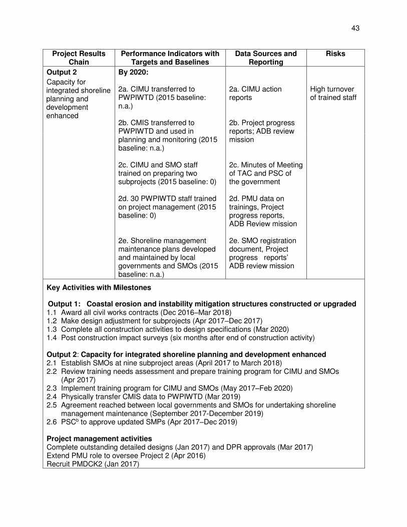
43
Project Results Chain
Performance Indicators with Targets and Baselines
Data Sources and Reporting
Risks
Output 2
Capacity for integrated shoreline planning and development enhanced
By 2020: 2a. CIMU transferred to PWPIWTD (2015 baseline: n.a.) 2b. CMIS transferred to PWPIWTD and used in planning and monitoring (2015 baseline: n.a.) 2c. CIMU and SMO staff trained on preparing two subprojects (2015 baseline: 0) 2d. 30 PWPIWTD staff trained on project management (2015 baseline: 0) 2e. Shoreline management maintenance plans developed and maintained by local governments and SMOs (2015 baseline: n.a.)
2a. CIMU action reports 2b. Project progress reports; ADB review mission 2c. Minutes of Meeting of TAC and PSC of the government 2d. PMU data on trainings, Project progress reports, ADB Review mission 2e. SMO registration document, Project progress reports’ ADB review mission
High turnover of trained staff
Key Activities with Milestones
Output 1: Coastal erosion and instability mitigation structures constructed or upgraded 1.1 Award all civil works contracts (Dec 2016–Mar 2018) 1.2 Make design adjustment for subprojects (Apr 2017–Dec 2017) 1.3 Complete all construction activities to design specifications (Mar 2020) 1.4 Post construction impact surveys (six months after end of construction activity) Output 2: Capacity for integrated shoreline planning and development enhanced 2.1 Establish SMOs at nine subproject areas (April 2017 to March 2018) 2.2 Review training needs assessment and prepare training program for CIMU and SMOs
(Apr 2017) 2.3 Implement training program for CIMU and SMOs (May 2017–Feb 2020) 2.4 Physically transfer CMIS data to PWPIWTD (Mar 2019) 2.5 Agreement reached between local governments and SMOs for undertaking shoreline
management maintenance (September 2017-December 2019) 2.6 PSCb to approve updated SMPs (Apr 2017–Dec 2019) Project management activities Complete outstanding detailed designs (Jan 2017) and DPR approvals (Mar 2017) Extend PMU role to oversee Project 2 (Apr 2016) Recruit PMDCK2 (Jan 2017)
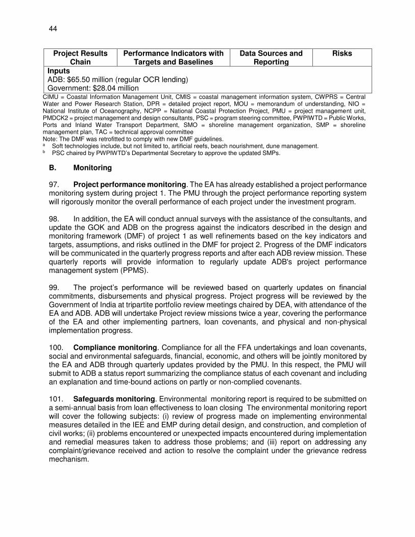
44
Project Results Chain
Performance Indicators with Targets and Baselines
Data Sources and Reporting
Risks
Inputs ADB: $65.50 million (regular OCR lending) Government: $28.04 million
CIMU = Coastal Information Management Unit, CMIS = coastal management information system, CWPRS = Central Water and Power Research Station, DPR = detailed project report, MOU = memorandum of understanding, NIO = National Institute of Oceanography, NCPP = National Coastal Protection Project, PMU = project management unit, PMDCK2 = project management and design consultants, PSC = program steering committee, PWPIWTD = Public Works, Ports and Inland Water Transport Department, SMO = shoreline management organization, SMP = shoreline management plan, TAC = technical approval committee Note: The DMF was retrofitted to comply with new DMF guidelines. a Soft technologies include, but not limited to, artificial reefs, beach nourishment, dune management. b PSC chaired by PWPIWTD’s Departmental Secretary to approve the updated SMPs.
B. Monitoring
97. Project performance monitoring. The EA has already established a project performance monitoring system during project 1. The PMU through the project performance reporting system will rigorously monitor the overall performance of each project under the investment program. 98. In addition, the EA will conduct annual surveys with the assistance of the consultants, and update the GOK and ADB on the progress against the indicators described in the design and monitoring framework (DMF) of project 1 as well refinements based on the key indicators and targets, assumptions, and risks outlined in the DMF for project 2. Progress of the DMF indicators will be communicated in the quarterly progress reports and after each ADB review mission. These quarterly reports will provide information to regularly update ADB's project performance management system (PPMS). 99. The project’s performance will be reviewed based on quarterly updates on financial commitments, disbursements and physical progress. Project progress will be reviewed by the Government of India at tripartite portfolio review meetings chaired by DEA, with attendance of the EA and ADB. ADB will undertake Project review missions twice a year, covering the performance of the EA and other implementing partners, loan covenants, and physical and non-physical implementation progress. 100. Compliance monitoring. Compliance for all the FFA undertakings and loan covenants, social and environmental safeguards, financial, economic, and others will be jointly monitored by the EA and ADB through quarterly updates provided by the PMU. In this respect, the PMU will submit to ADB a status report summarizing the compliance status of each covenant and including an explanation and time-bound actions on partly or non-complied covenants. 101. Safeguards monitoring. Environmental monitoring report is required to be submitted on a semi-annual basis from loan effectiveness to loan closing The environmental monitoring report will cover the following subjects: (i) review of progress made on implementing environmental measures detailed in the IEE and EMP during detail design, and construction, and completion of civil works; (ii) problems encountered or unexpected impacts encountered during implementation and remedial measures taken to address those problems; and (iii) report on addressing any complaint/grievance received and action to resolve the complaint under the grievance redress mechanism.
45
102. Gender and social dimensions monitoring will be monitored and reported through the Quarterly Project Progress Report. The report will cover the progress on women participation in all stages of project implementation. The sex segregation data on training participants and member of the SMOs and also membership of the executive body of SMOs will need to be included in the report. Minutes of SMO meetings will also be used as indicators to measure women’s participation and their interests in shoreline planning and management. The quantitative data and assessment on women’s participation in shoreline management will emerge from the minutes of meetings and attendance lists from training program. Quantitative data such as the number of women participating in micro-businesses in the coastal wards (tea vending, fish vending, nursery for green shields etc.) will be recorded and compared with the data prior to implementation of project 2. This assessment will initially be done jointly by the consultants, PMU and CIMU. Progress on these aspects will be reported as part of the Quarterly Project Progress Report. 103. The report on implementation of labor core standards that will be included in the quarterly project progress report will be based on the monthly reports submitted by contractors. The contractors will be required to submit monthly reports that cover: (i) number of employees and unskilled labor, age, sex, and salary; (ii) living conditions of their construction workers and construction camps with its facilities if any; (iii) health and safety facilities for the staff and construction workers; (iv) type and number of training conducted on health and safety including training on sexually transmitted diseases; and (v) other relevant information related with the implementation of Government labor Act and core labor standards. C. Evaluation
104. ADB will field an inception mission within 3 months after signing of the loan agreement for project 2. Review missions will be carried out on a semi-annual basis jointly by representatives of ADB and the EA. The review missions will assess the status of the project implementation including procurement, civil works, financing, compliance to environmental and social safeguards, and sustainability. A mid-term review mission will be carried out approximately 1.5 years after project 2 loan becomes effective. The mid-term review will evaluate compliance with the terms, conditions, and undertakings set out in the FFA, environmental and social safeguards, and loan covenants set out in the loan agreements. The review will allow for any necessary midcourse corrections to ensure successful implementation and achievement of the project objectives. Prior to the mid-term review the EA will send a comprehensive report on status and issues in advance of the mid-term review. Within 6 months of physical completion of the project, the EA will submit a project completion report to ADB.19 D. Reporting
105. The EA will provide ADB with (i) quarterly progress reports in a format consistent with ADB's project performance reporting system; (ii) consolidated annual reports including: (a) progress achieved by output as measured through the indicator's performance targets, (b) key implementation issues and solutions; (c) updated procurement plan and (d) updated implementation plan for next 12 months; and (iii) a project completion report within 6 months of physical completion of the Project. To ensure projects continue to be both viable and sustainable, project accounts and the EA audited financial statement, together with the associated auditor's report, should be adequately reviewed.
19 Project completion report format is available at: http://www.adb.org/Consulting/consultants-toolkits/PCR-Public-
Sector-Landscape.rar
46
106. The Project owner will establish a project performance monitoring system within 6 months from loan effectiveness and collect baseline data for performance monitoring. The key indicators and assumptions outlined at the impact and outcome levels in the investment program‘s design and monitoring framework will be the primary data required for analysis. E. Stakeholder Communication Strategy
107. The stakeholders communication strategy formulated as part of project 1 is ongoing and the activities under project 2 will continue to be directed at engagement and informing relevant stakeholders and sectors with timely, accurate, and comprehensive information. Such information sharing will help to build consensus and ensure continuous stakeholder support throughout project 2. The stakeholder engagement and communication strategy (SE&C) will increase stakeholder and community awareness of the project strategy, proposals activities and outputs in order to improve engagement and to develop greater community support for the project proposals and the decision making process.
X. ANTICORRUPTION POLICY
108. ADB reserves the right to investigate, directly or through its agents, any violations of the Anticorruption Policy relating to the project.20 All contracts financed by ADB shall include provisions specifying the right of ADB to audit and examine the records and accounts of the EA and all project contractors, suppliers, consultants, and other service providers. Individuals and/or entities on ADB’s anticorruption debarment list are ineligible to participate in ADB-financed activity and may not be awarded any contracts under the project.21 109. To support these efforts, relevant provisions of ADB’s Anticorruption Policy are included in the Loan Regulations, loan agreement and the bidding documents for the project. In particular, all contracts financed by ADB shall include provisions specifying the right of ADB's representatives to carry out random spot checks on the work in progress and utilization of funds for the project and examine the records and accounts of the EA, and all contractors, suppliers, consultants, and other service providers as they relate to the project. Individuals/entities on ADB’s anticorruption debarment list are ineligible to participate in ADB-financed activity and may not be awarded any contracts under the project.
110. ADB's Anticorruption Policy designates the Office of Anticorruption and Integrity (OAI) as the point of contact to report allegations of fraud or corruption among ADB-financed projects or its staff. OAI is responsible for all matters related to allegations of fraud and corruption. For a more detailed explanation refer to the Anticorruption Policy and Procedures. Anyone coming across evidence of corruption associated with the project may contact the Anticorruption Unit by telephone, facsimile, mail, or email at the following numbers/addresses:
(i) by email at [email protected] or [email protected] (ii) by phone at +63 2 632 5004 (iii) by fax to+6326362152 (iv) by mail at the following address (Please mark correspondence Strictly Confidential):
Office of Anticorruption and Integrity Asian Development Bank
20 Anticorruption Policy: http://www.adb.org/Documents/Policies/Anticorruption-Integrity/Policies-Strategies.pdf 21 ADB's Integrity Office web site: http://www.adb.org/integrity/unit.asp
47
6 ADB Avenue Mandaluyong City 1550 Metro Manila, Philippines
XI. ACCOUNTABILITY MECHANISM
111. People who are, or may in the future be, adversely affected by the project may submit complaints to ADB’s Accountability Mechanism. The Accountability Mechanism provides an independent forum and process whereby people adversely affected by ADB-assisted projects can voice, and seek a resolution of their problems, as well as report alleged violations of ADB’s operational policies and procedures. Before submitting a complaint to the Accountability Mechanism, affected people should make a good faith effort to solve their problems by working with the concerned ADB operations department. Only after doing that, and if they are still dissatisfied, should they approach the Accountability Mechanism.22
XII. RECORD OF CHANGES TO THE PROJECT ADMINISTRATION MANUAL
112. All revisions/updates during course of implementation should be retained in this Section to provide a chronological history of changes to implemented arrangements recorded in the PAM.
PAM Version Created Date Revision Date Reasons of Main Contents
Change of Change
22 For further information, see http://www.adb.org/Accountability-Mechanism/default.asp
48 Appendix 1
APPENDIX 1: TERMS OF REFERENCE FOR THE PROJECT MANAGEMENT AND DESIGN CONSULTANT
(PROJECT 2)
I. INTRODUCTION
A. Background
1. India has a coastline of 7,525 kilometers (km)—5,425 km along the nine national coastal states of the mainland and 2,100 km in the union territories. About 20%–25% of its population lives within 50 km of the coast, with 70% of them residing in rural areas. All the coastal states and territories are affected by coastal erosion. 2. Karnataka has a coastline of about 300 km, of which about 250 km (83%) is affected by erosion to some degree. The rise in sea levels and the likely increased frequency and intensity of storms will aggravate the erosion, with serious economic and environmental consequences for coastal states. Sea level rise is projected to be in the range of about 0.3m in the Indian subcontinent by the middle of the century; a projected rise of 1 meter in sea level by the end of the century could displace 7.1 million people in India, with a loss of 5,764 square km of land and 4,200 km of roads. Since specific sea level rise estimates are not available, the India estimate is assumed to be applicable to Karnataka. The coastal environment is of major importance to the country’s major economic and production sectors that include fisheries, agriculture, tourism, ports and maritime shipping, other major transport and communication sectors and their related infrastructures. Effective and sustainable management of the shoreline is vital to economic and social development with great bearing on the economic sustenance and sustainable livelihoods of a large sector of the population living in coastal areas. 3. Coastal erosion is caused by both natural (local shoreline curvature and geomorphology; inlet dynamics, change in Wave climate; Sea Level Rise and change in storm patterns and currents) and anthropogenic (fishing jetties, including dams, riverbed quarrying, harbors, and inlet stabilization) effects. In India, numerous examples demonstrate how human activities have contributed to or have directly caused coastal erosion. These include change in sediment supply through dredging, river damming, and sand mining or the construction of littoral barriers such as groynes, jetties, and ports. Beach scour can be caused by poorly planned seawall construction and loss of vegetation on the shoreline affects erosion rates. Sediment traps (such as dredged navigational channels) and alteration to wave processes caused by jetties and ports also play a role.
4. Coastal erosion in Karnataka is responsible for loss of land, houses, infrastructure, and business opportunities; and poses a high risk to human well-being, economic development, and ecological integrity. The impact will be much more extensive and widespread in the coming years, as the coastline is increasingly subject to a wide range of economic developments, many of which create conflicts and pressures on the already disturbed natural coastal environments. The rural poor coastal communities are the most vulnerable to the impacts of erosion and weak coastal management.
5. Threats and constrains to coastal ecosystems Despite their tremendous ecological and economic importance, India’s coastal ecosystems are under increasing threat. There are numerous direct and indirect pressures arising from different types of economic development across the country. It is clear that the cumulative impacts of the pressures on the coastal
Appendix 1 49
ecosystems are intensifying as a result of India’s economic and population growth. Coastal communities are affected through erosion and other impacts, as the drivers of change, degradation or loss of coastal ecosystems and services are mainly anthropogenic. The added threat of climate change adds to this degradation. The deterioration of coastal habitats affects the well-being of all people in many ways that cannot be measured in economic terms. The coastal wetlands of India play an extremely valuable ecological role; these include areas of tidal mudflats (23,620 sq. km) and mangroves (4,870 sq. km). Coastal wetlands such as these are considered to be amongst the most productive ecosystems and play a significant role in the ecological and economic sustainability of a region. 6. Disturbances to the beaches and coastal wetlands from anthropogenic and climate change impacts can be very significant. One of the best known and most widely applied modeling of this process is offered by Brunn (1962) The ‘Brunn Rule’ suggests that shoreline recession is in the range of 50 to 200 times the rise in relative sea level estimated to be around 0.3m by mid-century; this recession is caused by a beach’s desire to maintain an equilibrium beach profile. Changes in the predominant wave direction can cause instabilities in beaches.
7. Sea level rise and increased wave action will affect mangroves which form the main natural protection where the correct salinities exist. Although the mangrove is tolerant to changes in sea levels and salinities it is likely that mangrove will be most vulnerable at the margins, especially in areas of high energy erosion prone shorelines including areas of revetment where sediment removal and natural recruitment no longer occurs and where conventional planting methods become ineffective. Changes in the coastal hydrodynamics from sea level rise or changes in predominant wave direction can potentially cause shifts in the mudflats with potentially significant loss of mangrove in affected areas.
8. Coastal infrastructure is currently designed based on historic sea levels and wave regimes, with an estimated design life of 50–100 years. Infrastructure projects will become increasingly vulnerable to damage unless appropriate measures of climate resilience are incorporated.
9. Development coordination. There has been limited external assistance for coastal protection and management in India. Nearly all investment funding has been from the states, central government, and the private sector. The lack of external assistance has resulted in a lack of exposure to new ideas and practices. The project will maintain linkages with the MOEFCC Integrated Coastal Zone Management Project being implemented by MOEFCC with World Bank support. The project includes; (i) a national component which comprises mapping, delineation and demarcation of the hazard lines and delineation of coastal sediment cells all along the mainland coast of India (undertaken by the Survey of India); (ii) mapping, delineation and demarcation of Environmentally Sensitive Areas (ESA); (iii) capacity building of the MOEFCC and the State Coastal Zone Management Authorities; (iv) a nation-wide training program for coastal zone management; and (v) Setting up of a National Centre for Sustainable Coastal Management (NCSCM) at the Anna University, Chennai. At state level the project is working in three states Gujarat, Orissa and West Bengal, activities include ICZM planning, coastal management and investment projects. 10. In September 2010, Asian Development Bank (ADB) approved a multitranche financing Facility (MFF) for $ 250 million from the OCR for the two coastal states of Maharashtra and Karnataka for Sustainable Coastal Protection and Management Investment Program (SCPMIP). The FFA was signed in 2011. The Sustainable Coastal Protection and Management Investment Program (SCPMIP) is an investment program supported by an ADB loan which is designed to

50 Appendix 1
address immediate coastal protection needs and coastal instability using environmentally and socially appropriate solutions in the states of Karnataka, and Maharashtra. It will also develop institutional capacities to meet the long-term needs of sustainable coastal protection and management, and support initiatives to increase the participation of the private sector and communities in coastal protection and management.
11. TA No. 8652: Climate-Resilient Coastal Protection and Management Project - Climate-Resilient Coastal Protection and Management Project (CRCPMP) is being implemented through ADB and financed by the Global Environmental Facility (GEF). The TA objectives are to strengthen the resilience of the Indian coast, coastal infrastructure and communities to the adverse impacts of climate change through agreed strategies, and effective mainstreaming of climate change considerations into coastal protection and management. The CRCPMP will work very closely with the SCPMIP in Karnataka and Maharashtra with the specific objectives of (i) assessing the impacts of climate change on the coast of India; (ii) preparing guidelines for adaptation measures to ensure climate resilience in coastal protection and coastal infrastructure; (iii) provide specific recommendations for climate change adaptation for shoreline planning and design of subprojects for the two focal states of Maharashtra and Karnataka based on the above guidelines; and (iv) provide training to coastal states including training of trainers in the adaptation guidelines. 12. In Karnataka SCPMIP implementation started in 2012. Tranche 1 of the program is currently under way. The duration of the Project Management and Design Consultants (PMDC) employed for Tranche 1 by the EA is scheduled to end by May 2016.
13. Project 2, the second and final phase of the project, is scheduled to be completed by 1st December 2019 starting from September 2016 under the name: India Sustainable Coastal Protection and Management Project 2 Karnataka (SCPMP2).
II. THE PROJECT
A. Introduction
14. The project will have two key outputs: (i) coastal erosion and instability reduced; (ii) capacity for integrated shoreline planning and development enhanced. 15. The Tranche 1 subproject is currently in progress at Ullal. This ongoing subproject comprises of four components: (a) sand-filled geotextile groynes (inshore berms) at four locations along the Ullal spit (b) two offshore reefs at -7 mCD depth contour and (c) rehabilitation of North and South Breakwaters of Old Mangalore Port. The fourth component under this subproject is beach nourishment along the Ullal shoreline.
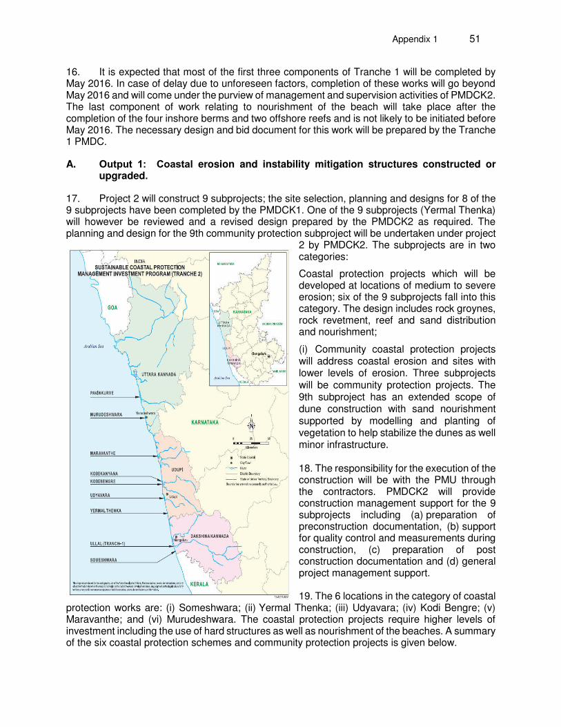
Appendix 1 51
16. It is expected that most of the first three components of Tranche 1 will be completed by May 2016. In case of delay due to unforeseen factors, completion of these works will go beyond May 2016 and will come under the purview of management and supervision activities of PMDCK2. The last component of work relating to nourishment of the beach will take place after the completion of the four inshore berms and two offshore reefs and is not likely to be initiated before May 2016. The necessary design and bid document for this work will be prepared by the Tranche 1 PMDC.
A. Output 1: Coastal erosion and instability mitigation structures constructed or upgraded.
17. Project 2 will construct 9 subprojects; the site selection, planning and designs for 8 of the 9 subprojects have been completed by the PMDCK1. One of the 9 subprojects (Yermal Thenka) will however be reviewed and a revised design prepared by the PMDCK2 as required. The planning and design for the 9th community protection subproject will be undertaken under project
2 by PMDCK2. The subprojects are in two categories:
Coastal protection projects which will be developed at locations of medium to severe erosion; six of the 9 subprojects fall into this category. The design includes rock groynes, rock revetment, reef and sand distribution and nourishment;
(i) Community coastal protection projects will address coastal erosion and sites with lower levels of erosion. Three subprojects will be community protection projects. The 9th subproject has an extended scope of dune construction with sand nourishment supported by modelling and planting of vegetation to help stabilize the dunes as well minor infrastructure. 18. The responsibility for the execution of the construction will be with the PMU through the contractors. PMDCK2 will provide construction management support for the 9 subprojects including (a) preparation of preconstruction documentation, (b) support for quality control and measurements during construction, (c) preparation of post construction documentation and (d) general project management support. 19. The 6 locations in the category of coastal
protection works are: (i) Someshwara; (ii) Yermal Thenka; (iii) Udyavara; (iv) Kodi Bengre; (v) Maravanthe; and (vi) Murudeshwara. The coastal protection projects require higher levels of investment including the use of hard structures as well as nourishment of the beaches. A summary of the six coastal protection schemes and community protection projects is given below.
52 Appendix 1
(i) Someshwara: The project site is located in Dakshina Kannada district, south of Mangalore. The proposed coastal protection scheme at the Someshwara site is a revetment using geotextile containers filled with sand, for a length of about 2kms. The proposed scheme provides protection to the communities and infrastructure adjacent to the shoreline. The estimated cost of the proposed scheme at Someshwara is $ 4.7 million.
(ii) Yermal Thenka: The project site is located in Udupi district. The proposed coastal protection scheme at Yermal Thenka is to rehabilitate the existing rock revetment for a length of 3.8kms and constructing new rock revetment for a length of 700m using large size armor rocks. The proposed scheme provides protection to the existing fisheries road running parallel to the shoreline for a length of 4km, agricultural property, land and houses from erosion. The total estimated cost of the proposed scheme at Yermal Thenka is $11.6 million. Yermal Thenka is a potentially valuable tourist beach and there is also need to allow continued traditional beach seine fishing and allow facilities for fishing boats to land and be stored in the beach area. Although reconstruction of revetment was selected the lowest cost option and would meet the key needs of protection of communities and road it was considered that alternative options should be considered that would potentially provide improved sand retention and support for beach enhancement. The design for Yermal Thenka will be reviewed by the project 2 consultants and if necessary a revised design will be prepared. Close consultation with the communities will be continued to further review the options and develop the most appropriate strategy and design for sustainable and environmentally appropriated protection at Yermal Thenka. Yermal Thenka will remain as a subproject for the project 2 investment; the design will be reviewed and revised as necessary.
(iii) Udyavara: The project site is located in Udupi district. The project site is a long narrow spit, surrounded by sea on the west and river on the east. A 9 km fisheries road, which runs along the spit that connects Malpe fishing harbour to the nearby villages, is under constant threat from erosion. The proposed coastal protection scheme at Udyavara includes protecting a shoreline length of 5km by providing 35 numbers of shore normal rock groynes spaced at an interval of 120m and nourishing the beach with a total volume 720,000m3 of sand. The total estimated cost of the proposed scheme at Udyavara is $14.6 million.
(iv) Kodi Bengre: The project site is located in Udupi district. The project site is a long narrow spit, surrounded by sea on the west and river on the east. The spit, which is densely populated, is under constant threat from erosion and wave flooding. The proposed coastal protection scheme at Kodi Bengre is to rehabilitate the existing rock revetment and constructing new rock revetment over a length of 4.5kms. The total estimated cost of the proposed scheme at Kodi Bengre is $11.1 million
(v) Maravanthe: The project site is located in Udupi district. Maravanthe project site is surrounded by Arabian Sea on the west and Souparnika river on the east forming a narrow isthmus on which the National Highway 66 (NH-66) running that, connects Mumbai in the north to Kochi in Kerala towards the south. The proposed scheme involves protecting a shoreline length of 3.5kms through establishing 15 shore normal groynes on the south and northern ends of the project site and 9 T-groynes at the middle section where National Highway -66 runs close to the sea and river. Sand redistribution is proposed to enhance the beach width at critical
Appendix 1 53
sections. The total estimated cost of the proposed scheme at Maravanthe is $ 13.5 million.
(vi) Murudeshwara: The project site is located in Uttara Kannada district. Murudeshwara is one of the prime tourist destinations within Karnataka state. The shore protection scheme here is a combination of offshore reef, sand nourishment of 900,00m3 and dune stabilization by vetiver grass on the northern stretch of 1.5 Km. The main rational of this scheme is to protect the beach located on the leeside of the reef by reducing the wave energy, increasing the beach width by sand nourishment. The total estimated cost of the proposed scheme at Murudeshwara is $ 3.9 million.
(vii) Community Protection Subprojects. Two community subprojects at Kodi Kanyana and Pavinakurve have been planned and designed under project 1 and will be implemented in 2016/2017.
Kodi Kanyana: The project site is located in Udupi district. Three-layered vegetation planting scheme along a 1.5km stretch is proposed in order to reduce wave rush into the cultivable lands located behind the proposed site and also to hold the beach. This scheme is proposed to protect a length of 1.5km stretch. Implementation and maintenance of this scheme is proposed to be carried out by involving local community. The total estimated cost of the proposed scheme at Kodi Kanyana is $ 0.14 million.
Pavinakurve: The project site is located in Uttara Kannada district. The project area is divided into three sectors, where a plantation scheme is proposed with a combination of different species of plants. This scheme is proposed to protect a 1.5km stretch. Implementation and maintenance of this scheme is proposed to be carried out by involving local communities. The total estimated cost of the proposed scheme at Pavinakurve is $ 0.15 million.
(viii) (Design adjustments of the subprojects will be prepared immediately prior to construction to incorporate the actual beach profiles of the subprojects at the time of construction. Post construction surveys of the subprojects will be implemented to assess the changes in the beach profiles after the completion of the works. A third community protection subproject will be planned and designed by the PMDCK2 with implementation proposed for 2017/2018. This third community subproject is aimed at addressing the issues of sand deficit currently on many of the Karnataka beaches; a problem that will likely be exacerbated by climate change. The subproject will investigate and develop methodologies to pump sand from the sea bed in the near-shore in waters of depth less than 20 m to support the reconstruction of the dunes.
20. The third community protection subproject will involve dune construction with a nourishment of about 800,000 m3 of sand and planting on the dunes for an area of 180 ha. This will cover approximately 20 to 30km of shoreline. Minor infrastructure facilities in the form of access, water drainage and small geo-textile bags for additional protection will be provided wherever appropriate. The potential sites will be identified and the designs will be finalized by the project 2 consultants. The stage 2 community protection subproject will incorporate the design guidelines for climate change resilience to be prepared by the CRCPMP project and will conduct numerical modeling of the impacts of the selected beaches under climate change. The potential sand resources in the near shore along the Karnataka coast will be assessed based on a major
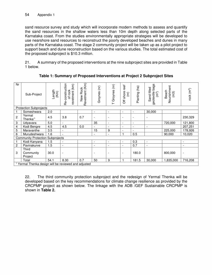
54 Appendix 1
sand resource survey and study which will incorporate modern methods to assess and quantify the sand resources in the shallow waters less than 10m depth along selected parts of the Karnataka coast. From the studies environmentally appropriate strategies will be developed to use nearshore sand resources to reconstruct the poorly developed beaches and dunes in many parts of the Karnataka coast. The stage 2 community project will be taken up as a pilot project to support beach and dune reconstruction based on the various studies. The total estimated cost of the proposed subproject is $10.3 million. 21. A summary of the proposed interventions at the nine subproject sites are provided in Table 1 below.
Table 1: Summary of Proposed Interventions at Project 2 Subproject Sites
Nr
Sub-Project L
en
gth
(K
m)
Re
-co
nstr
uction
o
f ro
ck
reve
tme
nt
(km
)
New
Ro
ck
Reve
tme
nt
(Km
)
Gro
yn
es (
nr)
T G
royn
es (
nr)
Off
sh
ore
re
ef
(nr)
Pla
ntin
g (
ha
)
Sa
nd
fill
ed
g
eo
textil
e b
ag
s (m
3)
Be
ach
N
ou
rish
men
t (m
3)
rock (
m3)
Protection Subprojects 1 Someshwara 2.0 - - - - 30,000
2 Yermal Thenka/1
4.5 3.8 0.7 - - - - - 230,329
3 Udyavara 5.0 - 35 - - - 720,000 121,800 4 Kodi Bengre 4.5 4.5 0.0 - - - - - 207,251 5 Maravanthe 3.5 - 15 9 - - 225,000 178,926 6 Murudeshwara 1.6 - - - 1 0.5 90,000 10,020 Community Protection Subprojects 1 Kodi Kanyana 1.5 - - - - 0.3 - - 2 Pavinakurve 1.5 - - - - 0.7 - -
3 Third Community Project
30.0 - - - - 180.0 800,000 -
Total 54.1 8.30 0.7 50 9 1 181.5 30,000 1,835,000 716,208 1 Yermal Thenka design will be reviewed and adjusted
22. The third community protection subproject and the redesign of Yermal Thenka will be developed based on the key recommendations for climate change resilience as provided by the CRCPMP project as shown below. The linkage with the ADB /GEF Sustainable CRCPMP is shown in Table 2.
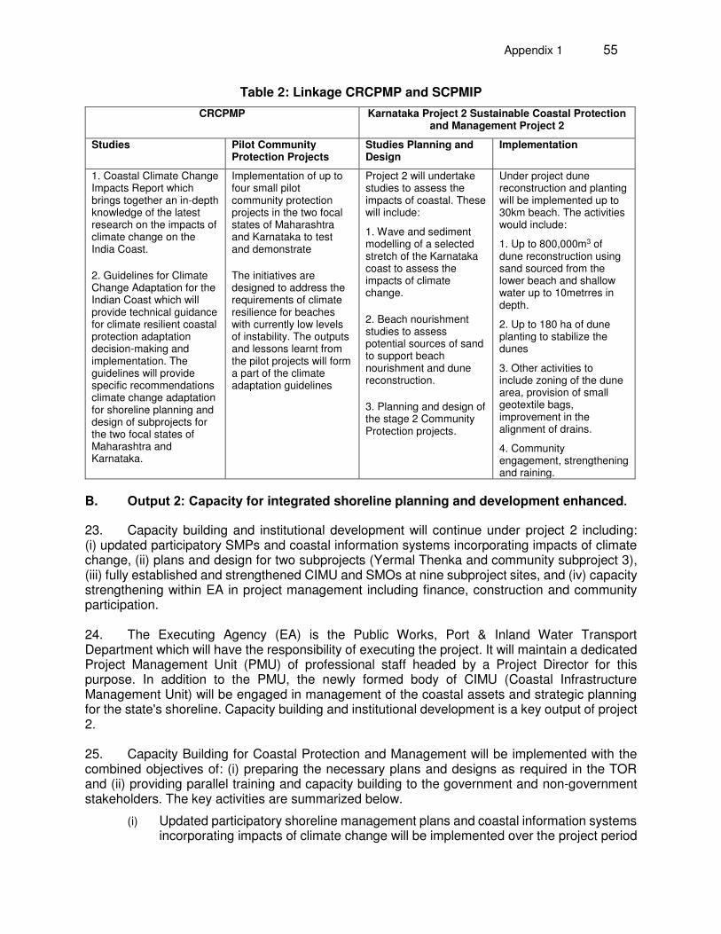
Appendix 1 55
Table 2: Linkage CRCPMP and SCPMIP
CRCPMP Karnataka Project 2 Sustainable Coastal Protection and Management Project 2
Studies Pilot Community Protection Projects
Studies Planning and Design
Implementation
1. Coastal Climate Change Impacts Report which brings together an in-depth knowledge of the latest research on the impacts of climate change on the India Coast.
2. Guidelines for Climate Change Adaptation for the Indian Coast which will provide technical guidance for climate resilient coastal protection adaptation decision-making and implementation. The guidelines will provide specific recommendations climate change adaptation for shoreline planning and design of subprojects for the two focal states of Maharashtra and Karnataka.
Implementation of up to four small pilot community protection projects in the two focal states of Maharashtra and Karnataka to test and demonstrate
The initiatives are designed to address the requirements of climate resilience for beaches with currently low levels of instability. The outputs and lessons learnt from the pilot projects will form a part of the climate adaptation guidelines
Project 2 will undertake studies to assess the impacts of coastal. These will include:
1. Wave and sediment modelling of a selected stretch of the Karnataka coast to assess the impacts of climate change.
2. Beach nourishment studies to assess potential sources of sand to support beach nourishment and dune reconstruction.
3. Planning and design of the stage 2 Community Protection projects.
Under project dune reconstruction and planting will be implemented up to 30km beach. The activities would include:
1. Up to 800,000m3 of dune reconstruction using sand sourced from the lower beach and shallow water up to 10metrres in depth.
2. Up to 180 ha of dune planting to stabilize the dunes
3. Other activities to include zoning of the dune area, provision of small geotextile bags, improvement in the alignment of drains.
4. Community engagement, strengthening and raining.
B. Output 2: Capacity for integrated shoreline planning and development enhanced.
23. Capacity building and institutional development will continue under project 2 including: (i) updated participatory SMPs and coastal information systems incorporating impacts of climate change, (ii) plans and design for two subprojects (Yermal Thenka and community subproject 3), (iii) fully established and strengthened CIMU and SMOs at nine subproject sites, and (iv) capacity strengthening within EA in project management including finance, construction and community participation. 24. The Executing Agency (EA) is the Public Works, Port & Inland Water Transport Department which will have the responsibility of executing the project. It will maintain a dedicated Project Management Unit (PMU) of professional staff headed by a Project Director for this purpose. In addition to the PMU, the newly formed body of CIMU (Coastal Infrastructure Management Unit) will be engaged in management of the coastal assets and strategic planning for the state's shoreline. Capacity building and institutional development is a key output of project 2. 25. Capacity Building for Coastal Protection and Management will be implemented with the combined objectives of: (i) preparing the necessary plans and designs as required in the TOR and (ii) providing parallel training and capacity building to the government and non-government stakeholders. The key activities are summarized below.
(i) Updated participatory shoreline management plans and coastal information systems incorporating impacts of climate change will be implemented over the project period
56 Appendix 1
to provide a comprehensive information on the shorelines including assessments of the impacts of climate change.
(ii) Preparation of plans and designs for 2 subprojects (Yermal Thenka and community subproject number 3). The planning and design will include near shore sand resource surveys which will assess the potential to provide supplementary sand on selected beaches with sand deficits. The outputs of the study will be applied to assess sand resources and availability and scope to restore the deficit of sand on selected beaches through beach nourishment and dune reconstruction. The findings of the study will also form a key addition to the shoreline management plans. Numerical modeling will be carried out on selected section beaches to assess the impacts of climate change and to support the outstanding design of two subprojects.
(iii) Fully established and strengthened Coastal Infrastructure Management Unit (CIMU) and Shoreline Management Organizations (SMO) at nine subproject sites. The CIMU will be the hub for long term sustainable planning and management of the coastline, which has been established as a structural cell within the Department of ports. Through the CIMU project 2 would support long term institutional strengthening and awareness of the key stakeholders including the EA staff, district level organizations, district collectors, and district planning committees, Zilla Panchayats, Urban Local Bodies and Gram Panchayats. It is proposed that the development of the CIMU would be in two stages; (a) during the initial 24 months of Project CIMU (June 2016 to May 2018) would be the establishment stage. During this project period the CIMU would be headed by a joint director within the auspices of the PMU under the over direction of the Project Director. The PMDCK2 would provide advisory guidance and support for the establishment of the CIMU. Selected staff from the EA would seconded to work within the CIMU; (b)after 24 months the responsibility for the CIMU would be transferred to the Director Ports and Harbours based in Karwar. The PMDCK2 would continue to provide support to the CIMU until the end of the project in mid-2019. It is proposed that the CIMU would form a third wing within the EA alongside the ports and inland transport wings. The CIMU would focus on the long term activities on coastal planning and management that would continue after the end of the project period in mid-2019; these would include: (i) ensuring effective coordination between the various agencies and stakeholders involved in coastal infrastructure; (ii) working with the State Ministry of Environment and the CRZA to support the development of long term sustainability of the coast and shorelines with special attention to ensure the natural coastal processes and sand movements are maintained with minimal disruption by coastal infrastructure investments; (iii) manage the CMIS being established under the SCPMIP, the ADB/GEF supported CRCPPMP project as well as the national information systems being developed by the MOWR and MOEFCC; (iv) support the establishment and training of the SMOs to be established at each subproject site; on a long-term time frame, CIMU will stimulate the successful functioning of SMOs and ensure their sustainability; (v) Implement the shoreline management tasks as set out in the Shoreline Management Plans; these will be undertaken by involving district administration, local bodies as stakeholders; and (vi) during the SCPMIP project period as well as beyond the project period to support the development and implementation of policies of sustainable coastal protection.
(iv) Strengthening of capacities within the EA in project management including finance, construction and community participation would be provided by on the job training and support as well as some formal training courses.
Appendix 1 57
III. THE CONSULTANCY
26. The PMDCK2 Consultancy will be implemented over three years and will be in two parts as below:
Part 1 Project Management and Design Part 2 Supporting Services which will include: (i) sand resource surveys; (ii) shoreline
surveys; (iii) environmental monitoring; and (iv) training delivery.
IV. PART 1: PROJECT MANAGEMENT AND DESIGN
A. Objectives
27. The four main objectives of Part 1 include:
(i) Project Management – provide overall planning, coordination and management of the various components of the project, coordination and management of the consultants' activities and ensure appropriately timed mutual feedback with the PMU.
(ii) Planning and Design – develop Sustainable Plans and Management of the Shorelines. Shoreline management plans and information systems will be strengthened and updated including the impacts of climate change. Planning and design of two subprojects
(iii) Construction Management Support - provide construction management support for the finalization of Tranche 1 subprojects and nine subprojects planned for implementation during project 2.
(iv) Institutional Strengthening – Undertake activities towards strengthening of CIMU and other state institutions for effective planning and management of the coastline.
28. The role of the Consultant will be to provide roadmaps for project management identify critical issues and suggest remedial measures for progress of the project, technical advice, undertake required planning and design, activities for institutional strengthening and provide construction management services. 29. The project performance will depend on the consultants' planning and timely response together with the performance of the PMU, the contractors and the field situations. It is therefore imperative that the consultants develop a good understanding of the site conditions and effective interactions with the PMU, the CIMU and the Contractors rapidly after their mobilization.
30. Services of the PMDCK2 are expected to start latest from June 2016. The period for consulting services shall be 36 months.
31. The scope of consultancy services is described in the following paragraphs for the four main categories: Project Management, Sustainable Shoreline Planning and Design, Construction management and Institutional Strengthening.
58 Appendix 1
B. Project Management
32. The Consultants will assist with the overall project coordination and management through the relevant agencies at national, state, district and panchayat levels. The Consultants will work closely with the State Project Management Units (PMU) to ensure the effective and timely delivery of the project outputs. The consultant will maintain liaison with the central government through CWC and MOWR. These will include:
(i) Working with the State Executing Agencies and State Project Management Units to identify the project management needs, planning, strategies and schedules for execution.
(ii) Provide support to the National Steering Committee, State steering committees and District Planning Councils to effectively guide the project implementation.
(iii) Detailing and development of the projects strategy to implement sustainable coastal protection and management through participative and integrated planning and management.
(iv) Ensuring the implementation schedules reflect the envisaged integrated approach with phasing of all the interrelated activities.
(v) Identifying the critical paths of project activities; critical activities include the implementation of the subprojects, completion of shoreline management plans, subprojects selections, subproject feasibility studies, detailed designs and preparation of the training plan.
(vi) Assisting with all project tasks, giving special attention to items on the critical path, and ensure these are given particular attention. Assisting with project administration, performance and monitoring and preparation of project reports and tender documents. As part of the project management role, the consultants will upgrade and transfer to the PMU the PPMS. This will help the EA and the PMU to monitor and evaluate implementation of the project, identify performance constraints and formulate and implement practical measures to address shortcomings. Annual performance evaluations will be conducted based on assessment of the projects. Outputs of the PPMS will be supplied to the Project Steering Committees and ADB. A basic reporting framework has been prepared by the Tranche 1 consultants.
C. Sustainable Shoreline Planning and Design
(i) Planning and design of the 2nd community protection project. The project investments have been based on 9 subproject sites consisting of the 6 protection subprojects and 2 community protection projects with a third community protection project proposed for the beaches with low erosion to help provide improved resilience to climate change which are estimated by the CRCPMP project to be quite significant. This subproject would include dune construction, planting and other minor infrastructure facilities such as access to the beach, water drainage through the dune and geotextile bag protection. The location and number of sites would be planned and designed by the PMDCK2 during 2016 with an environmental impact assessment (EIA) and DPR and tender documents to be prepared and approved in 2017. This additional project would be an opportunity to cement the linkage and strengthen climate change resilience under the loan investment. Further it provides an opportunity to provide strong innovation into the T2 investments. The
Appendix 1 59
Central Water Power Research Station will also have a complementary role in the design by way of necessary physical modelling and other design inputs.
(ii) Near shore sand mapping and resource surveys along part of the Karnataka coast. To address the deficit of sand, seabed survey for sand resource mapping is provisioned. For this purpose, the consultants will define the exact survey areas for the sand resource. The consultants will undertake a desk study and compile available information about sea-bed features offshore of Karnataka coastline. The exact survey areas will depend on the proximity to the locations identified for the second stage community protection subproject and the potential for sand availability. Outcomes of these surveys will feed into planning and design of the dune construction activity.
(iii) Primary role in this regard will be to: (a) define the survey areas (b) fine tune the BoQ items for sand resource mapping and (c) direct the survey outputs to the project 2 design and the CMIS. Project 1 PMDC (PMDCK1) has designed 8 subprojects for project 2, the 9th subproject relating to community protection will be undertaken during project 2. Beach topography used for these designs is based on the survey conducted during May-June of 2013 and December2014-January2015. The tender documents for the project 2 subprojects to be implemented include pre-implementation survey of the topography and bathymetry at the project sites to be undertaken by the contractors. These survey results will reflect the actual topographic and bathymetric conditions at the sites immediately before implementation.
The actual site conditions may necessitate minor adjustments to the levels and positions of the coastal structures in the tender design drawings.
PMDCK2 will also consider the results and guidelines of the climate change impact study by CRCPMP and evaluate modifications that may be necessary in addition to the climate change parameters that have been already incorporated by PMDCK1. These changes need to be incorporated to the good-for-construction drawings.
(iv) Review and Re-Design of subproject Yermal Thenka.
The present proposal of the shore protection scheme at Yermal Thenka consists of rehabilitation of an existing rock revetment and approximately 700m of new revetment. This scheme was proposed keeping in mind the community constraints. Options to replace the 700m of new revetment by softer solutions were discussed. It should be noted that this 700m is not in one piece, but consists of 4 pieces interspersed between rock revetments. This makes it more difficult for effective alternative, softer schemes to be designed in short segment-wise manner. It is decided that the design of this subproject will be reviewed again by the project 2 consultants with particular emphasis on the community concerns and utilization of tourism/ beach recreation potential. As required the subproject will be redesigned and a new bid document for this subproject, incorporating the changes following the design review, will be prepared in Q1 2017.
(v) Analysis and interpretation of the shoreline behavior from the six monthly topographic surveys of the SMP units.
First set of draft 'Shoreline Management Plans' have been developed for the three coastal districts of Karnataka. Provision is made for six-monthly topographic survey at all the SMP units from South to North of the state. Apart from this, six-monthly
60 Appendix 1
topographic and environmental surveys provisioned for the nine project 2 subprojects. The consultants will (a) prepare the documents for commissioning the surveys on behalf of the PMU, (b) analyze and compile the survey data and (c) upgrade the CMIS with the data. The consultants will report this work after each six-monthly survey.
(vi) Update SMPs based on CRCPMP assessments and guidelines
The CRCPMP project is expected to deliver country-specific guidelines of the potential impacts of climate change on the Indian coastline. PMDCK2 will use this data and the available topographic survey data of the SMP units to prepare data and procedure to update the Shoreline Management Plans. The CIMU should be a proactive partner in this process and build up the capability to execute successive upgradation of the Shoreline Management Plans.
33. The split of the tasks required from the Part 1 Project Management and Design and the Part 2 supporting are summarized below.
Table 3: Split of Tasks
Activity PMDCK2 Part 1 Project Management and Design
PMDCK2 Part 2 Supporting Services
Planning of 3rd Community Protection Subproject (CP3) Redesign of Yermal Thenka Subproject
Planning and Design, Numerical modeling
Topographic and bathymetric Surveys
Near shore sand mapping and resources surveys
Preliminary assessment of optimum areas for sand abstraction based on existing geotechnical data.
Definition of exact survey areas, fine tuning of BoQ items and streamlining outputs for design and publication in CMIS
Underwater surveys in the near shore including geophysical assessment, sub bed sand sampling
Updating of shoreline management plans
Updating the shoreline management plans
Surveys of beaches
D. Construction Management Support of Subproject Implementation
34. Construction Management support will be provided for the finalization of project 1 subproject and the nine subprojects under project 2. Specific activities include:
1. Bid Evaluation and Contract Award for the Subprojects:
35. It is expected that contractor selection and contract award will be completed for four sites (Udyavara, Maravanthe, Kodi kanyana and Pavinakurve) by September 2016 with the support of PMDCK1. The tender documents for three other subprojects (Someshwara, Kodi Bengre, and Murudeshwar) will be prepared by the PMDCK1, and the invitation for bids will be floated in early 2017. 36. The responsibility of the project 2 consultants includes evaluation and recommendation on the technical and price bids of these three remaining subprojects (Someshwara, Kodi Bengre,
Appendix 1 61
and Murudeshwar). They will also support the bidding and contract award process for the beach nourishment project at Ullal for which the bid document will have been prepared.
37. The design of Yermal Thenka has been prepared but it has been agreed that the design will be reviewed in 2016 and the revised design tendered in early 2017.
38. In addition, the project 2 consultants will undertake the tender document preparation and support the contract award process for the 9th subproject which is the 3rd Community project.
2. Pre-construction
39. During pre-construction stage of the construction works the Consultants will undertake:
(i) Review the mobilization plan, work methodology and pre-construction survey plan, (ii) Recommend on the necessary statutory clearances/certifications (iii) Carry out design adjustments and provide Good-For-Construction (GFC) drawing
after receiving the survey data of the area (iv) Dissemination of subproject information to the community. (v) Review the construction scheduling plan of the contractor (vi) Prepare a Quality Assurance and Quality Control plan for the subproject, including
the reporting templates for the contractor and the PMU. (vii) Update EMP based on contractor's methodology and work schedule (viii) Review Health and Safety plan 3. Construction Inspection and Management Services:
40. The consultants will provide management and site supervision support to the PMU for the implementation of the subprojects. This will include the subprojects at Ullal and Bengre (already in progress during Tranche 1) and the new subprojects to be implemented during project 2. Daily on-site supervision will be conducted by the PMU but the consultants will be required to provide periodic inspection and develop protocol for inspection. The consultant will support the timely progress of the works, enforce specified materials and workmanship requirements and control the quality of the construction. This includes an assessment of programs, materials, labor, construction methods and monitoring of compliance with specified construction methods, installation and commissioning. It includes supervision support for the contractors' programs, rates of progress, performance testing, compliance with specifications and drawings, health, safety and compliance with the environmental management plans. Specific tasks will include, but not be limited to:
(i) Contract administration and management; (ii) Preparation of monthly progress reports; (iii) Inspection of construction activities; (iv) Testing of materials on site, offsite testing when needed, as necessary the in-
factory testing and inspection of good and materials; (v) Review of contractor's submittals, verification of progress and interim payment
requests; (vi) Determination of final construction quantities; (vii) Supervise the environmental management and monitoring plan & prepare six-
monthly environmental monitoring report to ADB for each subproject; (viii) Health Safety and Environment: Check compliance with HSA plans of the
contractors;
62 Appendix 1
(ix) The PMDCK2 consultants will conduct training for contractors once during the construction with focus on EMP implementation by contractors as per the contract and EMP plan of IEE and ADB safeguards requirements. A provisional sum is available for conducting this training;
(x) Maintain records of all survey data, inspection, progress reports and test results and notify the contractors of any deficiencies;
(xi) Maintain a master diary which would include contractors daily records of labor and equipment employed, work in progress, weather conditions, instruction issued etc.;
(xii) Project labor relation, living conditions, health and safety measures, community relations etc. would be monitored and where necessary, steps taken to minimize any problems;
(xiii) Identification of key bottle necks and recommend remedial measures; (xiv) Review of operation, maintenance and management manuals for the facilities
constructed under the project; (xv) Review any claims made by the contractor for extension of time and / or additional
payment and make recommendations for the settlement of claims; (xvi) Facilitate any design adjustments if necessary during construction. This may also
involve interaction with the CWPRS, Pune; (xvii) Prepare subproject completion report, based on the commissioning review of as-
built drawing submitted by the contractor and other supporting documents.
4. Post-Construction
41. As parts of the works are completed and are actually ready for use, a “Taking-over Certificate” for that part of the works will be issued by the supervising consultant in consultation with the Client. At each issue of the Taking-over Certificate, the consultants will check the list of defects and outstanding work, essentially minor in nature and obtain and ensure an undertaking from the contractors to complete the outstanding matters during the Defects Liability period. 42. On completion of each construction contract, on issue of the Defects Liability Certificate, the Consultants will ensure that the Contractor delivers to the Client details of the construction, including formal site diaries, as-built drawings and other documents and manuals as referred to in the contract documents. As far as possible these will be in a standard format for all contracts and the documentation shall be in sufficient detail to enable the Client to operate and maintain the project facilities used in conjunction with the operation and maintenance manuals. 43. The EA will nominate an appropriate PMU officer as "Engineer" for the civil works. It is important to note that If the Services consist of or include the supervision of civil works, the following action that require prior approval by the Client shall be added: “Taking any action under a civil works contract designating the Consultant as “Engineer”, for which action, pursuant to such civil works contract, the written approval of the Client as “Employer” is required.”
E. Institutional Strengthening
44. The Consultants will undertake activities towards institutional strengthening in the state for sustainable planning and management of the coastline. Specific activities will include:
1. Preparation of Training Plan
45. Starting from the institutional review and training plan, prepared by Tranche 1 PMDCK2, will prepare a plan for training needs during project 2 for sustainable coastal protection and
Appendix 1 63
management. The Training plan should, in particular, address the needs of the newly formed CIMU (Coastal Infrastructure Management Unit) within Ports & IWT, the PMU and the SMOs. The consultants should consider whenever appropriate, other similar schemes, such as the World Bank Integrated Coastal Zone Management Project and National Sustainable Coastal Zone Management programme and the GEF-ADB CRCPMP to achieve higher leverage of the training programmes. Under this activity, the Consultants will deliver a detailed Training Plan, schedule and budget along with identification of the target audience for each training module. This training plan should be used to specify the BoQ items in the training package more definitely. The training plan will be implemented under the training package of the bid document.
2. Operationalization of Coastal Management Information System (CMIS)
46. A coastal management information system is under progress during Tranche 1. The main objective of the system is to serve as a web-based repository of coastal data for analysis, planning and design and public awareness regarding the state's shoreline protection and management systems. It is expected that the Tranche 1 consultants will put in place a web version of the desktop GIS data base by May 2016. Data management system (data open to public, restricted access with pass word, restricted to intranet etc.) and information uploading (mobile applications for sending data from the field, data uploading management) and Data upgradation (especially with respect to the survey data that will be generated during project 2) will be two key issues. The project 2 consultants will present a road map to the PMU and setup agreed milestones after an initial assessment during the inception stage.
3. Operationalization of the Coastal Infrastructure Management Unit (CIMU)
47. The Coastal Infrastructure Management Unit has been established as a structural cell within the Department of Ports. The formation of the CIMU is based on the Government Order of 21st February 2014 and office Order issued in April 2015. Although formally established, there has been limited progress on the activities of the CIMU. It is proposed that the development of the CIMU would be in two stages. Operationalization of the CIMU will be a key role of the PMDCK2. During the initial 24 months of the Project the CIMU would be in an establishment stage. 48. During this project period the CIMU would be headed by a joint director within the auspices of the PMU under the over direction of the Project Director. The PMDCK2 would provide advisory guidance and support for the establishment of the CIMU. Selected staff from the EA would be seconded to work within the CIMU. After 24 months, the responsibility for the CIMU would be transferred to the Director Ports and Harbors based in Karwar. The PMDCK2 would continue to provide support to the CIMU until the end of the project in mid-2019. It is proposed that the CIMU would form a third wing within the PWPIWTD alongside the ports and inland transport wings.
49. The proposed organizational arrangement for the CIMU after the transfer to the ports wing is shown in Figure 1 below.
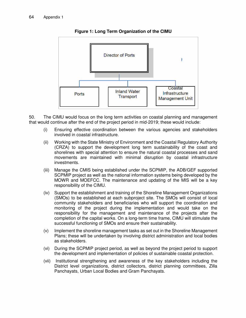
64 Appendix 1
Figure 1: Long Term Organization of the CIMU
50. The CIMU would focus on the long term activities on coastal planning and management that would continue after the end of the project period in mid-2019; these would include:
(i) Ensuring effective coordination between the various agencies and stakeholders involved in coastal infrastructure.
(ii) Working with the State Ministry of Environment and the Coastal Regulatory Authority (CRZA) to support the development long term sustainability of the coast and shorelines with special attention to ensure the natural coastal processes and sand movements are maintained with minimal disruption by coastal infrastructure investments.
(iii) Manage the CMIS being established under the SCPMIP, the ADB/GEF supported SCPMIP project as well as the national information systems being developed by the MOWR and MOEFCC. The maintenance and updating of the MIS will be a key responsibility of the CIMU.
(iv) Support the establishment and training of the Shoreline Management Organizations (SMOs) to be established at each subproject site. The SMOs will consist of local community stakeholders and beneficiaries who will support the coordination and monitoring of the project during the implementation and would take on the responsibility for the management and maintenance of the projects after the completion of the capital works. On a long-term time frame, CIMU will stimulate the successful functioning of SMOs and ensure their sustainability.
(v) Implement the shoreline management tasks as set out in the Shoreline Management Plans; these will be undertaken by involving district administration and local bodies as stakeholders.
(vi) During the SCPMIP project period, as well as beyond the project period to support the development and implementation of policies of sustainable coastal protection.
(vii) Institutional strengthening and awareness of the key stakeholders including the District level organizations, district collectors, district planning committees, Zilla Panchayats, Urban Local Bodies and Gram Panchayats.
Appendix 1 65
51. The core function of the CIMU is to ensure that Shoreline Protection and Management will be undertaken by involving district administration, local bodies as stakeholders, in line with the agreed Shoreline Management Policy and Plans. 52. The PMDCK2 will take a proactive role for the establishment of the CIMU including: (i) the development of operational guidelines including the roles and responsibilities for each position in the CIMU; (ii) development of a Project Finance Management System to improve PMU/CIMU's computer-based project finance management system and provide training for smooth transition from manual project finance management system; (iii) supporting the CIMU's role in addressing coastal management issues; (iv) increasing the awareness of the role of the CIMU within different levels of government and stakeholders; (v) supporting liaison between CIMU and other government departments; and (vi) provision of training for CIMU members.
4. Shoreline Management Organizations (SMOs) at Subproject Sites:
53. PMDCK1 has developed a SMO enlisting vision statement, legal aspects and operational procedures. SMOs at two locations are close to being formally established. Based on this ground work and experience, the consultant will lead the SMO establishment at the nine project 2 subprojects. The consultant’s role will include (a) site reconnaissance, identify key individuals at each subproject site and clarify the purpose and objectives of the SMO to the community leaders, (b) formulate an approach paper for the formation of the SMO including the members (c) present the SMO formation to the Gram Panchayat and review the concept paper with Gram Panchayat's feedback. The PMU will facilitate the meeting with the Gram Panchayat and accompany the consultant. Consultant's role ends with the finalization of the approach paper taking into account the feedback from the Panchayat. The concept paper is then handed over to the PMU to complete the registration of the SMO. The consultants will also organize a day training workshop on the role of the SMO and how it can carry out its expected functioning for each subproject site. There is a provision for organizing such activities under the heading 'SMO Initiation Cost'. The Consultants may like to explore the existing community based organizations (some of which are identified in the Social Impact Assessment report prepared during Tranche 1) for accelerating the process. F. Project Organization
54. The Consultants will work closely with the Project Management Unit (PMU) and Coastal Infrastructure Management Unit (CIMU) of the EA for smooth execution of the complete project, in compliance with the State and ADB requirements. 55. The project organization is indicated in Figure1. There are four state level committees; namely the PSC, Technical Approval Committee (TAC), Procurement Approval Committee (PAC) and Empowered Committee (EC). These committees act as umbrella bodies for higher level decision-making and project coordination at the state level. Central agencies involved in coordination and approval of the project are MOWR, Department of Economic Affairs (DEA), and Central Water Commission (CWC) and CWPRS.
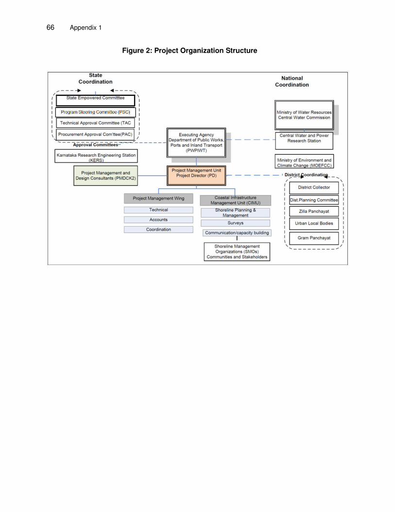
66 Appendix 1
Figure 2: Project Organization Structure
Appendix 1 67
V. PART 2: SUPPORTING SERVICES
A. Introduction
56. Supporting services comprises four parts: (i) sand resources surveys; (ii) shoreline surveys; (iii) environmental monitoring; and (iv) training delivery. B. Sand Resource Surveys
1. Background
57. The dune restoration and management is a soft measure of shore protection. A key element of the soft shore protection is to restore the sand deficit that exists along large parts of the Karnataka coast. Under project 2 it is proposed to incorporate a sand resource survey of the available sand resources along selected parts of the Karnataka coast. The results of the sand survey will provide a key input to the planning and design of reconstruction of the dunes along about 30km of coast including approximately 800,000m3 of sand nourishment together with planting and minor infrastructures including in sites where sand-filled geotubes are to be placed. 58. In addition, the survey results will form the first sea-bed sand resource mapping at selected places along the state shoreline. These results will be used to form a near shore sand resource map to support the state's move towards sustainable coastal protection and management with focus on softer approaches.
2. Scope
59. This specification defines the requirements for the following surveys, which shall be undertaken as part of the tasks of the PMDCK2. The sand surveys will map the sand resources in water depths of 5m to 20 m and will consist of two major parts.
(i) Geophysical survey of a large area of the sea bed for sand resource identification (ii) Sub-surface sediment sampling down to 2 metres in selected areas.
60. The accurate presentation of the findings of the surveys by the Surveyor is imperative in this investigation and it is important that the successful bidder shall provide capable and experienced surveyors in carrying out the required works. In carrying out the geophysical survey for sea-bed sand resource identification, the Surveyor shall present a work methodology that shall reflect the knowledge of the sea-bed geology along the Karnataka coast and lessons from other reconnaissance works of similar nature. 61. All reports, mapping and drawing text, dimensions, and elevations shall be expressed in the English Language and shall be in the metric system.
62. Site Location and Description. The total area to be covered is about 350 Km2 for geophysical survey and 160 spots for sub-surface sediment sampling spread over 6 sites. The survey area will be selected in water depth between 5m to 20m offshore from (402663.75 m E, 1647213.25 m N, in UTM 43P) in the north to (485338.58 m E, 1410305.27 m N in UTM 43P) in the south.
63. The survey area which will be identified during the Q3 2016 based on a preliminary analysis of requirements and existing data will be carried out under Part 1 of the PMDCK2.
68 Appendix 1
3. Geophysical Survey for Sea-Bed Sand Resource
64. Survey Location and Coverage
(i) The geophysical survey will be carried out in the designated area for each site (ii) Depth in the designated areas is expected to vary from 5m to 20m below Chart
Datum. (iii) Survey lines for the geophysical survey shall be run to best resolve the sub-bottom
features to a depth of 5m below the bottom. The coverage should maintain reasonable linear streamer control. Nominal line spacing alongshore is 50 metres with cross lines obtained at nominal 200m spacing. Where features are detected with any of the sensors, additional lines may be required to adequately define the bottom conditions.
65. Survey Objectives. The overall objectives of the surveys are to obtain:
(i) Identification of sub-seabed lithology and structures to a maximum depth of 5m below the seabed level;
(ii) Maps of sea-bed surface coverage in terms of rocks, marine clay, silt and sand, emphasis being the identification sandy areas,
(iii) Simultaneous measurement of water depth corrected to CD. (iv) Bathymetry survey offshore of 5m will be done simultaneously with sea-bed sand
reconnaissance mapping with the same lines plan. Any changes considered desirable shall be discussed with the Engineer prior to modification. All system parameters must be adequately logged and recorded on labels on field monitor records at the beginning of each survey line. Fix marks are to be made simultaneously on all systems at no greater interval than 50 metres. Gaps in the monitor record of any one system are not to exceed 5% on individual lines within specified coverage or 3% of the whole survey.
66. Equipment. It is expected that data are to be acquired will include the following equipment as approved by the Engineer:
(i) Single beam echo sounder Heave compensated bathymetric measurements shall be taken using a precision, single beam echo sounding system. Data shall be integrated with navigation data and presented as a plan of the whole area to a vertical resolution better than +/-0.5metres
(ii) Side scan sonar system (iii) Differential Global Positioning Satellite (DGPS) system with on line plotter and VDUs
for vessel and CDP positioning (Differential correction to be supplied from a locally established base station) with Laser Auto-Tracking of source/tailbuoy.
(iv) A high resolution sub-bottom profiler (sparker/ boomer type or finger profiler) (v) A grab sampler for calibration
67. The surveyor may plan his own while providing rationale to best meet the objectives of the survey but should include: (i) in-field processing system for rapid turnaround of QC processed data, to check trials and daily production; (ii) checking of the velocity of sound in the water column shall be determined at the start of operations each day, using a velocimeter or Temperature-Depth-Salinity (TDS) meter; (iii) bathymetric data shall be reduced to Chart Datum and related to Mean Sea Level using tidal information obtained from a tide gauge.
Appendix 1 69
68. Side Scan Sonar. The primary objective of using a system of Side Scan Sonar is to obtain total coverage map of the sea-bed surface sediments. The system's settings shall be selected by the surveyor to best meet the survey objectives of identification of sandy area. The system shall be towed using a ‘soft tow’ cable at a depth to maximize data quality. Side mounting is acceptable provided data quality is not reduced. The side scan range shall be set to provide at least 120% overlap between adjacent lines. The side scan sonar data needs to be verified by deploying grab sampler at suitable places. 69. Sub-bottom Profiler. Data acquired must include sub-bottom profile of the sea-bed to a 5m thick layer along the survey transects. While there are many sub-bottom profilers available that can penetrate much thicker layer to the order 40 to 100m, the emphasis is on the choice of a cost-effective device for efficient resolution of the first 5m layer below the sea-bed. The surveyor may consider a profiler of the type Sparker/Boomer, Finger or other meeting the requirement. 70. Positioning control shall be by use of an appropriate online systems such as the Global Positioning System (GPS), Differential Global Positioning Satellite system (DGPS) or a Range and Bearing positioning system capable of determining the location of each survey data point in real time to an absolute positioning accuracy of +/- 5m. The surveyor shall ensure that on-board computer calculate and records the positions simultaneously, and within the desired accuracy. The whole system shall be checked and proven before the survey by setting up the system and measuring between two National Survey coordinated points and establishing system error. The following minimum equipment shall be provided:
Vessel based GPS receiver (Trimble 4000 DL or equivalent). Positioning computer system with on line plotter and VDU (for helmsman control) as
minimum. Positioning information shall be obtained in World Geodetic System 1984 (WGS84)
spheroid and datum; correction values shall be transmitted in RTCM104 format (Radio Technical Commission for Maritime Services 104 format); corrected vessel position shall be computed in WGS84 and Universe Transverse Mercator Zone 43 (UTM43) projection for plotting data on final composite track charts.
Excessive feathering (i.e. >10o) and extreme course changes shall be avoided on all main lines. It is accepted that tie lines may experience high feathering and this shall be recorded on observer’s logs. The position of the lines may be adjusted with the agreement of the Engineer to make optimum use of local conditions.
Positioning data shall be processed on-line to allow the vessel to traverse the correct line pattern and to control shot interval and position. Raw positioning data shall be recorded to allow post-processing.
Post-processing shall be used to remove spurious data, correct errors (if any) and take advantage of smoothing techniques.
Raw positioning data exchange and post-plot positioning data shall conform to current UKOOA (or equivalent) formats approved by the Engineer.
Offline tolerance for the chosen coverage shall be ±10 metres at all times at the discretion of the Engineer.
To ensure adequate survey accuracy during the survey, Position Dilution of Precision (PDOP) values shall be less than 5.
Absolute positioning accuracy shall be better than +/-5 metres. The gyro compass shall be calibrated following installation on the vessel. Additional
checks shall be made following system failure or as requested by the Engineer. Fiducial marks shall be automatically produced on all data records. Each fix shall be
70 Appendix 1
labelled with number, time and date. Vessel track and bathymetry plotting facilities shall be available in the field. Track
charts shall be updated at the end of each day's work. The gap between adjacent survey lines shall not exceed 1.5 times the nominal line
spacing at any one point. If this is exceeded, the line shall be re-shot or an additional intermediate line acquired at the discretion of the Engineer. No payment will be made for additional lines required due to poor navigational control.
71. Digital Recording System. A system test tape shall be recorded during mobilization and shall be processed and proven to be in specification prior to commencement of the work. A copy of the post-processing display shall be provided to the Engineer. The monitors for these tests shall be made available to the Engineer before commencement of the work. These checks shall be repeated following any repair of the recording system or if requested by the Engineer. 72. The Surveyor shall undertake full manufacturer system checks on a daily basis. These shall be verified by the Engineer. Polarity tests on the streamer and recording system shall be carried out prior to commencement of the survey. Normally the Society of Exploration Geophysicists (SEG) convention for polarity shall be followed. Sample rate shall be no slower than 0.125ms. Record length shall be no greater than 100 ms. 73. Noise files shall be recorded at the beginning and end of each survey line. Noise levels shall be to the Engineer's satisfaction before work commences and are to be considered in relation to signal data from monitor records on line if adverse noise levels are experienced. Average Root Mean Squared (RMS) noise levels shall not exceed a maximum of 8 microbars (10 microbars near and far traces), except at the discretion of the Engineer. Noise from any one trace in the streamer shall not be more than twice the mean noise level of the streamer. 74. High-cut filter shall be half or three quarter Nyquist at -3dB. The minimum low-cut filter commensurate with maintaining seismic data quality shall be used. This will not necessarily be constant for the whole survey but shall depend on prevailing conditions. The on-board analogue monitor (read after write) shall be taken from the near trace, and shall be on a sufficient scale to allow assessment of equipment performance/noise etc., over the first 50 milliseconds of record. A near field hydrophone shall be used as the field time break (FTB) and shall be recorded on an auxiliary channel. 75. The Surveyor shall provide a full time, on site geophysicist with experience in the methods used and coastal geology. The Surveyor shall also supply an operator experienced in the system to be used, and all labor and equipment necessary to carry out the work. A competent surveyor familiar with survey systems shall also be available. The survey is to be under the specific direction of the Surveyor’s representative. However, all survey and instrument checks and line control shall be to the satisfaction of the Engineer. 76. The Surveyor shall provide a detailed description of the proposed equipment, staff, field technique and data processing method (including methods of data quality estimation and interpretation) and works program for approval by the Engineer prior to commencement of the work.
77. All fieldwork, data processing and interpretation will be monitored by the Engineer. The Engineer reserves the right to carry out his own interpretation of the data. The following data and deliverables will be provided:
Appendix 1 71
(i) Plan of sea-bed features of the entire survey area shall be produced based on interpretation of the survey data. Bathymetry data shall be reduced to Chart Datum with reference to observed tidal values from a tide gauge deployed on site.
(ii) The data should be interpreted and presented to show sub-seabed stratigraphy. Contour maps are also required of all geological sub divisions identified.
(iii) A preliminary interpretation of the sea-bed conditions and the sub-bottom features revealed in the geophysical survey is required upon completion of the survey. This information is required to identify alternative or new locations for sediment sampling along the seabed floor. A final phase of interpretation is required upon completion of all the site works and shall incorporate information obtained from the sand sampling survey, described in the next section.
(iv) Track charts corrected for the offset between the survey antenna and the measurement point so that the positions on both track charts and the processed sections are compatible;
(v) Contour maps sea-bed features at 1:500 scale or a suitable scale approved by the Engineer to illustrate the surface soil and sand geology, in particular identifying the areas of rich sand resources appropriate for beach nourishment.
(vi) Plot of layer thickness of sand along the survey transects and contour maps of layer thickness of sand over the survey area
(vii) Contour plots of seabed bathymetry and depth data at uniform grid over the survey area
(viii) All interpreted geological and bathymetric data used to produce contour maps shall also be supplied as ASCII x,y,z files on CD-ROM in a format to be agreed with the Engineer.
(ix) The scales of all plots and contour intervals will be agreed with the Engineer. All interpretations should distinguish between 'certain', 'probable' and 'uncertain' features. The level of accuracy should be estimated and stated for each contour plot, profile and map.
(x) The survey reports and drawings shall be presented to the Engineer as two paper copies and one Digital copy on CD.
4. Sediment sampling
78. Objectives. Following the geophysical survey of sea-bed surface characteristics and sub-bottom profiling, areas with the most potential of sand resource will be selected for direct sampling of sea-bed sediment for further quantification through laboratory testing. The objectives of this component are to establish more reliably the physical and chemical characteristics of sand type to about 2m depth of the sea-bed in the identified area. The sand available in these areas will be used for dune construction or nourishment. 79. Sampling grid. At each site of geophysical sand reconnaissance, a sampling grid of about 4 samples per km2. The actual requirements will be defined based on the results of the geophysical surveys. Sediment samples will be collected from these points for laboratory testing of physical and chemical properties. There will be about 160 sampling locations in total from all sites combined.
80. Depth of sampling. Sediment should be collected for a column depth of up to 2m below sea bed. 81. Equipment. The collection of sediment samples specified in the document shall be performed by using a vessel suitable for the specified water depth and marine environments. The
72 Appendix 1
vessel should be sufficiently equipped for recovering the core up to a depth of at least 2.0m using suitable equipment (Gravity corer, Vibrocore, etc.). Grab sampling may also be used to obtain a primary assessment of the sand before starting on detailed sampling. All sample tubes shall be made of aluminum, brass and stainless steel or galvanized steel and shall be clean inside and out, free from soil, grease and rust. The tubes shall not be damaged, and any previous labelling should be removed from the outside of the tube. The tubes used must be appropriate so that no sediment is contaminated by the tube in any way during storage or handling.
82. Sediment testing. The sediment samples will be tested to determine depth-wise physical and chemical characteristics at each sampling grid. Physical testing should include sieve analysis, specific gravity and friction angle at 25cm intervals. Chemical testing should give composition of oil and grease, PAH, heavy metals (Lead, Arsenic and Mercury). One chemical test needs to be done for each sample location. 83. The deliverables will include.
(i) Depth-wise information of physical characteristics of sediments at each sampling point,
(ii) Depth-wise information of chemical characteristics of sediments at each sampling point,
(iii) Reporting of sand reserve detail, (iv) Assessment of the compatibility of geophysical reconnaissance (both surface map
and profile) and Direct Sample testing. (v) Depth-wise information of physical and chemical characteristics at each sampling
point of the sea-bed should be reported in a tabular manner. Location of the sample collection should be specified in UTM coordinates.
(vi) The final report should include the methodology and the investigation results.
84. Data Storage. All survey records for bathymetry, geophysical and sand sampling are to be fully labeled and referenced by the Surveyor and retained at his offices for at least 12 months after completion of interpretation. They shall then be offered to the Engineer for no cost before disposal or being sent to storage. A complete listing of data shall be prepared and shall accompany data to the Engineer or designated storage facilities when so directed. The Surveyor shall not dispose of any data without the approval of the Engineer. 85. Final Report. The final report shall be concise, relevant to the survey objective and fit for purpose. Consideration shall be given to all potential users of the report and any information that they may require shall be readily available to allow for subsequent inspection or re-interpretation of the data. Speculative interpretations, unless substantiated by published data shall be avoided. All available data shall be incorporated into the interpretation and report. The report should clearly state the accuracy and confidence limits on all the data and interpretations presented.
86. The text of the final report shall cover all operational aspects of the survey, and equipment/vessel specifications shall be included. A full discussion of the methodologies employed with parameter details is required together with a detailed discussion of the soils/geological features identified and the results of the survey. Within two weeks of completing the survey works the Surveyor shall provide the following information:
(i) Digital archive of all field recordings, acquired and processed data (in SI units and in ASCII format / SEG Tapes or in format as approved by the Engineer),
(ii) Copies of all weekly Progress reports, (iii) Draft survey report listing the survey results required for each survey package.
Appendix 1 73
(iv) The Surveyor shall issue the Final survey report to the Engineer within two weeks of receiving any comments on the Draft report.
87. In addition to the digital copies of the Final Reports, two hard paper copies of the Draft and Final survey reports shall also be provided. Final report and survey data will be delivered for each site separately. 88. The quantities are based on an assumed shoreline length of 5 km at each site. There are expected to be about six sites along the Karnataka coastline and will include:
(i) Geophysical sand reconnaissance over 350km2 spread over 6 locations in 5-20m depth of water using side scan sonar for mapping surface sediment features and sub-bottom profiling including bathymetry
(ii) Sea-bed sediment sampling of 2m core including physical and chemical testing as specified and reporting for a total of 160 samples. Each site will have 24 to 28 sampling over 6 to 7 km2. The exact specifications will be decided by the project 2 planning and design consultants.
C. Shoreline Surveys
1. Introduction
89. Shoreline surveys will be carried out at the nine subproject sites (Someshwara, Yermal Thenka, Udyavara, Maravanthe, Kodi Bengre and Murudeshwar, Kodi Kanyana, Pavinakurve and the 3rd community protection) The surveys will be designed to: (i) support the planning and design of two subprojects (community project 3 and the revised design for Yermal Thenka); (ii) post construction monitoring at the subproject sites. The shoreline surveys will include: (i) topography of the beach from the land end to the low tide line; (ii) bathymetry of sea bed from shoreline; and (iii) measurement of waves, currents and tides. 90. Additional beach topographic surveys will cover the remaining part of the state's shoreline covering 243 km. Topographic survey in these stretches will be done at a reduced resolution of 500m spacing between two consecutive transects this will be used to update the shoreline management plans.
2. Frequency and Duration of the Surveys
91. The actual timing and detailed scope of the surveys will be decided by the PMDCK2 consultant team leader and the Project director during the project implementation. Provision has been made for mobilization for the bathymetric surveys where for the other surveys mobilization will be incorporated into the costs. 92. Measurement of waves, currents and tides will be done at a single location at a depth of about 5 mCD for a period of one month at different sites
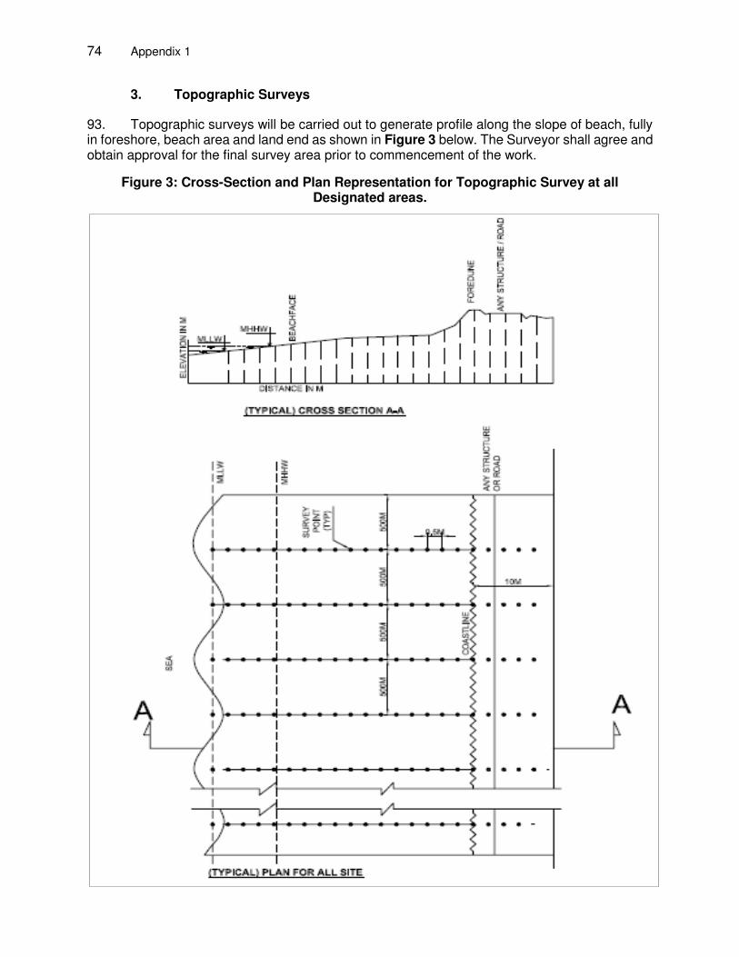
74 Appendix 1
3. Topographic Surveys
93. Topographic surveys will be carried out to generate profile along the slope of beach, fully in foreshore, beach area and land end as shown in Figure 3 below. The Surveyor shall agree and obtain approval for the final survey area prior to commencement of the work.
Figure 3: Cross-Section and Plan Representation for Topographic Survey at all Designated areas.
Appendix 1 75
94. The Surveyor shall employ suitable survey techniques and equipment to ensure that the survey information can be collected and presented in accordance with the requirements for precision, accuracy and reporting presented in this specification. Regular calibration checks shall be carried out on the equipment at the commencement and completion of the work each day and at any other time as requested by the Engineer. The Surveyor shall provide the required equipment, instrumentation and transportation as necessary to accomplish all required services and produce the detailed survey maps, digital terrain data, beach profiles, survey report and any other supporting data developed during the acquisition of field data.
95. If electronic or satellite position fixing equipment is used this shall be of type approved by the Engineer and any relevant Authorities. 96. Survey Details The topographic surveys should be carried up to 1m depth below the position of Mean Lowest Low Water (MLLW) along the survey area of the beach. While carrying out the survey the Surveyor should specify the date, time of survey at each section and shall be recorded along with photographs. All features, such as fences, buildings, marker lights, etc. encountered by the survey team within the area of the survey shall be marked onto to the survey drawings.
97. Survey Control: A horizontal and vertical control framework shall be established by the Surveyor and submitted to the Engineer for approval prior to commencement of the survey work. If no existing established survey grid and controls are identified, it is necessary to establish a new local grid system related to fixed permanent features and monuments. The survey grid shall have a sufficient number of permanently monumented survey stations to allow recovery of the survey grid throughout the survey and construction periods. 98. All levels surveyed shall be recorded and noted on the survey drawings and electronic data together with the survey datum and its relationship with Chart Datum, Mean Sea Level, and any other local datum referenced in the survey area.
99. Prior to setting out, the Surveyor shall mark out the approximate location of the monuments on a drawing for approval by the Engineer to ensure that an adequate number of permanent monuments are established in and near the survey area. The monuments shall be marked by a suitable metal survey point embedded in concrete, have a design life of at least five years, and where necessary be protected by a railing to prevent damage. 100. The Surveyor shall supply a schedule of all permanent markers and monuments, which shall include:
Monument reference number Co-ordinates of the monument relative to the survey grid adopted Description and sketch of the monument location with dimensions related to three
suitable points of reference or permanent detail Height above the survey datum The survey coordinates and projection to be adopted shall be World Geodetic System
1984 (WGS84) and Universe Transverse Mercator Zone 43 (UTM43). 101. Survey Accuracy and Datum: The final survey drawings shall portray the topography and prominent features, in order to allow immediate visual recognition. The ground surface shall be surveyed such that any point interpreted from this information shall be within 0.01m. The position

76 Appendix 1
of each survey point shall be measured and co-ordinates given to horizontal and vertical accuracies of ±0.02m and ± 0.01m respectively. The closing error for the main traverse shall not be more than 1/20,000. 102. The position of each monument shall be measured and co-ordinates recorded to horizontal and vertical accuracies of ±0.02m and ±0.01m respectively. The accuracy of the levelling to survey monuments and permanent survey markers shall be 5mm.
103. The interval between fix positions on survey lines shall no greater than 500 m to ensure that topographic contours can be accurately delineated. Where structures and steep changes in gradient are surveyed, it may be necessary to record more fixed positions to ensure that specific features and topography are identified. 104. The survey levels shall be reduced to a suitable datum approved by the Engineer. The datum to which the survey levels are reduced and recorded shall be checked by levelling to existing benchmarks and noted on the drawings, together with the relationship of the datum with Chart Datum and any other datum referenced in the survey area.
105. Reporting and Deliverables. Throughout the surveying period, the Surveyor shall submit regular survey reports to the Engineer. The Surveyor shall produce a final topographic survey report, which shall comprise the topographic survey drawings, a brief factual report and electronic data as detailed in this section. 106. Topographic Survey Drawings. Beach profile survey drawings shall be compiled at a scale of 1:500, or at a suitable scale approved by the Engineer. The location and extent of each beach profile shall be plotted on an accompanying plan survey drawing. The beach profiles shall contain notes to identify changes in beach gradient and any particular features. Each beach profile shall be complemented by at least four digital photographs of the beach, two taken perpendicular and two taken parallel to the profile.
107. Topo-survey should be carried out at an interval of 0.5m along the slope. The shore-parallel spacing between the transects is 50m at the subproject sites and 500m at the other places. The drawings shall contain all topographic and planimetric features encountered within the specified survey area and properly depict the existing site conditions as necessary for their intended purpose. The final topographic survey and generated mapping shall contain but not be limited to the following:
The grid, permanent ground markers and ground control points shall be plotted and drawn to an accuracy of 0.2mm at mapping scale relative to the straight lines forming the axes.
Spot levels and developed vertical contours at 0.5m intervals. Terrain features Planimetric feature data Location of primary survey stations (concrete monuments)
108. The surveys shall be presented to the Engineer in the following formats: (i) two hard copies on A1 size paper; (ii) AutoCAD DWG digital file format compatible with latest version; (iii) survey spot levels in XYZ text file format; and (iv) post-processed beach profile data along designated transects at the required transverse spacing. A digital copy of the topographic survey drawings and data files shall also be presented to the Engineer on CD.
Appendix 1 77
109. Topographic Survey Report a brief factual report for the topographic survey, detailing the following deliverables. The report will be submitted as draft and final versions. Survey reports will be prepared for each survey task within 3 weeks of completion of the field work.
Co-ordinates, location, level, and description of primary survey stations (concrete monuments)
Weather conditions summary Details of all equipment and techniques used Details of methods employed The draft survey report shall be presented to the Engineer as one digital copy on CD Deliverables field data plots maps and profiles on reproducible medium and in digital .dxf format final processed data (all formats) on paper and on reproducible medium contour lines of MLLW, MHHW and berm line (i.e. interface of the beach face and
berm)
110. Estimated Requirement for Topographic Surveys at the subproject sites is shown in Table 7. The actual requirements for each site may however be adjusted with the ceiling shown in the table.
Table 7: Estimated Surveys Lengths at Sub-Project Sites
Beach Survey length
Site Description Length (m) Width (m) LKM
Yermal Thenka 5000 100 10.1
Udyavara 5000 100 10.1
Maravanthe 4000 100 8.1
Kodikanyana 1500 100 3.1
Pavinakurve 2000 100 4.1
Someshwara 2500 100 5.1
Kodibengre 5000 100 10.1
Murudeshwara 2000 100 4.1
Dune Management 30000 100 60.1
Total topo survey length of t2 subprojects (single survey) 114.9
Frequency per year 2
No of year surveys to be carried out 3
Total topographic surveys length (estimated 6 surveys) 689.4
111. Estimated Requirements for Topographic surveys for the shoreline management. Additional beach topographic surveys will cover the remaining part of the state's shoreline covering 243 km. Topographic survey in these stretches will be done at a reduced resolution of 500m spacing between two consecutive transects this will be used to update the shoreline management plans as shown in the Table 8 below.
78 Appendix 1
Table 8: Estimated Survey Lengths for Shoreline Management Surveys
shoreline Survey length
Description Length (m) width (m) LKM
Karnataka 300000
Tranche-2 subprojects 57000 100
Net Length for SMP surveys 243000 100 48.7
Total topo-survey length of t2 subprojects for one time 48.7
Frequency of survey per year 2
No of years for surveys 3
Net Length for SMP surveys (for six-time surveys) 292.2
4. Bathymetric Surveys
112. Survey Location and Coverage: The length to be covered in the offshore direction from the shoreline (0 mCD) is 500m. 113. Bathymetric survey should be done along shore normal lines as much as possible, ideally aligned to the topographic survey lines. The Surveyor should aim to achieve an overlap of the bathymetric and topographic coverage barring very difficult wave and current conditions for the survey vessel or the towed equipment.
114. Survey Requirements. The overall requirement is to obtain accurate bathymetry in the designated area at each site. Bathymetric survey lines shall be run at 50m intervals normal to the shore line with additional infill in shallow water to resolve any features such as shoal or bar. Tie lines parallel to the shore should be run at 200m intervals to assist in identifying seabed features. 115. Proposed line plan should be submitted to the Engineer for approval taking into account prevailing currents and modified if necessary or desired. Any changes considered desirable shall be discussed with the Engineer prior to modification. All system parameters must be adequately logged and recorded on labels on field monitor records at the beginning of each survey line. Fixed marks are to be made simultaneously on all systems at no greater interval than 50 meters. Gaps in the monitor record of any one system are not to exceed 5% on individual lines within specified coverage or 3% of the whole survey.
116. Equipment Data is to be acquired using the following equipment as approved by the Engineer and should include: (i) Single beam echo sounder bathymetry system; (ii) Differential Global Positioning Satellite (DGPS) system with on line plotter and VDUs for vessel and CDP positioning (Differential correction to be supplied from a locally established base station) with Laser Auto-Tracking of source/tailbuoy; and (iii) In-field processing system for rapid turnaround of QC processed data, to check trials and daily production. 117. Bathymetry Measurement: Heave compensated bathymetric measurements shall be taken using a precision, single beam echo sounding system. Data shall be integrated with navigation data and presented as a plan of the whole area to a vertical resolution better than +/-0.5metres. Velocity of sound in the water column shall be determined at the start of operations each day, using a velocimeter or Temperature-Depth-Salinity (TDS) meter. Bathymetric data shall be reduced to Chart Datum and related to Mean Sea Level using tidal information obtained from a tide gauge.
Appendix 1 79
118. Positioning Control: Positioning control shall be by use of the Differential Global Positioning Satellite system (DGPS) or an alternatives positioning system capable of determining the location of each survey data point in real time to an absolute positioning accuracy of +/- 2m. A shore receiver shall be established at a third order coordinated location close to the site with the approval of the Engineer. The base station shall be permanently manned by an experienced surveyor who shall be equipped with shore to vessel communications. 119. The on-board receiver and shore station shall compute positions simultaneously, and correction values computed by the shore based receiver shall be applied to the vessel based receiver after transmission via a telemetry or radio link. The whole system shall be checked and proven before the survey by setting up the system and measuring between two National Survey coordinated points and establishing system error. The following minimum equipment shall be provided: (i) shore based GPS receiver (Trimble 4000 SST or equivalent); (ii) vessel based GPS receiver (Trimble 4000 DL or equivalent); (iii) Telemetry or suitable radio link between shore and vessel; and (iv) positioning computer system with on line plotter and VDU (for helmsman control) as minimum.
120. Positioning information shall be obtained in World Geodetic System 1984 (WGS84) spheroid and datum; correction values shall be transmitted in RTCM104 format (Radio Technical Commission for Maritime Services 104 format); corrected vessel position shall be computed in WGS84 and Universe Transverse Mercator Zone 43 (UTM43) projection for plotting data on final composite track charts. 121. The bathymetric surveys must incorporate the following:
(i) Excessive feathering (i.e. >10o) and extreme course changes shall be avoided on all main lines. It is accepted that tie lines may experience high feathering and this shall be recorded on observer’s logs. The position of the lines may be adjusted with the agreement of the Engineer to make optimum use of local conditions.
(ii) Positioning data shall be processed on-line to allow the vessel to traverse the correct line pattern and to control shot interval and position. Raw positioning data shall be recorded to allow post-processing.
(iii) Post-processing shall be used to remove spurious data, correct errors (if any) and take advantage of smoothing techniques.
(iv) Raw positioning data exchange and post-plot positioning data shall conform to current UKOOA (or equivalent) formats approved by the Engineer.
(v) Offline tolerance for the chosen coverage shall be ±10 metres at all times at the discretion of the Engineer.
(vi) To ensure adequate survey accuracy during the survey, Position Dilution of Precision (PDOP) values shall be less than 5.
(vii) Absolute positioning accuracy shall be better than +/-2 metres. (viii) The compass shall be calibrated following installation on the vessel. Additional
checks shall be made following system failure or as requested by the Engineer. (ix) The DGPS positioning system shall be checked against an established survey point
using land survey methods. (x) Fiducial marks shall be automatically produced on all data records. Each fix shall be
labelled with number, time and date. (xi) Vessel track and bathymetry plotting facilities shall be available in the field. Track
charts shall be updated at the end of each day's work. (xii) The gap between adjacent survey lines shall not exceed 1.5 times the nominal line
80 Appendix 1
spacing at any one point. If this is exceeded, the line shall be re-shot or an additional intermediate line acquired at the discretion of the Engineer. No payment will be made for additional lines required due to poor navigational control.
122. Digital Recording System. A system test tape shall be recorded during mobilization and shall be processed and proven to be in specification prior to commencement of the work. A copy of the post-processing display shall be provided to the Engineer. The monitors for these tests shall be made available to the Engineer before commencement of the work. 123. These checks shall be repeated following any repair of the recording system or if requested by the Engineer. The Surveyor shall undertake full manufacturer system checks on a daily basis. These shall be verified by the Engineer. Polarity tests on the streamer and recording system shall be carried out prior to commencement of the survey. Normally the Society of Exploration Geophysicists (SEG) convention for polarity shall be followed.
124. Sample rate shall be no slower than 0.125ms. Record length shall be no greater than100 ms. Noise files shall be recorded at the beginning and end of each survey line. Noise levels shall be to the Engineer's satisfaction before work commences and are to be considered in relation to signal data from monitor records on line if adverse noise levels are experienced. Average Root Mean Squared (RMS) noise levels shall not exceed a maximum of 8 microbars (10 microbars near and far traces), except at the discretion of the Engineer. Noise from any one trace in the streamer shall not be more than twice the mean noise level of the streamer. 125. High-cut filter shall be half or three quarter Nyquist at -3dB. The minimum low-cut filter commensurate with maintaining seismic data quality shall be used. This will not necessarily be constant for the whole survey but shall depend on prevailing conditions.
126. The on-board analogue monitor (read after write) shall be taken from the near trace, and shall be on a sufficient scale to allow assessment of equipment performance/noise etc., over the first 50 milliseconds of record. A near field hydrophone shall be used as the field time break (FTB) and shall be recorded on an auxiliary channel. 127. The Surveyor shall provide a full-time, on site hydrographer with experience in the methods used. The Surveyor shall also supply an operator experienced in the system to be used, and all labor and equipment necessary to carry out the work. A competent crew member familiar with survey systems shall also be available.
128. The survey is to be under the specific direction of the Surveyors’ representative, however all survey and instrument checks and line control shall be to the satisfaction of the Engineer. 129. The Surveyor shall provide a detailed description of the proposed equipment, staff, field technique and data processing method (including methods of data quality estimation and interpretation) and program for the works for approval by the Engineer prior to commencement of the work.
130. Report and Deliverables shall include the following:
(i) Data shall be reduced to Chart Datum with reference to observed tidal values from a tide gauge deployed on site.
(ii) Track plots of all survey lines should be provided. (iii) The Surveyor shall provide the following track charts corrected for the offset between
Appendix 1 81
the survey antenna and the measurement point so that the positions on both track charts and the processed sections are compatible.
(iv) Raw bathymetry data in ASCII XYZ digital format (to be agreed with Engineer); and (v) Bathymetry is to be presented with discrete plotted values at 5 metre centres,
contoured at 0.5 metre intervals or better to show bottom configuration and morphological features.
(vi) All bathymetric data used to produce contour maps shall also be supplied as ASCII x,y,z files on CD-ROM in a format to be agreed with the Engineer.
(vii) Post-processed ASCII data (X, Y, Z) of water depth with respect to the Chart Datum at regular grid points defined by the Engineer.
(viii) The scales of all plots and contour intervals will be agreed with the Engineer. All interpretations should distinguish between 'certain', 'probable' and 'uncertain' features. The level of accuracy should be estimated and stated for each contour plot, profile and map. The coordinate system for data outputs should be clearly specified.
131. All survey records and data should be sent to designated storage facilities when so directed. The Surveyor shall not dispose of any data without the approval of the Engineer. 132. Final Reports will be prepared for each survey task and shall be concise, relevant to the survey objective and fit for purpose. Consideration shall be given to all potential users of the report and any information that they may require shall be readily available to allow for subsequent inspection or re-interpretation of the data. Speculative interpretations, unless substantiated by published data shall be avoided. All available data shall be incorporated into the interpretation and report. The report should clearly state the accuracy and confidence limits on all the data and interpretations presented.
133. The text of the final report shall cover all operational aspects of the survey, and equipment/vessel specifications shall be included. A full discussion of the methodologies employed with parameter details is required together with a detailed discussion of the soils/geological features identified and the results of the survey. 134. Within two weeks of completing each survey the Surveyor shall provide the Engineer with the following information:
(i) Digital archive of all field recordings, acquired and processed data (in SI units and in ASCII format / SEG Tapes or in format as approved by the Engineer),
(ii) Copies of all weekly Progress reports, (iii) Draft survey report listing the survey results required for each survey package. (iv) The Surveyor shall issue the Final survey report to the Engineer within two weeks of
receiving any comments on the Draft report. (v) In addition to the digital copies of the Final Reports, two hard paper copies of the
Draft and Final survey reports shall also be provided.
135. Estimated Survey Requirements; the estimated requirements are shown in Table 9 below. The actual requirements may vary and will be decided by the PMDCK2 team leader during the project 2 implementation.
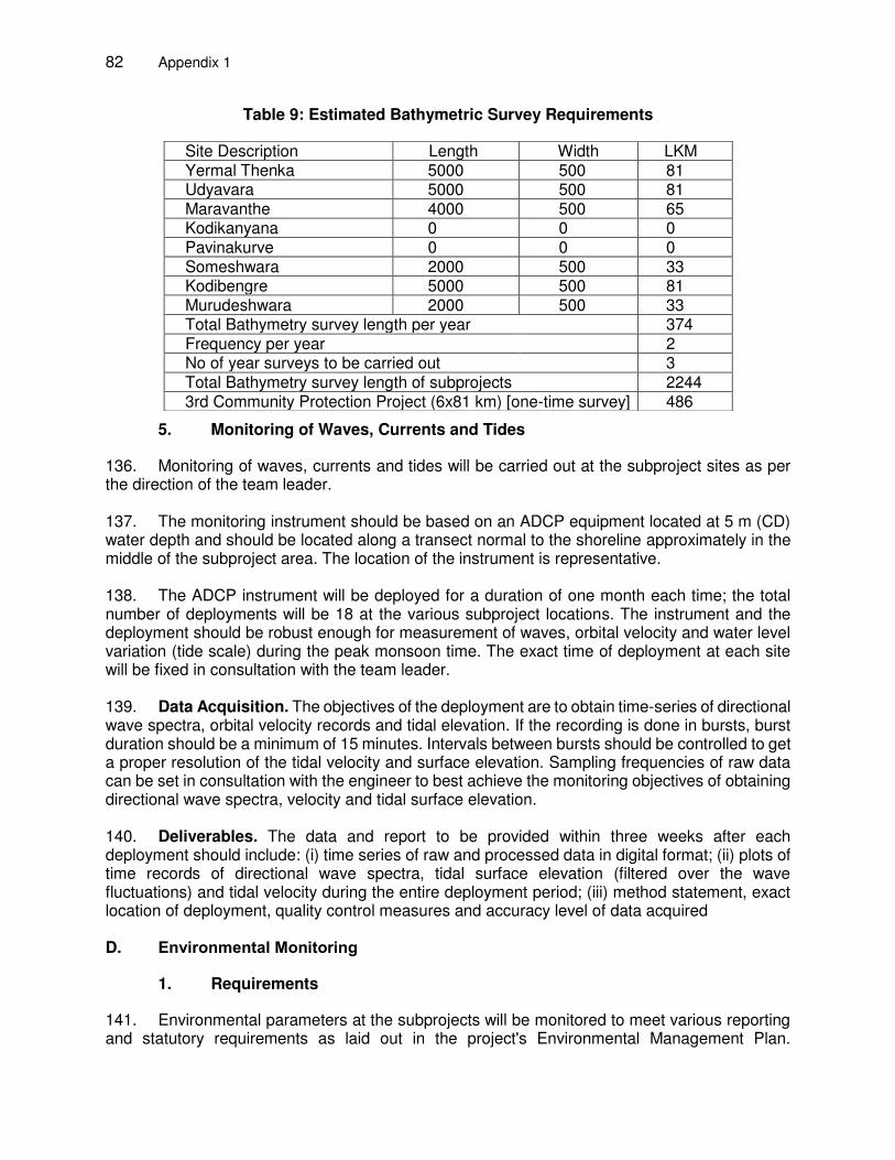
82 Appendix 1
Table 9: Estimated Bathymetric Survey Requirements
5. Monitoring of Waves, Currents and Tides
136. Monitoring of waves, currents and tides will be carried out at the subproject sites as per the direction of the team leader. 137. The monitoring instrument should be based on an ADCP equipment located at 5 m (CD) water depth and should be located along a transect normal to the shoreline approximately in the middle of the subproject area. The location of the instrument is representative.
138. The ADCP instrument will be deployed for a duration of one month each time; the total number of deployments will be 18 at the various subproject locations. The instrument and the deployment should be robust enough for measurement of waves, orbital velocity and water level variation (tide scale) during the peak monsoon time. The exact time of deployment at each site will be fixed in consultation with the team leader. 139. Data Acquisition. The objectives of the deployment are to obtain time-series of directional wave spectra, orbital velocity records and tidal elevation. If the recording is done in bursts, burst duration should be a minimum of 15 minutes. Intervals between bursts should be controlled to get a proper resolution of the tidal velocity and surface elevation. Sampling frequencies of raw data can be set in consultation with the engineer to best achieve the monitoring objectives of obtaining directional wave spectra, velocity and tidal surface elevation.
140. Deliverables. The data and report to be provided within three weeks after each deployment should include: (i) time series of raw and processed data in digital format; (ii) plots of time records of directional wave spectra, tidal surface elevation (filtered over the wave fluctuations) and tidal velocity during the entire deployment period; (iii) method statement, exact location of deployment, quality control measures and accuracy level of data acquired D. Environmental Monitoring
1. Requirements
141. Environmental parameters at the subprojects will be monitored to meet various reporting and statutory requirements as laid out in the project's Environmental Management Plan.
Site Description Length Width LKM Yermal Thenka 5000 500 81 Udyavara 5000 500 81 Maravanthe 4000 500 65 Kodikanyana 0 0 0 Pavinakurve 0 0 0 Someshwara 2000 500 33 Kodibengre 5000 500 81 Murudeshwara 2000 500 33 Total Bathymetry survey length per year 374 Frequency per year 2 No of year surveys to be carried out 3 Total Bathymetry survey length of subprojects 2244 3rd Community Protection Project (6x81 km) [one-time survey] 486
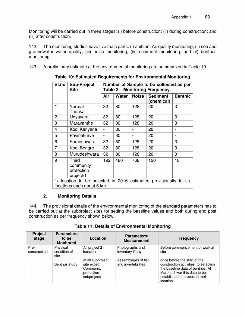
Appendix 1 83
Monitoring will be carried out in three stages: (i) before construction; (ii) during construction; and (iii) after construction. 142. The monitoring studies have five main parts: (i) ambient Air quality monitoring; (ii) sea and groundwater water quality; (iii) noise monitoring; (iv) sediment monitoring; and (v) benthos monitoring.
143. A preliminary estimate of the environmental monitoring are summarized in Table 10.
Table 10: Estimated Requirements for Environmental Monitoring
Sl.no Sub-Project Site
Number of Sample to be collected as per Table 2 – Monitoring Frequency.
Air Water Noise Sediment (chemical)
Benthic
1 Yermal Thenka
32 80 128 20 3
2 Udyavara 32 80 128 20 3
3 Maravanthe 32 80 128 20 3
4 Kodi Kanyana - 80 - 20 -
5 Pavinakurve - 80 - 20 -
6 Someshwara 32 80 128 20 3
7 Kodi Bengre 32 80 128 20 3
8 Murudeshwara 32 80 128 20 3
9 Third community protection project/1
192 480 768 120 18
1/ location to be selected in 2016 estimated provisionally to six locations each about 5 km
2. Monitoring Details
144. The provisional details of the environmental monitoring of the standard parameters has to be carried out at the subproject sites for setting the baseline values and both during and post construction as per frequency shown below.
Table 11: Details of Environmental Monitoring
Project stage
Parameters to be
Monitored Location
Parameters/ Measurement
Frequency
Pre-construction
Physical condition of site
All project 2 location
Photographs and inventory if any.
Before commencement of work at site
Benthos study
at all subproject site expect Community protection subproject)
Assemblages of fish and invertebrates
once before the start of the construction activities, to establish the baseline data of benthos. At Murudeshwar this data to be established at proposed reef location
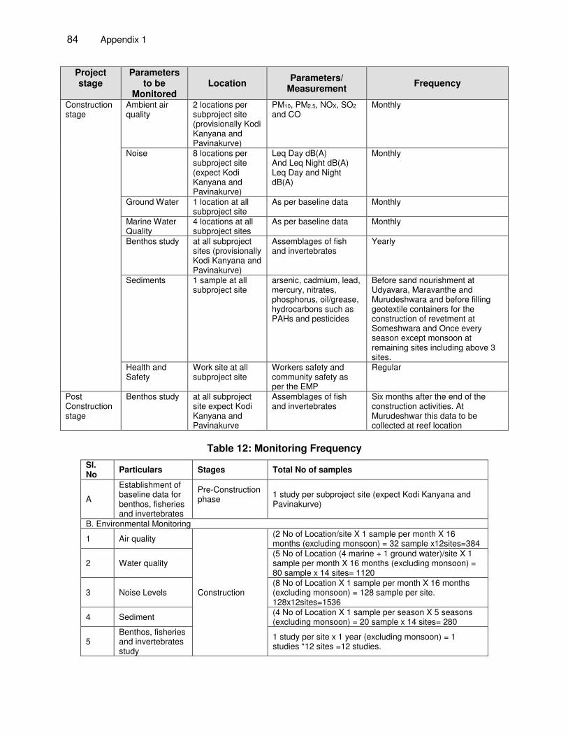
84 Appendix 1
Project stage
Parameters to be
Monitored Location
Parameters/ Measurement
Frequency
Construction stage
Ambient air quality
2 locations per subproject site (provisionally Kodi Kanyana and Pavinakurve)
PM10, PM2.5, NOX, SO2 and CO
Monthly
Noise 8 locations per subproject site (expect Kodi Kanyana and Pavinakurve)
Leq Day dB(A) And Leq Night dB(A) Leq Day and Night dB(A)
Monthly
Ground Water 1 location at all subproject site
As per baseline data Monthly
Marine Water Quality
4 locations at all subproject sites
As per baseline data Monthly
Benthos study at all subproject sites (provisionally Kodi Kanyana and Pavinakurve)
Assemblages of fish and invertebrates
Yearly
Sediments 1 sample at all subproject site
arsenic, cadmium, lead, mercury, nitrates, phosphorus, oil/grease, hydrocarbons such as PAHs and pesticides
Before sand nourishment at Udyavara, Maravanthe and Murudeshwara and before filling geotextile containers for the construction of revetment at Someshwara and Once every season except monsoon at remaining sites including above 3 sites.
Health and Safety
Work site at all subproject site
Workers safety and community safety as per the EMP
Regular
Post Construction stage
Benthos study at all subproject site expect Kodi Kanyana and Pavinakurve
Assemblages of fish and invertebrates
Six months after the end of the construction activities. At Murudeshwar this data to be collected at reef location
Table 12: Monitoring Frequency
Sl. No
Particulars Stages Total No of samples
A
Establishment of baseline data for benthos, fisheries and invertebrates
Pre-Construction phase
1 study per subproject site (expect Kodi Kanyana and Pavinakurve)
B. Environmental Monitoring
1 Air quality
Construction
(2 No of Location/site X 1 sample per month X 16 months (excluding monsoon) = 32 sample x12sites=384
2 Water quality (5 No of Location (4 marine + 1 ground water)/site X 1 sample per month X 16 months (excluding monsoon) = 80 sample x 14 sites= 1120
3 Noise Levels (8 No of Location X 1 sample per month X 16 months (excluding monsoon) = 128 sample per site. 128x12sites=1536
4 Sediment (4 No of Location X 1 sample per season X 5 seasons (excluding monsoon) = 20 sample x 14 sites= 280
5 Benthos, fisheries and invertebrates study
1 study per site x 1 year (excluding monsoon) = 1 studies *12 sites =12 studies.
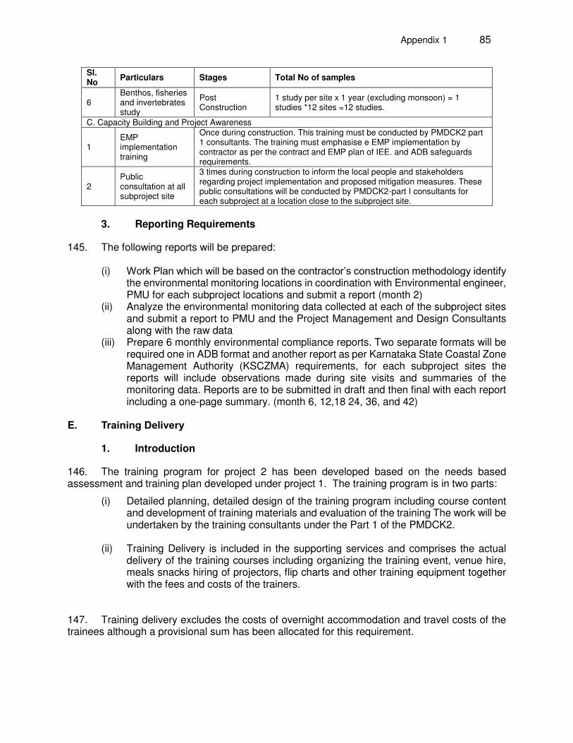
Appendix 1 85
Sl. No
Particulars Stages Total No of samples
6 Benthos, fisheries and invertebrates study
Post Construction
1 study per site x 1 year (excluding monsoon) = 1 studies *12 sites =12 studies.
C. Capacity Building and Project Awareness
1 EMP implementation training
Once during construction. This training must be conducted by PMDCK2 part 1 consultants. The training must emphasise e EMP implementation by contractor as per the contract and EMP plan of IEE. and ADB safeguards requirements.
2 Public consultation at all subproject site
3 times during construction to inform the local people and stakeholders regarding project implementation and proposed mitigation measures. These public consultations will be conducted by PMDCK2-part I consultants for each subproject at a location close to the subproject site.
3. Reporting Requirements
145. The following reports will be prepared:
(i) Work Plan which will be based on the contractor’s construction methodology identify the environmental monitoring locations in coordination with Environmental engineer, PMU for each subproject locations and submit a report (month 2)
(ii) Analyze the environmental monitoring data collected at each of the subproject sites and submit a report to PMU and the Project Management and Design Consultants along with the raw data
(iii) Prepare 6 monthly environmental compliance reports. Two separate formats will be required one in ADB format and another report as per Karnataka State Coastal Zone Management Authority (KSCZMA) requirements, for each subproject sites the reports will include observations made during site visits and summaries of the monitoring data. Reports are to be submitted in draft and then final with each report including a one-page summary. (month 6, 12,18 24, 36, and 42)
E. Training Delivery
1. Introduction
146. The training program for project 2 has been developed based on the needs based assessment and training plan developed under project 1. The training program is in two parts:
(i) Detailed planning, detailed design of the training program including course content and development of training materials and evaluation of the training The work will be undertaken by the training consultants under the Part 1 of the PMDCK2.
(ii) Training Delivery is included in the supporting services and comprises the actual
delivery of the training courses including organizing the training event, venue hire, meals snacks hiring of projectors, flip charts and other training equipment together with the fees and costs of the trainers.
147. Training delivery excludes the costs of overnight accommodation and travel costs of the trainees although a provisional sum has been allocated for this requirement.
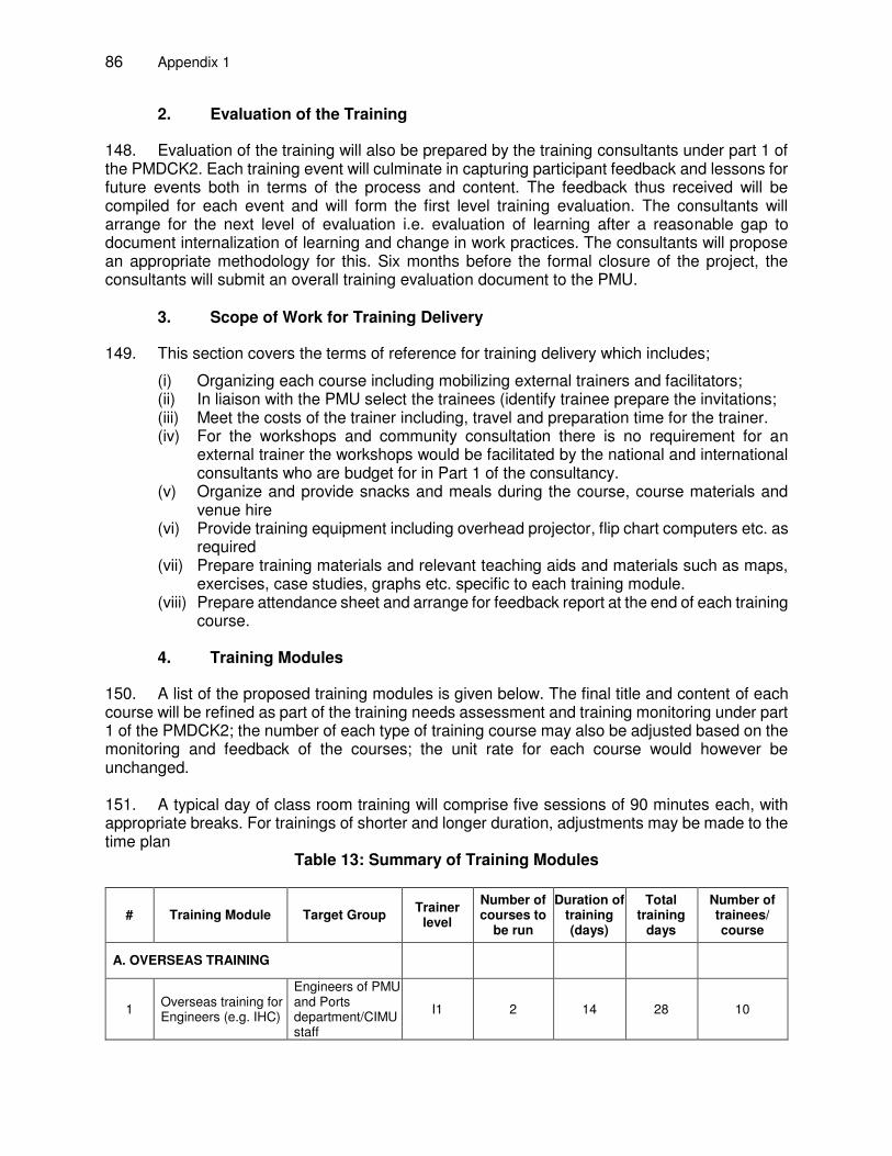
86 Appendix 1
2. Evaluation of the Training
148. Evaluation of the training will also be prepared by the training consultants under part 1 of the PMDCK2. Each training event will culminate in capturing participant feedback and lessons for future events both in terms of the process and content. The feedback thus received will be compiled for each event and will form the first level training evaluation. The consultants will arrange for the next level of evaluation i.e. evaluation of learning after a reasonable gap to document internalization of learning and change in work practices. The consultants will propose an appropriate methodology for this. Six months before the formal closure of the project, the consultants will submit an overall training evaluation document to the PMU.
3. Scope of Work for Training Delivery
149. This section covers the terms of reference for training delivery which includes;
(i) Organizing each course including mobilizing external trainers and facilitators; (ii) In liaison with the PMU select the trainees (identify trainee prepare the invitations; (iii) Meet the costs of the trainer including, travel and preparation time for the trainer. (iv) For the workshops and community consultation there is no requirement for an
external trainer the workshops would be facilitated by the national and international consultants who are budget for in Part 1 of the consultancy.
(v) Organize and provide snacks and meals during the course, course materials and venue hire
(vi) Provide training equipment including overhead projector, flip chart computers etc. as required
(vii) Prepare training materials and relevant teaching aids and materials such as maps, exercises, case studies, graphs etc. specific to each training module.
(viii) Prepare attendance sheet and arrange for feedback report at the end of each training course.
4. Training Modules
150. A list of the proposed training modules is given below. The final title and content of each course will be refined as part of the training needs assessment and training monitoring under part 1 of the PMDCK2; the number of each type of training course may also be adjusted based on the monitoring and feedback of the courses; the unit rate for each course would however be unchanged. 151. A typical day of class room training will comprise five sessions of 90 minutes each, with appropriate breaks. For trainings of shorter and longer duration, adjustments may be made to the time plan
Table 13: Summary of Training Modules
# Training Module Target Group Trainer
level
Number of courses to
be run
Duration of training (days)
Total training
days
Number of trainees/ course
A. OVERSEAS TRAINING
1 Overseas training for Engineers (e.g. IHC)
Engineers of PMU and Ports department/CIMU staff
I1 2 14 28 10
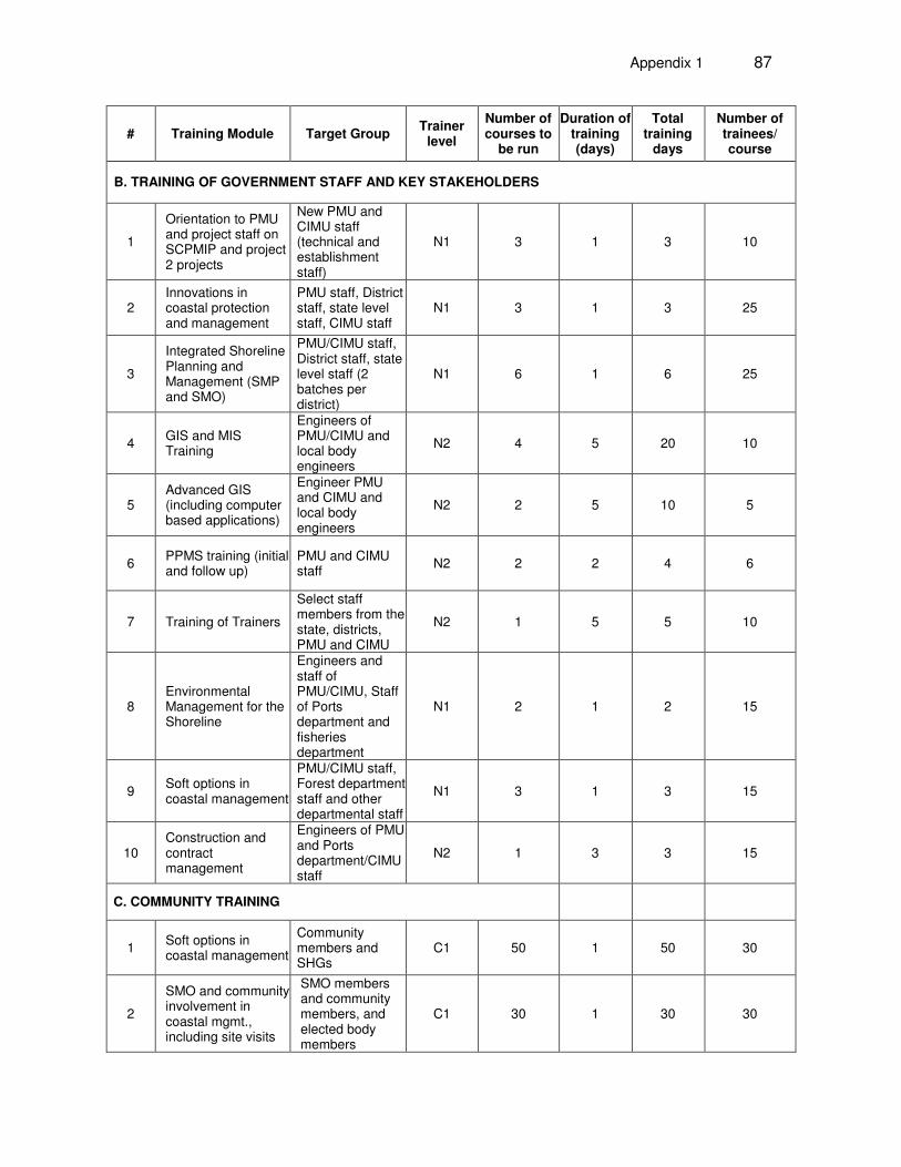
Appendix 1 87
# Training Module Target Group Trainer
level
Number of courses to
be run
Duration of training (days)
Total training
days
Number of trainees/ course
B. TRAINING OF GOVERNMENT STAFF AND KEY STAKEHOLDERS
1
Orientation to PMU and project staff on SCPMIP and project 2 projects
New PMU and CIMU staff (technical and establishment staff)
N1 3 1 3 10
2 Innovations in coastal protection and management
PMU staff, District staff, state level staff, CIMU staff
N1 3 1 3 25
3
Integrated Shoreline Planning and Management (SMP and SMO)
PMU/CIMU staff, District staff, state level staff (2 batches per district)
N1 6 1 6 25
4 GIS and MIS Training
Engineers of PMU/CIMU and local body engineers
N2 4 5 20 10
5 Advanced GIS (including computer based applications)
Engineer PMU and CIMU and local body engineers
N2 2 5 10 5
6 PPMS training (initial and follow up)
PMU and CIMU staff
N2 2 2 4 6
7 Training of Trainers
Select staff members from the state, districts, PMU and CIMU
N2 1 5 5 10
8 Environmental Management for the Shoreline
Engineers and staff of PMU/CIMU, Staff of Ports department and fisheries department
N1 2 1 2 15
9 Soft options in coastal management
PMU/CIMU staff, Forest department staff and other departmental staff
N1 3 1 3 15
10 Construction and contract management
Engineers of PMU and Ports department/CIMU staff
N2 1 3 3 15
C. COMMUNITY TRAINING
1 Soft options in coastal management
Community members and SHGs
C1 50 1 50 30
2
SMO and community involvement in coastal mgmt., including site visits
SMO members and community members, and elected body members
C1 30 1 30 30
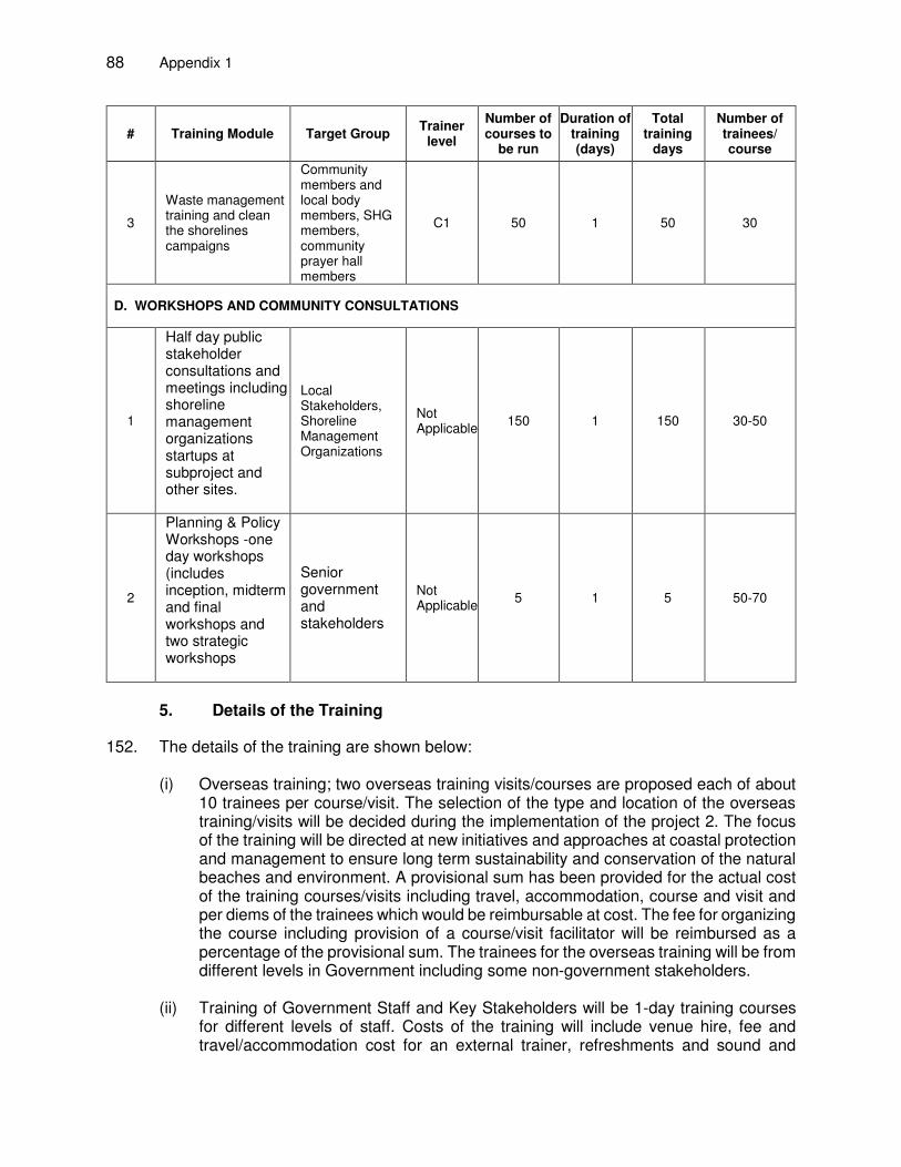
88 Appendix 1
# Training Module Target Group Trainer
level
Number of courses to
be run
Duration of training (days)
Total training
days
Number of trainees/ course
3
Waste management training and clean the shorelines campaigns
Community members and local body members, SHG members, community prayer hall members
C1 50 1 50 30
D. WORKSHOPS AND COMMUNITY CONSULTATIONS
1
Half day public stakeholder consultations and meetings including shoreline management organizations startups at subproject and other sites.
Local Stakeholders, Shoreline Management Organizations
Not Applicable
150 1 150 30-50
2
Planning & Policy Workshops -one day workshops (includes inception, midterm and final workshops and two strategic workshops
Senior government and stakeholders
Not Applicable
5 1 5 50-70
5. Details of the Training
152. The details of the training are shown below:
(i) Overseas training; two overseas training visits/courses are proposed each of about 10 trainees per course/visit. The selection of the type and location of the overseas training/visits will be decided during the implementation of the project 2. The focus of the training will be directed at new initiatives and approaches at coastal protection and management to ensure long term sustainability and conservation of the natural beaches and environment. A provisional sum has been provided for the actual cost of the training courses/visits including travel, accommodation, course and visit and per diems of the trainees which would be reimbursable at cost. The fee for organizing the course including provision of a course/visit facilitator will be reimbursed as a percentage of the provisional sum. The trainees for the overseas training will be from different levels in Government including some non-government stakeholders.
(ii) Training of Government Staff and Key Stakeholders will be 1-day training courses
for different levels of staff. Costs of the training will include venue hire, fee and travel/accommodation cost for an external trainer, refreshments and sound and
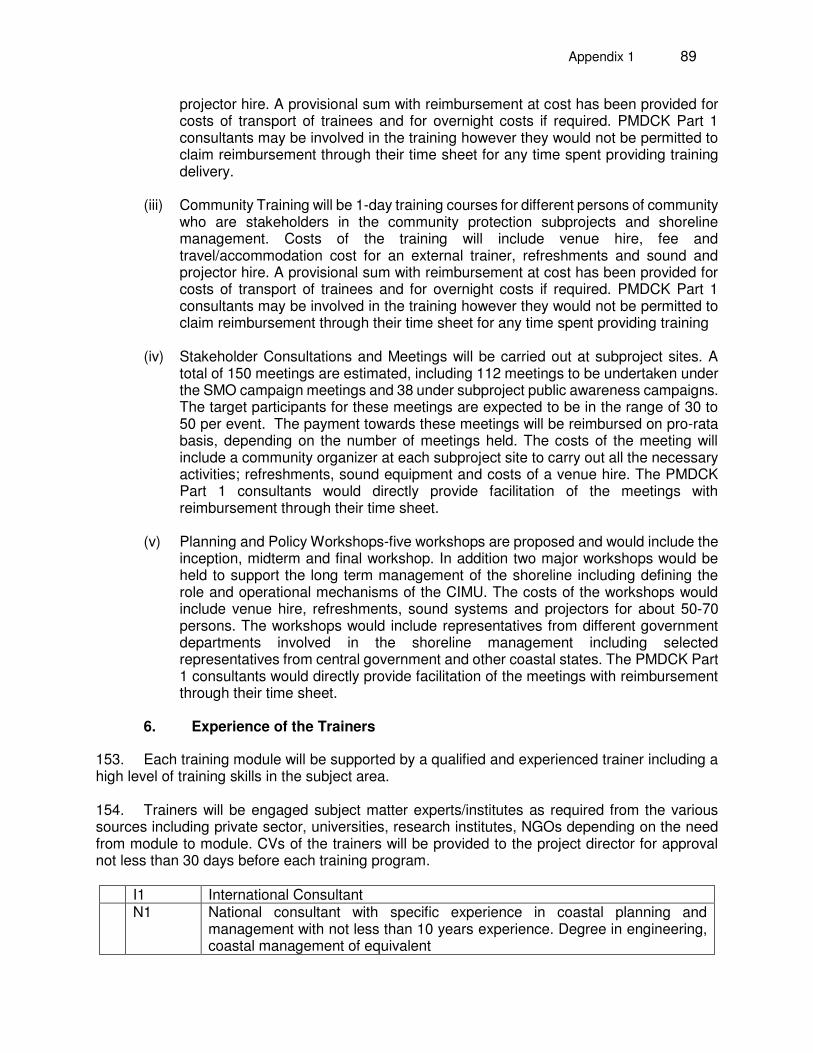
Appendix 1 89
projector hire. A provisional sum with reimbursement at cost has been provided for costs of transport of trainees and for overnight costs if required. PMDCK Part 1 consultants may be involved in the training however they would not be permitted to claim reimbursement through their time sheet for any time spent providing training delivery.
(iii) Community Training will be 1-day training courses for different persons of community
who are stakeholders in the community protection subprojects and shoreline management. Costs of the training will include venue hire, fee and travel/accommodation cost for an external trainer, refreshments and sound and projector hire. A provisional sum with reimbursement at cost has been provided for costs of transport of trainees and for overnight costs if required. PMDCK Part 1 consultants may be involved in the training however they would not be permitted to claim reimbursement through their time sheet for any time spent providing training
(iv) Stakeholder Consultations and Meetings will be carried out at subproject sites. A
total of 150 meetings are estimated, including 112 meetings to be undertaken under the SMO campaign meetings and 38 under subproject public awareness campaigns. The target participants for these meetings are expected to be in the range of 30 to 50 per event. The payment towards these meetings will be reimbursed on pro-rata basis, depending on the number of meetings held. The costs of the meeting will include a community organizer at each subproject site to carry out all the necessary activities; refreshments, sound equipment and costs of a venue hire. The PMDCK Part 1 consultants would directly provide facilitation of the meetings with reimbursement through their time sheet.
(v) Planning and Policy Workshops-five workshops are proposed and would include the
inception, midterm and final workshop. In addition two major workshops would be held to support the long term management of the shoreline including defining the role and operational mechanisms of the CIMU. The costs of the workshops would include venue hire, refreshments, sound systems and projectors for about 50-70 persons. The workshops would include representatives from different government departments involved in the shoreline management including selected representatives from central government and other coastal states. The PMDCK Part 1 consultants would directly provide facilitation of the meetings with reimbursement through their time sheet.
6. Experience of the Trainers
153. Each training module will be supported by a qualified and experienced trainer including a high level of training skills in the subject area. 154. Trainers will be engaged subject matter experts/institutes as required from the various sources including private sector, universities, research institutes, NGOs depending on the need from module to module. CVs of the trainers will be provided to the project director for approval not less than 30 days before each training program.
I1 International Consultant N1 National consultant with specific experience in coastal planning and
management with not less than 10 years experience. Degree in engineering, coastal management of equivalent
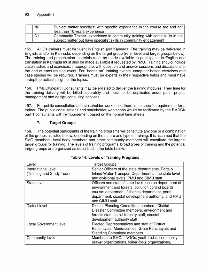
90 Appendix 1
N2 Subject matter specialist with specific experience in the course are and not less than 10 years experience
C1 Community Trainer -experience in community training with some skills in the subject matter but have specialist skills in community engagement
155. All C1-trainers must be fluent in English and Kannada. The training may be delivered in English, and/or in Kannada, depending on the target group (refer level and target groups below). The training and presentation materials must be made available to participants in English and translation in Kannada must also be made available if requested by PMU. Training should include case studies and exercises, if appropriate, with question and answer sessions and discussions at the end of each training event. For “hands on” training events, computer-based exercises and case studies will be required. Trainers must be experts in their respective fields and must have in-depth practical insight of the topics. 156. PMDCK2-part I Consultants may be enlisted to deliver the training modules. Their time for the training delivery will be billed separately and must not be duplicated under part I project management and design consulting services.
157. For public consultation and stakeholder workshops there is no specific requirement for a trainer. The public consultations and stakeholder workshops would be facilitated by the PMDCK part 1 consultants with reimbursement based on the normal time sheets.
7. Target Groups
158. The potential participants of the training programs will constitute any one or a combination of the groups as listed below, depending on the nature and type of training. It is assumed that the SMO members, local body members and other community members will constitute the largest target groups for training. The levels of training programs, broad types of training and the potential target groups are organized as described in the table below:
Table 14: Levels of Training Programs
Level Target Groups International level (Training and Study Tour)
Senior Officers of the state departments, Ports & Inland Water Transport Department at the state level and divisional levels, PMU and CIMU staff
State level Officers and staff of state level such as department of environment and forests, pollution control boards, tourism department, fisheries department, ports department, coastal development authority, and PMU and CIMU staff
District level District Planning Committee members, District Disaster Committee members, environment and forests staff, social forestry staff, coastal development authority staff
Local Government level Elected Representatives and staff of District Panchayats, Municipalities, Gram Panchayats and Standing Committee members
Community level Members to SMOs, NGOs, youth clubs, community prayer organizations, fisher-folks organizations,
Appendix 1 91
Level Target Groups country boat owners’ associations, women members of fishing market yards and SHGs and small tourism business operators
8. Quality Assurance
159. Full responsibility for the content and quality of the training material, meeting the deadlines and quality of training delivery. Announcement of specific training modules and communication to nominated trainees must be done well in advance. The Consultants must ensure that the quality of training events is regularly monitored by the use and analysis of feedback forms. Copies of feedback forms and results of the analysis of the feedback should be provided to the PMU within two weeks of completion of each training event. PPMS fields on training must be updated on a regular basis.
F. REPORTING REQUIREMENT AND SCHEDULE FOR DELIVERABLES
1. Reporting Requirements
160. The list of reports and time schedule are summarized in Table 15 below. Other occasional reports may be required from time to time on an informal basis.
Table 15: Specific Reporting Requirements
Ref. Report/Deliverable Timing A Project Management 1 Inception report
Inception report should contain but not limited to at least the following:
Familiarization of the design reports and the bid documents of the nine subprojects.
Assessment of the civil works completed of the Ullal project and the key issues for the completion of the Ullal (Tranche 1) project.
Field inspection of the ten subproject sites and preliminary assessment of the construction planning.
Review meeting with the PMU and the contractors of five subprojects on the mobilization and work progress plan.
Assessment of the status of the CMIS and the improvements needed.
Assessment of the status of the CIMU and the future needs and operational plan for the CIMU
Project plan.
2 months after commencement
2 Monthly Reports, Six-monthly Reports Monthly report reflects the overall project management during the preceding month with key inputs from the Team Leader (TL), Deputy Team Leader (DTL), support staff and other key consultants as the need arises. This does not include construction management services.
92 Appendix 1
Ref. Report/Deliverable Timing Monthly reports should be concise and should consist but not limited of the following: List of consultants deployed and durations
List of reports submitted
List of key activities by the consultant
List of key activities of the project
Major bottlenecks of the project progress
Mitigation plan for the bottlenecks Six-monthly reports are expanded summaries consisting of the same items as in monthly reports for the preceding six-month periods. In addition, it will include a review and an update of the complete project plan and review changes that will be necessary.
Monthly: Submitted two weeks after the preceding month Six monthly 2 weeks after every semester
3 Mid Term Report
The Mid-term report should give a summary description of the following items:
Summary of key activities by the consultant
Summary of key activities of the project
List of consultants deployed and durations
List of reports submitted
Major bottlenecks and mitigation plans for:
a. the short-term horizon (next one or two months)
b. medium term (six to one year)
Updated project plan with clearly the steps that need to be taken to project completion and present a revised project plan till project completion.
18 months after commencement
4 Draft Final Report The Draft Final Project Report should provide but not limited to the following details: Status of the Outputs by the Consultants
Status of the Project Progress
Training Evaluations
Conclusion
Recommendations for the future management of the coastal infrastructure assets built, upgradation of the next Shoreline Management Plan to be carried out and Coastal Management Information System.
32 months after commencement
5 Final report Based on the comments/suggestions provided by the PMU, ADB and other stakeholders, the Consultant shall prepare the final report.
36 months after commencement
6 Briefing reports These will be brief reports prepared to inform the state and central bodies and ADB on project status. These notes will be considered as part of the overall management activities carried out by the TL, DTL and the support staff.
As required
7 Reports of Project Performance Management System (PPMS) 12, 24, 36 months after commencement
Appendix 1 93
B Planning & Design
Ref Milestones/Reports Time schedule
8 Preliminary Assessment of Sand Resources based on existing information. Defining the locations for the sand resource surveys
3 months after commencement
9 Sand Resources Survey Report 6 months after commencement
10 Site identifications, modeling and design of dune construction project, leading to final project report, DPR and environmental assessment report for the second stage community protection subproject.
10 months after commencement
11 Review and Redesign of Yermal Thenka Subproject, revised DPR 7 months after commencement.
12 Adjustments to design based on pre-construction survey and CRCPMP assessment of climate change impacts
Within a month after pre-construction survey at each subproject site
13 Shoreline & beach behavior analysis report from SMP-6 monthly survey
Every six-monthly after receiving the survey data five times
14 Updating SMP on the basis of SMP-topo survey and CRCPMP guideline
C Construction Management
Ref Milestones/Reports Time schedule
15 Bid document preparation, support bidding process and contract award for the 9th subproject (2nd stage community protection project)
14 months after commencement
16 Evaluation of bids and recommendation on contract award of 4 subprojects (Someshwara, Kodi Bengre and, Mururdeshwar) and Ullal Beach Nourishment Project.
(Tender documents for these subprojects will be ready by May 2016.)
Evaluation of the technical bids within two weeks of the technical bid opening, and recommendation on contract award within one week of price bid opening.
17 Construction management services for the pre-construction activities for the 7 Tranche-2 civil works contracts and Ullal Beach Nourishment Works.
Pre-construction design finalization and supervision protocols to be provided within one
94 Appendix 1
month after receiving pre-construction topographic survey from the contractor.
18 Construction management services for the during-construction activities for Tranche-2 and on-going Tranche-1 civil works.
Monthly progress reports
19 Construction management services for the post-construction activities of the project 2 and Tranche 1 civil works subprojects.
Report per each subproject
20 Contract management of the planting schemes, stage 1 community project.
Quarterly reports
21 Implementation of the Dune Construction, planting and minor infrastructure schemes of 9th subproject, project 2 (2nd Stage Community Protection Project)
Quarterly reports
D Institutional Strengthening
Ref Milestones/Reports Time schedule
22 Detailed Training Plan 6 months after commencement
23 Implementation of the training delivery Spread over 24 months from month 6-30.
24 Operationalization and upgradation of Coastal Management Information System
8, 16, 24 months
25 Operationalization Plan and strengthening of the Coastal Infrastructure Management Unit
8, 16, 24 months
26 SMOs at 9 subproject sites under project 2 Within 1 year after commencement
161. The consultants will submit the reports both in electronic format (through emails or shared web space) and hard copies (three copies) to the PMU. The final reports shall be delivered both in soft and hard copies (seven) to the PMU. G. Team Composition & Qualification Requirements for the Key Experts for Part 1
162. Table 3 lists the specialists and their person months for the project. Table 4 lists the professional requirements for key experts. Table 5 suggests the task distribution among the key experts. The Team Leader is planned to be full time for the first 18 months of the project. The Deputy Team Leader and the supporting staff will be full time over the contract period. All other key experts should spend at least 70% of their proposed time in the field office. Staff inputs will be regularly reviewed and updated. In view of potential delays in construction activities, monthly mobilization plans for construction management and supervision support will be discussed and agreed with the PMU and the Project Director within one week before the end of each month. There are additional requirements of non-key experts who do not form part of the evaluation process; the requirements and costs need to be assessed by the bidders.
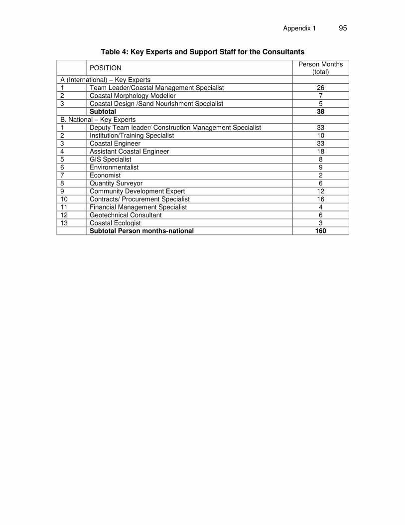
Appendix 1 95
Table 4: Key Experts and Support Staff for the Consultants
POSITION
Person Months (total)
A (International) – Key Experts 1 Team Leader/Coastal Management Specialist 26 2 Coastal Morphology Modeller 7 3 Coastal Design /Sand Nourishment Specialist 5 Subtotal 38 B. National – Key Experts 1 Deputy Team leader/ Construction Management Specialist 33 2 Institution/Training Specialist 10 3 Coastal Engineer 33 4 Assistant Coastal Engineer 18 5 GIS Specialist 8 6 Environmentalist 9 7 Economist 2 8 Quantity Surveyor 6 9 Community Development Expert 12 10 Contracts/ Procurement Specialist 16 11 Financial Management Specialist 4 12 Geotechnical Consultant 6 13 Coastal Ecologist 3 Subtotal Person months-national 160
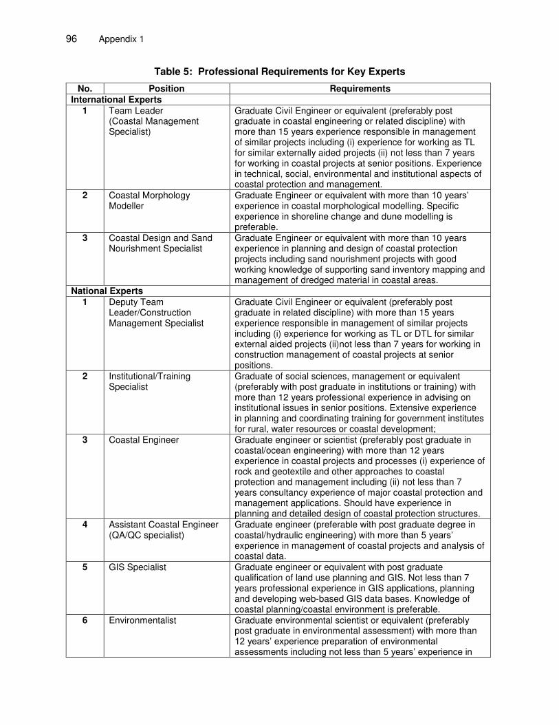
96 Appendix 1
Table 5: Professional Requirements for Key Experts
No. Position Requirements International Experts
1 Team Leader (Coastal Management Specialist)
Graduate Civil Engineer or equivalent (preferably post graduate in coastal engineering or related discipline) with more than 15 years experience responsible in management of similar projects including (i) experience for working as TL for similar externally aided projects (ii) not less than 7 years for working in coastal projects at senior positions. Experience in technical, social, environmental and institutional aspects of coastal protection and management.
2 Coastal Morphology Modeller
Graduate Engineer or equivalent with more than 10 years’ experience in coastal morphological modelling. Specific experience in shoreline change and dune modelling is preferable.
3 Coastal Design and Sand Nourishment Specialist
Graduate Engineer or equivalent with more than 10 years experience in planning and design of coastal protection projects including sand nourishment projects with good working knowledge of supporting sand inventory mapping and management of dredged material in coastal areas.
National Experts 1 Deputy Team
Leader/Construction Management Specialist
Graduate Civil Engineer or equivalent (preferably post graduate in related discipline) with more than 15 years experience responsible in management of similar projects including (i) experience for working as TL or DTL for similar external aided projects (ii)not less than 7 years for working in construction management of coastal projects at senior positions.
2 Institutional/Training Specialist
Graduate of social sciences, management or equivalent (preferably with post graduate in institutions or training) with more than 12 years professional experience in advising on institutional issues in senior positions. Extensive experience in planning and coordinating training for government institutes for rural, water resources or coastal development;
3 Coastal Engineer Graduate engineer or scientist (preferably post graduate in coastal/ocean engineering) with more than 12 years experience in coastal projects and processes (i) experience of rock and geotextile and other approaches to coastal protection and management including (ii) not less than 7 years consultancy experience of major coastal protection and management applications. Should have experience in planning and detailed design of coastal protection structures.
4 Assistant Coastal Engineer (QA/QC specialist)
Graduate engineer (preferable with post graduate degree in coastal/hydraulic engineering) with more than 5 years’ experience in management of coastal projects and analysis of coastal data.
5 GIS Specialist
Graduate engineer or equivalent with post graduate qualification of land use planning and GIS. Not less than 7 years professional experience in GIS applications, planning and developing web-based GIS data bases. Knowledge of coastal planning/coastal environment is preferable.
6 Environmentalist Graduate environmental scientist or equivalent (preferably post graduate in environmental assessment) with more than 12 years’ experience preparation of environmental assessments including not less than 5 years’ experience in
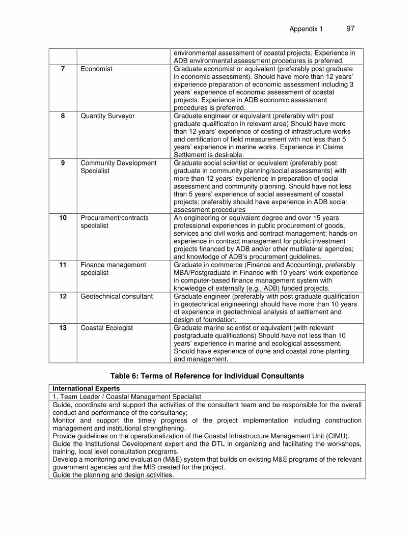
Appendix 1 97
environmental assessment of coastal projects; Experience in ADB environmental assessment procedures is preferred.
7 Economist Graduate economist or equivalent (preferably post graduate in economic assessment). Should have more than 12 years’ experience preparation of economic assessment including 3 years’ experience of economic assessment of coastal projects. Experience in ADB economic assessment procedures is preferred.
8 Quantity Surveyor Graduate engineer or equivalent (preferably with post graduate qualification in relevant area) Should have more than 12 years’ experience of costing of infrastructure works and certification of field measurement with not less than 5 years’ experience in marine works. Experience in Claims Settlement is desirable.
9 Community Development Specialist
Graduate social scientist or equivalent (preferably post graduate in community planning/social assessments) with more than 12 years’ experience in preparation of social assessment and community planning. Should have not less than 5 years’ experience of social assessment of coastal projects; preferably should have experience in ADB social assessment procedures
10 Procurement/contracts specialist
An engineering or equivalent degree and over 15 years professional experiences in public procurement of goods, services and civil works and contract management; hands-on experience in contract management for public investment projects financed by ADB and/or other multilateral agencies; and knowledge of ADB’s procurement guidelines.
11 Finance management specialist
Graduate in commerce (Finance and Accounting), preferably MBA/Postgraduate in Finance with 10 years’ work experience in computer-based finance management system with knowledge of externally (e.g., ADB) funded projects.
12 Geotechnical consultant Graduate engineer (preferably with post graduate qualification in geotechnical engineering) should have more than 10 years of experience in geotechnical analysis of settlement and design of foundation.
13 Coastal Ecologist Graduate marine scientist or equivalent (with relevant postgraduate qualifications) Should have not less than 10 years’ experience in marine and ecological assessment. Should have experience of dune and coastal zone planting and management.
Table 6: Terms of Reference for Individual Consultants
International Experts 1. Team Leader / Coastal Management Specialist Guide, coordinate and support the activities of the consultant team and be responsible for the overall conduct and performance of the consultancy; Monitor and support the timely progress of the project implementation including construction management and institutional strengthening. Provide guidelines on the operationalization of the Coastal Infrastructure Management Unit (CIMU). Guide the Institutional Development expert and the DTL in organizing and facilitating the workshops, training, local level consultation programs. Develop a monitoring and evaluation (M&E) system that builds on existing M&E programs of the relevant government agencies and the MIS created for the project. Guide the planning and design activities.
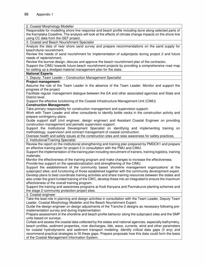
98 Appendix 1
2. Coastal Morphology Modeller Responsible for modelling shore line response and beach profile including dune along selected parts of the Karnataka Coastline. The analysis will look at the effects of climate change impacts on the shore line using CC data from the GEF project. 3. Coastal and Beach Nourishment Specialist Analyze the data of near shore sand survey and prepare recommendations on the sand supply for beach/dune nourishment. Review the needs of sand nourishment for implementation of subprojects during project 2 and future needs of replenishment, Review the burrow design, discuss and approve the beach nourishment plan of the contractor, Support the CIMU towards future beach nourishment projects by providing a comprehensive road map for setting up a dredged material management plan for the state. National Experts 1. Deputy. Team Leader – Construction Management Specialist Project management: Assume the role of the Team Leader in the absence of the Team Leader. Monitor and support the progress of the project Facilitate regular management dialogue between the EA and other associated agencies and State and District level. Support the effective functioning of the Coastal Infrastructure Management Unit (CIMU) Construction Management: Take primary responsibility for construction management and supervision support; Work with Team Leader and other consultants to identify bottle necks in the construction activity and prepare contingency plans. Guide support staff (civil engineer, design engineer) and Assistant Coastal Engineer on providing construction management and periodic supervision support; Support the Institutional Development Specialist on identifying and implementing training on methodology, supervision and contract management of coastal construction. Oversee health and safety issues at the construction sites and raise awareness for safety practices. 2. Institutional/Training Specialist Review the report on the institutional strengthening and training plan prepared by PMDCK1 and prepare an effective training plan for project 2 in consultation with the PMU and CIMU. Support the implementation of the training plan including recruitment of trainers, training logistics, training materials; Monitor the effectiveness of the training program and make changes to increase the effectiveness. Provide key support on the operationalization and strengthening of the CIMU. Support the establishment of the community based ‘shoreline management organizations’ at the subproject sites; and functioning of those established together with the community development expert. Develop plans to best coordinate training activities and share training resources between the states and also under the grant funded training of the CWC, develop these into an integrated to ensure the maximum effectiveness of the overall training program. Support the training and awareness programs at Kodi Kanyana and Pavinakurve planting schemes and the stage 2 community protection project sites. 3. Coastal engineer Take the lead role in planning and design activities in consultation with the Team Leader, Deputy Team Leader, Coastal Morphology Modeller and the Beach Nourishment Expert; Guide the design engineer on design adjustments of the Tranche-2 designs as necessary following pre-implementation survey and during implementation. Prepare assessment of the shoreline and beach profile behavior along the subproject sites and the SMP units based on surveys. Collate and assess the coastal data collected by the states and national agencies, especially bathymetry, beach profiles, sediment properties, river discharges, tide, wave, currents, wind and other parameters for coastal hydrodynamic and sediment transport modeling. Identify critical data gaps (if any) and recommend practical strategies to fill these gaps. Prepare proposals how this data could form the basis of the Coastal Management Information System.
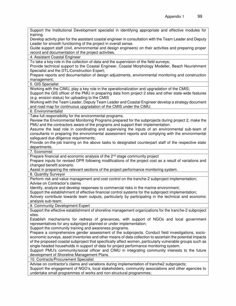
Appendix 1 99
Support the Institutional Development specialist in identifying appropriate and effective modules for training. Develop activity plan for the assistant coastal engineer in consultation with the Team Leader and Deputy Leader for smooth functioning of the project in overall sense. Guide support staff (civil, environmental and design engineers) on their activities and preparing proper record and documentation of the project activities. 4. Assistant Coastal Engineer To take a key role in the collection of data and the supervision of the field surveys; Provide technical support to the Coastal Engineer, Coastal Morphology Modeller, Beach Nourishment Specialist and the DTL/Construction Expert; Prepare reports and documentation of design adjustments, environmental monitoring and construction management; 5. GIS Specialist Working with the CIMU, play a key role in the operationalization and upgradation of the CMIS; Support the GIS officer of the PMU in preparing data from project 2 sites and other state-wide features (e.g. erosion status) for uploading to the CMIS Working with the Team Leader, Deputy Team Leader and Coastal Engineer develop a strategy document and road map for continuous upgradation of the CMIS under the CIMU. 6. Environmentalist Take full responsibility for the environmental programs. Review the Environmental Monitoring Programs prepared for the subprojects during project 2, make the PMU and the contractors aware of the programs and support their implementation. Assume the lead role in coordinating and supervising the inputs of an environmental sub-team of consultants in preparing the environmental assessment reports and complying with the environmental safeguard due diligence requirements; Provide on-the-job training on the above tasks to designated counterpart staff of the respective state departments. 7. Economist Prepare financial and economic analysis of the 2nd stage community project Prepare inputs for revised DPR following modifications of the project cost as a result of variations and changed benefit scenario. Assist in preparing the relevant sections of the project performance monitoring system. 8. Quantity Surveyor Perform risk and value management and cost control on the tranche-2 subproject implementation; Advise on Contractor’s claims Identify, analyze and develop responses to commercial risks in the marine environment; Support the establishment of effective financial control systems for the subproject implementation; Actively contribute towards team outputs, particularly by participating in the technical and economic analysis sub-team; 9. Community Development Expert Support the effective establishment of shoreline management organizations for the tranche-2 subproject sites. Establish mechanisms for redress of grievances, with support of NGOs and local government representatives for any subproject planned or under implementation; Support the community training and awareness programs. Prepare a comprehensive gender assessment of the subprojects. Conduct field investigations, socio-economic surveys, asset inventories and other means of data collection to ascertain the potential impacts of the proposed coastal subproject that specifically affect women, particularly vulnerable groups such as single-headed households in support of data for project performance monitoring system. Support PMU's community/social officer and CIMU in integrating community interests to the future development of Shoreline Management Plans. 10. Contracts/Procurement Specialist Advise on contractor’s claims and variations during implementation of tranche2 subprojects; Support the engagement of NGO’s, local stakeholders, community associations and other agencies to undertake small programmes of works and non-structural programmes;
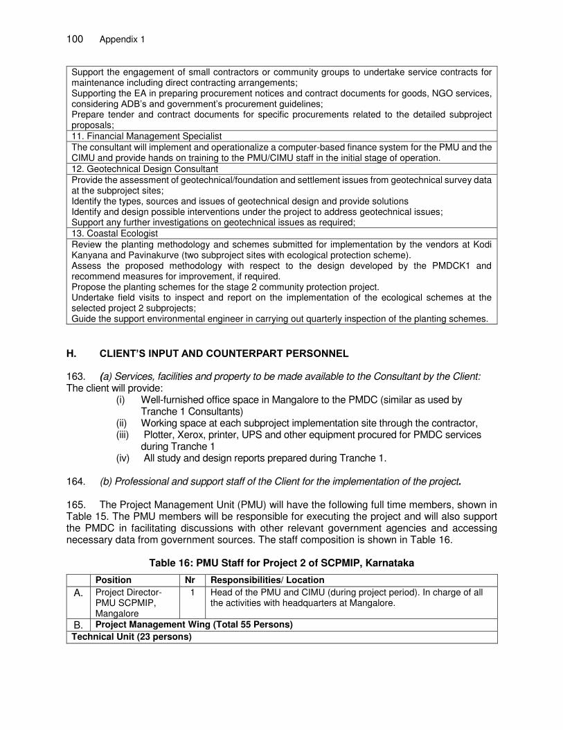
100 Appendix 1
Support the engagement of small contractors or community groups to undertake service contracts for maintenance including direct contracting arrangements; Supporting the EA in preparing procurement notices and contract documents for goods, NGO services, considering ADB’s and government’s procurement guidelines; Prepare tender and contract documents for specific procurements related to the detailed subproject proposals; 11. Financial Management Specialist The consultant will implement and operationalize a computer-based finance system for the PMU and the CIMU and provide hands on training to the PMU/CIMU staff in the initial stage of operation. 12. Geotechnical Design Consultant Provide the assessment of geotechnical/foundation and settlement issues from geotechnical survey data at the subproject sites; Identify the types, sources and issues of geotechnical design and provide solutions Identify and design possible interventions under the project to address geotechnical issues; Support any further investigations on geotechnical issues as required; 13. Coastal Ecologist Review the planting methodology and schemes submitted for implementation by the vendors at Kodi Kanyana and Pavinakurve (two subproject sites with ecological protection scheme). Assess the proposed methodology with respect to the design developed by the PMDCK1 and recommend measures for improvement, if required. Propose the planting schemes for the stage 2 community protection project. Undertake field visits to inspect and report on the implementation of the ecological schemes at the selected project 2 subprojects; Guide the support environmental engineer in carrying out quarterly inspection of the planting schemes.
H. CLIENT’S INPUT AND COUNTERPART PERSONNEL
163. (a) Services, facilities and property to be made available to the Consultant by the Client: The client will provide:
(i) Well-furnished office space in Mangalore to the PMDC (similar as used by Tranche 1 Consultants)
(ii) Working space at each subproject implementation site through the contractor, (iii) Plotter, Xerox, printer, UPS and other equipment procured for PMDC services
during Tranche 1 (iv) All study and design reports prepared during Tranche 1.
164. (b) Professional and support staff of the Client for the implementation of the project. 165. The Project Management Unit (PMU) will have the following full time members, shown in Table 15. The PMU members will be responsible for executing the project and will also support the PMDC in facilitating discussions with other relevant government agencies and accessing necessary data from government sources. The staff composition is shown in Table 16.
Table 16: PMU Staff for Project 2 of SCPMIP, Karnataka
Position Nr Responsibilities/ Location
A. Project Director- PMU SCPMIP, Mangalore
1 Head of the PMU and CIMU (during project period). In charge of all the activities with headquarters at Mangalore.
B. Project Management Wing (Total 55 Persons)
Technical Unit (23 persons)
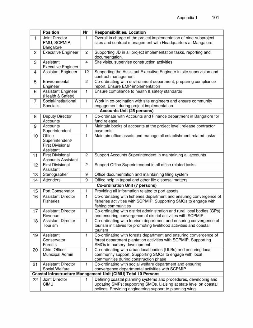
Appendix 1 101
Position Nr Responsibilities/ Location
1 Joint Director PMU, SCPMIP, Bangalore
1 Overall in charge of the project implementation of nine-subproject sites and contract management with Headquarters at Mangalore
2 Executive Engineer 2 Supporting JD in all project implementation tasks, reporting and documentation.
3 Assistant Executive Engineer
4 Site visits, supervise construction activities.
4 Assistant Engineer 12 Supporting the Assistant Executive Engineer in site supervision and contract management
5 Environmental Engineer
2 Co-ordinating with environment department; preparing compliance report. Ensure EMP implementation
6 Assistant Engineer (Health & Safety)
1 Ensure compliance to health & safety standards
7 Social/Institutional Specialist
1 Work in co-ordination with site engineers and ensure community engagement during project implementation
Accounts Unit (25 persons)
8 Deputy Director Accounts
1 Co-ordinate with Accounts and Finance department in Bangalore for fund release
9 Accounts Superintendent
1 Maintain books of accounts at the project level; release contractor payments
10 Office Superintendent/ First Divisional Assistant
1 Maintain office assets and manage all establishment related tasks
11 First Divisional Accounts Assistant
2 Support Accounts Superintendent in maintaining all accounts
12 First Divisional Assistant
2 Support Office Superintendent in all office related tasks
13 Stenographer 9 Office documentation and maintaining filing system
14 Attenders 9 Office help in tappal and other file disposal matters
Co-ordination Unit (7 persons)
15 Port Conservator 1 Providing all information related to port assets.
16 Assistant Director Fisheries
1 Co-ordinating with fisheries department and ensuring convergence of fisheries activities with SCPMIP. Supporting SMOs to engage with fishing communities
17 Assistant Director Revenue
1 Co-ordinating with district administration and rural local bodies (GPs) and ensuring convergence of district activities with SCPMIP.
18 Assistant Director Tourism
1 Co-ordinating with tourism department and ensuring convergence of tourism initiatives for promoting livelihood activities and coastal tourism
19 Assistant Conservator Forests
1 Co-ordinating with forests department and ensuring convergence of forest department plantation activities with SCPMIP. Supporting SMOs in nursery development
20 Chief Officer Municipal Admin
1 Co-ordinating with urban local bodies (ULBs) and ensuring local community support. Supporting SMOs to engage with local communities during construction phase
21 Assistant Director Social Welfare
1 Co-ordinating with social welfare department and ensuring convergence departmental activities with SCPMIP
Coastal Infrastructure Management Unit (CIMU) Total 10 Persons
22 Joint Director CIMU
1 Defining coastal planning systems and procedures, developing and updating SMPs; supporting SMOs. Liaising at state level on coastal polices. Providing engineering support to planning wing.
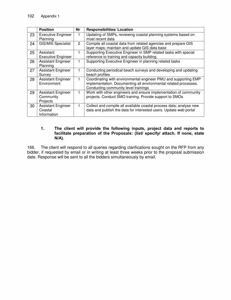
102 Appendix 1
Position Nr Responsibilities/ Location
23 Executive Engineer Planning
1 Updating of SMPs, reviewing coastal planning systems based on most recent data
24 GIS/MIS Specialist 2 Compile all coastal data from related agencies and prepare GIS layer maps; maintain and update GIS data base
25 Assistant Executive Engineer
1 Supporting Executive Engineer in SMP related tasks with special reference to training and capacity building.
26 Assistant Engineer Planning
1 Supporting Executive Engineer in planning related tasks
27 Assistant Engineer Survey
1 Conducting periodical beach surveys and developing and updating beach profiles
28 Assistant Engineer Environment
1 Coordinating with environmental engineer PMU and supporting EMP implementation. Documenting all environmental related processes. Conducting community level trainings
29 Assistant Engineer Community Projects
1 Work with other engineers and ensure implementation of community projects. Conduct SMO training. Provide support to SMOs
30 Assistant Engineer Coastal Information
1 Collect and compile all available coastal process data; analyse new data and publish the data for interested users. Update web portal
1. The client will provide the following inputs, project data and reports to facilitate preparation of the Proposals: (list/ specify/ attach. If none, state N/A).
166. The client will respond to all queries regarding clarifications sought on the RFP from any bidder, if requested by email or in writing at least three weeks prior to the proposal submission date. Response will be sent to all the bidders simultaneously by email.

Appendix 2 103
APPENDIX2:
PROCUREMENT PLAN (PROJECT 2) PROCUREMENT PLAN
Basic Data
Project Name: Sustainable Coastal Protection and Management Investment Program - Tranche 2 Project Number: 40156-033 Approval Number: Country: India Executing Agency: Public Works Ports and Inland
Waterways Department
Project Procurement Classification: B Implementing Agency: Ports and Inland Waterways Department
Project Procurement Risk: Moderate Project Financing Amount: US$ 93,540,000
ADB Financing: US$ 65,500,000 Cofinancing (ADB Administered):
Non-ADB Financing: US$ 28,040,000
Project Closing Date: 28 September 2020
Date of First Procurement Plan: Date of this Procurement Plan: 12 May 2017
A. Methods, Thresholds, Review and 18-Month Procurement Plan 1. Procurement and Consulting Methods and Thresholds Except as the Asian Development Bank (ADB) may otherwise agree, the following process thresholds shall apply to procurement of goods and works.
Procurement of Goods and Works Method Threshold Comments
International Competitive Bidding for Goods
US$ 3,000,000 and Above
National Competitive Bidding for Goods Between US$ 100,001 and US$ 2,999,999
The first NCB is subject to prior review, thereafter post review.
Shopping for Goods Up to US$ 100,000 EA will issue a public request for quotations
International Competitive Bidding for Works
US$ 40,000,000 and Above More technical complex works less than $40,000,000 would still be ICB
National Competitive Bidding for Works Between US$ 100,001 and US$ 39,999,999
More technical complex works less than $40,000,000 would still be ICB. The first NCB is subject to prior review, thereafter post review.
Shopping for Works Up to US$ 100,000 EA will issue a public request for quotations
2. Goods and Works Contracts Estimated to Cost $1 Million or More
The following table lists goods and works contracts for which the procurement activity is either
Consulting Services
Method Comments
Least-Cost Selection for Consulting Firm Quality- and Cost-Based Selection for Consulting Firm 80:20 quality-cost ratio
Single Source Selection for Consulting Firm Individual Consultants Selection for Individual Consultant
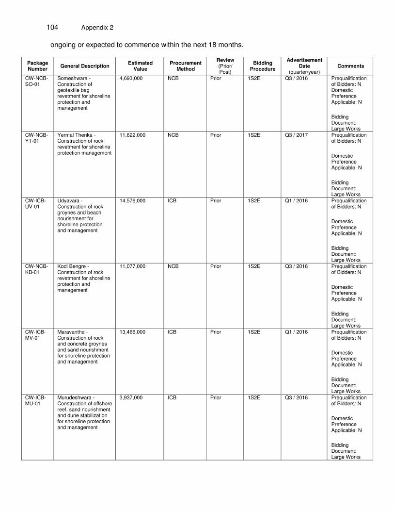
104 Appendix 2
ongoing or expected to commence within the next 18 months.
Package Number General Description Estimated
Value Procurement
Method Review (Prior/ Post)
Bidding Procedure
Advertisement Date
(quarter/year) Comments
CW-NCB-SO-01
Someshwara - Construction of geotextile bag revetment for shoreline protection and management
4,693,000
NCB Prior 1S2E Q3 / 2016 Prequalification of Bidders: N Domestic Preference Applicable: N Bidding Document: Large Works
CW-NCB-YT-01
Yermal Thenka - Construction of rock revetment for shoreline protection management
11,622,000
NCB Prior 1S2E Q3 / 2017 Prequalification of Bidders: N Domestic Preference Applicable: N Bidding Document: Large Works
CW-ICB-UV-01
Udyavara - Construction of rock groynes and beach nourishment for shoreline protection and management
14,576,000
ICB Prior 1S2E Q1 / 2016 Prequalification of Bidders: N Domestic Preference Applicable: N Bidding Document: Large Works
CW-NCB-KB-01
Kodi Bengre - Construction of rock revetment for shoreline protection and management
11,077,000
NCB Prior 1S2E Q3 / 2016 Prequalification of Bidders: N Domestic Preference Applicable: N Bidding Document: Large Works
CW-ICB-MV-01
Maravanthe - Construction of rock and concrete groynes and sand nourishment for shoreline protection and management
13,466,000
ICB Prior 1S2E Q1 / 2016 Prequalification of Bidders: N Domestic Preference Applicable: N Bidding Document: Large Works
CW-ICB-MU-01
Murudeshwara - Construction of offshore reef, sand nourishment and dune stabilization for shoreline protection and management
3,937,000
ICB Prior 1S2E Q3 / 2016 Prequalification of Bidders: N Domestic Preference Applicable: N Bidding Document: Large Works
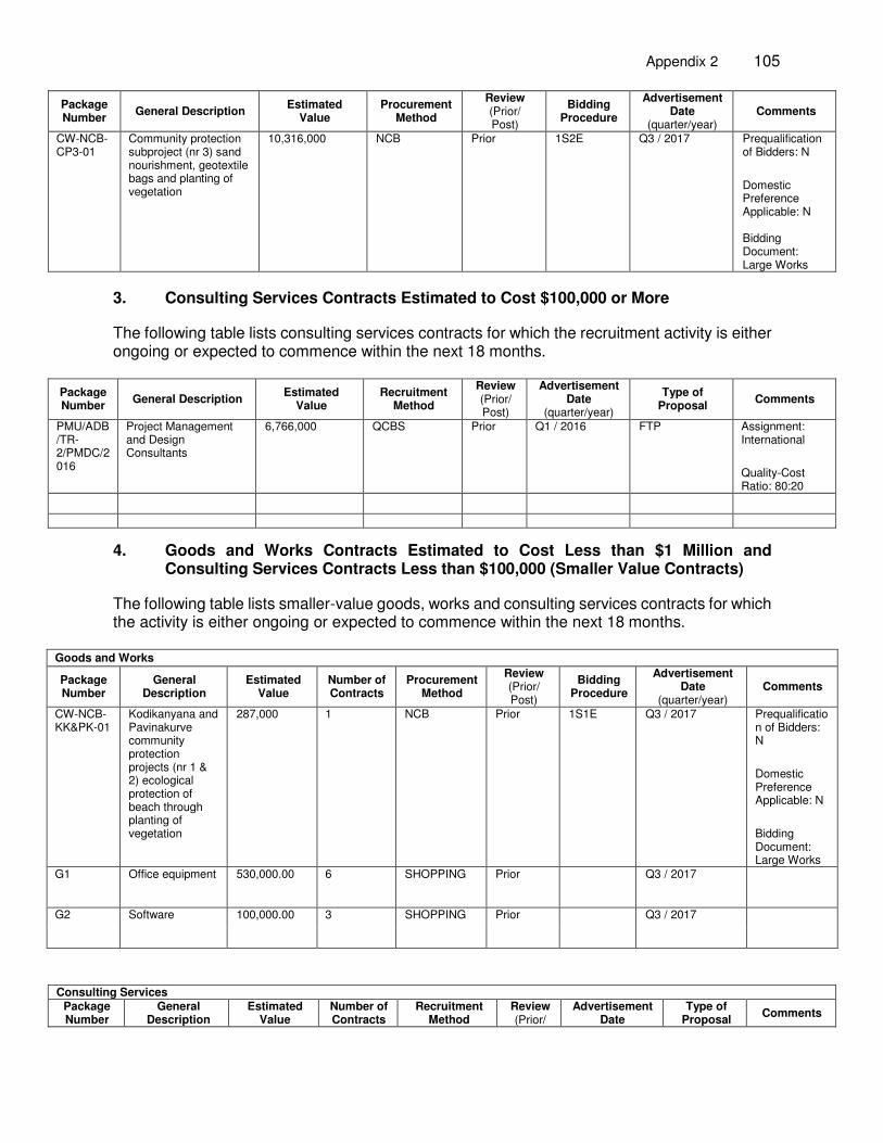
Appendix 2 105
Package Number General Description Estimated
Value Procurement
Method Review (Prior/ Post)
Bidding Procedure
Advertisement Date
(quarter/year) Comments
CW-NCB-CP3-01
Community protection subproject (nr 3) sand nourishment, geotextile bags and planting of vegetation
10,316,000
NCB Prior 1S2E Q3 / 2017 Prequalification of Bidders: N Domestic Preference Applicable: N Bidding Document: Large Works
3. Consulting Services Contracts Estimated to Cost $100,000 or More
The following table lists consulting services contracts for which the recruitment activity is either ongoing or expected to commence within the next 18 months.
Package Number General Description Estimated
Value Recruitment
Method Review (Prior/ Post)
Advertisement Date
(quarter/year) Type of
Proposal Comments
PMU/ADB/TR-2/PMDC/2016
Project Management and Design Consultants
6,766,000 QCBS Prior Q1 / 2016 FTP
Assignment: International Quality-Cost Ratio: 80:20
4. Goods and Works Contracts Estimated to Cost Less than $1 Million and Consulting Services Contracts Less than $100,000 (Smaller Value Contracts)
The following table lists smaller-value goods, works and consulting services contracts for which the activity is either ongoing or expected to commence within the next 18 months.
Goods and Works
Package Number
General Description
Estimated Value
Number of Contracts
Procurement Method
Review (Prior/ Post)
Bidding Procedure
Advertisement Date
(quarter/year) Comments
CW-NCB-KK&PK-01
Kodikanyana and Pavinakurve community protection projects (nr 1 & 2) ecological protection of beach through planting of vegetation
287,000 1 NCB Prior 1S1E Q3 / 2017 Prequalification of Bidders: N Domestic Preference Applicable: N Bidding Document: Large Works
G1 Office equipment 530,000.00 6 SHOPPING Prior Q3 / 2017
G2 Software 100,000.00 3 SHOPPING Prior Q3 / 2017
Consulting Services Package Number
General Description
Estimated Value
Number of Contracts
Recruitment Method
Review (Prior/
Advertisement Date
Type of Proposal Comments

106 Appendix 2
Post) (quarter/year) None
B. Indicative List of Packages Required Under the Project The following table provides an indicative list of goods, works and consulting services contracts over the life of the project, other than those mentioned in previous sections (i.e., those expected beyond the current period).
Goods and Works
Package Number
General Description
Estimated Value
(cumulative)
Estimated Number of Contracts
Procurement Method Review (Prior/Post) Bidding
Procedure Comments
None
Consulting Services
Package Number
General Description
Estimated Value
(cumulative)
Estimated Number of Contracts
Recruitment Method
Review (Prior/Post)
Type of Proposal Comments
None
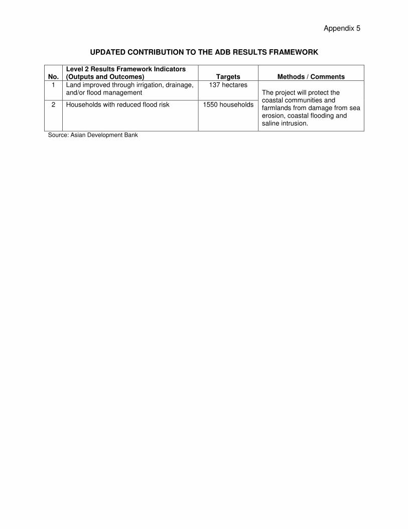
Appendix 5
UPDATED CONTRIBUTION TO THE ADB RESULTS FRAMEWORK
No. Level 2 Results Framework Indicators (Outputs and Outcomes) Targets Methods / Comments
1 Land improved through irrigation, drainage, and/or flood management
137 hectares The project will protect the coastal communities and farmlands from damage from sea erosion, coastal flooding and saline intrusion.
2 Households with reduced flood risk 1550 households
Source: Asian Development Bank
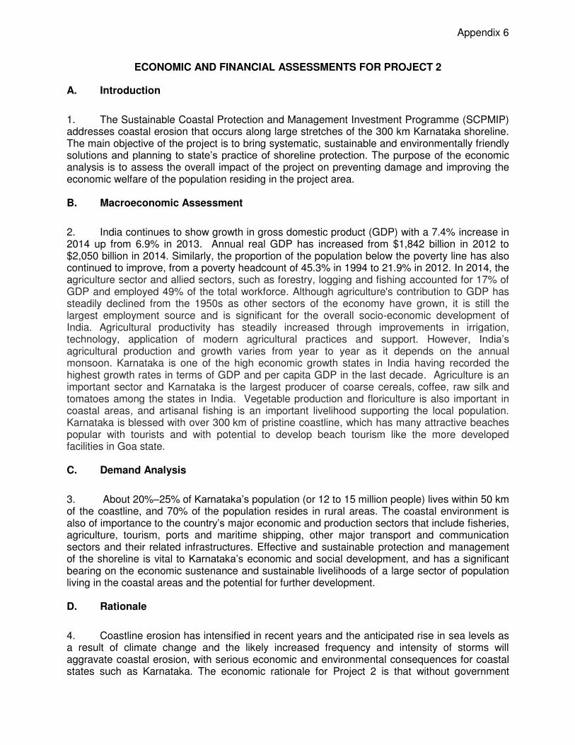
Appendix 6
ECONOMIC AND FINANCIAL ASSESSMENTS FOR PROJECT 2
A. Introduction
1. The Sustainable Coastal Protection and Management Investment Programme (SCPMIP) addresses coastal erosion that occurs along large stretches of the 300 km Karnataka shoreline. The main objective of the project is to bring systematic, sustainable and environmentally friendly solutions and planning to state’s practice of shoreline protection. The purpose of the economic analysis is to assess the overall impact of the project on preventing damage and improving the economic welfare of the population residing in the project area. B. Macroeconomic Assessment
2. India continues to show growth in gross domestic product (GDP) with a 7.4% increase in 2014 up from 6.9% in 2013. Annual real GDP has increased from $1,842 billion in 2012 to $2,050 billion in 2014. Similarly, the proportion of the population below the poverty line has also continued to improve, from a poverty headcount of 45.3% in 1994 to 21.9% in 2012. In 2014, the agriculture sector and allied sectors, such as forestry, logging and fishing accounted for 17% of GDP and employed 49% of the total workforce. Although agriculture's contribution to GDP has steadily declined from the 1950s as other sectors of the economy have grown, it is still the largest employment source and is significant for the overall socio-economic development of India. Agricultural productivity has steadily increased through improvements in irrigation, technology, application of modern agricultural practices and support. However, India’s agricultural production and growth varies from year to year as it depends on the annual monsoon. Karnataka is one of the high economic growth states in India having recorded the highest growth rates in terms of GDP and per capita GDP in the last decade. Agriculture is an important sector and Karnataka is the largest producer of coarse cereals, coffee, raw silk and tomatoes among the states in India. Vegetable production and floriculture is also important in coastal areas, and artisanal fishing is an important livelihood supporting the local population. Karnataka is blessed with over 300 km of pristine coastline, which has many attractive beaches popular with tourists and with potential to develop beach tourism like the more developed facilities in Goa state. C. Demand Analysis
3. About 20%–25% of Karnataka’s population (or 12 to 15 million people) lives within 50 km of the coastline, and 70% of the population resides in rural areas. The coastal environment is also of importance to the country’s major economic and production sectors that include fisheries, agriculture, tourism, ports and maritime shipping, other major transport and communication sectors and their related infrastructures. Effective and sustainable protection and management of the shoreline is vital to Karnataka’s economic and social development, and has a significant bearing on the economic sustenance and sustainable livelihoods of a large sector of population living in the coastal areas and the potential for further development. D. Rationale
4. Coastline erosion has intensified in recent years and the anticipated rise in sea levels as a result of climate change and the likely increased frequency and intensity of storms will aggravate coastal erosion, with serious economic and environmental consequences for coastal states such as Karnataka. The economic rationale for Project 2 is that without government
2
intervention to protect and manage the coastline in a coherent and planned way the economic wellbeing of coastal areas will be threatened by continuing erosion of the shoreline and thereby affecting agricultural production, livelihoods and property, coastal infrastructure, ecological integrity and curtail investment in economic development, especially tourism. 5. There has been limited external assistance for coastal protection and management in India. Nearly all investment funding has been from the states, central government, and the private sector. The lack of external assistance has resulted in a lack of exposure to new ideas and practices. Project 2 will support and maintain linkages with the main stakeholders in coastal protection in the planning, design and implementation of coastal erosion protection. E. Project Alternatives
6. Several options were studied at each site taking into account constraints to physical construction and implications for resettlement of the local people. The nine subprojects proposed for Project 2 are based on various design methodologies in consideration of the site-specific requirements and directed as far as possible towards soft options which will maintain the integrity of the natural beach with minimum impact on the natural shoreline processes. The shore protection solutions can be categorised into the following groups: (i) beach advance and stabilisation with retaining structures, such as straight and T-head groynes supported by beach nourishment; (ii) beach nourishment and stabilisation with offshore reefs; (iii) revetments of both rock and sand-filled geotextile bags; and (iv) dune construction and ecological dune stabilisation through vegetation planting. Several options have been studied at each of the subproject sites and the most technically effective and appropriate option identified. F. Methodology and Data
1. General
7. The economic analysis of Project 2 is in accordance with ADB’s Guidelines for the Economic Analysis of Projects (1997). The analysis uses cost-benefit analysis in which the future benefits are weighed against the investment costs with the economic performance measured by the economic internal rate of return (EIRR) and the economic net present value (ENPV), at the economic opportunity cost of capital (EOCC) of 12%. The benefits are principally the prevented losses that would occur in a future without-project (FWO-P) scenario as a result of the cumulative effect of coastal erosion. 8. Key assumptions. The economic analysis of the project is based on the following assumptions: (i) project life of 30 years including the construction period of four years with zero salvage value at the end of the period; (ii) project benefits built up in relation to the projected coastal erosion and saline inundation at each site, (iii) economic costs and benefits are expressed in constant 2015 terms with an exchange rate of INR 68.5 = $1.00, and are valued at the world price numeraire; (iv) taxes and duties, interest and price contingencies are excluded from the economic costs; and (v) economic costs and benefits for non-traded goods and services are derived by adjusting their values by the standard conversion factor of 0.90.
2. Project Benefits
9. The potential benefits of Project 2 mostly arise from the prevention of losses that would occur in the future situation without the project where a progressive rate of coastal erosion saline
3
intrusion is assumed to continue impacting on the local infrastructure, buildings and agricultural land. Benefits accrue principally from the protection of land, buildings and infrastructure from cumulative erosion saline water inundation and damage caused by the impact of the monsoon, and the avoidance of some other associated costs. 10. Valuation of the economic benefits was gained from several sources, including the Public Works Department, local Panchayat offices, consultation with local people, interpretation of Google maps and data from the earlier feasibility study.
11. The main items considered for quantification of benefits are listed as follow:
(i) The road along the coastline is a vital supporting infrastructure for fisheries activities and providing access. In the absence of effective coastal protection measures, the road will be progressively damaged and will eventually have to be replaced. The saving of temporary repair costs and the construction of new roads and bridges will cost around $8.3 million.
(ii) Coastal property is regularly damaged through coastal erosion and eventually property and buildings will be destroyed. Based on local information, it is estimated that around 2,760 buildings are vulnerable to be directly or indirectly damaged each year during the monsoon season, to varying degrees of severity. Almost 2,000 houses are assumed to have to be relocated and resettled at a total cost of almost $25 million over the 25-year project period.
(iii) Owning land in a coastal area is an important asset for the people for agricultural use and for other property. The proposed measures will protect land from coastal erosion. Another important aspect is that reduced overtopping of saline water will also improve productivity of agricultural crops. Around 540 acres (219 ha) in total is at risk of total loss due to erosion and a further 1,310 acre (530 ha) threatened by inundation with seawater. This land can be valued at its productive value for agriculture and its rental value for built-up land.
(iv) Avoidance of resettlement costs that may arise if land and buildings are threatened by coastal erosion forcing people to relocate. It is estimated the resettlement of families living in high-risk areas will cost around $20 million over the project period.
(v) An estimated 548 acres (222 ha) of land in these areas are under coconut production which will be affected by coastal erosion and saline intrusion rendering the land unproductive. Total revenue from coconuts to families owning the land is estimated at over $13 million during the life of the project.
(vi) Cashew production is another affected economic activity and approximately 32 acres (13 ha) of in these vulnerable areas are under cashew plantation which will be affected by seawater intrusion over the next 25 years rendering the land unproductive.
(vii) An estimated 690 acres of agricultural land used for producing rice and pulses is vulnerable to inundation with seawater at a total cost of lost production estimated at over $5.12 million during the project.
(viii) In the Udyavara subproject area around 250 acres (101 ha) of land is under Matti Gulla cultivation, a special variety of brinjal grown in this area for export to the Middle East, producing very high returns for the farmers. The loss of net income when this land eventually becomes unproductive totals $10.75 million.
(ix) According to socio-economic surveys carried out in December 2014, there are over 2,000 families who depend on fishing as their primary occupation at the Project 2 subproject sites. The loss of the beach and access for fishing and their forced

4
resettlement in the event of a breach of the land spit will lead to loss of the fishing resource and livelihood from fishing for these families necessitating them to switch to an alternative and less productive livelihood. The total net loss of livelihood is estimated at $36.85 million over the project life.
(x) In Udyavara subproject the connecting bridge between Udyavara and Malpe is at risk of becoming redundant when the associated land spit is breached in the absence of effective coastal protection. This would require local people to have to use an alternative ferry service, resulting in extra travel costs and journey times estimated to cost $10.75 million in total during the project life.
(xi) The National Highway 66 between the Arabian Sea and Souparnika River in Maravanthe is currently protected by a revetment which is under threat due to wave attack. In the absence of effective protection measures, there is 100% probability that the narrow isthmus will breach and subsequently this portion of the highway will collapse causing severe disruption to transport and communications. Construction of a new bridge and realignment of the National Highway to provide access over the collapsed portion plus the additional transport detour costs during construction is estimated to cost almost $60 million.
(xii) In four of the subprojects, Maravanthe, Someshwara, Murudeshwar and Pavinakurve tourism is a growing source of income for the local people. In the absence of protection from coastal erosion the beaches will lose their attraction to tourists and visitors reduce. With coastal protection tourism numbers are predicted to increase considerably. Changes in domestic tourists are excluded in this analysis while 30% of the projected increase in international tourists is assumed to be new visitors to India and 15% of their average daily expenditure included as the net economic benefit allowing for production costs and capital investment.
12. Land and assets have been valued in economic prices and all benefits arising from the protection against damage are associated with the occurrence of severe coastal erosion occurring in the future without-project situation over the life of the project, i.e. the likely damage that would occur if the project does not go ahead. Coastal erosion to some extent occurs every year associated with the annual monsoon when extreme weather and rainfall impacts on the wind and tide. Unlike other areas subject to unpredictable episodic events such as cyclones, in Karnataka coastal erosion occurs every year, resulting in a cumulative and progressive erosion of the shoreline. 13. The project impact and economic benefits have been defined for each of the eight subprojects that are planned and developed in sufficient detail at this stage to allow site specific assessments to be carried out. The ninth proposed subproject has not been defined in sufficient detail to allow the same level of assessment and its expected benefits are based on the impact of the two similar community forestry subprojects (Parvin Kurve and Kodi Kanyana) according to their benefits per km of beach frontage.
3. Non-Quantified Benefits
14. The project has been assessed based on the benefits that are possible to identify and quantify as discussed above. In addition to these benefits Project 2 is expected to generate added benefits that are more indeterminate and which cannot be easily quantified in monetary terms. These include: (i) increased security for artisanal fishing and rural fishing families leading to increased productivity and improved quality of life; (ii) improved security for households, farms and infrastructure at risk adjacent to the shoreline providing better conditions for future
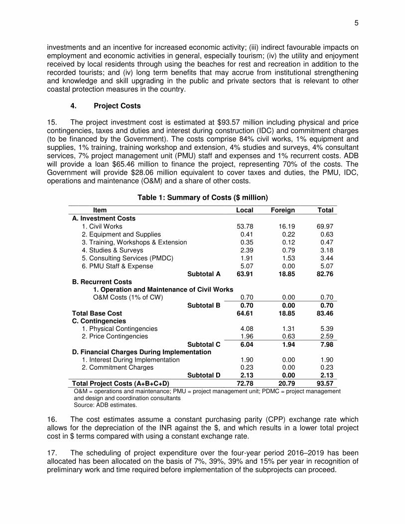
5
investments and an incentive for increased economic activity; (iii) indirect favourable impacts on employment and economic activities in general, especially tourism; (iv) the utility and enjoyment received by local residents through using the beaches for rest and recreation in addition to the recorded tourists; and (iv) long term benefits that may accrue from institutional strengthening and knowledge and skill upgrading in the public and private sectors that is relevant to other coastal protection measures in the country.
4. Project Costs
15. The project investment cost is estimated at $93.57 million including physical and price contingencies, taxes and duties and interest during construction (IDC) and commitment charges (to be financed by the Government). The costs comprise 84% civil works, 1% equipment and supplies, 1% training, training workshop and extension, 4% studies and surveys, 4% consultant services, 7% project management unit (PMU) staff and expenses and 1% recurrent costs. ADB will provide a loan $65.46 million to finance the project, representing 70% of the costs. The Government will provide $28.06 million equivalent to cover taxes and duties, the PMU, IDC, operations and maintenance (O&M) and a share of other costs.
Table 1: Summary of Costs ($ million)
Item Local Foreign Total
A. Investment Costs 1. Civil Works 53.78 16.19 69.97 2. Equipment and Supplies 0.41 0.22 0.63
3. Training, Workshops & Extension 0.35 0.12 0.47 4. Studies & Surveys 2.39 0.79 3.18 5. Consulting Services (PMDC) 1.91 1.53 3.44 6. PMU Staff & Expense 5.07 0.00 5.07
Subtotal A 63.91 18.85 82.76 B. Recurrent Costs 1. Operation and Maintenance of Civil Works
O&M Costs (1% of CW) 0.70 0.00 0.70
Subtotal B 0.70 0.00 0.70 Total Base Cost 64.61 18.85 83.46 C. Contingencies
1. Physical Contingencies 4.08 1.31 5.39 2. Price Contingencies 1.96 0.63 2.59
Subtotal C 6.04 1.94 7.98 D. Financial Charges During Implementation
1. Interest During Implementation 1.90 0.00 1.90 2. Commitment Charges 0.23 0.00 0.23
Subtotal D 2.13 0.00 2.13
Total Project Costs (A+B+C+D) 72.78 20.79 93.57 O&M = operations and maintenance; PMU = project management unit; PDMC = project management and design and coordination consultants Source: ADB estimates.
16. The cost estimates assume a constant purchasing parity (CPP) exchange rate which allows for the depreciation of the INR against the $, and which results in a lower total project cost in $ terms compared with using a constant exchange rate. 17. The scheduling of project expenditure over the four-year period 2016–2019 has been allocated has been allocated on the basis of 7%, 39%, 39% and 15% per year in recognition of preliminary work and time required before implementation of the subprojects can proceed.
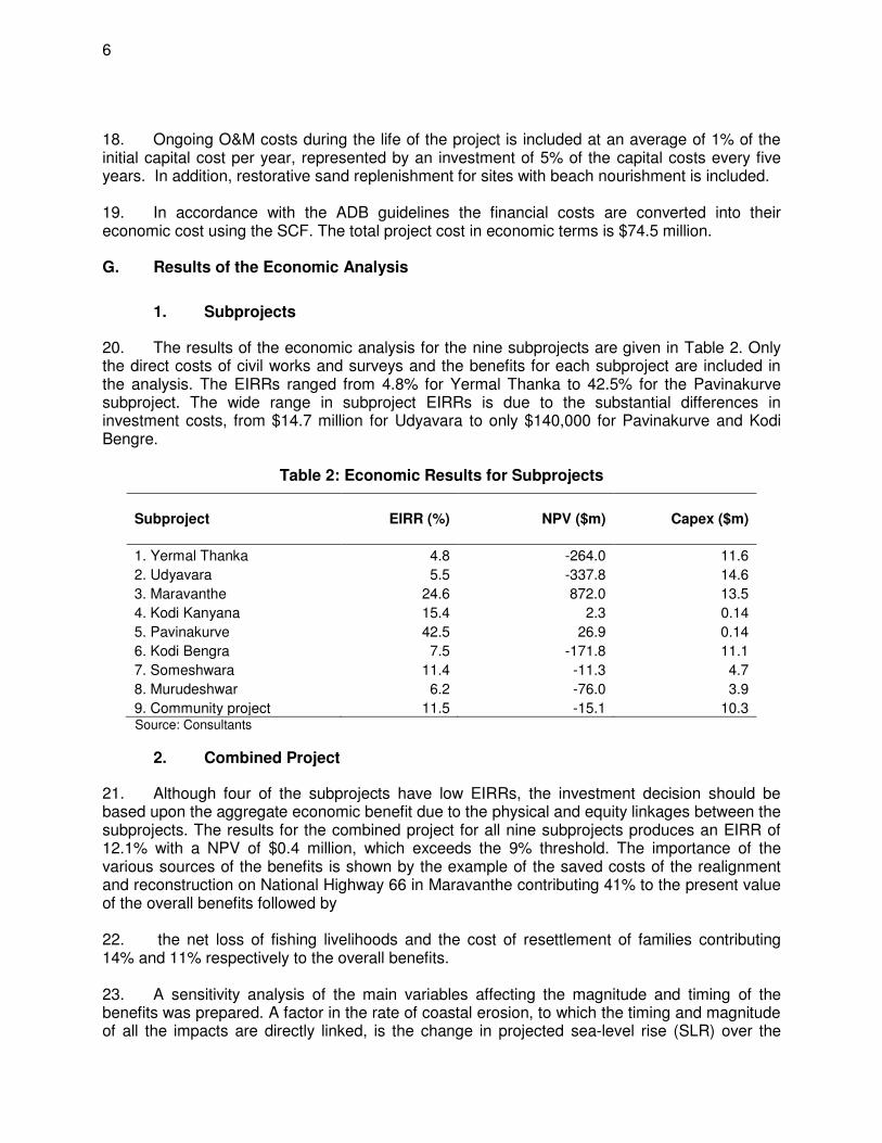
6
18. Ongoing O&M costs during the life of the project is included at an average of 1% of the initial capital cost per year, represented by an investment of 5% of the capital costs every five years. In addition, restorative sand replenishment for sites with beach nourishment is included. 19. In accordance with the ADB guidelines the financial costs are converted into their economic cost using the SCF. The total project cost in economic terms is $74.5 million. G. Results of the Economic Analysis
1. Subprojects
20. The results of the economic analysis for the nine subprojects are given in Table 2. Only the direct costs of civil works and surveys and the benefits for each subproject are included in the analysis. The EIRRs ranged from 4.8% for Yermal Thanka to 42.5% for the Pavinakurve subproject. The wide range in subproject EIRRs is due to the substantial differences in investment costs, from $14.7 million for Udyavara to only $140,000 for Pavinakurve and Kodi Bengre.
Table 2: Economic Results for Subprojects
Subproject EIRR (%) NPV ($m) Capex ($m)
1. Yermal Thanka 4.8 -264.0 11.6
2. Udyavara 5.5 -337.8 14.6
3. Maravanthe 24.6 872.0 13.5
4. Kodi Kanyana 15.4 2.3 0.14
5. Pavinakurve 42.5 26.9 0.14
6. Kodi Bengra 7.5 -171.8 11.1
7. Someshwara 11.4 -11.3 4.7
8. Murudeshwar 6.2 -76.0 3.9
9. Community project 11.5 -15.1 10.3 Source: Consultants
2. Combined Project
21. Although four of the subprojects have low EIRRs, the investment decision should be based upon the aggregate economic benefit due to the physical and equity linkages between the subprojects. The results for the combined project for all nine subprojects produces an EIRR of 12.1% with a NPV of $0.4 million, which exceeds the 9% threshold. The importance of the various sources of the benefits is shown by the example of the saved costs of the realignment and reconstruction on National Highway 66 in Maravanthe contributing 41% to the present value of the overall benefits followed by 22. the net loss of fishing livelihoods and the cost of resettlement of families contributing 14% and 11% respectively to the overall benefits. 23. A sensitivity analysis of the main variables affecting the magnitude and timing of the benefits was prepared. A factor in the rate of coastal erosion, to which the timing and magnitude of all the impacts are directly linked, is the change in projected sea-level rise (SLR) over the

7
period of the analysis from 2015 to 2040. To test for the impact of this variable minimum and maximum values for SLR were assumed.1 24. The other key variables are the capital investment costs, the cost of resettlement, and the net loss in livelihood for fishers who are forced to resettle and change to a less productive livelihood. The cost of the reconstruction of NH-66 in Maravanthe is also a major impact affecting the EIRR. The impact of changes in these variables is also shown in Table 3.
Table 3: Results of Sensitivity Analysis
Variable EIRR (%) NPV ($m) Switching
value
Base Case 12.1 0.4
Minimum SLR 7.2 -18.3
Maximum SLR 14.0 498.3
Capex + 20% 9.8 -7.3 2.6%
Capex – 20% 15.1 9.9
Opex +100% 11.4 -2.2 15%
Resettlement cost – 30% 11.9 -0.1 -27%
Loss of livelihood - 30% 11.5 -1.8 -5%
Removal of NH-66 cost/benefit 6.9 -18.1
SLR = sea level rise
25. The results show that the overall project is sensitive to changes in all these variables and relatively small changes in the costs and benefits affect the economic performance. The benefits associated with the benefit of not having to rebuild and relocate the main national highway in Maravanthe has a major impact and if this benefit is disregarded the EIRR falls to 6.9%. The switching values indicate the percentage change in the variable that causes the EIRR to fall below 12%.
H. Distribution and Poverty Analysis
26. Three stakeholders groups were considered: (i) the villagers and residents of the coastal areas; (ii) the commercial/business sector including the port; and (iii) the Government. As the Government will service the ADB loan for the investment cost and the O&M cost, and while the project will not generate incremental revenue, the Government incurs a net loss. The residents of the affected coastal areas will capture most of the net gains. The poverty impact ratio for the subprojects is estimated to be 24.5%.
1 The minimum SLR was assumed to be the rate of 1.3mm SLR per year to remain constant over the project life. For the maximum SLR it was assumed that the base case value in 2020 of 3.77mm per year in 2020 was increased by 50% to 5.55 mm per year and the value for 2040 of 4.8mm per year was increased to 9.6mm per year. This is done for studying sensitivity to an increased erosion due to 100% increase of SLR at the end of the project life compared to the standard value used. This is close to the RCP8.5 scenario for sea level rise rate.
8
I. Financial Analysis
27. The Project will have an impact on future government expenditure by reducing the requirement for infrastructure replacement. It is estimated that the subprojects will require 5% of their individual capital cost every five years for ongoing O&M to ensure sustainability of the capital investment. This amounts to an average total amount of $0.63 million (INR39.6 million) per year for a total shoreline length of 24.25 km. Presently the EA spends about $3.2 million annually for building rock revetments with additional emergency expenditure between $0.3 and $0.8 million during each monsoon for rock dumping. Thus, the O&M required for the subprojects of $0.63 per year is well within the current spending for shoreline protection and should be able to be managed within the current budget. 28. At some of the subproject sites, the proposed protection measures will increase agriculture productivity which will increase people’s income. However, since income from agriculture is tax free in India, the Government will not be able to generate any revenue from this source to fund future O&M expenses.
29. Some indirect benefits will accrue due to an anticipated increase in the number of tourists visiting the beaches for recreational purposes as a result of better coastal protection, especially in Someshwara, Udyavara, Marvanthe, Murudeshwar and Pavinakurve, which will result in income generation for local people, and increased government revenue through taxation and special fees that could be used to fund future O&M by shoreline management organisations.
Appendix 7
UPDATED SUMMARY POVERTY REDUCTION AND SOCIAL STRATEGY Country: India Project Title: Sustainable Coastal Protection and Management
Investment Program - Tranche 2
Lending/Financing Modality:
Multi-tranche Financing Facility
Department/ Division:
SARD/SAER
I. POVERTY AND SOCIAL ANALYSIS AND STRATEGY
Poverty targeting: targeted intervention-geographic (TI-G) – No A. Links to the National Poverty Reduction and Inclusive Growth Strategy and Country Partnership Strategy
The Government of India’s 12th Five Year Plan calls for an inclusive approach to development and stresses the need to improve infrastructure and reduce poverty to achieve sustainable development. The ADB country partnership strategy, 2013-2017 is closely aligned with India’s plan and aims to improve infrastructure and investment to enhance environmental sustainability. The Karnataka Sustainable Coastal Protection and Management Investment Program - Tranche 2 aims to minimize coastal erosion in 3 districts (Dakshina Kannada, Udupi and Uttara Kannada) that will contribute in reducing poverty levels in about 5,070 coastal households located in the project areas of the Tranche 2 subprojects. B. Results from the Poverty and Social Analysis during PPTA or Due Diligence
1. Key poverty and social issues. The Planning Commission estimates the percentage of persons living below the poverty line as 25.7% in rural areas, 13.7% in urban areas and 21.9% for the country as a whole, for the period 2011-12 (Source: Planning Commission, Government of India, Poverty Estimates 2011-12, July 2013). The corresponding poverty figures for Karnataka for the same year remains at 24.53% in the rural areas, and 15.25% in urban areas. Within Karnataka, the coastal areas typically present a relatively better picture in terms of poverty, educational levels, and overall quality of life index. The poverty ratios in the three coastal project districts (Dakshina Kannada, Udupi, and Uttara Kannada) range from 17.8% to 20.1%, little below the state average. In terms of the Human Development Index, Dakshina Kannada (0.722), Udupi (0.714) and Uttara Kannada (0.653) are ranked in the upper range of the first seven districts in Karnataka State (Source: Karnataka Human Development Report, Planning Commission, 2005). The coastal communities depend on fishing as their main source of livelihood. The household surveys conducted in the coastal wards, as part of project preparation, indicated that almost one-fourth of the population has fishing as the primary source of livelihood. Coastal erosion has had an adverse impact on the tourist inflow along the project locations, impacting the livelihood of small vendors and petty businesses. By protecting the beach, the project will address loss of livelihoods, temporary dislocation costs, loss of public assets and properties, improvement in business and trade and, thereby contribute to reducing the risk of poverty in the subproject areas. 2. Beneficiaries. Thirty-eight coastal wards in project locations host about 5070 households, who depend primarily on coastal resources for their livelihood. The local government records indicated that the total population in these 38 coastal wards is around 27,000 of which about 6,100 (22.5%) live below the poverty line (BPL). Around 41% (6,625 over 16,148) of the working population have fishery as their primary occupation. The scheduled castes and schedule tribe populations constitute about 19% of the total population in the coastal wards. With an average literacy rate of about 75%, the statistical data shows that coastal wards are better off compared to other wards in the districts. The male: female ratio for the project area is 942 males for 1000 females. Coastal erosion in all the project sites has significantly affected the livelihoods of the communities living along the coastline. The impact of erosion is very high particularly during the 3 monsoon months (June - August), resulting in reduced income, loss of land and other assets, damage to community infrastructure, restricted road connectivity. The coastal protection measures once completed will have positive impacts in terms of enhanced livelihood opportunities, protected land and other assets and assured connectivity. 3. Impact channels. Although the project will not contribute to reducing poverty directly, it will facilitate the sustainability of the existing livelihoods and enhance the job security of the people, which is a part of the overall national poverty reduction strategy of India. The protection of properties from erosion damage will have positive economic impacts in terms of reducing expenditure on property restoration, decreasing temporary loss of livelihoods and reducing expenditure in the repairs of public infrastructure. The reduction of public expenditure will ensure sustainable economic development especially in those project areas that mostly depend on fishing and other service occupations related to beach tourism. 4. Other social and poverty issues. The project does not aim to address other social aspects related to the promotion of tourism and fishery sectors such as providing vocational trainings allied to fisheries and boat building, fish marketing support, provision for agricultural extension support. Such activities are being addressed by the respective state departments through their district level administration. 5. Design features. Project 2 addresses the sustainable coastal protection measures using innovative engineering designs and institutional support mechanisms. Community participation is promoted by establishing Shoreline Management Organizations (SMOs) that will facilitate the selection of project locations for sand dune management interventions during project implementation and will maintain assets for coastal protection measures after the project is completed.
2
II. PARTICIPATION AND EMPOWERING THE POOR
1. Participatory approaches and project activities. For Kodi Kanyana and Pavinakurve subprojects, community based organizations (CBO) in close coordination with local authorities, have been significantly involved in project design, especially in the plantation component of the dune management restoration works. The CBOs have also been actively involved in providing inputs for project design but this has been limited to providing information on information related to severity of coastal erosion. Overall the role of community-based organizations and civil society organizations in managing shorelines, preventing erosion, and monitoring the occurrence of coastal erosion has yet to be fully institutionalized 2. Shoreline Management Organizations (SMOs) are expected to be established as a “rallying point” for civil society organizations to participate in the project not only during preparation, construction, but later on monitoring. 3. The civil society organizations will be represented in the site-specific SMOs. Each subproject will have a Shoreline Management Organization that will take up shoreline planning and management and post construction O&M tasks, with guidance from the Project Management Unit (PMU). 4. The following forms of civil society organization participation are envisaged during project implementation, rated as high (H), medium (M), low (L), or not applicable (NA):
M Information gathering and sharing H Consultation M Collaboration M Partnership
5. Participation plan. Plan for participation of civil society using the platform of Shoreline Management Organizations (SMOs) has been developed as part of the project design. Yes. No.
III. GENDER AND DEVELOPMENT
Gender mainstreaming category: Some Gender Elements (SGE) Key issues. Women’s participation in non-income generating community activities in the project area has been observed to be minimal. Women in the project area have limited interest in participating in non-income generating community activities and largely due to the difficult and often variable environmental conditions in the project sites, voiced reluctance in full participation. Nevertheless, based on surveys conducted during project design, it was observed that a significant number of women in coastal areas have an important role in the retail fish vending business and processing, and a significant number of them are also involved in small businesses to support beach tourism. Project 2 will thus benefit women as the project scope aims to reduce coastal erosion and this will in turn increase or maintain the beach width that will enable greater opportunities for women to be engaged in fish processing activities (dried fish etc.). Similarly, by reducing coastal erosion and creating ‘beach’ areas, project 2 is expected to promote opportunities for beach tourism that will also enable women to have a stronger stake in pursuing and increasing small businesses opportunities for themselves. Key actions. There will be potential involvement of women in activities required to meet output 1. However, it is not possible to set a target on their involvement due to the difficult and sometimes hostile environmental conditions, which prevents wholehearted interest and commitment by women to participate in construction related activities. This opinion was confirmed during stakeholder consultations during the project design. Out of 5 activities listed to achieve output 2, there are 2 activities that could be targeted to have a gender element: (i) fully established SMOs at nine sub-project sites, and (ii) capacity strengthening within PWPIWTD in project management including finance, construction and community participation. The establishment of SMOs in each subproject area will give an opportunity for women to be involved and for them to participate in decision making in community development activities, especially in maintaining the coastal protection facilities. The SMOs are expected to have at least 10 persons as part of the executive body, of which at least 3 will be expected to be women. The training programs on coastal management for local communities will incorporate strengthened knowledge to maintain assets and at least 30% of the participants should be women. As part of the capacity strengthening program, the PWPIWTD should encourage participation of its female staff. Any training held under this component should have female staff represented. The progress in implementing activities that are targeted to have gender elements as described above, will be reported by PMU in their quarterly project progress report. On this basis, Project 2 is categorized as a project with Some Gender Elements (SGE).
Gender action plan Other actions or measures No action or measure IV. ADDRESSING SOCIAL SAFEGUARD ISSUES
A. Involuntary Resettlement Safeguard Category: A B C FI 1. Key impacts. The investment program for tranche 2 will neither acquire any land nor resettle people; therefore, there is no impact due to involuntary resettlement. 2. Strategy to address the impacts. In case during project implementation, land needs to be acquired or people will need to be resettled, the involuntary resettlement framework of tranche 2 had been updated in accordance with ADB’s Safeguard Policy Statement 2009 and the Government of India new Act pertaining to the Right to Fair Compensation and Transparency in Land Acquisition, Rehabilitation, and Resettlement, 2013. 3. Plan or other Actions.
Resettlement plan Resettlement framework
Environmental and social management system arrangement
No action
Combined resettlement and indigenous peoples plan Combined resettlement framework and indigenous peoples
planning framework Social impact matrix
3
B. Indigenous Peoples Safeguard Category: A B C FI
1. Key impacts. The investment program under Project 2 does not pose a threat to the cultures and practices of indigenous peoples or schedule tribes, as they have been mainstreamed into society. They will also benefit from the result of investments, which will protect coastal erosion. Is broad community support triggered? Yes No
2. Strategy to address the impacts. Project 2 will not have any negative impact on indigenous peoples, as described in ADB Safeguard Policy Statement, 2009 or on schedules tribes as described in the Karnataka Scheduled Castes and Scheduled Tribes Act 1978. However, in the event that unanticipated indigenous people impacts occur during project implementation, and as part of the MFF requirement (as stated in ADB SPS 2009), during project 2 design the Indigenous People Planning Framework for tranche 1 had been updated in accordance with ADB’s SPS 2009 and the Constitution of India as well as the Karnataka Scheduled Castes and Scheduled Tribes Act 1978.
3. Plan or other actions.
Indigenous peoples plan Indigenous peoples planning framework Environmental and social management system
arrangement
Social impact matrix No action
Combined resettlement plan and indigenous peoples plan
Combined resettlement framework and indigenous peoples planning framework
Indigenous peoples plan elements integrated in project with a summary
V. ADDRESSING OTHER SOCIAL RISKS
A. Risks in the Labor Market 1. Relevance of the project for the country’s or region’s or sector’s labor market, indicated as high (H), medium (M), and low or not significant (L).
L unemployment L underemployment L retrenchment L core labor standards
2. Labor market impact.
B. Affordability
Not applicable
C. Communicable Diseases and Other Social Risks 1. The impact of the following risks are rated as high (H), medium (M), low (L), or not applicable (NA): L Communicable diseases NA Human trafficking
Others (please specify) ______________ 2. Risks to people in project area. The construction works use heavy machinery that needs to be operated by professional technicians and some construction areas will have also temporary impacts during construction, therefore, the boundary of construction works will display clear signs that non-authorized people will be forbidden from entering. In addition, the contractor will be required to establish emergency plans to handle any accident related with construction works.
VI. MONITORING AND EVALUATION
1. Targets and indicators: The project interventions have been targeted to: (i) reduce the annual rate of erosion to 60% from present levels; (ii) reduce annual loss of beach areas by 50%, (iii) ensure at least 20 SMOs and local governments will have the capacity to maintain assets created by the project; (iv) ensure 15 km of village and local government roads are protected; (v) ensure damaged houses and properties are reduced by 15% in numbers, and (vi) damaged fishing assets are reduced by 20% (in value). With the achievement of these physical targets, the project will contribute in improving livelihoods and incomes of people who lives in 38 wards along the coastal borders of the project areas. 2. Required human resources: The PMU will have one full time social development/institutional specialist to facilitate the creation of SMOs and address other social development issues related with the project 2. With the support of the two full time environment specialists/engineers under the PMU, the social development/institutional specialist will be responsible to ensure local community participation in the selection of locations for coastal protection measures such as plantation schemes and beach nourishment. These 2 environment specialists will also play the role of Grievance Redress Officers at the PMU, aside from their responsibility to manage environmental impacts related with health and safety. These positions have been budgeted for in the investment program. 3. Information in PAM: The PAM includes a comprehensive monitoring and evaluation system and management information system. Regular monitoring will be done by the PMU and project staff to measure effectiveness and progress on project implementation and also other aspect of the project such as monitoring the progress on implementation of EMP, progress on addressing labor and gender aspects as well as community participation in the project. 4. Monitoring tools: The quarterly project progress report will become an important tool to monitor achievement of the overall project implementation. An inception review will be undertaken 3 months after loan effectiveness, and mid-term review of the loan will be undertaken 1.5 year after the loan effectiveness date. Project reviews will be undertaken regularly and as needed. The review mission will evaluate the scope of the loan, implementation arrangements; safeguard issues, achievement of scheduled targets, contract management progress, and other issues including mid-course corrections. A project completion evaluation will be undertaken one year after the closure of the project. Findings of the completion report will be shared and disseminated within ADB and with key government officials at the national and state level.

4
Source: 1. Social Impact Assessment Report, Study commissioned under SCPMIP, December 2014 2. 12th Plan Approach Paper, 2012-2017, Government of India 3. Discussions with local governments of site-specific local government bodies(GPs) 4. Planning Commission, Government of India, Poverty Estimates 2011-12, July 2013). 5. Karnataka Human Development Report, Planning Commission, 2005.

Appendix 8
Resettlement Framework
Available at https://www.adb.org/sites/default/files/project-document/184530/40156-033-rf-01.pdf

Appendix 9
Indigenous People Planning Framework
Available at https://www.adb.org/sites/default/files/project-document/184532/40156-033-ippf-01.pdf

Appendix 10
Environmental Assessment and Risk Management Plan
Available at https://www.adb.org/sites/default/files/project-document/184531/40156-033-earf-01.pdf

Appendix 11
Initial Environmental Examination
Available at https://www.adb.org/sites/default/files/project-document/184529/40156-033-iee-01.pdf
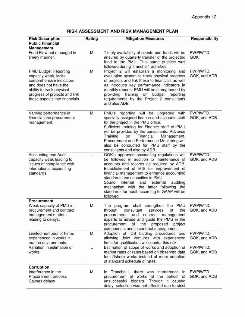
Appendix 12
RISK ASSESSMENT AND RISK MANAGEMENT PLAN
Risk Description Rating Mitigation Measures Responsibility
Public Financial Management
Fund Flow not managed in timely manner.
M Timely availability of counterpart funds will be ensured by quarterly transfer of the projected fund to the PMU. This same practice was followed during Tranche 1 activities.
PWPIWTD, GOK
PMU Budget Reporting capacity weak, lacks comprehensive indicators and does not have the ability to track physical progress of projects and link these aspects into financials
M Project 2 will establish a monitoring and evaluation system to track physical progress of projects and link these to financials as well as introduce key performance indicators in monthly reports. PMU will be strengthened by providing training on budget reporting requirements by the Project 2 consultants and also ADB.
PWPIWTD, GOK, and ADB
Varying performance in financial and procurement management.
M PMU’s reporting will be upgraded with specially assigned finance and accounts staff for the project in the PMU office. Sufficient training for Finance staff of PMU will be provided by the consultants. Advance Training on Financial Management, Procurement and Performance Monitoring will also be conducted for PMU staff by the consultants and also by ADB.
PWPIWTD, GOK, and ADB
Accounting and Audit capacity weak leading to issues of compliance with international accounting standards.
L GOK’s approved accounting regulations will be followed in addition to maintenance of accounts and records as required by ADB. Establishment of MIS for improvement of financial management to enhance accounting standards and capacities in PMU. Sound internal and external auditing mechanism with the latter following the standards for audit according to GAAP will be followed.
PWPIWTD, GOK, and ADB
Procurement Weak capacity of PMU in procurement and contract management matters leading to delays.
M The program shall strengthen the PMU through consultant services of the procurement, and contract management experts to advise and guide the PMU in the procurement of the proposed project components and in contract management.
PWPIWTD, GOK, and ADB
Limited numbers of Firms experienced in works in marine environments.
M
Adoption of ICB bidding procedures and allowing Joint ventures with experienced firms for qualification will counter this risk.
PWPIWTD, GOK, and ADB
Variation in estimation of works.
L Estimation of scope of works and adoption of market rates or rates based on observed data for offshore works instead of mere adoption of standard schedule of rates.
PWPIWTD, GOK, and ADB
Corruption Interference in the Procurement process Causes delays
M In Tranche-1, there was interference in procurement of works at the behest of unsuccessful bidders. Though it caused delay, selection was not affected due to strict
PWPIWTD, GOK, and ADB
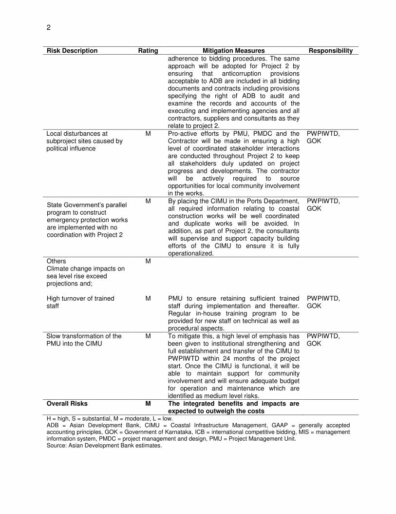
2
Risk Description Rating Mitigation Measures Responsibility
adherence to bidding procedures. The same approach will be adopted for Project 2 by ensuring that anticorruption provisions acceptable to ADB are included in all bidding documents and contracts including provisions specifying the right of ADB to audit and examine the records and accounts of the executing and implementing agencies and all contractors, suppliers and consultants as they relate to project 2.
Local disturbances at subproject sites caused by political influence
M Pro-active efforts by PMU, PMDC and the Contractor will be made in ensuring a high level of coordinated stakeholder interactions are conducted throughout Project 2 to keep all stakeholders duly updated on project progress and developments. The contractor will be actively required to source opportunities for local community involvement in the works.
PWPIWTD, GOK
State Government’s parallel program to construct emergency protection works are implemented with no coordination with Project 2
M
By placing the CIMU in the Ports Department, all required information relating to coastal construction works will be well coordinated and duplicate works will be avoided. In addition, as part of Project 2, the consultants will supervise and support capacity building efforts of the CIMU to ensure it is fully operationalized.
PWPIWTD, GOK
Others Climate change impacts on sea level rise exceed projections and; High turnover of trained staff
M
M
PMU to ensure retaining sufficient trained staff during implementation and thereafter. Regular in-house training program to be provided for new staff on technical as well as procedural aspects.
PWPIWTD, GOK
Slow transformation of the PMU into the CIMU
M
To mitigate this, a high level of emphasis has been given to institutional strengthening and full establishment and transfer of the CIMU to PWPIWTD within 24 months of the project start. Once the CIMU is functional, it will be able to maintain support for community involvement and will ensure adequate budget for operation and maintenance which are identified as medium level risks.
PWPIWTD, GOK
Overall Risks M The integrated benefits and impacts are expected to outweigh the costs
H = high, S = substantial, M = moderate, L = low. ADB = Asian Development Bank, CIMU = Coastal Infrastructure Management, GAAP = generally accepted accounting principles, GOK = Government of Karnataka, ICB = international competitive bidding, MIS = management information system, PMDC = project management and design, PMU = Project Management Unit. Source: Asian Development Bank estimates.
Supplementary Appendixes
Supplementary Appendixes
A. Climate Change: Project Adaptation Action Report B. Updated Detailed Project Report including Project Planning and Technical Rationale for
Subproject Interventions C. Financial and Economic Assessment D. Climate Risk and Vulnerability Assessment
Available upon request.