Embed Size (px)
Citation preview

Page 13
Periodic Atlas of the MetroscapeTraveling the Past into the Present The Regon's Highways & Byways
David Peterson del Mar, Historian Heather Kaplinger, Cartographer
Meg Merrick, Atlas Concept
Few of the overland emigrants who poured into the Willamette Valley in the early 1840s were seeking gold or fame. They wanted fertile farming land—as much as they could grab. That the Oregon Country was occupied by indigenous peoples and the Hudson’s Bay Company and claimed by Great Britain as well as the United States did not deter them. Great Britain and the United States set the boundary well north of the Willamette Valley in 1846. But the critical question of land owner-ship remained until the Donation Land Law of 1850 which confirmed claims made under earlier, very generous, acts; granted 320 acres to
white male Oregonians over the age of eighteen and another 320 acres to their wives and allowed those settling after December 1, 1850 to claim half as much. Historians have argued that the 1850 act contributed to Oregon’s conservatism. Wives could get land through the measure, but men’s thirst for another 320 acres proved to be so great that Oregon women were married long before they were old enough to exercise much in-dependence. The law made a point of excluding men of Hawaiian and African descent, a provision designed to deter dark-skinned peoples from settling here. The ample size of the grants, given the rudimen-tary state of Oregon farming, meant that much of the land would lie idle for another generation. In Empire of the Columbia: A History of the Pacific Northwest, Dorothy Johansen and Charles Gates argue that the outsized grants “isolated the settlers, impeding the growth of towns and the diversification of occupations, industry and crops, and increasing a characteristic tendency of pioneers toward provincialism and localism.” The generous Donation Land Law drew an unprecedented wave of settlers, some 20,000 from 1850-1851, and made imperative a quick, accurate survey of the territory’s arable land. The work began late in 1850, when surveyors established a base line that ran east and west from Portland and a meridian running south from the Willamette River’s mouth. The survey took many years to complete, but soon established a precise grid across most of the Wil-lamette Valley, which then, as now, held the great majority of Oregon’s residents. The survey’s principal goals had to do with land tenure: it was to both record the precise nature of existing claims and to map accurately the lines upon which new ones would be made. Indeed, new claimants had to make rectangular claims. Hence one can often distinguish earlier claims by their diagonal and irregular borders. But the surveyors did more than impose an imaginary grid on Ore-gon’s bountiful soils. They also recorded features of the actual, seen landscape—rivers, lakes, hills, and mountains, of course, but also soil types, timber, and marshland. They marked the ways in which settlers and Indians had marked the land with trails, roads, buildings, fields, and other features. Historical geographers—professional and amateur—have barely be-gun to mine this remarkably detailed source. Superimposed on recent maps of the Portland area, as presented here, one can see, literally, the ways in which modern arteries like Foster Road and Sandy Boulevard follow much earlier and rudimentary transportation routes, or how some streams and marshes have disappeared as others, such as Sucker Lake, both grew and assumed new names (Lake Oswego). The pioneering surveyors who tramped their way across fields, swamps, and hills did much more than help to settle Oregon. They left us a remarkably precise visual record of the land before a series of eco-nomic and social transformations would rework it, even as it intimates how that pre-modern landscape would shape the changes to come.Map Sources:http://libweb.uoregon.edu/map/GIS/Data/Oregon/Quadrant_4.htm http://libweb.uoregon.edu/map/GIS/Data/Oregon/Quadrant_1.htm Map and Aerial Photography Collection Digital Copies of the Cadastral Survey Maps for Oregon, produced by the General Land Office in the 19th and 20th centuries. These are large JPEG images in .zip files (1-2.5MB).
LEGEND*
Wilsonville, circa 1852
*This legend applies to all of the maps in this atlas.
MetroscapePage 14
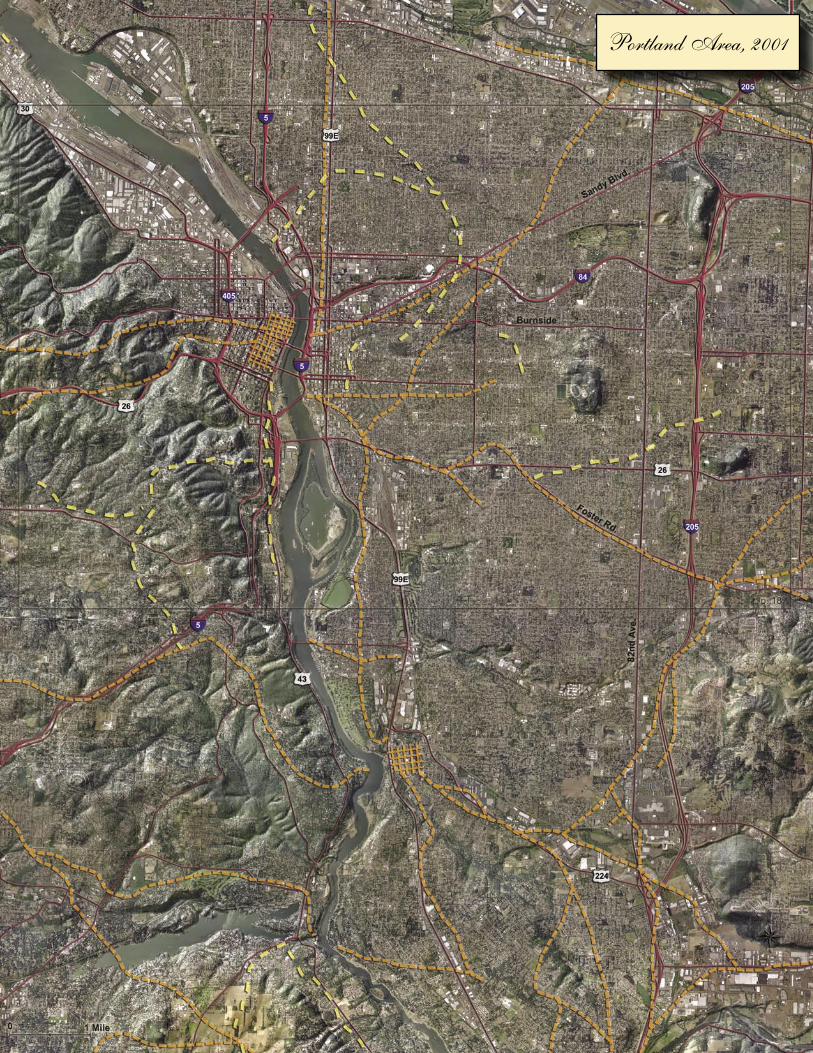
Portland Area, 2001

Page 15Metroscape
Portland Area, 2001 Portland Area, circa 1852

MetroscapePage 16

Metroscape Page 17
Milwaukie, Lake Oswego, and Oregon City, circa 1852

MetroscapePage 18
Portland Area Topo Property, circa 1852

Page 19Metroscape
M
Oregon City, 2001 Oregon City Property, circa 1852


![PERIODIC CLASSIFICATION & PERIODIC PROPERTIES [ 1 ...youvaacademy.com/youvaadmin/image/PERIODIC TABLE BY RS.pdf · [ 2 ] PERIODIC CLASSIFICATION & PERIODIC PROPERTIES BY RAJESH SHAH](https://img.pdfslide.us/doc/110x75/604570870a43592d4f6b3e29/periodic-classification-periodic-properties-1-table-by-rspdf-2.jpg)