1
! ( I ZONE AE (EL 5) ZONE X ZONE X ZONE X ZONE X ZONE X ZONE AE (EL 5) ZONE AE (EL 5) ZON E X ZON E A E (EL 5) ZON E X ZON E AE (EL 9) ZON E X ZO NE X ZONE X ZONE AE (EL 8) ZONE AE (EL 9) ZONE X ZONE AE (EL 8) B A Y S H ORE R O A D PENSACOLA BAY WHISPER BAY DRIVE PENSACOLA BAY C ORAL ST R IP PK WY DUK E DR W H I SP ER B AY D R RANCHE TTE S Q WH ISPER B AY BLV D RAN CHO VIL LA DR H O L I D A Y D R L A M B D R W H I S P E R P I N E D R BAYSH ORE C T W I N D S O R P A R K R D B A Y S H O R E T E R B A Y S H O R E L A N E BAYS HO RE D RIVE E B A Y S H ORE R O A D G U LF B RE EZE P K W Y 98 VILL A W OO DS CIR LIDO BLVD V ENI TI AN WAY VE BA Y SHORE DR IVE W LA UREL S T G U LF B R EEZE PK WY 98 R A N C H O VI L L A D R RO S A DE L VILLA DR W H I S P E R B A Y B L V D WIND MEADOW DR P AL M S T SKAGG ST P I N E S T E U L A S T W ES T AV E BR OWDER ST GLENN ST R A M B L E W O O D O R I O L E B E A C H R O A D W H I S P E R P I N E D R I V E Gulf Breeze 9 F9_9 8.79 Florida Alabama Baldwin County Santa Rosa County Okaloosa County Escambia County MAPS FOR ADVISORY PURPOSES ONLY - NOT FOR INSURANCE RATING PURPOSES For insurance rating purposes, refer to the currently effective Flood Insurance Rate Map (FIRM), available from your local government or the FEMA Map Service Center (1-800-358-9616/ http://store.msc.fema.gov) SCALE = 1" = 500' (1:6,000) OVERVIEW MAP LEGEND HURRICANE IVAN SURGE INUNDATION MAP Aerial Imagery: Baldwin Co., AL (2002); Escambia Co., FL (2003); Santa Rosa Co., FL (2001); Okaloosa Co., FL (2001) Flood Zones and Elevations: FEMA Flood Insurance Rate Maps (Baldwin Co., AL, [2002]; Escambia Co., FL [2000]; Santa Rosa Co. and City of Gulf Breeze, FL [2000]; Okaloosa Co., FL [2002]) High Water Marks: FEMA (Identified and surveyed Oct-Nov., 2004) Debris Line: FEMA (Compiled from aerial imagery collected by U.S. Army Corps of Engineers, Oct. 2004) Storm Track: NOAA National Weather Service Data Sources: 0 500 1,000 1,500 2,000 Feet State Boundary County Boundary Corporate Limits FEMA Flood Zone Boundary FEMA Floodway Boundary FEMA Base Flood Elevation 1 ! ( I Indoor High Water Mark 1 ! ( O Outdoor High Water Mark 1 ! ( D Debris High Water Mark 1 Preliminary Surge Elevation 1,2 Preliminary Debris Limit Limit of Surge Inundation Map Number: F30 Estimated Surge Elevation: 8-10 ft Gulf of Mexico I Elevation ID (See Index Map for Additional Information) 1 Measured in feet - NAVD88 (Baldwin County, AL); NGVD29 (Escambia, Santa Rosa, and Okaloosa Counties, FL) Elevation ID Elevation ID 2 Preliminary Surge Elevations do not include wave effects and therefore are not directly comparable to FEMA Base Flood Elevations. For information on estimating wave heights, see accompanying "Notes to Users," or the report, "Hurricane Ivan Surge Inundation Maps, Summary of Methods." Notes: Path of Eye of Hurricane Ivan Area Impacted by > 1% Annual Chance Surge Date of Event: September 16, 2004; Date of Map: December 2004 For more information on these advisory maps, please see www.fema.gov/ivanmaps

PENSACOLA BAY - Home | FEMA.gov · Gulf Breeze 9 F9_9 8.79 Florida Alabama Baldwin County Santa Rosa County Okaloosa County Escambia County MAPS FOR ADVISORY PURPOSES ONLY - NOT FOR

Embed Size (px)

Citation preview

!(I

ZONE AE(EL 5)

ZONE X

ZONE X

ZONE X

ZONE X

ZONE X

ZONE AE(EL 5)

ZONE AE(EL 5)

ZONE X

ZONE AE(EL 5)

ZONE XZONE AE(EL 9)

ZONE X

ZONE X

ZONE X

ZONE AE(EL 8)

ZONE AE(EL 9)

ZONE X

ZONEAE

(EL 8)

BAYSH

OR

E RO

AD

PENSACOLA BAY

WHISPERBAY DRIVE

PENSACOLA

BAY

CORAL STRIP PKWY

DUKE DR

WHISPER BAY DR

RANCHETTE SQWHISPER BAY

BLVD

RANCHO VILLA DR

HO

LIDA

Y D

R

LA

MB

DR

WH

ISPE

R P

INE

DRBAYSHORE

CT

WIN

DS O

R P

AR

K R

D

BAY

SHO

RE

T ER

BA Y

SHO

RE

L AN

E

BAYSHORE DRIVE E

BAYSH

OR

E RO

AD

GULF

BREEZE P

KWY

98

VILLAWOODS CIR

LIDO

BLVD

VENITIAN WAY

VE

BAYSHORE DRIVE W

LAUREL ST

GULF BREEZE PKWY

98

RA

NC

HO

VILL

AD

R

ROSA

DEL

VILLA

DR

WH

ISP E

R B

A Y B

LVD

WIND MEADOW DR

PALM ST

SKAGG ST

PIN

E ST

EU

LA S

T

WEST AVE

BROWDER ST

GLENN ST

RA

MB

LEW

OO

D

OR

IOLE

BEA

CH

RO

AD

WH

ISP E

R P

INE

DR

IVE

Gulf Breeze

9

F9_9

8.79

FloridaAlabama

Baldwin County

Santa Rosa County

Okaloosa County

Escambia County

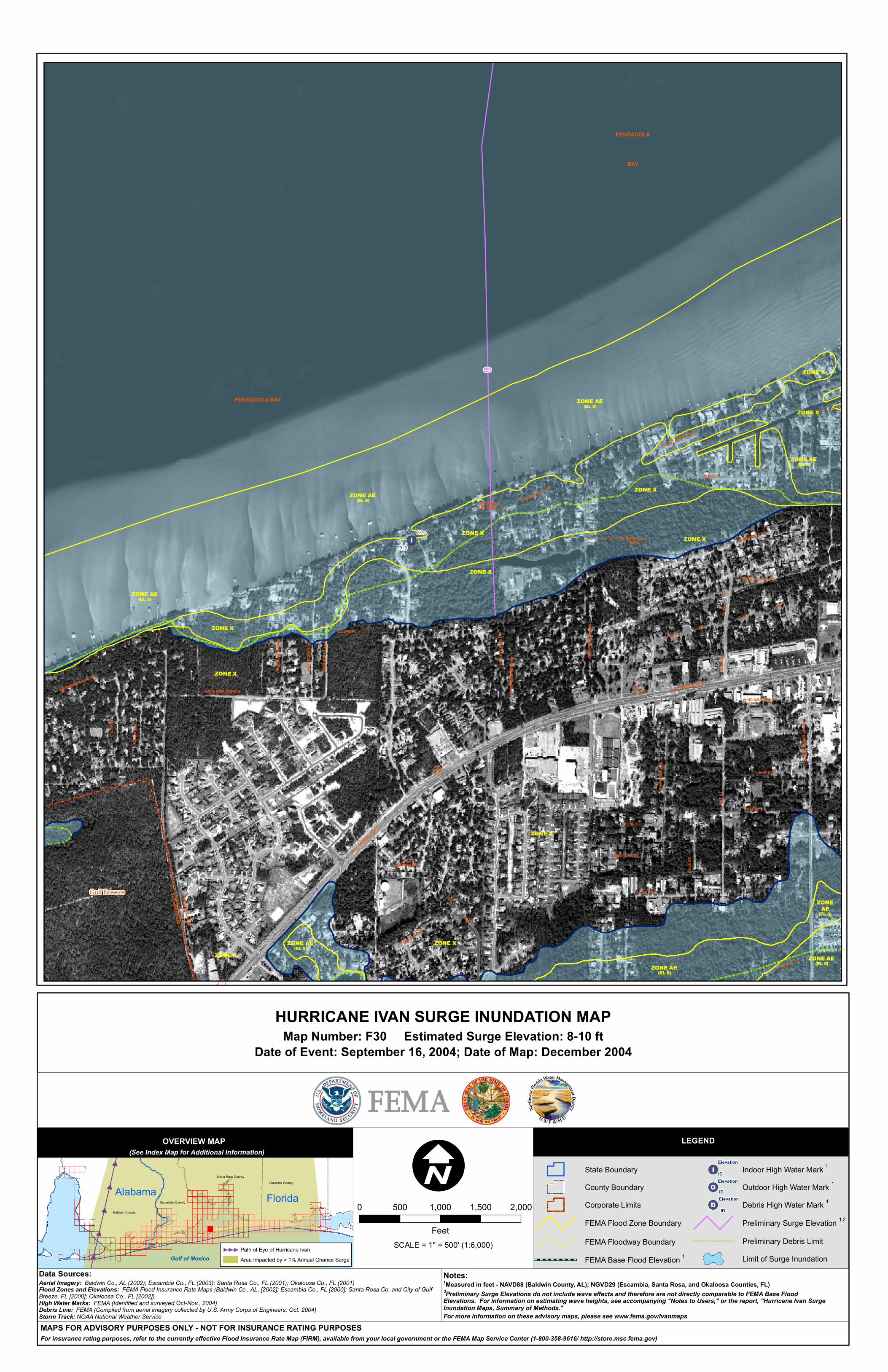
MAPS FOR ADVISORY PURPOSES ONLY - NOT FOR INSURANCE RATING PURPOSESFor insurance rating purposes, refer to the currently effective Flood Insurance Rate Map (FIRM), available from your local government or the FEMA Map Service Center (1-800-358-9616/ http://store.msc.fema.gov)

SCALE = 1" = 500' (1:6,000)

OVERVIEW MAP LEGEND

HURRICANE IVAN SURGE INUNDATION MAP

Aerial Imagery: Baldwin Co., AL (2002); Escambia Co., FL (2003); Santa Rosa Co., FL (2001); Okaloosa Co., FL (2001) Flood Zones and Elevations: FEMA Flood Insurance Rate Maps (Baldwin Co., AL, [2002]; Escambia Co., FL [2000]; Santa Rosa Co. and City of Gulf Breeze, FL [2000]; Okaloosa Co., FL [2002])High Water Marks: FEMA (Identified and surveyed Oct-Nov., 2004)Debris Line: FEMA (Compiled from aerial imagery collected by U.S. Army Corps of Engineers, Oct. 2004)Storm Track: NOAA National Weather Service

Data Sources:

0 500 1,000 1,500 2,000

Feet

State Boundary

County Boundary

Corporate Limits

FEMA Flood Zone Boundary

FEMA Floodway Boundary

FEMA Base Flood Elevation 1

!(I Indoor High Water Mark 1

!(O Outdoor High Water Mark 1

!(D Debris High Water Mark 1

Preliminary Surge Elevation 1,2

Preliminary Debris Limit

Limit of Surge Inundation

Map Number: F30 Estimated Surge Elevation: 8-10 ft

Gulf of Mexico

I Elevation

ID

(See Index Map for Additional Information)

1Measured in feet - NAVD88 (Baldwin County, AL); NGVD29 (Escambia, Santa Rosa, and Okaloosa Counties, FL)

Elevation

IDElevation

ID

2Preliminary Surge Elevations do not include wave effects and therefore are not directly comparable to FEMA Base Flood Elevations. For information on estimating wave heights, see accompanying "Notes to Users," or the report, "Hurricane Ivan Surge Inundation Maps, Summary of Methods."

Notes:

Path of Eye of Hurricane Ivan

Area Impacted by > 1% Annual Chance Surge

Date of Event: September 16, 2004; Date of Map: December 2004

For more information on these advisory maps, please see www.fema.gov/ivanmaps