Embed Size (px)
Citation preview

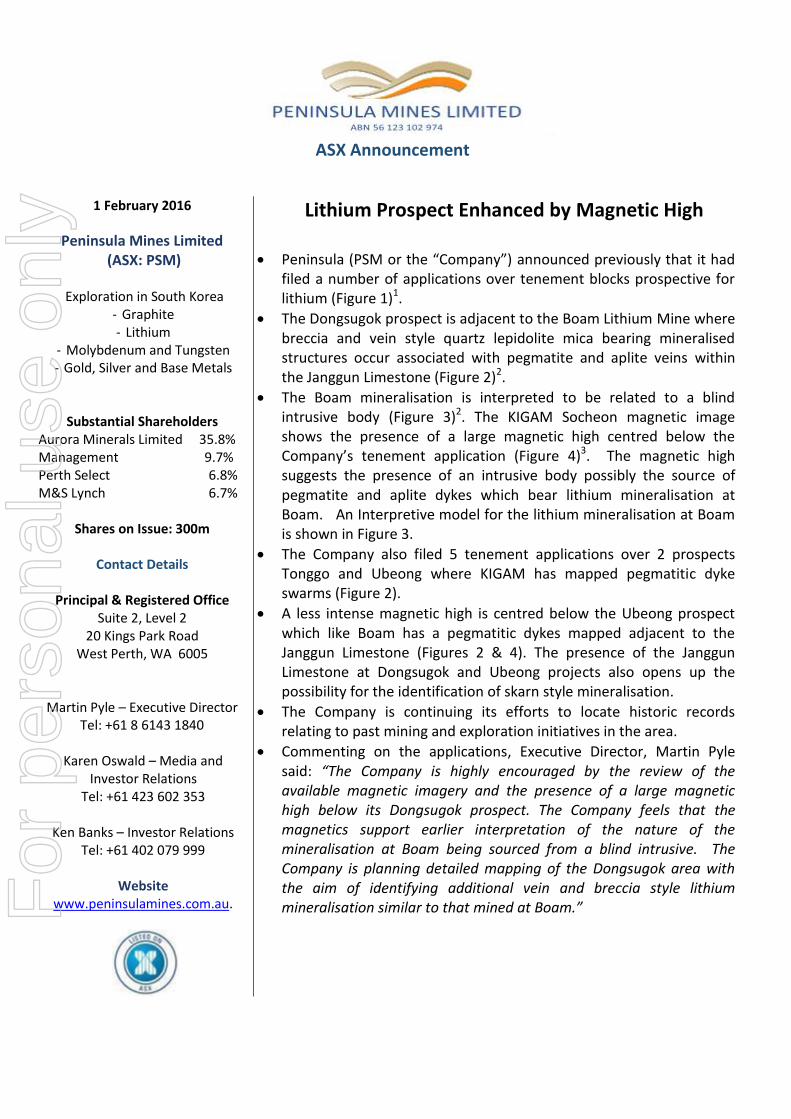
ASX Announcement 1 February 2016
ASX Code: ARM
Aurora Minerals Group of Companies Diversified Minerals Exploration via direct and indirect interests Predictive Discovery Limited (ASX: PDI) – 43.1% - Gold Exploration / Development in Burkina
Faso Peninsula Mines Limited (ASX: PSM) – 35.8% - Graphite, Lithium- Gold, Silver and Base Metals - Molybdenum and Tungsten Exploration in South Korea Golden Rim Resources (ASX: GMR) - 13.4% - Gold Exploration/ Development in Burkina Faso Aurora Western Australian Exploration – 100% - Manganese, Base metals and gold
Contact Details
Principal & Registered Office Suite 2, Level 2 20 Kings Park Road West Perth WA 6006
Martin Pyle – Managing Director Tel: +61 8 6143 1840 Karen Oswald – Media and Investor Relations Tel: +61 423 602 353 Ken Banks – Investor Relations Tel: +61 402 079 999
Website www.auroraminerals.com
PENINSULA MINES- LITHIUM PROSPECT ENHANCED BY MAGNETIC HIGH Peninsula Mines Limited, a company in which Aurora Minerals Limited holds a 35.8% shareholding, today announced an update on its Lithium Exploration in South Korea.
A copy of the announcement is attached. For further information please contact: Media Martin Pyle Karen Oswald Managing Director Marko Communications Telephone: +61 8 6143 1840 Mob: +61 423 602 353
For
per
sona
l use
onl
y
ASX Announcement
1 February 2016
Peninsula Mines Limited (ASX: PSM)
Exploration in South Korea
- Graphite - Lithium
- Molybdenum and Tungsten - Gold, Silver and Base Metals
Substantial Shareholders Aurora Minerals Limited 35.8% Management 9.7% Perth Select 6.8% M&S Lynch 6.7%
Shares on Issue: 300m
Contact Details
Principal & Registered Office
Suite 2, Level 2 20 Kings Park Road
West Perth, WA 6005
Martin Pyle – Executive Director Tel: +61 8 6143 1840
Karen Oswald – Media and
Investor Relations Tel: +61 423 602 353
Ken Banks – Investor Relations
Tel: +61 402 079 999
Website www.peninsulamines.com.au.
Lithium Prospect Enhanced by Magnetic High
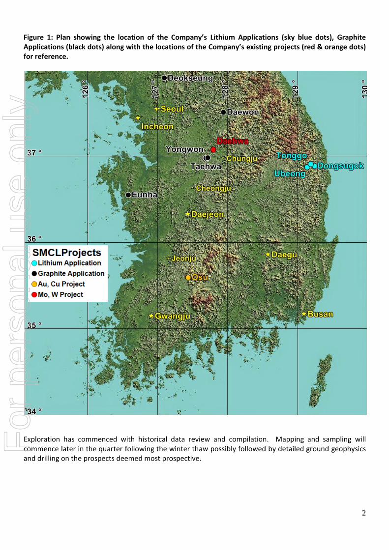
Peninsula (PSM or the “Company”) announced previously that it had filed a number of applications over tenement blocks prospective for lithium (Figure 1)1.
The Dongsugok prospect is adjacent to the Boam Lithium Mine where breccia and vein style quartz lepidolite mica bearing mineralised structures occur associated with pegmatite and aplite veins within the Janggun Limestone (Figure 2)2.
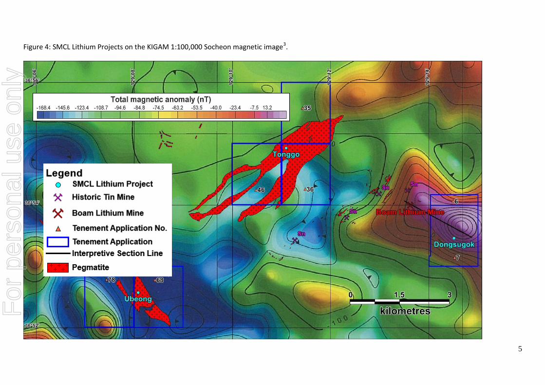
The Boam mineralisation is interpreted to be related to a blind intrusive body (Figure 3)2. The KIGAM Socheon magnetic image shows the presence of a large magnetic high centred below the Company’s tenement application (Figure 4)3. The magnetic high suggests the presence of an intrusive body possibly the source of pegmatite and aplite dykes which bear lithium mineralisation at Boam. An Interpretive model for the lithium mineralisation at Boam is shown in Figure 3.
The Company also filed 5 tenement applications over 2 prospects Tonggo and Ubeong where KIGAM has mapped pegmatitic dyke swarms (Figure 2).
A less intense magnetic high is centred below the Ubeong prospect which like Boam has a pegmatitic dykes mapped adjacent to the Janggun Limestone (Figures 2 & 4). The presence of the Janggun Limestone at Dongsugok and Ubeong projects also opens up the possibility for the identification of skarn style mineralisation.
The Company is continuing its efforts to locate historic records relating to past mining and exploration initiatives in the area.
Commenting on the applications, Executive Director, Martin Pyle said: “The Company is highly encouraged by the review of the available magnetic imagery and the presence of a large magnetic high below its Dongsugok prospect. The Company feels that the magnetics support earlier interpretation of the nature of the mineralisation at Boam being sourced from a blind intrusive. The Company is planning detailed mapping of the Dongsugok area with the aim of identifying additional vein and breccia style lithium mineralisation similar to that mined at Boam.”
For
per
sona
l use
onl
y
2
Figure 1: Plan showing the location of the Company’s Lithium Applications (sky blue dots), Graphite Applications (black dots) along with the locations of the Company’s existing projects (red & orange dots) for reference.
Exploration has commenced with historical data review and compilation. Mapping and sampling will commence later in the quarter following the winter thaw possibly followed by detailed ground geophysics and drilling on the prospects deemed most prospective.
For
per
sona
l use
onl
y

Figure 2: Lithium Tenement Applications on KIGAM Samgeunri 1:50,000 geology sheet4.
For
per
sona
l use
onl
y

4
Figure 3: Interpretive model for the lithium mineralisation at Boam (modified after Burnham, 1997 & Choi et al., 2014)2,5.
Interpreted
Lithium
Mineralisation
Targets
For
per
sona
l use
onl
y
5
Figure 4: SMCL Lithium Projects on the KIGAM 1:100,000 Socheon magnetic image3.
For
per
sona
l use
onl
y

References utilised in the compilation of this announcement: 1. PSM ASX release - Lithium Prospects, South Korea, 15 January 2015. 2. Choi, Y.H., Park, Y.R. and Noh, J.H., 2014, Genesis of Boam lithium deposit in Wangpiri, Uljin. Journal of Geological Society of Korea, V50, No.4, pp489-500. 3. Koo, S,B., Park, Y.S., Lim, M.T., Rim, H.R., Lee, H.I., Sung, N.H., Choi, J,H. and Koo., J.H., 2008, KIGAM 1:100,000 Socheon Aeromagnetic Contour Image. 4. Kim, O.J., Hong, M.S., Park, H.I. and Kim, K.T., 1963, KIGAM 1:50,000 Samgeunri Geology Sheet. 5. Burnham, C.W., 1997, Magmas and hydrothermal fluids. In H.L. Barnes (ed.), Geochemistry of Hydrothermal Ore Deposits, 3rd ed. John Wiley & Sons, pp63-123. Martin Pyle Executive Director +61 429 999 552 Peninsula’s ASX releases are available for download from the Company's website www.peninsulamines.com.au The information in this announcement that relates to Exploration Results, Mineral Resources or Ore Reserves is based on information compiled by Mr Daniel Noonan, a Member of The Australian Institute of Mining and Metallurgy. Mr Noonan is Exploration Manager for the Company and is employed as a consultant. Mr Noonan has sufficient experience which is relevant to the style of mineralisation and type of deposit under consideration and to the activity which he is undertaking to qualify as a Competent Person as defined in the 2012 Edition of the ‘Australasian Code for Reporting of Exploration Results, Mineral Resources and Ore Reserves’. Mr Noonan consents to the inclusion in the announcement of the matters based on this information in the form and context in which it appears.
JORC Code, 2012 Edition: Table 1
Section 1: Sampling Techniques and Data
(Criteria in this section apply to all succeeding sections.)
Criteria JORC – Code of Explanation Commentary
Sampling techniques
Nature and quality of sampling (e.g. cut channels, random chips, or specific specialised industry standard measurement tools appropriate to the minerals under investigation, such as down hole gamma sondes, or handheld XRF instruments, etc). These examples should not be taken as limiting the broad meaning of sampling.
At this stage of the project’s evaluation no field sampling has been undertaken.
Include reference to measures taken to ensure sample representivity and the appropriate calibration of any measurement tools or systems used.
No comment is required here as no sampling results are being reported or discussed.
For
per
sona
l use
onl
y
7
Criteria JORC – Code of Explanation Commentary
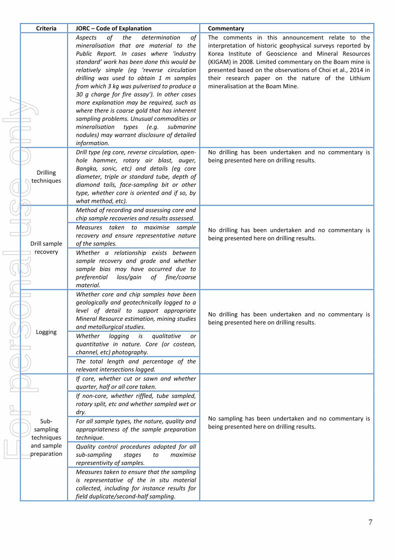
Aspects of the determination of mineralisation that are material to the Public Report. In cases where ‘industry standard’ work has been done this would be relatively simple (eg ‘reverse circulation drilling was used to obtain 1 m samples from which 3 kg was pulverised to produce a 30 g charge for fire assay’). In other cases more explanation may be required, such as where there is coarse gold that has inherent sampling problems. Unusual commodities or mineralisation types (e.g. submarine nodules) may warrant disclosure of detailed information.
The comments in this announcement relate to the interpretation of historic geophysical surveys reported by Korea Institute of Geoscience and Mineral Resources (KIGAM) in 2008. Limited commentary on the Boam mine is presented based on the observations of Choi et al., 2014 in their research paper on the nature of the Lithium mineralisation at the Boam Mine.
Drilling techniques
Drill type (eg core, reverse circulation, open-hole hammer, rotary air blast, auger, Bangka, sonic, etc) and details (eg core diameter, triple or standard tube, depth of diamond tails, face-sampling bit or other type, whether core is oriented and if so, by what method, etc).
No drilling has been undertaken and no commentary is being presented here on drilling results.
Drill sample recovery
Method of recording and assessing core and chip sample recoveries and results assessed.
No drilling has been undertaken and no commentary is being presented here on drilling results.
Measures taken to maximise sample recovery and ensure representative nature of the samples.
Whether a relationship exists between sample recovery and grade and whether sample bias may have occurred due to preferential loss/gain of fine/coarse material.
Logging
Whether core and chip samples have been geologically and geotechnically logged to a level of detail to support appropriate Mineral Resource estimation, mining studies and metallurgical studies.
No drilling has been undertaken and no commentary is being presented here on drilling results.
Whether logging is qualitative or quantitative in nature. Core (or costean, channel, etc) photography.
The total length and percentage of the relevant intersections logged.
Sub-sampling
techniques and sample preparation
If core, whether cut or sawn and whether quarter, half or all core taken.
No sampling has been undertaken and no commentary is being presented here on drilling results.
If non-core, whether riffled, tube sampled, rotary split, etc and whether sampled wet or dry.
For all sample types, the nature, quality and appropriateness of the sample preparation technique.
Quality control procedures adopted for all sub-sampling stages to maximise representivity of samples.
Measures taken to ensure that the sampling is representative of the in situ material collected, including for instance results for field duplicate/second-half sampling.
For
per
sona
l use
onl
y

8
Criteria JORC – Code of Explanation Commentary
Whether sample sizes are appropriate to the grain size of the material being sampled.
Quality of assay data
and laboratory
tests
The nature, quality and appropriateness of the assaying and laboratory procedures used and whether the technique is considered partial or total.
No sampling has been undertaken and no commentary is being presented here on sampling results.
For geophysical tools, spectrometers, handheld XRF instruments, etc, the parameters used in determining the analysis including instrument make and model, reading times, calibrations factors applied and their derivations, etc.
The Company has purchased the Korea Institute of Geoscience and Mineral Resources (KIGAM) 1:100,000 Total Magnetic Airborne Magnetic Imagery for the Socheon sheet on which the Dongsugok, Tonggo and Ubeong Projects lie (Published Dec 2008)
3.
The magnetic survey was undertaken by KIGAM using a Geometrics G-813 Proton Magnetometer. The flight lines were flown East-West at a 1 km line spacing with North-South tie lines flown at a 5km spacing. The flight altitude for the survey was 100-200m above ground level. The data processing involved setting the data level at 300m above mean sea level by upward/downward continuation. The International Geomagnetic Reference Field (IGRF) was used to assist with the removal of total magnetic anomaly. The KIGAM colour total magnetic contour maps are printed at 1:100,000 scale and referenced using the Bessel ellipsoid and the Tokyo datum with latitude and longitude coordinate marked.
Nature of quality control procedures adopted (e.g. standards, blanks, duplicates, external laboratory checks) and whether acceptable levels of accuracy (i.e. lack of bias) and precision have been established.
The company has relied on the processed image purchased from KIGAM for all subsequent interpretations. At this point in time, the Company has been unable to procure the raw data from the original airborne magnetic survey. No assay results have been reported or commented upon in this release.
Verification of sampling
and assaying
The verification of significant intersections by either independent or alternative company personnel.
If the company is able to procure the original raw survey data, it is the Company's intention to reprocess the data using an independent geophysical consultancy firm. No assay results have been reported or commented upon in this release.
The use of twinned holes. No drilling has been undertaken or commented upon in this release.
Documentation of primary data, data entry procedures, data verification, data storage (physical and electronic) protocols.
The Company has been unable at this point in time to procure the raw survey data from KIGAM. The Company has not completed any field mapping at this stage but intends to do so once the Korean winter passes and the snow cover has melted. The Company has relied on the information compiled and published by KIGAM and geological staff and students from the Kangwon National University for the project area. The Company’s data is stored in an excel database and routinely transferred to the Perth office.
For
per
sona
l use
onl
y

9
Criteria JORC – Code of Explanation Commentary
Discuss any adjustment to assay data. No assay results have been reported or commented upon in this release.
Location of data points
Accuracy and quality of surveys used to locate drill holes (collar and down-hole surveys), trenches, mine workings and other locations used in Mineral Resource estimation.
No drilling has been undertaken or commented upon in this release. The Company has relied on information compiled and published by KIGAM and geologists from the Kangwon National University.
Specification of the grid system used. All the KIGAM magnetic images are presented using the Bessel ellipsoid and Tokyo datum. These have been transformed to GRS080 coordinate system for the purpose of displaying the tenement applications.
Quality and adequacy of topographic control.
The National Geographic Information Institute (NGII) has 1:5000 scale digital contour data for the entire country. The Company understands that KIGAM used this contour data to produce a Digital Elevation Model (DEM) as part of the data levelling process.
Data spacing and
distribution
Data spacing for reporting of Exploration Results.
The aerial magnetic survey was undertaken by KIGAM using a Geometrics G-813 Proton Magnetometer. The flight lines were flown East-West at a 1 km line spacing with North-South tie lines flown at a 5km spacing. The flight altitude for the survey was 100-200m above ground level. The data processing involved setting the data level at 300m above mean sea level by upward/downward continuation. The International Geomagnetic Reference Field (IGRF) was used to assist with the removal of total magnetic anomaly. It is not anticipated that any of the data would be used to compile any form of Mineral Resource and the data is purely acquired as part of the overall reconnaissance evaluation of the projects. The Company intends to complete follow-up, closer spaced ground magnetic surveys over the tenement areas.
Whether the data spacing and distribution is sufficient to establish the degree of geological and grade continuity appropriate for the Mineral Resource and Ore Reserve estimation procedure(s) and classifications applied.
The flight line spacing is considered adequate for a regional scale airborne survey. The geophysical data is not intended for the use in any future resource estimation that may be undertaken.
Whether sample compositing has been applied.
No sampling results are presented here.
Orientation of data in relation to geological structure
Whether the orientation of sampling achieves unbiased sampling of possible structures and the extent to which this is known, considering the deposit type.
The main structural features trend approximately northeast-southwest and the airborne magnetic survey was flown east-west to reflect the prevailing trends observed in the geology across the Korean Peninsula.
If the relationship between the drilling orientation and the orientation of key mineralised structures is considered to have introduced a sampling bias, this should be assessed and reported if material.
No drilling has been undertaken or commented upon. For
per
sona
l use
onl
y

10
Criteria JORC – Code of Explanation Commentary
Sample security
The measures taken to ensure sample security.
All magnetic data was collected by KIGAM and the Company understands that KIGAM took adequate steps to maintain data security both during the surveying and subsequently during the data processing phase.
Audits or reviews
The results of any audits or reviews of sampling techniques and data.
The company is not aware of any historic internal KIGAM audits of their survey process.
Section 2: Reporting of Exploration Results
(Criteria listed in the preceding section also apply to this section.)
Criteria JORC – Code of Explanation Commentary
Mineral tenement and
land tenure status
Type, reference name/number, location and ownership including agreements or material issues with third parties such as joint ventures, partnerships, overriding royalties, native title interests, historical sites, wilderness or national park and environmental settings.
SMCL is a wholly owned subsidiary of Peninsula and has recently been granted 7 tenements at Hyeondong (Figures 2 & 4). The granted tenements include portions of blocks Hyeondong 6and Hyeondong 7. In addition, SMCL has been granted the entire Hyeondong 35, Hyeondong 36, Hyeondong 46, Hyeondong 68 and Hyeondong 78 tenement blocks. The tenements were granted on 11 January 2016. The company has until 10 July 2016 to successfully lodge Mineral Deposit Survey reports (MDS) over the applied areas before the Ministry of Trade, Industry and Energy makes its decision on the issuance of a Mining Right.
The security of the tenure held at the time of reporting along with any known impediments to obtaining a licence to operate in the area.
The Company has been granted tenure for 6 months and is required to submit a MDS report for each of the 7 applied tenements prior to the end of the 6 month application period. If the MDS report is accepted by the Ministry, the Company will be granted Mining rights over the applied tenement for a further 3 years. Following the successful filing of the MDS, the applicant is required to file Prospecting Application (PA).This report details the planned exploration activities to be completed over the tenement during the 3 year prospecting period. This includes the completion of a minimum quantum of geophysical surveys, geochemical surveys or drilling as defined under the Mines Act. Provided that at least 50% of the statutory requirement is completed within the initial 3 year prospecting period, the tenement holder is entitled to apply for an additional 3 year extension to facilitate the completion of the specified exploration programme. A Prospecting Report must then be submitted to the Ministry at the completion of the exploration programme. The tenement holder must then submit a Mine Planning Application (MPA) to the local Government Authority who will, if the MPA is approved, grant tenure for mining for a period of 20 years subject to statutory requirements as set out under the terms of the MPA approval. The applicant holding a Mining Right can apply for extensions provided all statutory requirements have been met over the life of the mine.
For
per
sona
l use
onl
y

11
Exploration done by other
parties
Acknowledgement and appraisal of exploration by other parties.
The Company is not aware of any detailed exploration having been undertaken in the past on any of the granted tenements. The Company has no records of the past production from any of the historic mines in the district. KIGAM has flown airborne radiometrics and airborne magnetics across South Korea as part of an ongoing data capture programme conducted over the last 30 or more years. KIGAM completed 1:50,000 scale geological mapping over the Samgeunri Geology sheet in 1963
4.
Geology
Deposit type, geological setting and style of mineralisation.
The mineralisation at Boam is described as being lepidolite micas associated with quartz veins either within pegmatitic or aplitic dykes or as breccia style mineralisation. Choi et al., 2014 have postulated that the Boam mineralisation is related to a large blind intrusive system (Figure 3). They have described the ore at the Boam mine as greisen style mineralisation associated with a blind intrusive body
1. Historically, the pegmatites
in the district were targeted for tin (Sn) mineralisation. At least 3 small scale underground Sn mines were active in the area. The presence of the Janggun Limestone at Dongsugok and Ubeong projects also opens up the possibility for the identification of skarn style mineralisation (Figure 2). The Company aims to identify the presence of lithium bearing veins and pegmatitic dykes at each of the three project areas.
Drill hole information
A summary of all information material to the understanding of the exploration results including a tabulation of the following information for all Material drill holes: easting and northing of the drill hole collar elevation or RL (Reduce Level) – elevation above sea level in metres) of the drill hole collar dip and azimuth of the hole down hole length and interception depth hole length
The Company is not aware of any historic drilling having been conducted at the Dongsugok, Tonggo, Ubeong Projects.
If the exclusion of this information is justified on the basis that the information is not Material and this exclusion does not detract from the understanding of the report, the Competent Person should clearly explain why this is the case.
The pictorial display and discussion on the Socheon magnetic image has been limited to Company's applied tenement areas (Figures 2 & 4).
Data aggregation
methods
In reporting Exploration Results, weighting averaging techniques, maximum and/or minimum grade truncations (eg cutting of high grades) and cut-off grades are usually Material and should be stated.
No assay results have been reported or commented upon. F
or p
erso
nal u
se o
nly

12
Where aggregate intercepts incorporate short lengths of high grade results and longer lengths of low grade results, the procedure used for such aggregation should be stated and some typical examples of such aggregations should be shown in detail.
No data aggregation has been undertaken.
The assumptions used for any reporting of metal equivalent values should be clearly stated.
No assay results have been reported or commented upon.
Relationship between
mineralisation widths and intercept lengths
These relationships are particularly important in the reporting of Exploration Results.
No assay results have been reported or commented upon.
If the geometry of the mineralisation with respect to the drill hole angle is known, its nature should be reported.
No drilling or assaying has been undertaken and no drilling or assay results have been reported or commented upon.
If it is not known and only the down hole lengths are reported, there should be a clear statement to this effect (eg ‘down hole length, true width not known’).
No drilling or assaying has been undertaken and no drilling or assay results have been reported or commented upon.
Diagrams
Appropriate maps and sections (with scales) and tabulations of intercepts should be included for any significant discovery being reported. These should include, but not be limited to a plan view of drill hole collar locations and appropriate sectional views.
Figures 2 and 4 illustrate the location of the Company's Dongsugok, Tonggo and Ubeong lithium project tenements. The tenement locations are displayed on the KIGAM 1:50,000 geology sheet modified after Choi et al., 2014
2,4. The tenements are also presented with respect
to the airborne magnetic highs and lows on the KIGAM 1:100,000 scale Socheon aeromagnetic image
3.
Balanced reporting
Where comprehensive reporting of all Exploration Results is not practicable, representative reporting of both low and high grades and/or widths should be practiced to avoid misleading reporting of Exploration Results.
No assay results have been reported or commented upon.
Other substantive exploration
data
Other exploration data, if meaningful and material, should be reported including (but not limited to): geological observations; geophysical survey results; geochemical survey results; bulk samples – size and method of treatment; metallurgical test results; bulk density, groundwater, geotechnical and rock characteristics; potential deleterious or contaminating substances.
Figure 3 is section modified after Choi et al., 2014 and Burham, 1997 that depicts the interpretive model for the formation of the Boam lithium deposit
2.
Further work
The nature and scale of planned further work (e.g. tests for lateral extensions or depth extensions or large-scale step-out drilling).
The Company plans to complete tenement scale geological mapping at each project. An assessment will then be made as to whether to proceed with further more detailed geophysical surveys or whether to undertake a drilling programme at one or more of the projects.
Diagrams clearly highlighting the areas of possible extensions, including the main geological interpretations and future drilling areas, provided this information is not commercially sensitive.
The recent acquisition of the KIGAM magnetic imagery for the project area indicates the presence of deeper intrusive related target that the company plans to investigate more fully in future using geophysical and/or drilling efforts. The conceptual model for deep intrusive target is presented in figure 3. This will be developed further as and when additional information is sourced or generated.
For
per
sona
l use
onl
y

13
For
per
sona
l use
onl
y