Embed Size (px)
Citation preview

PEBBLE PROJECT
2016 Reclamation Report
MLUP No. 6118
PREPARED BY: PEBBLE LIMITED PARTNERSHIP
DECEMBER 31, 2016
PEBBLE LIMITED PARTNERSHIP
2016 Reclamation Report i December 2016
CONTENTS
1.0 INTRODUCTION .................................................................................................................................. 1 1.1 Location ........................................................................................................................................ 1 1.2 Reclamation Objectives and Requirements .................................................................................. 1 1.3 Work Summary ............................................................................................................................. 2 1.4 Other Permits and Regulatory Requirements ............................................................................... 2
2.0 PROJECT DESCRIPTION .................................................................................................................... 3 2.1 Site Access .................................................................................................................................... 3 2.2 Environmental Controls ................................................................................................................ 3 2.3 Material & Equipment Staging ..................................................................................................... 4 2.4 Field Staff and Logistics ............................................................................................................... 5
3.0 MAINTENANCE ACTIVITIES ............................................................................................................ 6 3.1 Planned vs. Actual Activity .......................................................................................................... 6 3.2 Surface Disturbance and Reclamation .......................................................................................... 6 3.3 Consumptive Water Use ............................................................................................................... 6 3.4 2016 Maintenance Details ............................................................................................................ 6 3.5 State Inspection ............................................................................................................................. 9 3.6 Internal Inspections ..................................................................................................................... 11
4.0 SIGNATURE ....................................................................................................................................... 13
TABLES
Table 1. 2016 Drill Site Maintenance Summary ........................................................................................... 2 Table 2. Borehole Inspection Summary .......................................................................................... 12 Table 3. Additional Sites ............................................................................................................................. 12
FIGURES
Figure 1. Pebble Project Vicinity Figure 2. Pebble Claim Blocks Figure 3. 2016 Maintenance Locations Figure 4. Pebble Project Field Installations
APPENDICES
Appendix A: Maintenance and Inspection Photos Appendix B: Drill Site Inspection Categories Appendix C: 2016 Borehole Status (electronic) Appendix D: Annual Reclamation Statement and Letter of Intent to do Reclamation

PEBBLE LIMITED PARTNERSHIP
Annual Reclamation Report 1 December 2016
1.0 INTRODUCTION
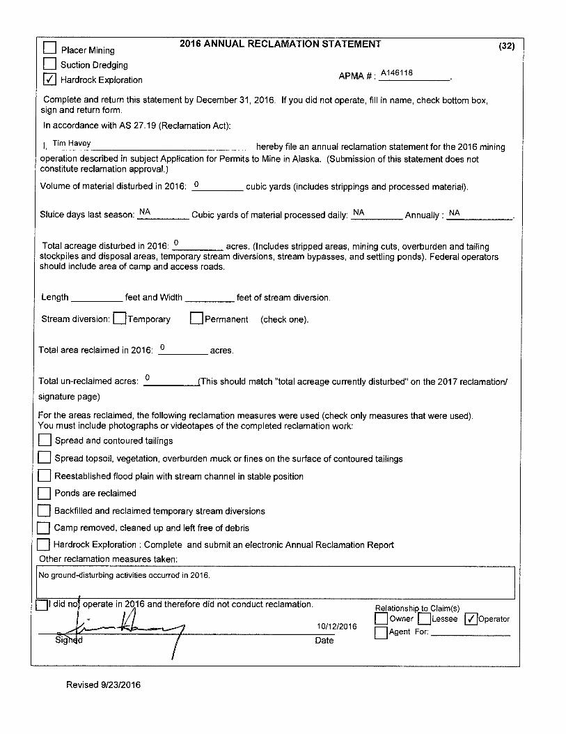
This report summarizes care and maintenance activities conducted during the 2016 field season at the Pebble Project, a mineral exploration and development project operated by the Pebble Limited Partnership (PLP). PLP is a U.S. company wholly owned by Northern Dynasty Minerals Ltd. of Vancouver, Canada, conducting exploration-related activities on state mineral claims leased to the Pebble East Claims Corporation, Pebble West Claims Corporation, and U5 Resources, Inc. These activities are authorized by Miscellaneous Land Use Permit (MLUP) No. 6118 issued by the Alaska Department of Natural Resources, Division of Mining, Land and Water (ADNR-MLW). The MLUP expires on 12/31/2016.1
During 2016, PLP operated the Pebble Project in care and maintenance status. No exploration or other land-disturbing activities occurred during the calendar year. All previous exploration sites have been fully reclaimed in accordance with AS 27.19 and 11 AAC 97.
1.1 LOCATION
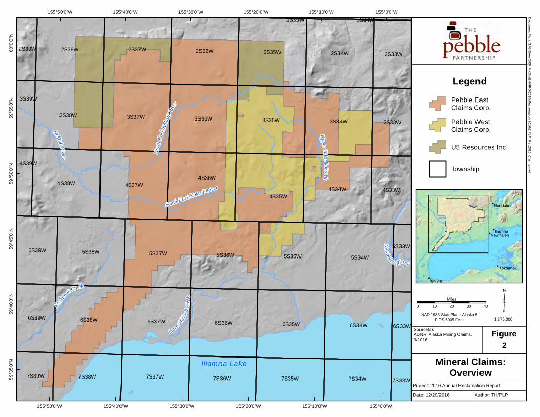
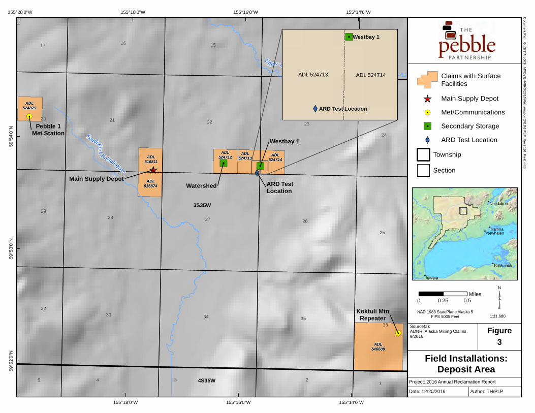
The Pebble Project is located in the Lake and Peninsula Borough in southwest Alaska. The main deposit is centered approximately 200 miles SW of Anchorage, 60 miles W of Cook Inlet and 17 miles NW of Iliamna (Figure 1). The Pebble Project comprises 2,402 Alaska state mineral claims, and contains one of the world’s most significant undeveloped deposits of copper, gold, and molybdenum (Figure 2).
1.2 RECLAMATION OBJECTIVES AND REQUIREMENTS
Alaska statute (AS 27.19) and regulation (11 AAC 97) require mining operators to reclaim any disturbed land to a “stable condition”, which means rehabilitation to a state that allows for the reestablishment of a vegetative cover within a reasonable period of time. MLUP No. 6118 further stipulates that:
• Surface disturbance shall be held to a minimum, and will be reclaimed by backfilling, contouring, and spreading of organic rich overburden to promote stabilization and natural revegetation.
• The area reclaimed shall be reshaped and recontoured to blend with surrounding physiography using strippings and overburden, and then stabilized to a condition that shall retain sufficient moisture to allow for natural revegetation.
• Upon completion of drilling activities, drill pads shall be reclaimed as necessary, including reseeding, to encourage natural revegetation of the sites and protect them from erosion. Trenches shall be backfilled with material excavated and mounded slightly.
• All exploration trenches shall be reclaimed before the end of the exploration season in which they are constructed, unless they are specifically approved to remain open by the Division of Mining, Land & Water.
1 PLP submitted an APMA to renew MLUP #6118 on October 13, 2016. A renewed permit is expected by December 31, 2016.

PEBBLE LIMITED PARTNERSHIP
Annual Reclamation Report 2 December 2016
MLUP No. 6118 also requires the filing of this reclamation report and Annual Reclamation Statement by December 31 of each year the permit is in effect. The Annual Reclamation Statement is included as Appendix D.
1.3 WORK SUMMARY
Work conducted during the 2016 field season included routine maintenance of existing field installations, minor enhancements to previously reclaimed areas, and visual inspection of more than 400 project drill sites to verify closure and reclamation status.
Maintenance activities for 2016 are summarized in Table 1 and shown on Figure 3. Details for each location are provided in Section 3.4. Inspections and results are discussed in Section 3.6. Representative photographs are included in Appendix A.
Table 1. 2016 Drill Site Maintenance Summary
BOREHOLE ID INITIAL DRILL DATE
ADL CLAIM NO.
LONGITUDE (WGS84)
LATITUDE (WGS84)
ACTIVITY
0051 1991 516818 -155.29289 59.90138 Spread topsoil; re-seeded 0112 1997 516873 -155.29859 59.89371 Backfilled hole with bentonite pellets; spread
topsoil; re-seeded 3072 2003 516818 -155.29283 59.90137 Spread topsoil; re-seeded 3127 2003 516873 -155.29856 59.89376 Removed Margo plug; backfilled hole with
bentonite pellets; spread topsoil; re-seeded 4190 2004 516811 -155.296 59.89687 Spread topsoil; re-seeded 4215 2004 516818 -155.29199 59.89902 Spread topsoil; re-seeded 5332 2005 540426 -155.26113 59.90077 Backfilled hole with bentonite pellets 8433M 2008 516874 -155.29727 59.8946 Backfilled hole with bentonite pellets; spread
topsoil and re-seeded GH06-072 2006 524808 -155.28773 59.87123 Replaced Margo plug GH11-292S 2011 524715 -155.24842 59.89527 Removed cables; re-sealed plate; replaced water
valve SRK-5D 2004 516867 -155.29853 59.89042 Installed new Margo plug
1.4 OTHER PERMITS AND REGULATORY REQUIREMENTS
Activities conducted during 2016 did not require any other permits.

PEBBLE LIMITED PARTNERSHIP
Annual Reclamation Report 3 December 2016
2.0 PROJECT DESCRIPTION
2.1 SITE ACCESS
Field operations are based out of PLP’s office at the Iliamna Airport in Iliamna, AK. Access to all worksites within the Pebble deposit is by helicopter only. PLP does not use ground vehicles to access the deposit area or travel between worksites. As a result, the deposit area remains free of temporary roads and tracks.
2.2 ENVIRONMENTAL CONTROLS
2.2.1 Vegetation and Tundra Preservation
PLP’s standard field work procedures require the use of wooden tundra pads and platforms for all heavy equipment and materials to minimize vegetation impacts. Individual worksites are also organized to have as small a footprint as possible, with mobilization and demobilization occurring within the shortest time frame to limit duration impacts. When a surface disturbance is necessary, groundcover, including vegetation, is removed and stockpiled for later use in reclaiming the site. Once the activity is complete, excavated areas are backfilled and re-covered with reserved tundra. Disturbed areas are also revegetated with native seed or an approved seed mixture as appropriate.
2.2.2 Fuel Management and Spill Prevention
PLP uses double-walled, welded aluminum fly tanks to transport and store all fuel for field operations. Tanks are filled at PLP’s Iliamna location to no more than 80 percent of the total capacity. (Most tanks used have a total capacity of 110 gallons, meaning each will contain no more than 88 gallons.) Each tank is visually inspected for leaks or spills prior to transport by helicopter.
All active fuel tanks are placed in welded aluminum secondary containments sized to hold 110 percent of the tank’s maximum capacity. Containments are placed on level ground at least 100 feet from any surface water.
Each tank location is stocked with a spill containment and cleanup kit. All field staff have been trained in the proper response and reporting protocols as part of PLP’s SPCC Plan. PLP also maintains a contract with Alaska Chadux Corporation to provide 24-hour spill response, if necessary. After each worksite is demobilized, the area is inspected to ensure no leaks or spills occurred.
2.2.3 Erosion and Sediment Control
Weed-free straw was used in conjunction with re-seeding efforts at boreholes 0051, 0112, 3072, 3127, 4190, 4215, and 8433M to minimize wind and water erosion.

PEBBLE LIMITED PARTNERSHIP
Annual Reclamation Report 4 December 2016
2.3 MATERIAL & EQUIPMENT STAGING
2.3.1 Main Supply Depot
The Main Supply Depot (MSD) was initially constructed in 2004 and serves as the primary storage and staging area for field operations. The site occupies approximately 2.5 acres of a gravel bluff in the West Deposit area (SE1/4 SE1/4 of Sec 21, T3S R35W and the NE1/4 NE1/4 of Sec 28, T3S, R35W) (ADL Nos. 516811 and 516874).
Multiple temporary wood frame buildings and platform tents provide sheltered storage for machinery, drilling equipment, environmental supplies, and variety of small parts and tools. Small quantities of drilling fluids, motor oils, and antifreeze are stored in sealed, original packaging inside weather-proof shelters. All temporary structures are constructed on elevated platforms or placed on tundra pads.
Other items such as drill rods, lumber, tundra pads, outhouses, fuel containments, rig supports, are stored within the MSD yard on racks or elevated platforms. These items represent equipment consolidated at the MSD from multiple field locations when exploration activities ceased in 2013. A categorized inventory of field equipment and supplies was provided to DNR with the APMA renewal application in October 2016.
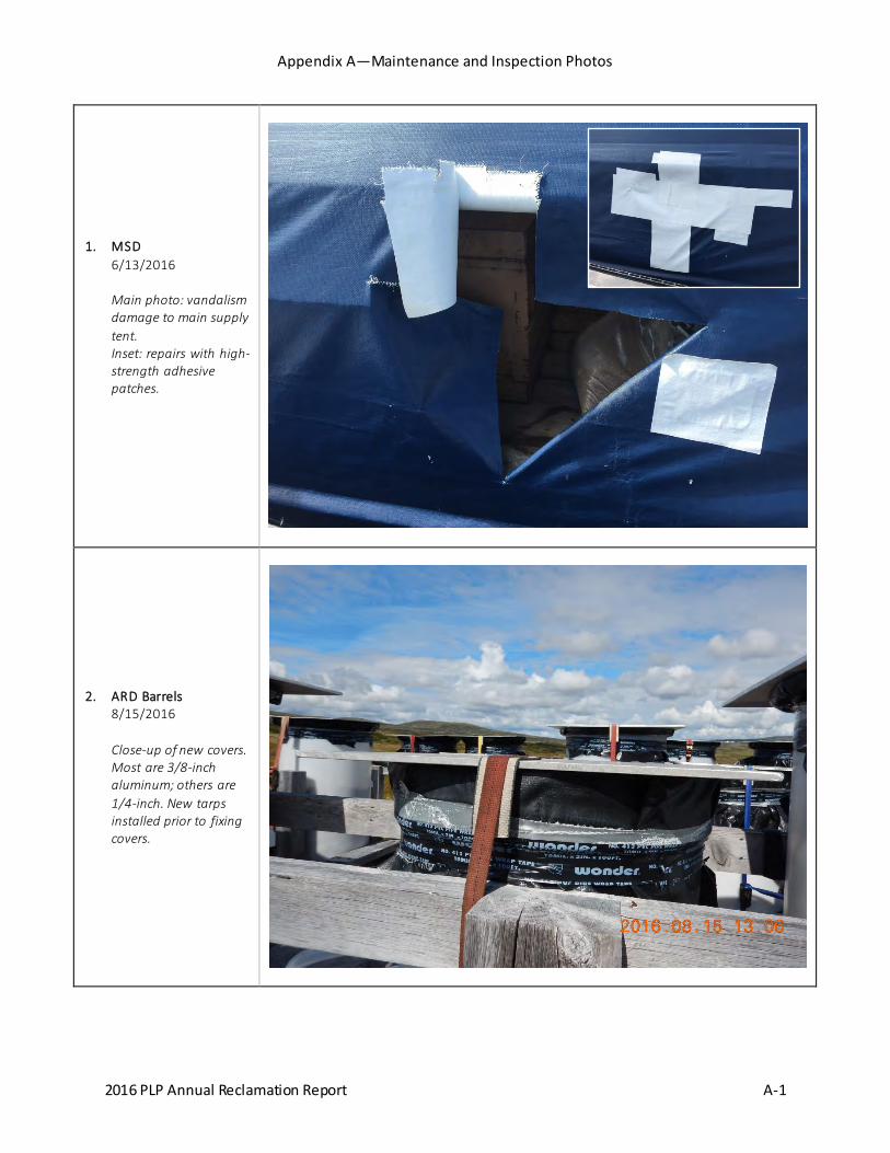
New high-strength adhesive patches designed for all-weather exposure were used to repair vandalism damage to the main supply tent (Photo 1).
2.3.2 Fuel Storage
Three 110-gallon fly tanks containing approximately 250 gallons of Jet A fuel were transported to the field during June 2016 to support maintenance activities. Tanks were stored in aluminum containments at the MSD to refuel helicopters. All tanks were removed to Iliamna after five days.
No fuel or other petroleum product spills were identified or reported during the 2016 field season.
2.3.3 Watershed
The Watershed site is located approximately 0.75 miles east of the MSD in the SW1/4 SE1/4 of Sec 22, T3S, R35W (ADL No. 524712). The site consists of three temporary buildings constructed on elevated platforms: one Quonset-style building with a corrugated metal roof (14’ x 16’) that served as a light machine shop, and two wood frame buildings (9’ x 38’; 10’ x 16’) used to store hoses, miscellaneous hand tools and field supplies. A small generator shed is attached to the Quonset hut. One 110-gallon fuel tank (empty) is kept in an aluminum containment next to the shed.
PLP continues to use the Watershed site as a storage location for field equipment.
2.3.4 West Bay 1 and 3
Each West Bay location consists of two temporary wooden structures (an 8’ x 12’ emergency shelter and a smaller generator shack). These structures are used to provide shelter for monitoring crews during data collection. West Bay 1 is located in the SW1/4 SW1/4 of Sec 23, T3S, R35W

PEBBLE LIMITED PARTNERSHIP
Annual Reclamation Report 5 December 2016
(ADL No. 524714). West Bay 3 is located in the NE1/4 SW1/4 of Sec 33, T3S, R36W (ADL No. 642412).
PLP continues to use both West Bay locations to store field equipment.
2.3.5 Meteorological and Communications
The Pebble 1 meteorological station is located in the SW1/4 NE1/4 of Sec 20, T3S, R35W (ADL No. 524829). The small site consists of a temporary fiberglass structure (approximately 8 x 8 ft) and associated equipment.
The Koktuli Mountain radio repeater is located in the NE1/4 SW1/4 of Sec 36, T3S, R35W (ADL No. 646608). The small site consists of a temporary metal structure (approximately 8 x 8 ft) and associated equipment. During 2016, steel cables were replaced and tightened to stabilize the transmission tower during high winds.
PLP continues to use the Pebble 1 met station to collect basic meteorological data, while the Koktuli Mountain repeater remains the primary means of communication with helicopters and field crews.
2.3.6 Acid Rock Drainage Test Location
The ARD site is located in the SE 1/4 SE 1/4 of Section 22, T3S, R35W (ADL No. 524713). It was set up to evaluate real time weathering and acid generation potential in area rock. The site consists of 12 large plastic barrels filled half way with rock fragments. Barrels are racked on wood tundra pads.
ARD testing is no longer active. Each barrel has been covered with a 40-mil HDPE tarp to prevent water intrusion. Drainage tubes are also sealed to prevent leakage. In August 2016 PLP installed aluminum plates on top of each barrel to guard against wind and wildlife damage. Aluminum plates are either 3/8-inch or 1/4-inch thick and secured with ratchet straps (Photo 2).
2.4 FIELD STAFF AND LOGISTICS
All work crews are based out of Iliamna and ferried to the work site by helicopter each day work is being performed. All waste is removed from the field and properly disposed in Iliamna.

PEBBLE LIMITED PARTNERSHIP
Annual Reclamation Report 6 December 2016
3.0 MAINTENANCE ACTIVITIES
3.1 PLANNED VS. ACTUAL ACTIVITY
PLP has operated the Pebble Project in a care and maintenance status since 2014. No exploration activities or land disturbances were planned for the 2016 field season, nor did any occur. Maintenance activities for individual sites are described in Section 3.4.
3.2 SURFACE DISTURBANCE AND RECLAMATION
Surface disturbances during the 2016 field season totaled 0.0 acres; 0.0 acres remain to be reclaimed.
3.3 CONSUMPTIVE WATER USE
Water was not used for any maintenance activity conducted during 2016; permit coverage was not required.
3.4 2016 MAINTENANCE DETAILS
Maintenance activities were conducted during the 2016 field season (May – September). The locations of the eleven maintenance sites are shown on Figure 3. Representative photos are provided in Appendix A.
All 2016 maintenance sites will be inspected during the 2017 field season to document vegetation growth and evaluate repair success.
3.4.1 Boreholes 0051 and 3072
These sites are located 15 feet apart in the West Deposit area approximately one-half mile north of the MSD. A wood marker indicates the location of Borehole 3072. Neither site has any permanent surface structures in place. Upwellings have never been observed or indicated from either borehole.
Soils at this site are known to be naturally high in iron oxide and can be seen in the large areas of rust-colored soil and rock nearby. The site is also located in a relatively flat area with a shallow water table that allows surface water to pond easily during spring runoff or heavy rain events. Although the site is stable, surface iron oxide is more prevalent within the initial disturbed area, which has impeded growth of natural vegetation.
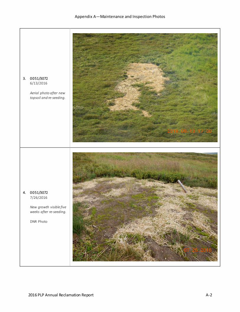
PLP applied approximately five cubic yards of topsoil (hauled from Iliamna) over a 350-square foot area at an average depth of five inches. A certified seed mixture2 was hand-cast over the topsoil and covered with straw (Photo 3). Fertilizer was not applied. Subsequent inspection showed germination and growth within five weeks of seeding (Photo 4).
2 The certified seed mixture is based on recommendations published by the Alaska DNR Division of Agriculture (Plant Materials Center) for revegetation projects in south-central Alaska (“A Revegetation Manual for Alaska”, Stoney Wright, ANDR-AG, August 2008). The mixture contains ‘Norcoast’ Bering hairgrass, ‘Arctared’ red fescue, ‘Boreal’ red fescue, and ‘Nortran’ tufted hairgrass.
PEBBLE LIMITED PARTNERSHIP
Annual Reclamation Report 7 December 2016
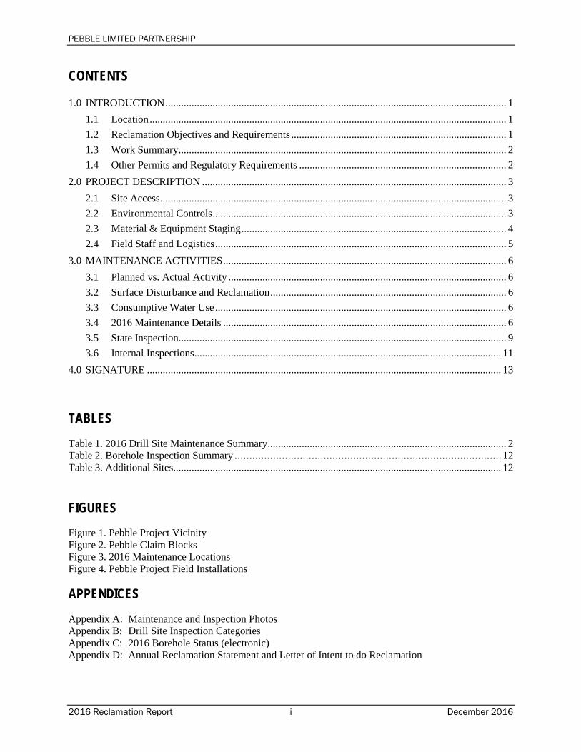
3.4.2 Borehole 0112
This site was drilled by Cominco in 1997 and is located one-quarter mile southwest of the MSD in the West Deposit. A wood marker indicates the borehole location. There are no surface structures present. Minor flow (less than 0.5 gallons per minute [gpm]) was observed at the site in May 2016, with characteristics similar to a groundwater seep. Water pooled in a small area around the borehole before dissipating into the surrounding vegetation.
PLP probed the borehole to a depth of approximately seven feet. Pel-Plug™ time-release bentonite pellets3 (1/4-inch) were added to the hole to within three feet of the surface; the remaining depth was filled with 1/2-inch pellets. All water flow was cut off.
The small area where water had pooled was filled with topsoil, re-seeded and covered with straw (Photo 5). Subsequent inspection five weeks later showed the bentonite seal in place and no evidence of water. Germination and growth were also observed in the re-seeded area.
3.4.3 Borehole 3127
This site is located one-quarter mile southwest of the MSD in the West Deposit. A wood marker indicates the borehole location. Steel casing extends three inches aboveground at an angle of 49 degrees and was fitted with a Margo plug. A small amount of ponded water was observed in October 2015. A follow-up inspection showed no leaks from the plugged casing. Instead, water was upwelling a few feet from the casing at a rate of approximately 1 gpm.
PLP removed the Margo plug from the casing, which immediately caused the upwelling to stop and all surface water to drain below ground. The casing was allowed to sit open for approximately 45 minutes, during which time no water flow was observed. The Margo plug was not re-installed. Instead, the casing was packed with 1/4-inch time-release bentonite pellets to a depth of approximately one foot below the surface. The small surrounding area was covered with topsoil, re-seeded and covered with straw (Photo 6). Subsequent inspection five weeks afterward showed the bentonite seal in place and no evidence of water. Germination and growth were also observed in the re-seeded area.
3.4.4 Borehole 4190
This site is located approximately 800 feet northwest of the MSD in the West Deposit. A wood marker indicates the borehole location. There are no surface structures present. An inspection in October 2015 showed bare patches around the borehole (approximately 15 square feet) and small quantities of ponded water. A subsequent inspection in May 2016 showed that surface water was pooling in a small depression around the borehole, with no evidence of upwelling or flowing water.
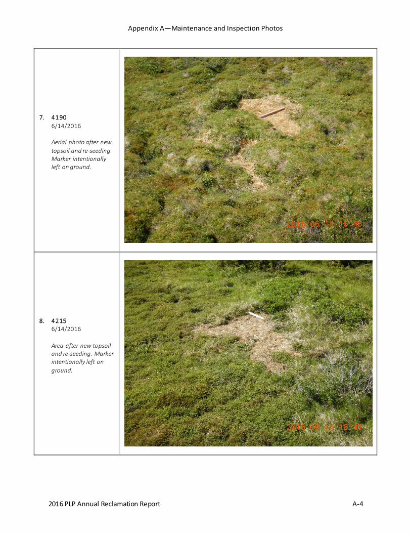
PLP applied topsoil to an average depth of six inches over the bare areas, re-seeded, and covered the area with straw (Photo 7). Subsequent inspection showed the site has remained dry, with germination and growth visible within five weeks of seeding.
3 Pel-Plug™ is a brand name of sodium bentonite with a high swell factor. Time-release pellets have a thin biodegradable coating.
PEBBLE LIMITED PARTNERSHIP
Annual Reclamation Report 8 December 2016
3.4.5 Borehole 4215
This site is located approximately one-quarter mile north of the MSD in the West Deposit. A wood marker indicates the borehole location. There are no surface structures present. An inspection in October 2015 showed small areas of mud around the drill site (approximately 20 square feet) with little vegetation. Water was not observed at the time. A subsequent inspection in May 2016 did not indicate upwelling. Instead, surface water was pooling in a small depression around the borehole.
PLP applied topsoil to a depth of six inches over the bare areas, re-seeded, and covered the area with straw (Photo 8). Subsequent inspection showed germination and growth within five weeks of seeding.
3.4.6 Borehole 5332
This site is located approximately one mile northeast of the MSD in the East Deposit. A wood marker indicates the borehole location. There are no surface structures present. The surrounding area is relatively flat and lies below a prominent ridge to the west. As a result, the area remains wet throughout much of the year with surface water volumes that vary with precipitation. Vegetation is well established around the drill site.
Ponded surface water was observed at the borehole in May 2016. A subsequent ground inspection in June 2016 was able to delineate a hole to a depth of approximately eight feet. PLP backfilled the hole with ¼-inch time-release bentonite pellets to the surface. Water flow appeared to stop, but could not be conclusively determined because the area was flooded at the time. A subsequent inspection in July 2016 showed surface water volume had noticeably diminished (Photo 9).
3.4.7 Borehole 8433M
This site is located approximately 800 feet southwest of the MSD in the West Deposit. No surface structures are present. A wood marker indicates the borehole location.
A potential upwelling from the site was observed in October 2015 and confirmed in May 2016. Water flows consistently at a rate of 1-2 gpm and dissipates into the tundra 12-15 feet away from the borehole. Water runs clear but the presence of iron-fixing microorganisms contributes to the formation of rust-colored mats in the outflow channel.
PLP identified a discrete hole to a depth of eight feet, although the staff person suspects the hole may be deeper. Bentonite pellets were backfilled into the hole and allowed to set. After 30 minutes all water flow stopped (Photo 10). Final reclamation was postponed until the seal integrity could be confirmed at a later date.
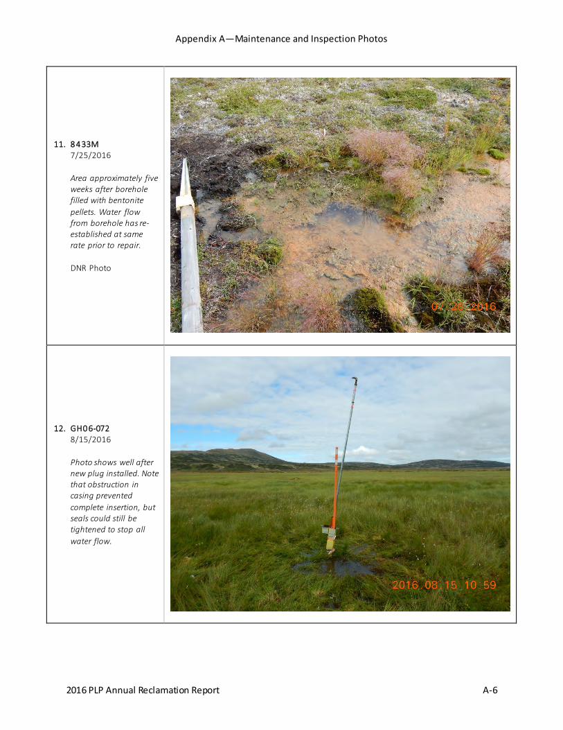
A follow up inspection in July 2016 showed that the bentonite pellets did not form a competent seal in the borehole. Water had resumed flowing at the same rate prior to the repair effort (Photo 11).
Prior to the 2017 field season, PLP will submit a work plan to DNR outlining the inspection, monitoring, and maintenance activities for this location.

PEBBLE LIMITED PARTNERSHIP
Annual Reclamation Report 9 December 2016
3.4.8 Monitoring Well GH06-072
This site is located 1.7 miles south of the MSD in a wet area north of Frying Pan Lake. The monitoring well is known to have moderate artesian pressure and is fitted with a Margo plug. An inspection in July 2016 showed that a small volume of water (less than 0.5 gpm) was welling up inside the PVC casing, suggesting the Margo plug had cracked. PLP installed a new Margo plug in August 2016 and cut off all water flow (Photo 12).
3.4.9 Monitoring Well GH11-292S
This site is located 1.5 miles east of the MSD in the East Deposit and is used for piezometric monitoring. A steel plate with a water valve is bolted to the casing, rising approximately six inches above the surface. Moderate artesian pressure has been documented at this monitoring well.
During a May 2016 inspection, water was observed leaking from between the steel plate and casing at a rate of approximately 2-3 gpm. Piezometer cables running through the gasket created a gap allowing water to flow out of the casing (Photo 13). PLP removed the cables, cleaned the gasket, replaced the water valve with a threaded plug, and re-bolted the steel plate to ensure a proper seal (Photo 14). All water flow was stopped. Water did not adversely affect surrounding vegetation; no additional reclamation required. A subsequent inspection in July 2016 showed that the repairs remain intact and the site remains dry.
3.4.10 Monitoring Well SRK-5D
This site is located 0.4 miles southwest of the MSD in the West Deposit. High artesian pressure has been documented at this monitoring well. An inspection in October 2015 showed water flowing due to a failed plug. PLP installed a new Margo plug in June 2016 to cut off all water flow (Photo 15). Subsequent inspection in July 2016 showed the site remained dry with the plug intact (Photo 16). Revegetation was not needed.
3.5 STATE INSPECTION
DNR staff conducted a two-day inspection of the Pebble Project on July 26 and 27, 2016. In addition to sites mentioned in Section 3.4, DNR requested additional information for the following sites identified during the inspection:
3.5.1 Borehole 3132
This site is located one-quarter mile southwest of the MSD and adjacent to Borehole 3131 by approximately three inches. Borehole 3131 was successfully repaired in 2015 by drilling and grouting the original borehole. A post-repair inspection did not find evidence of additional upwellings at the time.
Inspections by PLP and DNR in 2016 observed a small, diffuse upwelling several feet from the 2015 repair location. A consistent flow is visible but too small to quantify. Water dissipates into the surrounding ground within a few feet (Photo 17). The water source has not been determined but may be related to 2015 repair activities. For reporting purposes, inspection and maintenance activity for this upwelling are recorded under Borehole 3132.

PEBBLE LIMITED PARTNERSHIP
Annual Reclamation Report 10 December 2016
PLP will continue to investigate the water source and potential repair options. Prior to the 2017 field season, PLP will submit a work plan to DNR outlining the inspection, monitoring, and maintenance activities for this location.
3.5.2 Borehole 4279
The DNR inspection report notes the presence of ponded surface water but does not identify a source. PLP has inspected this site on multiple occasions and has determined that ponded water is not attributable to the borehole.
The site is located on the edge of wide, flat area north of the MSD that acts as a natural flood plain to an ephemeral stream. Seasonal precipitation routinely causes surface water to pond across the area. Photo 18 was taken during early summer when the area is typically driest. No water is visible in the photo, although the extent of previous flooding is evident by the growth of mosses and lichens. Photo 19 shows how the area floods following late season rains.
PLP will periodically inspect this site to confirm these findings. No repairs are planned at this time.
3.5.3 Borehole 9475
This site is known to have moderate artesian pressure. Repairs in 2015—re-drilling and grouting the casing exterior to the surface—were initially successful. Follow-up inspections in 2016 showed that water had flushed some grout from the borehole and had resumed flowing at a similar rate (2-3 gpm). Water flows downhill approximately 130 feet before dissipating.
PLP will continue to investigate potential repair options. Prior to the 2017 field season, PLP will submit a work plan to DNR outlining the inspection, monitoring, and maintenance activities for this location.
3.5.4 Borehole 12561
This site is located one mile west of the MSD in the West Deposit. A circular depression approximately 20 inches deep is visible around the wood marker. It is not clear if the depression is the result of ongoing subsidence or natural settling following initial reclamation in 2013. The depression is dry apart from occasional precipitation.
PLP will continue to monitor the site during 2017 by taking periodic measurements and compare any changes to the baseline. If subsidence is documented, PLP will remediate the site as appropriate in consultation with DNR staff.
3.5.5 Monitoring Well GH08-156
This monitoring well is located in the valley north of Kaskanak Mountain. A small volume of water (less than 0.5 gpm) flows from around the casing before dissipating approximately 10 feet away. Water has not been observed inside the casing; artesian conditions are not evident. PLP suspects that the site’s location on a hillside with a large upgradient area may cause shallow groundwater to daylight around the casing.
PEBBLE LIMITED PARTNERSHIP
Annual Reclamation Report 11 December 2016
PLP will continue to investigate this site in 2017 to determine the possible causes. If necessary, maintenance and repairs will be conducted in consultation with DNR staff.
3.5.6 Monitoring Well GH11-236
This site is located 2.25 miles northwest of the MSD. A circular depression approximately 12 inches deep is visible around the well casing. This condition was first observed by field crews in 2012, who noted the depression was about one foot below the surrounding ground. Subsequent inspections in 2013 and 2016 have made the same measurement, suggesting that the depression is the result of ground settling immediately after well installation in 2011 rather than ongoing subsidence.
PLP will continue to monitor the site during 2017 by taking periodic measurements and compare any changes to the baseline. If subsidence is documented, PLP will remediate the site as appropriate in consultation with DNR staff.
3.6 INTERNAL INSPECTIONS
PLP conducts routine inspections of project drill sites during each field season to ensure compliance with all permit and regulatory requirements. Information is summarized and provided to DNR, including current status, repair or maintenance needs, presence of above ground structures, reclamation status, safety markings, and abandonment method, if applicable.
3.6.1 Drill Site Status Summary
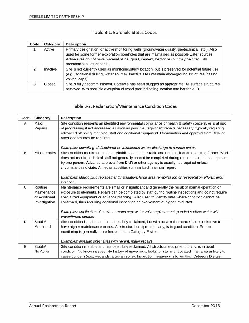
PLP assigns an alpha-numeric code to each drill site following inspection to more easily characterize each location and plan future maintenance and inspection needs. Numerals (1-3) describe the borehole operating status (e.g., active or potential use for monitoring or future drilling) while letters (A-E) describe the surface condition, including reclamation status and maintenance needs, if any. A detailed explanation of each code is provided in Appendix B.
For the 2016 field season, PLP planned to update inspection records for all drill sites such that the most recent inspection for any one site was not older than five years. PLP conducted 429 individual borehole inspections to bring all records current to within three years. The status of each project borehole is provided in Appendix C.
As shown in Table 2, nearly all sites (99 percent) are in stable condition and require no further action (D and E). Six sites require follow up inspection or maintenance (C), while an additional six require repairs to control minor upwellings (B). None of the project drill sites require major repairs (A) or otherwise pose a notable risk of causing adverse impact.

PEBBLE LIMITED PARTNERSHIP
Annual Reclamation Report 12 December 2016
Table 2. Borehole Inspection Summary Surface Condition
A B C D E
Major Repairs
Stable/ Minor Repairs
Maintenance or Follow-up
Stable/ Monitored
Stable/ No Action Total [a]
Bore
hole
St
atus
1 Active 0 2 1 27 582 612
2 Inactive 0 0 0 10 147 157
3 Closed 0 4 5 15 553 577 Total 0 6 6 52 1282 1346
[a] Includes drill sites within the active claim boundary only.
3.6.2 Identified Sites
Internal inspections identified three additional boreholes where water was either flowing or present. Each of these sites (Table 3) is stable in its current condition and does not present a notable risk of causing adverse impact. PLP will continue to monitor each site and investigate possible causes and maintenance options. A detailed work plan will be provided to DNR prior to the start of the 2017 field season.
Table 3. Additional Sites Drill Site Location Description Photo No.
7386 East Deposit
Clear water was observed bubbling up from the borehole location. Water flows continuously downhill for approximately 20 feet before dissipating, creating a defined channel and supporting stronger vegetation growth. Some algae growth is noted, but iron-fixing microorganisms were not observed. Flow appears consistent at less than 1 gpm.
20, 21
11538 Sharp Mtn Minor upwelling observed at base of marker. Water flows clear at a rate of 0.5-1 gpm continuously. No other water sources observed. Outflow channel is poorly defined, but discrete flow pattern observed. Supports stronger vegetation growth. Iron-fixing microorganisms were not observed, with only minimal algae growth.
22, 23
12550 Sharp Mtn Water ponded in depression near borehole location. No upwelling observed. May be ponded precipitation, but no inflow or outflow channels observed. Stronger vegetation growth around edge suggests continual presence of water. Biofilm suggests water is relatively stagnant with no flushing.
24
3.6.3 2017 Inspection Program Internal inspection protocols are routinely updated and refined based on current information. For the 2017 field season, PLP will continue to inspect and monitor drill sites as appropriate. At a minimum, all sites requiring specific monitoring or additional investigation will be inspected at least once during the season (all sites rated “B” or “C” in Table 2).
Additional locations will be inspected depending on general project activity and need. These sites will be selected based on various criteria, including repair history, potential for maintenance issues, site usage, and age of most recent inspection. Inspection details will be provided to DNR prior to the start of the 2017 field season.
PEBBLE LIMITED PARTNERSHIP
Annual Reclamation Report 13 December 2016
4.0 SIGNATURE
This report, prepared by Tim Havey, PLP Environmental Manager, is dated December 31, 2016 and satisfies the annual reporting requirements of MLUP No. 6118.
Signed,
Tim Havey Environmental Manager, PLP

CookInlet
Katmai NationalKatmai NationalPreservePreserve
L a k e C l a r kL a k e C l a r kN a t i o n a l P a r kN a t i o n a l P a r k
Lake ClarkLake ClarkNational PreserveNational Preserve
Wood-TikchikState Park
Chugach NationalForest
Trading BayGame Reserve
McNeil RiverGame Sanctuary
Shuyak IslandState Park
K a t m a i N a t i o n a l P a r kK a t m a i N a t i o n a l P a r k
BecharofNWR
McNeil RiverGame Reserve
AlagnakWild & Scenic River
Pedro BayAnchorPoint
Dillingham
Homer
Igiugig
Iliamna
Kokhanok
Naknek
Newhalen
Nondalton
PortAlsworth
IliamnaLake
Idi ta
r od
RE
A AK u
s pu k
RE
AA
Iditarod REAALake & Peninsula Borough
Matanuska-Susitna BoroughKenai Peninsula Borough
Kuspuk REAASouthwest Region REAA
Kenai Peninsula Borough
Kodiak Island Borough
Sou
thw
estR
egio
nR
EA A
Lake
&Pe
nins
ula
B oro
ugh
Sout
hwes
t Reg
ion
REA
A
Lake
& P
enin
sula
Bor
ough
Lake & Peninsula Borough
Bristol Bay Borough
Mulchatna
Riv
er
Dougla
s River
Kamis
ha kRive
r
Nuyaku k River
Tlikakila River
S tuyahok River
Kaskana
kC
reek
KingSa l monRiver
Koktuli River
King Salm onRiver
K vichak
River
Alagna kRi ver
Kokwo k R iver
Chu litna R iver
Nushagak River
Nushagak River
151°20'0"W
151°40'0"W
152°0'0"W
152°20'0"W
152°40'0"W
153°0'0"W
153°20'0"W
153°40'0"W
154°0'0"W
154°20'0"W
154°40'0"W
155°0'0"W
155°20'0"W
155°40'0"W
156°0'0"W
156°20'0"W
156°40'0"W
157°0'0"W
157°20'0"W
157°40'0"W
158°0'0"W
158°20'0"W
158°40'0"W61
°30'
0"N
61°1
0'0"
N60
°50'
0"N
60°3
0'0"
N60
°10'
0"N
59°5
0'0"
N59
°30'
0"N
59°1
0'0"
N58
°50'
0"N
58°3
0'0"
N58
°10'
0"N
LegendPebble Project MineralClaims
National Forest Service
National Park Service
State Game Refuge
State Game Sanctuary
State Park
Scale 1:2,000,000
0 10 20 30 40 50
Miles
Date: 12/20/2016 Author: TH/PLP
Pebble ProjectVicinity Map
Project: 2016 Annual Reclamation Report
1
NAD 1983 StatePlane Alaska 5FIPS 5005 Feet
Figure
Docum
ent Path: G
:\GIS
\ArcGIS
\_MX
Ds\E
NV
IRO
\2016\Reclam
ation 2016\1 PLP
_Rec2016V
icinity.mxd
Source(s):National Map, USGSADNR Mineral Claims, 2016
³
_̂
BristolBay
Iliamna Lake
Newh alen R ive r
Koktuli Rive r
Lower Talari
k CrekKaska
nak Creek
North
Fork
Koktu
li Rive
r
Upper Talar ik CreekSouth Fork Koktuli River
2S33W
3S33W
4S33W
5S33W
6S33W
7S33W
1S34W
2S34W
3S34W
4S34W
5S34W
6S34W
7S34W
1S35W
2S35W
3S35W
4S35W
5S35W
6S35W
7S35W
2S36W
3S36W
4S36W
5S36W
6S36W
7S36W
2S37W
3S37W
4S37W
5S37W
6S37W
7S37W
2S38W
3S38W
4S38W
5S38W
6S38W
7S38W
2S39W
3S39W
4S39W
5S39W
6S39W
7S39W
155°0'0"W
155°0'0"W
155°10'0"W
155°10'0"W
155°20'0"W
155°20'0"W
155°30'0"W
155°30'0"W
155°40'0"W
155°40'0"W
155°50'0"W
155°50'0"W60
°0'0
"N59
°55'
0"N
59°5
0'0"
N59
°45'
0"N
59°4
0'0"
N59
°35'
0"N
LegendPebble EastClaims Corp.
Pebble WestClaims Corp.
U5 Resources Inc
Township
0 10 20 30 40
Miles
Date: 12/20/2016 Author: TH/PLP
Mineral Claims:Overview
Project: 2016 Annual Reclamation Report
2
NAD 1983 StatePlane Alaska 5FIPS 5005 Feet
Figure
Docum
ent Path: G
:\GIS
\ArcGIS
\_MX
Ds\E
NV
IRO
\2016\Reclam
ation 2016\2 PLP
_Rec2016_C
laims.m
xd
Source(s):ADNR, Alaska Mining Claims,9/2016
³!
!
!
!
!
Igiugig
Iliamna
Kokhanok
Newhalen
Nondalton
1:275,000
XW"/
!.
_̂ "/
!.
ARD TestLocationWatershed
Pebble 1Met Station
Main Supply Depot
Westbay 1
Koktuli MtnRepeater
ADL646608
ADL516811
ADL516874
ADL524712 ADL
524713 ADL524714
ADL524829
Upper Talarik Creek
South Fork
KoktuliR iver
1314151617
20 21 22 23
24
25
26272829
3233 34 35
36
12345
3S35W
4S35W
155°14'0"W
155°14'0"W
155°16'0"W
155°16'0"W
155°18'0"W
155°18'0"W155°20'0"W59
°54'
0"N
59°5
3'0"
N59
°52'
0"N
Date: 12/20/2016 Author: TH/PLP
Field Installations:Deposit Area
Project: 2016 Annual Reclamation Report
3
NAD 1983 StatePlane Alaska 5FIPS 5005 Feet
Figure
Docum
ent Path: G
:\GIS
\ArcGIS
\_MX
Ds\E
NV
IRO
\2016\Reclam
ation 2016\3 PLP
_Rec2016_Field.m
xd
Source(s):ADNR, Alaska Mining Claims,9/2016
³!
!
!
!
!
Igiugig
Iliamna
Kokhanok
Newhalen
Nondalton
1:31,680
0 0.25 0.5Miles
XW
"/
ADL 524713 ADL 524714
Westbay 1
ARD Test Location
Claims with SurfaceFacilities
_̂ Main Supply Depot
!. Met/Communications
"/ Secondary Storage
XW ARD Test Location
Township
Section

_̂
!A
!A
!A
!A
!A
!A
!A
!A
!A
!A
!A
0112
0051/3072
3127
4190
42155332
8433M
GH06-072
GH11-292S
SRK-5D/KP-P3D
Upper Talarik Creek
South Fork Koktuli River
20 21
2029
21 22
2128
22 23
2227 23
26
2526
2627
2635
2728
2734
2829
2833
32 33
33 34
334
34 35
343
35 36
352
34
1600
1280
1320
1560
14801520
1200
1320
1800
1480
1440
880
1440
1400
1440
1120
1520
2000
1680
1360
1400
1320
1960
1280
1080
1640
1480
1360
1040
1240
1000
800
1040
1240
15601040
19201320
1880
1840
960
1080
1800
1600
1280
1360
1520
1400
1360
1320
1760
1720
840
1200
1000
1240
920
1000
1480
1200
1120
1240
1280
1440
960
1400
1160
1160
!A Maintenance Sites
_̂ Main Supply Depot
Section Boundary
Scale 1:24,000
0 0.25 0.5
Miles
Date: 12/30/2016 Author: TH/PLP
2016 Maintenance SitesFile: 4 PLP_Rec2016_Maintenance
4
GCS North American 1983 UTMZone 05V (Calculated)
Figure
Docum
ent Path: G
:\GIS
\ArcGIS
\_MX
Ds\E
NV
IRO
\2016\Reclam
ation 2016\4 PLP
_Rec2016_M
aintenance.mxd
Source(s):PLP Borehole Database 2016
³
_̂
!
!
IliamnaNewhalen
Annual Report—Photographs December 2016
APPENDIX A
Representative Maintenance Photographs
Appendix A—Maintenance and Inspection Photos
2016 PLP Annual Reclamation Report A-1
1. MSD 6/13/2016 Main photo: vandalism damage to main supply tent. Inset: repairs with high-strength adhesive patches.
2. ARD Barrels 8/15/2016 Close-up of new covers. Most are 3/8-inch aluminum; others are 1/4-inch. New tarps installed prior to fixing covers.
Appendix A—Maintenance and Inspection Photos
2016 PLP Annual Reclamation Report A-2
3. 0051/3072 6/13/2016 Aerial photo after new topsoil and re-seeding.
4. 0051/3072 7/26/2016 New growth visible five weeks after re-seeding. DNR Photo

Appendix A—Maintenance and Inspection Photos
2016 PLP Annual Reclamation Report A-3
5. 0112 6/14/2016 Area after new topsoil and re-seeding. Marker intentionally left on ground.
6. 3127 6/14/2016 Area after new topsoil and re-seeding. Marker intentionally left on ground. Removed Margo plug visible on ground at left.
Appendix A—Maintenance and Inspection Photos
2016 PLP Annual Reclamation Report A-4
7. 4190 6/14/2016 Aerial photo after new topsoil and re-seeding. Marker intentionally left on ground.
8. 4215 6/14/2016 Area after new topsoil and re-seeding. Marker intentionally left on ground.

Appendix A—Maintenance and Inspection Photos
2016 PLP Annual Reclamation Report A-5
9. 5332 7/26/2016 Area approximately five weeks after borehole filled with bentonite pellets. Water flow appears diminished. DNR Photo (printed date is incorrect)
10. 8433M 6/14/2016 Borehole after being filled with bentonite pellets. Photo shows technician siphoning remaining surface water to verify seal.
Appendix A—Maintenance and Inspection Photos
2016 PLP Annual Reclamation Report A-6
11. 8433M 7/25/2016 Area approximately five weeks after borehole filled with bentonite pellets. Water flow from borehole has re-established at same rate prior to repair. DNR Photo
12. GH06-072 8/15/2016 Photo shows well after new plug installed. Note that obstruction in casing prevented complete insertion, but seals could still be tightened to stop all water flow.

Appendix A—Maintenance and Inspection Photos
2016 PLP Annual Reclamation Report A-7
13. GH11-292S 6/14/2016 Monitoring well with steel plate removed. Although not immediately obvious, photo shows site submerged in clear water. Note location of piezometer cables under gasket.
14. GH11-292S 7/25/2016 Monitoring well with steel plate bolted in place. Piezometer cables removed. New threaded plug visible on top.

Appendix A—Maintenance and Inspection Photos
2016 PLP Annual Reclamation Report A-8
15. SRK-5D 6/14/2016 Technicians installing new Margo plug.
16. SRK-5D 7/26/2016 Monitoring well with new Margo plug installed. DNR Photo (printed date is incorrect)

Appendix A—Maintenance and Inspection Photos
2016 PLP Annual Reclamation Report A-9
17. 3132 7/26/2016 Wood post marks location for boreholes 3131 (repaired in 2015) and 3132, which are roughly three inches apart. Wet area to lower right is three feet from marker.
18. 4279 6/14/2016 Borehole area during relatively dry period. Note absence of surface water. Darker areas are mosses/lichens that generally represent extent of flood during rain events.

Appendix A—Maintenance and Inspection Photos
2016 PLP Annual Reclamation Report A-10
19. 4279 9/16/2016 Borehole area after late summer rains. Note extent of surface water ponding.
20. Borehole 7386 8/15/2016 Close-up of upwelling (hexagonal area near center). Water flows clear at consistent rate of less than 1 gpm.

Appendix A—Maintenance and Inspection Photos
2016 PLP Annual Reclamation Report A-11
21. Borehole 7386 8/15/2016 View of outflow channel towards water source.
22. Borehole 11538 8/16/2016 Close-up of upwelling. Water flows clear at rate of less than 1 gpm.

Appendix A—Maintenance and Inspection Photos
2016 PLP Annual Reclamation Report A-12
23. Borehole 11538 8/16/2016 View upslope towards borehole. Water volume does not create distinct channel, but vegetation growth indicates general flow pattern.
24. Borehole 12550 8/16/2016 Ponded water around borehole location. No upwelling or outflow observed. Discrete borehole could not be identified.

PEBBLE LIMITED PARTNERSHIP
Annual Reclamation Report December 2016
APPENDIX B
Inspection Categories
PEBBLE LIMITED PARTNERSHIP
Annual Reclamation Report December 2016
Table B-1. Borehole Status Codes
Code Category Description 1 Active Primary designation for active monitoring wells (groundwater quality, geotechnical, etc.). Also
used for some former exploration boreholes that are maintained as possible water sources. Active sites do not have material plugs (grout, cement, bentonite) but may be fitted with mechanical plugs or caps.
2 Inactive Site is not currently used as monitoring/study location, but is preserved for potential future use (e.g., additional drilling, water source). Inactive sites maintain aboveground structures (casing, valves, caps).
3 Closed Site is fully decommissioned. Borehole has been plugged as appropriate. All surface structures removed, with possible exception of wood post indicating location and borehole ID.
Table B-2. Reclamation/Maintenance Condition Codes
Code Category Description A Major
Repairs Site condition presents an identified environmental compliance or health & safety concern, or is at risk of progressing if not addressed as soon as possible. Significant repairs necessary, typically requiring advanced planning, technical staff and additional equipment. Coordination and approval from DNR or other agency may be required. Examples: upwelling of discolored or voluminous water; discharge to surface water.
B Minor repairs Site condition requires repairs or rehabilitation, but is stable and not at risk of deteriorating further. Work does not require technical staff but generally cannot be completed during routine maintenance trips or by one person. Advance approval from DNR or other agency is usually not required unless circumstances dictate. All repair activities summarized in annual report. Examples: Margo plug replacement/installation; large area rehabilitation or revegetation efforts; grout injection.
C Routine Maintenance or Additional Investigation
Maintenance requirements are small or insignificant and generally the result of normal operation or exposure to elements. Repairs can be completed by staff during routine inspections and do not require specialized equipment or advance planning. Also used to identify sites where condition cannot be confirmed, thus requiring additional inspection or involvement of higher level staff. Examples: application of sealant around cap; water valve replacement; ponded surface water with unconfirmed source.
D Stable/ Monitored
Site condition is stable and has been fully reclaimed, but with past maintenance issues or known to have higher maintenance needs. All structural equipment, if any, is in good condition. Routine monitoring is generally more frequent than Category E sites. Examples: artesian sites; sites with recent, major repairs.
E Stable/ No Action
Site condition is stable and has been fully reclaimed. All structural equipment, if any, is in good condition. No known issues. No history of upwellings, leaks, or staining. Located in an area unlikely to cause concern (e.g., wetlands, artesian zone). Inspection frequency is lower than Category D sites.

PEBBLE LIMITED PARTNERSHIP
Annual Reclamation Report December 2016
APPENDIX C
Borehole Status (electronic file)

PEBBLE LIMITED PARTNERSHIP
Annual Reclamation Report December 2016
APPENDIX D
2016 Reclamation Statement 2017 Letter of Intent to do Reclamation